
Blythewood City Zoning Code
COMMERCIAL ZONING
DISTRICTS
Sec. 155.180.- Commercial zoning districts land use table.
The commercial zoning districts land use table below lists the land uses allowed or disallowed in the respective commercial zoning districts. Allowed uses may be mixed on the same parcel and/or in the same building.
(A)
Permitted uses.
(1)
The letter "P" in a table cell denotes that the corresponding land use is allowed by right in the corresponding zoning district, subject to compliance with all other applicable regulations of the Zoning Chapter.
(2)
The letter "P" in a table cell along with a "sq. ft." number denotes that each principal use (including its accessory uses) is also subject to the equivalent gross floor area maximum. The board of zoning appeals is authorized to grant variances from these gross floor area maximums, on a case by case basis, so as to allow up to ten percent more gross floor area for a principal use (including its accessory uses) in the corresponding zoning district.
(B)
Conditional uses.
(1)
The letter "C" in a table cell denotes that the corresponding land use is allowed conditionally in the corresponding zoning district, subject to the conditions referenced in the corresponding "conditions and criteria" column of the table, and subject to compliance with all other applicable regulations of the zoning chapter.
(2)
The letter "C" in a table cell along with a "sq. ft." number denotes that each principal use (including its accessory uses) is also subject to the equivalent gross floor area maximum. The board of zoning appeals is authorized to grant variances from these gross floor area maximums, on a case by case basis, so as to allow up to ten percent more gross floor area for a principal use (including its accessory uses) in the corresponding zoning district.
(C)
Special exception uses.
(1)
The letters "SE" in a table cell denote that the corresponding land use is allowed conditionally in the corresponding zoning district upon a special exception approval by the board of zoning appeals, on a case by case basis, subject to the criteria referenced in the corresponding "conditions and criteria" column of the table, and subject to compliance with all other applicable regulations of the zoning chapter.
(2)
The letters "SE" in a table cell along with a "sq. ft." number denote that each principal use (including its accessory uses) is also subject to the equivalent gross floor area maximum. Upon approving the corresponding special exceptions, the board of zoning appeals is authorized to grant variances from these gross floor area maximums, on a case by case basis, so as to allow up to ten percent more gross floor area for a principal use (including its accessory uses) in the corresponding zoning district.
(D)
Prohibited uses. The letter "X" in a table cell denotes that the corresponding land use is prohibited in the corresponding zoning district. Land uses not listed in the commercial zoning districts land use table are also prohibited in the respective commercial zoning districts.
(E)
Land use intensities. The following table is a general guide to the assignment of land uses to the respective commercial zoning districts, based on a gradient of land use intensities.
(F)
Commercial zoning districts land use table.
(Ord. No. 5.202, 11-24-1981; Ord. No. 5.300, 6-26-2006; Ord. No. 5.369, 7-28-2009; Ord. No. 2012.007, 12-17-2012; Ord. No. 2017.010, 9-25-2017)
Cross reference— Penalty, see § 155.999.
Sec. 155.181. - Conditional uses.
This section lists the conditions and criteria that are referenced in the "conditions and criteria" column of the commercial zoning districts land use table (section 155.180(F)) for the corresponding conditional uses and special exception uses. Conditional uses and special exception uses are also subject to compliance with all other applicable regulations of the zoning chapter. The following land uses are listed alphabetically.
(A)
Accessory dwelling to single-family detached residential.
(1)
Accessory dwelling to single-family detached residential in the MC multi-neighborhood commercial district.
(a)
Location of accessory dwellings. Accessory dwellings shall be located only on parcels containing one single-family detached residential structure as a principal use. An accessory dwelling may be a separate structure or contained within the same structure as its principal use.
(b)
Number of accessory dwellings. Only one accessory dwelling shall be permitted per single-family detached residential structure. However, other conforming accessory structures may also be located on the same parcel.
(c)
Size of accessory dwellings. The gross floor area of an accessory dwelling shall not exceed 500 square feet.
(d)
Manufactured home residential structure. A manufactured home residential structure may not be used as an accessory dwelling.
(e)
Mobile home residential structure. A mobile home residential structure may not be used as an accessory dwelling.
(2)
Accessory dwelling to single-family detached residential in the MO multi-neighborhood office district.
(a)
Location of accessory dwellings. Accessory dwellings shall be located only on parcels containing one single-family detached residential structure as a principal use. An accessory dwelling may be a separate structure or contained within the same structure as its principal use.
(b)
Number of accessory dwellings. Only one accessory dwelling shall be permitted per single-family detached residential structure. However, other conforming accessory structures may also be located on the same parcel.
(c)
Size of accessory dwellings. The gross floor area of an accessory dwelling shall not exceed 500 square feet.
(d)
Manufactured home residential structure. A manufactured home residential structure may not be used as an accessory dwelling.
(e)
Mobile home residential structure. A mobile home residential structure may not be used as an accessory dwelling.
(3)
Accessory dwelling to single-family detached residential in the NC neighborhood commercial district.
(a)
Location of accessory dwellings. Accessory dwellings shall be located only on parcels containing one single-family detached residential structure as a principal use. An accessory dwelling may be a separate structure or contained within the same structure as its principal use.
(b)
Number of accessory dwellings. Only one accessory dwelling shall be permitted per single-family detached residential structure. However, other conforming accessory structures may also be located on the same parcel.
(c)
Size of accessory dwellings. The gross floor area of an accessory dwelling shall not exceed 500 square feet.
(d)
Manufactured home residential structure. A manufactured home residential structure may not be used as an accessory dwelling.
(e)
Mobile home residential structure. A mobile home residential structure may not be used as an accessory dwelling.
(4)
Accessory dwelling to single-family detached residential in the NO neighborhood office district.
(a)
Location of accessory dwellings. Accessory dwellings shall be located only on parcels containing one single-family detached residential structure as a principal use. An accessory dwelling may be a separate structure or contained within the same structure as its principal use.
(b)
Number of accessory dwellings. Only one accessory dwelling shall be permitted per single-family detached residential structure. However, other conforming accessory structures may also be located on the same parcel.
(c)
Size of accessory dwellings. The gross floor area of an accessory dwelling shall not exceed 500 square feet.
(d)
Manufactured home residential structure. A manufactured home residential structure may not be used as an accessory dwelling.
(e)
Mobile home residential structure. A mobile home residential structure may not be used as an accessory dwelling.
(B)
(1)
Accounting, auditing, and bookkeeping services in the NC neighborhood commercial district.
(2)
Hours of operation. The allowed hours of operation are from 7:00 a.m. to 10:00 p.m., local time.
(C)
(1)
Art, dance, drama, music, and martial arts schools in the NC neighborhood commercial district.
(2)
Hours of operation. The allowed hours of operation are from 7:00 a.m. to 10:00 p.m., local time.
(D)
(1)
Art, dealers, supplies, sales and services in the NC neighborhood commercial district.
(2)
Hours of operation. The allowed hours of operation are from 7:00 a.m. to 10:00 p.m., local time.
(E)
Assisted-living services.
(1)
(a)
Assisted-living services in the CC community commercial district.
(b)
Special exception criteria.
1.
Land use compatibility. The nature of the proposed land use is mutually compatible with the existing land uses surrounding its location, and with the future land uses allowed in the surrounding zoning district(s). The nature of the proposed land use is also consistent with the adopted comprehensive plan for the vicinity of its location.
2.
Design compatibility.
a.
The design of the proposed land use minimizes adverse impacts on the existing land uses surrounding its location, on the future land uses allowed in the surrounding zoning district(s), and on the community infrastructure. Potential impacts include, but are not limited to, visual appearance (site, buildings, landscaping, signage, lighting), traffic generation, vehicle ingress and egress and circulation, vehicle parking and loading, pedestrian access and safety, storm drainage, utility services, and nuisances such as noise, light, odor, smoke, and vibration.
b.
Conversely, the design of the proposed land use also minimizes adverse impacts from the existing land uses surrounding its location, from the future land uses allowed in the surrounding zoning district(s), and from the community infrastructure.
3.
Operation compatibility.
a.
The operation of the proposed land use minimizes adverse impacts on the existing land uses surrounding its location, on the future land uses allowed in the surrounding zoning district(s), and on the community infrastructure. Potential aspects include, but are not limited to, hours of operation, management of peak activity periods, and provisions for property maintenance.
b.
Conversely, the operation of the proposed land use also minimizes adverse impacts from the existing land uses surrounding its location, from the future land uses allowed in the surrounding zoning district(s), and from the community infrastructure.
4.
Land use definition.
a.
The proposed assisted-living services conforms to its land use definition;
b.
These services are provided by board-and-care establishments, such as adult foster care homes and adult care group homes. Services include daily activity assistance, such as dressing, grooming, bathing, and the like. These establishments may be located in single-family homes and share the house with the care provider's family.
(2)
(a)
Assisted-living services in the NC neighborhood commercial district.
(b)
Special exception criteria.
1.
Land use compatibility. The nature of the proposed land use is mutually compatible with the existing land uses surrounding its location, and with the future land uses allowed in the surrounding zoning district(s). The nature of the proposed land use is also consistent with the adopted comprehensive plan for the vicinity of its location.
2.
Design compatibility.
a.
The design of the proposed land use minimizes adverse impacts on the existing land uses surrounding its location, on the future land uses allowed in the surrounding zoning district(s), and on the community infrastructure. Potential impacts include, but are not limited to, visual appearance (site, buildings, landscaping, signage, lighting), traffic generation, vehicle ingress and egress and circulation, vehicle parking and loading, pedestrian access and safety, storm drainage, utility services, and nuisances such as noise, light, odor, smoke, and vibration.
b.
Conversely, the design of the proposed land use also minimizes adverse impacts from the existing land uses surrounding its location, from the future land uses allowed in the surrounding zoning district(s), and from the community infrastructure.
3.
Operation compatibility.
a.
The operation of the proposed land use minimizes adverse impacts on the existing land uses surrounding its location, on the future land uses allowed in the surrounding zoning district(s), and on the community infrastructure. Potential aspects include, but are not limited to, hours of operation, management of peak activity periods, and provisions for property maintenance.
b.
Conversely, the operation of the proposed land use also minimizes adverse impacts from the existing land uses surrounding its location, from the future land uses allowed in the surrounding zoning district(s), and from the community infrastructure.
4.
Land use definition.
a.
The proposed assisted-living services conforms to its land use definition;
b.
These services are provided by board-and-care establishments, such as adult foster care homes and adult care group homes. Services include daily activity assistance, such as dressing, grooming, bathing, and the like. These establishments may be located in single-family homes and share the house with the care provider's family.
(3)
(a)
Assisted-living services in the NO neighborhood office district.
(b)
Special exception criteria.
1.
Land use compatibility. The nature of the proposed land use is mutually compatible with the existing land uses surrounding its location, and with the future land uses allowed in the surrounding zoning district(s). The nature of the proposed land use is also consistent with the adopted comprehensive plan for the vicinity of its location.
2.
Design compatibility.
a.
The design of the proposed land use minimizes adverse impacts on the existing land uses surrounding its location, on the future land uses allowed in the surrounding zoning district(s), and on the community infrastructure. Potential impacts include, but are not limited to, visual appearance (site, buildings, landscaping, signage, lighting), traffic generation, vehicle ingress and egress and circulation, vehicle parking and loading, pedestrian access and safety, storm drainage, utility services, and nuisances such as noise, light, odor, smoke, and vibration.
b.
Conversely, the design of the proposed land use also minimizes adverse impacts from the existing land uses surrounding its location, from the future land uses allowed in the surrounding zoning district(s), and from the community infrastructure.
3.
Operation compatibility.
a.
The operation of the proposed land use minimizes adverse impacts on the existing land uses surrounding its location, on the future land uses allowed in the surrounding zoning district(s), and on the community infrastructure. Potential aspects include, but are not limited to, hours of operation, management of peak activity periods, and provisions for property maintenance.
b.
Conversely, the operation of the proposed land use also minimizes adverse impacts from the existing land uses surrounding its location, from the future land uses allowed in the surrounding zoning district(s), and from the community infrastructure.
4.
Land use definition.
a.
The proposed assisted-living services conforms to its land use definition:
b.
These services are provided by board-and-care establishments, such as adult foster care homes and adult care group homes. Services include daily activity assistance, such as dressing, grooming, bathing, and the like. These establishments may be located in single-family homes and share the house with the care provider's family.
(F)
(1)
Automated teller machine in the NC neighborhood commercial district.
(2)
Hours of operation. The allowed hours of operation are from 7:00 a.m. to 10:00 p.m., local time.
(G)
Automobile wash or detailing.
(1)
(a)
Automobile wash or detailing in the MC multi-neighborhood commercial district.
(b)
Trash storage. Adequate, enclosed, trash storage facilities shall be provided onsite.
(2)
(a)
Automobile wash or detailing in the TC town center district.
(b)
Trash storage. Adequate, enclosed, trash storage facilities shall be provided onsite.
(H)
(1)
Bakery in the NC neighborhood commercial district.
(2)
Hours of operation. The allowed hours of operation are from 7:00 a.m. to 10:00 p.m., local time.
(I)
(1)
Bank, credit union, or savings institution in the NC neighborhood commercial district.
(2)
Hours of operation. The allowed hours of operation are from 7:00 a.m. to 10:00 p.m., local time.
(J)
(1)
Beauty shop, barber shop, or nail salon in the NC neighborhood commercial district.
(2)
Hours of operation. The allowed hours of operation are from 7:00 a.m. to 10:00 p.m., local time.
(K)
(1)
Bed and breakfast in the NC neighborhood commercial district.
(2)
Number of guest rooms. No more than four guest rooms can be available for accommodations and breakfast service in an establishment at any one time.
(L)
(1)
Beer and wine store in the NC neighborhood commercial district.
(2)
Hours of operation. The allowed hours of operation are from 7:00 a.m. to 10:00 p.m., local time.
(M)
(1)
Book and other media store in the NC neighborhood commercial district.
(2)
Hours of operation. The allowed hours of operation are from 7:00 a.m. to 10:00 p.m., local time.
(N)
(1)
Camera and photographic supplies in the NC neighborhood commercial district.
(2)
Hours of operation. The allowed hours of operation are from 7:00 a.m. to 10:00 p.m., local time.
(O)
(1)
Caterer in the NC neighborhood commercial district.
(2)
Hours of operation. The allowed hours of operation are from 7:00 a.m. to 10:00 p.m., local time.
(P)
Cemetery.
(1)
(a)
Cemetery in the MC multi-neighborhood commercial district.
(b)
Road access. The site has frontage on an arterial road or collector road, except when located on the same parcel of land as an existing religious institution.
(2)
(a)
Cemetery in the MO multi-neighborhood office district.
(b)
Road access. The site has frontage on an arterial road or collector road, except when located on the same parcel of land as an existing religious institution.
(3)
(a)
cemetery in the NC neighborhood commercial district.
(b)
Road access. The site has frontage on an arterial road or collector road, except when located on the same parcel of land as an existing religious institution.
(4)
(a)
Cemetery in the NO neighborhood office district.
(b)
Special exception criteria.
1.
Land use compatibility. The nature of the proposed land use is mutually compatible with the existing land uses surrounding its location, and with the future land uses allowed in the surrounding zoning district(s). The nature of the proposed land use is also consistent with the adopted comprehensive plan for the vicinity of its location.
2.
Design compatibility. The design of the proposed land use minimizes adverse impacts on the existing land uses surrounding its location, on the future land uses allowed in the surrounding zoning district(s), and on the community infrastructure. Potential impacts include, but are not limited to, visual appearance (site, buildings, landscaping, signage, lighting), traffic generation, vehicle ingress and egress and circulation, vehicle parking and loading, pedestrian access and safety, storm drainage, utility services, and nuisances such as noise, light, odor, smoke, and vibration.
3.
Operation compatibility. The operation of the proposed land use minimizes adverse impacts on the existing land uses surrounding its location, on the future land uses allowed in the surrounding zoning district(s), and on the community infrastructure. Potential aspects include, but are not limited to, hours of operation, management of peak activity periods, and provisions for property maintenance.
4.
Site size. The site is a minimum of three contiguous acres, except when located on the same parcel of land as an existing religious institution.
5.
Road access. The site has frontage on an arterial road or collector road, except when located on the same parcel of land as an existing religious institution.
(5)
(a)
Cemetery in the TC town center district.
(b)
Special exception criteria.
1.
Land use compatibility. The nature of the proposed land use is mutually compatible with the existing land uses surrounding its location, and with the future land uses allowed in the surrounding zoning district(s). The nature of the proposed land use is also consistent with the adopted comprehensive plan for the vicinity of its location.
2.
Design compatibility. The design of the proposed land use minimizes adverse impacts on the existing land uses surrounding its location, on the future land uses allowed in the surrounding zoning district(s), and on the community infrastructure. Potential impacts include, but are not limited to, visual appearance (site, buildings, landscaping, signage, lighting), traffic generation, vehicle ingress and egress and circulation, vehicle parking and loading, pedestrian access and safety, storm drainage, utility services, and nuisances such as noise, light, odor, smoke, and vibration.
3.
Operation compatibility. The operation of the proposed land use minimizes adverse impacts on the existing land uses surrounding its location, on the future land uses allowed in the surrounding zoning district(s), and on the community infrastructure. Potential aspects include, but are not limited to, hours of operation, management of peak activity periods, and provisions for property maintenance.
4.
Site size. The site is a minimum of three contiguous acres, except when located on the same parcel of land as an existing religious institution.
5.
Road access. The site has frontage on an arterial road or collector road, except when located on the same parcel of land as an existing religious institution.
(Q)
Child care center (13 or more).
(1)
(a)
Child care center (13 or more) in the MC multi-neighborhood commercial district.
(b)
Special exception criteria.
1.
Land use compatibility. The nature of the proposed land use is mutually compatible with the existing land uses surrounding its location, and with the future land uses allowed in the surrounding zoning district(s). The nature of the proposed land use is also consistent with the adopted comprehensive plan for the vicinity of its location.
2.
Design compatibility.
a.
The design of the proposed land use minimizes adverse impacts on the existing land uses surrounding its location, on the future land uses allowed in the surrounding zoning district(s), and on the community infrastructure. Potential impacts include, but are not limited to, visual appearance (site, buildings, landscaping, signage, lighting), traffic generation, vehicle ingress and egress and circulation, vehicle parking and loading, pedestrian access and safety, storm drainage, utility services, and nuisances such as noise, light, odor, smoke, and vibration.
b.
Conversely, the design of the proposed land use also minimizes adverse impacts from the existing land uses surrounding its location, from the future land uses allowed in the surrounding zoning district(s), and from the community infrastructure.
3.
Operation compatibility.
a.
The operation of the proposed land use minimizes adverse impacts on the existing land uses surrounding its location, on the future land uses allowed in the surrounding zoning district(s), and on the community infrastructure. Potential aspects include, but are not limited to, hours of operation, management of peak activity periods, and provisions for property maintenance.
b.
Conversely, the operation of the proposed land use also minimizes adverse impacts from the existing land uses surrounding its location, from the future land uses allowed in the surrounding zoning district(s), and from the community infrastructure.
4.
Land use definition.
a.
The proposed child care center (13 or more) conforms to its land use definition;
b.
Child care centers are those required to be registered or licensed or approved by the South Carolina Department of Social Services, and which provide care for 13 or more children at any given time.
5.
Application. The application for a special exception includes the information required by the South Carolina Department of Social Services for registration, licensing, or approval.
(2)
(a)
Child care center (13 or more) in the MO multi-neighborhood office district.
(b)
Special exception criteria.
1.
Land use compatibility. The nature of the proposed land use is mutually compatible with the existing land uses surrounding its location, and with the future land uses allowed in the surrounding zoning district(s). The nature of the proposed land use is also consistent with the adopted comprehensive plan for the vicinity of its location.
2.
Design compatibility.
a.
The design of the proposed land use minimizes adverse impacts on the existing land uses surrounding its location, on the future land uses allowed in the surrounding zoning district(s), and on the community infrastructure. Potential impacts include, but are not limited to, visual appearance (site, buildings, landscaping, signage, lighting), traffic generation, vehicle ingress and egress and circulation, vehicle parking and loading, pedestrian access and safety, storm drainage, utility services, and nuisances such as noise, light, odor, smoke, and vibration.
b.
Conversely, the design of the proposed land use also minimizes adverse impacts from the existing land uses surrounding its location, from the future land uses allowed in the surrounding zoning district(s), and from the community infrastructure.
3.
Operation compatibility.
a.
The operation of the proposed land use minimizes adverse impacts on the existing land uses surrounding its location, on the future land uses allowed in the surrounding zoning district(s), and on the community infrastructure. Potential aspects include, but are not limited to, hours of operation, management of peak activity periods, and provisions for property maintenance.
b.
Conversely, the operation of the proposed land use also minimizes adverse impacts from the existing land uses surrounding its location, from the future land uses allowed in the surrounding zoning district(s), and from the community infrastructure.
4.
Land use definition.
a.
The proposed child care center (13 or more) conforms to its land use definition:
b.
Child care centers are those required to be registered or licensed or approved by the South Carolina Department of Social Services, and which provide care for 13 or more children at any given time.
5.
Application. The application for a special exception includes the information required by the South Carolina Department of Social Services for registration, licensing, or approval.
(R)
(1)
Clothing, jewelry, luggage, shoes, and the like in the NC neighborhood commercial district.
(2)
Hours of operation. The allowed hours of operation are from 7:00 a.m. to 10:00 p.m., local time.
(S)
(1)
Computer and software in the NC neighborhood commercial district.
(2)
Hours of operation. The allowed hours of operation are from 7:00 a.m. to 10:00 p.m., local time.
(T)
Conference center.
(1)
(a)
Conference center in the MC multi-neighborhood commercial district.
(b)
Special exception criteria.
1.
Land use compatibility. The nature of the proposed land use is mutually compatible with the existing land uses surrounding its location, and with the future land uses allowed in the surrounding zoning district(s). The nature of the proposed land use is also consistent with the adopted comprehensive plan for the vicinity of its location.
2.
Design compatibility.
a.
The design of the proposed land use minimizes adverse impacts on the existing land uses surrounding its location, on the future land uses allowed in the surrounding zoning district(s), and on the community infrastructure. Potential impacts include, but are not limited to, visual appearance (site, buildings, landscaping, signage, lighting), traffic generation, vehicle ingress and egress and circulation, vehicle parking and loading, pedestrian access and safety, storm drainage, utility services, and nuisances such as noise, light, odor, smoke, and vibration.
b.
Conversely, the design of the proposed land use also minimizes adverse impacts from the existing land uses surrounding its location, from the future land uses allowed in the surrounding zoning district(s), and from the community infrastructure.
3.
Operation compatibility.
a.
The operation of the proposed land use minimizes adverse impacts on the existing land uses surrounding its location, on the future land uses allowed in the surrounding zoning district(s), and on the community infrastructure. Potential aspects include, but are not limited to, hours of operation, management of peak activity periods, and provisions for property maintenance.
b.
Conversely, the operation of the proposed land use also minimizes adverse impacts from the existing land uses surrounding its location, from the future land uses allowed in the surrounding zoning district(s), and from the community infrastructure.
(2)
(a)
Conference center in the MO multi-neighborhood office district.
(b)
Special exception criteria.
1.
Land use compatibility. The nature of the proposed land use is mutually compatible with the existing land uses surrounding its location, and with the future land uses allowed in the surrounding zoning district(s). The nature of the proposed land use is also consistent with the adopted comprehensive plan for the vicinity of its location.
2.
Design compatibility.
a.
The design of the proposed land use minimizes adverse impacts on the existing land uses surrounding its location, on the future land uses allowed in the surrounding zoning district(s), and on the community infrastructure. Potential impacts include, but are not limited to, visual appearance (site, buildings, landscaping, signage, lighting), traffic generation, vehicle ingress and egress and circulation, vehicle parking and loading, pedestrian access and safety, storm drainage, utility services, and nuisances such as noise, light, odor, smoke, and vibration.
b.
Conversely, the design of the proposed land use also minimizes adverse impacts from the existing land uses surrounding its location, from the future land uses allowed in the surrounding zoning district(s), and from the community infrastructure.
3.
Operation compatibility.
a.
The operation of the proposed land use minimizes adverse impacts on the existing land uses surrounding its location, on the future land uses allowed in the surrounding zoning district(s), and on the community infrastructure. Potential aspects include, but are not limited to, hours of operation, management of peak activity periods, and provisions for property maintenance.
b.
Conversely, the operation of the proposed land use also minimizes adverse impacts from the existing land uses surrounding its location, from the future land uses allowed in the surrounding zoning district(s), and from the community infrastructure.
(U)
(1)
Congregate living services in the CC community commercial district.
(2)
Special exception criteria.
(a)
Land use compatibility. The nature of the proposed land use is mutually compatible with the existing land uses surrounding its location, and with the future land uses allowed in the surrounding zoning district(s). The nature of the proposed land use is also consistent with the adopted comprehensive plan for the vicinity of its location.
(b)
Design compatibility.
1.
The design of the proposed land use minimizes adverse impacts on the existing land uses surrounding its location, on the future land uses allowed in the surrounding zoning district(s), and on the community infrastructure. Potential impacts include, but are not limited to, visual appearance (site, buildings, landscaping, signage, lighting), traffic generation, vehicle ingress and egress and circulation, vehicle parking and loading, pedestrian access and safety, storm drainage, utility services, and nuisances such as noise, light, odor, smoke, and vibration.
2.
Conversely, the design of the proposed land use also minimizes adverse impacts from the existing land uses surrounding its location, from the future land uses allowed in the surrounding zoning district(s), and from the community infrastructure.
(c)
Operation compatibility.
1.
The operation of the proposed land use minimizes adverse impacts on the existing land uses surrounding its location, on the future land uses allowed in the surrounding zoning district(s), and on the community infrastructure. Potential aspects include, but are not limited to, hours of operation, management of peak activity periods, and provisions for property maintenance.
2.
Conversely, the operation of the proposed land use also minimizes adverse impacts from the existing land uses surrounding its location, from the future land uses allowed in the surrounding zoning district(s), and from the community infrastructure.
(d)
Land use definition.
1.
The proposed congregate living services conforms to its land use definition:
2.
Funded through the 1978 Congregate Housing Services Act, many of these establishments serve meals and other services in low-income and federally subsidized housing. Now, many establishments provide these services to other non-subsidized housing facilities. Services include housekeeping, laundry, transportation, recreational programs, and other convenience services.
(V)
Convenience store (with gasoline sales).
(1)
(a)
Convenience store (with gasoline sales) in the MC multi-neighborhood commercial district.
(b)
Vehicle services. No major repairs or sale of vehicles shall be conducted on the premises.
(2)
(a)
Convenience store (with gasoline sales) in the TC town center district.
(b)
Vehicle services. No major repairs or sale of vehicles shall be conducted on the premises.
(W)
(1)
Convenience store (without gasoline sales or fast food sales) in the NC neighborhood commercial district.
(2)
Hours of operation. The allowed hours of operation are from 7:00 a.m. to 10:00 p.m., local time.
(X)
(1)
Cosmetic and beauty supplies in the NC neighborhood commercial district.
(2)
Hours of operation. The allowed hours of operation are from 7:00 a.m. to 10:00 p.m., local time.
(Y)
Electrical substation.
(1)
(a)
Electrical substation in the MC multi-neighborhood commercial district.
(b)
Special exception criteria.
1.
Land use compatibility. The nature of the proposed land use is mutually compatible with the existing land uses surrounding its location, and with the future land uses allowed in the surrounding zoning district(s). The nature of the proposed land use is also consistent with the adopted comprehensive plan for the vicinity of its location.
2.
Design compatibility.
a.
The design of the proposed land use minimizes adverse impacts on the existing land uses surrounding its location, on the future land uses allowed in the surrounding zoning district(s), and on the community infrastructure. Potential impacts include, but are not limited to, visual appearance (site, buildings, landscaping, signage, lighting), traffic generation, vehicle ingress and egress and circulation, vehicle parking and loading, pedestrian access and safety, storm drainage, utility services, and nuisances such as noise, light, odor, smoke, and vibration.
b.
Conversely, the design of the proposed land use also minimizes adverse impacts from the existing land uses surrounding its location, from the future land uses allowed in the surrounding zoning district(s), and from the community infrastructure.
3.
Operation compatibility.
a.
The operation of the proposed land use minimizes adverse impacts on the existing land uses surrounding its location, on the future land uses allowed in the surrounding zoning district(s), and on the community infrastructure. Potential aspects include, but are not limited to, hours of operation, management of peak activity periods, and provisions for property maintenance.
b.
Conversely, the operation of the proposed land use also minimizes adverse impacts from the existing land uses surrounding its location, from the future land uses allowed in the surrounding zoning district(s), and from the community infrastructure.
4.
Security. The proposed electrical substation shall be enclosed by a secure fence and/or wall at least six feet high, with emergency contact information posted at the principal entrance.
(2)
(a)
Electrical substation in the MO multi-neighborhood office district.
(b)
Special exception criteria.
1.
Land use compatibility. The nature of the proposed land use is mutually compatible with the existing land uses surrounding its location, and with the future land uses allowed in the surrounding zoning district(s). The nature of the proposed land use is also consistent with the adopted comprehensive plan for the vicinity of its location.
2.
Design compatibility.
a.
The design of the proposed land use minimizes adverse impacts on the existing land uses surrounding its location, on the future land uses allowed in the surrounding zoning district(s), and on the community infrastructure. Potential impacts include, but are not limited to, visual appearance (site, buildings, landscaping, signage, lighting), traffic generation, vehicle ingress and egress and circulation, vehicle parking and loading, pedestrian access and safety, storm drainage, utility services, and nuisances such as noise, light, odor, smoke, and vibration.
b.
Conversely, the design of the proposed land use also minimizes adverse impacts from the existing land uses surrounding its location, from the future land uses allowed in the surrounding zoning district(s), and from the community infrastructure.
3.
Operation compatibility.
a.
The operation of the proposed land use minimizes adverse impacts on the existing land uses surrounding its location, on the future land uses allowed in the surrounding zoning district(s), and on the community infrastructure. Potential aspects include, but are not limited to, hours of operation, management of peak activity periods, and provisions for property maintenance.
b.
Conversely, the operation of the proposed land use also minimizes adverse impacts from the existing land uses surrounding its location, from the future land uses allowed in the surrounding zoning district(s), and from the community infrastructure.
4.
Security. The proposed electrical substation shall be enclosed by a secure fence and/or wall at least six feet high, with emergency contact information posted at the principal entrance.
(3)
(a)
Electrical substation in the NC neighborhood commercial district.
(b)
Special exception criteria.
1.
Land use compatibility. The nature of the proposed land use is mutually compatible with the existing land uses surrounding its location, and with the future land uses allowed in the surrounding zoning district(s). The nature of the proposed land use is also consistent with the adopted comprehensive plan for the vicinity of its location.
2.
Design compatibility.
a.
The design of the proposed land use minimizes adverse impacts on the existing land uses surrounding its location, on the future land uses allowed in the surrounding zoning district(s), and on the community infrastructure. Potential impacts include, but are not limited to, visual appearance (site, buildings, landscaping, signage, lighting), traffic generation, vehicle ingress and egress and circulation, vehicle parking and loading, pedestrian access and safety, storm drainage, utility services, and nuisances such as noise, light, odor, smoke, and vibration.
b.
Conversely, the design of the proposed land use also minimizes adverse impacts from the existing land uses surrounding its location, from the future land uses allowed in the surrounding zoning district(s), and from the community infrastructure.
3.
Operation compatibility.
a.
The operation of the proposed land use minimizes adverse impacts on the existing land uses surrounding its location, on the future land uses allowed in the surrounding zoning district(s), and on the community infrastructure. Potential aspects include, but are not limited to, hours of operation, management of peak activity periods, and provisions for property maintenance.
b.
Conversely, the operation of the proposed land use also minimizes adverse impacts from the existing land uses surrounding its location, from the future land uses allowed in the surrounding zoning district(s), and from the community infrastructure.
4.
Security. The proposed electrical substation shall be enclosed by a secure fence and/or wall at least six feet high, with emergency contact information posted at the principal entrance.
(4)
(a)
Electrical substation in the NO neighborhood office district.
(b)
Special exception criteria.
1.
Land use compatibility. The nature of the proposed land use is mutually compatible with the existing land uses surrounding its location, and with the future land uses allowed in the surrounding zoning district(s). The nature of the proposed land use is also consistent with the adopted comprehensive plan for the vicinity of its location.
2.
Design compatibility.
a.
The design of the proposed land use minimizes adverse impacts on the existing land uses surrounding its location, on the future land uses allowed in the surrounding zoning district(s), and on the community infrastructure. Potential impacts include, but are not limited to, visual appearance (site, buildings, landscaping, signage, lighting), traffic generation, vehicle ingress and egress and circulation, vehicle parking and loading, pedestrian access and safety, storm drainage, utility services, and nuisances such as noise, light, odor, smoke, and vibration.
b.
Conversely, the design of the proposed land use also minimizes adverse impacts from the existing land uses surrounding its location, from the future land uses allowed in the surrounding zoning district(s), and from the community infrastructure.
3.
Operation compatibility.
a.
The operation of the proposed land use minimizes adverse impacts on the existing land uses surrounding its location, on the future land uses allowed in the surrounding zoning district(s), and on the community infrastructure. Potential aspects include, but are not limited to, hours of operation, management of peak activity periods, and provisions for property maintenance.
b.
Conversely, the operation of the proposed land use also minimizes adverse impacts from the existing land uses surrounding its location, from the future land uses allowed in the surrounding zoning district(s), and from the community infrastructure.
4.
Security. The proposed electrical substation shall be enclosed by a secure fence and/or wall at least six feet high, with emergency contact information posted at the principal entrance.
(5)
(a)
Electrical substation in the TC town center district.
(b)
Special exception criteria.
1.
Land use compatibility. The nature of the proposed land use is mutually compatible with the existing land uses surrounding its location, and with the future land uses allowed in the surrounding zoning district(s). The nature of the proposed land use is also consistent with the adopted comprehensive plan for the vicinity of its location.
2.
Design compatibility.
a.
The design of the proposed land use minimizes adverse impacts on the existing land uses surrounding its location, on the future land uses allowed in the surrounding zoning district(s), and on the community infrastructure. Potential impacts include, but are not limited to, visual appearance (site, buildings, landscaping, signage, lighting), traffic generation, vehicle ingress and egress and circulation, vehicle parking and loading, pedestrian access and safety, storm drainage, utility services, and nuisances such as noise, light, odor, smoke, and vibration.
b.
Conversely, the design of the proposed land use also minimizes adverse impacts from the existing land uses surrounding its location, from the future land uses allowed in the surrounding zoning district(s), and from the community infrastructure.
3.
Operation compatibility.
a.
The operation of the proposed land use minimizes adverse impacts on the existing land uses surrounding its location, on the future land uses allowed in the surrounding zoning district(s), and on the community infrastructure. Potential aspects include, but are not limited to, hours of operation, management of peak activity periods, and provisions for property maintenance.
b.
Conversely, the operation of the proposed land use also minimizes adverse impacts from the existing land uses surrounding its location, from the future land uses allowed in the surrounding zoning district(s), and from the community infrastructure.
4.
Security. The proposed electrical substation shall be enclosed by a secure fence and/or wall at least six feet high, with emergency contact information posted at the principal entrance.
(Z)
(1)
Engineering, architectural, and surveying services in the NC neighborhood commercial district.
(2)
Hours of operation. The allowed hours of operation are from 7:00 a.m. to 10:00 p.m., local time.
(AA)
(1)
Florist in the NC neighborhood commercial district.
(2)
Hours of operation. The allowed hours of operation are from 7:00 a.m. to 10:00 p.m., local time.
(BB)
(1)
Government offices in the NC neighborhood commercial district.
(2)
Hours of operation. The allowed hours of operation are from 7:00 a.m. to 10:00 p.m., local time.
(CC)
Group home (ten or more).
(1)
(a)
Group home (ten or more) in the CC community commercial district.
(b)
Special exception criteria.
1.
Land use compatibility. The nature of the proposed land use is mutually compatible with the existing land uses surrounding its location, and with the future land uses allowed in the surrounding zoning district(s). The nature of the proposed land use is also consistent with the adopted comprehensive plan for the vicinity of its location.
2.
Design compatibility.
a.
The design of the proposed land use minimizes adverse impacts on the existing land uses surrounding its location, on the future land uses allowed in the surrounding zoning district(s), and on the community infrastructure. Potential impacts include, but are not limited to, visual appearance (site, buildings, landscaping, signage, lighting), traffic generation, vehicle ingress and egress and circulation, vehicle parking and loading, pedestrian access and safety, storm drainage, utility services, and nuisances such as noise, light, odor, smoke, and vibration.
b.
Conversely, the design of the proposed land use also minimizes adverse impacts from the existing land uses surrounding its location, from the future land uses allowed in the surrounding zoning district(s), and from the community infrastructure.
3.
Operation compatibility.
a.
The operation of the proposed land use minimizes adverse impacts on the existing land uses surrounding its location, on the future land uses allowed in the surrounding zoning district(s), and on the community infrastructure. Potential aspects include, but are not limited to, hours of operation, management of peak activity periods, and provisions for property maintenance.
b.
Conversely, the operation of the proposed land use also minimizes adverse impacts from the existing land uses surrounding its location, from the future land uses allowed in the surrounding zoning district(s), and from the community infrastructure.
4.
Land use definition.
a.
The proposed group home (ten or more) conforms to its land use definition;
b.
A home serving ten or more mentally or physically handicapped persons, and which provides care on a 24-hour basis and is approved or licensed by a state agency or department or under contract with the agency or department for that purpose.
5.
Application. The application for a special exception includes a description of the number of residents to be served, the number and qualifications of supervising and supporting staff onsite and offsite, the nature of the services to be provided, and the terms and conditions of the state approval or licensing.
(2)
(a)
Group home (ten or more) in the MC multi-neighborhood commercial district.
(b)
Special exception criteria.
1.
Land use compatibility. The nature of the proposed land use is mutually compatible with the existing land uses surrounding its location, and with the future land uses allowed in the surrounding zoning district(s). The nature of the proposed land use is also consistent with the adopted comprehensive plan for the vicinity of its location.
2.
Design compatibility.
a.
The design of the proposed land use minimizes adverse impacts on the existing land uses surrounding its location, on the future land uses allowed in the surrounding zoning district(s), and on the community infrastructure. Potential impacts include, but are not limited to, visual appearance (site, buildings, landscaping, signage, lighting), traffic generation, vehicle ingress and egress and circulation, vehicle parking and loading, pedestrian access and safety, storm drainage, utility services, and nuisances such as noise, light, odor, smoke, and vibration.
b.
Conversely, the design of the proposed land use also minimizes adverse impacts from the existing land uses surrounding its location, from the future land uses allowed in the surrounding zoning district(s), and from the community infrastructure.
3.
Operation compatibility.
a.
The operation of the proposed land use minimizes adverse impacts on the existing land uses surrounding its location, on the future land uses allowed in the surrounding zoning district(s), and on the community infrastructure. Potential aspects include, but are not limited to, hours of operation, management of peak activity periods, and provisions for property maintenance.
b.
Conversely, the operation of the proposed land use also minimizes adverse impacts from the existing land uses surrounding its location, from the future land uses allowed in the surrounding zoning district(s), and from the community infrastructure.
4.
Land use definition.
a.
The proposed group home (ten or more) conforms to its land use definition:
b.
A home serving ten or more mentally or physically handicapped persons, and which provides care on a 24-hour basis and is approved or licensed by a state agency or department or under contract with the agency or department for that purpose.
5.
Application. The application for a special exception includes a description of the number of residents to be served, the number and qualifications of supervising and supporting staff onsite and offsite, the nature of the services to be provided, and the terms and conditions of the state approval or licensing.
(3)
(a)
Group home (ten or more) in the MO multi-neighborhood office district.
(b)
Special exception criteria.
1.
Land use compatibility. The nature of the proposed land use is mutually compatible with the existing land uses surrounding its location, and with the future land uses allowed in the surrounding zoning district(s). The nature of the proposed land use is also consistent with the adopted comprehensive plan for the vicinity of its location.
2.
Design compatibility.
a.
The design of the proposed land use minimizes adverse impacts on the existing land uses surrounding its location, on the future land uses allowed in the surrounding zoning district(s), and on the community infrastructure. Potential impacts include, but are not limited to, visual appearance (site, buildings, landscaping, signage, lighting), traffic generation, vehicle ingress and egress and circulation, vehicle parking and loading, pedestrian access and safety, storm drainage, utility services, and nuisances such as noise, light, odor, smoke, and vibration.
b.
Conversely, the design of the proposed land use also minimizes adverse impacts from the existing land uses surrounding its location, from the future land uses allowed in the surrounding zoning district(s), and from the community infrastructure.
3.
Operation compatibility.
a.
The operation of the proposed land use minimizes adverse impacts on the existing land uses surrounding its location, on the future land uses allowed in the surrounding zoning district(s), and on the community infrastructure. Potential aspects include, but are not limited to, hours of operation, management of peak activity periods, and provisions for property maintenance.
b.
Conversely, the operation of the proposed land use also minimizes adverse impacts from the existing land uses surrounding its location, from the future land uses allowed in the surrounding zoning district(s), and from the community infrastructure.
4.
Land use definition.
a.
The proposed group home (ten or more) conforms to its land use definition:
b.
A home serving ten or more mentally or physically handicapped persons, and which provides care on a 24-hour basis and is approved or licensed by a state agency or department or under contract with the agency or department for that purpose.
5.
Application. The application for a special exception includes a description of the number of residents to be served, the number and qualifications of supervising and supporting staff onsite and offsite, the nature of the services to be provided, and the terms and conditions of the state approval or licensing.
(DD)
(1)
Hotel or motel in the MC multi-neighborhood commercial district.
(2)
Special exception criteria.
(a)
Land use compatibility. The nature of the proposed land use is mutually compatible with the existing land uses surrounding its location, and with the future land uses allowed in the surrounding zoning district(s). The nature of the proposed land use is also consistent with the adopted comprehensive plan for the vicinity of its location.
(b)
Design compatibility.
1.
The design of the proposed land use minimizes adverse impacts on the existing land uses surrounding its location, on the future land uses allowed in the surrounding zoning district(s), and on the community infrastructure. Potential impacts include, but are not limited to, visual appearance (site, buildings, landscaping, signage, lighting), traffic generation, vehicle ingress and egress and circulation, vehicle parking and loading, pedestrian access and safety, storm drainage, utility services, and nuisances such as noise, light, odor, smoke, and vibration.
2.
Conversely, the design of the proposed land use also minimizes adverse impacts from the existing land uses surrounding its location, from the future land uses allowed in the surrounding zoning district(s), and from the community infrastructure.
(c)
Operation compatibility.
1.
The operation of the proposed land use minimizes adverse impacts on the existing land uses surrounding its location, on the future land uses allowed in the surrounding zoning district(s), and on the community infrastructure. Potential aspects include, but are not limited to, hours of operation, management of peak activity periods, and provisions for property maintenance.
2.
Conversely, the operation of the proposed land use also minimizes adverse impacts from the existing land uses surrounding its location, from the future land uses allowed in the surrounding zoning district(s), and from the community infrastructure.
(d)
Number of rooms. The proposed hotel or motel has no more than 25 guest rooms available for accommodations.
(EE)
Household appliances and electronics store.
(1)
(a)
Household appliances and electronics store in the MC multi-neighborhood commercial district.
(b)
Special exception criteria.
1.
Land use compatibility. The nature of the proposed land use is mutually compatible with the existing land uses surrounding its location, and with the future land uses allowed in the surrounding zoning district(s). The nature of the proposed land use is also consistent with the adopted comprehensive plan for the vicinity of its location.
2.
Design compatibility.
a.
The design of the proposed land use minimizes adverse impacts on the existing land uses surrounding its location, on the future land uses allowed in the surrounding zoning district(s), and on the community infrastructure. Potential impacts include, but are not limited to, visual appearance (site, buildings, landscaping, signage, lighting), traffic generation, vehicle ingress and egress and circulation, vehicle parking and loading, pedestrian access and safety, storm drainage, utility services, and nuisances such as noise, light, odor, smoke, and vibration.
b.
Conversely, the design of the proposed land use also minimizes adverse impacts from the existing land uses surrounding its location, from the future land uses allowed in the surrounding zoning district(s), and from the community infrastructure.
3.
Operation compatibility.
a.
The operation of the proposed land use minimizes adverse impacts on the existing land uses surrounding its location, on the future land uses allowed in the surrounding zoning district(s), and on the community infrastructure. Potential aspects include, but are not limited to, hours of operation, management of peak activity periods, and provisions for property maintenance.
b.
Conversely, the operation of the proposed land use also minimizes adverse impacts from the existing land uses surrounding its location, from the future land uses allowed in the surrounding zoning district(s), and from the community infrastructure.
(2)
(a)
Household appliances and electronics store in the TC town center district.
(b)
Special exception criteria.
1.
Land use compatibility. The nature of the proposed land use is mutually compatible with the existing land uses surrounding its location, and with the future land uses allowed in the surrounding zoning district(s). The nature of the proposed land use is also consistent with the adopted comprehensive plan for the vicinity of its location.
2.
Design compatibility.
a.
The design of the proposed land use minimizes adverse impacts on the existing land uses surrounding its location, on the future land uses allowed in the surrounding zoning district(s), and on the community infrastructure. Potential impacts include, but are not limited to, visual appearance (site, buildings, landscaping, signage, lighting), traffic generation, vehicle ingress and egress and circulation, vehicle parking and loading, pedestrian access and safety, storm drainage, utility services, and nuisances such as noise, light, odor, smoke, and vibration.
b.
Conversely, the design of the proposed land use also minimizes adverse impacts from the existing land uses surrounding its location, from the future land uses allowed in the surrounding zoning district(s), and from the community infrastructure.
3.
Operation compatibility.
a.
The operation of the proposed land use minimizes adverse impacts on the existing land uses surrounding its location, on the future land uses allowed in the surrounding zoning district(s), and on the community infrastructure. Potential aspects include, but are not limited to, hours of operation, management of peak activity periods, and provisions for property maintenance.
b.
Conversely, the operation of the proposed land use also minimizes adverse impacts from the existing land uses surrounding its location, from the future land uses allowed in the surrounding zoning district(s), and from the community infrastructure.
(FF)
(1)
Insurance agency in the NC neighborhood commercial district.
(2)
Hours of operation. The allowed hours of operation are from 7:00 a.m. to 10:00 p.m., local time.
(GG)
(1)
Legal services in the NC neighborhood commercial district.
(2)
Hours of operation. The allowed hours of operation are from 7:00 a.m. to 10:00 p.m., local time.
(HH)
(1)
Medical or dental clinic in the NC neighborhood commercial district.
(2)
Hours of operation. The allowed hours of operation are from 7:00 a.m. to 10:00 p.m., local time.
(II)
Multi-family residential.
(1)
(a)
Multi-family residential in the CC community commercial district.
(b)
Special exception criteria.
1.
Land use compatibility. The nature of the proposed land use is mutually compatible with the existing land uses surrounding its location, and with the future land uses allowed in the surrounding zoning district(s). The nature of the proposed land use is also consistent with the adopted comprehensive plan for the vicinity of its location.
2.
Design compatibility.
a.
The design of the proposed land use minimizes adverse impacts on the existing land uses surrounding its location, on the future land uses allowed in the surrounding zoning district(s), and on the community infrastructure. Potential impacts include, but are not limited to, visual appearance (site, buildings, landscaping, signage, lighting), traffic generation, vehicle ingress and egress and circulation, vehicle parking and loading, pedestrian access and safety, storm drainage, utility services, and nuisances such as noise, light, odor, smoke, and vibration.
b.
Conversely, the design of the proposed land use also minimizes adverse impacts from the existing land uses surrounding its location, from the future land uses allowed in the surrounding zoning district(s), and from the community infrastructure.
3.
Operation compatibility.
a.
The operation of the proposed land use minimizes adverse impacts on the existing land uses surrounding its location, on the future land uses allowed in the surrounding zoning district(s), and on the community infrastructure. Potential aspects include, but are not limited to, hours of operation, management of peak activity periods, and provisions for property maintenance.
b.
Conversely, the operation of the proposed land use also minimizes adverse impacts from the existing land uses surrounding its location, from the future land uses allowed in the surrounding zoning district(s), and from the community infrastructure.
(2)
(a)
Multi-family residential in the MC multi-neighborhood commercial district.
(b)
Density. The residential density of the land use shall be limited to 16 dwelling units per acre.
(3)
(a)
Multi-family residential in the MO multi-neighborhood office district.
(b)
Density. The residential density of the land use shall be limited to 16 dwelling units per acre.
(4)
(a)
Multi-family residential in the NC neighborhood commercial district.
(b)
Density. The residential density of the land use shall be limited to eight dwelling units per acre.
(5)
(a)
Multi-family residential in the NO neighborhood office district.
(b)
Density. The residential density of the land use shall be limited to eight dwelling units per acre.
(JJ)
(1)
Optical in the NC neighborhood commercial district.
(2)
Hours of operation. The allowed hours of operation are from 7:00 a.m. to 10:00 p.m., local time.
(KK)
(1)
Real estate agents and managers in the NC neighborhood commercial district.
(2)
Hours of operation. The allowed hours of operation are from 7:00 a.m. to 10:00 p.m., local time.
(LL)
Recycling drop-off center.
(1)
Recycling drop-off center in the CC community commercial district.
(a)
Mobility of collection bins. The mobility of the collection bins shall be retained.
(b)
Backing onto public right-of-way. Vehicle access, onsite circulation, and parking area design shall enable vehicles to maneuver without backing onto a public right-of-way.
(c)
Collection or storage of hazardous or biodegradable waste. There shall be no collection or storage of hazardous or biodegradable waste onsite.
(d)
Maintenance of site. The site shall be maintained so as to continuously confine all collected materials.
(2)
Recycling drop-off center in the MC multi-neighborhood commercial district.
(a)
Mobility of collection bins. The mobility of the collection bins shall be retained.
(b)
Backing onto public right-of-way. Vehicle access, onsite circulation, and parking area design shall enable vehicles to maneuver without backing onto a public right-of-way.
(c)
Collection or storage of hazardous or biodegradable waste. There shall be no collection or storage of hazardous or biodegradable waste onsite.
(d)
Maintenance of site. The site shall be maintained so as to continuously confine all collected materials.
(3)
Recycling drop-off center in the TC town center district.
(a)
Mobility of collection bins. The mobility of the collection bins shall be retained.
(b)
Backing onto public right-of-way. Vehicle access, onsite circulation, and parking area design shall enable vehicles to maneuver without backing onto a public right-of-way.
(c)
Collection or storage of hazardous or biodegradable waste. There shall be no collection or storage of hazardous or biodegradable waste onsite.
(d)
Maintenance of site. The site shall be maintained so as to continuously confine all collected materials.
(MM)
Religious institution, with 300 seats or more.
(1)
(a)
Religious institution, with 300 seats or more in the MC multi-neighborhood commercial district.
(b)
Road access. The site has frontage on an arterial road or collector road.
(2)
(a)
Religious institution, with 300 seats or more in the MO multi-neighborhood office district.
(b)
Road access. The site has frontage on an arterial road or collector road.
(NN)
Restaurant, indoor and/or outdoor seating, and/or drive-through, and/or drive-in, and/or walk-up service.
(1)
(a)
Restaurant, indoor and/or outdoor seating, and/or drive-through, and/or drive-in, and/or walk-up service in the MC multi-neighborhood commercial district.
(b)
Special exception criteria.
1.
Land use compatibility. The nature of the proposed land use is mutually compatible with the existing land uses surrounding its location, and with the future land uses allowed in the surrounding zoning district(s). The nature of the proposed land use is also consistent with the adopted comprehensive plan for the vicinity of its location.
2.
Design compatibility.
a.
The design of the proposed land use minimizes adverse impacts on the existing land uses surrounding its location, on the future land uses allowed in the surrounding zoning district(s), and on the community infrastructure. Potential impacts include, but are not limited to, visual appearance (site, buildings, landscaping, signage, lighting), traffic generation, vehicle ingress and egress and circulation, vehicle parking and loading, pedestrian access and safety, storm drainage, utility services, and nuisances such as noise, light, odor, smoke, and vibration.
b.
Conversely, the design of the proposed land use also minimizes adverse impacts from the existing land uses surrounding its location, from the future land uses allowed in the surrounding zoning district(s), and from the community infrastructure.
3.
Operation compatibility.
a.
The operation of the proposed land use minimizes adverse impacts on the existing land uses surrounding its location, on the future land uses allowed in the surrounding zoning district(s), and on the community infrastructure. Potential aspects include, but are not limited to, hours of operation, management of peak activity periods, and provisions for property maintenance.
b.
Conversely, the operation of the proposed land use also minimizes adverse impacts from the existing land uses surrounding its location, from the future land uses allowed in the surrounding zoning district(s), and from the community infrastructure.
(2)
(a)
Restaurant, indoor and/or outdoor seating, and/or drive-through, and/or drive-in, and/or walk-up service in the TC town center district.
(b)
Special exception criteria.
1.
Land use compatibility. The nature of the proposed land use is mutually compatible with the existing land uses surrounding its location, and with the future land uses allowed in the surrounding zoning district(s). The nature of the proposed land use is also consistent with the adopted comprehensive plan for the vicinity of its location.
2.
Design compatibility.
a.
The design of the proposed land use minimizes adverse impacts on the existing land uses surrounding its location, on the future land uses allowed in the surrounding zoning district(s), and on the community infrastructure. Potential impacts include, but are not limited to, visual appearance (site, buildings, landscaping, signage, lighting), traffic generation, vehicle ingress and egress and circulation, vehicle parking and loading, pedestrian access and safety, storm drainage, utility services, and nuisances such as noise, light, odor, smoke, and vibration.
b.
Conversely, the design of the proposed land use also minimizes adverse impacts from the existing land uses surrounding its location, from the future land uses allowed in the surrounding zoning district(s), and from the community infrastructure.
3.
Operation compatibility.
a.
The operation of the proposed land use minimizes adverse impacts on the existing land uses surrounding its location, on the future land uses allowed in the surrounding zoning district(s), and on the community infrastructure. Potential aspects include, but are not limited to, hours of operation, management of peak activity periods, and provisions for property maintenance.
b.
Conversely, the operation of the proposed land use also minimizes adverse impacts from the existing land uses surrounding its location, from the future land uses allowed in the surrounding zoning district(s), and from the community infrastructure.
(OO)
(1)
Restaurant, indoor and/or outdoor seating only in the NC neighborhood commercial district.
(2)
Special exception criteria.
(a)
Land use compatibility. The nature of the proposed land use is mutually compatible with the existing land uses surrounding its location, and with the future land uses allowed in the surrounding zoning district(s). The nature of the proposed land use is also consistent with the adopted comprehensive plan for the vicinity of its location.
(b)
Design compatibility.
1.
The design of the proposed land use minimizes adverse impacts on the existing land uses surrounding its location, on the future land uses allowed in the surrounding zoning district(s), and on the community infrastructure. Potential impacts include, but are not limited to, visual appearance (site, buildings, landscaping, signage, lighting), traffic generation, vehicle ingress and egress and circulation, vehicle parking and loading, pedestrian access and safety, storm drainage, utility services, and nuisances such as noise, light, odor, smoke, and vibration.
2.
Conversely, the design of the proposed land use also minimizes adverse impacts from the existing land uses surrounding its location, from the future land uses allowed in the surrounding zoning district(s), and from the community infrastructure.
(c)
Operation compatibility.
1.
The operation of the proposed land use minimizes adverse impacts on the existing land uses surrounding its location, on the future land uses allowed in the surrounding zoning district(s), and on the community infrastructure. Potential aspects include, but are not limited to, hours of operation, management of peak activity periods, and provisions for property maintenance.
2.
Conversely, the operation of the proposed land use also minimizes adverse impacts from the existing land uses surrounding its location, from the future land uses allowed in the surrounding zoning district(s), and from the community infrastructure.
(d)
Hours of operation. The allowed hours of operation are from 7:00 a.m. to 10:00 p.m., local time.
(PP)
(1)
Restaurant, indoor seating only in the NC neighborhood commercial district.
(2)
Hours of operation. The allowed hours of operation are from 7:00 a.m. to 10:00 p.m., local time.
(QQ)
(1)
Restaurant, walk-up service only in the NC neighborhood commercial district.
(2)
Hours of operation. The allowed hours of operation are from 7:00 a.m. to 10:00 p.m., local time.
(RR)
Retirement housing services.
(1)
(a)
Retirement housing services in the CC community commercial district.
(b)
Special exception criteria.
1.
Land use compatibility. The nature of the proposed land use is mutually compatible with the existing land uses surrounding its location, and with the future land uses allowed in the surrounding zoning district(s). The nature of the proposed land use is also consistent with the adopted comprehensive plan for the vicinity of its location.
2.
Design compatibility.
a.
The design of the proposed land use minimizes adverse impacts on the existing land uses surrounding its location, on the future land uses allowed in the surrounding zoning district(s), and on the community infrastructure. Potential impacts include, but are not limited to, visual appearance (site, buildings, landscaping, signage, lighting), traffic generation, vehicle ingress and egress and circulation, vehicle parking and loading, pedestrian access and safety, storm drainage, utility services, and nuisances such as noise, light, odor, smoke, and vibration.
b.
Conversely, the design of the proposed land use also minimizes adverse impacts from the existing land uses surrounding its location, from the future land uses allowed in the surrounding zoning district(s), and from the community infrastructure.
3.
Operation compatibility.
a.
The operation of the proposed land use minimizes adverse impacts on the existing land uses surrounding its location, on the future land uses allowed in the surrounding zoning district(s), and on the community infrastructure. Potential aspects include, but are not limited to, hours of operation, management of peak activity periods, and provisions for property maintenance.
b.
Conversely, the operation of the proposed land use also minimizes adverse impacts from the existing land uses surrounding its location, from the future land uses allowed in the surrounding zoning district(s), and from the community infrastructure.
(2)
(a)
Retirement housing services in the MC multi-neighborhood commercial district.
(b)
Density. The residential density of the land use shall be limited to 16 dwelling units per acre.
(3)
(a)
Retirement housing services in the MO multi-neighborhood office district.
(b)
Density. The residential density of the land use shall be limited to 16 dwelling units per acre.
(4)
(a)
Retirement housing services in the NC neighborhood commercial district.
(b)
Density. The residential density of the land use shall be limited to eight dwelling units per acre.
(5)
(a)
Retirement housing services in the NO neighborhood office district.
(b)
Density. The residential density of the land use shall be limited to eight dwelling units per acre.
(SS)
(1)
Rooming house in the CC community commercial district.
(2)
Special exception criteria.
(a)
Land use compatibility. The nature of the proposed land use is mutually compatible with the existing land uses surrounding its location, and with the future land uses allowed in the surrounding zoning district(s). The nature of the proposed land use is also consistent with the adopted comprehensive plan for the vicinity of its location.
(b)
Design compatibility.
1.
The design of the proposed land use minimizes adverse impacts on the existing land uses surrounding its location, on the future land uses allowed in the surrounding zoning district(s), and on the community infrastructure. Potential impacts include, but are not limited to, visual appearance (site, buildings, landscaping, signage, lighting), traffic generation, vehicle ingress and egress and circulation, vehicle parking and loading, pedestrian access and safety, storm drainage, utility services, and nuisances such as noise, light, odor, smoke, and vibration.
2.
Conversely, the design of the proposed land use also minimizes adverse impacts from the existing land uses surrounding its location, from the future land uses allowed in the surrounding zoning district(s), and from the community infrastructure.
(c)
Operation compatibility.
1.
The operation of the proposed land use minimizes adverse impacts on the existing land uses surrounding its location, on the future land uses allowed in the surrounding zoning district(s), and on the community infrastructure. Potential aspects include, but are not limited to, hours of operation, management of peak activity periods, and provisions for property maintenance.
2.
Conversely, the operation of the proposed land use also minimizes adverse impacts from the existing land uses surrounding its location, from the future land uses allowed in the surrounding zoning district(s), and from the community infrastructure.
(d)
Land use definition.
1.
The proposed rooming house conforms to its land use definition:
2.
An establishment, other than a hotel, motel, or bed and breakfast, in which more than three persons who are not members of the owner's immediate family are housed or lodged in rooms used or intended to be used for living and sleeping, but not for cooking or eating purposes, for compensation, with or without meals being provided. Any dwelling in which these accommodations are offered in ten or more rooms shall be considered to be a hotel or motel.
(TT)
(1)
Seamstress or tailor shop in the NC neighborhood commercial district.
(2)
Hours of operation. The allowed hours of operation are from 7:00 a.m. to 10:00 p.m., local time.
(UU)
Sewage pump station.
(1)
(a)
Sewage pump station in the MC multi-neighborhood commercial district.
(b)
Special exception criteria.
1.
Land use compatibility. The nature of the proposed land use is mutually compatible with the existing land uses surrounding its location, and with the future land uses allowed in the surrounding zoning district(s). The nature of the proposed land use is also consistent with the adopted comprehensive plan for the vicinity of its location.
2.
Design compatibility.
a.
The design of the proposed land use minimizes adverse impacts on the existing land uses surrounding its location, on the future land uses allowed in the surrounding zoning district(s), and on the community infrastructure. Potential impacts include, but are not limited to, visual appearance (site, buildings, landscaping, signage, lighting), traffic generation, vehicle ingress and egress and circulation, vehicle parking and loading, pedestrian access and safety, storm drainage, utility services, and nuisances such as noise, light, odor, smoke, and vibration.
b.
Conversely, the design of the proposed land use also minimizes adverse impacts from the existing land uses surrounding its location, from the future land uses allowed in the surrounding zoning district(s), and from the community infrastructure.
3.
Operation compatibility.
a.
The operation of the proposed land use minimizes adverse impacts on the existing land uses surrounding its location, on the future land uses allowed in the surrounding zoning district(s), and on the community infrastructure. Potential aspects include, but are not limited to, hours of operation, management of peak activity periods, and provisions for property maintenance.
b.
Conversely, the operation of the proposed land use also minimizes adverse impacts from the existing land uses surrounding its location, from the future land uses allowed in the surrounding zoning district(s), and from the community infrastructure.
4.
Security. The proposed sewage pump station shall be enclosed by a secure fence and/or wall at least six feet high, with emergency contact information posted at the principal entrance.
(2)
(a)
Sewage pump station in the MO multi-neighborhood office district.
(b)
Special exception criteria.
1.
Land use compatibility. The nature of the proposed land use is mutually compatible with the existing land uses surrounding its location, and with the future land uses allowed in the surrounding zoning district(s). The nature of the proposed land use is also consistent with the adopted comprehensive plan for the vicinity of its location.
2.
Design compatibility.
a.
The design of the proposed land use minimizes adverse impacts on the existing land uses surrounding its location, on the future land uses allowed in the surrounding zoning district(s), and on the community infrastructure. Potential impacts include, but are not limited to, visual appearance (site, buildings, landscaping, signage, lighting), traffic generation, vehicle ingress and egress and circulation, vehicle parking and loading, pedestrian access and safety, storm drainage, utility services, and nuisances such as noise, light, odor, smoke, and vibration.
b.
Conversely, the design of the proposed land use also minimizes adverse impacts from the existing land uses surrounding its location, from the future land uses allowed in the surrounding zoning district(s), and from the community infrastructure.
3.
Operation compatibility.
a.
The operation of the proposed land use minimizes adverse impacts on the existing land uses surrounding its location, on the future land uses allowed in the surrounding zoning district(s), and on the community infrastructure. Potential aspects include, but are not limited to, hours of operation, management of peak activity periods, and provisions for property maintenance.
b.
Conversely, the operation of the proposed land use also minimizes adverse impacts from the existing land uses surrounding its location, from the future land uses allowed in the surrounding zoning district(s), and from the community infrastructure.
4.
Security. The proposed sewage pump station shall be enclosed by a secure fence and/or wall at least six feet high, with emergency contact information posted at the principal entrance.
(3)
(a)
Sewage pump station in the NC neighborhood commercial district.
(b)
Special exception criteria.
1.
Land use compatibility. The nature of the proposed land use is mutually compatible with the existing land uses surrounding its location, and with the future land uses allowed in the surrounding zoning district(s). The nature of the proposed land use is also consistent with the adopted comprehensive plan for the vicinity of its location.
2.
Design compatibility.
a.
The design of the proposed land use minimizes adverse impacts on the existing land uses surrounding its location, on the future land uses allowed in the surrounding zoning district(s), and on the community infrastructure. Potential impacts include, but are not limited to, visual appearance (site, buildings, landscaping, signage, lighting), traffic generation, vehicle ingress and egress and circulation, vehicle parking and loading, pedestrian access and safety, storm drainage, utility services, and nuisances such as noise, light, odor, smoke, and vibration.
b.
Conversely, the design of the proposed land use also minimizes adverse impacts from the existing land uses surrounding its location, from the future land uses allowed in the surrounding zoning district(s), and from the community infrastructure.
3.
Operation compatibility.
a.
The operation of the proposed land use minimizes adverse impacts on the existing land uses surrounding its location, on the future land uses allowed in the surrounding zoning district(s), and on the community infrastructure. Potential aspects include, but are not limited to, hours of operation, management of peak activity periods, and provisions for property maintenance.
b.
Conversely, the operation of the proposed land use also minimizes adverse impacts from the existing land uses surrounding its location, from the future land uses allowed in the surrounding zoning district(s), and from the community infrastructure.
4.
Security. The proposed sewage pump station shall be enclosed by a secure fence and/or wall at least six feet high, with emergency contact information posted at the principal entrance.
(4)
(a)
Sewage pump station in the NO neighborhood office district.
(b)
Special exception criteria.
1.
Land use compatibility. The nature of the proposed land use is mutually compatible with the existing land uses surrounding its location, and with the future land uses allowed in the surrounding zoning district(s). The nature of the proposed land use is also consistent with the adopted comprehensive plan for the vicinity of its location.
2.
Design compatibility.
a.
The design of the proposed land use minimizes adverse impacts on the existing land uses surrounding its location, on the future land uses allowed in the surrounding zoning district(s), and on the community infrastructure. Potential impacts include, but are not limited to, visual appearance (site, buildings, landscaping, signage, lighting), traffic generation, vehicle ingress and egress and circulation, vehicle parking and loading, pedestrian access and safety, storm drainage, utility services, and nuisances such as noise, light, odor, smoke, and vibration.
b.
Conversely, the design of the proposed land use also minimizes adverse impacts from the existing land uses surrounding its location, from the future land uses allowed in the surrounding zoning district(s), and from the community infrastructure.
3.
Operation compatibility.
a.
The operation of the proposed land use minimizes adverse impacts on the existing land uses surrounding its location, on the future land uses allowed in the surrounding zoning district(s), and on the community infrastructure. Potential aspects include, but are not limited to, hours of operation, management of peak activity periods, and provisions for property maintenance.
b.
Conversely, the operation of the proposed land use also minimizes adverse impacts from the existing land uses surrounding its location, from the future land uses allowed in the surrounding zoning district(s), and from the community infrastructure.
4.
Security. The proposed sewage pump station shall be enclosed by a secure fence and/or wall at least six feet high, with emergency contact information posted at the principal entrance.
(5)
(a)
Sewage pump station in the TC town center district.
(b)
Special exception criteria.
1.
Land use compatibility. The nature of the proposed land use is mutually compatible with the existing land uses surrounding its location, and with the future land uses allowed in the surrounding zoning district(s). The nature of the proposed land use is also consistent with the adopted comprehensive plan for the vicinity of its location.
2.
Design compatibility.
a.
The design of the proposed land use minimizes adverse impacts on the existing land uses surrounding its location, on the future land uses allowed in the surrounding zoning district(s), and on the community infrastructure. Potential impacts include, but are not limited to, visual appearance (site, buildings, landscaping, signage, lighting), traffic generation, vehicle ingress and egress and circulation, vehicle parking and loading, pedestrian access and safety, storm drainage, utility services, and nuisances such as noise, light, odor, smoke, and vibration.
b.
Conversely, the design of the proposed land use also minimizes adverse impacts from the existing land uses surrounding its location, from the future land uses allowed in the surrounding zoning district(s), and from the community infrastructure.
3.
Operation compatibility.
a.
The operation of the proposed land use minimizes adverse impacts on the existing land uses surrounding its location, on the future land uses allowed in the surrounding zoning district(s), and on the community infrastructure. Potential aspects include, but are not limited to, hours of operation, management of peak activity periods, and provisions for property maintenance.
b.
Conversely, the operation of the proposed land use also minimizes adverse impacts from the existing land uses surrounding its location, from the future land uses allowed in the surrounding zoning district(s), and from the community infrastructure.
4.
Security. The proposed sewage pump station shall be enclosed by a secure fence and/or wall at least six feet high, with emergency contact information posted at the principal entrance.
(VV)
Single-family attached residential.
(1)
(a)
Single-family attached residential in the MC multi-neighborhood commercial district.
(b)
Density. The residential density of the land use shall be limited to 16 dwelling units per acre.
(2)
(a)
Single-family attached residential in the MO multi-neighborhood office district.
(b)
Density. The residential density of the land use shall be limited to 16 dwelling units per acre.
(3)
(a)
Single-family attached residential in the NC neighborhood commercial district.
(b)
Density. The residential density of the land use shall be limited to eight dwelling units per acre.
(4)
(a)
Single-family attached residential in the NO neighborhood office district.
(b)
Density. The residential density of the land use shall be limited to eight dwelling units per acre.
(WW)
Single-family detached residential.
(1)
(a)
Single-family detached residential in the MC multi-neighborhood commercial district.
(b)
Density. The residential density of the land use shall be limited to 16 dwelling units per acre.
(2)
(a)
Single-family detached residential in the MO multi-neighborhood office district.
(b)
Density. The residential density of the land use shall be limited to 16 dwelling units per acre.
(3)
(a)
Single-family detached residential in the NC neighborhood commercial district.
(b)
Density. The residential density of the land use shall be limited to eight dwelling units per acre.
(4)
(a)
Single-family detached residential in the NO neighborhood office district.
(b)
Density. The residential density of the land use shall be limited to eight dwelling units per acre.
(XX)
(1)
Sporting goods, toy and hobby, and musical instruments in the NC neighborhood commercial district.
(2)
Hours of operation. The allowed hours of operation are from 7:00 a.m. to 10:00 p.m., local time.
(YY)
(1)
Tanning salon, massage parlor, or day spa in the NC neighborhood commercial district.
(2)
Hours of operation. The allowed hours of operation are from 7:00 a.m. to 10:00 p.m., local time.
(ZZ)
(1)
Veterinary services without boarding in the NC neighborhood commercial district.
(2)
Hours of operation. The allowed hours of operation are from 7:00 a.m. to 10:00 p.m., local time.
(AAA)
Water tower.
(1)
(a)
Water tower in the MC multi-neighborhood commercial district.
(b)
Special exception criteria.
1.
Land use compatibility. The nature of the proposed land use is mutually compatible with the existing land uses surrounding its location, and with the future land uses allowed in the surrounding zoning district(s). The nature of the proposed land use is also consistent with the adopted comprehensive plan for the vicinity of its location.
2.
Design compatibility.
a.
The design of the proposed land use minimizes adverse impacts on the existing land uses surrounding its location, on the future land uses allowed in the surrounding zoning district(s), and on the community infrastructure. Potential impacts include, but are not limited to, visual appearance (site, buildings, landscaping, signage, lighting), traffic generation, vehicle ingress and egress and circulation, vehicle parking and loading, pedestrian access and safety, storm drainage, utility services, and nuisances such as noise, light, odor, smoke, and vibration.
b.
Conversely, the design of the proposed land use also minimizes adverse impacts from the existing land uses surrounding its location, from the future land uses allowed in the surrounding zoning district(s), and from the community infrastructure.
3.
Operation compatibility.
a.
The operation of the proposed land use minimizes adverse impacts on the existing land uses surrounding its location, on the future land uses allowed in the surrounding zoning district(s), and on the community infrastructure. Potential aspects include, but are not limited to, hours of operation, management of peak activity periods, and provisions for property maintenance.
b.
Conversely, the operation of the proposed land use also minimizes adverse impacts from the existing land uses surrounding its location, from the future land uses allowed in the surrounding zoning district(s), and from the community infrastructure.
4.
Security. The proposed water tower shall be enclosed by a secure fence and/or wall at least six feet high, with emergency contact information posted at the principal entrance.
(2)
(a)
Water tower in the MO multi-neighborhood office district.
(b)
Special exception criteria.
1.
Land use compatibility. The nature of the proposed land use is mutually compatible with the existing land uses surrounding its location, and with the future land uses allowed in the surrounding zoning district(s). The nature of the proposed land use is also consistent with the adopted comprehensive plan for the vicinity of its location.
2.
Design compatibility.
a.
The design of the proposed land use minimizes adverse impacts on the existing land uses surrounding its location, on the future land uses allowed in the surrounding zoning district(s), and on the community infrastructure. Potential impacts include, but are not limited to, visual appearance (site, buildings, landscaping, signage, lighting), traffic generation, vehicle ingress and egress and circulation, vehicle parking and loading, pedestrian access and safety, storm drainage, utility services, and nuisances such as noise, light, odor, smoke, and vibration.
b.
Conversely, the design of the proposed land use also minimizes adverse impacts from the existing land uses surrounding its location, from the future land uses allowed in the surrounding zoning district(s), and from the community infrastructure.
3.
Operation compatibility.
a.
The operation of the proposed land use minimizes adverse impacts on the existing land uses surrounding its location, on the future land uses allowed in the surrounding zoning district(s), and on the community infrastructure. Potential aspects include, but are not limited to, hours of operation, management of peak activity periods, and provisions for property maintenance.
b.
Conversely, the operation of the proposed land use also minimizes adverse impacts from the existing land uses surrounding its location, from the future land uses allowed in the surrounding zoning district(s), and from the community infrastructure.
4.
Security. The proposed water tower shall be enclosed by a secure fence and/or wall at least six feet high, with emergency contact information posted at the principal entrance.
(3)
(a)
Water tower in the NC neighborhood commercial district.
(b)
Special exception criteria.
1.
Land use compatibility. The nature of the proposed land use is mutually compatible with the existing land uses surrounding its location, and with the future land uses allowed in the surrounding zoning district(s). The nature of the proposed land use is also consistent with the adopted comprehensive plan for the vicinity of its location.
2.
Design compatibility.
a.
The design of the proposed land use minimizes adverse impacts on the existing land uses surrounding its location, on the future land uses allowed in the surrounding zoning district(s), and on the community infrastructure. Potential impacts include, but are not limited to, visual appearance (site, buildings, landscaping, signage, lighting), traffic generation, vehicle ingress and egress and circulation, vehicle parking and loading, pedestrian access and safety, storm drainage, utility services, and nuisances such as noise, light, odor, smoke, and vibration.
b.
Conversely, the design of the proposed land use also minimizes adverse impacts from the existing land uses surrounding its location, from the future land uses allowed in the surrounding zoning district(s), and from the community infrastructure.
3.
Operation compatibility.
a.
The operation of the proposed land use minimizes adverse impacts on the existing land uses surrounding its location, on the future land uses allowed in the surrounding zoning district(s), and on the community infrastructure. Potential aspects include, but are not limited to, hours of operation, management of peak activity periods, and provisions for property maintenance.
b.
Conversely, the operation of the proposed land use also minimizes adverse impacts from the existing land uses surrounding its location, from the future land uses allowed in the surrounding zoning district(s), and from the community infrastructure.
4.
Security. The proposed water tower shall be enclosed by a secure fence and/or wall at least six feet high, with emergency contact information posted at the principal entrance.
(4)
(a)
Water tower in the NO neighborhood office district.
(b)
Special exception criteria.
1.
Land use compatibility. The nature of the proposed land use is mutually compatible with the existing land uses surrounding its location, and with the future land uses allowed in the surrounding zoning district(s). The nature of the proposed land use is also consistent with the adopted comprehensive plan for the vicinity of its location.
2.
Design compatibility.
a.
The design of the proposed land use minimizes adverse impacts on the existing land uses surrounding its location, on the future land uses allowed in the surrounding zoning district(s), and on the community infrastructure. Potential impacts include, but are not limited to, visual appearance (site, buildings, landscaping, signage, lighting), traffic generation, vehicle ingress and egress and circulation, vehicle parking and loading, pedestrian access and safety, storm drainage, utility services, and nuisances such as noise, light, odor, smoke, and vibration.
b.
Conversely, the design of the proposed land use also minimizes adverse impacts from the existing land uses surrounding its location, from the future land uses allowed in the surrounding zoning district(s), and from the community infrastructure.
3.
Operation compatibility.
a.
The operation of the proposed land use minimizes adverse impacts on the existing land uses surrounding its location, on the future land uses allowed in the surrounding zoning district(s), and on the community infrastructure. Potential aspects include, but are not limited to, hours of operation, management of peak activity periods, and provisions for property maintenance.
b.
Conversely, the operation of the proposed land use also minimizes adverse impacts from the existing land uses surrounding its location, from the future land uses allowed in the surrounding zoning district(s), and from the community infrastructure.
4.
Security. The proposed water tower shall be enclosed by a secure fence and/or wall at least six feet high, with emergency contact information posted at the principal entrance.
(5)
(a)
Water tower in the TC town center district.
(b)
Special exception criteria.
1.
Land use compatibility. The nature of the proposed land use is mutually compatible with the existing land uses surrounding its location, and with the future land uses allowed in the surrounding zoning district(s). The nature of the proposed land use is also consistent with the adopted comprehensive plan for the vicinity of its location.
2.
Design compatibility.
a.
The design of the proposed land use minimizes adverse impacts on the existing land uses surrounding its location, on the future land uses allowed in the surrounding zoning district(s), and on the community infrastructure. Potential impacts include, but are not limited to, visual appearance (site, buildings, landscaping, signage, lighting), traffic generation, vehicle ingress and egress and circulation, vehicle parking and loading, pedestrian access and safety, storm drainage, utility services, and nuisances such as noise, light, odor, smoke, and vibration.
b.
Conversely, the design of the proposed land use also minimizes adverse impacts from the existing land uses surrounding its location, from the future land uses allowed in the surrounding zoning district(s), and from the community infrastructure.
3.
Operation compatibility.
a.
The operation of the proposed land use minimizes adverse impacts on the existing land uses surrounding its location, on the future land uses allowed in the surrounding zoning district(s), and on the community infrastructure. Potential aspects include, but are not limited to, hours of operation, management of peak activity periods, and provisions for property maintenance.
b.
Conversely, the operation of the proposed land use also minimizes adverse impacts from the existing land uses surrounding its location, from the future land uses allowed in the surrounding zoning district(s), and from the community infrastructure.
4.
Security. The proposed water tower shall be enclosed by a secure fence and/or wall at least six feet high, with emergency contact information posted at the principal entrance.
(BBB)
Wireless communication tower. See sections 155.355 through 155.359 for the conditions applicable to a wireless communication tower.
(Ord. No. 5.202, 11-24-1981; Ord. No. 2012.007, 12-17-2012)
Cross reference— Penalty, see § 155.999.
Sec. 155.182. - Town center zoning district design standards.
The TC town center district is established and intended to encourage the development of the town center as the principal focal point of the entire community, with a vibrant mix of retail, service, office, restaurant, entertainment, cultural, civic, government, and residential uses that create a strong sense of place. The TC town center district is also established and intended to provide a public realm and streetscape with aesthetically pleasing architecture, landscaping, signage, lighting, utilities, and other features especially inviting to pedestrians. The design of buildings in the TC town center district shall be based on the architectural traditions of the Midlands and contemporary interpretations thereof. Accordingly, the architectural and other design standards of this section are applicable to all new land uses, new construction, and major improvements within the TC town center district.
(A)
General architectural requirements. These general architectural requirements apply to all of the building types of this section, unless specifically stated otherwise. They also apply to buildings which are not included in the building types of this section.
(1)
Maximum stories. Buildings may have a maximum of four stories with upper story heights of ten feet to 14 feet each.
(2)
Facade material combinations. Facade materials shall be combined only horizontally, with the lighter above the heavier, as illustrated below.
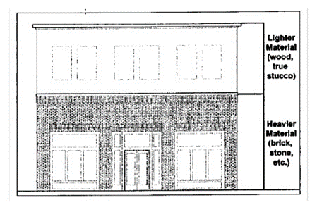
(3)
Facade material changes. As illustrated below, facade materials shall change vertically, not horizontally, with an exception allowed for major articulation required in the commercial building type, and an exception allowed for differentiation between adjacent facades required in the single-family attached residential building type.
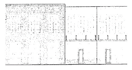
(4)
Prohibited facade materials. Concrete masonry units, glass block, aluminum siding, vinyl siding, and split-faced brick shall not be used on any facade.
(5)
Roofs. Mansard roofs are prohibited.
(6)
Roof materials.
(a)
Sloped roofs. Principal sloped roof materials shall be asphalt, fiberglass, or cedar shingles, concrete or clay tiles, slate or simulated slate, or standing seam metal.
(b)
Flat roofs. Flat roofs shall be of any material.
(c)
Gutters. Gutters on principal facades shall be copper, aluminum, or galvanized steel.
(d)
Downspouts. Downspouts shall match gutters in material and finish.
(e)
Flashing. Metal flashing, where utilized, shall be copper or factory finished sheet metal and shall be of a color that blends with other building materials.
(7)
Awnings. Awnings shall be fabrics, canvas, fixed and durable and rust-resistant metal, or similar material. Internally lit awnings and canopies that emit light through the awning or canopy material are prohibited.
(8)
Shutters. Where used, shutters shall match one-half the width of the window opening to which they are adjacent.
(9)
Windows. Except as established herein for the civic building type, windows shall be subject to the following:
(a)
Transmittance. Windows shall have a minimum light transmittance factor of 60 percent.
(b)
Reflectance. Windows shall not utilize highly reflective glazing. All glazing shall have a maximum reflectance factor of 0.20.
(c)
Coatings. Windows shall not utilize first-surface reflective coatings.
(10)
Chimneys. Chimneys shall be faced in full-depth brick or stone.
(11)
Garage facade materials. Accessory garage facade materials shall match those of the principal structure.
(B)
Commercial building type. Reflecting the traditional commercial and mixed-use buildings found along main streets throughout the region, the commercial building type applies to office, retail, and other commercial land uses, as well as buildings with a mix of commercial and residential land uses.
(1)
Major articulation. Buildings with individual principal facades over 200 feet in length shall provide a major articulation at least every 200 feet of facade length. This shall be accomplished as follows:
(a)
Facade material changes. The facade material shall change from grade to the roof; or
(b)
Facade composition changes. The facade composition shall change from grade to the roof; or
(c)
Impression of separate buildings. Changes in the storefront treatments, building setbacks, or similar features shall convey the impression of separate buildings.
(2)
Principal building facades on certain streets. For retail land uses, principal building facades fronting on the portions of the following streets within the TC town center district shall have a first floor storefront treatment along each corresponding street. For similarly located buildings without retail land uses, principal building facades shall be treated with architectural detailing, such as pilasters, false windows, or similar features where a storefront treatment is not provided.
(a)
Blythewood Road;
(b)
Main Street/Wilson Boulevard;
(c)
Langford Road;
(d)
Sandfield Road;
(e)
McNulty Road/McNulty Road Extension;
(f)
Boney Road;
(g)
Creech Road;
(h)
University Village Drive;
(i)
Community Road;
(j)
Locklier Road;
(k)
Montgomery Ridge Lane;
(l)
Blythe View Court.
(3)
Principal building facades on other streets.
(a)
Principal building facades fronting on streets other than the portions of the following streets within the TC town center district shall be treated with architectural detailing, such as pilasters, false windows, or similar features where a storefront treatment is not provided.
1.
Blythewood Road;
2.
Main Street/Wilson Boulevard;
3.
Langford Road;
4.
Sandfield Road;
5.
McNulty Road/McNulty Road Extension;
6.
Boney Road;
7.
Creech Road;
8.
University Village Drive;
9.
Community Road;
10.
Locklier Road;
11.
Montgomery Ridge Lane;
12.
Blythe View Court.
(b)
The building with individual principal facades over 100 feet in length shall incorporate wall projections or recesses a minimum of five feet in depth and a minimum of 20 contiguous feet in length per 100 feet of facade length. The combined length of the recesses and projections shall constitute more than 20 percent but less than 40 percent of the total facade length, as illustrated below.
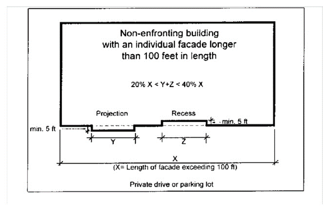
(4)
Multi-story principal building facades.
(a)
Visual divisions. Multi-story principal building facades shall provide visual divisions between the first and second floors. This shall be accomplished as follows:
1.
Storefront treatments. The first floor shall have a continuous storefront treatment; or
2.
Arcades or embayments. The first floor shall have an arcade or embayment; or
3.
Architectural features. The facade shall have architectural courses, awnings, or a change in primary facade materials.
(b)
Two-part or three-part facades. Multi-story principal building facades taller than two floors shall have two-part or three-part facades. Horizontal zones in the facade may be differentiated by a change in materials, window pattern, or window material, or by a cornice or course.
1.
Two-part facade. A two-part facade consists of a base zone (first story) and a shaft zone (all other stories), as illustrated below.
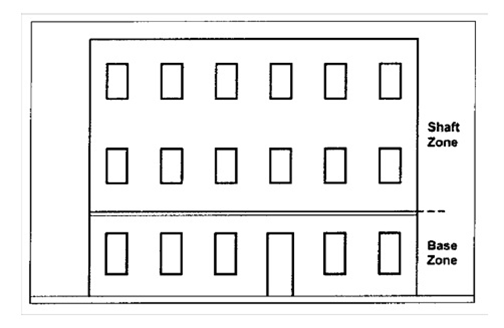
2.
Three-part facade. A three-part facade consists of a base zone (first story), a shaft zone (middle stories), and a cap zone (upper stories or cornice), as illustrated below.
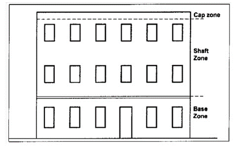
(5)
Facade materials.
(a)
Primary facade materials. Each floor of a principal building facade shall be faced with one of the following primary facade materials, in one shade or color.
1.
Full depth brick;
2.
Pre-cast concrete panels inset with thin brick with a minimum depth of 0.5 inch;
3.
Terra cotta;
4.
Natural stone, cast-stone, or pre-cast concrete resembling stone;
5.
Wooden or cementitious clapboard siding;
6.
True hard coat stucco.
(b)
Accent facade materials. The accent facade materials of each floor of a principal building facade may include any allowed primary facade material, along with ceramic tile or galvanized steel, provided:
1.
Ceramic tile or galvanized steel. Ceramic tile or galvanized steel are only permitted when the primary facade material is not wooden or cementitious clapboard siding.
2.
Total surface area. The total surface area of accent facade materials shall not exceed ten percent of the surface area of the facade of the floor on which it is located.
(6)
Foundations. Foundations shall be constructed as a distinct building element that contrasts with facade materials. Exposed above-ground foundations shall be coated or faced in cement, stucco, brick, manufactured stone, or natural stone to contrast with facade materials.
(7)
Arcades and cantilevers. The exterior wall of the first story of a building may be recessed by means of arcades or cantilevers, with the following provisions:
(a)
Support spacing. Recessed areas shall provide a minimum horizontal spacing between columns or supports of ten feet and a minimum vertical opening of 12 feet.
(b)
Depth and height. Recessed areas shall have a minimum depth of ten feet and a minimum clear height of 14 feet improved for pedestrian use.
(c)
Storefront treatment. A storefront treatment may be provided along the exterior wall adjoining the recessed area.
(8)
Roofs.
(a)
Flat roofs. Flat roofs are allowed, provided that they are vertically screened with a parapet wall along the principal building facades.
(b)
Sloped roofs. Principal sloped roofs shall have a pitch of between 8:12 and 12:12 and their eaves shall overhang between 12 and 36 inches beyond the facade, as illustrated below. This does not apply to dormers, porches, and roofs not visible from a street.
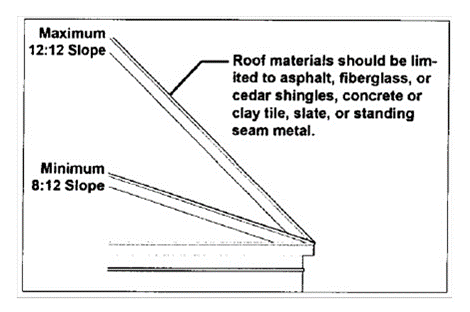
(9)
Principal building facade windows. For each principal building facade, the following window requirements apply.
(a)
Upper floor windows and doors. All floors above the first floor shall have windows and doors that equal between 20 percent and 60 percent of the total facade area, with each floor calculated independently.
(b)
Window design. Excluding first floor windows meeting the requirements of storefront treatment, all windows shall have the following design features.
1.
Window lights. Windows shall have true or simulated divided lights, or be one-over-one lights.
2.
Window aspect. Windows shall be vertically shaped with a height greater than width.
3.
Window sills. Windows shall include sills of brick, stone, cast stone, or terra cotta.
4.
Window pattern. Windows shall be arranged in a rigid or loose grid pattern.
(c)
Window frames. All window frames shall be recessed a minimum of two inches from the exterior facade.
(C)
Convenience store with gasoline sales building type. As a special type of commercial building, the convenience store with gasoline sales building type is subject to the same architectural and other design standards as in section 155.182(A) general architectural requirements, and in section 155.182(B) commercial building type, except for the following:
(1)
Minimum stories. Corner buildings at the following intersections shall have a storefront treatment along each corresponding street.
(a)
Blythewood Road and Main Street/Wilson Boulevard;
(b)
Blythewood Road and McNulty Road/McNulty Road Extension;
(c)
Blythewood Road and Boney Road;
(d)
Blythewood Road and Creech Road;
(e)
Blythewood Road and University Village Drive;
(f)
Blythewood Road and Community Road.
(2)
Accessory structures. Accessory structures such as canopies, and automobile wash or detailing shall match the architectural style and material of the principal structure, and shall be located further from the street frontages than the principal building, as illustrated below.
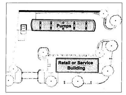
(D)
Civic building type. Civic buildings traditionally serve as the heart of the communities they represent. Since they create a collective identity, their design often sets them apart from more conventional private buildings. The civic building type applies to religious institution, museum, library, government, public safety, community center, public assembly, public and private school and college, hospital, and other civic land uses.
(1)
Facade materials.
(a)
Primary facade materials. Each floor of a principal building facade shall be faced with one of the following primary facade materials, in one shade or color.
1.
Full depth brick;
2.
Pre-cast concrete panels inset with thin brick with a minimum depth of 0.5 inch;
3.
Terra cotta;
4.
Natural stone, cast-stone, or pre-cast concrete resembling stone;
5.
Wooden or cementitious clapboard siding;
6.
True hard coat stucco
(b)
Accent facade materials. The accent facade materials of each floor of a principal building facade may include any allowed primary facade material, along with ceramic tile or galvanized steel, provided:
1.
Ceramic tile or galvanized steel. Ceramic tile or galvanized steel are only permitted when the primary facade material is not wooden or cementitious clapboard siding.
2.
Total surface area. The total surface area of accent facade materials shall not exceed ten percent of the surface area of the facade of the floor on which it is located.
(2)
Windows.
(a)
Upper floor windows and doors. All floors above the first floor shall have windows and doors that equal between 20 percent and 80 percent of the total facade area, with each floor calculated independently.
(b)
Transmittance. Windows may provide glass that is frosted, colored, or tinted such that views into the building are obstructed.
(E)
Multi-family residential building type. The multi-family residential building type reflects the traditional apartment houses or loft buildings found throughout the region. It applies to multi-family residential, retirement housing services, and rooming house land uses.
(1)
Principal building facades. No principal building facade shall exceed 200 feet in length.
(2)
Multi-story building facades.
(a)
Visual divisions. Multi-story principal building facades shall provide visual divisions between the first and second floors. The facades shall have architectural courses, awnings, or a change in primary facade materials;
(b)
Two-part or three-part facades. Buildings taller than two floors shall have two-part or three-part facades. Horizontal zones in the facade may be differentiated by a change in materials, window pattern, or window material, or by a cornice or course.
1.
Two-part facade. A two-part facade consists of a base zone (first story) and a shaft zone (all other stories), as illustrated below.
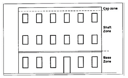
2.
Three-part facade. A three-part facade consists of a base zone (first story), a shaft zone (middle stories), and a cap zone (upper stories or cornice), as illustrated below.
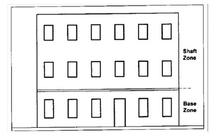
(3)
Facade materials.
(a)
Primary facade materials. Each floor of a principal building facade shall be faced with one of the following primary facade materials, in one shade or color.
1.
Full depth brick;
2.
Pre-cast concrete panels inset with thin brick with a minimum depth of 0.5 inch;
3.
Terra cotta;
4.
Natural stone, cast-stone, or pre-cast concrete resembling stone;
5.
Wooden or cementitious clapboard siding;
6.
True hard coat stucco.
(b)
Accent facade materials. The accent facade materials of each floor of a principal building facade may include any allowed primary facade material, along with ceramic tile or galvanized steel, provided:
1.
Ceramic tile or galvanized steel. Ceramic tile or galvanized steel are only permitted when the primary facade material is not wooden or cementitious clapboard siding.
2.
Total surface area. The total surface area of accent facade materials shall not exceed ten percent of the surface area of the facade of the floor on which it is located.
(4)
Foundations. Foundations shall be constructed as a distinct building element that contrasts with facade materials. Exposed above-ground foundations shall be coated or faced in cement, stucco, brick, manufactured stone, or natural stone to contrast with facade materials.
(5)
Arcades and cantilevers. Arcades and cantilevers are prohibited.
(6)
Stoops and porches. For principal building facades, a stoop or porch shall be provided for all first floor residential units as follows.
(a)
First floor elevation. The finished floor elevation of the first floor shall be raised a minimum of 24 inches above the adjacent grade, except where wheelchair access is provided at grade.
(b)
Stoops.
1.
Size and covering. Stoops shall have a minimum depth of five feet and a minimum width of five feet. Stoops may be covered or uncovered.
2.
Columns. Any columns shall be a minimum width of eight inches.
3.
Elevation. Stoops shall be raised a maximum of 48 inches above the adjacent grade.
4.
Steps. Steps shall have enclosed risers.
(c)
Porches.
1.
Size and covering. Porches shall have a minimum depth of eight feet and a minimum width of eight feet. Porches shall be covered.
2.
Elevation. Porches shall be raised a maximum of 48 inches above the adjacent grade.
3.
Columns. Columns shall be a minimum width of eight inches, with a primarily round or square shape, and a fluted or smooth finish.
4.
Steps. Steps shall have enclosed risers.
(7)
Roofs.
(a)
Flat roofs. Flat roofs are allowed, provided that they are vertically screened with a parapet wall along the principal building facades.
(b)
Sloped roofs. Principal sloped roofs shall have a pitch of between 5:12 and 12:12, and their eaves shall overhang between 12 and 36 inches beyond the facade. This does not apply to dormers, porches, and roofs not visible from a street.
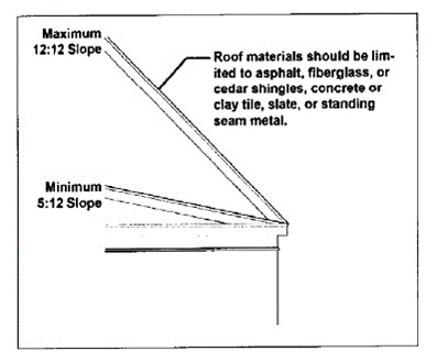
(8)
Principal building facade windows. For each principal building facade, the following window requirements apply.
(a)
Upper floor windows and doors. All floors above the first floor shall have windows and doors that equal between 20 percent and 60 percent of the total facade area, with each floor calculated independently.
(b)
Window design. All windows shall have the following design features.
1.
Window lights. Windows shall have true or simulated divided lights, or be one-over-one lights.
2.
Window aspect. Windows shall be vertically shaped with a height greater than width.
3.
Window sills. Windows shall include sills of brick, stone, cast stone, or terra cotta.
4.
Window pattern. Windows shall be arranged in a rigid or loose grid pattern.
(c)
Window frames. All window frames shall be recessed a minimum of two inches from the exterior facade.
(F)
Single-family attached residential building type. The single-family attached residential building type is subject to the same architectural and other design standards as the multi-family residential building type (see section 155.182(E)), except for the following:
(1)
Coverage. The maximum amount of land covered by an individual single-family attached residential unit, including accessory garages, shall be 2,000 square feet.
(2)
Principal building facades. Principal building facades of individual units shall have no more than four corners, excluding bay windows, stoops, or porches, as illustrated below.
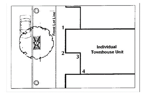
(3)
Facade differentiation. No more than three adjacent single-family attached residential units shall have the same facade design. Differentiation between adjacent facades may be accomplished by a change in facade materials, building height, color, roof form, or setbacks, provided that the appearance of separate buildings is achieved.
(G)
Building front setbacks and sidewalk facade zones.
(1)
Building facades fronting on the portions of the following streets within the TC town center district shall have minimum and maximum front setbacks according to their corresponding street cross-section, so as to establish a sidewalk facade zone within the minimum and maximum widths. These building front setbacks shall be measured from the outer edges of the future rights-of-way of the corresponding street cross-sections, where wider than the current rights-of-way, and regardless of the current physical configurations of the street cross-sections. Onsite parking areas and onsite vehicle circulation driveways shall not be located between such building facades and the street right-of-way.
(2)
For properties or developments with multiple buildings, a building located completely to the rear of a frontage building in compliance with its corresponding street cross-section does not have to meet these building front setback and sidewalk facade zone requirements, and may have onsite parking areas and onsite vehicle circulation driveways between its facade and the street right-of-way.
(3)
Building facades fronting on Blythewood Road east of the Interstate 1-77 right-of-way within the TC town center district shall have a minimum front setback of 25 feet so as to establish landscape, curb and sidewalk facade zones with the minimum widths set forth on street cross section ST 95-63 below. These building front setbacks shall be measured from the outer edges of the existing rights-of-way. Onsite parking areas and onsite vehicle circulation driveways may be located between such building facades and the street right-of-way. A building located completely to the rear of a frontage building or other building in compliance with the front set back herein prescribed does not have to meet these building front setback and sidewalk facade zone requirements, and may have onsite parking areas and onsite vehicle circulation driveways between its facade and the street right-of-way.
(a)
Blythewood Road west of Interstate 77 right-of-way (so as to exclude Blythewood Road east of the Interstate 77 right-of-way;
(b)
Main Street/Wilson Boulevard;
(c)
Langford Road;
(d)
Sandfield Road;
(e)
McNulty Road/McNulty Road Extension;
(f)
Boney Road;
(g)
Creech Road;
(h)
University Village Drive;
(i)
Community Road;
(j)
Locklier Road;
(k)
Montgomery Ridge Lane;
(l)
Blythe View Court.
(4)
Illustrated below are the corresponding street cross-sections for the TC town center district.
Street Cross-Section ST-95-63 for Blythewood Road west of the Interstate 77 right-of-way (so as to exclude Blythewood Road east of the Interstate 77 right-of-way) and Main Street/Wilson Boulevard
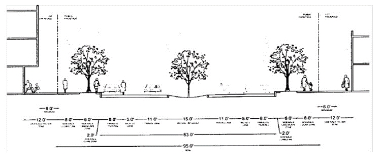
Street Cross-Section ST-74-48 for Langford Road, Sandfield Road, McNulty Road/McNulty Road Extension, Boney Road, Creech Road, University Village Drive, Community Road, Locklier Road, Montgomery Ridge Lane, and Blythe View Court
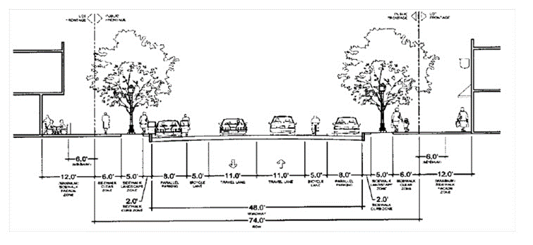
(H)
Building, driveway, and parking area placement.
(1)
Building facades fronting on the portions of the following streets within the TC town center district shall have side setbacks, driveway widths, and parking area placements as required below.
(a)
Blythewood Road;
(b)
Main Street/Wilson Boulevard;
(c)
Langford Road;
(d)
Sandfield Road;
(e)
McNulty Road/McNulty Road Extension;
(f)
Boney Road;
(g)
Creech Road;
(h)
University Village Drive;
(i)
Community Road;
(j)
Locklier Road;
(k)
Montgomery Ridge Lane;
(l)
Blythe View Court.
(2)
Building side setbacks and driveway widths. As illustrated below, the maximum side setbacks for frontage buildings shall be ten feet, for a depth of the first 40 feet back from the future or current right-of-way, whichever is wider. However, a maximum side setback of 30 feet is allowed to accommodate a two-way driveway and pedestrian walkways. For a centrally located driveway between multiple frontage buildings on the same property, a maximum separation of 30 feet is allowed to accommodate a two-way driveway and pedestrian walkways.
Building Placement with Side Driveway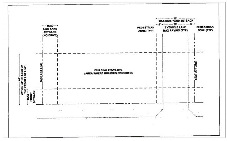
Building Placement with Central Driveway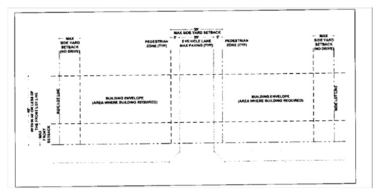
(I)
Shared driveways and interconnected parking areas. Driveways shared between adjacent parcels are encouraged, to reduce the number of driveway intersections with streets. Parking areas interconnected between adjacent parcels are also encouraged, to reduce vehicle movements on nearby streets.
(J)
Driveway spacing. As illustrated below, driveway intersections with streets shall be separated from one another by the minimum spacings, measured from near edge to near edge, in the latest edition of the South Carolina Department of Transportation access and roadside management standards.
Minimum Driveway Spacing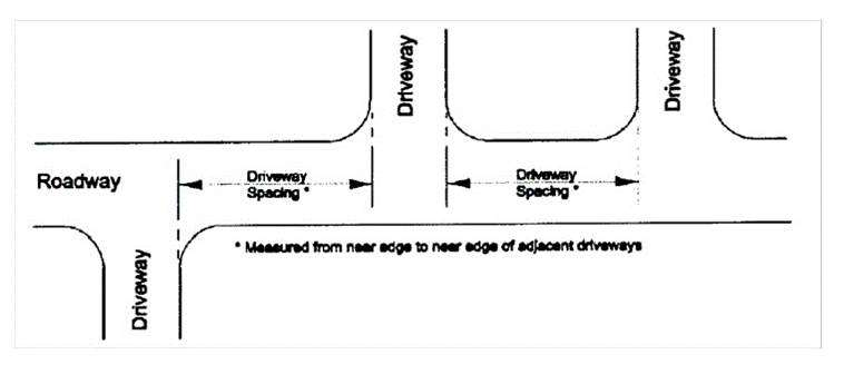
(K)
Driveway corner clearance. Driveway intersections with streets shall be separated from street intersections by the minimum corner clearances, measured from near edge to near edge, in the latest edition of the South Carolina Department of Transportation access and roadside management standards.
(L)
Pedestrian access. Accommodations for pedestrian access shall be made as follows.
(1)
Building front entrances. Each building shall include a pedestrian access connection from its front entrance to a sidewalk or an existing street right-of-way.
(2)
Pedestrian safety. Where separation of the movement of pedestrians from the movement of vehicles entering, exiting, and circulating within the site is not possible, pedestrian areas shall be delineated by special paving, grade separations, pavement marking, striping, signs, bollards, median refuge areas, traffic calming features, landscaping, lighting, or other means to enhance their safety for both daytime and nighttime use.
(3)
Accessible design. Accessibility to sites and buildings by individuals with disabilities shall be in accordance with the 2010 ADA Standards for Accessible Design, U.S. Department of Justice, September 15, 2010, which is incorporated by reference. This includes, but is not limited to, parking spaces, passenger loading zones, curb ramps, walking surfaces, gates, ramps, and building entrances.
(M)
Vehicle access, onsite circulation, and parking area design.
(1)
Backing onto public right-of-way. Vehicle access, onsite circulation, and parking area design shall enable vehicles to maneuver without backing onto a public right-of-way.
(2)
Curb cuts or driveway/street intersections. Where feasible, parcels shall have no more than one curb cut or driveway/street intersection per street frontage. A pair of one-way curb cuts or driveway/street intersections counts as one curb cut or driveway/street intersection. The use of connected rear alleys is encouraged to reduce the total number of curb cuts or driveway/street intersections.
(3)
Parking space and aisle dimensions. Onsite parking spaces for passenger vehicles shall be a minimum width of nine feet and a minimum length of 18 feet. However, spaces marked for compact vehicles may be a minimum width of eight feet and a minimum length of 16 feet. Parking area aisles for vehicle circulation shall be a minimum width of 24 feet for two-way aisles and 12 feet for one-way aisles.
(4)
Drive-through windows. Queuing of vehicles for drive-through windows shall be accommodated onsite without obstructing pedestrian movements onsite or offsite.
(5)
Truck loading spaces. Onsite space for the loading and unloading of trucks shall be provided as shown in the table below, based on the gross floor area of the structure(s) being served. A large truck loading space has a minimum overhead clearance of 14 feet, with a minimum width of 12 feet and a minimum length of 60 feet, exclusive of maneuvering room, loading dock, and the like. A small truck loading space has a minimum overhead clearance of ten feet, with a minimum width of eight feet and a minimum length of 20 feet, exclusive of maneuvering room, loading dock, and the like.
(6)
Parking ratios.
(a)
Land uses within the TC town center district shall provide the ratios of onsite, off-street parking spaces shown in the table below.
(b)
The minimum vehicle spaces requirements are intended to accommodate automobiles which would otherwise congest public streets or encroach upon the on-street parking in nearby residential neighborhoods. Truck loading spaces and parking spaces for fleet vehicles assigned to a site do not count toward the minimum vehicle spaces requirement. However, structured parking spaces, and accessible parking spaces for individuals with disabilities, do count toward the minimum vehicle spaces requirement.
(c)
The maximum vehicle spaces requirements are intended to limit the extent of surface parking; that, in turn, encourages more walking among compact land uses, reduces storm water runoff and urban heat island effects, and promotes alternative transportation. However, truck loading spaces and parking spaces for fleet vehicles assigned to a site do not count toward the maximum vehicle spaces limit. Similarly, structured parking spaces, and accessible parking spaces for individuals with disabilities, do not count toward the maximum vehicle spaces limit.
(d)
The minimum bicycle spaces requirements are intended to encourage more trips by bicycle.
(e)
For sites with a mixture of different land uses, parking spaces are calculated separately for each land use (within the table rows below) and then added together (within the table columns below). Ratios with a "sq. ft." number refer to the equivalent gross floor area. Fractional numbers of spaces shall be rounded up to the next whole number.
(N)
Fences, gates, and walls. Fence, gate, and wall materials shall be complementary to the architecture of their principal structure(s).
(1)
Fence and gate materials. Fence and gate materials shall consist of painted picket wood, vinyl, composite materials, natural or synthetic stone, black wrought iron, or prefinished aluminum. Chain link and wire fencing are prohibited where visible offsite. The finished sides of fences shall face the views from offsite.
(2)
Wall materials. Wall materials shall consist of natural or synthetic stone, cast stone, or brick.
(3)
Columns. New fences and walls shall include brick or stone columns spaced no further apart than 30 feet.
(4)
Sidewalk facade zones. Fences or walls located in sidewalk facade zones shall have a maximum height of 32 inches, or the minimum height required by the applicable building codes, whichever is greater.
(O)
Outdoor service equipment. Outdoor service equipment for buildings, such as dumpsters, trash containers, trash compactors, HVAC equipment, utility fixtures, generators, and the like shall be screened from pedestrian views by fences, walls, or landscaping. Roof-mounted equipment shall be screened from pedestrian views by parapet walls or other architectural features.
(Ord. No. 5.202, 11-24-1981; Ord. No. 5.369, 7-28-2009; Ord. No. 2012.007, 12-17-2012; Ord. No. 2015.017, 11-30-2015; Ord. No. 2017.010, 9-25-2017)
Cross reference— Penalty, see § 155.999.
Sec. 155.183. - Neighborhood office, neighborhood commercial, multi-neighborhood office, multi-neighborhood commercial, and community commercial zoning districts design standards.
The NO neighborhood office, NC neighborhood commercial, MO multi-neighborhood office, MC multi-neighborhood commercial, and CC community commercial districts are established and intended to provide a gradient of land use intensities among a broad range of commercially-oriented zones available outside the TC town center district. Like the TC town center district, these five additional commercial zoning districts are also established and intended to provide a public realm and streetscape with aesthetically pleasing architecture, landscaping, signage, lighting, utilities, and other features especially inviting to pedestrians. Accordingly, the architectural and other design standards of this section are applicable to all new land uses, new construction, and major improvements within the NO neighborhood office, NC neighborhood commercial, MO multi-neighborhood office, MC multi-neighborhood commercial, and CC community commercial districts.
(A)
Maximum stories. Buildings in the NO neighborhood office or NC neighborhood commercial districts may have a maximum of two stories. Buildings in the MO multi-neighborhood office or MC multi-neighborhood commercial districts may have a maximum of three stories. Buildings in the CC community commercial district may have a maximum of four stories.
(B)
Facade material combinations. Facade materials shall be combined only horizontally, with the lighter above the heavier, as illustrated below.
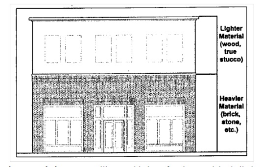
(C)
Facade material changes. As illustrated below, facade materials shall change vertically, not horizontally.
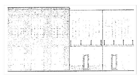
(D)
Prohibited facade materials. Concrete masonry units, glass block, aluminum siding, vinyl siding, and split-faced brick shall not be used on any facade.
(E)
Roof materials.
(1)
Sloped roofs. Principal sloped roof materials shall be asphalt, fiberglass, or cedar shingles, concrete or clay tiles, slate or simulated slate, or standing seam metal.
(2)
Flat roofs. Flat roofs shall be of any material.
(3)
Gutters. Gutters on principal facades shall be copper, aluminum, or galvanized steel.
(4)
Downspouts. Downspouts shall match gutters in material and finish.
(5)
Flashing. Metal flashing, where utilized, shall be copper or factory finished sheet metal and shall be of a color that blends with other building materials.
(F)
Awnings. Awnings shall be fabrics, canvas, fixed and durable and rust-resistant metal, or similar material. Internally lit awnings and canopies that emit light through the awning or canopy material are prohibited.
(G)
Shutters. Where used, shutters shall match one-half the width of the window opening to which they are adjacent.
(H)
Windows. Windows shall be subject to the following:
(1)
Transmittance. Windows shall have a minimum light transmittance factor of 60 percent.
(2)
Reflectance. Windows shall not utilize highly reflective glazing. All glazing shall have a maximum reflectance factor of 0.20.
(3)
Coatings. Windows shall not utilize first-surface reflective coatings.
(I)
Chimneys. Chimneys shall be faced in full-depth brick or stone.
(J)
Garage facade materials. Accessory garage facade materials shall match those of the principal structure.
(K)
Building front setback. In order to accommodate parking at the rear of the building and to encourage pedestrian access, front setbacks shall be a maximum of 25 feet.
(L)
Building side setbacks and rear setbacks. Minimum side setbacks for principal and accessory buildings and structures shall be ten feet. Minimum rear setbacks for principal and accessory buildings and structures shall be ten feet.
(M)
Parking area placement. Onsite parking areas and onsite vehicle circulation driveways shall not be located between a building and a street right-of-way. However, for properties or developments with multiple buildings, a building located completely to the rear of a frontage building may have onsite parking areas and onsite vehicle circulation driveways between its facade and the street right-of-way.
(N)
Shared driveways and interconnected parking areas. Driveways shared between adjacent parcels are encouraged, to reduce the number of driveway intersections with streets. Parking areas interconnected between adjacent parcels are also encouraged, to reduce vehicle movements on nearby streets.
(O)
Driveway spacing. As illustrated below, driveway intersections with streets shall be separated from one another by the minimum spacings, measured from near edge to near edge, in the latest edition of the South Carolina Department of Transportation access and roadside management standards.
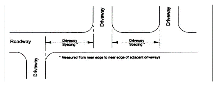
Minimum Driveway Spacing
(P)
Driveway corner clearance. Driveway intersections with streets shall be separated from street intersections by the minimum corner clearances, measured from near edge to near edge, in the latest edition of the South Carolina Department of Transportation access and roadside management standards.
(Q)
Pedestrian access. Accommodations for pedestrian access shall be made as follows.
(1)
Building front entrances. Each building shall include a pedestrian access connection from its front entrance to a sidewalk or an existing street right-of-way.
(2)
Pedestrian safety. Where separation of the movement of pedestrians from the movement of vehicles entering, exiting, and circulating within the site is not possible, pedestrian areas shall be delineated by special paving, grade separations, pavement marking, striping, signs, bollards, median refuge areas, traffic calming features, landscaping, lighting, or other means to enhance their safety for both daytime and nighttime use.
(3)
Accessible design. Accessibility to sites and buildings by individuals with disabilities shall be in accordance with the 2010 ADA Standards for Accessible Design, U.S. Department of Justice, September 15, 2010, which is incorporated by reference. This includes, but is not limited to, parking spaces, passenger loading zones, curb ramps, walking surfaces, gates, ramps, and building entrances.
(R)
Vehicle access, onsite circulation, and parking area design.
(1)
Backing onto public right-of-way. Vehicle access, onsite circulation, and parking area design shall enable vehicles to maneuver without backing onto a public right-of-way.
(2)
Curb cuts or driveway/street intersections. Where feasible, parcels shall have no more than one curb cut or driveway/street intersection per street frontage. A pair of one-way curb cuts or driveway/street intersections counts as one curb cut or driveway/street intersection. The use of connected rear alleys is encouraged to reduce the total number of curb cuts or driveway/street intersections.
(3)
Parking space and aisle dimensions. Onsite parking spaces for passenger vehicles shall be a minimum width of nine feet and a minimum length of 18 feet. However, spaces marked for compact vehicles may be a minimum width of eight feet and a minimum length of 16 feet. Parking area aisles for vehicle circulation shall be a minimum width of 24 feet for two-way aisles and 12 feet for one-way aisles.
(4)
Drive-through windows. Queuing of vehicles for drive-through windows shall be accommodated onsite without obstructing pedestrian movements onsite or offsite.
(5)
Truck loading spaces. Onsite space for the loading and unloading of trucks shall be provided as shown in the table below, based on the gross floor area of the structure(s) being served. A large truck loading space has a minimum overhead clearance of 14 feet, with a minimum width of 12 feet and a minimum length of 60 feet, exclusive of maneuvering room, loading dock, and the like. A small truck loading space has a minimum overhead clearance of ten feet, with a minimum width of eight feet and a minimum length of 20 feet, exclusive of maneuvering room, loading dock, and the like.
(6)
Parking ratios.
(a)
Land uses within the NO neighborhood office, NC neighborhood commercial, MO multi-neighborhood office, MC multi-neighborhood commercial, and CC community commercial districts, shall provide the ratios of onsite, off-street parking spaces shown in the table below.
(b)
The minimum vehicle spaces requirements are intended to accommodate automobiles which would otherwise congest public streets or encroach upon the on-street parking in nearby residential neighborhoods. Truck loading spaces and parking spaces for fleet vehicles assigned to a site do not count toward the minimum vehicle spaces requirement. However, structured parking spaces, and accessible parking spaces for individuals with disabilities, do count toward the minimum vehicle spaces requirement.
(c)
The maximum vehicle spaces requirements are intended to limit the extent of surface parking; that, in turn, encourages more walking among compact land uses, reduces storm water runoff and urban heat island effects, and promotes alternative transportation. However, truck loading spaces and parking spaces for fleet vehicles assigned to a site do not count toward the maximum vehicle spaces limit. Similarly, structured parking spaces, and accessible parking spaces for individuals with disabilities, do not count toward the maximum vehicle spaces limit.
(d)
The minimum bicycle spaces requirements are intended to encourage more trips by bicycle.
(e)
For sites with a mixture of different land uses, parking spaces are calculated separately for each land use (within the table rows below) and then added together (within the table columns below). Ratios with a "sq. ft." number refer to the equivalent gross floor area. Fractional numbers of spaces shall be rounded up to the next whole number.
(S)
Fences, gates, and walls. Fence, gate, and wall materials shall be complementary to the architecture of their principal structure(s).
(1)
Fence and gate materials. Fence and gate materials shall consist of painted picket wood, vinyl, composite materials, natural or synthetic stone, black wrought iron, or prefinished aluminum. Chain link and wire fencing are prohibited where visible offsite. The finished sides of fences shall face the views from offsite.
(2)
Wall materials. Wall materials shall consist of natural or synthetic stone, cast stone, or brick.
(3)
Columns. New fences and walls shall include brick or stone columns spaced no further apart than 30 feet.
(T)
Outdoor service equipment. Outdoor service equipment for buildings, such as dumpsters, trash containers, trash compactors, HVAC equipment, utility fixtures, generators, and the like shall be screened from pedestrian views by fences, walls, or landscaping. Roof-mounted equipment shall be screened from pedestrian views by parapet walls or other architectural features.
(Ord. No. 5.202, 11-24-1981; Ord. No. 5.369, 7-28-2009; Ord. No. 2012.007, 12-17-2012; Ord. No. 2021.014, § 1, 11-1-2021)
Cross reference— Penalty, see § 155.999.