
Brookhaven City Zoning Code
ARTICLE V
- OVERLAY DISTRICTS
Sec. 27-368. - Purpose and intent.
As the name implies, overlay zoning districts "overlay" applicable base zoning district classifications to alter some or all of the base zoning regulations that apply to particular sites. Overlay districts work to modify or supplement the regulations imposed by base zoning district when necessary to address special situations or accomplish specific objectives. Overlay zoning is intended to be used when the base zoning applied to an area remains generally appropriate, but when an additional, modified or eliminated requirement could help implement the city's planning goals or address an area-specific planning, design or land use regulation issue.
(Ord. No. RZ-2018-11-06, § I, Exh. A(27.58), 11-27-2018)
Sec. 27-369. - Interpretation.
(a)
All applicable regulations of the underlying base zoning district apply to property in an overlay district unless otherwise expressly stated in the overlay district regulations.
(b)
When overlay regulations conflict with regulations that otherwise apply in the underlying base zoning district, the regulations of the applicable overlay govern. If property is classified in multiple overlay districts and the regulations of one overlay district conflict with the regulations of another overlay district, the more restrictive regulation governs.
(Ord. No. RZ-2018-11-06, § I, Exh. A(27.59), 11-27-2018)
Sec. 27-370. - Procedure.
The boundaries of overlay zoning districts shall be shown on the official zoning map. The following procedures apply to the establishment, amendment or termination of all overlay districts unless otherwise expressly stated.
(1)
Overlay district regulations shall be established, amended or terminated in accordance with the zoning ordinance text amendment procedures of article 10, division 2 of this chapter.
(2)
Except as otherwise expressly stated, zoning map amendments establishing, expanding or reducing the boundaries of an overlay district or terminating all or part of an overlay district shall be processed in accordance with the zoning map amendment procedures of article 10, division 2 of this chapter.
(Ord. No. RZ-2018-11-06, § I, Exh. A(27.60), 11-27-2018)
Sec. 27-381. - Scope.
This division establishes special regulations governing lots located within the boundaries of the /BHO (Buford Highway Overlay) district.
(Ord. No. RZ-2018-11-06, § I, Exh. A(27.61), 11-27-2018)
Sec. 27-382. - Purpose and intent.
The purpose and intent of the /BHO district is to:
(1)
Implement the policies and objectives of the comprehensive plan, the Peachtree Creek Greenway Master Plan and other adopted plans and studies for the Buford Highway area;
(2)
Provide for connectivity of streets and communities, thereby promoting walkability, reducing dependence on automobile use and increasing ease of movement and opportunities for alternative modes of travel;
(3)
Promote the provision of workforce housing; and
(4)
Facilitate redevelopment of the area.
(Ord. No. RZ-2018-11-06, § I, Exh. A(27.62), 11-27-2018)
Sec. 27-383. - Applicability.
The /BHO district regulations apply to all building and development activities within the overlay district boundaries that meet one or more of the following criteria:
(1)
Require issuance of a land disturbance permit;
(2)
Create a new driveway on a public street;
(3)
Add eight or more off-street vehicle parking spaces on the subject site;
(4)
Result in structural improvements to existing buildings that exceed 25 percent of the county tax assessor's total assessed value of the existing improvements on the subject property, including the value of all structural improvements added over the previous 12-month period;
(5)
Add new principal buildings or additions to existing principal buildings that increase the floor area of on the subject site by more than ten percent, including the total gross floor area added over the previous 12-month period; or
(6)
A change in use or method of operation that results in a 20 percent or greater increase in traffic generation potential (from current use to proposed use), based on average daily and peak-hour traffic generation data published by the Institute of Transportation Engineers (ITE).
(Ord. No. RZ-2018-11-06, § I, Exh. A(27.63), 11-27-2018)
Sec. 27-384. - Streets.
(a)
Public and private streets shall comply with the requirements or public streets found in chapter 14 and other applicable sections of the city code.
(b)
All new streets shall connect at least two public streets or provide a temporary street stub that will allow for a future connection between at least two public streets. This provision is not intended to require or prohibit connections to streets that are located entirely outside the boundaries of the Buford Highway Overlay district.
(c)
When blocks are subdivided by new streets, the maximum perimeter length of resulting new blocks may not exceed 2,000 linear feet, measured from street centerline to street centerline.
(d)
The maximum allowed curb radius at any intersection or curb cut is 20 feet.
(e)
New curb cuts are prohibited on Buford Highway, Druid Hills Road or Briarcliff Road if the subject lot has access to another (non-primary) street. On lots without access to a non-primary street, a maximum of one curb cut is allowed from the abutting primary street, provided that lots with more than 700 linear feet of frontage on a primary street are allowed a maximum of one curb cut per 700 linear feet of primary street frontage, or fraction thereof.
(f)
Lots with access solely to a non-primary street are allowed a maximum of two curb cuts on such street. Lots with access to more than one non-primary street are allowed a maximum of one curb cut per street.
(g)
Curb cuts may not exceed 24 feet in width. The community development director is authorized to approve an administrative variance to allow greater width curb cuts when greater driveway widths are required by the fire marshal.
(h)
Access driveways shall be perpendicular to the abutting street. Circular and non-perpendicular access driveways are prohibited.
(i)
Gates and security arms may not cross or encroach upon any public street or sidewalk.
(j)
The following provisions apply to lots that abut a right-of-way controlled by the State of Georgia:
(1)
All improvements within the right-of-way and the location and design of any street or driveway providing access to the right-of-way shall comply with of the Georgia Department of Transportation requirements; and
(2)
An approved permit for proposed access or improvements is required from the Georgia Department of Transportation and shall be incorporated into the construction drawings for the project before the issuance of a land disturbance permit.
(Ord. No. RZ-2018-11-06, § I, Exh. A(27.64), 11-27-2018)
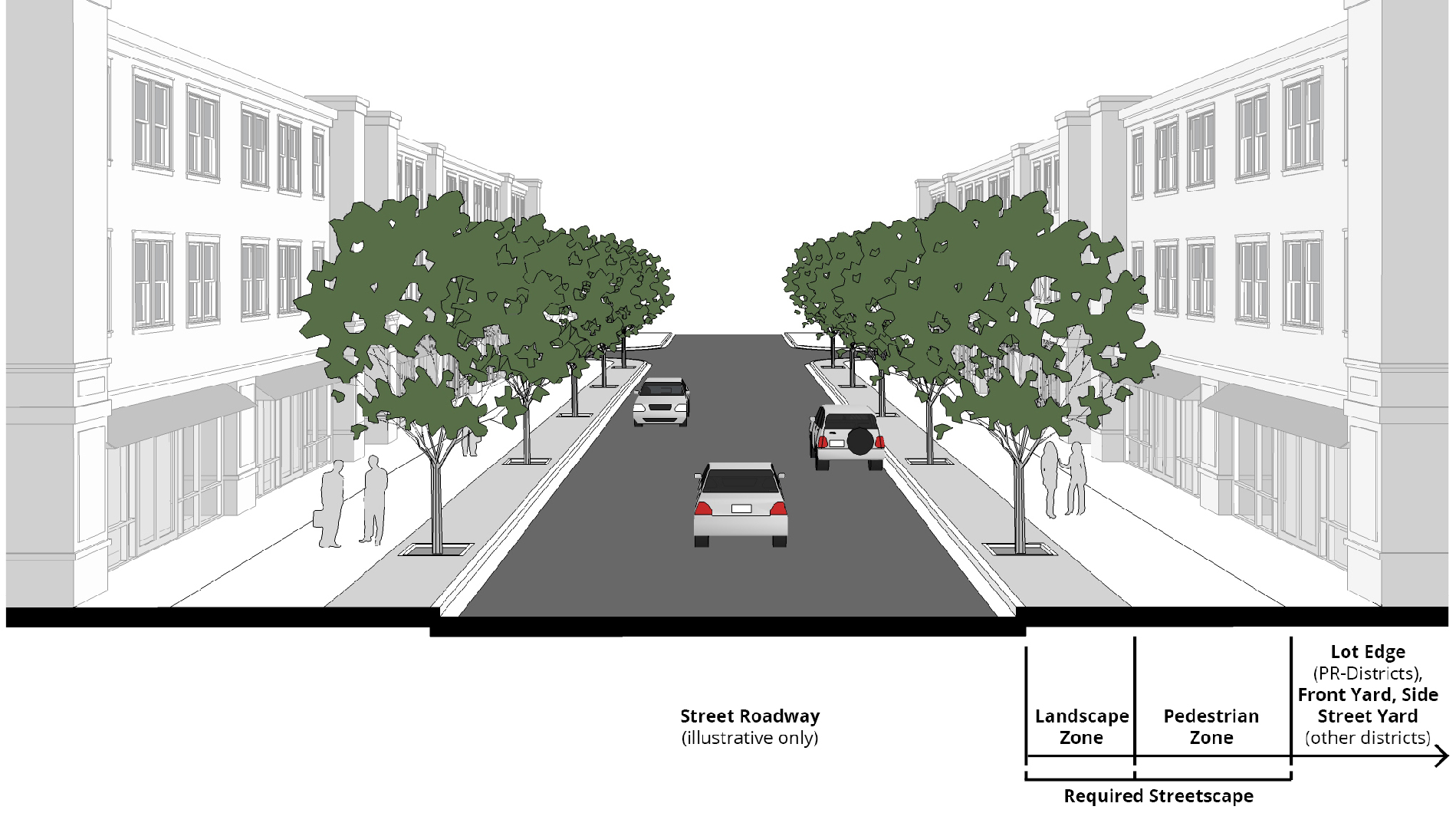
Sec. 27-385. - Streetscapes.
(a)
Streetscape improvements, multi-use trails and other pedestrian facilities shall be provided along all street frontages within the boundaries of the /BHO district in accordance with the regulations of this section. All bicycle and pedestrian facilities shall comply with the most recent version of the Bicycle, Pedestrian and Trail Plan.
(b)
Streetscapes shall consist of two parts: a landscape zone and a pedestrian zone.
(1)
The landscape zone starts at the back of the curb and extends inward (toward the lot) for the minimum distance and no more than the maximum distance indicated in table 5-1. This area is generally intended to accommodate trees, plants, street furniture, lights, trash receptacles and similar streetscape elements.
(2)
The pedestrian zone starts at the inner edge of the landscape zone and extends inward (toward the lot) for the minimum distance and no more than the maximum distance indicated in table 5-1. This area, typically referred to as the "sidewalk," is intended exclusively to accommodate unimpeded pedestrian movement. The pedestrian zone may also be used to accommodate multi-use trails when the zone is at least ten feet in width.
(c)
The minimum width of required streetscapes varies by street type, in accordance with table 5-1.
(d)
On existing streets with insufficient right-of-way width to accommodate the required streetscape elements, the right-of-way needed to accommodate the required streetscape elements may be expanded by mutual agreement between the owner of the abutting property and the entity controlling the subject right-of-way, or a public access easement may be provided to the city to accommodate the required streetscape elements.
(e)
Landscape zones.
(1)
Overstory trees shall be planted in all landscape zones spaced at a maximum distance of 30 feet on center or as approved by the city arborist.
(2)
New overstory trees shall be a minimum of three and one-half inches in caliper measured 12 inches above ground, shall be a minimum of 16 feet in height, shall have a minimum mature height of 30 feet and shall be limbed up to a minimum height of eight feet.
(3)
Overstory trees shall have a minimum planting area of four feet by eight feet. Tree planting areas shall provide porous drainage systems that allow for drainage of the planting area.
(4)
Overstory tree species shall be consistent for the entire length of the subject block face. Species are permitted to change on individual block faces only in cases of limited supply and/or concerns regarding disease or the health of existing and proposed trees. Such changes require review and approval by the community development director, after consultation with a certified arborist.
(5)
All planting and plant removal activity within required landscape zones, other than routine maintenance, requires review and approval by the community development director.
(6)
Street lights shall be located within the landscape zone spaced at a maximum distance of 60 feet on center on the following streets: Buford Highway, North Druid Hills Rd., Briarcliff Rd., Clairmont Rd., Briarwood Rd. and Cliff Valley Way.
(7)
Benches, trash receptacles, and bike racks shall be placed within the landscape zone on the following streets: Buford Highway, North Druid Hills Road, Briarcliff Road, Clairmont Road, Briarwood Road and Cliff Valley Way. Such features shall be provided at a ratio of not less than one bench, one trash receptacle, and one bike rack per 300 feet of street frontage, or portion thereof. Bike racks provided to meet this requirement may be counted towards satisfying bicycle parking requirements of this chapter. These streetscape elements may incorporate functional art and should include trash recycle containers similar to BigBelly that can incorporate art and graphic displays while contributing to the City's sustainability goals. Developers shall work collaboratively with the community development director or their designee and the ACC which will provide assistance and guidance regarding appropriate elements and which can offer a list of artists and others who are available for collaboration on art elements. This process shall run concurrently with the standard permitting process.
(8)
Landscape zones shall be planted with grass, ground cover or flowering plants, or consist of brick pavers, concrete pavers, or granite pavers where on-street parking is provided or pedestrian crossing and/or congregation is likely. Applicants are encouraged to incorporate green design considerations and eco-art into landscaping and drainage designs wherever possible. Many times, these requirements add only insignificant cost to a project as they simply require looking at standard engineering and landscape design through a design/art lens.
(f)
Pedestrian zones.
(1)
Pedestrian zones shall be paved in concrete and kept clear and unobstructed for the safe and convenient use of pedestrians. For all internal (privately-owned) sidewalk paving, the ACC and the community development director or designee shall work with the developer to provide assistance for incorporating arts elements such as sidewalk poetry or artwork that may be incorporated into final installations. This assistance can include:
a.
Offering design suggestions and best practices information.
b.
Providing an open source list of local artists, artisans, and fabricators who may be engaged by the developer to meet these requirements.
c.
Reviewing developer concepts to offer feedback and guidance.
d.
Coordination with other city departments that may have jurisdiction to ensure that all requirements are in alignment and do not delay the permitting process.
(2)
All sidewalk paving materials shall be continued across any intervening driveway at the same prevailing grade and cross slope as on the adjacent pedestrian zone area.
(3)
Pedestrian zones paved with materials other than concrete may be allowed with the approval of the community development director.
(4)
When newly constructed sidewalks abut existing adjacent sidewalks located within the boundaries of the /BHO district, the newly constructed sidewalk shall provide safe facilitation of pedestrian traffic flow to adjacent sidewalks. When newly constructed sidewalks abut existing adjacent sidewalks that are not located within the boundaries of the /BHO district, the newly constructed sidewalk shall provide safe facilitation of pedestrian traffic flow to adjacent sidewalks by tapering to match the width of the existing sidewalks, except if no adjacent sidewalk exists, the new sidewalk shall taper to match the widths identified in section 14-677 of the city code. Any development that disturbs existing sidewalks on an adjacent property shall replace disturbed areas to their pre-disturbance state and condition.
(5)
Safe and convenient pedestrian pathways shall be provided from sidewalks along streets to each publicly accessible building entrance, including pedestrian access routes to parking decks and through parking lots and between adjacent buildings within the same development. All such pathways shall be paved, with a minimum width of three feet or the width required by the underlying zoning district or ADA accessibility criteria, whichever width is greater.
(Ord. No. RZ-2018-11-06, § I, Exh. A(27.65), 11-27-2018; Ord. No. 2019-05-03, § I(Attch.), 5-28-2019; Ord. No. 2022-05-03, § I, 5-24-2022; Ord. No. RZ-2022-12-03, § I, 12-13-2022)
Sec. 27-386. - Workforce housing incentives.
(a)
Developers shall be entitled (as of right) to one additional story of building height for each ten percent of workforce housing units provided in excess of any applicable mandatory minimum requirements. Bonus height may exceed the maximum applicable building height limit of the underlying zoning district but may not exceed the maximum height limits established pursuant to section 27-388.
(b)
The planning commission is authorized to recommend and the city council is authorized to approve other incentives to projects that exceed applicable mandatory minimums, including fee waivers, expedited permitting and financial assistance.
(Ord. No. RZ-2018-11-06, § I, Exh. A(27.66), 11-27-2018)
Sec. 27-387. - Peachtree Creek Greenway.
(a)
The provisions of this section are intended to protect and enhance the Peachtree Creek Greenway, which is a major public investment and recreational amenity within the Buford Highway area.
(b)
Service, loading and outdoor storage areas on lots abutting the Peachtree Creek Greenway shall be screened in accordance with section 27-928. The screening required from R-zoned lots and public rights-of-way shall also be provided from the Greenway trail. Walls, fences and landscape screens may have breaks or openings to allow for access to the greenway trail.
(c)
New development is encouraged to have PCG facing uses and to provide connections to existing access points to the greenway. Public art and signage are encouraged in areas that abut or face the PCG.
(Ord. No. RZ-2018-11-06, § I, Exh. A(27.67), 11-27-2018; Ord. No. 2022-05-03, § I, 5-24-2022)
Sec. 27-388. - Building heights and density.
(a)
Hospitals, medical office and health service buildings, general office and hotels on O-I, OCR, M or X-zoned lots located south of I-85 within the boundaries of the /BHO district may be up to 20 stories in height. Residential buildings on O-I, OCR, or X-zoned lots located south of I-85 within the boundaries of the /BHO district may be up to eight stories in height. Parking decks accessory to such uses may not exceed eight stories in height. All other buildings are subject to the regulations of subsection (b) of this section.
(b)
To help implement the development intensities recommended in the Buford Highway Corridor Character Area of the comprehensive plan, buildings on properties within the /BHO district may exceed the maximum applicable building height limit of the underlying zoning district if approved through the special land use permit procedures of article 10, division 3 of this chapter. This provision does not apply to the buildings and uses specified in subsection (a) of this section.
(c)
To help implement the development intensities recommended in the Buford Highway Corridor Character Area of the comprehensive plan, residential and mixed-use buildings on properties within the /BHO district may exceed the maximum applicable density limit of the underlying zoning district if approved through the special and use permit procedures of article 10, division 3 of this chapter.
(Ord. No. RZ-2018-11-06, § I, Exh. A(27.68), 11-27-2018; Ord. No. 2019-05-03, § I(Attch.), 5-28-2019; Ord. No. 2019-07-01, I(Attch.), 7-23-2019)
Sec. 27-389. - Utilities.
(a)
Purpose and intent. It is the intent and purpose of this section to promote, protect, and improve the health, safety and welfare of the citizens as well as the aesthetics and quality of life of the City of Brookhaven by the establishment, herein, of standards and procedures for burying of existing overhead utilities as new developments are constructed and where significant redevelopment occurs. This section, therefore, establishes minimum requirements for placement of overhead utilities underground. While there are considerations to balance difficulties of urban development with the desires of the city, where questions of intent arise the purpose of this section is to ensure that said utilities are in fact buried in the majority of instances.
(b)
Applicability. Utilities, including telephone, electric power, and cable television in both public and private rights-of-way, shall be placed underground for all new developments with total floor areas exceeding 10,000 gross square feet, except when extreme conditions of underlying rock or other conditions prevent this requirement from being met or as provided in paragraph (b) below, and only as approved by the director.
(c)
Exceptions. The following exceptions shall apply to this section:
(1)
Underground utilities shall not be required for developments with total floor areas of 10,000 gross square feet or less.
(2)
Transmission and main lines shall not be required to be placed underground.
(3)
Accessory mechanical systems and features such as electric distribution, transformers, switchgear, meter pedestals, telephone pedestals, terminals and other similar equipment, which is normally installed above ground in accordance with accepted utility practices for underground distribution systems may be installed.
(4)
Meters, service connections, and similar equipment normally attached to the outside wall of the premises it serves may be installed.
(5)
Overhead utility services for existing developments in place as of the effective date of this section may be repaired, replaced or increased in capacity.
(6)
Temporary overhead facilities required for construction purposes will be permitted.
(d)
Utility conversion fund. A city fund, known as the "The City of Brookhaven Utility Conversion Fund" is hereby created. The purpose of said fund is to accept deposits as described in paragraph (d) below, along with other funds or grants apportioned by the mayor and city council, and the use of such funds shall be restricted for the sole purpose of offsetting the cost of projects undertaken by the city to bury or relocate power lines from streets and sidewalks.
(e)
Fee-in-lieu. In cases where the expense to bury overhead utilities for new developments described in paragraph (a), above, is deemed to be unreasonably costly due to the complexity of the work, the developer may request approval from the director of a fee-in-lieu arrangement, whereby the developer shall make a contribution toward the City's Utility Conversion Fund in lieu of requiring burial of the utilities. Such fee-in-lieu arrangement shall be based on a cost per linear foot of such underground relocation of utilities established by the mayor and city council, as may be adjusted from time to time by city ordinance.
(f)
Accessory mechanical systems and features. Accessory mechanical systems, including utility meters, boxes, HVAC units, and other similar equipment shall not be located between the building and a public or private right-of-way. Efforts shall be taken to locate accessory mechanical system features including utility meters, boxes and other similar equipment so as to not be visible from the public or private right-of-way. When this is not possible or satisfied, as determined by the director, the following screening shall be required:
(1)
Roof-mounted systems. Roof-mounted systems shall be screened with an opaque wall constructed of materials similar to the primary building.
(2)
All other systems. Systems mounted on walls, ground, or elsewhere, shall be screened with an opaque wall constructed of materials similar to the primary building or sufficient landscaping to provide year-round screening.
(g)
Waiver of utility provisions.
(1)
The director may waive one or more of the requirements of this article, provided that the director makes the following findings with respect to the utility service to which the waiver pertains:
a.
That the property owner seeking the waiver has submitted justification of the waiver in writing;
b.
That two or more of the following criteria are met:
1.
The city arborist has determined that the new or expanded utility service, if placed underground, would endanger an existing specimen tree by damaging its root system;
2.
The new or expanded utility service, if placed overhead, would not be visible from a public or private street or any other public or private right-of-way;
3.
The new or expanded overhead utility service, if placed underground, would significantly interfere with one or more existing city or private underground utilities;
4.
If the waiver is granted, there would be a reduction in the total number of overhead utility service lines serving the owner's property;
5.
If the waiver is granted, the length of the overhead utility service to the owner's property would be less than the length of the service in existence at the time the application is made;
6.
The new, extended or relocated service or facility is required to provide additional street lighting to suppress criminal activity and that the waiver is requested or supported by the chief of police; and
7.
The new, extended or relocated service or facility would require boring under a state route and is restricted by the Georgia Department of Transportation.
(2)
Any property owner whose application for a waiver under this section has been denied by the director may appeal the director's decision to the city council. Any such appeal must be filed within 30 days of the director's denial. City council shall conduct a public hearing on any such appeal. In deciding the appeal, council shall determine whether good cause exists to grant the requested waiver; provided, that, in making this determination, council shall, in conjunction with an appeal involving a utility service, consider the decision factors set out above.
(Ord. No. RZ-2018-11-06, § I, Exh. A(27.69), 11-27-2018; Ord. No. 2020-10-08, § I(attch.), 10-27-2020)
Sec. 27-390. - Open space.
(a)
Applicability. On-site open space shall be provided for development sites within the /BHO district except for those:
(1)
Developed exclusively with single-family detached dwellings; and
(2)
Sites located south of I-85.
(b)
Minimum open space ratio. The minimum amount of on-site open space required is based on the size of the lot on which the use is located, as follows:
(1)
On development sites with an area of less than one acre, at least ten percent of the development site shall be open space; and
(2)
On development sites with an area of one acre or more, at least 15 percent of the development site shall be open space.
(c)
General regulations. The general regulations of this subsection apply to open space provided to meet minimum open space ratios.
(1)
Areas counted to meet the open space regulations of this section (section 27-390) shall be provided in the form of amenity spaces, plazas, pocket parks or parks that comply with the applicable regulations of this section. Street rights-of-way, parking lots, outdoor dining areas, transition buffers, landscape strips and other areas that do not comply with applicable open space regulations may not be counted toward satisfying open space ratios.
(2)
No buildings may be located in open spaces unless expressly stated in this section.
(3)
Unless otherwise expressly stated in this section, open spaces shall be open to general public access during daylight hours and shall be directly accessible from a public sidewalk.
(4)
Open spaces shall be at-grade, unless otherwise expressly stated in this section.
(5)
No individual open space may traverse a street or rail right-of-way unless located on a bridge over such right-of-way that conforms to the minimum dimensional requirements of the subject open space type.
(6)
When a building or individual ground-story commercial establishment adjoins an open space, pedestrian access (both ingress and egress), operable to residents or customers, shall be provided.
(7)
Stormwater management practices, such as normally dry storage and retention facilities or ponds that retain water, may be integrated into open spaces, subject to the following:
a.
Stormwater features in open space shall be designed by a qualified professional as formal or natural amenities with additional uses other than stormwater management, such as an amphitheater, sports field, or a pond or pool as part of the landscape design. It is strongly encouraged to consider eco-art landscape design principles for the design of these features.
b.
Stormwater features may not be fenced or enclosed by retaining walls over 30 inches in height.
(8)
Trees used to satisfy minimum open space requirements shall:
a.
Be at least three and one-half inches in caliper size (measured 12 inches above the ground);
b.
Be at least 16 feet in height at time of planting, with a minimum mature height of 30 feet;
c.
Be spaced at least 25 feet on-center; and
d.
Limbed up to a height of at least eight feet.
(9)
All open space requirements shall be fully met before issuance of a certificate of occupancy for the development.
(10)
Covenants or other legal arrangements shall specify ownership of all open spaces, the method of and responsibility for maintenance, taxes and insurance, compulsory membership and assessment provisions, and shall be incorporated into legal instruments sufficient to ensure that the open space requirements of this section are maintained. Such arrangements shall be in a form approved by the city attorney.
(d)
Open space types.
(1)
Amenity space. The amenity space open space type is intended to provide small covered or uncovered, unenclosed, outdoor areas. Amenity spaces are limited to at-grade hardscape or landscape areas improved for pedestrian enjoyment; rooftop decks; patios and porches; balconies; or yards, lawns, and gardens. Interior or exterior stairs or elevators may provide access to rooftop decks, patios, porches, and balconies. They are further subject to compliance with the criteria of table 5-2.
| TABLE 5-2 — AMENITY SPACE CRITERIA | ||
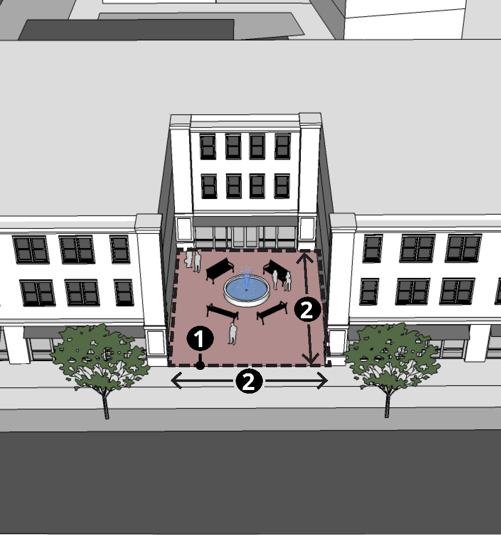 | ||
| Criteria/Requirements | ||
| Minimum Area (sq. ft.) | 100 | |
| Maximum Area (sq. ft.) | 4,356 | |
| Minimum Dimension (ft.) | 10 | |
| Min. Perimeter Length (% of open space perimeter) | ||
| Abutting Public Streets | None | |
| Abutting Buildings or Public Streets | None | |
| Maximum Coverage (% of open space area) | ||
| Impervious Surfaces | 100 | |
| Water Feature or Stormwater Features | 50 | |
| Minimum Tree Planting (or Preservation) | ||
| Minimum Seating | None | |
(2)
Plaza. The plaza open space type is intended to provide an open space, available for civic purposes and commercial activities. A plaza shall be spatially defined by buildings or streets at its edges. Plazas are subject to the regulations of table 5-3.
| TABLE 5-3 — PLAZA CRITERIA | ||
 | ||
| Criteria/Requirements | ||
| Minimum Area (sq. ft.) | 4,356 | |
| Maximum Area (sq. ft.) | 43,560 | |
| Minimum Dimension (ft.) | 60 | |
| Min. Perimeter Length (% of open space perimeter) | ||
| Abutting Public Streets | 25 | |
| Abutting Buildings or Public Streets | 75 | |
| Maximum Coverage (% of open space area) | ||
| Impervious Surfaces | 30 | |
| Water Feature or Stormwater Features | 50 | |
| Minimum Number of Trees (per 10,000 sq. ft.) | 4 | |
| Minimum Seating (per 1,000 sq. ft.) | 4 | |
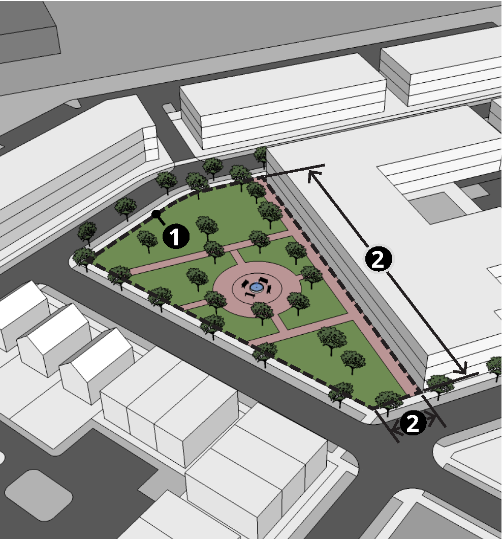
(3)
Pocket park. The pocket park open space type is intended to provide an open space for unstructured recreation. A pocket park may be spatially defined by buildings or streets at its edges. Pocket parks are subject to the regulations of table 5-4.
| TABLE 5-4 — POCKET PARK CRITERIA | ||
 | ||
| Criteria/Requirements | ||
| Minimum Area (sq. ft.) | 4,356 | |
| Maximum Area (sq. ft.) | 21,780 | |
| Minimum Dimension (ft.) | 60 | |
| Min. Perimeter Length (% of open space perimeter) | ||
| Abutting Public Streets | 25 | |
| Abutting Buildings or Public Streets | 50 | |
| Maximum Coverage (% of open space area) | ||
| Impervious Surfaces | 25 | |
| Water Feature or Stormwater Features | 30 | |
| Minimum Number of Trees (per 10,000 sq. ft.) | 4 | |
| Minimum Seating (per 1,000 sq. ft.) | 4 | |
(4)
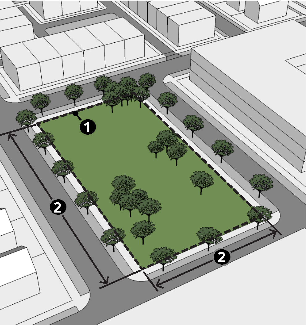
Park. The park open space type is intended to provide an open space available for structured or unstructured recreation. A park may be independent of surrounding buildings at its edges. Parks are subject to the regulations of table 5-5.
| TABLE 5-5 — PARK CRITERIA | ||
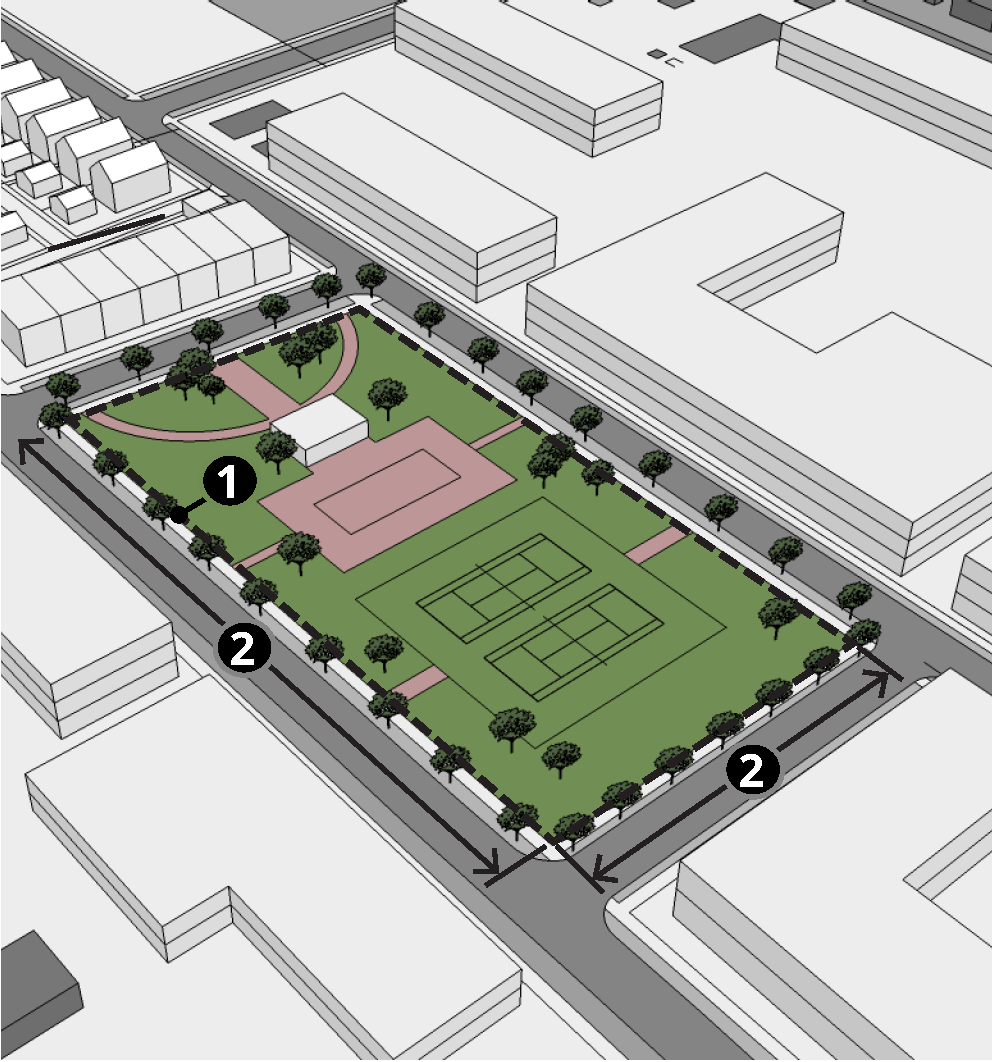 | ||
| Criteria/Requirements | ||
| Minimum Area (sq. ft.) | 21,780 | |
| Maximum Area (sq. ft.) | None | |
| Minimum Dimension (ft.) | 80 | |
| Min. Perimeter Length (% of open space perimeter) | ||
| Abutting Public Streets | 25 | |
| Abutting Buildings or Public Streets | None | |
| Maximum Coverage (% of open space area) | ||
| Impervious Surfaces | 25 | |
| Water Feature or Stormwater Features | 30 | |
| Minimum Number of Trees (per 10,000 sq. ft.) | 0.5 | |
| Minimum Seating (per 1,000 sq. ft.) | 0.5 | |
(Ord. No. RZ-2018-11-06, § I, Exh. A(27.70), 11-27-2018; Ord. No. 2022-05-03, § I, 5-24-2022; Ord. No. RZ-2022-12-03, § I, 12-13-2022; Ord. No. 2025-04-01, 1(Attch.), 4-22-2025)
Sec. 27-401. - Scope.
This division establishes streetscape and access regulations for development within the boundaries of the Peachtree Road Overlay (/PRO) District. The overlay district is based upon the vision developed as part of the Brookhaven-Peachtree Livable Centers Initiative (LCI) plan. The LCI plan created a community vision and action plan for the development of a more dynamic mixed-use community with the character of a multistory, urban village surrounding the Brookhaven-Oglethorpe University MARTA Transit Station and the Peachtree Road corridor from Fulton County to Ashford-Dunwoody Road. Key goals of the LCI plan include support for a high-quality, multi-modal transportation system featuring spacious, tree-lined sidewalks, bicycle infrastructure, an interconnected street network and limitations on driveway access.
(Ord. No. RZ-2018-11-06, § I, Exh. A(27.71), 11-27-2018)
Sec. 27-402. - Purpose and intent.
The purpose and intent of the /PRO district is as follows:
(1)
To implement the policies and objectives of the LCI plan, the comprehensive plan, Brookhaven City Centre Master plan and this zoning ordinance;
(2)
To facilitate access to:
a.
The Brookhaven-Oglethorpe University MARTA Transit Station; and
b.
Compatible and neighboring commercial, civic, recreational, institutional and residential areas; and
(3)
To provide for connectivity of streets and communities, thereby promoting walkability, reducing dependence on automobile use and increasing ease of movement and opportunities for alternative modes of travel.
(Ord. No. RZ-2018-11-06, § I, Exh. A(27.72), 11-27-2018; Ord. No. RZ-2023-06-05, § I, 6-28-2023)
Sec. 27-403. - Applicability.
The /PRO district regulations apply to all building and development activities within the overlay district boundaries that meet one or more of the following criteria:
(1)
Require issuance of a land disturbance permit;
(2)
Create a new driveway on a public street;
(3)
Add eight or more off-street vehicle parking spaces on the subject site;
(4)
Result in structural improvements to existing buildings that exceed 25 percent of the county tax assessor's total assessed value of the existing improvements on the subject property, including the value of all structural improvements added over the previous 12-month period;
(5)
Add new principal buildings or additions to existing principal buildings that increase the floor area of on the subject site by more than ten percent, including the total gross floor area added over the previous 12-month period; or
(6)
A change in use or method of operation that results in a 20 percent or greater increase in traffic generation potential (from current use to proposed use), based on average daily and peak-hour traffic generation data published by the Institute of Transportation Engineers (ITE).
(Ord. No. RZ-2018-11-06, § I, Exh. A(27.73), 11-27-2018)
Sec. 27-405. - Streets.
(a)
Public and private streets shall comply with the requirements for public streets found in chapter 14 and other applicable sections of the city code. Crosswalks on Dresden Drive and Apple Valley Road shall be "art" crosswalks and the community development department shall assist the developer on coordinating design, to the standards of the ACC.
(b)
All new streets shall connect at least two public streets or provide a temporary street stub that will allow for a future connection between at least two public streets. This provision is not intended to require connections to streets that are located entirely outside the boundaries of the /PRO district.
(c)
When blocks are subdivided by new streets, the maximum perimeter length of resulting new blocks may not exceed 2,000 linear feet, measured from street centerline to street centerline.
(d)
The maximum allowed curb radius at any intersection or curb cut is 20 feet.
(e)
No curb cuts are allowed on Peachtree Road or Apple Valley Road (primary streets) if the subject lot has access to another (non-primary) street. On lots without access to a non-primary street, a maximum of one curb cut is allowed from the abutting primary street, provided that lots with more than 700 linear feet of frontage on a primary street are allowed a maximum of one curb cut per 700 linear feet of primary street frontage, or fraction thereof.
(f)
Lots with access solely to a non-primary street are allowed a maximum of two curb cuts on such street. Lots with access to more than one non-primary street are allowed a maximum of one curb cut per street.
(g)
Curb cuts may not exceed 24 feet in width. The community development director is authorized to approve an administrative variance to allow greater width curb cuts when greater driveway widths are required by the fire marshal.
(h)
Access driveways shall be perpendicular to the abutting street. Circular and non-perpendicular access driveways are prohibited.
(i)
Gates and security arms may not cross or encroach upon any public street or sidewalk.
(j)
The following provisions apply to lots that abut a right-of-way controlled by the State of Georgia:
(1)
All improvements within the right-of-way and the location and design of any street or driveway providing access to the right-of-way shall comply with of the Georgia Department of Transportation requirements; and
(2)
An approved permit for proposed access or improvements is required from the Georgia Department of Transportation and shall be incorporated into the construction drawings for the project before the issuance of a land disturbance permit.
(Ord. No. RZ-2018-11-06, § I, Exh. A(27.75), 11-27-2018; Ord. No. 2022-05-03, § I, 5-24-2022)
Sec. 27-406. - Streetscapes.
(a)
Streetscape improvements, multi-use trails and other pedestrian facilities shall be provided along all street frontages within the boundaries of the /PRO district in accordance with the regulations of this section. All bicycle and pedestrian facilities shall comply with the most recent version of the Bicycle, Pedestrian and Trail Plan.
(b)
Streetscapes shall consist of two parts: a landscape zone and a pedestrian zone.
(1)
The landscape zone starts at the back of the curb and extends inward (toward the lot) for the minimum distance and no more than the maximum distance indicated in table 5-6. This area is generally intended to accommodate trees, plants, street furniture, lights, trash receptacles and similar streetscape elements.
(2)
The pedestrian zone starts at the inner edge of the landscape zone and extends inward (toward the lot) for the minimum distance and no more than the maximum distance indicated in table 5-6. This area, typically referred to as the "sidewalk," is intended exclusively to accommodate unimpeded pedestrian movement. The pedestrian zone may also be used to accommodate multi-use trails when the zone is at least ten feet in width.
(c)
The minimum width of required streetscapes varies by street type, in accordance with table 5-6.
(e)
On existing streets with insufficient right-of-way width to accommodate the required streetscape elements, the right-of-way needed to accommodate the required streetscape elements may be expanded by mutual agreement between the owner of the abutting property and the entity controlling the subject right-of-way, or a public access easement may be provided to the city to accommodate the required streetscape elements.
(f)
Landscape zones.
(1)
Overstory trees shall be planted in all landscape zones spaced at a maximum distance of 30 feet on center or as approved by the city arborist.
(2)
New overstory trees shall be a minimum of three and one-half inches in caliper measured 12 inches above ground, shall be a minimum of 16 feet in height, shall have a minimum mature height of 30 feet and shall be limbed up to a minimum height of eight feet.
(3)
Overstory trees shall have a minimum planting area of four feet by eight feet. Tree planting areas shall provide porous drainage systems that allow for drainage of the planting area.
(4)
Overstory tree species shall be consistent for the entire length of the subject block face. Species are permitted to change on individual block faces only in cases of limited supply and/or concerns regarding disease or the health of existing and proposed trees. Such changes require review and approval by the community development director, after consultation with a certified arborist.
(5)
All planting and plant removal activity within required landscape zones, other than routine maintenance, requires review and approval by the community development director.
(6)
Street lights shall be located within the landscape zone spaced at a maximum distance of 60 feet on center on the following streets: Peachtree Road, Dresden Drive, North Druid Hills Road and Apple Valley Road.
(7)
Benches, trash receptacles, and bike racks shall be placed within the landscape zone on the following streets: Peachtree Road, Dresden Drive, North Druid Hills Road and Apple Valley Road. Such features shall be provided at a ratio of not less than one bench, one trash receptacle, and one bike rack per 300 feet of street frontage, or portion thereof. Bike racks provided to meet this requirement may be counted towards satisfying bicycle parking requirements of this chapter. Along Dresden Drive and Apple Valley Road, these streetscape elements shall incorporate functional art and should include trash recycle containers such as BigBelly or similar that can incorporate art and graphic displays while contributing to the city's sustainability goals. Developers shall work collaboratively with the community development director or designee and the ACC which will provide assistance and guidance regarding appropriate elements and which can offer a list of creatives and others who are available for collaboration on art elements. This process shall run concurrently with the standard permitting process.
(8)
Landscape zones shall be planted with grass, ground cover or flowering plants, or consist of brick pavers, concrete pavers, or granite pavers where on-street parking is provided or pedestrian crossing and/or congregation is likely. Applicants are encouraged to incorporate green design considerations and eco-art into landscaping and drainage designs wherever possible. Many times, these requirements add only insignificant cost to a project as they simply require looking at standard engineering and landscape design through a design/art lens.
(g)
Pedestrian zones.
(1)
Pedestrian zones shall be paved in concrete and kept clear and unobstructed for the safe and convenient use of pedestrians. For all internal (privately-owned) sidewalk paving, the ACC and the community development director or designee shall work with the developer to provide assistance for incorporating arts elements such as sidewalk poetry or artwork that may be incorporated into final installations. This assistance can include:
a.
Offering design suggestions and best practices information.
b.
Providing an open source list of local artists, artisans, and fabricators who may be engaged by the developer to meet these requirements.
c.
Reviewing developer concepts to offer feedback and guidance.
d.
Coordination with other city departments that may have jurisdiction to ensure that all requirements are in alignment and do not delay the permitting process.
(2)
All sidewalk paving materials shall be continued across any intervening driveway at the same prevailing grade and cross slope as on the adjacent pedestrian zone area.
(3)
Pedestrian zones paved with materials other than concrete may be allowed with the approval of the community development director.
(4)
When newly constructed sidewalks abut existing adjacent sidewalks located within the boundaries of the /PRO district, the newly constructed sidewalk shall provide safe facilitation of pedestrian traffic flow to adjacent sidewalks. When newly constructed sidewalks abut existing adjacent sidewalks that are not located within the boundaries of the / PRO district, the newly constructed sidewalk shall provide safe facilitation of pedestrian traffic flow to adjacent sidewalks by tapering to match the width of the existing sidewalks, except if no adjacent sidewalk exists, the new sidewalk shall taper to match the widths identified in section 14-677 of the city code. Any development that disturbs existing sidewalks on an adjacent property shall replace disturbed areas to their pre-disturbance state and condition.
(5)
Safe and convenient pedestrian pathways shall be provided from sidewalks along streets to each publicly accessible building entrance, including pedestrian access routes to parking decks and through parking lots and between adjacent buildings within the same development. All such pathways shall be paved, with a minimum width of three feet or the width required by the underlying zoning district or ADA accessibility criteria, whichever width is greater.
Figure 5-1. /PRO District Streetscape
(h)
Special provisions for RS zoning. The community development director or the director's designee is authorized to waive requirements for streetscape furnishing and amenities on RS-zoned lots occupied solely by single-family detached houses. The community development director is also authorized to reduce the required width of landscape and pedestrian zones on RS-zoned lots, provided that such reduction does not result in a landscape zone width of less than two feet or a pedestrian zone width of less than five feet.
(Ord. No. RZ-2018-11-06, § I, Exh. A(27.76), 11-27-2018; Ord. No. 2019-05-03, § I(Attch.), 5-28-2019; Ord. No. 2022-05-03, § I, 5-24-2022; Ord. No. RZ-2022-12-03, § I, 12-13-2022)
Sec. 27-407. - Utilities.
(a)
Purpose and intent. It is the intent and purpose of this section to promote, protect, and improve the health, safety and welfare of the citizens as well as the aesthetics and quality of life of the City of Brookhaven by the establishment, herein, of standards and procedures for burying of existing overhead utilities as new developments are constructed and where significant redevelopment occurs. This section, therefore, establishes minimum requirements for placement of overhead utilities underground. While there are considerations to balance difficulties of urban development with the desires of the city, where questions of intent arise the purpose of this section is to ensure that said utilities are in fact buried in the majority of instances.
(b)
Applicability. Utilities, including telephone, electric power, and cable television in both public and private rights-of-way, shall be placed underground for all new developments with total floor areas exceeding 10,000 gross square feet, except when extreme conditions of underlying rock or other conditions prevent this requirement from being met or as provided in paragraph (b) below, and only as approved by the director.
(c)
Exceptions. The following exceptions shall apply to this section:
(1)
Underground utilities shall not be required for developments with total floor areas of 10,000 gross square feet or less.
(2)
Transmission and main lines shall not be required to be placed underground.
(3)
Accessory mechanical systems and features such as electric distribution, transformers, switchgear, meter pedestals, telephone pedestals, terminals and other similar equipment, which is normally installed above ground in accordance with accepted utility practices for underground distribution systems may be installed.
(4)
Meters, service connections, and similar equipment normally attached to the outside wall of the premises it serves may be installed.
(5)
Overhead utility services for existing developments in place as of the effective date of this section may be repaired, replaced or increased in capacity.
(6)
Temporary overhead facilities required for construction purposes will be permitted.
(d)
Utility conversion fund. A city fund, known as the "The City of Brookhaven Utility Conversion Fund" is hereby created. The purpose of said fund is to accept deposits as described in paragraph (d) below, along with other funds or grants apportioned by the mayor and city council, and the use of such funds shall be restricted for the sole purpose of offsetting the cost of projects undertaken by the city to bury or relocate power lines from streets and sidewalks.
(e)
Fee-in-lieu. In cases where the expense to bury overhead utilities for new developments described in paragraph (a), above, is deemed to be unreasonably costly due to the complexity of the work, the developer may request approval from the director of a fee-in-lieu arrangement, whereby the developer shall make a contribution toward the City's Utility Conversion Fund in lieu of requiring burial of the utilities. Such fee-in-lieu arrangement shall be based on a cost per linear foot of such underground relocation of utilities established by the mayor and city council, as may be adjusted from time to time by city ordinance.
(f)
Accessory mechanical systems and features. Accessory mechanical systems, including utility meters, boxes, HVAC units, and other similar equipment shall not be located between the building and a public or private right-of-way. Efforts shall be taken to locate accessory mechanical system features including utility meters, boxes and other similar equipment so as to not be visible from the public or private right-of-way. When this is not possible or satisfied, as determined by the director, the following screening shall be required:
(1)
Roof-mounted systems. Roof-mounted systems shall be screened with an opaque wall constructed of materials similar to the primary building.
(2)
All other systems. Systems mounted on walls, ground, or elsewhere, shall be screened with an opaque wall constructed of materials similar to the primary building or sufficient landscaping to provide year-round screening.
(g)
Waiver of utility provisions.
(1)
The director may waive one or more of the requirements of this article, provided that the director makes the following findings with respect to the utility service to which the waiver pertains:
a.
That the property owner seeking the waiver has submitted justification of the waiver in writing;
b.
That two or more of the following criteria are met:
1.
The city arborist has determined that the new or expanded utility service, if placed underground, would endanger an existing specimen tree by damaging its root system;
2.
The new or expanded utility service, if placed overhead, would not be visible from a public or private street or any other public or private right-of-way;
3.
The new or expanded overhead utility service, if placed underground, would significantly interfere with one or more existing city or private underground utilities;
4.
If the waiver is granted, there would be a reduction in the total number of overhead utility service lines serving the owner's property;
5.
If the waiver is granted, the length of the overhead utility service to the owner's property would be less than the length of the service in existence at the time the application is made;
6.
The new, extended or relocated service or facility is required to provide additional street lighting to suppress criminal activity and that the waiver is requested or supported by the chief of police; and
7.
The new, extended or relocated service or facility would require boring under a state route and is restricted by the Georgia Department of Transportation.
(2)
Any property owner whose application for a waiver under this section has been denied by the director may appeal the director's decision to the city council. Any such appeal must be filed within 30 days of the director's denial. City council shall conduct a public hearing on any such appeal. In deciding the appeal, council shall determine whether good cause exists to grant the requested waiver; provided, that, in making this determination, council shall, in conjunction with an appeal involving a utility service, consider the decision factors set out above.
(Ord. No. RZ-2018-11-06, § I, Exh. A(27.77), 11-27-2018; Ord. No. 2020-10-08, § I(attch.), 10-27-2020)
Sec. 27-418. - General.
This division establishes the general authority and basic procedure for establishment of /NCO, Neighborhood Character Overlay districts.
(Ord. No. RZ-2018-11-06, § I, Exh. A(27.78), 11-27-2018)
Sec. 27-419. - Purpose.
/NCO districts are intended to help address one or more of the following purposes:
(1)
Protect the physical character of stable neighborhoods that exhibit unique development and building patterns;
(2)
Foster development and redevelopment that are compatible with the scale and physical character of existing buildings through the use of development and design standards;
(3)
Encourage neighborhood investment in the form of construction and development that conforms to the size, orientation and setting of existing buildings in the neighborhood;
(4)
Serve as one possible method of implementing adopted small area plans or neighborhood plans.
(Ord. No. RZ-2018-11-06, § I, Exh. A(27.79), 11-27-2018)
Sec. 27-420. - Selection criteria.
An /NCO district shall be a geographically defined area that has a significant concentration of sites that are united by physical development patterns or architecture. To be eligible for /NCO zoning, the area shall meet all of the following criteria:
(1)
The area shall possess urban design, architectural or other physical development characteristics that create an identifiable setting, character and association; and
(2)
The designated area shall be a contiguous area of at least five acres. Areas of less than five acres may be designated if they abut and extend an existing /NCO overlay district.
(3)
Proposed regulations and overlay district boundaries shall be prepared following an inclusive, transparent process of public involvement that includes opportunities for affected property owners and residents to participate in the suggestion of district regulations or otherwise offer recommendations and provide input. The proposed regulations and overlay district boundaries shall then be reviewed by community development department staff who will perform an analysis and make a recommendation to the city council regarding the strengths and weaknesses of the proposed language.
(4)
At the time of the public hearing to consider adoption of an overlay district, the applicant shall document the public involvement process used in preparing the proposed regulations and district boundaries, by providing at least the following information:
a.
The opportunities provided for participation and input;
b.
The types of information disseminated to affected residents, businesses and property owners and the methods of dissemination;
c.
The level of participation by affected residents, businesses and property owners in meetings and discussions; and
d.
The level of support shown by affected residents, businesses and property owners for the proposed regulations and overlay district boundaries.
(4)
The final determination of the desirability of establishing a neighborhood character overlay district and the appropriate level of regulation rests solely with the city council. Should the council determine that such an overlay district is appropriate, it may utilize, in whole or in part, the proposed regulations and district boundaries, may modify either, or may choose to establish regulations and boundaries of its own choosing.
(Ord. No. RZ-2018-11-06, § I, Exh. A(27.80), 11-27-2018)
Sec. 27-421. - Uses.
The use regulations of the underlying base zoning district apply in /NCO overlay districts, unless expressly modified by the adopted regulations of the specific neighborhood character overlay district.
(Ord. No. RZ-2018-11-06, § I, Exh. A(27.81), 11-27-2018)
Sec. 27-422. - Development/design standards.
In establishing an /NCO overlay district, the city council is authorized to adopt district-specific development and design standards to guide development and redevelopment within the subject /NCO overlay district. When area-specific development and design standards have been adopted, each application for new construction or structural alteration of an existing building within the designated /NCO shall comply with those standards.
(Ord. No. RZ-2018-11-06, § I, Exh. A(27.82), 11-27-2018)
Sec. 27-423. - Procedure.
(a)
Recommendations to establish an /NCO district shall be accompanied by a report containing the following information:
(1)
Specific findings regarding the need for the proposed overlay and its consistency with the stated purpose of the /NCO district.
(2)
Any recommended overlay-specific use, development or design regulations that will apply within the overlay and what actions (e.g., new development, building additions, change of use) will trigger compliance with those regulations.
(3)
A description of public education and outreach activities undertaken to inform property owners, residents and tenants of the effect of proposed overlay regulations;
(4)
A map showing the boundaries of the proposed overlay, including all lots included within the boundaries and identifying those owners of property within the proposed overlay who have indicated, in writing, their support or opposition to the overlay district text or map amendment. Property owners may submit their written indication of support or opposition at informal informational meetings, at public hearings, or by writing directly to the community development director or planning commission chair. The report and all other pertinent information shall be transmitted to the planning commission and city council before their public hearing and final action, respectively.
(b)
Final decision-making authority to establish or amend a /NCO district rests solely with the city council within its legislative discretion. See also section 27-370.
(Ord. No. RZ-2018-11-06, § I, Exh. A(27.83), 11-27-2018)
Sec. 27-434. - Scope.
This division establishes regulations and standards governing development, use, alteration, structures, and natural growth on lots located in whole or in part within the boundaries of the /AEO (Airport Environs Overlay) district.
(Ord. No. RZ-2018-11-06, § I, Exh. A(27.84), 11-27-2018)
Sec. 27-435. - Purpose.
The purposes of the /AEO district are as follows:
(1)
To protect the health, safety, and welfare of persons and the value of property in and near the DeKalb-Peachtree Airport;
(2)
To provide for the safe and efficient operation of the airport;
(3)
To help ensure the safety of fliers from hazards to air navigation;
(4)
To help ensure compatibility between the airport and surrounding land uses; and
(5)
To protect the airport from encroachment of incompatible uses, structures, and natural growth.
(Ord. No. RZ-2018-11-06, § I, Exh. A(27.85), 11-27-2018)
Sec. 27-436. - Boundaries.
(a)
All of the land area within the boundaries of the DeKalb-Peachtree Airport and within one mile of the centerline extended of each instrument runway, for a distance of two and one-half miles from each end of such runway, is declared to be within the boundaries of the /AEO district.
(b)
The /AEO district is further divided into three subdistricts, as follows:
(1)
/AEO-1: From the end of the runway extending outward in a fan-shape to match the horizontal extent of the approach-departure clearance surface for a distance of 3,000 feet.
(2)
/AEO-2: From the end of the /AEO-1 subdistrict to a point two and one-half miles from the end of the runway, extending in a fan-shaped fashion to match the horizontal extent of the approach-departure clearance surface.
(3)
/AE-3: All of the /AEO district not included in an /AEO-1 or /AEO-2 subdistrict.
(c)
The boundaries of the /AEO and its associated subdistricts are shown on map and are available for inspection during office hours in the offices of the community development department.
(d)
Dimensions of imaginary surfaces as presented in subpart C of the Code of Federal Regulations (14 CFR), Objects Affecting Navigable Airspace, are incorporated herein by reference.
(Ord. No. RZ-2018-11-06, § I, Exh. A(27.86), 11-27-2018)
Sec. 27-437. - Applicability.
The /AEO district regulations of this division apply to each application for a permit for the development, use, or alteration of any structure, or natural growth when the subject property is located in whole or in part within the boundaries of the /AEO district. The regulations apply only to that portion of the subject property within the boundaries of the /AEO district.
(Ord. No. RZ-2018-11-06, § I, Exh. A(27.87), 11-27-2018)
Sec. 27-438. - Height restrictions.
Except as otherwise expressly stated in this division, no obstructions to air navigation, structure or natural growth, may be erected, altered, allowed to grow or be maintained to such a height or in a manner so as to become an obstruction to air navigation.
(Ord. No. RZ-2018-11-06, § I, Exh. A(27.88), 11-27-2018)
Sec. 27-439. - Use restrictions.
(a)
The following uses and operations are prohibited within the /AEO district:
(1)
Uses that results in electrical interference with radio communications between the airfield and aircraft;
(2)
Uses that generate airborne smoke or dust into the atmosphere;
(3)
Uses that make it difficult for fliers to distinguish between airfield lights and other lights;
(4)
Uses that result in glare in the eyes of fliers using the airfield;
(5)
Uses that impair visibility in the vicinity of the airfield;
(6)
Uses that attract birds; and
(7)
Uses that otherwise endanger the landing, takeoff, or maneuvering of aircraft.
(b)
Within the /AEO-1 subdistrict, public assembly, restaurant, and educational classroom uses with a density of occupation greater than 25 persons per acre of land are prohibited. Other uses may be permitted provided they meet all requirements of this division and have received a special administrative permit from the community development department director. The application shall be forwarded to the director of the DeKalb County airport department within five days of receipt by the community development department. The director of the DeKalb County airport department shall return written comments to the community development department within 30 days of receipt of the application. Such comments shall indicate whether granting of the permit would constitute a hazard to air navigation.
(c)
Within the /AEO-1 subdistrict, no new residential use may be established and no residential use may be continued after it has been discontinued for a period of 180 days unless a special administrative permit is issued by the community development department director. The application shall be forwarded to the director of the DeKalb County airport department within five days of its receipt by the community development department. The director of the DeKalb County airport department shall return written comments to the community development department within 30 days of receipt of the application.
(Ord. No. RZ-2018-11-06, § I, Exh. A(27.89), 11-27-2018)
Sec. 27-440. - Permits.
(a)
Within /AEO-1, no material change may be made in the use of land, and no structure or natural growth may be materially erected, altered, planted, or otherwise established unless a permit for such activity has been approved by the community development director, after review by the director of the DeKalb County airport department. Each such application shall indicate the purpose for which the desired use, structure, or natural growth is intended, a boundary survey indicating the location of the property and the location, dimensions, and height above mean sea level of any new or altered structure or natural growth, and a written description of the manner in which the activity would comply with the regulations of this division. No such permit may be granted if the proposed activity would:
(1)
Allow the establishment, creation, extension, or maintenance of a use that does not comply with applicable /AEO district regulations; or
(2)
Permit a nonconforming use, structure, or natural growth to be made, become higher, or become a greater hazard to air navigation or become less compatible in use than it was on the effective date of the ordinance from which this division is derived or from the date when application for a permit is made.
(b)
Within the /AEO district, no existing use, structure, or natural growth may be replaced, replanted, substantially altered, rebuilt, or allowed to become a greater hazard to air navigation, unless a permit for such activity has been approved by the community development director, after review by the director of the DeKalb County airport department. No such permit may be granted if the activity would:
(1)
Allow the establishment, creation, extension, or maintenance of or extend a use that does not comply with applicable /AEO regulations; or
(2)
Permit a nonconforming use, structure, or natural growth to be made, become higher, or become a greater hazard to air navigation or become less compatible in use than it was on the effective date of the ordinance from which this division is derived or from the date when application for a permit is made.
(Ord. No. RZ-2018-11-06, § I, Exh. A(27.90), 11-27-2018)
Sec. 27-441. - Marking of potential hazards.
Any permit or variance granted under the provisions of this division may be granted with the condition that the owner of the structure or natural growth in question install, operate, and maintain markers and lights that may be necessary to indicate to aircraft pilots the presence of a hazard to air navigation.
(Ord. No. RZ-2018-11-06, § I, Exh. A(27.91), 11-27-2018)