
Centennial City Zoning Code
ARTICLE 8
Development Landscaping and Tree Protection
Sec. 12-8-101. - Purpose of Article.
A.
Purpose. The purpose of this Article is to establish landscaping standards that protect and preserve the appearance and character of the City, improve the compatibility of abutting uses, protect the ecological and recreational value of the City's natural heritage, and conserve scarce water resources by promoting the planting of native and drought-resistant trees and shrubs. To these ends, this Article provides standards for planting, maintenance, and removal of trees and other landscaping.
B.
Intent. In establishing these standards, it is the City Council's intent to encourage the preservation of trees and their value to the community, increase the compatibility of adjacent uses, and to minimize the effects on the surrounding environment due to noise, dust, debris, artificial light intrusions, and other impacts of an adjoining or nearby use.
Sec. 12-8-102. - Application of Article.
A.
Applicability.
1.
Generally. The landscaping requirements of this Article apply to all new development and redevelopment, except existing single-family attached and single-family detached dwelling units on platted lots.
2.
Sliding Scale. Landscaping standards within Article 8 shall be met if the proposed improvement warrants the compliance thresholds as set forth in Division 12-4, Compliance Thresholds.
B.
Relationship to Other Articles.
1.
Division 3-4, Residential Neighborhood Development Standards and Division 3-7, Nonresidential and Mixed-Use Development Standards, establish a landscape surface ratio. See Section 12-3-206, Landscape Surface Ratio, for calculations. This Article sets out the rules for how the required landscape surfaces must be allocated, configured, and planted. If the application of the requirements of this Article result in more landscape surface than is required by Article 3, Development Standards, then the requirements of this Article shall control. However, relief may be available pursuant to Section 12-8-403, Bufferyard Model.
2.
Article 7, Open Space, Floodplain Management, and Environmental Quality, sets out requirements for preservation and protection of certain natural resource areas. Division 8-5, Natural Resource Protection Area Landscaping, sets out the rules for restoration and landscaping of preserved natural areas.
C.
Calculation of Planting Requirements.Division 8-2, Determination of Planting Requirements, sets out how the planting requirements of this Article are calculated, and the size and quality of plant material that must be used to satisfy those requirements. It also allows for credit for preservation of existing trees.
D.
Development Landscaping.Division 8-3, Development Landscaping, sets out the planting requirements for groundcovers, street trees, landscape surfaces and common open spaces that are not allocated to other purposes (e.g., parking lot landscaping or bufferyards), private lots, and parking lots.
E.
Bufferyards.Division 8-4, Bufferyards, sets out the rules for bufferyard design and the requirements for parking buffers and district boundary buffers.
F.
Natural Resource Protection Area Landscaping.Division 8-5, Natural Resource Protection Area Landscaping, sets out the rules for restoration and landscaping of natural areas that are preserved on-site according to the requirements of Article 7, Open Space, Floodplain Management, and Environmental Quality.
G.
Tree Protection and Care.Division 8-6, Tree Protection and Care, sets out the rules for protecting trees in terms of:
1.
Where trees can be planted in relation to utilities and sight distance triangles;
2.
When new trees that are required by this Article can be planted;
3.
How existing trees that are preserved for landscaping credit must be protected during construction and development; and
4.
Who is responsible for maintenance of street trees and trees in common open space or landscape areas.
H.
Landscape Plans and Performance Guarantees.Division 8-7, Landscape Plans and Performance Guarantees, establishes a requirement for submittal of a landscape plan along with specified applications for development approval, and specifies what information must be included in the landscape plan. It also requires developers to provide a performance guarantee to ensure the survival of landscaping for a period of time after it is installed.
(Ord. 2024-O-14 §52; Ord. 2025-O-12 §§8, 9)
Sec. 12-8-201. - Plant Requirements.
A.
Generally. The Plant Requirements set forth in Sec. 12-8-201 shall be determined by a development's Required Landscape Area. Required Street Trees, Table 12-8-202, and Parking Lot Landscaping, Sec. 12-8-305, are separate landscaping requirements that must be met and cannot be combined with the Plant Requirements.
B.
Plant Requirements. The required plant requirements are set out in Table 12-8-201, Plant Requirements. Within a required landscaped area for development or redevelopment, the following ratios for landscape materials apply.
C.
Fractional Plant Requirements. The number of trees and shrubs shall be calculated on a fractional basis. For example, if 1.5 trees are required it is rounded up to two (2) trees.
D.
Deductions. The following areas on a site proposed for development may be deducted from the required landscape surface ratio:
1.
Parking lot landscaping areas;
2.
Bufferyards;
3.
Stormwater detention facilities or drainage easements;
4.
Open water;
5.
Stream channels; or
6.
Natural resource protection areas.
E.
Minimum Planting Requirements. If a parcel proposed for development has less than 1,000 square feet of required landscape area, the parcel shall plant a minimum of 1 tree and 10 shrubs.
F.
Substitutions. If an applicant can demonstrate to the Director that the parcel proposed for development has notable site constraints, such as, but not limited to, utility easements, drainage easements, topography, or existing stormwater infrastructure, the Director may allow a substitution of 1 tree for 20 shrubs or 20 shrubs for 1 tree. No more than 50% of the required plantings shall be substituted.
(Ord. 2025-O-12 §10)
Sec. 12-8-202. - Areas of Required Landscaping.
A.
Generally. There are six general areas of a parcel proposed for development in which landscaping may be required. The way in which the landscaping requirements for each of these areas are expressed is set out in Table 12-8-202, Planting Units of Measurement by Landscape Area.
B.
Identification of Landscape Areas on Nonresidential, Multifamily, and Mixed-Use Parcels. Landscaped areas on nonresidential, multifamily, and mixed-use parcels and adjacent rights-of-way are identified as follows:
1.
Street tree lawns are areas along the right-of-way where street trees may be planted. This landscape area may or may not be applicable to a parcel proposed for development. See Section 12-8-302, Street Trees.
2.
Parking lot landscape areas are those areas within the public surface parking lots that must be landscaped. Parking areas are delineated to include access aisles and parking spaces, and any corners that are necessary to give the parking area a regular shape. Parking lots in screened service areas are not required to be landscaped.
3.
Bufferyards are areas around the perimeter of the parcel proposed for development where landscaping is required to buffer the development from neighboring properties and rights-of-way.
4.
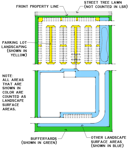
Common area landscape areas include parking lot landscape areas, bufferyards, and open drainage facilities, and any additional area that is necessary to bring the parcel proposed for development into compliance with the landscape surface ratio requirement. See Figure 12-8-202B, Illustrative Residential Landscape Areas.
|
Figure 12-8-202A
Illustrative Nonresidential Landscape Areas |
|---|
 |
C.
Identification of Landscape Areas on Residential Parcels. Landscaped areas in single-family detached and single-family attached developments are identified as follows:
1.
Street tree lawns are areas along the right-of-way where street trees may be planted. This landscape area may or may not be applicable to a parcel proposed for development. See Section 12-8-302, Street Trees. Street tree lawns are counted as landscape areas if they are created along new streets that were formerly part of the parcel proposed for development.
2.
Parking lot landscape areas are those areas within the surface parking lots that must be landscaped. Parking areas are delineated to include access aisles and parking spaces, and any corners that are necessary to give the parking area a regular shape.
3.
Bufferyards are areas around the perimeter of the parcel proposed for development where landscaping is required to buffer the development from neighboring properties and rights-of-way.
4.
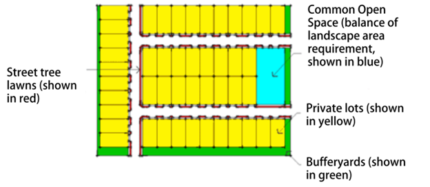
Common area landscape areas include parking lot landscape areas, bufferyards, and open drainage facilities, and any additional area that is necessary to bring the parcel proposed for development into compliance with the landscape surface ratio requirement. See Figure 12-8-202B, Illustrative Residential Landscape Areas.
5.
Private lots landscape areas are the yards on lots that are intended for individual ownership, or, in the case of common maintenance communities or condominiums, areas around dwelling units that would be located within private lots if the subdivision were platted for conventional fee-simple ownership. See Figure 12-8-202B, Illustrative Residential Landscape Areas.
|
Figure 12-8-202B
Illustrative Residential Landscape Areas |
|---|
 |
D.
Measurement for Planting Landscape Areas. The planting requirements of this Article are applied to the various landscape areas of a parcel proposed for development and abutting rights-of-way, as set out in Table 12-8-202, Planting Measurement by Landscape Area.
(Ord. 2025-O-12 §§11—14)
Sec. 12-8-203. - Selection of Plant Material.
A.
Generally. Plant material that is used to demonstrate compliance with this Article shall be selected as provided in this Section.
B.
Approved Plant List. A list of approved plants is set out in Appendix A. The list separates plants into Large Trees, Small Trees, Evergreen Trees, and Shrubs, and classifies each according to whether or not the species counts towards the Xeric planting requirements of subsection E., below. The Director is delegated the authority to modify the approved plant list according to the following criteria:
1.
Plants may be added to the list if the Director finds a preponderance of credible evidence that the species:
a.
Is not on any of the following lists:
i.
The United States Department of Agriculture's Invasive and Noxious Weeds list for the State of Colorado;
ii.
The Colorado Noxious Weed List, promulgated by the Colorado Department of Agriculture; or
iii.
The City of Centennial prohibited plant list; and
b.
Is either native to the region or not invasive; and
c.
Is either on the Plant Select® list, Colorado State University Extension — Yard & Garden, Landscaping, or has one or more of the following characteristics:
i.
Drought-tolerance (low or medium water consumption);
ii.
Fire resistant;
iii.
Produces a food crop; or
iv.
Provides habitat for native wildlife or migratory birds, including food, cover, or nesting resources for species native to Colorado or identified as priority species by Colorado Parks and Wildlife.
2.
Plants may be annotated as limited to locations that are more than 10 feet from street rights-of-way if the Director finds that the trees are already present in such numbers along City rights-of-way that further installation of the species would likely violate subsection D.3., below.
3.
The Director may add Plants to the Approved Plant List if the species meets the characteristics identified in subsection B.1.c.
4.
The Director may remove Plants from the Approved Plant List if the species is on any of the lists identified in subsection B.1.a., above.
C.
Prohibited Plant List. A list of prohibited plants is set out in Appendix A. The Director is delegated the authority to add species to the prohibited plant list to make it consistent with the lists identified in subsection B.1.a., above.
D.
Required Biodiversity. Diversity of the genera and species of trees and shrubs is required in order to prevent monocultures which could result in large-scale losses in the event of disease or blight. Therefore:
1.
Within each category of required landscaping (i.e., large trees, small trees, and shrubs):
a.
Not more than 40 percent shall be of any one genera; and
b.
Not more than 20 percent shall be of any one species.
2.
Each street block shall have at least three genera of street trees. For the purpose of this paragraph only, street trees shall include all trees that are planted within 10 feet of the public street right-of-way.
3.
Not more than 40 percent of the street trees in the City shall be of the same genus.
4.
These biodiversity standards are encouraged but shall not be mandatory for development sites or development areas of less than two (2) acres.
E.
Required Xeric Plantings. At least 50 percent of each category of plants (i.e., large trees, small trees, evergreen trees, and shrubs) that are used to meet the landscaping requirements of this Article shall be listed as Xeric on the approved plant list.
F.
Minimum Size of Plants at Installation. Plant material shall be installed in the following minimum sizes:
G.
Quality of New Plantings.
1.
All landscape material shall be in compliance with the standards of the American Association of Nurserymen, except that the minimum root ball diameter of balled and burlap trees shall be according to the Rules and Regulations of the Colorado Nursery Act, promulgated by the Colorado Department of Agriculture.
2.
Single trunk species with co-dominant trunks (multiple trunks of equal size) shall not be used. Single trunk trees shall have one trunk to the top, and all branches shall be less than half of the diameter of the adjacent trunk.
3.
All plant material shall have a habit of growth that is normal for the species and shall be of sound health, vigorous growth, and free from insect pests, diseases and injuries.
H.
Hydrozones. Plantings are to be grouped within hydrozones. Hydrozones are a grouping of similar water use plantings within a site (for example, low water use plantings with other low water use plantings; very low water use plantings with very low water use plantings). Plantings of a very low water use are not to be planted in a moderate to high water use hydrozone.
(Ord. 2021-O-13 §34; Ord. 2025-O-12 §§15—18)
Sec. 12-8-204. - Credit for Existing Trees.
A.
Generally. Existing trees that are protected according to Section 12-8-603, Tree Protection During Construction and Development, count towards the planting requirements of this Article, provided that:
1.
They are either:
a.
On the approved plant list; or
b.
Established for at least 5 years and not on the prohibited plant list or the Colorado Noxious Weed List; and
2.
They are not:
a.
Overmature;
b.
Diseased;
c.
Poor in form; or
d.
Leaning heavily over buildings.
B.
Credit for Preservation of Trees. It is the policy of the City to promote the preservation of its healthy mature tree canopy. Healthy, mature trees that are preserved on-site shall count as more than one tree for the purposes of landscaping requirements for development and redevelopment pursuant to Section 12-12-402, Sliding Scale Compliance Requirements, as set out in Table 12-8-204, Credit for Preservation of Trees.
(Ord. 2021-O-13 §35; Ord. 2025-O-12 §19)
Sec. 12-8-301. - Groundcover.
A.
Exemptions. Single-Family Attached, Single Family-Detached, and Accessory Dwelling Units (ADUs) are exempt from Artificial Turf requirements, Functional Turf requirements, and Non-Functional Turf requirements. Common areas within Single Family Attached and Single Family Detached developments are not exempt from Artificial Turf requirements, Functional Turf requirements, and Non-Functional Turf requirements.
B.
Generally. In order to prevent erosion and wind-blown dust, pervious areas shall be planted or covered with trees, shrubs, ornamental grasses, garden plants, or groundcovers. Groundcovers include non-native seed mixes, native seed mixes, turf, organic mulch, and inorganic mulch. Groundcover shall meet the following requirements:
1.
To prevent moveable or floating groundcover from spilling into stormwater facilities, sidewalks, parking lots, streets and similar areas, groundcover shall be contained by edging, topography, or physical barriers.
2.
Groundcover shall be regularly maintained to prevent moveable or floating groundcover from spilling into stormwater facilities, sidewalks, parking lots, streets and similar areas.
C.
Artificial Turf and Turf Grass Requirements.
1.
Artificial Turf is only permitted within an area or space that is regularly used for civic, community, or recreational purposes, which may include a playground, a sports field, a picnic ground, an amphitheater, dog relief area, and the playing area of a golf course.
2.
Functional Turf is permitted within an area or space that is regularly used for civic, community, or recreational purposes, which may include a playground, a sports field, a picnic ground, an amphitheater, a portion of a park, and the playing area of a golf course. Functional Turf is not permitted in decorative or ornamental areas, low-traffic locations, and along public right-of-way.
a.
There is no limit to Functional Turf if it is demonstrated that the Functional Turf will be used for areas or spaces stated in Section 12-8-301C(2).
b.
Functional Turf may be native or non-native turf grass.
3.
Non-Functional Turf is only permitted in stormwater detention facilities. Non-Functional Turf shall not be used in areas that are not heavily trafficked by pedestrians, which may include along public street right-of-way, parking lot islands, landscaping areas abutting parking lots, medians, or along other transportation corridors. Other groundcovers, such as native turf grasses, and xeriscaping shall be utilized in the Non-Functional Turf areas.
(Ord. 2025-O-12 §20)
Sec. 12-8-302. - Street Trees.
A.
Generally. If permitted by the Roadway Design and Construction Standards Manual, street trees shall be planted according to the standards and in the following circumstances below:
1.
Within both sides of all new streets (except alleys) in the Urban Center and Activity Center districts within rights-of-way;
2.
Within both sides of all new streets in other zone districts where there is sufficient width to accommodate the street tree lawn within rights-of-way;
3.
Along existing rights-of-way where a street tree lawn within rights-of-way is present and the entity responsible for the rights-of-way authorizes the improvement;
4.
In medians that are created on a parcel proposed for development;
5.
In medians that are constructed near a parcel proposed for development in order to manage the traffic impacts of the development, provided that the medians:
a.
Are of sufficient width to accommodate the root system;
b.
Are maintained by the property owners' association of the development that provides the median; and
c.
The installation of street trees in the median would not be detrimental to public safety; and
6.
In existing street tree lawns that abut proposed new development in any district if the street tree lawns are not already planted according to the requirements of subsection B., below, provided that the jurisdiction that controls the street consents to such planting.
B.
Spacing.
1.
Generally. Street trees shall be spaced at least 25, but not more than 40, feet on center in street tree lawns, but shall not be installed in locations that interfere with required sight triangles. Special plantings may be clustered if a registered landscape architect certifies that the cluster arrangement will not negatively affect the continuing health of the clustered trees.
2.
Medians. Street trees within medians shall conform to any standards within the Roadway Design and Construction Standards Manual.
C.
Tree Selection. All trees planted within parkways shall be large trees with single-stemmed trunks, branched no lower than six feet above the ground (for visibility purposes), except that ornamental trees may be used if large trees would conflict with existing overhead power lines. Ornamental trees shall be selected which will fit within the street tree lawn without interfering with street, sidewalk, or trail infrastructure, and which will avoid undue amounts of tree litter on the sidewalk and street. Trees that bear fruit, nuts, or similar items should be avoided.
(Ord. 2024-O-15 §19; Ord. 2025-O-12 §21)
Sec. 12-8-303. - Landscape Surface and Common Open Space.
A.
Generally. The standards of this Section apply to required landscape surfaces and common open spaces which are not also designated as:
1.
Private lots;
2.
Parking lot landscaping areas;
3.
Bufferyards;
4.
Stormwater detention facilities;
5.
Open water;
6.
Stream channels or drainages;
7.
Natural resource protection areas; or
8.
Play fields and other active recreation areas that must be clear of trees.
B.
Planting Requirements. Required landscape surfaces and common open spaces shall be planted as required by Table 12-8-201, Planting Requirements.
(Ord. 2024-O-13 §56; Ord. 2024-O-14 §§53, 54; Ord. 2025-O-12 §22)
Sec. 12-8-305. - Parking Lots.
A.
Generally. Parking lot landscaping is required in any parking lot that contains more than 10 parking spaces. Parking lot landscaping shall be installed in landscape islands and in corners of parking lots that cannot be used for parking spaces due do geometric constraints. Such corners shall be delineated by the extension of the back line of the parking spaces that define the corner. See Figure 12-8-305, Parking Lot Planting Areas.
B.
Planting Areas. Planting areas shall be arranged within parking lots as follows:
1.
A planting area shall be installed at each end of a parking row that intersects with an aisle, except on the outside of corners (which are corner planting areas). See Figure 12-8-305, Parking Lot Planting Areas.
2.
A planting area shall be installed at each corner of the parking lot. See Figure 12-8-305, Parking Lot Planting Areas.
3.
A planting area shall be provided between parking modules for each two parking modules that are arranged parallel to each other. For the purpose of this calculation, fractions shall be rounded down. See Figure 12-8-305, Parking Lot Planting Areas.
|
Figure 12-8-305
Parking Lot Planting Areas |
|---|
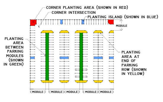 |
4.
Planting islands shall be provided as necessary to meet the planting requirements of subsection D. within the overall planting area that is required by multiplying the total number of required large trees (calculated as set out in subsection D., below) by the area per tree required by subsection C., below. See Figure 12-8-305, Parking Lot Planting Areas.
C.
Planting Area per Tree. Each required tree shall be installed in a permeable area that is:
1.
Not less than 125 square feet; and
2.
Not less than 9 feet in any horizontal direction.
D.
Planting Requirements. Large trees shall be installed as required by Table 12-8-305, Planting Requirements. Such trees shall be distributed around the parking lot so that each planting area includes at least one tree.
(Ord. 2024-O-13 §57; Ord. 2024-O-14 §55)
Sec. 12-8-306. - Drive-In Lanes and Vehicle Stacking Areas.
Drive-in lanes and vehicle stacking areas that are adjacent to public streets or sidewalks shall be separated from such streets or sidewalks by walls or hedges that are at least three feet in height. These structures or landscape elements may be incorporated into and counted as part of required, co-located bufferyards.
Sec. 12-8-307. - Soil Criteria.
A.
Non-Native Grasses and Plantings. Before seeding or sodding turf grass, the soil must be treated with amendments at 4 cubic yards per 1,000 square feet, incorporated to a depth of 6 inches.
B.
Native Grasses and Plantings. For native seeds and plants, the soil is only required to be treated with amendments of 2 cubic yards per 1,000 square feet, incorporated to a depth of 6 inches.
(Ord. 2025-O-12 §23)
Sec. 12-8-308. - Mulches.
A.
Organic Mulch.
1.
Shall be applied at one (1) cubic yard per eighty (80) square feet at a depth of two (2) inches, and as appropriate to each species.
2.
Shall be applied to the soil surface, not against the plant stem, or high against the base of trunks to minimize disease.
3.
Organic mulch material includes bark and wood chips. Avoid construction debris such as pallets.
B.
Inorganic Mulch.
1.
Rock mulch shall have a minimum depth of two inches (2").
2.
Inorganic mulch includes rock, gravel, or pebbles (pea gravel).
3.
Recycled rubber for landscape use is prohibited.
(Ord. 2025-O-12 §24)
Sec. 12-8-309. - Irrigation System Requirements.
A.
For new development and redevelopment, all landscaped areas, except on individually platted single-family residential lots, shall be served by a functioning automatic irrigation system that includes a battery backup, a weather-based smart controller, and a rain sensor to override the irrigation cycle when sufficient rainfall has occurred. Multi-program controllers shall be used when the landscape design contains more than one hydrozone and shall be designed to irrigate hydrozones separately.
B.
Temporary irrigation methods are permitted where native seed mixes or other low-water plantings will require water until established.
C.
Only drip and subsurface irrigation systems will be allowed in areas less than ten (10) feet in width.
D.
Trees, shrubs and plantings in bed areas shall be irrigated by drip, bubbler systems, low volume spray heads or subsurface irrigation systems
E.
High-water-use turf grass areas may be irrigated using pop-up or rotary/gear-drive sprinklers. Pop-up heights on sprinkler heads should be adequate to clear the grass height when extended.
F.
Low-water-use turf grass areas may be irrigated using a drip system, a subsurface irrigation system, or a pop-up or rotary/gear-drive sprinklers. Pop-up heights on sprinkler heads should be adequate to clear the grass height when extended.
(Ord. 2025-O-12 §25)
Sec. 12-8-401. - Bufferyard Purpose and General Design Parameters.
A.
Purposes of Bufferyards. Bufferyards are used to screen development from streets and adjacent properties, to enhance the streetscape, to improve compatibility of adjacent uses, and to protect natural resources from impacts of nearby development.
B.
Opacity and Width Standards.
1.
Opacity Standards. The opacity of the bufferyard is a measure of the percentage of the view that is blocked by the bufferyard from grade to a height of 35 feet. Opacity relates to planting density, plant forms, bufferyard widths, and the presence of structures (e.g., fences and walls) or topography (e.g., natural slopes or constructed berms).
2.
Width Standards. Comparable opacities can be achieved with bufferyards of different widths. However, in certain circumstances (e.g., where noise, dust, runoff, or other non-visual impacts are to be mitigated by the bufferyard), the width of the bufferyard may be as important or more important than its opacity. Where bufferyard widths are specified by limited or conditional use standards, alternatives with narrower widths are not allowed.
C.
Bufferyard Design.
1.
Standard Bufferyards.Section 12-8-402, Standard Bufferyards, sets out standard bufferyard widths and planting requirements for each level of opacity that may be required by this LDC.
2.
Bufferyard Model.Section 12-8-403, Bufferyard Model, provides a model for the design of alternative bufferyards that can be used to meet the bufferyard opacity standards of this Division.
3.
Parking Buffers.Section 12-8-405, Parking Buffers, sets out additional standards for bufferyards at the edges of parking areas. The intent of these standards is to ensure that parking areas are screened to a height of three feet in order to improve their aesthetic appeal from the street and mitigate nighttime glare on the adjacent street from headlights in the parking lot.
(Ord. 2025-O-12 §26)
Sec. 12-8-402. - Standard Bufferyards.
A.
Generally. Standard bufferyards are set out in Table 12-8-402, Standard Bufferyards. The table includes three alternative configurations; one with landscaping only, one with berms or elevation increases from the property line to the interior boundary of the bufferyard, and one with fences or walls.
B.
Opacity Scale. Bufferyards were previously determined on an opacity scale of 0% opacity to 100% opacity. To maintain consistency with prior standards expressed in percentage opacity, any reference to 0% to 30% opacity shall be deemed a Type A Bufferyard, any reference to 31% to 60% opacity shall be deemed a Type B Bufferyard, and any reference to 61% to 100% opacity shall be deemed a Type C Bufferyard. Where prior approvals, conditions, or references cite opacity percentages, those requirements shall be interpreted as the equivalent Bufferyard Type established in Table 12-8-402.
(Ord. 2025-O-12 §§27, 28)
Sec. 12-8-403. - Bufferyard Model.
A.
Generally. In the alternative to the bufferyards set out in Section 12-8-402, Standard Bufferyards, an applicant may use the City of Centennial Bufferyard Model to establish a bufferyard with comparable opacity. The bufferyard model computes the opacity of bufferyards based on user-defined width; plantings required per 100 linear feet of the bufferyard; the presence of, and height of, berms; and the presence of, location of, and height of fences and walls.
B.
Approval of Modeled Bufferyards. Alternative bufferyards developed using the City of Centennial Bufferyard Model shall be approved if it is demonstrated that:
1.
Opacity. The opacity of proposed bufferyards that apply the bufferyard model shall be at least that which is required by this LDC.
2.
Width.
a.
The width of the proposed bufferyard shall be not less than 10 feet, and shall be reduced by not more than 5 feet from the narrowest bufferyard described in Table 12-8-402, Standard Bufferyards. If a bufferyard width is mandated by a limited or conditional use standard, no reductions from the specified width are permitted unless authorized by a variance.
b.
The bufferyard model must show that the proposed bufferyard width is adequate, or a registered landscape architect shall certify that the plants selected for the bufferyard will fit in the proposed space at maturity without compromising their health, longevity, or stability.
3.
Planting Requirements. The planting requirements of the bufferyard model are measured on a per 100 linear feet basis.
(Ord. 2025-O-12 §29)
Sec. 12-8-404. - Reserved.
Editor's note— Ord. 2025-O-12 §30, adopted Oct. 22, 2025, repealed § 12-8-404, which pertained to constrained bufferyards and derived from the 2010 Land Development Code.
Sec. 12-8-405. - Parking Buffers.
A.
Surface Parking Lots. Bufferyards that are located at the edges of surface parking lots shall include a continuous masonry wall, berm, or hedge that is at least three feet in height at the time of planting between parking spaces and a public or private street, private drive, and/or adjacent sites. This requirement shall be waived by the Director in areas where at least one of the following conditions exist:
1.
The elevation of the parking lot is three feet or more below the elevation of the curb of the street;
2.
Buildings or other structures provide the same or better screening effect;
3.
The parking lot continues into adjacent site(s); or
4.
The bufferyard opacity is at least 30 percent (Buffer Type A).
B.
Tuck-Under Parking. Tuck-under parking shall be located behind buildings. It shall be screened from view from adjacent properties and rights-of-way by buildings or a bufferyard that includes a masonry wall, berm, or combination thereof, that is at least 5 feet in height.
C.
Subterranean Parking. Access to subterranean parking shall be located at the sides or rear of the building if a ramp that is visible from outside the building provides more than four feet of grade change.
D.
Structured Parking Lots. Structured parking lots shall be screened from view from public rights-of-way and abutting properties in one or more of the following ways:
1.
Linear buildings or other buildings that are not parking structures;
2.
Topographical changes (e.g., construction into a hillside);
3.
A six-foot wide planting strip, planted with trees suitable for street tree installations, planted between 25 and 35 feet on center; or
4.
Any bufferyard that is at least 30 percent opaque (Buffer Type A).
(Ord. 2021-O-13 §36; Ord. 2025-O-12 §31)
Sec. 12-8-406. - District Boundary Bufferyards.
A.
Generally. Table 12-8-406, District Boundary Bufferyard Standards, sets out the opacity of the bufferyard that is required between zoning districts where:
1.
The district boundary line follows the property line of the parcel proposed for development; and
2.
The adjacent property is not separated from the parcel proposed for development by an easement, right-of-way, or permanent open space that is at least 50 feet in width, such as a public street, creek and trail, utility easement, or resource protection area.
B.
Interpretation of Table. The table is a matrix in which all districts are shown. Rows show the zoning of the parcel proposed for development, and columns show the zoning of the abutting property. To calculate the required bufferyard for a proposed development:
1.
The number in the cell at the intersection between the row that represents the district of the parcel proposed for development and the column that represents the zoning of abutting property is the required bufferyard type if the abutting property is developed and does not include the bufferyard that would be required of it by Table 12-8-406, District Boundary Bufferyard Standards.
2.
A reduced bufferyard that is calculated as the difference between the bufferyard type indicated for the parcel proposed for development and the bufferyard that is required of the abutting property (but not less than zero) is allowed if:
a.
The abutting property is vacant; or
b.
The abutting property is developed and the development includes at least the bufferyard required by Table 12-8-406, District Boundary Bufferyard Standards.
3.
The abbreviation "NA" means that no bufferyard is required on the parcel proposed for development.
C.
Existing Walls. Existing walls may be counted towards bufferyard requirements if they are in good repair. However, if more than one wall is installed in abutting bufferyards, only the larger of the two walls is counted towards the overall opacity of the combined bufferyard. Fences and walls in abutting bufferyards shall not be located closer than 10 feet to each other.
D.
Additional Requirements. Some Limited Uses and Special Uses may have a requirement for greater bufferyard opacity or depth, as specified Division 2-4, Limited and Conditional Use Standards.
(Ord. 2024-O-13 §58; Ord. 2024-O-14 §62; Ord. 2025-O-12 §§32, 33)
Sec. 12-8-407. - Open Field Bufferyards.
A.
Generally. Open field bufferyards are wide, sparsely planted bufferyards that use distance to mitigate the impacts of development on abutting property. The open field bufferyard is intended to balance buffering of uses with preservation of mountain views.
B.
Where Required.
1.
Open field bufferyards are required along district boundaries where all of the following conditions are met:
a.
One side of the boundary is zoned BP or CG and the other side is zoned NC or NI; and
b.
The parcel proposed for development fronts on Dry Creek Road; and
c.
The parcel proposed for development is at least 1,000 feet deep (measured from the front lot line to the rear lot line).
2.
Subdivision of parcels that meet the criteria of this subsection as of November 1, 2009 shall not be used to circumvent the open field bufferyard requirement.
C.
Dimensional and Planting Requirements. Open field bufferyards shall be planted as follows:
1.
Minimum width: 72 feet.
2.
Planting Requirements. Each 100 linear feet of bufferyard shall be planted with:
a.
One canopy tree; and
b.
Two small, ornamental trees.
(Ord. 2024-O-13 §§59, 60; Ord. 2025-O-12 §34)
Sec. 12-8-501. - General Requirements.
A.
Generally. Natural resource protection areas may require landscaping in order to restore or enhance their resource values. Such landscaping may be counted towards the requirements of this Article (if it meets the size and quality requirements), and shall receive priority over other unallocated open space or landscape surface landscaping (i.e., landscaping that is not allocated to parking lots, private lots, bufferyards, etc.).
B.
Restoration of Resource Protection Areas. If additional planting would enhance the resource value of a natural resource protection area, the area shall be planted with native vegetation that would typically be found in the type of natural community that is being protected. The plantings may be irrigated with temporary systems in order to ensure that they become established. However, permanent irrigation systems are not allowed in resource protection areas unless extraordinary circumstances (e.g., a federally mandated habitat management plan or other unusual circumstance) justifies the installation. Invasive plant species shall be removed from natural resource protection areas.
Sec. 12-8-502. - Seed Mixes.
Where seeding is used to restore resource protection areas, the seed mix shall be composed of native plants that are appropriate to the soil type where the seeds are planted. The Director is authorized to maintain a list of acceptable seed mixes for moist and dry soil types.
Sec. 12-8-601. - Planting Locations.
A.
Generally. In addition to the other requirements of this Article, the following rules apply to the installation of plants.
B.
Distance from Utilities.
1.
No street or canopy trees shall be planted under or within 10 lateral feet of any overhead utility lines.
2.
No trees, except street tree species that are approved by the City, shall be planted over or within five lateral feet of any underground water line, sewer line, transmission line, or other utility line, or as required by the owner of the utility or the requirements of the specific easement.
C.
Sight Distance Triangles. Trees shall not be installed in locations where there is a substantial likelihood that the tree, when mature or when a sapling, would have to be materially compromised in order to maintain sight distance triangles.
(Ord. 2024-O-15 §20; Ord. 2025-O-12 §35)
Sec. 12-8-602. - Timing of Landscape Installation.
A.
Generally. Landscaping that is required by this Article shall be installed generally between May 15 and October 15.
B.
Street Trees.
1.
Street trees shall be installed between May 15 and October 15, when growing conditions in Centennial are generally most favorable for establishment.
2.
The Director may approve installation outside of this period if site and weather conditions are suitable for planting, such as early spring prior to bud break, or late fall before the ground has frozen. The applicant shall provide evidence that the selected planting period will not compromise tree health or long-term viability.
3.
If compliance with subsection B.1., above, is impractical due to the time of year that development commences, an applicant may provide a performance guarantee in an amount equal to 125 percent of the estimated cost of purchase and installation of required street trees.
C.
Effect on Certificate of Occupancy. If a certificate of occupancy would be issued but for the application of the requirements of subsection A. or B., above, the City may issue a temporary certificate of occupancy, with a permanent certificate of occupancy conditioned upon installation of required landscaping.
(Ord. 2025-O-12 §36)
Sec. 12-8-603. - Tree Protection During Construction and Development.
A.
Generally. Existing trees that are to be counted towards landscaping requirements shall be protected according to the requirements of this Section.
B.
Protected Root Zone. The protected root zone is the larger of:
1.
The area under the dripline of the tree; or
2.
A radius that extends from the center of the trunk 18 inches per one inch of diameter at breast height of the protected tree.
|
Figure 12-8-603
Illustrative Protected Root Zone |
|---|
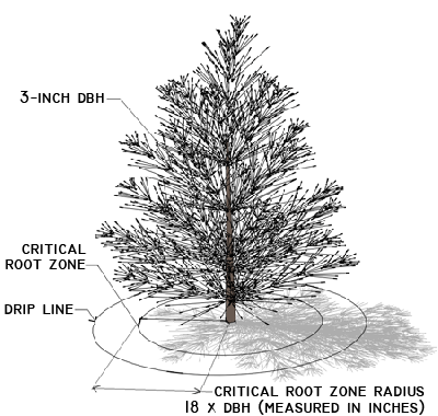 |
C.
Restrictions Within Protected Root Zone.
1.
The protected root zone of all protected trees shall be barricaded during construction to prevent damage to the trees and their roots by construction equipment or soil compaction. The barricades shall be posted "Off Limits."
2.
No cutting or filling, nor storage of building materials or debris, nor disposal of wastes, shall take place within protected root zone of any protected tree.
3.
No impervious paving shall be placed within the protected root zone of any protected tree.
D.
Transplanting Existing Trees. Credit shall be given for trees that are transplanted from one part of the parcel proposed for development to another if:
1.
The trees are transplanted according to the American National Standard for Transplanting of Trees (ANSI A300 Part 6 Transplanting).
2.
Surety is provided that will ensure replacement of the transplanted tree with the number of new trees for which credit was given according to Table 12-8-204, Credit for Preservation of Trees. The surety shall be effective for a period of two years from the date the tree is installed in its new location.
E.
Tree Care During Construction. Protected trees shall be cared for regularly during construction as follows:
1.
Regular watering if rainfall is inadequate;
2.
Pruning of branches that are dead, diseased, hazardous, or detrimental to natural form; and
3.
Fertilizing if nutrient stress is apparent.
Sec. 12-8-604. - Maintenance and Care of Trees.
A.
Street Trees. Street trees that are planted between the edge of pavement and private property lines shall be cared for by:
1.
The adjacent property owner; or
2.
A property owners' association, if:
a.
Membership in the property owners' association is mandatory; and
b.
The covenants, conditions, and restrictions that define the scope of the association's authority unambiguously include the maintenance of street trees or common elements.
B.
Trees on Nonresidential, Mixed-Use, and Multifamily Parcels. Trees that are planted on nonresidential, mixed-use, and multifamily parcels shall be maintained as specified in the approved landscape plan. Maintenance and care shall be according to the most current ANSI A300 Standards for Tree Care Operations.
Sec. 12-8-701. - Landscape Plan Required.
A.
Generally. Landscape plans are required for all development that is subject to the requirements of Division 8-3, Development Landscaping; Division 8-4, Bufferyards; or Division 8-5, Natural Resource Protection Area Landscaping. See Section 12-8-102, Application of Article.
B.
Timing of Approval. Landscape plans shall be submitted for approval at the site plan stage, or if no site plan is required, at the building permit stage of the development approval process.
C.
Qualifications and Certifications.
1.
The landscape plan shall be prepared by a Colorado-licensed landscape architect.
2.
The irrigation system plan shall be completed by a Certified Irrigation Designer (CID) and installed by a Qualified Water Efficient Landscaper (QWEL)-certified professional.
3.
The Director may waive the requirements of qualifications and certifications if the Director finds that they are unwarranted due to the type or scale of development approval sought, the conditions of the site being developed, or both.
(Ord. 2025-O-12 §37)
Sec. 12-8-702. - Contents of Landscape Plans.
A.
Generally. The landscape plan and related exhibits shall include the elements that are set out in this Section. The Director may waive elements of the landscape plan if the Director finds that they are unnecessary due to the type of development approval sought, or the conditions of the site being developed, or both.
B.
Plan Drawing.
1.
A plan view drawing prepared at a standard scale that ensures clarity of the proposal (scale shall be approved by the Director), which shall indicate:
a.
Dimensions, surface area, and type of planting area (e.g., bufferyard, parking lot landscaping, etc.) for each planting area;
b.
Dimensions and surface area of any proposed functional turf areas;
c.
Dimensions, surface area, and type of resource protection areas;
d.
The location and quantity of trees and shrubs to be installed, which shall be drawn at three-fourths (¾) of mature size and annotated with genus, species, common name, drought tolerance, and size at planting;
e.
The location, quality, size (DBH), and protected root zone of trees that are to be preserved on the site;
f.
The location and extent of areas of groundcover, and the groundcovers, turf, seed, or inorganic materials to be installed or planted;
g.
Existing and proposed topography of the site, shown at two-foot contours;
h.
Dimensions of relevant hardscape elements, including fences, walls, border edge treatments, berms, water features, bicycle racks, trash enclosures, street furniture (including lighting so as to verify tree canopy conflicts), public art, and recreational facilities, as applicable. Staff may require details or specifications for landscape features or structures to be attached to the landscape plan in order to facilitate subsequent inspection;
i.
Dimensions and surfacing of all easements, pedestrian walkways, and pedestrian-oriented areas (existing and proposed);
j.
Location and dimensions of maintenance easements for drainage facilities;
k.
Location of existing and proposed overhead and underground utilities;
l.
Location and base flood elevation of floodplains, including an annotation as to whether the floodplains are a major drainageway (a tributary area of 130 acres or more per Urban Drainage and Flood Control District requirements);
m.
Dimensions and slopes of stormwater detention areas;
n.
Special landscape features for stormwater detention and treatment, such as green roofs, rain gardens, or bioswales;
o.
Dimensions and locations of sight distance triangles; and
p.
Location, genus, species, and spacing of street trees.
q.
Location of hydrozones (irrigation details are shown as part of the schematic irrigation plan).
r.
Applicable soil criteria and standards shall be noted on the landscape design plan. Written verification of approved soil amendment type and volume is required.
s.
If a project builds in phases, a note or dashed boundary identifying landscape installation timing.
2.
Information regarding specific design techniques that will be used to prevent water infiltration or damage at the street section may be required by the Director if it is found that there is good cause to believe that such damage could occur.
3.
Where there is significant existing vegetation on site, staff may require an inventory of plant material. Existing, healthy, non-invasive trees shall be saved on the property if a practical design can be created that will accommodate their preservation.
C.
Installation Details. Schematic drawings of typical plant installation methods shall be provided. Such drawings shall indicate how the soil will be augmented to support the growth and health of the plant material.
D.
Elevation Drawings. If the applicant proposes bufferyards pursuant to Section 12-8-403, Bufferyard Model, then scaled elevation drawings of the proposed bufferyards shall be provided, showing the bufferyard at five to seven years of growth.
E.
Water Source.
1.
All landscape plans shall indicate the source or sources of irrigation water and the types of irrigation used. This information may be provided on a separate sheet. If the source is a private well, the applicant shall provide evidence of landscape irrigation rights.
2.
No waivers of the landscape requirements of this LDC will be granted in the event that the parcel proposed for development is served by a well which does not allow landscape irrigation use. The applicant will be required to obtain and document the legal right to use an off-site water source.
F.
Schematic Irrigation Plans. Landscape Plans shall include a schematic irrigation plan that shows:
1.
The proposed lap/backflow preventer and irrigation controller location;
2.
The location of the manual gate valve that will control the entire irrigation system;
3.
The anticipated type of irrigation proposed for each landscape area, hydrozone, or irrigation zone (turf, shrub beds, etc.);
4.
The recommended setback distance of all proposed irrigation heads from back of curb or edge of pavement; and
5.
All proposed sleeve locations.
G.
Tabular Data. Tabular data shall show the area of each required landscape area, the number of each type of plant required in each area, each plant type used, the number of plants of each type to be installed, and the genus and species of plants used to meet the requirements of this LDC.
(Ord. 2025-O-12 §38)
Sec. 12-8-703. - Performance Guarantees.
Applicants shall provide performance guarantees to ensure that landscaping that does not survive for a period of two years from the date of installation is replaced.