
Cibolo City Zoning Code
ARTICLE 20
- SUBDIVISION REGULATIONS21
Editor's note—Ord. No. 1332, § I(Exh. A), adopted April 27, 2021, amended Art. 20, §§ 20.1—20.6, in effect replacing said article with §§ 20.1—20.6, as set out herein. Formerly, Art. 20 pertained to similar subject matter and derived from Ordinance 1233, adopted April 24, 2018.
Section 20.1 - General.
Section 20.1.1 Short title.
This Article shall be known, cited and referred to as "The City of Cibolo Subdivision Regulations."
Section 20.1.2 Definitions.
Applicable definitions are referenced in Article 1, Section 1.13 of this UDC.
Section 20.1.3 Authority of the City; Extension to Extraterritorial Jurisdiction (ETJ); Purpose.
A.
This Article is adopted under the authority of the Constitution and laws of the State of Texas, including Chapter 212, Texas Local Government Code.
B.
Purpose.
The purpose of this Article is to promote sound planning in the subdivision of land, and to provide consistent rules, which protect the public health, safety, and welfare while allowing the legal platting of land.
C.
The following rules and regulations are hereby adopted as the Subdivision Regulation of the City of Cibolo, Texas, also referred to herein as "this Article". This Article shall be applicable to the filing of plats and to the subdivision of land, as that term is defined herein and in Chapter 212 of the Texas Local Government Code, within the corporate limits of the City and its extraterritorial jurisdiction as they may be from time to time adjusted by annexation or disannexation. The City shall have all remedies and rights provided by said Chapter 212 regarding the control and approval of subdivisions and plats both within the City and within its extraterritorial jurisdiction.
Section 20.1.4 Development Agreements.
Development agreements affecting land in the city limits and the extraterritorial jurisdiction of the City may be used in accordance with Chapter 212 to do the following:
A.
Contract for an area's continued extraterritorial jurisdiction status for up to an initial term of fifteen (15) years and up to two additional extensions for a maximum total term of forty-five (45) years.
B.
Extend city planning authority over the land, including enforcement of not only the same land use, development and environmental regulations applicable in the City, but specific additional regulations for the land.
C.
Provide for infrastructure for the land including streets, roads, drainage, water, wastewater and other utility systems.
D.
Specify the uses and development of the land.
E.
"Other lawful terms and considerations" as agreed to by the parties.
Section 20.1.5 Consistency with Comprehensive Master Plan and UDC.
It is the intent of the City that this Article shall be consistent with the adopted Comprehensive Master Plan of the City, this Unified Development Code (UDC) and any supplemental land use and community development policies that may be adopted by the City Council. No plat or subdivision of land within the City or its extraterritorial jurisdiction, as determined by the Local Government Code, shall be approved unless it conforms to such plans, policies and ordinances.
The City's Comprehensive Master Plan was adopted as a guide, not as a mandate, for growth and development of the entire City and its extraterritorial jurisdiction. The Future Land Use Map shall not be, nor be considered, a zoning map, nor constitute zoning regulations or establish zoning boundaries and is not site or parcel specific and shall be used to illustrate generalized locations. Also, the Future Thoroughfare Plan depicts generalized locations of new alignments which are subject to modification to fit local conditions and are subject to refinement as development occurs.
Section 20.1.6 Special Provisions.
A.
No permit shall be issued by the City for the installation of septic tanks upon any lot in a subdivision for which a final plat has not been approved and filed for record, or upon any lot in a subdivision in which the standards contained in this Article have not been complied with in full.
B.
No building, repair, plumbing or electrical permit shall be issued by the City for any structure on a lot in a subdivision for which a final plat has not been approved and filed for record, nor for any structure on a lot within a subdivision in which the standards contained in this Article have not been complied with in full.
C.
The City shall not repair, maintain, install or provide any streets or allow the provision of public utility services in any subdivision for which a final plat has not been approved and filed for record, nor in which the standards contained in this UDC or referred to in this Article have not been complied with in full.
D.
The City shall not permit the sale, supply or approval of any utility service within a subdivision for which a final plat has not been approved and filed for record, nor in which the standards contained in this Article or referred to in this Article have not been complied with in full.
E.
If any subdivision exists for which a final plat has not been approved or in which the standards contained in this Article or referred to in this Article have not been complied with in full, the City Council shall pass a resolution reciting the fact of such noncompliance or failure to secure final plat approval, and reciting the fact that the provisions of subsections (a), (b), (c) and (d) of this section will apply to the subdivision and the lots therein. The City Secretary shall, when directed by the City Council, cause a certified copy of such resolution under the corporate seal of the City to be filed in the deed records of the county or counties in which such subdivision or part thereof lies. If full compliance and final plat approval are secured after the filing of such resolution, the City Secretary shall forthwith file an instrument in the deed records of such county or counties stating that subsections (a), (b), (c) and (d) of this section no longer apply.
F.
Notwithstanding any contrary provisions in this UDC, if an applicant meets all other applicable requirements of this UDC, and chooses to file security prior to recordation of the final plat, and meets all requirements for posting security in this UDC, then the special provisions of this section shall not apply and permits may be issued, and improvements may be installed and maintained.
Section 20.1.7 Conflicting Regulations.
Whenever the requirements of this Article conflict with the requirements of any other lawfully adopted rules, regulations, or ordinances, the most restrictive or that imposing the higher standards shall govern.
Section 20.1.8 Application of Article.
The provisions of this Article shall apply to the following forms of land subdivision and development activity within the City's limits and its extraterritorial jurisdiction; subject to the applicable provisions and exemptions of Chapter 212 of the Texas Local Government Code and exceptions to this Article:
A.
The division of land into two (2) or more tracts, lots, sites or parcels;
B.
All subdivisions of land whether by metes and bounds division or by plat, which were outside the jurisdiction of the City's subdivision regulations, and which subsequently came within the jurisdiction of the City's subdivision regulations through:
1.
Annexation;
2.
Extension of the City's extraterritorial jurisdiction; or;
3.
Through adoption of inter-local agreements.
C.
The combining of two or more contiguous tracts, lots, sites or parcels for the purpose of creating one or more legal lots in order to achieve a more developable site, except as otherwise provided herein;
D.
When a building permit is required for the following uses on unplatted property.
1.
Residential single-family:
a.
Construction of a new single-family dwelling unit; or
b.
Moving of a primary structure or a main building onto a piece of property;
2.
Nonresidential and multi-family:
a.
Construction of a new nonresidential or multi-family structure;
b.
Moving a primary structure onto a piece of property; or
c.
Conversion of residential home into Commercial, which requires the issuance of a Certificate of Occupancy (Section 20.3.10);
F.
For tracts where any public improvements are proposed; or
G.
Whenever a property owner proposes to divide land lying within the City or its extraterritorial jurisdiction into two or more tracts, and claims exemption from Subchapter A of Chapter 212 of the Texas Local Government Code for purposes of development, that results in parcels or lots all greater than five (5) acres in size in the City limits or 10 acres in the ETJ; or in the event that development of any such tract is intended, and where no public improvement is proposed to be dedicated, he shall first obtain approval of a development plat that meets the requirements of Texas Local Government Code Chapter 212, Subchapter B, Regulation of Property Development, Sections 212.041 through 212.050, as may be amended.
Section 20.1.9 Platting Not Required.
The provisions of this Article shall not apply to:
A.
Development of legally platted land (i.e., land having final plat approval and having a recorded or recordable final plat) and approved prior to the effective date of this Article, except as otherwise provided for herein (construction of facilities and structures shall conform to design and construction standards in effect at the time of construction) and for which no re-subdivision is sought;
B.
Sale, inheritance, or gift of land by metes and bounds of tracts upon which no improvements, development, subdivision or alteration is occurring;
C.
Existing cemeteries complying with all State and local laws and regulations;
D.
A division of land created by order of a court of competent jurisdiction;
E.
When a building permit is requested for unplatted or already platted parcels for one or more of the following activities:
1.
Replacement or reconstruction of an existing primary single-family or duplex structure, but not to exceed the square footage, nor deviate from the original location, of the original structure;
2.
Building additions, up to 50% of existing structure;
3.
Accessory buildings, as defined in Article 15 of this UDC;
4.
Remodeling or repair which involves no expansion of square footage (aside from above); or
5.
Moving a structure off a lot or parcel, or for demolition permits.
F.
A division of land in the ETJ for which all lots or tracts in the subdivision or development are at least ten (10) acres in size and have at least sixty 60 feet of frontage on a public street. However, a development plat may be required;
G.
A division of land within the corporate limits of the City into parts greater than five (5) acres, where each part has at least sixty (60) feet of frontage on a public street and no public improvement is being dedicated; provided, however, dedication of a public improvement pursuant to a development plat will not be deemed to require that the owner/developer obtain a subdivision plat. However, a development plat may be required; or
H.
The platting of land for which an application has been filed prior to the effective date of this UDC.
Section 20.1.10 City Participation in Cost.
A.
The subdivider will be required to install, at their own expense, all water lines, streets, sewer lines, storm sewer lines and drainage facilities, and structures within the subdivision in accordance with the Cibolo Design and Construction Manual governing the same and as set forth herein, including all engineering costs covering design, layout, and construction.
B.
There will be no participation by the City in the cost of any of the underground utility lines or drainage facilities within the subdivision except in the event of the requirement for oversize lines to serve land areas and improvements beyond the subdivision in question.
C.
The developer will pay for all extensions of the City water and sanitary sewer systems and obtain and pay for all easements.
D.
Engineering Review:
The base engineering review fee for preliminary review and final review of any plat or Land Study submitted to the City Engineer shall be paid for by the developer or property owner. The fee for all changes or requests for further review from the developer or property owner by the City Engineer of any plat or plans shall be billed by the City at the standard rates charged by the City Engineer to said developer or property owner. All engineering charges must be paid before the subdivider will receive final plat approval by the City.
E.
Legal Fees:
All legal fees incurred by the City in the development or enforcement of the terms and conditions, such as preparing special legal agreements or instruments, as set forth by this Article shall be paid by the City to its Attorney. The City shall then bill the subdivider such fees. All legal fees must be paid to the City before the development shall receive Final Plat approval by the City, as described in the " City of Cibolo Schedule of Fees", as amended.
Section 20.1.11 Waivers.
A.
General.
Where the City finds that undue hardships will result from strict compliance with provision(s) of this Article, or where the purposes of these regulations may be served to a greater extent by an alternative proposal, it may approve a waiver from any portion of these regulations so that substantial justice may be done and the public interest is secured, provided that the waiver shall not have the effect of nullifying the intent and purpose of these regulations, and further provided that the City shall not approve a waiver unless it shall make findings based upon the evidence presented to it in each specific case that:
1.
Granting the waiver will not be detrimental to the public safety, health or welfare, and will not be injurious to other property or to the owners of other property, and the waiver will not prevent the orderly subdivision of other property in the vicinity;
2.
Because of the particular physical surroundings, shape and/or topographical conditions of the specific property involved, a particular hardship to the property owner would result, as distinguished from a mere inconvenience, if the strict letter of these regulations is carried out; or an alternate design will generally achieve the same result or intent as the standards and regulations prescribed herein; and
3.
The waiver will not in any manner vary the provisions of the UDC or other ordinance of the City.
B.
Conditions.
In approving a waiver from any provision of this Article, the City may require such conditions as will secure substantially the purposes described in this Article.
C.
Procedures:
1.
A petition for a waiver shall be submitted in writing to the Planning and Engineering Director by the property owner or agent before the plat is submitted for the consideration of the City. The petition shall explain the purpose of the waiver, state fully the grounds for the waiver, and all of the facts relied upon by the petitioner.
2.
Waivers may be approved, disapproved or approved with conditions by the City Council.
3.
The findings of the City Council, together with the specific facts upon which such findings are based, shall be incorporated into the official minutes of the governing bodies reviewing and taking action on the waiver.
Section 20.1.12 Appeals of Administrative Decisions.
A.
Except as appeals of decisions regarding the apportionment of municipal infrastructure, the decision of any City administrative official pursuant to an interpretation of this Article may be appealed to the City Council. Each appeal shall be submitted to the City in writing and shall include a clear description of the reasons for the appeal. If the appeal involves technical design and/or construction standards, then the appeal shall be supported and accompanied by appropriate studies and data that support the appeal, which shall be prepared by an appropriate professional expert who is knowledgeable in the subject matter of the appeal. The City Council, at its discretion, shall have the right to have the supporting studies and data reviewed and evaluated by either appropriate City staff officials or by retained outside consulting experts, as the City Council deems appropriate the fees for which may be charged to the appellant. Each appeal shall be decided within sixty (60) days following receipt of the complete appeal request (including any necessary supporting studies and data) from the applicant.
Section 20.1.13 Appeal for Relief from Apportionment of Municipal Infrastructure Costs.
A.
Purpose and applicability.
1.
Purpose.
The purpose of an appeal for relief from a dedication, reservation, construction, payment of fees, or payment of construction cost requirement is to assure that the application of uniform apportionment of municipal infrastructure costs to a proposed Master Plan or plat is roughly proportionate to the proposed development, taking into consideration the nature and extent of the demands created by the proposed development on municipal infrastructure.
2.
Applicability.
An appeal for relief under this Article may be filed only to contest the roughly proportionate nature of any apportionment that is imposed under this Article to a Master Plan or plat application or to any other development application authorized under this UDC, whether the requirement is pursuant to uniform standards, or attached as a condition to approval of the application. It is the developer's responsibility to determine the burden of proof of roughly proportionate. An appeal under this Article shall not be used to seek variation from a standard on grounds applicable to a petition for a waiver under this Article. Relief under this provision may not be sought for a recorded plat.
3.
Effect.
If the relief requested under the petition is granted in whole or in part by the City Council, the requirement initially imposed shall be modified accordingly, and the standards applied or the conditions attached to initial approval of the application shall be thereafter applied in accordance with the relief granted and the property owner will not be required to resubmit the application in order to get the benefit of the relief granted.
B.
Appeal procedures.
1.
Roughly proportionate analysis.
If an applicant for Master Plan or plat approval disagrees with the roughly proportionate nature of the apportionment at any time in the Master Plan's or plat's review process, he should so advise the City in writing no later than two weeks before such Master Plan or plat would be considered by the Planning and Zoning Commission. The City Engineer or other professional engineer retained by the City shall prepare a roughly proportionate analysis prior to consideration of the Master Plan or plat by the Planning and Zoning Commission. If the City Engineer's analysis shows the apportionment of the municipal infrastructure costs to the applicant's development do not exceed the amount that is roughly proportionate to the development's impact and the applicant disagrees with such analysis, the applicant may appeal in accordance with this Article.
2.
Planning and Zoning Commission Action.
The Commission may not approve a Master plan or plat for which an appeal in accordance with this Section has been applied until the City Council has made its decision on the appeal.
3.
Form of appeal.
The appeal for relief from an apportionment requirement shall be in the form of a petition to City Council and allege that application of the standard or the imposition of conditions relating to the Apportionment is not roughly proportional to the nature and extent of the impacts created by the proposed development on municipal infrastructure. The fee for this process shall be as provided for in the Planning and Development Services Fee Schedule, as amended.
4.
Evidence.
The petitioner shall demonstrate that the apportionment requirement that was applied is not roughly proportional to the proposed development's impact on municipal infrastructure. Written evidence presented on behalf of an appellant at any appeal hearing may include evidence that addresses any of the following information that may be pertinent to the circumstances and any other information the appellant deems necessary to the appeal:
a.
Total capacity of the municipal infrastructure system to be utilized by the proposed development, employing standard measures of capacity and equivalency tables relating the type of development proposed to the quantity of system capacity to be consumed by the development. If the proposed development is to be developed in phases, such information also shall be provided for the entire development proposed, including any phases already developed;
b.
Total capacity to be supplied to the municipal infrastructure system by the proposed Apportionment. If the development application is part of a phased development, the information may include any capacity supplied by prior Apportionments;
c.
Comparison of the capacity of the municipal facilities system(s) to be consumed by the proposed development with the capacity to be supplied to such system(s) by the proposed Apportionment. In making this comparison, the impacts on the municipal infrastructure system(s) from the entire development shall be considered;
d.
The effect of any credits against any impact fees due the petitioner as a result of the Apportionment in accordance with City requirements;
e.
The effect of any City participation in the costs over-sizing the capital improvement to construct;
f.
Time for filing petition and study.
The petition shall be filed with the City within ninety (90) days of the initial decision on the application. Where the apportionment requirement is applicable to more than one requirement, the petition may be filed following a decision on any application in which the requirement is applied. The study and any evidence in support of the petition shall be filed within ninety (90) days of the date the petition was filed, unless the petitioner seeks an extension in writing. The City Engineer may extend the time for submitting the study or other evidence for a period not to exceed an additional sixty (60) days for good cause shown; or
g.
Land in extraterritorial jurisdiction.
Where the subject municipal infrastructure are located in the extraterritorial jurisdiction of the City and are to be dedicated to the County pursuant to an inter-local agreement under Texas Local Government Code Chapter 242, a petition and evidence in support of the petition shall not be accepted as complete for filing by the City Engineer unless the petition or study or other evidence is accompanied by verification that a copy has been delivered to the County.
C.
Processing of Petitions and Decision.
1.
Administrative official.
The Planning and Engineering Director is the administrative official responsible for processing an apportionment. Where the petition is for the appeal from an apportionment in the City's extraterritorial jurisdiction that is to be dedicated to the County pursuant to an inter-local agreement under Texas Local Government Code Chapter 242, the Planning and Engineering Director shall coordinate a recommendation with the appropriate County official responsible for reviewing plats in the County.
The Planning and Engineering Director shall submit the petition to the City Engineer who shall evaluate the petition and supporting study and other evidence, and shall make a recommendation to the City Council based upon the information contained in the study, any comments received from the County, and the appropriate City officials. In evaluating the petition and other evidence, the City Engineer shall take into account the maximum amount of any impact fees to be charged against the development for the type of municipal infrastructure improvement that is the subject of the petition, and any credits due the petitioner against impact fees, as well as any traffic impact, drainage or other adequate facilities studies evaluating the impacts of the development or similar developments on municipal infrastructure. The City Engineer must utilize generally accepted methodology in evaluating the petitioner's study, including but not limited to impact fee methodologies.
2.
Decision-Maker.
The City Council shall decide the appeal for relief based on the criteria set forth in item D below.
3.
Appeal hearing and decision time frames.
a.
The City Council shall consider the request after an appeal hearing on the subject is held.
b.
The City Council shall hold the appeal hearing and consider the petition within thirty (30) days of the submission of the study and any other evidence submitted on behalf of the appellant in support of the appeal.
c.
The City Council shall make a final decision within thirty (30) days following the final submission of any testimony or evidence by the developer at the appeal hearing.
4.
Decision.
The City Council shall consider the petition for relief, the analysis prepared by the City in accordance with this section and the evidence presented, and based upon the criteria set forth in "Criteria for Approval" subsection below, and shall take one of the following actions:
a.
Deny the appeal for relief, and impose the standard or condition in accordance with the initial decision;
b.
Deny the appeal for relief, upon finding that the proposed requirements are inadequate to offset the impacts of the development on the municipal infrastructure, and either deny the application or require that additional Apportionments for municipal infrastructure be made as a condition of approval of the application;
c.
Grant the appeal in part and add such conditions of approval to the application as it deems appropriate;
d.
Grant the appeal for relief, and waive in whole or in part any Apportionment requirement necessary to meet the criteria for approval; or
e.
Grant the appeal for relief, in whole or in part, and direct that the City participate in the costs of the particular municipal infrastructure.
5.
Notification of decision on appeal.
The petitioner shall be notified in writing of the decision on the appeal for relief by the Planning and Engineering Director within 10 days following the decision.
D.
Criteria for approval.
In deciding the appeal for relief from an apportionment, the City Council shall determine whether the petitioner has demonstrated that the City apportionment is not roughly proportional to the proposed development's impact on municipal infrastructure. In making such determination, the City Council shall consider the evidence submitted by the petitioner, the staff's report and recommendation and, where the property is located within the city's Extraterritorial Jurisdiction, any recommendations from the County.
E.
Implementation of appellate decision.
1.
When appeal for relief is granted.
When the City Council grants the appeal for relief, the date of the final decision will be deemed the date of approval of the application, and the City must process the application consistent with the relief granted.
2.
When appeal for relief is denied.
When the City Council denies the appeal for relief, the date of the final decision will be deemed the date of denial of the application, and the petitioner must either withdraw the application or be prepared to make the required apportionment pursuant to the decision, as appropriate.
3.
Where approval of the appeal was conditioned.
The City may require the applicant to submit modified Master Plans, plats, construction plans, or supporting materials consistent with the relief granted and condition(s) imposed by the City Council on the petition.
4.
Period of relief.
The relief granted on a petition shall remain in effect for the period that the Master Plan or plat approval is in effect and shall expire upon expiration of the Master Plan or plat approval. Extension of the Master Plan or plat approval also shall result in extension of the relief granted on the petition.
Section 20.1.14 Payment of all Indebtedness Attributable to a Specific Property.
No person who owes delinquent taxes, delinquent assessments, delinquent fees, or any other delinquent debts or obligations to the City and that are directly attributable to a piece of property, shall be allowed to file any plat or re-plat until the taxes, assessments, debts or obligations directly attributable to said property and owed by the property owner or a previous owner thereof shall have been first fully discharged by payment, or until an arrangement satisfactory to the City has been made for the payment of such debts or obligations. It shall be the applicant's responsibility to provide evidence or proof that all taxes, assessments, debts or obligations have been paid before any plat is filed.
Section 20.1.15 Right to Deny.
The City may deny a plat and any approval pursuant to this UDC if the applicant:
1.
Does not submit an administratively complete application in accordance with this Article within the required time frames of the Commission and City Council approved meeting schedule; or
2.
Pay full filing fee.
Section 20.1.16 Misrepresentation of Facts.
It shall be a violation of this UDC for any person to knowingly or willfully misrepresent, or fail to include, any information required by this UDC in any plat application or during any public hearing or meeting of the Planning and Zoning Commission or City Council. Such a violation shall constitute grounds for denial of the plat.
(Ord. No. 1368, § 2, 6-28-2022; Ord. No. 1380, § 3, 9-27-2022)
Section 20.2 - Administration
Section 20.2.1 Authority of City Engineer.
The City Engineer is hereby authorized and directed to promulgate City standards for the design, construction, installation, location and arrangement of streets, curbs, street signs, alleys, sidewalks, septic tanks, monuments, criteria for drainage easement requirements, drainage facilities, water delivery, waste water, pedestrian ways and for the compaction of utility ditches within the right-of-way. The City Engineer shall file such standards with the City Council for approval and, thereafter, file such standards with the City Secretary at least ten (10) days before they become effective. The City Engineer may amend the standards from time to time, upon the approval of the City Council, and such amendment shall be filed with the City Secretary at least ten (10) days before it becomes effective. No such rules, regulations, standards and specifications shall conflict with this Article, any other section of this UDC or any other Ordinance of the City. All such improvements shall be constructed, installed, designed, located and arranged by the applicant in accordance with such rules, regulations, standards and specifications.
Section 20.2.2 Schedule of fees, charges and expenses.
A.
Until all applicable fees, related charges and expenses, if any, have been paid in full, no action shall be taken on any application or appeal under this Article.
B.
The fee schedule for the purpose of recovering the administrative cost of processing platting and subdivision requests and the public hearings called for by this UDC are identified in the Planning and Engineering Department Fee Schedule. Such fees shall be paid by the applicant and shall not be designed to restrict an applicant's ability to seek a hearing and/or to generate revenue for other than the recovery of actual administrative cost incurred by the City. Immediately upon receipt of such application and fee, the Community Services Director shall note thereon the date of filing and make a permanent record thereof.
C.
Each plat shall be processed according to the procedures set forth in this Article, provided however that no plat shall be processed which attempts to amend or remove any covenant(s) or restriction(s) of the preceding plat until such preceding plat or portion of such preceding plat has been vacated or amended by re-plat in compliance with the provisions set forth in this UDC.
D.
Upon receipt and completion of all appropriate application form(s) and fee(s) by the City, a determination shall be made as to whether the plat is a Type I, Type II, or Type III submission as defined below:
1.
Type I plat submission: A plat depicting a subdivision of land that has not been previously platted.
2.
Type II plat submission: A plat depicting a re-plat or re-subdivision of land, which at any time during the preceding five years was limited by an interim or permanent zoning classification or deed restriction to residential use of not more than two residential units per lot. A type II plat submission may require public notice as provided for in this UDC, Section 20.3.14.
3.
Type III plat submission: A re-plat designed to amend the preceding plat for which property owner notice is not required (i.e. minor plats and development plats).
Section 20.3 - General Platting and Development Procedures
Section 20.3.1 Pre-Development Application Process.
A.
Informal Consultation:
Prior to the official filing of any development application specified herein, the subdivider may consult with and present a proposed plan for the subdivision to the City for comments and advice on the procedures, specifications, and standards required by the City for the subdivision of land. At such a meeting the, City staff may make any suggestions that would direct the proposed subdivision toward desirable objectives and possibly prevent unnecessary work and expense if objectives are not met. Since the purpose of this step is to facilitate the exchange of information and determine the appropriate development process for a prospective project, this step is voluntary and does not require a formal application or fees.
B.
Application for Letters of Certification
1.
Certifying Departments.
Prior to submitting any Development Application for any Plans or Plats as defined under Texas Local Government Code 212.001 approval, the applicant shall secure letters of certification as required by this UDC. A request for letters of certification and required items shall be filed by the applicant with the following entities as required in "City of Cibolo LOC Submittal Checklist" as amended from time to time.:
a.
Planning and Engineering Department
b.
Fire Department
c.
Parks and Recreation
d.
Public Works Department
2.
Application Requirements.
Any request for a Letter of Certification shall be accompanied by an application prepared in accordance with the Development Code with each department(s) required technical exhibits.
3.
Completeness Review.
Upon receipt of a request for letters of certification, the City Manager or designee shall preform a determination of application completeness pursuant to Section 3.2.B.
4.
Decision.
The following procedures shall apply to the issuance of a letter of certification:
a.
After the City Manager or designee has determined whether the request for letters of certification and required technical data is complete, each certifying department shall issue or deny a letter of certification within ninety (90) days. When a certifying department determines that the proposed plan, plat or any of the required accompanying data does not conform with the requirements of this UDC or other applicable regulations, ordinances or laws, the applicant may, at their option, revise any nonconforming aspects. If any data is revised and resubmitted, the certifying department/agency shall have up to thirty days (30) days from the latest date of submission to issue or deny a letter of certification.
b.
Failure to Submit Letter of Certification. If a letter of certification is not issued or denied within the time periods prescribed in subsection C.4.a. above, the same shall be deemed issued and the applicant may submit an Development Application for master development plan, subdivision plat, or site plan approval, without submitting the letter of certification.
5.
Issuance Criteria.
The letter of certification request is a process for compiling a complete application for master development plan, subdivision, or site plan review. The City Manager or designee, in considering action on a Letter of Certification request should consider the following criteria:
a.
The certification request complies with all applicable regulations, ordinances and laws including but not limited to the Unified Development Code, Code of Ordinances, Development Manual, Public Works Technical Specifications, and Public Works Design Guide. A letter of certification does not authorize any subdivision or development activity, and any action by the certifying department shall constitute only a recommendation as to whether the activities subject to the request for letters of certification would comply with the applicable development requirements.
6.
Scope of Issuance.
A letter of certification does not authorize the development or subdivision of land. Upon receipt of all letters of certification, the applicant may submit an application for master development plan, subdivision plat, or site plan approval. Letters of certification shall remain valid for one (1) year from the date of issuance by the certifying department/agency. After that time period, new or updated letters of certification shall be required to file a proposed plat with the planning commission. Each new proposed plat to be filed will be required to obtain new letters of certification prior to application submittal.
7.
Amendments.
A letter of certification may be amended prior to filing an application for subdivision approval if the proposed amendment:
a.
Does not increase the number of lots subject to the application;
b.
Does not increase by more than five (5%) percent of the lineal footage of roadways or the areas within the paved surface of the street right-of-way; or
c.
Does not reduce the amount of open space within the proposed subdivision.
8.
Recording Procedures.
A letter of certification is not recorded. A letter of certification shall be maintained by the applicant and presented with the proposed application for master development plan, subdivision plat or site plan approval.
C.
Governing Body Action Deadlines and Procedures
1.
Deadlines
a.
Development Application will only be accepted for submission in accordance with the Development Application Submittal Calendar as amended each calendar year;
b.
The municipal authority responsible for approving Development Applications shall approve, approve with conditions, or disapprove a plan or plat within 30 days after the date the Development Applications is filed. A Development Applications is approved by the municipal authority unless it is disapproved within that municipal;
c.
If this UDC requires that a Development Application be approved by the City Council in addition to the Planning and Zoning Commission, the City Council shall approve, approve with conditions, or disapprove the Development Applications within 30 days after the date the Development Application(s) is approved by the Planning and Zoning Commission or is approved by the inaction of the Commission. A Development Application(s) is approved by the governing body unless it is disapproved within that period.
2.
Extensions
Notwithstanding Subsection (1)(b) or (1)(c) above, the City or Applicant may extend the 30-day period described by those subsections for a period not to exceed 30 days if:
a.
The applicant requests the extension in writing to the municipal authority responsible for approving plats or the governing body of the municipality, as applicable; and
b.
The municipal authority or governing body, as applicable, approves the extension request.
3.
Failure to act
If the municipal authority responsible for approving the Development Application fails to approve, approve with conditions, or disapprove a plan or plat within the prescribed period, the authority on the applicant's request shall issue a certificate stating the date the Development Applications was filed and that the authority failed to act on the Development Applications within the period.
4.
Record
The municipal authority responsible for approving Development Applications shall maintain a record of each application made to the authority and the authority's action taken on it. On request of an owner of an affected tract, the authority shall certify the reasons for the action taken on an application.
5.
Approval Procedure
a.
Conditional approval or disapproval requirements.
i.
A municipal authority or governing body that conditionally approves or disapproves a Development Applications under this subchapter shall provide the applicant a written statement of the conditions for the conditional approval or reasons for disapproval that clearly articulates each specific condition for the conditional approval or reason for disapproval.
ii.
Each condition or reason specified in the written statement:
(1)
Must:
(a)
Be directly related to the requirements under this subchapter; and
(b)
Include a citation to the law, including a statute or municipal ordinance, that is the basis for the conditional approval or disapproval, if applicable;
(2)
May not be arbitrary.
b.
Approval procedure: Applicant response to conditional approval or disapproval.
After the conditional approval or disapproval of a Development Application under Section 5a., the applicant may submit to the municipal authority or governing body that conditionally approved or disapproved the Development Application a written response that satisfies each condition for the conditional approval or remedies each reason for disapproval provided. The municipal authority or governing body may not establish a deadline for an applicant to submit the response.
c.
Approval procedure: Approval or disapproval of response.
i.
A municipal authority or governing body that receives a response under Section 5b. shall determine whether to approve or disapprove the applicant's previously conditionally approved or disapproved Development Application not later than the 15th day after the date the response was submitted.
ii.
A municipal authority or governing body that conditionally approves or disapproves a Development Application following the submission of a response under Section 5b.:
(1)
must comply with Section 5a.; and
(2)
May disapprove the Development Application only for a specific condition or reason provided to the applicant under Section 5a.
iii.
A municipal authority or governing body that receives a response under Section 5b. shall approve a previously conditionally approved or disapproved Development Application if the response adequately addresses each condition of the conditional approval or each reason for the disapproval.
iv.
A previously conditionally approved or disapproved plan or plat is approved if:
(1)
The applicant filed a response that meets the requirements of Subsection (iii); and
(2)
The municipal authority or governing body that received the response does not disapprove the Development Application on or before the date required by Subsection (i) and in accordance with Section 5a.
Section 20.3.2 Overall Development Concept Plan/Land Study/Master Plan/Mixed Use Concept Plan.
A.
All persons desiring to subdivide land within the area of jurisdiction of this Article and has received all Letters of Certification in accordance with Section 20.3.1.B shall first prepare and submit, the following information:
1.
Five (5) hard copies and one (1) .pdf copy of the Land Study in compliance with all applicable provisions of this Article.
2.
Three (3) copies and one (1) .pdf copy of the preliminary utility plans. Topographic contours with intervals of not more than five (5) feet shall be shown on the Land Study.
3.
One (1) hard copy and one (1) .pdf of a tree survey showing all trees on the site, per the requirements of this UDC.
4.
A completed application form;
5.
A certificate or letter from a title guaranty company or from an attorney duly licensed to practice law in the State of Texas certifying the following concerning title to the land:
a.
A statement of records examined and date of examination; description of the property in question by metes and bounds; name of the fee owner as of the date of examination and the date, file number, and volume and page of the recording of the deed involved; the name of any lien holder together with the date of filing and volume and page of such lien; and a general description of any easements or fee strips granted, along with the file number, date of filing, and volume and page of recording.
6.
A non-refundable check payable to the City in the amount as specified within the City fee schedule, as amended.
7.
In cases where public streets, alleys, or easement are proposed to be platted across private easement or fee strips, a copy of the instrument establishing such private easement or fee strip shall be submitted. Where a private easement has no defined location, agreement on a defined easement must be reached before submission of final plat.
8.
At the time that the Land Study is filed with the City, the applicant shall file a certificate showing that all taxes have been paid on the subject property and that no delinquent taxes exist against the property. The applicant shall also file proof of ownership documentation.
9.
Applications shall comply with all applicable Administrative Rules with respect to submittal deadlines and schedules, policies and guidelines, fees and forms, applications, checklists, interpretations, processes, and all other information deemed necessary to enforce, interpret or explain the ordinances and provisions of the City and protect the health, safety and welfare of the community.
10.
Applicable Letters of Certification as required in "City of Cibolo LOC Submittal Checklist" as amended from time to time.
B.
The Land Study/Master Plan shall be prepared by a qualified professional engineer, certified land planner, registered architect or registered professional land surveyor at a scale no smaller than one (1") inch equals two hundred (200') feet and on sheets no larger than twenty-four (24") inches by thirty-six (36") inches in size (unless otherwise approved by the City Planner) The following information shall be submitted:
1.
On all plan sheets:
a.
Title block on each page of the land study with the proposed name of the development, name and address of the owner/and the person responsible for preparing the land study;
b.
Graphic and written scale of the drawing;
c.
North arrow;
d.
Date the drawing was prepared;
e.
Location of the tract per the abstract and survey records of Guadalupe County, Texas;
f.
Vicinity map or location map that shows the location of the subject tract within the City or its extraterritorial jurisdiction in relationship to existing major roadways;
g.
Limits of the subject tract in heavy lines;
h.
Names of adjacent additions or subdivisions or the name of the owners of record and recording information for adjacent parcels of unplatted land, including parcels on each side of an adjoining road, creek, easement or the like;
i.
Depiction of all contiguous holdings of the property owner(s);
j.
Existing buildings located on the subject property and any protected trees, as prescribed in this UDC.
2.
Existing use and conditions plan sheets shall show the following:
a.
Existing uses of the subject property;
b.
Existing buildings located on the subject property and any protected or heritage trees, as prescribed in this UDC;
c.
Generalized existing vehicular and pedestrian circulation plan for the subject property;
d.
Existing zoning for subject property, existing zoning and existing/proposed uses on adjacent land;
e.
Existing/proposed driveways and median openings within two hundred (200') feet of the subject property and the location, width, paving material, and names of all existing or platted streets or other public ways within two hundred (200') feet of the subject property;
f.
Existing easements located on or within two hundred (200') feet of the subject property. This information shall include the type, dimension, ownership, and recording information;
g.
Existing railroad rights-of-way located on or within two hundred (200') feet of the subject property;
h.
Existing topography at five (5') foot intervals with existing drainage channels or creeks;
i.
Existing 100-year floodplain areas and floodways as shown on the Federal Insurance Rate Maps (FIRMs), or proposed CLOMR boundaries for the subject tract with a note on the drawing indicating the appropriate panel number and any known environmentally sensitive areas relative to wetlands, endangered or otherwise listed species, archeological indicators, predominant soil types of the properties and slope analysis;
j.
Size and location of existing water mains, wastewater mains, and lift stations located on and within two hundred (200') feet of the subject property.
3.
Proposed use and development plan sheets shall show the following:
a.
Proposed phasing of the development and the order of platting;
b.
Designation of those areas within the subject property covered by tree canopy areas of ten thousand (10,000) square feet or more;
c.
The applicant shall depict the types of land uses, planned densities for residential areas, and any non-residential uses anticipated. This information shall not include a lot pattern nor specify lot sizes or lot dimensions;
d.
Generalized proposed vehicular and pedestrian circulation plan for the subject property.
4.
Additional information to be submitted under separate cover:
As necessary, depending upon the scope and nature of the Land Study, the City will require the filings of a Preliminary Engineering Report that provides a general and broad description of the following issues, as may be pertinent to the project: an assessment of how the Land Study will conform to the Future Land Use Map, Future Thoroughfare Plan, Parks Plan within approved Master Plan and other applicable provisions of this UDC, and identify how the project will tie into existing and/or proposed drainage facilities and utilities.
5.
The Land Study shall identify which level of Traffic Impact Analysis will be required and a proposed scope of the TIA to be submitted with the Preliminary Plat and indicate how the developer intends to comply with the Parkland Dedication requirements if a residential development is proposed.
6.
The City Engineer and City Planner may require additional information as necessary to demonstrate compliance with this UDC and City Council policies.
C.
Procedures and Conditions
1.
If a Land Study application is submitted in accordance with all the above requirements, the Land Study shall be deemed to be "complete" and shall be reviewed by the City Engineer and the City. If all the above requirements have not been satisfied, the Land Study will be deemed "incomplete" and will be rejected without being docketed for Planning and Zoning Commission consideration. Once the Land Study is docketed for Planning and Zoning Commission review, the applicant must submit five (5) final hard copies of the Land Study, Drainage Plan and Utility Plan at the same size previously stipulated, and one (1) .pdf copy of each.
Once the Preliminary addresses all City review comments, a final submittal of the following items are required:
a.
Three (3) full size and one (1) half-size approved plan sets;
b.
Two (2) final copies of all engineering reports (if amended from the original submittal);
c.
A DVD or CD providing PDF's of all submitted plans and reports.
A DVD or CD containing all plans as properly georeferenced Geographic Information System (GIS) shapefiles. Shapefiles must be projected to the following coordinate system: NAD 1983 State Plane Texas South Central FIPS 4204 Feet. As an alternative, a .DWG (AutoCAD) file may be accepted, but it must be properly projected to the above-mentioned coordinate system.
2.
The Planning and Zoning Commission and the City Council shall review and evaluate the Land Study to determine whether the proposed development conforms to the Future Land Use Plan, Future Thoroughfare Plan, the UDC and other applicable ordinances of the City;
3.
The Planning and Zoning Commission may recommend, and the City Council require, conditions of approval that;
a.
Govern the timing (phasing) or sequencing of the development to ensure that the development is built-out in accordance with a schedule of public improvements to ensure that the development adequately adheres to the City's minimum design criteria for public improvements;
b.
Pertain to proposed parkland dedication;
c.
Pertain to the conformity of the proposed Land Study to this UDC;
d.
Pertains to any issue related to the public health, safety or general welfare of the City; or
e.
Additional information to be submitted to supplement the submittal of a Preliminary Plat.
4.
A Land Study may be submitted for review concurrently with a preliminary plat application, provided that the respective requirements for both types of applications are satisfied as specified by this UDC as amended.
D.
Effect of Review
1.
The Land Study shall be used only as an aid to show the anticipate layout of the proposed development and to assess the adequacy of public facilities/services needed to serve the proposed development. Any proposed use or development depicted on the Land Study shall not be deemed formal authorization or approval by the City until Final Plat is approved by the City and recorded by the County Clerk of Guadalupe County. If the applicant chooses to plat only an initial phase or phases of the development, a new Land Study shall not be required for plat approval of subsequent phases if the proposed development layout, character, and/or other conditions affecting the development do not substantially change from one phase to the next or deviate from the spirit and intent or the original Land Study approved by the City.
2.
An approved Land Study shall be valid for a period of five (5) years, or as otherwise specified by the Texas Local Government Code, from the date of Land Study approval by the City Council. Prior to the lapse of approval for a Land Study, the property owner may petition the City Council to extend the Land Study approval. Such petition shall be considered at a public meeting before the City Council and an extension may be granted by the City Council at such meeting. If no petition for extension of Land Study approval is submitted by the property owner prior to the expiration date, the Land Study shall be deemed to have expired and shall become null and void. In the case of a phased development, a land study will not be deemed to have expired if the development is progressing in accordance with the phasing schedule of the original Land Study approved by the City, or if the delay in completing the Land Study is necessitated by the timing of public improvements required to adequately serve properties in the affected property;
3.
In determining whether to grant a request for extension, the City Council shall take into account the reasons for the lapse, the ability of the property owner to comply with the conditions attached to the original approval, and the extent to which the UDC in effect at the time of the extension request shall apply to the Land Study. In the event the City Council denies a request for extension, the property owner must thereafter submit a new Land Study application for approval, and shall conform to all applicable regulations then in effect;
4.
The City Council may grant extension of the Land Study subject to additional conditions based upon the applicable City regulations and/or State legislation in effect at the time that the extension is requested, or such as are necessary to ensure compliance with the original conditions of approval. In granting an extension, the City Council will require that the Land Study adhere to all UDC requirements in effect at the time that the extension in requested, which shall include the Cibolo Design and Construction Manual;
5.
The City Council may specify a shorter time for extension of the Land Study than the original five (5) year approval period.
E.
Criteria for Approval. The Planning and Zoning Commission, in its review, and the City Council, in considering final action on an Overall Development Concept Plan/Land Study/ Master Plan/Mixed Use Concept Plan, should consider the following criteria:
1.
The Study/Plan will be consistent with all zoning requirements for the property, if within the City corporate limits, or any development regulations approved as part of a Development Agreement;
2.
The proposed provision and configuration of roads, water, wastewater, drainage and park facilities will be adequate to serve each phase of the development;
3.
The schedule of development is feasible and prudent and assures that the proposed development will progress to completion within the time limits proposed or allowed prior to Study/Plan expiration;
4.
If the land lies within the extra territorial jurisdiction and/or is part of an approved Development Agreement, the proposed Study/Plan conforms to the provisions of the Development Agreement and is consistent with the incorporated Conceptual Plan or any development regulations contained in the approved Development Agreement; and
5.
The location, size and sequence of the phases of development proposed assures orderly and efficient development of the land subject to the plan.
F.
Land Study Requirement Not Required
1.
The requirement to obtain approval of a Land Study prior to beginning the platting process of a development may not be required when the Planning and Engineering Director or his/her designee determines that the scope of the development can fully be resolved through the platting and site plan review processes or in those instances where plats are filed in accordance with a previously approved Land Study.
Section 20.3.3 Preliminary Plat.
A.
Once the person desiring to subdivide land within the area of jurisdiction of this Article has received all letters of certification in accordance with Section 20.3.1.B., the person may submit the Preliminary Plat application as specified by the City. The following information must be submitted to constitute a complete submittal:
1.
Four (4) hard copies and one (1) .pdf copy of the Preliminary Plat encompassing all land owned by the subdivider. The overall concept shall be in compliance with all applicable provisions of this Article.
2.
Three (3) hard copies and one (1) .pdf copy of the proposed plans or reports for the furnishing of water, the installation of sanitary sewer facilities, and provisions for storm sewers, and general drainage facilities. Topographic contours with intervals of not more than two (2) feet shall be shown.
3.
Two (2) hard copies and one (1) .pdf copy of the proposed Traffic Impact Analysis report, per the TIA requirements stipulated in Article 18 of this UDC.
4.
Statement of the intent of the developer to provide parkland dedication in accordance with the requirements of this UDC or to pay fees in lieu of parkland dedication. If parkland will be provided, the plat shall include a General Note that states the amount of parkland required by the UDC and the amount of parkland proposed to be dedicated by the plat. Parkland dedicated for the exclusive use of the neighborhood being platted shall not qualify as fulfilling the parkland dedication requirement.
5.
Two (2) hard copies and one (1) .pdf of a proposed Stormwater Management Report/Plan, per the requirements of Cibolo Design and Construction Manual.
6.
One (1) hard copy and one (1) .pdf of a tree survey showing all trees on the site, per the requirements of this UDC.
7.
A completed application form;
8.
A certificate or letter from a title guaranty company or from an attorney duly licensed to practice law in the State of Texas certifying the following concerning title to the land:
a.
A statement of records examined and date of examination; description of the property in question by metes and bounds; name of the fee owner as of the date of examination and the date, file number, and volume and page of the recording of the deed involved; the name of any lien holder together with the date of filing and volume and page of such lien; and a general description of any easements or fee strips granted, along with the file number, date of filing, and volume and page of recording;
9.
A non-refundable check payable to the City in the amount as specified within the fee schedule of the City, as amended.
10.
In cases where public streets, alleys, or easement are proposed to be platted across private easement or fee strips, a copy of the instrument establishing such private easement or fee strip shall be submitted. Where a private easement has no defined location, agreement on a defined easement must be reached before submission of final plat.
11.
At the time that the preliminary plat is filed with the City, the applicant shall file a certificate showing that all taxes have been paid on the subject property and that no delinquent taxes exist against the property. The applicant shall also file proof of ownership documentation.
12.
Applications shall comply with all applicable Administrative Rules with respect to submittal deadlines and schedules, policies and guidelines, fees and forms, applications, checklists, interpretations, processes, and all other information deemed necessary to enforce, interpret or explain the ordinances and provisions of the City and protect the health, safety and welfare of the community.
13.
Engineering/Construction Plans may be submitted concurrently with the Preliminary Plat. City Engineer approval of Engineering/Construction Plans is not required as a prerequisite to the approval of a Preliminary Plat. Engineering/Construction Plans shall comply with all requirements specified in this UDC.
14.
Applicable Letters of Certification as required in "City of Cibolo LOC Submittal Checklist" as amended from time to time.
B.
The Preliminary Plat shall be prepared by a qualified professional engineer or registered professional land surveyor drawn on sheets of eighteen (18") inches by twenty-four (24") inches and drawn to a known engineering scale of not smaller than one (1") inch equals one hundred (1"=100') feet or a larger scale, shall be submitted in a quantity as specified by the City Planner. In cases of large developments that would exceed the dimensions of the sheet at the one (1") inch equals one hundred (1" =100') feet scale. A Preliminary Plat may be depicted on multiple sheets or to another known engineering scale, as approved by the City Planner.
C.
Preliminary Plats shall utilize all of the standardized plat notes described in Section 20.6 of this UDC, as applicable, and the Preliminary Plat shall be accompanied with reports, exhibits, studies, surveys, calculations and other information as necessary to demonstrate that the Preliminary Plat submittal, in its entirety, provides the information described below.
All the reports, surveys, exhibit, calculations and other supporting information shall be incorporated by reference as a part of the Preliminary Plat.
1.
A Preliminary Plat may depict more than one phase, which, if so proposed, shall be clearly identified;
2.
Vicinity or location map that shows the location of the proposed Preliminary Plat within the City or the ETJ, in relationship to existing major roadways and the existing/proposed zoning of the subject property and adjacent properties;
3.
Boundary lines, abstract survey lines, corporate boundaries, ETJ boundaries, front building setbacks;
4.
Bearings and distances sufficient to locate the exact area proposed for the subdivision, and all survey monuments identified and labeled;
5.
Length and bearing of all straight lines, radii, arc lengths, tangent lengths, and central angles of all curves shall be indicated along the lines of each lot. Curve and line data may be placed in a table format;
6.
Accurate reference ties via courses and distances to at least one recognizable abstract survey corner or existing subdivision corner shall be shown;
7.
Name, location and recording information for all adjacent subdivisions, including those located on the other sides of roads or creeks. For unplatted properties, the name of property owners and recording information shall be shown;
8.
Location, width and names of existing/proposed rights-of-way, property lines, subdivision name, section, block and lot information for properties; the location, type, dimension, ownership, and recording information for existing and proposed easements; and existing structures on and within two hundred (200') feet of the subject property; shall be depicted;
9.
Title block, the title under which the proposed subdivision is to be recorded, the name and address of the owner/applicant, the name and address of the engineer or registered public surveyor who prepared the plat and plans, graphic and written scale, date of preparation, north arrow, location of the property according to the abstract survey records of Guadalupe County, and number of lots, segregated by the intended use of each lot (i.e. single-family residential, open space, school, park);
10.
Sites, if any, to be reserved or dedicated for parks, schools, playgrounds or other uses and the entity to which those sites are to be dedicated;
11.
Contours with intervals of two (2) feet or less shown for the area with all elevations on the contour map referenced to sea level datum;
12.
Minimum finished floor elevations of building foundations for all lots adjacent to or within 100-year floodplain or within an area that may be susceptible to flooding according to FEMA Flood Hazard Maps;
13.
Greenspace Preservation and Buffers and related drainage criteria described in Article 19 shall be depicted;
14.
The plat shall include all standardized language contained in Section 20.6; including the ownership certificate, engineer and surveyor certifications, City signature blocks, approval dates by the Planning and Zoning Commission and City Council, and signature blocks for GVEC, CCMA, CPS and Green Valley Special Utility District (if applicable);
15.
Plats must include the following general notes:
Notice: Selling a portion of this addition by metes and bounds is a violation of the Unified Development Code of the City of Cibolo and State platting statutes and is subject to fines and withholding of utilities and building permits.
Notice: Plat approval shall not be deemed to or presumed to give authority to violate, nullify, void, or cancel any provisions of local, state, or federal laws, ordinances, or codes.
Notice: The applicant is responsible for securing any Federal permits that may be necessary as the result of proposed development activity. The City of Cibolo is not responsible for determining the need for, or ensuring, compliance with any Federal permit.
Notice: Approval of this plat does not constitute a verification of all data, information and calculations supplied by the applicant. The Engineer of Record or Registered Public Land Surveyor is solely responsible for the completeness, accuracy and adequacy of their submittal whether or not the application is reviewed for code compliance by the City Engineers.
Notice: All responsibility for the adequacy of this plat remains with the engineer or surveyor who prepared them. In approving these plans, the City of Cibolo must rely on the adequacy of the work of the Engineer and/or surveyor of record.
Notice: Routine maintenance of weeds and grass in all easements shall be the responsibility of the property owner, HOA, or Property Owner Association on which the easement is located in accordance with City of Cibolo Code of Ordinances provisions for high weeds and grass.
16.
All residential plats shall contain a general note stating that a Geotechnical Report demonstrating compliance with all Recommended Practice for the Design of Residential Foundations, Version 1 standards of the Texas Section of the American Society of Civil Engineers, the Geotechnical standards of the City of Cibolo UDC and the City of Cibolo Building Code, each of which as may be amended, prior to the issuance of a building permit;
17.
Additional General Notes may be required by the City as necessary (e.g. for drainage, public access, OSSF approval, TxDoT driveway permissions or other special types of easements) and appropriate to protect public health, safety and welfare;
18.
Street names must comply with all 911 Emergency Management criteria.
D.
With the Preliminary Plat Submittal additional reports, data and information, shall be submitted under separate cover identified as an Engineering Report and will include the following:
1.
Utility and Drainage Reports with adequate information to determine conformity with the utility and drainage requirements of this UDC. Physical features, including the location and size of water courses, 100-year flood plains per FIRM maps, proposed CLOMR boundaries, regulated wetlands and areas where water drains into and out of the subdivision;
2.
A report indicating any known/studied environmentally sensitive areas relative to wetlands endangered or otherwise listed species, archeological indicators, soils, and slope analysis;
3.
Based on the scope, size and complexity of a project, the City may require the submittal of written and descriptive engineer reports or studies, such as a Phase 1 environmental report, slope or soil studies and calculations to determine if the plat complies with this UDC and other ordinances of the City;
4.
A proposed grading plan, depicting areas into and out of the proposed subdivision shall be shown. The preliminary drainage plan shall depict stormwater detention/retention areas, proposed surface and/or subsurface drainage improvements and locations for proposed drainage discharge from the site shall be shown;
5.
A tree survey indicating all trees to be preserved or removed, their DBH in inches, botanic and common names, and locations clearly represented on a topographic survey. Protected and heritage trees stipulated in this UDC are to be preserved and shall be physically tagged and protected from site construction.
6.
Developer must also provide the Standard or Non-Standard Service Agreement Letters and Wastewater Capacity Analysis required in Section 19.1.F.1.f of this UDC.
E.
Once the Preliminary addresses all City review comments, a final submittal of the following items is required:
1.
Three (3) full size and one (1) half-size approved plan sets;
2.
One (1) final copy of all engineering reports (if amended from the original submittal);
3.
A DVD or CD providing PDF's of all submitted plans and reports;
4.
A DVD or CD containing all plans as properly georeferenced Geographic Information System (GIS) shapefiles. Shapefiles must be projected to the following coordinate system: NAD 1983 State Plane Texas South Central FIPS 4204 Feet. As an alternative, a .DWG (AutoCAD) file may be accepted, but it must be properly projected to the above-mentioned coordinate system.
F.
Requirement Prior to Approval - Before consideration of the plat application by the Planning and Zoning Commission, the City Engineer and City Planner shall certify the plat complies with all applicable requirements of this UDC as specified in Section 20.3.1.B.
G.
The City Engineer, City Planner or City Manager shall not recommend a Preliminary Plat to the Planning and Zoning Commission, unless the following standards are met:
1.
The plat must substantially comply with an approved Land Study, if applicable;
2.
The proposed plat must comply with all requirements of this UDC and the Cibolo Design and Construction Manual, unless a variance from a requirement is requested and determined to be acceptable based on just cause for the variance being demonstrated by the applicant; and
3.
The approval of the plat would be harmful to the health, safety or general welfare of the City.
H.
Approval of the Preliminary Plat
1.
The Planning and Zoning Commission shall be the governing body with final authority for approval, denial or approval with conditions for Preliminary Plats.
2.
When a preliminary plat has been approved, the subdivider may file construction plans. On approved construction plans, the subdivider may thereafter file a final plat of sections of the proposed subdivision upon which approval of the preliminary plat has been obtained, and upon the filing of a final plat covering a portion of such subdivision, the remainder of the preliminary plat shall be deemed as considered approved or conditionally approved; provided, however, that such approval or conditional approval of the remainder of the preliminary plat shall be limited to a three (3) year period from the date of final approval of a section or sections thereof; provided further; however, that the Planning and Zoning Commission may, upon application and at its discretion, extend such period of validity not to exceed two (2) years.
When a preliminary plat has been approved and thereafter the subdivider fails to file a final plat of the subdivision or a section thereof within a period of two (2) years, the approval of the preliminary plat shall be void except; however, the Planning and Zoning Commission may, upon application and at its discretion, extend such period of validity not to exceed one (1) additional year.
I.
Approval Criteria for Preliminary Plat Application
In exercising its authority under the preceding subsection, the Planning and Zoning Commission, in reviewing the application and making its recommendation, and the City Council, in considering final action on a preliminary plat application, should consider the following criteria:
1.
Includes all information and supporting documentation required under applicable state and local laws;
2.
If approved, plat will comply with all applicable zoning and subdivision regulations promulgated by the city and/or county (where applicable);
3.
Conforms with, and is not contrary to, the city's comprehensive master plan;
4.
Includes template forms for all required easements and dedications including all conveyances relating to public utilities, and documents generally evidencing ability to obtain same from grantor or power of eminent domain along with letter of approval as to form from the utility provider;
5.
Provides for the installation and dedication of adequate public improvements, including water and wastewater services as required by section 19.1(f) of the UDC.
6.
Includes all existing sewers, water mains, gas mains, electric and telephone lines, culverts or other underground structures or utilities within the tract and immediately adjacent thereto with pipe sizes and locations indicated, as well as the direction, distance and size of water or sewer mains not within or adjacent to the tract;
7.
Includes the size and location of all proposed roads, streets, public and private drainage facilities, public parks, and public utility infrastructure and easements, including water and wastewater distribution main;
8.
Includes a conditional letter of map change ("CLOMC") issued by the federal emergency management agency ("FEMA") if any lots within the proposed subdivision will be located within an existing floodplain, including a conditional letter of map revision (as designed or based on fill) ("CLOMR" or "CLOMR-F") or conditional letter of map amendment ("CLOMA"), as applicable; and
9.
Complies with all terms and conditions of a public improvement agreement, if applicable, which may be evidenced by a certified letter, issued by an attorney representing the applicant, affirming that the applicant has reviewed the entire public improvement agreement and determined that the proposed development is in compliance.
Section 20.3.4 Engineering/Construction Plans, Studies and Technical Reports.
A.
Prior to filing an application for a Final Plat, the developer shall submit one (1) DVD and four (4) complete full sized paper sets of all signed and sealed engineering reports and studies and engineering/construction plans for all proposed streets, storm sewers, drainage structures, water and wastewater facilities, retaining walls, sidewalks, and any other required public improvements for the area covered or to be covered by the final plat in accordance with Article 20.5 of this UDC. Construction plans shall include all of the information, title page, Engineering letters, technical reports and General Construction Notes and Special Notes listed in Article 20.5 to constitute a complete submittal. Incomplete submittals will not be accepted.
1.
Complete and detailed construction plans and written specifications indicating the method of construction and the materials to be used shall be submitted for:
a.
The water distribution system showing the size and location of all existing and proposed water mains, service lines, valves, fire hydrants, and all other water distribution appurtenances within the proposed subdivision, as well as the location and method of connecting the proposed water lines, water mains, and water services to the City's existing system.
b.
The sanitary sewer system showing by plan and profile the size, location, and the gradient of all existing and proposed sanitary trunk lines, laterals, manholes, and service within the proposed subdivision and the location and the method of connecting the proposed sewer system into the existing sanitary sewer system or the proposed location, type, capacity and schematic of operation of a temporary treatment plant.
c.
The storm water drainage system showing by plans and profile the means and methods of draining the proposed subdivision, showing in detail all existing and proposed drainage structures and the means and method of connecting the proposed drainage system into the City's existing drainage system and the means and methods of sediment control shall be shown.
d.
All proposed bridges or culverts within the proposed subdivision, showing in detail, by plan and/or profile, the structural members, connectors, railings, approaches, reinforcing steel and deck.
e.
All existing and proposed streets and alleys within the proposed subdivisions, showing by plans and profiles the width of the rights-of-way: the widths of the proposed roadway; the gradient of all curb lines; the location and size of all drainage inlets; and the type of pavement.
f.
For a development containing existing fill or that propose to use fill, plans, reports and detailed specifications shall be submitted demonstrating compliance with the fill standards and requirements of this UDC. This standard pertains to fill to be used for infrastructure improvements to be dedicated to the public and to all lots where fill will be utilized. The following information shall be clearly depicted and described on the plans:
i.
All areas that will have twenty-four (24") inches of more of fill or imported materials;
ii.
Locations of former and existing ponds that will require the removal of deleterious materials, as well as muck and organic materials, and compaction details for these features;
iii.
Post construction and prior to inspections, 79G test reports, construction material testing and observation reports shall be provided to the City.
iv.
For lots that contain more than twenty-four (24") inches of fill, a geotechnical soils analysis shall be provided on the construction plans and provided to the City, with building pad preparation and foundation recommendations.
2.
Construction Plans shall be submitted in accordance with standardized plat and construction plat notes as applicable, described in this Article, and shall provide all of the technical information contained in this Article.
a.
Construction Plans cover sheet shall include a signature block where the City Engineer will sign and date upon acceptance of the plans for construction. The Signature Block will be titled: "Accepted for Construction"; will have a place for the City Engineer to sign and date said block; and include the following language:
"Note: The City Engineer's signature affixed to this document indicates that the City Engineer and City Staff has reviewed this document and has found it to be in general conformance with the City's UDC or approved variances to the same. The City Engineer, through the acceptance of this document, assumes no responsibility, other than stated above, for the completeness and/or accuracy of this document. Responsibility for the engineering adequacy of the facilities depicted in this document lies solely with the Registered/Licensed Professional Engineer whose seal and signature is affixed to this document."
B.
Construction/Engineering plans, reports and studies shall be prepared by a professional engineer licensed to practice in the State of Texas. All plans, studies and reports shall be signed and sealed by the engineer.
C.
Cost estimates for all public improvements shall be submitted with the construction plans. Each public improvement shall be tabulated and quantified into terms of lineal road length, lineal sidewalk length, lineal water line length (per diameter of water line), lineal sanitary sewer line length (per diameter of sanitary sewer line), lineal drainage channel lengths, acreage of storm water pond acreage, and the like, to quantify the cost/valuation of each public improvement.
D.
The City Engineer shall review the plans, specifications, reports and studies for compliance with this UDC and the Cibolo Design and Construction Manual. When plans approved, each of the three (3) complete sets of plans, studies and reports will be marked as "Accepted" and will be signed by the City Engineer. One (1) "Accepted" plan set shall be retained by the City Engineer. The other "Approved" plan sets will be provided to the developer and the Planning and the Construction Inspector.
E.
Utility and Agency Comments or Approvals.
In addition to the acceptance of Construction Plans by the City Engineer, Construction Plans shall not be considered accepted until the City Engineer and City Planner have received letters or memos from all utilities that have jurisdiction over improvements required or desired in the subdivision, including:
1.
City of Cibolo Public Works;
2.
Guadalupe Valley Electric Cooperative (GVEC);
3.
City Public Service (CPS) Energy (where applicable);
4.
Cibolo Creek Municipal Authority (CCMA);
5.
Green Valley Special Utility District (where applicable);
6.
Texas Department of Transportation, if any state right-of-way is involved in streets or access points;
7.
Cable and telephone utility providers;
8.
Guadalupe County, if any county right-of-way is involved in streets or access points; and
9.
Any other State or public agency with approval with jurisdiction over improvements desired in the subdivision.
It shall be the responsibility of the developer to notify each affected utility provider or outside agency having jurisdiction over the development to provide said utility provider or agency with plans and specifications required to review the development. It shall also be the responsibility of the developer to provide the City Engineer and City Planner with letters or memos from each utility or agency.
F.
If plans are not accepted, one set shall be marked with the objections and note and returned to the applicant or developer for corrections. Once construction plans are accepted by the City Engineer, the owner/developer shall provide three (3) complete sets of plans, reports and studies to be signed and sealed by the City Engineer and distributed as prescribed above.
G.
A Final Plat for the development may not be submitted until Construction Plans have been accepted by the City Engineer.
H.
The engineering/construction plans shall be valid for a period of one (1) year from the date on which they were accepted. The City Council may grant a one (1) year extension, but in no case shall be extended more than twice. If the plans expire, the City shall have the discretion to cause the plans to be subject to be reapproved by the City in accordance with the current Cibolo Design and Construction Manual, as it may have been amended after the original acceptance of the construction plans, assuming that no construction has occurred.
I.
Once the Construction Plans address all City review comments, a final submittal of three (3) full size plan sets, two (2) final copies of all engineering reports (if amended from the original submittal) and a DVD or CD providing PDFs of all submitted plans and reports is required. The final submittal must also include a CD or DVD that contains all final plans and reports as PDF files and all plans in a format that can be incorporated into the City GIS network. Plans may be submitted in AutoCAD, ArcView or any other approved format compatible with the City GIS platform. Acceptable graphical data must be formatted with DWG (AutoCAD) or a Geographic Information System (GIS) shapefile submitted with the x-y coordinates projected to the following coordinate system: NAD 1983 State Plane Texas Central FIPS 4204 Feet.
Section 20.3.5 Final Plat.
A.
A Final Plat may not be submitted to the City until Construction Plans are approved by the City Engineer, in accordance with this Article, Section 20.5, of this UDC. Once Construction Plans are approved, a subdivider may submit a Final Plat application as specified by the City. The following information must be submitted to constitute a complete submittal:
1.
Four (4) hard copies and one (1) .pdf copy of the Final Plat or Preliminary/Final Plat encompassing all land owned by the subdivider.
2.
Two (2) hard copies and one (1) .pdf copy of the Final Utility and the Final Storm water Management Report.
3.
Two (2) hard copies and one (1) .pdf copy of the Final Traffic Impact Analysis report.
4.
Statement of the intent of the developer to provide parkland dedication in accordance with the requirements of this UDC or to pay fees in lieu of parkland dedication. If parkland will be provided, the plat shall include a General Note that states the amount of parkland required by the UDC and the amount of parkland proposed to be dedicated by the plat. Parkland dedicated for the exclusive use of the neighborhood being platted shall not qualify as fulfilling the parkland dedication requirement.
5.
One (1) hard copy and one (1) .pdf of a Final Tree Survey showing all protected trees and heritage trees and the methods proposed by the developer to tag and preserve these trees, per the requirements of this UDC. Heritage trees to be preserved will be designated as such and depicted as a "Heritage Tree" on the Construction Plans. A grading plan shall accompany the tree survey with all trees located. Protected trees stipulated in this UDC must be noted as a tree to be preserved and shall be physically tagged and protected from site construction.
6.
A completed application form;
7.
A non-refundable check payable to the City in the amount as specified within the City fee schedule, as amended.
8.
The owner, developer, or dedicator of any subdivision plat wherein public streets, alleys, or easements are shown crossing private easements or fee strips shall, by letter to the City, assume responsibility for any modifications and/or protection of existing pipelines, or other facilities prior to the approval of the plat by the City.
9.
At the time that the plat is filed with the City, the applicant shall file a certificate showing that all taxes have been paid on the subject property and that no delinquent taxes exist against the property. The applicant shall also file proof of ownership documentation.
10.
Applications shall comply with all applicable Administrative Rules with respect to submittal deadlines and schedules, policies and guidelines, fees and forms, applications, checklists, interpretations, processes, and all other information deemed necessary to enforce, interpret or explain the ordinances and provisions of the City and protect the health, safety and welfare of the community.
11.
The Final Plat or Preliminary/Final Plat shall have all required certifications and dedications specified by this UDC, include all required General Notes stipulated in the Preliminary Plat requirements of this Article and contain all standardized plat language described in Article 20.6 of this UDC.
12.
All residential plats shall contain a general note stating that a Geotechnical Report demonstrating compliance with all Recommended Practice for the Design of Residential Foundations, Version 1 standards of the Texas Section of the American Society of Civil Engineers, the Geotechnical standards of the City of Cibolo UDC and the City of Cibolo Building Code, each of which as may be amended, prior to the issuance of a building permit.
13.
Letters of Certification as required in "City of Cibolo LOC Submittal Checklist" as amended from time to time.
B.
The Final Plat or Preliminary/Final Plat shall be prepared by a qualified professional engineer or registered professional land surveyor drawn on sheets of eighteen (18") inches by twenty-four (24") inches and drawn to a known engineering scale of not smaller than one inch equals one hundred (1"=100') feet or a larger scale, shall be submitted in a quantity as specified by the City Planner. In cases of large developments that would exceed the dimensions of the sheet at the one-inch equals one hundred (1" =100') feet scale. A plat may be depicted on multiple sheets or to another known engineering scale, as approved by the City Planner.
C.
Final Plat or Preliminary/Final Plat submittals shall provide all the following information on the plat or in supporting documents, exhibits and reports, surveys or calculations, as appropriate. All the reports, surveys, exhibit, calculations and other supporting information submitted with the Final Plat or Preliminary/Final Plat shall be incorporated by reference as a part of the Final Plat or Preliminary/Final Plat and shall be subject to City review and approval.
1.
Accurate dimensions, both linear and angular, of all items on the plat shall be indicated and shown on the final plat at a scale of either one (1") inch = one hundred (100') or two hundred (200') feet. The boundary of the site shall close within one in ten thousand (1:10,000). Linear dimensions shall be expressed in feet and decimals of a foot; angular dimensions may be shown by bearing.
2.
The name of the subdivision, name and addresses of owners and/or subdividers, name and address of engineer or manager preparing plat, the legal description of the plat and dates of preparation or revision.
3.
North arrow scale and map key(s).
4.
All certification statements, dedication restrictions and other inscriptions required by the UDC.
5.
All lots, blocks, streets, alleys, pipelines, fee strips, water courses, greenspace buffers, easements, reserves and total area, number of lots and number of blocks.
6.
Front setback lines.
7.
Street names, lot numbers, block numbers and alphabetical identification of reserves.
a.
Blocks are to be numbered consecutively within the overall plat/or sections of an overall plat as recorded.
b.
All lots are to be numbered consecutively within each block. Lot numbering may be cumulative throughout the subdivision if the numbering continues from block to block in a uniform manner that has been approved on an overall preliminary plat.
c.
Reserves (land to be used for other than residential purposes) are to be labeled as numbered blocks and lots.
8.
Locations of heritage trees that are to be preserved and maintained shall be designated as such and shown on all lots and common area and any other location where they may exist. Protected trees stipulated in this UDC must be noted as a tree to be preserved and shall be physically tagged and protected from site construction. Locations for where replacement heritage trees will be planted, per replacement tree caliper ratio stipulated in this UDC shall be designated with proper nomenclature added to designate that these trees are not [to] be removed, except as permitted by this UDC;
9.
Dimensions of streets and alleys:
a.
Complete curve data (P.C., L.R.P.R.C., P.T.) shown on each side of streets and alleys.
b.
Length and bearings of all tangents.
c.
Dimensions from all angle points and points of curve to an adjacent side lot line.
d.
Actual width of all streets and alleys, measured at right angles or radially where curved.
e.
Complete bearings and dimensions for front, rear, and side lot lines. The following note for side lot lines may be used in lieu of bearings:
"All side lot lines are either perpendicular or radial to street frontage unless otherwise noted."
10.
Water courses and easements:
a.
Distances to be provided along the side lot lines from the front lot line to the point where the sideline crosses the drainage easement line or the high bank of a stream.
b.
Traverse line shall be provided along the edge of all large water courses in a convenient location, preferably along a utility easement if paralleling the drainage easement of a stream.
c.
Green space Preservation and Buffers and related drainage criteria of Article 19 of this UDC shall be depicted.
11.
Pipelines (oil, gas, flowlines etc.):
a.
Pipelines having no defined easement location or width shall be tied by dimensions to all adjacent lot and tract corners. If no agreement can be reached on a defined easement, then building setback lines shall be shown at a distance of ten (10) feet from the parallel to the center line of the pipeline.
12.
Boundaries:
a.
Ownership or outline of the tract or tracts the plat is proposed to subdivide shall be shown with very heavy, solid lines. The boundaries of the plat shall be described with complete and overall dimensions and bearings and be tied to an original corner of the original survey of which the subdivision is a part;
13.
Extensional data:
b.
The location, width, and name of existing streets and subdivisions or property ownerships and the location and dimensions of existing lots, easements, pipelines, fee strips, survey lines, building lines, water courses, or other important information shall be shown on all sides of the subdivision for a distance of not less than two hundred (200) feet. The lines of such indication beyond the plat boundary shall be dashed;
14.
Private restrictions:
a.
A copy of the private restrictions (covenants) to be recorded with the final plat may be requested by the City as necessary to ensure compliance with all requirements of this UDC. Reference to said private restrictions (covenants) will be noted on the plat(s);
15.
All General Notes required to be included on the Preliminary Plat shall be included on the Final Plat.
D.
Once the Final Plat addresses all City review comments, a final submittal of the following items is required:
1.
Three (3) full size and one (1) half-size approved plan sets;
2.
One (1) final copy of all engineering reports (if amended from the original submittal);
3.
A DVD or CD providing PDF's of all submitted plans and reports;
4.
A DVD or CD containing all plans as properly georeferenced Geographic Information System (GIS) shapefiles. Shapefiles must be projected to the following coordinate system: NAD 1983 State Plane Texas South Central FIPS 4204 Feet. As an alternative, a .DWG (AutoCAD) file may be accepted, but it must be properly projected to the above-mentioned coordinate system.
E.
Guarantee of Performance - The developer of the proposed plat, and their assigns, shall comply with Section 20.3.6 of this UDC.
F.
Private Easements and Fee Strips
The developer of any plat shall obtain from the holder of any private easement or fee strip within the plat crossed by proposed streets or alleys an instrument granting to the public the use of said public streets, alleys, or easements over and across said private easements or fee strips for construction, operation, and maintenance of those public facilities normally using the type of public streets, alleys, and easements indicated. A signed copy of this instrument shall be delivered to the City, and the original shall be filed for record along with the plat.
G.
Approval of Final Plat
1.
The Planning and Zoning Commission shall the governing body with final authority for approval, denial or approval with conditions for Final Plats.
2.
In the event a Final Plat does not receive Planning and Zoning Commission approval within the above thirty (30) day timeframe, a note on the recorded Final Plat will state:
"This plat was filed for approval on ___________ in accordance with the City of Cibolo Unified Development Code, Article 20. Due to inaction by the approving body of the Planning and Zoning Commission, this plat is deemed approved on ___________ by operation of law per House Bill 3167."
3.
When a Final Plat has been approved, the subdivider may commence with the plat recordation process, provided that the City is furnished a current Certified Tax Certificate confirming that all taxes have been paid in full.
4.
On approval of the plat, said plat being otherwise fully and properly endorsed, the Chairman of the Commission, the Commission Vice-Chair, Mayor and City Secretary shall sign the Final Plat. However, in no case shall the plat be recorded nor signed by any agent of the City until the City Engineer has approved all plans and specifications for the subdivision as herein required.
5.
Final Plat approval will expire two (2) years after Commission action granting approval of any plat unless the plat has been filed for record.
6.
After final approval has been obtained and prior to recording the plat, one (1) mylar print and one (1) paper copy of the Final Plat shall be furnished to the City, at the developer's expense. The plat recording fees of the County Clerk shall also be submitted to the City.
7.
Staking Plat on Ground—The engineer or surveyor shall place such monuments as required by the City set at all corners and angle points of the boundaries of the original tract to be subdivided and at all street intersections, angle points in street lines and points of curve, and at such intermediate points as shall be required by the City. Such monuments shall be of iron pipe not less than three-quarters (3/4") of an inch in diameter and three (3') feet in length, driven securely into solid earth with the grades of same being at grade with established sidewalk, or if the walk is not established, flush with natural grade.
The City recommends that staking be performed prior to recording the Final Plat to confirm that the plat accurately represents the survey and that all required monuments are accurately shown on the plat. Remedies to resolve any discrepancy between the staking survey and approved Final Plat are subject to the Amending Plat requirements of this Article, but the City has more latitude to administratively correct minor discrepancies on the Final Plat before the plat being recorded.
8.
In exercising its authority under this section, the Planning and Zoning Commission, in reviewing the final plat and making its recommendation, and the City Council, in considering final action on a final plat application, should consider the following criteria:
a.
Includes all information and supporting documentation required under applicable state and local laws;
b.
If approved, the completed development will comply with all applicable zoning and subdivision regulations promulgated by the City and/or County (where applicable);
c.
Compliance with all terms and conditions of a Public Improvement Agreement, if applicable, which may be evidenced by a certified letter, issued by an attorney representing the applicant, affirming that the applicant has reviewed the entire Public Improvement Agreement and determined that the proposed development is in compliance.
d.
Includes a Conditional Letter of Map Change (CLOMA, CLOMR, or CLOMR-F) issued by the Federal Emergency Management Agency, if any lot within the proposed subdivision will be located within an existing floodplain.
e.
Conforms with, and is not contrary to, the City's Comprehensive Master Plan;
f.
Includes fully executed agreements for all required easements and dedications, including any conveyances relating to public utilities or other public infrastructure;
g.
Includes complete plans and specifications, approved in writing by all entities having jurisdiction over the proposed improvements, for the installation, maintenance and operation of adequate water utility service as required by Section 19.1(F) of the UDC, including a final engineering report certifying the availability of sufficient surface water and/or ground water to satisfy the ultimate needs of the subdivision and evidence that sufficient water rights have been obtained and dedicated, whether through acquisition or wholesale water supply agreement.
h.
Where wastewater treatment is to be provided by an existing retail public utility, as that term is defined by §13.002(19), Texas Water Code, the applicant shall furnish evidence of a contractual agreement between the applicant and a retail public utility in substantially the form attached in Section 20.6. Before final plat approval, an appropriate permit to dispose of wastes shall have been obtained from the TCEQ and complete plans and specifications for the installation, maintenance and operation of adequate wastewater collection and treatment facilities, as required by Section 19.1(F) of the UDC, shall have been approved by all entities having jurisdiction over the proposed project.
i.
Where there is no existing retail public utility to construct and maintain the proposed sewerage facilities, the applicant shall establish a retail public utility and obtain a CCN from the Public Utility Commission. Before final plat approval, a wastewater treatment permit authorizing the treatment of the wastewater for the ultimate build-out population of the subdivision shall have been obtained from the Texas Commission on Environmental Quality and complete plans and specifications for the proposed wastewater facilities shall have been approved by all entities having jurisdiction over the proposed project.
9.
Disapproval of Final Plat. The Planning and Zoning Commission shall not recommend approval of, nor shall the City Council approve of, any final plat that does not include the following, as applicable:
a.
Applicant has demonstrated that adequate public improvements have been constructed which are sufficient to service the needs of the proposed subdivision and all lots therein. Such public improvements shall include public streets, roads, alleyways, parks, drainage and other such infrastructure as are necessary and sufficient to provide adequate service the entire subdivision and which have not been designed or installed in a manner that is inconsistent with any provision of the City's Comprehensive Master Plan or other applicable law.
b.
Applicant has demonstrated that sites for adequate water and wastewater facilities have been dedicated to the appropriate retail public utility responsible for operation and maintenance of the facilities;
c.
Applicant has provided adequate evidence that adequate water and wastewater facilities have been constructed and installed in accordance with all applicable laws and regulations, pursuant to plans and specifications approved by all appropriate entities having jurisdiction over the facilities being City, County, other public utility provider, and/or TCEQ, including any change orders;
d.
Applicant has obtained all necessary permits for the proposed water facilities and wastewater facilities (other than for OSSF permits or individual lots within the proposed subdivision) and has entered into a financial agreement with the City or other public utility provider, secured by a bond or other alternative financial guarantee such as a cash deposit or letter of credit, for the provision of adequate water and wastewater facilities in compliance with the requirements of the UDC; and
e.
The final plat, or an engineering report attached thereto, must discuss the availability and methodology of providing adequate water and wastewater services to each individual lot within the development, including a detailed cost estimate per lot for any unconstructed water or wastewater facility necessary to serve each lot within the development. The plan shall include a construction schedule for each significant element needed to provide adequate water or wastewater facilities, including any required financial guarantees.
H.
Expiration and Extension of a Final Plat
1.
Expiration.
The approval of a Final Plat shall remain in effect for a period of two (2) years after the date the application was approved or conditionally approved by the Planning and Zoning Commission, during which period the applicant shall submit any required revisions for approval and recordation of the plat. If the Final Plat has not been recorded within the two (2) year period, the Final Plat approval, unless extended, shall expire and the plat shall be null and void.
2.
Extension.
At the request of the property owner or their representative, the expiration date for approval of a Final Plat may be extended by the Commission for a period not to exceed six (6) months. A Final Plat is not subject to reinstatement following expiration.
Section 20.3.6 Guarantee of Performance, Inspection, Acceptance of Public Improvements; Licensing.
A.
If the applicant chooses to construct the required improvements prior to recordation of the final plat, all such construction shall be inspected while in progress by the appropriate City department and must be approved upon completion by the City Engineer and any other public utility if that utility provides service to the development. Written notification by such officials stating that the construction conforms to the specifications and standards contained in or referred to in this UDC must be presented to City Planner prior to recordation of the Final Plat.
B.
It the applicant chooses to file security in lieu of completing construction prior to the recording the plat the applicant may provide a:
1.
Performance bond or surety bond;
2.
Letter of credit; or
3.
Escrow funds equal to the total installation cost of the required improvements.
C.
Security shall be in an amount equal to one hundred twenty-five (125%) percent of the estimated cost of completion of the required public improvements. The issuer of any surety bond and letter of credit shall be subject to the approval of the City Engineer and the City Attorney.
D.
Performance bond.
The performance bond shall comply with the following requirements:
1.
All performance bonds must be in the forms acceptable to the City Engineer and the City Attorney.
2.
All performance bonds must be executed by such sureties as are named in the current list of "Companies Holding Certificates of Authority as Acceptable Sureties on Federal Bonds and as Acceptable Reinsuring Companies", as published in Circular 570, as may be amended, by the Financial Management Service, Surety Bond Branch, U.S. Department of the Treasury.
3.
All performance bonds must be signed by an agent and must be accompanied by a certified copy of the authority to act; and
4.
All performance bonds shall be obtained from surety or insurance companies that are duly licensed or authorized in the State of Texas to issue performance bonds for the limits and coverage required.
E.
Letter of Credit.
The letter of credit shall:
1.
Be irrevocable;
2.
Be for a term sufficient to cover the completion of the required public improvements;
3.
Require only that the City present the issuer with a sight draft and a certificate signed by credit.
F.
As portions of the public improvements are completed in accordance with the approved engineering plans, the applicant may make written application to the City to reduce the amount of the original security. If the City as approved by the City Engineer is satisfied that such portion of the improvements has been completed in accordance with City standards, the City may, but is not required to, cause the amount of the security to be reduced by such amount that it deems appropriate, so that the remaining amount of the security adequately ensures the completion of the remaining public improvements.
G.
Guarantee of materials and workmanship.
1.
The applicant or developer shall require of the construction contractors with whom he contracts and shall himself be responsible for guaranteeing that all materials required under this Ordinance and workmanship in connection with such improvements are free of defects for a period of two years after acceptance of the improvements by the City and other utility.
2.
The City may inspect all required improvements to ensure that construction is being accomplished in accordance with the plans and specifications approved by the City. The City shall have the right to inspect any construction work being performed to ensure that it is proceeding in accordance with the intent of the provisions of this UDC. Any change in design that is required during construction should be made by the licensed professional engineer whose seal and signature are shown on the plans. Another engineer may make revisions to the original engineering plans if so, authorized by the owner of the plans, and if those revisions are noted on the plans or documents. All revisions shall be approved by the City Engineer. If the City's Engineer finds, upon inspection, that any of the required public improvements have not been constructed in accordance with the plans and specifications approved by the City then the developer shall be responsible for completing and correcting the deficiencies at the developer's expense.
3.
The developer/applicant shall pay for testing services that verify conformance with the approved plans and specifications. All expenses for tests that fail to meet these specifications shall also be paid for by the developer.
4.
Upon completion, inspection, and acceptance of the required utility improvements, the applicable utility provider, if any other than the City, shall submit a letter to the City, City Engineer and the developer/applicant stating that all required utility improvements have been satisfactorily completed and accepted by the applicable utility provider.
5.
Subject to the provisions of this Article, the City may withhold City services and improvements of whatsoever nature, including the maintenance of streets and the furnishing of all other City services from any subdivision or property until all of the street, utility, storm drainage and other public improvements are properly constructed according to the approved construction plans, and until such public improvements are dedicated to and accepted by the City.
6.
If the surety on any performance bond furnished by the applicant is declared bankrupt, or becomes insolvent, or its right to do business is terminated in the State of Texas, the developer shall, within twenty (20) business days thereafter, substitute another performance bond and surety, both of which must be acceptable to the City.
7.
When all of the improvements are found to be constructed and completed in accordance with the approved plans and specifications and with the City's standards, and upon receipt of one set of "Record Drawing" plans, and a digital copy of all plans (in a format as determined by the City Engineer) the City Engineer shall accept such improvements for the City, subject to the guaranty of material and workmanship provisions in this Article.
8.
Temporary Improvements.
The applicant shall build and pay for all costs of temporary improvements required by the City and shall maintain those temporary improvements for the period specified by the City. Any temporary public improvement (e.g., a temporary cul-de-sac, alley turnout, drainage swale, erosion control device, etc.) shall be placed within an easement established specifically for that purpose. The recording information of the instrument establishing the temporary easement shall be by Instrument and approved by the City Engineer. A temporary easement for a required public improvement shall not be abandoned without the City Engineer's approval and without written consent by the City.
9.
Government Units.
Governmental units to which these contract and security provisions apply may file, in lieu of the contract and security, a certified resolution or ordinance from officers or agents authorized to act in their behalf, agreeing to comply with the provisions of this Ordinance.
10.
Acceptance of dedication offers.
Acceptance of formal offers for the dedication of streets, public areas, easements or parks shall be by authorization of the City Engineer. The approval by the Commission of a Preliminary or Final Plat shall not, in and of itself, be deemed to constitute or imply the acceptance by the City of any public improvements required by the plat. The City may require the plat to be endorsed with appropriate notes to this effect.
11.
No applicant or contractor shall begin construction of public improvements, including grading, within a subdivision until the construction plans are approved by the City Engineer and a Site Development Permit issued by the City, in accordance with this UDC.
12.
The developer/applicant shall notify the City prior to commencement of construction. This notice shall give the location and date of the start of construction.
13.
Acceptance of the development shall mean that the developer has transferred all rights to all the public improvements to the City for use and maintenance. The City may, at its option and on recommendation of the City Engineer, accept dedication of a portion of the required public improvements if the remaining public improvements are not immediately required for health and safety reasons, and if the property owner has posted a performance bond, letter of credit or cash bond in the amount of one hundred and twenty-five (125%) percent of the estimated cost of those remaining improvements for a length of time to be determined by the City Engineer.
14.
Upon acceptance of the required public improvements, the City Engineer shall submit a letter to the developer/applicant stating that all required public improvements have been satisfactorily completed and accepted by the City. Upon receipt of the approval letter from the City Engineer, the developer shall submit a Maintenance/Warranty Bond and Public Improvement Acceptance Forms for City Engineer and City Council approval, per the requirements described in this UDC.
15.
Contractor Licensing and Registration.
Any contractor wishing to construct a public improvement must be licensed in accordance with all applicable state statutes. In addition to the license requirements of State of Texas, contractors working on public improvements shall be registered and approved by the City. The City may deny or approve a public improvement contractor, approve with conditions, require reasonable bonding of the contractor's work, suspend or revoke a public improvement contractor's registration. The City may withhold approval of said registration for reasonable cause to include failure to construct public improvements to code or City specifications, for violations of any City Ordinances, for failure to provide accurate or complete data as required by the City, or for failure to correct subdivision public improvements which fail within a year of their acceptance in accordance with this UDC. The contractor may appeal the City's registration decisions to the City Council.
Section 20.3.7 Deferral of Required Improvements.
A.
The City Council may, upon petition of the property owner and favorable recommendation of the City Planner, defer at the time of plat approval, subject to appropriate conditions, the provision of any or all public improvements as in its judgment, are not required in the immediate interests of the public health, safety and general welfare.
B.
Whenever a petition to defer the construction of any public improvements required under this UDC is granted by the City Council, the property owner shall deposit in escrow with the City their share of the costs of the future public improvements as approved by the City Engineer and City Manager prior to filing of the plat, or the property owner may execute a separate improvement agreement secured by a cash escrow or, where authorized, a letter of credit guaranteeing completion of the deferred public improvements upon demand of the City.
Section 20.3.8 Recordation.
A.
After the approval of a Final Plat, as prescribed by this UDC, and the receipt of letters of service from applicable utilities, the City Planner may begin the process to record such Final Plat with the County clerk upon the applicant's performance of the following:
1.
Completion of the construction of required improvements prior to recordation in compliance with this UDC, and the granting of preliminary acceptance of the improvements by the City.
2.
Filing of security in lieu of completing construction prior to recordation in a form approved by the City Attorney, and in compliance with this UDC.
B.
In addition to the performance required under subsection A of this Article, the applicant shall provide, as appropriate, the following:
1.
A check or checks payable to the County Clerk in the amount of the recordation fee for filing the Final Plat.
2.
A tax certificate from the City, county and school district showing that no taxes are currently due or delinquent against the property.
3.
The applicant shall provide dedication of all streets, alleys, parks, easements and other land intended for public use, signed by the owner or owners and by all other persons owning an interest in the property subdivided and platted, which shall be acknowledged in the manner prescribed by the laws of the state for conveyance of real property, and which shall be submitted and attached to or placed in the Final Plat in accordance with the provisions in this Ordinance.
4.
The City Planner shall cause such plat to be filed with the county clerk upon compliance with this UDC. After filing of the plat, the applicant shall provide the City with a mylar copy, sufficient paper copies as determined by the City Planner, and a digital copy of the final plat in a format acceptable to the City Planner.
Section 20.3.9 Site Development Permit Required.
A.
General
1.
The City will make no improvements nor will the City maintain any streets or any utility service in any addition or subdivision for which approved Preliminary and Final Plats are not on file with the City and the County Recorder. Furthermore, no plat of a subdivision shall be filed in the office of the County Recorder without official approval as required by this UDC.
2.
No construction work shall begin on the improvements in a proposed subdivision prior to approval of Construction Plans by the City Engineer, as specified by this UDC. No excavation, grading or site clearing activities shall occur prior to approval of construction plans. However, limited/preliminary grading or site preparation activities (i.e. excavation, filling, tree removal/clearing, etc.) may be authorized by the City Manager at their discretion upon recommendations by the City Engineer and the City Construction Inspector provided that:
a.
Such request is submitted in writing and signed by the property owner and said request states that the property owner assumes all responsibility and liability relating to the proposed work;
b.
Such activities will not be detrimental to the public health, safety or general welfare;
c.
Such activities are within the area of an approved preliminary plat and all applicable conditions or stipulations relating to the preliminary plat approval have been met;
d.
Engineering and construction plans have been submitted and approved by the City Engineer and Construction Inspector prior to the commencement of the construction work; and
e.
Site Development Permit has been issued once the City Engineer and City Planner have confirmed compliance with all requirements of this UDC.
3.
A Site Development Permit is required from the City prior to beginning any work in the City or the Cibolo ETJ that affects erosion control, storm drainage, vegetation or tree removal, grading or excavation. Said permit shall be subject to all contractors participating in the proposed work attending a Preconstruction Conference with the City to discuss the project prior to release of a Site Development Permit and before any filling, excavation, clearing and/or removal of vegetation and trees is performed;
4.
Prior to authorizing the release of a Site Development Permit, the City Engineer and Construction Inspector shall be satisfied that the following conditions have been met:
a.
Construction Plans have been approved by the City Engineer in accordance with this UDC;
b.
All necessary off-site easements and/or dedications required for public infrastructure have been conveyed solely to the entity for which the improvements are to be dedicated with the proper signatures attached. The original documents and the appropriate filing fees shall be returned to the City Engineer prior to approval and release of the engineering plans;
c.
All contractors participating in the construction work have been presented with a set of approved plans bearing the stamp of release by the City Engineer;
d.
A complete list of the contractors, their representatives on the work site, and telephone numbers where a responsible party, who may be reached at all times, must be submitted to the City Engineer and Construction Inspector;
e.
All applicable fees Site Development Fees have been paid to the City.
B.
Process
1.
Once Construction Plans are approved by the City Engineer, the developer may authorize a contractor to commence install/construct the public improvements in accordance with the approved plans and the City's standard specifications, and at the developer's expense. The developer shall employ engineers, surveyors, and other professionals as necessary to design, stake, supervise, and perform the construction of such improvements, and shall cause their contractor to construct the said improvements in accordance with these regulations and with this UDC and the Cibolo Design and Construction Manual.
2.
Pre-Construction Conference.
Before any construction may begin, a Pre-Construction Conference will be held for subdivisions for project coordination. The conference must be attended by the developer, all contractors and sub-contractors, utility companies, the City Engineer, the City Manager (and/or an appointed representative) and anyone concerned with the subdivision development.
3.
A full set of the City Engineer approved engineering/construction plans must always also be available for inspection on the job site.
4.
A drainage plan showing how the drainage of each lot relates to the overall drainage plan for the plat under consideration shall be available for inspection on the job site at all times and shall be made available to each builder in the development to ensure that all builders comply with the drainage plan.
Section 20.3.10 Issuance of Building Permits and Certificates of Occupancy.
A.
No building permit shall be issued, street address assigned or utility connection allowed for a lot, building site, building or use unless the lot or building site has been officially recorded by a final plat approved by the City and filed for record at the County.
B.
Upon application for a "foundation only" building permit, a building "foundation only" permit shall be issued provided that a Final Plat has been recorded. However, the building permit shall not be issued and building construction shall not be allowed to surpass the construction of fire protection improvements until all required fire lanes have been completed and until all water lines serving fire hydrants have been completed, inspected and tested, within five hundred (500') feet of the lot where the building permit is sought.
C.
Unless exempted by this UDC, no lot may be sold nor title conveyed until the Final Plat has been approved and recorded by the County Recorder of Guadalupe County, Texas.
D.
No certificate of occupancy shall be issued for a building or the use of property unless all subdivision improvements have been completed and a final plat has been approved by the City and recorded by the County Recorder of Guadalupe County, Texas. Notwithstanding the above, the City may authorize the conditional occupancy of a structure provided that an agreement providing cash escrow, a letter of credit, or other sufficient surety is approved by the City Engineer for the completion of all remaining public improvements, and provided that the structure is safely habitable in accordance with the Cibolo Building Code, as amended.
Section 20.3.11 Public Improvements Acceptance/Warranty Required
A.
It is expressly understood that as a condition to the approval of said subdivision, no Building Permits will be issued until all public infrastructure is installed and other improvements required by this UDC is accepted for the subdivision in which said lot is contained except as specified in this section.
B.
Inspection and Acceptance of Public Improvements
1.
Inspection
Construction inspection shall be supervised by the City of Cibolo Construction Inspector or appointed City staff members. Construction shall be in accordance with the approved construction plans. Any significant change in design required during construction shall be made by the applicant's engineer and shall be subject to approval by the City Engineer. The applicant's engineer shall complete a preliminary inspection of the development or the unit of the development being presented for preliminary acceptance prior to requesting a preliminary acceptance inspection by the City Engineer and City staff. The applicant's engineer shall submit a signed and sealed letter to the City Engineer stating that the development or the unit of the development being presented for preliminary acceptance is complete in accordance with the approved construction plans and all known deficiencies ("punch list" items) have been corrected. If the Construction Inspector or City staff finds upon conducting the preliminary inspection walk-through that any of the required public improvements have not been constructed properly and in accordance with the approved construction plans, the property owner shall be responsible for completing and/or correcting said public improvements prior to the applicant's engineer's requesting a second preliminary acceptance walk-through. A fee shall be charged for each additional requested preliminary walk-through as described in the City of Cibolo Fee Ordinance.
2.
Acceptance of Public Improvements
a.
Preliminary Acceptance (Part I)
i.
When the City Engineer determines that public improvements have been installed in compliance with the approved construction plans, the developer may petition the City for preliminary acceptance of public improvements by completing Part I of the "Developer Petition for Acceptance of Public Improvements" shown in this UDC and forwarding it to the City in three (3) copies with required supporting documents as specified in the "Developer Petition for Preliminary Acceptance of Public Improvements."
ii.
After recommendation(s) by the City Engineer, the City shall accept or reject the petition for preliminary acceptance of public improvements and said acceptance or rejection shall be final. The City may provide for conditional acceptance of public improvements provided that the applicant guarantees that all materials and workmanship are to be in accordance with the approved plans and specifications prescribed by the City and to correct any and all deficiencies not in accordance with approved plans and specifications as may be noted until final acceptance by the City in accordance with Final Acceptance as specified below.
iii.
Each public improvement shall be tabulated and quantified into terms of lineal road length, lineal sidewalk length, lineal water line length (per diameter of water line), lineal sanitary sewer line length (per diameter of sanitary sewer line), lineal drainage channel lengths, acreage of storm water pond acreage, and the like, as well as the valuation for each public improvement.
iv.
In conjunction with the submittal of the Preliminary Acceptance instrument, the applicant shall submit the following:
•
Two (2) hard copies of the following items: construction plans approved by the City Engineer, As-Built construction plans certified by a registered P.E., field density and material source tests by a recognized testing laboratory and a geotechnical report;
•
DVD and complete log of the televised sewer line inspections completed after the mandrel, vacuum and pressure tests;
•
Acceptance letters from all utility providers;
•
Itemized Construction Cost report;
•
Pre-walk Punch list (provided by project Engineer);
•
Copy of recoded Final Plat;
•
Maintenance Bond per UDC Article 20.6; and
•
A DVD with AutoCAD and PDF's of all items on the above list.
b.
Final Acceptance (Part II)
i.
After 18 months from the date of preliminary acceptance in accordance with Part I, or when 90% of the buildable lots within the development or the unit of the development being presented for final acceptance have been developed, whichever point in time occurs last, the developer may petition the City for final acceptance of public improvements by completing Part II of the "Developer Petition for Acceptance of Public Improvements" as shown in this UDC and providing three (3) copies of the form to the City.
ii.
Upon the submission of a complete petition with all the required information and attachments specified in this UDC, the Construction Inspector or appointed City staff members, in conjunction with the City Engineer, shall perform final acceptance inspections to determine that the owner has maintained the public improvements in good condition and has corrected any and all deficiencies specified in the Preliminary Acceptance procedure.
iii.
When the City Engineer determines that the owner has maintained the public improvements in good condition and has corrected any and all deficiencies specified in the Preliminary Acceptance procedure or any other deficiencies having arisen from the effective date of the acceptance of the petition for preliminary acceptance, the petition shall be forwarded to the Planning and Engineering Director for final acceptance of the public improvements. The effect of approval of a petition for final acceptance of public improvements by the City shall be the assumption of the responsibility for maintenance of the public improvements by the City.
iv.
A warranty Period of eighteen (18) months is to be maintained for public improvements after Final Acceptance per the developer/owner unless otherwise modified per City Engineer.
c.
Notice of Deficiencies
i.
In the event required plans and/or specifications have not been complied with during either Phase I or Phase II of the public infrastructure inspection and acceptance processes, the City Engineer will so inform the developer in writing listing each discrepancy requiring correction. A copy of said notice to the developer shall be forwarded to the Planning and Engineering Director;
ii.
When all listed discrepancies have been corrected, the owner shall request re-inspection by the City Engineer and Construction Inspector. The developer shall pay all re-inspection costs prior to acceptance;
iii.
When inspection or re-inspection determines that all plans and specifications have been complied with, the City Engineer shall complete the final acceptance certificate shall forward three (3) copies with supporting information to the Planning and Engineering Director for consideration for approval.
d.
An affidavit from the applicant stating that to the best of their information and belief, the contractor(s) has complied with the regulations contained in this Article.
e.
Prior to Final Acceptance of any public improvements, "As Built" plans shall be submitted to the City.
C.
Performance Bond, Maintenance Bond, Warranty Bond, and Preliminary/Final Acceptance Forms
1.
In Section 20.6 of this UDC are the forms for Performance, Maintenance and Warranty Bonds and Preliminary and Final Acceptance instruments submitted for all public improvements.
2.
For each of these instruments, the developer shall submit three (3) original signature copies. Upon execution of each instrument, the owner/developer will receive an original executed copy.
3.
Performance, Maintenance and Warranty Bonds may only be released by an affirmative action on the part of the City Engineer and/or Planning and Engineering Director.
4.
The developer or owner shall covenant to warranty the required public improvements for a period of 18 months in the case of Preliminary Acceptance and Final Acceptance following acceptance by the City of all required public improvements and shall provide a maintenance bond in the amount of twenty-five (25%) percent, with a minimum amount of $25,000, of the costs of the improvements for such period. All improvements located within an easement or right-of-way shall be bonded.
(Ord. No. 1424, § 1, 12-12-2023)
Section 20.3.12 Dormant Subdivisions.
Any Master Plan, Land Study Preliminary Plat, Final Plat, Replat, Amending Plat, conveyance plat or Development Plat that is dormant, per the provisions of Texas Local Government Code Section 245.005, shall expire upon the adoption date of this UDC and shall become null and void.
Section 20.3.13 Vacating Plat.
A.
Prior to the sale of any lot.
In cases where lots have not been sold, any plan, plat or Replat may be vacated by the proprietors of the land covered thereby at any time before the sale of any lot therein by a written instrument declaring the same to be vacated, duly executed, acknowledged and recorded in the same office as the plat to be vacated, provided the approval of the City has been obtained. On the execution and recording of the vacating instrument, the vacated plat shall have no effect.
B.
After the sale of any lot.
In cases where lots have been sold, the plan, plat or Replat, or any part thereof, may be vacated upon the application of all the owners of lots in such plat and with the approval of the City. On the execution and recording of the vacating instrument, the vacated plat has no effect.
Section 20.3.14 Replatting.
A.
Replat required.
Unless otherwise expressly provided for herein, a property owner who proposes to replat any portion of an already approved and filed Final Plat, other than to amend or vacate the plat, must first obtain approval for the replat under the standards and procedures prescribed for the replatting of land by this Ordinance. All improvements shall be constructed in accordance with the same requirements as for a Final Plat as provided herein. The City Planner may waive or modify requirements for a Preliminary Replat under certain circumstances where the proposed replat does not involve a large land parcel or an existing structure or business on the subject property, and where the proposed plat revisions are relatively simple in nature.
B.
Replatting without vacating preceding plat.
A replat of a Final Plat or portion of a Final Plat may be recorded and is controlling over the preceding plat without vacation of that plat if the replat:
1.
Is signed and acknowledged by only the owners of the property being replatted;
2.
Is approved by the Planning and Zoning Commission.
3.
Does not attempt to amend or remove any covenants or restrictions previously incorporated in the Final Plat.
C.
Residential re-plat.
In addition to compliance with (B) above, a replat without vacation of the preceding plat must conform to the requirements of this Section if:
1.
During the preceding five years, if any of the area to be re-platted was limited by an interim or permanent zoning classification to residential use for not more than two residential units per lot; or
2.
Any lot in the preceding plat was limited by deed restrictions to residential use for not more than two (2) residential units per lot.
If a proposed replat described by this subsection requires a variance or exception, a public hearing must be held by the municipal planning commission or the governing body of the municipality.
Notice of the public hearing required under this section shall be given before the 15th calendar day before the date of the hearing by publication in an official newspaper or a newspaper of general circulation in the County. Notice of the public hearing shall also be given by written notice before the 15th calendar day before the date of the hearing, with a copy or description of any requested waivers and a copy of Section 212.015 (c) of the Texas Local Government Code, sent to the property owners, as documented on the most recently approved ad valorem tax roll of the City of lots that are in the original subdivision and that are within 200 feet of the lot(s) to be re-platted. In the case of a subdivision in the extraterritorial jurisdiction, the most recently approved County tax roll shall be used. The written notice may be delivered by depositing the notice, properly addressed with appropriate postage paid, in a post office or postal depository within the boundaries of the City.
D.
If the proposed replat requires a variance and is protested in accordance with subsection (C) above, the proposed replat must receive, in order to be approved, the affirmative vote of at least three-fourths of the members present of the municipal planning commission or governing body, or both. For a legal protest, written instruments signed by the owners of at least twenty (20%) percent of the area of the lots or land immediately adjoining the area covered by the proposed replat and extending 200 feet from that area, but within the original subdivision, must be filed with the municipal planning commission or governing body, or both, prior to the close of the public hearing.
Compliance with this subsection is not required for approval of a replat of part of a preceding plat if the area to be replatted was designated or reserved for other than single or duplex family residential use by notation on the last legally recorded plat or in the legally recorded restrictions applicable to the plat.
E.
If a proposed replat described by Subsection C above does not require a variance or exception, the municipality shall, not later than the 15th day after the date the replat is approved, provide written notice by mail of the approval of the replat to each owner of a lot in the original subdivision that is within 200 feet of the lots to be replatted according to the most recent municipality or county tax roll.
F.
Any replat that adds or deletes lots must include the original subdivision and lot boundaries. If a replat is submitted for only a portion of a previously platted subdivision, the replat must reference the previous subdivision name and recording information and must state on the replat the specific lots which have changed along with a detailed "Purpose for Replat" statement.
G.
If the previous plat is vacated as prescribed in Section 212.013 of the Texas Local Government Code, as amended, and as provided in this UDC, a public hearing is not required for a re-plat of the area vacated. It would, instead, be submitted as a "Preliminary or Final Plat" and reviewed accordingly.
H.
The replat of the subdivision shall meet all the requirements for a Final Plat for a new subdivision that may be pertinent, as provided for herein.
I.
The title shall identify the document as a "Final Plat" of the "_______ Addition, Block ___, Lot(s) ___, being a Replat of Block _______, Lot(s) _______ of the ________ Addition, an addition to the City of Cibolo, Texas, as recorded in Volume _______, Page _______ of the Plat Records of ________ County, Texas".
J.
An application submittal for a replat shall be the same as for a Final Plat and shall be accompanied by all items required for Final Plats including the required number of copies of the plat, a completed application form, the required application fee and Letters of Certification as required in "City of Cibolo LOC submittal checklist" as amended from time to time.
K.
The replat shall also bear a detailed "Purpose for Replat" statement which describes exactly what has been changed on the plat since the original (or previous) plat was approved by the City and filed at the County.
L.
The replat shall be filed at the County in the same manner as prescribed for a Final Plat, and approval of a re-plat shall expire if all filing materials are not submitted to the City, and if the replat is not filed at the County within the time periods specified for a Final Plat.
Section 20.3.15 Amending Plats.
A.
An Amended Plat shall meet all the informational and procedural requirements set forth for a Final Plat, including the required number of copies of the plat, a completed application form, and the required application fee, as amended.
B.
Upon receipt of a favorable recommendation for approval from the City Engineer, the City Planner may approve an Amending Plat which may be recorded and is controlling over the preceding or Final Plat without vacation of that plat if the Amending Plat is signed by the applicants only and if the amending plat is for one or more of the purposes set forth in this Article. The procedures for Amending Plats shall apply only if the sole purpose of the Amending Plat is to:
1.
Correct an error in a course or distance shown on the preceding plat;
2.
Add a course or distance that was omitted on the preceding plat;
3.
Correct an error in a real property description shown on the preceding plat;
4.
Indicate monuments set after the death, disability, or retirement from practice of the engineer or surveyor responsible for setting monuments;
5.
Show the location or character of a monument that has been changed in location or character or that is shown incorrectly as to location or character on the preceding plat;
6.
Correct any other type of scrivener or clerical error or omission previously approved by the municipal authority responsible for approving plats, including lot numbers, acreage, street names, and identification of adjacent recorded plats;
7.
Correct an error in courses and distances of lot lines between two adjacent lots if:
a.
Both lot owners join in the application for amending the plat;
b.
Neither lot is abolished;
c.
The amendment does not attempt to remove or modify recorded covenants or restrictions or easements; or
d.
The amendment does not have a material adverse effect on the property rights of the owners in the plat.
8.
Relocate a lot line to eliminate an inadvertent encroachment of a building or other improvement on a lot line or easement;
9.
Relocate one or more lot lines between one or more adjacent lots if:
a.
The owners of all those lots join in the application for amending the plat;
b.
The amendment does not attempt to remove or modify recorded covenants or restrictions or easements; or
c.
The amendment does not increase the number of lots.
10.
To make necessary changes to the preceding plat to create six or fewer lots in the subdivision or a part of the subdivision covered by the preceding plat if:
a.
The changes do not affect applicable zoning and other regulations of the City;
b.
The amendment does not attempt to remove or modify recorded covenants or restrictions or easements; and
c.
The area covered by the changes is located in an area that the City Council has approved, after a public hearing, as a residential improvement area.
11.
To replat one or more lots fronting on an existing street if:
a.
The owners of all those lots join in the application for amending the plat;
b.
The amendment does not attempt to remove recorded covenants or restrictions;
c.
The amendment does not increase the number of lots; or
d.
The amendment does not create or require the creation of a new street or make necessary the extension of municipal facilities.
C.
The City Planner may approve amending plats administratively, or, for any reason, may elect to present the Amending Plat to the Planning and Zoning Commission and City Council for consideration and approval. Any decision made on the Amending Plat by the Planning and Engineering Director shall be approval of the plat. Should the City refuse to approve the Amending Plat, then the plat shall be referred to the Planning and Zoning Commission for review and approval within the time period required by State law.
D.
Notice, a public hearing, and the approval of other lot owners is not required for the approval and issuance of an Amending Plat.
E.
The Amended Plat shall be entitled and clearly state that it is an "Amended Plat", and it shall include a detailed "Purpose for Amended Plat" statement which describes exactly what has been changed on the plat since the original (or previous) plat was approved by the City and filed at the County. It shall also state the specific lots affected or changed as a result of the amended plat and shall include the original subdivision plat boundary. All references to "Final Plat" or "Replat" shall be removed.
F.
The Amending Plat shall be filed at the County in the same manner as prescribed for a Final Plat, and approval of an Amending Plat shall expire if all filing materials are not submitted to the City, and if the plat is not filed at the County within the time periods specified for a Final Plat.
Section 20.3.16 Minor Plats.
A.
A Minor Plat shall meet all of the informational and procedural requirements set forth for a Final Plat, and shall be accompanied by all items required by the City Planner, including the required number of copies of the plat, a completed application form, and the required application fee.
B.
Upon receipt of a favorable recommendation for approval by the City Engineer, the City Planner may approve, or approve with conditions, a Minor Plat, or may, for any reason, elect to present the Minor Plat to the Commission for consideration. The City Planner may not deny a Minor Plat. Should the City refuse to approve the Minor Plat, then the plat shall be referred to the Commission for review and approval within the time period required by State law.
C.
Notice, a public hearing, and the approval of other lot owners are not required for the approval a Minor Plat.
D.
The Minor Plat shall be titled and clearly state that it is a "Minor Plat."
E.
The Minor Plat shall be filed at the County in the same manner as prescribed for a Final Plat, and approval of a Minor Plat shall expire if all filing materials are not submitted to the City (including Letters of Certification as required in "City of Cibolo LOC Submittal Checklist" as amended from time to time) and if the plat is not filed at the County within the time periods specified for a Final Plat.
Section 20.3.17 Development Plats.
A.
Authority.
This Section is adopted pursuant to the Texas Local Government Code, Chapter 212, Subchapter B, and Sections 212.041 through 212.050, as amended.
B.
Purpose.
Development plats may be required only to ensure that adequate easements and rights of way will be provided with respect to land not subject to platting requirements. Site Plan approval is required.
C.
Applicability.
For purposes of this Section the term "development" means the new construction of any building or structure of any nature (residential or nonresidential). "Development" does not include: (i) construction of any building or improvement used for agricultural purposes; or (ii) construction of new Single-Family Dwellings, nor any accessory structure appurtenant thereto, on property within City limits that is zoned as AgriculturalHomestead (AG). This Section shall apply to any land lying within the City or within its Extraterritorial Jurisdiction, as follows:
1.
The development of any tract of land which has not been platted or re-platted prior to the effective date of this UDC, unless expressly exempted herein;
2.
The development of any tract of land for which the property owner claims an exemption from the City's Subdivision Regulations of this UDC, including requirements to re-plat, which exemption is not expressly provided for in such regulations;
3.
The development of any tract of land for which the only access is a private easement or street; or
4.
The division of any tract of land resulting in parcels or lots each of which is greater than five (5) acres in size, and where no public improvement is proposed to be dedicated or constructed.
D.
Exceptions.
No development plat shall be required where:
1.
The tract to be developed has received Final Plat or Replat approval or was created prior to the effective date of this Ordinance; or
2.
A subdivision plat is also required under the ordinances of the City; or
3.
The tract to be developed:
(i)
Is at least five (5) acres; and
(ii)
Was conveyed as a portion of a larger tract that, at the time of conveyance, was at least ten (10) acres and zoned as Agricultural-Homestead (AG), regardless of whether the larger tract has previously received Final Plat or Replat approval; and
(iii)
Does not require construction or dedication of any public road or utility prior to issuance of a building permit; and
(iv)
Is not part of a phased development project involving other tract(s) subdivided from the same larger tract.
E.
Prohibition on development.
No development shall commence, nor shall any building permit, utility connection permit, electrical connection permit or similar permit be issued for any development or land division subject to this Section, until a development plat has been reviewed and approved by the Commission or City Planner if a Minor Plat, and filed of record at the applicable County.
F.
Standards of approval.
The Development Plat shall not be approved until the following standards have been satisfied:
1.
The proposed development conforms to the Comprehensive Master Plan's rules and ordinances of the City concerning its current and future streets, sidewalks, alleys, and public utilities facilities;
2.
Public dedications to serve the development have been tendered; and
3.
The proposed development conforms to the general plan, rules and ordinance of the City that are related to development of a land parcel not otherwise subject to the City's platting requirements.
G.
Conditions.
The City Planner, in the case of a Minor Plat, or otherwise the Commission, may impose such conditions on the approval of the Development Plat as are necessary to ensure compliance with the standards in subsection F above.
H.
Approval procedure.
The application for a Development Plat shall be submitted to the City in the same manner as a Final Plat and shall be approved, conditionally approved, or denied by the Commission or the City Planner, if a Minor Plat, in a similar manner as a Final Plat. Upon approval, the Development Plat shall be filed at the County in the same manner as prescribed for a Final Plat. Approval of a Development Plat shall expire if all filing materials are not submitted to the City, and if the plat is not filed at the County within the time periods specified for a Final Plat.
I.
Applicants must submit all Development Plat application materials to the City for review in the same form and manner as for a Final Plat (including Letters of Certification as required in "City of Cibolo LOC Submittal Checklist" as amended from time to time), or the application shall be deemed incomplete.
Section 20.3.18 Standard Plat Language, Notes, Bonds and Acceptance Forms
When submitting any plat, bond, acceptance form or any other legal instrument required by this Article of the UDC, the standardized language, notes and forms provided in Section 20.6 of this Article shall be utilized, when and where applicable.
Section 20.3.19 Reserved.
Section 20.3.20 Temporary Domestic Wastewater Systems Prohibited.
A.
Scope and applicability.
This Section establishes rules that apply to any temporary system constructed for the purpose of collecting, disposing of, and/or treating domestic wastewater within the City or its extraterritorial jurisdiction, including a "pump-and-haul" operation that serves lots used primarily for residential purposes. For the purpose of this section a "pump-and-haul" operation shall mean a temporary and/or permanent sanitary sewer system which transports domestic wastewater by holding and/or storing the wastewater and pumping it into over-the-road vehicles for transportation to the waste water treatment facility in lieu of, or in combination with, continuously connected piping from the waste water generation site to the treatment facility. This section does not apply to a wastewater system that processes fewer than 5,000 gallons of domestic wastewater each day, or which otherwise qualifies as an on-site sewer system ("OSSF") that is subject to permitting authority of the county, grease traps, or portable toilets. The rules provided in this section shall be considered cumulative of and in addition to any other applicable requirements established by any other provision of the UDC or other law.
B.
Prohibited, except for emergency authorization.
A temporary wastewater system, including a pump-and-haul operation, shall not be permitted to operate within the city or its extraterritorial jurisdiction except in case of an unforeseen damage to or failure of existing sanitary sewer facilities or equipment constituting an emergency that necessitates the use of a temporary wastewater system to avoid or mitigate an imminent threat to public health, safety, or welfare, including any emergency condition or event that may result in destruction of property, serious bodily injury, or death. In case of such emergency, the City Manager or his/her designee shall have sole discretion to issue written authorization(s) for the limited use of a temporary wastewater system, including a pump-and-haul operation, by the City and/or any third-party until the emergency no longer poses an imminent threat to persons, property, or the health, safety or welfare of the public. Such emergency authorization(s) shall be limited in scope and duration, as determined by the City Engineer to be necessary and appropriate given the nature of the emergency.
C.
Penalty.
A person or entity that owns or operates a temporary wastewater system within the City, except in accordance with an emergency authorization issued by the City Engineer, shall be punished by a fine of $2,000.00 for each day that the temporary wastewater system remains in operation. For violations or threatened violations occurring within the City's extraterritorial jurisdiction, the City may seek appropriate injunctive relief to enforce this section.
(Ord. No. 1365, § 1, 5-24-2022; Ord. No. 1368, § 3, 6-28-2022; Ord. No. 1380, § 4—6, 9-27-2022; Ord. No. 1404, § 1, 8-8-2023)
Section 20.4 - Legal Remedies
Section 20.4.1 City Attorney's Enforcement Authority.
On behalf of the City, the City Attorney shall, upon approval of the Council, institute appropriate action in a court of competent jurisdiction to enforce the provisions of this Article, for the standards referred to in this Article with respect to any violation thereof which occurs within the City or within the Extraterritorial Jurisdiction of the City as such jurisdiction is determined under state law, or within any area subject to all or a part of the provisions of the UDC, in accordance with Article 1, Section 1.11 of this UDC.
Section 20.4.2 Vested Rights Petition.
A.
Interpretation, Conflict, Separability and Vested Rights.
For purposes of determining a vested rights petition, no vested rights accrue solely from the filing of an application that has expired pursuant to this section, or from the filing of a complete application that is subsequently denied.
1.
Interpretation.
In their interpretation and application, the provisions of these regulations shall be held to be the minimum requirements for the promotion of the public health, safety and general welfare. These regulations shall be construed broadly to promote the purposes for which they are adopted;
2.
Conflict with other laws.
These regulations are not intended to interfere with, abrogate, or annul any other ordinance, rule or regulation, statute or other provision of law except as provided in these regulations. Where any provisions of these regulations impose restrictions different from those imposed by any other provision of these regulations, or other provision of law, the provision which is more restrictive or imposes higher standards shall control;
3.
Determination of vested rights.
Vested rights shall be determined through the filing and processing of a Vested Rights Petition.
B.
Vested Rights Petition.
1.
A qualified party shall be required to file a vested rights petition to determine whether one or more standards of these subdivision and property development regulations should not be applied to a preliminary or final plat application by operation of state law, or whether certain plats are subject to expiration;
2.
Applicability.
A vested rights petition may be filed with an application for a preliminary or Final Plat application. A vested right petition also may be filed to prevent expiration of certain plats pursuant to this chapter;
3.
Effect.
Upon granting of a vested rights petition in whole or in part, the plat application shall be decided in accordance with the standards specified in the relief order based on prior subdivision requirements or development standards, or the approved plat otherwise subject to expiration shall be extended.
C.
Petition Requirements.
1.
A vested rights petition may be filed by a property owner or the owner's authorized agents, including the applicant, with a Preliminary or Final Plat application, or by the holder of a plat subject to expiration pursuant to this Article.
2.
Form of petition. The vested rights petition shall allege that the petitioner has a vested right for some or all of the land subject to the plat application under Texas Local Government Code, chapter 245 or successor statute, or pursuant to Texas Local Government Code, section 43.002 or successor statute, that requires the City to review and decide the application under standards in effect prior to the effective date of the currently applicable standards. The petition shall include the following information and documents:
a.
A narrative description of the grounds for the petition;
b.
A copy of each approved or pending development application which is the basis for the contention that the City may not apply current standards to the plat application which is the subject of the petition;
c.
The date of submittal of the plat application, or of a development plan pursuant to which the plat was subsequently filed, if different from the official filing date established under this section;
d.
The plat application date;
e.
Identification of all applicable standards to the plat application from which relief is sought;
f.
Identification of the standards which a petitioner contends applies to the plat application;
g.
Identification of any current standards which petitioner agrees can be applied to the plat application at issue;
h.
A copy of any prior vested rights determination by the City involving the same land; and
i.
Where the petitioner alleges that a plat subject to expiration under this Article should not be terminated, a description of the events, including any plat or other development applications on file that should prevent such termination.
3.
Time for filing petition. A vested rights petition shall be filed with a plat application for which a vested right is claimed, except that the petition may be filed before the date of expiration of a plat subject to expiration as provided herein.
D.
Processing of Petition and Decision
1.
Responsible official. The responsible official shall process the vested rights petition. A copy of the petition shall be forwarded to the City Attorney following acceptance.
2.
Decision by Commission and Council. On petition, the Planning and Zoning Commission and City Council shall render a decision on the vested rights petition in conjunction with its decision on the plat application, based upon the report and recommendation of the responsible official.
3.
Appeal of decision on petition. The petitioner or any interested person may appeal the Commission's decision on the vested rights petition within ten (10) business days of the date of such decision to the City Council. An appeal under this subsection stays acceptance of filing of any related development applications.
4.
Decision by City Council. The City Council on appeal shall decide the vested rights petition. The request may (at the applicant's option) be accompanied by a waiver of the time for decision on the plat application imposed under these subdivision and property development regulations pending decision by the Council, which shall stay further proceedings on the application, for a period not to exceed thirty (30) days and subject to the Council's approval of such waiver. The Council shall decide the petition, after considering the responsible official's report and the decision by the Planning and Zoning commission within thirty (30) calendar days of receipt of the notice of appeal.
E.
Action on Petition and Order
1.
Action on the petition.
The decision-maker on the vested rights petition may take any of the following actions:
a.
Deny the relief requested in the petition, and direct that the plat application shall be reviewed and decided under currently applicable standards;
b.
Grant the relief requested in the petition, and direct that the plat application shall be reviewed and decided in accordance with the standards contained in identified prior subdivision and property development regulations;
c.
Grant the relief requested in part, and direct that certain identified current standards shall be applied to the plat application, while standards contained in identified prior subdivision and property development regulations also shall be applied; or
d.
For petitions filed pursuant to this chapter, determine whether the approved plat should be terminated, or specify the expiration date or the conditions of expiration for such plat.
2.
Order on petition.
The responsible official's report and each decision on the vested rights petition shall be memorialized in an order identifying the following:
a.
The nature of the relief granted, if any;
b.
The approved or filed plat application(s) or other development application(s) upon which relief is premised under the petition;
c.
Current standards which shall apply to the plat application for which relief is sought;
d.
Prior standards which shall apply to the plat application for which relief is sought, including any procedural standards;
e.
The statutory exception or other grounds upon which relief is denied in whole or in part on petition; and
f.
For petitions filed pursuant to this chapter, determine whether the approved plat should be terminated, and specify the expiration date or the conditions of expiration for the plat.
F.
Criteria for Approval
The decision-maker shall decide the vested rights petition based upon the following factors:
1.
The nature and extent of prior plat or other development applications filed or approved for the land subject to the petition;
2.
Whether any prior vested rights determinations have been made with respect to the property subject to the petition;
3.
Whether any prior approved applications for the property have expired or have been terminated in accordance with law;
4.
Whether any statutory exception applies to the standards in the current subdivision and property development regulations from which the applicant seeks relief;
5.
Whether any prior approved plat or other development applications relied upon by the petitioner has expired; and
6.
For petitions filed pursuant to this chapter, whether any of the events preventing expiration have occurred.
G.
Application Following Relief Order
Following the City's final decision on the vested rights petition, the property owner shall conform the plat application for which relief is sought to such decision. If the plat application on file is consistent with the relief granted on the vested rights petition, no revisions are necessary. Where proceedings have been stayed on the plat application pending referral of the vested rights petition to the City Council, proceedings on the application shall resume after the City Council's decision on the vested rights petition.
H.
Expiration
Relief granted on a vested rights petition shall expire on occurrence of one of the following events:
1.
The petitioner or property owner fails to submit a required revised plat application consistent with the relief granted within thirty (30) days of the final decision on the petition;
2.
The plat application for which relief was granted on the vested rights petition is denied under the criteria made applicable through the relief granted on the petition; or
3.
The plat application for which relief was granted on the vested rights petition expires.
Section 20.5 - Construction Plan Requirements
Where expressly required by this Article to submit Construction Plans, said Construction Plans shall comply with the below standards (Sections 20.5.1 - 20.6):
Section 20.5.1 Compliance with Cibolo Design and Construction Manual.
The Cibolo Design and Construction Manual is hereby adopted by reference as a part of this UDC. Construction Plans shall be designed in accordance contained in the Cibolo Design and Construction Manual. Public improvements shall be constructed in accordance with the Cibolo Design and Construction Manual. Public improvements shall not be accepted unless the City Engineer affirms that the said improvements comply with all aspects of the Cibolo Design and Construction Manual.
Section 20.5.2 Construction Plan Submittal Requirements.
Construction Plan submittal shall include all of the following:
A.
TAX CERTIFICATE (1 copy)
Tax certificates must be submitted with all construction plan applications. These may be obtained from the Guadalupe County Tax Office and should indicate there are no taxes owed.
B.
FEES
Construction plan review is subject to the Cibolo Schedule of Fees.
C.
ENGINEER'S SUMMARY LETTER (two (2) signed/sealed copies and one (1) Electronic PDF Copy)
No construction plans will be accepted unless accompanied by a summary letter signed and sealed by the same registered Texas professional engineer who sealed the construction plans. Summary letters for small projects do not require an engineer unless slopes or trenches exceed five feet in depth.
The summary letter should describe the proposed development and might include, but not limited to, the following:
1.
Acreage to be developed;
2.
Watershed in which project is located;
3.
Type of development;
4.
Explanation of any proposed project phasing;
5.
Methods to be used for handling stormwater runoff, i.e., drainage easements, channels, curb inlets, storm sewers, detention, sedimentation and filtration ponds, water quality control methods, etc.;
6.
Effect the proposed development will have on existing and future drainage systems in the area and on the natural and traditional character of the land and waterways;
7.
Address the applicable sections of the UDC;
8.
Address dam safety and landfill certification requirements; and
9.
Include Variance request and a description of the variance and justification, and the applicable ordinance and section.
D.
GEOTECHNICAL REPORT (2 signed/sealed copies/1 Electronic Copy)
Pavement design shall be based on City Design and Construction Manual specifications for street pavement thickness and design and provide information regarding pavement structural design and other pertinent engineering design information. Show a legible professional engineer's seal and signature. The City Engineer has authority to follow the recommendations of the Geotechnical Report with respect to the provided engineering design and recommendations when the recommendations of the Geotechnical Report demonstrate that to do so would be in the general interest of the City and be in accordance with generally accepted engineering practices.
E.
CONSTRUCTION PLANS (two (2) signed/sealed copies and one (1) Electronic PDF Copy)
Plans shall be submittal on twenty-four by thirty-six (24" x 36") inch sheets. An additional plan set is required if the project is on a State Highway. The construction plan set shall consist of the following information, in the following order:
1.
Cover Sheet;
2.
Preliminary Plat;
3.
Erosion and Sedimentation Controls;
4.
Drainage and Utility Layout;
5.
Street Plan and Profile;
6.
Drainage Plan and Profile Sheets;
7.
Detention, Filtration and/or Sedimentation Ponds; and
8.
Construction Details.
Construction Plans details shall incorporate all of the Standard Construction Plan Notes specified in this UDC, as may be amended from time to time, and the Cibolo Design and Construction Manual, as may be amended from time to time.
Note: Once Construction Plans are approved, three (3) full-size "Approved" sets, one (1) "Approved" half-size set of the signed plans, and a DVD or CD containing all plans as properly georeferenced Geographic Information System (GIS) shapefiles shall be submitted before a Pre Construction meeting and Site Development Permit can be released. Shapefiles must be projected to the following coordinate system: NAD 1983 State Plane Texas South Central FIPS 4204 Feet. As an alternative, a .DWG (AutoCAD) file may be accepted, but it must be properly projected to the above-mentioned coordinate system.
F.
TRAFFIC CONTROL PLAN
Two (2) hard copies and one (1) electronic copy of a Traffic Control Plan must be included if the construction is in an existing right-of-way. One (1) additional plan is required if the project is on a State Highway.
G.
PAVEMENT STRIPING PLAN (If applicable)
If pavement striping is proposed, two (2) hard copies of a striping plan is required. One (1) additional plan is required if the project is on a State Highway. One (1) electronic copy must also be submitted to Planning and Engineering staff.
H.
DRAINAGE REPORT
Two (2) hard copies and One (1) Electronic Copy shall be submitted with the application and shall include the following:
1.
Source of flood plain information (calculations where applicable);
2.
Table of contents with index and tabbed appendices;
3.
Calculations supporting adequacy of existing and proposed on-site channels, storm sewers, and drainage structures;
4.
Calculations supporting adequacy of detention pond size;
5.
Calculations for floodplain modifications and cross-sections;
6.
Summary assessment of impact on adjacent properties and drainage structures and an assessment of impact to habitable structures and properties downstream of the development, as determined by the City Engineer;
7.
Signature and seal of professional engineer on report;
8.
Calculations of existing and fully developed flows;
9.
Calculations of off-site flows; and
10.
Calculations of capacity of drainage facilities on adjacent properties affecting hydraulic performance in the subdivision.
A final report reflecting all changes done during review must be submitted for the project file after all comments have been addressed.
I.
ACKNOWLEDGEMENT FORM CONCERNING SUBDIVISION PLAN NOTE/DEED RESTRICTIONS
The applicant should carefully check these records before signing the attached Acknowledgment Form. Plat notes are shown on the face of the subdivision plat. Plats are available at the City or the Courthouse. Deed restrictions are recorded at the Courthouse, if you do not have them in your possession.
ACKNOWLEDGMENT FORM CONCERNING
Subdivision Plat Notes, Deed Restrictions or Restrictive Covenants
I, __________________have checked for subdivision plat notes, deed notes, deed restrictions,
restrictive
(Printed name of applicant)
covenants and/or UDC conditions prohibiting certain uses and/or requiring certain
development restrictions i.e., height, access, screening etc. on this property, located
at:
Section 20.5.3 Standard Construction Plan Requirements and General Notes
A.
COVER SHEET
The cover sheet shall include the below information:
1.
Subdivision name on cover sheet in ½ inch or larger letters (use same name as on the final plat);
2.
Legal description of property (lots, block, subdivision name);
3.
Name, address and telephone number of owner and engineering firm preparing plans;
4.
Name of watershed;
5.
Location map showing the precise location of the tract (4" x 4" minimum) with north arrow;
6.
TxDOT stationing, for streets intersecting or adjacent to state-maintained roadways;
7.
Tabulation sheet index;
8.
Legible professional engineer's seal, signature, license number and State firm number;
9.
List granted or proposed variances/waivers from the Cibolo Design and Construction Manual and/or the Unified Development Code;
10.
The following General Notes:
"Release of this application does not constitute a verification of all data, information and calculations supplied by the applicant. The engineer of record is solely responsible for the completeness, accuracy and adequacy of their submittal, whether or not the application is reviewed for Code compliance by the City Engineer."
"All responsibility for the adequacy of these plans remains with the Engineer who prepared them. In approving these plans, the City of Cibolo must rely upon the adequacy of the work of the Design Engineer."
11.
Applicable City of Cibolo General Construction Notes (See Below);
12.
Tabulation of applicable Special Notes;
13.
Construction Sequencing
14.
Approval Block for the City Engineer; and
15.
A revision block showing the number and date of each revision.
B.
APPROVED PRELIMINARY PLAT and PROPOSED FINAL PLAT
Following the cover sheet in the Construction Plan set should be the approved Preliminary Plat and proposed Final Plat. A copy of the recorded Final Plat should be included in the final plan set of the approved construction plans.
C.
GENERAL CONSTRUCTION NOTES
1.
All construction shall be in accordance with the City Design and Construction Manual and the Unified Development Code, here after referred to the UDC.
2.
Approval of these construction plans by the City does not constitute a verification of all data, information and calculations supplied by the applicant. The Engineer of Record is solely responsible for the completeness, accuracy and adequacy of their submittal whether the application is reviewed for code compliance by the City Engineer.
3.
All responsibility for the adequacy of these plans remains with the engineer who prepared them. In approving these plans, the City must rely on the adequacy of the work of the Engineer.
4.
Design procedures are in complete compliance with the City Design and Construction Manual. It is the responsibility of the engineer to request a waiver from any aspect of these plans that do not comply with the UDC.
5.
A minimum of two (2) existing benchmarks tied to City grid should be shown on the plans. In addition, two (2) permanent benchmarks per subdivision shall be installed in each subdivision to include description, location, and elevation and tie to City standards when possible.
6.
Cast bronze survey markers shall be placed in concrete in permanent, accessible locations at the time of construction. The locations of the markers shall be indicated on the construction plans. A minimum of one (1) marker shall be placed for each twenty (20) acres of the project.
7.
Prior to beginning construction, the owner or authorized representative shall convene a Pre-Construction Conference between the City, consulting engineer, contractor, and any other affected parties. Notify the City at least forty-eight (48) hours prior to the time of the conference and 48 hours prior to the beginning of construction.
8.
The contractor shall give the City a minimum forty-eight (48) hours' notice before beginning each construction phase.
9.
Barricades, built to City specifications, shall be constructed on all dead-end streets and as necessary during construction to maintain job safety. (Streets, etc. may be listed in addition to or instead of note.)
10.
If blasting is planned by the contractor, a blasting permit must be secured prior to commencement of any blasting.
11.
Any existing pavement, curbs, and/or sidewalks damaged or removed will be repaired by the contractor at their expense before acceptance of the subdivision.
12.
The location of any water and/or wastewater lines shown on the plans must be verified by the Public Works Department.
13.
Use One Call Utility System: Dial 1-800-344-8377, 48 hours before digging.
14.
All storm sewer pipes to be Class III RCP unless noted otherwise.
D.
SPECIAL NOTES FOR PLANS WHEN APPLICABLE:
1.
The subgrade material in (name of subdivision) was tested by (name of professional soil lab) in (day, month, and year) and the street section designed according to City Design and Construction Manual.
2.
Street sections are to be constructed as follows:
a.
Provide street names, width of R.O.W., or other methods to identify proposed design of different pavement thickness. In writing or graphically, describe the street section(s) to be constructed;
b.
Manhole frames, covers, and water valve covers will be raised to finished pavement grade at the owner's expense by a qualified contractor with City inspection. All utility adjustments shall be completed prior to final paving construction;
c.
Crowns of intersecting streets will culminate in forty (40') feet from the intersecting curb line unless otherwise noted. Inlets on the intersecting street shall not be constructed within forty (40') feet of the valley gutter, unless otherwise noted;
d.
Prior to Final Acceptance of a street outside the City limits, street name signs conforming to County standards shall be installed by developer;
e.
Sidewalk requirements (give street name and location of required sidewalk, i.e., north, south, east, or west side;
f.
A curb lay down is required at all points where the proposed sidewalk intersects the curb;
g.
When using lime stabilization of subgrade, it shall be placed in slurry form;
h.
Inside the City Limits, sidewalks shall be completed prior to acceptance of any driveway approaches and/or issuance of a Certificate of Occupancy. When outside the City Limits, a Letter of Credit may be posted, or other suitable financial arrangements may be made to ensure construction of the sidewalks. In either case, sidewalks adjacent to" common areas", parkways, or other locations on which no building construction will take place, must be constructed prior to Final Acceptance of the subdivision; and
i.
A license agreement for landscaping maintenance and irrigation in street R.O.W. shall be executed by the developer in party with the City prior to Final Acceptance of the subdivision.
E.
CONSTRUCTION SEQUENCING (List Process on Construction Plan Set)
1.
Call the Planning and Engineering Department forty-eight (48) hours prior to beginning any work and schedule a Preconstruction Meeting with the City and all affected utility providers, the General Contractor, the Developer and the Developer's Engineer;
2.
Obtain a Site Development Permit from the Planning and Engineering Department;
3.
Provide the Planning and Engineering Department with evidence all TCEQ licenses and requirements are up to date;
4.
Install temporary erosion controls and tree protection fencing prior to any clearing and grubbing. Notify the City when installed;
5.
Rough-cut all required or necessary ponds. Either the permanent outlet structure or a temporary outlet must be constructed prior to development of any embankment or excavation that leads to ponding conditions. The outlet system must consist of a low-level outlet and an emergency overflow meeting the requirements of the UDC. The outlet system shall be protected from erosion and shall be maintained throughout the course of construction until final restoration is achieved;
6.
Deliver approved rough-cut sheets to the City Engineer prior to clearing and grubbing;
7.
Rough grade streets. No development of embankment will be permitted at this time;
8.
Install all utilities to be located under the proposed pavement or within the road right-of-way;
9.
Deliver storm sewer cut sheets to the City Engineer;
10.
Begin installation of storm sewer lines. Upon completion, restore as much disturbed area as possible, particularly channels and large open areas;
11.
Deliver final grade cut sheets to the City Engineer;
12.
Re-grade streets to sub-grade;
13.
Ensure that underground utility crossings are completed. Lay first course base material on streets;
14.
Install curb and gutter;
15.
Lay final base course on all streets;
16.
Lay asphalt;
17.
Complete final grading and restoration of detention, sedimentation/filtration ponds;
18.
Complete permanent erosion control and restoration of site vegetation;
19.
Remove and dispose of temporary erosion controls; and
20.
Complete any necessary final dress up of areas disturbed.
F.
DRAINAGE LAYOUT SHEETS
Show the following on Construction Plans and/or Drainage Report:
1.
Drainage layout of subdivision (scale: 1" = 100') with north arrow to top or right of sheet and show limits of construction as a distinguishable line;
2.
Existing adjoining street layout or other property adjacent to project (show adjacent subdivision names);
3.
Street names lot and block numbers, and R.O.W. lines;
4.
Location of all existing drainage structures on or adjacent to project;
5.
Existing contours at two (2') foot minimal intervals Individual drainage areas and upstream drainage areas based on improvements and final grading (distinguish these areas by heavy dashed lines);
6.
Size in acres, C, I, T, C and Q for 10, 25 and 100-year storm event for each specific sub-drainage area.
7.
Arrows indicating flow direction for all streets and lots;
8.
Summation of Q's at pertinent points (street intersections, inlets, passing inlets, headwalls, channel outfalls, control outlet structures, etc.);
9.
All low and high points;
10.
All street and lot fill areas (usually done by shading);
11.
Proposed drainage facilities (including but not limited to the layout of storm sewer with line designation, size of lines, pond(s) and pond designation, outfalls and Q10, 25 and 100 shown for outfalls.)
12.
All existing and proposed drainage easements, as per final plat or by separate instrument, with all recording information provided;
13.
Q 10,25 and Q 100 leaving proposed streets onto surrounding property and Q10, 25 and 100 entering proposed streets from surrounding property;
14.
Existing and proposed 100-year flood plains for all waterways;
15.
Minimum building slab elevations for lots on which the 100-year flood plain encroaches (only if elevations are not shown on approved/released final plat included with plans);
16.
Provide the following for each drainage area:
a.
Runoff Calculations:
T.C. (time of concentration-in minutes), A (drainage area)
I10, C10, Q10, I25, C25, Q25, I 100, C100, Q100;
b.
For inlet design provide an inlet flow calculation table;
17.
For storm sewer design:
a.
T.C.'s, areas;
b.
Composite "C" value (if a uniform time of concentration for the system is not used);
18.
Greenspace Preservation and Buffers and related drainage criteria described in Article 19.10 shall be depicted;
19.
Clearly show limits of construction and match lines with station equations for storm sewer and channel 'tie-ins' to existing or proposed;
20.
Legible professional engineer's seal, signature, and date of signing;
21.
All proposed waivers to City Design and Construction Manual and other policies; and
22.
Include signature block on right hand side of all inside sheets.
G.
STREET PLAN AND STREET PROFILE SHEETS
Street plans must show the following:
1.
The street name and sheet number in the right corners;
2.
North arrow to top and right of sheets;
3.
Stationing south to north or west to east with street layout directly over the profile stationing;
4.
Scale: 1" = 20', or 1" = 40' for very large projects;
5.
R.O.W. and paving dimensions (face to face of curb);
6.
Lot numbers, block numbers and frontage dimensions (dimensions required only if approved/released Final Plat is not included with the review plans);
7.
Street names within respective R.O.W;
8.
Existing or proposed easements (w/ recording information) and intersecting R.O.W;
9.
Sidewalks and assignments as per City and Final Plat requirements;
10.
Centerline "TIC" marks, every fifty (50') feet;
11.
Drainage facilities within or intersecting ROW and indicate stationing on both sides of inlets (show inlet type and label storm sewer lines, i.e. LINE "A", M.H., etc.);
12.
Existing drainage facilities (w/ pipe sizes and material indicated) as dashed lines;
13.
Drainage flow arrows, high and low points;
14.
Match lines on street plan sheets and storm sewer plans for continuation of streets on other sheets;
15.
As a minimum, a fifty (50') foot extension of proposed streets and show proposed tie-in to existing streets;
16.
Sheet numbers for intersecting streets, show full intersection, provide dimensions and street names;
17.
Stations equation along CL (centerline) intersections of streets;
18.
Barricades if required;
19.
Plan view must transpose directly above profile stationing when possible (otherwise, center the midpoint of the curve on the sheet) (limits shown on the plan view must be the same as the limits shown on the profile);
20.
Labeled asphalt valley gutter or concrete valley gutter (required if % grade <1.2%) at intersections where appropriate;
21.
Clearly show the beginning and ending of project;
22.
Limits of gutter depression by shading and showing stationing or dimensioning;
23.
Clearly show all PC, PT, CC, or PRC stations;
24.
All fill areas;
25.
Horizontal curves conforming to the most recent City Street Standards; and
26.
Legible professional engineer's seal, signature, and date of signing.
Street profiles must show the following:
1.
Legend and scale (scale: H: 1" = 20' and V: 1" = 2');
2.
Heavyweight lines at every one hundred (100') feet station;
3.
Heavyweight lines at every two (2') feet vertical elevation line;
4.
Even elevation in right and left margins;
5.
Street profile for minimum of one hundred and fifty (150') feet beyond end of project, including property lines and proposed future grade and/or existing street grade;
6.
Existing centerline, left and right R.O.W. profiles;
7.
Proposed centerline profiles a minimum of two-line widths to stand out from other profile lines;
8.
Proposed TC elevations (clearly identify right and left for curb splits);
9.
Identify and provide elevations at all PC, PT, PRC, PCC, PVC, PVI, or PVT stations by circle or heavy dot;
10.
Vertical curves with the following information: curve length, PVI stations and elevation, tangent intercept, tangents and tangent grades (show elevations every twenty-five (25) feet maximum along vertical curves;
11.
Curb returns PC, MID PT, PT, with tangent and grade past point of return;
12.
Elevations every fifty (50') feet (i.e. +00 and +50) along the street profile;
13.
Maximum curb split of two (2%) percent (30' street = 0.60', 44' street = 0.88') if applicable;
14.
Vertical curves conforming to latest City Design and Construction Standards;
15.
Submit letter of understanding for street lighting in sag curves and confirmation of availability of fixed source lighting when applicable; and
16.
Show clear site triangle at all subdivision entrances as required by Article 18.14 of this UDC.
H.
DRAINAGE PLAN
Show the following on Construction Plans and/or Drainage Report:
1.
Show contours, drainage features and street layout and name, lot layout and lot and block numbers (where storm drainage occurs);
2.
Indicate limits of one hundred (100) year flood plain for fully developed upstream conditions and denote FEMA one hundred (100) year floodplain if different from the fully developed condition;
3.
Drainage easements. Indicate recording information. (Show recording number or if by plat, indicate "by Plat");
4.
Storm drainage facilities. Label and give sizes (i.e.: line "A-18" RCP, channel "B"-r' FB (Flat bottom), 2-10' x 6' MBC, etc.;
5.
All horizontal PI PC, PT, BEGIN and END stations and pipe and/or channel intersection equations;
6.
All inlets, Q at inlets, Q passing inlets, and flow lines;
7.
PI deflection angle in degrees;
8.
North arrow to top or right of sheet and show scale (scale: 1" = 50");
9.
Any storm sewer assignments off R.O.W. or centerline;
10.
Channel and/or pipe riprap and type of headwalls (show erosion control measures (dissipater blocks, rock riprap, etc.);
11.
Beginning, end stations, for erosion control material used for channels (label type of material to be used, i.e. dry stacked or mortared rock, etc.);
12.
Note 100-year overflow swales over pipe system (when used) and provide a typical detail;
13.
Open channels with a minimum flat bottom width of six (6') feet
14.
Greenspace Preservation and Buffers and related drainage criteria described in Article 19.10 shall be depicted;
15.
Legible professional engineer's seal and signature;
16.
Any waivers to City of Cibolo UDC or other policies; and
17.
Include room for City Engineer stamp or signature block on right hand side of all inside sheets.
I.
DRAINAGE PROFILE
Show the following on Construction Plans and/or Drainage Report:
1.
Scales: horizontal (same as Plan, Vertical, 1/10 th of horizontal scale);
2.
Stationing proceeding from low end to high end from left to right for channels or storm sewer lines;
3.
Existing ground profile at proposed channel locations;
4.
Top of bank left and right, and fill areas for channels;
5.
All stations and elevations at points of intersecting drainage lines, grade breaks, riprap, drop sections, toe of splash pads, toe of slope, beginning of slope, and beginning of riprap;
6.
D10, Q10, V10, HGL10, D25, Q25, V25, HGL25, D100, Q100, V100, HGL100 and Head losses (H), for each segment of channel;
7.
Channel bottom width, side slopes, concrete trickle or pilot channel, height of channel lining if used, maximum and minimum depth of channel, Manning's "n" value used, and typical channels cross-sections to scale;
8.
Clearly show the beginning and end of construction and show stations for channels;
9.
Flowline elevation every fifty (50') feet maximum (i.e. 0+00, 0+50);
10.
T.C. elevations at inlets on storm sewer lines;
11.
Grade of flow line (in %), and pipe sizes (label all pipes as RCP/Class for storm sewer lines);
12.
D10, Q10, V10, HGL10, D25, Q25, V25, HGL25, D100, Q100, V100, HGL100 and Head losses (H), and df (when pipe is flowing full) for storm sewer lines;
13.
Stations and elevations at PI, PC, PT, grade breaks, intersecting lines, and beginning and end of construction for storm sewer lines;
14.
All riprap, headwalls, etc. at pipe ends;
15.
Full channel section at pipe ends when appropriate; and
16.
Existing and finished ground line and fill areas at pipe centerline for storm sewer lines.
J.
DETENTION PLAN
Show the following on Construction Plans and/or Drainage Report:
1.
Include drainage area map for detention ponds in plans;
2.
Typical cross-section(s) of ponds and section, through the inlet and outlet structures. Show the 10/25/100-year water surface elevation grids (WSEL);
3.
Indicate pond bottom and side slopes and ramp slopes and top width of berms;
4.
Summary table of supportive calculations for hydrology, hydraulics, control outlet structures, etc.;
5.
Stage/Storage/Discharge Table (also indicate 10, 25- and 100-year storm events;
6.
Indicate staging area, access drives (including Type II driveway approaches), ramps, gates, fences, perimeter access strips, signs, setbacks, and setback easements per DCM 1.2.4.E;
7.
Construction details (including complete structural details) for the pond improvements;
8.
Delineate easements with recording information;
9.
Show all trees and utilities and other improvements within the pond area;
10.
Add dam safety certification to cover sheet when applicable; and
11.
Greenspace Preservation and Buffers and related drainage criteria described in Article 19.10 shall be depicted.
K.
WATER QUALITY PLAN
1.
Pond plans and appropriate cross sections with existing and proposed grading.
2.
Sizing of facility.
3.
Stage/storage for each chamber and total.
4.
Construction details including City of Cibolo UDC details and criteria.
5.
Liner details (also show protective and planting layer when applicable).
6.
Provide complete QA/QC plans for pond liners when required.
7.
Irrigation field plans imposed on the tree plan for re-irrigation ponds.
8.
Vegetative bench planting sheet for wet ponds.
9.
Intake structure/wet wells and pump details and specs.
10.
Greenspace Preservation and Buffers and related drainage criteria described in Article 19.10 shall be depicted.
L.
PAVEMENT STRIPING AND SIGNS PLAN
1.
Sheet to be reasonable scale, show curb and gutter, driveways, sidewalks and accessibility routes within one hundred and fifty (150') feet of the project.
2.
All pavement striping and sign plans shall be in accordance with the Texas Manual of Uniform Traffic Control Devices (TMUTCD) and City standards.
3.
Sight distance analysis for stop signs.
4.
Stop signs, stop bars in relationship to sidewalk ramps.
5.
Assumption of any all way stop or signal locations needs to be supported by warrant study as per the Texas Manual of Uniform Traffic Control Devices.
6.
Include warning signs as needed with advisory speed plates.
7.
Show speed limit signs in accordance with the assumed design speeds, with exception of the local streets which should be designed at twenty-five (25) MPH and shall be posted.
8.
Show any proposed parking restricted areas.
9.
Non-standard pavement striping and signs details will need to be approved by the City Engineer.
10.
Show street name signs in accordance with all City standards.
M.
CONSTRUCTION DETAILS
1.
Use City and Construction Manual for all work in the Right of Way and Easements.
2.
Show the following:
a.
Manhole or junction box detail. And;
b.
Pipe end riprap or headwall details. And;
c.
Channel lining. And;
d.
Construction plans and details for proposed reinforced concrete box culverts, bridges and related structures may be adaptations of TxDOT standards. And;
e.
Traffic/pedestrian railing and fencing details. And;
f.
Retaining wall construction drawings in accordance with City standards. And;
g.
Other details as needed for construction.
N.
FILL MANAGEMENT DETAILS and REPORT
1.
Construction plans, reports and analysis demonstrating compliance with the fill requirements of this UDC.
Section 20.6 - Standard Plat Language, Notes, Bonds and Acceptance Forms
When submitting any plat, bond, acceptance form or any other legal instrument required by this UDC, the standardized language, notes and forms of this section shall be utilized, when and where applicable.
Ownership Certificate
The purpose of the ownership certificate is to identify the owner and provide the Volume and Page of Deed Records, verifying the ownership. When the property owner is a corporation, typically an agent is authorized to sign for the corporation, using the following format. When one property owner is an individual or several individuals, the following format should be used.
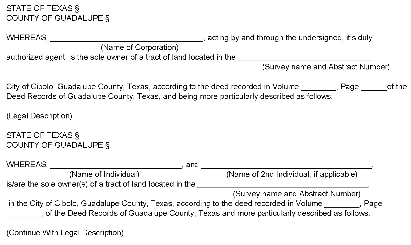
Surveyor's Certificate:
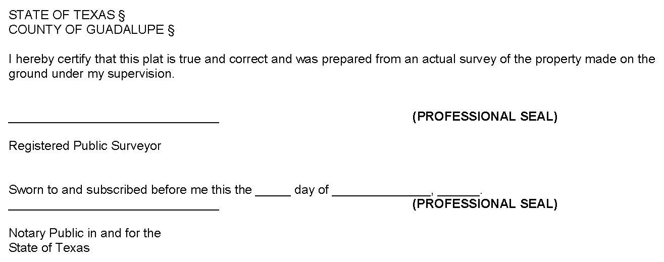
Engineer's Certificate:
An engineer's certificate is required in all cases except when the plat does not require engineering considerations.
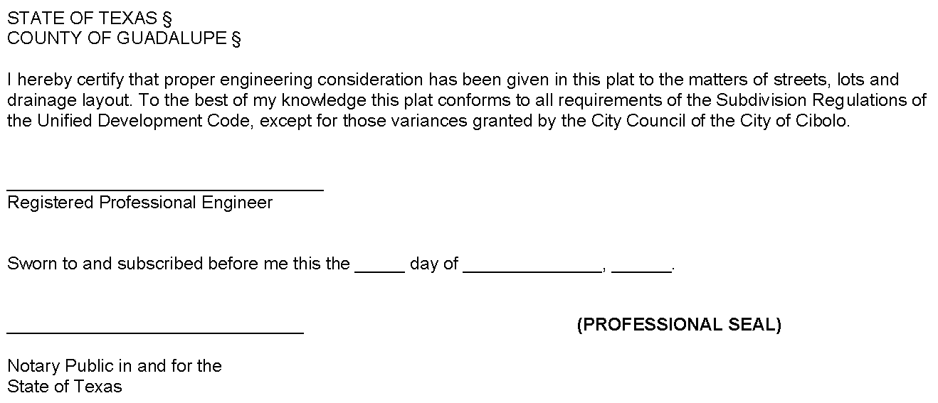
Certificate of Approval by City Engineer

Easement Note for Patio Homes and Single-Family Attached Residences
An easement for the benefit of each lot is hereby reserved over, across, and upon
each lot adjoining to such lot for roof overhangs not exceeding two feet in width,
and brick ledges which support exterior veneer walls and associated brick and veneers
not exceeding six inches in width.
Owner's Acknowledgment:
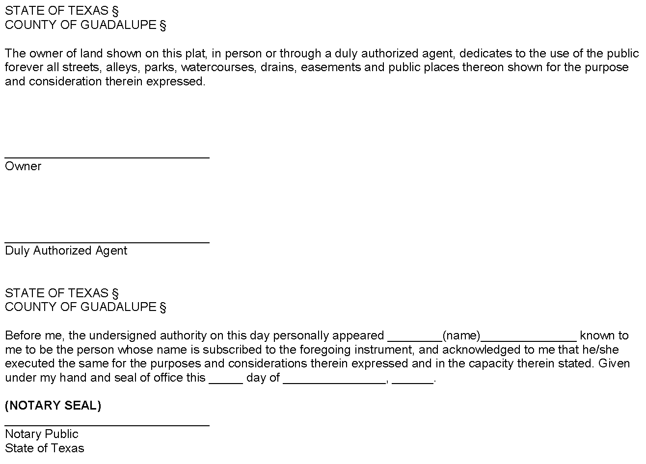
Approval of the Planning and Zoning Commission:
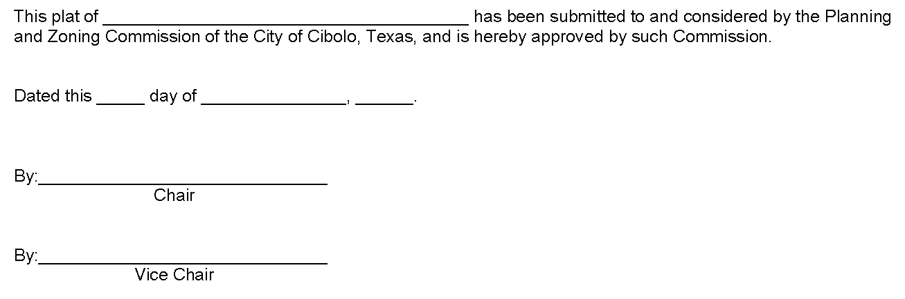
Approval of the City Council:
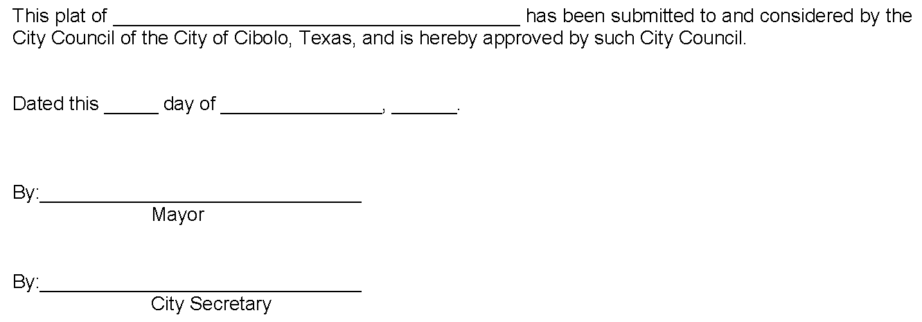
Approval of the City Planner (Minor Plats Only):
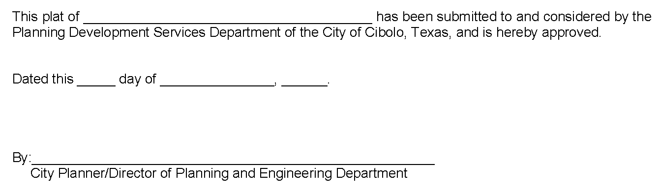
If a plat contains an access easement:
The undersigned does covenant and agree that the access easement may be utilized by
any person or the general public for ingress and egress to other real property, and
for the purpose of General Public vehicular and pedestrian use and access, and for
Fire Department and emergency use, in, along, upon, and across said premises, with
the right and privilege at all times of the City of Cibolo, its agents, employees,
workmen, and representatives having ingress, egress, and regress in, along, upon,
and across said premises.
If a plat contains VAM easements:
The area or areas shown on the plat as "VAM" (Visibility, Access, and Maintenance)
easement(s) are hereby given and granted to the city, its successors and assigns,
as an easement to provide visibility, right of access, and maintenance upon and across
said VAM easement. The city shall have the right, but not the obligation, to maintain
any and all landscaping within the VAM easement. Should the city exercise this maintenance
right, it shall be permitted to remove and dispose of any and all landscaping improvements,
including without limitation, any trees, shrubs, flowers, ground cover, and fixtures.
The city may withdraw maintenance of the VAM easement at any time. The ultimate maintenance
responsibility for the VAM easement shall rest with the owners. No building, fence,
shrub, tree, or other improvements or growths, which in any way endanger or interfere
with the visibility, shall be constructed in, on, over, or across the VAM easement.
The city shall also have the right, but not the obligation, to add any landscape improvements
to the VAM easement, to erect any traffic control devices or signs on the VAM easement,
and to remove any obstruction thereon. The city, is successors, assigns, or agents,
shall always have the right and privilege to enter upon the VAM easement or any part
thereof for the purposes and with all rights and privileges set forth herein.
Plat Vacation Instrument
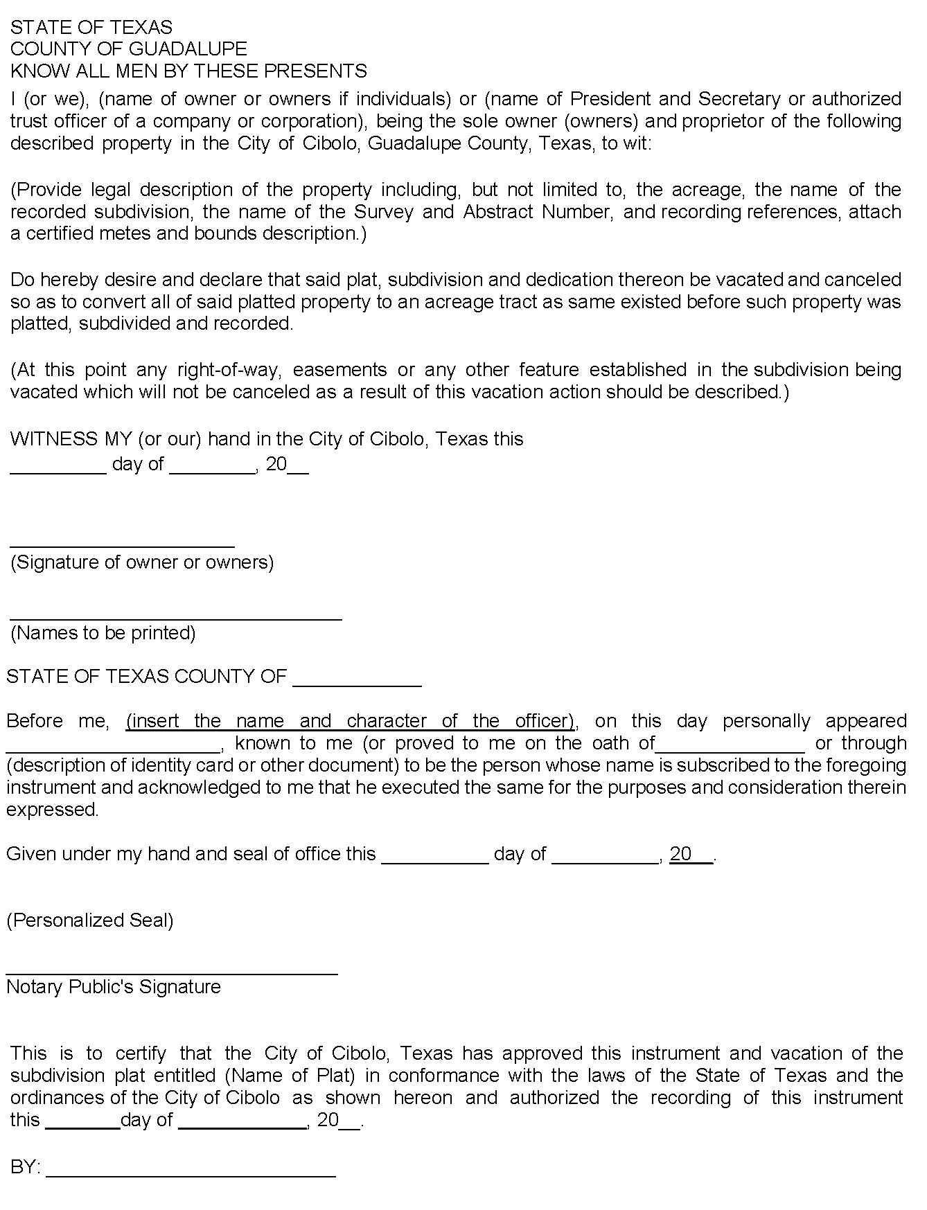
Waiver of the Statutory 30-Day Review for a Land Study, Preliminary Plat or Final
Plat
OWNER LETTERHEAD
Date
City Planner
Planning Department
City of Cibolo
P.O. 826
Cibolo, Texas 78108
Re:
Please allow this correspondence to serve as my request to the City of Cibolo waive the statutory 30-day period of time to review the above referenced project, thereby tabling the item until I provide additional information or clarification of issues before the Planning and Zoning Commission and City Council may take action on the application. Without this waiver, this application would be denied.
Applicant hereby acknowledges and understands that pursuant to Texas Local Government Code SEC. 212.0097, the City may not request or require an applicant to waive a deadline or other approval procedure in Section 212.009, and this request is made voluntarily.
Applicant hereby waives any rights that inure to this application by virtue of Texas Local Government Code Sec. 212.009, and hereby request that an extension of the review period be granted pursuant to the City of Cibolo UDC. Further, I understand and acknowledge that my application is technically considered to be "incomplete" until I provide the City of Cibolo the additional information or clarifying details required to demonstrate compliance with the City of Cibolo UDC and that until such time as that information in provided, this request shall remain "tabled and incomplete". This application shall remain "tabled and incomplete" for a period not to exceed thirty (30) days, after which time this application shall expire; necessitating the refilling of the application as a new application. The applicant also understands this request is subject to the approval of the municipal authority or governing body.
Sincerely,
Name of Developer/Applicant
STATE OF TEXAS §
COUNTY OF GUADALUPE §
This instrument was acknowledged before me on the ___ day of _______, 201___, by
________ of ___________, on behalf of said corporation.
Notary Public, State of Texas
Notary Seal
Dedication Statement
NOW, THEREFORE, KNOW ALL MEN BY THESE PRESENTS:
THAT ___________ acting herein by and through its duly authorized officers, does hereby adopt this plat designating the hereinabove described property as ___________, an addition to the City of Cibolo, Texas, and does hereby dedicate, in fee simple, to the public use forever, the streets, alleys and public parkland shown thereon. The streets, alleys and parkland are dedicated for street purposes. The easements and public use areas, as shown, are dedicated for the public use forever, for the purposes indicated on this plat. No buildings, fences, trees, shrubs, or other improvements or growths shall be constructed or placed upon, over, or across the easements as shown, except that landscape improvements may be placed in landscape easements, if approved by the City of Cibolo. In addition, utility easements may also be used for the mutual use and accommodation of all public utilities desiring to use or using the same unless the easement limits the use to particular utilities, said use by public utilities being subordinate to the public's and City of Cibolo's use thereof. The City of Cibolo and public utility entities shall have the right to remove and keep removed all or parts of any buildings, fences, trees, shrubs, or other improvements or growths which may in any way endanger or interfere with the construction, maintenance, or efficiency of their respective systems in said easements. The City of Cibolo and public utility entities shall at all times have the full right of ingress and egress to or from their respective easements for the purpose of constructing, reconstructing, inspecting, patrolling, maintaining, reading meters, and adding to or removing all or parts of their respective systems without the necessity at any time of procuring permission from anyone.
If a plat contains a Fire/Fire Lane Easement:
That the undersigned does hereby covenant and agree that he (they) shall construct
upon the fire lane easements, as dedicated and shown hereon, a hard all-weather surface
and that he (they) shall maintain the same in a state of good repair at all times
and keep the same free and clear of any structures, fences, trees, shrubs, or other
improvements or obstruction, including but not limited to the parking of motor vehicles,
trailers, boats, or other impediments to the access of fire apparatus. The maintenance
of paving on the fire lane easements is the responsibility of the owner, and the owner
shall post and maintain appropriate signs in conspicuous places along such fire lanes,
stating "Fire Lane, No Parking." The police or their duly authorized representative
is hereby authorized to cause such fire lanes and utility easements to be maintained
free and unobstructed at all times for Fire Department and emergency use.
If a plat contains VAM easements:The area or areas shown on the plat as "VAM" (Visibility, Access, and Maintenance) easement(s) are hereby given and granted to the city, its successors and assigns, as an easement to provide visibility, right of access, and maintenance upon and across said VAM easement. The city shall have the right, but not the obligation, to maintain any and all landscaping within the VAM easement. Should the city exercise this maintenance right, it shall be permitted to remove and dispose of any and all landscaping improvements, including without limitation, any trees, shrubs, flowers, ground cover, and fixtures. The city may withdraw maintenance of the VAM easement at any time. The ultimate maintenance responsibility for the VAM easement shall rest with the owners. No building, fence, shrub, tree, or other improvements or growths, which in any way endanger or interfere with the visibility, shall be constructed in, on, over, or across the VAM easement. The city shall also have the right, but not the obligation, to add any landscape improvements to the VAM easement, to erect any traffic control devices or signs on the VAM easement, and to remove any obstruction thereon. The city, is successors, assigns, or agents, shall always have the right and privilege to enter upon the VAM easement or any part thereof for the purposes and with all rights and privileges set forth herein.
Drainage and Floodway Easement or Drainage Right-of-Way for Multi-Family, Commercial and Non-Single-Family Residential Subdivisions
STATE OF TEXAS §
COUNTY OF GUADALUPE §
CITY OF CIBOLO §
This plat is hereby adopted by the owners (called "Owners") and approved by the City of Cibolo, (called "City") subject to the following conditions which shall be binding upon the Owners, their heirs, grantees, successors, and assigns: The drainage and floodway easement as shown and described by bearings and distances on Lot _______, Block _______, of the plat is called "Drainage and Floodway Easement." The Drainage and Floodway Easement is hereby reserved for the public's use forever but including the following covenants with regard to maintenance responsibilities. The existing creek or creeks traversing the Drainage and Floodway Easement will remain as an open channel at all times and shall be maintained by the individual owners of the lot or lots that are traversed by or adjacent to the Drainage and Floodway Easement. The City will not be responsible for the maintenance and operation of said creek or creeks or for any damage or injury to private property or person that results from the flow of water along said creek, or for the control of erosion. No obstruction to the natural flow of storm water run-off shall be permitted by construction of any type of building, fence, or any other structure within the Drainage and Floodway Easement. Provided, however, it is understood that in the event it becomes necessary for the City to channelize or consider erecting any type of drainage structure in order to improve the storm drainage, then in such event, the City shall have the right, but not the obligation, to enter upon the Drainage and Floodway Easement at any point, or points, with all rights of ingress and egress, to investigate, survey, erect, construct, or maintain any drainage facility deemed necessary by the City for drainage purposes. Each property owner shall keep the natural drainage channels and creeks traversing the Drainage and Floodway Easement adjacent to their property clean and free of debris, silt, and any substance which would result in unsanitary conditions or obstruct the flow of water, and the City of Cibolo shall have the right of ingress and egress for the purpose of inspection and supervision of maintenance work by the property owner to alleviate any undesirable conditions which may occur. The natural drainage channels and creeks through the Drainage and Floodway Easement, as in the case of all-natural channels, are subject to storm water overflow and natural bank erosion to an extent which cannot be definitely defined. The City shall not be held liable for any damages or injuries of any nature resulting from the occurrence of these natural phenomena, nor resulting from the failure of any structure or structures, within the natural drainage channels, and the Owners hereby agree to indemnify and hold harmless the City from any such damages and injuries. Building areas outside the Drainage and Floodway Easement line shall be filled to a minimum elevation as shown on the plat. The minimum floor elevation for each lot shall be as shown on the plat.
Drainage and Floodway Easement or Drainage Right-of-Way for Plats Where Floodplain or Drainage Easements are Maintained by a Homeowners Association
STATE OF TEXAS §
COUNTY OF GUADALUPE §
CITY OF CIBOLO §
This plat is hereby adopted by the owners (called "Owners") and approved by the City of Cibolo, (called "City") subject to the following conditions which shall be binding upon the Owners, their heirs, grantees, successor, and assigns: Lot _______, Block _______, as shown on the plat is called "Drainage and Floodway Easement." The Drainage and Floodway Easement is hereby reserved for the public's use forever but including the following covenants regarding maintenance responsibility. The existing creek or creeks traversing the Drainage and Floodway Easement shall always remain as open channels and shall be maintained by all of the owners of lots in the subdivision by and through a lawfully created homeowners association to be created by the Owners. The Owners covenant and agree that such a homeowner's association (called "Association") shall be created prior to the final acceptance of the City. All Association documents shall be subject to the approval of the City and shall specifically contain covenants binding the Association to continuously maintain the Drainage and Floodway Easement. Such covenants shall not relieve the individual lot owners of the responsibility to maintain the Drainage and Floodway Easement should the Association default in the performance of its maintenance responsibility. The Association documents shall also contain provisions that they may not be amended with regard to the Drainage and Floodway Easement maintenance responsibilities without the approval of the City. The fee simple title to the Drainage and Floodway Easement shall always remain in the Association. The City will not be responsible for the maintenance and operation of said creek or creeks or for any damage or injury to private property or person that results from the flow of water along said creek, or for the control of erosion. No obstruction to the natural flow of storm water run-off shall be permitted by construction of any type of building, fence, or any other structure within the Drainage and Floodway Easement. Provided, however, it is understood that in the event it becomes necessary for the City to consider channelizing or erecting any type of drainage structure in order to improve the storm drainage, then in such event, the City shall have the right, but not the obligation, to enter upon the Drainage and Floodway Easement at any point, or points, with all rights of ingress and egress to investigate, survey, or to erect, construct, and maintain any drainage facility deemed necessary for drainage purposes. The Owners and the Association shall keep the natural drainage channels within the Drainage and Floodway Easement free of debris, silt, or any substance which would result in unsanitary conditions or obstruct the flow of water, and the City shall have the right of ingress and egress for the purpose of inspection and supervision of maintenance work by the Owners and the Association to alleviate any undesirable conditions which may occur. The creeks and natural drainage channels through the Drainage and Floodway Easement, as in the case of all-natural channels, are subject to storm water overflow and natural bank erosion to an extent which cannot be definitely defined. The City shall not be liable for any damages and injuries of any nature resulting from the occurrence of these natural phenomena, nor resulting from the failure of any structure or structures, within the Drainage and Floodway Easement, and the Owners hereby agree to indemnify and hold harmless the City from any such damages and injuries. Building areas outside the Drainage and Floodway Easement shall be filled to a minimum elevation as shown on the plat.
Drainage and Floodway Easement for Plats Not Governed by a Homeowners Association
STATE OF TEXAS §
COUNTY OF GUADALUPE §
CITY OF CIBOLO §
This plat is hereby adopted by the owners (called "Owners") and approved by the City of Cibolo, (called "City") subject to the following conditions which shall be binding upon the Owners, their heirs, grantees, successors, and assigns: Lot _______, Block _______, as shown on the plat is called "Drainage and Floodway Easement." The Drainage and Floodway Easement is hereby reserved for the public's use forever for drainage and floodway purposes. All Owner documents shall specify, confirm and bind the Owner(s) to continuously maintain the Drainage and Floodway Easement and shall relieve the individual lot owners and City of Cibolo of the responsibility to maintain the Drainage and Floodway Easement. The fee simple title to the Drainage and Floodway Easement shall always remain in the Owner(s). The City will not be responsible for the maintenance and operation of said creek or creeks or for any damage or injury to private property or person that results from the flow of water along said creek, or for the control of erosion. The Owners shall not obstruct the natural flow of storm water run-off by the construction of any type of building, fence, or any other structure within the Drainage and Floodway Easement. The City shall at all times have the right to enter upon the Drainage and Floodway Easement, at any point, or points, with all rights of ingress and egress, to investigate, survey, erect, construct, and maintain any facility deemed necessary by the City for drainage purposes. The drainage channels and creeks, as in the case of all-natural channels, are subject to storm water overflow and natural bank erosion to an extent which cannot be defined. The City shall not be held liable for any damages or injuries of any nature resulting from the occurrence of these natural phenomena, nor resulting from the failure of any structure or structures, within the Drainage and Floodway Easement, and the owners hereby agree to indemnify and hold harmless the City from any such damages and injuries. The building areas outside of the Drainage and Floodway Easement shall be filled to a minimum elevation as shown on the plat. The minimum floor elevation for each lot shall be as shown on the plat.
AMENDED PLAT CERTIFICATE OF APPROVAL
APPROVED AS AN AMENDED PLAT, this the ___ day of ___, 20___, by the City of Cibolo, Texas.
___________
City of Cibolo City Engineer
STATE OF TEXAS §
COUNTY OF §
BEFORE ME, the undersigned authority, a Notary Public in and for said county and state, on this day personally appeared ___________known to me to be the person whose name is subscribed to the foregoing instrument and acknowledged to me that he executed the same for the purpose and consideration thereof expressed.
GIVEN UNDER MY HAND AND SEAL OF OFFICE
THIS ___ DAY OF ___, 20___.
(Notary Seal)
___________
NOTARY PUBLIC in and for the STATE OF TEXAS
CERTIFICATE OF APPROVAL
APPROVED AS AN AMENDED PLAT, this the ___ day of ___, 20___, by the City of Cibolo, Texas.
___________
City Planner/Planning and Engineering Director
(Include the same notary language described above)
PRIVATE STREETS
NOW THEREFORE, KNOW ALL MEN BY THESE PRESENTS:
1.
That ___________ ("Owner"), acting herein by and through its duly authorized officer, does hereby adopt this plat designating the herein described property as ___________, an addition to the City of Cibolo, Texas (the "City"), and does hereby dedicate to the City: (i) easements for the purposes shown on this plat and for the mutual benefit, use, and accommodation of all public utility entities including the City providing services to the addition created hereby and desiring to use or using the same, and also an easement and right-of-way, under, across, and upon Block ___________, Lot ___________ shown hereon for the construction, installation, maintenance, operation, inspection, removal, and reconstruction of the facilities, equipment, and systems of such public utility entities; and (ii) for the use, benefit, and accommodation of the City, an easement and right-of-way, under, across, and upon Block ___________, Lot ___________ shown hereon for any purpose related to the exercise of a governmental service or function including, but not limited to, fire and police protection, garbage collection, inspection and code enforcement, and the removal of any vehicle or obstacle that impairs emergency access. Block ___________, Lot ___________ and all streets shown hereon are private streets and are not dedicated for use as public streets, or rights-of-way and the public shall have no right to use any portion of such private streets. Owner acknowledges that so long as the streets and related improvements constructed on Block ___________, Lot ___________ shown hereon shall remain private, certain City services shall not be provided on said private streets including, but not limited to, street cleaning, routine police patrols, enforcement of traffic and parking ordinances, and preparation of accident reports. Except for private streets and related improvements, no buildings, fences, trees, shrubs, or other improvements or growths shall be constructed or placed upon, or across the easements dedicated herein. The City and public utility entities shall have the right to remove and keep removed all or parts of any buildings, fences, trees, shrubs, or other prohibited improvements or growths which may in any way endanger or interfere with their respective easements. In addition, the City shall have the right to remove and keep removed any vehicle or obstacle that impairs emergency access to its easement. The City and public utility entities shall at all times have the full right of ingress and egress to and from their respective easements without the necessity at any time of procuring permission from anyone. The use, by the City and public utility entities, of their respective easements shall not unreasonably interfere with the rights of property owners and the homeowners association (the "Association") in and to Block ___________, Lot ___________ shown hereon as set forth in the "Declaration of Covenants, Restrictions, and easements for the ___________", dated ________, recorded in Guadalupe County Recorder Volume _______, Page_______, of the official Land Records of Guadalupe County, Texas (the "Declaration").
2.
That the Association agrees to release, indemnify, defend, and hold harmless the City and any governmental entity or public utility entity that owns public improvements within the addition created by this plat (collectively, the "Indemnities") from and against any claims for damages to the private streets, restricted access gates and entrances, and related appurtenances (collectively, the "Private Streets") caused by the reasonable use of the Private Streets by the Indemnities. This paragraph 2 does not apply to damages to the Private Streets caused by the design, construction, or maintenance, or any public improvements owned by any of the Indemnities.
3.
That the Association agrees to release, indemnify, defend, and hold harmless the Indemnities from and against any claims for damages to property and injury to persons (including death) that arise out of the use of the Private Streets by the Indemnities and that are caused by the failure of the Association to design, construct, or maintain the Private Streets in accordance with City standards. The indemnification contained in this paragraph 3 shall apply regardless of whether a contributing factor to such damages or injury the negligent acts or omissions of the Indemnities or their respective officers, employees, or agents was;
4.
That the owner of each lot shown on this plat agrees to release the Indemnities from claims for damages to property and injury to persons (including death) that arise out of the use of the Private Streets by the Indemnities and that are caused by the failure of the Association to design, construct, or maintain the Private Streets in accordance with City standards;
5.
That the obligations of the Association and lot owners set forth in paragraphs 2, 3, and 4 above shall immediately and automatically terminate when the streets and other rights-of-way have been dedicated to and accepted by the City;
6.
That no improvements shall be constructed or installed in the ___________ Wall and Wall Maintenance Easement on Block ___________, Lot ___________ except for fencing, landscaping, underground drainage pipes, and underground sprinkler system;
7.
That if Block ___________, Lot ___________ in the future becomes a public street as provided in the Declaration, Owner dedicates to the City a sidewalk easement on the portions of Block ___________, Lot ___________ on which a sidewalk is installed connecting the sidewalk on Block ___________, Lot ___________ ___ into public sidewalks on ___________, together with (a) the area lying between such sidewalks and the lot line of Block ___________, Lot ___________, and (b) the area lying within two feet of the other side of the sidewalks.
This plat approved subject to all platting ordinances, rules, regulations, and resolutions of the City of Cibolo, Texas.
WITNESS MY HAND, this ___ day of ___, 20___
By: ___________
Owner/Developer
STATE OF TEXAS §
COUNTY OF §
BEFORE ME, the undersigned, a Notary Public in and for the State of Texas, on this day personally appeared ___________, known to me to the person whose name is subscribed to the foregoing instrument and acknowledged to me that he executed the same for the purpose, and consideration therein expressed, as
___________ a Texas ___________, in its capacity as ___________ of ___________, a Texas limited partnership, on behalf of said partnership.
GIVEN UNDER MY HAND AND SEAL OF OFFICE this ___________ of ___________, 20___.
(Notary Seal)
___________
NOTARY PUBLIC in and for the STATE OF TEXAS
Conveyance Plat Note
Conveyance plats must be titled "Conveyance Plat" and carry the following wording:
A conveyance plat is a record of property approved by the city for the purpose of sale or conveyance in its entirety or interests thereon defined. No building permit shall be issued, nor permanent public utility service provided, until a final plat is approved, filed of record, and public improvements accepted in accordance with the provisions of the Unified Development Code of the City of Cibolo. Selling a portion of this property by metes and bounds, except as shown on an approved, filed, and accepted conveyance plat, final plat, or replat is a violation of the City of Cibolo UDC and State law.
Deed Restrictions Statement for Replats
To be processed as a replat "without property owner notification" and be controlling
over the previous plat without vacating the previous plat the submittal must meet
the following condition, and the following statement must be shown and certified to/by
the property owner.
This statement is only used when replatting nonresidential zoned property. Is should follow the dedication statement because the property owner is certifying to the statement.
BEING all of lots ___________, Block ___________
Section/Unit ___________, Subdivision Addition Name ___________, a
subdivision in the City of Cibolo, Guadalupe County, Texas, according to the plat recorded in Volume _______,
Page _______, of the Official Plat Records of the County Clerk of Guadalupe County, Texas.
I ___________(Property Owner), hereby certify that deed restrictions do not exist upon the property included within this Replat that limit said property to residential use for not more than two residential units per lot.
PERFORMANCE BOND
STATE OF TEXAS §
COUNTY OF GUADALUPE §
CITY OF CIBOLO §
KNOW ALL MEN BY THESE PRESENTS:
THAT WE, ___________, as Principal, hereinafter called the "Developer" and the other subscriber hereto, as Surety, do hereby acknowledge ourselves to be held and firmly bound to the City of Cibolo, a municipal corporation, in the sum of ___________ Dollars ($) for the payment of which sum, well and truly to be made to the City of Cibolo and its successors, the said Developer for and Surety do bind themselves, their heirs, executors, administrators, successors, and assigns, jointly and severally.
THE CONDITIONS OF THIS OBLIGATION ARE SUCH THAT:
WHEREAS, the Developer has on or about this day executed a Contract in writing with the City of Cibolo for all of such work to be done as set out in full in said Contract Documents therein referred to and adopted by the City Council, all of which are made a part of this instrument as fully and completely as if set out in full herein.
NOW THEREFORE, if the said Developer shall faithfully and strictly perform Contract in all its terms, provisions, and stipulations in accordance with its true meaning and effect, and in accordance with the Contract Documents referred to therein and shall comply strictly with each and every provision of Contract and with this bond, then this obligation shall become null and void and shall have no further force and effect; otherwise the same is to remain in full force and effect.
It is further understood and agreed that the Surety does hereby relieve the City of Cibolo or its representatives, from the exercise of any diligence whatever in securing compliance on the part of the Developer with the terms of the Contract, and the Surety hereby waives any notice to it of any default, or delay by the Developer in the performance of their Contract and agrees that it, the Surety, shall be bound to take notice of and shall be held to have knowledge of all acts or omissions of the Developer in all matters pertaining to the Contract. The Surety understands and agrees that the provision in the Contract that the City of Cibolo shall retain certain amounts due the Developer until the expiration of thirty days from the acceptance of the Work is intended for the City's benefit, and the City of Cibolo shall have the right to pay or withhold such retained amounts or any other amount owing under the Contract without changing or affecting the liability of the Surety hereon in any degree.
It is further expressly agreed by Surety that the City of Cibolo or its representatives are at liberty at any time, without notice to the Surety, to make any change in the Contract Documents and in the Work to be done there under, as provided in the Contract, and in the terms and conditions thereof, or to make any change in, addition to, or deduction from the work to be done there under; and that such changes, if made, shall not in any way vitiate the obligation in this bond and undertaking or release the Surety there from.
It is further expressly agreed and understood that the Developer and Surety will fully indemnify and save harmless the City of Cibolo from any liability, loss, cost, expense, or damage arising out of or in connection with the work done by the Developer under the Contract.
If the Contract Price is greater than $1.2 million and in the event that the City of Cibolo shall bring any suit or other proceeding at law on the Contract or this bond or both, the Developer and Surety agree to pay to the City the sum of 10 percent of whatever amount may be recovered by the City in suit or legal proceeding, which sum of 10 percent is agreed by all parties to be indemnity to the City for the expense of or time consumed by its City Attorney, assistants, and office force, and other cost and damage occasioned to the City. This amount of 10 percent is fixed and liquidated by the parties; it being agreed by them that the exact damage to the City would be difficult to ascertain.
This bond and all obligations created hereunder shall be performable in Guadalupe County, Texas. This bond is given in compliance with the provisions of Article 5160, Revised Civil Statutes of Texas, as amended, which is incorporated herein by this reference. However, all express provisions hereof shall be applicable whether or not within the scope of said statute.
Notices required or permitted hereunder shall be in writing and shall be deemed delivered when actually received or, if earlier, on the third day following deposit in a United States Postal Service post office or receptacle, with proper postage affixed (certified mail, return receipt requested), addressed to the respective other party at the address prescribed in the Contract Documents, or at such other address as the receiving party may hereafter prescribe by written notice to the sending party.
IN WITNESS THEREOF, the said Developer and Surety have signed and sealed this instrument on the respective dates written below their signatures and have attached current Power of Attorney.
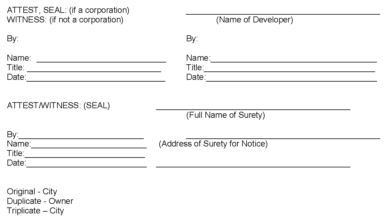
Maintenance Bond
STATE OF TEXAS §
COUNTY OF GUADALUPE §
CITY OF CIBOLO §
KNOW ALL MEN BY THESE PRESENTS:
That we, ___________ the undersigned subdivider, as Principal, and , as Surety, do hereby acknowledge ourselves to be held and firmly bound unto the City of Cibolo, a municipal corporation of the County of Guadalupe and State of Texas, in the full and just sum of $___________(being twenty-five (25%)) percent of the estimated cost of the hereinafter enumerated site improvements) for the payment of which well and truly to be made, we hereby bind ourselves and our respective heirs, administrators, executors and assigns, jointly and severally, firmly by these presents.
WHEREAS, the Principal has petitioned the City Council of the City of Cibolo for permission to develop a subdivision within the jurisdiction of the City of Cibolo, more particularly described as follows, to wit: (Legal Description), which is shown on a subdivision plat, entitled Subdivision, heretofore conditionally approved by the Planning and Zoning Commission of The City of Cibolo on ___________20___; and
WHEREAS, under the provisions of the City of Cibolo Unified Development Code, the City Council of the City of Cibolo requires, as a condition precedent to the granting of such petition, that the Principal a guarantee that he will maintain and cause to be maintained, in good condition according to the requirements of such subdivision ordinance, and to correct any and all deficiencies not in accordance with the approved plans and specifications as may be noted, the following site improvements for a period of eighteen (18) months after acceptance of the construction thereof by the City Council or until such time as such improvements have received Final Acceptance by the City, whichever is the latter:
NOW, THEREFORE, the condition of this obligation is such that if the Principal shall maintain or correct, and cause to be maintained or corrected, the above mentioned improvements in accordance with the requirements of the City of Cibolo subdivision ordinance, and the amendments thereto, if any, for the period of eighteen (18) months after the acceptance of the construction thereof by the City Council of the City of Cibolo, or until said improvements have received Final Acceptance by the City Council of Cibolo, then this obligation shall be void: otherwise, the obligations made under this bond will remain in full force and effect.
IN TESTIMONY WHEREOF, WITNESS OUR HANDS and seal, this the ___________ Day of ___________, 20___.
Subdivider and Principal
Surety
By:
Attorney in Fact
APPROVED AND ACCEPTED, THIS THE ___ DAY OF ____________ 20____.
CITY OF CIBOLO
BY: ________________________________
TITLE: ________________________________
Original - City
Duplicate - Owner
Triplicate - City
Warranty Bond
STATE OF TEXAS §
COUNTY OF GUADALUPE §
CITY OF CIBOLO §
KNOW ALL MEN BY THESE PRESENTS:
That we, ________ the undersigned subdivider, as Principal, and ___________,as Surety, do hereby acknowledge ourselves to be held and firmly bound unto the City of Cibolo, a municipal corporation of the County of Guadalupe and State of Texas, in the full and just sum of $_______(being ten 10%) percent of the estimated cost of the hereinafter enumerated site improvements) for the payment of which well and truly to be made, we hereby bind ourselves and our respective heirs, administrators, executors and assigns, jointly and severally, firmly by these presents.
WHEREAS, the Principal has petitioned the City Council of the City of Cibolo for permission to develop a subdivision within the jurisdiction of the City of Cibolo, more particularly described as follows, to wit: (Legal Description), which is shown on a subdivision plat, entitled ___________Subdivision, heretofore conditionally approved by the Planning and Zoning Commission of The City of Cibolo on ________20___; and
WHEREAS, under the provisions of the City of Cibolo Unified Development Code, the City Council of the City of Cibolo requires, as a condition precedent to the granting of such petition, that the Principal guarantee that he will maintain and cause to be maintained, in good condition according to the requirements of such subdivision ordinance, and to correct any and all deficiencies not in accordance with the approved plans and specifications as may be noted, the following site improvements for a period of eighteen (18) months after acceptance of the construction thereof by the City Council:
NOW, THEREFORE, the condition of this obligation is such that if the Principal shall maintain or correct, and cause to be maintained or corrected, the above mentioned improvements in accordance with the requirements of the City of Cibolo subdivision ordinance, and the amendments thereto, if any, for the period of eighteen (18) months after the acceptance of the construction thereof by the City Council of the City of Cibolo, then this obligation shall be void: otherwise, the obligations made under this bond will remain in full force and effect.
IN TESTIMONY WHEREOF, WITNESS OUR HANDS and seal, this the ___________ Day of ___________, 20___.
Subdivider and Principal
Surety
By:
Attorney in Fact
APPROVED AND ACCEPTED, THIS THE ___ DAY OF ____________ 20____.
CITY OF CIBOLO
BY: ________________________________
TITLE: ________________________________
Original - City
Duplicate - Owner
Triplicate - City
Preliminary Acceptance
PART I
DEVELOPER PETITION FOR PRELIMINARY ACCEPTANCE OF PUBLIC IMPROVEMENT(S) FOR: (Name/Section of Development).
STATE OF TEXAS §
COUNTY OF GUADALUPE §
CITY OF CIBOLO §
WHEREAS, , hereinafter called Owner, is the owner of the land described as Subdivision, desires to file this, his (its) Petition, with the City Council of the City of Cibolo. This petition is being filed in accordance with the terms and provisions of the current Regulations.
NOW THEREFORE, KNOW ALL MEN BY THOSE PRESENT THAT ___________ (Owner) respectfully files this, a Petition with the City Council of the City of Cibolo for Preliminary Acceptance of the following described public improvements (list each improvement, the length of each improvement and the valuation of each improvement):
Water:
Sanitary Sewer:
Drainage:
Street:
Other:
OWNER, in filing this petition, sets forth the following information as required in current Regulations:
A.
Attached hereto as Exhibit "A" is a true and correct copy of the itemized construction costs of the above described project (s). Construction was accomplished by:
Contractor Name at a total cost of $ .
B.
Attached as Exhibit "B" are two (2) true and correct copies of "as built" drawings certified to by a registered professional engineer.
C.
Attached as Exhibit "C" are two (2) true and correct copies of field density tests and material source tests, certified by a recognized testing laboratory (Exhibit "C" is required only for street and alley improvements).
OWNER GUARANTEES:
A.
All materials and workmanship to be in accordance with approved plans and specifications prescribed by the City, and
B.
To correct any and all deficiencies not in accordance with approved plans and specifications as may be noted until final acceptance by the City Engineer and City Council.
IN TESTIMONY WHEREOF, WITNESS OUR HANDS and seal this, the ___ Day of ___________, 20___.
Subdivider and Principal
Surety By: ___________
Attorney in Fact
APPROVED AND ACCEPTED, THIS THE ___________ day of ___________ 20___.
CITY OF CIBOLO
BY: ___________
TITLE: ___________
Original - City
Duplicate - Owner
Triplicate - City
Final Acceptance
PART II
DEVELOPER PETITION FOR FINAL ACCEPTANCE OF PUBLIC IMPROVEMENT(S),
FOR: (Name/Section of Development).
WHEREAS, the City Council of the City of Cibolo, Texas approved the Preliminary Acceptance of the improvements listed in Part I Petition for:
Subdivision; and
NOW THEREFORE, KNOW ALL MEN BY THOSE PRESENT THAT ___________(Owner) respectfully files this, a Petition with the City Council of the City of Cibolo for Final Acceptance of the following described public improvements (list each improvement, the length of each improvement and the valuation of each improvement):
Water:
Sanitary Sewer:
Drainage:
Street:
Other:
WHEREAS, the owner has maintained such improvements in good condition for at least one year from date of acceptance by the City Council; and
WHEREAS, the owner has corrected all deficiencies reported by the City of Cibolo,
It is therefore requested that final inspection be made of said improvements, that Final Acceptance be approved by the City Council of the City of Cibolo, and that the Owner be relieved of any further obligation to maintain or cause to maintain such improvements.
(Date)
By
(Owner)
Original - City
Duplicate - Owner
Triplicate - City
Final Acceptance
PART III
FINAL ACCEPTANCE
The above improvements listed in the petition have been inspected as required by current regulations, all required maintenance has been performed, and all noted deficiencies have been corrected. I recommend that the improvements described in the petition be accepted by the City of Cibolo and all maintenance on said improvements be assumed by the City.
___________ ___________
(Date) City Engineer, City of Cibolo, Texas
APPROVED AND ACCEPTED BY THE CITY COUNCIL OF THE CITY OF CIBOLO, TEXAS, ON THIS, THE ___________ DAY OF, ___________ 20___ AD.
Mayor, City of Cibolo, Texas
City Secretary, City of Cibolo, Texas
Original - City
Duplicate - Owner
Triplicate - City