
Cibolo City Zoning Code
ARTICLE 4
- ZONING REGULATIONS5
Editor's note—Ord. No. 1332, § I(Exh. A), adopted April 27, 2021, amended Art. 4, §§ 4.1—4.7, in effect replacing said article with §§ 4.1—4.7, as set out herein. Formerly, Art. 4pertained to similar subject matter and derived from Ordinance 1233, adopted April 24, 2018; Ord. No. 1324, § 1, adopted Dec. 8, 2020; and Ord. No. 1325, § 2, adopted Jan. 12, 2021.
Section 4.1 - General Provisions
4.1.1 Purpose and Intent
The purpose of this Article is to promote the public health, safety, general welfare and quality of life of the present and future citizens of the City.
4.1.2 Consistency with Comprehensive Master Plan
The City's Comprehensive Master Plan, as adopted and as amended and periodically updated, is the policy guide for the development of this Article.
4.1.3 Minimum Requirements
The provisions of this Article shall be interpreted and applied as the minimum requirements for the promotion of public health, safety, general welfare and quality of life of the present and future citizens of the City.
Whenever the requirements of this UDC conflict with the requirements of any other lawfully adopted rules, regulations, or ordinances, the requirement that is most restrictive or that imposes higher standards will apply.
The issuance of any permit, certificate or approval in accordance with the standards and requirements of this UDC shall not relieve the recipient of such permit, certificate or approval from the responsibility of complying with all other applicable requirements of any other municipality, special district, state or federal agency having jurisdiction over the structures or land uses for which the permit, certificate or approval was issued.
Section 4.2 - Zoning Authority and Roles
4.2.1 Planning and Zoning Commission
4.2.1.1. Planning and Zoning Commission created
A.
A Commission of the City Council of the City is hereby created which shall be known as the Cibolo Planning and Zoning Commission. The Commission shall consist of seven members.
B.
A chairperson and vice-chairperson shall be elected annually among the commission members. In the absence of both the chairperson and vice-chairperson, the Commission shall appoint an acting chairperson.
C.
There shall be seven places on the commission being defined as Place #1, Place #2, Place #3, Place #4, Place #5, Place #6, and Place #7 and two (2) alternates.
4.2.1.2. Meetings
A.
Regular meetings shall be held monthly unless a lack of agenda items allows for a meeting not to be held. Special meetings may be required at the request of the chairperson or at the request of the Mayor and/or City Council. The time and place of both special and regular meetings are subject to change upon proper notification of all members of the Commission.
4.2.1.3. Parliamentary procedure; meetings open to public
A.
The Commission will conduct its meetings in conformance with "Robert's Rules of Order," latest revision, which shall be the commission's final authority on all questions of procedure and parliamentary law.
B.
A quorum shall consist of a majority of the entire membership of the Commission and any issue to be voted on shall be resolved by a majority of those present.
4.2.2 Role of City Council
The City Council is responsible for appointing and removing members of the Planning and Zoning Commission. After first receiving a P and Z report, City Council shall: conduct a public hearing and after the public hearing is concluded, hear and render decisions on applications for original zoning or proposed amendments, to the official zoning map, take final action on UDC amendments, take final action on certain appeals and non-zoning related variances from the UDC, and (where defined in this UDC) take final action on decisions by the Planning and Zoning Commission and City staff in the administration of this UDC.
4.2.3 Role of City Staff
City staff designated by the City Manager will administrate the duties and procedures provided in this UDC. The provisions of this ordinance will ordinarily be carried out by said officials, or a designee such as assistants, deputies, or department heads.
4.2.4 Role of Board of Adjustment
The Board of Adjustment (BOA) has the powers and duties set forth in Chapter 211 of the Texas Local Government Code. The Board of Adjustment's jurisdiction extends to and includes the following specific powers and duties:
1)
Zoning Variance from Zoning standards of this UDC
2)
Appeal of an Administrative Decision, where defined by this UDC and TLGC §211.010.
4.2.4.1 Membership
The Board of Adjustment shall consist of seven (7) regular members and two (2) alternate members, each to be appointed for a term of two (2) years and removable for cause by the City Council. The two (2) alternate members shall serve in the absence of one (1) or more regular members when requested to do so by the City Manager or designee.
4.2.5 Role of the Building Official or Designee
A.
Whenever any building work is being done contrary to the provisions of this UDC, the Building Official may order the work stopped and also revoke the building permit theretofore issued by notice in writing served on any person owning such property or their agent or on any person engaged in the doing or causing of such work to be done, and any such person shall forthwith stop and cause to be stopped such work until authorized by the Building Official to recommence and proceed with the work or upon issuance of a building permit in those cases in which the building permit has been revoked, and further such stop work order and revocation of permit shall be posted on work being done in violation of this ordinance.
B.
Whenever any building or portion thereof is being used or occupied contrary to the provisions of this UDC, the Building Official shall order such use or occupancy discontinued and the building or portion thereof vacated by notice served on any person using or causing such use or occupancy to be continued, and such person shall vacate such building or portion thereof within 10 (ten) days after receipt of such notice, or make the building or portion thereof comply with the requirements of this ordinance.
Section 4.3 - Processes
4.3.1 Zoning Map Amendment Process (Rezoning)
The Official Zoning Map may be amended based upon changed or changing conditions in a particular area or in the City generally, or to rezone an area, or to extend the boundary of an existing zoning district. All amendments must be in accordance with the Future Land Use Plan. The City Council is responsible for final action on Zoning Map Amendments.
4.3.1.1 Submittal Requirements
An application for Zoning Map Amendment shall be deemed complete when the applicant or agent has provided on or before the application submittal date prescribed by the City Planner or designee:
A.
A letter or application form, signed by the property owner(s), stating the current and requested zoning classifications;
B.
A copy of the current deed, indicating ownership and authority to file the application;
C.
A legal description of the property, whether by Lot and Block, or by metes and bounds;
D.
The full required fee for processing the application; and
E.
A list of property owners within two hundred (200) feet of the property for which the change in district boundary is proposed.
4.3.1.2 City Staff Review
A.
City Planner shall review the application and make a determination of completeness of the application.
B.
A complete application will be reviewed by the City Planner and designees for consideration of applicable criteria and prepare a report to the Planning and Zoning Commission and City Council.
C.
The City Planner's report may include a recommendation for final action.
4.3.1.3 Planning and Zoning Commission Required Notice, Hearing and Action
The Planning and Zoning Commission shall hold a public hearing to consider proposed changes in district boundaries or amendments to regulations. Written notice of any such public hearing shall be mailed to all owners of real property, according to the most current, approved County tax rolls, lying within two hundred (200) feet of the property for which a change in district boundaries is proposed. Such notice shall be mailed not less than eleven (11) days before the date set for hearing. If an application or petition has been filed, the party responsible shall appear in person or by agent.
The Commission shall act upon changes and amendments as originally submitted or modified. If the Commission is satisfied that a proposed change or amendment is justified, it shall recommend City Council approval. If modifications are required, such modifications shall be included in the recommendation to the City Council. If the Commission is not satisfied that a proposed change or amendment is justified, it shall recommend City Council disapproval. The reasons for disapproval shall be included in the recommendation to the City Council.
4.3.1.4 City Council Required Notice, Hearing
A public hearing shall be held by the City Council before adopting any proposed supplement, amendment or change. Notice of such hearing shall be given before the 15 th day before the date of the hearing. Notice of the time and place of the hearing must be published in an official newspaper or a newspaper of general circulation in the municipality. If an application or petition has been filed, the owner shall appear in person or by agent.
4.3.1.5 Approval Criteria
In determining whether to approve, approve with modifications, or disapprove a proposed amendment, the City Council shall consider the following:
A.
The application is complete, and the information contained within the application is sufficient and correct enough to allow adequate review and final action;
B.
The Zoning Map Amendment is consistent with the City's adopted Comprehensive Master Plan;
C.
The Zoning Map Amendment promotes the health, safety, or general welfare of the city and the safe and orderly development of the City;
D.
The Zoning Map Amendment is compatible with the present zoning and conforming uses of nearby property and the character of the neighborhood. And;
E.
The property to be rezoned is suitable for uses permitted by the District that would be applied by the proposed amendment.
4.3.2 Conditional Use Permit.
A Conditional Use Permit is intended to provide some flexibility to traditional zoning by offering a mechanism to balance specific site constraints and development plans with the larger interest of the community and the integrity of the UDC. An application for Conditional Use Permit follows the same process as a Zoning Map Amendment Process (Rezoning), as described above, in all respects. The Permit, if granted, may include conditions placed upon the development of the property. The Planning and Zoning Commission and City Council shall consider the following, at a minimum, in conjunction with its deliberations for approval or denial of the application and the establishment of conditions:
A.
Consistency with the Comprehensive Master Plan;
B.
Conformance with applicable regulations in this UDC and standards established by the UDC;
C.
Compatibility with existing or permitted uses on abutting sites, in terms of building height, bulk, scale, setbacks and open spaces, landscaping and site development, and access/circulation;
D.
Potential unfavorable impacts on existing or permitted uses on abutting sites, the extent that such impacts exceed those which reasonably may result from use of the site by a permitted use;
E.
Modifications to the site plan which would result in increased compatibility or would mitigate potentially unfavorable impacts or would be necessary to conform to applicable regulations and standards and to protect the public health, safety, morals and general welfare. And;
F.
Safety and convenience of vehicular and pedestrian circulation in the vicinity, including traffic reasonably expected to be generated by the proposed use.
The Planning and Zoning Commission, in recommending favorably upon an application for a Conditional Use Permit, must make all the following findings of fact:
A.
The proposed use is in accord with the objectives of these regulations and the purposes of the district in which the site is located.
B.
That the proposed use will comply with each of the applicable provisions of these regulations.
C.
That the proposed use and site development, together with any modifications applicable thereto, will be completely compatible with existing or permitted uses in the vicinity.
D.
That the conditions applicable to approval are the minimum necessary to minimize potentially unfavorable impacts on nearby uses and ensure compatibility with existing or permitted uses in the same district and the surrounding area, and that the prescribed zoning standards ensure proper mitigation of identified impacts by recommending stricter standards where necessary.
E.
The Commission gave due consideration to all technical information supplied by the applicant.
F.
That the proposed use, together with the conditions applicable thereto, will not be detrimental to the public health, safety or welfare or materially injurious to properties or improvements in the vicinity.
G.
For Sexually Oriented Businesses, the Commission or Council may require any information that may be necessary to determine if the proposed business will comply with all requirements of City Ordinance Number 744.
4.3.3 Post Decision Procedures for Zoning Map Amendment Process and Conditional Use Permits
A.
Notification Required
Within ten (10) business days following final action on any development application, the City shall provide written notification to the applicant of the decision of the City Council considering the request. If an application has been denied, the notification should include the reasons for denial as well as any information relating to reapplication procedures for the appropriate application.
B.
Reapplication Following Denial
When a rezoning or conditional use permit application is denied, a new rezoning or conditional use permit application for all or a part of the same property shall not be accepted for filing for a period of six (6) months after the date of denial unless the subsequent application involves a proposal that is substantially different from the previously denied proposal. For the purpose of this section, a request may be considered substantially different if the change is to a different zoning classification, there is a change in conditions relating to zoning principles of the property or surrounding properties or there is a change in the nature of the development of the property or surrounding properties. The City Manager or designee shall resolve any questions concerning the similarity of the reapplication. The final decision-maker may, at its option, waive the six (6) month waiting period if, after due consideration of the matter at a scheduled and posted meeting, it is determined that denial of the request was based upon erroneous or omitted information, or if substantial new information pertaining to the request is discovered.
C.
Amendments and Revisions to Approved Application
Unless otherwise expressly provided by this UDC, any request to amend or revise an approved development application shall be considered a new application, which must be decided in accordance with the procedures governing the original application and the standards in effect at the time such new application is filed with the City.
D.
Amendments Required
Whenever a subsequent development application differs substantially from a previously approved development application to which the subsequent application must conform, the applicant shall submit an amended development application for the initial development application, which shall be decided prior to the subsequent application. The applicant's failure to comply with this section shall result in denial of the subsequent application
4.3.4 Appeal of Administrative Decision
The Board of Adjustment shall have the authority to hear requests for the appeal of the decision made by the City pursuant to Texas Local Government Code §211.010.
4.3.5 Zoning Variance
The Board of Adjustment shall have the authority to hear requests for zoning variances in accordance with the terms of this UDC and Texas Local Government Code §211.010.
4.3.5.1 Application Requirements for Zoning Variances
The following terms prescribe the initiation and initial process of a variance application:
Applications must be made in a format and in a manner consistent with requirements determined by the City. Applications must include all materials determined necessary by the City. Information regarding format requirements and submittal materials required for the application will be made available by the City in advance of any application.
Upon submission of an application and payment of the applicable fee, the City will determine whether the application is complete.
4.3.5.2 Consideration
The City Staff shall prepare a report, which may include a recommendation for final action. The BOA will review the application, the Staff report, conduct a hearing in accordance with the BOA's established procedures and state law, and take final action on the application. In accordance with Texas Local Government Code 211.009, the concurring vote of seventy-five (75%) percent of the total members of the Board is necessary to authorize a variance from the terms of the Zoning Ordinance articles of this UDC.
4.3.5.3 Criteria for Granting a Zoning Variance, Findings Required
The Board of Adjustment shall prescribe only conditions that it deems not prejudicial to the public interest and shall list its decision with findings of fact. In making the required findings, the Board of Adjustment shall take into account the nature of the proposed use of the land involved, the existing use of land in the vicinity, the number of persons who will reside or work in the proposed development, the possibility that a nuisance may be created, and the probable effect of such variance upon traffic conditions and upon public health, convenience, and welfare of the vicinity. No variance shall be granted unless the Board of Adjustment finds all of the following:
A.
Extraordinary Conditions - that there are extraordinary or special conditions affecting the land involved such that strict application of the provisions of this Code will deprive the applicant of a reasonable use of the land. For example, a variance might be justified because of topographic, or other special conditions unique to the property and development involved, while it would not be justified due to inconvenience or financial disadvantage;
B.
Substantial Detriment - that the granting of the variance will not be detrimental to public health, safety, or welfare, or injurious to other property in the area, or to the City in administering this Code;
C.
Other Property - that the conditions that create the need for the variance do not generally apply to other property in the vicinity;
D.
Applicant's Actions - that the conditions that create the need for the variance are not the result of the applicant's own actions; and
E.
Comprehensive Plan - that the granting of the variance would not substantially conflict with the Comprehensive Master Plan and the purposes of this Code.
4.3.5.4 Insufficient Findings
The following types of possible findings do not constitute sufficient grounds for granting a variance:
A.
Property cannot be used for its highest and best use;
B.
Only a financial or economic hardship;
C.
Self-created hardship by the property owner or its agent;
D.
Development objectives of the property owner are or will be frustrated; or
E.
Fact that property may be utilized more profitably should a variance be granted.
4.3.5.5 Limitations
The Board of Adjustment may not grant a variance when the effect of a variance would be any of the following:
A.
To allow the establishment of a use not otherwise permitted in the applicable zoning district;
B.
To increase the density of a use above that permitted by the applicable district;
C.
To extend physically a nonconforming use of land; or
D.
To change the zoning district boundaries shown on the Official Zoning Map.
4.3.5.6 A variance shall not be valid if action authorized is not begun within a period of ninety (90) days. Action begins with the issuance of a building permit.
4.3.6 Color Variance
New construction and existing buildings and structures and appurtenances thereof within the City that are moved, reconstructed, materially altered or repaired shall be visually compatible with other buildings to which they are visually related and/or upon the repainting and/or alteration of any structure, the paint and material color shall be submitted for review and approval to the Planning and Engineering Director or designee. Staff is authorized to attempt to find a design solution that will satisfy the general spirit and intent of this UDC
If a solution cannot be found relative to Section 8.3.2.B of the UDC regarding building colors, the Planning and Zoning Commission shall have the authority to hear requests for a color variance in accordance with the terms of this UDC.
4.3.6.1 Application Requirements for Color Variances
The following terms prescribe the initiation and initial process of a color variance application:
A.
A completed Universal Development Application, notarized and signed by the property owner(s);
B.
A letter addressed to the Planning and Zoning Commission, stating the requested color variation with example and any additional information the applicant deems relevant to the request;
C.
Upon submission of an application, request letter and payment of the applicable fee, the City will determine whether the application is complete.
4.3.6.2 Criteria for Granting a Color Variance
The following criteria shall be used to determine whether the variance application shall be approved, conditionally approved or denied:
A.
Consideration of current/proposed use. And;
B.
Effect to surrounding property owners if variance is granted. And;
C.
Would property owner suffer a hardship, not to include loss of profit, if the variance is not approved. And;
D.
Relationship of materials, texture and color. The relationship of the materials, and texture of the exterior of a building include its windows and doors, shall be visually compatible with the predominate materials used in the other buildings to which it is visually related.
Section 4.4 - Establishment of Zoning Districts
The following Zoning Districts are hereby established for the City as authorized by the City Charter and Chapter 211 of the Texas Local Government Code:
4.4.1 Official Zoning Map
The City is hereby divided into the above Zoning Districts, as shown on the Official Zoning Map, which, together with all explanatory matter thereon, is hereby adopted by reference and declared to be a part of the Code of Ordinances of the City. The Official Zoning Map shall be identified by the signature of the Mayor, attested by the City Secretary, and bear the Seal of the City under the following words:
"This is to certify that this is the Official Zoning Map referred to in the City Code of Ordinances, Appendix A, commonly referred to as the Unified Development Code (UDC). Adopted by Ordinance Number _______ on _______ by the City Council of the City of Cibolo, Texas."
If, in accordance with the provisions of this UDC, as amended, changes are made in the District boundaries or other matter portrayed on the Official Zoning Map, such changes shall be entered on the Official Zoning Map, within thirty business days after the amendment has been approved by the City Council and signed by the Mayor.
Approved zoning changes shall be entered on Zoning Map Amendment archive map and each change shall be identified on the map by the ordinance number making the change.
No change of any nature shall be made on the Official Zoning Map or matter shown thereon except in conformity with procedures set forth in this Ordinance. Any unauthorized change shall be null and void and have no force or effect.
Regardless of the existence of purported copies of the Official Zoning Map which may from time to time be made or published, the Official Zoning Map, which shall be located in the office of the City Secretary, shall be the final authority as to the current zoning status of all areas in the City.
4.4.2 Digital Mapping
Digital maps, created through the use of geographical information system technology, containing registration points recorded on the Texas State Plane Coordinate System, as amended, may be used in the administration and enforcement of this Ordinance, but will not replace the paper originals of official maps required by this Ordinance.
4.4.3 Replacement of Official Zoning Map
In the event that the Official Zoning Map becomes damaged, destroyed, lost or difficult to interpret because of the nature and/or number of changes and additions, the City Council shall, by ordinance, adopt a new Official Zoning Map, which shall supersede the prior Official Zoning Map. The new Official Zoning Map may correct drafting or other errors or omissions in the prior Official Zoning Map, but no such correction shall have the effect of amending the original Official Zoning Map or any subsequent amendment thereof. The new Official Zoning Map shall be identified by the signature of the Mayor, attested by the City Secretary, and bearing the Seal of the City and date under the following words:
"This is to certify that this Official Zoning Map supersedes and replaces the Official Zoning Map adopted (date of adoption of map being replaced) as part of Ordinance No. 1048 of the City, Texas."
Unless the prior Official Zoning Map has been lost or has been totally destroyed, the prior map or any significant parts thereof remaining shall be preserved, together with all available records pertaining to its adoption or amendment. The City shall initiate creation of a revised Official Zoning Map consistent with the provisions of this Ordinance.
4.4.4 Rules for Interpretation of District Boundaries
Where uncertainty exists as to the boundaries of Districts as shown on the Official Zoning Map, the following rules shall apply:
A.
Boundaries indicated as approximately following the center lines of streets, highways, or alleys shall be construed to follow such center lines;
B.
Boundaries indicated as approximately following platted lot lines shall be construed as following such lot lines;
C.
Boundaries indicated as approximately following city limits shall be construed as following such city limits;
D.
Boundaries indicated as following railroad lines shall be construed to be midway between the rails of the main line;
E.
Boundaries indicated as approximately following the center lines of streams, rivers, canals, lakes, or other bodies of water shall be construed to follow such center lines;
F.
Boundaries indicated as parallel to or extensions of features indicated above shall be so construed. Distances not specifically indicated in a classification amendment shall be determined by the scale of the map; and
G.
Where physical features, such as streets, railroad lines, rivers, streams and such, existing on the ground are at variance with those shown on the Official Zoning Map, or in other circumstances not covered above, the Planning and Engineering Director shall make a written interpretation of the District boundaries, for approval by the City Manager.
4.4.5 Uniform Application of District Regulations
No building, structure, or land shall hereafter be used or occupied, and no building or structure or part thereof shall hereafter be erected, constructed, reconstructed, moved, or structurally altered except in conformity with all the zoning regulations herein specified for the District in which it is located.
4.4.6 Overlay District Applicability
The Mixed-Use Overlay Districts defined herein (OT, 78, TC) include requirements specific to the designated areas as defined on the Official Zoning Map. The requirements in the overlay districts are in addition to existing zoning requirements in the corresponding zoning districts. Standards and requirements not specifically addressed in the mixed-use overlay requirements but provided for in this UDC for similar development shall apply. In the case of conflicting zoning requirements between existing zoning and the overlay district, the more flexible of requirements may apply.
4.4.7 Classification of New and Unlisted Uses
It is recognized that new types of land uses will develop, and forms of land use not anticipated may seek to locate in the City. In order to provide for such changes and contingencies, a determination as to the appropriate classification of any new or unlisted form of land use shall be made as follows:
A.
The question concerning any new or unlisted use shall be determined by the City Planner. The City Planner may choose to refer the matter to the Planning and Zoning Commission for an interpretation as to the zoning classification into which such use should be placed. The referral of the use interpretation question shall be accompanied by a statement of facts listing the nature of the use and whether it involves dwelling activity, sales, processing, type of product, storage and amount and nature thereof, enclosed or open storage, anticipated employment, transportation requirements, the amount of noise, odor, fumes, dust, toxic material, and vibration likely to be generated, and the general requirement for public utilities such as water and sanitary sewer. An applicant may appeal the decision of the City Planner with respect to the classification of a new or unlisted use.
B.
The Planning and Zoning Commission shall consider the nature and described performance of the proposed use and its compatibility with the uses permitted in the various districts and determine the zoning district or districts within which such use should be permitted.
C.
If the Planning and Zoning Commission determines that the proposed use should be added to the Schedule of Permitted Uses (Article 13 of this UDC), the UDC shall be amended after public hearings before the Planning and Zoning Commission and the City Council. If the Planning and Zoning Commission determines that the proposed use fits within the definition of a use currently listed in the Schedule of Permitted Uses, it shall transmit such finding, together with an appropriate parking requirement, in recommendation form to the City Council. The City Council shall by simple majority vote with respect to the recommendation of the Planning and Zoning Commission or make such determination concerning the classification of such use as is determined appropriate based on its findings and direct staff accordingly.
4.4.8 Prohibited Uses
No land or building shall be used or occupied for a use which will in any manner create an unreasonable potential hazard to the general public, health, safety and welfare, as, for example, but not by way of limitation, any dangerous, injurious, noxious or otherwise objectionable fire, explosive, radioactive or other hazardous conditions; noise or vibration; smoke, dust, odor or other form of air pollution; heat, cold, dampness, movement of air, electrical or other disturbances; glare; or liquid or solid wastes in a manner or amount not conforming to the appropriate performance standards of this UDC.
4.4.9 Annexation
All territory which may hereafter be annexed into the City shall automatically be classified as Agricultural (AG) until such time as permanent zoning is requested, per the Zoning Map Amendment Process, as prescribed by this ordinance. The City Council shall assign permanent zoning to annexed properties within eighteen (18) months of the completion of annexation proceedings, or as soon as is practical following annexation. The City Council can consider the Agricultural district as a permanent zoning designation through the Zoning Map Amendment Process, as prescribed by this UDC.
(Ord. No. 1364, § 1, 5-24-2022)
Section 4.5 - Zoning District Purpose Statements
4.5.1.1 Estate Residential (SF-1)
This district is established for large-lot single-family residential housing and is consistent with a very low density suburban/exurban development with housing arranged in conventional detached format with a maximum density of 1 unit per acre, to create a semi-rural setting of the City.
4.5.1.2 Low Density Residential District (SF-2)
This district is established for large-lot single-family residential housing and is consistent with a very low density suburban/exurban development with housing arranged in conventional detached format with a maximum density of two (2) units per acre, to create a semi-rural setting of the City.
4.5.1.3 Low-Medium Density Residential District (SF-3)
This district is established for traditional suburban development of single-family detached dwellings in a low to medium density setting of up to three (3) units per acre maximum. Higher intensity residential development serves as a buffer to protect this area from incompatible uses.
4.5.1.4 Medium Density Residential District (SF-4)
4.5.1.5 Reserved
4.5.1.6 Reserved
This district is established for traditional suburban development of single-family detached dwellings in a medium density setting of four (4) units per acre maximum. Higher intensity residential development serves as a buffer to protect this area from incompatible and nuisance issues.
4.5.1.7 Two-Family Residential District (TF-1)
The two-family residential district enables duplex residential development up to twelve (12) units per acre. The district is intended to serve as a transitional or buffer use.
4.5.1.8 Multi-Family District (MF-1)
This district provides for attached, multiple family residential use to a maximum density of eighteen (18) units per acre, situated with access to an arterial roadway. It is intended to be located near retail and office use to provide convenient service and serve as a transitional or buffer use.
4.5.1. 9 Multi-Family District (MF-2)
This district provides for attached, multiple family residential use to a maximum density of twenty-four (24) units per acre, situated with access to an arterial roadway or highway. It is intended to be located near retail and office use to provide convenient service, and access to regional facilities for its residents and serve as a transitional or buffer use.
4.5.1.10 Manufactured Home District (MH-1)
The Manufactured Home District, MH-1, is established to provide a single-family residential zoning district most appropriate to an established neighborhood that contains predominantly manufactured home residences. This district allows for HUD-Code manufactured homes, modular homes, or other site-built homes on individual lots and provides for a diversity of housing options.
4.5.1.11 Mobile Home Park District (MH-2)
The MH-2 Mobile Home Park District is intended to provide locations for development of mobile home residence parks. Homes in this district shall be restricted to mobile homes as defined by the U.S. Department of Housing and Urban Development.
4.5.1.12 Agricultural-Homestead District (AG)
The Agricultural district is intended to serve as an initial temporary zoning designation for newly annexed properties into the City and as a permanent zoning designation for those rural properties of the City that are ideally suited for agricultural purposes. Since single-family residences are permitted in this district, this district is considered to be a residential district.
4.5.2 Mixed-Use Districts (Old Town, FM 78, Town Center Overlays and MURE zoning)
The Mixed-Use Districts are intended to ensure harmonious development, redevelopment, and rehabilitation of uses by integrating an appropriate mix of residential retail, office, entertainment, civic uses commensurate with traditional values of the city, its citizens, and the surrounding area. The establishing of these Mixed-Use Districts serve to reinforce and reinvigorate downtown Cibolo's mixed-use residential, light retail and services, preserve the historical traditions and monuments of the "Old Town" and to create a Mixed Use District to expand a central core to the geographic center of Cibolo.
4.5.3 Non-Residential Districts
4.5.3.1 Neighborhood Commercial District (C-1)
The Neighborhood Commercial district is established to provide for a limited variety of commercial uses and services associated with neighborhood storefront retail, service, financial, and office activities which are compatible and designed in scale with surrounding residential areas. The intent of this District is to provide convenient neighborhood access to commercial services, and buffer neighborhoods from undesirable impacts of high intensity uses, such as noise, traffic and odors through performance standards.
4.5.3.2 Community Retail/Service (C-2)
The Community Retail/Service District is established to reinforce and reinvigorate downtown Cibolo's historical traditions and monuments. Town Center preserves the character, pedestrian scale, and architecture of the area surrounding Main Street by providing a limited range of business; creating a central, mixed-use destination environment for local: storefront retail, restaurants, lodging, family entertainment and evening entertainment venues including but not limited to live music, dance halls and bars.
4.5.3.2.1 Community Retail/Service - Restrictive Alcohol Sales (C-2R)
This district allows all uses permitted in the Community Retail/Service District (C-2), except that certain uses involving high-volume sales of alcoholic beverages are prohibited, including liquor sales and bars/micro-breweries, in order to provide a buffer zone between more intensive commercial uses and less intensive uses, such as residential uses.
4.5.3.3 General Retail/Office District (C-3)
The General Retail/Office District establishes a broad range of business operations, services and commercial development requiring arterial or collector street access. This district is intended for a variety of office, institutional and indoor retail uses that are designed to make the most efficient use of existing infrastructure and provide for orderly transitions and buffers between districts and uses. This district should facilitate economic development activities that will strengthen neighborhoods; promote the development of targeted industries and provide community balance; provide educational and employment opportunities; and encourage local economic investment for citizens of Cibolo.
4.5.3.3.1 General Retail/Office District - Restrictive Alcohol Sales (C-3R)
This district allows all uses permitted in the General Retail/Office District (C-3), except that certain uses involving high-volume sales of alcoholic beverages are prohibited, including liquor sales and bars/micro-breweries, in order to provide a buffer zone between more intensive commercial uses and less intensive uses, such as residential uses.
4.5.3.4 General Commercial District (C-4)
The General Commercial District is established to provide for a broad range of commercial uses and activities in high visibility areas to serve the needs of the surrounding region. It is the most intensive commercial zoning district and generally situated along a highway, arterial or collector thoroughfare as defined in the Comprehensive Master Plan.
4.5.3.5 Light Industrial District (I-1)
The I-1 District is established to permit most commercial uses, office park, flex-space, and low impact industrial uses which are compatible with surrounding commercial districts. Limited retail and service use that serve the industrial development zone are also permitted.
4.5.3.6 Heavy Industrial District (I-2)
The I-2 District is established to provide for a broad range of industrial uses. It is the least restrictive industrial zoning district and is intended for the grouping of industrial uses in locations that have adequate and convenient access to major arterials, highways, and rail lines.
4.5.3.7 Public Facilities District (PF)
The Public Facilities District is intended to provide for public, semi-public and institutional facilities within close proximity to various neighborhood and commercial land uses and to serve as a transitional or buffer use. Permitted uses include, but are not limited to parks, green space, government buildings and schools.
4.5.4 Special Districts
Generally, Special Districts are provided as follows in order to further goals and objectives of the City's Comprehensive Master Plan.
4.5.4.2 Mixed Use Regional Employment Center District (MURE)
This zoning district is reserved for areas suitable to provide a mix of very high density residential, retail, office, service, research and development, institutional and clean light industrial uses along major highways. The purpose of this district is to promote economic development and retail activity, while promoting traffic circulation and safety, protecting adjacent residential neighborhoods, and promoting a positive image of the community. It is expressly intended that no low-density residential dwellings will be allowed in this mixed-use district and any existing dwellings will remain as legal non-conforming dwellings. Medium density residential uses shall only be considered in the form of apartment or condominium uses on upper levels of buildings where non-residential uses are provided on the ground level.
4.5.4.3 FM 78 Mixed Use Overlay District (FM 78)
The "78" Overlay District (78) intends to provide a cohesive set of design and use standards for properties within its boundaries. The District recognizes the importance of the FM 78 corridor through Cibolo as a local and regional commercial center, and emphasizes traffic management, mixed commercial and residential use opportunities, and management of visual clutter through signage control, screening and buffering. Architectural design standards are part of the 78 Overlay District to promote the development of pedestrian-scale buildings and define the corridor as an active district that integrates a variety of land uses.
4.5.4.4 Old Town Mixed Use Overlay District (OT)
The Old Town Overlay District (OT) is intended to provide a cohesive set of design and use standards for properties within its boundaries. The OT District recognizes the historical fabric of Old Town Cibolo and seeks to preserve the character, pedestrian scale, and architecture of the area surrounding Main Street. Additionally, it seeks to provide a pedestrian-oriented environment and flexibility for harmonious residential, civic, and commercial uses, as well as context-sensitive design standards to integrate new development with the City's original core.
4.5.4.5 Town Center Mixed Use Overlay District (TC)
The Town Center Overlay District is intended to provide a cohesive set of design and use standards for properties within its boundaries. The TC District recognizes the current and future importance of this area adjacent to the Old Town District, the future extension of FM 1103 and Haeckerville Road, and generally the area's central location with respect to the ultimate city limits. The TC District provides additional flexibility to mix residential, commercial, and civic uses. Additionally, it seeks to provide a pedestrian-oriented building environment and manage visual clutter through signage control, screening and buffering.
(Ord. No. 1364, § 2, 5-24-2022)
Section 4.6 - Zoning Use Regulations
4.6.1 Zoning Use Table
4.6.1.1 Authority
The provisions of this Chapter are adopted pursuant to Texas Local Government Code Chapter 211 and the City Charter.
4.6.1.2 Types of Use
All the uses listed and described in the Zoning Regulation of this UDC are defined and described in Article 1 of this UDC. The following paragraphs serve as a key to the summary table and indicate how each specific use is treated.
4.6.1.2.1 Uses Permitted by Right
A "P" indicates that a use is allowed by right. Such uses are subject to all other applicable Ordinances.
4.6.1.2.2 Conditional Use Permit Required
A "C" indicates that a use is allowed only if approved by a Conditional Use Permit by the City Council in accordance with the procedures of this Article. Conditional uses are subject to all other applicable regulations of this UDC.
4.6.2 Supplemental Use Standards
An "S" indicates that a use is allowed subject to supplemental use standards of this UDC. There are some "S" uses that are permitted by right designates as "P-S" and other uses that require a Conditional Uses Permit by this UDC, those uses are designated as "C-S".
4.6.3 Performance Standards for Sexually Oriented Businesses
Sexually oriented business shall only be permitted only in those zoning districts identified in Article 13 (Use Tables) of this UDC and subject to the granting of a Conditional Use Permit, per the Conditional Use Permit requirements of Section 4.3.2 (Conditional Use Permit) of this UDC and subject to compliance with all requirements of City Ordinance Number 744 (Sexually Oriented Businesses).
4.6.4 Uses Not Allowed
A cell that is blank indicates that a use is not allowed.
4.6.5 Article 13 Use Tables
Article 13 (Use Tables) of this UDC, presents the uses that are allowed in each Zoning District, in accordance with all Zoning Regulation standards and regulations of this UDC.
Section 4.7 - Lot Design Regulations
The purpose of this section is to describe lot development standards for both residential and non-residential lots. This section contains standards on lot size, minimum setback requirements, and maximum building heights in order to provide for a variety of housing and land development patterns and to meet the diverse needs of the current and future residents of Cibolo, in a manner consistent with the goals and objectives set forth in the Future Land Use Plan.
4.7.1 Density and Maximum Lot Coverage Standards
Article 14 (Lot Design Standards) of this UDC, identifies the following development standards for lots in all zoning districts.
4.7.1.1 Maximum Development Density
Each residential Zoning District provides a maximum number of dwelling units per acre that can be placed on a tract. In many cases, the total number of units that can be placed on a site after considering the land area needed to accommodate infrastructure and environmental factors (right-of-way, drainage, floodplains, steep slopes, impervious cover limitations, minimum lot size standards, yard setbacks, and maximum lot coverage) will be less than based simply on the maximum development density.
4.7.1.2 Maximum Lot/Impervious Coverage
Each development lot has a Maximum Lot/Impervious Cover, expressed as a percentage, which represents the maximum percent of impervious surface area allowed on a lot within each particular Zoning District. It is computed as the total amount of impervious surface on the lot divided by the total lot area. Impervious surfaces on a lot include buildings, driveways, garages, porches, patios, private walks, accessory buildings, and any other impervious surfaces constructed on the lot. Building coverage is measured from the faces of the walls, not the eaves of the roof.
4.7.1.3 Lot Dimension Standards
4.7.1.3.1 Minimum Lot Area/Maximum Lot Area
Minimum Lot Area is the minimum amount of square footage allowed within a lot, based on its zoning district classification. Maximum Lot Area applies only to multifamily zoning districts, in order to ensure against undue concentrations of multi-family developments.
4.7.1.3.2 Minimum Lot Width
The Minimum Lot Width is the minimum width of a lot measured parallel to and along the front property line.
4.7.1.3.3 Setback Measurements
Side yard setbacks are measured from the side lot line with no vertical obstructions within the setback. Front and rear yard setbacks are measured from the front and rear lot lines, respectively.
4.7.1.3.4 Width to Depth Ratio
The average depth of any lot shall not exceed four times the average width of the lot. This requirement shall not apply to lots platted prior to the adoption of this UDC.
4.7.1.3.5 Exceptions
A.
Platted subdivisions established by a duly approved plat approved by City Council prior to April 24, 2018 shall be exempt from meeting the lot width, depth, and/or square footage requirements of this UDC and shall instead be subject to the lot design requirements in effect at the time the property was platted. This exemption shall also apply to those developments that obtained the approval of a Master Plan or Land Study prior to April 24, 2018, that are being platted in accordance with the approved Master Plan. Those developments may continue to be platted using the lot design requirements in effect when the Master Plan was approved. This exemption shall not pertain to expired Master Plans.
B.
The Front Building Setback line shall be measured from the property line to the front face of the building, covered porch, covered terrace, or attached accessory building. Eaves and roof extensions may project into the required front yard, not to exceed two (2') feet. Ordinary projections of windowsills, belt courses, chimneys, bay windows, cornices and other architectural features may project into the required front yard a depth not to exceed twelve (12") inches.
C.
Side Yards: Every part of a required side yard shall be open and unobstructed except for accessory buildings and HVAC equipment, as permitted herein, and the ordinary projections of window sills, belt courses, chimneys, bay windows, cornices and other architectural features, which may project up to, but not to exceed, twelve (12") inches into the required side yard. Roof eave projections may not exceed twenty-four (24") inches into the required side yard.
4.7.2 Accessory Building Lot Coverage Standards
Article 15 (Accessory Building Standards) of this UDC depict the minimum lot standards by zoning district.
4.7.3 Accessory Building Standards
4.7.3.1 General
An accessory building refers to a detached subordinate structure, the use of which is incidental to that of the principal building. The size, bulk, and location of accessory buildings are limited according to Article 15 of this UDC. In every case, the maximum lot/impervious coverage specified for each district under Article 14 of this UDC shall apply.
4.7.3.2 Easements
General Note 2 in Article 15 allows the placement of accessory structures built on skids within three (3) feet of a rear or side property line, provided that the building does not interfere with the use of any easement present. In the event that an easement is present, permits may not be issued for the building unless the following language is stipulated to on the building permit:
The owner, and any future assigns, understand and acknowledge that the proposed building is located in a legally designated easement and was informed of that fact by the City. As such, the owner and any future assigns do hereby indemnify the City and entity with easement rights against any damages that may occur to this structure in the event that the structure needs to be removed by whatever means necessary to maintain the easement. This indemnification clause may only be voided by the removal of this building outside of the said easement.
4.7.4 Special District Regulations
[4.7.4.1 Intentionally Omitted.]
4.7.4.2 Mixed Use District Summary and Mixed-Use Overlay Definitions
The following sections of this Article create a Mixed-Use District and Mixed-Use Overlay district. Below is summary table showing all Mixed-Use Districts and a list of definitions that shall specifically pertain to these Mixed Uses.
Activity Center.
"Activity center" is a general term for a Mixed-Use development that integrates a
range of complementary and mutually supporting uses and activities. Typically, an
activity center includes a predominant type of use, such as commercial or employment-related,
that is then supported by a mix of one or more other uses, such as residential, civic,
or institutional. Activity centers may vary in size, intensity, scale, and their mix
of supportive uses, depending on their purpose, location, and context. In each case,
activity centers are intended to be mixed-use and pedestrian-oriented with good connections
and transitions to surrounding areas. Residences are a component of all activity centers,
whether on-site or immediately adjacent. The activity center should support a range
of housing types and densities within the individual neighborhoods. There are three
(3) distinct types of activity centers:
Neighborhood Center.
Neighborhood centers are small, low-impact, limited activity centers intended to primarily
service the needs of immediately adjacent neighborhoods, in a service area typically
ranging from one half (½) to two (2) miles. Principal uses contribute to the efficient
functioning and attractiveness of neighborhoods, relate to and accommodate walkup
pedestrian traffic, and do not generate noxious fumes, excessive light or noise. The
mix of uses may include neighborhood-serving retail, convenience or specialty food
sales, restaurants, dwelling units above the first floor, live/work units, single-family
attached dwellings, general offices, or medical offices. The Old Town and Town Center
Overlay districts are examples of a Neighborhood Center.
Commercial Center.
Commercial centers are activity centers that primarily accommodate large retail establishments,
which may provide major durable goods shopping, and serve a number of residential
areas over a significant portion of the city. Commercial centers contain a mix of
supporting uses, including multi-family dwellings, office, entertainment and retail
uses, medical offices and clinics, and civic uses. The mix enables combined trip destinations
and supports more effective transit service and provides viable pedestrian and bicycle
access and circulation. The FM 78 Overlay district is an example of a Commercial Center.
Regional/Employment Center.
A regional/employment center is a large (thirty (30) or more acres), intensive activity
center that combines the uses of commercial centers and employment centers and that
serves the city and region as a whole. A regional activity center may be a regional
shopping mall, corporate office headquarters, or a major concentration of employment
supported by a mix of uses that meets the needs of employees, visitors and residents.
Primary uses include major commercial and/or employment uses, supported by a full
range and mix of uses including large and small retail establishments, general offices
and office complexes, governmental and civic uses, business services, research and
development, major service uses, restaurants, lodging, child care, personal services,
and higher density housing, as well as warehousing and industrial uses or educational
facilities. These centers are generally located at the intersection of or along major
arterials, or near limited access freeways and Interstates 10 and 35. The Mixed-Use
Regional Employment Center (MURE) district is an example of this mixed-use district.
Build-to Line.
Unlike a setback line, a build-to line is the line at which construction of a building
façade must occur on a lot. A build-to line runs parallel to, and is measured from,
the front property line and is established to create an even (or more or less even)
building façade line on a street.
Concept Plan, Mixed Use.
A narrative and graphic representation drawn to scale of the proposed development
of a particular site which delineates the basic zoning and subdivision requirements
including, but not limited to, the intended lot lines, general uses, ranges of square
footages of the proposed uses and the general location of building and parking areas,
points of access, primary internal circulation, contour lines, easements and required
dedication areas for public facilities. The Concept Plan will also provide the graphic
details required on a preliminary plat for those instances when it will be used as
a substitute for a preliminary plat. The Concept plan shall not be used as a preliminary
plat when the property is located in a Mixed-Use Zone District.
Contextual Area.
A mapped part of the City that is characterized by a general similarity of development
age, street types and patterns, and block sizes. There are two (2) contextual areas
in the City: (1) The "older/established" contextual area, known as Old Town Cibolo
and (2) the "newer/developing" contextual areas such as the Central Business District,
as defined in Section 1.12.
Enhanced Drive Aisle.
An element of a parking area in a Mixed-Use zone district intended to provide access
to parking areas, and connections for vehicles and pedestrians. It serves to define
a block structure in parking areas.
Façade.
That portion of any exterior elevation on the building extending from grade to top
of the parapet wall or eaves and the entire width of the building elevation.
Focal Point.
A visual landmark. It commonly identifies the center of a development or area for
public gathering and contributes to establishing the character of the development.
The Focal Point may be a statue, a plaza, a pavilion or some other structure or focused
area.
Human-Scale.
The relationship between the dimensions of the human body and the proportion of the
spaces that people use. This is underscored by surface texture, activity patterns,
colors, materials and details. The understanding of walking distances and spatial
perceptions at a human scale determines the most positive placement of buildings,
and the physical layout of the community. Buildings ranging in height from two (2)
to six (6) stories, trees and pedestrian-scaled signs and streetlights, textured pedestrian
paths and semi-private spaces all enhance this positive scale.
Infill or Infill Development.
Development of vacant parcels within a built-up area. Parks and open space are considered
infill development, since they are permanent uses for vacant parcels.
Internal Street or Internal Street System.
The system of public or private streets located internal to a development site, and
which may connect at one or both ends to a perimeter public street. The internal street
system is intended to provide vehicle, pedestrian, and bicycle access and circulation
to all uses within a development site.
Live/Work Unit.
A residential use type that combines a dwelling and a commercial space under single
ownership in a structure. The residential portion of the unit shall contain at least
four hundred (400) square feet of gross floor area. The commercial space shall allow
activities compatible with residential use with respect to noise, smoke, vibration,
smell, electrical interference, and fire hazard, and may include such uses as professional
services and offices, and the creation, display and sale of art, craftwork, jewelry,
fabrication of cloth goods and similar activities.
Mixed-Use Development.
Development that combines and integrates two or more principal land uses, such as
commercial, office, civic, industrial, or residential uses with a strong pedestrian
orientation. The mix of uses may be combined in a vertical mixed use building(s) or
combined in separate buildings located on one property and/or under unified control.
Pad Site.
A "pad site" is a building or building site located in a retail center that is physically
separate from the principal building located within the same center. Pad sites are
reserved for free-standing, single commercial uses, and accommodate buildings that
are smaller than the principal building in the center. Typical pad site uses include
buildings that contain restaurants, banks, and automotive services.
Pedestrian Passthrough.
A feature providing unrestricted public pedestrian access through a building or structure
or between buildings or structures.
Perimeter Street or Perimeter Street System.
The system of public streets that abut the perimeter of a development site, zone district,
or activity center. Perimeter streets provide access to the internal street system,
thus providing access and circulation to principal uses located in the interior of
the development site, district, or activity center.
Phasing Plan.
A graphic and narrative document that displays the sequence and/or timing of intended
development. Phasing is used to sequence the provision of public facilities. Phasing
may be specified in a sequential order (1, 2, 3,) or by time period (2004, 2005).
Transitions.
Generally, an array of tools and techniques designed to achieve compatibility between
adjoining land uses that may differ by type and intensity.
Transition Uses.
A land use that may be appropriate to be located between land uses of different types
and intensities within a mixed-use project or in the context of surrounding land uses.
Site and Building Transitions.
Designing and adapting the form and mass of a building to take into consideration
neighboring buildings and land uses.
Landscape Buffer and Screening Transitions.
The use of landscaping, berms, fences, walls, or any combination of these, to buffer
and screen a more intense land use from an adjacent, less intense use.
Vertical Mixed-Use Building.
A multi-story building containing a vertical mix of two or more principal uses.
Walkway or Pedestrian Walkway.
An on-site path for pedestrians and/or bicyclists that is not part of the public right-of-way
and is not a public (dedicated) sidewalk or public (dedicated) trail. "Walkways" as
defined herein are private sidewalks that typically combine to form a network providing
internal pedestrian and bicyclist access and circulation on a development site, and
typically connect to the public sidewalk system.
Wrapped Use.
A retail service or other commercial use type that occupies the ground floor of a
structure and extends on both sides of a corner of a structure.
4.7.4.3 Mixed Use Regional Employment Center (MURE) District Regulations
A.
Purpose.
This zoning district is reserved for areas suitable to provide a mix of very high density residential, retail, office, service, research and development, institutional and clean light industrial uses along major highway corridors. The purpose of this district is to promote economic development and retail activity, while promoting traffic circulation and safety, protecting adjacent residential neighborhoods, and promoting a positive image of the community. It is expressly intended that no low-density residential dwellings will be allowed in this district and that any existing dwellings will remain as legal non-conforming dwellings. Medium density residential uses shall only be considered in the form of apartments or condominiums on upper stories of buildings where higher intensity uses are provided on the ground level.
This district is intended to accommodate development of regional/employment centers. The district is for large, intensive activity centers that combine the uses of commercial centers and employment centers and serve the city and region. The district should be utilized for significant and mutually supportive combinations of commercial and employment activities. Because of their size, both sets of activities function as regional centers in terms of market for retail and employment opportunities. Higher density residential use is also a critical component of a regional/employment center in order to assure extended hours of activity within the district and provide support for a mix of uses. Uses should include a mix of commercial and employment uses integrated in a single, mutually supportive regional destination. These uses may range from regional mall anchor stores, government offices, and corporate headquarters to specialty retail and higher density housing. They may also include research and development uses, major service and office center complexes, and major educational facilities, as well as warehousing and industrial uses that will not diminish the suitability of the district for less intensive uses. Supporting uses may include restaurants, hotels, entertainment, childcare, civic activities, business services, lodging for business travelers, and multifamily residential uses. Uses should be concentrated and mixed to create more diversity and synergy among uses, combine destinations, support more effective transit service, and provide viable pedestrian and bicycle access and circulation. Mobility choices should be integrated by providing pedestrian and bicycle connectivity within the center and to adjoining areas.
B.
Location.
A MURE zoning district should typically be located at the intersection of two major highways or arterial streets, along the city's planned arterial system, or near limited access freeways and interstate highways. Concentrated employment activities should be located within MURE zone districts whenever possible. Sites with direct access to existing or planned major transportation facilities and compatibility with adjacent land uses are appropriate for the MURE zone district.
C.
Incentives.
Regulatory incentives are provided in the MURE zoning districts to encourage and facilitate creative MURE development. Following is a summary, but not an all-inclusive, description of incentives provided herein:
1.
Broader application of staff authority to grant administrative relief from specified development and design standards to development in the MURE zoning district provided that such relief is consistent with the guidelines of this district and the Mixed-Use Concept Plan of the MURE approved by the City Council.
2.
Alternative Compliance: An applicant may propose alternative compliance to the strict application of design standards, such that the alternative:
a)
Achieves the intent of the subject design standard to the same or better degree than the subject standard;
b)
Achieves the mixed-use goals and policies in the Comprehensive Master plan to the same or better degree than the subject standard; and
c)
Results in equivalent or better benefits to the community than compliance with the subject design standard.
d)
The procedures and criteria for alternative compliance are described below.
3.
A longer term of approval for concept plans.
4.
Longer vesting of property rights connected with an approved development plan.
5.
A greater number and variety of uses allowed in the MURE district.
D.
Process.
1.
Establishment of MURE Districts
The establishment of a MURE district shall require compliance with the Zoning Map amendment process of this UDC, and the submittal of a Mixed-Use Concept Plan demonstrating compliance with the MURE standards described herein. The City Council also reserves the right to create Zoning Map amendments, in accordance with the Zoning Map amendment process established by this UDC, at any location where the City Council determines that it would be in the best interest of the City to create a MURE district. Where such districts are created, it shall be the responsibility of the developer to subsequently submit a Mixed-Use Concept Plan for Planning and Zoning Commission review and City Council approval to develop a property in a MURE district.
2.
Mixed Use Concept Plan
The application to establish a MURE zone district shall include a Mixed Use Concept Plan that describes and illustrates, in written and graphic format, the intended locations and quantities of proposed uses, the layout of proposed vehicle and pedestrian access and circulation systems and areas designated to meet the transitional requirements and other pertinent aspects of the MURE district described herein. In addition, the Mixed-Use Concept Plan shall indicate how the proposed uses will relate to the surrounding properties. Compliance with this requirement must include a conceptual graphic concept plan that may be supplemented with a conceptual narrative or statement describing the project.
3.
Mixed Use Concept Plan Review Criteria
The following review criteria shall apply to the review of Mixed-Use Concept Plan:
a)
General.
i.
Is the proposed mixed-use concept plan consistent with the City Comprehensive Master Plan, Future Land Use Map and Future Thoroughfare Plan?
ii.
Is the proposed mixed-use concept plan consistent with applicable City-approved master plan?
b)
Mix of Uses.
i.
Are the mix and location of principal uses consistent with the intent and standards of the MURE district?
ii.
Are any proposed residential uses well integrated with other uses, sited in a manner that is safe, well transitioned from surrounding non-residential uses and is proposed housing types and densities consistent with the purpose of the MURE district?
iii.
Do open spaces serve as amenities and support transportation modes such as walking and bicycling?
iv.
Are build-to lines established along perimeter streets to support a pedestrian-oriented streetscape?
c)
Access and Circulation Systems.
i.
Do proposed vehicle, pedestrian, bike ways and linear parks provide logical and convenient connections between proposed uses and to existing or proposed uses located outside of the MURE zone and will they establish a high level of connectivity with existing networks and proposed networks shown on the Future Transportation Plan?
ii.
Does the hierarchy of perimeter and internal streets disperse development-generated vehicular traffic to a variety of access points, discourage through traffic in adjacent residential neighborhoods, and provide neighborhood access to on-site uses?
d)
Parking.
i.
Are automobile and bicycle parking areas located to support principal uses, minimize potential negative impacts on adjacent properties, discourage an exclusive automobile orientation and provide a safe environment for pedestrians, motorists, and cyclists?
e)
General Utility Infrastructure.
i.
Do the general utility layout, proposed rights-of-way, utility corridors and easements show appropriate points of connection for water, wastewater, natural gas, electric and telecommunication utilities?
ii.
Is the capacity, age and condition of utility infrastructure sufficient to meet the needs of the MURE center at build-out, and if not, have proper relocation, replacement or other modifications been shown?
iii.
Are utilities deigned in a manner to allow for the expansion and extension of utility networks to adjoining off-site properties and the potential expansion of the MURE district?
iv.
Is the utility design adequate to ensure public health and safety and fire protection?
f)
On-Site Amenities and Landscaping.
i.
Do the general location and type of on-site amenities provide desirable open space, create an inviting image, enhance the pedestrian environment and offer spaces for people to gather interact and rest?
ii.
Do landscaping themes that relate to individual streetscapes, internal landscaping, parking lot landscaping and buffers contribute ecologically and aesthetically to the character of the MURE center and support a pedestrian-friendly environment?
iii.
Are areas of unique or significant natural features integrated into the MURE center?
g)
Signage and Lighting Systems.
i.
Does the lighting system unify the development and is it compatible with, or complementary to, any surrounding neighborhoods?
ii.
Are signage themes designed to unify the MURE center?
h)
Consideration of Context and Transitions to Adjacent Areas.
i.
Does the Mixed Use Concept Plan propose appropriate transitions between different land uses within the MURE and with existing or proposed uses outside of the MURE to ease the progression from more intense to less intense land uses and building masses and mitigate visual impact, uses or activities that could be reasonably regarded as nuisances by neighbors?
4.
Mixed Use Concept Plan Amendments
An Amended Mixed-Use Concept Plan application shall be submitted when:
i.
There is a proposed change in the general location of an approved principal use;
ii.
There is a proposed change in the amount, type or density of residential uses;
iii.
There is a proposed change in pedestrian or vehicular circulation systems, rights-of-way, utility corridors or easements;
iv.
There is a proposed change of use that would change the location or amount of required parking;
v.
There is a proposed change in uses that would change trip generation calculations; or
vi.
There is a proposed change to an existing phasing plan.
An Amended Mixed-Use Concept Plan shall include maps of the entire mixed-use project and shall update all development information in written and graphic format since the adoption of the original MURE Concept Plan and/or the most recent amendment(s).
If the proposed amendment is minor in nature and generally consistent with the spirit and intent of the original Mixed-Use Concept Plan, the City Planner may approve the amended plan administratively. If the amendment is more substantive in scope or in the spirit and intent of the original approved Mixed-Use Concept Plan, the amended plan must be reviewed by the Planning and Zoning Commission and approved by City Council.
5.
Expiration of a Mixed-Use Concept Plan
A Mixed-Use Concept Plan shall expire under any of the following circumstances:
i.
Six (6) years have occurred since approval of the Mixed-Use Concept Plan and no development plan implementing the Mixed-Use Concept Plan has been approved; or
ii.
Six (6) years have occurred since approval of a development plan implementing the Mixed-Use Concept Plan and no building permit has been issued or any development commenced.
6.
Extension of a Mixed-Use Concept Plan
A one (1) year extension may be issued by the Planning and Engineering Director or designee, provided that a written request has been received prior to the expiration of the Mixed Use Concept Plan and the Director has determined that no major changes in the City's development standards, or changes in the development pattern of the surrounding properties has occurred. If a change occurs to the use of any surrounding property that affects a Mixed Use Concept Plan that has expired, or that is about to expire, an extension of time may only be granted after Planning and Zoning Commission review and City Council approval, with the extension being subject to any conditions of approve that address the changes to the surrounding properties that may have occurred.
7.
Phasing Plan
An application to establish a Mixed-Use district shall include a phasing plan that describes and illustrates, in written and graphic format, implementation of the Mixed-Use Concept Plan when development is anticipated to occur in multiple phases over several years. A phasing plan shall be a working document used to identify the sequence, timing and responsibility for construction of necessary utilities and infrastructure. The requirement for a phasing plan is waived if a complete development plan for the entire zone district is submitted. The phasing plan shall show how the project is to be incrementally and sequentially developed. It shall show the phasing of principal uses, transition tools, pedestrian improvements, streets, utilities, drainage improvements, building areas, parking, and interim uses. It shall relate the development phases to infrastructure requirements for each phase.
8.
Site Plan
Before building permits may be issued in a Mixed-Use district, a Site Plan that implements the approved Mixed-Use Concept Plan must be approved. Changes in ownership shall not be considered a valid basis or justification for a variance or an amendment to any previously approved site plan. All development in a Mixed-Use district shall be in conformance with the approved site plan.
9.
Site Plan Review Criteria
In addition to the Site Plan review criteria for all development plans in the City as set forth in the UDC, and compliance with all applicable sections of the UDC, including but not limited to the building design, environmental performance standards, landscaping and tree preservation and all platting requirements.
The following additional review criteria shall apply:
i.
The proposed development plan will implement the Mixed-Use Concept Plan and all mixed-use requirements;
ii.
The proposed development plan will implement the mixed-use phasing plan; and
iii.
The proposed development plan will demonstrate how all mixed-use district purposes requirements and standards as set forth below will be met;
10.
Procedures and Criteria for Alternative Compliance
Alternative compliance is a procedure that allows development to propose alternative design concepts that will fully implement the spirit and intent of any design standard for mixed use development through an alternative design. It is not a general waiver of regulations, but is rather a site-specific plan to incorporate an alternative design that is equal to, or better than, the strict application of a design standard in meeting the intent of both the particular mixed use zone district and the applicable standard.
If a mixed-use concept plan or site plan is to include a request for approval of alternative compliance, a pre-submittal conference is required to determine the preliminary response from the City Planner. Based on that response, the application for a concept plan or site plan shall include enough explanation and justification, in both written and graphic form, for the alternative compliance requested. A request for approval of alternative compliance may include proposed alternatives to one or more design standards.
To grant an alternative compliance request, the City Planner must find that the following criteria are met:
i.
The proposed alternative achieves the intent of the subject design standard to the same or better degree than the subject standard;
ii.
The proposed alternative achieves the mixed-use goals and policies in the Comprehensive Master Plan to the same or better degree than the subject standard; and
iii.
The proposed alternative results in benefits to the community that are equivalent to, or better than, compliance with the subject design standard.
If the City Planner determines that all three criteria are not met, an applicant may appeal that determination to the Planning and Zoning Commission.
Alternative compliance shall apply to the specific site for which it is requested and does not establish a precedent for assured approval of any other request at any other location in the City.
E.
Use Regulations
In the "MURE" Mixed Use Regional Employment district, no buildings or land shall be used, and no buildings shall be hereafter erected, reconstructed, altered, or enlarged, unless otherwise provided in these regulations, as described below:
1.
Permitted Uses
Uses permitted by right in the MF-1, MF-2, C-1, and C-3 Districts shall be permitted, except as may be expressly prohibited below. Institutional uses such as technical schools, hospitals and utilities are also permitted by right.
2.
Permitted Uses Subject to Supplemental Use Requirements
Heavy commercial uses in the C-4 district and clean light industrial uses and research and development uses, as are permitted in the I-1 district shall also be permitted subject to adherence to the Environmental Performance Standards of the UDC and Performance standards described in this district. For terms of enforcing these regulations, clean light industrial shall be defined as an industrial use that has little to no environmental impact related to noise, heat, vibration, odor, and the other environmental performance standards described in this UDC, with aspects of industrial processes being contained within an industrial building and/or structure. Certain vehicle towing facilities and vehicle storage appurtenant thereto shall be permitted, subject to applicable supplemental use requirements, provided that the business has been issued a permit to perform incident management towing, as defined by the Texas Department of Licensing and Regulation. Semi-truck docks and related loading, storage and distribution functions of permitted clean light industrial uses would be focused toward site locations that are not visible to surrounding rights-of-way and that are hidden by principal buildings or other screening techniques. Any outdoor operations or outdoor storage shall be completely screened and buffered from public rights-of-way and any adjoining residential zoning districts and be placed on a surface that will not create dust or non-compliance with any Environmental Performance Standard of this UDC.
3.
Conditional Use Permit (CUP) Required
Any use permitted in the I-1 and I-2 district that may fall outside the definition of clean light industrial may be considered subject to the issuance of a Conditional Use Permit (CUP) by the City Council, after Planning and Zoning Commission review and recommendation. The criteria for the approval of any CUP for an I-2 will be the suitability of such a use in the context of the surrounding uses and the ability of the I-2 use to contain all industrial processes to the interior of buildings and not pose a significant risk to any residential uses that may be in the MURE development. Any outdoor storage or other outdoor uses shall be completely screened and buffered from public rights-of-way and any adjoining residential zoning districts and shall be limited to an incidental percentage of the total operations. Any prospective I-2 use shall demonstrate the measures proposed to be implemented to comply with all Environmental Performance Standards of this UDC, including, but not limited to the prevention of dust. The City reserves the right to deny any CUP request for an I-1 or I-2 for a non-clean light industrial use on the basis that such requested use would be detrimental to overall development of the highway corridor or adversely affect any adjoining or nearby properties.
4.
Prohibited Uses
The following uses are expressly prohibited: sexually oriented businesses, mini-warehouse storage, general outdoor storage, kennels, pawn shops, surplus sales, or outdoor advertising signs (billboards) or any other use that is not consistent with creating a positive image for the City. Any use that is not expressly listed as a prohibited use that is denied by staff may be appealed to the Planning and Zoning Commission and City Council in accordance procedural requirements of this UDC and the Fee Schedule for Administrative Appeals.
F.
Height, Area and General Building Placement Development Standards
In the "MURE" Mixed Use Regional Employment district, the following development standards shall be applicable:
1.
Floor Space.
No limit on floor space for shops, stores, or businesses except as specified herein.
2.
Height.
No building hereafter erected, reconstructed, altered, or enlarged shall exceed sixty-five
(65) feet. Building height is limited to two and one-half (2 ½) stories, or thirty-five
feet (35') when they are located within one hundred feet (100') of a property zoned
Single-Family (SF-1 through SF-4).
3.
Front Yard.
There shall be a front yard of not less than twenty-five (25') feet for uses permitted
in the MF-1, MF-2, C-1, and C-3 districts and fifty (50') feet for uses permitted
in the C-4, I-1 and I-2 district. Corner lots shall have a minimum exterior side yard
of twenty-five (25') feet on the second front yard, the yard generally parallel to
the street with the greatest frontage, unless reversed frontage is approved by the
City Planner. Frontage on third streets shall be considered as second front yards
and shall be subject to the primary front yard setback requirement;
4.
Rear Yard.
There shall be no rear yard setback imposed, except on those lots that border AG or
any SF zoning districts. In those instances, the rear yard setback shall be twenty-five
(25') feet for MF-1, MF-2, C-1, or C-3 uses, thirty-five (35') feet for C-4 uses and
fifty (50') feet for industrial uses. As a condition of CUP approval, the City may
require a greater setback for any I-2 uses, as appropriate;
5.
Side Yard.
There shall be no side yard setback, except on lots that border AG or any SF zoning
districts, in which case side yard setback shall be twenty-five (25') feet for MF-1,
MF-2, C-1, and C-3 district uses, thirty-five (35') feet for C-4 uses and fifty (50')
feet for industrial uses. As a condition of CUP approval, the City may require a greater
setback for any uses, as appropriate;
6.
Zero Lot Line Setback Permitted.
The City Planner may consider zero lot line development where appropriate on those
side and rear property lines within the interior of the Highway Commercial zoning
district where same uses adjoin one another, subject to compliance with all applicable
City Building and Fire Codes, as amended. The allowance for zero lot line setbacks
does not supersede any requirements for landscaping, or buffering required by this
UDC or any applicable City Building or Fire Codes. The zero-lot line setback option
shall not apply to uses allowed by right in C-4, I-1 and I-2 districts except uses
in those districts that adjoin uses in the same C-4, I-1 or I-2 districts. If the
City Planner denies a request for a zero-lot line setback, the developer may appeal
this decision to the Planning and Zoning Commission;
7.
Width of Lot.
The minimum lot width standards listed in Article 14 of this UDC shall be applicable;
8.
Driveways.
Drive approaches shall comply with all driveway standards of the UDC and the TIA approved
as an element of the Mixed-Use Concept Plan and/or the site plan;
9.
Compliance with UDC.
Except as stipulated above, all other requirements of this UDC shall be applicable.
This shall include, but not be limited to; landscaping, building design, environmental
performance standards, drainage, off-street parking, outdoor display and storage,
buffering and/or the need for a Traffic Impact Analysis;
10.
Signs.
Outdoor advertising signs (billboards) shall be prohibited. On-site signs shall be
permitted in accordance with the City Sign Ordinance, as amended. In those instances
where a development has multiple street frontages, or have multiple uses, the developer
shall have the right to submit a Master Sign Program to govern the entire development.
Approval of the Master Sign Program shall be subject to Planning and Zoning Commission
approval Sign Programs are designed to allow an appropriate mix of signage necessary
for wayfinding, identification of the name of the overall development project and
for major anchor tenants. Master Sign Programs shall create a unifying sign design
for the entire development. If the Commission denies a request for a Master Sign Program,
the developer may appeal this decision to the City Council;
11.
Minimum Size of MURE District.
The minimum size of acreage that may be considered for MURE zoning shall be twenty-five
(25) acres. The City Council has the discretion to approve smaller size tracts for
MURE zoning if an applicant can demonstrate by the submittal of a Mixed Use Concept
Plan how the provisions of the MURE district on a smaller scale project would benefit
the City or would assist the City. The City may also assign MURE zoning to smaller
sized properties in order to achieve the goal of assembling properties for the purpose
of creating a conventionally sized MURE district.
G.
Blocks, Access and Street Design Standards
The single most important element in the physical and functional integration of mixed-use development is vehicular and pedestrian transportation networks and orientation. The overall layout of a mixed-use project is built around a viable transportation network that provides for superior movement of automobile and truck traffic and includes pedestrian-friendly improvements to generate a high level of pedestrian activity and connectivity between different land uses. The framework for a pedestrian-oriented layout has three main components: 1) a block structure that reflects a walkable arrangement and positioning of uses, 2) building placement, orientation, and design to enhance the pedestrian environment and streetscape within that structure, and 3) a street network to define the block edges, create continuous pedestrian connections, and integrate pedestrian travel with other modes of transportation.
1.
Block Design
The following block design guidelines are intended to provide for enhanced automobile and truck access efficiencies and create pedestrian-oriented development by establishing a well-defined pattern of walkable blocks and intersecting streets, attractive and well-designed streetscapes that are human-scaled and pedestrian friendly. Buildings must relate appropriately to surrounding mixed uses and create a heightened sense of place, by providing safe, efficient and convenient vehicular access and circulation patterns, in concert with pedestrian-friendly development designs.
a.
Block Standards
i.
Block standards shall apply to all developments contains four (4) acres or more of gross land area.
ii.
All development shall be arranged in patterns of interconnecting streets and blocks, while maintaining respect for the natural landscape and floodplain.
iii.
Each block shall range between a minimum of 200 feet and a maximum of 600 feet.
iv.
The average block length standard across each development site and the entire MURE district shall be a maximum of five hundred (500) feet, except for those uses where the scale of operations requires additional block length.
v.
For block lengths that exceed 400 feet, a mid-block pedestrian pass through shall be provided, where practical, connecting opposite sides of block faces. For large scale industrial operations, this requirement may be waived if this requirement is not practical.
vi.
An applicant may submit alternative block standards, provided that such alternative achieves the intent of the above standards and the procedures and criteria of this section.
vii.
An enhanced drive aisle should be used to frame block frontages that consist entirely of surface parking areas.
viii.
For blocks that contain non-residential uses, midblock through-alleys are encouraged to enable secondary vehicle access.
ix.
A block is defined as a tract of land bounded by streets, or a combination of streets, driveways, open space, or easements right of way, shorelines of waterways, or boundary lines of municipalities. Blocks shall generally adhere to the design standards depicted in Diagram 1 below, subject to permitted design deviations created by needs of specific large scale uses or developments that result in private streets and/or internal access drives.
Mixed Use Diagram 1 Street Design and Pedestrian Connection Concepts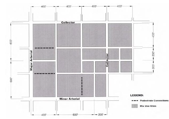
b.
Vehicle Access, Circulation, and Connectivity Standards
i.
Vehicle access, circulation, and connectivity in all Mixed-Use districts shall be subject to the approval of a Traffic Impact Analysis (TIA) prepared in accordance AASSHTO standards and generally accepted traffic engineering standards.
ii.
Streets and access shall be provided in accordance with the Future Thoroughfare Plan, all transportation requirements of the UDC and the Cibolo Design and Construction Manual.
iii.
Streets and access shall be provided in a manner that relates appropriately to existing roads, perimeter streets and driveways.
iv.
Within any mixed-use district, cross access easements and/or common shared driveways shall be required to ensure access between uses and to reduce traffic congestion on public streets.
v.
Where the entire frontage along an internal block face consists of parking areas, an enhanced drive aisle may be utilized in lieu of a street to provide access to the parking area provided that the TIA demonstrates that the throat length is sufficient to provide adequate stacking space and driving lanes into and out of the enhanced drive aisle to allow safe ingress and egress and minimize traffic congestion.
vi.
Development in Mixed Use districts shall be based on a block structure that is consistent with the block standards contained herein, in accordance with the UDC and in a manner compatible with existing streets and blocks.
vii.
Internal streets in Mixed Use districts shall be aligned to connect with existing or proposed external streets of equivalent functional classification in order to create through street connections from mixed use development to adjacent development. When necessary to prevent cut-through traffic from entering adjoining residential areas, street alignments shall be discontinuous and traffic calming improvements shall be utilized.
viii.
For new Mixed-Use developments that are four (4) acres or more in total gross land area, internal circulation shall be provided through an internal street system and multiple blocks.
ix.
Internal streets provided according to this section may be public or private. All public and private streets shall be designed and constructed according to the policies, standards, and guidelines governing street design of this section, the UDC and the Cibolo Design and Construction Manual.
H.
Pedestrian and Bicycle Access, Circulation and Connection
1.
Pedestrian friendly design is integral to efficient circulation in a mixed-use development. Mixed use center visitors and residents should be encouraged to walk via a carefully designed, safe and enjoyable network of sidewalks and walkways. Easy, reasonably direct access should be provided to buildings, amenities, parking, and bike paths. There should be frequent, well placed connections to adjacent land uses to encourage neighbors to use alternative means of transportation to visit the center. Pedestrian crosswalks should be designed so that pedestrians are as safe as possible. Development of appropriately designed crosswalks is encouraged for the safety and convenience of pedestrian street-crossings. The goal is to place at least as much emphasis on alternative modes of transportation as on auto access;
2.
These standards are intended to ensure a safe and convenient system of well-connected pedestrian ways and bikeways. These facilities shall be designed to link MURE developments with adjacent uses, including residential areas, shopping, employment centers, recreational facilities, open space, parks, transit stops, and schools. Within individual developments, safe and convenient pedestrian and bikeway systems shall be provided that directly connect buildings, parking areas, open space, transit stops, services, on-site amenities, and other areas of interest.
3.
Mixed Use developments shall provide and contribute to an on-site system of pedestrian walkways, sidewalks, and bikeways to provide continuous access to all uses within a development site and to land uses on adjacent properties, per the UDC and Cibolo Design and Construction Manual.
4.
Connectivity Standards.
All new development shall provide pedestrian and bicycle systems that provide continuous connections with off-site destinations according to the following standards:
a)
Safe and convenient bicycle and pedestrian access from the development site shall be provided to existing and designated public bike paths or greenways located on or adjacent to the development site.
b)
Connections shall be made to provide direct pedestrian and bicycle travel from within the development to adjacent uses and perimeter sidewalks.
c)
Where a Mixed-Use district is located adjacent to a signalized street intersection, a pedestrian walkway shall connect the on-site pedestrian system with the intersection.
d)
Connections from a perimeter public sidewalk system to the on-site sidewalks shall be made at the same block length interval as exists within the development site to the greatest extent practical.
e)
Within all Mixed-Use districts, each development shall provide an on-site system of pedestrian walkways or public sidewalks throughout the Mixed-Use district. On-site pedestrian circulation systems shall provide the most efficient access route between the intended points of travel. Specifically, on-site pedestrian connections shall be provided to and between the following points:
f)
The primary entrance or entrances to each building containing a principal use;
g)
Greenways or trail systems; and
h)
On-site amenities.
i)
Pedestrian networks must be provided that provide linkages to primary Mixed-Use development destinations to prevent short cuts through landscape areas or unnecessary driving. Consequently, sidewalks should be planned early in the site design process and should be broadly depicted on the Mixed-Use Concept Plan.
j)
All developments served by on-site parking in surface lots or parking structures shall provide either a sidewalk along the perimeter of the block or a designated pedestrian walkways through the parking lot, extending from the rows of parking furthest from the building served to either a building entrance or to a sidewalk or walkway leading to such entrance.
k)
Where an internal block face exists or is proposed greater than four hundred feet (400'), a pedestrian walkway shall be included through the parking lot, separate from streets, such that the four hundred foot (400') minimum distance between walkways is achieved. Alternative compliance may be allowed as described in this section.
l)
Where an enhanced drive aisle forms the perimeter of a block, sidewalks shall be provided on both sides of the drive aisle.
I.
Parking.
The purpose of this section is to ensure the provision, location, and design of off-street parking areas that accommodate motor vehicles while balancing the needs of pedestrians, bicyclists, and transit users with the use of the automobile. Parking areas are secondary and supportive of the primary land uses on the site.
1.
Generally, the parking requirements of the UDC shall be applicable to all Mixed-Use districts. The City, however, recognized that the unique nature of mixed-use development poses challenges to providing adequate number of parking for mixed use projects or a wasteful surplus of parking spaces and impervious cover. This is particularly an issue in mixed developments that combine residential and non-residential uses that have unique parking needs, such as hotels, restaurants, medical uses and high density residential. Consequently, the City will allow the submittal of a Parking Demand Analysis developed specifically to quantify the off-street parking requirements for a specific land use or mix of land uses. Such a parking analysis shall be prepared by qualified professionals and shall be subject to City approval through the Mixed-Use Concept Plan process, without the need for variances from the parking standards of the UDC.
2.
Exemption for Off-Street Parking in Structures.
Required off-street parking spaces provided within a parking structure (either above
or below-grade) shall be exempt from the maximum off-street parking amount established
above.
3.
Shared Parking Standards.
The amount of off-street parking required for a Mixed Use development may be reduced
by an amount determined by the City Planner when it can be demonstrated through a
parking demand study that sufficient parking is or can be met by the subject uses
through shared parking. The parking demand study shall provide information and evidence
about the anticipated parking demand at peak times during a day and the distance relationship
between available shared parking spaces and the specific uses served.
4.
Shared Parking Encouraged.
To promote an overall reduction in parking, the use of shared parking shall be required
when the development is under the control of a single owner/developer and contains
commercial, retail, office, institutional, or other uses with staggered peak parking
demands.
5.
Shared Parking and Cross Access Agreements.
Where shared parking is provided, a shared parking and cross access agreement between
the cooperating property owners shall be approved by the City Planner and recorded
prior to issuance of a building permit. This agreement must be recorded as a deed
restriction on both properties and cannot be modified or revoked without the consent
of the City Planner. If any requirements for shared parking are violated, the affected
property owners must provide a remedy satisfactory to the City Planner or provide
the full amount of required parking for each use, in accordance with the requirements
of the UDC.
6.
Maximum Total Reductions.
Total cumulative reductions to the minimum off-street parking requirements shall not
exceed twenty-five (25%) percent of the total number of spaces required by the UDC,
unless an additional reduction in spaces is quantified in a parking demand study approved
by the City Planning and Engineering Director or designee.
7.
Parking Location and Layout.
The purpose of these standards is to ensure that the location and design of off-street
parking areas balance the needs of pedestrians and automobiles on the site. The location
and layout of parking areas should support the pedestrian environment as well as contribute
to efficient automobile access and circulation.
8.
On-site, Off-Street Surface Parking Standards and Building Orientation.
Off-street surface parking provided on-site for development within a Mixed-Use district
shall be located according to the following standards:
a)
Off-street parking shall be context sensitive. In Mixed Use districts where buildings are located close to public rights-of-way, parking shall be provided on the rear side of the building.
b)
Off-street, surface parking areas shall be located at the side, to the rear, or at the face of a building that does not front along a street. No off-street parking shall be located between a building and the adjacent street frontage unless the parking field is buffered from the right-of-way view by berms, landscaping or decorative monumentation.
c)
All off-street surface parking areas shall be located within a designated block. For block faces that are composed entirely of surface parking lot areas, a street or enhanced drive aisle that provides a detached sidewalk, defined pedestrian crossings, and street or parking lot trees along the block face shall border the block face.
d)
Rear sides of buildings with associated parking fields that back up to public rights-of-way shall be permitted subject to back of the building having a decorative design and limited service areas, such as truck docks, to ensure an attractive streetscape.
e)
Off-street surface parking areas that serve buildings fronting on an entry/spine street should be located to provide the earliest possible access to automobiles after they have entered the site.
f)
The use of alternative pervious parking surface materials, such as geo-block, may be utilized.
9.
Parking Structures Standards.
a)
Off-street parking facilities in above-grade structures shall comply with the following standards:
i.
Blank walls are prohibited. Parking structures shall be visually similar in character and scale to adjacent buildings.
ii.
Except on sides abutting an alley, all floors above the ground floor of the parking structure shall have architecturally articulated facades designed to screen the view of parked cars.
b)
Vehicle entries/access to off-street parking structures shall be integrated into the placement and design of adjacent buildings or oriented away from the primary street frontage. At a minimum, parking structure facilities shall have user vehicle access from locations that minimize conflicts with pedestrian circulation.
c)
Ground Floor Use and Design — Nonresidential Parking Structures
When a parking structure provides commercial parking or is integrated into a building containing primarily nonresidential uses, at least eighty (80%) percent of the ground floor of any side of an above-grade parking structure that is adjacent to a public street (except an alley) or adjacent to a public open space/plaza shall be constructed to an adequate depth to permit future occupancy by any commercial or other non-parking principal use allowed in the district. The ground-level facade of the structure for at least the lowest twelve (12) vertical feet (1 st story) of the structure and shall include at least three (3) of the following features designed to create an attractive ground level garage design appropriate for the MURE:
Facade articulation and modulation through changes in vertical wall plane and/or a change in building material;
•
Use of real windows with glazing that may be translucent, but shall not include black or mirrored glass or similar opaque glazing;
•
Integration of multiple building entrances.
•
Use of false windows defined by frames or lintels and sills;
•
Buffering of the street edge with landscaping, berms, or landscaped planters.
d)
Ground Floor Use and Design — Residential Parking Structures
When a parking structure provides parking for residential uses in the area, or when the structure is integrated into a residential building, the applicant shall either:
i.
Follow the design standard for Nonresidential Parking Structures described above; or
ii.
Integrate non-residential uses into the ground level of the parking structure
iii.
Use a combination of non-residential uses the ground-level façade of the structure elements described above for at least the lowest twelve (12) vertical feet (1 st story) of the structure and shall include at least three (3) of the listed design elements to create an attractive ground level design of land uses and design elements appropriate for the MURE:
•
Use of real windows with glazing that may be translucent, but shall not include black or mirrored glass or similar opaque glazing;
•
Integration of multiple building entrances.
•
Use of false windows defined by frames or lintels and sills;
•
Buffering
e)
Incentive for Parking Structures
Subject to approval by the City Planner, if off-street parking is provided in a structure (above or below grade) that is integrated into the design of a building containing a principal use, the maximum building height may be increased by up to 25% of the height limitation of the Mixed Use district.
J.
Landscaping and Screening.
1.
In addition to on-site amenities, landscaping in mixed use developments is applied primarily in three settings: parking lots, streetscapes and walkways, and at the edges of a site. In all three cases, a thematic approach to landscape design can enhance the pedestrian environment, unify the different elements of the project, and impart a well-defined character and image. Landscaping shall be provided in accordance with all landscaping, screening and buffer requirements of the UDC, with an emphasis placed on the appearance of the site from rights-of-way and from any adjoining residential uses within, or outside, of the Mixed-Use development.
2.
Required parking lot screening requirements shall apply to both perimeter and internal streets. Surface parking spaces shall be screened from right-of-way views to a minimum height of forty-two (42") inches above street elevation by using berms, plantings, and/or decorative structures.
3.
Use of Screening Structures In Lieu of Plantings
The use of structures such as masonry walls or ornamental fencing for street-side parking lot screening purposes shall be permitted in lieu of plantings. Structures shall be a minimum of forty-two (42") inches in height from street elevation.
4.
In order to encourage infill and redevelopment in Mixed Use districts on constrained sites containing less than ten (10) acres and bordered by developed land along the entire perimeter (excluding intervening public streets), the following exceptions to the parking lot landscaping requirements above are available to such infill and redevelopment occurring in an Older/Established Contextual Area:
a)
The City Planner may reduce the 20% landscaping requirement up to fifty (50%) percent of landscaping requirements if trees planted along the site perimeter also serve to screen and shade the interior of the parking lot and fully buffer any protected use.
5.
Tree Preservation as Administrative Relief: The preservation of valuable protected or heritage trees may serve as a credit in lieu of required shade trees as provided in the UDC
6.
All screening and buffering requirements of the UDC shall be fully applicable. Outdoor storage, where permitted, shall be fully screened and shall only be permitted on a dust free surface material.
7.
Required street trees in mixed use zone districts may be placed in the public right-of-way at locations that will not damage sidewalks, curbs, street or utility improvements. Street trees shall be planted along all streets in a Mixed-Use district.
K.
Use Context and Use Transitions.
One essential element to provide for the long-term success and viability of Mixed-Use districts in the City is the provision of transitional uses and use context between different land uses. This is essential to ensure public safety, maintain livability for residential uses within Mixed Use districts and ensure the long-term viability of the Mixed-Use district. Transitional context sensitive measures are also essential to ensure that a Mixed-Use district will not adversely affect the viability of existing or proposed uses outside of, but adjoining, a Mixed-Use district. Appropriate transition measure between variable land uses within and outside of the Mixed-Use development must be developed at the conceptual stage of developing a Mixed-Use Concept Plan. For that reason, all Mixed-Use Concept Plan must clearly designate the techniques that are proposed to provide appropriate transitions and to ensure that the Mixed-Use development is contextually sensitive to existing development outside of the Mixed-Use development.
1.
Transitions can be provided by the developer by using any of the following techniques, or by a combination of techniques:
a)
Space (Distance)
b)
Earthen Landscaped Berms
c)
Landscaping (Dense Evergreen Shrubs and a Mix of Trees in Layers)
d)
Decorative Fences/Walls
e)
Decorative Building Designs, Quiet Building Sides, Limiting Upper Story Windows
f)
Road (Tree Line Boulevard or Parkway Design)
g)
Green Belt/Tree Preserve, Common Amenity Area or a Wet or Dry Storm water Pond or Linear Park
h)
Reduced Building Height/Building Bulk Step-downs
i)
Land Use Transitions from Higher to Lower Use Intensities
j)
Implement Green/LEED Design Concepts
k)
Building Layout and Screening Techniques that confine or internalize impacts of more intensive uses on less intensives uses
l)
Innovative Spatial Land Use Planning Techniques such as creating common areas or pedestrian ways between various intensities of land uses
m)
Any other alternative measure(s) that will provide a suitable transition and ensure safety and compatibility between uses
n)
Limit Uses to those businesses that generally operate between 8 AM to 5 PM, disallowing uses with outdoor operations and other activities in certain use areas or limiting any other operational aspect(s) of development.
Transitions between adjacent land uses with different intensities are typically achieved through back-to-back building orientation, attractive building design, large distances between uses and landscaped buffer areas per Section 17.1.L. Accordingly, the following standards and guidelines encourage the use of alternative transition tools, including site/building transitions (such as reducing the scale of commercial building mass next to residential), and development of less intense land uses between commercial and single-family residential areas (such as lower-intensity office, civic/open space, or multi-family land uses). Limited operational compatibility standards are offered as a tool to further ease transitions from more intense to less intense land uses. Landscaped buffers, walls, and fences are used only when these other alternative transitions are not effective or not possible, given site conditions and constraints, or not desirable given prevailing development patterns in a specific area.
2.
Transitional Standards.
a)
Development of a more intensive land use adjacent to an existing, planned or zoned less-intensive land use, either inside or outside the Mixed-Use district boundary. The City Planner shall have the authority to make a final determination regarding relative intensity of adjacent land uses, taking into consideration, at a minimum, the relative size, design, operations and traffic generation patterns of the adjacent land uses; and
b)
Require mitigation techniques to mitigate negative impacts, uses or activities on a project that, as determined by the City Planner, could reasonably be regarded as a nuisance for neighbors.
c)
Transitional determinations made the City Planner may be appealed to the Planning and Zoning Commission.
3.
General Transition Tool Guidelines.
a)
When a transition tool is required, an applicant shall incorporate site and building transition tools, green/open space transition tools, and transition uses before using landscape buffers or screens.
b)
The following are approaches, methods and techniques that are permitted transition tools under this part:
i.
Site and building transition tools, including but not limited to, building setbacks as established by surrounding development, building placement and orientation as established by surrounding development, similar building height, similar building width, similar roof form, similar building materials, and facade articulation
ii.
Green/open space transition tools, including but not limited to the use of courts, squares, parks and plazas, and use of natural features such as topography, waterways, and existing stands of trees.
iii.
Transition uses and other community serving uses as transitions, such as, but not limited to the transition uses and siting lesser intensive uses at the perimeter of the Mixed-Use district.
iv.
Parkways, streets and streetscapes;
v.
Operational standards, and
vi.
Landscape buffers and screens.
c)
Mixed use development should employ the following techniques as applicable to ensure compatibility with surrounding development. For purposes of these transition tools, the term "surrounding development" shall mean (1) immediately adjacent development on the same block face or on facing blocks as the subject site, as well as (2) prevalent patterns established in the existing neighborhood located within one-quarter mile of the subject development site.
d)
Use similar building setbacks, as established by surrounding development;
e)
Use similar building placement and orientation, as prevalent in surrounding development;
f)
Use similar building height as exists for immediately adjacent development (e.g., step down the building height of the more intensive land use to approximately match the building height of an adjacent, less intensive land use);
g)
Use similar building width, as prevalent in surrounding development;
h)
Use similar roof form and building materials, as found on immediately adjacent development;
i)
Mitigate the larger mass of commercial, civic, and industrial buildings with façade articulation;
j)
Use front-to-front nonresidential to residential building orientations, especially with commercial uses that are pedestrian intensive (e.g., restaurants, banks);
k)
Orient land uses with potentially adverse impacts, features, or uses away from neighboring uses. For example, avoid placing garages, parking lots, or service areas facing the fronts of neighboring buildings.
4.
Green/Open Space Transitions.
Mixed use development may employ the following techniques to provide transitions and ensure compatibility with surrounding development:
a)
Use small green spaces, courts, squares, parks, plazas, and similar spaces as transition areas that can also function as community gathering places;
b)
Use existing natural features as transitions, including natural differences in topography (not retaining walls), streams, existing stands of trees, and similar features. When existing natural features are used as transitions, the City may still require that adequate pedestrian connections to adjacent land uses be accommodated.
5.
Transition Uses and Other Community-Serving Uses as Transitions.
a)
An applicant may site a transition use, as specified on the Mixed-Use Concept Plan, or any other similar use, as transitions to lower intensity adjacent uses, such as residential;
b)
For example, when office, small-scale retail, pedestrian-intensive retail, civic, or public uses are planned as part of the same development containing more intensive commercial uses, the applicant may site the less intensive uses or more community-serving uses as transitions to lower intensity, adjacent uses, such as residential. Banks, and restaurants—all of which are community-serving uses—may be sited next to, and/or fronting, adjacent medium-density residential uses.
6.
Parkways, Streets, and Streetscapes.
The distance and separation afforded by the public right-of-way, together with similar or the same type of streetscape improvements on both sides of parkway or street may be utilized as a transition to adjacent development.
7.
Landscape Buffers and Screening Transitions.
Where application of the transitions tools listed above are not possible, or where the City Planner determines these transition tools by themselves do not create an adequate transition to or buffer for less intensive land uses, the landscape buffer and screening requirements of the UDC may be utilized.
8.
Operational Compatibility Standard.
The City Planner may impose conditions that impose operational compatibility standards, or accept formally recorded Deeds, Restrictions and Covenants that regulate discretionary development actions of end users to ensure that development in a Mixed Use zone district will be compatible with existing and planned neighborhoods and uses, including but not limited to conditions regarding the following:
a)
The availability or ability to develop specific uses otherwise allowed by the UDC;
b)
Hours of operation;
c)
Hours of deliveries and other similar uses;
d)
Location, intensity and hours of operation of exterior lighting, including security lighting;
e)
Placement of trash receptacles;
f)
Amplification of music in a place of entertainment;
g)
Location of delivery and loading zones; and
h)
Placement and illumination of outdoor vending machines.
9.
Transitions along the Public Right-of-Way.
a)
Within a mixed use zone district or other commercial center or Mixed-Use Development, vehicle drivers on the adjacent public rights-of-way should be able to recognize the increased presence of pedestrians and bicyclists, who in turn should perceive the improved accommodation of alternate-mode travel and increased personal safety in these places;
b)
Incorporate medians and islands into streets for pedestrian refuge;
c)
Enhance mid-block and intersection crosswalks with respect to paving treatments, signal activation, curb cuts, and similar elements; and
d)
Integrate a sidewalk and pedestrian walkway system into the development's on-site circulation patterns. Emphasis should be placed on connections between front doors, parking, and transit.
L.
SIGNAGE.
Signage in a Mixed-Use Center is important not only for effectively guiding vehicular and pedestrian circulation, but also for establishing a project identity. Locational, directional, and tenant signage provide necessary orientation for users. It is also important for marketing the various uses and creating a positive image of the development. Signage that is designed according to a theme consistent with the overall design of the development serves to unify the center.
1.
The signage in a Mixed-Use Center is to be coordinated to provide a unified signage design. Signage is to be planned to clearly identify different use areas, complement the pedestrian nature of the center and shall be integrated to complement the architectural consistency with the overall design of the building that the sign identifies or of the center. The unified sign design elements should identify a recognizable character for sign design that contributes to the character of the center. Signs should reflect the character through consistency of materials, illumination, sizes, proportions and locations.
2.
Signs should be carefully integrated within the site, landscape and architectural design context within which they are located. Size, shape and proportions should be compatible with the size and scale of the surroundings and should not compete with or obscure other design features of the site, landscape or structures. Signage should also provide attractive and appropriately placed designation of primary entrances.
3.
Near residential uses, lighting should be reduced or extinguished during nonbusiness hours or at a certain hour in the evening, to reduce adverse impacts of commercial lighting on residential use. Internally illuminated signs or awnings are generally discouraged.
M.
ROADWAYS/TRANSPORTATION.
Mixed use centers will incorporate all modes of transportation (motorized vehicles, bicycles, and pedestrians) both safely and efficiently by meeting the design standards outlined in the UDC and Cibolo Design and Construction Manual.
Since Mixed-Use developments tend to create higher traffic impacts than those that are strictly residential, Mixed-Use Center will be limited to locations along arterial and collector streets, with the cross-street for an arterial being no less than a collector. This will minimize the impact on adjacent residential neighborhoods.
1.
Access and Connectivity.
Access and connectivity for all modes of transportation is key to developing viable mixed-use centers. Access to mixed use centers needs to be safe for both vehicles and pedestrians. Mixed use centers must also maintain good connectivity and safe pedestrian crossings while not overburdening the regional transportation system with traffic signals. The following access standards are to be met for a mixed-use development:
a)
A minimum of one access point per property ownership shall be permitted, which may be jointly shared with adjacent properties;
b)
Signalized access will only be allowed where approved by the City Engineer based on the recommendations of an approved TIA and in accordance with all AASHTO standards and only when traffic impacts are forecast to meet signal warrants as identified in the Manual on Uniform Traffic Control Devices (MUTCD). Pedestrian signals will be allowed when traffic and/or pedestrian impacts are forecast by the Traffic Study to meet signal warrants as defined in the MUTCD. The installation of traffic and pedestrian signals for proposed development will not be the responsibility of the City;
c)
To determine the placement of a signalized access when warrants are met, a progression analysis shall be conducted within a traffic study for existing plus site generated traffic and for twenty-year horizon conditions in order to meet City standards for traffic flow along an arterial or collector street corridor;
d)
Signalized access will only be allowed for streets constructed to City standards;
e)
Mixed use developments will be based on a block structure to provide connectivity and to allow block length combinations that will provide flexibility in providing pedestrian access and signalized access when warranted. Block lengths, as measured from curb face to curb face, will be a minimum of two hundred (200') feet and a maximum of six hundred (600') feet, with the average of all block lengths in a mixed-use development not to exceed five hundred (500') feet. No vehicular access will be allowed into mixed use centers within six hundred (600') feet of two intersecting principal arterials or higher classified roadways. Pedestrian and/or bicycle access into the site will be required within two hundred (200') feet of two intersecting principal arterials;
f)
Left- or right-turn storage lanes may be required along arterials or parkways and along entry/spine streets that provide access to a mixed-use center. The specific design of such lanes shall be based on twenty-year traffic projections for that roadway and meet the guidelines outlined in the Cibolo UDC and Design and Construction Manual;
g)
Driveways that provide access to parking lots from perimeter streets into mixed use centers shall be of sufficient length to allow vehicles to enter the center and not be obstructed from on-site conflicts in which traffic queues onto the public or private street system. The greater the peak hour traffic demand for the mixed-use center, the longer the unobstructed driveway must be. The unobstructed length shall be measured from the back of the sidewalk or the stop bar exiting the site to the first intersection back of curb or parking drive aisle. For minimum driveway lengths reference City of Cibolo Design Construction Manual.
h)
Pedestrian access shall consist of sidewalks and an on-site system of pedestrian walkways as identified in both the pedestrian assessment portion of the Traffic Study and in the pedestrian circulation plan submitted as part of the Mixed-Use Concept Plan. Sidewalks and on-site walkways shall provide direct, continuous access between the intended points of travel. Specifically, pedestrian connections shall be provided to and between the following points:
i.
From parking to the primary entrance or entrances to each building housing a principal use;
ii.
Any sidewalk or walkway on adjacent properties that extends to the boundaries shared with the development;
iii.
Any public sidewalk system along the perimeter streets adjacent to the development site; and
iv.
Any public amenities.
i)
All sidewalks, pedestrian walkways, or trails shall have and maintain a minimum unobstructed pathway width of six (6') feet and be detached from the back of curb, unless otherwise referenced.
2.
Pedestrian Environment.
Following are the pedestrian standards to be maintained for a Mixed-Use development:
a)
A pedestrian assessment study will be conducted as part of the traffic study for a mixed-use center. In addition to the other information required as part of the traffic study, the pedestrian assessment shall provide information on estimated hourly pedestrian and vehicular traffic for the mixed-use development;
b)
Entry/spine streets shall be required for all mixed-use developments. Entry/spine streets are intended to provide the main access from arterial streets into the center and are intended to identify that a motorist has entered a "unique" area. Entry/spine streets are also intended to concentrate and provide a safe route for pedestrian and bicycle ingress and egress into and out of the mixed-use development;
c)
Clear sight distances free from obstructions must be maintained to allow vehicles to safely make turns at intersections and for pedestrians to have adequate time to cross the street. Therefore, the UDC Site Distance Requirements will be applied to proposed projects. Intersection design shall meet MUTCD guidelines and may include enhanced crosswalks with directional ramps, pavement treatment, median refuge islands and pedestrian indicators;
d)
Pedestrian refuge areas or medians will be required on all roadways classified as major collector and above;
e)
All pedestrian crossings shall comply with the standards set forth in the Americans with Disabilities Act (ADA), UDC, or Cibolo Design and Construction Manual, whichever is the stricter rule. Pedestrian ramps shall be oriented directionally only.
f)
Delineated crosswalks with patterned surface can be effective traffic control devices; however, they should not be used indiscriminately. It has been shown that pedestrians may develop a false sense of security regarding their use of a marked location and step into the crossing without adequately checking for oncoming vehicles. Information from the pedestrian assessment will be evaluated based on AASHTO standards and generally accepted transportation engineering standards.
N.
Utilities.
The design of a mixed-use development is to occur in a comprehensive manner, where land uses, site layout, utility corridors, landscaping, lighting and other infrastructure are designed in concert with one another. This will especially apply to utility design work, where advance planning and layout will facilitate construction, operation and maintenance, both from a functional and aesthetic standpoint.
When submitting the Mixed-Use Concept Plan the following information shall be provided:
a)
A plan identifying the points of interconnection for water, wastewater, gas, and electric.
b)
A map showing the general corridor and initial layout for each utility.
c)
Demand calculations for each utility under full build-out conditions.
d)
A summary describing current utility infrastructure in the area of development. This summary shall include the age and condition of the infrastructure, and any proposed modifications (including relocation and replacement). Capacity issues and load requirement of the proposed mixed use shall also be identified, including any impacts on existing infrastructure.
1.
Supply and General Standards.
a)
Each utility will determine if existing mains and service lines are adequate to serve the proposed uses. Modification of existing utility lines used to support the new development, if required, shall be at the developer's expense;
b)
Fire service and hydrant lines installed for commercial or multi-family residential use require independent connections to the water mains;
c)
Where available, recycled or reclaimed water should be used for landscape irrigation. The City encourages the creation and/or extension of recycled or reclaimed water mains and the use of recycled or reclaimed water for irrigation;
d)
Consideration for wastewater hydraulics should be included in the Mixed-Use Concept Plan. Modifications of existing infrastructure to achieve the required flow rate should be at the developer's expense;
e)
Private main agreements may be required for parcels with limited access to public facilities;
f)
Access to utility infrastructure is of prime importance and shall be maintained to City standards for all public streets and utility easements;
g)
The initial Mixed-Use Concept Plan should show all proposed rights-of-way and utility corridors and easements;
h)
Easements shall be provided for all public water lines and hydrants not located in a public right-of-way. Changes in location of utilities or final transformer, fire hydrant or meter locations may require granting of additional easements.
2.
Street Lighting.
a)
Street lighting systems, when provided, should be located in the utility corridor of the parkway area of the ROW. To the extent possible, public streetlights should be limited to public roadways and utility easements in private roadways;
b)
Public street lighting should be installed and maintained by GVEC (and CPS where applicable). All other lighting for onsite streets, pedestrian walkways, bikeways and parking lots should be installed and maintained by the developer. The spacing, location, height, fixture style, light source and level of illumination shall be subject to the standards and review of GVEC or CPS. Other types of light poles or luminaires/fixtures may be installed, subject to the approval of GVEC or CPS.
3.
Landscaping.
a)
Fences and substantially sized landscaping shall be prohibited in utility easements. Flowers, grass and groundcovers shall be required to cover all easements. Small shrubs may be planted at the developer's risk in the event that the easement needs to be maintained. No trees shall be placed within fifteen (15') feet of the centerline of any wet utility;
b)
Cibolo main and service lines that run under decorative rock, landscaping, or specialty paving may be required to be sleeved or encased to protect the integrity of the main and service lines and minimize damage to landscaping in the event of required maintenance.
4.
Cable and Telecom.
Cable and telecommunications facilities may be included in a joint dry trench, subject to the agreement of each utility.
5.
Storm Water Ponds and Drainage Easements.
The Mixed-Use Concept Plan should show storm water ponds and easements necessary to comply with the UDC and City Design and Development Manual.
O.
COMBINING MURE DESIGN ELEMENTS INTO A MIXED-USE CONCEPT PLAN
This section shows a potential layout for a mixed-use development to demonstrate how the various provisions, standards, and guidelines in this section can be applied in concert to a mixed-use development. Given the potential range of site sizes, conditions, locations, contexts, uses, intensities, building types, and transitions, there is no limit to the possible variations in layouts of mixed sites in Mixed Use districts. The purpose of this hypothetical design is to take just one possibility as an illustrative example for applying specific code sections, design standards, and guidelines within the context of a unified site plan for a mixed-use development.
The illustrations are in the order of an idealized planning and design process:
1.
Identify the Mixed-Use site and place its size and location into the context of existing uses, access, and connections.
2.
Develop the proposed mixed-use development in terms of land use mix, acreage, square footage and parking; with particular emphasis on:
•
Block Structure and Street Network;
•
Building Placement and Parking; and
•
Context and Transitions to existing development
3.
Develop a Mixed-Use Concept Plan to show use locations, streets, storm ponds and other major project elements.
4.
Refine the Mixed-Use Concept Plan into a detailed site development plan.
Mixed Use Diagram 2: Context Plan (Surrounding Land Uses and Roads)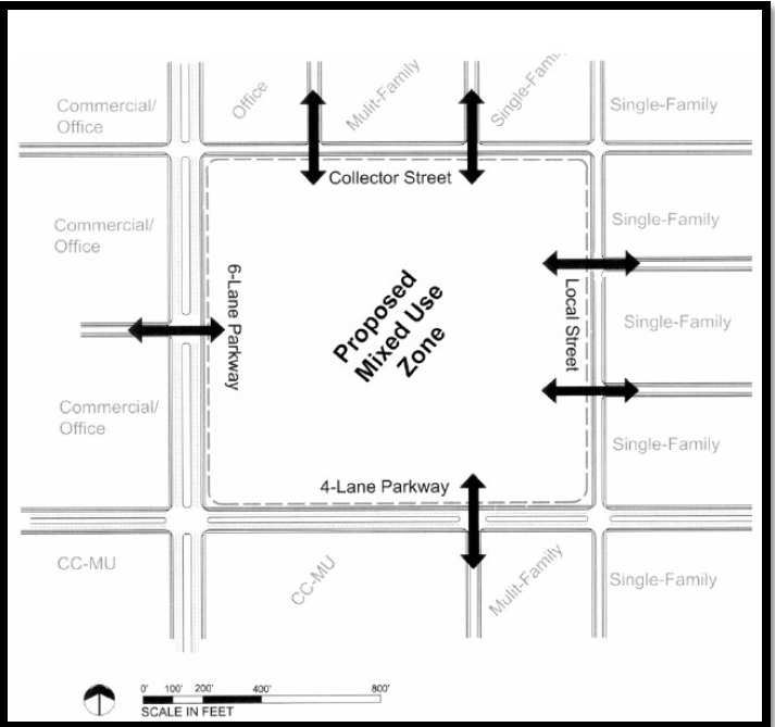
The below information shall be provided to support and define the Mixed Use Concept Plan
Mixed Use Diagram 3: Proposed Mixed Use Plan (Land Use Mix, Acreage and Square Footage)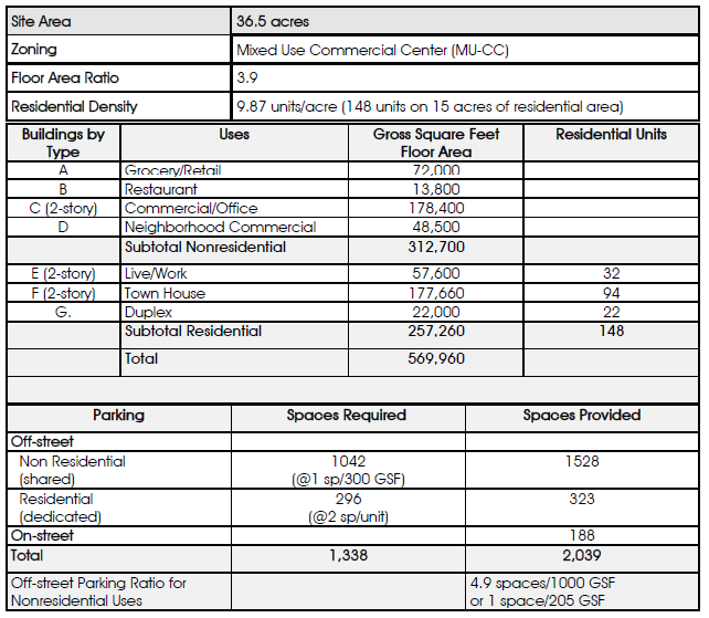
Mixed Use Diagram 4: Detailed SIte Development Plan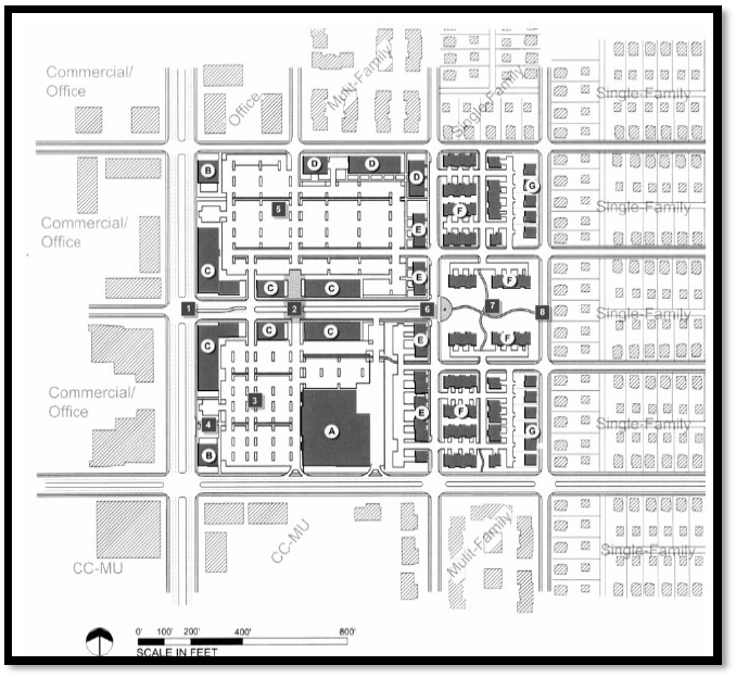
Mixed Use Diagram 5: Example of a Mixed-Use Regional Employment Center (MURE) Concept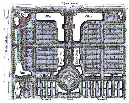
4.7.4.4 Old Town Mixed Use Overlay District Regulations
The Old Town Mixed Use Overlay District (OT) is intended to provide performance standards that direct the redevelopment of properties within the district. The focus of the performance standards is to limit specific impacts to adjacent properties, while enabling flexibility in planning to the developing owner. Transition of use, buffering, and internal circulation are emphasized. Where these standards conflict with other standards or regulations of this or other City Ordinances, or with private restrictive covenants, the more flexible standard(s) may apply.
4.7.4.4.1 Permitted Uses
The uses of the underlying zoning district from the official City zoning map, as amended, are permitted, to the extent that all applicable performance standards of this section are met. In addition to the permitted uses of the underlying district, the following uses are permitted within the OT district boundary:
1.
Single-family residential, provided that this use takes access from a local public street.
2.
Attached residential uses (Upper-story or behind primary structure) are permitted, provided that the residential use is clearly secondary to the primary commercial (C-2) use, the attached residential is not visible from right-of-way and the gross floor area of the entire structure does not include more than fifty (50%) percent residential uses.
3.
Institutional uses such as, but not limited to parks, government offices, churches, schools, technical schools, hospitals shall be permitted.
4.
Townhouse residential, condominium residential and duplex residential to 12 units per acre development density is permitted subject to the granting of a Conditional Use Permit, per the CUP requirements of Article 3 and 4.3.2 of this UDC.
5.
Hotel/Motel (Bed and Breakfast) are permitted subject to the granting of a CUP.
4.7.4.4.2 Performance Standards.
Any use permitted within the base district of the Old Town Overlay District, or as permitted above, shall conform to the following performance standards:
A.
Lighting and Glare.
No use or operation shall be located or conducted so as to produce intense glare or direct illumination across the bounding property line from a visible source of illumination nor shall any such light be of such intensity as to create a nuisance or detract from the use and enjoyment of adjacent property.
B.
Open Storage.
No open storage of materials or commodities, or equipment shall be permitted except as an accessory use to a main use which is located in a building. No open storage operation or refuse disposal containers shall be located in the front of the main building and no storage use shall constitute a wrecking, junk, or salvage yard. All open storage areas and refuse disposal containers shall be screened from view of the public by a fence or wall (minimum height six (6') feet, maximum height eight (8') feet), and shrubs, trees or other landscaping as approved by the Building Official; and no allowed open storage shall extend above the specified screening fence or wall. A Dust Control Plan, demonstrating compliance with the Environmental Performance Standards of this UDC, shall be required for any outdoor storage areas.
C.
Parking.
Off-street parking shall meet the standards of the UDC. However, shared parking may be utilized within the Old Town Overlay district provided a Shared Parking Study is prepared and submitted with the Site Plan Application that clearly demonstrates the feasibility of shared parking. The study must address, at a minimum, the size and type of the proposed development, the composition of tenants, the anticipated rate of parking turnover and the anticipated peak parking and traffic loads for all uses that will be sharing off-street parking spaces. Old Town parking standards may be further relaxed if a public parking facility is located within 500 feet of the proposed use.
In addition to the above, any development proposed within the Old Town Overlay District may be offered a possible percentage reduction to off-street parking requirements where no shared parking exists. Percentage reduction may be offered per City Manager or designee subject to a Pre-Development meeting with staff and exhausting any shared parking alternatives.
D.
Internal Circulation and Connectivity.
The site plan shall provide for a logical system of internal circulation which minimizes access to adjacent arterial streets. Street, driveway and alley connectivity shall be provided to all adjacent non-residential properties, regardless if the existing adjacent tracts offer a receiving connection point. Pedestrian connectivity (i.e. sidewalks) shall be provided to adjacent tracts, regardless if the existing adjacent tracts provide a connection point.
E.
Setbacks.
Front yard setbacks may be reduced to the average front yard setback of existing buildings on the same side of the street block. Building separation must be maintained pursuant to the Fire Code.
F.
Maximum Lot Coverage.
The maximum allowable impervious cover may be increased by way of a waiver request to 95%, if storm water management facilities are available to mitigate increased peak runoff, or adequate conveyance is provided consistent with adopted drainage criteria. This waiver may be granted at the discretion of the City Manager, upon consultation with the City Engineer.
G.
Screening Wall and Buffer Yard.
A screening walls and buffer yards are to be used as a development tool to minimize potential nuisances as well as act as a transition between non-residential and residential land uses. The screening walls and buffer yards shall include (but not limited to) landscaping. The screening walls and landscaping are to be installed along the property lines between the non-residential and residential land uses. The requirements for the screening walls and buffer yards are as follows:
1.
Eight (8') foot high solid screening wall made of masonry and/or concrete requiring no additional buffer yard; or
2.
Eight (8') foot high semi-opaque (meaning very small gaps exist between screening material) screening wall made of wood, masonry, and/or concrete with a required five (5') foot wide landscape buffer yard which shall include:
a.
One (1) evergreen tree no smaller than three inches (3.0") caliper every twenty 20 feet along a property line between the non-residential and residential properties; and
b.
Eight (8') no less than four (4') foot tall shrubs between each set of evergreen trees.
3.
If lot is seventy (70) feet or wider, the property shall comply with the non-residential and multi-family landscape buffer requirements as set out in the UDC, Article 47, Section 1.7 (L).
a.
If property is within the Old Town Mixed Use Overlay District the owner may apply for a variance from the requirements set out in item 3.
Any utilization of the front yard by non-residential uses other than for vehicular ingress/egress and landscaping shall construct a four (4') foot high screening wall made of wood, masonry and/or concrete along the side property lines abutting residential land uses beginning from the front elevation of the building to the front property line.
All open space within a buffer yard shall be planted with grass or other vegetative ground cover. No parking, HVAC equipment, generators, dumpsters, storage, and/or accessory building shall be permitted within a required buffer yard.
The following must not be considered as all or part of a buffer yard: alleys or public rights-of-way.
H.
Building Design.
Buildings in the Old Town, shall be governed by the following standards:
1.
Modifications to the exterior façade(s) of any existing building shall first be approved by the City subject to a finding that the proposed design, fenestration, (windows), height, color palette and encouraged exterior building materials are consistent with surrounding buildings and general design themes of the Old Town.
2.
All new buildings in the Old Town shall incorporate a design, height, fenestration (windows), and color palette that are cohesive with those on surrounding buildings and are consistent with the general design theme of the Old Town.
3.
Building design shall preserve or enhance the historical fabric, character, pedestrian scale and architecture of Old Town Cibolo and shall be context sensitive.
4.
Residential development shall be consistent with the scale, height, design, colors, roof pitches, setbacks and related characteristics of surrounding residences and consistent with the general Old Town style.
5.
Exterior Building Materials
It is encouraged that all primary and accessory non-residential buildings constructed in the Old Town shall have all exterior walls clad in brick, stone, stucco, tile, cultured stone or split faced block for one hundred (100%) percent of the wall area, exclusive of all windows, doors, roofs, glass construction materials, or sidewalk and walkway covers. However additional building accents such as decorative metal, clay and/or concrete tiles, standing seam metal, exterior insulation finish system (EIFS), decorative cast stone, and block glass are permitted such as they do not exceed fifteen (15%) percent of the total exterior wall surface area (Reference UDC Appendix C).
If encouraged exterior building materials are used, developer may be granted a total of 25% in reductions to items such as but not limited to: landscaping, buffering and/or parking for overall development.
6.
No building (Commercial or Residential) in the Old Town Overlay shall exceed forty-five (45') feet in height.
7.
Building Colors
a)
Primary exterior wall colors shall be compatible with the colors of buildings on surrounding properties.
b)
Where no surrounding color pallet exists, primary building colors should be earth tones and other colors typical for South Central Texas. City Council has approved exterior colors based on the Sherwin Williams Historic Color Palette - https://www.sherwin williams.com/homeowners/color/find-and-explore-colors/paint-colors-by family#/section/historic found in UDC Appendix A. Fluorescent colors are prohibited. Colors used on roof materials are encouraged to contrast exterior building colors.
I.
Creation of a Unified Activity Center and Central City Focal Point
The Old Town and Town Center Overlays districts are located at the confluence of existing and proposed regional streets, proposed bicycle pathways, proposed linear park and existing creeks, floodplains and drainage networks. For that reason, the City, when reviewing projects in these districts, will have the right to impose conditions of approval that will ensure that the Old Town and Town Center Overlays function as two halves of unified Activity Center and that creates a single integrated core City environment that integrates all of the existing and proposed streets, park, bike ways, floodplains and drainage networks into forms that will maintain the viability of Old Town Cibolo for residential development, result in an expansion of residential, commercial and institutional opportunities east of Town Creek, the maintenance and design floodplains and drainage systems into forms that results in conservation, parks and recreation opportunities and creating transportation networks that integrate the Old Town and Town Center areas with existing development and linear park north of FM 1103 and emerging development south of FM 78.
J.
Elements of Section 4.7.4.5 (MURE) of this Article of the UDC were written to be applicable to all Mixed-Use districts of Cibolo. Specifically all of the general land use, transportation planning concepts, principals and general design guidelines described in Section 4.7.4.3 Subsections D.3 (a-h), D.4, D.7, D-10 and Subjects G-O shall be applicable to the Old Town and Town Center Overlay districts.
4.7.4.4.3 Approval Process.
1.
For individual commercial or residential lots less than one (1) acre in area, a site plan shall be submitted demonstrating compliance with the requirements of this overlay district for City staff approval.
2.
For commercial or residential projects at or greater than one (1) acre in area but less than three (3) acres in area, a Mixed Use Concept Plan, as described in the MURE district of this UDC, shall be submitted demonstrating compliance with the requirements of this overlay district for City Planner approval. All transitional and contextual requirements and standards of the MURE district shall be applicable. The City Planner shall have the prerogative to refer the Mixed-Use Concept Plan to the Planning and Zoning Commission for review and approval. If the Mixed-Use Concept Plan is denied by the Commission, the applicant may appeal the decision to the City Council.
3.
For any commercial or residential projects at or greater than three (3) acres in area, a Mixed Use Concept Plan, as described in the MURE district of this UDC, shall be submitted demonstrating compliance with the requirements of this overlay district for Commission review and City Council approval. All transitional and contextual requirements and standards of the MURE district shall be applicable. The Mixed-Use Concept Plan must be reviewed by the Planning and Zoning Commission and considered for approval by City Council.
Mixed Use Diagram 6: Example of a "Mock" Old Town Cibolo Redevelopment Concept that
Shows Sensitivity to Existing Single-Family Residencies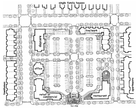
4.7.4.4.4 Nonconforming Residential Structures and Lots.
A.
Purpose and Intent. The purpose of this section is to preserve the residential character of certain lots within the Old Town Overlay District and to provide relief to smaller residential lots typical of the Overlay District and its historic nature in order to preserve for ability to continue use and enjoyment thereof. Notwithstanding Article 5 of this UDC, this section shall be liberally construed to allow certain residential nonconforming lots and structures to be repaired or replaced in accordance with this section, regardless of current zoning regulations for the specified residential district, without the necessity of seeking a variance or other special exception unless otherwise specified herein. Nothing in this section shall be construed in a manner that violates any local, state or federal law or regulation, or authorizes a use not otherwise allowed within the applicable zoning district.
B.
Applicability. In determining whether this section applies to a specific lot or structure, the current property owner has the burden of proof and is responsible for submitting adequate supporting documentation, e.g. deed, plat, probated will, etc. This section does not apply to any structure built after the effective date of this section, nor to any lot which was created, by plat or otherwise, after the effective elate of this section, i.e. lots created by combining two or more lots, or subdividing an existing lot, are not subject to this section. This section applies only to lots and residential structures within the Old Town Overlay District which were:
1.
Included among the thirty-three (33) properties rezoned from C-2 to SF-4 as part of Ordinance 1395; and
2.
Conveyed as a separate and distinct lot prior to the effective date of this ordinance by plat or metes and bounds.
C.
Noncforming Lots. A nonconforming lot that is subject to this section, whether or not the lot has previously been platted, shall be considered a conforming lot for all intents and purposes, i.e. determining whether replat is needed, issuance of building permits, etc., so long as the lot satisfies the following lot design requirements, which shall be determined by the lot dimensions and setbacks in existence as of the effective date of this section.
NOTE: The lot dimensions and setbacks provided in this section were neither prepared by nor reviewed by a licensed engineer, and were generated for illustration purposes only using publicly-available data; as such, these values shall not be relied upon if an owner or permit applicant submits a survey or other legal instrument as evidence to show that actual lot dimensions and/or setbacks in existence as of the effective date of this section differ from the values depicted herein. A valid survey or other legal instrument shall always supersede the values depicted in the table below.
D.
Nonconforming Structures. A nonconforming structure that is subject to this section may be repaired, replaced, enlarged, altered, or otherwise improved, provided that the property owner submits adequate evidence showing that the structure is subject to this section, and the work is in compliance with the restrictions in Section 4.7.4.4.4(C.). Any nonconforming structure may be repaired, replaced, enlarged, altered, or otherwise improved as long as the building footprint, height or envelope are not increased or otherwise modified to be further out of compliance with the provisions of Section 4.7.4.4.4(C.) above. All other applicable requirements set forth in this UDC must be met, e.g. permit requirements, building codes, construction regulations, etc. A permit to allow construction on a nonconforming lot to repair, replace or otherwise improve a nonconforming structure shall not be denied solely due to the nonconforming status of the lot or structure, as might otherwise be the case under Article 5 of this UDC.
Should a structure on one of the above properties be demolished for any reason, it may be rebuilt to the existing setbacks as indicated within the table or evidenced by a survey or other legal instrument submitted by an owner or permit applicant. Any new construction that expands the current structure is required to comply with the minimum established setbacks for the SF-4 District within the Old Town Mixed Used Overlay:
4.7.4.5 FM 78 Mixed Use Overlay District Regulations
The FM 78 Mixed Use Overlay (FM 78) district is intended to provide for the development of the area adjacent to FM 78, as defined on the Official Zoning Map. The further intent of this overlay district is to preserve the scale, dimension and proportion of the existing development while facilitating retail and civic uses and diversity of residential offerings.
4.7.4.5.1 Permitted and Prohibited Uses
A.
All uses described in the MURE district shall be permitted in this mixed use district, with the exception of uses permitted solely in the I-1 and I-2 districts and any expressly prohibited MURE use; subject to all of the performance standards, guidelines and standards of the MURE district, including: setbacks, building height, buffers and transitional standards. In addition to the permitted uses of the underlying district, the following uses are permitted within the FM 78 District boundary:
1.
Townhouse, apartment and condominium residential development as well as additional uses permitted within MF-1 and MF-2 zoning may be permitted in this overlay district only subject to the granting of a Conditional Use Permit (CUP) by City Council in accordance with all of the Conditional Use Permit procedural requirements specified in Article 3 and 4.3.2 of this UDC.
2.
Vertical Mixed Use: Upper-story residential use is permitted, provided that the ground level of the building is occupied by non-residential uses, and subject to the granting of a Conditional Use Permit for said residential uses as described in Section 4.7.4.5.1.A of this UDC.
B.
The following uses are expressly prohibited: sexually oriented businesses, mini-warehouse storage, general outdoor storage, kennels, pawn shops, surplus sales, outdoor advertising signs (billboards) or any specifically proposed use that the City Council may consider as being inconsistent with creating a positive image of the City and FM 78 Overlay district.
4.7.4.5.2 Performance Standards.
Any use permitted within the base district of the FM 78 Overlay District, shall adhere to all performance standards described in the MURE district.
A.
Parking.
1.
Off-street parking shall meet the standards defined in Article 10 of this UDC, except as modified by the performance standards of the MURE district.
2.
Internal Circulation and Connectivity
a)
The Mixed-Use Concept Plan shall provide for a logical system of internal circulation which minimizes access to adjacent arterial streets. Driveway or alley connectivity shall be provided to all adjacent non-residential properties, regardless if the existing adjacent tracts offer a receiving connection point. Pedestrian connectivity shall be provided to adjacent tracts, regardless if the existing adjacent tracts provide a connection point. All MURE circulation and connectivity standards are applicable.
3.
Elements of Section 4.7.4.3 (MURE) of this Article of the UDC were written to be applicable to all Mixed-Use districts of Cibolo. Specifically all of the general land use, transportation planning concepts, principals and general design guidelines described in Section 4.7.4.3 Subsections D.3 (a-h), D.4, D.7, D-10 and Section 4.7.4.3 Subsections G-O shall be applicable to the FM 78 Overlay district.
4.7.4.5.3 Approval Process.
A.
A Mixed-Use Concept Plan, as described in the MURE district, shall be submitted demonstrating compliance with the requirements of this overlay district for Commission review and City Council approval. All MURE district transitional and contextual requirements and standards shall be applicable. The Mixed-Use Concept Plan must be reviewed by the Commission and approved by City Council.
Mixed Use Diagram 7: Example of a Commercial/High Density Residential Concept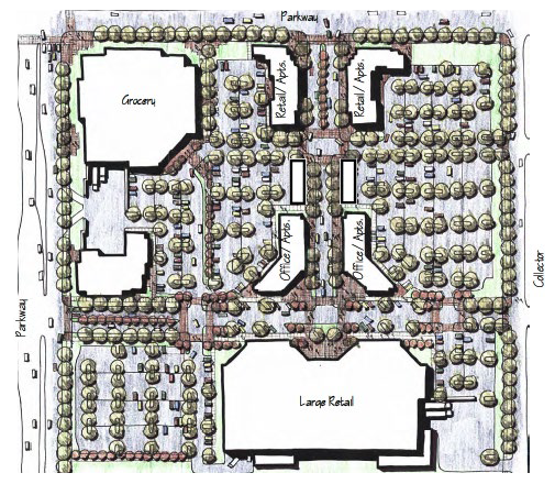
4.7.4.6 Town Center Mixed Use Overlay (TC) District Regulations
The Town Center Mixed Use Overlay (TC) District, adopted per Ordinance 804 in 2007, is intended to provide performance standards that direct the development of properties within the district in a form similar to Old Town Cibolo, with residential, duplex, retail, services, office and institutional uses. The focus of the performance standards is to limit specific impacts to adjacent properties, while enabling flexibility in planning to the developing owner. Transition of use, buffering, and internal circulation are emphasized. Where these standards conflict with other standards or regulations of this or other City Ordinances, or with private restrictive covenants, the more restrictive standard shall apply.
4.7.4.6.1 Permitted Uses
1.
The permitted use section of the C-2 district and Old Town Mixed Use Overlay district shall govern the uses permitted by right and by CUP in the TC district.
2.
Uses permitted in the C-3 zoning district shall not be permitted by right, but may be permitted upon City Council approval of a Mixed Use Concept Plan that demonstrates that C-3 uses are appropriate based on factors such as, but not limited to the location of property adjacent to a railroad right-of-way, adjacent to a proposed TxDOT right-of-way or at a location adjacent to any street depicted on the Future Thoroughfare Plan; subject to an applicant demonstrating that C-3 uses will be cited in a manner with appropriate transitions, as described in the MURE district in this Article, to transition C-3 development to other existing or proposed land uses in the C-2/TC Overlay districts. The City Council reserves the right to deny any request for C-3 uses that is not consistent with the purpose of the TC district.
3.
Prohibited Uses
The following uses are expressly prohibited: sexually oriented businesses, mini-warehouse storage, general outdoor storage, kennels, pawn shops, surplus sales, convenience stores, gasoline service stations, automobile related uses, outdoor advertising signs (billboards) or any other C-3 use that the City Council may consider as being inconsistent with creating a positive image of the City and Town Center Overlay district.
4.
Appeals
Any use that is not expressly listed as a prohibited use that is denied by staff can be appealed to the Planning and Zoning Commission and City Council in accordance with the procedural requirements of this UDC and the Fee Schedule for Administrative Appeals.
4.7.4.6.2 Performance Standards.
All performance standards in C-2 district and those described in the OT district shall be applicable. In addition, the following standards shall be applicable:
1.
Creation of a Unified Activity Center and Central Regional Focal Point
The Old Town and Town Center Overlay districts are located at the confluence of existing and proposed regional streets, proposed bicycle pathways, proposed linear park and existing creeks, floodplains and drainage networks. Accordingly, the City, when reviewing projects in these districts, may impose conditions of approval to ensure that the Old Town and Town Center Overlays function as two halves of a unified Activity Center to create a single integrated core City setting that integrates existing and proposed streets, linear parks, bike ways, floodplains and drainage networks into forms that will maintain the viability of Old Town Cibolo for residential development, result in an expansion of residential, commercial and institutional opportunities east of Town Creek, the maintenance and design floodplains and drainage systems into forms that result in conservation, park and recreation opportunities and a unified transportation network that integrate Old Town and Town Center with existing streets and parks north of FM 1103 and new development south of FM 78.
2.
Elements of Section 4.7.4.3 (MURE) of this Article of the UDC were written to be applicable to all Mixed-Use districts of Cibolo. Specifically all of the general land use, transportation planning concepts, principals and general design guidelines described in Section 4.7.4.3 Subsections D.3 (a-h), D.4, D.7, D-10 and Subjects G-O shall be applicable to the Old Town and Town Center Overlay districts.
4.7.4.6.3 Approval Process
1.
For any commercial or residential projects, a Mixed-Use Concept Plan, as described in the MURE district of this UDC, shall be submitted demonstrating compliance with the requirements of this overlay district for P and Z review and City Council approval. All transitional and contextual requirements and standards of the MURE district shall be applicable. The Mixed-Use Concept Plan must be reviewed by the P and Z and approved by City Council.
Mixed Use Diagram 7: Prototypical Town Center Concept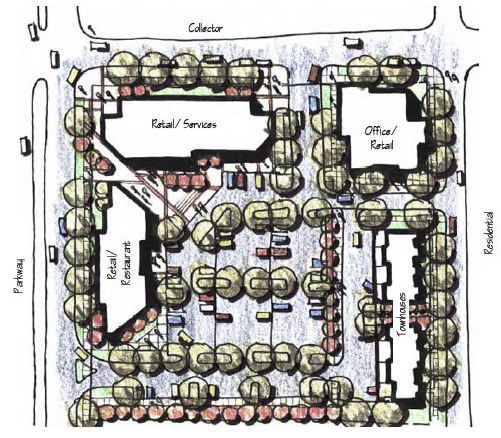
(Ord. No. 1364, § 3, 5-24-2022; Ord. No. 1384, § 1, 11-21-2022; Ord. No. 1400, § 1, 6-27-2023; Ord. No. 1422, § 2, 12-12-2023)