
Citrus Heights City Zoning Code
CHAPTER 106
50 - SPECIAL PLANNING AREA DEVELOPMENT STANDARDS
Sec. 106.50.010.- Purpose and Applicability
A.
Purpose. The standards and requirements in this Chapter are intended to provide for flexibility in the application of Zoning Code standards to proposed development under limited and unique circumstances. The purpose is to allow consideration of innovation in site planning and other aspects of project design, and more effective design responses to site features, uses on adjoining properties, and environmental impacts than the Zoning Code standards would produce without adjustment. The City expects each project within a Special Planning Area to be of obvious, significantly higher quality than would be achieved through conventional design practices and standards.
B.
Applicability. The provisions of this Chapter apply to proposed development and new land uses within the special planning areas identified by this Chapter.
C.
Conflicting requirements. In the event of any conflict between a requirement of this Chapter and another provision of this Zoning Code, the requirements of this Chapter shall prevail.
Sec. 106.50.020. - Antelope Commons
A.
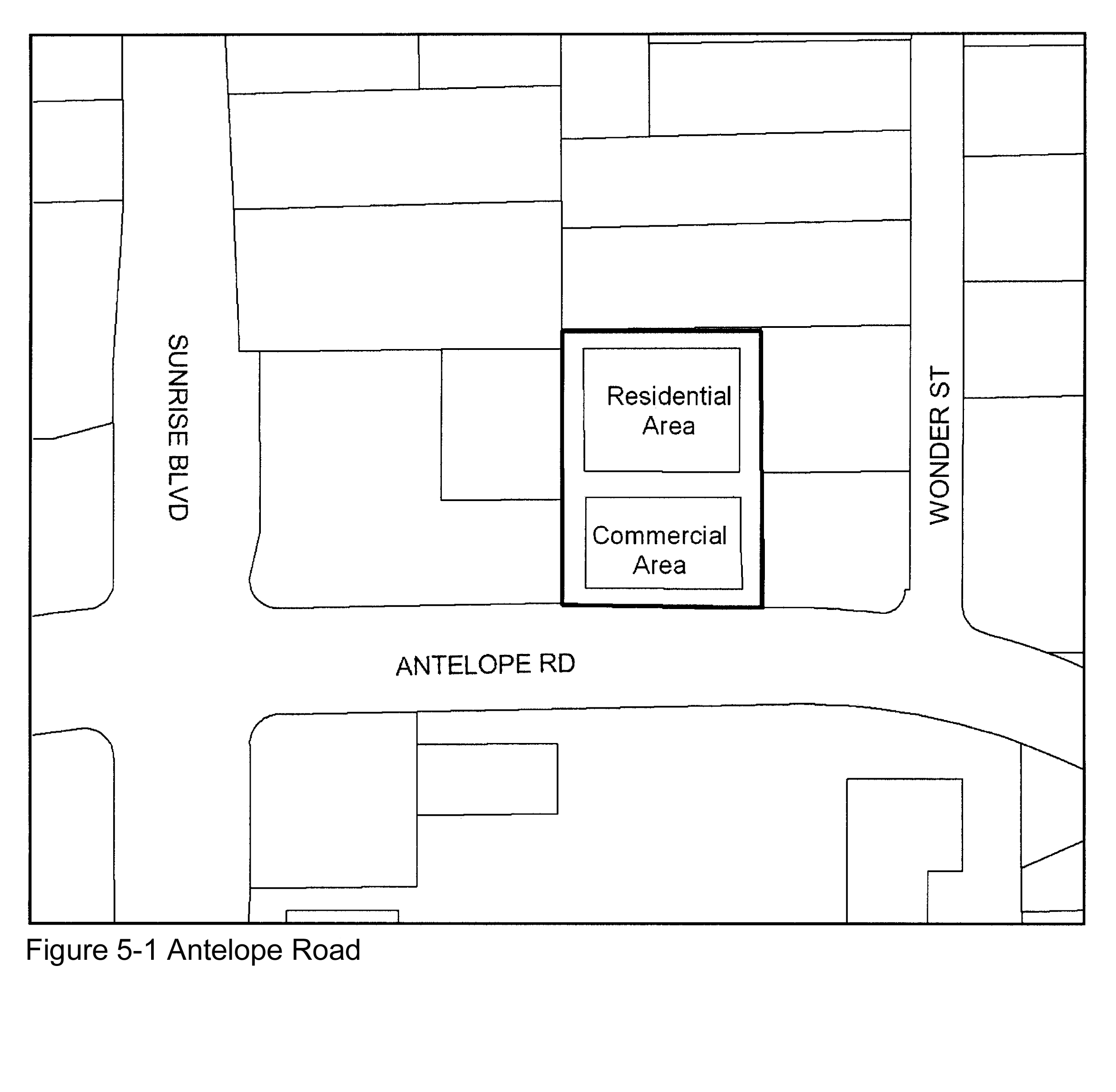
Purpose. The provisions of this Section are intended to allow development within the Antelope Commons SPA to buffer future residents from Antelope Road and adjoining commercial uses, and support an innovative mixed use development design that is an asset to the community, and a transition between existing residential and commercial uses.
B.
Applicability. This Section applies to proposed development and new land uses within the Antelope Commons SPA, as shown on Figure 5-1 and the Zoning Map.
C.
Allowable land uses. Land uses within the planning area shall be limited to townhouses and offices in a mixed use setting. No retail sales shall be conducted from the office structure. Uses other than retail sales shall be office uses including accountants, insurance brokers, engineers, attorneys and similar activities.
D.
Permit requirements. Design review approval shall be required for all proposed development, except for residential accessory structures in compliance with Section 106.42.200 (Residential Accessory Uses and Structures).
E.
Density. Residential density shall not exceed 10.2 dwelling units per acre.
F.
Development standards - Overall project design objectives. The site shall be developed with a mix of residential and office uses. Each townhouse shall be served by a central interior access road, which will also provide emergency access and easement for underground utilities. Garage access to two enclosed parking spaces in eight units and one enclosed parking space in two units shall be via the central drive. Each unit will have one additional covered parking space, in addition to the enclosed spaces. This configuration will allow the townhouses to each have enclosed private outdoor spaces on the east and west sides of the site, to serve as visual buffers for adjoining residences. An additional common open space area along the north boundary of the property will serve as a further buffer for existing residents to the north. All residential units shall have landscaped private rear yards, appropriately designed to provide visual screening for neighboring residents. The common open space area situated along the north property line shall have a children's play area and shall be landscaped to provide visual screening for neighboring residences to the north.
G.
Development standards - Overall project site.
1.
Grading. The design, layout and configuration of improvements shall minimize the extent and amount of grading. The following techniques shall be considered and utilized where feasible:
a.
Grading for streets shall be reduced as much as possible, consistent with the minimum requirements for utility service, drainage requirements and street design and improvement requirements.
b.
Grading plan approval and Grading Permit issuance shall require that the Engineering Division first determine that the plans are consistent with the approved site plans.
2.
Streets. Internal streets may be private.
a.
If private, the streets will meet private roadway standards as required by the Fire District and City and be maintained by the homeowner association (HOA). A Private Road Maintenance Agreement shall also be implemented with the HOA in compliance with the requirements of the Sacramento Metro Fire Department, and the Engineering Division.
b.
All internal private roads shall be of patterned concrete or paver materials, and approved as to design through the Design Review process.
3.
Tree preservation. Improvements shall be designed, laid out, and configured to minimize the relocation of trees.
4.
Access drives.
a.
Access to onsite parking shall be by the internal access drives. The internal access drives shall be installed with a full pavement width of 24 feet within which parking shall be prohibited.
b.
The use of raised curbs will function as vehicle barriers, wheel stops and planter edges.
c.
Garage doors shall be a minimum of five feet from the edge of an access drive. Residents shall be prohibited from using access drives for parking. Guest parking shall be permitted in designated areas, and within the parking lot serving the office building, during off-business hours.
d.
A vertical clearance of at least 13 ½ feet shall be maintained above access drives.
5.
Common open space area. A common open space area along the north boundary of the property shall be no less than 20 feet wide, as measured from the north property line.
6.
Landscape and paving. The landscaping, including all common areas, front yards, and office structure, shall be maintained by the HOA with the exception of the private rear yards of each townhouse. The landscaping design shall be approved through the Design Review process.
H.
Development standards - Individual buildings.
1.
Minimum lot area. The minimum lot area for townhouse units shall be 1,500 square feet.
2.
Setback requirements.
a.
Townhouses. Each townhouse shall comply with the following setback requirements, as applicable.
(1)
Front. The front of each townhouse shall be set back five feet from the curb of fronting internal private street.
(2)
Side, rear. Each townhouse shall be provided 20-foot minimum side and rear yard setbacks. Each unit shall have a rear yard private outdoor area no less than 20 feet deep, as measured along the west and east property lines.
b.
Office building. The office building shall be provided a 20-foot minimum setback from the front property line along Antelope Road; and a 29-foot minimum setback from the north, east and west property lines.
c.
Equipment. All air conditioning equipment shall be located a minimum of 10 feet from internal streets, and 15 feet from each perimeter property line. The equipment will be screened from public view with landscaping.
3.
Height limits. The maximum height for a townhouse structure shall be 34 feet; the maximum height for the office structure shall be 35 feet.
4.
Site coverage. The total area of all building footprints shall not exceed 60 percent of the total site area.
5.
Fencing requirements. The north, east, and west property boundaries shall be fenced by an eight-foot tall masonry wall, while the south side of the private yards of parcels 5 and 10 shall be fenced by a six-foot tall masonry wall. All walls and fences shall comply with the requirements of Section 106.30.050 (Fences and Walls).
6.
Building design details.
a.
Roof. Each building shall have a pitched roof.
b.
Exterior wall finishes. Each building shall have an exterior finish of either stucco or high grade metal siding.
c.
Materials and colors. The materials and color palettes will be complimentary to the building design, as approved through the Design Review.
7.
Exterior lighting. Exterior sconce lighting shall be used to accent the Office structure as well as provide security and entrance accent lighting for the Townhouses. All exterior lighting shall have full cut-off shields to eliminate light contamination on surrounding properties, and shall comply with all applicable requirements of Chapter 106.25 (Outdoor Lighting).
8.
Office hours of operation. Office uses within the office structure shall not be open before 7:00 a.m. nor after 6:00 p.m., Monday through Friday.
9.
Parking. Off-street parking shall be provided as follows, instead of as required by Section 106.36.040 (Number of Parking Spaces Required):
a.
Townhouse. One or two enclosed parking spaces per unit, plus one covered space for each unit.
b.
Office. Four and one-half parking spaces per 1,000 square feet of office area, in a covered parking structure under the office structure and adjacent to the office structure.
c.
Guest parking. One guest parking space for each two townhouses. Because the project is a mixed use development, the parking spaces normally occupied by office employees may be used for guest parking during off-business hours, and during weekends.
I.
Signs and street addresses. On-site signs shall comply with the following requirements, in addition to those in Chapter 106.38 (Signs):
1.
Office monument sign shall complement color and design of structure;
2.
Residential and office address signs shall be Illuminated at night;
3.
Address signs shall have numbers at least four inches in height;
4.
Address numbers shall be visible for emergency personnel;
5.
Address numbers shall be on the front of each townhouse, near the entrance; and
6.
Monument signs are allowed at the entrances to the project along Antelope Street.
Sec. 106.50.030. - Antelope Crossing.
A.
Purpose. The intent of the Antelope Crossing Special Planning Area (SPA) is to spur reinvestment in the planning area and reposition the area to capitalize on the shopping centers' location while reducing vehicle miles traveled (VMT). The Antelope Crossing SPA shall provide for a mix of uses, improve connectivity between the shopping center and surrounding residential development and establish design standards to ensure aesthetically pleasing, quality development to meet the goals of the Antelope Crossing Transformation Plan.
B.
Applicability. This Section applies to proposed development and new land uses within the Antelope Crossing SPA, as shown on Figure 5-2 and the Zoning Map.
C.
Allowable land uses. Allowed uses within the planning area shall be limited to those authorized in the SC (Shopping Center) zoning district by Section 106.26.030 (Commercial and Industrial District Land Uses and Permit Requirements), subject to the permit requirements of Subsection D below.
D.
Permit requirements. Design Review approval shall be required for all proposed development. The replacement of an existing land use shall require planning permit approval in compliance with Section 106.26.030 (Commercial and Industrial District Land Uses and Permit Requirements).
E.
Development standards — Overall project design objectives. The design objectives of this Section are to accommodate a mixture of commercial and residential uses through innovative design, redevelop underutilized and aging buildings, create open space, plazas and pocket parks to create a walkable and attractive neighborhood center. Implementation of the development standards will create a safe and efficient network for vehicles, transit, bicycles and pedestrians, orient buildings toward the street, encourage different uses such as mixed-use office buildings for job creation, ensure compatibility with adjoining residential uses, and provide for innovative site design and enhanced architecture of commercial/mixed use and residential buildings.
Proposed development shall comply with all applicable requirements of the SC zoning district, including Article 3 (Site Planning and Project Design Standards) and Article 4 (Standards for Specific Land Uses) of the Zoning Code, and the following standards:
1.
Grading. The design, layout, and configuration of improvements shall minimize the extent and amount of grading.
2.
Landscaping. Landscaping shall be provided in accordance with the landscaping standards in Article 3. Each new nonresidential and multi-unit residential project shall provide landscaping in compliance with this Article.
3.
Internal circulation. Proposed internal circulation improvements shall create a network of roadways providing safe and direct access as well as visibility to businesses by vehicles, pedestrians and bicycles alike. Roadway improvements shall balance the needs of all users and include elements such as wide sidewalks, bicycle lanes and bicycle parking, slow travel lanes, bus shelters, parking within roadways, pedestrian-scaled light posts, way-finding signage and street trees. Where possible, traffic calming measures such as bulb-outs and enhanced crosswalks shall be built to further contribute to a safe, accessible and pedestrian friendly circulation network.
4.
Public spaces and plazas. Wide sidewalks consisting of shade trees, pedestrian-scaled light posts and other pedestrian amenities that are adjacent to retail shall be provided to create active spaces and enhance the pedestrian experience. Wide sidewalks adjacent to cafes and restaurants shall provide for outdoor dining areas. Plazas and greens shall be incorporated with new development to further provide places to gather in Antelope Crossing. Open spaces shall be designed to enhance the pedestrian experience for shoppers, workers, residents and the public by providing passive recreation, as well as gathering spaces that can be used for events.
5.
Floor area limitation. The floor area ratio (FAR) for residential and nonresidential buildings constructed in the planning area shall not exceed 0.6 in accordance with Article 2.
6.
Residential units. Total residential units for the planning area shall not exceed 118 units.
7.
Height limit. No structure shall exceed a maximum height of 24 feet and two stories within 50 feet of a residential zone, 50 feet and four stories elsewhere in accordance with the height standards in Article 2.
8.
Setbacks. Building setbacks shall comply with the development standards in Article 2. The front and/or side-corner setback may be reduced or eliminated by the review authority to accommodate the placement of a building at the back of the street sidewalk, and/or pedestrian space including outdoor sitting or eating areas. Building setbacks may not be reduced to allow parking closer to street.
9.
Parking. All land uses shall comply with the parking and loading standards in Article 3. Additionally guest parking for residential development projects may be provided on adjoining commercial uses upon approval of the property owner(s). Reciprocal parking between adjacent uses that have different parking demands such as office and residential uses is allowed to avoid the overprovision of parking. A recorded access agreement shall be required for any offsite parking.
10.
Outdoor lighting. Outdoor lighting shall comply with the outdoor lighting standards in Article 3. All outdoor lighting fixtures shall be designed, located, installed, aimed downward and maintained in order to prevent glare, light trespass, and light pollution.
11.
Signs. Proposed signs shall comply with the sign standards in Article 3 except as described below. Proposed signage shall be designed to enhance the identity of Antelope Crossing and individual businesses.
(a)
Freeway oriented signs. One freeway oriented freestanding may be allowed with Use Permit approval, and otherwise in compliance with the sign standards in Article 3. The freeway oriented freestanding sign shall be located on property abutting a freeway that is oriented to and intended to be read from the freeway for the purpose of identifying the Planning Area and tenant(s) within the Planning Area. The sign shall be of a superior design incorporating high quality materials. Freeway signage shall incorporate Antelope Crossing's identity concept. The sign may have an electronic message component not to exceed 100 square feet on each side of the sign and shall operate in accordance with the following:
(1)
The digital freeway sign shall display static messages only, and shall not have animation, movement, or the appearance or optical illusion of movement in or on any part of the sign structure, design, or pictorial segment of the sign. Each static message shall not include flashing or scintillating lighting, or varying light intensity.
(2)
Each message on the sign must be displayed for a minimum of 12 seconds.
(3)
The sign shall not operate at brightness levels of more than 0.3 foot-candles above ambient light, as measured using a foot-candle meter at a distance of 250 feet from the sign face. Each digital display area shall have a light sensing device that will adjust the brightness of the sign as ambient light conditions change throughout the day.
(4)
The electronic display may only display messages related to businesses located within the Antelope Crossing Special Planning Area.
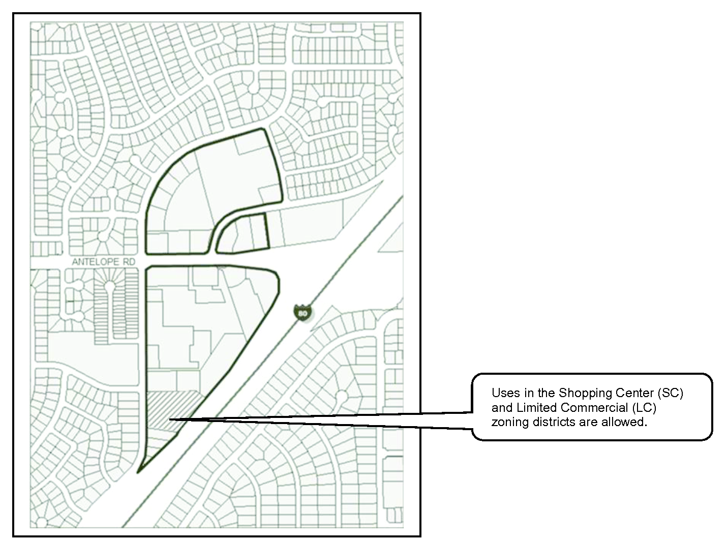
Figure 5-2 - Antelope Crossing
(Ord. No. 2015-004, § 3, 5-28-2015)
Editor's note— Ord. No. 2015-004, § 3, adopted May 28, 2015, renamed § 106.50.030 from Antelope Road - I-80 as Antelope Crossing.
Sec. 106.50.040. - Auburn Boulevard Corridor
A.
Purpose. The provisions of this Section are intended to allow development along the Auburn Boulevard Corridor that will accommodate a mixture of commercial and residential uses, redevelopment of underutilized and aging buildings, preserve and enhance existing open space, provide a safe Auburn Boulevard Corridor to accommodate vehicles, transit, bicycles and pedestrians, ensure compatibility with adjoining residential uses, and provide for enhanced architectural designs of commercial/mixed use buildings. It is also the intent of this Section to provide for the implementation of The Boulevard Plan.
B.
Applicability. This Section applies to proposed development and new land uses within the Auburn Boulevard Corridor SPA, as shown on Figure 5-3 and the Zoning Map.
C.
Allowable land uses. Allowed uses shall be limited to those authorized in The Boulevard Plan.
D.
Permit requirements. Each proposed development shall with the permit and application requirements in The Boulevard Plan, in addition to the application requirements in Chapter 106.60 (Permit Application Filing and Processing).
E.
Density. Residential density shall comply with The Boulevard Plan.
F.
Development standards. Proposed development shall comply with the standards and guidelines in The Boulevard Plan.
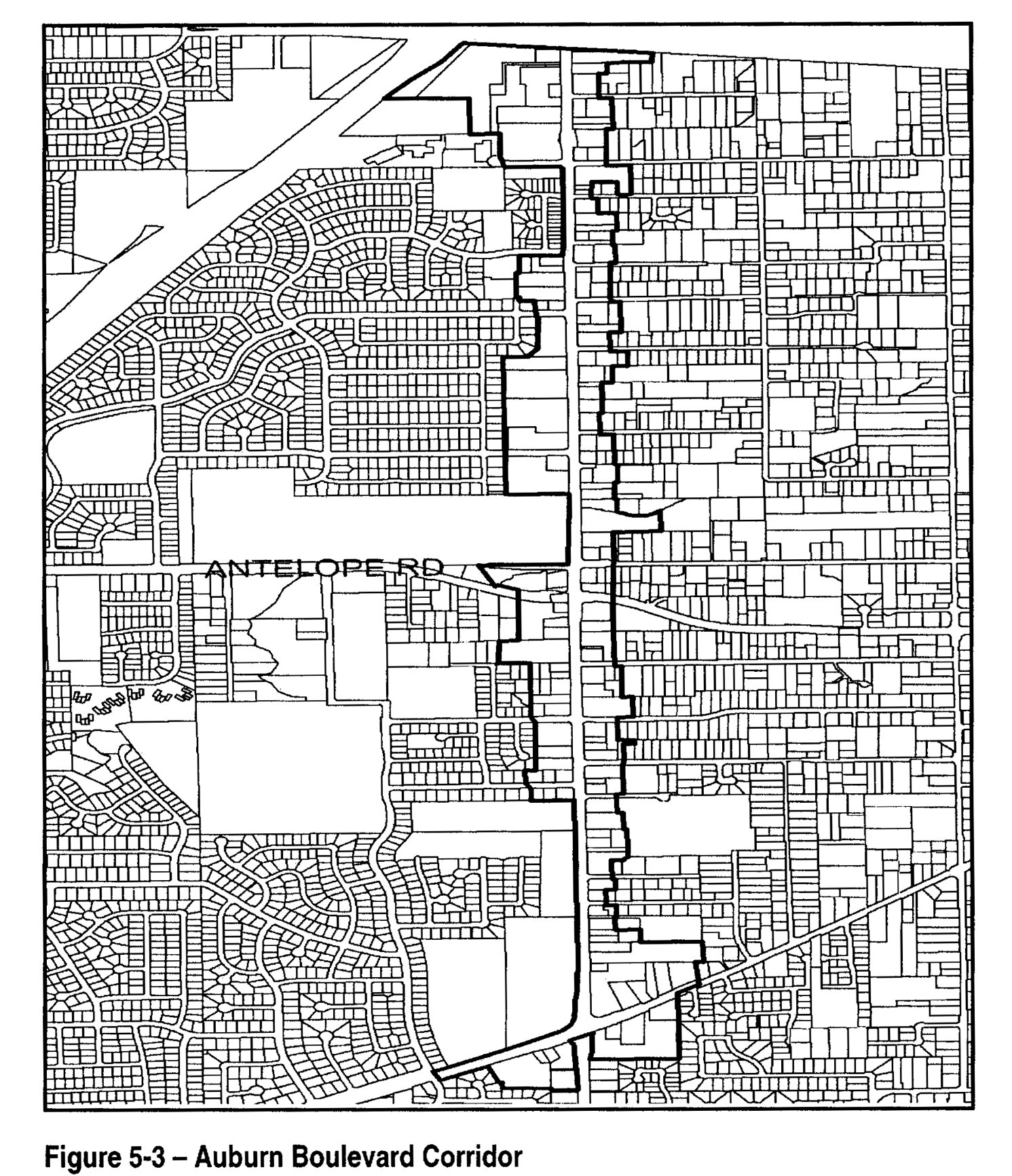
Figure 5-3 Auburn Boulevard Corridor
Sec. 106.50.050. - Auburn Boulevard - Van Maren Lane
A.
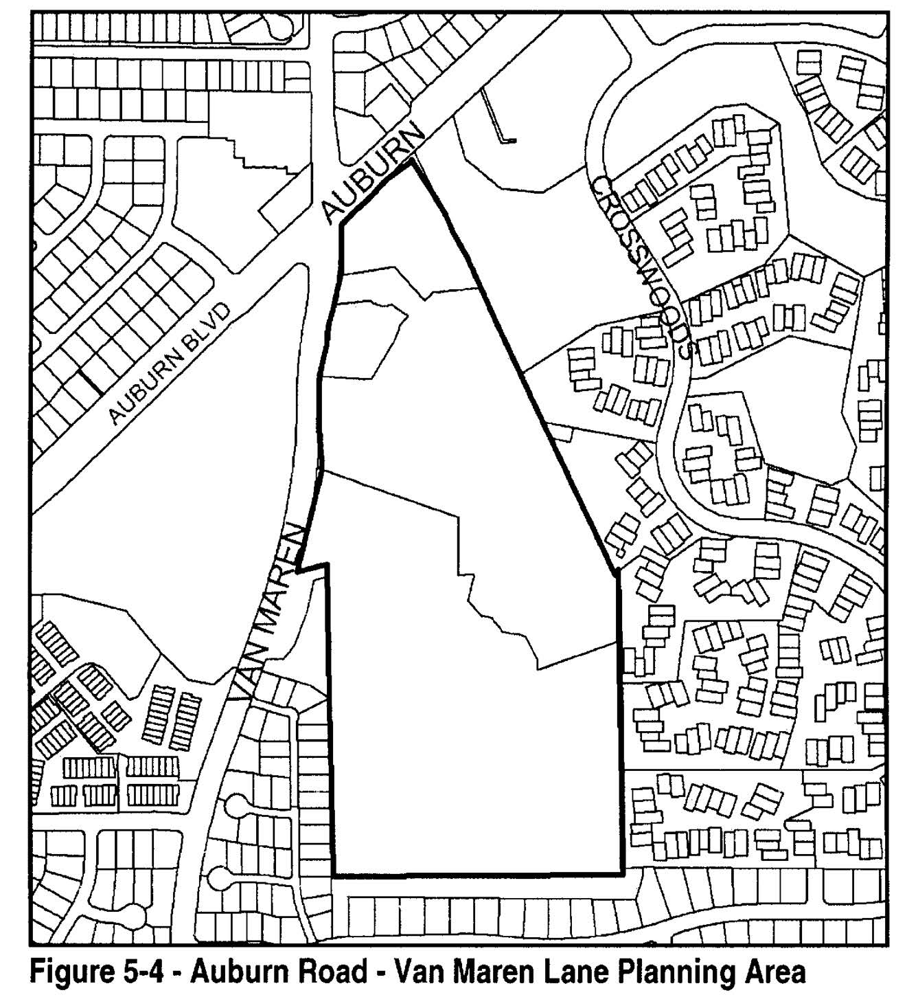
Purpose. The provisions of this Section are intended to ensure that development within the Auburn Boulevard - Van Maren Lane SPA will retain creeks and floodplains in a natural condition, buffer future residents from freeway noise and pollutants through the use of greenbelts and innovative design, provide for adequate access to major streets, and ensure that the design of proposed development is compatible with existing surrounding development.
B.
Applicability. This Section applies to proposed development and new land uses within the Auburn Boulevard - Van Maren Lane SPA, as shown on Figure 5-4 and the Zoning Map.
C.
Allowable land uses. Land uses within the planning area shall be limited to those identified as permitted or conditional in the RD-10 zoning district by Section 106.24.030 (Residential and Open Space District Allowable Land Uses and Permit Requirements), Table 2-2, except as follows, and subject to the permit requirements of Subsection D below.
1.
No parcel shall be developed with other than a single-family or two-family dwelling, unless a different use otherwise allowed in the RD-10 zoning district, and not prohibited by Subsection C.2 below, is authorized by Use Permit approval.
2.
No use listed in Section 106.24.030 (Residential and Open Space District Allowable Land Uses and Permit Requirements), Table 2-2, under "Recreation, Education, and Public Assembly Uses," "Retail Trade," "Services - Business, Financial, and Professional," or "Services," shall be permitted, except for family day care homes and day care centers, and public safety facilities.
D.
Permit requirements.
1.
Design Review required. Design Review approval shall be required for all proposed development, except that allowed by Subsection C.1 above, and except for residential accessory structures in compliance with Section 106.42.200 (Residential Accessory Uses and Structures).
2.
Project coordination. Project review and approval shall include the review authority considering the relationship of the proposed circulation pattern with that of surrounding areas to provide for an interconnected street system and the coordination of circulation between projects with the overall community.
E.
Density. The review authority may approve a maximum residential density of 10 dwelling units per acre, in compliance with the other provisions of this Section, for a portion of a project where corresponding areas are dedicated for the preservation of open space along natural streams, where there are significant groves of heritage or landmark trees, or in other environmentally sensitive areas.
F.
Development standards. Proposed development shall comply with all applicable requirements of the RD-10 zoning district, Articles 3 (Site Planning and Project Design Standards) and 4 (Standards for Specific Land Uses), and the following standards; except that the review authority may modify the following standards where necessary to reduce site grading, avoid encroachment into floodplains, or to preserve native trees.
1.
Grading. The design, layout, and configuration of improvements shall minimize the extent and amount of grading. No grading, except as provided in Municipal Code Section 16A.52, shall occur on a parcel subject to the requirements of this Section until a Grading Permit is obtained from the Engineering Division.
a.
Split-level building design and foundation systems shall be used to accomplish elevation transitions as close to existing grades as possible.
b.
Street grading shall be limited to the maximum extent feasible, consistent with the minimum requirements for utility service, drainage requirements, and street design and improvement requirements.
c.
No grading shall be permitted within any stream floodway. The Engineering Division shall not approve a grading plan or issue a Grading Permit unless the plan is consistent with the site plan approved with the Use Permit for the site, and with the standards of this Section.
2.
Trees. The design, layout, and configuration of proposed improvements shall minimize the removal of trees. No native tree with a diameter of nine inches or more, measured at 54 inches above the ground shall be damaged or removed unless:
a.
The tree is located within the right-of-way of an approved street or specifically approved for removal by the review authority as part of the approved site plan.
b.
The removal is necessary for: the elimination of diseased growth; fire prevention and control; flood prevention and control; or as may be required for pedestrian, bicycle or equestrian paths and trails.
3.
Streams. Proposed development shall be designed so that each natural stream with well-defined banks and a contributory watershed of at least 30 acres, shall remain and be maintained in its natural state except for:
a.
The removal and clearing of debris, growth, brush, or trees necessary to maintain the free passage of storm and drainage waters, or to prevent the flooding of buildings and other improvements; and
b.
The construction of improvements approved by the Council as being necessary to prevent of erosion, or otherwise protect public health, safety, or welfare.
4.
Limitation on access in proposed subdivisions. No subdivision shall be designed or approved with lots fronting on, and taking access from, Auburn Boulevard, or Van Maren Road, where the lots can be feasibly provided public street access elsewhere.
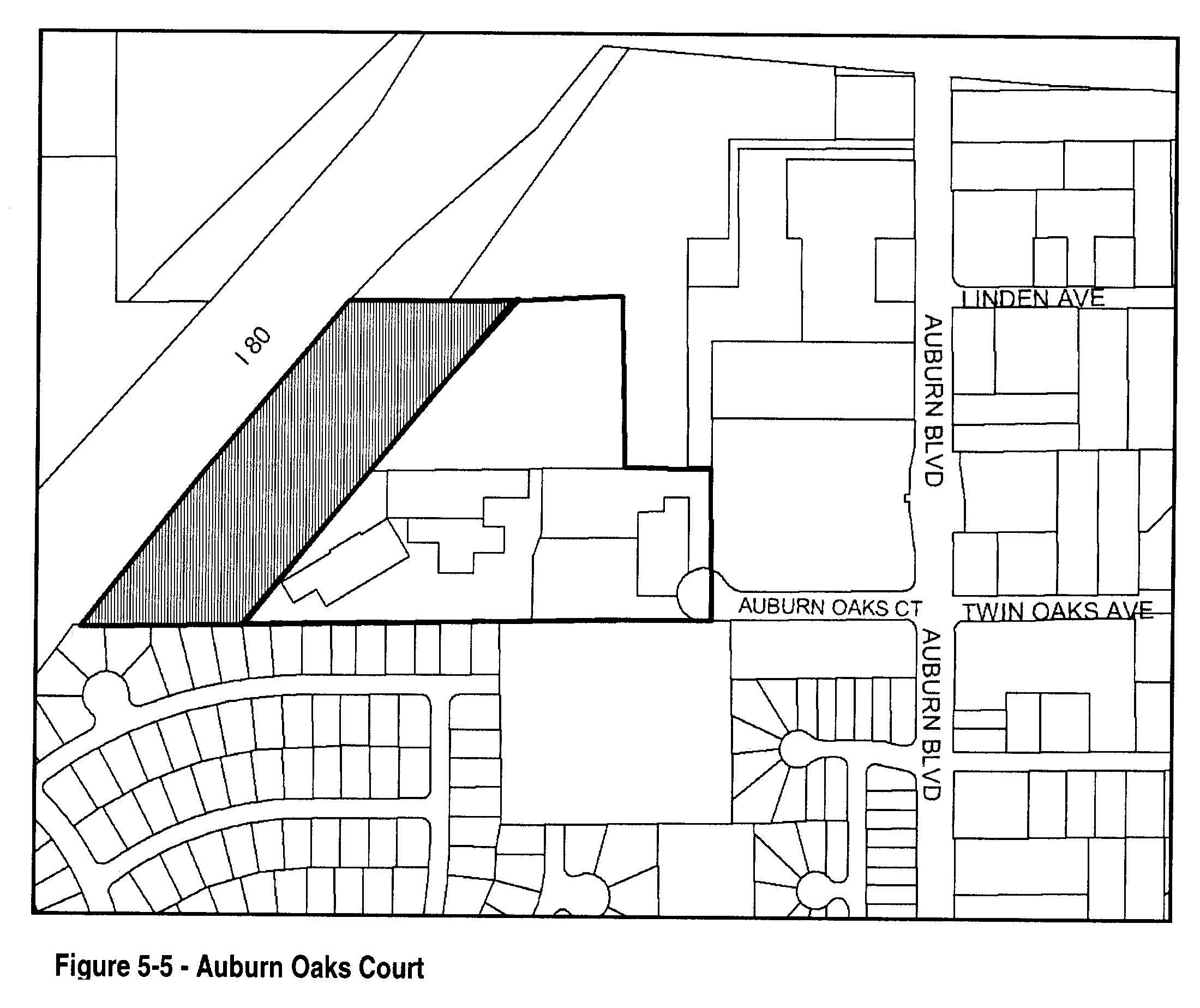
Sec. 106.50.060. - Auburn Oaks Court
A.
Purpose. The provisions of this Section are intended to ensure that proposed development within the Auburn Oaks Court SPA will buffer future residents from freeway noise and pollutants and mitigate those impacts, provide for adequate circulation within the project site and adequate access to surrounding major streets, and ensure that the design of proposed development is compatible with existing surrounding development.
B.
Applicability. This Section applies to proposed development and new land uses within the Auburn Oaks Court SPA, as shown on Figure 5-5 and the Zoning Map.
C.
Allowable land uses. Land uses within the planning area shall be limited to those identified as permitted or conditional in the RD-20 zoning district by Section 106.24.030 (Residential and Open Space District Allowable Land Uses and Permit Requirements), and SC (Shopping Center) zoning district by Section 106.26.030 (Commercial and Industrial District Land Uses and Permit Requirements), subject to the following limitations, and the permit requirements of Subsection D. below:
1.
No parcel shall be developed with other than a single-family or two-family dwelling, unless a different use otherwise allowed in the RD-20 or SC zoning districts, and not prohibited by Subsection C.2 below, is authorized by Use Permit approval.
2.
The portion of the property shown in Figure 5-5 as a 300-foot wide strip adjacent to Highway 80 shall be limited to land uses identified by Section 106.26.030 (Commercial and Industrial District Land Uses and Permit Requirements) as being permitted within the SC zoning district. No residential use shall be approved within the area, unless the Council finds that noise and air quality impacts associated with the freeway are mitigated by means other than the use of a 300-foot setback.
D.
Permit requirements.
1.
Design Review required. Design Review approval shall be required for all proposed development, except as provided by Subsection C.1 above, and except for residential accessory structures in compliance with Sections 106.42.200 (Residential Accessory Uses and Structures), and 106.42.015 (Accessory Dwelling Units).
2.
Project coordination. Project review and approval shall include the review authority considering the relationship of the proposed circulation pattern with that of surrounding areas to provide for an interconnected street system and the coordination of circulation between projects with the overall community.
E.
Density. Residential density shall not exceed 20 dwelling units per acre, except where additional density is authorized through Use Permit approval, consistent with the General Plan.
F.
Development standards.
1.
Proposed development shall comply with the requirements of the RD-20 or SC zoning districts, as applicable, and Articles 3 (Site Planning and Project Design Standards) and 4 (Standards for Specific Land Uses).
2.
The review authority may require landscaping or walls to buffer residential uses to the south from noise or lights from proposed development on the site, and may limit the building height to one-story; provided that the review authority may modify this standard where necessary to reduce site grading to preserve native trees.
(Ord. No. 2017-002, § 3(Exh. A-1), 7-13-2017)
Sec. 106.50.070. - Camden Place
A.
Purpose. The provisions of this Section are intended to ensure that development within the Camden Place SPA will protect and preserve the creeks and floodplains in a natural condition, buffer future residents from Auburn Boulevard and adjoining commercial uses, and support an innovative design that is an asset to the community.
B.
Applicability. This Section applies to proposed development and new land uses within the Camden Place SPA, as shown on Figure 5-6 and the Zoning Map.
C.
Allowable land uses. Land uses shall be limited to single family and/or half-plex residential units.
D.
Permit requirements. Design review approval shall be required for all proposed development, except for residential accessory structures in compliance with Section 106.42.200 (Residential Accessory Uses and Structures).
E.
Density. Residential density shall not exceed 20 dwelling units per acre.
F.
Development standards - Overall project design objectives. Development on the site shall utilize the beauty of Brooktree Creek. The homes shall be rear loading (the garage entrance is at the back of the home). Access to the garages shall be from the interior streets and drive aisles. This concept will allow the majority of the homes in Camden Place to front on the creek. The homes that will not be facing the creek will have a mews or green space with landscaping. A small private courtyard shall be provided for each unit.
G.
Development standards - Overall project site.
1.
Grading. The design, layout and configuration of improvements shall minimize the extent and amount of grading. The following techniques shall be considered and utilized where feasible.
a.
Grading for streets shall be reduced as much as possible, consistent with the minimum requirements for utility service, drainage requirements and street design and improvement requirements.
b.
No grading shall be permitted with the floodway of any stream. Grading plan approval and Grading Permit issuance shall require that the Engineering Division first determine that the plans are consistent with the approved site plans.
2.
Streets. Internal streets may be private.
a.
If private, the streets will meet private roadway standards as required by the Fire District and City and be maintained by the homeowner association (HOA). A Private Road Maintenance Agreement shall also be implemented with the HOA in compliance with the requirements of the Sacramento Metro Fire Department, and the Engineering Division.
b.
All internal private roads shall be of patterned concrete or paver materials, and approved as to design through the Design Review process.
3.
Tree preservation. Improvements shall be designed, laid out, and configured to minimize the relocation of trees.
4.
Brooktree Creek. Brooktree Creek shall remain and be preserved in its natural state except for:
a.
The removal and clearing of debris, growth, brush or trees necessary for the maintenance of the free passage of storm and drainage waters, or for the prevention of flooding of buildings and other improvements; and
b.
The construction of any improvements expressly approved by the Council, and where the improvements are found to be necessary for the prevention of erosion, the protection of public or private property, or for the preservation of the public health, safety or welfare.
5.
Elderberry bush preservation. The elderberry bushes on the site shall remain. There shall be no permanent subdivision improvements within 40 feet of the elderberries. Pedestrian trails are permissible provided they are located outside the dripline of the shrubs.
6.
Access drives.
a.
Access to onsite parking shall be by the internal access drives. The internal access drives shall be installed with a full pavement width of 24 feet within which parking shall be prohibited.
b.
The use of raised curbs will function as vehicle barriers, wheel stops and planter edges.
c.
Garage doors shall be a minimum of three feet from the edge of the access drive. The residents will be discouraged from using these areas for parking because centrally located parking spaces have been provided throughout the project.
d.
A vertical clearance of at least 13 ½ feet shall be maintained above access drives.
7.
Landscape and paving. The landscaping, including all common areas, front yards and mews areas, shall be maintained by the HOA with the exception of the private courtyards. The landscaping design shall be approved through the Design Review process.
H.
Development standards - Individual buildings.
1.
Minimum lot area. The minimum lot size for single dwellings shall be 1,500 square feet. The minimum lot size for the individually owned parcel of a half-plex unit shall be 750 square feet.
2.
Setback requirements.
a.
Side setbacks.
(1)
A zero lot line setback shall be allowed on one side of the unit. The zero lot line is only allowed on interior property lines; corner lots shall provide a minimum three-foot setback. A minimum three-foot setback is also required for the front and rear yards.
(2)
Buildings shall be separated by a minimum of three feet.
(3)
There shall be a minimum of a three-foot unobstructed easement provided adjacent to the structure within the adjacent side yard for maintenance and drainage purposes.
b.
Garages. Each garage shall be setback three to five feet from the internal street.
c.
Equipment. All air conditioning equipment shall be located a minimum of 10 feet from internal streets. The equipment will be screened from public view with landscaping.
3.
Height limits. The maximum allowable building height shall be 32 feet.
4.
Site coverage. The total area of all building footprints and roofed areas shall not exceed 50 percent of the total site area.
5.
Building design details.
a.
Roof. Each building shall have a pitched roof.
b.
Exterior wall finishes. Each building shall have an exterior finish of either stucco or high grade siding.
c.
Materials and colors. The color palettes shall be complimentary to the building design.
d.
Location of openings. Windows, doors or other openings shall not be permitted on the side of a primary structure that is located less than three feet from a side property line.
e.
Courtyards. Each unit shall have an enclosed courtyard for the private yard.
6.
Exterior lighting. All exterior lighting shall have full cut-off shields to eliminate light contamination on surrounding properties, and shall comply with all applicable requirements of Chapter 106.25 (Outdoor Lighting).
7.
Parking. Off-street parking shall be provided as follows, instead of as required by Section 106.36.040 (Number of Parking Spaces Required):
a.
Single dwelling. Two enclosed parking spaces per unit, plus one guest space for each two units.
b.
Half-plex. One enclosed parking space per unit plus one guest parking space for each unit.
No parking shall be allowed within a side yard.
I.
Signs and street addresses. On-site signs shall comply with the following requirements, in addition to those in Chapter 106.38 (Signs).
1.
Street address color shall contrast with background house color;
2.
Street addresses shall be Illuminated at night;
3.
Street addresses shall be at least four inches in height;
4.
Street addresses shall be located so as to be readily visible to emergency personnel;
5.
There shall be no signage on the front or rear of a home; and
6.
A monument sign is allowed at the entrance to the project from Auburn Boulevard
Figure 5-6 - Camden Place
Sec. 106.50.080. - [Citrus Heights Civic Center Special Planning Area (SPA)]
A.
Purpose. The provisions of this Section are intended to enable the City to develop a Civic Center which concentrates government uses at a civic center complex that provides residents and businesses easy and efficient access to a range of governmental services. The Citrus Heights Civic Center Special Planning Area (SPA) will preserve and protect adjacent properties by establishing appropriate uses within the SPA, provide for adequate circulation within the Civic Center Area, and ensure that the design of proposed development is compatible with existing surrounding development.
B.
Applicability. This Section applies to proposed development and new land uses within the Citrus Heights Civic Center SPA, as shown on Figure 5-15 and the Zoning Map.
C.
Allowable land uses. Land uses within the planning area shall be limited to public uses and those identified as permitted or conditional in the BP zoning district by Section 106.26.030 (Commercial and Industrial Zoning Districts Allowable Land Uses and Permit Requirements). All non-public uses will require approval of a Use Permit.
D.
Permit requirements. Design Review approval shall be required for all proposed development.
E.
Development standards - Overall Project Design Objectives. The design objectives of this Section are to accommodate a mixture of public uses including City Hall, Community Center, Post Office, Police Services and associated Public Facilities and other related uses. The development shall comply with all applicable requirements of the BP zoning district, Articles 3 (Site Planning and Project Design Standards) and 4 (Standard for Specific Land Uses) except for those standards listed below:
1.
Wetland Area. Wetlands and other natural areas shall be preserved as amenities to adjacent development. All development (including driveways and parking) shall maintain a minimum setback of 50' from the edge of wetland areas, unless a lesser distance is authorized by the Army Corps of Engineers.
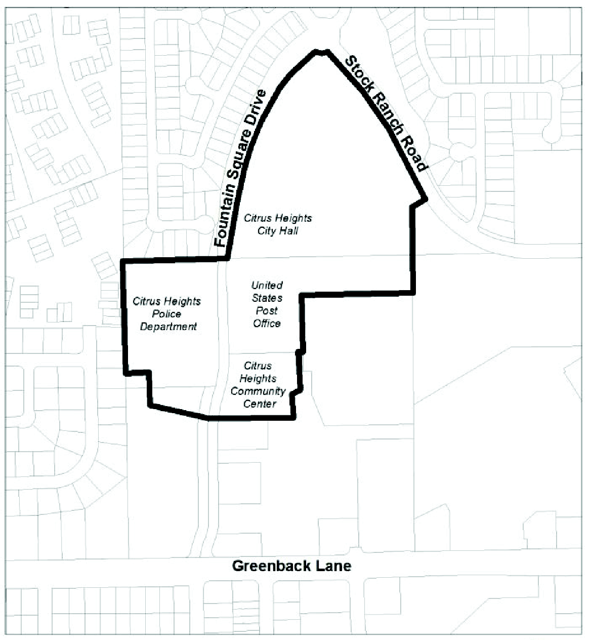
Figure 5-15 - Citrus Heights Civic Center
(Ord. No. 2015-003, § 3, 4-19-15)
Sec. 106.50.090. - Citrus Heights Community
A.
Purpose. The provisions of this Section are intended to ensure that proposed development within the Citrus Heights Community SPA will protect and preserve creeks and floodplains in a natural condition, provide for adequate circulation within the project site and adequate access to major off-site streets, encourage the establishment of a trail system in the general areas shown in Figure 5-7, and preserve the rolling topography of the property.
B.
Applicability. This Section applies to proposed development and new land uses within the Citrus Heights Community SPA, as shown on Figure 5-7 and the Zoning Map.
C.
Allowable land uses. Land uses within the planning area shall be limited to those identified as permitted or conditional in the RD-15 zoning district by Section 106.24.030 (Residential and Open Space District Allowable Land Uses and Permit Requirements), Table 2-2, except as follows, and subject to the permit requirements of Subsection D below.
1.
No parcel shall be developed with other than a single-family or two-family dwelling, unless a different use otherwise allowed in the RD-15 zoning district, and not prohibited by Subsection C.2 below, is authorized by Use Permit approval.
2.
No use listed in Section 106.24.030 (Residential and Open Space District Allowable Land Uses and Permit Requirements), Table 2-2, under "Recreation, Education, and Public Assembly Uses," "Retail Trade," "Services - Business, Financial, and Professional," or "Services," shall be permitted, except for family day care homes and day care centers, and public safety facilities.
D.
Permit requirements.
1.
Design Review required. Design review approval shall be required for all proposed development, except as provided by Subsection C.1 above, and except for residential accessory structures in compliance with Section 106.42.200 (Residential Accessory Uses and Structures).
2.
Project coordination. Project review and approval shall include the review authority considering the relationship of the proposed circulation pattern with that of surrounding areas to provide for an interconnected street system, and the coordination of circulation between projects and with the overall community.
E.
Density. The review authority may approve a maximum residential density of 15 dwelling units per acre, in compliance with the other provisions of this Section, for a portion of a project where corresponding areas are dedicated for the preservation of open space along natural streams, where there are significant groves of heritage or landmark trees, or in other environmentally sensitive areas.
F.
Development standards. Proposed development shall comply with all applicable requirements of the RD-15 zoning district, Articles 3 (Site Planning and Project Design Standards) and 4 (Standards for Specific Land Uses), and the following standards; except that the review authority may modify the following standards where necessary to reduce site grading, avoid encroachment into floodplains, or to preserve native trees.
1.
Grading. The design, layout, and configuration of improvements shall minimize the extent and amount of grading. The following techniques shall be considered and utilized where feasible:
a.
Grading for streets shall be limited as much as possible, consistent with the minimum requirements for utility service, drainage requirements, and street design and improvement requirements.
b.
No grading, except as provided in Municipal Code Section 16A.52 occur until a grading permit is obtained from the Engineering Division.
c.
No grading shall be permitted within the floodway of any stream. The Engineering Division shall not approve any grading plans or issue any grading permits unless the plans are consistent with the approved site plan and the standards in this Section.
2.
Trees. The design, layout, and configuration of proposed improvements shall minimize the removal of trees. No native tree with a diameter of nine inches or more, measured at 54 inches above the ground shall be damaged or removed unless:
a.
The tree is located within the right-of-way of an approved street or specifically approved for removal by the review authority as part of the approved site plan.
b.
The removal is necessary for: the elimination of diseased growth; fire prevention and control; flood prevention and control; or as may be required for pedestrian, bicycle or equestrian paths and trails.
3.
Streams. Proposed development shall be designed so that each natural stream with well-defined banks and a contributory watershed of at least 30 acres, shall remain and be maintained in its natural state except for:
a.
The removal and clearing of debris, growth, brush, or trees necessary to maintain the free passage of storm and drainage waters, or to prevent the flooding of buildings and other improvements; and
b.
The construction of improvements approved by the Council as being necessary to prevent erosion, or otherwise protect public health, safety, or welfare.
Figure 5-7 - Citrus Heights Community
(Ord. No. 2015-003, § 3, 4-19-15)
Editor's note— Ord. No. 2015-003, adopted April 19, 2015 renumbered § 106.50.080 as § 106.50.090.
Sec. 106.50.100. - Greenback Woods
A.
Purpose. The provisions of this Section are intended to ensure that development within Greenback Woods SPA will retain creeks and floodplains in a natural condition, buffer future residents from freeway noise and pollutants through the use of greenbelts and innovative design, and provide adequate circulation within the project site and adequate access to the planning area.
B.
Applicability. This Section applies to proposed development and new land uses within the Greenback Woods SPA, as shown on Figure 5-8 and the Zoning Map.
C.
Allowable land uses. Land uses within the planning area shall be limited to those identified as permitted or conditional in the RD-20 zoning district by Section 106.24.030 (Residential and Open Space District Allowable Land Uses and Permit Requirements); and within the area shown in Figure 5-8, the GC (General Commercial), or BP (Business Professional) zoning districts by Section 106.26.030 (Commercial and Industrial District Land Uses and Permit Requirements), subject to the permit requirements of Subsection D below.
D.
Permit requirements.
1.
Design review required. Design review approval shall be required for all proposed development, except for residential accessory structures in compliance with Section 106.42.200 (Residential Accessory Uses and Structures).
2.
Project coordination. Project review and approval shall include the review authority considering the relationship of the proposed circulation pattern with that of surrounding areas to provide for an interconnected street system, and the coordination of circulation between projects and the overall community.
E.
Density. Residential density shall not exceed 20 dwelling units per acre, except as follows:
a.
The review authority may approve additional density in compliance with the other provisions of this Section, for a portion of a project where corresponding areas are dedicated for the preservation of open space along natural streams, where there are significant groves of heritage or landmark trees, or in other environmentally sensitive areas.
b.
Residential development shall not exceed four dwelling units per acre and 15 dwelling units per acre in the areas shown in Figure 5-8.
F.
Development standards. Proposed development shall comply with all applicable requirements of the RD-20, GC, and BP zoning district, as applicable, Articles 3 (Site Planning and Project Design Standards) and 4 (Standards for Specific Land Uses), and the following standards; except that the review authority may modify the following standards where necessary to reduce site grading, avoid encroachment into floodplains, or to preserve native trees.
1.
Grading. The design, layout, and configuration of improvements shall minimize the extent and amount of grading. The following techniques shall be considered and utilized where feasible:
a.
The use of split-level building design and foundation systems to accomplish elevation transitions as close to existing grades as possible.
b.
Grading for streets shall be limited as much as possible, consistent with the minimum requirements for utility service, drainage requirements, and street design and improvement requirements.
c.
No grading, except as provided in Municipal Code Section 16A.52, shall occur until a grading permit is obtained from the Engineering Division.
d.
No grading shall be permitted within the floodway of any stream. The Engineering Division shall not approve any grading plans or issue any grading permit unless the plans are consistent with the approved site plan and the standards in this Section.
2.
Trees. The design, layout, and configuration of proposed improvements shall minimize the removal of trees. No native tree with a diameter of nine inches or more, measured at 54 inches above the ground shall be damaged or removed unless:
a.
The tree is located within the right-of-way of an approved street or specifically approved for removal by the review authority as part of the approved site plan.
b.
The removal is necessary for: the elimination of diseased growth; fire prevention and control; flood prevention and control; or as may be required for pedestrian, bicycle or equestrian paths and trails.
3.
Streams. Proposed development shall be designed so that each natural stream with well-defined banks and a contributory watershed of at least 30 acres, shall remain and be maintained in its natural state except for:
a.
The removal and clearing of debris, growth, brush, or trees necessary to maintain the free passage of storm and drainage waters, or to prevent the flooding of buildings and other improvements; and
b.
The construction of improvements approved by the Council as being necessary to prevent erosion, or otherwise protect public health, safety, or welfare.
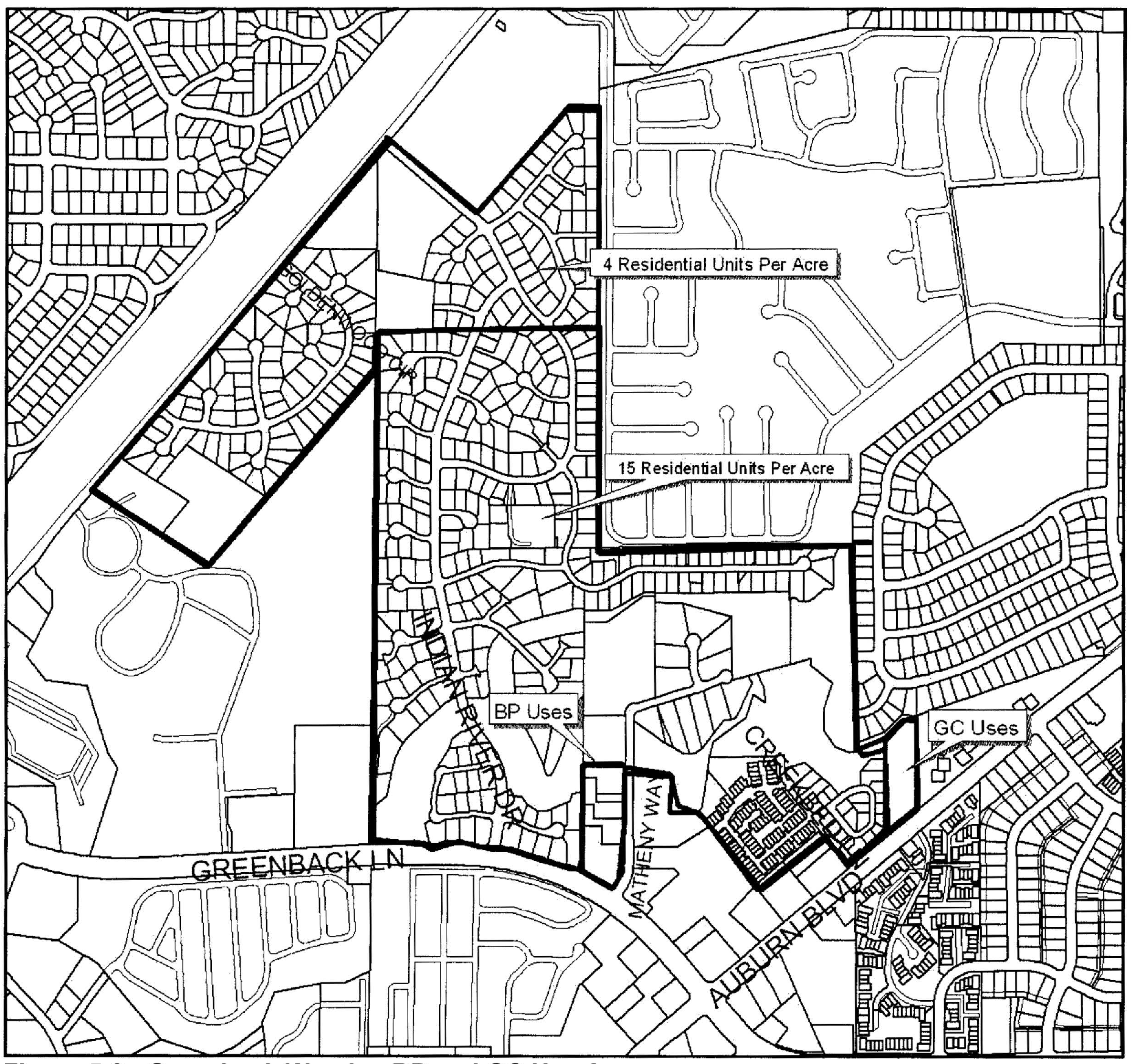
Figure 5-8 - Greenback Woods - BP and GC Use Areas
(Ord. No. 2015-003, § 3, 4-19-15)
Editor's note— Ord. No. 2015-003, adopted April 19, 2015 renumbered § 106.50.090 as § 106.50.100.
Sec. 106.50.105. - 5555 Mariposa Residential
A.
Purpose. The provisions of this Section are intended to ensure that development within the 5555 Mariposa Residential SPA shall protect and preserve environmentally sensitive areas, native trees, as well as creeks and floodplains in a natural condition, reduce roadway noise and pollutants through the use of greenbelts and innovative design, provide adequate circulation within the project site and adequate access to major roads.
B.
Applicability. This Section applies to proposed development and new land uses within the 5555 Mariposa Residential SPA, as shown on Figure 5-8.5 and the Zoning Map.
C.
Allowable land use. Land use shall be limited to single-family residential.
D.
Permit requirements. Design review approval shall be required for all proposed development, except for residential accessory structures in compliance with Section 106.42.200 (Residential Accessory Uses and Structures).
E.
Development review. Prior to issuance of a building permit for any non-accessory building, a development plan shall be submitted for review and approval by the Planning Commission. The plan shall be in substantial conformance with the standards set forth in this Chapter. The plan shall show the location of proposed improvements, trees to be retained and removed, parking traffic circulation, landscaping, grading plans, a topographic map drawn with two foot contours, floor plans, elevations and perspectives sufficient to illustrate the full design character of the project. Said review and approval shall not render the property undevelopable for the uses and densities authorized in this Chapter.
F.
Density. The density of residential development of any portion of the property shown in Figure 5-8.5 shall not exceed 6.5 dwelling units per acre.
G.
Development standards - Overall project site.
1.
Grading. The design, layout, and configuration of improvements shall minimize the extent and amount of grading. The following techniques shall be considered and utilized if feasible:
a.
Grading for streets shall be reduced as much as possible, consistent with the minimum requirements for utility service, drainage requirements, and street design and improvement requirements.
b.
No grading, except as provided in Section 16.44.090 of the Municipal Code shall be done until a grading permit is obtained from the Engineering Division.
c.
No grading shall be permitted within the floodplain of any stream unless approved by the Planning Commission. The Engineering Division shall not approve any grading plans or issue any grading permit unless said plans are consistent with the site plans approved by the Planning Commission and with the policies as set forth in this Section.
2.
Tree preservation. The design, layout, and configuration of the improvements shall be accomplished as to minimize the removal of Oak trees. No Oak trees having a diameter of six inches or more, measured four and one-half feet above the ground shall be damaged or removed unless:
a.
The trees are located within the right-of-way of an approved street, private road, or as otherwise specifically approved by the Planning Commission as part of the site plan approval.
b.
Such removal is necessary for elimination of diseased growth, for fire prevention and control, erosion and flood control, or as may be required for pedestrian, bicycle or equestrian paths and trails.
c.
Adequate on-site mitigation, as required by the Planning Commission, is identified in conjunction with the projects development plan approval.
3.
Natural streams. All natural streams having well-defined banks, and a contributory watershed of at least 30 acres, shall remain and be maintained in their natural state except:
a.
For the removal and clearing of debris, growth, brush or trees necessary for the maintenance of the free passage of storm and drainage waters, or for the prevention of flooding of buildings and other improvements.
b.
The construction of any improvements expressly approved by the City Engineer, and where such improvements are found to be necessary for the prevention of erosion, the protection of public or private property, or for the preservation of the public health, safety, or welfare.
c.
The finish floor elevation of each dwelling shall be two feet higher than the 100-Year Floodplain. New construction shall be limited to existing encroachments (i.e., former racquet ball club).
4.
Project coordination. The Planning Commission, in reviewing and approving development plans, shall consider the relationship of the circulation pattern of the project with neighboring projects and neighborhoods to insure compatibility and Project Coordination with the neighborhood.
5.
Private streets. Private streets shall be permitted within the project site to provide greater flexibility in site design. The project shall meet the following standards:
a.
Private roadways shall be constructed to the appropriate public roadway standard, as determined by the City Engineer, with respect to pavement width and thickness, curbs, gutters, sidewalks, etc.
b.
The streets shall meet all private roadway standards as determined by the Fire District and the City Engineer and be maintained by the homeowner association (HOA). A private Road Maintenance Agreement will also be implemented with the HOA per the requirements of the Sacramento Metro Fire Department and City Engineering Division.
c.
Enhanced pavement shall be provided within the common courtyards as well as at the main entry to the site from Mariposa Avenue. All crosswalks and bridges shall also receive a decorative surface treatment.
6.
Cluster developments. Cluster developments with irregular lot dimensions, reduced lot sizes and minimum setbacks of three feet minimum shall be permitted as provided on project specific development plans.
7.
Refuse containers storage. Refuse containers shall be stored (except on pick-up day) within yard areas not visible from the public (i.e., from Skycrest Elementary School, Mariposa Avenue and San Juan Park) or shall be completely screened by a decorative (trellis) partition.
8.
One story homes. Six homes onsite must be one-story.
9.
Parking. The parking requirement is a minimum of two enclosed parking spaces per dwelling plus one guest parking space for each dwelling. Guest parking shall be distributed throughout the site at designated guest parking spaces and along the street. Garages and driveways shall at all times be available for parking of vehicles only (i.e., not Boats or RVs). Storage within the garage, or any other use within the garage, is only allowed to the extent that it does not impede parking of the vehicle or vehicles of the owner/tenant of the unit. The CC&Rs shall require that residents park their vehicles in their own garages, leaving guest parking spaces available for guests.
10.
Boat and RV storage. Guest parking and on-street parking spaces are strictly reserved for guest and overflow parking. Guest spaces shall not be used for RV or boat storage.
11.
Building setback. Overall perimeter setbacks shall comply with the following building setbacks:
a.
A minimum 60-foot building setback from Mariposa Avenue.
b.
A minimum 20-foot building setback from the site's northerly west boundary adjacent to existing residences.
c.
A minimum 10-foot building setback from the site's southerly west boundary.
d.
A minimum 15-foot building setback from Skycrest Elementary School.
e.
A minimum 10-foot building setback from San Juan Park.
f.
A minimum 15-foot building setback from the private street.
g.
A minimum 3-foot building setback to the interior side property line.
h.
A minimum 10-foot building setback to the rear property line.
12.
Setback to drainage channel. All structures shall provide a minimum 50-foot setback from the top of the bank or lesser of existing encroachment line as shown in the following map:
Exhibit S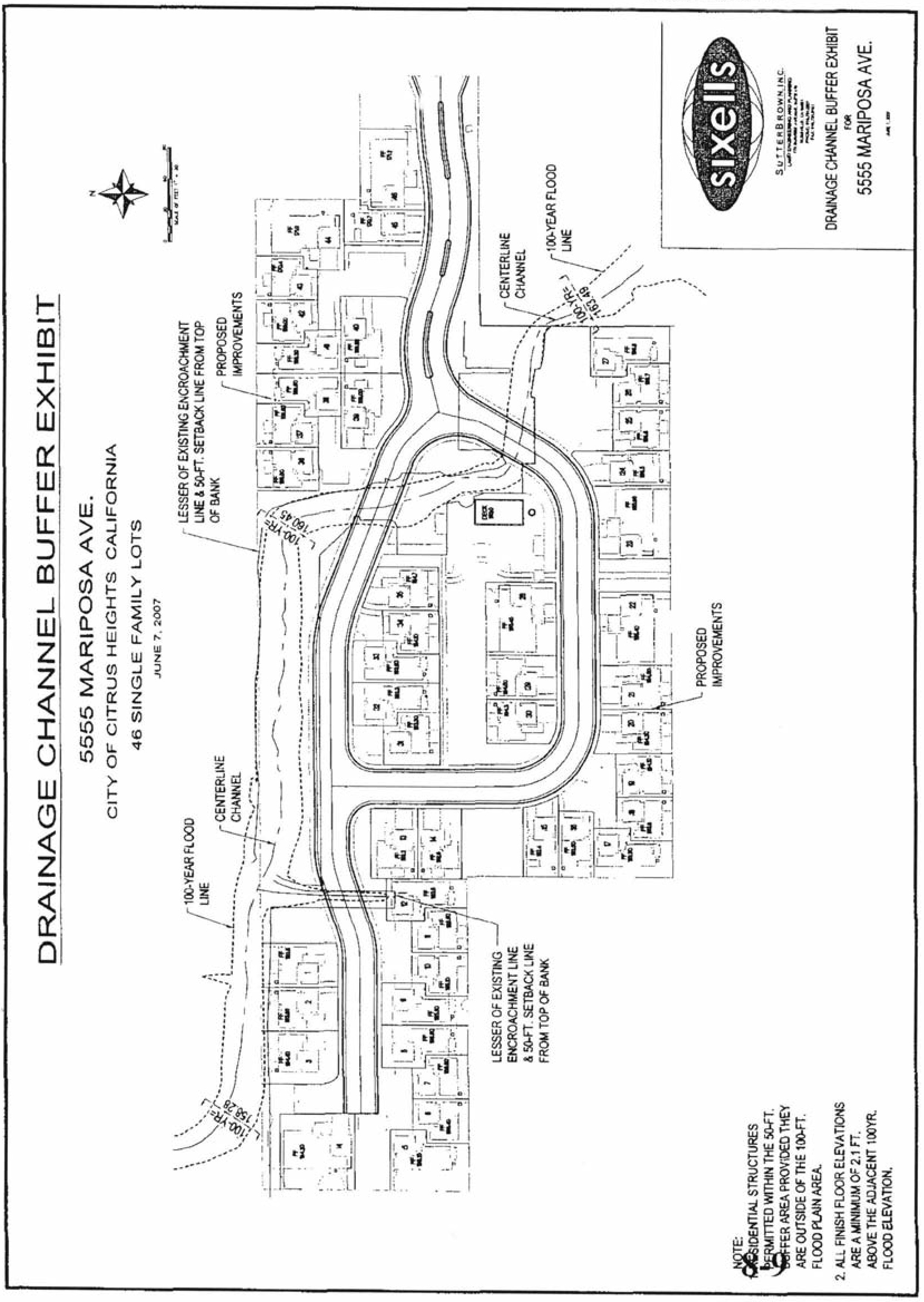
13.
Landscaping. The landscaping, including all common areas, including front yards and side-street yards shall be maintained by the homeowners association.
14.
Lighting. All outdoor lighting, including building mounted lighting fixtures and street lights shall utilize full cut-off lenses.
15.
Minimum lot size. The minimum lot size for each home shall be 2,100 square feet.
H.
Project design. Development of the site shall utilize a cluster home design which orients dwellings around a courtyard/common drive or provides units that provide direct access to the main drive. No more than five dwelling units are allowed within a cluster. Architectural detailing for each dwelling as well as the courtyard, including landscaping enhanced paving and ornamental and monumental entry features such as lighting and signage for each dwelling is required to provide interest and aesthetics within the courtyard. The following shall apply to the design:
I.
Building height. The maximum building height shall be 30 feet from finish grade.
J.
Pitched roofs. All buildings shall be constructed with pitched roofs.
K.
Architecture. All buildings and structures shall maintain a craftsman architectural theme and shall provide complimentary colors and finishes to the building design.
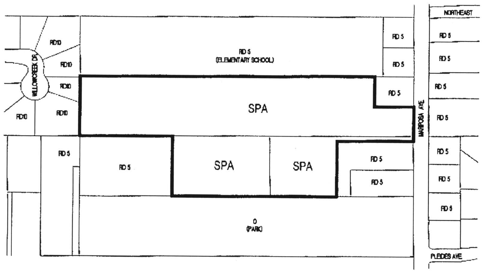
Figure 5-8.5
(Ord. No. 2007-10, § 3(Exh. F), 9-13-2007; Ord. No. 2015-003, § 3, 4-19-2015)
Editor's note— Ord. No. 2015-003, adopted April 19, 2015 renumbered § 106.50.095 as § 106.50.105.
Sec. 106.50.107. - Mitchell Farms Special Planning Area
A.
Purpose. The provisions of this Section are intended to ensure that development within the Mitchell Farms SPA shall protect and preserve to the extent feasible environmentally sensitive areas, native trees, as well as creeks and floodplains in a natural condition, reduce roadway noise and pollutants through the use of greenbelts and innovative design, provide safe and efficient circulation within the project site and adequate access to major roads.
B.
Applicability. This Section applies to proposed development and new land uses within the Mitchell Farms SPA, as shown on Figure 5-8.7 and the Zoning Map.
C.
Allowable land uses. Land uses shall be limited to single-family dwellings and accessory structures, recreational amenities, trails, open space and cellular telecommunications uses.
D.
Permit requirements. Design review approval shall be required for all proposed development, excluding residential accessory structures as defined in Chapter 106.80.
E.
Density. The density of residential development of any portion of the property shown in Figure 5-8.7 shall not exceed 20 dwelling units per acre.
F.
Development standards—Overall project site.
1.
Grading. The design, layout, and configuration of improvements shall minimize the extent and amount of grading. The following techniques shall be considered and utilized if feasible:
a.
Grading for streets shall be reduced as much as possible, consistent with the minimum requirements for utility service, drainage requirements, and street design and improvement requirements.
b.
No grading shall be done until a grading permit is obtained from the Engineering Division.
c.
No grading shall be permitted within the 100-year floodplain of any stream or within the creek setback area (as defined by Section 106.30.040) unless approved by the Engineering Division. The Engineering Division shall not approve any grading plans or issue any grading permit unless said plans are consistent with the site plans approved by the Planning Commission and with the policies as set forth in this Section.
2.
Tree preservation. The design, layout, and configuration of the improvements shall minimize the removal of trees. No protected tree, as defined by Chapter 106.39 shall be damaged or removed unless:
a.
The trees are located within the right-of-way of an approved street, private road, or as otherwise specifically approved by the City as part of the site plan approval, or
b.
Such removal is necessary for elimination of diseased growth, for fire prevention and control, erosion and flood control, or as may be required for pedestrian or bicycle paths and trails, or
c.
Adequate on-site or offsite mitigation is identified in conjunction with the development plan approval of the Mitchell Farms project.
All trees within the special planning area shall be protected under Chapter 106.39, regardless of the size of the lot.
3.
Creek Corridor/Open Space Area. The SPA area is bisected by an unnamed tributary of Arcade Creek. The tributary and associated aquatic resources shall remain and be maintained in their natural state except:
a.
For the removal and clearing of debris, growth, brush or trees necessary for the maintenance of the free passage of storm and drainage waters, or for the prevention of flooding of buildings and other improvements.
b.
For the construction, use and maintenance of a recreational trail system and park amenities.
c.
For the construction of any other improvements expressly approved by the City Engineer, and where such improvements are found to be necessary for the prevention of erosion, the protection of public or private property, the delivery of utilities such as water and sewer, or for the preservation of the public health, safety, or welfare.
Unless otherwise provided above and subject to federal and state regulatory requirements, jurisdictional waters within the Creek Corridor shall be avoided.
4.
Private streets. Private streets shall be permitted within the project site to provide greater flexibility in site design. The project shall meet the following standards:
a.
Private roadways shall be constructed to the appropriate public roadway standard, as determined by the City Engineer, with respect to pavement width and thickness, curbs, gutters, sidewalks, etc. Separated sidewalks with landscape planters may be required.
b.
The private streets shall meet all private roadway standards as determined by the Fire District and the City Engineer and be maintained by the Homeowner Association (HOA). A private Road Maintenance Agreement will also be implemented with the HOA per the requirements of the Sacramento Metropolitan Fire District and City Engineering Division.
5.
Refuse containers storage. Refuse containers shall be stored (except on pick-up day) within yard or garage areas not visible to the public or shall be completely screened by a decorative partition or by landscaping. Each storage area shall provide concrete or similar walkway to provide access to the adjacent street or alley.
6.
Building height. The maximum building height shall be 30 feet from finish grade.
7.
Parking. The parking requirement is a minimum of two enclosed parking spaces per dwelling plus one guest parking space for each dwelling. Guest parking shall be distributed throughout the site at designated guest parking spaces and along the streets. Parking along both public and private streets can be counted toward the guest parking requirement. Garages and driveways shall at all times be available for parking of vehicles only (i.e., not boats or RVs). Storage within the garage, or any other use within the garage, is only allowed to the extent that it does not impede parking of the vehicle or vehicles of the owner/tenant of the unit. The CC&Rs shall require that residents park their vehicles in their own garages, leaving guest parking spaces available for guests.
8.
Boat and RV storage. Guest parking and on-street parking spaces are strictly reserved for guest and overflow parking. Guest spaces shall not be used for RV or boat storage. Guest parking spaces shall also not be used for commercial vehicle parking or storage.
9.
Neighborhood gateways. Individual neighborhood entry gateways to the SPA area shall be enhanced and shall include accent trees, colorful annual plants, signage and other special landscape elements.
10.
Street lighting. Street lighting shall meet minimum City standards and shall consist of fixtures along public and private streets, sidewalks and trails providing sufficient illumination for vehicular and pedestrian safety. Outdoor lighting shall meet the following standards:
a.
All street lights on public and private streets shall have a color temperature of 3,000K or less.
b.
All lighting within the open space area shall be approved by the Sunrise Recreation and Park District. If available and acceptable to the Sunrise Recreation and Park District, all open space lighting shall be certified "Dark Sky Approved" by the International Dark Sky Association.
c.
All lighting in the common areas owned by the HOA shall be certified "Dark Sky Approved" by the International Dark Sky Association.
d.
All lighting on private lots, whether attached to the home or free-standing, shall be certified "Dark Sky Approved" by the International Dark Sky Association.
11.
Minimum lot size. The minimum lot size for each home shall be as follows:
12.
Minimum usable outdoor area. Each patio and paseo lot shall have a minimum usable private/semi-private outdoor area as outlined below. To be considered "usable," a minimum width of eight feet is required.
The minimum usable outdoor area can be reduced in size for parcels that adjoin open space and have direct visibility from their outdoor area into the open space. For parcels which are the recipient of a shared use easement, the area within that easement can count towards the minimum usable outdoor area.
A patio cover, open on at least three sides, can be included in the minimum usable outdoor area.
13.
Building setback. All dwelling units shall comply with the following minimum building setbacks:
a.
Traditional single-family homes.
*The primary structure may project into a required rear yard setback provided that an area equal to the projection is provided as a yard or court within the buildable area of the lot. In no event shall the setback be less than 10 feet.
b.
Patio homes.
c.
Paseo homes.
14.
Accessory structures.
a.
Single-family homes. All accessory structures shall comply with the provisions contained within Section 106.42.200 of the Zoning Code.
b.
Patio homes. All accessory structures shall comply with the building setbacks outlined in Section 13 (Building Setbacks) above.
c.
Paseo homes. All accessory structures shall comply with the building setbacks outlined in Section 13 (Building Setbacks) above.
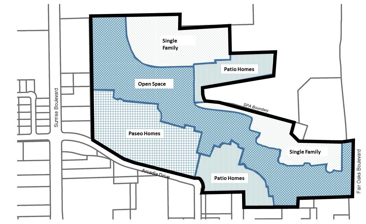
Figure 5-8.7 Mitchell Farms
(Ord. No. 2018-002, § 3, 9-27-2018)
Sec. 106.50.110. - Oak Avenue - Wachtel Way
A.
Purpose. The provisions of this Section are intended to ensure that development within the Oak Avenue - Wachtel Way SPA will protect and preserve the creeks and floodplains in a natural condition, buffer existing large residential and agricultural - residential lots from high density development, provide for adequate circulation within the project site and adequate access to major streets, and encourage the establishment of a trail system in the general areas shown in the Oak Avenue - Wachtel Way Special Planning Area.
B.
Applicability. This Section applies to proposed development and new land uses within the Oak Avenue - Wachtel Way SPA, as shown on Figure 5-9 and the Zoning Map.
C.
Allowable land uses. Land uses within the planning area shall be limited to those identified as permitted or conditional in the RD-20 zoning district by Section 106.24.030 (Residential and Open Space District Allowable Land Uses and Permit Requirements), Table 2-2, except as follows, and subject to the permit requirements of Subsection D. below:
1.
Single-family dwellings or two-family dwellings are permitted. Higher densities may be authorized through Design Review approval in compliance with Subsection D below.
2.
No use listed in Section 106.24.030 (Residential and Open Space District Allowable Land Uses and Permit Requirements), Table 2-2, under "Recreation, Education, and Public Assembly Uses," "Retail Trade," "Services - Business, Financial, and Professional," or "Services," shall be permitted, except for home occupations, public utility facilities, and other outdoor recreation facilities.
D.
Permit requirements.
1.
Design Review required. Design Review approval shall be required for all proposed development, except as provided by Subsection C.1 above, and except for residential accessory structures in compliance with Sections 106.42.200 (Residential Accessory Uses and Structures), and 106.42.015 (Accessory Dwelling Units).
2.
Project coordination. Project review and approval shall include the review authority considering the relationship of the proposed circulation pattern with that of surrounding areas to provide for an interconnected street system, and the coordination of circulation between projects, and the overall community.
E.
Density. Residential density shall not exceed 20 dwelling units per acre, except as follows:
1.
The review authority may approve additional density in compliance with the other provisions of this Section, for a portion of a project where corresponding areas are dedicated for the preservation of open space along natural streams, where there are significant groves of heritage or landmark trees, or in other environmentally sensitive areas.
2.
Residential development in the areas shown in Figure 5-9 as allowed a maximum density of two dwelling units per acre, and in the area shown with a minimum net parcel area of one-half acre (20,000 square feet) shall comply with those requirements.
F.
Development standards. Proposed development shall comply with all applicable requirements of the RD-20 zoning district, Articles 3 (Site Planning and Project Design Standards) and 4 (Standards for Specific Land Uses), and the following standards; except that the review authority may modify the following standards where necessary to reduce site grading, avoid encroachment into floodplains, or to preserve native trees.
1.
Grading. The design, layout, and configuration of improvements shall minimize the extent and amount of grading. The following techniques shall be considered and utilized where feasible:
a.
Grading for streets shall be limited as much as possible, consistent with the minimum requirements for utility service, drainage requirements, and street design and improvement requirements.
b.
No grading, except as provided in Municipal Code Section 16A.52 shall occur until a grading permit is obtained from the Engineering Division.
c.
No grading shall be permitted within the floodway of any stream. The Engineering Division shall not approve any grading plans or issue any grading permits unless the plans are consistent with the approved site plan and the standards in this Section.
2.
Trees. The design, layout, and configuration of proposed improvements shall minimize the removal of trees. No native tree with a diameter of nine inches or more, measured at 54 inches above the ground shall be damaged or removed unless:
a.
The tree is located within the right-of-way of an approved street or specifically approved for removal by the review authority as part of the approved site plan.
b.
The removal is necessary for: the elimination of diseased growth; fire prevention and control; flood prevention and control; or as may be required for pedestrian, bicycle or equestrian paths and trails.
3.
Streams. Proposed development shall be designed so that each natural stream with well-defined banks and a contributory watershed of at least 30 acres, shall remain and be maintained in its natural state except for:
a.
The removal and clearing of debris, growth, brush, or trees necessary to maintain the free passage of storm and drainage waters, or to prevent the flooding of buildings and other improvements; and
b.
The construction of improvements approved by the Council as being necessary to prevent erosion or otherwise protect public health, safety, or welfare.
4.
Conditions of approval. Design Review approval within the planning area shall be subject to the following conditions.
a.
Half-acre lots along the west and north boundary shall be developed with one single-family dwelling per lot.
b.
The tennis courts located in the floodplain are permitted provided that the applicant can supply evidence that the proposal (development at existing grade with normal cyclone fencing around the facilities) will not result in an increase of the 100-year water surface elevation (WSE) greater than one-half foot, nor adversely affect existing flood-prone structures downstream. Additionally, a "hold harmless" agreement relieving the City from any liability due to flooding of the facilities in the floodplain must be recorded to the satisfaction of the Council.
c.
Grant the City an easement for a recreation trail on the west side of Cripple Creek, to the satisfaction of the Sunrise Parks and Recreation Department.
d.
Grading and similar site preparation is to be done during the dry season.
e.
Do not remove any native oak trees. Do not grade, trench, or cut within the root zones of the oaks existing along the western portion of the northern property line. Landscaping under these trees should be such that excessive summer irrigation is not necessary.
f.
Should construction uncover artifacts or unusual amounts of stone, bone, or shell, work is to be stopped and the City notified to have the significance of the finds evaluated.
g.
Construct a right turn acceleration lane on the north side of Oak venue, near Wachtel Avenue, as is specified in diagram H-25 of the City Improvement Standards.
h.
Incorporate a Sound Transmission Class of 30 in the design of the townhouses adjacent to Oak Avenue.
i.
Provide solid screening along the western and northern property lines, as indicated on the landscaping plan.
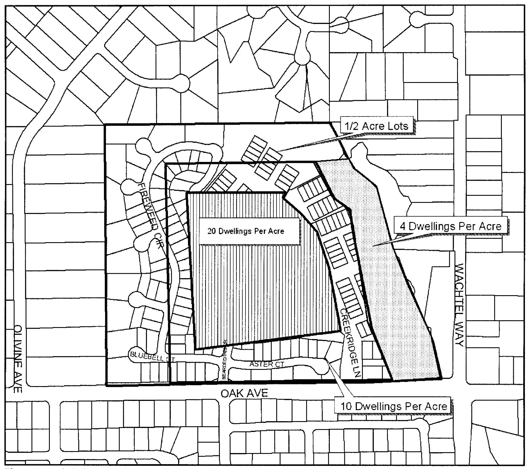
Figure 5-9 - Oak Avenue - Wachtel Way
(Ord. No. 2015-003, § 3, 4-19-2015; Ord. No. 2017-002, § 3(Exh. A-1), 7-13-2017)
Editor's note— Ord. No. 2015-003, adopted April 19, 2015 renumbered § 106.50.100 as § 106.50.110.
Sec. 106.50.120. - San Juan
A.
Purpose. The provisions of this Section are intended to allow development on the property within the San Juan SPA that will protect adjoining properties by establishing appropriate uses on the site to ensure the compatibility of future developments on the site.
B.
Applicability. This Section applies to proposed development and new land uses within the San Juan SPA, as shown on Figure 5-10 and the Zoning Map.
C.
Allowable land uses. Land uses within the planning area shall be limited to:
1.
Mini-storage plus accessory residential unit with Conditional Use Permit approval; and
2.
The uses listed in Section 106.26.030 (Commercial and Industrial District Land Uses and Permit Requirements) as permitted in the BP (Business and Professional Office) zone.
D.
Permit requirements. Use Permit approval is required in compliance with Section 106.62.050 (Use Permit and Minor Use Permit) prior to the issuance of a Building Permit for any non-accessory building, provided that Use Permit review and approval shall not render the property undevelopable for the uses and densities authorized in this Section.
E.
Development standards. The location and configuration of buildings and other improvements shall comply all applicable requirements of this Zoning Code except as otherwise specified by this Section; provided that the Commission may approve modifications to standards through Use Permit approval whenever necessary. The following are minimum development standards within the area covered by this Section.
1.
Setback requirement. There shall be a minimum 25-foot building setback from any residential zone or other sensitive use as determined by the Director (for example, a child care center).
2.
Height limit. A structure within 100 feet of a residential zone shall not exceed a maximum height of 24 feet.
3.
Screening. There shall be a minimum eight-foot tall masonry wall installed along the interior boundary lines of all adjoining residential or recreation zones.
4.
Landscaping. A landscape planter with a minimum width of six feet shall be installed along the interior boundary lines of any abutting residential zone.
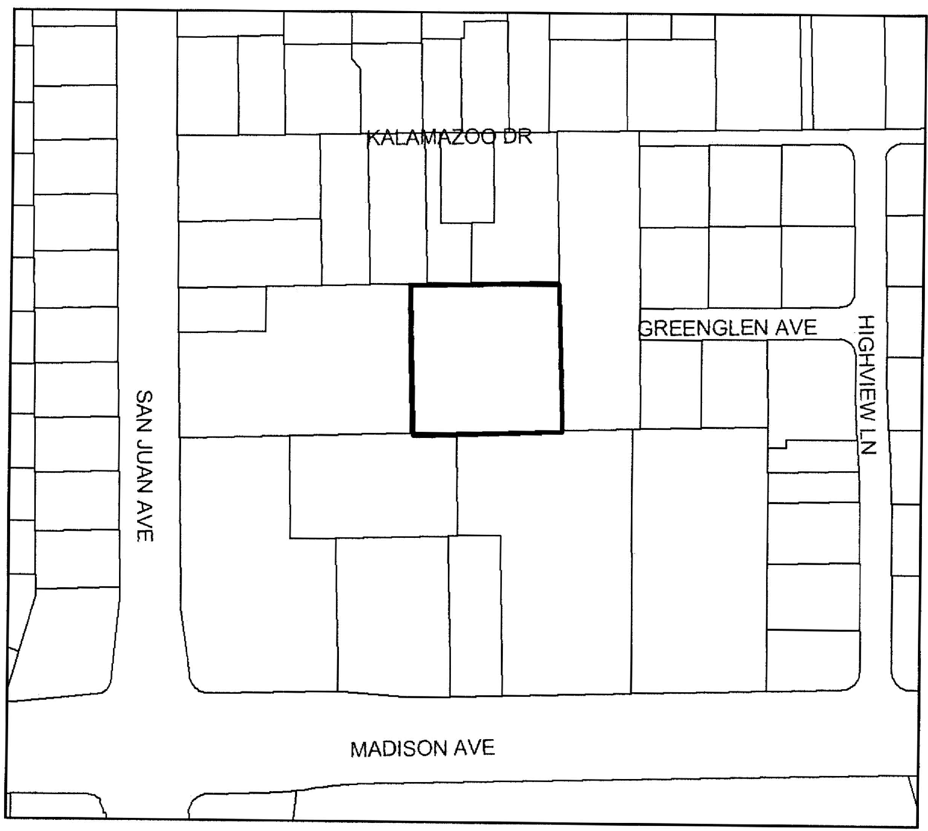
Figure 5-10 - San Juan Avenue
(Ord. No. 2015-003, § 3, 4-19-2015)
Editor's note— Ord. No. 2015-003, adopted April 19, 2015 renumbered § 106.50.110 as § 106.50.120.
Sec. 106.50.130. - Stock Ranch
A.
Purpose. The provisions of this Section are intended to:
1.
Allow development on the property within the Stock Ranch SPA that will accommodate a mixture of uses, protect and preserve the oak trees, creeks, and floodplains in a natural condition, create a trail system along and over the creek and to Auburn Boulevard, provide for adequate circulation within the project site and adequate access to the major streets, ensure compatibility with adjoining residential uses, and provide for enhanced architectural designs of commercial buildings; and
2.
Implement the Stock Ranch Guide for Development.
B.
Applicability. This Section applies to proposed development and new land uses within the Stock Ranch SPA, as shown on Figure 5-11 and the Zoning Map.
C.
Allowable land uses. Land uses within the planning area shall be limited to those identified allowed by the Stock Ranch Guide for Development.
D.
Permit requirements. Development projects within the boundaries of the Stock Ranch Guide for Development are subject to the standard application requirements of the Zoning Code and other applicable documents, as well as any additional application requirements contained in the Guide for Development.
E.
Development standards. The location and configuration of buildings and other uses, and operation of uses, and residential density shall comply with the standards and guidelines in the Stock Ranch Guide for Development.
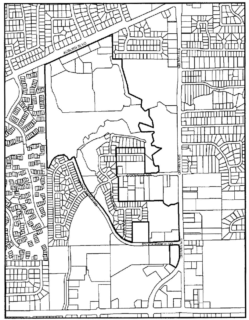
Figure 5-11 - Stock Ranch
(Ord. No. 2015-003, § 3, 4-19-2015)
Editor's note— Ord. No. 2015-003, adopted April 19, 2015 renumbered § 106.50.120 as § 106.50.130.
Sec. 106.50.135. - Sunrise Tomorrow
A.
Purpose. The provisions of this Section are intended to allow development along the Sunrise Tomorrow property that will accommodate a mixture of commercial and residential uses, redevelopment of underutilized and aging buildings, increase open space, accommodate vehicles, transit, bicycles and pedestrians, ensure compatibility with adjoining residential uses, and provide for enhanced architectural designs of residential, commercial/mixed use buildings. It is also the intent of this Section to provide for the implementation of the Sunrise Tomorrow Specific Plan.
B.
Applicability. This Section applies to proposed development and new land uses within the Sunrise Tomorrow Specific Plan SPA, as shown on Figure 5-12 and the Zoning Map.
C.
Allowable land uses. Allowed uses shall be limited to those authorized in the Sunrise Tomorrow Specific Plan.
D.
Permit requirements. Each proposed development shall comply with the permit and application requirements in the Sunrise Tomorrow Specific Plan, in addition to the application requirements in Chapter 106.60 (Permit Application Filing and Processing).
E.
Density and intensity. Residential density and non-residential development intensity shall comply with the Sunrise Tomorrow Specific Plan.
F.
Development standards. Proposed development shall comply with the standards and guidelines in the Sunrise Tomorrow Specific Plan.
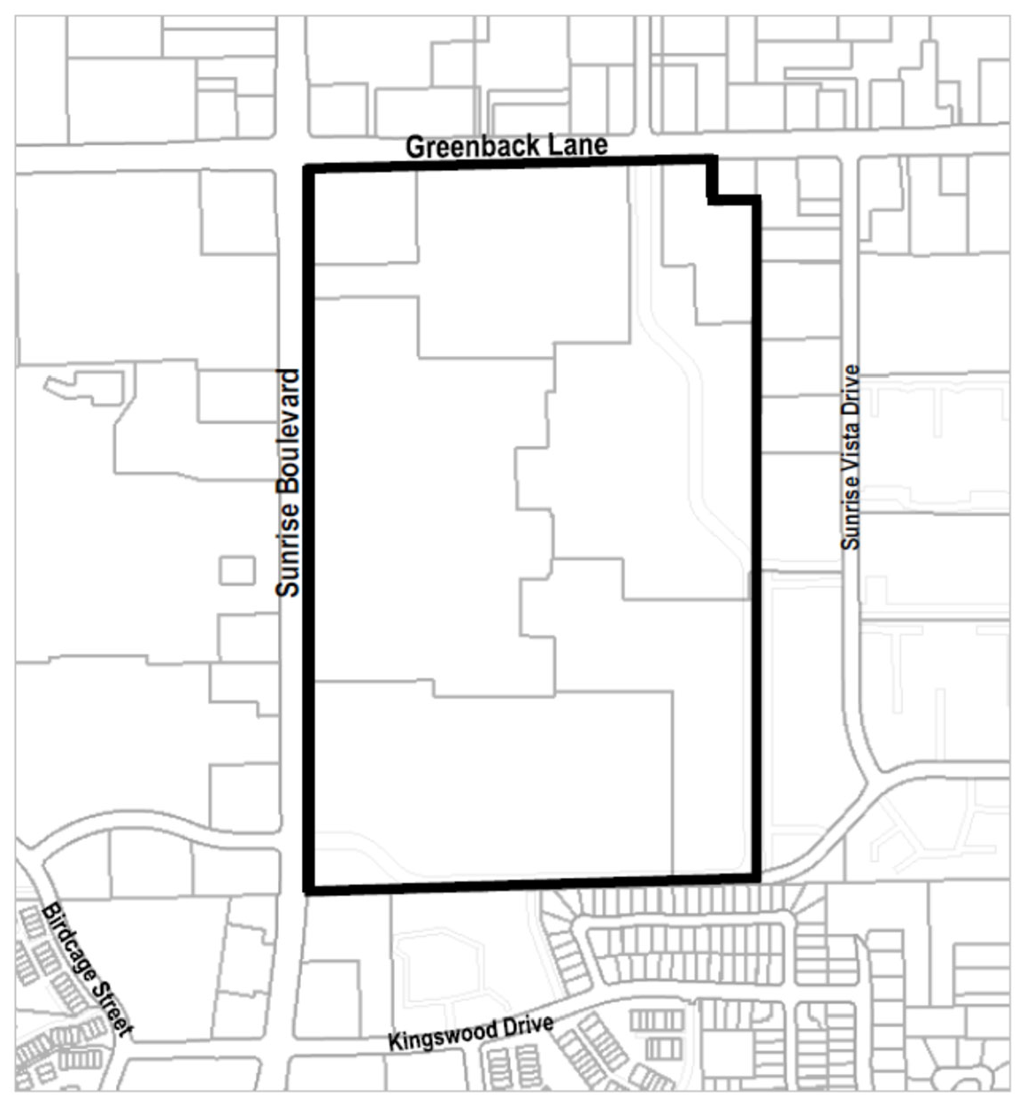
Figure 5-12 - Sunrise Tomorrow SPA
(Ord. No. 2021-006, § 3, 12-9-2021)
Sec. 106.50.140. - Sylvan Road - Woodside Drive
A.
Purpose. The provisions of this Section are intended to ensure that development on the property within the Sylvan Road - Woodside Drive SPA will:
1.
Protect and preserve the creeks and floodplains in a natural condition;
2.
Buffer future residents from commercial development to the south and from the traffic noise associated with Auburn Boulevard and Sylvan Road;
3.
Provide for adequate circulation within the project site and adequate access to major streets;
4.
Encourage the establishment of a trail system in the general areas shown in Figure 5-12; and
5.
Preserve the residential character of this portion of the community by prohibiting the expansion of the commercial areas to the north and south into the area shown in Figure 5-12.
B.
Applicability. This Section applies to proposed development and new land uses within the Sylvan Road - Woodside Drive SPA, as shown on Figure 5-12 and the Zoning Map.
C.
Allowable land uses. Land uses within the planning area shall be limited to those identified as permitted or conditional in the RD-5 zoning district by Section 106.24.030 (Residential and Open Space District Allowable Land Uses and Permit Requirements), Table 2-2, except that single-family dwellings or two-family dwellings are permitted. Higher densities may be authorized through Use Permit approval in compliance with Subsection D below.
D.
Permit requirements.
1.
Design Review required. Design review approval shall be required for all proposed development, except for residential accessory structures in compliance with Sections 106.42.200 (Residential Accessory Uses and Structures), and 106.42.015 (Accessory Dwelling Units).
2.
Project coordination. Project review and approval shall include the review authority considering the relationship of the proposed circulation pattern with that of surrounding areas to provide for an interconnected street system, and the coordination of circulation between projects and the overall community.
E.
Density. The density of residential development of any portion of the property shown in Figure 5-12 shall not exceed five dwelling units per acre, except that the review authority may approve additional density in compliance with the other provisions of this Section, for a portion of a project where corresponding areas are dedicated for the preservation of open space along natural streams, where there are significant groves of heritage or landmark trees, or in other environmentally sensitive areas.
F.
Development standards. Proposed development shall comply with all applicable requirements of the RD-5 zoning district, Articles 3 (Site Planning and Project Design Standards) and 4 (Standards for Specific Land Uses), and the following standards; except that the review authority may modify the following standards where necessary to reduce site grading, avoid encroachment into floodplains, or to preserve native trees.
1.
Grading. The design, layout, and configuration of improvements shall minimize the extent and amount of grading. The following techniques shall be considered and utilized where feasible:
a.
The use of split-level building design and foundation systems to accomplish elevation transitions as close to existing grades as possible.
b.
Grading for streets shall be limited as much as possible, consistent with the minimum requirements for utility service, drainage requirements, and street design and improvement requirements.
c.
No grading, except as provided in Municipal Code Section 16A.52, shall occur until a grading permit is obtained from the Engineering Division.
d.
No grading shall be permitted within the floodway of any stream. The Engineering Division shall not approve any grading plans or issue any grading permit unless the plans are consistent with the approved site plan and the standards in this Section.
2.
Trees. The design, layout, and configuration of proposed improvements shall minimize the removal of trees. No native tree with a diameter of nine inches or more, measured at 54 inches above the ground shall be damaged or removed unless:
a.
The tree is located within the right-of-way of an approved street or specifically approved for removal by the review authority as part of the approved site plan.
b.
The removal is necessary for: the elimination of diseased growth; fire prevention and control; flood prevention and control; or as may be required for pedestrian, bicycle or equestrian paths and trails.
3.
Streams. Proposed development shall be designed so that each natural stream with well-defined banks and a contributory watershed of at least 30 acres, shall remain and be maintained in its natural state except for:
a.
The removal and clearing of debris, growth, brush, or trees necessary to maintain the free passage of storm and drainage waters, or to prevent the flooding of buildings and other improvements; and
b.
The construction of improvements approved by the Council as being necessary for prevention of erosion, or otherwise protect public health, safety, or welfare.
4.
Fences. No solid fence shall be constructed within 30 feet of the edge of any floodplain, unless approved by the Commission. Any approved fence shall comply with all applicable requirements of Section 106.30.050 (Fences and Walls).
5.
Limitation on access in new subdivisions. No subdivision shall be approved with lots fronting on Auburn Boulevard, or on Sylvan Road, where street frontage can feasibly be provided for the lots on another public street.
6.
Street width. Residential streets of a width less than major collector streets may be constructed to class "B" Standards as specified in the City's improvement standards. Major collector streets may be constructed to Class "B" standards, provided that a sidewalk constructed to the standards specified for Class "A" streets is constructed on one side of the street.
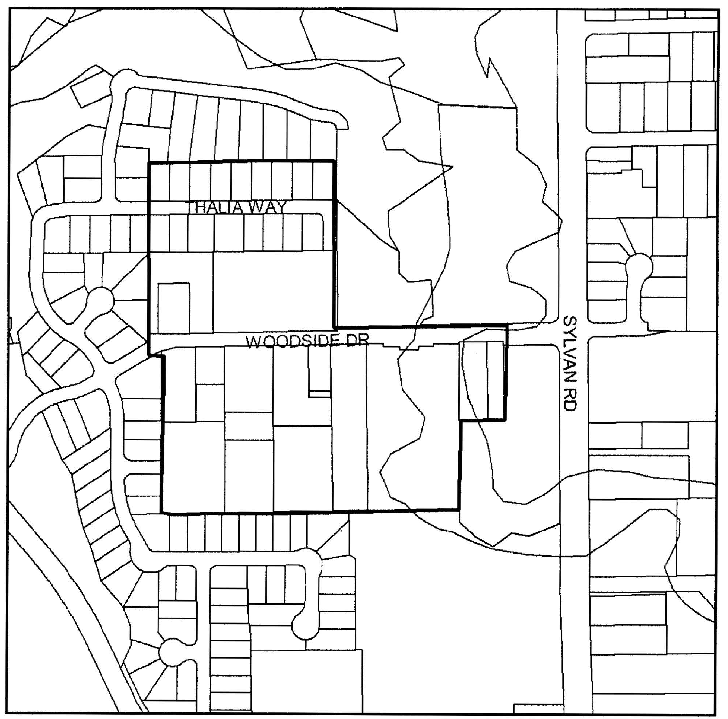
Figure 5-13 - Sylvan Road
(Ord. No. 2015-003, § 3, 4-19-2015; Ord. No. 2017-002, § 3(Exh. A-1), 7-13-2017; Ord. No. 2021-006, § 3, 12-9-2021)
Editor's note— Ord. No. 2015-003, adopted April 19, 2015 renumbered § 106.50.130 as § 106.50.140.
Sec. 106.50.150. - Verner Avenue
A.
Purpose. The provisions of this Section are intended to ensure that proposed development within the Verner Avenue Special Planning Area (SPA) will preserve and protect properties by establishing appropriate uses adjacent to the freeway, provide for adequate circulation within the project site, and ensure that the design of proposed development is compatible with existing surrounding development.
B.
Applicability. This Section applies to proposed development and new land uses within the Verner Avenue SPA, as shown on Figure 5-13 and the Zoning Map.
C.
Allowable land uses. Land uses within the planning area shall be limited to those identified as permitted or conditional in the RD-2 zoning district by Section 106.24.030 (Residential and Open Space District Allowable Land Uses and Permit Requirements).
D.
Permit requirements. Design Review approval shall be required for all proposed development.
E.
Development standards - Overall project design objectives. The design objectives of this Section are to accommodate a mixture of cemetery uses, including religious services, burial grounds, meeting facilities, office space, and other related uses. The development shall comply with all applicable requirements of the RD-2 zoning district, Articles 3 (Site Planning and Project Design Standards) and 4 (Standard for Specific Land Uses) except for those standards listed below:
1.
Streets. Internal streets may be considered private streets.
2.
Height limits. Buildings may be allowed up to 40 feet in height. Projections into the height limit are allowed in accordance with Section 106.30.060 (Height Limits and Exceptions).
3.
Parking. Parking shall be provided as required by Section 106.36.040 (Number of Parking Spaces Required). Incidental parking for peak times (burial services, graveside services, etc.) may be allowed along one-side of the private roadway. Parking along these roadways shall not count towards required parking.
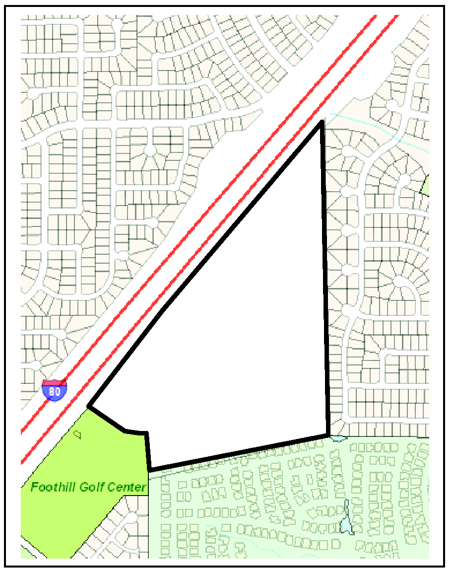
Figure 5-14 - Verner Avenue
(Ord. No. 2013-010, § 3, 11-14-2013; Ord. No. 2015-003, § 3, 4-19-2015; Ord. No. 2021-006, § 3, 12-9-2021)
Editor's note— Ord. No. 2015-003, adopted April 19, 2015 renumbered § 106.50.140 as § 106.50.150.