
Columbus City Zoning Code
CHAPTER 3320
TRADITIONAL NEIGHBORHOOD DEVELOPMENT
3320.01 - Purpose.
The purpose of this article is to encourage the development of transit-supportive mixed-use neighborhoods that foster pedestrian activity and a sense of community. It recognizes that many activities of living should occur within easy walking distance, giving independence to those who do not drive. It also recognizes the importance of linkages to the broader community and the importance of public transit as a viable alternative to the automobile by providing appropriate densities and land uses within walking distance of the transit stop.
This article recognizes that the suburban development pattern of late 20th century has produced a separation of land uses, excessive vehicular trip generation, inefficient public transportation, and infrastructure costs that exceed available resources. It is the intent of this article to provide for a development pattern that can reduce trip demand and infrastructure costs, and to create more viable communities, by adapting the land development principles that guided our country's first settlements, towns, cities and suburbs.
(Ord. 1518-01 § 3 (part).)
3320.011 - Principles.
Those principles, as adapted to our current situation, are listed below:
A.
The basic increment of planning is the transit-supportive, mixed-use neighborhood of a minimum density of five units per acre.
B.
The neighborhood is defined by an easy walking distance from edge to center, ranging from one-quarter mile to one-half mile.
C.
A variety of housing stock serves a range of incomes and age groups and includes backyard apartments, apartments above shops and residential units adjacent to work places.
D.
A variety of business types are accommodated, from retail and professional offices to live-work units and outbuildings for start-up businesses. The office stock serves a range from home occupations to conventional office buildings. The retail stock includes a range from the corner store to small supermarkets.
E.
Special sites are reserved for civic buildings to serve as symbols of the community, thus enhancing community identity.
F.
A variety of civic space takes the form of parks, greens, squares and plazas.
G.
A variety of thoroughfares are designed to be equitable to the pedestrian, bicycle and automobile. Thoroughfares are connected in such a way as to encourage walking and reduce the number and length of automobile trips.
H.
Building frontages spatially delineate thoroughfares and civic spaces and mask parking lots.
I.
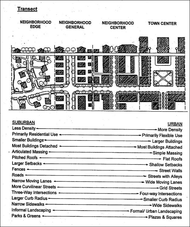
Smaller block sizes reflecting intensity of use for each district will serve to support the above principles. (See Transect diagram)
This article contains four zoning districts that support the development of more traditional communities. These districts include neighborhood edge, neighborhood general, neighborhood center and town center. While these districts support a mix of land uses, not all uses are considered appropriate. Section 3320.19 identifies certain prohibited uses, including most drive-through commercial uses, retail uses exceeding 10,000 square feet, automotive sales, and large scale transportation and distribution facilities. Therefore, it should be recognized and understood that not all sites in the community are considered appropriate for the zoning districts contained in this article.
(Ord. 1518-01 § 3 (part).)
3320.013 - Transect.
The transect illustrates the desired interrelationship of the traditional neighborhood development districts.
(Ord. 1518-01 § 3 (part).)
3320.03 - Definitions.
"Administrative Review" means the review of a Regulating Plan.
"Ancillary dwelling unit" means a dwelling unit not greater than 800 square feet sharing a single set of utility connections with a principal building. It may or may not be a separate building. Either the principal building or the apartment shall be occupied by the owner. An ancillary dwelling unit does not count toward density calculations.
"Apartment" means a dwelling unit sharing a building and a lot with other dwellings and/or uses.
"Back of a building" means the side opposite the front of a building.
"Basis points" means total possible points not including bonus points.
"Bicycle network" means an interconnected system of bicycle trails, thoroughfares, and bicycle lanes within thoroughfares.
"Bicycle lane" means a dedicated bicycle way generally created by striping from the edge of a thoroughfare.
"Bicycle route" means a vehicular travel lane within a thoroughfare having speed limit of 25 mph and below.
"Bicycle trail" means an independent bicycle way generally running through the countryside or parallel with a parkway or highway.
"Big box retail" means a retail store with greater than 50,000 square feet of retail floor space on one floor.
"Block" means the length of street between two intersecting streets.
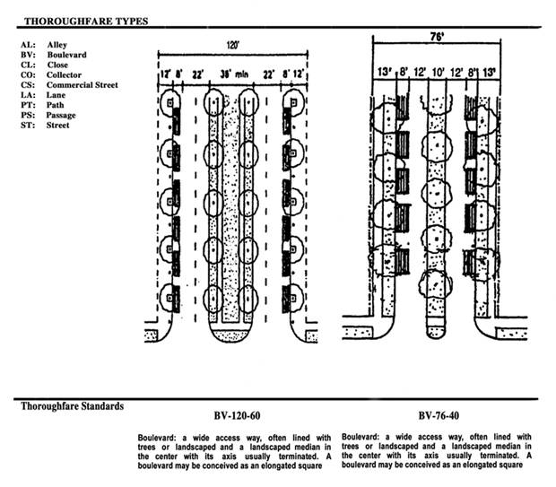
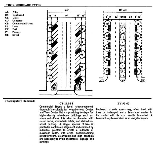
"Boulevard" means a wide access way, often lined with trees having a landscaped median in the center with its axis usually terminated. A boulevard may be conceived as an elongated square. See Thoroughfares section.
"Building parcel" means a tract of land intended to be occupied by individually owned building(s).
"Buildout" means the portion of the building on the frontage line.
"Civic Buildings" may be used for neighborhood scale commercial uses, and not-for-profit organizations dedicated to religion, recreation, arts and culture, education, government, social service, and transit.
"Civic space" means a tract of land, designated and used by the public for active and passive recreation.
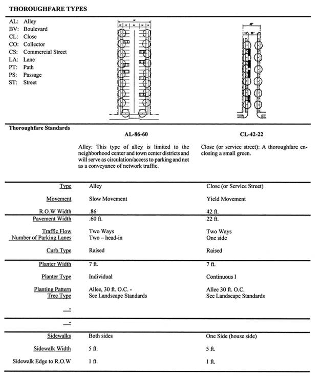
"Close" means a thoroughfare enclosing a small green.
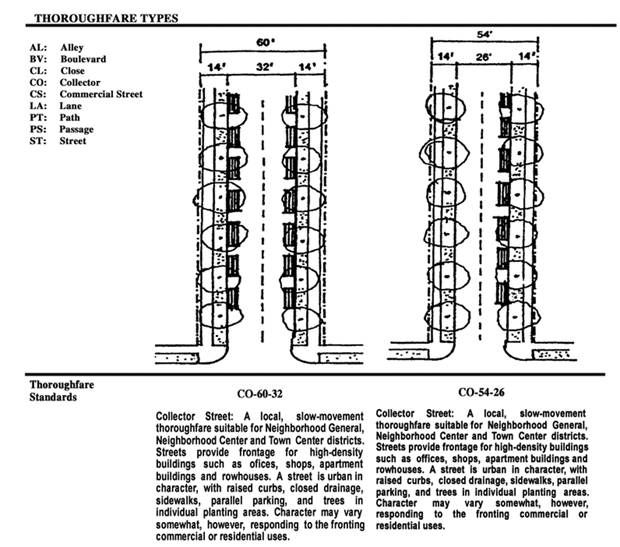
"Collector street" means a local, slow-movement thoroughfare suitable for neighborhood general, neighborhood center and town center districts. Streets provide frontage for high-density buildings such as office, shops, apartment buildings and rowhouses. A collector street is urban in character, with raised curbs, closed drainage, sidewalks, parallel parking, and trees in individual planting areas. Character may vary somewhat, however, responding to the fronting commercial or residential uses. See Thoroughfares section.
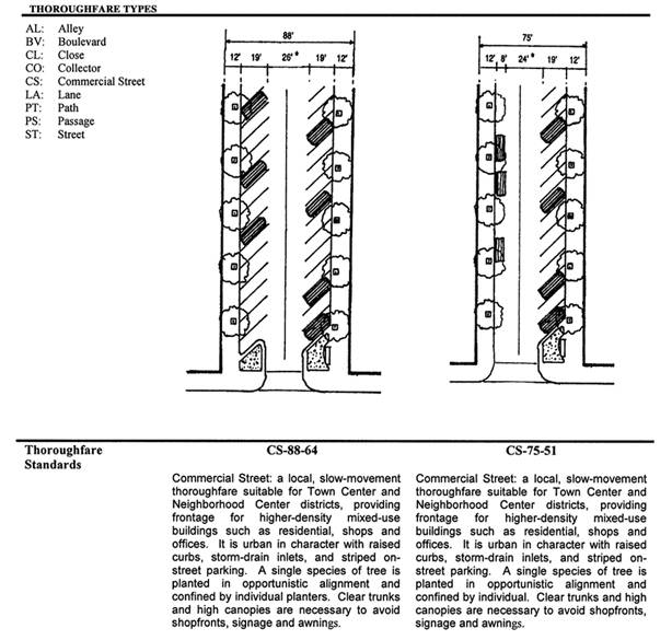
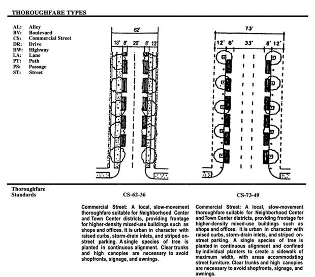
"Commercial street" means a local, slow-movement thoroughfare suitable for neighborhood center and town center districts, providing frontage for higher-density mixed-use buildings such as shops and offices. It is urban in character with raised curbs, storm-drain inlets and striped on-street parking. A single species of tree is planted in continuous alignment and confined by individual planters to create a sidewalk of maximum width, with areas accommodating street furniture. Clear trunks and high canopies are necessary to avoid shopfronts, signage and awnings. See Thoroughfares section.
"Commercial use" means the general term that includes office and retail uses. See Use Standards.
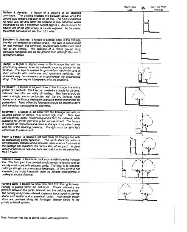
"Common lawn" means a frontage type in which the façade is set back substantially from the frontage line. The front yard thus created should remain unfenced and be visually continuous with adjacent yards. The ideal is to simulate buildings sitting in a common rural landscape. A front porch is not warranted, as social interaction from the fronting thoroughfare is unlikely at such a distance. Common lawns are suitable frontages for higher speed thoroughfares, as the large setback provides a buffer from the traffic.
"Conceptual thoroughfare plan" illustrates the general location of thoroughfare pattern, identifies public and publicly accessible thoroughfares, establishes the location of connections to adjacent properties and thoroughfares, and the types of thoroughfares utilized.
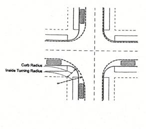
"Curb radius" means the curved edge of a thoroughfare at an intersection.
"District" means an area dedicated to a single zoning category.
"Dooryard" means a frontage type in which the facade is set back from the frontage line with an elevated garden or terrace or a sunken light court. This type can effectively buffer residential quarters from the sidewalk, while removing the private yard from public encroachment. The terrace is suitable for restaurants and cafes as the eye of the sitter is level with that of the standing passerby. The light court can give light and access to a basement.
"Driveway" means a vehicular access way into a lot from the frontage.
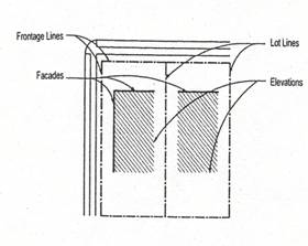
"Elevation" means the exterior walls of a building. See Façade.
"Entrance door" means the principal entrance to a building, usually leading directly to a lobby, the main shopping floor or the living room.
"Façade" means the exterior walls of a building that are set along a frontage line. See Elevation.
"Forecourt" means a frontage type in which the façade is aligned close to the frontage line with a portion of it set back. The forecourt created is suitable for gardens, vehicular drop offs, and utility off loading. This type should be used sparingly and in conjunction with the two frontage types above, as a continuous excessive setback is boring and unsafe for pedestrians. Trees within the forecourts should be placed to have their canopies overhanging.
"Foundation planting" means the planting along the exterior foundation of a building designed to soften and enhance the architecture and to accentuate certain architectural elements (i.e. entryways). The planting should be of correct size for the intended location and should be designed to present a continuous theme around the building using both evergreen and deciduous materials to provide year round appeal. Planting should be maintained to prevent an overcrowded or overgrown appearance.
"Front" means the provision of an element along a frontage line, as in "porches front the avenue."
"Front of a building" means the widest side of the building fronting on the widest thoroughfare except lane, alley or a passage, interconnected with other thoroughfares, which has no fewer entrance doors than any other side of the building.
"Frontage" means the layer of a lot between the façade and the lot line that fronts a thoroughfare or a civic open space or the privately held layer between the façade of a building and the lot line.
"Gallery and arcade" means a frontage type which is the façade of a building or an attached colonnade. The building overlaps the sidewalk above while the ground story remains set back at the lot line. This type is indicated for retail use, but only when the sidewalk is fully absorbed within the arcade so that a pedestrian cannot bypass it. An easement for private use of the right-of-way is usually required. To be useful, the arcade should be no less than 12 feet wide.
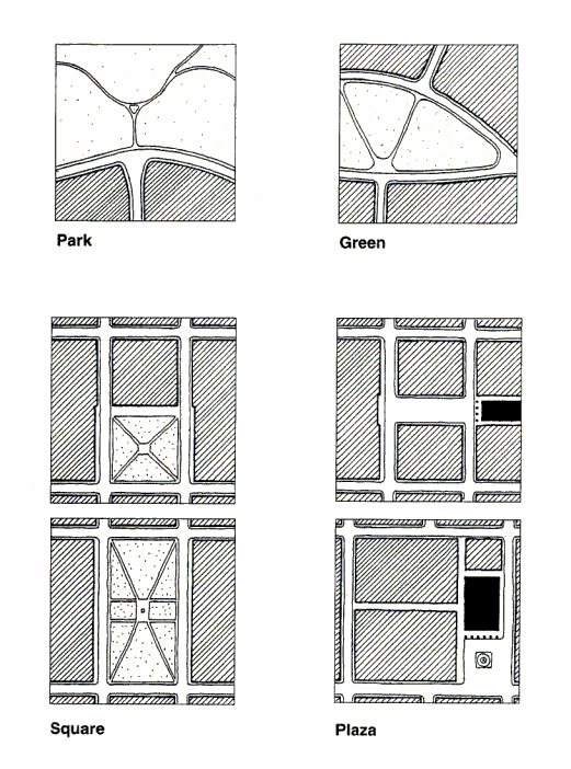
"Green" means a medium-sized civic open space available for unstructured recreation, its landscape predominantly consisting of grassy areas and trees, naturalistically disposed and requiring only limited maintenance.
"Hedge" means a continuous row of shrubs with minimum height of 24 inches at installation, three feet on center maximum and reaching 36 inches in height and 85 percent opacity within three years.
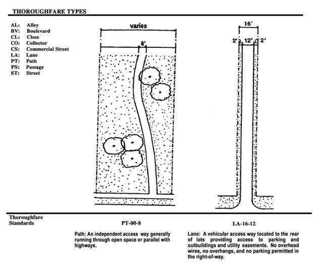
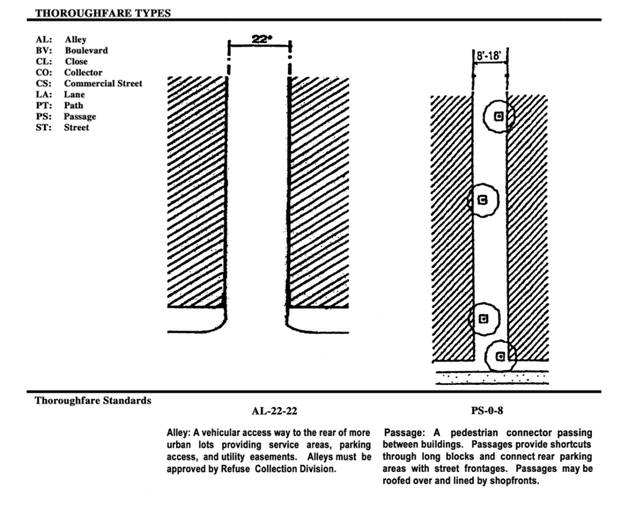
"Lane" means a vehicular access way located to the rear of lots providing access to parking and outbuildings and utility easements designed for providing access to more than two residential properties. No overhead wires, no overhangs, and no parking are permitted in the right-of-way. See Thoroughfares section.
"Live-work unit" means a commercial building type with one dwelling above a commercial shopfront. Common walls are permitted on the side lot lines.
"Lodging" means premises available for short-term residence, including daily and weekly letting. See Use Standards Table.
"Lot line" means the boundary that legally and geometrically demarcates a lot. Lot lines appear graphically on the Regulating Plan as the baseline for measuring setbacks. See Frontage Line.
"Lot width" means the dimension of a lot measured parallel to the frontage line at the building setback.
"Mid-block parking lot" means parking lots situated between the side walls of buildings and not extending beyond the rear or front wall of the buildings, which are no wider than two parking lanes and the access drive.
"Neighborhood scale commercial" means single use retail tenants of 10,000 square feet or less.
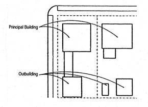
"Outbuilding" means an ancillary building, usually located towards the rear of the lot, on the same lot as an existing or future principal building. See Principal Building.
"Park" means a large open area available for recreation, usually located at the neighborhood edge, fronted by buildings. Its landscape comprises paved paths and trails, open lawn, trees, and open shelters, all naturalistically disposed and requiring limited maintenance.
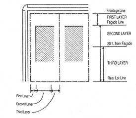
"Parking layer" means the depth of the lot within which open parking is permitted. The first layer is the area between the frontage line and the façade. The second layer is the area behind the façade to the rear lot line. The third layer is the area between 20 feet behind the front façade to the rear lot line. (see Building Standards Table)
"Parking structure" means a building containing two or more stories of parking.
"Parking way" means a frontage type in which the façade is no more than eight feet from the right-of-way. Parking is placed within the first layer. Private sidewalks are provided between the public sidewalk and the building entrances. The parking area and private sidewalk system are landscaped to provide shade and shelter and a streetwall buffer. Appropriate transit stops are provided along the frontages, directly linked to the private sidewalk system.
"Passage" means a pedestrian connector passing between buildings. Passages provide shortcuts through long blocks and connect rear parking areas with street frontages. Passages may be roofed over and lined by shopfronts. See Thoroughfares section.
"Path" means an independent pedestrian access way generally running through open space or parallel with highways.
"Pedestrian shed" means the distance that may be traversed at an easy pace in a five minute walk from the Neighborhood Center or Town Center generally one-third of a mile radius.
"Plaza" means a public space at the intersection of important streets set aside for civic purposes and commercial activities, its landscape consisting of durable pavement and trees requiring little maintenance.
"Porch and fence" means a frontage type in which the façade is set back from the frontage line with an encroaching porch appended. The porch should be within a conversational distance of the sidewalk, while a fence (optional) at the frontage line maintains the demarcation of the yard. A great variety of porches is possible, but to be useful, none should be less than eight feet wide.
"Principal building" means the main building on a lot, always oriented towards the frontage. A principal building accommodates the functions described in the Use Standards Table.
"Retail frontage line" means those frontage lines designated on the Regulating Plan that are required to provide a shopfront, making the ground level available for retail or commercial use.
"Rowhouse" means a single-family house placed on its own lot, sharing at least one sidewall with an adjacent rowhouse.
"Setback" means the area of a lot measured from a lot line that must be maintained clear of permanent structures. Galleries, fences, arcades, porches, stoops, balconies, bay windows, terraces, and decks (that align with the first floor level) may encroach into the frontage and the rear setback. Encroachments elsewhere in the zoning code such as eaves and overhangs are also permitted. Air conditioning units are permitted in the side yard.
"Shared parking" means the condition wherein day/night and weekday/weekend schedules allow parking spaces to be shared by users of more than one building or more than one use within the same building.
"Shopfront" means a frontage type in which the façade is aligned close to the frontage line with the entrance at sidewalk grade. This type is conventional for retail frontage. It is commonly equipped with a cantilevered shed roof or an awning. The absence of a raised ground story precludes residential use on the ground floor, although this use is appropriate above.
"Square" means a public space, seldom larger than a block, at the intersection of important streets, its streetscape consisting of paved walks, lawns, trees and civic buildings all formally disposed and requiring substantial maintenance.
"Stoop" means a frontage type in which the façade is aligned close to the frontage line with the ground story elevated from the sidewalk, securing privacy for the windows. This type is suitable for ground-floor residential uses at short setbacks with rowhouses and apartment buildings. An easement may be necessary to accommodate the encroaching stoop. This type may be interspersed with the shopfront.
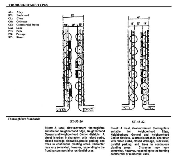
"Street" means a local, slow-movement thoroughfare suitable for neighborhood edge, neighborhood general, and neighborhood center. A street is urban in character, with raised curbs, closed drainage, sidewalks, parallel parking and trees in continuous planting areas. Character may vary somewhat, however, responding to the fronting commercial or residential uses. See Thoroughfares section.
"Streetwall" means a continuous wall or fence with a minimum height of 36 inches and 90 percent opacity.
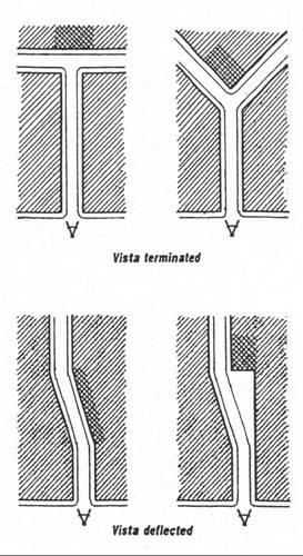
"Terminated vista" means the visual composition at the axial termination of a thoroughfare. The termination or deflection should occur within 600 feet of any vantage point.
"Thoroughfare" means the urban element that provides the major part of the public space as well as paved lanes for vehicles. A thoroughfare is endowed with two attributes: capacity and character. Capacity is the number of vehicles that can move safely through a segment of the thoroughfare within a given time period. It is physically manifested by the number of lanes and their width, by the centerline radius, and the superelevation of the pavement. Character is suitability of a thoroughfare as a setting for pedestrian activities and as a location for a variety of building types. Character is physically manifested by the thoroughfare's associated building and frontage types as determined by its location within each district.
"TND" refers to Traditional Neighborhood Development, Article II of city of Columbus Zoning Codes codes.
(Ord. 1518-01 § 3 (part); Ord. 1627-02 § 1.)
3320.05 - Neighborhood edge district.
The neighborhood edge district is the least dense, most purely residential part of a community. It consists principally of single-family, detached houses with outbuildings permitted. Buildings are situated on larger lots with setbacks on all sides. Where lots are wide enough, garages may be accessed from the front by a driveway. The preferred building frontage is the common lawn. Civic spaces are parks and greens. The neighborhood edge district is designated as "NE" on the Zoning Map.
(Ord. 1518-01 § 3 (part).)
3320.07 - Neighborhood general district.
The neighborhood general district is a primarily residential part of a community, typically the largest area within the pedestrian shed. It consists of single-family, both attached and detached, houses with one outbuilding permitted on each lot. Buildings are situated on smaller lots with shorter setbacks to the front and side yards. The narrow lots require that the parking be accessed from the rear by lanes. Building frontages allow for porches, fences, and small lawns. The streetscape consists of the regular, aligned planting of single tree species. The thoroughfares are roads or streets usually including parallel parking, bordered by curbs equipped with underground storm drains and bordered by sidewalks. Civic spaces are parks, greens and squares. The neighborhood general district is designated as "NG" on the Zoning Map.
(Ord. 1518-01 § 3 (part).)
3320.09 - Neighborhood center district.
The neighborhood center district is the denser, fully mixed-use part of a community. It is typically located at the center of a pedestrian shed or along an important thoroughfare. It consists primarily of attached buildings and apartment houses without outbuildings. The parking, which is substantial, must be accessed by rear alley and located behind the front facade of the building. The thoroughfares include parallel parking and the civic open spaces consist of squares and greens. The neighborhood center district is designated as "NC" on the Zoning Map.
(Ord. 1518-01 § 3 (part).)
3320.11 - Town center district.
The town center district is the densest business, cultural and entertainment concentration of the community. Buildings are attached and often tall, situated on a wide range of lot sizes. There is a very short mandatory front setback with wide sidewalks. The majority of required parking is to be accessed by rear alley or provided on the street. All uses not considered noxious are permitted within the buildings. Civic spaces are squares and plazas. The town center district is designated as "TC" on the Zoning Map.
(Ord. 1518-01 § 3 (part).)
3320.13 - Administration.
A.
General Provisions.
1.
A traditional neighborhood development (TND) can include one or more of four zoning districts: neighborhood edge, neighborhood general, neighborhood center and town center. The procedures in Chapters 3305 and 3307 of the Columbus City Code apply to a TND. Additional requirements are described herein.
2.
The TND is not subject to limited overlay provisions of Columbus City Codes Chapter 3370.
3.
Should conflicts exist with other provisions of the Zoning Code, the more stringent provisions shall apply.
4.
Should conflicts exist, this article shall take precedence over Section 3123.08 of Columbus City Codes.
5.
Should conflicts exist, the Columbus Building Code shall take precedence over this article.
6.
Applications shall comply with requirements of Chapters 3318 and 3125.
7.
The definitions in this article apply only to the TND article. In the absence of a definition in this article, other definitions of the Zoning Code apply.
8.
The minimum land area for rezoning to a TND district is two acres.
9.
If the development contains private roads, each property owner must be notified of this fact by deed or covenant.
10.
Diagrams included in this article serve only as illustrations and shall not be used as definitions or limitations.
11.
Projects of 50 to 100 acres shall have no less than ten percent of the project area contained in each of two TND districts
12.
Projects over 100 acres shall have no less than ten percent of the project area contained in each of three TND districts.
13.
No more than 50 percent of any TND project area shall be allocated to neighborhood edge district.
14.
Projects over 100 acres shall have no more than 50 percent of the project area allocated to neighborhood center district.
15.
Perimeter lots in the neighborhood general district that abut the neighborhood center district may be developed using neighborhood edge standards. No other use of neighborhood edge districts or standards may occur adjacent to neighborhood center or town center districts.
B.
Rezoning Application Requirements.
1.
An application for rezoning must include:
A.
Development plan including a site plan indicating the proposed district(s) (neighborhood edge, neighborhood general, neighborhood center, or town center), conceptual bicycle plan, conceptual thoroughfare plan including thoroughfare types and connections to adjacent thoroughfares and properties, designation of public thoroughfares known at the time of zoning, and the one-third mile pedestrian shed or commercial uses; civic spaces including the location of play equipment, and civic buildings; location and size of civic spaces and civic building sites; maximum number of residential units, and maximum square footage of non-residential uses for each district.
B.
Regional context diagram (drawing upon the existing land uses, the proposed land use plan, and/or approved area plan) showing how the application fits into the surrounding land uses and is consistent with the purpose statement and intent of this article per Chapter 3320.
C.
Statement addressing the consistency of the application with each TND principle in Section 3320.011.
D.
An existing conditions plan, depicting the site at the time of zoning application, at least one inch equals 200 feet min, showing location, north arrow, scale, property lines, dimensions and area, adjacent properties, existing thoroughfares, existing buildings and natural and historic resources.
2.
After approval of the application for rezoning by city council the applicant must submit the regulating plan (Section 3320.135) and any additional documentation requested to support compliance with requirements of the rezoning ordinance.
C.
Regulating Plan Administrative Review.
1.
After approval of the rezoning application by city council, the applicant must submit a regulating plan for administrative determination of compliance with the requirements of this article. To receive administrative approval the regulating plan must be in compliance with the boundaries of the zoning districts, maximum number of residential units and maximum square footage of non-residential uses as approved by city council and the requirements of this article. Substantial compliance must be achieved with respect to the conceptual thoroughfare plan, bikeway plan and the location and size of civic spaces and civic building sites approved by city council. No zoning clearance shall be issued without such approval. Substantial compliance with regard to the conceptual thoroughfare plan will mean compliance with type of public and publicly accessible thoroughfares, unless changes are approved by department of public service, general location and type of access to adjacent thoroughfares and properties, the general internal circulation pattern, and the designation of public thoroughfares.
2.
The purpose of the administrative review is to confirm that submitted documents conform to the requirements of this article. A checklist containing the mandatory and desired elements of Sections 3320.15, 3320.17, 3320.19, and 3320.21 with a minimum score required, will be used to determine regulating plan compliance with the code.
3.
A regulating plan may be submitted for all or a portion of territory zoned in one or more TND districts. If the regulating plan is intended to claim points for features or meet requirements such as parking through features, contained in the larger territory but outside the limits of the regulating plan itself, a memorandum of agreement (MOA) is required to be submitted at the time of regulating plan submittal. The MOA is an agreement among the owner(s) of the property that was the subject of the rezoning, the developer(s) of the regulating plan area, and the City of Columbus. The MOA must describe specifically the areas in which points will be claimed for features outside the regulating plan area and whether it is intended to claim points for such features on future regulating plans.
4.
The owner(s) of property and the developer(s) of the regulating plan area must sign the MOA at the time of regulating plan submittal. Upon approval of the regulating plan, the director of the department of development or designee will sign the MOA and copies will be transmitted to the owner(s) and developer(s). A copy of the MOA will be placed in the rezoning file for use in the review of each regulating plan for territory contained in the TND district(s) covered by the rezoning.
5.
The regulating plan must contain all mandatory elements in each section (thoroughfares, natural and historic resources, civic spaces and civic buildings, private buildings) and obtain at least 50 percent of the possible points in the desired elements category of each section and 75 percent of the possible points of both categories (mandatory and desired elements) for all sections added together. Within the desired elements categories, items not applicable to a particular application shall not count toward the basis points for calculating the percentages. Under no circumstances are bonus points to be considered toward the basis points.
6.
Documents including, but not limited to, the following shall constitute the regulating plan.
Form A: Regulating Plan Review Application.
Form B: Project Statistics Table.
A site plan at least one inch equals 200 feet minimum, with corresponding statistics, showing natural and historic resources, zoning districts, proposed thoroughfares and thoroughfare types, proposed civic spaces, and adjacent properties, thoroughfares, buildings, and natural and historic resources. All thoroughfare types, parking regulations, zoning districts and boundaries, frontage types, building parcels and/or lots must be labeled on the site plan.
List of street tree species for the approval of the city forester.
Civic space detail plans at one inch equals 50 feet minimum, showing landscaping and location of benches and play equipment, catalog cuts of site furniture, details and specifications of pads for site furniture, layout drawings of playground equipment and manufacturer specifications, and details and specifications of playground surfacing materials.
An illustrative site plan at one inch equals 200 feet minimum. (optional)
Proposed home owners association documents.
Any additional materials, as required, to document compliance with the code.
(Ord. 1518-01 § 3 (part); Ord. 1627-02 § 2; Ord. No. 0128-2009, § 1, 2-9-2009; Ord. No. 2019-2021, § 1, 7-26-2021)
3320.15 - Thoroughfares.
A.
General.
1.
Thoroughfare types permitted by this article are described in detail in the Permitted Thoroughfare Types by District Table. The Thoroughfare Standards Table lists the requirements for each thoroughfare type. Thoroughfare types shall be designated on the regulating plan as specified herein.
2.
The location of street trees may be altered to reflect specific site and building placement.
3.
Plantings in the right-of-way are subject to city forester review and approval.
4.
In the case of private thoroughfares, right-of-way provisions are intended as dimensional requirements to accommodate sidewalk, planter and other thoroughfare elements.
5.
In the neighborhood center and town center districts the design of street, collector, commercial street, and close thoroughfare types may be modified such that the sidewalk is adjacent to the pavement and the planter located between the sidewalk and right-of-way edge. Sidewalk width must be increased to six feet and the public service department must approve the overall design.
6.
All thoroughfares, public or private, must include provisions for appropriate signage such as no-parking signs in conformance with the uniform signage manual or other means approved by public safety director and public service director.
7.
Refuse collection division must approve the layout of public or private thoroughfares intended for the use by refuse collection vehicles. Multifamily developments, condominium and homeowner association documents must include a provision that thoroughfares, refuse collection service methods, and other needed infrastructure will be upgraded, as needed, in the event that city refuse collection service is requested.
8.
Multi-use paths, bikeways and bike paths must be publicly dedicated or be placed within a public easement.
B.
Mandatory Elements:
1.
Thoroughfare lighting fixtures on public and private thoroughfares are of traditional design and conform with the standards for Street Lights #1, 2, 3, 4, and 5 contained in Columbus Street Lighting Master Plan, Project 2020 Lighting Columbus. (3 pts.)
2.
Lanes are provided for all lots less than 50 feet in width. (3 pts.)
3.
Commercial lots in neighborhood center and town center districts have rear parking areas accessed by an alley, except the parking way frontage type may be used for commercial uses. No parking is permitted in the alley or lane right-of-way except for Al-86-60. (3 pts.)
4.
Alleys and lanes are interconnected. (3 pts.)
5.
All parking in a neighborhood center district is on-street, in parking lots, in parking structures/garages, or in a combination of the three. All parking lots are located mid-block or behind the buildings and accessed from an alley connected to other thoroughfares, except for the parking way frontage type may be used for commercial uses. Where a parcel contains one principal building with no more than eight dwelling units, the rear parking lot may be accessed through a driveway to the fronting thoroughfare. (No more than 16 dwelling units may be accessed by any one driveway.) No more than half the units located on any given thoroughfare can be accessed by a driveway. (3 pts.)
6.
Vistas of 600 feet or longer are not terminated by parking lots. (3 pts.)
7.
The thoroughfare network and thoroughfare types conform with the permitted thoroughfare types by District Table and the Thoroughfare Standards Table. (3 pts.)
8.
The thoroughfare layout connects to all adjacent public stub streets and includes public stub streets to facilitate connections to adjacent future development sites. Substantial internal connections shall also exist within the site. The thoroughfares layout contains no cul-de-sacs or other unconnected thoroughfares, unless a determination is made by the director of the department of development or designee that the provision of connected streets is infeasible or inappropriate. (3 pts.)
9.
Regulating plan shall include a bicycle network of trails, lanes, thoroughfares, and/or routes and connections to adjacent properties. (3 pts.)
10.
The front of a building faces a civic space or a public or private vehicular thoroughfare, except a lane, alley, or passage, interconnected to other thoroughfares. (3 pts.)
11.
Buildings do not back onto public or private vehicular thoroughfares, except limited access highways, lanes, alleys, or passages. (3 pts.)
12.
All lots in neighborhood general are accessed from lanes. (3 pts.)
C.
Desired Elements:
1.
Neighborhood edge thoroughfares intersect in unconventional geometries. (0-2 pts.)
2.
Landscaped medians are constructed in neighborhood center or neighborhood general districts. (0-3pts.)
3.
Landscaped medians are constructed in town center districts. (0-3 pts.)
4.
Medians are built up to the right-of-way of intersecting streets, rather than being set back for dedicated left turn lanes. (1 pts.)
5.
Utilities other than sewer and water facilities are located at the rear of properties. (0-2 pts.)
6.
In conjunction with on-street parking, parking is provided in the rear of commercial lots in neighborhood center and town center districts. This item is not applicable where on-street parking is prohibited. (0-2 pts.)
7.
Bicycle parking is provided either in in either the streetscape or the adjacent front/side yard near commercial or civic spaces. (2 pts)
(Ord. 1518-01 § 3 (part); Ord. 1627-02 § 5; Ord. No. 2019-2021, § 1, 7-26-2021)
Permitted Thoroughfare Types By District
Ω A modified version of LA-16-12 with 20′ of pavement, 20′ ROW, and 10′ rear setback for outbuildings may be used in the Neighborhood Edge and Neighborhood General districts in the back of single family dwelling units that front civic spaces.
*22′ will be allowed for private streets.
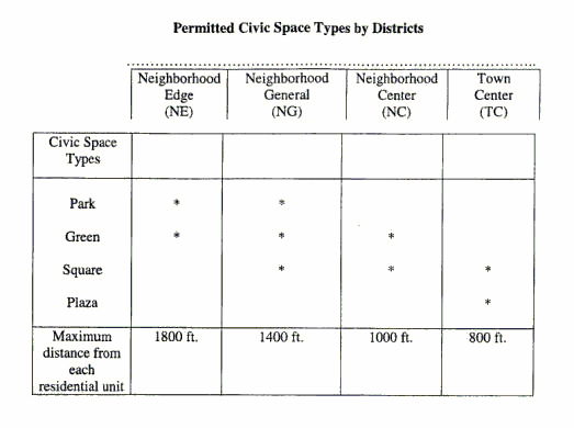
3320.17 - Civic spaces and civic buildings.
A.
General.
1.
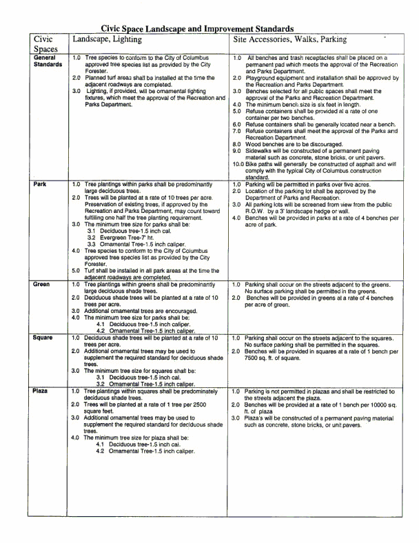
Civic space types are designated on the regulating plan and conform with the Permitted Civic Space Types by Districts Table and the Civic Space Landscape Standards.
2.
Civic building sites are designated on the regulating plan and are not required to be located on a civic space.
3.
Frontage type requirements do not apply to civic buildings, except for retail uses.
4.
Parking location for civic buildings is designated on the regulating plan and approved in consideration of impact on surrounding uses.
5.
Thoroughfares adjacent to civic spaces or civic buildings conform to the standards of the underlying districts. Thoroughfares within a civic space are designed integrally with the civic space.
6.
Civic spaces that preserve significant natural features are allowed in all districts without limitation.
7.
For purposes of meeting allocation requirements, at least 50 percent of any district is other than civic space.
8.
Civic spaces of one acre or greater will be dedicated to public use, accepted by the city of Columbus, and maintained by the recreation and parks department to a standard similar to other civic spaces maintained by them. Civic spaces approved at the time of rezoning count toward the requirements of Columbus City Codes Chapter 3318.
9.
Civic spaces to be owned and maintained by the city of Columbus or otherwise dedicated for public use are accessed by a public thoroughfare.
B.
Mandatory Elements:
1.
The development contains civic spaces within the required distance of each housing unit. (3 pts)
2.
Civic space types are designated on the regulating plan and conform with the standards specified in the Civic Space Types by Districts Table and the Civic Space Landscape Standards. (3 pts)
3.
A majority of civic spaces and civic building space have a minimum of 50 percent of their perimeter along a thoroughfare excluding alleys, lanes and paths. All civic spaces must have frontage. (3 pts)
4.
Side and rear setbacks are no smaller than those required for private buildings on adjacent lots. (3 pts)
5.
On-site parking does not exceed the number of spaces required by this article minus the number of parking spaces that can reasonably be accommodated on-street adjacent to the civic building. (3 pts)
6.
Each neighborhood center and town center district contains at least one civic space designed and improved as a plaza, square or green of no less than one-half acre and no greater than three acres. (3 pts.)
7.
Land designated for neighborhood commercial uses, such as a live-work space, daycare center, and convenience store, in neighborhood center districts of more than five acres is integrated into the regulating plan. (3 pts.)
8.
At least one civic space in each neighborhood general, neighborhood edge, and neighborhood center district containing one family dwellings is furnished with play equipment for children according to Civic Space Improvement and Landscape Standards. One civic space in each district is landscaped and furnished with benches, the remainder are landscaped. (3 pts.)*
9.
All parking lots along frontages are masked by a streetwall, and/or hedges. (3 pts)
10.
Parking lots are planted with indigenous shade trees at a minimum ratio of one tree per ten parking spaces. (3 pts)
11.
Trash compacters and dumpsters are not located in or adjacent to civic spaces unless they are associated with a civic building and so designated on the regulating plan.
C.
Desired Elements:
1.
Civic building site(s) are designated on the regulating plan. (2 pts.)*
2.
A commitment exists to build minor civic structures such as a picnic shelter, park facilities, gazebo or centralized mail facility. (2 pts.)*
3.
A commitment exists to build non-retail commercial uses. (2 bonus pts.)
4.
A civic building site intended for use as a childcare center is reserved in each neighborhood center or neighborhood general district. (2 pts)
5.
A commitment exists to build a daycare center or pre-school. (2 bonus pts)
6.
A commitment exists to build significant civic buildings such as a school, religious building, meeting hall, library, indoor recreation facility, or public swimming pool. (6 bonus pts.)
7.
A commitment exists to build a corner store or other neighborhood retail. (6 bonus pts.)*
8.
A school site acceptable to public or private school officials has been dedicated (if applicable). (3 pts.)*
9.
A school site will be deeded to a public or private school. (2 bonus pts)
10.
Civic buildings, civic spaces, natural features and/or structures terminate major vistas associated with CO, BV, and CS thoroughfare types. (2 pts.)*
11.
Civic space within each neighborhood center district is within 500 feet of the geographic center of the pedestrian shed. (1 pts.)*
12.
A corner store or café acceptable to Cota as a transit stop is contained within each neighborhood center or town center district (if applicable). (1 pts.)*
13.
A commitment exists to build a transit stop acceptable to COTA (if applicable). (2 pts.)*
(Ord. 1518-01 § 3 (part); Ord. 1627-02 § 8.)
* Multiple points possible.
3320.19 - Private buildings.
This chapter shall contain Sections 3320.191 through 3320.195 and Building Standards Table, Use Standards Table and Frontage Types Chart. In the case of condominium developments, lot size requirements are to be considered dimensional requirements.
A.
General.
1.
Standards for the following uses are specified in the Use Standards Table: residential, lodging, office, retail, manufacturing, and civic.
2.
The configuration and disposition of lots and buildings is specified in the Building Standards Table and the Frontage Types Illustrations.
3.
The required number of off-street parking spaces are specified in the Use Standards Table. The parking requirement may be reduced by implementing a shared parking policy based on "Shared Parking" © 1983 by The Urban Land Institute or successor documents.
4.
On-street parking within the frontage of the building is counted toward on-site parking requirements of apartment building and rowhouse building types but not residences above commercial uses. The required parking may be provided on private lots within the pedestrian shed (one-third of a mile) of the lot it serves and on thoroughfares within the pedestrian shed if such parking is neither adjacent to another existing or proposed use nor counted toward another use.
5.
At the discretion of the applicant, on-street parking may not be counted toward the maximum parking requirements of retail uses.
6.
If a commercial parking structure exists or is planned within the pedestrian shed, the required parking may be purchased, depending on availability.
7.
As much as 40 percent of the neighborhood edge land area may be developed with neighborhood general standards for single unit dwellings, provided these standards are not used for any portion of neighborhood edge located immediately along the exterior perimeter of the overall development site.
8.
The following uses are prohibited in all TND zones: drive-through commercial uses except service stations, book and video drops and banks; vending machines, except within buildings; detached signs and billboards; "big-box" and single use tenants of 10,000 square feet or more; exterior commercial kennels and animal husbandry; prisons; depots for the distribution or storage of goods; scrap yards except recycling collection centers; automotive sales, except service and repair not exceeding four garage bays; mineral extraction; landfills and dumps; electric substation; newspaper printing; off-premises graphics, except for off-premises graphics which are approved as part of a graphics plan or special permit by the graphics commission; adult bookstore, adult motion picture theater, adults only entertainment facility, production of adult materials or adult entertainment, sale of adult videos or other sexually oriented businesses; armory; pool room; poultry killing (killing or dressing for sale at retail on the premises); stable; tinsmith; ice house; outside storage of wrecked or non-operative motor vehicles associated with any garage repair shop or motor vehicle repair/maintenance use.
9.
A maximum of 20 percent of the units in neighborhood general may be built as two-unit dwellings, unless a higher level is indicated and approved in the development plan.
10.
A maximum of ten percent of the units in neighborhood general may be four-unit dwellings and must be depicted on the regulating plan.
B.
Mandatory Elements.
1.
The developer will not permit the placement of single-family houses substantially similar in design next to or directly across the street from each other. (3 pts.)
2.
The regulating plan complies with the requirements of the Use Standards Table in each district. (3 pts.)
3.
The configuration and disposition of lots and buildings complies with the Building Standards Table and the Frontage Types Illustration. (3 pts.)
4.
The facade is parallel to straight frontage lines and parallel to the chord of curved or broken frontage lines. (3 pts.)
5.
Building facades along the frontage line meet the frontage requirements of the Building Standards Table. (3 pts.)
6.
Principal building(s) have a front door opening directly to a frontage line on a principal thoroughfare. (3 pts.)
7.
Trash containers are stored at the side or rear outside the public-right-of-way. (3 pts.)
8.
Garage door opening(s) facing a frontage do not exceed 40 percent of the width of the house facade (including the garage). (3 pts.)
9.
Storefronts have no more than one integral sign and one blade sign for each retail establishment on each facade. (3 pts.)
10.
The blade sign of a storefront is located either just above or just below the integral sign, is no larger than five square feet per side and does not project more than three feet in any direction. (3 pts.)
11.
Where different zones abut along a side or rear property line, the larger of the required side and rear setbacks apply along the shared property line. (3 pts.)
12.
Frontage types are designated on the regulating plan in compliance with the Frontage Types Illustrations. (3 pts.)
13.
Private sidewalks are provided between the public sidewalk and building entrances and between connecting parking areas and the public sidewalk. (3 pts.)
14.
All parking lots along frontages are masked by a streetwall, and/or a hedge. (3 pts.)
15.
Parking lots are planted with indigenous shade trees at a minimum ratio of one tree per ten parking spaces. (3 pts.)
16.
The integral sign of a storefront is located on a frieze, fascia or awning located directly above the storefront. Signage is broken at intervals of no greater than 20 feet. (3 pts.)
17.
The shopfront type is used along retail frontages. (3 pts.)
18.
Residential buildings in neighborhood center district have at least one entrance door facing the thoroughfare for every two ground floor units facing the thoroughfare street. (3 pts.)
19.
In the neighborhood edge district double width driveways are permitted on lots of 55 feet width or greater with the garage set back two feet from the front façade of the main building. (3 pts.)
20.
In the neighborhood edge district single width driveways are permitted on lots of 50 feet width or greater with the garage setback 20 feet from the front façade of the main building. (3 pts.)
21.
Vistas of 600 feet or longer are terminated by buildings or civic spaces. (3 pts.)
22.
No more than 50 percent of the units in a building may face an AL-86-60. (3 pts.)
C.
Desired Elements.
1.
The first floor of frontages of parking structures is dedicated to commercial use, excluding parking, and upper stories at frontages are articulated to disguise the appearance of the garage. (3 pts.)
2.
Parking structures are masked by a building from the thoroughfares. (3 pts.)
3.
Parking structures do not lead directly to the buildings they serve and provide a pedestrian access route along a frontage line to the main building entrance. (1 pts.)
4.
Buildings are placed on axis to terminate vistas. (1 pts.)
5.
Garages facing a frontage use single car garage door openings. (0-3 pts.)
6.
The integral sign of a storefront is no more than 24 inches in height, and externally lit. (2 pts.)
7.
Utility meters, air-handling equipment and the like are set back at least ten feet from the front façade of the buildings. (2 pts.)
8.
The parking and private sidewalk systems in the town center district are landscaped. (1 pts.)
9.
Front or side porches of 50 square feet or more are provided on one- and two-family buildings. (0-3 pts.)
10.
Foundation planting is provided along all multifamily building frontages. Planting shall be of sufficient quantity and spacing to provide complete coverage of the entire length of the building (excluding doorways). (2 pts.)
(Ord. 1518-01 § 3 (part); Ord. 1627-02 § 11.)
* Stoops or porches can encroach eight feet into the set back in the Neighborhood Edge and Neighborhood General districts.
** Temporary model home parking lots permitted.
*** Zero side setback requires a three feet maintenance easement.
# permitted only within the frontage of retail uses.
Note: Construction with a zero set back may subject the applicant to additional requirements and standards such as city of Columbus Building Codes and foundation encroachment into the Right-Of-Way.
Ψ In Neighborhood Edge and Neighborhood General districts minimum lot depth may be reduced to a minimum of 70′ if at the same time the width is increased from the stated minimum by a ratio of 3 to 1 (for every 3′ reduction in depth the width is increased by 1′).
Φ Minimum lot width in Neighborhood General district may be reduced to 25′ provided that the lot is to be used for a two-family dwelling and adjoins another 25′ minimum lot accommodating the remainder of the two-family dwelling.
Ω Minimum side setback for two- to four-family dwellings at the common wall side shall be 0.
π In neighborhood Center and Town Center districts 1 st layer parking is permitted utilizing the parking way frontage type under circumstances indicated in the article.
* Not required if access is from alley or lane.
X In the Neighborhood Center district there shall be no more than eight dwelling units on the ground floor facing or fronting each thoroughfare.
3320.21 - Natural and historic resources.
A.
Desired elements.
1.
Lakes, ponds, streams, and wetlands are retained. (0-2 pts.)
2.
Specimen trees and significant tree stands are retained. (0-2 pts.)
3.
Hilltops, ravines, ridges and significant topographic features are retained. (0-2 pts.)
4.
Lakes, ponds, streams, wetlands, or tree stands are enhanced or created. (0-2 pts.)
5.
Existing structures are retained and restored to useful purpose if deemed to be of historic value by the historic resources commission. The applicant has applied for their listing on the Columbus Register of Historic Places. (3 pts.) *
6.
Existing natural or historic resources are preserved and incorporated into civic spaces. (2 pts.)
(Ord. 1518-01 § 3 (part).)
3320.23 - Agricultural and sustainable development standards.
A.
An agricultural use, farm, field crops, garden, greenhouse, or nursery may be conducted in any district contained in this chapter without restriction as to the operation of incidental vehicles and machinery or restriction as to the incidental sale and marketing, including produce stands, of products raised on the premises, provided that:
1.
The agricultural use is located on-premises and on a minimum lot area of one (1) acre; and
2.
A poultry and livestock building, structure and yard is located on-premises and is located a minimum distance of 100 feet from a lot or street line; and
3.
Poultry and livestock for sale are kept in approved enclosures.
4.
The agricultural standards comply with the appropriate regulations of the Columbus Health Department.
B.
A stable may be erected in any residential district contained in this chapter provided that:
1.
The stable is located on-premises and on a minimum lot area of five acres; and
2.
The stable complies with the appropriate regulations of the Columbus Health Department.
C.
On lot areas of less than one (1) acre, Produce Stands shall be allowed as an accessory use to the parcel's primary use or the on-site agricultural use in any residential district, subject to the following:
1.
The Produce Stand may be in operation during the growing season. The growing season is considered to be the months of April through December.
2.
Sales shall be limited to two (2) days per week.
3.
Sales shall be limited to between 8:00 a.m. and 8:00 p.m.
4.
Only one (1) Produce Stand is permitted per parcel.
5.
For parcels that contain a dwelling unit, Produce Stands must be removed from the premises or stored inside a structure at the end of each day
6.
For parcels that contain a dwelling unit, one (1) sign that is non-illuminated and with a maximum area of four (4) square feet, may be displayed during the growing season but must be removed from the premises or stored inside a structure at other times of the year. All signs shall comply with zoning code standards of Chapter 3376 On Premises Signs in Residential Districts.
7.
For parcels that do not contain a dwelling unit, Produce Stands or Signs do not need to be stored or removed. Furthermore, two (2) signs that are non-illuminated and with a maximum area of four (4) square feet each, may be displayed.
8.
The area used for the Produce Stand shall comply with the vision clearance requirements of zoning code Chapter 3321.05 General Site Development Standards.
D.
Solar energy collection may be conducted in any residential district contained in this chapter, subject to the following:
1.
Equipment directly related to the gathering of solar energy shall be exempt from screening requirements.
2.
Electricity collected on-site may be distributed off-site for use or sale.
(Ord. No. 1501-2022, § 6, 6-13-2022)
Article III. General Standards
Editor's Note: Ord. No. 1537-2009, § 18, adopted May 3, 2010, amended the title of Art. III to read as herein set out. Prior to inclusion of said ordinance, Art. III was entitled, "Special Districts."