
Davie City Zoning Code
ARTICLE XIII
- SPECIAL PLANNING AREAS AND DISTRICTS
DIVISION 1. - WESTERN THEME DISTRICT[14]
Editor's note— Section 1 of Ord. No. 90-47, adopted Aug. 15, 1990, amended Art. XIII, Divs. 1 and 2 of Ch. 12 to read as herein set out. Prior to said amendment, Divs, 1 and 2 contained development regulations pertaining to the Western Theme Area and the Davie Downtown District and were derived from Ord. No. 90-4, § 7, adopted Feb. 21, 1990.
DIVISION 3. - COMMUNITY REDEVELOPMENT[15]
Editor's note— Ord. No. 2012-11, § 2, adopted Aug. 1, 2012, repealed the former Art. XII, Div. 3, §§ 12-395—12-409, and enacted a new Art. XIII, Div. 3, as set out herein. The former Art. XIII, Div. 3, pertained to similar subject matter and derived from Ord. No. 90-4, § 7, adopted Feb. 21, 1990; and Ord. No. 92-24, § 3, adopted June 3, 1992.
DIVISION 5. - UNITED RANCHES OVERLAY[16]
Editor's note— Ord. No. 2014-23, § 2(Exh. A), adopted Dec. 2, 2014, changed the title of Div. 5 from "United Ranches Special Zoning Districts" to read as set out herein.
DIVISION 7. - COMMUNITY BUSINESS CENTER DISTRICT (CBC)[17]
Editor's note— Ord. No. 2012-28, § 2(Exh. A), adopted Dec. 5, 2012, amended ch. 12 by moving §§ 12-32.100—12-12-538.28 from Art. III to Art. XIII to be renumbered as set out herein.
DIVISION 8. - PLANNED TRUCK STOP DISTRICT (TS)[18]
Editor's note— See editor's note following Art. XIII, Div. 7.
DIVISION 9. - GRIFFIN CORRIDOR DISTRICT[19]
Editor's note— See editor's note following Art. XIII, Div. 7.
DIVISION 10. - REGIONAL ACTIVITY CENTER-ACADEMICAL VILLAGE DISTRICT (RAC-AV)[20]
Editor's note— See editor's note following Art. XIII, Div. 7.
DIVISION 11. - REGIONAL ACTIVITY CENTER DISTRICTS[21]
Editor's note— See editor's note following Art. XIII, Div. 7.
Sec. 12-385.- Purpose and intent.
There is hereby created a Western Theme District, which is intended to help preserve and promote aspects of the town's agricultural and equestrian heritage through architectural design. The provisions of this division shall supplement, and be cumulative to, other requirements of the Land Development Code.
(Ord. No. O2019-019, § 2(Exh. A), 8-21-19)
Editor's note— Ord. No. O2019-19, § 2(Exh. A), adopted Aug. 21, 2019, repealed the former § 12-385 and enacted a new § 12-385 as set out herein. The former § 12-385 pertained to the creation of the Western Theme District and derived from Ord. No. 90-47, §, adopted Aug. 15, 1990; and Ord. No. 96-35, § 1, adopted Aug. 21, 1996.
Sec. 12-386. - Boundaries.
The Western Theme District shall be composed of an area including all that portion of land lying with the area described as follows:
Beginning at the point of intersection of the centerline of Davie Road (SW 64th Avenue) and the north line of section 26, township 50 south, range 40 east; thence easterly to a point of intersection with the westerly boundary of lot 579 of the recorded plat of Playland Village section 4; thence southwesterly and southerly along the westerly boundaries of lots 579 thru [through] 564 of Playland Village section 4, extended southerly to a point of intersection with the southerly right-of-way of SW 38th Court, this point also being described as the northwest corner of lot 1 of the recorded plat of Playland Village section 1; thence continue southerly along the westerly boundaries of lots 1 through 4 of the recorded plat of Playground Village section 1 of the southwest corner of said lot 4, also described as the point of intersection with the northerly boundary of lot 8 block 1 of the recorded plat of Everglades Park; thence easterly along the northern boundary of said lot 8, block 1 to the northeast corner of said lot 8, block 1, thence southerly along the easterly boundary of lot 8, block 1, of the recorded plat of Everglades Park extended southerly to a point of intersection with the centerline of SW 39th Court; thence westerly along the centerline of SW 39th Court to a point of intersection with the northerly extension of the easterly boundary of lot 7, block 2 of the recorded plat of Everglades Park, thence southerly along the northerly extension of the easterly boundary of southeast corner of said lot; thence westerly along the southerly boundary of lot 7, block 2 of the recorded plat of Everglades Park to the northeast corner of lot 3 of the recorded plat of Strong Park; thence southerly along the easterly boundary of said lot 3 extended to a point of intersection with the centerline of SW 41st Street; thence easterly along the centerline of SW 41st Street to a point of intersection with the northerly extension of the easterly boundary of lot 23 of the recorded plat of Strong Park; thence southerly along the northerly extension of said lot 23 to the southeast corner of said lot; thence westerly along the southerly boundary of lot 23 of the recorded plat of Strong Park to a point of intersection with the northeast corner of lot 2 of the recorded plat of White Park; thence southerly along the easterly boundaries of lot 2, extended southerly, and lot 20 of the recorded plat of Strong Park to a point of intersection with the southeast corner of said lot 20, said point also described as the northwest corner of lot 14, block 2 of the recorded plat of Davie Park; thence easterly along the northerly boundary of said lot 14 to the northeast corner of said lot 14, block 2; thence southerly along the easterly boundary of lot 14, block 2 of the recorded plat of Davie Park extended southerly to a point of intersection with the southerly right-of-way of SW 41st Court; thence easterly along the southerly right-of-way of SW 41 Court to a point of intersection with the northeast corner of lot 13, block 1 of the recorded plat of Davie Park; thence southerly along the easterly boundary of lot 13, block 1 of the recorded plat of Davie Park to the southeast corner of said lot; thence westerly along the southerly boundaries of lots 13 and 14, block 1 of the recorded plat of Davie Park to a point of intersection with the northerly extension of the centerline of SW 63rd Avenue; thence southerly along the centerline of SW 63rd Avenue to a point of intersection with the centerline of SW 43rd Street, thence easterly along the centerline of SW 43rd Street to a point of intersection with the northerly extension of the westerly boundary of lot 1, block 1 of the recorded plat of 1st Addition to Davie; thence southerly along the northerly extension of the westerly boundary of lots 1 and 2, block 1 of the recorded plat of 1st Addition to Davie to the southwest corner of said lot 2, block 1; thence easterly along the southerly boundary of lot 2, block 1 of the recorded plat of 1st Addition to Davie extended easterly to a point of intersection with the centerline of SW 62nd Avenue; thence southerly along the centerline of SW 62nd Avenue to a point of intersection with the westerly extension of the southerly boundary of lot 1, block 5 of the recorded plat of Davie Heights; thence easterly along the southerly boundaries of lots 1 through 5, block 5 of the recorded plat of Davie Heights to the southeast corner of said lot 5, block 5, this point also being described as the point of intersection with the westerly boundary of lot 16 of the recorded plat of Davie Heights Extension; thence southerly along the westerly boundary of lot 16 of the recorded plat of Davie Heights Extension to the southwest corner of said lot 16; thence easterly along the southerly boundaries of lots 15 and 16 of the recorded plat of Davie Heights Extension to the southeast corner of said lot 15, this point also described as the point of intersection with the westerly boundary of lot 12 of the recorded plat of Durden Subdivision; thence northerly along the westerly boundary of lot 12 of the recorded plat of Durden Subdivision to the northwest corner of said lot 12; thence northerly along the westerly boundary of lot 11 for a distance of 20 feet; thence easterly along a line 20 feet north of and parallel with the south line of lot 11 of the recorded plat of Durden Subdivision to a point of intersection with the westerly right-of-way of SW 61st Avenue; thence southerly along the westerly right-of-way of SW 61st Avenue to the point of intersection with the north line of the C-11 Canal right-of-way; thence westerly to a point of intersection with a northerly extension of the westerly boundary of Tract 51; thence northerly along the extension of the westerly boundary of Tract 51, and the westerly boundary of Tract 46 to the northwest corner of said Tract 46, this point also described as northeast corner of Tract 45; thence westerly along the northerly boundary of Tract 46 to the northwest corner of said Tract 45; thence northerly 165 feet along the westerly boundary of Tract 1; thence easterly 900 feet along a line 165 feet north of and parallel to the south line of Tract 1, thence northerly along a line 900 feet east of and parallel to the westerly boundary of Tract 1 to a point of intersection with the centerline of SW 41st Street; thence easterly 100 feet along the centerline of SW 41st Street; thence northerly along a line 320 feet west of and parallel to the westerly right-of-way of Davie Road (SW 64th Avenue) to a point of intersection with the south line of Tract 4; thence westerly 575 feet along the south line of Tract 4, said point also being described as the southwest corner of lot 1 of the recorded plat of Davie 39th Street plat; thence northerly along the westerly boundary of lot 1 of the recorded plat of Davie 39th Street plat to a point of intersection with the southerly right-of-way of SW 39th Street; thence easterly along the southerly right-of-way of SW 39th Street extended to a point of intersection with the centerline of Davie Road (SW 64th Avenue); thence northerly and northeasterly along the centerline of Davie Road (SW 64th Avenue) to point of intersection with the north line of section 26, township 50 south, range 40 east, said point also being the point of beginning.
(Ord. No. 90-47, § 1, 8-15-90; Ord. No. 96-35, § 1, 8-21-96; Ord. No. 2000-7, § 1, 2-2-00; Ord. No. 2001-028, § 2, 6-6-01)
Sec. 12-387. - Western Theme Design Manual.
The Western Theme Design Manual shall be adopted by ordinance and shall govern all development and re-development within the Western Theme District.
Editor's note— Ord. No. O2019-019, § 2(Exh. A), adopted Aug. 21, 2019, repealed the former § 12-387 and enacted a new § 12-387 as set out herein. The former § 12-387 pertained to review procedure and applications for permits and derived from Ord. No. 90-47, § 1, adopted Aug. 15, 1990; and Ord. No. 96-35, § 1, adopted Aug. 21, 1996.
Sec. 12-388. - Design variations.
The town council is authorized to approve specific design variations to the requirements of the Western Theme Design Manual in the manner set forth in section 12-438.23.
(Ord. No. O2019-019, §§ 2(Exh. A), 3(Exh. B), 8-21-19)
Editor's note— Ord. No. O2019-019, § 2(Exh. A), adopted Aug. 21, 2019, repealed the former § 12-388 and enacted a new § 12-388 as set out herein. The former § 12-388 pertained to setbacks, uses and heights in commercial zones and derived from Ord. No. 90-47, § 1, adopted Aug. 15, 1990; Ord. No. 96-35, § 1, adopted Aug. 21, 1996; Ord. No. 99-14, §§ 1—3, adopted May 5, 1999; and Ord. No. 2007-21, §§ 1, 2, adopted Aug. 15, 2007.
Sec. 12-389. - Reserved.
Editor's note— Ord. No. O2019-019, § 2(Exh. A), adopted Aug. 21, 2019, repealed § 12-389, which pertained to Western Theme Development Manual and derived from Ord. No. 90-47, § 1, adopted Aug. 15, 1990; and Ord. No. 96-35, § 1, adopted Aug. 21, 1996.
Sec. 12-390. - Reserved.
Editor's note— Ord. No. O2019-019, § 2(Exh. A), adopted Aug. 21, 2019, repealed § 12-390, which pertained to outdoor lighting and derived from Ord. No. 90-47, § 1, adopted Aug. 15, 1990; and Ord. No. 96-35, § 1, adopted Aug. 21, 1996.
Sec. 12-391. - Reserved.
Editor's note— Ord. No. O2019-019, § 2(Exh. A), adopted Aug. 21, 2019, repealed § 12-391, which pertained to signage and derived from Ord. No. 90-47, § 1, adopted Aug. 15, 1990; Ord. No. 96-35, § 1, adopted Aug. 21, 1996; Ord. No. 96-44, § 1, adopted Nov. 6, 1996; and Ord. No. 2015-017, § 2(Exh. A), adopted June 10, 2015.
Sec. 12-392. - Reserved.
Editor's note— Ord. No. O2019-019, § 2(Exh. A), adopted Aug. 21, 2019, repealed § 12-392, which pertained to parking and traffic circulation and derived from Ord. No. 90-47, § 1, adopted Aug. 15, 1990; and Ord. No. 96-35, § 1, adopted Aug. 21, 1996.
Sec. 12-393. - Reserved.
Editor's note— Ord. No. O2019-019, § 2(Exh. A), adopted Aug. 21, 2019, repealed § 12-393, which pertained to landscaping and derived from Ord. No. 90-47, § 1, adopted Aug. 15, 1990; and Ord. No. 96-35, § 1, adopted Aug. 21, 1996.
Sec. 12-394.1.- Title.
This division shall be known as the "Eastside Neighborhood Special Zoning District (ENSZD)."
(Ord. No. 94-45, § 1, 12-21-94)
Sec. 12-394.2. - Intent, applicability and boundaries.
(A)
Intent. This district is intended to guide design for the improvement and redevelopment of properties in the Eastside Neighborhood Area. The standards contained herein intend to:
(1)
Maintain flexibility while ensuring that each building contributes to the whole;
(2)
Ensure that buildings are placed on their lots so as to create public spaces between buildings that are walkable, well-proportioned and memorable;
(3)
Allow streets and other public spaces to be naturally watched over and more secure;
(4)
Ensure that buildings are placed on their lots so as to create well-defined and usable private spaces behind buildings;
(5)
Ensure that service areas and parking lots are screened from view where possible;
(6)
Encourage interaction among neighbors and establish community identity and pride;
(7)
Maximize affordable housing opportunities and convenience to jobs and commerce.
(B)
Applicability. The requirements of this division shall be in addition to each and every other requirement of the Town of Davie Land Development Code (Code), and, in the case of conflict, the provisions of this division shall control.
(C)
Boundaries. The boundaries of the ENSZD shall be delineated on the ENSZD map of this division.
(Ord. No. 94-45, § 1, 12-21-94)
Sec. 12-394.3. - Regulating plan.
The Regulating Plan graphic for the Eastside Neighborhood provides the overall view of appropriate land uses. Several properties provide more than one (1) permitted use. The Regulating Plan is intended to be a guide to direct necessary uses and building types to fulfill the goal of redevelopment in the Eastside Neighborhood Area. The three (3) types of buildings of this zoning district are front porch houses (Type I), side porch houses (Type II) and civic buildings. Each building type and placement produces a significant impact on the built environment.
The Regulating Plan is not intended to restrict or prohibit development on any parcel. Properties which are shown as a new street or civic use on the Regulating Plan may be constructed as either Type I or Type II buildings. Properties which are shown with different boundaries from the Regulating Plan may be developed with the present boundaries.
(Ord. No. 94-45, § 1, 12-21-94)
Sec. 12-394.4. - Neighborhood site design standards.
The neighborhood site design standards for porch houses Type I and Type II are within Figure 394.4-1. A request to seek relief from standards may be executed through a variation in design per section 12-438.23.
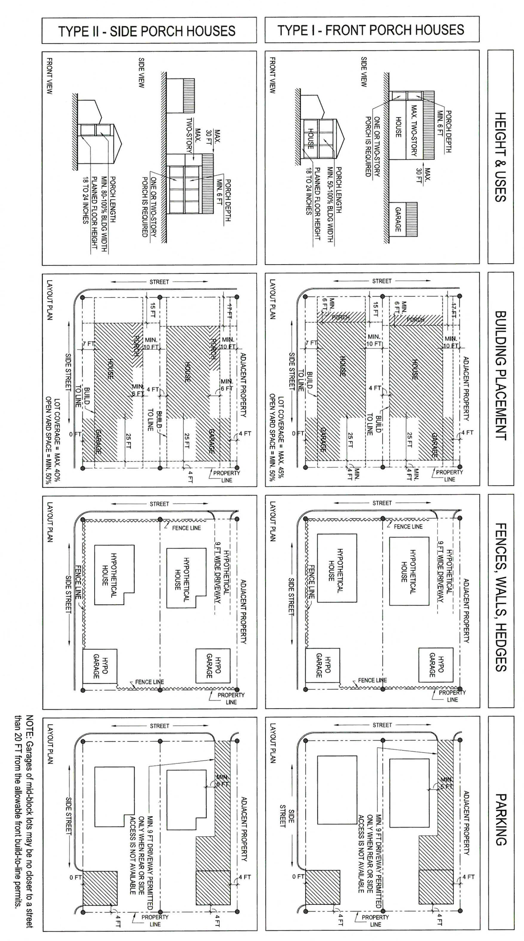
FIGURE 394.4.1
Civic building standards are as follows:
(a)
Heights. The height for civic buildings shall not exceed forty-five (45) feet; however, steeples, flagpoles, monuments, and similar architectural features with a footprint no greater than one hundred twenty-five (125) square feet may exceed forty-five (45) feet, but shall be no taller than ninety (90) feet.
(b)
Uses. Community hall or neighborhood clubhouse, public school, church or house of worship, public day care center, governmental building, library, museum, park facilities, cultural center.
(c)
Building placement. Civic buildings on sites which are located at the terminus of a street or vista shall be positioned on the site so as to signify the view axis with either a centered facade, tower, or some vertical architectural feature.
(d)
[Encroachments.] Encroachments into the right-of-way by publicly owned facilities are permitted in the form of porticos, arcades, or colonnades.
(e)
Setbacks. There shall be side and rear setbacks of five (5) feet at each property line.
(f)
[Primary entrance.] The primary entrance of the building or group of buildings shall face the front lot line.
(g)
Fences, walls, hedges. A fence, wall, or hedge, or combination thereof, shall be constructed along all unbuilt property lines of civic building lots, including the rear property line, except where openings are required for driveways or pedestrian walkways.
(h)
Parking. On-street parking within six hundred (600) feet of a civic building may apply towards the parking requirement of such development. Off-street parking shall be to the rear or side of civic buildings, and not on the corner of a corner lot.
(Ord. No. 94-45, § 1, 12-21-94; Ord. No. O2018-009, § 2(Exh. A), 4-4-18)
Sec. 12-394.5. - General provisions.
(A)
Porches, balconies. Porches shall occur streetward of the build-to line. Balconies may cantilever beyond the build-to line and shall not extend beyond the porch. Porches shall be open except for railings and support columns.
(B)
Arcades/colonnades. A ten-foot minimum depth [shall be] required from building wall to column face. A ten-foot minimum clearance [shall be] required, not including signs and other fixtures. Enclosed areas shall be permitted above the arcades/colonnades. Awnings are encouraged in the neighborhood, but are not considered arcades or colonnades.
(C)
Height. There shall be no height limit on structures or parts of structures with footprints of less than one hundred twenty-five (125) square feet. The height of detached garages shall not exceed fifteen (15) feet. Corner lot buildings are encouraged to be two (2) stories in height.
(D)
Minimum lot size:
(1)
Single-family: Three thousand six hundred (3,600) square feet.
(2)
Civic: Ten thousand (10,000) square feet.
(E)
Garages. For the purposes of this district, a metallic carport shall not be considered a garage. Any garage shall be placed precisely the distance from the property line following the applicable criteria below:
(1)
Corner lots: Rear property line of four (4) feet and at street side property line of zero (0) feet.
(2)
Mid-block lots: Side property line of four (4) feet and no closer to a street than twenty (20) feet from the allowable front build-to line permits.
(F)
Future additions to buildings. All future additions to primary buildings originally built to this [Land Development] Code shall be constructed within the buildable area designated by this [Land Development] Code. Garages need not be constructed at the same time as the primary structure. Existing buildings requesting additions are encouraged to be constructed within the buildable area, pursuant to the standards contained in this division, but may adhere to the R-5 and CF District Regulations, as applicable. Existing buildings within the ENSZD are identified on the Existing Conditions Map.
(G)
Drainage/stormwater runoff. All stormwater shall be retained on the property from which it originates. Overhangs intruding into the public right-of-way shall be guttered and drainage shall be deposited on the building site.
(H)
Fence or wall along street frontage. For new homes constructed after December 21, 1994, a fence, wall, or combination thereof, but excluding chain link fencing, is required to enclose the front yard area. The fence or wall shall be thirty (30) inches to thirty-six (36) inches in height and shall extend across the entire front property line and along any side property line which is both adjacent to a street and forward of the front building facade. The fence or wall may include such openings to accommodate one (1) pedestrian accessway of up to four (4) feet wide and one (1) vehicular accessway of up to twelve (12) feet wide. The height and materials of all other fences and walls shall be governed by Section 12-33(O), provided that a fence or wall located forward of the front building facade shall not exceed thirty-six (36) inches in height.
(I)
Parking requirements. [The requirements for parking shall be as follows: Single-family, two (2) spaces per dwelling; civic, one (1) space per four hundred (400) square feet.
(1)
On-street spaces adjacent to a private lot shall count toward the parking requirements of that lot. For purposes of calculating required parking for any lot, a partial space longer that eleven (11) feet equals one (1) space. Parking may occur on-street, in garages and on parking surfaces. A standard parking stall space shall be nine (9) feet by eighteen (18) feet. Handicapped spaces shall be twelve (12) feet by eighteen (18) feet.
(2)
Front driveways to rear parking areas are permitted only where rear or side street access is unavailable. Lots that have both rear and side access capabilities shall use the rear access.
(3)
Circular drives are prohibited except for civic buildings.
(4)
Parking areas of civic buildings are not required to be curbed; however, [they] must possess car stops in place of curbing.
(5)
Parking areas shall consist of the following surfaces only: Turf block, compacted grass, brick, pavers, asphalt or concrete.
(Ord. No. 94-45, § 1, 12-21-94; Ord. No. O2019-012, § 2(Exh. A), 6-5-19)
Sec. 12-394.6. - Neighborhood architectural standards.
(A)
Intent. The Architectural Standards work with Eastside Neighborhood Site-Design Standards, Regulating Plan, and Street Standards, to ensure harmony among buildings. A strict style sheet is avoided so that variety and creativity are not stifled. At the same time, however, the Architectural Standards provide a clear and administratively simple way to review proposals for compliance and fit with the desired image for Eastside. The lists of permitted materials come from a study of the buildings found in South Florida, and are chosen for appropriateness to the subtropical environment.
A basic intention of the Architectural Standards is authenticity. The standards encourage building constructions which are straightforward and functional, and which draw their ornament genuinely from the traditional assembly of real materials. The standards discourage "fake" materials, such as simulated wood, to avoid a tacky image for the neighborhood. Exceptions should be granted using this statement of intent as a basis for decision-making. The Neighborhood Architectural Standards List includes materials, configurations and general requirements.
Where these Architectural Standards conflict with the Town of Davie Code of Ordinances, these Architectural Standards shall govern for properties within the ENSZD.
(B)
Reserved.
(Ord. No. 94-45, § 1, 12-21-94)
Sec. 12-394.7. - General requirements.
(A)
Mailboxes shall be located at the front of the fence line, accessible to the postal carrier from the sidewalk. Mailboxes may be attached to the fence or garden wall, or supported on a post immediately behind the fence or garden wall.
(B)
The following shall be located in rear yards or side yards not facing side streets: Window and wall air conditioners, air conditioning compressors.
(C)
The following shall be located in the rear yards only: Clotheslines, clothes drying yards, antennas, barbecues, swimming pools and tubs.
(D)
Materials that attempt to fake the appearance of some other material shall be discouraged. The following are prohibited:
(1)
Undersized shutters.
(2)
"Ribbon windows" or horizontal stripes of glass.
(3)
Reflective and/or bronze-tint glass.
(4)
Plastic or PVC roof tiles.
(5)
Backlit awnings.
(6)
Glossy-finish awnings.
(7)
Styrofoam cornices.
(8)
Barbed wire or wire mesh fences.
(Ord. No. 94-45, § 1, 12-21-94)
Sec. 12-394.8. - Landscaping.
Landscaping of lots shall conform to the Town of Davie Land Development Code, Article VI. Residential lots shall follow the R-5 District standards and community building lots shall follow the CF District standards.
(Ord. No. 94-45, § 1, 12-21-94)
Sec. 12-394.9. - Signage and lighting.
All signage and lighting within the ENSZD shall conform to the Town of Davie Land Development Code, Article VIII.
(Ord. No. 94-45, § 1, 12-21-94)
Sec. 12-394.10. - Street standards.
(A)
Intent. These street standards establish certain dimensions and details for the streets within Eastside. Each time a street is constructed or reconstructed, these standards shall be the basis for the design and engineering. The intent is to create streets which appropriately serve the needs of pedestrians, cyclists and motorists, rather than motorists alone. The design requirements for a given street depend on its location and function. These standards are devised to:
(1)
Discourage high-speed car traffic and careless driving, and encourage eye contact between motorists and pedestrians (through parallel parking, correct travel-lane width, and suitable radii at corners);
(2)
Establish safe crossings for pedestrians at intersections (through suitable radii at corners);
(3)
Maintain appropriate passage for emergency vehicles and occasional moving vans (through "clear zones" at corners, to allow smaller curb radii but admit larger vehicles when required);
(4)
Establish safe sidewalks where pedestrians have minimum conflict with moving cars (by regulating curb cuts and by locating parking and trees between sidewalks and travel lanes);
(5)
Maintain shade and an agreeable appearance (through orderly spacing of full-size canopy trees);
(6)
Minimize the heat buildup and to limit impervious area (through minimized asphalt areas and through placement of canopy trees);
(7)
Efficiently provide parking (through parallel spaces on-street) and to control parking habits (through curbed street sections which deter random or disorderly parking).
(B)
Standards. These referenced standards of this division shall supersede section 12-338 when in conflict. In order to promote pedestrian safety, corner curb radii shall be twenty (20) feet. Travel lanes may be reduced to ten (10) feet each in width (minimum pavement) to establish quicker pedestrian crossings as well as discouraging increased traffic speeds associated with wider roadways. Sidewalks are required to be at least five (5) feet in width unless restricted by right-of-way and street design dimensions which may require a narrower sidewalk which shall not be less than four (4) feet in width. Parallel parking [is] to be encouraged along streets. Minimum width of on-street parking stalls shall be nine (9) feet, which includes adjacent gutter. On-street parking stalls shall be twenty-two (22) feet long. A clear zone radius of twenty-five (25) feet is applicable to streets in the ENSZD.
(C)
Landscaping. Trees within the public right-of-way shall be spaced evenly twenty (20) to thirty (30) feet apart, except near street intersections where they may be spaced closed together. All plant materials shall conform to the standards for Florida No. 1 or better, as given in "Grades and Standards for Nursery Plants" Part I, 1963 and Part II, State of Florida, Department of Agriculture, Tallahassee, or equal thereto. Grass sod shall be clean and reasonably free of weeds and noxious pests for diseases. Grass areas shall be planted in species normally grown as permanent lawn. Grass areas must be sodded. All new landscaping must incorporate the Xeriscape principles.
(Ord. No. 94-45, § 1, 12-21-94)
Sec. 12-395.- Town council as community redevelopment agency.
The town council of the Town of Davie, Florida declares that the town council is the community redevelopment agency of the Town of Davie, Florida, in the place and stead of the board of commissioners previously appointed by the town council pursuant to F.S., § 163.356. The rights, powers, duties, privileges, and immunities vested in the community redevelopment agency shall be vested in the town council. The members of town council shall constitute the members of the community redevelopment agency which is a legal entity separate, distinct and independent of town council. The board of commissioners of the community redevelopment agency is reduced from seven (7) members to five (5) members. The town council is subject to, and assumes, all existing responsibilities and liabilities of the previous board of commissioners. The town council will be governed in its actions, responsibilities and use of powers as described in F.S., ch. 163, pt. III.
(Ord. No. 2012-11, § 2, 8-1-12)
Sec. 12-396. - Community redevelopment plan.
The community redevelopment plan, as approved and amended, shall continue to be in full force and effect, unless and until further amended.
(Ord. No. 2012-11, § 2, 8-1-12)
Sec. 12-397. - Boundaries of Davie Community Redevelopment District.
The Davie Community Redevelopment District shall continue to include all that portion of land lying within the areas described in ordinances and resolutions of the Town of Davie and the Davie Community Redevelopment Agency on file of the office of the town clerk.
(Ord. No. 2012-11, § 2, 8-1-12)
Sec. 12-430.- Purpose and intent.
The town council annexed the area known as "United Ranches" into the Town of Davie effective September 15, 2006. In accordance with the Interlocal Agreement, the town has created the United Ranches Overlay District in order to preserve the Broward County zoning classifications, rules, and regulations applicable to this area as of September 14, 2006, except as otherwise provided in this division and to provide special procedural standards for any future zoning changes and development approvals.
(Ord. No. 2007-015, § 2, 6-20-07; Ord. No. 2014-23, § 2(Exh. A), 12-2-14)
Editor's note— Ord. No. 2014-23, § 2(Exh. A), adopted Dec. 2, 2014, changed the title of § 12-430 from "Created" to read as set out herein.
Sec. 12-431. - Boundaries.
General description:
North side of Stirling Road.
South side of Griffin Road.
East side of Flamingo Road.
West side of Nob Hill Road.
Legal description:
As described in Resolution 2006-244 of the Town of Davie, Florida, approving an Interlocal Agreement between Broward County and the Town of Davie for the annexation of the United Ranches area.
(Ord. No. 2007-015, § 2, 6-20-07)
Sec. 12-432. - Procedural standards for zoning changes and developmental approvals.
(A)
Reserved.
(B)
Notification: All applications for zoning changes within the United Ranches area require written notification to all United Ranches area residents.
(C)
Necessary majority: Any and all proposed municipal enactments that may effect a change in the United Ranches area, including but not limited to all quasi-judicial items, including zoning modifications, site plans, plats, and variances, must be approved by a supermajority of the town's governing body.
(D)
Preservation committee: Applications for a change of zoning within the United Ranches area must first be presented to a preservation committee consisting of five (5) members residing in United Ranches. The members of the preservation committee shall be appointed for a two (2) year term by the town's governing body, and shall be responsible for issuing recommendations on zoning changes within the United Ranches area.
(Ord. No. 2007-015, § 2, 6-20-07; Ord. No. 2014-23, § 2(Exh. A), 12-2-14)
Editor's note— Ord. No. 2014-23, § 2(Exh. A), adopted Dec. 2, 2014, changed the title of § 12-432 from "General provisions" to read as set out herein.
Sec. 12-432.1. - Special zoning standards in the United Ranches Overlay District.
(A)
General preservation of Broward County zoning. Unless adopted by an ordinance of the Town of Davie in accordance with this division, the Broward County zoning classifications, rules, and regulations applicable to this area as of September 14, 2006, shall remain in effect.
(B)
Exception for specified uses. The following uses shall not be established within the boundaries of the United Ranches Overlay District without first being rezoned to a current Town of Davie zoning district and without demonstrating compliance with all currently applicable town zoning standards, including minimum lot size and distance separation requirements and vehicular access standards:
Non-profit neighborhood social and recreational facilities
Places of worship and accessory schools and day care
Veterinary clinics
Veterinary hospitals
Kennels, commercial boarding and breeding
Essential services
This paragraph is not intended to prohibit the continuation or expansion of any use which may have been lawfully established prior to September 15, 2006.
(C)
Exception for family and transitional community residences and recovery communities. To make the reasonable accommodation the Fair Housing Act as amended (42 U.S.C. § 3601) requires, the development and operation of family and transitional community residences and recovery communities within residential zoning districts encompassed by the United Ranches Overlay District shall be governed by sections 12-34(W) and 12-34(Z) of this chapter, and each residential zoning district within the United Ranches Overlay District shall be considered a Town of Davie "A-1" district for purposes of implementing sections 12-34(W) and 12-34(Z) of this chapter.
(Ord. No. 2014-23, § 2(Exh. A), 12-2-14; Ord. No. O2023-016, § 2(Exh. A), 9-20-23)
Sec. 12-433.1. - Purpose.
The purpose of the district is to preserve a designated area of the town which embodies locally significant elements of the town's historical, cultural and architectural assets. The sites listed in section 12-433.2 are intended to identify these resources, when taken individually or as a whole, possess integrity of design, setting, materials, feeling and character of the town. Preservation is intended to provide for the education and enrichment of residents and visitors of the town. The purpose of the thematic historic committee is to effectively administer the duties provided for herein.
(Ord. No. 2011-11, § 2, 2-16-11; Ord. No. 2017-023, § 2(Exh. A), 8-2-17)
Sec. 12-433.2. - Thematic historic district.
All sites listed below shall be designated as part of the thematic historic district.
Historic Sites
(Ord. No. 2011-11, § 2, 2-16-11; Ord. No. 2017-023, § 2(Exh. A), 8-2-17)
Sec. 12-433.3. - Definitions.
Local significance. Importance of a property to the history of its community.
Site. Location of a significant event, a historic occupation or activity, or a building or structure, whether standing, ruined, or demolished, where the location itself possesses historic, cultural, or archeological value regardless of the value of any existing structure.
Thematic historic district. This type of district includes a finite group of resources related to one another in a clearly distinguishable way by a common theme related to historical context, architectural style, development period, or other characteristics, where visual continuity is not significant and sites are not necessarily located within a geographically contiguous area.
(Ord. No. 2011-11, § 2, 2-16-11; Ord. No. 2017-023, § 2(Exh. A), 8-2-17)
Sec. 12-433.4. - Thematic historic district committee.
The town council is hereby designated as the thematic historic district committee.
(Ord. No. 2011-11, § 2, 2-16-11; Ord. No. 2017-023, § 2(Exh. A), 8-2-17)
Sec. 12-433.5. - Advisory responsibilities of the committee.
The committee has the responsibility to:
A.
Undertake an inventory to include a survey of properties of historical, architectural and cultural local significance.
B.
Recommend sites of local significance to be designated by ordinance as part of the thematic historical district.
C.
Review and make recommendations, guided by the standards below, to landowners proposing new construction, structural additions, alterations, demolition, reconstruction, restoration within the thematic historical district.
1.
Standards for preservation.
a.
A property should be used as it was historically, or be given a new use that maximizes the retention of distinctive materials, features, spaces, and spatial relationships. Where a treatment and use have not been identified, a property should be protected and, if necessary, stabilized until additional work may be undertaken.
b.
The historic character of a property should be retained and preserved. The replacement of intact or repairable historic materials or alteration of features, spaces, and spatial relationships that characterize a property should be avoided.
c.
Each property should be recognized as a physical record of its time, place, and use. Work needed to stabilize, consolidate, and conserve existing historic materials and features should be physically and visually compatible, identifiable upon close inspection, and properly documented for future research.
d.
Changes to a property that have acquired historic significance in their own right should be retained and preserved.
e.
Distinctive material, features, finishes, and construction techniques or example of craftsmanship that characterize a property should be preserved.
f.
The existing condition of historic features should be evaluated to determine the appropriate level of intervention needed. Where the severity of deterioration requires repair or limited replacement of distinctive feature, the new material should match the old in composition, design, color, and texture.
g.
Chemical or physical treatments, if appropriate, should be undertaken using the gentlest means possible. Treatments that cause damage to historic materials should not be used.
h.
Archeological resources shall be protected and preserved from unauthorized access, excavation and disruption. If such resources must be disturbed and that such preservation and protection is not otherwise required by law, the developer shall consult with the Broward County Archaeologist to determine appropriate mitigation.
2.
Standards for rehabilitation.
a.
A property should be used as it was historically or be given a new use that requires minimal change to its distinctive materials, features, spaces, and spatial relationships.
b.
The historic character of a property should be retained and preserved. The removal of distinctive materials of alteration of features, spaces, and spatial relationships that characterize a property should be avoided.
c.
Each property should be recognized as a physical record of its time, place, and use. Changes that create a false sense of historical development, such as adding conjectural features or elements from other historic properties, should not be undertaken.
d.
Changes to a property that have acquired historic significance in their own right should be retained and preserved.
e.
Distinctive materials, features, finishes, and construction techniques or examples of craftsmanship that characterize a property should be preserved.
f.
Deteriorated historic features should be repaired rather than replaced. Where the severity of deterioration requires replacement of a distinctive feature, the new feature should match the old in design, color, texture, and, where possible, materials. Replacement of missing features should be substantiated by documentary and physical evidence.
g.
Chemical or physical treatments, if appropriate, should be undertaken using the gentlest means possible. Treatments that cause damage to historic materials should not be used.
h.
Archeological resources shall be protected and preserved from unauthorized access, excavation and disruption. If such resources must be disturbed and that such preservation and protection is not otherwise required by law, the developer shall consult with the Broward County Archaeologist to determine appropriate mitigation.
i.
New additions, exterior alterations, or related new construction should not destroy historic materials, features, and spatial relationships that characterize the property. The new work should be differentiated from the old and should be compatible with the historic materials, features, size, scale and proportion, and massing to protect the integrity of the property and its environment.
j.
New additions and adjacent or related new construction should be undertaken in such a manner that, if removed in the future, the essential form and integrity of the historic property and its environment would be unimpaired.
3.
Standards for restoration.
a.
A property should be used as it was historically or be given a new use which reflects the properties restoration period.
b.
Materials and features from the restoration period should be retained and preserved. The removal of materials or alteration of features, spaces, and spatial relationships that characterize the period should not be undertaken.
c.
Each property shall be recognized as a physical record of its time, place, and use. Work needed to stabilize, consolidate and conserve materials and features from the restoration period shall be physically and visually compatible, identifiable upon close inspection, and properly documented for future research.
d.
Materials, features, spaces, and finished that characterize other historical periods should be documented prior to their alteration or removal.
e.
Distinctive materials, features, finishes, and construction techniques or examples of craftsmanship that characterize the restoration period should be preserved.
f.
Deteriorated features from the restoration period should be repaired rather than replaced. Where the severity of deterioration requires replacement of a distinctive feature, the new feature should match the old in design, color, texture, and, where possible, materials.
g.
Replacement of missing features from the restoration period should be substantiated by documentary and physical evidence. A false sense of history should not be created by adding conjectural features from other properties, or by combing features that never existed together historically.
h.
Chemical or physical treatments, if appropriate, should be undertaken using the gentlest means possible. Treatments that cause damage to historic materials should not be used.
i.
Archeological resources shall be protected and preserved from unauthorized access, excavation and disruption. If such resources must be disturbed and that such preservation and protection is not otherwise required by law, the developer shall consult with the Broward County Archaeologist to determine appropriated mitigation.
j.
Designs that were never executed historically should not be constructed.
4.
Standards for reconstruction.
a.
Reconstruction should be used to depict non-surviving portions of a property when documentary and physical evidence is available to permit accurate reconstruction with minimal conjecture, and such reconstruction is essential to the public understanding of the property.
b.
Reconstruction of a landscaped, building, structure, or object in its historic location should be preceded by a thorough archeological investigation to identify and evaluate those features and artifacts which are essential to an accurate reconstruction. If such resources must be disturbed and that such preservation and protection is not otherwise required by law, the developer shall consult with the Broward County Archaeologist to determine appropriate mitigation.
c.
Reconstruction should include measures to preserve any remaining historic materials, features, and spatial relationships.
d.
Reconstruction should be based on accurate duplication of historic features and elements substantiated by documentary or physical evidence rather than on conjectural designs or the availability of different features from other historic properties. A reconstructed property should re-create the appearance of the non-surviving historic property in materials, design, color, and texture.
e.
A reconstruction should be clearly identified as a contemporary re-creation.
f.
Designs that were never executed historically should not be constructed.
D.
Recommendations of the committee shall be made prior to issuance of any permit by the town for any structure within the thematic historic district.
(Ord. No. 2011-11, § 2, 2-16-11; Ord. No. 2017-023, § 2(Exh. A), 8-2-17)
Sec. 12-434.- Intent/purpose.
The Community Business Center (CBC) District is intended to implement the Employment Center classification of the Town of Davie Comprehensive Plan by providing for development of community business centers that function as integrated and planned developments. The CBC District is specifically designed to promote compatibility with adjacent residential areas and the community as a whole. The district accomplishes this through limitations and prohibition on uses that may be inherently incompatible with residential communities and by providing increased landscape buffers and open space areas.
(Ord. No. 2001-033, § 1, 7-3-01; Ord. No. 2012-28, § 2(Exh. A)(§ 12-32.100), 12-5-12)
Sec. 12-434.1. - Permitted uses.
(1)
Agriculture;
(2)
Banks, Financial Services;
(3)
Catering (Food);
(4)
Contractor, Office Only;
(5)
Fabrication and Assembly;
(6)
Government Buildings/Municipal Public Service/Postal Facilities;
(7)
Laboratories, excluding live animal research;
(8)
Motion Picture/Television Studio;
(9)
Offices (including medical, real estate, sales, etc);
(10)
Photographic Studio;
(11)
Printer;
(12)
Radio or TV Station;
(13)
Research and Development Facility; and
(14)
Wholesale.
(Ord. No. 2001-033, § 1, 7-3-01; Ord. No. 2012-28, § 2(Exh. A)(§ 12-32.101), 12-5-12)
Sec. 12-434.2. - Restricted uses.
The following uses are permitted subject to the provisions indicated below:
(1)
Hotels, Motels, subject to a Special Permit, and subject to the following:
(a)
Hotels, Motels shall be located within a master planned development a minimum of twenty (20) acres.
(b)
Maximum building height of thirty-five (35) feet, may go to fifty (50) feet only when demonstrated that the additional height is compatible with adjacent plan designations and uses.
(c)
Bars, Lounges, Dance Halls and Night Clubs allowed as accessory uses, approved at time of Special Permit.
(d)
Game Room and Arcade allowed as accessory uses, approved at the time of Special Permit.
(e)
Hotels, Motels shall be located directly adjacent to the primary road right-of-way servicing the master planned development and shall not be located directly adjacent to residential uses, land use plan designations, or zoning districts.
(2)
Residential Uses, without the need to amend the town land use plan map, provided that flexibility or reserve units are applied to the parcel consistent with the provisions of the adopted Comprehensive Plan of the Town of Davie.
(a)
The design regulations for a residential parcel shall be governed by the density of said parcel relative to the applicable zoning district.
(3)
Satellite Dish Receiving Antennae, subject to special permit from town council if greater than four (4) feet in diameter and located closer than five hundred (500) feet to any residential use, residential land use plan designation, or zoning district, or roadway exterior to the CBC development; and if exceeding twelve (12) feet in diameter, regardless of location.
(a)
Satellite Dish Receiving Antennae not subject to the special permit requirements, shall be fully screened from view through the use of berms, walls, fences, shrubs, hedges, trees or any combination thereof; provided that when walls and/or fences are used they shall not exceed eight (8) feet in height, and shall be planted with shrubs, hedges or trees for fifty (50) percent of the length of the outboard view of such wall or fence. The plant materials used shall achieve a full cover appearance within six (6) months of planting, and shall be in conformance with Town Code requirements.
(b)
Satellite Dish Receiving Antennas, subject to Special Permit requirements shall adhere to the landscape requirements for telecommunications towers as stated in Land Development Code section 12-113.
(c)
Provisions regulating dish antennae adjacent to residential use or zoning shall not apply to residentially zoned vacant land if such land is land use plan designated commercial and no residential reserve units have been applied to said land.
(Ord. No. 2001-033, § 1, 7-3-01; Ord. No. 2012-28, § 2(Exh. A)(§ 12-32.102), 12-5-12)
Sec. 12-434.3. - Accessory uses.
Accessory uses, limited to those listed below, are permitted subject to any further requirements listed below:
(1)
Storage, distribution; may comprise up to seventy-five (75) percent of the gross square feet (floor area) of a wholesale use.
(2)
Recreation, Open Space.
(3)
Utilities.
(4)
Motor Fuel Pumps, accessory to a principal use and not available to the public and as regulated in section 12-34(Y).
(5)
Services, limited to the following, shall not cumulatively comprise more than twenty (20) percent of the gross building square footage of a CBC development and shall not be entitled to individual freestanding signage:
(a)
Bakery, Delicatessen, no drive-thru facilities
(b)
Nursery, Adult, Child Care Facility
(c)
Office Equipment Sales
(d)
Repair Shop (non-vehicular)
(6)
Retail display and showroom areas, in line or incidental and accessory to the primary permitted use, limited to no more than twenty (20) percent of the gross square footage of each building, subject to a special permit.
(Ord. No. 2001-033, § 1, 7-3-01; Ord. No. 2012-28, § 2(Exh. A)(§ 12-32.103), 12-5-12)
Sec. 12-434.4. - Prohibited uses.
The CBC District is not intended to permit manufacturing, industrial uses, or heavy commercial uses. Any use which is inconsistent with this intent and is not specifically identified as a permitted use shall be prohibited. The following uses are specifically prohibited:
(1)
Adult Entertainment Facilities
(2)
Amusement Parks
(3)
Animal Hospitals
(4)
Animal Kennel
(5)
Auction House
(6)
Bingo Establishments
(7)
Boat Yards
(8)
Bottled Fuel
(9)
Bowling, Skating
(10)
Brewing/Distilling of Malt Beverages, Liquors
(11)
Cabinet and Carpentry Shop
(12)
Car Wash
(13)
Cement, Concrete, Lime
(14)
Convenience Store, Free Standing
(15)
Fast Food, except as provided for in section 12-434.3
(16)
Food Processing Facility
(17)
Foundry, Drop Forging
(18)
Gardeners, Landscape Contractors
(19)
Golf Courses
(20)
Junk Yards
(21)
Landfill/Trash, Garbage Disposal
(22)
Machine Shop
(23)
Manufacturing, Light, Medium, Heavy
(24)
Mini Warehouse/Self Storage
(25)
Mining
(26)
Mobile Home Sales
(27)
Mortuary
(28)
Movie Theater, Performing Arts
(29)
Bars, Lounges, Dance Halls and Nightclubs, not accessory to a hotel
(30)
Parking Lot, Rental
(31)
Pawnshop
(32)
Petroleum Storage, Refining, Distribution, etc.
(33)
Pool Rooms
(34)
Private Club
(35)
Restaurant
(36)
Retail, except as provided for in section 12-434.3
(37)
Sales of Construction Equipment
(38)
Sandblasting
(39)
Slaughter Yards
(40)
Schools
(41)
Service Stations
(42)
Sheet Metal Shop
(43)
Special Residential Facilities
(44)
Sports Arena
(45)
Trash Transfer Station
(46)
Truck Stop
(47)
Vehicle Towing/Storage
(48)
Vehicle, Boat, Truck Sales
(49)
Vehicle Customizing
(50)
Truck, Auto, Trailer, Utility Rental
(51)
Vehicle Boat, Truck Sales
(52)
Vehicle, Boat, Truck Repair, Major
(53)
Vehicle Repair, Minor
(54)
Vehicle Towing
(Ord. No. 2001-033, § 1, 7-3-01; Ord. No. 2012-28, § 2(Exh. A)(§ 12-32.104), 12-5-12)
Sec. 12-434.5. - Limitations of use.
(1)
Master Plan. Rezoning to the CBC District shall require a conceptual master plan showing generalized building locations, height, access; internal roadway layout and on site circulation system; the maximum square footage of development; perimeter landscaping and buffering; and, other unique design features including, by way of example, lakes, recreational trails, common open space, wetlands, etc. Such plans shall also meet the requirements as stated in sections 12-375 through 12-379. Master Planned Developments, including but not limited to Unified Control.
(2)
All activities within the CBC District shall take place within completely enclosed structures, except as identified below:
(a)
Agricultural uses
(b)
Motor fuel pumps, as accessory use only subject to regulations as stated in section 12-434.3(4).
(c)
Recreation and Open Space, including facilities appurtenant to hotels, motels and residential use.
(d)
Designated seating areas when utilized as an accessory use to a deli/bakery, pursuant to an approved site plan.
(3)
All exterior loading doors shall remain fully closed except during loading and unloading.
(a)
Such doors shall also be located so as not to directly face adjacent roadways.
(b)
Landscaping and other visual barriers shall be utilized to screen any interior loading areas from view from adjacent rights-of-way, through the use of a wall, fence, or landscaped berm, or any combination thereof.
(c)
Such doors shall not face adjacent residential uses, land use plan designations or zoning districts, nor be located within one hundred (100) feet of same.
(d)
The provisions of (a), (b), and (c) above, shall not apply to residentially zoned vacant land if such land is land use designated commercial and no residential reserve units have been applied to said land.
(e)
Exterior loading doors shall operate only during the hours of 6:00 a.m. to 8:00 p.m., Monday through Friday and 9:00 a.m. to 5:00 p.m., Saturday and Sunday. When located abutting residential uses, land use plan designations or zoning districts, exterior loading doors shall operate only during the hours of 6:00 a.m. to 8:00 p.m., Monday through Friday, 9:00 a.m. to 5:00 p.m., Saturday and Sunday.
(4)
The overnight parking of running tractor-trailers trucks shall be prohibited. This includes, but is not limited to, the parking of tractor-trailers overnight requiring running cab air-conditioning or the overnight parking of trucks with refrigeration systems running.
(Ord. No. 2001-033, § 1, 7-3-01; Ord. No. 2012-28, § 2(Exh. A)(§ 12-32.105), 12-5-12)
Sec. 12-434.6. - Site area.
Intent: To promote planned, coordinated development rather than piecemeal, unrelated development.
(1)
Parcel dimensions, area:
Minimum size of unified CBC development: .....5 acres
Minimum lot or lease area: .....1 acre
Minimum lot frontage: .....100 feet
(2)
Required yards:
Intent: To promote attractive, well-landscaped development that is compatible with residential development.
(a)
Perimeter Setback Adjacent to Residential—Where a property line or lease line of a parcel abuts a residential use or zoning district, every building adjacent to such property line shall be set back at least fifty (50) feet from that property line.
(b)
Perimeter Setback Adjacent to Roadways—Where a property line or lease line abuts a roadway, every adjacent structure shall be set back at least twenty-five (25) feet from that property line.
(c)
Where a property line or lease line abuts a canal or public utility transmission easement/right-of-way at least fifty (50) feet in width, every adjacent structure shall beset back at least twenty-five (25) feet from that property line.
(d)
Perimeter Setback to Nonresidential—Where a property line or lease line abuts a nonresidential use or zoning district, including other parcels within a CBC development, the minimum structure setback from such property line shall be as follows:
Front of Building: .....25 feet
Rear of Building: .....20 feet
Sides of Building: .....15 feet
Separation between Buildings: .....20 feet
(3)
Landscape Buffers:
(a)
Landscape buffers are required along all property lines in accordance with section 12-111(D) of the Town's Land Development Code, except perimeter buffer areas for CBC zoning, adjacent to residential uses, land uses, and zoning districts, shall be twenty-five (25) feet; and CBC zoning adjacent to residential uses, land uses or zoning, but separated by a canal or primary transmission right of way with minimum fifty-foot width shall be ten (10) feet. In addition, the landscape buffer shall contain one (1) fourteen-to-sixteen foot canopy tree for each thirty (30) linear feet or fraction thereof of property line, one (1) accent tree shall be required every fifty (50) linear feet or fraction thereof of property line, and a continuous row of hedges shall be installed.
(b)
Walls, fences, hedges or a combination thereof are required along exterior rights-of-way and may be required along other exterior property lines as determined by the Site Plan Committee and as required by section 12-33(N), Fences, Walls, and Hedges. Abutting rights-of-way shall have the visual enjoyment of the landscape buffer.
(4)
Maximum Building Height: Thirty-five (35) feet (except Hotels and Motels where fifty (50) feet is permitted by special permit)
(5)
Site Coverage:
(a)
Maximum Building Coverage .....40 percent
of site
(b)
Minimum Open Space/Landscaped Area .....30 percent
of site
(6)
Garbage Dumpsters: Garbage dumpsters shall not be located closer than fifty (50) feet to the property line of a residential use or a residential land use plan designation or zoning district boundary. This provision shall not apply adjacent to residentially zoned vacant land if such land is land use plan designated for commercial use, in which case a minimum ten-foot separation is required. All dumpsters shall be screened from view with a six-foot high concrete block enclosure with a decorative metal gate. A minimum landscape buffer of ten (10) feet surrounding the perimeter of the enclosure shall be required with hedge material planted on three (3) sides.
(Ord. No. 2001-033, § 1, 7-3-01; Ord. No. 2012-28, § 2(Exh. A)(§ 12-32.106), 12-5-12)
Sec. 12-435.- Intent/purpose.
The Planned Truck Stop (TS) District is intended to govern the location, intensity and method of development related to property proposed for use as a Truck Stop and other associated commercial vehicles, trucks and automotive services for the traveling public. This district is to be located along Interstate Roadways or the Florida Turnpike System. The establishment of this district is to promote and aid the travel, transport and tourist industries; to promote the public safety, convenience and enjoyment of travel and the free flow of traffic through the town; and to assure adequate space for parking, loading, overnight storage and service of commercial vehicles and automotive services for the traveling public. The TS District is consistent with areas designated as industrial on the Town of Davie Future Land Use Plan Map.
(Ord. No. 99-42, § 1, 12-1-99; Ord. No. 2012-28, § 2(Exh. A)(§ 12-32.200), 12-5-12)
Sec. 12-435.1. - Permitted uses.
(1)
Convenience Stores
(2)
Fast Food Restaurant
(3)
Office, Professional (including Medical Offices and Clinics)
(4)
Restaurant, Standard
(5)
Service Stations
(6)
Truck Service (Major Repair)
(7)
Truck Stop
(8)
Warehouse (Storage)
(9)
Sales of trucks, vehicles and rentals subject to a limitation of five (5) percent of the area rezoned to TS.
(Ord. No. 99-42, § 1, 12-1-99; Ord. No. 2012-28, § 2(Exh. A)(§ 12-32.201), 12-5-12)
Sec. 12-435.2. - Restricted uses.
The following uses are permitted subject to the provisions indicated below:
(1)
Communication Apparatus subject to applicable requirements of section 12-34(G) within this chapter and article XV, Telecommunication Towers and Antennas.
(2)
Hotel, Motel and similar lodging subject to special permit approval.
(3)
Commercial and retail business uses. The uses indicated above may be permitted with the assignment of "Commercial Flexibility" subject to the requirement for a Broward County Compatibility determination pursuant to the adopted Town of Davie Comprehensive Plan and Broward County Land Use Plan.
(Ord. No. 99-42, § 1, 12-1-99; Ord. No. 2012-28, § 2(Exh. A)(§ 12-32.202), 12-5-12)
Sec. 12-435.3. - Accessory uses.
The permitted accessory uses and structures in the Planned Truck Stop (TS) District are as follows:
(1)
Uses, Buildings and Structures which:
(a)
Are of a nature customarily accessory and clearly incidental and subordinate to permitted principal uses, Buildings and Structures.
(b)
Shall be located on the same property as the Planned Truck Stop.
(c)
Shall not involve uses or building structures not in keeping with the intent/purpose of the Planned Truck Stop District.
(2)
Accessory uses include but not limited to those listed below:
(a)
Certified Scales
(b)
Truck Wash
(c)
Video Games
(d)
Newsstands
(e)
Barber Shops and Beauty Salons
(f)
Exercise, Health Facility and Laundry
(g)
Shower Facility
(h)
Wrecker Service
(i)
Lounge associated with a restaurant or kitchen on-site.
(j)
Retail Sales
(k)
Postal Sales and Parcel Shipments
(Ord. No. 99-42, § 1, 12-1-99; Ord. No. 2012-28, § 2(Exh. A)(§ 12-32.203), 12-5-12)
Sec. 12-435.4. - Prohibited uses.
The following are the prohibited uses and structures in the Planned Truck Stop (TS) District:
(1)
Any permitted use, accessory use, restricted use or structure not specifically or by reasonable implication permitted herein.
(2)
Adult Facilities.
(3)
Sales of Alcoholic Beverages for consumption off the premises. This prohibition does not include the sale of Beer and Wine accessory to a convenience store.
(4)
Sales, Wholesale, this prohibition does not include the sales of tires, batteries and vehicle parts and bulk storage of petroleum products for sales on-site but does include the bulk sale of petroleum products.
(Ord. No. 99-42, § 1, 12-1-99; Ord. No. 2012-28, § 2(Exh. A)(§ 12-32.204), 12-5-12)
Sec. 12-435.5. - Limitations of use.
(1)
All land included for the purpose of development in the Planning Truck Stop (TS) District shall be owned or under the control of the petitioner for such zoning designation, whether that petitioner be an individual, partnership, corporation or a group of individuals, partnerships or corporations. The petitioner shall present firm evidence of unified control of the entire area within the proposed development and shall state agreement that, if the petitioner proceeds with the proposed development same will:
(a)
Do so in accordance with the officially approved conceptual master plan of the Development and such other conditions or modifications as may be attached to the Development;
(b)
Provide agreements, covenants, contracts, deed restrictions or sureties acceptable to the town council for completion of the undertaking in accordance with the adopted conceptual master plan as well as for the continuing operation and maintenance of such areas, functions and facilities as are not to be provided, operated or maintained at general public expense;
(c)
Bind Development successors in title to any commitments made under items (a) and (b) above.
(2)
Rezoning to the Planned Truck Stop (TS) District shall require a Conceptual Master Plan depicting generalized Building locations, access, internal roadway layout and on-site circulation system; the maximum square footage of Development; perimeter landscaping and buffering and other unique design features pertinent to the site.
(3)
All activities within the TS District shall take place within completely enclosed structures except as indicated below:
(a)
Recreation and Open space, including facilities appurtenant to Hotels, Motels and similar lodging.
(b)
Designated seating areas when utilized as an accessory use to a restaurant, pursuant to an approved site plan.
(c)
Upon Application for a Planned Truck Stop Rezoning, the Petitioner shall provide a list of activities that warrant an exception for the enclosure requirement. The town will make a final determination as part of the application review.
(Ord. No. 99-42, § 1, 12-1-99; Ord. No. 2012-28, § 2(Exh. A)(§ 12-32.205), 12-5-12)
Sec. 12-435.6. - Development standards; yard and bulk requirements.
(1)
Locational Standards: A Planned Truck Stop is a unique and specialized land use. Given the distinctive nature of this particular use, the locational standards identified below are of paramount importance. As such, no variance may be granted by town council to these locational provisions, since such approval may constitute a use variance relative to a particular Planned Truck Stop location.
(a)
No Planned Truck Stop (TS) District shall be located within five (5) miles of any other Planned Truck Stop District. For the purpose of this section, all measurements of distance shall be along a straight airline route from the nearest point on any TS property line to the nearest point on any other property line zoned TS.
(b)
No Planned Truck Stop (TS) District shall be located closer than twenty-five hundred (2,500) feet from property designated Residential on the Town of Davie Land Use Plan Map or land zoned Residential pursuant to the Town of Davie Land Development Code. For the purpose of this section, all measurements of distance shall be along a straight airline route from the nearest point on any TS property line to the nearest point on any property line zoned or designated Residential.
(2)
Minimum Parcel Dimensions:
(a)
The minimum parcel size for consideration of rezoning to the TS District is twenty (20) acres.
(b)
The minimum lot frontage for a parcel zoned TS shall be four hundred (400) feet.
(3)
Minimum Required Yards:
(a)
The perimeter setback for all yards adjacent to major roadways shall be at least one hundred (100) feet from the respective property line.
(b)
Transitional yard setback required where a property line or lease line abuts service stations, truck service (major repair) or warehouse (storage), every adjacent structure shall be set back one hundred (100) feet. This requirement would not apply to structures containing convenience stores or other uses if part of the service station use.
(4)
Maximum Building Height:
(a)
For all permitted uses within a TS Development, seventy five (75) feet excepting hotels, motels and similar lodging which shall not exceed seven (7) floors or one hundred (100) feet in height.
(5)
Maximum Building Coverage:
(a)
Forty (40) percent of site area
(6)
Minimum Open Space:
(a)
Twenty (20) percent of site area. One half (½) of the area required to be devoted to Open Space may be comprised of water bodies.
(7)
Minimum Building Separation:
(a)
No two (2) buildings on the same parcel within a TS District shall be located closer to one (1) another than a distance equal to the height of the lower building.
(Ord. No. 99-42, § 1, 12-1-99; Ord. No. 2012-28, § 2(Exh. A)(§ 12-32.206), 12-5-12)
Sec. 12-435.7. - Development standards; off-street parking and loading; site landscaping.
Signage and Lighting.
(1)
Off-Street Parking and Loading Requirements.
(a)
Within the Planned TS District, off-street parking and loading shall be provided in accordance with the general provisions set forth in Article VII of the Town of Davie Land Development Code where applicable and appropriate. However, given the unique and specialized nature of the TS District, the Petitioner may provide an alternate off-street parking and loading plan that provides justification of the flexible standards for town consideration.
(2)
Site Landscaping Requirements.
(a)
Recognizing the unique nature and design of Truck Stop Facilities, the petitioner may submit a Master Landscape Plan in conjunction with the Conceptual Master Plan application for rezoning to the TS District. The Master Landscaping Plan submitted shall meet the purpose and intent of site landscaping pursuant to the Land Development Code and make provision for Landscaping and Buffering in an acceptable and alternative manner.
(3)
Signage and Lighting Requirements.
(a)
Recognizing the unique nature and design of Truck Stop facilities, a petitioner may submit an alternative signage and lighting plan for consideration by the town in conjunction with the Conceptual Master Plan for rezoning to the TS District.
(Ord. No. 99-42, § 1, 12-1-99; Ord. No. 2012-28, § 2(Exh. A)(§ 12-32.207), 12-5-12)
Sec. 12-435.8. - Development standards; other special provisions.
(1)
All activities within a Planned TS District shall be conducted within completely enclosed buildings unless otherwise excepted herein.
(2)
Outdoor storage shall be prohibited in a Planned Truck Stop.
(3)
Any Planned Truck Stop District Development involving more than one (1) building or structure shall provide common access roads and pedestrian walkways.
(4)
A site plan submitted pursuant to Article XII of the Land Development Code shall be in substantial accordance with the officially approved Conceptual Master Plan of the Development as approved by town council.
(5)
All commercial vehicle truck traffic accessing a Planned Truck Stop District shall not utilize predominately residential streets within the Town of Davie for such access. Such traffic shall access the site via major thoroughfares in proximity thereto and local roadways so designated in the Town Comprehensive Plan.
(Ord. No. 99-42, § 1, 12-1-99; Ord. No. 2012-28, § 2(Exh. A)(§ 12-32.208), 12-5-12)
Sec. 12-436.- Griffin Corridor District.
This division shall be known as the "Griffin Corridor District."
(Ord. No. 2000-7, § 1, 2-2-00; Ord. No. 2012-28, § 2(Exh. A)(§ 12-32.300), 12-5-12)
Sec. 12-436.1. - Intent, applicability and boundaries.
(A)
Intent. This district is intended to shape urban form and land use along the Griffin Road corridor. The regulations and intent statements contained herein together comprise a policy blueprint for corridor development. Specifically, the district is intended to accomplish the following:
(1)
Result in improved living and working environments relative to typical highway commercial development patterns.
(2)
Enhance the town's tax base by increasing property values through high-quality development, and assisting in the redevelopment of downtown.
(3)
Promote planned developments rather than haphazard speculative development that compromises the integrity of the corridor and the economic health of the town.
(4)
Promote land uses which attract people for specific purposes such as employment, entertainment, business needs, and shopping, as distinguished from land uses which depend largely upon pass-by traffic for business.
(5)
Create a showcase corridor which serves as the prominent east-west thoroughfare providing a linkage between the State Road 7, Florida Turnpike, Davie Road, and University Drive corridors; the major north-south urban thoroughfares within the town.
(6)
Protect the integrity of adjacent residential neighborhoods.
(7)
Permit a mix of residential and nonresidential development, including mixed uses within buildings or parcels.
(8)
Compliment rather than compete with downtown or University Drive commercial corridor development.
(9)
Encourage visual interest by ensuring the building and visual landscapes are accented rather than their parking facilities.
(10)
Bring buildings to the roadway and ensure proper proportioning to "enclose" the corridor, and provide a sense of place.
(11)
Provide for preservation of historical structures.
(12)
Provide for public amenities and pedestrian conveniences.
(13)
Maintain flexibility so as not to restrict creativity in development and design, while producing development that adheres to the intent of the District, contributing positively to the image of the town.
(Ord. No. 2000-7, § 1, 2-2-00; Ord. No. 2012-28, § 2(Exh. A)(§ 12-32.301), 12-5-12)
Sec. 12-436.2. - Reserved.
Editor's note— Ord. No. O2020-002, § 2(Exh. A), adopted Feb. 5, 2020, repealed § § 12-436.2, which pertained to master plans and derived from Ord. No. 2000-7, § 1, adopted Feb. 2, 2000; and Ord. No. 2012-28, § 2(Exh. A)(§ 12-32.302), adopted Dec. 5, 2012.
Sec. 12-436.3. - Use zones.
Use of land within the Griffin Corridor District is governed by four (4) use zones as follows, each of which are delineated on the Official Zoning Map. Permitted uses and associated standards for development vary between use zones, each reflecting unique locational and parcel conditions within the Griffin Corridor District. Following the title of each use zone, below, is the abbreviation for the zone used within tables delineating permitted uses and development standards.
(A)
West Gateway (Use Zone 1). This zone extends from University Drive east to the Downtown Zone, described below. Office and related complementary uses permitted within the Commercial land use plan designation are encouraged within this zone. Some uses require Commerce/Office plan designation.
(B)
Downtown (Use Zone 2). This zone generally extends from the eastern boundary of the West Gateway Zone at the Old Davie School east to SW 61 Avenue. Entertainment, dining and tourist-oriented retail uses are encouraged here, with offices and residential uses encouraged on upper floors. Increased building intensity is encouraged, reflecting the gateway to Downtown Davie and the hub of the Griffin Road corridor. Development and uses within this zone reflect a pedestrian orientation.
(C)
East Gateway (Use Zone 3). This zone extends eastward from SW 61 Avenue to just east of SW 54 Terrace. Retail, office and complimentary uses are encouraged here, although at a lesser intensity than within the Downtown Use Zone.
(D)
Griffin Commerce (Use Zone 4). This zone extends eastward from the Florida Turnpike to State Road 7. Medium-density residential uses are predominant within this use zone. Should redevelopment occur, Commerce Park type uses, developed in a campus setting with significant open space, are encouraged here. Such uses require a Commerce/Office or Industrial land use plan designation. Development within this area is not subject to the architectural requirements of the Griffin Corridor District.
(E)
Intersection Commercial Nodes ("Nodes"). Within certain use zones, nodes permit concentrations of highway commercial type uses that cater to, and depend upon, large vehicular traffic volumes, which are not permitted outside of such nodes. The nodes are delineated on the Official Town of Davie Zoning Map.
(1)
University Drive Node: Located between University Drive and SW 76 Avenue within the West Gateway Zone.
(2)
Florida Turnpike Node: Located east of SW 54 Terrace and west of the Florida Turnpike within the East Gateway Zone.
(3)
State Road 7 Node: Located at the State Road 7/Griffin Road intersection within the Griffin Commerce Zone, this node is irregularly shaped, accommodating an existing shopping center at the southwest corner of the intersection, and a small commercial parcel at the northwest corner.
(Ord. No. 2000-7, § 1, 2-2-00; Ord. No. 2012-28, § 2(Exh. A)(§ 12-32.303), 12-5-12)
Sec. 12-436.4. - Permitted uses.
The following table identifies the permitted uses within the Griffin Corridor District. This district covers a large area regulated by several underlying land use plan designations. Each land use plan designation allows a different range of uses. Therefore, a given use may not be permitted on every parcel of land within a use zone. A "permitted use" herein is permitted only if consistent with the land use plan designation of a given property. Therefore, before it can be determined that a particular use or combination of uses are permitted on a given parcel of land, the comprehensive plan must be consulted in order to determine whether the use is consistent with the plan.
The town administrator or designee shall have the discretion to permit uses which are not specifically listed but are similar to uses that are expressly permitted, provided such uses are not expressly identified as permitted, conditionally permitted or prohibited or in another zoning district.
Table Key:
P = Permitted
* = Permitted, subject to any restrictions for the particular use set forth in Sec. 12-34, Standards for Specific Uses.
R(#) = Permitted but restricted as indicated in the corresponding table footnote.
N = Not Permitted
R(1) Education uses within the Downtown (Use Zone 2) are permitted only as mixed education/commercial uses, and as such shall incorporate retail, restaurant, entertainment uses, and/or galleries open to the public, into the first floor. Such uses shall be accessible from the adjacent sidewalk along Griffin and Davie Roads with wall signage identifying the uses, must comprise at least eighty (80) percent of the structure's street frontage on Griffin Road and Davie Road, and comprise at least seventy-five (75) percent of the first floor area. Education uses shall also provide a public plaza with pedestrian amenities along the parcel's street frontage or at an alternative location equally conducive to pedestrian use by passersby.
R(2) Reference section 12-34(Z) pertaining to Special Residential Facilities.
R(3) Accessory uses are subject to the following restrictions:
(a) Drive-thru windows, including vehicular stacking lanes, are prohibited except in the rear yard, and shall not be permitted within one hundred (100) feet of a property line zoned, land use plan designated or occupied for single-family residential use provided that no drive-thru window or stacking lane shall be visible from a public right-of-way.
R(4) Reserved.
R(5) Office uses may locate on upper floors only within buildings constructed after the effective date of these regulations. Buildings constructed prior to effective date designed of these regulations and designed for, and occupied by, offices may retain offices on the first floor. Offices may also occupy single story buildings.
R(6) Subject to a special permit approved by town council.
R(7) Satellite dish antennae only, subject to the restrictions of section 12-34(G), and subject to approval of a Special Permit for more than one (1) dish on a property.
R(8) Retail, general services, studio and personal service uses indicated as restricted uses within the West Gateway (Use Zone 1) are limited to the first floor of a three-floor building. Such uses are not permitted in buildings with fewer than three (3) floors.
R(9) Personal service uses and convenience retail uses are limited to fifteen (15) percent of a commerce-park type development with no freestanding signage. Such uses shall not be the sole occupants of any freestanding building, nor shall personal service and convenience retail uses comprise more than twenty-five (25) percent of any structure.
R(10) Reference [sic] No animal hospital shall be located within two hundred fifty (250) feet of a residential zoning district, land use plan designation or single-family detached use, measured in a straight air distance from the nearest point of the animal hospital building to the nearest point of any parcel land use plan designated, zoned or occupied for single-family detached residential use. There shall be soundproofing in any area where animals are contained or treated. There shall be no overnight boarding, except in conjunction with medical needs associated with the animal hospital or clinic activities.
R(11) Within the University Drive Node fast food restaurants, fuel pumps, car washes, convenience stores, nightclubs, rental parking lots, movie theaters and/or performing arts centers are prohibited.
R(12) In the Downtown zone, permitted only as part of a mixed-use development wherein residential uses are located within the same structure as nonresidential uses, or within separate structures which are integrated into the planned mixed-use development. In "Commerce" and "Node" districts, residential is encouraged to be part of a mixed-use development but not required.
R(13) Buildings designed to contain a mix of the following uses are permitted provided any residential use is located within an upper floor, and that residential and nonresidential uses do not share the same floor: residential; office; retail; studios; galleries; educational uses; services; restaurants; and, lodging. The use of the town's flexibility provisions may be required in order to permit a mixed-use structure or mixed-use development.
R(14) For purposes of Article XV which regulates the location of telecommunication apparatus by zoning designation, the zoning of any given parcel of land within the Griffin Corridor District shall be the zoning district that first permits the most intense use of the parcel.
R(15) Permitted as an accessory use to restaurants and hotels.
R(16) Hotels are prohibited in the University Drive Node. Within a Residential land use plan designation, the maximum number of rooms is double the number of dwelling units permitted by the applicable plan designation. Within nonresidential plan designations which permit lodging uses, there is no hotel unit density limitation.
R(17) Hospitals are prohibited in the University Drive Node.
R(18) Governed by section 12-34(A), Location of designated sexually oriented business uses.
R(19) Requires Commerce Office land use designation.
R(20) Parking lot rental means rental of parking spaces as a principal use, whether in a surface lot or elevated parking structure, for the purpose of serving the parking needs of residential, commercial and institutional uses within ¼ mile of such parking facility, specifically excluding the parking or storage of commercial trucks.
(Ord. No. 2000-7, § 1, 2-2-00; Ord. No. 2001-48, § 1, 11-20-01; Ord. No. 2007-2, § 1, 1-17-07; Ord. No. 2012-1, § 2(Exh. A), 1-18-12; Ord. No. 2012-15, § 2(Exh. A), 8-1-12; Ord. No. 2012-28, § 2(Exh. A), 12-5-12; Ord. No. 2012-28, § 2(Exh. A)(§ 12-32.304), 12-5-12; Ord. No. 2014-2, § 2(Exh. A), 1-15-14; Ord. No. 2014-23, § 2(Exh. A), 12-2-14; Ord. No. 2017-031, § 2(Exh. A), 11-1-17; Ord. No. O2019-012, § 2(Exh. A), 6-5-19; Ord. No. O2020-002, § 2(Exh. A), 2-5-20; Ord. No. O2020-016, § 2(Exh. A), 6-10-20; Ord. No. O2023-016, § 2(Exh. A), 9-20-23)
Sec. 12-436.5. - Architecture.
All new structures shall conform to the architectural design standards contained within the Griffin Corridor Architectural Design Manual adopted by the town council except the architectural requirement shall not apply within the Griffin Commerce Use Zone. The Western Theme architectural standards, as adopted within the Western Theme Overlay District, shall apply to properties within the Downtown Use Zone fronting Davie Road and Griffin Road. Required architectural details shall be provided on all sides of a structure. Existing structures are not required to conform to the architectural standards unless undergoing a substantial exterior renovation, valued at a cost of fifty (50) percent or more of the assessed value of the structure. Historically significant buildings identified in the Comprehensive Plan, and those buildings with unique architecture deemed by the town council as worthy of being preserved, shall be exempt from this requirement.
(Ord. No. 2000-7, § 1, 2-2-00; Ord. No. 2012-28, § 2(Exh. A)(§ 12-32.305), 12-5-12)
_____
Sec. 12-436.6. - Minimum lot requirements.
(A)
Minimum lot area:
(B)
Minimum Lot Frontage:
(C)
Minimum Lot Depth:
(Ord. No. 2000-7, § 1, 2-2-00; Ord. No. 2012-28, § 2(Exh. A)(§ 12-32.306), 12-5-12; Ord. No. O2021-005, § 2(Exh. A), 2-3-21)
Editor's note— Ord. No. O2021-005, § 2(Exh. A), adopted Feb. 3, 2021, amended the title of § 12-436.6 to read as herein set out. The former § 12-436.6 title pertained to minimum parcel requirements.
_____
Sec. 12-436.7. - Access and circulation.
(A)
Each accessway onto Griffin Road shall serve the maximum number of parcels practical through use of shared openings, and connections between the parking and circulation facilities of neighboring parcels where uses are compatible.
(B)
Nonresidential and multiple-family development generally should not access residential side-streets outside of the Downtown use zone, particularly those without outlets. The town may require mitigation of any traffic impact such an accessway may have on residential street, above that normally expected for residential use of the street.
(Ord. No. 2000-7, § 1, 2-2-00; Ord. No. 2012-28, § 2(Exh. A)(§ 12-32.307), 12-5-12)
Sec. 12-436.8. - Open space.
The following open space ratios shall apply to all development within a given use zone, unless otherwise noted below:
(Ord. No. 2000-7, § 1, 2-2-00; Ord. No. 2012-28, § 2(Exh. A)(§ 12-32.308), 12-5-12)
_____
Sec. 12-436.9. - Maximum height.
(A)
Maximum Building Heights:
(1)
Within the University Drive Node, East Gateway Zone, Downtown Zone, West Gateway Zone, and Griffin Commerce Zone, the maximum number of habitable floors shall be three (3). The maximum height of the three (3) floors shall be thirty-five (35) feet allowing for a minimum of ten (10) additional feet for architectural treatments. Within the Florida Turnpike and State Road 7 Nodes the maximum height shall be sixty (60) feet.
(B)
Minimum Height. All buildings constructed after the effective date of these regulations within the Downtown use zone having frontage on Davie Road, Griffin Road shall have a minimum of two (2) floors and must be at least thirty (30) feet in height. Nonresidential or mixed-use buildings with frontage on SW 65 Avenue and SW 46 Street constructed after the effective date of these regulations within the Downtown use zone shall have two (2) floors.
(Ord. No. 2000-7, § 1, 2-2-00; Ord. No. 2012-28, § 2(Exh. A)(§ 12-32.309), 12-5-12; Ord. No. O2023-019, § 2(Exh. A), 12-6-23)
_____
Sec. 12-436.10. - Building placement.
The intent of these regulations is to require that buildings be placed forward within a parcel, close to the major thoroughfares in order to accomplish three (3) goals: to de-emphasize the roadway and emphasize the streetscape along side it; to permit large rear setbacks adjacent to residential uses; and, to act as a noise barrier for adjacent residential uses. Nothing within these regulations shall be construed to require any historical or culturally significant structure to comply with the following building placement standards where such compliance would jeopardize the structure or the historical or cultural context of the site it is situated upon.
(A)
Street side building placement. The following regulations determine building placement on a parcel. Mixed-use residential/commercial buildings shall comply with all nonresidential use standards.
(1)
Existing residential structures within all use zones shall maintain the streetside (front) setback requirements under which they were constructed.
(2)
East Gateway, West Gateway. Structures with frontage along Griffin Road shall be built according to one (1) of the following options, providing that the town council may require that a particular alternative be utilized based upon existing conditions in the area of a proposed development:
(a)
A minimum setback of thirty (30) feet and maximum setback of forty (40) feet from the edge of right-of-way with a 40-foot landscape buffer or 30-foot landscape buffer and ten-foot sidewalk adjacent to the structure; or
(b)
A build-to line of fifty (50) feet from the edge of right-of-way, incorporating a 20-foot landscape buffer abutting the Griffin Road Right-of-Way, a one-way front drive, parallel parking and a ten-foot sidewalk.
(3)
Griffin Commerce Use Zone: All structures shall be built with a minimum 40-foot setback from the right-of-way.
(4)
Downtown Use Zone. Structures with frontage on Griffin and Davie Roads shall be built according to the following standards:
(a)
West of Davie Road, structures shall be built twenty-five (25) feet from the edge of the right-of-way, utilizing a ten-foot landscape buffer and a 15-foot front walk in between the landscape buffer and the structure.
(b)
East of Davie Road, structures shall be built fifty (50) feet from the edge of right-of-way, incorporating a 22-foot landscape buffer abutting Griffin Road and/or Davie Road right-of-way, a one-way front drive, parallel parking and a ten-foot sidewalk.
(c)
Structures with frontage on one (1) of the local streets within the Downtown use zone shall be built fifteen (15) feet from the right-of-way, providing for a five-foot landscape strip and a ten-foot sidewalk.
(B)
Minimum rear setbacks.
(1)
Existing residential structures shall maintain the rear setbacks of the zoning districts they were constructed under.
(2)
East Gateway, West Gateway, Griffin Commerce and Nodes:
(a)
New residential structures shall provide a minimum 40-foot rear yard.
(b)
Nonresidential structures abutting land zoned, land use plan designated or occupied for single-family residential use shall be set back at least fifty (50) feet from the rear property line for each fifteen (15) feet of building height, or fraction thereof.
(c)
Nonresidential structures abutting all other plan designations, zoning and uses shall be set back at least twenty-five (25) feet.
(d)
Downtown Use Zone:
(1)
For nonresidential uses, there shall be no minimum rear setback unless abutting a property zoned, land use plan designated or occupied by a residential use, in which case the rear setback shall be ten (10) feet.
(2)
Residential uses shall provide a minimum 15-foot rear setback.
(C)
Required side setbacks:
(1)
West Gateway, East Gateway, Griffin Commerce Use Zones: The minimum side setback shall be one (1) foot per one (1) foot of building height, provided that no side yard abutting a residential side street shall be less than thirty-five (35) feet in depth.
(2)
Downtown; nonresidential interior side: no minimum setback
Downtown, nonresidential corner side: shall conform to the applicable front build-to
line of the corner side street.
(Ord. No. 2000-7, § 1, 2-2-00; Ord. No. 2012-28, § 2(Exh. A)(§ 12-32.310), 12-5-12)
Sec. 12-436.11. - Landscaping.
Landscaping shall meet the requirements of article VI unless otherwise noted below.
(A)
Where a drive aisle is to be utilized in front of a structure, the required landscape buffer adjacent to the right-of-way shall be twenty (20) feet in width.
(B)
Where no drive aisle is to be utilized in front of a structure, the minimum landscape buffer width shall be thirty (30) feet.
(C)
In the Downtown Use Zone where no front drive is to be utilized in front of a structure, the required landscape buffer adjacent to the right-of-way shall be 10 feet in width along Griffin and Davie Roads. Along local roads, the landscape buffer shall be five (5) feet in width.
(D)
In the Griffin Commerce use zone, the minimum landscape buffer shall be forty (40) feet along Griffin Road and SW 48 Street.
(E)
Landscape buffers shall match the grade of the right-of-way at the streetside property line, or, in the case of a retaining wall along the right-of-way line, shall match the top elevation of the retaining wall. The landscape buffer shall not exceed a 20:1 slope within the required buffer width abutting the right-of-way, and shall not exceed a 4:1 slope thereafter if necessary to transition to the finished grade of the adjacent property. A retaining wall not to exceed three (3) feet in height may be utilized at the rear of the landscape buffer to transition to the finished grade of the adjacent property.
(F)
Landscape buffers for areas west of Davie Road within the Downtown Use Zone shall comply with the landscaping requirements of the Western Theme District.
(G)
Landscape buffers twenty (20) feet in width or greater shall include one (1) 14-to-16-foot canopy tree per every forty (40) linear feet of street frontage. Said trees shall be arranged in a linear planting scheme. In addition, three (3) accent trees or palms shall be planted in groupings for every five-hundred (500) square feet of buffer area within five (5) to fifteen (15) feet from the edge of pavement along Griffin Road. A maximum of thirty (30) percent palms may be used to meet this requirement. The developer shall provide one (1) shrub and one (1) ground cover per every one (1) linear foot of property frontage planted in massings. Each massing shall be in a meandering planting design with no more than thirty (30) feet between groupings. Shrubs shall be installed at twenty-four (24) inches in height and maintained at a minimum height of three (3) feet and a maximum height of five (5) feet. Ground covers shall be installed at twelve (12) inches in height and maintained at a maximum of twenty-four (24) inches in height. All planting beds shall provide a twenty-four (24) inch mulch bed a minimum three (3) inches deep between plants and sod.
(H)
For the purposes of continuity, accent trees, palms, shrubs and ground covers shall be selected from the materials list provided by the Town of Davie.
(I)
The perimeter buffer required by section 12-111(D)(3) between commercial and residential uses shall be increased to twenty (20) feet in width and shall include one (1) canopy tree for every thirty (30) feet of property line.
(J)
Perimeter buffers along residential side streets shall be the full depth of the required building setback along such side streets, provided this requirement does not apply within the Downtown Use Zone.
(Ord. No. 2000-7, § 1, 2-2-00; Ord. No. 2012-28, § 2(Exh. A)(§ 12-32.311), 12-5-12)
Sec. 12-436.12. - Mixed uses.
Buildings designed to contain residential units; offices; and retail, studios, galleries, educational uses, services, restaurants or lodging uses are permitted subject to the same development standards as nonresidential structures. Building setbacks and landscape buffers for mixed use developments where the residential use is located in separate building(s) from the nonresidential use but integrated into the overall development shall be determined based upon the design of the proposed development as reflected in a master plan or site plan, as appropriate, using the standards for both residential and nonresidential development set forth herein, as a guide.
(Ord. No. 2000-7, § 1, 2-2-00; Ord. No. 2012-28, § 2(Exh. A)(§ 12-32.312), 12-5-12)
Sec. 12-436.13. - Power lines, lighting.
All power lines along Griffin Road and Davie Road shall be moved underground. The developer shall be responsible for installing street lights along Griffin Road to the town's specifications established specifically for the Griffin Road corridor.
(Ord. No. 2000-7, § 1, 2-2-00; Ord. No. 2012-28, § 2(Exh. A)(§ 12-32.313), 12-5-12)
Sec. 12-436.14. - Parking.
(A)
Parking shall be as provided in article VII, except as provided below.
(1)
Commercial parking within the Downtown Use Zone shall be provided at a ratio of one (1) space per two hundred fifty (250) square feet of gross floor area.
(2)
Office parking within the Downtown Use Zone shall be provided at a ratio of one (1) space per three hundred fifty (350) square feet of gross floor area.
(3)
Mixed use developments throughout the Griffin Corridor District may utilize section 12-438.17(I) which reduces parking requirements based upon shared parking with different hours of use.
(B)
It is the intent of these regulations that off-street parking areas not be visible from main thoroughfares, other than parallel parking permitted along a front drive within a parcel.
(1)
All off-street parking, other than parallel parking permitted along a front drive, shall be located at least twenty-five (25) feet to the rear of the maximum setback or build-to-line, as appropriate.
(2)
Parking on the side of a structure shall be screened from view along Griffin Road.
(Ord. No. 2000-7, § 1, 2-2-00; Ord. No. 2012-28, § 2(Exh. A)(§ 12-32.314), 12-5-12; Ord. No. O2019-004, § 2(Exh. A), 1-23-19)
Sec. 12-436.15. - Building massing and orientation.
Within the Downtown use zone, a building shall occupy the entire width of the parcel it is located on, notwithstanding corner side setbacks and clearance needed for a drive which may be required to access the rear of the property.
(Ord. No. 2000-7, § 1, 2-2-00; Ord. No. 2012-28, § 2(Exh. A)(§ 12-32.315), 12-5-12)
Sec. 12-436.16. - Sidewalks.
Sidewalks required within the Downtown Use Zone shall be constructed of brick pavers to match those installed by the Community Redevelopment Agency along Davie Road.
(Ord. No. 2000-7, § 1, 2-2-00; Ord. No. 2012-28, § 2(Exh. A)(§ 12-32.316), 12-5-12)
Sec. 12-436.17. - Signage.
(A)
Signage for each use shall be reviewed for compatibility with the architectural theme.
(B)
Freestanding signage is prohibited outside of the Griffin Commerce use zone. Within the Griffin Commerce use zone, pole signs are prohibited, however, monument signs consistent with Article VIII, Illustration 12-242(A) may be utilized. Monument signs may six (6) or eight (8) feet in height. A six-foot monument sign may have a horizontal dimension not to exceed ten (10) feet. An eight-foot monument sign may have a horizontal dimension not to exceed eight (8) feet.
(C)
Permissible signage area, as well as other signage requirements, shall be governed by article VIII, notwithstanding the signage area limitations for freestanding signs set forth herein and the requirement for compatibility with the architectural theme.
(D)
Freestanding signs shall be set back five (5) feet from the front property line.
(E)
Freestanding signs are prohibited within one hundred (100) feet of any residential side street outside of the Downtown use zone that has no outlet.
(Ord. No. 2000-7, § 1, 2-2-00; Ord. No. 2012-28, § 2(Exh. A)(§ 12-32.317), 12-5-12)
Sec. 12-436.18. - Dumpster location.
Where possible, dumpster enclosures should be designed into the rear of the building. Dumpster enclosures shall be completely screened by landscaping on three (3) sides and shall be inconspicuous except when viewed from the front of the enclosure. Enclosures shall not be located within fifty (50) feet of a property that is zoned, land use plan designated or occupied for single-family residential use.
(Ord. No. 2000-7, § 1, 2-2-00; Ord. No. 2012-28, § 2(Exh. A)(§ 12-32.318), 12-5-12)
Sec. 12-436.19. - Loading areas.
Loading areas shall be screened from view along streets and other properties, and shall be set back at least one hundred (100) feet from a property that is zoned, land use plan designated or occupied for single-family residential use.
(Ord. No. 2000-7, § 1, 2-2-00; Ord. No. 2012-28, § 2(Exh. A)(§ 12-32.319), 12-5-12)
Sec. 12-436.20. - Design variations.
(A)
The Griffin Corridor District encompasses a wide variety of parcel sizes, locations, uses and other existing conditions. Certain standards of this division may impose hardships in certain instances, or may not serve the intention of this district as well as an alternate standard. For these reasons, the town council is authorized to approve design variations to the standards of the following sections: 12-436.5, Architecture, 12-436.8, Open space, 12-436.10, Building placement, 12-436.11, Landscaping, 12-436.12, Mixed uses, 12-436.13 Power lines, lighting, 12-436.14, Parking, 12-436.15, Building massing and orientation, 12-436.16, Sidewalks, 12-436.18, Dumpster location, and 12-436.19, Loading areas. All other standards of this division must be enforced unless another form of relief is granted, such as a variance pursuant to section 12-309.
(B)
Procedure.
(1)
Submittal requirements shall be established administratively.
(2)
The town council shall evaluate each request for design variation based upon the criteria set forth in this section, and may approve, approve with conditions, or deny such request. Approved design variations must be itemized on the associated site plan or site plan modification.
(3)
The town council is authorized to approve up to three (3) design variations per project.
(C)
Standard of review for design variations. The town council must use the following criteria to base decisions to approve, approve with conditions, or deny requests for design variation:
(1)
Whether the design variation is a reasonable accommodation of design flexibility that results in overall superior development and design consistent with the intent and principles of this division; or
(2)
Whether the design variation is appropriate to accommodate site conditions not anticipated in these regulations, or to reconcile conflicting requirements, provided the request is generally consistent with the intent and principles of this division.
(Ord. No. O2023-019, § 2(Exh. A), 12-6-23)
Editor's note— Ord. No. O2023-019, § 2(Exh. A), adopted Dec. 6, 2023, repealed the former § 12-436.20 and enacted a new § 12-436.20 as set out herein. The former § 12-436.20 pertained to master planning incentives and waivers and derived from Ord. No. 2000-7, § 1, adopted Feb. 2, 2000; and Ord. No. 2012-28, § 2(Exh. A)(§ 12-32.320), adopted Dec. 5, 2012.
Sec. 12-436.21. - Nonconforming use of land.
In the Griffin Commerce Zone, if any legal nonconforming use of land, permitted under the C-1 zoning district, ceases for any reason for a period of more than one-hundred twenty (120) days, any subsequent use of such land shall conform with these regulations.
(Ord. No. 2000-7, § 1, 2-2-00; Ord. No. 2012-28, § 2(Exh. A)(§ 12-32.321), 12-5-12)
Sec. 12-437.- Regional Activity Center-Academical Village District.
This division shall be known as the "Regional Activity Center-Academical Village District."
(Ord. No. 2004-001, § 4, 1-7-04; Ord. No. 2012-28, § 2(Exh. A)(§ 12-32.400), 12-5-12)
Sec. 12-437.1. - Intent/purpose.
The Regional Activity Center-Academical Village District (RAC-AV) is intended to encourage and promote large-scale development and redevelopment as well as small parcel infill and redevelopment that facilitate a coordinated and balanced mix of land uses, providing for: educational facilities; to include research, training and other educational support uses; healthcare, shopping opportunities to meet the basic and expanded needs of students, residents, employees and visitors, office, hotel/conference, a wide selection of housing types for all income ranges; and governmental users. The mix of land uses associated with the RAC-AV will provide recreation/entertainment; and various employment opportunities, which will encourage the use of intermodal transit terminals that will connect to local and regional transit routes.
(Ord. No. 2004-001, § 4, 1-7-04; Ord. No. 2012-28, § 2(Exh. A)(§ 12-32.401), 12-5-12)
Sec. 12-437.2. - Applicability.
The parcels of land generally located between University Drive (to the west), College Avenue (to the east), SW 30th Street and Abe Fischler Blvd. (to the north) and 36th Street and Perimeter Road (to the south) comprising two hundred eighty-five (285) acres of Nova Southeastern University and shown on the Town of Davie Future Land Use Map as Regional Activity Center.
(Ord. No. 2004-001, § 4, 1-7-04; Ord. No. 2012-28, § 2(Exh. A)(§ 12-32.402), 12-5-12)
Sec. 12-437.3. - Definitions.
The purpose of this section is to define words, terms and phrases contained within this subdivision. In the interpretation of this subdivision the provisions and rules of this section shall be observed and applied except when the context clearly requires otherwise, or is defined in Article XIV, section 12-503. Terms requiring interpretation specific to this document are as follows:
(A)
Academical Village: Thomas Jefferson first coined the term Academical Village in the early 1800's. Mr. Jefferson conceived of the University of Virginia as an "academical village" in which students and faculty would live and work together, fostering a sense of community among scholars. (See www.virginia.edu for more information.)
(B)
Building Height: See Height and Grade.
(C)
Grade: The greater of:
1.
The natural elevation of the ground when compared to the abutting properties
2.
The base flood elevation requirement for the lowest floor as shown on the flood insurance rate map published by the Federal Emergency Management Agency (FEMA)
3.
Eighteen (18) inches above the FEMA base floor elevation requirement for the bottom of the lowest horizontal structural member (LHSM) of the lowest floor
4.
Eighteen (18) inches above the State of Florida, Department of Environmental Protection or its successor agency, minimum requirement for the bottom of the (LHSM) of the lowest floor.
For the purpose of the definition of grade, the term floor shall be defined as the top of lowest inside surface of an enclosed area in a building, including the basement. For example, the top of the slab in a concrete slab construction or the top of wood flooring in wood frame construction. The term does not include an unfurnished or flood resistant enclosure, usable solely for parking of vehicles, building access or storage in an area other than a basement area.
Grade established herein as the basis of measuring height, shall not apply to non-habitable structures such as a fence, wall, hedge or swimming pool.
(D)
Height: The height of buildings and structures shall be measured from the grade to the uppermost part of the roof or structure. Spires and steeples, chimneys, parapet walls, machine rooms, elevator towers and the like necessary to the design and function of a building but not designed for human occupancy, shall not be included in the measurement of overall height of a building. The height shall be the roof peak for structures with pitched roofs and the roof slab for structures with flat roofs.
(E)
Master plan area: The applicant's area illustrated in the conceptual master plan to rezone to RAC-AV.
(F)
Open space: An outdoor, at grade space, which is accessible to the public all or most of the time, including parks, plazas, squares, canal-walks, colonnades, courtyard gardens, and pedestrian paths and/or associated ornamental or shading landscaped areas.
(G)
Pedestal: The bottom portion of a building that creates street frontage.
(H)
Pedestrian ways: Any paths which are strictly reserved for people to move through out the site by foot.
(I)
People streets: Pedestrian dominated streets where vehicular movement is low-volume and secondary to the people.
(J)
Street: A thoroughfare for the movement of pedestrians and/or vehicles.
(Ord. No. 2004-001, § 4, 1-7-04; Ord. No. 2012-28, § 2(Exh. A)(§ 12-32.403), 12-5-12)
Sec. 12-437.4. - Permitted uses.
P = Permitted use subject to any applicable standards set forth in section 12-34.
C = Conditionally permitted subject to any applicable standards set forth in section 12-34.
N = Not permitted.
(Ord. No. 2004-001, § 4, 1-7-04; Ord. No. 2012-28, § 2(Exh. A)(§ 12-32.404), 12-5-12; Ord. No. O2020-016, § 2(Exh. A), 6-10-20; Ord. No. O2023-016, § 2(Exh. A), 9-20-23)
Sec. 12-437.5. - Prohibited uses.
(A)
Any permitted use, accessory use, or structure not specifically or by reasonable implication permitted herein is prohibited.
(Ord. No. 2004-001, § 4, 1-7-04; Ord. No. 2012-28, § 2(Exh. A)(§ 12-32.405), 12-5-12)
Sec. 12-437.6. - Limitations of use.
Rezoning of land to the RAC-AV district shall require a conceptual Master Plan depicting general building locations, access, internal road lay out and on-site circulation system, perimeter landscaping and buffering, and other unique design features pertinent to the site.
(Ord. No. 2004-001, § 4, 1-7-04; Ord. No. 2012-28, § 2(Exh. A)(§ 12-32.406), 12-5-12)
Sec. 12-437.7. - Parcel size, setbacks and height limitations.
(A)
Minimum parcel size:
(1)
The minimum parcel size for consideration of rezoning to the RAC-AV District is twenty (20) acres.
(B)
Minimum required yards:
(1)
Mixed use area: Any building adjacent to single family residential use shall be set back at least one hundred (100) feet from the right-of-way or property line.
(2)
University area: Any building adjacent to single family residential use shall be set back at least seventy-five (75) feet from the right-of-way or property line.
(3)
School area: Any building adjacent to single family residential use shall be set back at least fifty (50) feet from the right-of-way or property line.
(4)
Any building adjacent to major arterial roads shall be setback thirty (30) feet from the right-of-way or property line.
(5)
Any building adjacent to collector or local roads shall be setback zero (0) feet from the right-of-way or property line.
(C)
Minimum building separation:
(1)
Setbacks between buildings in the RAC-AV are not required.
(D)
Maximum building height:
(1)
Mixed use buildings: Mixed use buildings shall not exceed seventy-five (75) feet in height. However, a maximum height of fifteen (15) stories, or one hundred fifty (150) feet shall be permitted upon the approval of an amendment to the Town of Davie Comprehensive Plan related to the height of buildings in the RAC.
(2)
University buildings: University buildings shall not exceed seventy-five (75) feet in height. However, a maximum height of twelve (12) stories, or one hundred twenty-five (125) feet shall be permitted upon the approval of an amendment to the Town of Davie Comprehensive Plan related to the height of buildings in the RAC.
(3)
School buildings: School Buildings shall not exceed five (5) stories, or fifty (50) feet in height.
Commentary: Land Use Plan Amendment Application LA-04-1, amending the maximum height in the RAC from seventy-five (75) feet to one hundred fifty (150) feet, has been filed.
(E)
Maximum building coverage:
(1)
Mixed use area: Seventy (70) percent of master plan area.
(2)
University area: Sixty (60) percent of master plan area.
(3)
School area: Sixty (60) percent of master plan area.
(F)
Minimum open space:
(1)
Mixed use area: Thirty (30) percent of master plan area.
(2)
University area: Forty (40) percent of master plan area.
(3)
School area: Forty (40) percent of master plan area.
(Ord. No. 2004-001, § 4, 1-7-04; Ord. No. 2012-28, § 2(Exh. A)(§ 12-32.407), 12-5-12)
Sec. 12-437.8. - Density.
(A)
The total maximum overall residential density for the area described in section 12-437.2 shall not exceed be twenty-two (22) dwelling units per gross acre.
(B)
Parcels of land within the area described in section 12-437.2 may exceed the density limitation set forth in section (A) above so long as the district as a whole does not exceed the density limitations.
(C)
For purposes of calculating density student dormitories shall not apply.
(Ord. No. 2004-001, § 4, 1-7-04; Ord. No. 2012-28, § 2(Exh. A)(§ 12-32.408), 12-5-12)
Sec. 12-437.9. - Circulation, parking and access.
Circulation, parking and access are essential ingredients to a successful Master Plan. From the highest traveled road to a bike lane, all elements of circulation, parking and access may be addressed with due diligence. These systems may be designed not only to facilitate the movement and staging of people and automobiles but may also be designed to exist harmoniously with the surrounding landscape.
(A)
No obstructions exceeding two (2) feet in height may be placed in a triangular area measuring fifty (50) feet from the intersection of curb lines on a primary road and twenty-five (25) feet from the curb line on a secondary road.
(B)
Street design. Street types in the RAC-AV District differ from standard FDOT roads and are illustrated as follows:
Typical street section illustrations shall only apply to all future roads with in the designated RAC-AV District. The street types are subject to change in accordance with the Amendment 12-24section 12-437.18 and shall be presented in the annual report as defined in section 12-437.19. (See Exhibit D for Street Type Location Plan.)
(1)
Primary streets. Primary streets shall be distinguished by a median, bike lane, and a walk. All vehicular lanes shall be a minimum of eleven (11) feet wide.
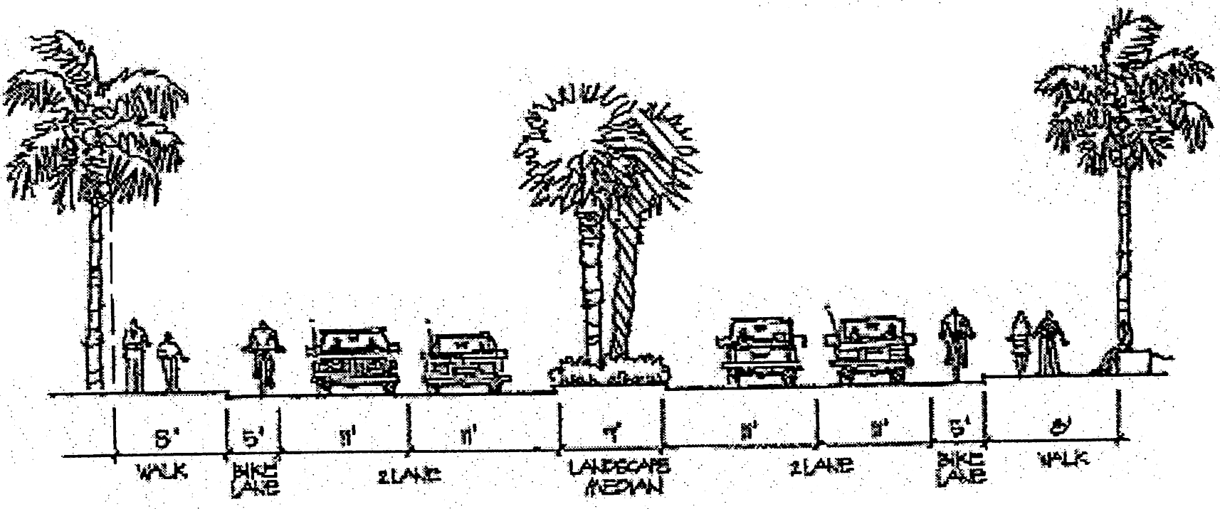
Type 'A' 4-Lane Primary Street (Section)
Bike lanes may be five (5) feet wide, if space is not available three (3) feet
minimum width is acceptable.
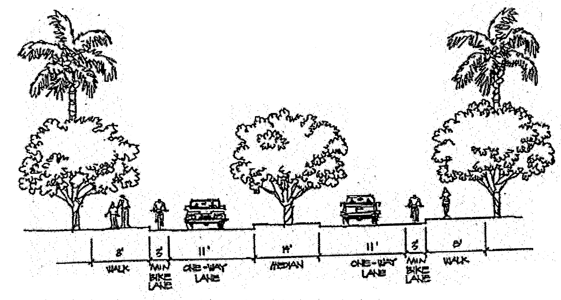
Type 'B' 2-Lane Primary Street (Section)
(2)
Secondary streets. Street width shall contain a minimum of two (2) lanes, one (1) in each direction, and each lane a minimum of eleven (11) feet.
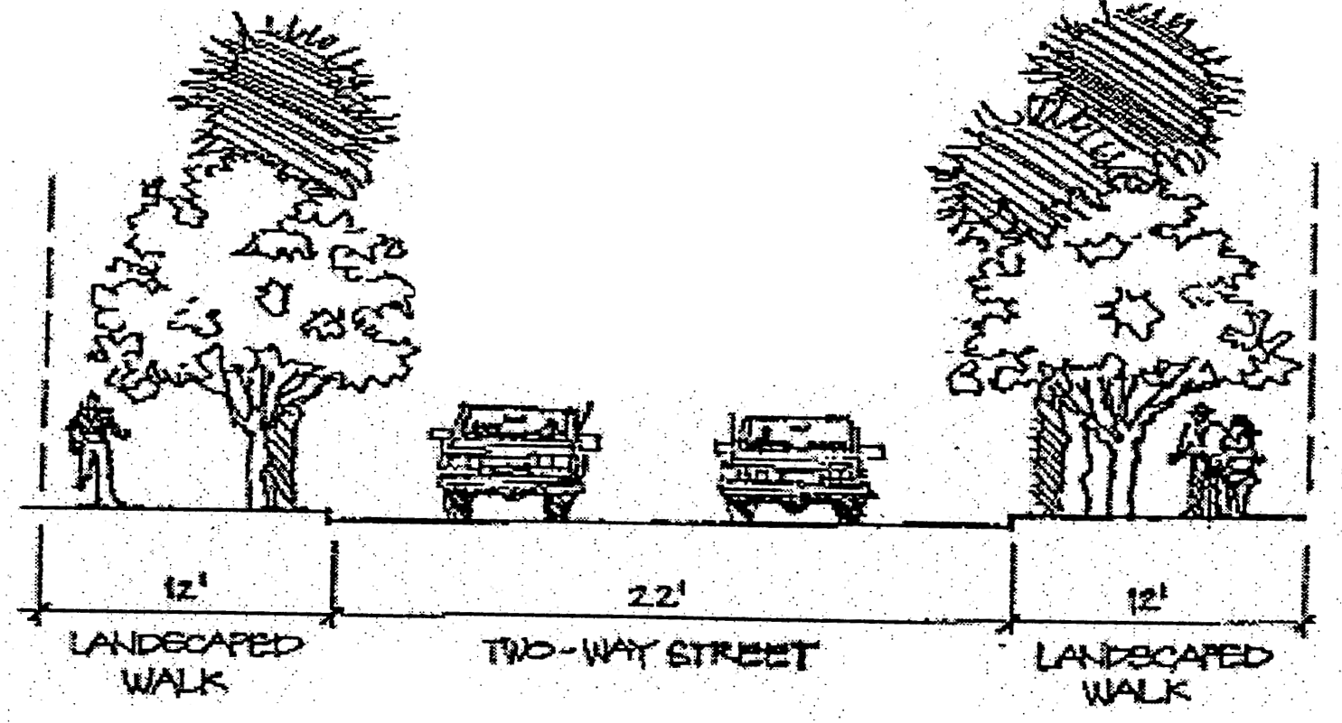
Secondary Street Section (Typical)
(3)
People streets. People streets that front restaurants and/or retail shall have a fifteen (15) foot minimum sidewalk width.
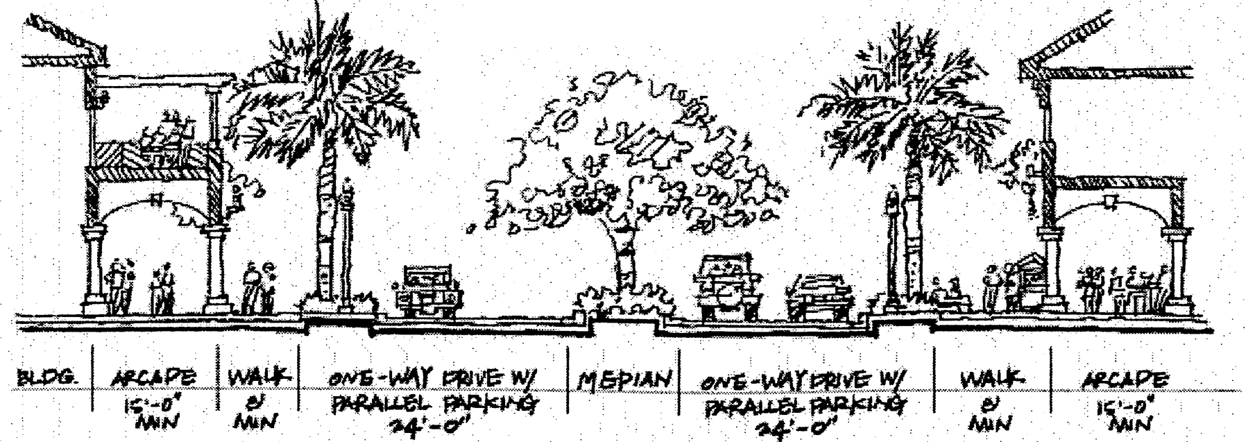
People Street Section (Typical)
(4)
Pedestrian ways shall be a minimum of six (6) feet.
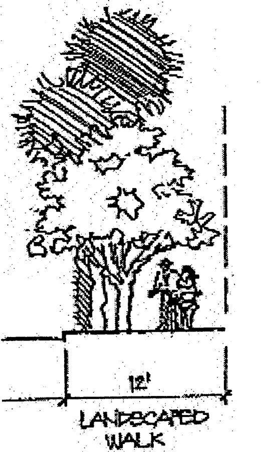
Pedestrian Way Section (Typical)
(5)
Bicycle ways. Bicycle lanes shall have a minimum five (5) foot striped and signed area, or a minimum width of three (3) feet in addition to any existing traffic lane.
(6)
Transit stops. Transit stops shall be placed approximately one hundred (100) feet from proposed parking structures or a major parking lot containing more than five hundred (500) spaces. Transit stops may use parking structures and bus shelters as landmarks.
(7)
Bus stops. The Town of Davie, NSU, SFEC, BCT shuttle/bus systems shall utilize the same intermodal "stop" facilities. Bus stops shall be provided along the major roadway at each designated intersection, arrival courtyard, and adjacent plaza or special location. If possible such stops along the outside of the loop may contain a small additional lane segment (minimum of ten (10) feet wide) separate and distinct from normal traffic lanes, to facilitate thru traffic flow while transit vehicles are stopped.
(8)
Parking. Given the unique and specialized nature of the RAC-AV District the applicant may provide alternate off-street parking and loading requirements that provide justification of the flexible standards for town consideration. Campus and town transit shall account for ten (10) percent of the overall means of transportation to the RAC-AV district and shall be subtracted from the overall number of spaces required throughout the RAC-AV District.
Off-Street Parking Requirements
* All other uses subject to review upon development application and annual report
(C)
Structured parking. Structured parking facilities are permissible within the district and may be designed with street level frontages consisting of habitable space on busy streets and treated with an architecturally articulated facade that screens the parking area of the structure on minor streets. Street level openings to parking structures may occur only on side streets and be minimized to accommodate necessary vehicle entrances and pedestrian access only.
(D)
For the purposes of calculating parking spaces, gross floor area shall not include:
(1)
Covered or enclosed parking areas.
(2)
Exterior unenclosed private balconies.
(3)
Floor space used for mechanical equipment for the building; and elevator shafts and stairwells at each floor.
(E)
Shared parking. The intent of shared parking is to permit a reduction in the total number of required parking spaces when a parcel is occupied by two (2) or more uses which typically do not experience peak parking demands at the same time.
(1)
Parking spaces serving uses possessing unique and widely divergent operating hours, such that one (1) use would not, in its day-to-day, operation have need of the parking spaces during the operating hours of the other use, may share those parking spaces with another use providing the area where the sharing occurs is not heavily impacted by a parking shortage and provided that:
(a)
A shared parking agreement is developed between property owners and the agreement is submitted to the development services for review prior to recording the in the public records of Broward County; and
(b)
A copy of the recorded shared parking agreement is transmitted to the P&Z manager prior to issuance of a certificate of occupancy.
(2)
When any land or building is used for two (2) or more uses, the minimum total number of required parking spaces shall be determined by the following procedures:
(a)
Multiply the minimum required parking for each individual use, excluding spaces reserved for use by specified individuals or classes of individuals, by the appropriate percentage listed in the appropriate table for each of the designated time periods. Add the resulting sum for each of the five (5) vertical columns of the table. The minimum parking requirement is the highest sum resulting from the foregoing calculation.
(b)
The maximum reduction under this provision shall be twenty-five (25) percent, unless a greater reduction is approved as a technical deviation.
Shared Parking Requirements
(3)
Unless designated for compact cars, each required parking space shall have a minimum width of nine (9) feet and a minimum length of eighteen (18) feet with a twenty-four (24) foot aisle for ninety (90) degree parking with appropriate adjustments to the aisle width for angle parking. Compact car spaces shall have a minimum width of eight (8) feet and a minimum length of sixteen (16) feet. No more than twenty-five (25) percent of all required parking spaces in parking structures and in surface or open air lots of more than fifty (50) spaces can be designed and designated for compact cars.
(F)
Parking stall dimensions.

Parking Stall Dimensions
(1)
The number of spaces required under the provisions of the above paragraph shall include the following requirements for parking spaces for handicapped persons:
(a)
All spaces for the handicapped shall have access to a curb-ramp or curb-cut when necessary to allow access to the building served. Each curb-ramp or curb-cut shall be located so that users will not be compelled to wheel behind parked vehicles, and shall be located the shortest possible distance between the parking area and the entrance to the principal building it serves. Each parking space for the handicapped shall be paved and installed in accordance with State Standards and the Manual on Uniform Traffic Control Devices and the Federal Department of Transportation, as may be amended from time to time.
(G)
All access roads shall intersect any frontage road at a minimum ninety (90) degree angle. When not possible, visibility will determine acceptance of the alternate intersection angle.
(Ord. No. 2004-001, § 4, 1-7-04; Ord. No. 2012-28, § 2(Exh. A)(§ 12-32.409), 12-5-12)
Sec. 12-437.10. - Open space.
(A)
RAC-AV District encourages open space. Parcels that are one-hundred (100) acres or more in size shall provide at least twenty-five (25) percent to open space.
(B)
Open space shall provide a continuous pedestrian linkage throughout the district as well as provide a connection to downtown Davie via the Town of Davie Trail System
(C)
Open space shall provide a wide variety of recreational opportunities and environments.
(Ord. No. 2004-001, § 4, 1-7-04; Ord. No. 2012-28, § 2(Exh. A)(§ 12-32.410), 12-5-12)
Sec. 12-437.11. - Grading drainage and retention.
(A)
Use separation. Development with the RAC-AV shall utilize grade changes to separate different uses.
(B)
Barrier free access. Slopes for wheelchair accessibility shall not exceed one (1) in twelve (12), with a length not to exceed thirty (30) feet.
(C)
Detention and retention basins. Retention basins may have a safety ledge extending six (6) feet from the edge of the water and at a depth of two and one-half (2½) feet. Maximum slopes to the water line of retention basins may be thirty (30) percent or 3:1.
(Ord. No. 2004-001, § 4, 1-7-04; Ord. No. 2012-28, § 2(Exh. A)(§ 12-32.411), 12-5-12)
Sec. 12-437.12. - Building design.
Buildings for all new constructions may be designed in accordance with a concept and theme throughout the RAC-AV. However, the building character in the university and school areas will differ from the mixed use area due to campus context.
(A)
Architectural design character. The university and school areas will juxtapose to campus greens, lush landscapes and courtyards spaces and in the mixed use area, the first floors of all buildings, including structured parking, may be designed to encourage pedestrian scale activity.
Any building which borders directly on high volume vehicular streets with in the mixed use area shall allow highly visible window facades to encourage stopping and shopping.
Any building which borders directly on high volume vehicular streets with in the mixed use area shall include step backs on upper levels in order to secure site lines to landmark elements.
Any building which border a single family residential use shall remain smaller in scale to ensure that daylight reaches the adjacent yards/properties.
(B)
Building site location. Building construction within the RAC-AV shall maximize energy efficiency and privacy and shall protect view corridors.
(C)
Massing. All buildings, which front University Drive, people streets, or other significant corridors within the RAC-AV district, shall be displayed as follows:
(1)
A minimum cornice height of twenty-five (25) feet, which may consist of a uniform alteration to the building massing for a minimum of four (4) feet perpendicular to the vertical surface.
(2)
Buildings which exceed thirty-five (35) feet in height shall maintain no more that three (3) stories without horizontal moderation in vertical surface plane. This moderation or expression line shall delineate where a building shall step back and shall assist in avoiding large continuous facades. This moderation may consist of a minimum four (4) foot horizontal variation in surface plane such as brise soleil, balconies, and building projections. Repetitive moderations may be discouraged.
(3)
All buildings shall have a minimum of three (3) planes of vertical separation.
(4)
The first thirty-five (35) feet of the exterior facade vertical plane may incorporate where possible; cornice, molding stringcourses, ornamentations, changes in material or color, and other sculpting of the architectural surface.
(5)
Pedestrian bridge between structures which pass over public right of way shall be permitted.
(D)
Building materials. In keeping with the image and intent of the RAC Academical Village District, certain building materials are more appropriate than others. Materials not listed below or new building materials, as they are developed or become available, will be given special consideration.
(1)
Roofing materials (Surfaces visible from the ground).
(a)
Permitted: Standing seam metal, clay tile, concrete tile.
(b)
Not permitted: Asphalt shingles, slate.
(2)
Siding materials.
(a)
Permitted: Precast concrete, stucco, metal, EIFS.
(b)
Not permitted: Wood siding, Hardi-plank.
(E)
Colors.
(1)
Colors may reflect existing palette of adjacent buildings. Color schemes shall be recommended for approval during the site plan approval process.
(Ord. No. 2004-001, § 4, 1-7-04; Ord. No. 2012-28, § 2(Exh. A)(§ 12-32.412), 12-5-12)
Sec. 12-437.13. - Site landscape.
The landscape treatment of the public sector must be consistent to provide a visual connection throughout the RAC-AV District. Plantings along public roadways, canals and other public corridors may provide a common framework. See Article VI for standard requirements.
(A)
Required plant material. See Town of Davie Code section 12-102.
(B)
Landscape themes. All unpaved areas shall be planted with an effective combination of trees, ground cover, lawn, shrubbery and/or approved dry landscape materials and mulches. All required landscaped areas, including landscaped areas within parking lots, shall consist of water efficient plant material. Landscaped areas containing trees and shrubs shall be under planted with ground cover, with the remaining areas to incorporate a minimum two (2) to three (3) inch layer of compost or mulch.
Sod incorporated into the landscape design shall be planted only in areas that do not exceed a slope of 4:1. Said sod shall be of a water efficient variety.
The plant material selected shall be suitable for the given soil and climate conditions. Plant selection shall take into consideration water conservation through appropriate use and groupings of plants that are well adapted to particular sites and to particular watering needs, climatic, geological or topographical conditions.
(C)
Street landscape. Street trees can be used to enhance the street by adding shade to the walks and roadways. Their presence can also assist in scaling down building mass and allowing street fronts to have a more pedestrian scale.
(1)
Tree grates may be installed around trunks where trees are planted within sidewalks or other paved pedestrian areas. They may be sized between a six (6) to eight (8) foot diameter.
(2)
Project street frontages are highly visible to both patrons and motorists. As the first design feature seen by people entering a project, street frontages establish the visual image for both the project and the streetscape. Because of these considerations, street frontage parkways shall be of ample width and generously landscaped. Landscape plans shall treat this parkway, including any portion within the public street right-of-way, as one (1) integrated greenbelt.
(3)
Parkway frontage landscape design may include sidewalks and/or bicycle-pedestrian ways, and planting consisting of trees, shrubs, and either grass (drought-resistant varieties) or groundcover. Frontage landscape treatment shall be of low height near project entries so as to preserve sight lines and ensure traffic safety.
(4)
A thirty (30) foot landscape buffer shall be required adjacent to FDOT arterial roads. See section 12-111(b)(5)(b).
(a)
Primary streets A and B. Formal palms shall be planted a maximum of thirty-five (35) feet oc and two feet six inches (2'6") minimum from the edge of the roadway along the entire loop road and main entry drives. All palms shall be installed at a minimum of ten (10) feet clear trunk.
(b)
Secondary streets. Clusters of palms, shade and accent trees shall border two (2) lane roads and be under planted with an effective combination of shrubs and groundcover. All trees shall be planted two feet six inches (2'6") minimum from the edge of the roadway. All plantings shall respect the traffic safety site line at intersections.
(c)
People streets. Palms shall be planted a maximum of thirty-five (35) feet oc and two feet six inches (2'6") minimum from edge of the roadway. The palms shall be under planted with small ground cover or annual color. The median shall be planted with shade trees thirty-five (35) feet oc and under planted with effective combination of shrubs and ground cover. All shade trees shall be installed at a minimum height of fourteen (14) to sixteen (16) feet. Sixty (60) percent of the median shall be landscaped. Sod will not be considered landscaping; only shrubs and ground cover are acceptable in calculating the sixty (60) percent.
(D)
Pedestrian area landscape. Landscape plans for any development involving pedestrian areas shall include additional special design requirements, including but not limited to, the following:
(1)
Use of small scale plant materials. Planting adjacent to walkways and within plazas and other pedestrian spaces may include smaller species of shrubs and trees in keeping with the intent to maintain an intimate human scale in these areas.
(2)
Landscaping amenities. Pedestrian spaces may be enhanced by planting accents such as trees, shrubs, and/or vines espaliered against wall surfaces, flower beds, window boxes, and hanging pots with flowers and vines.
(E)
Water front landscape. All planting surrounding existing and proposed water features may maintain an overall unity. The plant palette in these areas may consist of at least fifty (50) percent native waterscape plant material.
(1)
Seventy (70) percent of the total water edge LF shall be landscaped.
(2)
All planting shall not only serve as an attractive amenity to the water's edge but as a functional infiltration system for storm water runoff.
(F)
Parking lot landscape. A minimum of fifteen (15) percent of the net site area, with fifty (50) percent to be located within the parking areas, shall be landscaped as follows, unless otherwise specified in the code:
(1)
Where parking areas adjoin a public right-of-way, a landscaped planting strip equal in depth to the required setback or ten (10) feet, whichever is greater, shall be established and continuously maintained between the public right-of-way and parking areas. The minimum ten (10) foot landscaped area shall not be credited toward the fifteen (15) percent or the fifty (50) percent standards; however, any additional landscaping maybe credited. Any planting, sign, or other structure within safety sight-distance of a driveway shall not exceed twenty-four (24) inches in height.
(2)
Interior parking spaces shall have a continuous ten-foot wide planter strip with ten-foot by 18-foot planter areas every ten (10) parking spaces unless alternative provisions are approved. Provisions shall be made to ensure that adequate pedestrian paths are provided throughout the landscaped areas.
(3)
All parking areas facing a primary roadway shall consist of a maximum hedge of five (5) feet to screen parked cars from cars driving by.
(4)
All areas in a parking lot not used for driveways, maneuvering areas, parking spaces, or walks, shall be permanently landscaped with suitable materials and permanently maintained, pursuant to a program submitted by the applicant and approved by the town.
(5)
All landscaped islands shall be bordered by a concrete curb that is at least six (6) inches height and six (6) inches wide. All landscaped area shall be a minimum of six (6) feet width.
(6)
To increase the parking lot landscaped area, a maximum of two (2) feet of the parking stall depth may be landscaped in lieu of asphalt while maintaining the required parking dimensions. This overhang is in addition to the required yard setbacks.
(G)
Entry Ways. Landscape plans for any development involving corner parcels shall include additional special design requirements, including, but not limited to, the following:
(1)
A minimum landscape area of five hundred (500) square feet for each corner area adjacent to a major/secondary arterial street, and three hundred (300) square feet for each corner are adjacent to a collector street
(2)
Incorporate significant landscape and water features wherever appropriate.
(3)
Specimen trees shall be a minimum of eight (8) to ten (10) feet.
(4)
Ensure that any corner landscape plan within a "traffic safety sight area" shall be designed to protect public safety.
(H)
Tree Preservation. Tree preservation, removal and relocation shall be governed by article VI, division 3.
(I)
Planting Size and Densities. For all landscaped areas other than manufactured slopes over six (6) feet in height, landscape planting shall conform to the following minimum size and planting density standards:
(1)
Trees:
Minimum size: Shade trees—Fourteen (14) to sixteen (16) feet, accent trees—Eight (8) to ten (10) feet, palms ten (10) feet clear trunk.
Maximum spacing of shade trees in parkways, entry drives, street medians, parking lot planter strips, and project boundary strips: Thirty (30) feet; maximum of palms: Twenty-five (25) feet, maximum of accent trees: Fifteen (15) feet. Trees may be planted either in irregular clusters or at equal intervals.
(2)
Shrubs:
Minimum size: One (1) gallon minimum with at least thirty (30) percent to be five (5) gallon.
Maximum spacing: Average ten (10) feet.
(J)
Irrigation. All plantings will require irrigation systems providing one hundred (100) percent coverage throughout the RAC-AV District. Irrigation systems shall distribute a minimum of one and one-half (1½) inches of water per week during a maximum eight (8) hour watering cycle. All irrigation systems shall be completely automatic, and shall be equipped with rain gauges for water conservation.
Due to the intense pedestrian activity anticipated for the area, irrigation shall be designed to avoid over spraying pedestrian areas. Bubbler and mist heads shall be used to offer more control efficiency of water use. For confined planting area, emitter systems or underground drip systems shall be used.
Irrigation systems shall be designed to accommodate the specific water requirements of the various areas of the planting design. Areas with different water requirements shall be zoned separately.
Water distribution shall be designed to minimize overspray onto buildings and site structures as well.
(K)
Site Furnishing. Site furnishings may be compatible with their surroundings, and may maintain unity throughout the RAC-AV District.
(1)
Seating. Seating with RAC-AV District shall be design to discourage overnight sleeping. Seat walls shall be implemented at grade changes and to separate spaces.
(2)
Tree grates. Tree grates shall have barrier free access for wheelchairs and carriages.
(3)
Planters. Planters and flowerpots shall be used for landscape relief and to reduce or accent architectural mass.
(4)
Trash receptacles. Receptacles are to be to be sited only where they will be both accessible and used. They shall be placed along major pedestrian corridors, but shall not impede pedestrian traffic. They shall also be located at portals, pedestrian nodes, intersections, and seating areas. Trash receptacles shall not obstruct views or transmit unpleasant odors. Trash receptacles must be waterproof and shall contain a lid. Each receptacle shall have a sturdy removable liner for easy maintenance and be sized to accept standard trash bags. All transits stops or bus stops shall have at least one (1) trash receptacle.
(Ord. No. 2004-001, § 4, 1-7-04; Ord. No. 2012-28, § 2(Exh. A)(§ 12-32.413), 12-5-12; Ord. No. O2021-030, § 2(Exh. A), 11-3-21)
Sec. 12-437.14. - Signage.
Signage within the RAC-AV District shall be subject to Article VIII, Division 1, Signs, of the Town Code.
(Ord. No. 2004-001, § 4, 1-7-04; Ord. No. 2012-2, § 2(Exh. A), 1-18-12; Ord. No. 2012-28, § 2(Exh. A)(§ 12-32.414), 12-5-12)
Editor's note— Ord. No. 2012-2, § 2(Exh. A), adopted Jan. 18, 2012, changed the title of [former] § 12-32.414 from "signage and graphics" to "signage."
Sec. 12-437.15. - Lighting.
Lighting systems shall establish a sense of security and unity throughout the RAC-AV District over flow light is prohibited.
(A)
Scale, Proportion, and Hierarchy. The larger the scale of the use, the higher the mounting light shall be. The size of the fixture shall also be in proportion to the height of its pole to avoid awkward proportions.
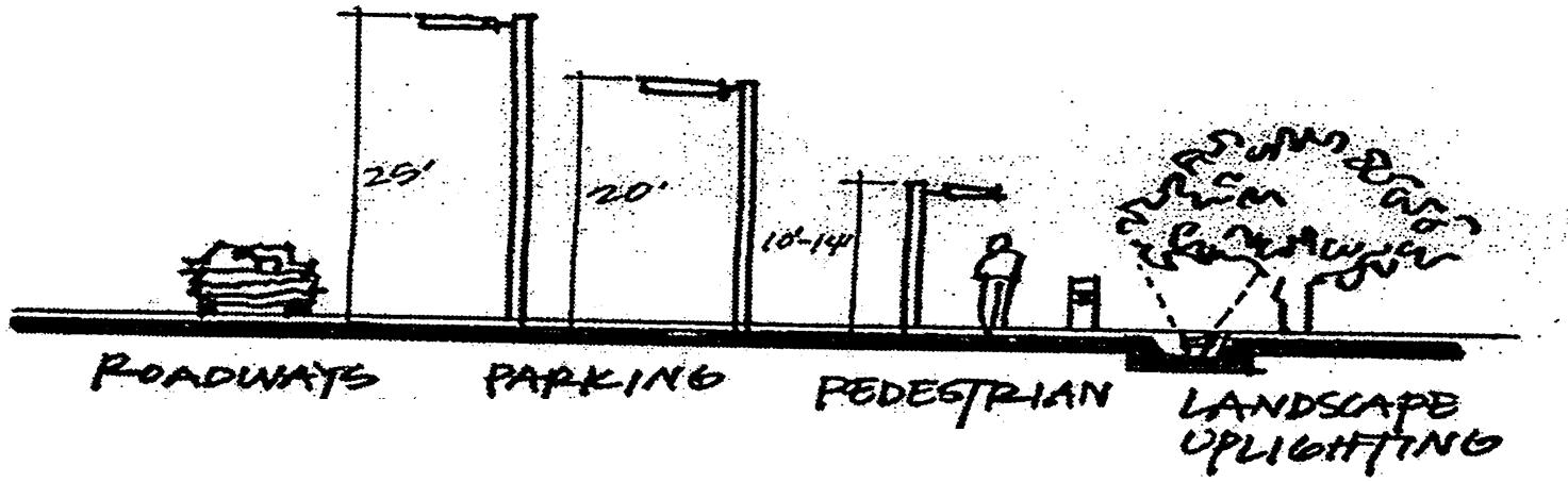
Lighting
(B)
Light Levels. The following minimum average maintained foot-candle levels shall be provided for the RAC-AV District:
1.
Approach roadways: 1.0 FC.
2.
Side streets: 0.8 FC.
3.
Parking lots: 1.0 FC.
4.
Promenades: 1.0 FC.
5.
Sidewalks: 0.6 FC.
6.
Landscape lighting (varies).
7.
Property line spill: 0.5 FC.
(C)
Light source. The following standards are included for selection of an appropriate light source:
(1)
High pressure sodium. Shall be used on all streets and parking lots and shall not be used areas of high pedestrian use.
(2)
Metal halide. Shall be used in high pedestrian area such as plazas and along people streets.
(3)
Color corrected mercury vapor. Shall only be used in low voltage situations where efficiency is not critical, or shall accent landscape material because of its ability to emphasize green foliage.
(4)
Incandescent. Shall only be used where regular maintenance is possible, such as building entries and small courtyards.
(D)
Light location. The placement of lighting throughout the RAC-AV District shall be designed as follows:
(1)
Streetscape lighting is required for primary and secondary streets.
(2)
All light poles shall be located a minimum of four (4) feet from the curb face and maintained plumb and secure. The placement of poles shall not create obstructions to pedestrian ways.
(3)
Fixtures along side streets shall be located approximately one hundred (100) feet on centers. All light poles shall be located a minimum of four (4) feet from the curb face and maintained plumb and secure. The placement of poles shall not create obstructions to pedestrian ways. Light poles on designated people streets shall be designated to permit specialty banners.
(4)
Parking lot lighting. Lighting in off-street parking lots shall be designed to allow safe and secure night use of these facilities.
(5)
Parking lot lights located interior to larger parking lots shall have a Type V (square) distribution to ensure maximum coverage and shall be spaced approximately one hundred twenty (+120) feet on centers.
(6)
Light poles shall not be located with in vehicular and pedestrian circulation aisles and parking stalls. They shall be located at regular spacing within the landscaped area of center or side islands and protected by curbs or wheel stops.
(7)
Light poles shall not be located with in vehicular and pedestrian circulation aisles and parking stalls. They shall be located at regular spacing within the landscaped area of center or side islands and protected by curbs or wheel stops.
(8)
Pedestrian lighting. Must establish a safe and secure atmosphere for nighttime use and provide a distinct ambiance, which differentiates pedestrian facilities from adjacent vehicular zones. The fixtures, poles and bollards must have a human scale and offer a visual appearance, which complements the other streetscape elements.
(9)
Landscape lighting. Shall not exceed between 0.5 and 1.0 ambient foot-candles.
(10)
Landscape accent lights shall be unobtrusive in appearance and/or hidden from view. All landscape lighting shall be placed where beams are directed away from pedestrians' viewpoint. Lights mounted directly in trees shall be discouraged unless means of attaching the fixture and conduit are sensitively handled to protect the plant's health and assure a pleasing appearance.
(Ord. No. 2004-001, § 4, 1-7-04; Ord. No. 2012-28, § 2(Exh. A)(§ 12-32.415), 12-5-12)
Sec. 12-437.16. - Processing.
(A)
An application to rezone property to RAC-AV shall proceed in accordance with sections 12-306 and 12-307.
(Ord. No. 2004-001, § 4, 1-7-04; Ord. No. 2012-28, § 2(Exh. A)(§ 12-32.416), 12-5-12)
Sec. 12-437.17. - Development within a RAC-AV District.
(A)
Development within a RAC-AV shall proceed in accordance with the Master Site Plan and Design Standards approved by the town council, which will be on file at the office of the town clerk. The Master Site Plan and Design Standards shall designate a mixed use, university and school area. No building permit or certificate of occupancy shall be issued in, or for development in a RAC-AV except in conformity with all provisions granting the RAC-AV.
(Ord. No. 2004-001, § 4, 1-7-04; Ord. No. 2012-28, § 2(Exh. A)(§ 12-32.417), 12-5-12)
Sec. 12-437.18. - Changes to the approved RAC-AV.
(A)
Any changes made to the approved Master Site Plan and the corresponding Design Standards will be approved by the development services department and submitted annually in accordance with section 12-437.19.
(B)
Should the department determine that a requested change or deviation from the approved Master Site Plan and corresponding Design Standards do not comply with the principles of the RAC-AV, or section 12-437.18(C), the applicant may appeal to the town council for approval of such change or deviation.
(C)
Notwithstanding any other provision in the Code, an amendment or modification to a structure, approved as a part of the Master Site Plan which alters the location or appearance of said structure by less than twenty (20) percent may be allowed without further review.
(D)
Upon review by the planning and zoning board for a deviation or change to the Master Site Plan and corresponding Design Standards, the planning and zoning board may take such action as deemed appropriate. This may include approving the requested change or deviation, or referring the requested change or deviation to the town council for further study and recommendation.
(Ord. No. 2004-001, § 4, 1-7-04; Ord. No. 2012-28, § 2(Exh. A)(§ 12-32.418), 12-5-12)
Sec. 12-437.19. - Annual report.
The owner(s) of property within a RAC-AV shall submit an annual report to the director of development services. The first annual report shall be submitted one (1) year after the effective date of the ordinance, and on that same date every year thereafter until development under the Master Site Plan is complete. The annual report shall include the following information:
(A)
Any changes to the Master Site Plan or Design Standards;
(B)
An outline of the development activity begun and concluded in the reporting year.
(Ord. No. 2004-001, § 4, 1-7-04; Ord. No. 2012-28, § 2(Exh. A)(§ 12-32.419), 12-5-12)
Sec. 12-438.- "RAC" Regional Activity Center Districts.
(RAC-AV: Regional Activity Center-Academical Village District, which applies to the Nova University Campus is self contained within Division 10. None of the provisions of this Division apply to the RAC-AV.)
(Ord. of 2-6-08, § 1(Exh. A); Ord. No. 2012-28, § 2(Exh. A)(§ 12-32.500), 12-5-12)
Sec. 12-438.1. - Introduction.
In 1998 the Town of Davie enacted a Regional Activity Center land use category for the east side of the Town of Davie, generally bordered by University Drive, I-595, Florida's Turnpike, and the C-11 Canal adjacent to Griffin Road. The total area designated Regional Activity Center on the land use plan map exceeds two thousand two hundred (2,200) acres, of which more than seven hundred fifty (750) acres are part of the South Florida Education Center (SFEC). The SFEC is a collection of educational institutions located in proximity to one another, and sometimes sharing campus space. The purpose of creating the Regional Activity Center land use plan designation was to enable the town to comprehensively plan for the area as one (1) mixed-use unit, thereby coordinating land use with transit opportunities, and capitalizing on the potential of the SFEC to grow, creating spin-off research and product development, as well as housing opportunities in areas designated for redevelopment, both of which would contribute to the economic feasibility of redeveloping Downtown Davie.
Several years later, the Metropolitan Planning Organization (MPO), working with the Federal Transit Administration (FTA) and Florida Department of Transportation (FDOT) began planning the preliminary design for east-west rapid transit along the Interstate 595 corridor. The SFEC was seen as a major contributor to potential ridership. The Town of Davie subsequently contracted with a multi-disciplinary team to complete a year-long master plan study of the entire Regional Activity Center. The master plan targets urban-scale redevelopment of community and regional significance that is keyed to a long-term mass transit strategy of developing transit corridors, peripheral parking facilities and greenways that are coordinated with a proposed Central Broward east-west transit station location at the northern terminus of College Avenue.
The master plan, adopted in 2006 by the town, serves as a blueprint for creating an eastern mixed-use village premised upon the unique collaborative opportunities for redevelopment and economic development related to the SFEC as a resource, and transit and other modes of mobility as the other vital component that would facilitate the area known as the Regional Activity Center in fulfilling its land use designation as a "redevelopment of regional significance."
These land development regulations and design standards are intended to implement the adopted master plan. The entire report on these phases of work can be found on record with the Town of Davie.
(Ord. of 2-6-08, § 1(Exh. A); Ord. No. 2012-28, § 2(Exh. A)(§ 12-32.501), 12-5-12)
Sec. 12-438.2. - Terminology and abbreviations.
Definitions of terms unique to the "RAC" Regional Activity Center zoning districts are defined in section 12-438.27. A few key terms and abbreviations necessary for understanding the totality of the RAC Districts regulations are defined in this section.
(A)
The term "RAC Districts" shall mean Davie Regional Activity Center zoning districts.
(B)
The terms "These Regulations" and "This Division" shall mean the Regulations of Subdivision 12-500 of the Unified Land Development Code, Chapter 12.
(C)
The term "Master Plan" refers to the Regional Activity Center Master Plan adopted by the town council.
(D)
The abbreviation "BTL" shall mean Build-To-Line.
(E)
The abbreviation "TOD" shall mean Transit-Oriented Development.
(F)
The abbreviation "SFEC" shall mean South Florida Education Center, comprised of four (4) universities, a vocational and technical school, and public magnet grade school.
(G)
The abbreviation "DU/AC" shall mean Dwelling Units per (gross) Acre.
(H)
The abbreviation "SFR" shall mean detached Single-Family Residence.
(I)
The abbreviation "R&D" shall mean Research and Product Development.
(J)
The abbreviation "GFA" shall mean Gross Floor Area.
(Ord. of 2-6-08, § 1(Exh. A); Ord. No. 2012-28, § 2(Exh. A)(§ 12-32.502), 12-5-12)
Sec. 12-438.3. - Intent/purpose.
The intent of the RAC districts is to provide for the redevelopment of a multi-modal, pedestrian-friendly, and thoroughly interconnected mixed-use village that encourages significant regional redevelopment. The districts have an opportunity to integrate the unique educational culture of the SFEC to create an unparalleled location to live, work, and play. The RAC districts promote the development of a pedestrian and transit-oriented, mixed-use community through the vertical mixing of uses, transit-supportive intensities, and the shaping of urban form.
In order to account for the large scale and varying conditions of the RAC districts, it is imperative that priorities and flexibility be built into regulating the redevelopment of the area. Understanding the intent for each district is important as redevelopment occurs. Therefore the principles that implement the intent for each district are listed for review. Flexibility has been built into the regulations in the form of the design adjustment process (see section 12-438.23). The principles listed throughout these regulations serve as performance criteria used to evaluate site plans, permits and requests for design adjustment.
It is the intent of these regulations to encourage (re)development by providing certainty and predictability in the development review process through clear and certain direction as to the desired development outcome.
The adopted RAC Master Plan established several objectives that the RAC district regulations are intended to implement, as follows. It is important that these regulations be evaluated periodically to ensure that all necessary steps are being taken to implement the RAC Master Plan.
Transit-Oriented Development
(A)
A park-once philosophy; shared private/public structured (or interim surface) parking is encouraged at strategic locations with connecting shuttle service.
(B)
Achieve a reduction in roadway congestion through the above-referenced peripheral shared parking opportunities, as well as convenient and enticing pedestrian ways, and convenient transit service.
(C)
Establish on-street parking throughout the RAC districts in order that a larger proportion of private property can be developed through reduced reliance on off-street parking; and to enhance the walkability of streets by slowing the speed of traffic and buffering sidewalks from vehicular traffic.
(D)
Establish a core area of regional transit-supportive uses and intensity. Transit-Oriented Development shall be a key component.
(E)
Strongly encourage buildout to the highest permissible density and intensity within one-half (½) mile of the proposed east-west regional transit station at the College Avenue and SR 84 intersection.
Open Space and Connectivity
(F)
Encourage the provision of area-wide water retention via curvilinear canals and water bodies with adjacent pedestrian ways to transform surface drainage features into greenways. Where area-wide drainage infrastructure is not available, encourage the use of underground stormwater vaults for retention.
(G)
Gradually create a systematic and interconnected open/public space component that serves the functions of greenspace relief from an urban environment, recreation and a conduit for pedestrian and bicycle travel.
(H)
Achieve a street network that offers alternative routes via parallel streets.
(I)
Encourage a variety of pedestrian, bicycle, and vehicular routes that provide appropriate connections to surrounding roadways.
(J)
Provide pedestrian and bicycle amenities to encourage these modes of mobility.
Establish Regionally Significant Uses with Links to SFEC
(K)
Provide flexibility in the permitted uses of land while not precluding re-use for the primary intended uses, nor precluding infill of urban intensity. Examples include allowing several uses within a building that is designed to ultimately house a research and product development use, or future ground floor retail that may not be supported by current market conditions.
(L)
Whenever a site is developed at a relatively low intensity relative to the maximum permitted intensity, the site and improvements thereon should be designed and constructed to enable buildout of the site at the maximum allowable intensity at some future time without the need for substantial demolition. Known as "beginning with the end in mind," this approach may, for example, involve designing and constructing buildings to accommodate vertical expansion and designing surface parking lots to eventually accommodate a parking structure.
Housing and Residential Density
(M)
Allow and encourage a variety of housing types and price points through varying maximum densities, creative dwelling configurations, mixing of uses, incentives, and accessory dwellings.
(N)
To the extent that comprehensive plan density and RAC future land use plan category provisions permit, the number of dwelling units that can be constructed on a lot shall be governed by building and site design, and not a maximum density calculation.
Urban Form
(O)
Encourage visual interest by ensuring the building and visual landscapes are accented rather than their parking facilities.
(P)
Bring buildings to the roadway, ensure proper proportioning and require continuous building facades to "enclose" designated streets in order to help create a lively and visually appealing environment that invites people to live, locate businesses, and spend time shopping, dining and interacting with others.
(Q)
Require the location of on-site parking facilities in the rear yard, accessed when possible through rear alleys or side streets.
(R)
Provide for public amenities and pedestrian conveniences.
(Ord. of 2-6-08, § 1(Exh. A); Ord. No. 2012-28, § 2(Exh. A)(§ 12-32.503), 12-5-12; Ord. No. O2023-019, § 2(Exh. A), 12-6-23)
Sec. 12-438.4. - Applicability.
(A)
The regulations and intent statements contained herein together comprise a policy blueprint for development.
(B)
The RAC districts together encompass all land designated RAC on the future land use plan map, except for the following areas: land zoned "RAC-AV" Academical Village (See division 10); land south of the RAC-AV situated between University Drive and SW 76 th Avenue; land south of the C-11 Canal; the Eastside Neighborhood Special Zoning District; and, the Lauderdale Little Ranches and Lauderdale Little Ranches 1st Addition subdivisions recorded in Plat Book 21, Pages 23 and 28 respectively of the Broward County Public Records, and located adjacent to, and east of, the Florida Turnpike, and north of Orange Drive.
(C)
In case of conflict with any other regulation of chapter 12, "Land Development Code," this division shall take precedence. The RAC district regulations shall specifically prevail over any other regulations of chapter 12 pertaining to uses, site development and intensity standards, building size or scale, district performance standards, dimensions, area, separation, coverage, yards, open space, and frontage.
(D)
In the case of conflict with any court-ordered settlement agreement or F.S. Ch. 1013 campus master plan adopted prior to the adoption of these regulations, the settlement agreement or campus master plan shall prevail to the extent provided therein or by applicable law. It is anticipated, however, that campus master plans will be amended consistent with these regulations, to the extent possible, no later than the next required update.
(E)
Uses of land which were originally established within the M-3 (Hacienda Village) zoning district prior to February 6, 2008, shall not be considered in conflict with these RAC regulations (division 11) and may continue to operate and expand pursuant to the M-3 (Hacienda Village) zoning requirements until February 6, 2038. This paragraph is not intended to prohibit any landowner from voluntarily complying with the RAC regulations at any time.
(F)
All RAC districts are subject to provisions of the future land use element of the comprehensive plan, which establishes a maximum number of dwelling units and nonresidential area that can be constructed within a district. Therefore, while any given property within a RAC district can be developed to an intensity specified in these regulations in the form of stories and height, the ability of development on any given parcel to reach its maximum allowable intensity hereunder is subject to the availability of dwelling units and/or nonresidential floor area within the Regional Activity Center land use plan designation, as specified in the future land use element. However, each conforming property is entitled to the level of development authorized by the town's zoning and land development regulations prior to the establishment of the RAC districts. Additional development allowance shall be allocated on a first-come, first-serve basis.
(G)
All new development and redevelopment within the RAC districts shall be consistent with the principles, intent and requirements of these regulations, except as provided in section 12-438.16, "Nonconformities."
(Ord. of 2-6-08, § 1(Exh. A); Ord. No. 2012-28, § 2(Exh. A)(§ 12-32.504), 12-5-12; Ord. No. O2023-019, § 2(Exh. A), 12-6-23)
Sec. 12-438.5. - Transit-oriented streets.
(A)
Principles.
(1)
Transit-oriented streets are mixed-use arterial or collector thoroughfares, with designated transit lanes in most cases, wide sidewalks, and buildings placed close to the street and built to the side lot lines in order to provide a sense of enclosure to the street corridor.
(2)
Transit-oriented streets are primarily located within a five (5) minute walk from existing or planned regional transit stops, the South Florida Education Center or downtown Davie.
(3)
Transit-oriented development is encouraged along these streets in order that a sufficient mix and intensity of uses exists to support transit use and minimize the need for private automobile travel for those working, shopping, getting an education, and/or living on or near such a street.
(4)
Retail, restaurant, and entertainment uses are encouraged on the ground floor, but are not required. Residential development on upper floors is encouraged.
(5)
The mix of these uses is needed to ignite a vibrant street experience and offer a mix in shopping destinations.
(6)
Buildings along transit-oriented streets should be architecturally interesting.
(7)
Transit-oriented streets should be framed by urban blocks. The characteristics of urban blocks are identified in section 12-438.8, "Components of Place; Streets and Blocks."
(8)
The intersection of SW 30th Street and University Drive is located directly on the trunk line transit network, and should be considered an Urban Transit-Oriented Node. Additional planning and urban design should occur for this area to ensure an efficient location of the transit stop, park and ride facilities, center of activity, residential areas, secondary areas, and new connectors and local streets where necessary.
(9)
The following intersections are located on a local feeder bus line within ten (10) minutes travel time from a trunk transit line. Additional planning and urban design should occur for the area around these intersections to ensure an efficient location of the transit stop, park and ride facilities where applicable, center of activity, residential areas, secondary areas, and new connectors and local streets where necessary.
a.
Nova Drive and College Avenue.
b.
Davie Road and Oakes Road (future).
c.
Davie Road and Orange Drive.
(B)
Requirements.
(1)
The following are transit-oriented streets:
• Davie Road, from Orange Drive to Oakes Road (future)
• Davie Road, from SW 30th Street to SR 84
• College Avenue south of Nova Drive
• Nova Drive
• SW 30th Street
• Orange Drive, from SW 67 th Avenue to Davie Road.
(2)
Transit-oriented streets are treated differently than other streets in that building frontage on such streets shall be structurally designed to accommodate first-story nonresidential use through a minimum floor-to-ceiling ground floor height, and must contain at least two (2) stories. Additionally, buildings that will have at least fifty (50) percent of their street frontage situated within four hundred (400) feet of the center of the intersection of any two (2) transit-oriented streets are required to have a minimum of two (2) use types as classified on Table 12-438.7(C) (ex: retail and office, retail and residential, etc.). Ground floor street frontage on all transit-oriented streets shall consist of retail-conducive storefronts incorporating features such as frequent entries, attractive signage, and display windows to enhance the pedestrian experience.
(3)
Table 12-438.7(C), "Table of Permitted Uses," Table 12-438.9(E), "Intensity of Use Standards," and Table 12-438.10(C), "Site Development Standards" regulate developments fronting transit-oriented streets separately from development within the same zoning district but not fronting a transit-oriented street. For example, a property fronting Nova Drive, a transit-oriented street, is regulated in the listed tables under the column "Transit-Oriented Street" and not under the columns "RAC-ED" or RAC-RTW districts.
(A)
Where a Transit-Oriented Street regulation pertains to a building (ex: use, height, and all site development standards within Table 12-438.10(C), or a lot (ex: use and open space), such regulation shall control over the corresponding zoning district regulations for the entirety of the building and lot with frontage on the transit-oriented street, except as provided in (B), below.
(B)
It is the intent of these regulations that lots fronting transit-oriented streets be part of urban blocks as characterized in section 12-438.8, "Components of Place; Streets and Blocks." However, this urban block requirement as it applies to lot and block depth is not mandatory in the RAC-ED, RAC-RTW and RAC-RTE districts, which contain some large parcels in excess of one hundred (100) acres, and which may or may not be subdivided into numerous smaller frontage blocks and lots. To the extent that the transit-oriented street frontage of very large parcels is not divided into blocks consistent with the dimensions in section 12-438.8 (for example, a fifty-acre campus-type development with only one (1) access road onto a transit-oriented street), the regulations applicable to development fronting transit-oriented streets shall be applied to each entire block fronting a transit-oriented street or the first six hundred (600) feet of lot depth (a basic block depth dimension) measured inward from the street line of the transit-oriented street, whichever distance is less.
(Ord. of 2-6-08, § 1(Exh. A); Ord. No. 2010-021, § 2, 9-7-10; Ord. No. 2012-28, § 2(Exh. A)(§ 12-32.505), 12-5-12; Ord. No. 2014-23, § 2(Exh. A), 12-2-14; Ord. No. O2023-019, § 2(Exh. A), 12-6-23)
Sec. 12-438.6. - RAC districts; intent and requirements.
The intended form and character for each of the six (6) RAC zoning districts is described in this section through narratives, illustrations, and images. Principles vs. requirements for the developer to adhere to are clearly identified.
(A)
Davie Regional Research and High Tech District West District (RAC-RTW).
(1)
General Boundaries. North: SR 84; south: Nova Drive from Davie Road to College Avenue, and approximately three hundred (300) feet south of Nova Drive west of College Avenue; east: Davie Road; west: SW 71 st Terrace.
(2)
District Intent and Character. It is the intent of this district to promote regionally significant development that includes research and product development (R&D) facilities that compliment the education and research institutions of the SFEC and offer the possibility of adaptive reuse of existing warehouse buildings.
New developments must be sensitive to the existing cemetery. Key multi-modal connections along College Avenue and Davie Road are vital to the overall success of this district. The potential for regional east-west transit along Interstate 595 calls for high-intensity residential and employment development, and public parking facilities to serve the entire Regional Activity Center, proximate to this potential transit alignment, centered near the northern terminus of College Avenue at SR 84.
(3)
Development Pattern. It is the intent of this district that the existing street network of north-south and east-west streets be maintained and enhanced by infilling the existing "superblocks" (see Figure 506-2 below) with additional streets created as the area redevelops over time. A master street plan should be developed that determines approximately where new and extended streets should occur to substantially improve east-west connectivity within this district, and where mid-block alleys are feasible and should be provided.
It is further intended that buildings will be placed close to, and oriented towards, perimeter streets in order to contribute to pedestrian activity on the streets and the attendant viability of retail and service establishments. Accordingly, parking should be internalized within a block, behind the buildings.
Given the existing superblock pattern, it is expected that some blocks will continue to exceed the ideal dimensions identified in section 12-438.8, "Components of place; streets and blocks" after dedications are made. Within superblocks, it is permissible for there to be considerable internal building orientation provided that: perimeter buildings must still engage edge/perimeter streets; that parking is located behind the buildings; and, that pedestrian connections within and external to the development are provided. Figure 506-2 below illustrates the superblock pattern that consists of large blocks with a considerable number of internal buildings, oriented to parking facilities. The superblock is contrasted in the graphic with a basic urban block representative of a future condition in the RAC-TC District, where all buildings front and engage the street, and rear access is often provided via alleys for parking and loading functions.
The only Auto-Oriented street is SR 84, which is characterized by high speeds and few traffic lights. In contrast to the remainder of the district, properties fronting SR 84 are required to provide a landscaped separation from the roadway.
(4)
Principles and Objectives.
(a)
Shared structured parking proximate to the proposed I-595 and College Avenue transit station with connecting shuttle service.
(b)
The College Avenue, Davie Road and Nova Drive corridors should support and compliment the functions of the SFEC by providing residential opportunities and supporting retail and service opportunities.
(c)
Re-use or redevelopment of industrial parcels for R&D, technology businesses and other university support uses, as well as residences and neighborhood services.
(5)
Requirements.
(a)
Permitted uses for this district can be found in Table 12-438.7(C).
(b)
Intensity standards for this district can be found in Table 12.438.9(E).
(c)
Site development standards can be found in Table 12-438.10(C).
(d)
Building frontage regulations can be found in section 12-438.11.
(B)
Davie Regional Research and High Tech District East District (RAC-RTE).
(1)
General Boundaries. SR 84 to the north, the Oakes Road alignment to the south, Florida's Turnpike to the east, and Davie Road to the west.
(2)
District Intent and Character. High potential for immediate development is the focus for this district. It is the intent of this district to promote regionally significant development that includes large-scale commercial development, and R&D that is complimentary to the educational and research institutions of the SFEC.
More than one hundred (100) acres of lake can potentially be filled and developed. It is recognized that commercial or R&D use of these properties will likely serve as a catalyst for urban infill and redevelopment of the RAC. Mixing of retail and office uses with residential is encouraged.
(3)
Development Pattern. There is no established street pattern within this district, which is comprised of large parcels and water. The regulations governing development within this district allow for flexible use of land, provided that key multi-modal connections are provided as shown on the adopted RAC master plan, consisting of the proposed Oakes Road extension west over Florida's Turnpike to Davie Road, and the extension of Reese Road south to Oakes Road. The master plan also encourages the creation of an additional east-west corridor in the vicinity of Nova Drive or to its north, that will connect Davie Road with Reese Road.
Reese Road is considered an auto-oriented street where it parallels 84 and Florida's Turnpike.
(4)
Principles and Objectives.
(a)
Development of well-planned, large-scale commercial, office, entertainment, lodging, R&D, and technology uses, with a residential component.
(b)
Catalyzing redevelopment of Davie's Regional Activity Center, and serving as a major draw of people to the area.
(c)
Provide additional tax base for the town in an appropriate location.
(5)
Requirements.
(a)
Permitted uses for this district can be found in Table 12-438.7(C).
(b)
Intensity standards for this district can be found in Table 12-438.9(E).
(c)
Site development standards can be found in Table 12-438.10(C).
(d)
Building frontage regulations can be found in section 12-438.11.
(C)
South Florida Education District (RAC-ED).
(1)
General Boundaries. North: approximately 300 feet south of Nova Drive; south: S.W. 39 th Street; east: Davie Road; and, west: College Avenue in the southern portion of the RAC-ED, and the southerly extension of SW 71 Terrace in the northern portion of the RAC-ED, encompassing the University of Florida agricultural field station.
(2)
District Intent and Character. This district is unique to the others in that it is primarily occupied by educational entities including: Broward County School District; Broward County Community College; Florida Atlantic University; University of Florida IFAS; Mc Fatter Vocational Center; and, Nova Southeastern University. Together, these schools are known as the South Florida Education Center (SFEC).
The focus of this district is to reduce vehicular impact on area roads as well as maximize land available for educational purposes. For the car to no longer dominate the landscape on these campuses, mobility alternatives must be provided, and parking should be centralized and structured, with connections to transit. Surface lots should be infilled with shared parking garages and education facilities. Strong multi-modal connections throughout the campuses are also vital along College Drive and Davie Road. Key pedestrian connections to the library and performing arts center centrally located in the district are encouraged.
(3)
Development Pattern. The district is mainly comprised of educational campuses, characterized by a minimal number of roadways and general lack of interconnectivity, but also characterized as relatively cohesive and master planned developments on large parcels with focal and centralized open spaces and a pedestrian network that can be further enhanced. The campuses are characterized by outlying, on-site parking facilities with a park-once philosophy.
It is the intent of this district to further develop the park-once philosophy by locating the parking off-campus proximate to the proposed east-west regional transit along the Interstate 595 corridor, with connecting north-south local transit. Achievement of this objective has the potential to reduce traffic congestion in and around the campuses, and to increase developable land on the campuses by reducing the amount of campus space that is occupied or planned for parking facilities.
(4)
Principles and Objectives.
(a)
Reduction of surface parking, replaced by structured parking and new buildings with ground floor retail and service uses oriented towards College Avenue and Nova Drive.
(b)
Off-campus parking on the perimeter of the RAC with transit connections to the SFEC campuses.
(c)
The College Avenue, Davie Road and Nova Drive corridors should support and compliment the functions of the SFEC by providing residential opportunities and supporting retail and service opportunities. For this to occur, the colleges would need to eliminate much of the existing surface parking along College Avenue and replace it with structured parking and intervening buildings that front College Avenue.
(5)
Requirements.
(a)
Permitted uses for this district can be found in Table 12-438.7(C).
(b)
Intensity standards for this district can be found in Table 12-438.9(E).
(c)
Site development standards can be found in Table 12-438.10(C).
(d)
Building frontage regulations can be found in section 12-438.11.
(D)
Davie Town Center District (RAC-TC).
(1)
General Boundaries. S.W. 39 th Street and its easterly extension to the north, the C-11 Canal to the south, SW 61 st Avenue to the east, and the RAC boundary to the west.
(2)
District Intent and Character. Located in the southern portion of the RAC, this district is also known as Downtown Davie, and is located within the Community Redevelopment Area. A portion of the RAC-TC District is governed by the Western Theme Overlay District Development Manual architectural and signage standards, which in the case of conflict take precedence over the architectural and signage standards and guidelines of this Division within Western Theme Overlay District. The district's focus will be on-street life and the civic center of the town. Town Hall and the Rodeo Grounds will anchor the area west of Davie Road. East of Davie Road, the area will be allowed to develop organically, with few constraints as to the location of use types, as a true mixed-use neighborhood including retail, office, service, lodging, and residential uses. These uses may occur in any compatible combination that complies with standards and regulations of this Division. Town Hall and Rodeo Grounds improvements, as well as a renewed commitment to the street will drive redevelopment renewed vibrancy in this district.
(3)
Development Pattern. The existing street pattern is a semi-urban grid variation. A true urban grid pattern has north-south and east-west streets at regular and closely-spaced intervals. Missing street segments and new streets shown on the Downtown Davie Master Plan or subsequent plans for the area, should be infilled for better mobility.
(4)
Principles and Objectives.
(a)
Water retention handled in underground storage vaults and through pervious green space.
(b)
The RAC-TC is envisioned as a mixed-use village.
(c)
Centralized parking facilities to reduce on-site parking reliance.
(5)
Requirements.
For areas designated Western Theme Overlay District:
(a)
The Western Theme Development Manual shall control architecture and signage.
For all other areas of the RAC-TC District:
(b)
Permitted uses for this district can be found in Table 12-438.7(C).
(c)
Intensity standards for this district can be found in Table 12.438.9(E).
(d)
Site development standards can be found in Table 12-438.10(C).
(e)
Building frontage regulations can be found in section 12-438.11.
(E)
Davie Downtown Neighborhood District, Low-Density (RAC-ND-2).
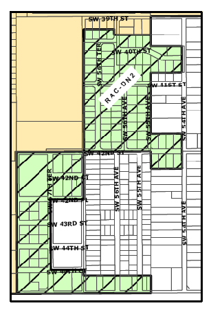
Figure 506-3. RAC-DN2 District
(1)
General Boundary Description. Generally located north of Orange Drive, south of SW 39 th Street, east of SW 59 th Avenue and west of SW 54 th Avenue.
(2)
District Intent and Character. This residential district has the opportunity to serve the entire RAC with a diverse offering of housing types and price points. The existing single-family residential character must be preserved in order to serve as a transition to an adjacent single-family detached neighborhood outside of the RAC zoning districts. A mix of single family detached homes, townhouses, and duplex and multiple-family dwellings designed to simulate single-family detached dwellings, will provide a compatible variety of housing types and price points (see "Principles and Objectives" "(c)" below. Pocket parks and safe walkable streets are encouraged to fulfill the ultimate possibility for this district.
(3)
Development Pattern. The existing street network is a modified grid characterized by missing street segments and large water body interruptions to the grid. The network should be modified where possible to most closely approach an urban grid pattern for improved mobility within the neighborhood.
(4)
Principles and Objectives.
(a)
Establish on-street parking and rear alleys serving rear-yard parking where possible to create more walkable streets.
(b)
New and remodeled dwellings should be located closer to the street, and utilize front porch design.
(c)
The focus of redevelopment should be to maintain the single-family character of the neighborhood but to allow higher densities in the form of duplexes, townhomes, and even multiple-family structures, provided the building design and architectural characteristics are consistent with those of either attached or detached single-family homes, including but not limited to scale, mass, proportions, strategic use of entryways, roof design, and facade design and articulation. The illustrations that follow demonstrate the use of one (1) exterior entrance to serve two (2) or more dwelling units from an interior foyer. The first two (2) illustrations appear to be single-family detached dwellings because of both the internalization of some unit entrances and a single cohesive building design that lacks the repeating elements that would visually identify each dwelling unit within the building as is typically seen in duplexes and townhomes.
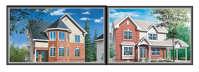
Figure 506-4
Figure 506-4. These buildings each contain three (3) dwelling units but appear to be one (1) single-family detached unit. These illustrations are not intended to depict the architectural theme of the RAC districts.
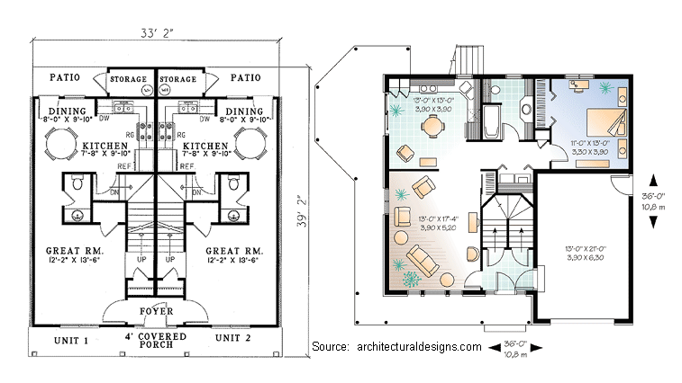
Figure 506-5
Figure 506-5. These floorplans illustrate the internalization of individual unit access. The bottom of each image represents the front facade and main entrance to each building.
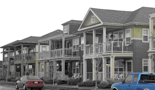
Figure 506-6
Figure 506-6. Flat-on flats consistent with single-family residential character.
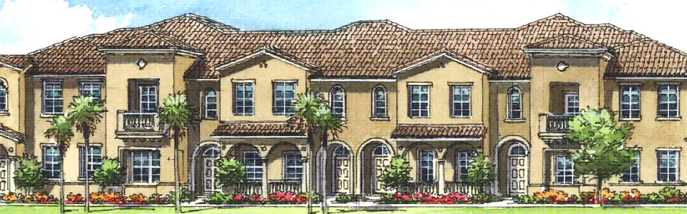
Figure 506-7
Figure 506-7. This building appears to be a single-family attached dwelling (townhomes) but actually contains stacked flats through the use of some internalized unit entrances.
(d)
Accessory dwelling units to single-family detached homes are permitted and encouraged where the accessory unit is located within the single-family dwelling, or where rear alley access exists to service detached accessory units. Detached accessory dwellings are most feasible when the principal single-family building is situated close to the street, thus providing adequate rear yard area for the accessory dwelling.
(e)
Allow the establishment of one (1) to two (2) neighborhood commercial concentrations by special permit, consisting of no more than a few acres to serve the immediate retail and service needs of nearby residents. Parking provision should be minimal, and mixed-use structures with residences on the second story are encouraged, including live/work units.
(5)
Requirements.
(a)
Permitted uses for this district can be found in Table 12-438.7(C).
(b)
Intensity standards for this district can be found in Table 12-438.9(E).
(c)
Site development standards can be found in Table 12-438.10(C).
(d)
Building frontage regulations can be found in section 12-438.11.
(F)
Davie Downtown Neighborhood District, Medium-Density (RAC-ND-4).
(1)
General Boundary Description. Generally located north of Orange Drive, south of the Oakes Road alignment, east of Davie Road and west of Florida's Turnpike.
(2)
District Intent and Character. This primarily residential district has the opportunity to serve the entire RAC with a diverse offering of housing types and price points. Residential use must be preserved in order to serve as a large residential unit generator needed for the area. A mix of townhouse and multiple-family dwellings with the interspersion of retail and office in the transition zone to the west bordering the town center district will provide job opportunities and vitalization to this district. Pocket parks and safe walkable streets are encouraged to fulfill the ultimate possibility for this district.
The area south of SW 42 nd Street, extending east from Betty Booth Roberts Park to the RAC-DN2 District boundary is industrial in nature, and is not conducive to redevelopment of adjacent properties. Redevelopment of the industrial properties into mixed-use (neighborhood retail or office, and residential), or as purely residential use is encouraged. Light industrial uses are permitted in recognition of the industrial history of the area, provided the requirements of this Division for building form and site design are met.
(3)
Development Pattern. The existing street network is a modified grid characterized by missing street segments and large water body interruptions to the grid. The network should be modified where possible to most closely approach an urban grid pattern for improved mobility within the neighborhood.
(4)
Principles and Objectives.
(a)
Establish on-street parking and the rear alleys serving rear-yard parking where possible to create more walkable streets.
(b)
New and remodeled dwellings should be located close to the street.
(c)
The focus of redevelopment should be to expand and enhance multiple-family development of the neighborhood utilizing a stoop-frontage design.
(d)
Accessory dwelling units to existing single-family detached homes are permitted and encouraged where the accessory unit is located within the single-family dwelling, and where rear alley access exists to service freestanding accessory units. Detached accessory dwellings are most feasible when the principal single-family building is situated close to the street, thus allowing adequate rear yard area for the accessory dwelling.
(5)
Requirements.
(a)
Permitted uses for this district can be found in Table 12-438.7(C).
(b)
Intensity standards for this district can be found in Table 12.438.9(E).
(c)
Site development standards can be found in Table 12-438.10(C).
(d)
Building frontage regulations can be found in section 12-438.11.
(Ord. of 2-6-08, § 1(Exh. A); Ord. No. 2012-28, § 2(Exh. A)(§ 12-32.506), 12-5-12; Ord. No. 2013-21, § 2(Exh. A), 9-18-13)
Sec. 12-438.7. - Permitted uses.
(A)
Mixing of Uses. Uses can be mixed horizontally or vertically, subject to the rules of this subsection.
(1)
Horizontal mixing via separate buildings is permitted, subject to compatible integration of buildings. Compatible integration shall ensure, at a minimum, that residential uses are not facing, proximate to or accessed through nonresidential loading areas; that all buildings within the development share one (1) harmonious architectural style, with nonresidential buildings having residential design features; and, nonresidential uses within separate buildings on the same lot as residential uses shall be limited to those uses that can also be integrated compatibly within the same building.
(2)
Building setbacks and landscape buffers for mixed-use developments where the residential use is located in separate building(s) from the nonresidential use(s) but integrated into the overall development, shall be determined based upon the design of the proposed development as reflected in a master plan or site plan, as appropriate.
(3)
Mixing of residential and nonresidential uses within the same building is encouraged in any location where both use types are permitted by Table 12-438.7(C), below, subject to functionally appropriate separation of the uses, which may include, but is not limited to: separate stories; separate access; separation and buffering of residential units from loading areas and noisy nonresidential uses via one (1) or more intervening stories of office use, extra-thick concrete floors, soundproofing on ceilings, walls and sound-containing openings, operational standards and time limits, or other proven technique acceptable to the town. Live/work units shall provide internal access between the residential and nonresidential components.
(4)
The residential and commercial portions of a live/work unit shall be mutually accessible from the interior of a building.
(5)
Mixing of residential use with industrial uses shall be permitted only upon a town determination of compatibility, and shall require an upper floor location for residential use at the street frontage of the building.
(B)
Accessory Uses are Permitted. Family day care homes and home occupations are subject to the detailed use provisions of section 12-34(J) and (N), respectively. One (1) accessory dwelling with up to seven hundred and fifty (750) square feet of floor area (see definition of Floor Area, Minimum in section 12-503 for calculation), is permitted accessory to a single-family detached 1 residence, subject to density limitations of the comprehensive plan. Accessory dwellings may be part of the principal building, or an accessory building, on the ground floor or an upper story.
_____
(C)
Schedule of Permitted Uses.
KEY:
P = Permitted
N = Not Permitted
(*) = Permitted subject to section 12-34, "Detailed use regulations"
(#) = Permitted subject to corresponding table footnote
Unlisted uses that are similar to permitted uses within a given district shall be permitted, provided such uses are not listed as permitted uses in other districts.
Table notations:
(*) See section 12-34 "Detailed Use Regulations" for conditions of use.
(1)
Not permitted on the ground floor within one (1) block or six hundred (600) feet of the intersection of two (2) Transit-Oriented Streets, whichever is greater. Transit-Oriented Streets are identified in section 12-438.5, "Transit-Oriented Streets."
(2)
Multiple-family and duplex dwellings shall be designed to resemble single-family dwellings pursuant to section 12-438.6(E)(4)(c).
(3)
(Reserved.)
(4)
Permitted only as follows:
a.
At locations which vehicle repair was a lawfully permitted use on the date of the adoption of these regulations (February 6, 2008); or
b.
On parcels zoned RAC-RTE or RAC-RTW, where vehicle repair work is conducted only within a completely enclosed building which is continuously air conditioned and not involving outdoor storage of parts or materials; or
c.
By way of a special permit per section 12-35.
(5)
Maximum size is seven hundred fifty (750) square feet; permissibility is subject to density limitations of the comprehensive plan.
(6)
Permitted within any area in which M-1 uses are permitted and on any parcel fronting on Orange Drive.
(7)
Permitted on parcels fronting on Orange Drive. May be permitted in other locations by special permit, pursuant to section 12-35, "Special Uses" for uses that blend with, and serve the neighborhood residents, and for commercial uses, in locations deemed appropriate for neighborhood commercial uses.
(8)
Industrial uses legally established as of the date of adoption of these regulations, and zoned M-1 or M-2 prior to the adoption of these regulations shall be entitled to the permitted uses of the M-1 District.
(9)
See section 12-438.5, "Transit-Oriented Streets" for applicability.
(10)
Governed by chapter 12, article XV, Wireless Telecommunication Facilities.
(11)
Governed by section 12-34(A), Location of Designated Sexually Oriented Business Uses.
(Ord. of 2-6-08, § 1(Exh. A); Ord. No. 2010-021, § 3, 9-7-10; Ord. No. 2012-1, § 2(Exh. A), 1-18-12; Ord. No. 2012-15, § 2(Exh. A), 8-1-12; Ord. No. 2012-28, § 2(Exh. A), 12-5-12; Ord. No. 2012-28, § 2(Exh. A)(§ 12-32.507), 12-5-12; Ord. No. 2013-10, § 2(Exh. A), 4-17-13; Ord. No. 2014-2, § 2(Exh. A), 1-15-14; Ord. No. 2014-23, § 2(Exh. A), 12-2-14; Ord. No. 2017-031, § 2(Exh. A), 11-1-17; Ord. No. O2018-009, § 2(Exh. A), 4-4-18; Ord. No. O2020-016, § 2(Exh. A), 6-10-20; Ord. No. O2023-016, § 2(Exh. A), 9-20-23; Ord. No. O2023-019, § 2(Exh. A), 12-6-23)
Sec. 12-438.8. - Components of place; streets and blocks.
(A)
Principles.
(1)
Walkability is the cornerstone and key to an urban area's efficient ground transportation.
(2)
Safety and visual appeal are key elements of creating a pedestrian-friendly environment. Streets must be safe and attractive in order to attract and retain shoppers and residents.
(a)
Provide on-street parking and landscaped bump-outs at intersections to separate pedestrians from moving vehicles.
(b)
Provide landscape buffers in the sidewalks to further separate pedestrians from vehicles.
(c)
Provide wide planted medians in the middle of the street when prescribed by the applicable street section in section 12-438.28, to provide a more intimate scale and reduce vehicular speed.
(d)
Provide sidewalk width along Transit-Oriented Streets as prescribed by the applicable cross-sections, with comfortable seating and lighting.
(e)
Provide shade trees, arcades, galleries, awnings and canopies to provide cover from rain and moderate temperatures on the sidewalk along the building's street frontage. Provide quality architectural detail in streetscape amenities and building facades to increase interest, appearance, and richness in the pedestrian experience.
(f)
Provide views to intriguing vistas to help entice people to walk longer distances.
(g)
Design intersections to reduce crossing distances, provide clearly marked crosswalks that are aligned with sidewalks and provide automatic crosswalk signals.
(3)
Alternate, parallel paths of travel enhance all modes of mobility, and reduce reliance on single, multi-lane and high-speed arterials and collectors that inhibit pedestrian and bicycle activity. This in turn enables multi-lane roadways to incorporate on-street parking and wider sidewalks, both of which enhance retail and pedestrian activity. The creation of new and extended streets where shown on the adopted RAC Master Plan and conceptualized within the district development pattern provisions of section 12-438.6 will enhance overall connectivity within the RAC. Three (3) major road connections include Oakes Road between SR 7 and Davie Road, the extension of Reese Road to Oakes Road, and the creation of an additional east-west street in the vicinity of Nova Drive or north.
(4)
Symbols of the Community. Defining a character for each street type allows visitors to be more aware of the function of the street. Street scale and symbols along the street improves way finding ability and creates a unique sense of place that will be remembered.
(a)
Use landmark treatment at entry streets to announce arrival.
(b)
Use pavers and specialty landscape treatment at crosswalks and major streets to define important intersections.
(c)
Use different tree species to indicate varying street types.
(d)
Use town seal or town name on key site amenities to reinforce the sense of place.
(5)
An urban block typically has a perimeter measuring approximately eighteen hundred (1,800) linear feet. In South Florida's urban areas, this usually translates into blocks measuring three hundred (300) feet by six hundred (600) feet, or closer to four hundred (400) feet by five hundred (500) feet. The maximum length of an urban block should not exceed seven hundred (700) feet, and the perimeter measurement should not exceed two thousand (2,000) linear feet.
(B)
Requirements.
(1)
The extension of existing streets located within the RAC districts shall occur where the town determines that such extensions will bridge gaps in the street network and substantially enhance connectivity, and further provided that such extensions do not constitute an undue hardship or disproportionate burden upon any one (1) property. Development of a master right-of-way plan to this end shall be guided by the development pattern provisions of section 12-438.6, and within the RAC-TC District as specified on the adopted master plan for same, as may be amended from time to time.
(2)
Corner curb radii should be between four (4) and fifteen (15) feet. These fairly tight turning radii are intended to shorten pedestrian crossings and inhibit drivers from turning corners at high speeds. To allow for emergency vehicles such as fire trucks to turn corners, a 25-foot radius clear zone shall be established free of all vertical obstructions including but not limited to telephone poles, sign poles, fire hydrants, electrical boxes, and newspaper boxes.
(3)
Pedestrian passages leading from the street to the middle of a block shall be provided along Transit-Oriented Streets when there is a distance of seven hundred fifty (750) feet or more in between cross-streets or dedicated through-block pathways.
(Ord. of 2-6-08, § 1(Exh. A); Ord. No. 2012-28, § 2(Exh. A)(§ 12-32.508), 12-5-12)
Sec. 12-438.9. - Intensity of use standards.
(A)
All development is subject to the allocation of density and intensity promulgated for the Regional Activity Center in the future land use element of the adopted comprehensive plan.
(B)
Pursuant to section 12-438.4, "Applicability," article IV, "District Performance Standards and Capacity Analysis" shall not apply.
(C)
Minimum and maximum intensities of use are established on Table 12-438.9(E), below.
(D)
(Reserved.)
_____
[(E)]
Table 12-438.9(E). Intensity of use standards.
Key: SFR = single-family detached or semi-detached dwelling
Table notations
(1)
Varies by dwelling type:
(a)
Sixty (60) feet for single-family and duplexes.
(b)
Ninety (90) feet for a townhouse development with twenty (20) foot individual lots for townhouses.
(c)
Fifty (50) feet for multiple-family dwellings.
(d)
Minimum lot width for duplex, townhouse, and multiple-family residential types may be decreased by six (6) to eight (8) feet where shared driveways are provided if the opposite side lot setback is zero (0) feet.
(e)
Lot width may be decreased for all residential types by ten (10) to twelve (12) feet when alley access is available, as determined by city based upon drainage and design considerations.
(2)
After dedication of any necessary right-of-way for the corner street.
(3)
Add ten (10) feet to the requirement in (1), above.
(4)
Add five (5) feet to the requirement in (1), above.
(5)
Section 12-33(M), "Exclusion of height limits" shall apply to projections above the top of any roof.
(6)
See section 12-438.5, "Transit-Oriented Streets" for applicability.
(7)
Buildings located within two hundred (200) feet of the northern edge of Orange Drive shall not exceed three (3) stories or forty-five (45) feet in height.
(F)
(Reserved.)
(Ord. of 2-6-08, § 1(Exh. A); Ord. No. 2012-28, § 2(Exh. A)(§ 12-32.509), 12-5-12; Ord. No. O2023-019, § 2(Exh. A), 12-6-23)
Sec. 12-438.10. - Site development standards.
(A)
Intent: The lower four (4) stories of buildings should be built at, or close to, the street lines as dictated by the character of the street and zoning district. Provisions will be made for right-of-way encroachments such as arcades and for recessed facades for public plazas which follow the guidelines on outdoor spaces. (See open space regulations 12-438.18)
(B)
Pursuant to section 12-438.4, "Applicability," Article V, "Development and Use Standards", shall not apply.
(C)
Site development standards.
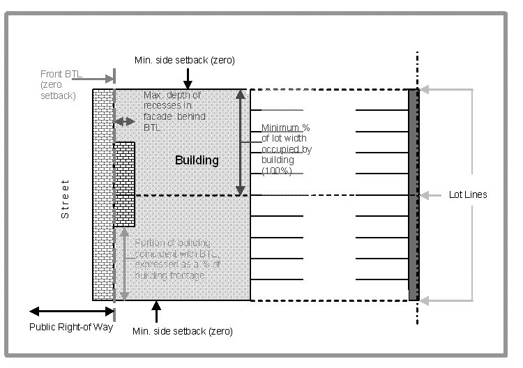
Figure 510-1. Illustration of terms used in table of site development standards
*See section 12-438.5, "Transit-Oriented Streets" for applicability
(1)
General notations.
(a)
Civic buildings, as determined by the town council, on sites that are located at the terminus of a street or vista shall be positioned on the site so as to signify the view axis with either a centered facade, tower, or some vertical architectural feature.
(b)
Lots fronting SR 84 are subject to a thirty (30) foot landscape buffer on SR 84 pursuant to section 12-111, "Landscaping standards for lots and sites." The requirements of the CC, Commerce Center District shall apply in lieu of the standards in Table 12-438.10(C), above, but shall not supersede the intensity standards of Table 12-438.9(E).
(c)
Frontage standards will provide for encroachments.
(Ord. of 2-6-08, § 1(Exh. A); Ord. No. 2012-28, § 2(Exh. A), 12-5-12; Ord. No. 2012-28, § 2(Exh. A)(§ 12-32.510), 12-5-12)
Sec. 12-438.11. - Building frontage types and regulations; right-of-way encroachments.
(A)
Intent: The area where a building faces the street and meets with the sidewalk is generally referred to as the "building frontage". It is here that the interaction occurs between people on the sidewalk and businesses in the buildings. There are three (3) main reasons for controlling building frontage:
(1)
To define the edge of each street corridor, thereby establishing a sense of enclosure.
(2)
To ensure a high level of pedestrian interest through continuous and visually interesting facades close to the sidewalk and interactive facades, allowing the pedestrian to view inside, and those inside to monitor the sidewalk and street.
(3)
To increase commerce by supporting a high level of activity along the street.
Therefore, buildings should align their facades along the build to line. Street level restaurants, shops, stores, and offices are all accessed at that line, and the more continuous it is the greater possibility for success they will all experience. Gaps in between buildings will create areas of low activity and low commercial potential in the same way a vacant lot will, and should be avoided wherever possible.
Building frontages are controlled by build-to-lines and minimum and maximum setbacks, which are regulated by the types of streets that they front (which often correlate to a given RAC district).
(B)
All buildings on lots with Transit-Oriented Street frontage shall have their principal frontage (i.e. main entrance and architectural orientation) along such street. All buildings on lots with other collector or arterial roadways shall have their principal frontage on the highest such street classification or as otherwise determined by the town.
_____
(C)
Permitted building frontage types.(3)
Table notations:
(1)
Permitted in locations where commercial use is allowed by Table 12-438.7(C), Table notation number (6).
(2)
Subject to town council approval (See section 12-438.22). Other frontage types may be permitted if they are consistent with the intent of the frontage requirements for the lot.
(3)
Frontage requirements within the Western Theme Overlay District are set forth within the Western Theme Development Manual.
(D)
Description of Frontage Types.
(1)
Arcade:
(a)
A frontage wherein the facade of the upper stories project forward of the BTL over a colonnade that covers the sidewalk. The arcade shall extend to within three and one-half to four (4) feet from the back edge of the curb as determined by the town based upon existing and proposed right-of-way improvements and conditions, thereby enclosing the sidewalk and discouraging pedestrians from bypassing it. The first floor facade under the arcade shall be shopfront at the BTL. An arcade shall have a minimum twelve (12) foot vertical clearance and a minimum dimension of twelve (12) feet of width between the outer edge of the columns and the first floor building facade (see illustration below).
(b)
The town may allow an arcade wherein the facade of the upper stories, and the face of the columns are vertically aligned with the BTL in order to accommodate unique ground floor uses such as a concentration of outdoor dining or the placement of kiosks within the sidewalk outside of the arcade. The first floor facade under the arcade shall be shopfront, and it should be set back no more than twelve (12) feet from the BTL. A minimum vertical clearance of twelve (12) feet under the arcade is required. A public sidewalk easement shall be dedicated under such an arcade.
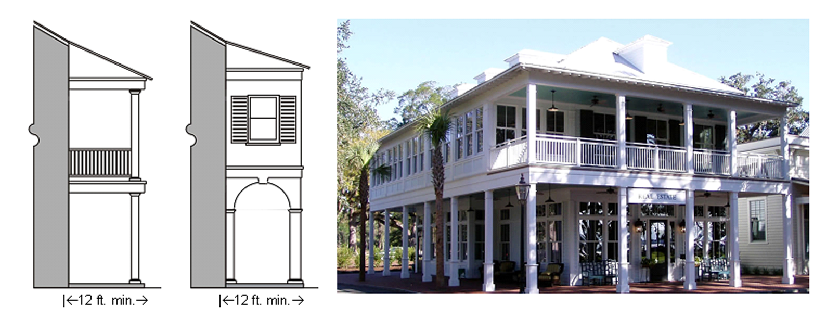
Figure 511-1
(2)
Gallery: A frontage wherein the facade is located at the back edge of the sidewalk (BTL) with an attached cantilevered shed or a lightweight colonnade overlapping the sidewalk for the entire street frontage of a building. The gallery shall extend to within no less four (4) feet from the back edge of the curb, thereby enclosing the sidewalk and discouraging pedestrians from bypassing it. The first floor facade under the gallery shall be shopfront at the BTL. The Gallery shall have a minimum twelve (12) foot vertical clearance.
(3)
Shopfront: A frontage type wherein the facade is located at the back edge of the sidewalk (BTL) at grade, with a substantial glazing on the sidewalk level, and an awning projecting at least seven (7) feet forward of the BTL when the shopfront is not combined with a gallery or arcade frontage. The awning shall extend for at least eighty (80) percent of the building facade. A minimum seventy (70) percent of the facade width shall be glazed between two (2) feet and eight (8) feet above the sidewalk, and shall not be reflective or opaque. A portion of the building frontage may be recessed as permitted in section 12-438.10(C) in order to create a covered alcove in which outdoor dining or merchandising can occur. Shopfront entries may be recessed up to two (2) feet with display windows angled inwards from the facade to doorway for clear pedestrian view to the interior.
(4)
Modified Shopfront: A frontage type wherein the facade is located at the back edge of the sidewalk (BTL) at grade, with sufficient glazing on the sidewalk level to allow for cross-visibility between pedestrians on the sidewalk and occupants inside the building. An awning shall project at least seven (7) feet forward from the BTL and shall extend for at least eighty (80) percent of the building facade. A minimum fifty (50) percent and a maximum seventy-five (75) percent of the facade width shall be glazed between two (2) feet and eight (8) feet above the sidewalk, and shall not be reflective or opaque. Entries may be recessed up to two (2) feet but display windows angled inwards from the facade to doorway are not permitted.
(4a)
Stoop: A frontage type wherein the facade is constructed at a build-to-line that is very close to the street line, with a lower story that elevated at least eighteen (18) inches but not more than thirty-six (36) inches above the sidewalk to establish a sense of transition from public to private realm, and to secure privacy for the windows. The access is a landing or platform with steps leading to the sidewalk, which may encroach forward of the BTL to the street line. In the event thatthe lower story is not elevated at least eighteen (18) inches above the sidewalk, the elevated platform (stoop) shall serve to establish the sense of transition from public to private realm, and shall require steps leading down to finished floor level within the building.
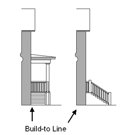
Figure 511-2
(5)
Porch: A frontage type wherein the facade is located at a build-to-line that is separated from, but relatively close to, the street line, with an attached porch at least eight (8) feet wide and six (6) feet deep located forward of the BTL. The porch shall extend at least five (5) feet forward of the build-to-line, and shall approach no closer than two and a half (2.5) feet to the sidewalk. Porches shall be elevated at least eighteen (18) inches above the sidewalk and adjacent grade.
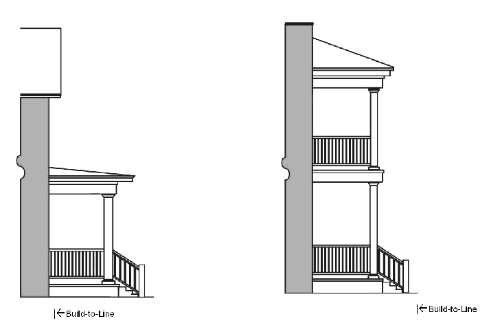
Figure 511-3. Left: Porch frontage. Right: Modified porch frontage.
(5a)
Modified Porch: A frontage type that utilizes a first-floor porch with upper floors and/or continuous balconies extending over the porch, but not forward of the BTL. This frontage type is intended for streets of a lesser hierarchy, intensity and sidewalk width than Transit-Oriented Streets. The front edge of the porch shall be coterminous with the BTL, and may be up to ten (10) feet in depth from the BTL. The porch shall count towards the minimum required percentage of building frontage that must coincide with the BTL pursuant to Table 12-438.10(C). The porch shall either be elevated at least eighteen (18) inches above grade or kept at grade but separated from the public sidewalk by a decorative railing.

Rear-most building features and at-grade modified porch
(E)
Other Frontage Requirements.
(1)
Building facades that are subject to street build-to-lines or maximum setbacks from the street shall be built parallel to the principal frontage line, or parallel to the tangent of a curved principal frontage line (see Figure 511-1, below). This provision is not intended to limit or preclude alcoves or variations in the plane of the street-front facade.
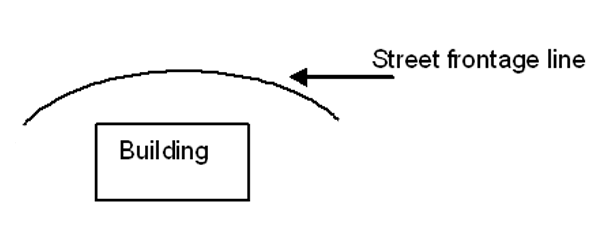
Figure 511-5
(2)
Streetscreens used to shield vehicular use areas from sidewalks shall be solid and opaque below three (3) feet in height, and at least thirty-five (35) percent open-screening above three (3) feet (ex: iron or aluminum) consistent with Crime Prevention Through Environmental Design (CPTED) principles, and constructed and painted to match the adjacent building facade.
(3)
Mechanical equipment is not permitted along any street frontage. Screening of all mechanical equipment is required.
(4)
The front or side (in case of corner lots) of every building must face the street. Rear facing buildings, loading docks, overhead doors and service entries are prohibited on street-facing facades. This paragraph shall not apply to lots within the RAC-RTE District that do not front a Transit-Oriented Street.
(5)
All principal buildings shall have a principal entrance opening to a street, square, plaza, or sidewalk. The principal entrance shall not open onto a parking lot. This paragraph shall not apply to lots within the RAC-RTE District that do not front a Transit-Oriented Street.
(Ord. of 2-6-08, § 1(Exh. A); Ord. No. 2010-021, § 4, 9-7-10; Ord. No. 2012-28, § 2(Exh. A)(§ 12-32.511), 12-5-12)
Sec. 12-438.12. - Rules of transition.
(A)
RAC-RTW and RAC-ED development on lots abutting a residential zoning district outside of the RAC, and any M-1 District use that is established after the effective date of this provision and is adjacent a use that is not first permitted in any "M" District, shall provide a landscape buffer as required in section 12-111(D) for industrial districts adjacent to residential zoning. RAC-TC development on lots abutting residential zoning outside of the RAC shall either be residential and of like dimensions and character as the adjoining permitted uses, or shall provide the landscape buffer required in section 12-111(D).
(B)
Buildings on lots adjacent to residential zoning outside the RAC shall be set back from said district boundary at least one and one-half (1.5) feet for each foot of height measured to the eave or parapet of the roof. For example, a building in a RAC district with a fifty (50) foot setback from a residential zoning boundary may be no higher than thirty-three (33) feet as measured to the eave or parapet of the roof.
(C)
Nonresidential or mixed-use buildings abutting, or separated by a street or alley in the rear yard from, a residential zoning district (including RAC-DN2) that permits residential buildings of a maximum two (2) floors in height, shall provide a ten-foot-wide landscape buffer. A six (6) foot wall, hedge or other durable landscape barrier shall be installed. One (1) 14- to 16-foot tree shall be planted for each forty (40) linear feet of property line or fraction thereof, along with a continuous hedge. The shrub and/or wall requirement of this section may be waived if the adjoining property has a buffer that meets the minimum requirements of this provision.
(D)
No loading space or outdoor storage shall be permitted within one hundred (100) feet of a residential zoning district boundary (including RAC-DN2), nor shall any loading space face a residential zoning district boundary.
(E)
Height Transitions.
(1)
Where the maximum permitted height within a district exceeds the greater of four (4) stories or sixty- five (65) feet, allowable building heights shall "step-up" from the facade facing arterial and collector streets. These "height contours" shall allow additional height on a 1:1 vertical to horizontal basis until the district maximum is reached, except as provided below. For example, to achieve a building height of ninety (90) feet, that portion of the building exceeding sixty-five (65) feet would have to be set back an additional twenty-five (25) feet from the building face along the collector or arterial street. This can be accomplished in as many increments as desired (see Figure 512-1 below). No such step-up shall be required adjacent to Florida's Turnpike or the I-595/SR 84 corridor (including Reese Road frontage).
Figure 512-1
(2)
Buildings exceeding either three (3) stories or thirty-five (35) feet in height shall employ one (1) or more of the following techniques for ensuring compatibility with an abutting, conforming single-family detached residence, as deemed acceptable and effective by the town:
(a)
Reduce the perceived mass of the building and the height differential by stepping the building down on the side(s) abutting the single-family detached residence.
(b)
Provide adequate separation between buildings to minimize the perceived height difference and lower the line-of-sight from the taller building to the single-family property.
(c)
Use appropriate landscape materials and buffering techniques to screen the taller building from the single-family residence and obstruct the line of sight between the buildings.
(d)
For upper story windows, use glass block, low awnings or high windows to obstruct line of sight to the single-family property, and/or the strategic location of building functions and windows to maximize privacy for the single-family lot.
(e)
Use green (landscaped) terraces to obstruct line-of-site to the single-family property.
Figure 512-2
Figure 512-2 illustrates a combination of techniques including the use of step-downs in height to reduce mass and height differential, trees and landscaped terraces to block line of site and provide a buffer. Varying the horizontal plane of the facade and using color variations also reduces the apparent mass of the building.
Figure 512-3
Figure 512-4
These are examples of green terraces that can be employed to afford privacy between buildings and soften the impact of larger, taller buildings. Such use of landscaping can also assist with stormwater capture and building energy efficiency.
(3)
Lots with frontage on a Transit-Oriented Street can be developed to six (6) stories and ninety-five (95) feet without any horizontal stepping if at least one-half (½) of the lot's street frontage is located within two hundred and fifty (250) feet of the center of the intersection of any two (2) Transit-Oriented Streets, and if all quadrants of the intersection are zoned to permit height exceeding four (4) stories and sixty-five (65) feet. Additional height, up to the district maximum, may be achieved by 1:1 stepping.
(F)
Adjacent Nonconformities. When a site plan under review for development or redevelopment borders nonconforming development, the site plan shall consider the discontinuity of public improvements (ex: sidewalk width and location) or other incompatibilities that will result at the site edges, and which may endure until the adjacent property(ies) are developed/redeveloped. The site plan shall propose a transition between the proposed conforming development and adjacent nonconforming development that is acceptable to the town.
(G)
Existing and proposed residential uses including mixed uses shall be designed to be integrated into the existing neighborhoods created through the implementation of the RAC. Compatibility and appropriate transitional design elements will be reviewed at time of site plan review, consistent with these land development regulations. Such regulations in review shall ensure that existing industrial uses will not become incompatible with new development and that new development shall provide buffers and site design in light of exiting land uses.
(Ord. of 2-6-08, § 1(Exh. A); Ord. No. 2012-28, § 2(Exh. A)(§ 12-32.512), 12-5-12)
Sec. 12-438.13. - Use of public right-of-way; required improvements and dedications.
(A)
Intent and Character. The public right-of-way should be envisioned as a primary place of activity. Using and invigorating the right-of-way along the streets is the single most important element to redeveloping a pedestrian-friendly, multi-modal community. The right-of-way will incorporate vehicular, pedestrian, and bicycle improvements. The town and the private developer should work together to make sure there is a seamless relationship between building entrances, plazas, sidewalks, and crosswalks. A continuous, attractive, and enjoyable experience is the goal for the pedestrian. The public right-of-way will serve the community by offering places for activities such as sidewalk seating, people watching, waiting on transit, small gatherings, and street vendor opportunities. In order for a safe and comfortable pedestrian experience to be achieved, shelter from sun and rain is encouraged through continuous awnings, covered walks, landscape and umbrella coverage of the sidewalk.
(B)
Principles.
(1)
Pedestrian experience and amenities should be the priority when allocating funds for right-of-way improvements; no longer should right-of-way improvements be solely focused on the automobile.
(2)
Building occupants are encouraged to add elements such as decorative pots, cafe seating and awnings in areas of the sidewalk approved by the town.
(3)
Pervious pavers and extensive plant beds added to the public use areas are encouraged to reduce storm water runoff.
(4)
Shade trees and light surfaces shall be utilized to increase the urban tree canopy and reduce heat.
(5)
Utilizing continuous trenches for planting street trees and shrubs allows for a better root system that results in healthier longer living large trees.
(6)
Transit stops should be integrated into the overall design of the street and the adjacent building.
(7)
Street vendors are encouraged in areas where plaza or other gathering space is of adequate size.
(8)
Where allowed, on-street parking with planter bulb-outs is encouraged.
(9)
A pedestrian bridge over SR 84 should connect the east-west rapid transit station to the College Avenue corridor.
(C)
Requirements.
(1)
The developer of each development site shall be responsible for burying overhead power and utility lines along transit-oriented streets, Orange Drive, and along all streets within the RAC-TC, and providing sidewalks, street lighting, street furniture and other improvements within the right-of-way adjacent to development site pursuant to the applicable street section(s) in section 12-438.28, "Street sections" and the specifications for same adopted by the town council. The town may permit payment in lieu of construction for improvements that the town will undertake on an areawide basis.
(2)
Right-of-way shall be dedicated to fulfill the street section requirements in section 12-438.28.
(3)
Greenway dedications shall be required pursuant to an open space and drainage master plan, when adopted.
(4)
The several components that must be integrated into the design of rights-of-ways are transit shelters and bicycle lockers that are easily accessible to pedestrians, lighting, shade (from trees, awnings, arcades, and canopies), site furnishing, and directory signage.
(5)
No structure or landscaping shall impede pedestrian or bike circulation within the right-of-way.
(Ord. of 2-6-08, § 1(Exh. A); Ord. No. 2010-021, § 5, 9-7-10; Ord. No. 2012-28, § 2(Exh. A)(§ 12-32.513), 12-5-12; Ord. No. O2024-015, § 2(Exh. A), 5-15-24)
Sec. 12-438.14. - Massing and articulation.
(A)
Intent. Massing refers to the bulk plane of a building. The perception of building mass is influenced by the building's distance from the street, its height relative to its width, whether height is reached in one (1) or multiple vertical and/or horizontal planes, and the spacing between buildings. Articulation refers to the treatment of a building's facade. A blank facade has no articulation. A facade with substantial fenestration, balconies, character lines, columns, etc. is highly articulated. Buildings are the face of the town. Their form, quality, interest, function, and style all serve to define the character of this place.
(B)
Principles.
(1)
Buildings are encouraged to vary in overall height and not be contained in a single volume of continuous height.
(a)
All buildings that front Transit-Oriented streets and other collector and arterial streets are encouraged to display a uniform cornice height between twenty-five (25) and thirty-five (35) feet above finished grade. This cornice height should consist of a uniform alteration to the building massing for a minimum of four (4) feet perpendicular to the vertical surface. Buildings exceeding thirty-five (35) feet in height should maintain no more than three (3) stories without horizontal moderation in vertical surface plane. This moderation should consist of a minimum four (4) foot horizontal variation in surface plane such as brise soleil, balconies, building projections, etc. Repetitive moderations are discouraged.
(b)
The first thirty-five (35) feet of the exterior facade vertical plane should enhance the pedestrian environment by incorporating appropriate architectural features. Such features include cornice, molding stringcourses, ornamentations, changes in material or color, and other sculpting of the architectural surface, which add special interest and are compatible with public sector site elements.
(2)
Pedestrian bridges extending over public right-of-way may be permitted providing those connections have secured legitimate air rights over the public corridor and meet all applicable codes. The location of pedestrian bridges should be limited to building complexes where buildings share common needs/uses or when the interaction between users of the buildings is important for the success of the use. A connection over SR 84 to future east-west rapid transit is considered a necessity once the transit infrastructure is in place. All over street connections should be of exceptional design, which enhance the visual and functional quality of the streetscape and should be compatible with site elements.
(3)
Where possible, rooftops should be designed to accommodate various forms of human activity such as sun decks, tennis courts, gardens, outdoor cafes, etc. Roof surfaces not allocated to human activity should be finished with a surface material that does not affect the quality of views from surrounding buildings or site lines from taller buildings should be directed way from unsightly rooftops. All rooftop mechanical equipment, stair, and elevator towers should be designed as an integral part of the building volume and/or adequately screened. Rooftops designed and used to hold topsoil and landscape plantings (green roofs) are encouraged. See also section 12-438.26, "Green building."
(4)
Facades of buildings should be divided into individual storefronts or entries.
(5)
Large expanses of glass should be subdivided into smaller units.
(6)
Differentiation should be provided at the base and the top of windows (see Figure 514-1 for illustrations of this concept).
Figure 514-1
(7)
The ground-level floors should be visually separated from floors above through the use of architectural elements that could include galleries, awnings, canopies or lintels, or by recessing the ground-floor level from the floor above (arcade frontages).
(8)
A visible and delineated roofline is encouraged, such as a cornice, pediment, or related visual trim. The upper termination of a building should be more strongly developed in a building with a flat or slightly sloping roof (see Figure 12-514-1 for illustrations of this concept).
(9)
Store entrances should be recessed, not flush, with the edge of the building facade, to provide shelter for persons entering and exiting, to articulate the facade, and to provide maximum window display area at the entrance.
(10)
Landscaping should provide additional texture at street level as well as increase pedestrian awareness of buildings, their entrances and the visual access. Decorative planters are encouraged as well as trees planted utilizing tree grates.
(11)
Building design should encourage multi-tenant occupancy at the lower two (2) floors.
(12)
Solid walls should not exceed twenty (20) feet in length without vertical articulation.
(13)
Ornamental fountains, waterfalls, sculptures, arbors, trellises, planted beds, clock pedestals, awnings, and canopies are encouraged.
(14)
False fronts or parapets that create an insubstantial appearance should be avoided.
(15)
Stepping the building (see Figures 12-512-1 and 12-512-2) can also reduce the apparent scale of the building and establish a "base" and a "top."
(16)
Changes in mass should relate to structural system(s) and the organization of interior space.
(17)
New development, or the retrofitting of existing development, should address the public sidewalk. Design of the sidewalk-level facade should be incorporated into the design of the overall building.
(18)
Street frontage facades should have entryways at reasonable intervals, typically no more than fifty (50) feet apart.
(19)
Ground level facades that face the street should be designed with entrances, windows, display windows, or other display devices.
(C)
Requirements. This subsection applies to buildings other than industrial buildings within the RAC-RTW and RAC-RTE districts that have no frontage on arterial or collector roads, or that are substantially screened from such roads.
(1)
Facades shall be constructed in a manner to appear substantial, avoiding low-quality building materials and construction details that contribute to the perception of a facade as flimsy, or are inconsistent with the materials and architectural style.
(2)
The building facade shall use architectural solutions (e.g. building materials, texture, offset building massing, repetition of columns, recess entries, windows, and awnings) to avoid the creation of impenetrable, un-articulated building facades.
(3)
Landscape elements shall never impede pedestrian circulation.
(4)
Single dominant building masses are prohibited.
(5)
Substantial variations in massing shall include changes in height and horizontal plane.
(6)
Horizontal mass shall not exceed a height to width ratio of one to three (1:3), without a substantial architectural element that either projects up or away from the building, such as a tower, bay, lattice, or other architectural feature.
(7)
Building massing, architectural details, entry details or changes in materials shall be used to highlight the location of building entries. For example, greater height can be used to accentuate entries in the form of tower elements, tall voids, or a central mass at an entry plaza.
(8)
Buildings that are part of an existing or future complex shall have a unity of character and design. The design character of buildings shall be such that it is aesthetically pleasing and without cluttered forms having no apparent system of organization.
(9)
All building elevations shall receive architectural treatment, although the primary emphasis may be given to the main facade(s).
(10)
All development must be designed to enhance ground-level architectural elements on a human scale. Entry conditions, building materials, awnings, windows, lighting, and well-designed signage can all contribute to conditions ideal for attracting pedestrians.
(11)
All buildings shall have a minimum of two (2) planes of vertical separation.
(Ord. of 2-6-08, § 1(Exh. A); Ord. No. 2010-021, § 6, 9-7-10; Ord. No. 2012-28, § 2(Exh. A)(§ 12-32.514), 12-5-12)
Sec. 12-438.15. - Miscellaneous requirements.
(A)
Screening required.
(1)
Dumpsters, dumpster enclosures and loading zones shall not be located within twenty (20) feet of any street line or BTL.
(2)
Dumpsters and their enclosures and loading zones shall be screened from view at the street frontage by a building or screenwall six (6) feet in height with a planter at the street-facing base of the screen wall, provided that the town may require additional screening if necessary to obscure same from street view.
(3)
Utility boxes and machinery, including, but not limited to, backflow devices, electric meters, air conditioning units, and transformer boxes, shall not be visible from public rights-of-way, parks and other public spaces.
(4)
Loading areas shall be screened from view from streets and properties with conforming residential uses.
(B)
(Reserved.)
(C)
Street furniture. Street furniture, including, but not limited to, benches, transit shelters, waste bins, bike racks or lockers shall be of a uniform style within the district, as specified by the town.
(D)
Measurement of street-side setbacks and build-to-lines shall be measured from the ultimate street right-of-way lines that include any dedication(s) required to achieve the adopted street sections within the RAC.
(E)
Airport noise compatibility. In accordance with Broward County Ordinance # 2010-44, none of the three thousand one hundred seventy-four (3,174) dwelling units approved by way of Broward County Land Use Plan Amendment PCT 10-6 shall be located within the sixty (60) DNL noise contour of Runway 9R/27L, pursuant to Environmental Impact Statement, December 2008 2020 B1b. The town shall make the noise contour map available to the public in the same manner as zoning maps. The town shall be responsible for the monitoring of residential development activity within the RAC.
(F)
Drive-through windows.
(1)
Generally. Drive-through windows, such as for banks and fast food restaurants, are permitted as pursuant to this paragraph (F).
(2)
Vehicle stacking. As determined by the town engineer, drive-through windows shall provide sufficient vehicle stacking to ensure that vehicles to do not back out onto public streets or neighboring properties and do not hinder pedestrian or vehicular access throughout the site.
(3)
Food service uses. In the RAC-TC district, food service uses shall not include drive-through facilities. This is not intended to prohibit the continuation of food service drive-through facilities lawfully established prior to May 4, 2016.
(4)
Other uses. In the RAC-TC district, drive-through facilities for uses other than food service are allowed provided that vehicular access to such drive-through facility is not by way of a transit-oriented street.
(G)
Davie Road, South Gateway.
(1)
At the northwest and northeast corners of Davie Road and Orange Drive, new development must provide a pedestrian square at the corner measuring at least fifty-five (55) feet by fifty-five (55) feet. Each pedestrian square shall provide publicly accessible open space with a combination of hardscape and landscape features that serve as an extension of the adjacent sidewalk areas. The required pedestrian square area must not include habitable buildings but up to fifty (50) percent of the pedestrian square area may include non-habitable structures such as clock towers, public artwork, or seating areas. In the event of any conflict with the site development standards of section 12-438.10, the provisions of this paragraph shall prevail.
(Ord. of 2-6-08, § 1(Exh. A); Ord. No. 2011-28, § 2, 8-17-11; Ord. No. 2012-28, § 2(Exh. A), 12-5-12; Ord. No. 2012-28, § 2(Exh. A)(§ 12-32.515), 12-5-12; Ord. No. 2016-014, § 2(Exh. A), 7-27-16; Ord. No. O2019-004, § 2(Exh. A), 1-23-19; Ord. No. O2023-019, § 2(Exh. A), 12-6-23)
Editor's note— Ord. No. O2019-004, § 2(Exh. A), adopted January 23, 2019, renamed § 12-438.15 from "supplemental regulations" to "miscellaneous requirements."
Sec. 12-438.16. - Nonconformities.
(A)
Lawfully established lots within the Regional Activity Center Districts which do not meet the minimum lot area or lot dimension requirements of this division shall be governed by section 12-38.
(B)
Except as set forth in paragraph (C) below, lawfully established uses within the Regional Activity Center Districts which do not comply with the standards of section 12-438.7 shall be governed by section 12-40.
(C)
Nonconforming characteristics of use which are unique to this Division, such as but not limited to the intensity of use standards, site development standards, building frontage types and parking location standards, shall not be governed by section 12-39 but instead shall be governed by the following.
(1)
Renovations. Interior renovations and renovations or modifications to the exterior of a nonconforming building are permitted without triggering compliance of said building with the standards of this Division provided that the building footprint is unchanged.
(2)
Expansion of building. The expansion of a nonconforming building shall be permitted as long as the cumulative square-footage of such expansion within any five (5) year period does not exceed twenty-five (25) percent of the gross floor area of a building, as it existed on February 6, 2008. In the event that the cumulative five (5) year threshold is met, compliance with these regulations shall be required if the town determines that substantial compliance with these regulations can be achieved without compromising the intended use of the expansion and logistics of the building and site layout.
(D)
RAC-RTE and RAC-RTW districts. In the RAC-RTE and RAC-RTW districts, uses first allowed in the M-2 District which were lawfully established prior to February 06, 2008 shall be permitted to operate, expand and change to other M-2 uses without limitation, and shall not be subject to the limitations of section section 12-40 until after January 1, 2023, after which time, the provisions of section 12-40 shall apply, except that the threshold for a use to be considered "discontinued" or "abandoned" shall be one (1) year. The provisions of this paragraph are temporary and transitional in nature and shall not in any way be interpreted to confer any rights to the use of land or structure beyond what is temporarily permitted herein.
(Ord. of 2-6-08, § 1(Exh. A); Ord. No. 2012-28, § 2(Exh. A)(§ 12-32.516), 12-5-12; Ord. No. 2013-21, § 2(Exh. A), 9-18-13; Ord. No. 2014-2, § 2(Exh. A), 1-15-14; Ord. No. O2019-004, § 2(Exh. A), 1-23-19)
Sec. 12-438.17. - Off-street parking requirements.
(A)
Intent and applicability. This section is intended to minimize both the actual and perceived presence and dominance of parking facilities within designated corridors by prescribing the location of, and access to, parking facilities via the rear of properties, away from the street, and by minimizing the potential for "overparking," which occurs when there is an oversupply of parking spaces. It is also the intent of these regulations to encourage the provision of strategically centralized public parking with transit connections, and on-street parking that further reduces the amount of off-street parking that must be provided.
The parking paradigm used in this section reflects an urbanizing, but not yet urban area, where alternate modes of transportation and shared parking facilities begin to reduce demand for parking spaces. As strategically located centralized public parking is provided and multi-modal infrastructure and service improves over time, the parking space requirements should be adjusted to reflect the modal shift that is expected to occur.
Parking and loading requirements and vehicular use area design geometrics shall comply with Article VII except as provided in this section.
(B)
Driveway Allowances. The Town of Davie seeks to have buildings fronting the entire width of their lots along transit-oriented streets, as well as many other streets within the RAC districts. Wherever these regulations require buildings to occupy the entire width of a lot, off-street parking facilities must be provided in the rear yard, accessed by a side street or an alley, or contiguous rear parking areas with through-access that together function like an alley. If no such infrastructure exists, driveway access is permitted as follows. However, it is required that new development be designed in a way to create opportunity for these connections to be made when adjacent lots are redeveloped in the future.
(1)
When vehicular access is necessary within the street frontage, it will be limited to a single curb cut for access in and out, provided two (2), one-way drives may be permitted if necessary for parking facility circulation.
(2)
Additional driveways may be permitted for lots where sufficiently high trip generation requires extra driveways, as determined by the town engineer.
(3)
Driveways should be located along side property lines within shared access easements to encourage connection from adjacent properties. Under such circumstances, the minimum separation requirement between driveways and property lines shall be waived. The town may require easements for future sharing of driveway access.
(4)
Every rear parking facility shall be designed for connectivity to existing or future rear parking facilities on adjoining properties with the same street frontage. This shall include the recording of cross-access easements.
(5)
As redevelopment occurs, connections shall be made between rear parking lots on neighboring lots. This connectivity will reduce the need for curb cuts along the street, and allow opportunity for those driveways to be redeveloped for building frontage, paseos, or outdoor building space.
(6)
In order to encourage existing developed lots to connect their rear parking facilities to those of adjoining lots, up to five (5) percent of the required parking may be eliminated if logistically necessary to provide said connections. Parking facilities that are nonconforming as to required number of spaces by five (5) percent or more shall not qualify.
(C)
Alleys. Few blocks in the RAC are bisected by alleys. The benefit of rear alleys are that they allow for a continuous building frontage and fewer vehicle-pedestrian conflicts. Alleys may be incorporated into rear parking lots as standard drive aisles.
(D)
Through-Block Pathways (paseos). Through-block pathways refer to interior on-site pedestrian walkways that are not located within a public right-of-way (but may be located on public property). The alignment of these pathways, where required, shall take into account pedestrian connections shown in the comprehensive plan, proposed, and existing buildings and to the extent possible property lines to enhance the pedestrian environment and connections to adjacent property. Paseos shall be designed to enhance the surrounding buildings and to provide community amenities.
(E)
Parking Placement and Design. The intent of parking placement regulations is to de-emphasize parking lots from the public streetscape and to provide an environment conducive to pedestrian activity by locating parking lots and their access away from street frontages, where the following provisions shall apply. Strategically located peripheral public parking facilities with transit, bicycle, and pedestrian connections are specifically encouraged.
(1)
No surface parking shall be located within twenty-five (25) feet of any street line that forms the basis of a build-to-line, except as provided in (11), below.
(2)
Parking spaces shall be screened from view at all frontage lines by a building or screenwall six (6) feet in height with a planter at the street-facing base of the screenwall, except as provided in eleven (11), below, and except for lots within the RAC-RTE district that do not front a transit-oriented street.
(3)
Parking structures shall be set back at least fifty (50) feet from all transit-oriented streets and any street for which a build-to-line is established herein. The intent of this setback is to ensure that adequate space exists for a liner building, as encouraged below, even if the liner building is not constructed at the time the parking structure is built. Parking structures should be enclosed by a liner building built along all of said street frontages a minimum thirty (30) feet deep, and not less than two (2) floors and twenty-five (25) feet in height measured to the roof eave or parapet. The liner building may be attached or detached from the parking structure.
(4)
If inadequate lot width precludes a parking structure with liner building along a street, the parking structure may be built to the BTL and architectural solutions shall be utilized, such as creation of a false facade, provided that one (1) of the permitted frontage types shall be utilized, and that the first floor shall be inhabitable and usable for one (1) or more permitted uses.
(5)
Street level openings to parking structures may occur only on side streets (not primary or urban secondary) and shall be minimized to accommodate necessary vehicle entrances and pedestrian access only.
(6)
Gates/ticket machines within any parking facility must allow for one (1) vehicle to stack exclusive of public right-of-way.
(7)
Where corner access and rear access exists, access shall be from the rear except as provided in (11), below.
(8)
Drive-thru service windows, including vehicular stacking lanes, are prohibited except in the rear yard, and shall not be permitted within one hundred (100) feet of a property line zoned, land use plan designated or occupied for single-family residential use, provided that no drive-thru window or stacking lane shall be visible from a public right-of-way.
(9)
Single-family detached housing may provide parking in the side yard if neither on-street parking or rear alley access is available, however, front yard parking is prohibited.
(10)
All other residential types shall provide only rear yard parking.
(11)
Front or side yard parking for flex space developments that require extensive loading areas, and which have multiple-tenant offices facing street, may be authorized by a level one (1) adjustment.
(12)
Where no on-street parking exists along transit-oriented street frontages, the town may allow up to one (1) double loaded corridor in front of buildings designed for retail and entertainment uses if cross-access to other front-yard parking facilities exists or will be provided, such that the parking connections will allow for continuous circulation without utilizing the street. The required pedestrian zone and build-to-line shall be established at the back edge of the parking facility as if it were the frontage line. Intent: parking in front of a retail-type uses is a proven necessity for the success of such businesses.
(13)
Off-site parking facilities are permitted within the RAC districts. If the off-site parking facility is more than one thousand two hundred fifty (1,250) feet from the development site seeking to utilize the off-site spaces, transit service with a maximum fifteen (15) minute headway between the parking facility and development site must exist or be planned with committed funding within five (5) years of issuance of a building permit for the development site. The owner of the off-site parking facility shall enter into written arrangement with the town, whereby the land providing the parking area shall never be sold or disposed of except in conjunction with the sale of the building the parking area serves so long as the off-site parking facilities are required. Said agreement shall be recorded at the expense of the owner and shall run with the land to bind the heirs, successors and assigns of said owner. Said written agreement may be voided by the town administrator if other provisions are made for off-street parking facilities.
(14)
The availability of on-street parking spaces shall reduce the off-street parking requirement of uses on an abutting lot. Each on-street parking space abutting a lot for at least fifty (50) percent of its length shall reduce the off-street parking requirement on such lot by one (1) space.
(F)
Bicycle Parking Requirements. Secure and convenient off-street bicycle parking facilities shall be provided as follows at no cost to users. All bicycle parking facilities shall be provided on private property in a highly visible location to intended users, protected from sun and rain by a roof, canopy or other approved cover, and situated to maximize the Crime Prevention through Environmental Design (CPTED) principle of natural surveillance. Bicycle racks and bicycle lockers are required as follows.
(1)
Office and institutional: One (1) space per forty (40) required parking spaces.
(2)
Residential multi-family: One (1) space per three (3) dwelling units.
(3)
Retail, service, entertainment:
(a)
For the first four hundred fifty (450) required parking spaces, one (1) bicycle space per fifteen (15) required automobile parking spaces.
(b)
For all additional required parking spaces above four hundred fifty (450), one (1) bicycle space per fifty (50) required parking spaces.
(4)
Mixed-use: Add the requirements of the separate uses.
(G)
Parking space dimensions. Required off-street parking spaces shall be at least nine (9) feet in width and eighteen (18) feet in length. Compact parking spaces are subject to the dimensional requirements and quantity limitations of article VII.
(H)
Parking reductions. The following parking reductions may be applied to new development, specifically, excluding duplex dwellings and townhomes.
(1)
Reduction for bicycle parking and lockers. The parking requirement for all uses within a development shall be reduced by five (5) percent where bicycle parking spaces are provided at one hundred fifty (150) percent of that required section 12-438.17(F) and a minimum one (1) square foot of locker space is provided per bicycle parking space.
(2)
Reduction for changing and shower facilities. The parking requirement for office and institutional uses shall be reduced by five (5) percent where the development includes separate men's and women's shower and changing facilities in the amount of one (1) enclosed shower stall and thirty (30) square feet of changing area for every ten (10) required bicycle spaces intended to serve such office or institutional use.
(3)
Substitution of motorcycle/scooter parking spaces. One (1) of every fifty (50) required automobile parking spaces may be substituted with a designated motorcycle/scooter space clearly demarcated by striping and/or curbing and signage. For example; a development requiring one hundred (100) parking spaces could substitute two (2) automobile parking spaces for motorcycle/scooter spaces. A motorcycle space shall be no smaller than three (3) feet by seven (7) feet.
(4)
Off-street parking along the street frontage of a lot shall count towards the parking requirement.
(I)
Shared parking.
(1)
Intent. The intent of shared parking is to permit a reduction in the total number of required parking spaces when a parcel is occupied by two (2) or more uses which typically do not experience peak parking demands. At the same time, providing the area where the sharing occurs is not heavily impacted by a parking shortage and provided that a shared parking agreement between property owners is recorded in the public records subsequent to town approval of the same. The developer or property owner is responsible for providing a copy of the recorded shared parking agreement to the town prior to issuance of a certificate of occupancy.
(2)
Shared parking calculations. The reductions for mixed-use developments are based upon shared parking calculations provided in Table 12-438.17(I), below. Instructions for use of the shared parking calculations follow this table.
(3)
Procedure. For developments designed to accommodate two (2) or more uses, after first taking any applicable reductions allowed by paragraph (H), and eliminating handicap accessible spaces, multiply the minimum required parking for each individual us by the appropriate percentage listed in the table for each designated time period. Add the resulting figures for each of the five (5) columns of the table. The highest number of parking spaces shown in the five (5) columns represents the minimum number of parking spaces required for the development, not including handicap accessible spaces.
(4)
Maximum reduction. The maximum reduction under this provision shall be twenty-five (25) percent, excluding any reductions achieved through numbers one (1) through six (6), above.
(Ord. of 2-6-08, § 1(Exh. A); Ord. No. 2010-021, § 7, 9-7-10; Ord. No. 2012-28, § 2(Exh. A)(§ 12-32.517), 12-5-12; Ord. No. O2019-004, § 2(Exh. A), 1-23-19; Ord. No. O2021-030, § 2(Exh. A), 11-3-21; Ord. No. O2024-015, § 2(Exh. A), 5-15-24)
_____
Sec. 12-438.18. - General open space principles and requirements.
(A)
Intent. Open space is not only a physical space but serves dually as functional linkages between neighborhoods/districts. It is recommended that open space is provided throughout the RAC within five (5) minute walking distances. Open space as part of all new developments is integral to livability within RAC districts. Open space encourages outdoor activity and life outside developments, which in turn creates a safer environment. Open space in conjunction with new developments should be located and designed to meet the needs of residents, businesses, and other users; to ensure a proper pedestrian scale; and in some cases to provide pervious area to serve the town in handling storm water drainage.
(B)
Principles. To increase usable/attractive open space within the RAC that benefits both the public and private developers the following principals are suggested:
(1)
Design public and private development projects to include usable, common open space consistent with one (1) or more open space typologies discussed in this section (i.e. plaza, paseo, courtyard, pocket park, etc.). This common space may assume a variety of different forms of site design solutions, but all common open space shall be integrated into the overall design of the new development and should easily connect to surrounding buildings and other pedestrian connection routes (and where possible, to adjacent open space networks).
(2)
Reclaim all underutilized town-owned land within the RAC districts and create a plan for revitalizing these spaces so that they are no longer in deterioration.
(3)
Encourage development of all open water sites with waterfront park features so that the area is dually serving the community in function and aesthetics.
(4)
Encourage all new parks to be cutting edge public spaces that will spark community pride.
(5)
Provide streetscape improvements (existing and future streets) that have a strong commitment to the pedestrian - comfortable walking, shaded seating, attractive pedestrian-scale features; ultimately serving the RAC as common open space connections.
(C)
Open space and open space types defined.
(1)
The following areas shall be considered as part of the required open space, both individually and in combination: landscaped areas; public sidewalks ten (10) feet in width or greater; plazas, courtyards, paseos and other open space types defined herein; outdoor dining and landscaping within any of the above; and, water features may count for up to twenty (20) percent of required open space. As an incentive, the percentage of water that may count towards required open space shall be increased to thirty-five (35) percent upon the provision of a waterfront park or promenade at least five hundred (500) feet in length and thirty (30) feet in width.
(2)
Open spaces that do not conform to a defined open space type in section 12-438.19 (ex: required buffers, lawn areas, water bodies without a pedestrian promenade or other recreation component) shall not be considered common open space.
(3)
This provisions shall control to the extent of conflict with open space requirements in chapter 12.
(D)
Requirements.
(1)
Open space shall be provided in the amount required in Table 12-438.9(E). Provision of all or some of the required open space as common open space is also encouraged through incentives.
(2)
Ensure existing parks and town common spaces are provided with adequate pedestrian connection to surrounding primary street corridors.
(Ord. of 2-6-08, § 1(Exh. A); Ord. No. 2012-28, § 2(Exh. A)(§ 12-32.518), 12-5-12; Ord. No. O2023-019, § 2(Exh. A), 12-6-23)
_____
Sec. 12-438.19. - Types of open spaces; principles and minimum standards.
Besides traditional "park space" it is important that other types of spaces be developed, for example: small urban plazas; the upgrade of alleys to pedestrian paseos; and dedicated sections of sidewalks for social and recreational uses. Types of open spaces that should occur throughout the RAC, and allowable locations, are identified in this section.
(A)
Table 12-438.19(A) Common Space types Allowable by Street
(B)
Pedestrian Streets. Include streets that will focus on ground floor retail and large amount of pedestrian activity. Transit-oriented streets are very important pedestrian streets. Pedestrian streets should have the widest sidewalks, streetscape elements, and ground floor uses that result in a comfortable and interesting pedestrian experience.
(1)
Characteristics and requirements.
(a)
Developers may install sidewalk elements, such as commemorative plaques or artwork, as approved by the town, at the main entrance to buildings.
(b)
The sidewalk paving pattern and materials should be continuous and flush.
(c)
Street trees and street landscaping should be spaced a minimum of twenty-five (25) feet apart
(d)
Walking paths shall be adequately lit.
(e)
Sidewalk furniture (benches, drinking fountains, etc.) should be abundant.
(f)
Compliance with the applicable street/sidewalk section is required (ex: specifications for street lighting, awnings, paving, street furniture, etc.).
(C)
Pocket Parks. Pocket parks can occur nestled in downtown Davie, on a college campus or amongst the largely residential Downtown Davie neighborhood districts (RAC-ND2 and 4). Ranging usually in size from one-half (½) acre to an acre, pocket parks can offer relief from the hardscape of downtown or can be utilized as a community yard if set on the center of a square of residential units. Pocket parks are most successful when found directly off the beating path of a successful pedestrian street or with residential units "watching" the park.
(1)
Characteristics and requirements.
(a)
Pocket parks should abut streets and be physically and visually accessible from the public sidewalks. Adjacent development should be designed with natural surveillance considerations including building orientation and access to the park, and fenestration, in order to encourage pocket park use and ensure security.
(b)
The pocket parks shall be accessible to the public for at least the time of normal business hours.
(c)
The pocket park shall not consist of any hiding places. Special features, and medium size vegetation shall be implemented with this in mind.
(d)
Pocket parks shall provide at least one (1) sitting place for each two hundred (200) square feet of pocket park.
(e)
An even mix of sun and shade coverage is encouraged.
(f)
A pocket park shall be exclusive of any vehicular access, loading and parking areas.
(g)
Provide adequate security lighting.
(h)
Plastic playground equipment is discouraged.
(D)
Plazas. Plazas are large outdoor rooms that extend the public realm from the street or sidewalk to the main entry of an adjacent building. They enhance the pedestrian environment and will invigorate adjacent developments/districts within which they are located.
(1)
Characteristics and requirements.
(a)
Plazas should abut public areas and be physically and visually accessible from the public sidewalks. Security fences, walls, and entry gates should not block the sidewalk edge of the plaza or views into the plaza.
(b)
The plaza shall be accessible to the public for at least the time of normal business hours.
(c)
Entries to the plaza, business and storefronts within the plaza shall be designed and lighted so they are safe and visible to plaza guest, avoiding hiding places.
(d)
Ground level facades discussed in section 12-438.24 (facades and frontage) shall be applied to facades facing a plaza.
(e)
Plazas shall provide at least one (1) sitting place for each one hundred (100) square feet of plaza in addition to any permitted outdoor dining provided.
(f)
Plazas should have adequate mix of sun vs. shaded area. No more than forty (40) percent of the plaza shall be covered with a roof.
(g)
At least ten (10) percent of the plaza's surface shall be landscaped to provide heat relief.
(h)
Vehicular access, loading, or parking within the plaza is prohibited. Emergency access drives will be considered through plaza upon review of integration into plaza design.
(i)
Plazas shall be a minimum of two thousand, five hundred (2,500) square feet in areas.
(E)
Courtyards/Outdoor Space. Located within the confines of building walls, sometimes between multiple developments. Many times courtyards are not directly visible or open to the street. They are smaller than plazas. The following principals are suggested when designing a courtyard:
(1)
Characteristics and requirements.
(a)
The courtyard shall be accessible to the public for at least the time of normal business hours.
(b)
Courtyards should be physically accessible from the public sidewalks.
(c)
Entries to the courtyard, business and storefronts within the courtyard shall be designed and lighted so they are safe and visible to courtyard guest, avoiding hiding places.
(d)
Courtyards shall provide at least one (1) sitting place for each seventy-five (75) square feet of courtyard in addition to any permitted outdoor dining provided.
(e)
Courtyards should have adequate mix of sun vs. shaded area, no more than fifty (50) percent of the courtyard should be covered with a roof.
(f)
No vehicular access, loading, or parking is permitted.
(g)
At least ten (10) percent of the courtyard surface shall be landscaped. Shade trees and gardens are strongly encouraged.
(F)
Linear Waterfront Parks/Promenades. Existing canals and large tract water bodies dominate the landscape in many areas of the RAC districts. Improvements to the surrounding green space would increase walkability and property values of adjacent businesses and residents. The surrounding green space of these existing water bodies as well as future water bodies should be utilized as linear parks or promenades. Linear parks and promenades can be found within urban areas or in more suburban scenarios, connecting multiple businesses via an attractive pedestrian promenade. In South Florida, promenades and linear parks are often adjacent to water bodies.
(1)
Characteristics and requirements.
(a)
Linear parks and promenades shall be physically accessible and clearly visible from adjacent street corridors and adjacent business entries.
(b)
At least fifty (50) percent of the linear park and twenty (20) percent of the promenade surface shall be landscaped. Shade trees are strongly encouraged in either scenario Linear parks and promenades shall provide at least one (1) sitting place per one hundred (100) linear feet of park/promenade length in addition to any permitted outdoor dining that may be provided.
(c)
Landscape and site lighting within the park/promenade shall not impede the flow of the pedestrians.
(d)
No vehicular access, loading, or parking is permitted within the promenade. Emergency access drives will be considered along linear park or promenade upon review of integration into park/promenade design.
(e)
Parks and promenades must consist of adequate lighting, and directional signage that is pedestrian-scaled.
(G)
Recreation and Ball Fields. Existing as well as proposed recreation parks and ball fields are important to the overall success of the RAC districts, providing a location for organized sports that support university and residential needs. Recreation/ball fields are green spaces specifically used for organized sporting events and usually consist of, but are not limited to, these elements, multi-use fields, tennis courts, basketball courts, and bleacher/refreshment facilities.
(1)
Characteristics and requirements.
(a)
Recreation and ball fields shall be physically accessible from public sidewalks.
(b)
Recreation and ball fields shall provide signage clearly stating field hours of operation.
(c)
Recreation and ball fields shall not spill light pollution on surrounding residential uses.
(d)
Gray water use is recommended for irrigation of fields.
(e)
Field lights shall utilize cutoff fixtures adjacent to residential and mixed-uses.
(f)
Security fencing shall be at a minimum black or dark green vinyl coated chain-link. Decorative aluminum fencing (powder coated black) is encouraged.
(g)
Fields must provide adequate and attractive seating, signage, and lighting.
(H)
Landmark/Town Park. Vibrant towns have a signature park highlighting and physically representing the ideals/face of the town. The RAC districts would benefit from a signature park that could have an icon element, interactive water features, educational component, passive, active areas, and space for outdoor events.
(1)
Characteristics and requirements.
(a)
Town park design should be state of the art, reflections of the community's past and suggestions to its future should be evident. Educational components should play an important role as well as a schedule of events that will draw people to the park.
(b)
High quality site features and materials (pavement, lighting, seating, signage, etc.) are encouraged.
(c)
The town park should be physically accessible from all surrounding public sidewalks, to ensure pedestrian access.
(d)
The town park should abut a main public thoroughfare.
(e)
Parking counts should be kept to a minimum; alternate forms of transportation to the park are encouraged.
(f)
The town park shall be at least three (3) acres preferably six (6) acres.
(g)
The park must have an adequate mix of landscape vs. hardscape.
(h)
Only porous parking surface is permitted, only a maximum of five (5) percent of the square feet of the park can be devoted to surface parking.
(i)
Drought resistant plants or use of gray water for irrigation is encouraged.
(I)
Common Open Space Connections. Open space connections consist of public and private sidewalks and paseos. These connections are the key to the ensuring walkability of the community and the success of common open spaces.
(1)
Sidewalks consist of two (2) types: sidewalks as part of a pedestrian street experience and independent sidewalks that traverse a site and connect separated developments. Comfortable sidewalks with attractive paving, generous landscape, shade trees, and attractive/functional lighting create a memorable experience for pedestrians walking throughout the RAC districts. The following principles should be reviewed when designing sidewalks:
(2)
Characteristics and requirements.
(a)
Sidewalks shall be comfortable and attractive. When possible, alternative paving materials and patterns are encouraged.
(b)
Adequate seating and lighting should be integrated into sidewalk design.
(c)
All independent sidewalks not adjacent to a street or falling under the streetscape sections shall be a minimum of six (6) feet.
(J)
Paseos are narrow pedestrian passages that serve as a break in larger blocks or mid block access. Former service alleys are encouraged to be redeveloped into paseos as buildings are transformed. Paseos small sizes are perfect for retail development. Paseos are useful in warmer climates where their enclosure and relative shade make them an attractive alternative to street retail.
(1)
Characteristics and requirements.
(a)
Building wall heights framing a paseo should not be more than three (3) times the height of the paseo's width.
(b)
Overhead structures; such as trellises or roof structures should not dominate any more than fifty (50) percent of the paseo length.
(c)
Building facades facing the paseo shall reflect that of the required street frontage.
(d)
Additional shade besides that cast from the building shall be individual umbrellas or overhead awnings/architectural fabric.
(e)
Paseos should have direct visual connection from the street to their destination points.
(f)
Seating and visual interest (sculpture, landscape, water features, etc.) are encouraged to ensure safety and usability of the paseo.
(g)
Paseos shall not be more than thirty (30) feet nor less than ten (10) feet wide.
(h)
No vehicular access, loading or parking is permitted. Emergency access drives will be considered through paseos upon review of integration into paseo design.
(i)
Paseos should be accessible to the public for at least the time of normal business hours.
(j)
Entries to the paseo business and storefronts shall be designed and lighted so they are safe and visible to paseo guests, avoiding hiding places.
(k)
Landscape and lighting shall not impeded pedestrians circulation.
(l)
Landscape should cover a minimum of ten (10) percent of the surface of the paseo.
(Ord. of 2-6-08, § 1(Exh. A); Ord. No. 2012-28, § 2(Exh. A)(§ 12-32.519), 12-5-12; Ord. No. O2023-019, § 2(Exh. A), 12-6-23)
Sec. 12-438.20. - Reserved.
Editor's note— Ord. No. 2018-004, § 2(Exh. A), adopted March 21, 2018, repealed § 12-438.20. Former § 12-438.20 pertained to signage regulations and derived from an Ord. adopted February 6, 2008; and Ord. No. 2012-28, adopted December 5, 2012.
Sec. 12-438.21. - Landscaping requirements and principles.
This section establishes minimum landscaping requirements within the RAC districts. The landscape regulations for Florida-friendly lawns and landscapes contained with Article VI. Landscaping, shall supersede this section upon the finding of any conflict.
(A)
Requirements.
(1)
Lots that were developed under the landscaping requirements of Article VI shall continue to comply with same.
(2)
Redevelopment of lots originally subject to Article VI shall comply with the requirements of this section.
(3)
Schedule of required landscaping.
(B)
Principles.
(1)
Generally. Planting areas should be layered and dense to therefore create a continuous "sense of green." These planting areas will contribute immeasurably to the districts' visual pleasure, especially in the enjoyment of natural outdoor amenities. In addition to these, a consideration to preserve the natural materials should be given, as well as attempt to utilize indigenous materials when adding to the planting. The following guidelines offer both functional as well as aesthetic information.
(2)
Ground Plane Materials. Shrub materials, in their wide variety of forms, colors, and textures, provide the basis for visual interest and spatial definition below eye level. When properly used, masses of shrub material can become the unifying element in the landscape, bringing diverse landscape elements into overall harmony. Through contrasting variations in form and texture, seasonal color displays, ground plane materials also contribute much to the variety and interest of the landscape.
(3)
Upper Story Materials. Upper story materials will provide aesthetic and functional value to the district. These plant materials will provide canopies, soften or enhance architectural elements.
(4)
Vines and Groundcovers. Vining plants are often used to climb walls, providing both textural relief and shade for the surface. Trained on trellises, they give supplemental shade and color interest. Groundcover plants form low, spreading mats, which require little maintenance and effectively stabilized banks and slopes from wind or water erosion.
(5)
Accent Materials. Plants, which singly or in small groups provide a distinctive display because of their outstanding flowering, seasonal color, interesting form, or habit of branching, should be used as specimens or accents in the landscape. Careful placement of accent plants will provide strong points of focal interest within the overall planting scheme.
(6)
Shading and Cooling. A critical need of all public sites will be the provision of shade and relief from the summer heat especially in open areas of high pedestrian usage. Maximum impact of the sun will usually occur to the west and southwest of tall structures. Tree materials are excellent shade producing elements, but different tree types are useful in different circumstances.
Trees with large leaves and a dense canopy produce heavy shade under their crown.
Single trees will provide 'islands' of shade, while groups of trees, spaced either formally or informally at intervals, can form a "bosque" effect which can make large areas useful for daytime activities.
Since consistent shade may hinder growth of other plants beneath such trees, it is recommended that bosques only occur in predominately paved areas, or else care is taken to under plant with shade tolerant species.
While shrubs and ground cover do not produce shade directly useful to humans, they are highly beneficial in reducing ground temperatures and evaporation from the soil, and in moderating reflection and glare.
In the design of areas for maximum daily use, the dynamics of solar movement must be understood so that trees may be located for maximum shade advantage. Sun angles and altitudes determine the best location for trees in relation to use areas.
Whenever public spaces adjoin private development, the shade provided by buildings should be utilized. Beyond the building shadow, however, canopy trees can effectively extend the total amount of comfortable surface area available. Smaller, less formal areas, such as tot lots, may require only intermediate sized trees due to the reduced scale of the space. Small, intimate spaces such as unit terraces may be successfully shaded with a single small tree.
(7)
Screening. A second consideration in the use of plant materials relates to their adaptability in the screening of use areas and to protect and enhance project elements. Dense planting along streets and drives can soften vehicle noise as well as aid in the filtration of dust from the air. All levels of planting contribute to the screening of streets and parking areas. Proper placement of under story plant materials can eliminate headlight glare from approaching vehicles.
Planting can be introduced to take advantage of cooling breezes as well as to mitigate the effects of major winds considered undesirable project elements. Proper species selection and plant placement can funnel breezes to desired areas. Plant materials are highly useful in the visual screening of unsightly views such as exposed utilities, storage areas, loading areas, or parking lots. Efforts should be made to identify areas, which are potentially distractive to the visual environment, and employ screening with plant materials.
Through deliberate placement, plant materials (especially trees) can direct a person's view to an important area. In the same way, planting can enclose a view. When planting along public streets, consider the door swing of vehicle, stopped at the curb. Avoid situations where plant materials will interfere with easy door opening or ingress/egress of the driver. If there is a conflict, the plant materials will eventually become damaged.
Treatment of the area below a tree should consider the variety and the amount of area surrounding the tree. Heavily used areas should use a tree grate. Softer materials can be used in less intense situations.
Nearly every vehicle has an overhang. It is necessary to remember this when landscaping around streets, parking lots, etc. The overhang can occur at either end of the vehicle. Often, oil can drip from the vehicles. This can damage plant materials placed to close to the vehicles.
(8)
Design Simplicity. A natural plant association may contain thousands of plants, and these may have many diverse forms and space relations. Nevertheless, there exists even in nature the strict unity of one (1) governing element that links the parts. In any plant composition there should be a predominance of material, color, or texture to give needed unity. Accent material should then be introduced to play against the dominant material creating the needed contrast. A complicated planting scheme, except in unique situations, is seldom as successful as simple masses, with a predominant species to provide unity and a few individual accent plants.
These principles apply to all scales of development, with masses and accents occurring in greater size and number, but retaining the same proportional philosophical approach. Simplicity and strength should describe the RAC development district planting. Plant material should be clustered to create a feeling of mass. At the same time, there needs to be enough variety of plant material to suggest richness.
Equal attention needs to be paid to the ground plane. Ground cover plants need to be selected with as much care as trees and shrubs. Careful selection of groundcovers can add exciting colors and textures to the ground plane. Whenever possible, use ground covers in lieu of grass. Once established, ground covers will require less constant maintenance.
(9)
Color. The use of blooming plants will be a major objective of all areas of the RAC development district. It should be an aesthetic goal of all public sector development to utilize flowering material throughout RAC development district. The use of perennial plants to anchor planting massing and annual blooming plants should provide a rotation of seasonal color.
Permanently planted materials should occur in large bold masses of unified color, with consideration given to their textural scale and compatibility with adjacent materials during periods when they are not in bloom. The use of temporary, blooming plants can be accomplished through both in ground and container grown plant material.
(Ord. of 2-6-08, § 1(Exh. A); Ord. No. 2010-020, § 2(Exh. A), 9-7-10; Ord. No. 2012-28, § 2(Exh. A)(§ 12-32.521), 12-5-12; Ord. No. 2014-12, § 2(Exh. A), 12-2-14)
Sec. 12-438.22. - Site plan procedures.
Applications for site plans shall be governed by the requirements of Article XII.
(A)
Prospective applicants for site plan approval are encouraged to submit for conceptual approval prior to finalizing and submitting a formal site plan application. Conceptual approval offers the developer an immediate opportunity to obtain feedback from the town's planning professionals and town council as to the project design, architecture, and if necessary, design variations (see 12-438.23 below). The conceptual approval process, submittal requirements, application fee, and schedules shall be established administratively.
(Ord. of 2-6-08, § 1(Exh. A); Ord. No. 2012-28, § 2(Exh. A)(§ 12-32.522), 12-5-12; Ord. No. O2023-019, § 2(Exh. A), 12-6-23)
Sec. 12-438.23. - Design variations.
(A)
Intent and purpose. The RAC districts differ from many other zoning districts within the town because of its emphasis on design principles, and because it seeks to combine different use types within buildings and development sites rather than separate them, and to encourage an urban intensity of development and form.
In order to accomplish this, several areas of the RAC districts have specific, prescribed development standards rather than minimums and maximums, to define the urban form of future development. Given this level of specificity throughout an area as large in breadth as the RAC districts, requests for variation from the standards and requirements can occasionally be expected in order to account for the variation in conditions within the RAC districts, and the difficulty of accounting for them in a design-specific regulation. Requests for variation can also be expected to facilitate design interpretations and alternatives that work as well, or better, than the prescribed standard. Finally, some aspects of site development and design have not been prescribed or because the sheer size and variation of conditions and objectives within the RAC districts made this prohibitive. In some such cases, the intent of the regulations may be executed with slight variation based on the specifics of the site, adjacent street and uses, and development proposal. For these reasons, the town council is authorized to approve design variations to the standards of the following sections: 12-438.10, Site development standards, 12-438.11, Building frontage types and regulations; right-of-way encroachments, 12-438.12, Rules of transition, 12-438.14, Massing and articulation, 12-438.18, General open space principles and requirements, 12-438.21, Landscaping requirements and principles, 12-438.24, Building design guidelines, 12-438.24, Additional design guidelines, and 12-438.26, Green building. All other standards of this division must be enforced unless another form of relief is granted, such as a variance pursuant to section 12-309.
(B)
Procedure.
(1)
Submittal requirements shall be established administratively.
(2)
The town council shall evaluate each request for design variation based upon the criteria set forth in this section, and may approve, approve with conditions, or deny such request. Approved design variations must be itemized on the associated site plan or site plan modification.
(3)
The town council is authorized to approve up to three (3) design variations per project.
(C)
Standard of review for design variations. The town use the following criteria to base decisions to approve, approve with conditions, or deny requests for design variation:
(1)
Whether the request is for a reasonable accommodation of design flexibility that results in overall superior development and design consistent with the intent and principles of this division; or,
(2)
Whether the variation is appropriate to accommodate site conditions not anticipated in these regulations, or to reconcile conflicting requirements, provided the request is generally consistent with the intent and principles of this division.
(Ord. No. O2023-019, § 2(Exh. A), 12-6-23)
Editor's note— Ord. No. O2023-019, § 2(Exh. A), adopted Dec. 6, 2023, repealed the former § 12-438.23 and enacted a new § 12-438.23 as set out herein. The former § 12-438.23 pertained to variations in design; administrative relief and derived from Ord. of 2-6-08, § 1(Exh. A); and Ord. No. 2012-28, § 2(Exh. A)(§ 12-32.523), adopted Dec. 5, 2012.
Sec. 12-438.24. - Building design guidelines.
For areas designated Western Theme Overlay District, this section shall be superseded by the Western Theme Development Manual.
(A)
Architectural Articulation. Architectural articulation describes the treatment of facades and building massing that ultimately form a significant part of the individual buildings "expression" and by extension the quality of the built environment overall.
(1)
Principles.
(a)
Increased articulation at ground level and at levels where people interact directly with the building promotes a more "human scale".
(b)
Increased articulation at primary facades (those on major thoroughfares) is appropriate to provide a sense of hierarchy in the visual environment.
(c)
Individual buildings can have varied approaches to architectural articulation with respect to each other but should have a consistent approach within a single building in terms of proportion, limited material mix, etc.
(d)
Articulation should generally be arranged so to emphasize the vertical over the horizontal in proportion.
(B)
Architectural Landmarks. Architectural landmarks are significant buildings that help anchor important public spaces. They help create hierarchy within the built environment with respect to the open spaces that they define and create common points of focus and reference within the built environment.
(1)
Principles.
(a)
Architectural landmarks should be located in prominent locations and at the end of important vistas as they become reference points and anchors.
(b)
Architectural landmarks should have a building program that speaks to the community as a whole and is used by the broader public.
(c)
Architectural landmarks should have programs with frequent use and large numbers of people; they naturally become focuses of energy within a city.
(d)
Traditionally, architectural landmarks have been city halls, post offices, religious facilities, theaters, and museums.
(e)
Private buildings can be considered for architectural landmark status based on the nature and quantity of use, a significant campus building for instance would be an appropriate example.
(f)
An approved landmark building is encouraged to create a unique architectural expression to help it stand out within the built context.
(g)
The landscape and/or plaza space in front and around an architectural landmark should also be of higher quality, unique and take into consideration the larger space or sequence of spaces that it is anchoring.
(h)
Architectural landmarks typically are articulated with more monumental or larger scale architectural elements, designed again to give prominence.
(i)
Architectural landmark buildings are encouraged to be in use for during as many different parts of the day and night as possible, gathering and activity are recommended.
(2)
Requirements.
(a)
A building program must be reviewed for confirmation of architectural landmark status by virtue of proposed position in Master Plan, use and quality of proposed building.
(b)
An approved landmark building should be given special consideration with respect to the zoning requirement that apply to typical buildings. Such allowances would be as follows:
1.
Additional height (if warranted, not typical of landmarks)
2.
Additional density
3.
Reduced setbacks
4.
Increased design flexibility (styles and materials that might otherwise be considered based on the quality of design)
(C)
Fenestration. Fenestration refers to the building openings, windows, etc. that provide natural light to the interior of the built environment and also form a significant part of a buildings architectural expression. The treatment of the fenestration is critical in both defining visually the built form of buildings, managing and providing natural light to the interior of spaces and effecting energy use as a product of heat gain by the sun.
(1)
Principles.
(a)
There should be an orderly relationship among windows, doors, porches, and roof forms.
(b)
Windows and openings should tend to be vertical in proportion.
(c)
Areas with large glazed surfaces should have additional articulation to both provide sufficient architectural detail to create a "human scale" and to provide shading on the heat gain intensive sides of buildings.
(d)
Clear glazing with Low E coatings (for heat gain) are strongly preferred to reflective surfaces. The life of the inside of the building should be visible from the exterior wherever possible.
(e)
Fenestration/louvers at parking structures where exposed to side streets should be proportioned similar to the rest of the structure and be attractively treated.
(f)
Articulation around windows/openings should be consistent and proportionate to the building expression as a whole so as to integrate the fenestration into the facade as a whole.
(2)
Requirements.
(a)
Windows will be required to be vertical in proportion and curtain wall areas will be required to affect a vertical proportion with the hierarchy of their members.
(b)
Storefronts will require vertical members at no greater than eight (8) feet to zero (0) inch intervals to create sufficient articulation at ground level.
(c)
Mirrored glazing or very dark shading glazing is prohibited along street frontages other than local street frontages within the RAC-RTW and RAC-RTE districts.
(D)
Architectural Lighting. The treatment of architectural lighting is an important visual enhancement to the built environment, it also is part of the overall illumination system which relates to safety at night.
(1)
Principles.
(a)
Lighting can either be concealed and indirect or can be provided by well designed, quality fixtures that create enhancement to the architecture that they are attached to.
(b)
Step lights and bollards at a walking level enhance safety and provide attractive lighting that does not create visual glare.
(c)
Street lighting should be of an attractive and long lasting design that fits well into the overall design context and should have light apertures that focus the lighting on the street and away from buildings so as not to disrupt the residences.
(d)
Minimum light levels must be met from a safety point of view but excessive lighting and energy waste must also be avoided.
(e)
Natural light colors are preferred; high pressure sodium (orange) lighting is discouraged.
(f)
Ballast noise/maintenance is also an important consideration.
(2)
Requirements.
(a)
All exterior steps and significant grade transitions must have light levels for safety per accepted industry standards.
(b)
Exterior exit ways, parking lots and public areas around buildings must have sufficient light levels for safety per accepted industry standards.
(c)
Lighting designs will be reviewed by the town from the standpoint of energy efficiency, color, quality, and aperture/spread.
(d)
High pressure sodium lighting will be limited to service areas and areas with limited public impact only.
(e)
All outdoor lighting fixtures shall be consistent with the night sky regulations found in section 12-262.
(E)
Architectural Materials. Architectural materials are the visually exposed portions of the built environment. The long term quality and integrity of the materials and expression defines in the long term the built environment.
(1)
Principles.
(a)
Materials should be natural and authentic wherever possible where there is a high level of human contact with the building (notably at the ground level).
(b)
Materials should be long lasting and consistent in their expression with limited maintenance, particular attention to durability is essential at the ground level due to high traffic/use.
(c)
A range of materials and expressions are encouraged in the overall built environment, materials such as wood, stone, stucco, metal, etc.
(d)
It is expected that the materials used are consistent with the building expression.
(e)
In order to create an authentic mixed use environment as a whole, emphasis at the ground level is on the time honored materials and building traditions thus further promoting the "human scale".
(f)
Simulated materials are acceptable if used in locations where they are not in direct contact with people and have qualities that do not make them stand out as obviously "fake".
(g)
Where simulated materials are used (e.g. vinyl siding to simulate wood siding), materials with simpler details that look most convincing will be preferred.
(h)
Brick and stone veneers will be judged by both their finishes and the treatment at the corners, full corner pieces should be used to conceal thin-ness of veneer treatment. Veneers over massed volumes vs. single surfaces will also be preferred.
(Ord. of 2-6-08, § 1(Exh. A); Ord. No. 2009-6, § 4, 2-4-09; Ord. No. 2010-021, § 8, 9-7-10; Ord. No. 2012-28, § 2(Exh. A)(§ 12-32.524), 12-5-12)
Sec. 12-438.25. - Additional design guidelines.
(A)
Site furnishings. Site furnishings play an important role in the overall visual quality and identity throughout the RAC districts. Careful consideration must be given to the selection of the site furnishings such as benches, trash receptacles, drinking fountains, bicycle racks, etc. Site furnishings should be accessible and usable by the handicap whenever possible. Furnishing should be compatible with their surroundings, and should maintain unity throughout the RAC districts.
Materials for site furnishings should be chosen for maximum strength, durability, and should require as little maintenance as possible. Surface finishes should weather and age gracefully. Accents in the form of hardware, etc. may require additional maintenance beyond the recommended minimum. Recommended materials include:
• Cultural and/or artistic metals
• Aluminum/cast aluminum
• Stainless steel
• Concrete
• Granite
• Keystone
• Specialty hardwoods
• Cast iron, finished with an epoxy based paint capable of resisting the elements of South Florida.
(1)
Bike Racks. Bike racks will provide a safe and secure place for residents and visitors to lock bicycles and participate in civic activities. The placement of bicycle racks will also invite residents and visitors to interact within the district recreationally. A variety of bicycle rack designs is encouraged. Such racks may be architecturally treated as significant items or minimized relative to their visual impact. Bike racks may be integrated with light standards or with other site elements to reduce their visual impact.
(2)
Bollards. Bollards should be designed and implemented to be both functional and aesthetically pleasing. They should be used to discourage vehicular intrusion into a pedestrian area.
Bollard design should relate to adjacent architectural or streetscape elements. The design of the bollards should reflect or enhance the theming of the district. All bollards should be harmonious with the other site furnishings. The incorporation of lighting into the bollard design is encouraged in special applications for emphasis and where vandalism is not considered a problem.
(3)
Flagpoles/Banners. Flagpoles and banners present opportunities for the inclusion of color, pattern, and movement in the district. They can be used both as temporary signage and as a seasonal display. Banners may include many items of various shapes such as windsocks and flags. They can be hung from walls, light fixtures, or any other structural element of sufficient strength.
(4)
Seating. Seating is used for social interaction; people watching, waiting, and resting. Seating should occur in heavily used public areas and along main pedestrian corridors. Benches should be located in shaded areas as well as in open areas where a high volume of people could congregate. In locations where longer stays are anticipated, benches with backs should be used. Backless benches should be provided for shorter stays. Special care should be taken to locate and select benches that discourage overnight sleeping by vagrants.
Special measures should be taken to ensure that the selection of benches will be ones that are comfortable year round and are not affected by the exposure to intense sun. It should be noted, that seat walls provide other opportunities for seating. Seat walls could be implemented at grade changes, separate spaces, and be decorative in nature.
(5)
Tree Grates. Tree grates are used to expand the walkable surface of the pedestrian corridor, while adding canopy tree shade to the pedestrian environment. The tree grates need to have barrier free access for wheelchairs and carriages to carefully travel over them. Tree grates should be compatible with the character of the surrounding area.
(6)
Planters. As special site elements, planters and flowerpots can visually enhance a space and provide areas for landscape relief, as well as reduce or accent an architectural mass. Planters should be designed very carefully in consideration of the plants to be used. Pots can be used singly or in a mass to accentuate a space with color and visual interest.
(7)
Trash Receptacles. Trash receptacles shall be incorporated within a consistent system of color, materials, and style. They shall compliment other furnishings and help unify the image of the RAC university mixed-use district. The major consideration when providing trash receptacles is their location. Receptacles are to be sited only where they will be both accessible and used. They should be placed along major pedestrian corridors, but shall not impede on pedestrian traffic. They should also be located at portals, pedestrian nodes, intersections, and seating areas.
Trash receptacles shall be sited carefully to not obstruct views and to not transmit unpleasant odors. Trash receptacles must be waterproof and should contain a lid. Each receptacle shall have a sturdy removable liner for easy maintenance and be sized to accept standard trash bags. Maintenance vehicles shall have reasonable access on the promenade to the trash receptacles.
(B)
Special Features.
(1)
Fountains. Fountains can be utilized as major elements in enhancing the image of the RAC districts. Water in the fountains may be used in a variety of ways. The movement of water can create excitement and life in the environment. Its sound can be used to drown out undesirable noises. The design of fountains should take in to consideration the safety of plaza participants, especially if the fountain is interactive. The type of fountain spray should respond to the amount of wind action through the plaza area. Wind regulators should be used to minimize water spray on users and adjacent paving. Fountains should be designed using state of the art, cost efficient equipment and finishes, which will require minimal maintenance. The color and materials used in and around fountains should be compatible with other streetscape and plaza elements. Fountains can be used as focal points in major plazas or as entry features. Table 12-438.9(F) provides incentive credit for enhanced open space features such as fountains, in conjunction with the open space standards of section 12-438.19, "Types of open spaces; principles and minimum standards."
(2)
Public Art. Art in the urban landscape is perhaps the most intense form of design. Beyond visual and hopefully, spiritual inspiration, it reflects the attitude and character of the community towards culture. There are several notable programs to bring art into the city beyond individual homes or businesses. They include Chicago Public Art Program, Kansas City, and Broward County "Art in Public Places".
A public fine arts collection is encouraged throughout the newly developed areas. The idea of creating a space and featuring areas for public art differentiate this District as a community dedicated to the enjoyment of fine art. As mentioned before these types of programs have been established across the country in more that two hundred (200) states, counties, and municipalities. The object of these programs is to present fine art, as opposed to contextual art, for public places. It may include sculpture, mosaics, frescoes, etc. Its location may be permanent or temporary/mobile. In the display of fine art in public spaces, the area exhibits its ability to appreciate new ways of seeing life, its cultural pride, and its unique image.
(C)
Public Sector Signage and Graphics.
(1)
Intent and Purpose. Signage and graphics will affect the overall character of the RAC districts. In addition to serving the functional purpose of informing and directing pedestrian/vehicular traffic, well-designed signs establish a visual identity for an area. To be truly effective, all signs must contribute to the cohesiveness of a project. With this in mind, it is imperative that the design quality of public sector signs be in the highest of quality. The visual appearance of public signs will set the standard for private developers to follow. Before considering the design of public sector signs, it is necessary to fully understand who will be needing signs and why. The RAC districts will be serving a broad spectrum of people ranging from tourists, visitors, and shoppers, to residents. Some will be walking or riding a bicycle, while others driving vehicles. Public and private sign design must relate to all of these various users.
In light of the broad range of public users, the design of signs and graphics needs to be flexible. It is essential that the sign design have the ability to expand and serve new areas within the public sector. The development of the RAC development district will undoubtedly require several years. The graphic design of the signs must be a high quality, must be timeless, and must tie into the theme of the RAC districts.
Design and selection of materials for the sign idea and sign standard must be readily available over a period of several years. Requests for additional public signs will be made even after the completion of the final project phase. Signs must be reproducible without undue costs. The ease of replacing damaged signs must also be considered.
The size of signs should vary depending on how they are viewed, i.e., their size should be considerably larger if they are seen from a moving auto as opposed to a pedestrian on foot. The introduction of a larger than necessary sign within the context of a pedestrian area can, negate its original purpose. Within pedestrian areas, signs, which are located at an excessive height, will be relatively ineffective.
Many styles of standards can be selected for freestanding public signs. Each standard has a slightly different visual appearance. Standards can be complicated or simple. The final selection of a standard design should in part be determined by its adaptability to the various types of signs needed in the project.
(2)
Applicability.
(a)
Directional. To emphasize the character of the RAC districts and the cohesiveness of its various components, a series of signs directing vehicles and pedestrians throughout the area is recommended. Since a directional sign usually includes a list of nearby functions and businesses it serves as a directory of what can be found. The hierarchy of information on directional signs should be as follows:
• Major public action nodes
• Major public attractions
• Major commercial attractions
• Individual businesses
There are two (2) types of directional signs; motor vehicles and pedestrians/cyclists. In many cases, messages for both groups will be combined. Only in areas where the pedestrians are far removed from vehicular traffic are separate signs necessary.
(b)
Informational. This type of signage will provide important information, within the RAC districts, to identify focal areas including, but are not limited to; transit stops, public plaza entrances, and other focal areas. Informational kiosks should be located near busy site elements and may display a variety of temporary civic local information for the resident or visitor. Informational signage could also include street identification signs, therefore having a consistent street identification standard.
(c)
Regulatory. Regulatory signage within the RAC districts will be used to define emergency access, service vehicle areas, bicycle only paths, handicapped areas, etc. It is meant to define specific points that are limited to overall use.
(d)
Entry/gateway. Entry/gateway statement pertains to vehicular traffic and involves large-scale elements. Their purpose is to designate the point of transition from one (1) area to another which, in this case, is to designate The RAC districts from the outside and to announce major destinations within the districts. Elements that should be incorporated into the entry statement include:
• Special paving
• Masses of plant material
• Focal elements
• Special lighting
• Banners
• Signage
• Water Features
(D)
Lighting. A well-coordinated lighting system is an effective means of establishing a sense of security and unity throughout the RAC districts. Although the primary function of site lighting is to provide nighttime orientation and security, light fixtures become a very visible site element and are essential elements in creating the image of the RAC districts. Therefore, careful consideration should be taken not only to technically efficient systems but also to visually acceptable fixtures and standards. Lighting should only be directed at the selected element, over flow of light must not exist. All outdoor lighting fixtures shall be consistent with the night sky regulations found in section 12-262.
(1)
Scale, Proportion, and Hierarchy. Consideration should be taken to the proper relation between the scale of a fixture and the scale of the area in which it will be implemented. In general, the larger the scale of the use, the higher the mounting light. The size of the fixture should also be in proportion to the height of its pole to avoid awkward proportions. Different uses require varying types of lighting. This section deals with the different types and scale of fixtures as well as light levels (footcandles) and light sources acceptable for each anticipated use. (See section 12-437.15 for all lighting requirements.)
(2)
Light Levels. The following minimum average maintained footcandle levels shall be provided for the RAC districts:
(3)
Light Source. Several different light sources are available for site lighting, with characteristic advantages and disadvantages to each. The following general guidelines are included for selection of an appropriate light source.
(a)
High Pressure Sodium. Because of high efficiency and long lamp life, high-pressure sodium should be the predominant light source throughout the RAC districts. It should be used on all streets and parking lots. Because of its somewhat poor color rendition qualities, however, it should be avoided or supplemented in areas of high pedestrian use.
(b)
Metal Hallide. Although not as efficient as high-pressure sodium, metal halide is much more pleasant in high pedestrian areas because it illuminates with very true colors. It should be considered for larger scale "people gathering spaces" such as plazas and along people streets.
(c)
Color Corrected Mercury Vapor. Mercury vapor is also a pleasant light source for pedestrian areas but it is less efficient than metal halide. It should be used only in low voltage situations where efficiency is not critical, or to accent landscape material because of its ability to emphasize green foliage.
(d)
Incandescent. Incandescent light, while pleasant for people environments, is very inefficient and has a short lamp life. It should only be used in low-level pedestrian scale fixtures where special effects are necessary and where regular maintenance is possible such as building entries, small courtyards, etc.
(4)
Light Location. Streetscape lighting (arterial and collector roads). Wherever possible, existing fixtures and poles illuminating the RAC districts should be retained, repaired, and or replaced to maintain the consistency and efficiency of the current street light system. As necessary, individual poles should be relocated to resolve conflicts with proposed streetscape elements and pedestrian flow. Where supplemental or future street lights are proposed they shall match the existing fixtures/poles.
All poles shall be located a minimum of four (4) feet to zero (0) inches (4'-0") from the curb face and maintained plumb and secure. The placement of poles should not create undesirable obstructions in pedestrian ways. Light poles in high pedestrian traffic areas can be outfitted for specialty banners.
(5)
Local Street (a.k.a. Side Street) Lighting. Wherever possible, existing fixtures and concrete poles illuminating side streets should be retained, repaired and replaced to maintain consistency with the current street lighting system. As necessary, individual concrete poles should be relocated to resolve conflicts with proposed streetscape elements and pedestrian flow.
Fixtures along side streets shall be located approximately one hundred (100) feet on centers. All poles shall be located a minimum of four (4) feet to zero (0) inches (4'-0") from the curb face and maintained plumb and secure. The placement of poles should not create undesirable obstructions in pedestrian ways. Light poles on designated "people streets" shall be outfitted for specialty banners.
(6)
Parking Lot Lighting. Lighting in off-street parking lots should be designed to allow safe and secure night use of these facilities. Wherever possible, existing poles illuminating parking lots should be retained and repaired with new fixtures added to provide a more efficient and consistent lighting system.
Parking lot lights located interior to larger parking lots shall have a Type V (square) distribution to ensure maximum coverage and to be spaced approximately one hundred and twenty (+120) feet on centers. Parking lot lights located along the perimeter of parking lots shall have a Type III distribution to throw light towards the lot interior and minimize glare on adjacent facilities. These fixture/poles shall be spaced one hundred (+100) feet on centers.
Lighting within parking areas must be closely coordinated with parking lot design. Poles should be located out of the way of vehicular and pedestrian circulation aisles and parking stalls. They should be located at regular spacing within the landscaped area of center or side islands and protected by curbs or wheel stops.
(7)
Pedestrian Lighting. Pedestrian lighting of the RAC districts must serve a variety of functions. This lighting must establish a safe and secure atmosphere for nighttime use and provide a distinct ambiance, which differentiates pedestrian facilities from adjacent vehicular zones. The fixtures, poles and bollards must have a human scale and offer a visual appearance, which complements the other streetscape elements in creating a unique image for the area.
(8)
Landscape Lighting. In many instances, appropriate light levels and pleasant accent effects may be achieved through the use of landscape lighting. Accent spotlight fixtures, directed upwards into tree or palm foliage, provide low intensity but often-dramatic illumination of nearby pedestrian areas.
Whereas up lighting provides a more selective result, down lighting (with fixtures attached to free standing poles or neighboring buildings) is advantageous when more tha one (1) tree is to be lit or when a less concentrated effect is desired. Lighting trees is as much art as it is science. For this reason, it is impossible to give definitive guidelines regarding the quantity of illumination or exact placement of fixtures. However, desired effects usually require between one-half (0.5) and one (1) ambient footcandles, depending on design objectives, color of foliage, surrounding light levels, etc.
When used, landscape accent lights should be unobtrusive in appearance and/or hidden from view. All landscape lighting should be placed where beams are directed away from pedestrians' viewpoint. Lights mounted directly in trees should be discouraged unless means of attaching the fixture and conduit are sensitively handled to protect the plant's health and assure a pleasing appearance.
(9)
Materials. Light fixtures are available in many materials. Of these materials, cast aluminum or cast bronze provides maintenance, long life, and pleasing aesthetics. Fixture fittings of cast aluminum fixtures should be stainless steel. Poles and bollards for lighting should be aluminum, fiberglass, decorative concrete, or cast iron. These poles provide a thin profile and require little maintenance. Depending on location and thematic considerations, decorative poles may be chosen. Light poles in main public areas should aim to enhance the overall theme of the RAC districts as a unique cultural hub.
(10)
Color and Finish. During daylight hours, lighting fixtures should blend into the landscape and coordinate with other site furnishings. The right color and finish of the lighting material will enhance the theme during daylight hours, therefore making it a 24-hour site detail. Finish should be baked-on powdered coatings that minimize maintenance.
(Ord. of 2-6-08, § 1(Exh. A); Ord. No. 2009-6, § 5, 2-4-09; Ord. No. 2012-28, § 2(Exh. A)(§ 12-32.525), 12-5-12)
Sec. 12-438.26. - Green building.
(A)
Intent and Purpose. This section is an introduction to the elements of LEED and Green Building recommended by the Town of Davie. It is encouraged that the guidelines below are understood prior to submitting for this incentive based section of the regulations. For more information please refer to United States Green Building Council's (USGBC) www.usgbc.org/LEED website.
(1)
What is a Green Building?
• A sustainable building that emphasizes state of the art strategies for sustainable site development, water savings, energy efficiency, materials selection, and indoor environmental quality.
(2)
Who ranks the Green Buildings?
• United States Green Building Council's (USGBC) LEED ranking system which is a voluntary, consensus-based national standard for developing high-performance, sustainable buildings.
(3)
How are Green Building principles used for developing the RAC?
• The Town of Davie wants to encourage responsible development through an incentive program that will further enhance the area, compatibility and will utilize environmental and sustainable building techniques.
• The incentives will allow flexibility in development regulations not currently allowable.
(4)
What incentives are offered?
• Flexible height allowances
• Flexible setback allowances
• Waving construction fees
(B)
GREEN Building and Site Plan Benefits.
(1)
Economic benefits.
(a)
Reduces operating costs of building or business.
• Tax credits and incentives
• Reduces energy use. Electricity use from HVAC and lighting, as much as seventy five (75) percent
• Freshwater consumption
• Wastewater output
• Solid waste generation
• Greater durability of buildings and materials
(b)
Increases business or property value.
• Increases retail sales (as much as six (6) percent)
• Increases real estate value
• Enhances marketability (quicker lease or sale)
(c)
Improves employee relations.
• Improves productivity (as much as eighteen (18) percent)
• Less absenteeism
• Reduces employee turnover
• Easier recruiting
• Increases learning
• Faster recovery from illness
(2)
Social benefits.
(a)
Improves public health by improving water, air, and indoor lighting quality.
• Reduces demand on public services (power, water, storm water, waste, etc)
• Reduces dependence on automobile
• Improves health through walkable communities
• Increases use of local businesses and materials
• Improves quality of life
(3)
Environmental benefits.
(a)
Improves air quality.
• Reduces use of energy, which is produced by burning fossil fuels
• Selecting materials without VOCs (Volatile Organic Compounds)
(b)
Improves water quality by cleaner storm water runoff.
(c)
Reduces global warming.
• Reduce carbon dioxide from reduces automobile dependence
• Avoid HCFC (hydro chlorofluorocarbon) and HFC (Hydro Fluorocarbon) refrigerants
(d)
Reduces impacts of resource extraction.
• Select sustainable materials versus mining and deforestation
(e)
Improves and increases wildlife or vegetative habitat.
• Recreate or restore habitat on site
• Selecting products that have been produced sustainable
(f)
Reduces urban heat island effect (reflective or green roofs).
(C)
GREEN Building and Site Plan Components.
Intent. These are issues that developers will need to consider in becoming LEED certified, but are also strongly encouraged to be considered without certification. These particular issues are addressed because they highlight the major issues that the town wishes to encourage through the use of incentives.
(1)
Building Requirements.
(a)
All Buildings in the RAC seeking LEED certification will be required to meet the prerequisites listed below. Incentives will be offered through the incorporation of Green Building Principals as developed by the United States Green Building Council (USGBC), Florida Green Building Council (FGBC) & Leadership in Energy and Environmental Design (LEED).
(b)
Green Building Incentive Program—Seven (7) main prerequisites:
1.
Erosion and Sedimentation control.
2.
Fundamental Building Systems Commissioning.
3.
Minimum Energy Performance.
4.
CFC (Chlorofluorocarbons a.k.a. "Freon") Reduction in HVAC & R (Heating Ventilation Air Conditioning & Refrigerant) Equipment.
5.
Storage and Collection of Recyclables.
6.
Minimum Indoor Air Quality Performance.
7.
Environmental Tobacco Smoke Control.
(c)
Amendments to the FGBC (Florida Green Building Council) and LEED requirements will be enforced at the time of site plan review.
(2)
Reducing Urban Heat Islands (LEED Sustainable Site Credit 7).
(a)
An urban heat island (UHI) is a metropolitan area which is significantly warmer than its surroundings. As population centers grow in size from village to town to city, they tend to have a corresponding increase in average temperature. Traditional dark non-reflective surfaces for parking lots, roofs, walkways and other surfaces absorb solar radiation and radiate it back to surrounding areas. The Environmental Protection Agency says: "On hot summer days, urban air can be between two (2) and ten (10) degrees Fahrenheit. 2-10°F [2-6°C] hotter than the surrounding countryside." This increases local HVAC equipment cooling energy consumption. This effect can be mitigated through the use of shading and the use of light colored materials that reflect the solar radiation.
(b)
To achieve credit for reducing the Urban Heat Island:
1.
Use Energy Star compliant roofing (highly reflective).
2.
Use roofing with high emittance rating.
3.
Install a "green" roof (vegetated) for at least fifty (50) percent of the roof area.
(3)
Light Pollution (LEED Sustainable Site Credit 8).
(a)
Light Pollution is light that has "escaped" the area intended for its use and instead lights an area that is better left undisturbed. Light pollution causes problems in reducing the visual access to the night sky, disturbing the nocturnal environments, and it causes substantial energy costs over the lifetime of a building that could be avoided. The town has the right to over-ride this for any needs of their own: wayfinding, signage, safety, security, etc.
(b)
To achieve credit for reducing light pollution:
1.
Eliminate all unshielded fixtures.
2.
Minimize up lighting.
3.
Utilize down lighting.
4.
Employ a lighting professional to assess the projects lighting needs.
5.
Light only areas that require it.
(4)
Storm Water Management.
(a)
The Davie RAC is part of a larger water management system called CBWCD (Central Broward Water Control District). Many property owners within the RAC live on property that is either adjacent to a community lake or one (1) of the district's secondary canals. While these lakes and canals can lend a pleasant appearance to neighboring property, it is important to remember that, first and foremost, they exist for the purposes of storm water storage and drainage.
(b)
The goal of the Town of Davie is that new development will not disrupt any of the natural water flows but will increase on-site filtration and eliminate contaminants. To achieve this objective the town new developments to utilize the benefits of:
1.
Pervious materials as a substitute to concrete and asphalt; pervious paving vs. impervious paving (LEED sustainable Site credit 6)
• Pervious materials are able to absorb surface water rather than shedding the water.
• Pervious materials are cooler for the reducing surface heat radiation.
• Pervious materials reduce the need for curbs and gutters as drainage structures.
2.
Aquascaping areas of water run-off
• Serves to catch, trap, and filter pollutants within water runoff.
• Aides in controlling erosion of water body banks and filter pollutants within water runoff areas.
(5)
Potable Water Conservation.
Importance of water…a community that can conserve water will be a positioned for adapting to the future.
Water efficient landscapes
Native plantings
Buildings should employ the use of innovative wastewater technologies such as low flow fixtures and waterless fixtures where possible. Current codes do not allow for the use of greywater or blackwater systems. Lower water usage will result in lower water connection fees.
(6)
Reduced Site Disturbance (LEED Sustainable Site Credit 5).
The intent of this regulation is to conserve existing natural areas and restore damaged areas to provide habitat and promote biodiversity.
The requirements for this regulation involve reducing the development footprint (defined as entire building footprint, access roads and parking) to exceed the local zoning's open space requirement for the site by twenty-five (25) percent. For areas with no local zoning requirements like the university campuses, designate open space area adjacent to the building that is equal to the development footprint.
(7)
Alternative Energy.
(8)
Alternative Transportation (LEED Sustainable Site Credit 4).
A critical part of this plans long term success will be determined by how well new developments provide opportunity for people to use alternative modes of transportation. Proposed bus routes have been proposed in the RAC master Plan study. These routes are encouraged to create a park once philosophy for those visiting the RAC. We also to encourage pedestrian links to bus routes and bicycle racks to allow persons to utilize as many modes of transportation as possible.
(Ord. of 2-6-08, § 1(Exh. A); Ord. No. 2012-28, § 2(Exh. A)(§ 12-32.526), 12-5-12)
Sec. 12-438.27. - Definitions.
The following terms are defined specifically for use in RAC zoning districts.
Accessory dwelling unit. A dwelling unit not greater than seven hundred fifty (750) square feet in gross floor area sharing ownership and utility connections with a single-family detached residence. An accessory unit may be attached to the single-family dwelling or may be an accessory building. Accessory units count towards density calculations.
Adaptive re-use. The reconfiguring of a building to accommodate a use for which the building was not designed.
Affordable housing unit. Housing for which monthly rents or mortgage payments (including taxes and insurance) do not exceed thirty (30) percent of an amount representing eighty (80) percent of the medium income limits for Broward County, adjusted for family size for the households.
Air rights. The right for a building or structure to project over and above the ground surface of a public right-of-way.
Auto-oriented uses and development. Uses and development that: 1) convenience uses that rely on pass-by automotive traffic for a large portion of their business; and 2) provide sales and/or one (1) or more services pertaining to automobiles or otherwise specifically accommodating automobile patronage through provision of a drive-thru window or similar operation.
Bed and breakfast, inn. An owner-occupied and operated detached dwelling unit that offers sleeping accommodations without individual food preparation facilities, and at least one (1) meal per day prepared within a centralized kitchen for transient guests, for a nightly fee, and which does not utilize outside services or employees, except for those customarily found in single-family residential neighborhoods such as housekeeping and landscape maintenance. Bed and breakfasts accept reservations directly on the premises and advertise themselves as a bed and breakfast.
Brise-soleil. A permanent screen, usually of louvers, placed on the outside of a building to shield the windows from direct sunlight.
Building frontage (length of). The length of a building facade along a street, as measured horizontally between lot lines.
Building frontage (type of). The several types of building facades utilized along streets, such as Arcade, Gallery, Shopfront, Stoop, and Porch, as defined in section 12-438.11.
Build-to-line (BTL). A building setback line parallel to the block face, to which the entire building facade of at least the lowest four (4) stories shall be coincident, except as provided herein for recessions in the facade, and projections forward of the BTL such as arcade and gallery frontage types, as well as allowable upper story building projections. A BTL is not a minimum setback, but rather an exact setback or range of setbacks that a building facade must be built to.
Building height. The vertical extent of a building measured in stories and feet from finished grade, and not including any portion of a roof, raised basement or a habitable attic. Projections above the roof shall be subject to the height exceptions of section 12-33(M).
Cantilevered shed roof. A roof having a single slope.
Cornice. A continuous, molded projection that crowns a wall or other construction, or divides it horizontally for compositional purposes.
Courtyard building. A building that occupies the boundaries of its lot while internally defining one (1) or more private patios.
Day-Night average sound Level (DNL). The twenty-four (24) hour average sound level for the period from midnight to midnight, obtained after the addition of ten (10) decibels to sound levels for the periods between 10:00 p.m. and 7:00 a.m. local time. The symbol for DNL is (Ldn) and is measured in decibels.
Dormer. A window which is set vertically on a sloping roof. The dormer has its own roof, which may be flat, arched, or pointed. Dormer adds additional articulation to the facades and rooflines of buildings.
DNL Contour Map. A graphical representation of the noise exposure around an airport using the DNL metric.
Eave. The overhanging lower edge of a roof.
Facade. See section 12-503, "Definitions."
Fenestration. Windows and other exterior openings of a building.
Gray water. Stormwater or wastewater that is treated and redistributed through for irrigation and other nonpotable water needs.
Horizontal mixed-use (attached). A mix of uses whereby different uses are adjacent to each other within the same plot or development. For example, a retail/commercial or office use occupies one (1) building and residential units occupy another adjacent building on the same lot.
Horizontal mixed-use (detached). A mix of uses whereby different uses are adjacent to each other within the same plot or development. For example, a retail/commercial or office use occupies one (1) building and residential units occupy another adjacent building on the same plot.
Infill. Development occurring within areas that are already predominantly developed and have adequate infrastructure to support the buildout. Also means the retrofitting of new streets within an existing street network.
Liner building. A building, usually shallow in depth, specifically designed to mask a parking lot, parking garage or blank wall from a frontage.
Lintel. A horizontal beam supporting the weight above a door or window.
Loggia. An open-sided, roofed or vaulted gallery, either free-standing or along the front or side of a building, often at an upper level. A covered outdoor room.
Lot frontage. The distance that a lot abuts a street. If multiple adjacent lots of record are under unified control on or after the date of adoption of the ordinance from which this section is derived, they will be considered as one (1) lot frontage for the purposes of addressing driveway allowances onto abutting streets.
Live work unit. A dwelling unit that is also the primary place of work, which place of work is located on the ground floor for the occupant of the unit.
Affordable housing unit. Housing for which monthly rents or mortgage payments (including taxes and insurance) do not exceed thirty (30) percent of an amount representing eighty (80) percent of the medium income limits for the Town of Davie, adjusted for family size for the households.
Open space. The following areas shall be considered as part of the required open space, both individually and in combination: landscaped areas; public sidewalks ten (10) feet in width or greater; plazas, courtyards, paseos and other open space types defined herein; outdoor dining and landscaping within any of the above; and, water features.
Parking lot rental. Rental of parking spaces as a principal use, whether in a surface lot or elevated parking structure, for the purpose of serving the parking needs of residential, commercial and institutional uses within ¼ mile, specifically excluding the parking or storage of commercial trucks.
Parking structure. A building containing two (2) or more stories/levels of parking, inclusive of the surface parking underneath the second level.
Parapet. A low, protective or decorative wall at the edge of a roof.
Paseo. An covered or uncovered pedestrian passageway that is unenclosed at both ends, located in between buildings or as an integrated feature within the facade of a building that provides access from one (1) street to another street, an alley, or an interior block plaza or parking area.
Pediment. A wide, low-pitched gable surmounting a colonnade or a major division of a facade.
Pergola. An arbor or a passageway of columns supporting a roof of trelliswork on which climbing plants are trained to grow. Pergola's are usually a separate structure from the main building.
Porch. An exterior appendage to a building, forming a covered approach or vestibule to a doorway, the floor of which is raised above the finished grade level of the ground around it and approximately level with the abutting finished floor elevation of the building.
Principal frontage. Those lot lines or building facades that coincide with collector or arterial streets, or otherwise designated as the street along which the front of the building will be oriented.
Story. A habitable floor level within a building of no more than fourteen (14) feet in height from finished floor to finished ceiling, except that the first floor may be up to twenty-four (24) feet in height.
Street frontage. The portion(s) of a lot that fronts a street.
Streetscreen. Sometimes called a streetwall; a freestanding wall built along the frontage line, or coplanar with the facade, often for the purpose of masking a parking lot from the road or thoroughfare.
Stringcourses. A horizontal course of brick or stone flush with, or projecting beyond, the face of a building, and often molded to mark a division in the wall. Also called a belt course.
Transit-oriented development (TOD). Mixed-use development that combines a pedestrian-friendly environment with retail or entertainment ground floor uses and significant amounts of office space and housing, and located within one-quarter to one-half mile side-walk route to a transit station. Specifically, a TOD provides continuous, shaded sidewalks with street furniture and minimal driveway interruptions, paseos where appropriate, and nearly continuous shop frontage.
Transit station. A transit stop incorporated into a principal building, and providing an air-conditioned seating area with television and electronic bus location information.
Workforce housing unit. Housing for which monthly rents or mortgage payments (including taxes and insurance) do not exceed thirty (30) percent of an amount representing one hundred twenty (120) percent of the median income limits for the Town of Davie, adjusted for family size for the households.
(Ord. of 2-6-08, § 1(Exh. A); Ord. No. 2012-28, § 2(Exh. A)(§ 12-32.527), 12-5-12; Ord. No. O2018-009, § 2(Exh. A), 4-4-18; Ord. No. O2021-030, § 2(Exh. A), 11-3-21; Ord. No. O2023-019, § 2(Exh. A), 12-6-23)
Sec. 12-438.28. - Street sections.
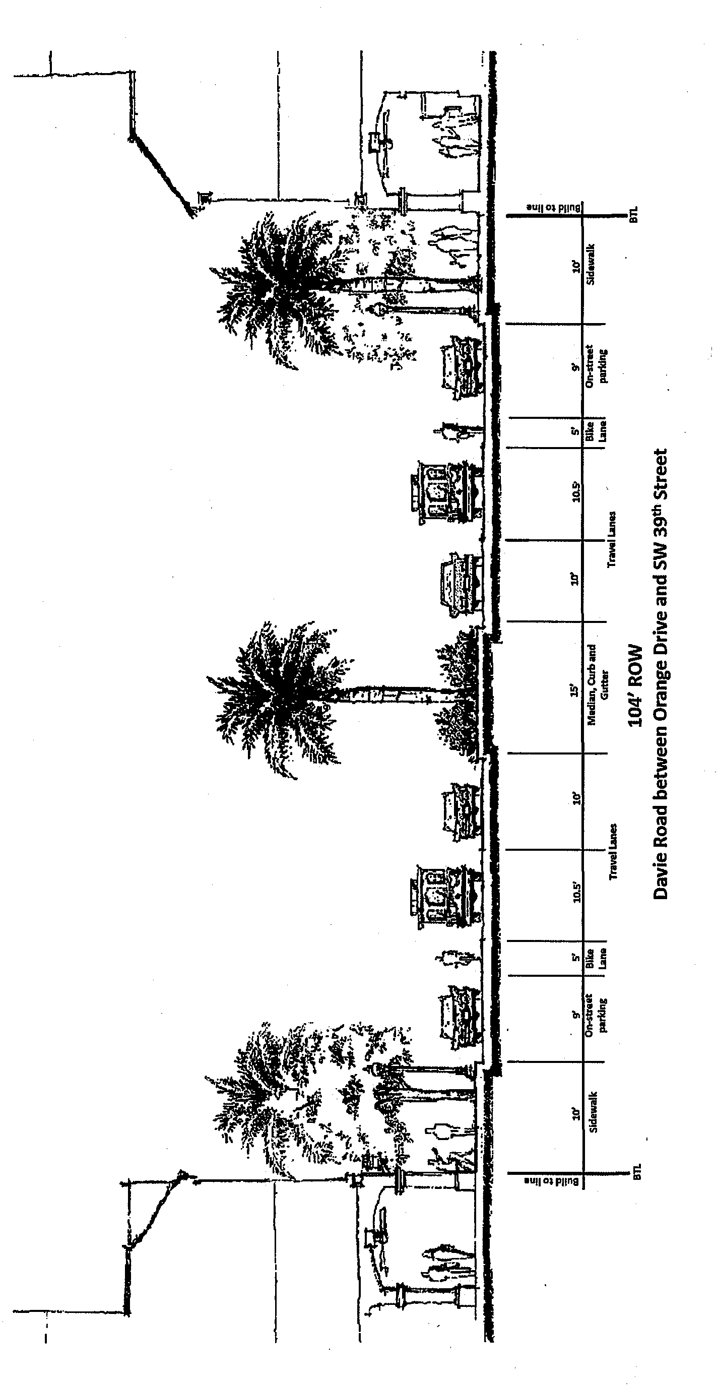
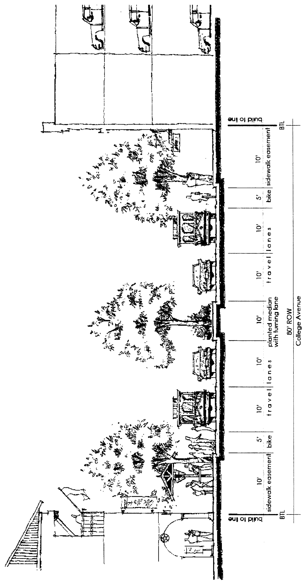
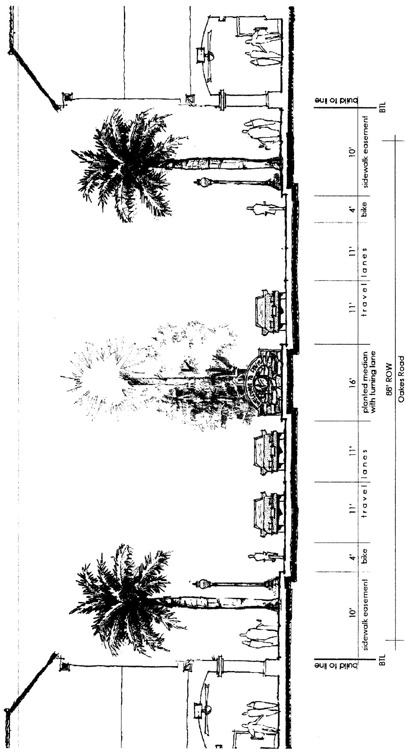
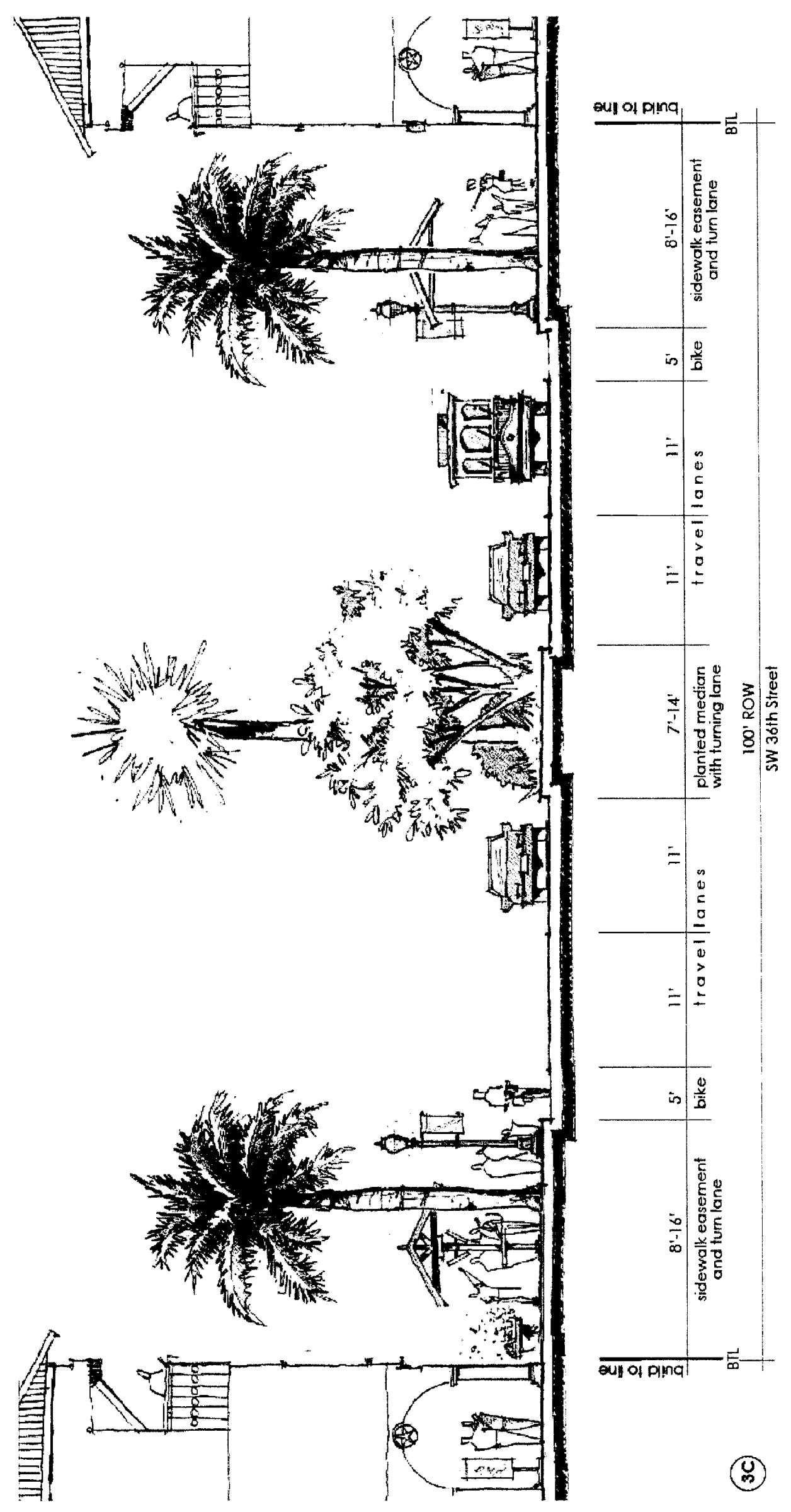
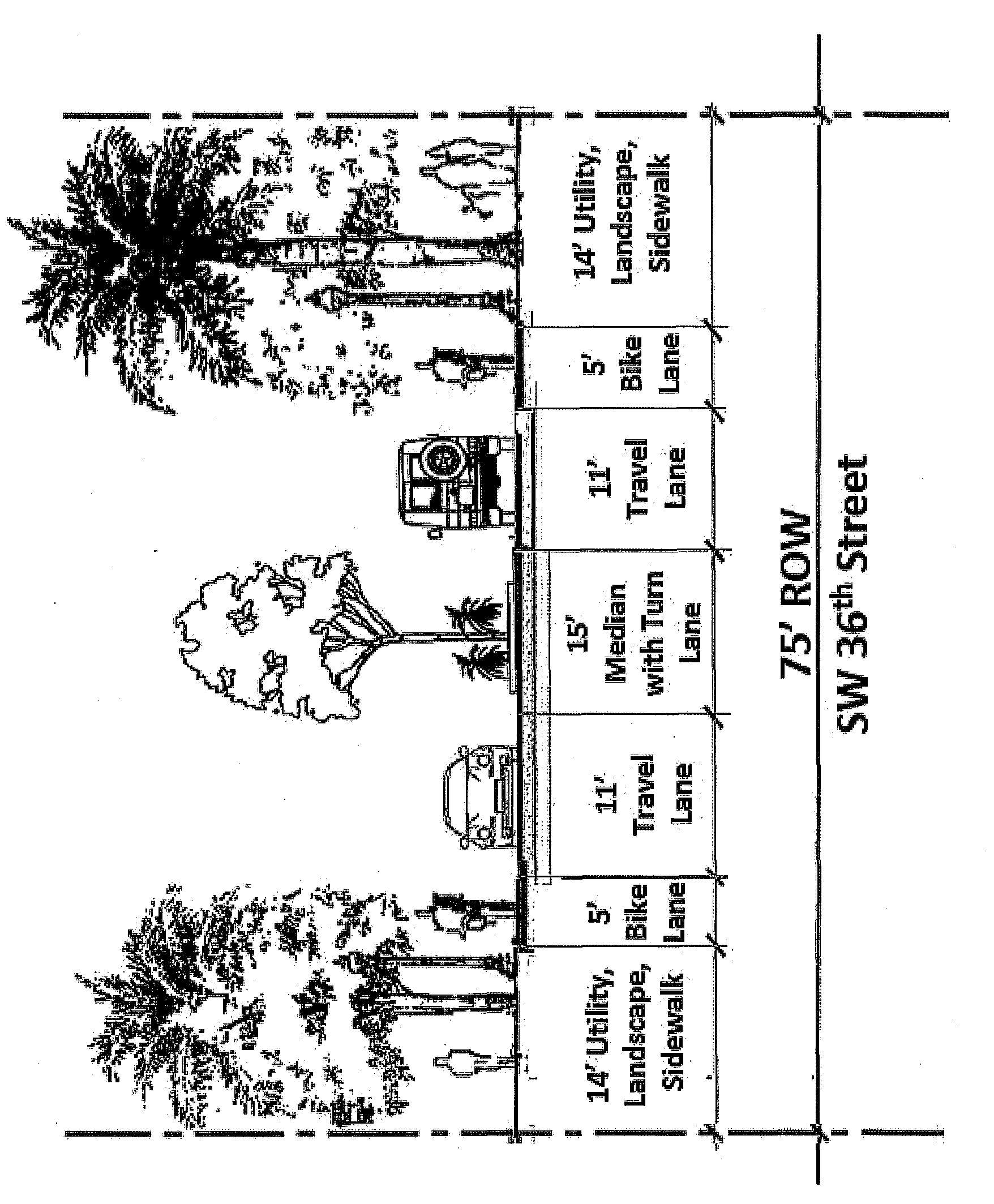
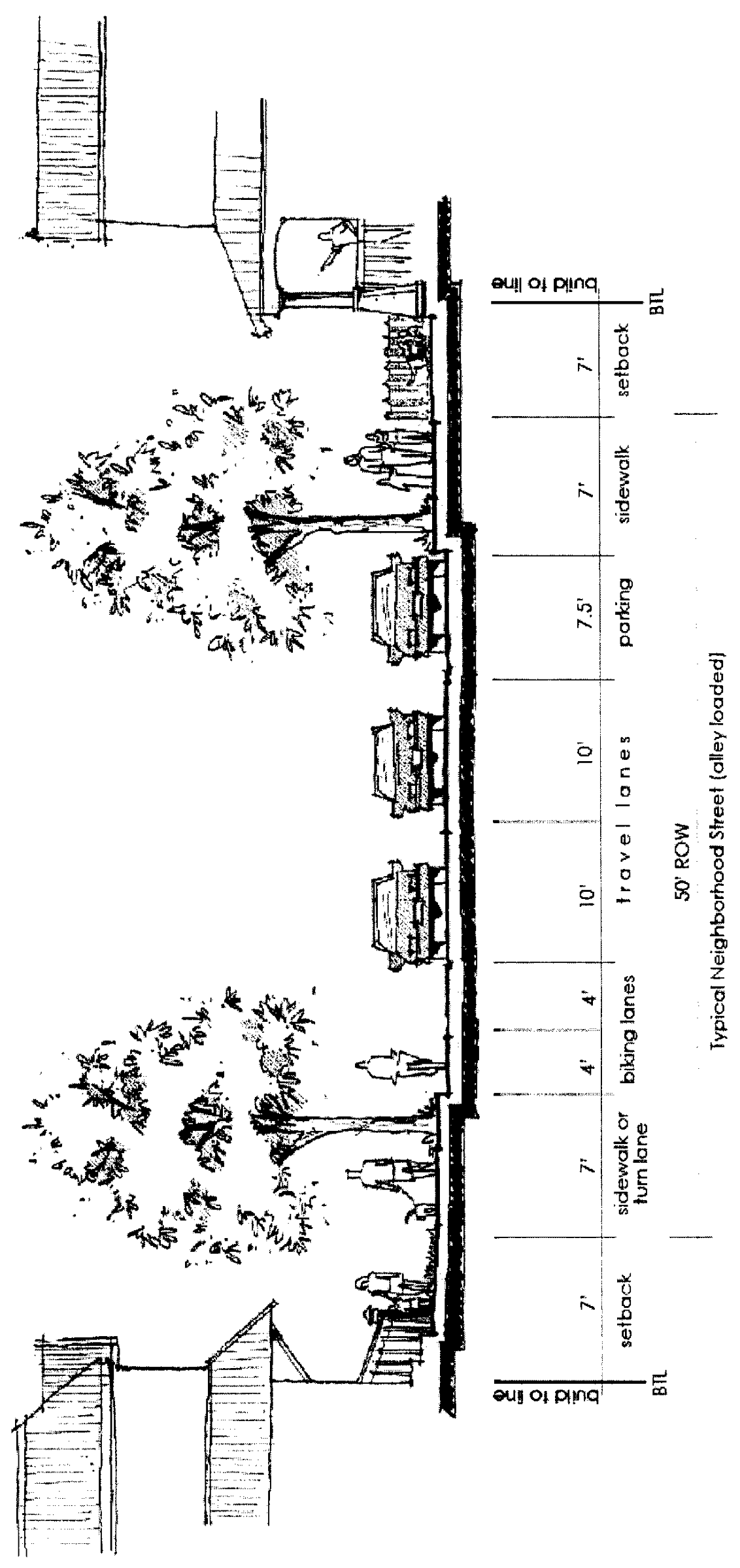
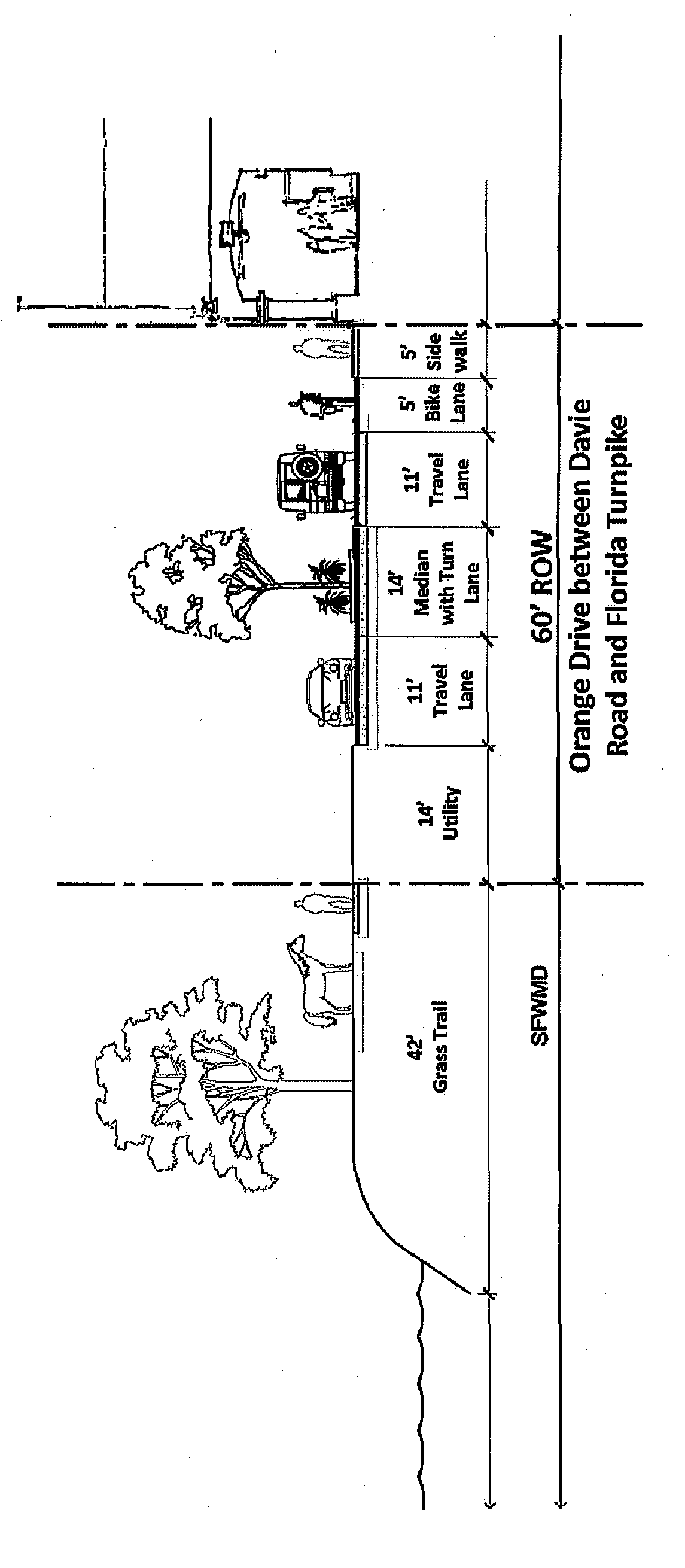
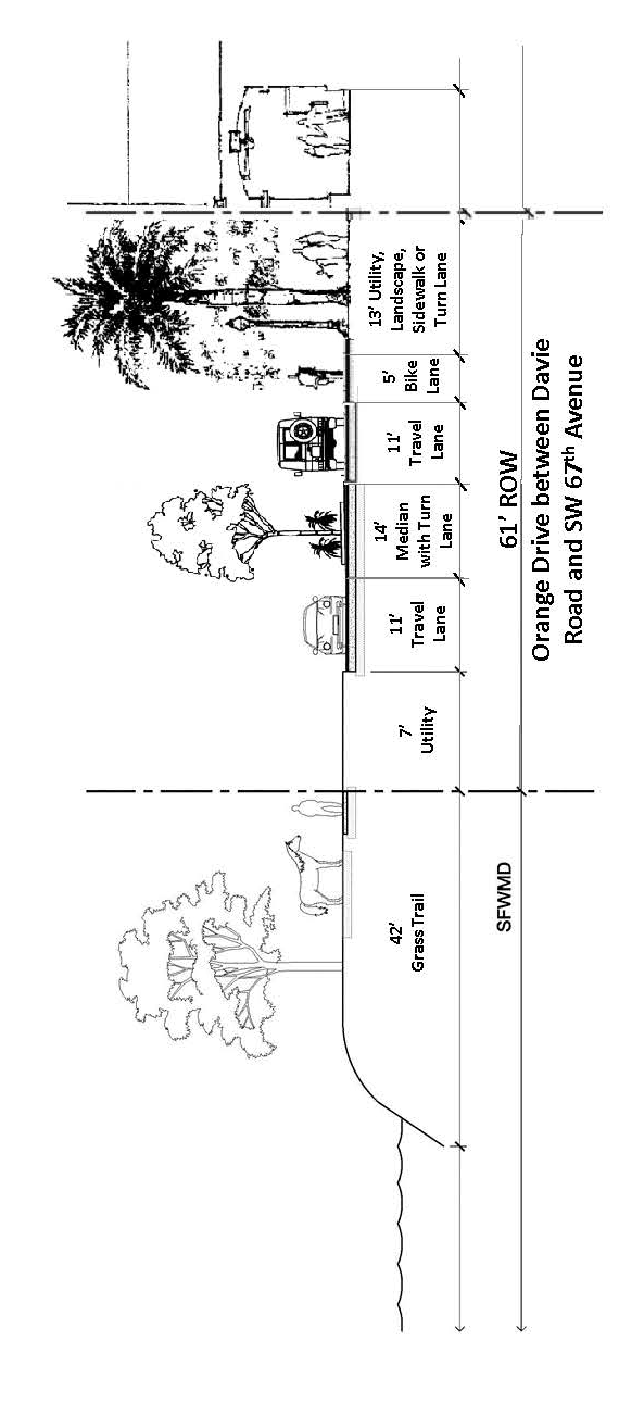
(Ord. of 2-6-08, § 1(Exh. A); Ord. No. 2010-021, § 9(Exh. B), 9-7-10; Ord. No. 12-28, § 2(Exh. A)($12-32.528), 12-5-12; Ord. No. 2017-024, § 2(Exh. A), 8-2-17; Ord. No. O2020-002, § 2(Exh. A), 2-5-20)
Sec. 12-440.- General provisions.
(A)
Purpose and intent. This division is specifically intended to encourage the redevelopment of lands designated as Transit Oriented Corridor on the Future Land Use Plan Map of the Town of Davie Comprehensive Plan. The TOC Future Land Use Map designation and the land development regulations set forth in this Division are intended to implement the State Road 7/US 441 Master Plan (Master Plan) which was approved by the town council by Resolution 2005-236 on September 7, 2005. The master plan was originally created through a community charette series conducted in 2004. The conceptual master plan (see Figure 2) conveys the current vision of the master plan; illustrating the highest and best uses for the property and the core components necessary for successful redevelopment.
It is the intent of this division is to ensure that new development and redevelopment within the TOC area:
(1)
Promotes an appropriate urban form through building placement and sensitivity of site design through the implementation of sustainable building standards;
(2)
Coordinates land use and transportation patterns to encourage infill and redevelopment with an emphasis on compact, pedestrian-oriented mixed-uses that promote increased mobility and integration of transit and bicycle systems and similar alternatives to the automobile;
(3)
Provides for newly-formed blocks with public open spaces and interconnected networks of tree-lined or shaded roads, to be designed and created incrementally, that will improve pedestrian access to transit and reduce the length of automobile trips;
(4)
Provides for an urban design which emphasizes comfort, safety, and distinctive identity.
The transformation of the State Road 7/U.S. 441 corridor requires changes to the public right-of-way such that the street, landscape, and buildings work together to create a distinctive and functional urban place. Central to this vision is the creation of mixed-use and multi-story buildings along the State Road 7/U.S. 441 corridor and a departure from the present standard of single-story retail buildings with surface parking. The mixed uses along the State Road 7/U.S. 441 corridor may not be established through the introduction of mixed use buildings exclusively. Office buildings or properly-scaled residential buildings may be part of the Mixed Use District provided that new residential is located within easy walking distance of shops and services with the creation of a greatly-enhanced pedestrian realm which should support investment that attracts residents and businesses to the corridor.
(B)
Definitions.
Alley. A vehicular way located to the rear of lots, providing access to service areas and parking behind residential, commercial, and office buildings, which may also contain utility easements.
Build-to-line (BTL). As opposed to a minimum setback, a build-to-line is a line specifying exactly where a building must be located on a lot.
Courtyards/outdoor. An open space that is located within the confines of building walls, sometimes between multiple buildings or developments.
Liner building. A building, usually shallow in depth, specifically designed to mask a parking lot, parking garage or blank wall from a frontage or street. (See Liner Building Illustration)
Lot layers. Segments of a lot in which certain elements are permitted or required. The first lot layer is the distance between the curb and the required build-to-line or the actual building façade, whichever is greater. The second lot layer extends twenty (20) feet from the first lot layer. The third lot layer extends from the second lot layer to within five (5) feet of the rear property line.
Mixed use. Multiple uses, such as office, retail, residential, which are within the same building through superimposition or adjacency, or in multiple buildings within the same development area that are adjacent to one (1) another.
Parking structure. A structure containing two (2) or more levels of parking.
Street frontage. The area where a building faces the street and the building normally meets the sidewalk.
(C)
Applicability.
(1)
In general. Nothing in this division is intended to impair or diminish the rights of the existing land owners or their successors or assigns to continue the use and enjoyment of their properties consistent with the zoning in effect at the time of adoption of this division.
(2)
Floating zone/rezoning. Given that the redevelopment of the TOC will occur over many years and will require the support of the private sector and additional investment of the public sector, it is the intent of these regulations that they 'float' above the existing zoning districts until such time that a property is rezoned to a TOC district. Except as provided in paragraph (4) below, whether initiated by a landowner or the town, individual parcels shall be eligible to be rezoned only to a TOC district as depicted in Figure 2. Until such rezoning occurs, parcels of land will continue to be governed by the existing zoning provisions but landowners are discouraged from making significant improvements which would be inconsistent with TOC zoning. Based on actual redevelopment activity occurring in the TOC area and the completion of public improvements envisioned in the master plan, such as premium transit service, transit supportive infrastructure, and public stormwater improvements, the town shall periodically evaluate whether to initiate the rezoning of parcels to the corresponding TOC districts.
(3)
Conflicts. Where the provisions of this division conflict with any other provision of the Town of Davie Land Development Regulations, the provisions of this division shall prevail except as specifically stated otherwise in this division.
(4)
De minimis zoning boundary amendments. Despite any provision to the contrary in section 12-440(C), Town Council may rezone an area to a town zoning district other than a TOC district, provided that all of the following are met:
(a)
The area to be rezoned is one (1) acre or less in size.
(b)
The proposed rezoning supports the expansion of a conforming use which was lawfully established on adjacent property prior to January 1, 2020.
(c)
The proposed zoning district is consistent with the Transit Oriented Corridor land use designation.
(D)
How to use this Code. The following flow chart, Figure 1, is intended to help simplify the process of determining the regulations that are applicable to a parcel.
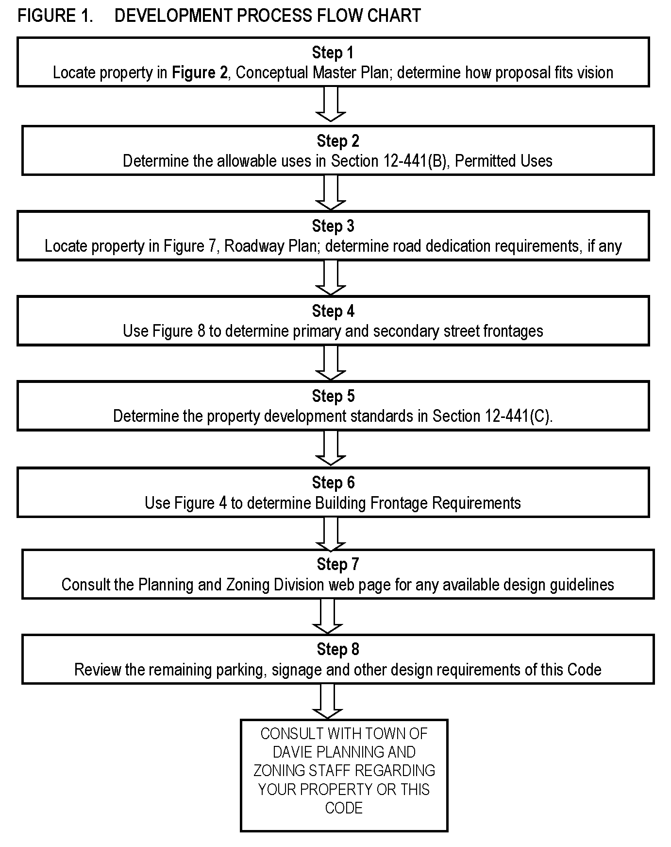
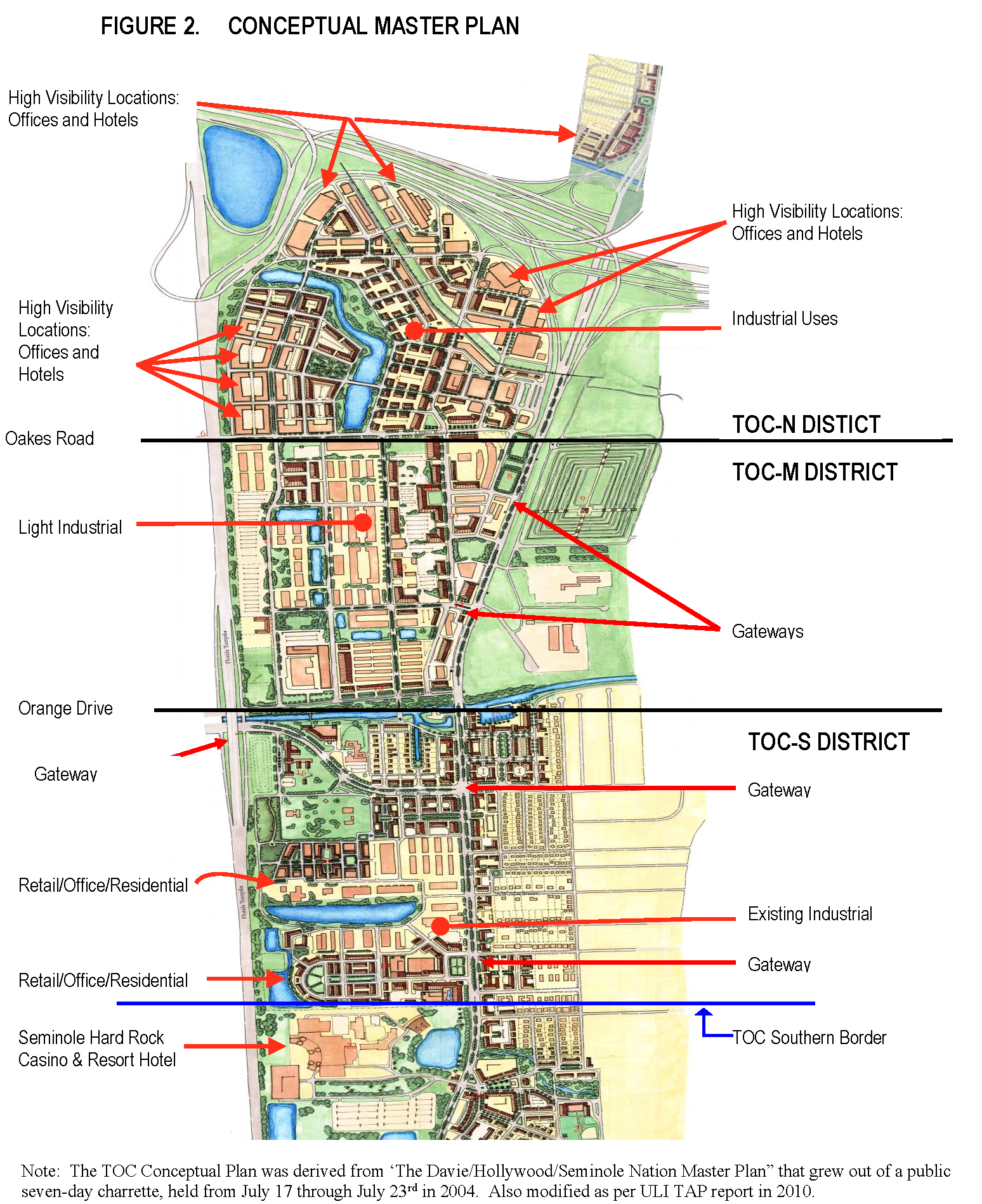
(Ord. No. O2020-006, § 2(Exh. A), 3-4-20; Ord. No. O2024-015, § 2(Exh. A), 5-15-24)
Sec. 12-441. - Development standards.
(A)
District purposes. In general, the TOC districts are intended to accommodate existing industrial uses but with an emphasis on achieving higher utilization of the area in light of its proximity to the sea port, airport, and major transportation and educational facilities within the region. New development, which may include residential and hotels in select locations, will be designed using transit-oriented design principles and provide for connections to local and regional transit systems.
TOC-N. Taking advantage of its close proximity to Interstate-595, this district allows the widest range of uses, including intensive industrial uses.
TOC-M. Allows for the continuation of existing intensive industrial uses but limits new development to commerce, less intensive industrial uses and residential and lodging in select areas. Stricter urban design principles are required for new development to ensure compatibility of uses and to accommodate transit and mobility.
TOC-S. Allows for the continuation of existing intensive industrial uses but limits new development to commerce, less intensive industrial uses and residential and lodging in select areas. This district, which has urban design principles similar to TOC-M, can be expected to accommodate commercial and entertainment uses based on the close proximity of the Seminole Hard Rock Casino to the south.
(B)
Permitted uses.
(1)
Mixing of uses. Uses may be mixed horizontally or vertically, subject to the rules of this division. Horizontal mixing via separate buildings is permitted, provided that no residential on the first four (4) floors face nonresidential loading areas.
Mixing of residential and nonresidential uses within the same building is encouraged and permitted subject to appropriate separation of the uses, including, but not limited to, separation by building floor, separation of access, and buffering of residential units from more intensive uses, such as through soundproofing and restrictions on operating hours.
(2)
Standards for specific uses.
(a)
In general. The standards set forth for the specific uses listed in section 12-34 of the Town Code, shall apply within the TOC district unless such standards are specifically designed to protect non-TOC districts. For example, a specific standard that applies broadly to all commercial properties shall apply equally within the TOC districts, while a standard specifically designed to regulate a use in the B-1 district shall not apply to the TOC district, even if the area had previously been zoned B-1.
No building or structure, or part thereof, shall be erected, altered or used, or land or water used, in whole or in part for other than the uses specified in this division. The permitted uses of the TOC districts are set forth in the following table. Any use not specifically listed is prohibited.
_____
P = Permitted Use
N = Not Permitted Use
P(#) = Permitted subject to corresponding table footnote
Table Notations:
(1)
Singularly residential use buildings shall only be permitted within one thousand (1,000) feet of supporting commercial and office uses.
(2)
New residential uses proposed within areas of existing industrial or other existing potentially incompatible uses shall mitigate negative impacts on site in accordance with section 12-441(F)(4).
(3)
Medium Industrial and Planned Industrial Park uses are only permitted as a continuation of a pre-existing use as governed by section 12-444.
(4)
Requirements of section 12-34(W) apply.
(C)
Site development standards.
(1)
Site development standards.
Table Notes:
(1)
As measured along the front property line. Flag lots are not allowed.
(2)
Building frontage refers to the width of the building facade along the property line. Where paved passageways are used to connect the public sidewalk with courtyards or parking lots in the interior of a parcel, up to fifteen (15) feet of such passageways may be considered part of the building facade.
(3)
Open space refers to that portion of a lot which is pervious and not occupied by buildings, structures, pavement (including pervious paving material), parking areas, driveways or outdoor storage areas. Individual developments may qualify for reductions in the on-site open space requirement as provided in section 12-442(B).
(4)
Overall density and intensity within the Transit Oriented Corridor Future Land Use category is governed by Objective 13.1 of the Comprehensive Plan. The town's planning and zoning division maintains a tracking sheet to monitor the amount of remaining development.
(5)
See section 12-441(D) for bonus height provisions.
(6)
Building placement along a primary or secondary frontage shall be referenced to the property line location after any dedication of right-of-way necessary to comply with the roadway plan as set forth in section 12-442(A)1. In cases where the exact location of the right-of-way line has not been determined, the town engineer shall determine the most likely location of the line based on the most up-to-date plans for construction or reconstruction of the roadway. This will ensure that the building placement, sidewalk, street trees and other public amenities will be properly aligned when the roadway is eventually constructed.
(7)
Primary frontage refers to building frontages along primary roads as identified in Figure 8. Primary roads are of such importance to the overall functionality of the overall development of the TOC area that all building form provisions apply. On a corner where both streets are primary streets, any new building shall be constructed to the built-to line of both streets except as necessary to maintain clear sight triangle requirements in section 12-113. In circumstances where the Town Code for sight distance may not be applicable, the American Association of State Highway and Transportation Officials (AASHTO) "Green Book, Fifth Edition" or the Florida "Green Book" shall be used.
(8)
Secondary frontage refers to building frontages along secondary roads. A secondary road is any public road within the TOC that is not identified as a primary road in Figure 8. Secondary frontages are exempt from certain provisions of the building form requirements allowing for open parking lots, unlined parking decks, drive-throughs and building frontages without required projecting elements. (see Frontages Illustration).
(9)
No setback is required where the adjacent property owners have made arrangements for maintenance of buildings on a common boundary (e.g., party wall agreements).
(10)
As defined and illustrated in Figure 4.
_____
(2)
Allowable encroachments into the public right-of-way. The town council may allow awnings, balconies, galleries, arcades and similar building elements that provide the public shelter from the sun and rain to be constructed within the public right-of-way. Such encroachments shall extend into the sidewalk area such that a minimum eight (8) foot clear zone is maintained both horizontally and above the grade of the sidewalk. Columns and similar supports shall be no closer than two (2) feet to any curb and shall not impede the flow of bicycle or pedestrian traffic. No such encroachment shall involve enclosed, habitable floor area or extend into any trafficway reservation area. All such encroachments must have legal agreements acceptable to the town attorney which, at a minimum, shall outline maintenance responsibilities and liability.
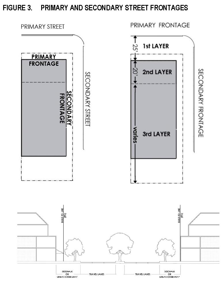
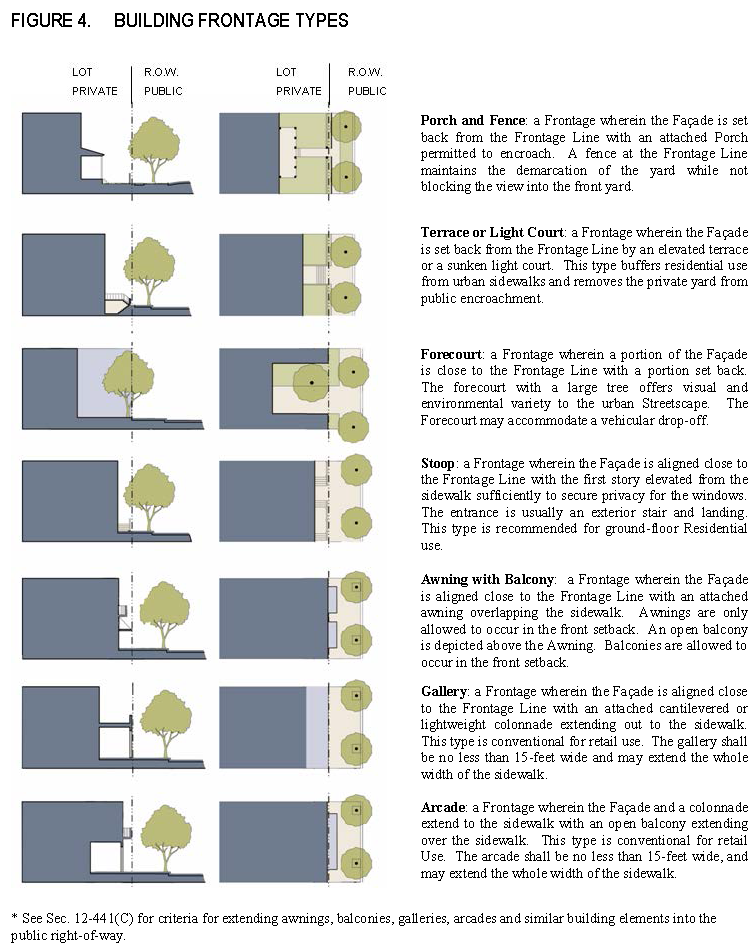
(D)
Height.
(1)
Building height limits.
(a)
Maximum building heights. No building or structure shall be erected or altered to exceed the height limits set forth in Section 12-441(C). The total building height shall be measured as set forth in section 12-503, definition of "building height" and the exceptions of Section 12-89 shall apply.
(2)
Bonus height. Projects which provide an overall public benefit shall be allowed bonus height up to the maximum bonus shown in section 12-441(C)1. The qualifications for bonus height shall be as follows.
(E)
Supplemental requirements.
(1)
Airport noise compatibility.
(a)
In general. Portions of the TOC area are subject to noise impacts from Fort Lauderdale International Airport. For purposes of this paragraph, "DNL noise contours" refers those noise impact exposure in the Runway 9R/27L Environmental Impact Statement, December 2008-2020 B1b.
(b)
All TOC districts. Upon approval of any site plan or plat within the TOC involving new residential units, the town administrator shall provide written notice of such approval to the Broward County Director of Urban Planning and Redevelopment, indicating the project location and the number and type of units.
(c)
Within the 60-65 DNL contour.
1.
Any new development project involving residential uses shall include a condition of approval requiring that the developer record in the Official Records of Broward County a notice to all potential purchasers of such residential housing that the property lies within the 60-65 DNL noise contour.
2.
Any new building with residential dwelling units must include noise mitigation measures in order to achieve outdoor-to-indoor Noise Level Reduction (NLR) of at least twenty-five (25) decibels (25 dB).
(d)
Within the sixty-five (65) and above DNL contour. No new residential units or other "non-compatible land uses" shall be permitted. "Non-compatible land uses" refers to the category of noise-sensitive land uses set forth in Table 1, 14 CFR Part 150, Appendix B, as amended from time to time.
(2)
Schools. The town will work with the Broward County School District to develop strategies and conceptual design approaches for future school development needed to accommodate existing and future student populations as identified by the Broward County School Board. School facilities, whether public or private, should be in the form of compact, urban campuses and should be sited and designed as focal points within the overall community. Great care shall be taken in site selection, site layout and design to ensure that schools are interconnected with other uses and enhance multi-modal opportunities.
(3)
Compatibility. New residential uses proposed within areas of existing industrial or other existing potentially incompatible uses shall mitigate negative impacts on site through the use of increased landscape buffers, walls and other mitigation measures deemed appropriate based upon the adjacent existing use. Residential units shall be located as far away from the industrial activities as is possible based upon site configuration.
(F)
Parking.
(1)
Purpose and intent. This subsection (F) contains design standards to ensure that parking is convenient and accessible, accommodates all land uses, and supports goals of the master plan such as:
• Enable people to park once at a convenient location and to access a variety of commercial enterprises in pedestrian friendly environments.
• Avoid adverse parking impacts on neighborhoods adjacent to redevelopment areas.
• Maximize on-street parking.
• Encourage parking to be located in the third layer of the lot, and/or behind building structures.
• Provide flexibility for redevelopment of small sites.
(2)
In general. Off-street parking shall comply with the provisions of chapter 12, article VII except as otherwise specified in this subsection (F).
(3)
Provision of required parking spaces. The required number of parking spaces may be provided by any combination of the following:
(a)
Within the lot layers specified by this subsection (F).
(b)
Along the on-street parking lane corresponding to the lot frontage, provided that the on-street parking lane is paved and fully developed for such parking.
(c)
By a shared parking facility established in conformance with this subsection (F).
(4)
Location of off-street parking. Off-street parking is defined as either surface or structured and shall be limited to areas of the lot as specified below (refer to Figure 3 for lot layer locations).
(a)
Surface parking.
1.
Open surface parking. For purposes of this paragraph, a surface parking lot is one (1) that fully or partially extends to a parcel's street frontage (including landscaped setback areas) and is not located behind a building along the parcel's primary street frontage. Open surface parking lots in the first layer of the lot are prohibited. Open parking in the second lot layer is discouraged and limited to no more than twenty (20) percent of the front lot width. All parking areas are encouraged in the third lot layer. Open parking areas shall be masked from the frontage by a building or streetscreen.
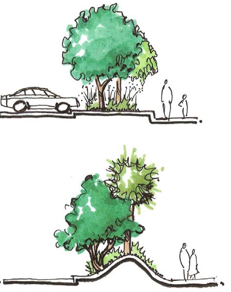
A streetscreen is a freestanding screen situated along the frontage line, or coplanar with the facade capable of preventing a parking area from being readily viewed from a street frontage. Streetscreens may be made up of a wall, fence, landscaping or a combination of these and should be between three (3) and eight (8) feet in height. Walls must match the adjacent building facade. Streetscreens shall have openings no larger than is necessary to allow automobile and pedestrian access. In addition, all streetscreens over four (4) feet high should be thirty (30) percent transparent or be articulated to avoid the appearance of blank walls.
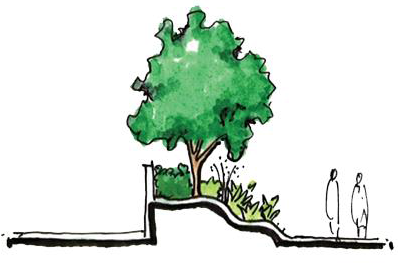
2.
Wrapped surface parking. A wrapped surface parking lot is created by placing a narrow building(s) between the parcel's street frontage(s) and the parking lot. Except for driveway access, the parking lot is to be located behind the liner buildings and no portion of the parking lot is to be readily visible from the primary street.
(b)
Structured parking.
1.
Exposed. An exposed above-ground parking structure is a structure that is fully or partially exposed to the primary front street(s) on the ground level. Exposed parking structures shall not be located in the first lot layer on the ground level. The parking structure above the ground level may be exposed to the building's street frontage(s) for the second and/or third lot layers.
2.
Wrapped on ground level. Wrapped on the ground level refers to a multi-story parking structure where non-parking uses are integrated into the ground level of the building along the primary street frontage(s) of the parcel, as shown in Figure 6. Non-parking uses are encouraged to be integrated into the building along secondary street frontages, further hiding the parking structure from view. The parking structure above the ground level may be exposed to the building's street frontage(s) on the upper levels.
3.
Wrapped on all levels. An above-ground parking structure where non-parking uses or enhancements to the elevation of the parking structure which may include fake windows, balconies, or other pleasing architectural treatments are integrated into the building along the parcel's primary street frontage(s) on all levels of the building. Non-parking uses or enhancements to the elevation of the parking structure which may include fake windows, balconies, or other pleasing architectural treatments are encouraged to be integrated into the building along all street frontages, to further hide the parking structure from view.
(5)
Exceptions and alternatives.
(a)
Liner buildings. Liner Buildings less than thirty (30) feet deep and no more than two (2) stories shall be exempt from minimum parking requirements.
(b)
Adjacent transit stop. Lots immediately adjacent to a designated Broward County Transit stop or Town of Davie Circulator stop may count the stop for up to five (5) required parking spaces, or a maximum of ten (10) spaces if the bus stop has a shelter from sun and rain, and a maximum of fifteen (15) spaces if the bus stop has a shelter from sun and rain and has an operable variable schedule "real-time" display or automated ticket dispenser, provided there is direct access to the bus stop via a minimum five (5) foot sidewalk.
(c)
Parking reductions pursuant to section 12-438.17(H).
(d)
Shared parking pursuant to section 12-438.17(I).
(6)
Bicycle parking.
(a)
Bicycle parking requirements pursuant to section 12-438.17(F).
(7)
Valet parking. Off-street parking facilities maintained with valet parking shall be allowed, provided that the minimum off-street parking requirements of this division are satisfied and that an attendant shall remain on duty during business hours or as long as the principal building, or buildings services by the valet parking area, are occupied.
Minimum off-street parking requirements may be reduced through the efficient utilization of valet parking. In a designated valet parking area vehicles can be parked closer together without adhering to minimum parking space sizes.
(G)
Access. Along primary streets, curb cuts and driveways shall be prohibited. Vehicular access shall be provided via secondary streets or alleyways.
(H)
Landscaping.
(1)
In general. The landscaping requirements of chapter 12, article VI, of the Town Code shall apply except as otherwise noted in this subsection (H). In the event of any conflict between article VI and this subsection (H), the provisions of this subsection (H) shall apply.
(2)
Requirements.
(a)
Regardless of the use, new development shall meet the landscaping requirements of Sec. 12-111(D) Commercial and Industrial districts.
(b)
Tree requirements. When necessary to provide a continuous pedestrian pathway, the requirement for planting in a minimum ten (10) foot wide area may be waived provided that sufficient area is provided for viability and growth potential of each particular tree.
(c)
Street trees. At least one (1) tree shall be planted for every forty (40) lineal feet of the lot frontage within the first lot layer abutting a primary street. Trees located within the right-of-way shall be the discretion of the town.
(d)
Interior landscape for parking areas. The pathways from parking areas to main entrances shall be the focus of landscape design in those areas containing off-street parking lots. These areas shall be planted with shade trees no more than thirty (30) feet on center. A pedestrian walkway of no less than four (4) feet shall be provided within the buffer to create a continuous shaded walkway from the parking lot to the front entrance. Curbed interior landscape islands twelve (12) feet wide are required for every ten (10) parking spaces in alternating rows of parking spaces, or equivalent configuration approved by the town, and shall contain one (1) large shade tree.
(3)
Perimeter buffer areas for non-residential uses adjacent to exclusively residential property. A landscape buffer of at least twenty (20) feet in width shall be required adjacent to any residentially zoned or used property. An eight-foot masonry wall shall be installed along the property line with the landscaping material placed on the outside of the wall, subject to the adjacent property granting a landscape maintenance easement. In addition, the landscape buffer shall contain one (1) fourteen- to sixteen-foot tree for each thirty (30) linear feet or fraction thereof of property line, and a continuous row of hedges shall be installed.
(I)
Signage. All signage shall be governed by chapter 12, article VIII of the Town Code except that design variations to signage standards may be approved by town council pursuant to section 12-443.
(Ord. No. O2020-006, § 2(Exh. A), 3-4-20; Ord. No. O2021-030, § 2(Exh. A), 11-3-21; Ord. No. O2022-013, § 2(Exh. A), 8-17-22; Ord. No. O2023-016, § 2(Exh. A), 9-20-23)
Sec. 12-442. - Streets and public spaces.
(A)
Streets and sidewalks.
(1)
Roadway plan. New streets and blocks shall generally conform to Figure 7, Roadway Plan. Note that Figure 7 includes street locations, roadway types and cross-sections. Existing roadways shall be utilized and enhanced where possible to meet the standards of this paragraph.
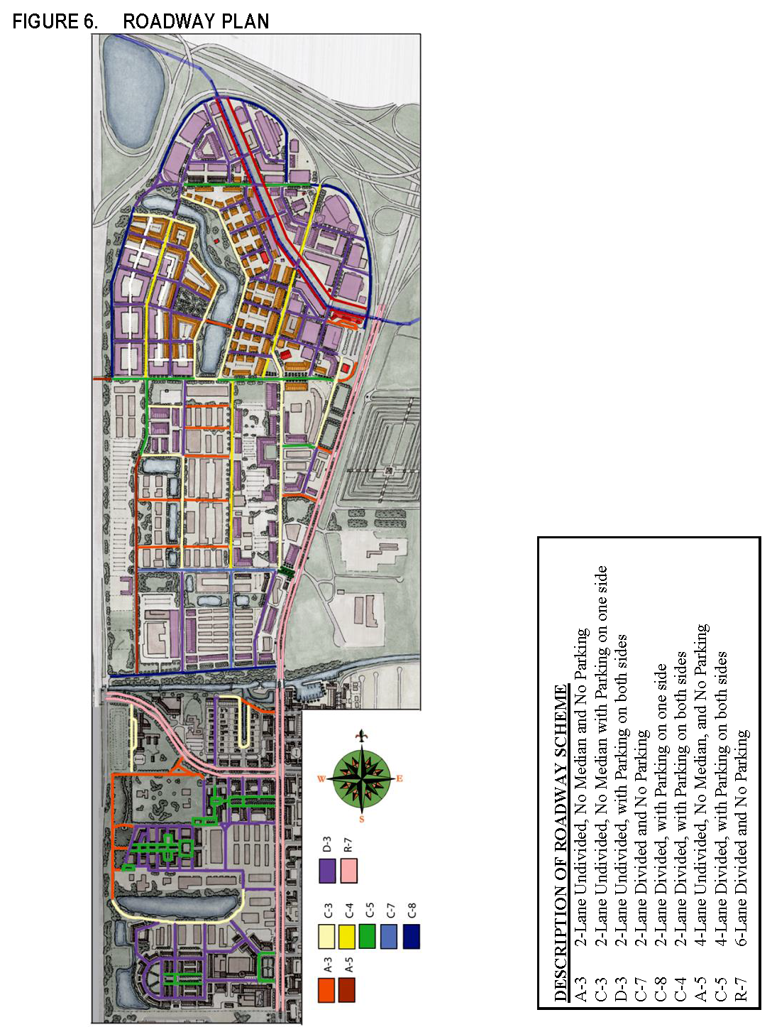
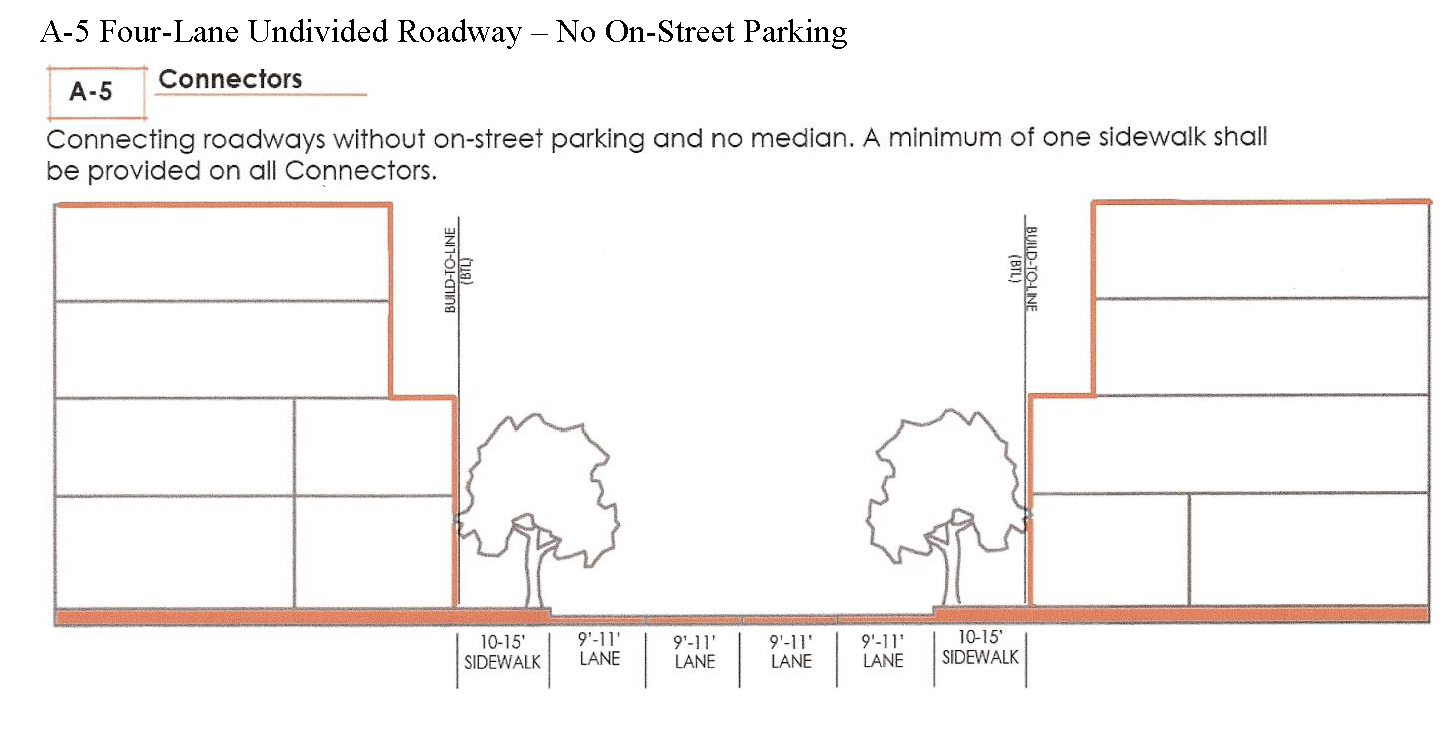
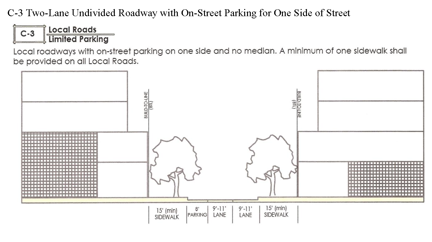
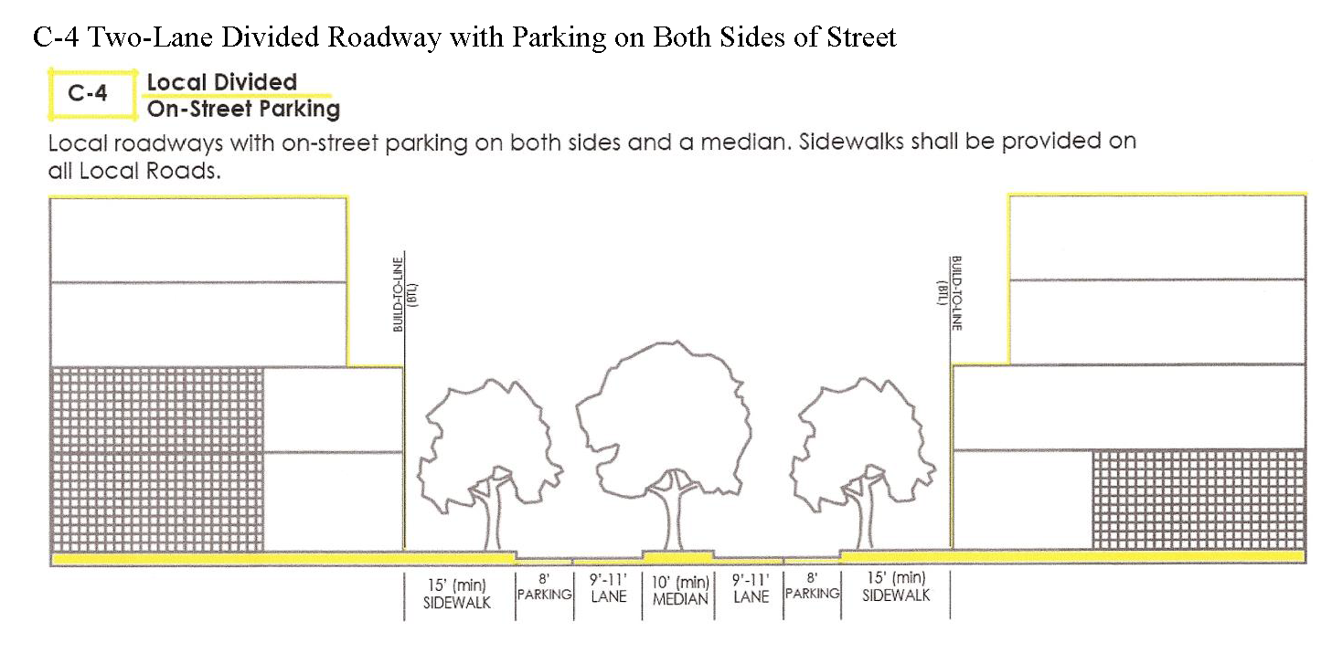
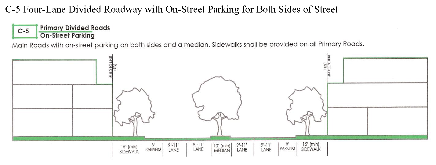
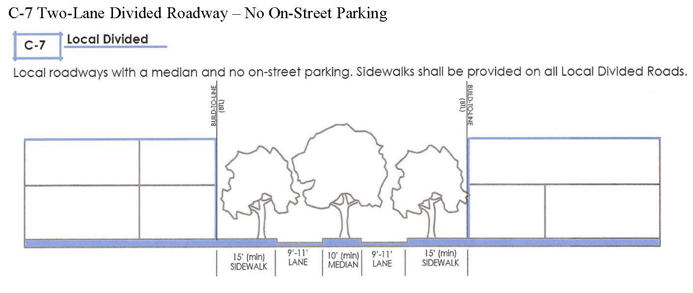
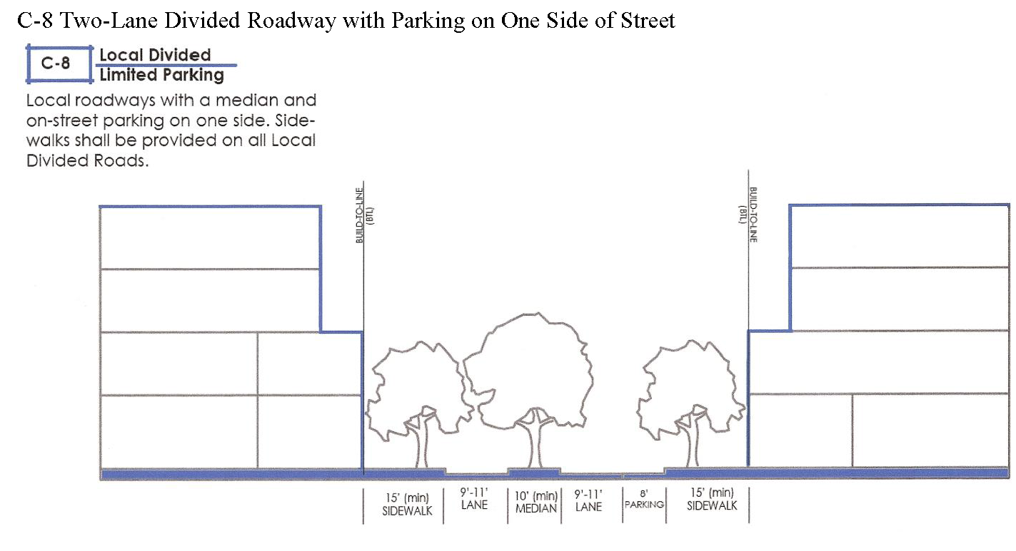
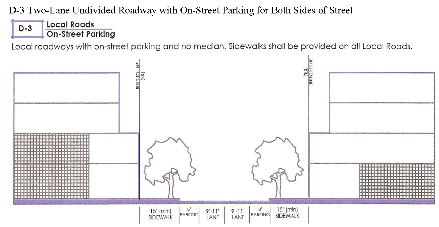
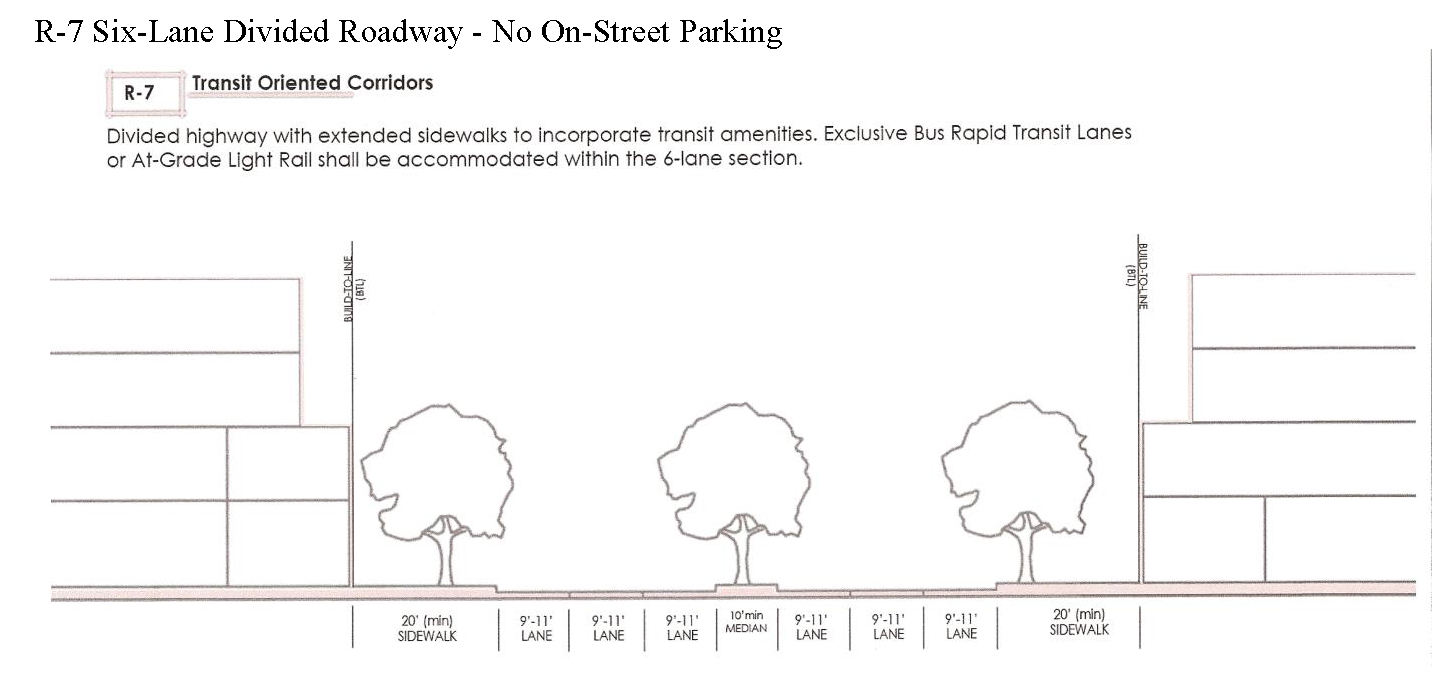
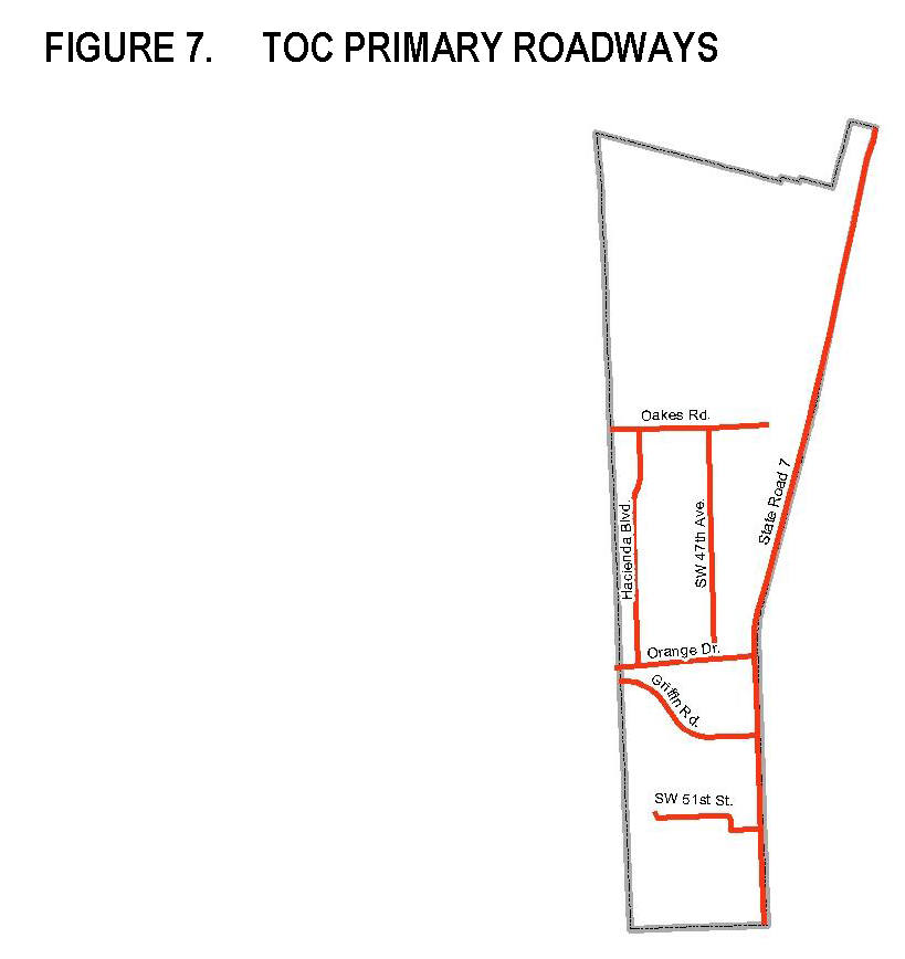
(2)
Required dedications, construction of improvements.
(a)
Right-of-way shall be dedicated to the public as necessary to fulfill the street section requirements in section 12-442.
(b)
The developer of each development site shall be responsible for installing sidewalks and street trees within the right-of-way adjacent to the development site pursuant to the applicable street section(s) in section 12-442. The town may permit payment in lieu of construction where it will be more efficient to undertake improvements on an areawide basis.
(B)
Open space.
(1)
Generally. Over time, the TOC area will be developed with a network of publicly accessible open spaces capable of serving a wide variety of purposes, including stormwater management, parks, trails and waterways. Whether through designated spaces on developed parcels or on public lands, the town must ensure that no less than one hundred twenty (120) acres of the TOC is reserved as open space. After completion of a stormwater master plan, the town will establish a mechanism for development of the necessary stormwater facilities and possibly public open spaces. This may provide landowners alternative options for meeting the minimum open space requirements, including the option to provide open space off-site. The following table indicates the types of public open spaces envisioned for the TOC.
(2)
On-site open space. The on-site open space requirement shall be as set forth in section 12-441(C). The on-site open space requirement shall be reduced by five (5) percent if at least twenty-five (25) percent of the open space provided on site is designed as publicly-accessible open space utilizing any of the methods shown in Figure 9. Publicly-accessible open space must provide shade and seating areas and shall not be gated.
(3)
Off-site open space. (Reserved.)
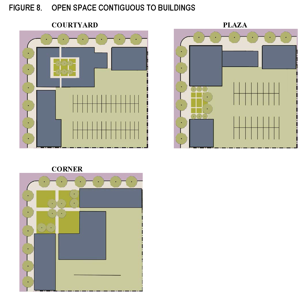
(C)
Pedestrian amenities. Pedestrian comfort and safety is critical to the success of the Transit Oriented Corridor. By focusing on the experience of the individual throughout the TOC districts, a more appropriate balance between pedestrian, bicycle and vehicular traffic can be realized. Streetscapes within the TOC must offer protection from the vehicular traffic as well as the elements. Understanding the diverse mix of uses within the TOC, it is also important to maintain adequate buffers to mitigate undesirable impacts on adjacent properties.
The following pedestrian amenities shall be uniform throughout the TOC. Additional studies shall be undertaken and developed with the approval of town council.
(1)
Trees. A minimum of one (1) canopy tree shall be planted within the first lot layer frontage for each thirty (30) feet of frontage line as depicted in Figure 3. With the approval of the town and with legal agreements acceptable to the town attorney, a landowner may meet this requirement by installing street trees within the public right-of-way.
(2)
Lighting. (Reserved.)
(3)
Street furniture. (Reserved.)
(D)
Walls, screening, and buffering. In order to protect the public spaces and adjacent mixed uses within the TOC from potentially negative impacts, new development shall provide the following:
(1)
Landscape buffers. Landscape buffers in the first lot layer shall be used to screen parking or vehicle storage in the second or third lot layers. Landscape buffers may be interrupted by pedestrian walkways as needed to provide access to public rights-of-way.
Bermed landscape buffers in the first lot layer shall be used to screen parking or vehicle storage and light industrial uses. These buffers may maintain access to parking from public sidewalks or passages where appropriate.
Walls with bermed landscape buffers in the first lot layer shall be used to screen vehicle storage and Medium Industrial (M-2) or Planned Industrial Park (M-3) uses. These buffers shall not maintain access to and from public sidewalks or passages.
(2)
Walls. Walls shall be utilized when necessary to screen views and mitigate industrial related and potentially negative impacts on adjacent properties from the public realm. In TOC districts where property frontages allow the use of a wall to maintain a consistent urban form, the wall shall be subject to the regulations of this division. Emphasis on frontages that utilize walls shall be based on the quality of the design and construction. Structural and aesthetic articulation shall be required.
Walls shall be designed, installed and maintained to reduce the visual impact of large, undifferentiated frontages. Articulation and/or fenestration shall be used to visually minimize the scale and length of frontage walls. No blank walls will be permitted along frontages within the TOC.
Frontage walls, where permitted, shall not exceed eight (8) feet in height unless designed to screen Medium Industrial (M-2) or Planned Industrial Park (M-3) uses. Frontage walls that extend for a distance greater than one hundred (100) linear feet, shall use an indented wall plane of six (6) to eight (8) feet in depth and thirty (30) to forty (40) feet in length per one hundred (100) linear feet of wall. The spaces created by indented walls shall be utilized for additional landscaping or streetscape amenities such as benches or integrated bus shelters.
(Ord. No. O2020-006, § 2(Exh. A), 3-4-20)
Sec. 12-443. - Design variations, administrative relief.
(A)
Purpose and intent. The TOC districts differ from many other zoning districts within the town because of its emphasis on design principles, and because it seeks to combine different use types within buildings and development sites rather than separate them, and to encourage an urban intensity of development and form. In order to accomplish this, several areas of the TOC districts have specific, prescribed development standards, rather than minimums and maximums, to define the urban form of future development. Given this level of specificity throughout an area as large in breadth as the TOC districts, requests for variation from the standards and requirements can occasionally be expected in order to account for the variation in conditions within the TOC districts, and the difficulty of accounting for them in a design-specific regulation. Requests for variation can also be expected to facilitate design interpretations and alternatives that work as well, or better, than the prescribed standard. Finally, some aspects of site development and design have not been prescribed or because the sheer size and variation of conditions and objectives within the TOC districts made this prohibitive. In some such cases, the intent of the regulations may be executed with slight variation based on the specifics of the site, adjacent street and uses, and development proposal. For all of these reasons, the variance process of section 12-309 has been supplanted by a design-based variation process that shifts the focus of review from hardship to design and logistics issues. However, variances still apply to code provisions not specific to the TOC districts, and to the intensity standards of the TOC districts.
(B)
Procedure.
(1)
The town council is authorized to approve variations to the standards and requirements of this division, provided that variations from the intensity standards of this division are subject to the variance process.
(2)
Design variations associated with site plan and site plan modifications shall be considered as part of such site plan or modification applications.
(3)
Submittal requirements shall be established administratively.
(4)
The town council shall evaluate each request for design variation based upon the criteria set forth in this section, and may approve, approve with conditions, or deny such request after conducting an advertised, quasi-judicial public hearing pursuant to the requirements applicable to site plan approval.
(C)
Standard of review. The town council shall use the following criteria to base decisions to approve, approve with conditions, or deny requests for design variation:
(1)
Whether the request is for a reasonable accommodation of design flexibility that results in the same or better design consistent with the intent and principles of this division that govern the standard for which variation is requested; or
(2)
Whether the variation is appropriate to accommodate site conditions not anticipated in these regulations, or to reconcile conflicting requirements, provided the request is generally consistent with the intent and principles of the this division that govern the standard for which variation is requested.
(Ord. No. O2020-006, § 2(Exh. A), 3-4-20)
Sec. 12-444. - Nonconformities.
(A)
Nonconforming uses. Despite any provision to the contrary in section 12-441.B, any use of a parcel of land which was lawfully established prior to January 1, 2020 shall be considered a permitted use and shall not be subject to section 12-40 provided that the use is not expanded beyond the boundaries of the parcel as established prior to January 1, 2020. The use may be expanded within the boundaries of the parcel as established prior to December 31, 2021, such as through the addition of new buildings, structures and storage areas, provided that such additions comply with the design standards of this division, utilizing the design variation provision of section 12-443 if needed.
(B)
Nonconforming structures. Nonconforming buildings and structures shall not be modified so as to increase the level of nonconformity but shall otherwise not be subject to the provisions of section 12-39.
(Ord. No. O2020-006, § 2(Exh. A), 3-4-20)
Sec. 12-410. - Authorization to create neighborhood improvement districts.
The Town of Davie is hereby authorized to create neighborhood improvement districts by the enactment of a separate ordinance for each district, which ordinance:
(1)
Specifies the boundaries, size and name of the district.
(2)
Authorizes the district to receive a planning grant from the Department of Community Affairs of the State of Florida.
(3)
Includes a statement of purposes to utilize a maximum of two (2) mills ad valorem taxes or special assessments on real property within the district.
(4)
Designates the town council as the board of directors of the district.
(5)
Establishes an advisory council to the board of directors comprised of property owners or residents of the district.
(6)
May prohibit the use of any district power authorized by F.S. Section 163.514 of the "Safe Neighborhoods Act."
(Ord. No. 90-4, § 7, 2-21-90)
Sec. 12-411. - Advisory council—Report of district activities; budget; consultation with town staff.
The advisory council shall perform such duties as may be prescribed by the town council and shall submit within the time period specified by the town council, acting as the board of directors, a report on the district's activities and a proposed budget to accomplish its objectives. In formulating a plan for services or improvements, the advisory council shall consult in public session with the appropriate staff or consultants of the town responsible for the district's plan.
(Ord. No. 90-4, § 7, 2-21-90)
Sec. 12-412. - Dissolution of district.
A district may be dissolved by the town council by rescinding the ordinance creating the district. The town council shall consider rescinding the ordinance if presented with a petition containing the signatures of sixty (60) percent of the residents of a district.
(Ord. No. 90-4, § 7, 2-21-90)
Sec. 12-413. - Property owner's association neighborhood improvement districts—Authority to create.
The Town Council of the Town of Davie may create property owner's association neighborhood improvement districts by the enactment of a separate ordinance for each district, which ordinance:
(1)
Establishes that an incorporated property owners' association, representing seventy-five (75) percent of all owners of property within a proposed district meeting the requirements of this section, has petitioned the town council for the creation of a district for the area encompassed by the property owned by members of the association.
(2)
Specifies the boundaries, size and name of the district.
(3)
Authorizes the town council, through mutual agreement with the property owners' association, to:
(a)
Request a matching grant from the state's Safe Neighborhoods Trust Fund to prepare the first year's safe neighborhood plan. The provider of the local match for the state grant shall be mutually agreed upon between the town council and the property owners' association. The town council may agree to provide the match as a no-interest-bearing loan to be paid back from assessments imposed by the association on its members or shareholders.
(b)
Provide staff and other technical assistance to the property owners' association on a mutually agreed-upon basis, contractual or otherwise.
(c)
Prepare the first year's safe neighborhood plan, which shall comply with and be consistent with the Town of Davie's adopted comprehensive plan.
(4)
Provides for an audit of the property owners' association.
(5)
Designates the officers of the incorporated property owners' association as the board of directors of the district.
(6)
May prohibit the use of any district power authorized by F.S. Section 163.514.
(Ord. No. 90-4, § 7, 2-21-90)
Sec. 12-414. - Same—Qualifications.
In order to qualify for the creation of a neighborhood improvement district, the property owners shall form an association in compliance with this section, which shall be a corporation, for profit or not for profit, and of which not less than seventy-five (75) percent of all property owners within the proposed area have consented in writing to become members or shareholders. Upon consent by seventy-five (75) percent of the property owners in the proposed district, all consenting property owners and their successors shall become members of the association and shall be bound by the provisions of the articles of incorporation, the bylaws of the association, the covenants, the deed restrictions, the indentures, and any other properly promulgated restrictions. The association shall have no member or shareholder who is not a bona fide owner of property within the proposed district. Upon receipt of its certificate of incorporation, the property owners' association shall notify the clerk of the Town of Davie, in writing, of such incorporation and shall list the names and addresses of the officers of the association.
(Ord. No. 90-4, § 7, 2-21-90)
Sec. 12-415. - Same—Powers.
Any incorporated property owners' association operating pursuant to the Safe Neighborhoods Act shall have the power:
(1)
To negotiate with the town council of the Town of Davie for closing, privatizing or modifying the rights-of-way, and appurtenances thereto, within the district.
(2)
To utilize various legal instruments, such as covenants, deed restrictions and indentures, to preserve and maintain the integrity of property, land and rights-of-way owned and conveyed to it within the district.
(3)
To make and collect assessments and to lease, maintain, repair and reconstruct any privatized street, land or common area within the district upon dedication thereof to the association.
(4)
Without the joinder of any property owner, to modify, move or create any easement for ingress and egress or for the purpose of utilities, if such easement constitutes part of or crosses the district property. However, this shall not authorize the association to modify or move any easement which is created in whole or in part for the use or benefit of anyone other than association members, or which crosses the property of anyone other than association members, without the consent or approval of such person as required by law or by the instrument creating the easement. Nothing in this subsection shall effect the rights of ingress or egress of any member of the association.
(Ord. No. 90-4, § 7, 2-21-90)
Sec. 12-416. - Same—Continuance.
A property owners' association neighborhood improvement district shall continue in perpetuity as long as the property owners' association created pursuant to this article exists under the applicable laws of the State of Florida.
(Ord. No. 90-4, § 7, 2-21-90)
Sec. 12-417. - Special neighborhood residential or business improvement districts—Authority to create.
The town council may declare the need for and create special neighborhood residential or business improvement districts by the enactment of a separate ordinance for each district, which ordinance:
(1)
Conditions the implementation of the ordinance on the approval of a referendum as provided in section 12-418 below.
(2)
Limits the taxing power of a special neighborhood improvement district up to two (2) mills annually.
(3)
Authorizes special assessments to support planning and implementation of district improvements.
(4)
Specifies the boundaries, size and name of the district.
(5)
Authorizes the district to receive a planning grant from the Department of Community Affairs of the State of Florida.
(6)
Provides for the appointment of a three-member board of directors for the district.
(7)
May authorize a special neighborhood improvement district to exercise the power of eminent domain pursuant to Chapter 73 and 74 of the Florida Statutes. Any property identified for eminent domain by the district shall be subject to the approval of the town council before eminent domain procedures are exercised.
(8)
May prohibit the use of any district power authorized by F.S. Section 163.504.
(Ord. No. 90-4, § 7, 2-21-90)
Sec. 12-418. - Same—Referendum to implement.
A referendum to implement a special neighborhood residential or business improvement district shall be held within one hundred twenty (120) days after the occurrence of one of the following:
(1)
The governing body of the Town of Davie declares, by the enactment of a separate ordinance pursuant to section 12-417, that there is a need for a special neighborhood residential or business improvement district to function within a proposed area; or
(2)
A petition containing the signatures of forty (40) percent of the electors of a proposed special neighborhood residential improvement district area or twenty (20) percent of the property owners of a proposed special neighborhood business improvement district area is presented to the town council. The petition shall define the proposed area and shall state that it is for the purpose of calling a referendum to determine whether a special neighborhood residential or business improvement district should be created in such proposed area.
(Ord. No. 90-4, § 7, 2-21-90)
Sec. 12-419. - Same—Referendum to conform to state law.
The referendum to implement a special neighborhood residential improvement district ordinance shall be held as prescribed in F.S. Section 163.511.
(Ord. No. 90-4, § 7, 2-21-90)
Sec. 12-420. - Actions required of boards of local governments, property owners' associations and special neighborhood improvement districts.
All boards of local governments, property owners' associations, and special neighborhood improvement districts created pursuant to F.S. Sections 163.501 through 163.522 shall:
(1)
Collect data on the types, frequency, severity and location of criminal activity occurring in the district, including determination from surveys and other research techniques of the level of crime as perceived by neighborhood residents; and comparison of the types of crime in the district on a per capita, city-wide and county-wide basis.
(2)
Provide an analysis of crimes related to land use and environmental and physical conditions of the district, giving particular attention to factors which support or create opportunities for crime, which impede natural surveillance, which encourage free circulation through the district, or which hinder the defense of social territories perceived by residents as under control. Any factor used to define or describe the conditions of the physical environment can serve as the basis of a crime-to-environment relationship. These factors include streets, alleys, sidewalks, residential blocks, position of dwellings on a block, single versus multifamily dwellings, abandoned houses, parking areas and parking lots, informal pathways, functional areas of the environment, traffic flow patterns, and the existence of barriers, such as fences, walls, gullies and thick vegetation.
(3)
Determine, from surveys and other data collection techniques, areas within the district where modification or closing of, or restriction of access to, certain streets would assist crime prevention and enhance neighborhood security for property owners and residents.
(4)
Formulate and maintain on a current basis for each district short-range and long-range projects and plans which the crime-to-environment analysis, including surveys and citizen participation, has determined are applicable and appropriate for crime prevention through environmental design strategies and tactics, and which will improve the attractiveness and security of the district by reducing criminal activity, will stabilize neighborhoods and enhance property values within the district, will promote proper use and informal control of residential streets within the district, will improve public facilities and amenities and provide for territorial control of streets and areas within the district by legitimate users, and will increase the probability that persons who commit crimes in the district will be apprehended.
(5)
Prepare and initiate actions deemed most suitable for implementing safe neighborhood improvement plans, including modifications to existing street patterns and removal, razing, renovation, reconstruction, remodeling, relocation and improvement of existing structures and facilities, and addition of new structures and facilities, and coordination with other agencies providing relevant informational, educational and crime prevention services. The preparation of actions for implementation shall utilize crime prevention through environmental design strategies and tactics.
(6)
Participate in the implementation and execution of safe neighborhood improvement plans, including any establishment, acquisition, construction, ownership, financing, leasing, licensing, operation and management of publicly owned or leased facilities deemed beneficial in effecting such implementation for the public purposes stipulated in Florida Statutes, Section 163.502. This section shall not give the board, association or special district any power or control over any town property unless and until assigned to it by the town council of the Town of Davie.
(7)
Ensure that all capital improvements within the district are consistent with the Capital Improvement Plan of the Comprehensive Plan of the Town of Davie.
(Ord. No. 90-4, § 7, 2-21-90)
Sec. 12-421. - Powers of neighborhood improvement districts.
The neighborhood improvement districts created under authority of this article shall have all powers provided for said districts by virtue of F.S. Section 163.514.
(Ord. No. 90-4, § 7, 2-21-90)
Sec. 12-422. - Fiscal management and budget preparation.
The fiscal management and budget preparation of the neighborhood improvement district shall be as provided for by F.S. Section 163.5151.
(Ord. No. 90-4, § 7, 2-21-90)
Sec. 12-423. - Creation of safe neighborhood improvement plans.
All neighborhood improvement districts shall create a safe neighborhood improvement plan and shall meet the requirements of F.S. Section 163.516.
(Ord. No. 90-4, § 7, 2-21-90)
Sec. 12-424. - District created.
A local government neighborhood improvement district is hereby created pursuant to Chapter 163 of the Florida Statutes to include approximately twenty-two thousand five hundred (22,500) acres consisting of the lands bounded on the north, south, east and west by the municipal boundaries of the Town of Davie.
(Ord. No. 90-4, § 7, 2-21-90)
Sec. 12-425. - Name of district.
The local government neighborhood improvement district created hereby shall be known as the "Town of Davie Neighborhood Improvement District."
(Ord. No. 90-4, § 7, 2-21-90)
Sec. 12-426. - Authority to apply for and receive grant.
The local government neighborhood improvement district created hereby is hereby authorized to apply for and receive from the Florida Department of Community Affairs up to two hundred fifty thousand dollars ($250,000.00) for planning grant and up to an additional thirty thousand dollars ($30,000.00) to employ the services of technical experts.
(Ord. No. 90-4, § 7, 2-21-90)
Sec. 12-427. - Utilization of tax or special assessment.
The purpose is hereby stated that the district is authorized to levy an ad valorem tax on real and personal property of up to two (2) mills annually. The district is furthermore authorized to use special assessments pursuant to Chapter 170, Florida Statutes, to support planning and implementation of district improvements. For the purposes of making such assessments, the terms "municipality" and "governing body of the municipality" used in said chapter shall mean the district and board respectively.
(Ord. No. 90-4, § 7, 2-21-90)
Sec. 12-428. - Board of directors.
The town council of the Town of Davie is hereby designated as the board of directors of the district. The board of directors shall be empowered to make and collect general assessments to finance any of the improvements to the district authorized in Chapter 163, Florida Statutes.
(Ord. No. 90-4, § 7, 2-21-90)
Sec. 12-429. - Advisory council.
An advisory council is hereby established for the local government neighborhood improvement district created hereby. The advisory council shall be composed of no fewer than five (5) members who shall be owners of real property located in the district or residents of the district who are subject to ad valorem taxation in the improvement district. The members of the advisory council shall be appointed by the board of directors and shall serve at the pleasure of the board of directors. The advisory board shall perform such duties as may be prescribed by the board of directors and shall submit within the time period specified by the board of directors a report on the district's proposed activities and a proposed budget to accomplish the district's objectives. In formulating a plan for services or improvements, the advisory council shall consult in public session with the appropriate staff or consultants of the Town of Davie responsible for preparation of the district's plan.
(Ord. No. 90-4, § 7, 2-21-90)