
Davie City Zoning Code
ARTICLE IX
RURAL LIFESTYLE REGULATIONS
DIVISION 5. - OPEN SPACE OVERLAY DISTRICT[10]
Editor's note—Ord. No. O2023-007, § 2(Exh. A), adopted June 7, 2023, repealed the former Div. 5, §§ 12-298—12-299.7 and enacted a new Div. 5 as set out herein. The former Div. 5 pertained to open space design overlay and derived from Ord. No. 2002-34, § 1, adopted Oct. 16, 2002; Ord. No. 2013-21, § 2(Exh. A), adopted Sept. 18, 2013; Ord. No. 2017-015, § 2(Exh. A), adopted April 19, 2017; and Ord. No. O2020-002, § 2(Exh. A), adopted Feb. 5, 2020.
Sec. 12-280. - Reserved.
Editor's note— Ord. No. O2023-007, § 2(Exh. A), adopted June 7, 2023, repealed § 12-280, which pertained to title and derived from Ord. No. 2002-35, § 1, adopted Oct. 16, 2002.
Sec. 12-281. - Intent and applicability.
(A)
Intent. The intent of this article is to further the existing rural lifestyle of the Town of Davie within the area designated for one (1) dwelling unit per acre.
Specifically, these rural lifestyle regulations are intended to accomplish the following:
(1)
Preservation of the rural lifestyle characteristics currently existing throughout the Town of Davie. The characteristics are broadly defined as open spaces, large areas without fences, recreational trails adjacent and throughout neighborhoods, and variation in housing styles.
(2)
Ensure that developments provide for a seamless transition from existing agricultural uses to single-family homes.
(3)
Encourage public access through communities.
(4)
Ensure that new development provides landscape buffers along designated scenic corridors.
(5)
Ensure that future growth is in keeping with the goal of the Rural Lifestyle Initiative as adopted by town council on July 3, 2001.
(6)
Ensure that trails are provided and enhanced consistent with the town's master trail map.
(B)
Applicability. The requirements of this article apply to the portions of the town zoned AG, A-1 or R-1. Lawfully established developments developed in conformance with this article are not considered in conflict with subsequently adopted provisions to this article that are more restrictive, provided that any new development or substantial modification requiring site plan approval by the town council demonstrates compliance with current requirements to the maximum extent practicable.
(Ord. No. 2002-35, § 1, 10-16-02; Ord. No. 2017-015, § 2(Exh. A), 4-19-17; Ord. No. O2023-007, § 2(Exh. A), 6-7-23)
Sec. 12-282. - Intent and applicability.
(A)
Intent. The intent of the scenic corridor overlay district is to preserve and enhance the rural character and scenic qualities along roadways identified as rural and agricultural by the town council. The goals of the scenic corridor overlay district are 1) to prevent the visual encroachment of buildings and structures along scenic roadways and 2) to maintain existing desirable vegetation and enhance vegetation along designated roadways.
(B)
Applicability. The scenic corridor overlay district shall apply to all property, regardless of zoning category, on each side of the roadway segments defined in Map 1. The minimum width of each scenic corridor overlay district is as follows:
* Parcels which were under individual ownership and under five (5) acres in size as of October 16, 2002. This is not intended to reduce the amount of landscape material required by section 12-285.
(C)
Exceptions. The following areas are exempt from the scenic corridor requirements of this division.
(1)
Parcels within any Griffin Road Corridor zoning district.
(2)
Parcels within the boundaries of the Davie Community Redevelopment Agency.
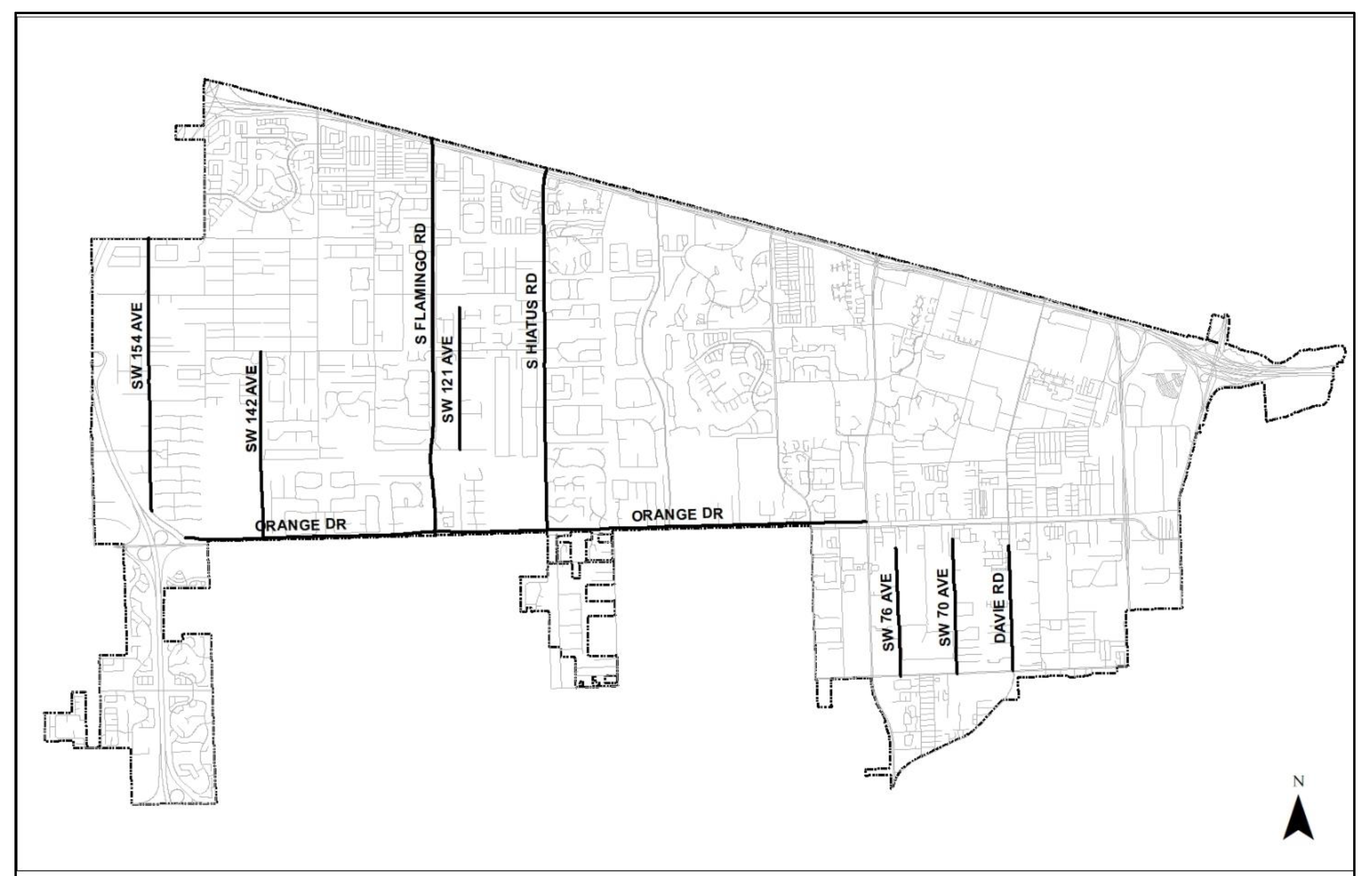
Map 1
(Ord. No. 2002-35, § 1, 10-16-02; Ord. No. 2017-015, § 2(Exh. A), 4-19-17; Ord. No. O2023-007, § 2(Exh. A), 6-7-23; Ord. No. O2025-014, § 2(Exh. A), 5-7-25)
Editor's note— Ord. No. O2023-007, § 2(Exh. A), adopted June 7, 2023, amended § 12-282 and in doing so changed the title of said section from "Intent, applicability, and boundaries" to "Intent and applicability," as set out herein.
Sec. 12-283. - Scenic corridor development standards.
(A)
Scenic corridor buffers. In addition to any other landscape requirements of this chapter, any new development abutting a scenic corridor must include a scenic corridor buffer in compliance with this division.
(B)
Notwithstanding any other provision of this Code, the following structures, improvements and uses shall be the only structures, improvements and uses permitted within the designated scenic corridor buffers:
(1)
Existing agricultural buildings.
(2)
Sidewalks, recreational trails, and equestrian trails.
(3)
Trees, shrubs and landscaping materials as required by this article or as otherwise indicated on an approved site plan.
(4)
Fences (specifically excluding walls), mailboxes, bus stops, bus shelters, and entranceways as further specified in section 12-284.
(5)
Roadways, access ways or access points, including required curbing.
(6)
Traffic control devices and such other improvements related to the safe and efficient movement of traffic.
(7)
Grassed swales and similar stormwater conveyance features, specifically excluding stormwater retention or detention areas (wet or dry), regardless of whether these are requirements of the town, an independent water control district or any combination of such requirements.
(8)
Underground utilities and associated accessory structures.
(9)
Street lights and pedestrian lights, when required.
(10)
Signs.
(Ord. No. O2023-007, § 2(Exh. A), 6-7-23)
Editor's note— Ord. No. O2023-007, § 2(Exh. A), adopted June 7, 2023, repealed the former § 12-283 and enacted a new § 12-283 as set out herein. The former § 12-283 pertained to development standards and derived from Ord. No. 2002-35, § 1, adopted Oct. 16, 2002; and Ord. No. 2017-015, § 2(Exh. A), adopted April 19, 2017.
Sec. 12-284. - Fences, mailboxes, bus stops and entranceway features.
(A)
All mailboxes, bus stops and entranceway features developed within a scenic corridor buffer shall be made of natural materials or substances derived from natural materials, including, but not limited to, wood, stucco, stone, brick and clay tile. Painted colors shall be limited to earth tones, natural, and white.
(B)
No entranceway feature within a scenic corridor buffer shall be internally lighted. Light fixtures for external illumination shall be screened with cut-off shields. External illumination shall not exceed one and one-half (1.5) footcandles.
(C)
No mailbox or entranceway feature within a scenic corridor buffer shall be greater than four and one-half (4.5) feet in height.
(D)
Fences within a scenic corridor buffer are not intended to be substantial in appearance and shall meet the design requirements of section 12-287.
(Ord. No. 2002-35, § 1, 10-16-02; Ord. No. 2009-25, § 2, 12-2-09; Ord. No. 2012-28, § 2(Exh. A), 12-5-12; Ord. No. 2017-015, § 2(Exh. A), 4-19-17)
Sec. 12-285. - Landscaping.
The landscaping provided within a scenic corridor buffer shall be open and provide visibility to a community from adjacent roadways. Landscape material may utilize groundcover and shrubs but shall be designed to be relatively open through the clustering of landscape material.
(A)
A scenic corridor buffer shall, at a minimum, include the following:
(1)
One (1) row of canopy street trees with each tree having a minimum three (3) inch diameter at breast height (DBH).
(2)
The first row of canopy trees shall be planted along a line ten (10) feet back from the right-of-way line.
(3)
Street trees shall be planted every forty (40) feet on center.
(4)
A minimum of four (4) sub-canopy trees per one hundred (100) feet of road frontage shall be planted in and about access points and intersections.
(5)
Three (3) additional canopy trees shall be planted per eight thousand (8,000) square feet of scenic corridor buffer area.
(6)
Sixty (60) percent of all required trees shall be native plant species.
(7)
To the maximum extent practicable, pre-existing native trees and shrubs within each scenic corridor buffer area must be preserved and incorporated into the buffer design.
(B)
Existing or dedicated public or private right-of-way or right-of-way that is reserved pursuant to a development order, development permit, site plan, plat or other land use approval shall not be included in calculation of the scenic corridor buffer width.
(Ord. No. 2002-35, § 1, 10-16-02; Ord. No. 2017-015, § 2(Exh. A), 4-19-17; Ord. No. O2023-007, § 2(Exh. A), 6-7-23)
Sec. 12-285.1. - Administrative relief.
The town council may grant relief from the provisions of this division upon a showing by the property owner that the regulations imposed upon the property by another governmental agency will cause there to be a hardship upon the property owner if that property owner is required to fully comply with this division. The town council shall grant the minimum relief necessary to remedy the demonstrated hardship and there shall be no waiver granted as to the landscaping standards of section 12-185.
(Ord. No. O2023-007, § 2(Exh. A), 6-7-23)
Sec. 12-286. - Intent and applicability.
Intent. It is the intent of these regulations to ensure that development is compatible with the surrounding land uses and maintains and enhances the rural character of the applicable zoning district. Residential development within the AG, A-1 and R-1 zoning districts shall be designed to ensure that the transition from vacant land and/or farmland to development is reviewed for the ultimate effect such development may have upon surrounding agricultural areas.
Applicability. The Rural Lifestyle Regulations shall apply to those portions of the town in the AG, A-1 and R-1 zoning categories. In order to accomplish the goals set forth above, the town has determined that a separate set of regulations, over and above those that already exist, are necessary for these areas. With respect to the areas described above, these regulations shall prevail over any other regulations set forth in this Code to the extent that any such regulations could be construed to permit development within those boundaries which is not permitted by these regulations.
(Ord. No. 2002-35, § 1, 10-16-02; Ord. No. 2006-001, § 1, 1-4-06; Ord. No. 2009-25, § 2, 12-2-09; Ord. No. 2012-28, § 2(Exh. A), 12-5-12; Ord. No. 2017-015, § 2(Exh. A), 4-19-17; Ord. No. O2023-007, § 2(Exh. A), 6-7-23)
Editor's note— Ord. No. O2023-007, § 2(Exh. A), adopted June 7, 2023, amended § 12-286 and in doing so changed the title of said section from "Intent, applicability, and boundaries" to "Intent and applicability," as set out herein.
Sec. 12-287. - Special restrictions and development standards.
The following special restrictions and standards shall apply within the Rural Lifestyle area:
(A)
Residential density is limited to one (1) dwelling unit per gross acre and flex and reserve units, as defined in the Broward County Administrative Rules Document, shall not be used to increase the number of permitted dwelling units.
(B)
Fences and walls.
(1)
Fences located within any required front yard or within any required yard adjacent to a right-of-way or scenic corridor shall be a maximum of four (4) feet in height. In all other locations, fences shall be a maximum of six (6) feet in height.
(2)
Fences are limited to the following styles:
(a)
Split rail fence.
(b)
Green or black vinyl clad chain link fence.
(c)
Decorative picket fences in a uniform color of white, black or earth tone.
(d)
Shadow box and board-on-board fences shall be permitted only within the building envelope.
(e)
Other fence material approved as part of the site plan for the development prior to October 16, 2002 (the date of adoption of the Rural Lifestyle Regulations).
(3)
(Reserved.)
(4)
Fences located outside the building envelope shall be no more than fifty (50) percent opaque.
(5)
Fences located within a scenic corridor buffer shall be no more than twenty (20) percent opaque.
(6)
Walls shall be limited as follows:
(a)
Walls are prohibited within scenic corridor buffers and limited to a maximum of three (3) feet in height in all other locations.
(b)
Wall sections shall not exceed ten (10) lineal feet and provide a hedge or other landscaping between any two (2) wall sections such that the hedge or landscaped area extends at least two (2) times length of the longest adjacent wall section.
(c)
No wall shall be placed atop a berm.
(7)
Columns used in conjunction with a fence or wall shall be limited to three (3) feet in width per column, with no less than ten (10) feet of separation shall be provided between columns. The town administrator or designee shall be authorized to waive the column separation requirement as may be necessary to create a pedestrian access gate or accessway.
(8)
Berms within twenty-five (25) feet of a property line shall be a maximum of three (3) feet in height, have a maximum slope of 3:1 and shall include an undulating, meandering design.
(9)
Finials and similar decorative elements placed on top of columns or fence posts may extend up to twenty-five (25) percent higher than the maximum fence or wall height set forth in this paragraph (B).
(C)
Guardgates, guardhouses, gate-arms and similar access devices.
(1)
Maximum guardhouse building height: Twenty (20) feet.
(2)
Maximum guardhouse building square footage: Two hundred (200) square feet.
(3)
The facade of all guardhouse buildings shall be made of natural materials or substances derived from natural materials, including, but not limited to, wood, stucco, stone, brick and clay tile.
(4)
Guardgates shall be set back a minimum of one hundred twenty-five (125) feet and guardhouses shall be set back a minimum of one hundred (100) feet, as measured from the nearest edge of the road pavement of any designated scenic corridor.
(Ord. No. 2017-015, § 2(Exh. A), 4-19-17; Ord. No. O2021-030, § 2(Exh. A), 11-3-21; Ord. No. O2023-007, § 2(Exh. A), 6-7-23)
Editor's note— Ord. No. 2017-015, § 2(Exh. A), adopted April 19, 2017, repealed § 12-287 and enacted a new § 12-287 as set out herein. Former § 12-287 pertained to development standards and derived from Ord. No. 2002-35, adopted October 16, 2002; Ord. No. 2003-001, adopted December 18, 2002; and Ord. No. 2010-19, adopted September 7, 2010.
Sec. 12-288. - Reserved.
Editor's note— Ord. No. O2023-007, § 2(Exh. A), adopted June 7, 2023, repealed § 12-288, which pertained to incentives and derived from Ord. No. 2002-35, § 1, adopted Oct. 16, 2002; Ord. No. 2009-25, § 2, adopted Dec. 2, 2009; and Ord. No. 2017-015, § 2(Exh. A), adopted April 19, 2017.
Sec. 12-288.5. - Reserved.
Editor's note— Ord. No. O2023-007, § 2(Exh. A), adopted June 7, 2023, repealed § 12-288.5, which pertained to title and derived from Ord. No. 2002-35, § 1, adopted Oct. 16, 2002; and Ord. No. 2017-015, § 2(Exh. A), adopted April 19, 2017.
Sec. 12-289. - Reserved.
Editor's note— Ord. No. O2023-007, § 2(Exh. A), adopted June 7, 2023, repealed § 12-289, which pertained to purpose and derived from Ord. No. 2002-35, § 1, adopted Oct. 16, 2002; and Ord. No. 2017-015, § 2(Exh. A), adopted April 19, 2017.
Sec. 12-290. - Architectural design standards.
(A)
Garage standards. For any new development requiring site plan approval, garages must be arranged such that garage doors do not face the street unless located at least fifteen (15) feet behind the front door of the home.
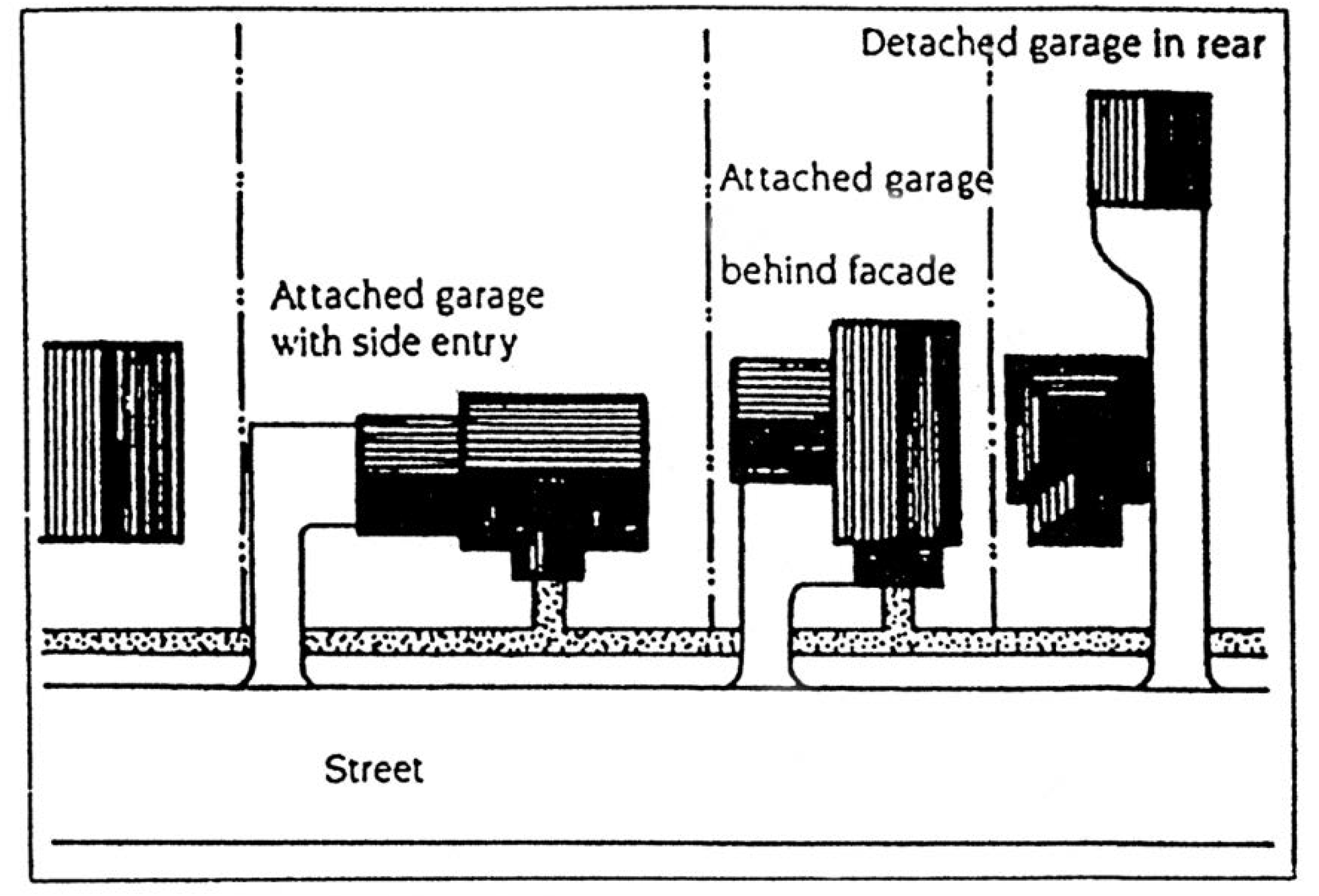
Figure 8: Recommended garage locations
(B)
Front building projections. Building projections including porches and verandas (minimum ten (10) feet in width), bay or garden windows shall be allowed within the required front yard.
(C)
Building orientation. All new residential homes shall orient toward the street. The front doors shall face the street.
(D)
Translucent materials. All facades shall contain a minimum of fifteen (15) percent transparent or translucent materials.
(E)
Roof pitch. Pitched roofs, other than gambrel roofs, shall have a minimum pitch of 4:12. Flat roofs are only permitted over porches and utility rooms located at the rear of a dwelling, where the flat roof areas comprise nor more than twenty-five (25) percent of the total roof area of the building.
(Ord. No. 2002-35, § 1, 10-16-02; Ord. No. 2012-28, § 2(Exh. A), 12-5-12; Ord. No. O2023-007, § 2(Exh. A), 6-7-23)
Sec. 12-291. - Anti-monotony.
(A)
No two (2) detached single family homes having the same architectural elevation shall be built or maintained side by side or fronting across the street within an area of a six-lot block.
(B)
No two (2) detached single family homes having the same color paint used on more than eighty (80) percent of the single family homes shall be built or maintained side by side or fronting across the street within a six-lot block.
(C)
No two (2) detached single family homes having the same color roof with the same style roof tile shall be built or maintained side by side or fronting across the street within a six-lot block.
(Ord. No. 2002-35, § 1, 10-16-02; Ord. No. O2023-007, § 2(Exh. A), 6-7-23)
Sec. 12-292. - Street standards.
(A)
Existing nonconforming vehicular accessway. An "existing nonconforming vehicular accessway" may gain town council approval by following the procedures found herein and meeting the applicable prerequisites and conditions imposed thereby:
1.
An "existing nonconforming vehicular accessway" shall be defined as found in section 12-503, Definitions;
2.
The use of such an "existing nonconforming vehicular accessway" does not in its present state conform to the existing code requirements imposed under sections 12-292(C), 12-288 or any other applicable town code sections;
3.
The "existing nonconforming vehicular accessway" was in use by resident(s) prior to the passage of the existing code restrictions applicable thereto;
4.
The petitioner shall submit to the town council a petition request, upon a form to be provided by the town, and a copy of the petition request shall be sent via certified mail with return receipt card to all affected properties served by the vehicular accessway at the mailing address as may be found in the most recent Broward County Property Appraiser's records, in order to obtain relief from the applicable code regulations as provided herein;
5.
Said relief shall be authorized by the town council, and such approval shall be in the form of an ordinance approved by a majority of the town council;
6.
Town council ordinance approval may include, but not be limited to the following: staff recommendations, conditions, and requirements;
7.
Such conditions shall include the approval and grant of all required governmental ingress and egress easements or similar licenses or covenants that shall run with the land; said document(s) shall be recorded in the Broward County public records upon their execution by the parties, either as an individual covenant running with the land of each affected resident or when an association of residents exist as a part of the documents and covenants applicable thereto;
8.
No part of this Code section shall preclude the town or its residents upon the town's approval, from initiating any further action, including, but not limited to, special assessment, condemnation or creation of a special improvement district as may be necessary to bring said "existing nonconforming vehicular accessway" into a conforming state with codes and standards applicable to other public roads;
9.
In order for the town council to evaluate the effects of the relief found within this Code section upon the health, safety and welfare of all residents affected thereby, the following minimum criteria shall be provided in a form proscribed by the development services director or his designee (unless waived by the town council):
a.
Number of affected residential lots or units currently serviced;
b.
Number of potential residential lots or units that may be serviced;
c.
Dimensions of existing nonconforming vehicular accessway (length, width, surface type, depth, etc.);
d.
Device(s) to be executed in approved dedication of affected parcels (rights-of-way, easements, etc.);
e.
Title search shall be performed and submitted to the town (said records shall provide all documentation and records comprising a diligent and reliable search for prior ownership and previously-executed documents related to the existing nonconforming vehicular accessway);
f.
Property identification numbers, folio numbers, and tax identification numbers shall be provided for all affected real property parcels;
g.
A pre-approval public safety inspection shall be required to be performed by the police and fire department designees;
h.
A pre-approval engineering inspection shall be required to be performed by the town engineer or its designee;
i.
A pre-approval public works and utility department inspection(s) shall be required to be performed by the public works and utility department designees;
j.
An alternative route analysis may be conducted by the town engineer or its designee;
k.
All such required criteria shall be presented to the development services director or his designee prior to presentation to the town council.
Sec. 12-293. - Reserved.
Editor's note— Ord. No. 2017-015, § 2(Exh. A), adopted April 19, 2017, repealed § 12-293. Former § 12-293 pertained to plat requirements and public dedications and derived from Ord. No. 2002-35, adopted October 16, 2002.
Sec. 12-294. - Reserved.
Editor's note— Ord. No. O2023-007, § 2(Exh. A), adopted June 7, 2023, repealed § 12-294, which pertained to site landscaping and derived from Ord. No. 2002-35, § 1, adopted Oct. 16, 2002; and Ord. No. 2017-015, § 2(Exh. A), adopted April 19, 2017.
Sec. 12-295. - Open space relationships.
Existing Town of Davie, county, and/or state open space, such as parks or trails, shall be buffered during the site design process. No site plan shall be approved for a parcel governed by the Rural Lifestyle Regulations which does not provide for a buffer consistent with the following criteria:
(A)
Parks and other protected undeveloped lands shall be buffered by providing a minimum twenty (20) foot landscape buffer along the property line. Such land shall be planted and maintained by the applicant, yet individual fences may not be placed within the buffer. An association may place a uniform green vinyl clad chain-link fence or other design at the discretion of the planning and zoning manager, without delineating individual lots, around the landscape buffer. Such landscape buffer and associated restrictions shall be clearly identified on the approved site plan.
(B)
Town of Davie trails, as set forth in the Town of Davie master trail map shall be augmented and enhanced through the following:
(1)
Existing recreation trails shall be designed for an ultimate thirty-foot trail width.
(2)
Future trails shall provide for both recreation and equestrian trails, providing for the thirty-foot cross-section and amenities. Trails shall be dedicated to the town, when possible, equally between any adjacent property owners.
(C)
A minimum of twenty (20) percent of the designated park buffer shall be landscaped.
(Ord. No. 2002-35, § 1, 10-16-02; Ord. No. 2017-015, § 2(Exh. A), 4-19-17; Ord. No. O2023-007, § 2(Exh. A), 6-7-23)
Sec. 12-296. - Street lighting.
In furtherance of maintaining rural character, the Town Council shall have the authority to waive or modify requirements for street lighting.
(Ord. No. O2023-007, § 2(Exh. A), 6-7-23)
Editor's note— Ord. No. O2023-007, § 2(Exh. A), adopted June 7, 2023, repealed the former § 12-296 and enacted a new § 12-296 as set out herein. The former § 12-296 pertained to stormwater retention and derived from Ord. No. 2002-35, § 1, adopted Oct. 16, 2002; and Ord. No. 2017-015, § 2(Exh. A), adopted April 19, 2017.
Sec. 12-297. - Administrative relief.
The town council may approve full or partial waivers to the site design standards of this division. The applicant must specify within the site plan application the type of relief requested as well as hardship that would result if the applicant were required to fully comply with this division. The town council shall grant the minimum relief necessary to remedy the demonstrated hardship.
(Ord. No. O2023-007, § 2(Exh. A), 6-7-23)
Editor's note— Ord. No. O2023-007, § 2(Exh. A), adopted June 7, 2023, repealed the former § 12-297 and enacted a new § 12-297 as set out herein. The former § 12-297 pertained to lighting and derived from Ord. No. 2002-35, § 1, adopted Oct. 16, 2002; and Ord. No. 2017-015, § 2(Exh. A), adopted April 19, 2017.
Sec. 12-298. - Intent, applicability.
(A)
Intent. This division is intended to provide an alternative approach to single-family development that encourages the preservation and enhancement of certain environmental, cultural, rural and agricultural characteristics within the town. Specifically, this division encourages creative design approaches to residential development which comply with town comprehensive plan requirements while maximizing opportunities for public access to open spaces, such as recreational and equestrian trails, public and private parks, wetlands and other natural resources, wildlife habitat, agricultural land, historical resources and archeological resources.
(B)
This division is applicable to only to parcels zoned AG, A-1 or R-1 which are twenty (20) gross acres or more in size. Upon approval of an Open Space Overlay District pursuant to these regulations, any development of the subject property must be in accordance with the requirements of this division.
(Ord. No. O2023-007, § 2(Exh. A), 6-7-23; Ord. No. O2025-014, § 2(Exh. A), 5-7-25)
Sec. 12-299. - Open space overlay process.
(A)
An application to adopt an Open Space Overlay District must be processed in the same manner as an application for rezoning, as set forth in article X, except that the criteria set forth in section 12-307(A)(1) does not apply and instead the following criteria applies:
1.
Whether the proposed Open Space Overlay District complies with the eligibility requirements of section 12-298.
2.
Whether and to what extent the development proposed in conjunction with the Open Space Overlay District maximizes opportunities for public access to open spaces as described in section 12-298.
3.
Whether and to what extent the proposed development includes appropriate provisions for preservation, governance, and routine maintenance of designated open spaces.
(Ord. No. O2023-007, § 2(Exh. A), 6-7-23)
Sec. 12-299.1. - Open space design criteria.
(A)
Minimum criteria. The criteria set forth in this section, which are in addition to other requirements of this chapter, are the minimum necessary for approval of an Open Space Overlay District and related development plan.
(B)
Minimum lot area. As an alternative to the minimum lot areas set forth in section 12-81, an Open Space Overlay development may be designed with lot sizes as set forth below by providing open spaces meeting the minimum requirements set forth in this section.
(C)
Minimum open space. Open spaces intended to meet the minimum open space requirements set forth in paragraph (B), above, must meet the design standards of this paragraph (C).
(1)
Open space defined. For purposes of this division, open space means any land, including natural or restored wetlands, used primarily for resource protection, landscape buffers, outdoor recreation, or agriculture, where agricultural products are not sold on-site, specifically excluding areas within single-family lots, stormwater detention and retention areas, and public or private rights-of-way, whether existing or proposed. Recreational structures, such as tennis courts, gazebos and walkways are permitted within open space areas provided that such impervious areas do not exceed fifteen (15) percent of the required open space. This definition of open space supersedes other definitions of open space within this chapter to the extent of any conflict.
(2)
Contiguity. Open space areas within a development must be contiguous. Open spaces are considered contiguous if separated only by a public right-of-way, pedestrian trail or residential amenity.
(3)
Dimensions.
(a)
No portion of any open space parcel shall be less than fifty (50) feet in width, provided that any portion of an open space parcel that includes a public access easement for pedestrian access may be as little as ten (10) feet in width.
(b)
If adjacent to a public right-of-way, an open space parcel must extend a minimum of one hundred (100) feet along such right-of-way.
(4)
Access. Each area of common open space shall have a minimum of two (2), fifteen (15) foot-wide pedestrian access points accessible from a public roadway.
(5)
Ownership and management of open space areas.
(a)
Any proposed open space, unless conveyed to the town, shall be subject to a restrictive covenant, conservation easement or other instrument acceptable to the Town Attorney, ensuring that such open space is, in perpetuity, used and maintained in a manner consistent with this division and consistent with the approved site plan, and identifying the homeowner association or other party(s) responsible for maintenance and control of such open space.
(b)
The conveyance must:
1.
Ensure that the open space will be properly maintained and protected from all forms of development, except as shown on the approved site plan, and that the open space shall never be changed to another use.
2.
Indicate the allowable uses of the open space.
3.
Provide for maintenance to be undertaken by the town in the event that the open space is inadequately maintained or is determined by the town to be a public nuisance, the cost of such work being the responsibility of the property owners.
(D)
Lot development standards. As an alternative to the residential development standards set forth in section 12-81, all Open Space Overlay developments are governed by the following standards:
(E)
Building coverage. As an alternative to the residential development standards set forth in section 12-81, in an Open Space Overlay development, the maximum building coverage ratio for developments in which all residential lots are restricted to one (1) story dwellings is 0.30. The maximum building coverage ratio for all other developments is 0.225. The term "building coverage" has the same meaning as set forth in section 12-503.
(F)
Reserved.
(G)
Curbing. In order to protect and maintain rural characteristics, an Open Space Overlay development may reduce or eliminate curbing as determined appropriate by the Town Engineer and the Town Council.
(Ord. No. O2023-007, § 2(Exh. A), 6-7-23; Ord. No. O2024-015, § 2(Exh. A), 5-15-24)
Sec. 12-299.3. - Administrative relief.
The town council may approve full or partial waivers to the following Open Space Overlay criteria:
(A)
Section 12-299.1(C)(2), Contiguity;
(B)
Section 12-299.1(C)(3), Dimensions; and
(C)
Section 12-299.1(D), Access.
The applicant must specify within the site plan application the type of relief requested as well as hardship that would result if the applicant were required to fully comply with this division. The town council shall grant the minimum relief necessary to remedy the demonstrated hardship.
(Ord. No. O2023-007, § 2(Exh. A), 6-7-23)