
Douglasville City Zoning Code
ARTICLE 11
- SUBDIVISION STANDARDS3
Editor's note— Ord. No. O-2024-33, § 2, adopted Aug. 19, 2024, amended Art. 11 in its entirety to read as herein set out. Former Art. 11, §§ 11.01—11.07, pertained to similar subject matter and derived from Ord. No. O-2020-1, § 1, adopted Jan. 13, 2020; and Ord. No. O-2022-8, § 35, adopted March 7, 2022.
Sec. 11.01.- Application of regulations.
A.
Subdividing land. No tract of land within the City of Douglasville shall be subdivided, and no tracts of land shall be combined, without prior approval of the City of Douglasville in accordance with this Unified Development Ordinance, provided however the division of land into parcels of five acres or more where no new street is involved is exempt from this requirement.
B.
Recording a plat. No plat of a Subdivision shall be recorded in the Office of the Clerk of the Superior Court of Douglas County unless it has first been approved in compliance with the regulations of this UDO.
C.
Use of a plat. The transfer of title or sale of land by reference to a plat of a subdivision that has not been approved by the City of Douglasville and properly recorded in compliance with the regulations set forth in this UDO is prohibited and shall not be recognized or qualified as a subdivision under this UDO.
D.
Erection of buildings. No building permit shall be issued, and no building shall be erected on any subdivided lot within the City of Douglasville unless that lot legally existed prior to the enactment of these regulations, or unless that lot shall first have been created in accordance with the regulations set forth in this UDO.
E.
Dedication of land and facilities. No land or facilities shall be dedicated to the City of Douglasville for public ownership or use unless that dedication is made in accordance with the regulations set forth in this UDO.
(Ord. No. O-2024-33, § 2, 8-19-24)
Sec. 11.02. - General requirements.
A.
Suitability of the land. Land subject to flooding, improper or inadequate drainage or erosion, if developed as proposed, and any land deemed unsuitable for development due to steep slopes, unsuitable soils, subsurface conditions or other undesirable properties, shall not be subjected to development as a lot within a subdivision for any uses that shall or may create or continue such conditions or increase danger to health, safety, life, or property. No land identified as unbuildable area or land within any delineated floodways shall be included within the buildable area of any subdivision or included within any lot of a subdivision. In addition, no undisturbed buffer that is required by any of the local development codes and ordinances to protect the health, safety and welfare of the community shall be included or within any lot proposed for a subdivision for any development.
B.
Reserved.
C.
Differences in ordinances. Whenever there is a difference between minimum standards or requirements under the regulations set forth in this UDO and those contained in any applicable zoning regulations, development regulations, building codes or other ordinances or regulations, the most restrictive shall apply.
D.
Conformance. All proposed subdivisions must conform to the most recently adopted Comprehensive Plan of the City of Douglasville.
E.
Access. When land is subdivided into larger parcels than ordinary building lots, such lots shall be arranged and designed to allow for the opening of future streets and to provide access to those areas not presently served by streets. No subdivision should be designed to completely eliminate street access to adjoining parcels of land. Every development should be designed to facilitate access to adjoining properties, which are developed or anticipated to be developed in a manner compatible with or substantially similar to the subject property. Locations of inter-parcel access shall be as required by and subject to the approval of the City of Douglasville. Private streets, as may be approved under the provisions of this UDO, shall be constructed to the roadway standards of the City of Douglasville.
(Ord. No. O-2024-33, § 2, 8-19-24)
Sec. 11.03. - Project design standards.
A.
Standards incorporated by reference.
1.
DOT standard specifications. Unless otherwise specially set forth herein, all of the materials, methods of construction, and workmanship for the work covered in reference to street construction and storm drainage construction shall conform to the latest standard specifications of the Georgia Department of Transportation.
2.
AASHTO design standards. Design criteria and standards not specifically set forth herein shall conform to the latest edition of the AASHTO Policy on Geometric Design of Highways and Streets.
3.
FHWA traffic control standards. Traffic control signs and devices, and street striping shall conform to the "Manual on Uniform Traffic Control Devices for Streets and Highways," latest edition, published by the Federal Highway Administration of the U.S. Department of Transportation.
B.
General design standards.
1.
Blocks. The length, width and shape of blocks shall be determined with due regard to:
a.
Provision of adequate building sites suitable to the special needs of the type of use contemplated.
b.
Zoning regulations as to lot sizes and dimension.
c.
Need for convenient access, circulation, control and safety of street traffic.
d.
Limitations and application of topography:
1)
Length.
a)
Blocks shall be at least 600 feet but not more than 1,800 feet in length, except as the department considers necessary to secure efficient use of land or desired features of street pattern.
b)
In blocks greater than 1,000 feet in length, one or more public easements of not more less than 20 feet in width may be required to extend entirely across the block for pedestrian crosswalks, fire protection or utilities.
2)
Width. Blocks shall be wide enough to allow two rows of lots, except where frontage lots on arterial streets are provided, or when prevented by topographic conditions or the size of the property, or for lots along the periphery of the subdivision, in which a single row of lots may be approved.
2.
Lots.
a.
Minimum lot dimensions and areas. All lots proposed in a subdivision shall meet or exceed the area and dimensional requirements of the UDO for the zoning district in which the lots are located. The size, shape and orientation of every lot shall be subject to approval for the type of development and use contemplated.
b.
No lot shall be more than six times as deep as it is wide at the building setback line, unless excepted by the community development director or his/her designee and/or the city engineer or his/her designee for reasons of topography or irregularity of the entire tract.
c.
Authority of health department regarding septic systems and package wastewater treatment systems. Nothing contained in this article shall be construed as preventing the health department, after study of the conditions existing in a proposed subdivision, from requiring that all or any portion of the area of such subdivision shall not be built upon or that the minimum lot sizes set forth in this UDO are inadequate and must be increased to ensure the protection of the public health.
d.
Adequate building sites. Each lot shall contain a site large enough for a normal building that will meet all building setback requirements and not be subject to flood or periodic inundation. Lot remnants shall be added to adjacent lots, rather than remain as unusable parcels.
e.
Arrangement. Insofar as practical, side lot lines shall be at right angles to straight street lines or radial to curved street lines.
f.
Corner lots. Corner lots shall be sufficiently large to permit the location of buildings so as to conform to the front building lines on both streets.
g.
Frontage on highways restricted. Residential lots shall not be platted to front directly on the right-of-way of an existing, major thoroughfare, including a state or U.S. numbered highway, unless the lots are served by a frontage road or a street contained within the proposed subdivision.
h.
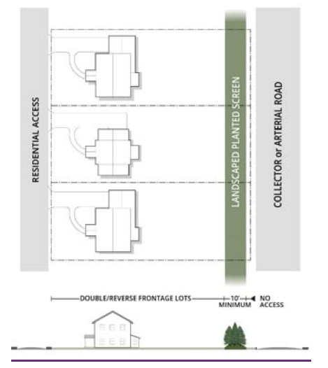
Double and reverse frontage lots. Double frontage and reverse frontage lots are prohibited except where deemed to provide separation of residential development from a state or U.S. numbered highway (whether a collector or arterial street) or to overcome specific disadvantages of topography and orientation of property. An easement of at least ten feet in width, improved with a landscaped planted screen, across which there shall be no right of access, shall be provided along the line of lots abutting any such highway or a disadvantaged use.
i.
Properties adjacent to lakes. The subdividing of land adjacent to or surrounding an existing or proposed lake, shall be such that lots abutting the lake shall be drawn to the centerline of the lake. Such requirements may be waived upon submittal to the community development director or his/her designee and/or the city engineer or his/her designee of an acceptable method for the maintenance of the lake and any recreational operations.
3.
Inter-parcel access requirements.
a.
Internal access easements required. For any office or retail sales or services use, the property owner shall grant an access easement as described in this section to each adjoining property that is zoned or used for an office or retail sales or services use. The purpose of the easement is to facilitate movement of customers from business to business without generating additional turning movements on the public street.
b.
Access easement provisions.
1)
The easement shall permit automobile access from the adjoining property to driveways and parking areas intended for customer or tenant use; but parking spaces may be restricted to use by the owner's customers and tenants only.
2)
The granting of such easement shall be effective upon the granting of a reciprocal easement by the adjoining property owner.
3)
Upon the availability of access to driveways and parking areas of the adjoining lot, the pavement or other surfacing of the owner's driveways and parking areas shall be extended to the point of access on the property line.
c.
Relief. Where the proposed land use is such that adverse impact of the required easement on use of the property would outweigh the reduced impact on the public street provided by the reciprocal easements, the community development director or his/her designee and/or the city engineer or his/her designee may waive the requirement for access easements, in whole or in part, administratively.
4.
Easements. Easements shall be required in connection with subdivisions or developments for the following purposes, among others:
a.
Utility easements. Whenever it is necessary or desirable to locate a public utility line outside of the street right-of-way, the line shall be located in an easement dedicated to the city (or other appropriate public entity) for such purpose. Easements for water and sanitary sewers shall be a minimum of 20 feet wide and may be required to be wider depending on the depth of cut.
b.
Water course and drainage easements.
1)
A publicly dedicated stormwater easement or drainage easement is to be provided along any drainage channel, stream or water impoundment within a development located outside of a street right-of-way. The easement is to be substantially centered on the watercourse or surround the high water line of the impoundment, and shall be of such width as the development official deems necessary for adequate access by maintenance equipment. All easements shall be no less than 20 feet wide when used as an open ditch. Piped storm drainage shall have a minimum easement width of 15 feet wide.
2)
Drainage easements off the street right-of-way shall be clearly defined on the plat and deed of the individual property owner, and such property owner shall keep the easement free of obstructions and maintain that part of the easement within the property owner's boundary line so that free and maximum flow is maintained at all times.
c.
Overlapping easements. Easements for water and sanitary sewers and drainage purposes shall not overlap unless approved by the Douglasville-Douglas County Water and Sewer Authority.
C.
Required improvements.
1.
Minimum requirements. The following improvements shall be provided by the developer or at the developer's expense in every subdivision or development in accordance with the standards contained in this article.
a.
Survey monumentation of the public streets and lot lines in a subdivision.
b.
Public streets providing access to a development and to all lots in a subdivision, including the extension of streets required to provide access to adjoining properties.
1)
Public streets contained wholly within a subdivision shall be improved to the full standards contained in this article. Existing streets that adjoin a development shall be improved to the minimum standards from the centerline of the street along the development's frontage. (Half streets are not allowed).
2)
Public streets in nonresidential areas or serving a multi-family development shall be improved to "collector" street standards. In residential subdivisions, streets that serve 100 dwelling units or more shall be improved to "collector" street standards, while those serving fewer than 100 dwelling units shall be improved to "local" street standards.
3)
The city may participate in sharing the costs of construction and installation to the extent that improvements are needed to bring the street to a higher level of classification than required to exclusively serve the subdivision or development.
4)
Curb and gutter are required along all roadways.
c.
All drainage structures, including channels, shall be in place, inspected by the Douglasville Douglas County Water Sewer Authority (WSA) and functioning properly prior to the start of any building construction on any lot served or adjacent to the stormwater sewer and easement.
d.
Sidewalks shall be required as provided in section 11.03.E., streets. The community development director and/or his or her designee and/or the city engineer and/or his or her designee may require the developer to install additional sidewalks and wider sidewalks within a distance of up to one mile on streets leading to or going through commercial areas, school sites, places of public assembly, and other congested areas.
e.
Street name signs, stop signs and traffic control signs shall be installed by the city at the developer's expense, unless included as a condition of a land disturbance permit.
f.
Public water service, where in the written opinion of the development official, a public water supply is within a reasonable distance, shall be provided to every lot in a subdivision and to every development for both domestic use and fire protection. Water mains shall be connected to the existing public water system and extended past each lot. A contractor approved by the WSA shall install all elements of the water system, including mains, valves and hydrants at the developer's expense. The WSA may participate in sharing the costs of construction and installation to the extent that pipe sizes are needed in excess of that size required to exclusively serve the subdivision or development.
g.
Where a public water supply is not available, each lot in a subdivision shall be furnished with a water supply system approved by the development official and the Douglas County Health Department and any other applicable governing authority.
h.
Fire hydrants shall be located along the streets in every subdivision served by a public water system and within every development project.
i.
Every lot in a subdivision and every development shall be connected to a public sanitary sewerage system unless on-site disposal is allowed by the health department and any other applicable governing authority. Sewer lines shall be connected to an existing sanitary sewerage system and extended past each lot. Every element of the sanitary sewer system, including mains, lift stations, outfalls, and laterals, shall be installed at the developer's expense by a contractor approved by WSA.
j.
Every commercial conveyor car wash permitted and constructed after August 15, 2012, regardless of the water source, shall install and maintain in good working condition a recycled water system, wherein a minimum of 50 percent of water utilized will be recycled.
2.
Gated communities. Improvements in gated communities shall meet all requirements and standards that apply to public subdivisions.
3.
Guarantee in lieu of completed improvements. No final subdivision plat shall be approved by the city or accepted for recordation by the clerk of superior court until one of the following conditions has been met:
a.
All required improvements have been constructed in a satisfactory manner and approved by the community development director and/or his or her designee and/or the city engineer and/or his or her designee, or
b.
The city has received in escrow 110 percent of the estimated cost of installation of the required improvements and has approved an executed contract for installation of the improvements by a qualified contractor. Such improvements shall be limited to final topping course on the street, sidewalks, streetlights, grassing of shoulders and deferred landscaping and all other right-of-way amenities as required by this UDO. The executed contract shall call for completion of the improvements within two years of approval of the final subdivision plat.
D.
Survey monuments. A two-inch iron pipe 16 inches in length shall be placed at all corners of the exterior boundaries of the subdivision being developed and shall be set flush or up to six inches above the finished grade. Existing permanent monuments that, in the professional opinion of a registered land surveyor, are of sufficiently durable construction may be maintained in lieu of new monuments as described above. All other street or lot corners or angle points and points of curve in each street shall be marked with an iron pipe at least three-quarters inch by 16 inches and set two inches above the finished grade. All such monuments shall be properly set in the ground and shown on the final plat and shall be approved by a registered land surveyor prior to the time of final plat approval.
E.
Streets.
1.
Access.
a.
A publicly approved street meeting the requirements of this article shall serve every development and every lot within a subdivision, except for gated communities.
b.
Every development and every subdivision shall have access to the public street system via a paved roadway.
c.
When land is subdivided into larger parcels than ordinary building lots, such parcels shall be arranged and designed so as to allow for the opening of future streets and to provide access to those areas not presently served by streets.
d.
No subdivision or development shall be designed in a way that would completely eliminate street access to adjoining parcels of land.
e.
Reserve strips controlling access to streets, alleys or public grounds shall be prohibited.
f.
Development along state and U.S. numbered highways.
1)
When a residential subdivision is adjacent to or contains a state or U.S. numbered highway, the applicable department of transportation mandates the construction of frontage roads. These roads should run approximately parallel to both sides of the highway to facilitate access to the lots. In cases of deep lots, rear service drives or double frontage lots should be used as specified in the 'lots' section above. Residential lots in a subdivision shall have no direct access to a state or U.S. numbered highway.
2)
Where a subdivision borders on or contains a railroad right-of-way or limited access highway right-of-way, the department may require a street approximately parallel to and on each side of such right-of-way, at a distance suitable for the appropriate use of the intervening land, as for park purposes in residential districts, or industrial purposes in appropriate districts. Such distances shall also be determined with due regard for the requirements of approach grades and future grade separations as determined by the Georgia Department of Transportation.
3)
Subdivision streets that intersect a state or U.S. numbered highway shall do so at intervals of not less than 800 feet, or as required by the Georgia Department of Transportation, whichever is greater.
2.
Street classifications. Streets are classified according to the function that they serve, the type, speed, and volume of traffic they will carry and the required standards of design. The classifications of streets and roads are shown in the city's comprehensive plan.
3.
Relation to present and future street system.
a.
The street pattern character, extent, width, grade and location within a development or subdivision shall provide for the continuation or appropriate projection of the existing street pattern and planned streets at the same or greater width, but in no case less than the required minimum width in the section of the community involved, unless the department deems such extension undesirable. In a situation where topography or other conditions make continuous or conformance to existing streets impossible, conformance to a plan for a neighborhood approved by the development official shall be required.
b.
Existing streets that adjoin a development or subdivision boundary shall be deemed a part of the subdivision. The proposed street system within a subdivision shall have the right-of-way of existing streets extended no less than the required minimum width. Subdivisions that adjoin only one side of an existing street shall dedicate one-half of the additional right-of-way needed to meet the minimum width requirement for the street. If any part of the subdivision includes both sides of an existing street, all of the required additional right-of-way shall be dedicated.
c.
Where, in the opinion of the city and/or the applicable transportation department, it is necessary to provide for street access to adjoining property, proposed streets shall be extended by dedication of right-of-way to the boundary of such property through the development.
4.
Design standards for streets.
a.
Arterial streets. All state or U.S. numbered highways, and other thoroughfares classified as arterials, shall meet all design requirements of the Georgia Department of Transportation.
b.
Collector streets. A collector street that is a state or U.S. numbered highway shall meet all design requirements of the Georgia Department of Transportation. All other collector streets shall comply with the design and construction requirements of this UDO, except collector streets shall be improved to local street standards in subdivisions devoted to single family use with lots of 20,000 square feet or larger.
c.
Local streets and culs-de-sac. All local streets and culs-de-sac shall comply with the design and construction requirements of this UDO.
d.
Minimum width of right-of-way. Minimum width of right-of-way measured from lot line to lot line shall be as follows:
Table 11-1 Minimum Right-of-Way Width
e.
Additional right-of-way. Subdivisions which include an existing platted street or road that does not conform to the minimum right-of-way requirements of this UDO and is identified as a transportation improvement project in the transportation plan shall provide additional width along one or both sides of such street or road so that the minimum right-of-way required by this article is established. Subdivisions abutting only one side of such a street or road shall provide a minimum of one-half measured from the center of the existing right-of-way, of the right-of-way required by these regulations.
f.
Vertical alignment of streets.
1)
Grades on arterials shall not exceed four percent; grades on collectors shall not exceed eight percent; grades on local streets shall not exceed 14 percent. Grades between 12 and 14 percent shall not exceed a length of 150 feet. The grade across a cul-de-sac in all directions shall not exceed one and one-half percent. All streets shall have a minimum grade of one percent. Major and minor thoroughfare profile grades, unless specified by GDOT, shall be connected by vertical curves of minimum length in feet equal to 20 times the algebraic difference between rates of grade expressed in feet per 100; for all other streets, including local streets and alleys, not less than ten times.
2)
All changes in grade shall be connected by a vertical curve so constructed as to afford a minimum sight distance, said sight distance being measured from the driver's eyes, which are assumed to be three and one-half feet in height above the pavement surface, to an object six inches high on the pavement. The minimum sight distance shall be as follows:
Table 11-2 Minimum Sight Distance
g.
Horizontal alignment of streets. Where a deflection angle of more than ten degrees in the alignment of a street occurs, the radius of curvature of the center line of said street shall be not less than as follows:
Table 11-3 Horizontal Alignment
h.
The minimum horizontal midblock visibility measured on centerline shall be determined by the Georgia DOT or 500 feet for arterials; 300 feet for collectors and 200 feet for local streets.
1)
Curved streets shall have a minimum tangent of 100 feet at intersections as measured from the centerline of cross streets. A tangent of a least 250 feet in length shall be introduced between reverse curves on arterials, 100 feet on collector streets, and 50 feet on local streets. Tangent sections of any subdivision street shall not exceed 600 feet to avoid excessive speeds. Traffic calming measures, approved by the city, shall be installed on streets with tangent sections exceeding 600 feet.
2)
Adjoining street intersections shall be spaced at least 200 feet apart measured from edge of right-of-way to edge of opposing right-of-way.
3)
Street jogs with centerline offsets of less than 125 feet on local streets shall not be allowed.
4)
Intersections. The centerline of no more than two streets shall intersect at any one point. All streets shall intersect at no less than 60 degrees, and as near a right angle as possible. The angle of intersection is to be measured at the intersection of the street centerlines. Such intersecting streets shall provide an uninterrupted line of sight from the center point of the intersection for not less than the minimum sight distance required in accordance with this UDO. Detailed designs of intersections may be required.
a)
In approaches to intersections, there shall be a suitable leveling of the street at a grade not exceeding three percent and for a distance of less than 50 feet from the nearest line of the intersecting street.
b)
Curb line radius at street intersections shall be at least 25 feet and where the angle of street intersection is less than 90 degrees, the applicable city and/or transportation department may require a greater radius.
c)
At an intersection where traffic is to be controlled by stop signs on the minor road, the minor road shall be designed to intersect the major road in accordance with the standards imposed by the Georgia Department of Transportation where applicable; and where not applicable, the minor road shall intersect at such location as will provide minimum sight distance in either direction along the major road as follows: 650 feet for an arterial, 600 feet for a minor thoroughfare, 400 feet for a collector street and 350 feet for a local street.
5)
Islands at intersections shall be subject to individual approval by the development official. In no case shall anything extend more than 30 inches above the back of the curb within the right-of-way of the intersecting street.
6)
Intersecting street right-of-way lines shall parallel the back of curb or edge of pavement of the roadway and shall be rounded with a radius of no less than four feet.
i.
Dead-end streets (culs-de-sac).
1)
A cul-de-sac shall be no more than 600 feet long unless necessitated by topographic or other conditions and approved by the department, but in no case exceed 800 feet in length. Culs-de-sac shall terminate in a circular turnaround having a minimum right-of-way of at least 100 feet in diameter for residential and 150 feet for commercial and industrial, and a paved turnaround with a minimum outside diameter of 80 feet. Such a street shall be provided at the closed end with a turnaround having the following right-of-way and roadway dimensions:
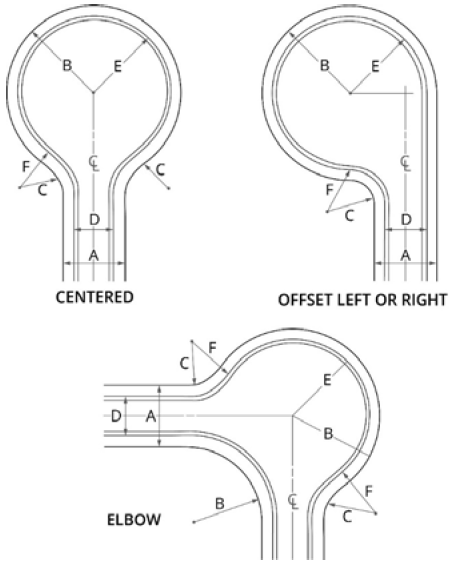
Figure 11-1 Cul-de-Sac Types
Table 11-4 Culs-de-sac
2)
Where a subdivision contains a dead-end street, other than a cul-de-sac, the department may require the subdivider to provide a temporary vehicular turnaround within the right-of-way, when the development official or department considers such to be necessary for effective traffic circulation.
3)
A dead-end street other than a cul-de-sac shall not be allowed except as a temporary stage of construction of a street that is intended to be extended in a later stage of construction. Such a temporary dead-end street shall be provided with a temporary turnaround having a roadway radius of 40 feet if:
a)
One or more lots front exclusively on the street; and
b)
Extension of the street is not under construction when the final plat is submitted for recording.
c)
Dead-end streets shall be designed to connect to future development and shall not be blocked with a private lot.
4)
Temporary turnarounds shall consist of a tack coat and one inch of asphalt.
j.
Alleys and service drives. Alleys or service drives may be required on any lot used for multifamily, commercial or industrial, but shall not be provided in residential blocks except where the subdivider produces evidence satisfactory to the development official or department of the need for alleys or service drives and/or where specifically required under this unified development ordinance. Where an alley has been specifically authorized or required by the city and/or the applicable transportation department, it shall comply with the following minimum design standards:
1)
The roadbed width shall be no less than 20 feet, containing a paved roadway of no less than 20 feet exclusive of gutters.
2)
Dead-end alleys shall be provided with a turn-around having a radius of at least 40 feet.
3)
An apron of 30 feet is required. No variance shall be granted for a reduced apron.
k.
Street names.
1)
Proposed streets that are obviously in alignment with others already existing and named shall bear the names of existing streets. In no case shall the name for a proposed street duplicate or too closely approximate, phonetically, existing street names in the city or Douglas County, irrespective of the use of the "suffix" street, avenue, boulevard, road, pike, drive, way, place, court or other derivatives.
2)
Property address numbers shall be provided by the developer and approved by the city.
3)
Street names shall be reviewed and approved by Douglas County E-911.
l.
Half streets prohibited. Whenever a street is planned adjacent to the proposed subdivision tract boundary, the entire street right-of-way shall be platted within the proposed subdivision.
m.
Split level streets and One-way Streets. Streets which are constructed so as to have two trafficways, each at a different level with the same right-of-way, shall provide a paved traffic surface of at least 20 feet on each level and a slope between the two trafficways of not less than three to one. One-way streets and split streets will be allowed when:
1)
Topographic conditions are such that alternatives to the typical street construction would be more desirable.
2)
The shape and size of the parcel could be more efficiently developed.
In either case, approval must be obtained from the department.
5.
Street improvements. Street improvements shall be reviewed and approved by the director or their designee.
a.
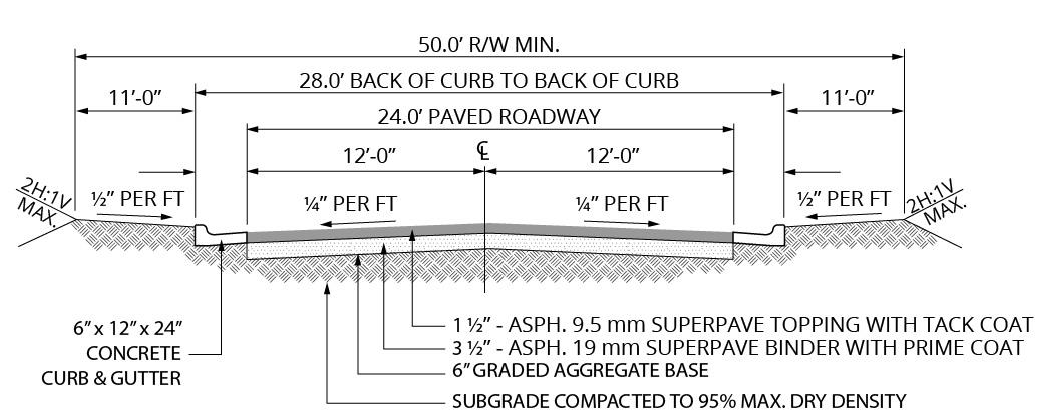
Minimum width of roadway. The minimum roadway width, measured from back of curb to back of curb (or edge of pavement to edge of pavement for a swale ditch section) shall be as follows:
Table 11-5 Minimum Roadway Width
b.
Curb and gutter.
1)
Curb and gutter are required on all streets.
2)
Local residential street curbs shall be six-inch × 24-inch vertical or roll back type 3,000 psi Portland cement concrete at 28 days. Roll back type is allowed in residential subdivisions with prior written approval of the department.
3)
Curbs along collectors and local commercial or industrial street curbs shall be six-inch times 24-inch vertical type only, 3,000 psi Portland cement concrete at 28 days.
4)
Curbing along streets shall meet the following standards:
a)
Developer's engineer or surveyor shall set line and grade.
b)
One-half inch expansion joints of pre-molded bitumastic expansion joint material shall be provided at all radius points and at intervals not to exceed 50 feet in the remainder of the curb and gutter.
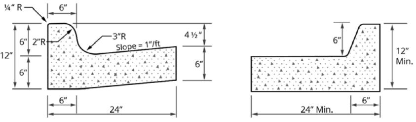
Figure 11-2 Curb and Gutter
c)
The development official and department shall individually approve special curbing design (center islands, etc.).
d)
Curb and gutter shall be set true to line and grade and finished by skilled workers to the section shown on the plans.
e)
Inferior workmanship or construction methods resulting in unsightly curb and gutter will be cause for rejection of the finished work.
f)
Adequate storm drainage structures shall be provided. The curb and gutter shall be constructed so as to present a smooth, even line both horizontally and vertically.
5)
Valley gutters shall not be allowed across streets at street intersections.
c.
Slopes and shoulder improvements.
1)
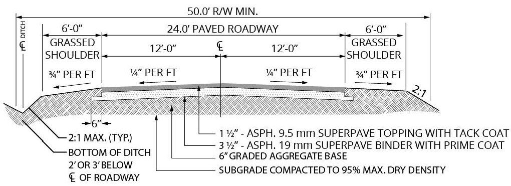
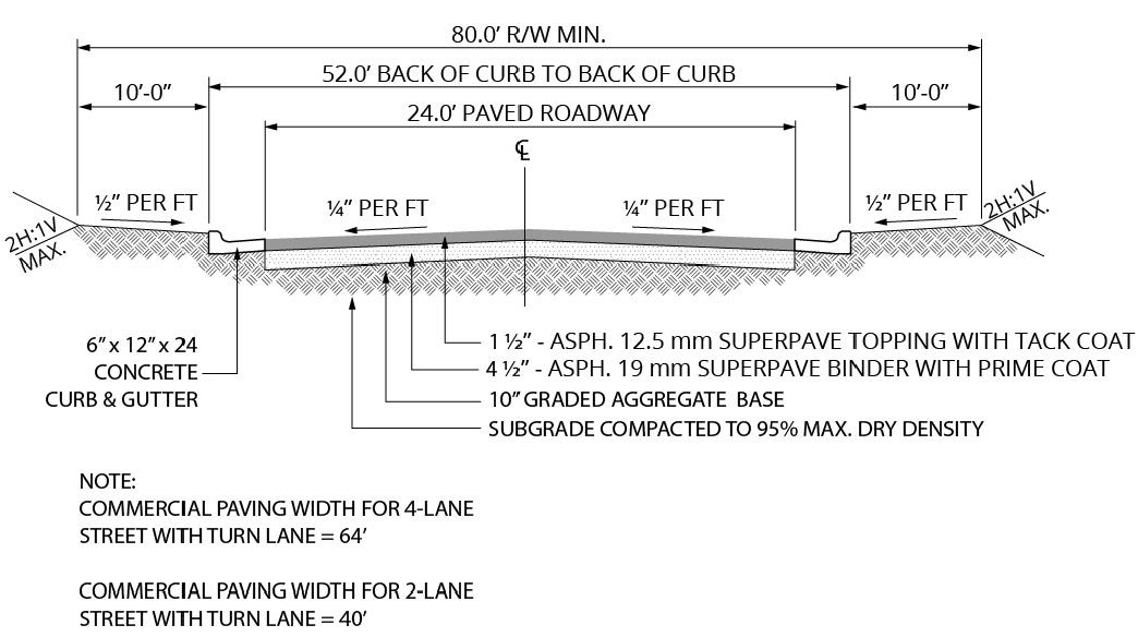
On streets with curb and gutter, the shoulders shall slope one-fourth inch to the foot toward the roadway for at least seven feet from back of curb, and no more than one-half inch to the foot for the remainder of the right-of-way width.
2)
On streets with swale ditch drainage, the shoulders shall slope three-quarters inch to the foot away from the roadway for at least five feet to the drainage channel. The maximum slope for the drainage channel shall be two feet of run for each one foot of fall, with a minimum two-foot wide channel at the bottom of the swale.
3)
Typical street sections.
a)
Curbed local street.
b)
Uncurbed local street.
c)
Curbed commercial street.
d.
Turning lanes. Turning lanes may be required at all entrances to subdivisions and industrial, office and commercial developments that front on arterial and collector streets. Turning lanes shall be 12 feet in width (including curb and gutter if required) for a minimum distance of 200 feet measured from the intersection of the right-of-way lines or the edge of the driveway.
e.
Street name and traffic control signs. Street name signs of a type approved by the city are to be placed at all intersections. Traffic control signs shall be placed by the developer and conform to the U.S. Manual on Uniform Traffic Control Devices, latest edition.
f.
Sidewalks.
1)
Sidewalks shall be provided along all curb and gutter streets other than alleys and interstate highways, as follows:
a)
Along both sides of all arterial streets and collector streets;
b)
Along one side of all local streets and cul-de-sac.
2)
Sidewalks shall be located not less than one foot from the property line to prevent interference of encroachment by fencing, walls, hedges, or other planting or structures placed on the property line at a later date.
3)
Sidewalks shall be no less than five feet in width, constructed of concrete no less than four inches in depth; exceptionally, sidewalks on interior streets in residential subdivisions with driveways spaced no more than 200 feet apart shall be not less than four feet in width and constructed of concrete no less than four inches in depth.
4)
Sidewalks must be offset at least 18 inches from the back of curb, and the offset area shall be filled with stamped concrete or like material approved by the development official, except adjacent to residential property where the offset area may be backfilled and grassed. Areas adjacent to sidewalks and opposite the offset shall be backfilled and grassed.
5)
Sidewalks shall be constructed of concrete, except where alternate materials are approved by variance granted pursuant to the provisions of this UDO. Concrete shall be 3,000 psi at 28 days' strength.
6)
Curb ramps shall be provided at all street intersections and street crosswalks.
7)
Sidewalks shall be constructed in compliance with the Federal Americans with Disabilities Act.
g.
Streetlights. All developers of residential subdivisions with lots less than five acres in size, and all developers of shopping centers, industrial parks and similar such developments, shall be required to provide streetlights in the public rights of way in such developments. Such developers, at the time of submission of the preliminary plat of the development, or at the time of application for a building permit, which ever shall first occur, shall present a proposed streetlight layout, acceptable to the development official, which details the proposed streetlights for the development.
6.
Location of utilities in streets.
a.
All developers of residential subdivisions with lots less than five acres in size, and all developers of shopping centers, industrial parks and similar such developments, shall be required to provide underground utilities in such developments. Such developers, at the time of the submission of the preliminary plat of the development, or at the time of application for a building permit, whichever shall first occur, shall present a proposed underground utility layout, acceptable to the development official, which details the proposed underground utilities within the right-of-way for the development.
1)
All utilities beneath pavement shall be installed and the ditch backfilled and thoroughly compacted before any pavement or base is installed, or the pipes shall be bored if installed after street construction.
2)
All utility manholes and valve boxes shall be brought to the finished grade within the roadway section.
3)
All private utilities that will cross under pavement shall be installed completely throughout the subdivision prior to any roadway base being applied. Installation of approved utility sleeves shall be considered as an alternate.
b.
Above-ground utilities. Where above-ground utilities are existing or otherwise allowed, telephone poles, street light poles, telephone junction boxes and other public or private utility structures placed above ground within a street right-of-way must be at least eight feet back from the back of the street curb (or edge of pavement) and one foot back from the edge of any sidewalk, whichever is farthermost from the roadway.
7.
Pavement cuts.
a.
Pavement cuts for the installation of utilities shall be avoided whenever possible. Utility crossings shall be bored across any arterial, subject to the approval of the Georgia DOT, and across any collector unless a pavement cut is approved by the director or their designee.
b.
All utility street cuts within public rights-of-way shall be reviewed and approved by the department before construction begins.
c.
Pavement cuts across local streets shall be permitted, provided the road is repaired with at least six inches of 3,000 psi Portland cement and topped with at least two inches of E or F hot plant mix asphaltic cement. The top of the concrete pad shall not exceed the elevation of the aggregate base course of the original road construction.
d.
Pavement cuts across local streets shall conform to the following:
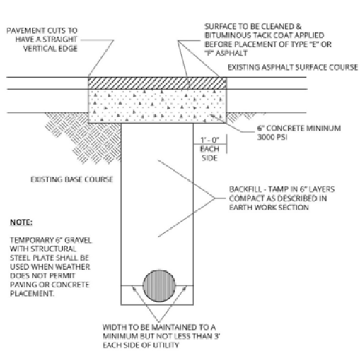
Figure 11-3 Pavement Cuts
F.
Driveways.
1.
Approval required.
a.
No driveways shall be connected to a public street and no curbs or medians on public streets or rights-of-way shall be cut or altered for access without a driveway permit issued by the department.
b.
Requirements of the Georgia DOT shall apply whenever more restrictive than the standards in this UDO.
2.
Driveway connections.
a.
Vehicular access. Vehicular access from properties to streets shall comply with the following dimensional requirements, measured at the right-of-way line:
Table 11-6 Driveway Width Requirements
1 Includes divided entrances with center islands.
2 At least one driveway for every lot shall be a minimum of 20 feet wide, unobstructed for fire apparatus accessibility.
b.
Driveway aprons. Driveway connections shall be provided between the edge of pavement or back of curb to the right-of-way line. No property may be afforded access from a public street except as follows:
1)
Curb and gutter streets shall be provided with a driveway apron constructed of 3,000 psi concrete at least six inches thick. Sidewalks, where provided, shall be warped to the driveway apron and are to be identified across the driveway apron by construction joints or control joints.
2)
All driveway aprons shall have a radius connecting the driveway to the curb line or pavement edge as follows:
Table 11-7 Driveway Apron Radii
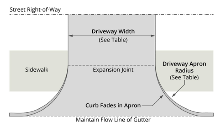
Figure 11-4 Driveway Apron Radii
c.
Intersection spacing. The distance from a driveway to the intersection of two streets, and the distance between driveways along a street, shall be based on the type of street the driveway connects to, in accordance with the following table. All measurements shall be taken along the right-of-way lines.
Table 11-8 Driveway Separations
d.
Apron design. The driveway apron shall be constructed such that no water shall enter from the street.
e.
Number of driveways limited along major streets.
1)
Along all arterial streets and any other state or U.S. numbered highway, no more than one point of vehicular access from a property shall be permitted for each 300 feet of lot frontage, or fraction thereof.
2)
Along collector streets that are not state or U.S. numbered highways, no more than two points of vehicular access from a property to each abutting public street shall be permitted for each 400 feet of lot frontage, or fraction thereof; provided however, that lots with less than 100 feet of frontage shall have no more than one point of access to any one public street. The department shall determine whether the points of access may be unrestricted or will have to be designed for right-in, right-out traffic flow.
G.
Sight triangle at street and driveway intersections.
1.
A sight visibility triangle shall be located at every street intersection with another street or a private driveway.
a.
At public street intersections, the sight visibility triangle is delineated by the two intersecting street right-of-way lines and a line connecting the right-of-way lines at the points indicated in the sight triangle table. The connecting points shall be measured from the right-of-way lines extended to their point of intersection.
b.
At private driveway intersections with public streets, the edge of the driveway's pavement or back of curb will be used for the sight triangle measurements along the driveway.
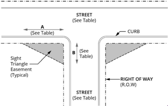
Figure 11-5 Sight Triangle
Table 11-9 Sight Visibility Triangle Table (See Drawing)
2.
The planting of trees or other vegetation or the location of structures exceeding 30 inches in height that would obstruct the clear sight across the sight visibility triangle shall be prohibited.
3.
No commercial driveway shall be constructed within 150 feet of the ROW corner of an intersection.
H.
Storm drainage.
1.
Applicability and exemptions.
a.
An adequate drainage system, including necessary ditches, pipes, culverts, drains, inlets, bridges, etc., shall be provided for the proper drainage of all surface water.
b.
All persons proposing development or construction in the city shall prepare a stormwater management plan. No final subdivision plat shall be approved and no development or building permit shall be issued until and unless the stormwater management plan has been reviewed and approved by the WSA, except as exempt below.
c.
Exemptions from storm drainage requirements. The following development activities are exempt from the provisions of this section and the requirement of providing a stormwater management plan:
1)
Agricultural land management.
2)
Additions or modifications to existing single-family detached dwellings.
3)
Residential development consisting of single-family houses, each on a lot of less than one-half acre.
I.
System design.
1.
Analyses shall be performed in accordance with the publication entitled Manual for Erosion and Sediment Control in Georgia published by the Soil and Water Conservation Commission.
2.
All drainage facilities shall be so designed as to serve the entire drainage area in which these facilities are located.
3.
All drainage features shall be in accordance with standards and specifications of Douglasville-Douglas County Water and Sewer Authority and no extension shall be made from the street drainage through abutting property without approval of the city and/or the WSA.
4.
Improvements, such as widening, deepening, relocating, clearing, protecting, or otherwise improving existing lake and shore lines, stream beds and other watercourses for the control of mosquitoes and public health nuisances, shall be provided by the developer in accordance with standards and requirements of Douglas County Health Department.
5.
Any water impoundment structure shall be constructed so as to minimize mosquito breeding and other nuisance hazards. The outside toe of any dam to be constructed within the city shall require the approval of the city and/or its designee and shall be constructed in accordance with standards and specifications as determined by the city and/or its designee.
6.
No land subject to flooding as determined by the city shall be platted or improved for residential or other use which may be endangered by floods, unless such land shall be raised four feet above existing or forecast flood level with fill dirt taken from within that part of the subdivision within the floodplain, unless a greater height is specified by the city; such filling operations shall not deepen the floodplain below its lowest level or reduce the cross-section of the floodplain, provided further that all existing natural cover shall be replaced in kind after cutting and filling operations are complete.
7.
In order to obtain a land disturbance permit, a hydrology report shall be prepared that includes appropriate calculations for the two-year, ten-year, 25-year, and 100-year design frequency storms as defined by the National Weather Service. The report shall show detailed calculations indicating the formula used, along with the co-efficient of runoff, the time of concentration, the rainfall intensity, the discharged velocity, and the source of all data used.
8.
The hydrology report shall include a map outlining the areas and showing the acreage of all on-site and off-site drainage basins contributing flow through the project for both the pre- and post-development conditions.
9.
The hydrology report must include calculations for both the peak rate of runoff discharge, which is necessary to determine the configurations and sizes of pipes, channels, and other routing or flow control structures, and the total runoff volume, which is used to assess the need for and to size stormwater detention facilities. Additionally, the report should specify the peak runoff rate at the point or points of discharge for the ten-year, 24-hour storm. The hydrology report shall be submitted to the city's water authority or its designee.
10.
Runoff peak rate of discharge for drainage areas less than 20 acres in size may be calculated using the rational method, with a minimum time of concentration of five minutes. Flows from drainage areas larger than 100 acres in size shall be calculated using the SCS method or other approved methodology. Calculations done using the (bow string method) shall not be accepted.
11.
Rainfall intensities used in hydrologic analyses shall not be less than those shown by applicable rainfall curves published by the National Oceanic and Atmospheric Administration (NOAA) for the city and the county area. Those curves are on file and available for inspection with the NOAA.
12.
Runoff coefficients for pre- and post-development activity must be calculated based on the maximum potential development of the parcel, considering current zoning conditions. This approach ensures consistency with local conditions when using the rational method. For applications utilizing the SCS (Soil Conservation Service) method, runoff curve numbers should be sourced from the Manual for Erosion and Sediment Control in Georgia. Additionally, when applying Talbot's formula, a runoff index of 0.80 or its equivalent must be used.
13.
Hydraulic capacity for open channel or closed conduit flow shall be determined using the Manning equation. Values used for "n" shall be 0.021 for corrugated metal pipe and 0.013 for reinforced concrete.
14.
All stormwater shall be conveyed from point of collection to a natural waterway by a stormwater conveyance structure. For the purpose of this policy, a natural waterway shall be defined as a stream, creek, branch, etc., which experiences constant year-round flow of such a degree as to exhibit a defined channel of the magnitude required to accommodate discharge from storm sewers during normal rainfall occurrences. A stormwater conveyance structure shall be a culvert, pipe, spillway, or channel.
15.
The stormwater flow velocity at the site's downstream property line shall not exceed the pre-development activity velocity.
16.
All free flowing storm drainage systems shall be designed to accommodate the runoff generated by a 100-year design frequency storm utilizing the available head at the entrance.
17.
The controlled release of stormwater runoff shall be required for all developments or construction in order to prevent an increase in the predevelopment rate of runoff in excess of ten percent, or one cubic foot per second for a ten-year frequency 24-hour storm, whichever is greater. Such releases shall prevent any increase in the predevelopment rate of runoff of less frequent storms up to and including the 100-year storm.
J.
Street cross drains.
1.
Pipe size for culverts under streets (street cross drains) shall be determined by design runoff and hydraulic capacity. The minimum allowable street cross drain diameter shall be 18 inches, with a minimum slope of one percent.
2.
Street cross drains shall be constructed of class III reinforced concrete.
3.
Street cross drains shall be sized to handle the runoff of a 100-year, 24-hour storm. Cross drains shall be designed to handle the peak rate of discharge associated with a 100-year storm with at least one-foot of freeboard from the top of the roadway shoulder.
4.
Velocity at design flow shall be sloped so as to maintain a minimum velocity of at least three feet per second but not more than the velocity that would cause erosion damage to the conduit.
5.
Street cross drain design is to be in accordance with the methods contained in the State Highway Standard 1030D, latest edition.
6.
Street cross drains carrying live streams shall extend to where the crown of the pipe intersects the street embankment slope and shall have flared end sections with a one-foot-wide collar of six-inch-thick concrete.
7.
Maintain full shoulder width across all cross drains as the minimum length.
8.
Street water shall be limited to a maximum distance as follows: 400 feet on grade up to seven percent; 300 feet on grades from seven to ten percent; 250 feet on grade over ten percent.
9.
Bridges shall be designed on a 100-year storm frequency.
10.
Junction boxes having access to the pipe shall be constructed to meet the requirements of Georgia DOT Standard 1030D (or most current).
K.
Traffic and erosion.
1.
Before any traffic over a storm drain is allowed, the developer shall provide an adequate depth and width of compacted backfill to protect the structure from damage or displacement acceptable to the development official. Where the developer chooses to leave the drain open and same is crossed by a driveway, the size of pipe shall be determined by the development official, and no building permit will be approved unless the installation meets the requirements of the city.
2.
The developer shall remove any debris or silt that constricts the flow through a pipe as often as necessary to maintain drainage.
3.
All pipe structures shall be cleaned before the work is accepted. Any damage or displacement that may occur due to traffic or erosion shall be repaired or corrected at the developer's expense.
4.
The developer's obligation to clean and repair pipes ceases after acceptance of the system by the proper authority at the end of the five-year maintenance period.
L.
Inlets and catch basins.
1.
Inlets and catch basins shall be designed in accordance with the Georgia Department of Transportation's Drainage Manual for Highways, latest edition.
2.
Frames and grates shall be as selected by the development official and department based upon site conditions.
3.
Stormwater catch basins shall be spaced so that the spread in the street for a ten-year design peak rate of discharge shall not exceed eight feet, as measured from the face of the curb.
4.
Catch basins shall be located at all low points of streets and shall be located so as to service no more than four acres.
M.
Piped systems.
1.
Design runoff and hydraulic capacity shall determine pipe size. The minimum allowable pipe diameter shall be 24 inches under a street and 18 inches under a driveway.
2.
Minimum clearances. Minimum clearances are: one foot between the bottom of the roadway base and the exterior crown of the culvert, and a minimum of six inches between underground utilities and exterior crown of culverts.
3.
Trench construction. Trench construction for storm drainage pipe shall be in accordance with standard drawings.
4.
Storm drainpipes shall be constructed of class III reinforced concrete or aluminized type II corrugated culvert.
a.
Concrete Pipe.
1)
Concrete pipe shall be reinforced within the right-of-way but may be plain pipe outside of the right-of-way.
2)
Flat bottom and circular pipe sections shall be laid in a prepared trench with the socket ends pointing upstream. Sections shall be joined in accordance with manufacturer's recommendations.
b.
Corrugated aluminum or pipe. Corrugated aluminum pipe and pipe arches sections shall be laid in a prepared trench with outside laps of circumferential joints pointing upstream and with longitudinal joints at the sides. Coupling bands, fastened by two or more bolts, shall join the sections. The space between adjoining sections shall be not more than the width of one corrugation.
c.
Elongation. Elongation of metal pipes shall be as shown on the plans. The contractor shall order the elongation of the vertical axis of the pipe to be done in the shop. Corrugated metal pipe shall be shipped with wire-tie in the pipe ends. Wire-ties shall be removed as soon as possible after the fill is completed.
5.
The design of piped stormwater collection systems shall be based upon conveyance of the peak rate of discharge associated with a 100-year, 24-hour storm.
6.
Stormwater pipes that do not carry live streams shall extend at least 50 feet beyond the front building setback lines, and may be required to extend farther where necessary to provide an adequately protected building site on the property.
7.
Any storm drainage pipe dedicated to the public that extends outside of the street right-of-way shall be located within a minimum 20-foot wide easement.
8.
All storm drainage pipes shall be at least 18 inches below the surface and shall have a slope of at least one percent. Subdrainage will be installed to control the surplus groundwater by intercepting sidehill seepage or by lowering or regulating the groundwater level where such conditions exist.
9.
Pipe bedding shall be provided as specified in Design and Construction of Sanitary and Storm Sewers, prepared by the American Society of Civil Engineers (Manuals and Reports on Engineering Practice No. 37), latest edition.
10.
Development storm drain outlet systems shall connect to a public stormwater conveyance system or to a free-flowing stream. The developer shall be required to provide evidence of acceptable capacity to receive additional flow.
11.
Under no circumstances shall structures be constructed over an existing or proposed storm drain, whether public or private.
12.
Maximum continuous length of pipe shall be 300 feet.
N.
Headwalls.
1.
Headwalls or flared end sections with concrete collars are required at the inlet and outlet on all street cross drains and storm drain pipes.
2.
Headwalls are to be precast concrete, stone masonry with reinforced concrete footings, or poured-in-place, reinforced concrete with reinforced concrete footings.
3.
Flared end sections shall be constructed of the same material as the drainage pipe to which they are being connected.
4.
High water elevation contour is to be based on a 100-year storm at the entrance of each head wall.
5.
Energy dissipation devices, such as splash pads, riprap, stilling basins, etc., shall be provided at the outlet of every street cross drain and storm drainpipe.
O.
Open channels.
1.
The plat must be marked and an easement shown for a 15-foot easement for the drain.
2.
All stormwater channels shall be designed to carry at least the 100-year frequency storm with one foot of freeboard.
3.
Velocity at design flow shall be six and one-half feet per second. A higher velocity may be allowed if actions are taken that would avoid erosion or scouring of the channel.
4.
All stormwater channels must be designed to retain natural design characteristics and to convey flows that prevent dwelling flooding, property damage, or public access and/or utility interruption.
5.
The development official may determine that the expected long-term maintenance of a surface drainage system could prove impractical, and a stormwater pipe collection system may be required.
6.
Any storm drainage channel that extends outside of the street right-of-way shall be located within a 20-foot wide easement.
7.
In cases in which a subdivision or development is traversed by a stream, there shall be provided a conservation easement extending 25 feet from each side of the stream bank.
8.
All drainage easements, natural ditches, and drainage areas shall have a flat bottom construction of rip rap of appropriate size. Side slopers shall have a maximum slope of 3:1 and shall be stabilized with grass and/or riprap as necessary to control erosion.
9.
Cross drains under driveways shall meet the standards for street cross drains.
P.
Stormwater detention.
1.
Stormwater management plan required. All persons proposing development or construction shall prepare a stormwater management plan. No final subdivision plat shall be approved and no development or building permit shall be issued until and unless the stormwater management plan has been reviewed and approved by the director, except as exempted below.
a.
Stormwater detention facilities providing for the storage and controlled release of runoff shall be required if stormwater cannot be conveyed to a natural waterway or that the increase in runoff due to development may create problems of downstream flooding, overloading of existing structures or other problems directly attributable to the development of a parcel of land. The release rate (quantity and velocity) of stormwater shall be no greater than the calculated point discharge prior to development.
b.
All stormwater detention facilities shall be designed to control the runoff volumes associated with storms having two-year, ten-year, 25-year and 100-year return frequencies, considered individually.
c.
Detention shall be provided such that the peak rate of flow from the site after development will not exceed the corresponding flow that would have been created by the same return frequency storms prior to development.
d.
Reservoir routing methods shall be used for all detention facility design.
e.
The drainage system being developed shall have adequate capacity to bypass through the development the flow from all upstream areas for a storm of 100-year design frequency for the land off site and upstream under existing development. The bypass flow rate shall be not less than the 100-year flow rate of record or computed using a runoff coefficient of not less than 0.50.
f.
The live detention storage to be provided shall be calculated on the basis of the 100-year frequency rainfall as published by the National Weather Service for the affected areas. The detention volume required shall be that necessary to handle the runoff of a 100-year rainfall, for any and all durations, from the proposed development less that volume discharged during the same duration at the approved release rate as specified above.
g.
The development official may permit several developers to construct joint facilities. The development official shall approve or disapprove the waiver of on-site drainage or detention facilities on the basis of the engineering feasibility of a combined facility. No use of land or occupancy of buildings within the properties served by these facilities shall be permitted until completion of the retention and drainage structures, except upon specific approval.
h.
The department shall be authorized to approve alternative methods of stormwater detention based on appropriate engineering studies that do demonstrate equal or better performance in accordance with accepted stormwater management practices. Approved alternatives may include well maintained and landscaped lakes that may be provided to act jointly as detention reservoirs and recreation facilities or aesthetic focal points within forest preserve areas, public or private parks, housing developments, shopping centers, and industrial parks. Other control methods to regulate the rate of stormwater discharge which may be acceptable include, but not be limited to, detention on flat roofs, parking lots, streets, lawns, underground storage, and oversized storm drains with restricted outlets.
i.
Detention facilities and drainage structures shall, where possible, use natural topography and natural vegetation. In lieu thereof these shall have planted trees and vegetation such as shrubs and permanent ground cover on their borders. All on-site facilities shall be properly maintained by the owner in such a way that they do not become nuisances. Nuisance conditions shall include: improper storage resulting in uncontrolled runoff and overflow; stagnant water with concomitant algae growth, insect breeding, and odors; discarded debris; and safety hazards created by the facility's operation. Private facilities are the perpetual responsibility of the landowner.
j.
Principal outlets such as weirs shall be constructed of concrete block or reinforced concrete with watertight joints. Outlet pipes shall be at least six inches in diameter. Riser pipes, if used, shall be at least eight inches in diameter.
k.
No portion of any detention facility shall be located in any required buffer, street right-of-way or within a flood hazard area.
l.
The 100-year ponding limits of a detention facility shall not encroach upon a public street.
m.
An easement at least 25 feet in width shall be required to provide access to the detention facility from a street.
n.
Every detention facility shall be completely enclosed within a drainage easement. The drainage easement shall extend at least ten feet beyond the ponding limits of the 100-year storm.
o.
Detention facilities shall be enclosed with a minimum four-foot high black powder-coated chainlink fence around all facilities having a maximum water or undercut depth of more than four feet or a bank slope greater than one and one-half to one and shall be equipped with a minimum eight-foot wide access as necessary for maintenance. Fencing may be waived by the development official and department in other than areas zoned residential and where the pond is more than 500 feet from a residential district.
p.
Developments that adjoin and flow directly into a river are exempt from stormwater detention requirements.
Q.
Public utilities.
1.
Sanitary sewerage.
a.
No septic tanks shall be allowed if public sewerage is available, as determined by the water and sewer authority. The subdivider or developer shall provide sanitary sewer services to each lot within the bounds of the subdivision. The layout and specifications of the system shall be in accordance with the specifications of the providing agency.
b.
In a drainage basin which, at the time of plat approval is scheduled for a public sewerage system within three years, all subdivisions shall be provided with a temporary commercial sewer disposal system, as approved by the Environmental Protection Division of the Department of Natural Resources, State of Georgia. Such system shall include permanent sewerage outfall lines plus a temporary treatment system to be installed by subdivider.
c.
Whenever installation of a sanitary sewer is required as provided by these regulations, no new street shall be paved without such sewer being first installed in accordance with the requirements of the Public Health Division, Georgia Department of Human Resources sewer specifications for private disposal systems and the WSA for public disposal systems.
d.
When the sewer is located in a street right-of-way and it will be necessary to cut into the street to serve the abutting lots, a connection shall be stubbed out to the property line to serve each lot prior to surfacing the street.
e.
Where connection to the sanitary sewerage system is not feasible in the view of the development official, the lot shall contain adequate area for the installation and safe operation of a septic tank and disposal field, as approved by the health department.
f.
Prior to the construction of any private community sewerage disposal system, the location, size, plans and specifications of such a facility shall be approved by the development official and department, the health department and the State Department of Natural Resources, Environmental Protection Division. Adequate space must be provided for a complete, secondary community sewerage disposal system.
2.
Public water.
a.
Each subdivision or development shall connect to the public water system, where available within a reasonable distance of service, and shall provide service to each lot or the development as a whole, as appropriate, at the expense of the developer.
b.
The layout and specifications of the system shall be in accordance with city specifications and shall be installed by a contractor approved by the water and sewer authority and/or the city.
c.
Fire hydrants in subdivisions shall be spaced no more than 400 feet apart and shall meet all requirements of the fire department.
d.
When the water main is located in the street right-of-way and it will be necessary to cut into the street surface to serve the abutting lot, a connection shall be stubbed out to the property line and a meter box installed to serve each lot prior to surfacing the street. Alternatively, lines may be bored at the builder's expense.
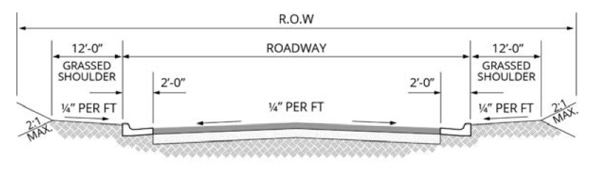
Figure 11-6 R.O.W. Design Parameters
Table 11-10 Design Parameters
* Per Georgia DOT for State and U.S. numbered highways.
(Ord. No. O-2024-33, § 2, 8-19-24)
Sec. 11.04. - Sketch plan/conceptual plan.
A.
Purpose of sketch plan. The purpose of a sketch plan (also referred to as a conceptual plan) review is to provide a developer with an economical way to work with the planning staff and elected officials in reaching a general agreement as to the nature of a proposed land subdivision project, its impact on the community, and its conformance with the codes, ordinances, plans and policies. For the sketch plan review, the developer will not need detailed architectural and engineering drawings.
B.
Sketch plan specifications. As a minimum, the following information and materials should be provided as a part of the sketch plan application package:
1.
One copy of an accurate and up-to-date survey of the property proposed for subdivision;
2.
One copy of a vicinity map at a scale of 1:600 showing the property in relation to the general area of the jurisdictional limits in which it is located;
3.
Three hard copies and one electronic copy of a schematic plan drawn clearly and accurately by a design professional at a scale appropriate for the nature of the project, to include:
a.
Scale, north arrow, and date of preparation;
b.
Approximate topography;
c.
All primary and secondary conservation areas;
d.
Significant existing man-made features on the property;
e.
Proposed streets, lots, public areas, open spaces, greenbelts, buffers, amenity areas, and other significant proposed improvements;
f.
Zoning setbacks, and the approximate area of each lot;
g.
Any other features that will be important in the design and development of the project; and
h.
Any off-site improvements that may be needed to properly develop the property.
4.
One copy of a reduced 11 inches by 17 inches copy of the sketch plan suitable for distribution;
5.
One copy of the stormwater management sketch plan;
6.
Typical floor plans and elevations of the houses that are planned for the proposed subdivision; and
7.
A sketch plan review fee.
C.
Sketch plan review process.
Step 1: The developer of a proposed subdivision shall meet with the City of Douglasville Community Development Director or designee to discuss what is required for sketch plan approval in terms of documents, fees, and schedules.
Step 2: The developer shall submit to the City of Douglasville Community Development Director or designee a complete sketch plan application package including all items specified under section 11.04.B., and any other matter appropriately required by the City of Douglasville.
Step 3: The sketch plan application package is carefully checked by the City of Douglasville Community Development Director or designee to determine whether it is complete. If it is incomplete it will be returned to the developer with an explanation of why it is incomplete and what must be done to make it complete. The developer will then begin the process again with step 2 and no additional fee will be required.
Step 4: If the sketch plan application package is complete, it will be accepted by the City of Douglasville Community Development Director or designee; the date of acceptance will be noted. For every submittal, the City of Douglasville Community Development Director or designee shall have at least 14 working days for review and comments.
Step 5: If the City of Douglasville Community Development Director concludes the sketch plan is not acceptable, the sketch plan shall be returned to the developer with an explanation of why it was found to not be acceptable, and with instructions as to what needs to be done to make it acceptable. The developer will then begin the process again at step 2, and a new plan review fee will be required.
Step 6: If the City of Douglasville Community Development Director or designee approves the sketch plan, the developer will be authorized to proceed with the preparation of a preliminary plat that will be based on the approved concept and be in accordance with all conditions and agreements included in the action to approve the concept.
(Ord. No. O-2024-33, § 2, 8-19-24)
Sec. 11.05. - Preliminary plat.
A.
Purpose of preliminary plat. The purpose of a preliminary plat is to provide a review of a proposed subdivision at an intermediate point between the conceptual plan and a full set of construction plans. It is intended that this review will help assure that the plans which are being prepared are in accordance with all applicable development codes and ordinances and with the conditions set forth in the approval of the conceptual plan.
B.
Preliminary plat specifications. The preliminary plat for a subdivision shall be clearly and legibly drawn at a scale of not less than 100 feet to one inch. The sheet size shall not exceed 36 inches by 48 inches, provided, however, a scale of 200 feet to one inch may be used to avoid sheets more than 36 inches by 48 inches. The minimum sheet size shall be 17 inches by 22 inches. The preliminary plat (which is submitted with the development plan application) shall, at a minimum, contain the following:
1.
Proposed name of the subdivision.
2.
Names, addresses, and telephone numbers of the property owner of record and the developer and/or subdivider.
3.
Name, address, and telephone number for each professional firm associated with the preparation of the preliminary plat.
4.
Date of survey, north arrow, and graphic scale.
5.
Subdivision location including land lot(s) and land district(s), area in acres, internal and abutting zoning, proposed number of lots with minimum lot size, and proposed phasing, if any.
6.
A location sketch or vicinity map positioning the subdivision in relation to the surrounding area with regard to recognized permanent landmarks. The location sketch scale shall be at a scale of 600 feet to the inch.
7.
Boundary lines of the overall property perimeter showing bearings in degrees, minutes and seconds and distances in feet and hundredths of a foot along all lines and the bearing and distances to an existing street intersection or other recognized permanent landmark. The source of boundary information shall be shown.
8.
Current field-run topography with mean sea level contours at intervals no greater than five feet. The source of topographic information shall be shown.
9.
Accurate locations of all-natural features such as lakes, ponds, streams, creeks, state waters, wetlands, floodplain boundaries, riparian buffers, wildlife and priority habitats (as identified by Department of Natural Resources), and other significant features, and notations designating any federal, state, or local regulatory agency permits or approvals that are or may be required relative to development of or around such features. The source of floodplain information shall be shown. If applicable, the petitioner must provide a copy of the wetland delineation that has been approved by the US Army Corps of Engineers, or at a minimum, a delineation prepared by a qualified wetland scientist.
10.
Primary and secondary conservation areas.
11.
Approved stormwater management plan.
12.
Accurate locations of all cultural features such as all existing historic resources, public recreational facilities, cemeteries, rights-of-way, easements, pavements (including widths), bridges, culverts and storm drains, utility lines, appurtenances and structures, municipal, county, or other political subdivision jurisdictional limits, land lot and district lines, zoning districts and limits and other significant features.
13.
Proposed layout including lot lines with preliminary dimensions, lot numbers, block letters, street rights-of-way with names and widths, easements, public use facilities, facilities exclusively for subdivision use and all relevant conditions of zoning.
14.
Location of all known existing or previous landfills.
15.
Proposed method of water supply and sewage disposal.
C.
Preliminary plat, supplemental information. The following supplemental information shall be required for each submittal of a preliminary plat:
1.
A written summary of the proposed subdivision giving information as to the overall development plan including, as appropriate, the type and square footage of structures, number of housing units, types of land uses, anticipated traffic generation, and other pertinent information so that the effects and conformance of the subdivision as to the purposes and requirements specified in articles 8 and 11, can be considered by the City of Douglasville Community Development Director or designee.
2.
Description of the anticipated utility systems required to serve the proposed subdivision including projected average and peak demands or flows for potable water (water availability report), fire protection, sewerage, and electrical power.
3.
Description of proposed stormwater management practices for the subdivision including the ownership and proper maintenance provisions of all stormwater detention facilities within the subdivision.
4.
Such additional information as may be reasonably required to obtain an adequate understanding of the subdivision.
D.
Preliminary plat review process.
Step 1: The developer of a proposed subdivision shall meet with the community development director or their designee to discuss what is required for preliminary plat approval in terms of documents, fees, and schedules.
Step 2: The developer shall submit to the community development department two complete sets of the preliminary plat application package.
Step 3: The preliminary plat application package shall be carefully checked to determine whether it is complete. If it is incomplete, it will be returned to the developer with an explanation of why it is incomplete and what must be done to make it complete. The developer will then begin the process again with step 2, and no additional fee will be required.
Step 4: If the preliminary plat application package is complete, it will be accepted; the date of acceptance will be noted. For every submittal, the community development department and the engineering department, or their designees, shall have at least 14 working days for review of the preliminary plat, and preparation of review comments.
Step 5: If it is concluded that the preliminary plat is not acceptable, the preliminary plat shall be returned to the developer with an explanation of why it was found to not be acceptable, and with instructions as to what needs to be done to make it acceptable. The developer will then begin the process again at step 2 and a new plat review fee will be required.
Step 6: After the preliminary plat application has been reviewed, the preliminary plat submittal shall then be approved by the community development director or designee in writing. The community development director shall have the authority to impose conditions and agreements on any plat approval as will ameliorate the negative effects of the proposed development on internal or surrounding properties.
Step 7: If the preliminary plat is approved by the community development director, it shall be forwarded to the developer, and he will be authorized to proceed with the preparation of construction plans. The construction plans will be based on the approved preliminary plat and be in accordance with all conditions and agreements included in the action to approve the preliminary plat.
(Ord. No. O-2024-33, § 2, 8-19-24)
Sec. 11.06. - Construction plans.
A.
Purpose of construction plans. The purpose of the construction plans is to provide all the detailed engineering information necessary to build the proposed subdivision in accordance with the approved preliminary plat and all the other development codes and ordinances of the city. It shall be the responsibility of the community development director or their designee to approve the format and content of the plans and specifications, and to determine what supplemental information shall be required to assure proper construction of the project.
B.
Construction plans and specifications. The construction plans for a subdivision shall be clearly and legibly drawn at a scale of not less than 100 feet to one inch. The sheet size shall not exceed 36 inches by 48 inches, and the minimum sheet size shall be 17 inches by 22 inches. The Construction Plans shall include the following information:
1.
Name of subdivision;
2.
Name, address and telephone numbers of the owner/developer of the property;
3.
Name, address and telephone number of the professional engineer who prepared the plans;
4.
Name, address and telephone number of the designated 24-hour contact person for the project;
5.
Date plans were prepared, north arrow and graphic scale on all appropriate sheets.
6.
Location map at a scale of 600 feet to the inch;
7.
An accurate list of all conditions relative to the zoning or development of the property as a subdivision and the approval of the conceptual plan and preliminary plat;
8.
Pertinent site development data;
9.
A copy of each permit or approval that shall be required from any federal, state or local regulatory agency for or in connection with the proposed subdivision, or any portion thereof, or a copy of a pending application for any such permit or approval.
10.
Detailed limits of clearing and tree-save plans;
11.
Detailed limits all undisturbed buffers and open space;
12.
Erosion and sediment control plans;
13.
Detailed stormwater management plans;
14.
Detailed electric and natural gas utility plans;
15.
Detailed roadway plans;
16.
Detailed grading plans;
17.
Detailed water supply/utility plans;
18.
Detailed sanitary sewer plans; and
19.
Such other information as may be required by the City of Douglasville to fully evaluate and review the project.
C.
Construction plan review process.
Step 1: The developer of a proposed subdivision shall meet with the community development department or its designee to discuss what is required for construction plan approval in terms of documents, fees, and schedules.
Step 2: The developer shall submit two complete sets of the construction plan application package.
Step 3: The construction plan application package shall be carefully checked by the community development department to determine whether or not it is complete. If it is incomplete it will be returned to the developer with an explanation of why it is incomplete and what must be done to make it complete. The developer will then begin the process again with step 2, and no additional fee will be required.
Step 4: If the construction plan application package is complete, it will be accepted by the community development department and the date of acceptance will be noted. For every submittal, the community development department shall have at least 30 working days for review of the construction plans and to prepare comments.
Step 5: The community development department shall review and approve two identical sets of plans, one for the developer and one for the city. The developer shall then make three hard copies and one electronic copy of the approved set for the community development department, along with one 11-inch by 17-inch set. The developer shall keep one copy of the approved set on the construction site at all times.
Step 6: Upon request, after approval on the construction plans and receipt of all permits and approvals, which shall become a part of the developer's construction plans, the community development department shall issue a land disturbance or development permit to install the erosion control facilities and the tree-save fence in accordance with the approved plans. A fee is required for this permit in accordance with the fee schedule set by city council.
Step 7: Upon request, the staff shall inspect the property to determine whether the erosion control facilities and tree-save fence were installed properly. This inspection shall take place within three working days of the request.
Step 8: If the installation is not approved, the developer shall be informed in writing of what needs to be done to secure approval, and then begin the process again with step 7. A re-inspection fee shall be required.
Step 9: After approval of the erosion control facilities and tree-save fence, the developer may request that the community development department issue a permit to clear and grade the property in accordance with the approved plans. A fee may be required for this permit in accordance with the fee schedule set by city council.
Step 10: Upon request, city staff shall inspect the property to determine whether the clearing and grading were done properly. This inspection shall take place within five working days of the request.
Step 11: If the clearing and grading are not approved, the developer shall be informed in writing of what needs to be done to secure approval, and then begin the process again with Step 10. A re-inspection fee may be required in accordance with the fee schedule set by city council.
Step 12: The community development department or designee may periodically inspect the property to determine whether the site is developed in accordance with the approved plans. Also, the developer shall submit for review and approval all test results, documentation, and certifications that are required to demonstrate satisfactory construction and adherence to all federal, state, or local regulatory agency permits and approvals, all codes, ordinances and development standards.
Step 13: Upon request, the community development department shall make a final inspection of the construction. Based on the site inspection and the review of the supporting documentation, the community development department shall determine whether the construction work is acceptable. This determination shall be made within ten working days of the request. If it is determined that the construction is satisfactory, the community development department will authorize the preparation of a final plat.
Step 14: If the construction is not approved, the developer shall be informed in writing of what needs to be done to secure approval, and then begin the process again with step 13. A re-inspection fee shall be required.
Note: If the developer wishes to make any substantive change to the construction plans at any time during the process, that change must first be approved by the community development department in accordance with the construction plan review process.
Note: Staff inspections will be performed on a regular basis during the construction process to assure conformance with the approved plans and specifications.
D.
Construction plans certification.
1.
Construction plans, engineer's certification of design. The following certification statement from the design professional of record shall appear in the approved construction plans package:
I hereby certify that the design of stormwater and drainage facilities including culverts, drainage structures and detention or retention ponds and appurtenances; the design of roadways and streets; and the design of water system facilities including pipelines, fire hydrants, valves and appurtenances, sanitary sewerage facilities including gravity sewer pipelines, force mains, manholes and appurtenances was prepared under my direct supervision and is in strict accordance with all applicable federal, state, and local regulatory permits and approvals, and all applicable local codes, ordinances and regulations.
_______
Signature of Engineer of Record
_______
Date
_______
Name (Printed)
_______
No. (Seal)
2.
Construction plans approval, city engineer. The following certification statement from the city engineer or his/her designee shall appear in the approved land disturbance application:
All requirements of the City of Douglasville relative to the preparation and submission of these plans and specifications have been fulfilled and approval is hereby granted subject to the conditions stipulated below:
_______
City Engineer
_______
Date
3.
Construction plans approval, community development director. The following certification statement from the City of Douglasville community development director shall appear in the approved land disturbance application:
These construction plans have been reviewed and found to be in accordance with the approved conceptual plan and the approved preliminary plat, and any zoning conditions that may have been previously imposed on the property.
_______
Community Development Director
_______
Date
(Ord. No. O-2024-33, § 2, 8-19-24)
Sec. 11.07. - Final plat.
A.
Purpose of the final plat. The purpose of the final plat of a subdivision is to present an accurate depiction of the layout of the subdivision that has been constructed so that it can be properly recorded and then used as a permanent reference for the sale of the property included within the subdivision.
B.
Final plat specifications.
1.
The final plat shall be clearly and legibly drawn in black ink on suitable permanent reproducible material. The scale of the final plat shall be 100 feet to one inch or larger. Sheet size shall be 18 inches by 24 inches.
2.
The final plat shall be based on a certified boundary survey delimiting the entirety of the property contained within the final plat and tied to a city-established monument with the same degree of accuracy as the boundary itself. The survey shall have an accuracy of no less than one in 10,000 and shall meet all requirements of Georgia Law regarding the recording of maps and plats. The final plat shall be submitted as hard copy and electronically in a format acceptable to the city.
3.
The final plat shall conform to the approved sketch plan and preliminary plat and it may constitute only a portion of the approved sketch plan, which the subdivider proposes to record at any one time, provided that such portion conforms to the requirements of these regulations, and said portion is not inconsistent with the public health, safety, or welfare. Any substantial deviation from the approved sketch plan or preliminary plat shall require revision and reapproval of both the sketch plan and preliminary plat. The final plat shall contain the following information:
a.
Name of the subdivision and unit or phase number, if any.
b.
Names, addresses, and telephone numbers of the property owner of record and the developer or subdivider.
c.
Name, address, and telephone number of each professional firm associated with the portion of the subdivision depicted on the final plat.
d.
Date of plat and survey, north arrow and graphic scale.
e.
Subdivision location including land lot(s) and land district(s), area in acres, internal and abutting zoning, proposed number of lots and area represented in tabular format showing associated square footage.
f.
A location sketch or vicinity map positioning the subdivision in relation to the surrounding area regarding recognized permanent landmarks. The location sketch scale shall be drawn at a scale of 600 feet to the inch.
g.
Field-run boundary survey of the subdivision property perimeter showing actual bearings in degrees, minutes and seconds and distances in feet and hundredths of a foot along all lines and the bearing and distances to an existing street intersection or other recognized permanent landmark. The boundary information shall be tied and related to the State Plane Coordinates System, 1983 North American Datum, Georgia, East zone.
h.
Municipal or county jurisdictional lines tied to the lines of the subdivision by distance and angles when such lines traverse or adjoin the subdivision; land lot or land district lines traversing or adjoining the subdivision shall also be indicated.
i.
Locations, widths, and names of all streets within and immediately adjoining the plat and all other public or utilities easements or rights-of-way.
j.
Street centerlines showing angles of deflection and standard curve data including radii, chord lengths, and bearings, lengths of arcs and tangents, and points of curvature and tangency.
k.
Lot lines with complete dimensions to the nearest one-hundredth of a foot and bearings to the nearest second, and radii, arc and chord lengths, and chord bearings of rounded corners.
l.
Building setback lines with dimensions. When lots are located on a curve or when side lot lines are at angles other than 90 degrees, the lot width at the building line shall be shown.
m.
Lots numbered in numerical order, blocks lettered alphabetically, and addresses as established by the city.
n.
Location, material and size of all drainage pipes, location and type of all drainage system appurtenances such as catch basins, headwalls and inlets, location and extent of detention ponds with 100-year event level noted, the location, material and size of all water and sewer mains and appurtenances, the location of all fire hydrants, and the location, width and purpose of any easements, including slope easements.
o.
Location of any areas to be reserved, donated, or dedicated to public use with notes stating their purpose and limitations. Location of any areas to be reserved by private deed covenant for common use of all property owners or dedicated to a homeowner's association.
p.
A statement of restrictive covenants or conservation easements, if any, and if they are brief enough to be put directly on the final plat; otherwise, if covenants are separately recorded, a statement as follows:
"This plat is subject to the covenants set forth in the separate document(s) recorded with the Clerk of Superior Court of Douglas County, Georgia in Deed Book ___, Page ___, dated [insert date], which hereby become a part of this plat, and which were recorded on [insert date]."
q.
Accurate location, material, and description of property corner or line monuments or markers. All monuments and markers shall be in place prior to approval of the final plat.
r.
Extent and elevation of the regulated floodplain within the subdivision. When floodplain is present, a chart giving the areas within and outside of the floodplain for each lot containing any portion of the floodplain shall be on the final plat. The origin of the floodplain data shall be indicated. The minimum finished floor elevation for sites adjacent to the floodplain shall be indicated on the plat for each lot.
s.
Individual lots, which are deemed by the community development department or its designee as requiring site plans, shall be designated in a readily identifiable manner. No part of any lot shall contain state waters, conservation easements or other permanently protected areas, or the required undisturbed buffers for those areas.
t.
Certificates and statements specified in this UDO.
C.
Final plat, supplemental information. The following supplemental information shall be required for each final plat:
1.
A maintenance bond warranting workmanship and covering damages for a period not less than five years from the date the final plat is recorded.
2.
As-built construction plans in both a paper and electronic format, showing all infrastructure installation details, and certified by the engineer of record.
D.
Final plat review process.
Step 1: The developer of a proposed subdivision shall meet with the community development department or its designee to discuss what is required for final plat approval in terms of documents, fees, and schedules.
Step 2: The developer shall submit two complete final plat application packages.
Step 3: The final plat application package shall be carefully checked by the community development department or designee to determine whether or not it is complete. If it is incomplete it will be returned to the developer with an explanation of why it is incomplete and what must be done to make it complete. The developer will then begin the process again with step 2 and no additional fee will be required.
Step 4: If the final plat application package is complete, it will be accepted by community development department or designee; the date of acceptance will be noted. For every submittal, the community development department shall have at least 15 working days for review of and comments on the final plat.
Step 5: If the community development department concludes the final plat is not acceptable, the final plat shall be returned to the developer with an explanation of why it was found to not be acceptable, and with instructions as to what needs to be done to make it acceptable. The developer will then begin the process again at step 2 and a new plat review fee will be required.
Step 6: Prior to recording the final plat, the developer shall complete all required improvements, including the installation of the landscape plan for the public areas, and those improvements must all be inspected and approved by the community development department or its designee. If for any reason, it is not possible or practical for the developer to be able to complete this work within a reasonable period, the developer may post a cash bond, the amount of which shall be determined by the community development department or its designee, pending the satisfactory completion of the work.
Step 7: Prior to recording the final plat, the developer must post an acceptable maintenance bond to guarantee the quality and workmanship of the required improvements for a period of not less than two years following the date the final plat is recorded.
Step 8: Once the developer has completed steps 6 and 7, and the City Engineer or its designee has approved the final plat, the developer shall provide to the community development department or its designee a complete and accurate set of as-built drawings in both paper and electronic format acceptable to the city. The as-built drawings must also be approved by the community development department or its designee.
Step 9: Record the final plat.
E.
Final plat certifications.
1.
Final plat surveyor's certification. The following certification statement from the surveyor of record shall appear in the approved final plat package:
It is hereby certified that this plat is true and correct and was prepared from an actual survey of the property made by me or under my supervision; that all monuments shown hereon actually exist or are marked as "future" and their location, size, type, and material are correctly shown. This plat conforms to all requirements of the Georgia Plat Act. By:
_______
Signature of Registered Georgia Land Surveyor
_______
Date
_______
Name (Printed)
_______
No. (Seal)
2.
Engineer's Certification. The following certification statement from the engineer of record shall appear in the approved final plat package:
I hereby certify that this subdivision was constructed in accordance with the construction plans and specifications which were approved by the City of Douglasville Community Development Director or designee, as well as any approved revisions thereto, and that all applicable engineering requirements of the applicable development and zoning ordinances have been fulfilled, except as noted below:
_______
Signature of Engineer of Record
_______
Date
_______
Name (Printed)
_______
No. (Seal)
3.
Final plat approval certification. The following certification statement from the community development director or designee shall appear in the approved final plat package:
This final plat has been prepared in accordance with the approved sketch plan, the approved preliminary plat, the approved construction plans, and the other applicable development codes and ordinances, and has been approved by the City of Douglasville for recording in the Office of the Clerk of the Superior Court of Douglas County.
_______
City Engineer
_______
Date
_______
City Clerk
_______
Date
_______
Community Development Director
_______
Date
4.
Maintenance guarantee. The undersigned, and all of its successors assigns to its interest in the subject property and, hereby warrant and guarantee to the City of Douglasville the full and complete maintenance of a certain improvement known as [_______] and more particularly shown in plat book [_______], page(s) [___], of the Douglas County, Georgia records.
This warranty and guarantee is made in accordance with the applicable subdivision and development regulations of the City of Douglasville. This guarantee includes not only paving but also all other appurtenant structures and amenities lying within the right-of-way of any said road and in the buffer areas, including but not limited to all curbing, drainage pipes, culverts, catch basins, drainage ditches, and pedestrian walks. Utilities owned and operated by a governmental body or public utility company shall be the responsibility of said governmental body or public utility company and not the developer.
The developer shall correct and repair or cause to be corrected and repaired all damages to said improvements. In the event the developer fails to correct any damages within 30 calendar days after written notice thereof, then said damages may be corrected by the City of Douglasville and all costs and charges billed to and paid by the developer; but this remedy shall not limit the City of Douglasville, and it shall also have any remedies available to it as approved by law.
The terms of this agreement shall be for a period of five years beginning on the date of written acceptance of said improvements by the City of Douglasville as evidenced by the final plat approval of said completed improvements.
After the termination of said five-year period the City of Douglasville shall be responsible to the citizens for the maintenance of said improvements as provided by law. Provided, however, any damages which occurred prior to the end of said five-year period and which still are unrepaired at the termination of said period shall remain the responsibility of the developer (written notice of said damages must be given prior to the time the five-year period ends).
In witness whereof, the developer has caused this agreement to be executed by its duly authorized officers this ___ day of _______, _______.
_______
Owner/Developer
_______
Date
_______
Title
_______
(Seal)
_______
Notary Public State of Georgia (Seal)
5.
Certificate of dedication.
State of Georgia
County of Douglas
The owner of the land shown on the attached final plat (the "plat") acknowledges that the plat was made from an actual survey, and for value received, the sufficiency of which is hereby acknowledged, does hereby convey in fee simple to the City of Douglasville, Georgia, and further dedicates to the use of the public forever all streets and rights-of-way, pedestrian walks, watercourses, drains, easements, greenbelts and public places shown on the plat, except those easements designated on this plat as other utility company easements, and except those streets specifically designated on the plat as private streets.
In consideration of the approval of this plat and other valuable considerations, the owners do hereby agree to hold the City of Douglasville, Georgia, harmless for a five-year period from any and all liabilities arising from any and all claims, damages, or demands arising on account of the design and construction of the improvements shown on the plat, to include but not limited to, the roads, streets, fills, embankments, ditches, cross drains, culverts and bridges within the proposed right-of-way shown, resulting from any and all causes other than by an act of the City of Douglasville, Georgia.
And further, the owner warrants that he owns fee simple title to the property shown on the plat and agrees that the City of Douglasville shall not be liable to the undersigned or subsequent owners in title for a period of five years for any claim of damages resulting from negligence in exercising engineering techniques and due caution in the construction of cross drains extension, drives, structures or buildings, the changing of courses of streams and rivers, flooding from natural creeks and rivers and any other matter whatsoever on private property. All monetary liability arising from the property shown on the plat during the term of the five-year hold harmless period specified herein shall be the liability of the owner, or its successors and assigns in interest. I further warrant that I have the right to convey said land according to this plat and do hereby bind myself and the owners subsequent in title to defend the covenants and agreements set out.
In witness whereof, I have hereunto set by hand and affixed my seal this ___ day of _______, 20___.
_______
Owner/Developer
_______
Date
_______
Title (Seal)
_______
Notary Public State of Georgia (Seal)
(Ord. No. O-2024-33, § 2, 8-19-24)