
Douglasville City Zoning Code
ARTICLE 4
- COMMERCIAL AND MIXED-USE DISTRICTS
Sec. 4.01.- General provisions.
A.
The intent of the commercial and mixed use districts is to protect established commercial and mixed use areas as well as promote well designed and properly located future developments that create minimal impact on adjacent, incompatible districts.
B.
The district provisions discourage any use that would substantially interfere with the retail, service or office function of the districts. Compatible park, open space, utility and civic uses as well as integrated residential dwelling units are permitted in commercial and mixed use districts as identified in article 2, uses, use regulations and restrictions.
Sec. 4.02. - Interpretation.
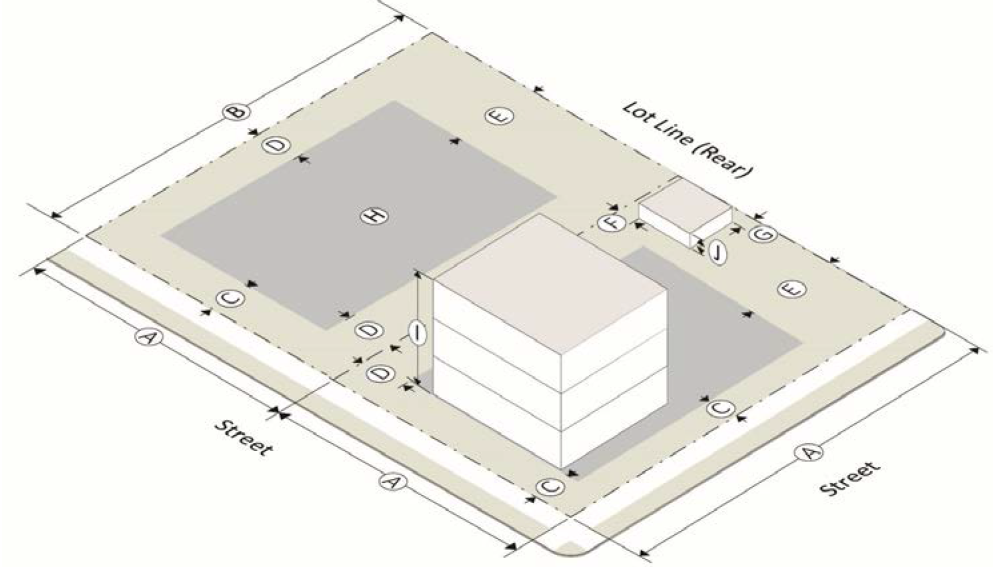
The following graphics depict the interpretation of lot development standards. The official definitions for these terms can be found in the article 12, definitions.
Sec. 4.03. - PUD planned unit development.
A.
Purpose. The purpose of a planned unit development is to encourage the best possible site plans and building arrangements under a unified plan of development, rather than under lot-by-lot regulation. The developer benefits from better land utilization, economy in the provision of roads and utilities and flexibility in design. Approval of an overall concept plan by the city council provides an opportunity to assure that the development will be in accordance with the land use plan and the character of the neighborhood in which the development is located.
It is anticipated that a pattern of creative and innovative neighborhood development, including residential and neighborhood commercial, will be developed that is distinguished from other residential zoning districts through a diversity of lot sizes, housing types and sizes to accommodate persons of a variety of stages of life in a pedestrian-oriented setting that is well integrated with the city's neighborhoods, parks, civic spaces, and supportive services.
B.
Lot development standards.
C.
Land use mix. A PUD must contain at least two types of land use that are not otherwise allowed together in another zoning district or two types of residential density. Each PUD development is anticipated to include a mix of land uses as identified in the table below. The intent of allowing non-residential uses is to create a node of neighborhood oriented retail and services primarily for the convenience of those in and directly adjacent to the PUD district. Non-residential development must be at a scale and type that is compatible with the residential component of the development.
D.
Residential Density.
1.
The total number of dwelling units permitted within a PUD shall be computed by multiplying the maximum permitted density (dwelling units per acre) by the total acreage of the PUD property, excluding land within public or private road rights-of-way and public easements, flood-plain and wetland areas, and areas permanently inundated by water.
2.
Density bonus.
a.
A maximum density of eight dwelling units per acre shall not be exceeded unless one or more of the following are requested and approved as a part of the design concept plan as identified in the table below.
b.
Bonuses below are additive.
c.
In no case shall the overall residential density exceed ten dwelling units per acre.
E.
Open space required; common area standards.
1.
Within the PUD, 20 percent of the gross land area must be set aside as common area open space, half of which must be usable for active or passive recreation.
2.
The common and open space areas and facilities shall be held in common by a legally constituted association of property owners with the financial capability to maintain the open space and shall be on a recorded plat as permanent common area open space for the use of residents, workers, patrons and visitors to the development.
3.
For the purposes of calculation, common open space does not include any streets or public rights-of-way, or yard areas or landscape areas located on private property. Common open space does include land and water areas that are available to all occupants of the PUD on a continuing and permanent basis, such as walking trails, community centers or clubhouses, golf courses and other recreation areas, protected flood plains or wetlands.
4.
Lands dedicated to an approved public use, such as a school or fire station, shall be credited as part of the 20 percent common open space requirement.
5.
Each common area or open space must comprise a contiguous area of at least 3,000 square feet.
6.
Higher density dwelling units such as quadplexes, apartments and townhouses are recommended to be adjacent to, or directly across the street from a common area such as a public park, green or square.
7.
A system of pedestrian pathways consisting of sidewalks or multi-use paths shall be provided linking each lot containing one or more dwelling units to at least one common area.
8.
Maintenance of common areas shall be one of the following:
a.
Maintained by the city if common areas are accepted by the city as a part of a final development agreement; or
b.
By a mandatory property owner's association which shall be responsible for ownership, operation, maintenance and insurance of all land and facilities within the common areas of the development.
F.
PUD perimeter compatibility. Land uses developed at the perimeter of the site shall be developed in a manner that is compatible with adjacent off-site land uses or zoning, or a 100-foot wide buffer shall be provided between the uses in the PUD and the perimeter of the site. Compatibility shall be judged on the basis of similar land uses, average lot sizes, setbacks, and other development standards.
G.
Submission requirements.
1.
Concept plan required, development standards.
a.
Development of the PUD shall be guided by a graphic concept plan that designates the land uses of the PUD. The concept plan may be accompanied by a development standards text, which may be approved as a condition of zoning or special use, providing development standards and uses for the project which vary, augment or limit the requirements of this UDO.
b.
To the extent that the approved concept plan and development standards for a PUD contradict the UDO, the contradictory provisions of the UDO are inapplicable to that PUD. For properties zoned to design concept development (DCD) before the effective date of this UDO, to the extent that development standards are not stated with regard to a particular land use or area, then the standards in the UDO applicable to the zoning district most consistent with the DCD approval for that land use or area shall apply, provided such standards do not contradict the concept plan for the DCD. For properties zoned to PUD on or after the effective date of this UDO, to the extent that development standards are not stated with regard to a particular area, then the standards and land uses required and permitted in the area shall be those allowed for the zoning district designated on the concept plan.
2.
Concept plan as a condition of zoning. No changes in land use or density shall be allowed in any approved and incorporated concept plan or development standards text, except as subsequently approved pursuant to a rezoning of the property. For properties zoned to DCD concurrent with adoption of the official zoning map on the effective date of this UDO, and for which development has commenced but is not complete prior to the effective date of this UDO, the individual land use plan for any such property shall serve as a concept plan, and such property shall continue to be developed in accordance with development standards applicable at the time of adoption of the land use plan, unless and until new individualized development standards are approved for such property by the mayor and city council. For all properties zoned to PUD subsequent to the effective date of this UDO, the land uses permitted within a DCD and the development standards applicable to each, by location, shall be established as a condition of approval by the city council at the time that the property is rezoned to PUD.
3.
Traffic study required. The applicant shall submit a traffic study along with the zoning application for any property which:
a.
Has an existing zoning classification other than DCD, and for which the applicant seeks PUD zoning; or
b.
Is already zoned as DCD, and for which the applicant seeks a change or addition to the concept plan, development text or special stipulations, or an initial adoption of any such elements.
The report shall comply with the provisions of section 10.06.H., traffic study.
H.
Facade materials for residential dwellings.
1.
Acceptable façade materials. For detached residential dwellings in PUD developments approved on or the effective date of this UDO, façade materials shall be limited to the following:
a.
Type A—Brick, stone, and cementitious siding (not to exceed 75 percent of any single wall surface).
b.
Type B—Stucco, wood and other materials listed as type A.
c.
Type C—Finished concrete, glazed surface, metal (not corrugated or unfinished) and other material listed as type A or type B.
2.
Single dwelling calculation. Except as provided in paragraph 3. of this subsection, every detached residential dwelling in any PUD development approved on or after the effective date of this UDO, shall be constructed with façade materials of not less than 25 percent brick on each and every side.
3.
Multi-dwelling calculation. For any PUD development approved on or after the effective date of this UDO, as an alternative to the requirements of paragraph 1. of this subsection, the development text may specify façade materials for all detached residential dwellings conforming to one of the following plans:
a.
80 percent plan. Where every residential dwelling in the PUD development has a minimum lot size of 8,000 square feet, and a minimum dwelling size of 1,500 square feet, and where the maximum density is four units per acre, the development text may provide for:
1)
Not fewer than 80 percent of the total number of dwellings each to have not less than 80 percent brick façade on each and every side, and
2)
The remaining dwellings to have type C façade material.
b.
50 percent plan. Where every residential dwelling in the PUD development has a minimum lot size of 9,000 square feet, and a minimum dwelling size of 1,700 square feet, and where the maximum density is three and one-half units per acre, the development text may provide for:
1)
Not fewer than 50 percent of the total number of dwellings each to have not less than 80 percent brick façade on each and every side, and
2)
The remaining dwellings to have type B façade material.
c.
Twenty percent plan. Where every residential dwelling in the PUD development has a minimum lot size of 10,000 square feet, and a minimum dwelling size of 1,800 square feet, and where the maximum density is three and one-quarter units per acre, the development text may provide for:
1)
Not fewer than 20 percent of the total number of dwellings each to have not less than 80 percent brick façade on each and every side, and
2)
The remaining dwellings to have type A façade material.
I.
Supplemental regulations.
1.
Supplemental use regulations shall be as established in article 2, use regulations and restrictions as based on section 2.02, allowed uses.
2.
The PUD district is intended to encourage ingenuity and resourcefulness in land planning, to:
a.
Assure the provision of park and recreation land and facilities for the use of the occupants of the development in order to obtain a more desirable environment, and to
b.
Encourage a mix of uses for creation of communities where individuals can live, work and play.
3.
A PUD district is required to include at least two types of land use that are not otherwise allowed together in another zoning district, or at least two types of residential density, in order to promote unique solutions to land development issues.
(Ord. No. O-2025-39, § 3, 11-3-25)
Sec. 4.04. - O-I office-institutional.
A.
Purpose. The O-I office-institutional district is established to provide a district for offices, institutions, and limited commercial activities not involving the sale, storage, or processing of merchandise unless otherwise permitted herein, along with appropriate accessory uses, in accordance with the comprehensive plan for the city.
B.
Lot development standards.
C.
Supplemental regulations.
1.
Supplemental use regulations shall be as established in article 2, use regulations and restrictions as based on section 2.02, allowed uses.
2.
Lots in the historic district are exempt from lot dimension requirements.
(Ord. No. O-2025-39, § 3, 11-3-25)
Sec. 4.05. - NC neighborhood commercial.
A.
Purpose. The NC neighborhood commercial district is intended to provide suitable areas for the retailing of goods and services to surrounding residential neighborhoods and at the same time protect the residential neighborhoods from intrusive traffic and parking congestion in accordance with the land use plan for the city.
B.
Lot development standards.
C.
Supplemental regulations.
1.
Supplemental use regulations shall be as established in article 2, use regulations and restrictions as based on section 2.02, allowed uses.
2.
Lots in the historic district are exempt from lot dimension requirements.
3.
Any business in this district that contains other businesses within the same primary use and occupying the same space, such as a grocery store with a branch bank or fast food restaurant inside, shall be considered a single business establishment.
(Ord. No. O-2025-39, § 4, 11-3-25)
Sec. 4.06. - CBD central business.
A.
Purpose. The CBD, central business district is intended to protect and promote a suitable pedestrian friendly area for office, institutional, entertainment and commercial uses which benefit from proximity to each other, to encourage the eventual elimination of uses inappropriate to a central business area, and to encourage the intensive development of a central business district for the City of Douglasville, in accordance with the land use plan for the city. Residential uses are appropriate in the central business district when combined with nonresidential uses in mixed-use buildings, as long as the nonresidential uses occupy at least the ground floor area.
B.
Lot development standards.
C.
Supplemental regulations. Supplemental use regulations shall be as established in article 2, use regulations and restrictions as based on section 2.02, allowed uses.
Sec. 4.07. - RMP regional marketplace.
A.
Purpose. The RMP regional marketplace district is a district for planned shopping centers designed to accommodate general retail and personal service activities conducted in a unified development and designed to serve a regional area. This type of development is characterized by upscale specialty stores and services with dining and entertainment in an outdoor, multi-story, walkable setting. RMPs can incorporate limited high density residential.
B.
Lot development standards.
C.
Supplemental Regulations. Supplemental use regulations shall be as established in article 2, use regulations and restrictions as based on section 2.02, allowed uses.
(Ord. No. O-2025-39, § 3, 11-3-25)
Sec. 4.08. - GC general commercial.
A.
Purpose. The GC general commercial district is intended to provide areas for those business and commercial uses that are a higher intensity than neighborhood commercial districts or for the central business district, in accordance with the land use plan for the city.
B.
Lot development standards.
C.
Supplemental regulations.
1.
Supplemental use regulations shall be as established in article 2, use regulations and restrictions as based on section 2.02, allowed uses.
2.
Lots in the historic district should comply with the setback requirements of the historic district per chapter 48 of the City of Douglasville Code of Ordinances.
3.
Properties over five contiguous acres in size may be required to provide additional landscaping and buffering and may also be required to ensure appropriate connectivity to surrounding streets and pedestrian walkway systems.
(Ord. No. O-2025-39, § 3, 11-3-25)
Sec. 4.09. - PSP public-semi-public.
A.
Purpose. The PSP public-semi-public district is established to provide a district for public and semi-public uses including government buildings, schools and publicly owned parks and recreation facilities, in accordance with the comprehensive plan for the city.
B.
Lot development standards. The City of Douglasville is exempt from all lot development standards, but are subject to a concept plan approval.
C.
Supplemental Regulations. Supplemental use regulations shall be as established in article 2, use regulations and restrictions as based on section 2.02, allowed uses.
Sec. 4.10. - TCMU town center mixed use.
A.
The purpose and intent of the town center mixed use (TCMU) zoning district is to encourage a creative mixture of small scale residential and commercial uses that are immediately accessible to neighborhood amenities, retail space, and institutional facilities.
B.
Development plan required. The development standards shall be determined by a development plan. The development plan must be reviewed and approved by both the city engineer and community development director or their designees. The development plan will be evaluated as part of the rezoning process and before any land disturbance permits may be issued. The development plan will be approved as a condition of zoning. At minimum, the development plan shall include the following elements:
1.
Analysis of existing conditions. The analysis of existing conditions shall include a boundary survey and topographic map of the site at minimum 1 inch = 40 feet scale. It shall include all-natural features, all manmade features, bodies of water, riparian areas, easements, and adjacent rights-of-way to be moved, altered, or retained. It shall also include a narrative indicating past and present uses of the site and the incidences of any historic or cultural landmarks either on site or adjacent to the site.
2.
Overall site plan. The overall site plan shall be a minimum scale of 1 inch = 40 feet. It shall include, at minimum, building footprints, ingress, egress, density, location and number of parking spaces, open space, height, rights-of-way, building setbacks, buffers, landscape strips, location of overhead and underground utilities, amenity areas, water retention/detention areas, designated land use mix, distance between the proposed development and community facilities, and proposed amenities.
3.
Phasing plan. Should a town center mixed use zoning district require two years or longer to complete, the applicant shall provide a phasing plan to be approved by the community development director or his or her designee.
4.
Architectural pattern book. An architectural pattern book shall be approved as a condition of zoning. The architectural pattern book shall include elevations of all proposed buildings with a narrative description of building materials, fencing, and screening guidelines, proposed public furniture and/or art, and a photometric lighting plan with sample fixtures. Elements of the pattern book will be evaluated based on compatibility with the character of the Downtown area.
C.
Lot development standards.
D.
Land use mix. A town center mixed-use development must contain at least two types of land uses or housing densities as identified in the table below that are not otherwise allowed together in another zoning district. The intent is to create a node of neighborhood-oriented retail, commercial, and residential services that work together to provide community needs. Non-residential developments must be of a scale and type that is compatible with the residential component of the development and the surrounding areas.
E.
Public facility requirement. The town center mixed-use development must be within one-quarter mile of a public facility. Applicable public facilities include open space used for passive and active parks, walking trails, playgrounds, public schools, libraries, and community centers. To be considered a public facility, the space must be existing and must contain a minimum of 500 continuous square feet of space which is accessible for public use.
If the proposed development is not already within a one-quarter mile radius of a public facility, open space must be provided as part of the development that is a minimum of 500 square feet of continuous pervious surface open for recreational use and which shall be maintained by a mandatory property owners association.
F.
Residential density. The total number of dwelling units permitted within a TCMU shall be computed by multiplying the maximum permitted density (dwelling units per acre) by the total acreage of the TCMU property, excluding land within public or private road rights-of-way and public easements, flood-plain and wetland areas, and areas permanently inundated by water. The maximum density shall not exceed 35 units per acre.
G.
Access control.
1.
Traffic study required. The applicant shall submit a traffic study which complies with section 10.06.H of the Unified Development Ordinance (traffic study) along with the zoning application for any property which is being considered for the TCMU zoning designation.
2.
All automotive ingress and egress to residential and commercial uses must be from public streets.
3.
There shall be pedestrian access available between the adjacent civic, recreational, or commercial uses and the residential uses.
4.
All interior streets shall have sidewalks of not less than 15 feet in width.
5.
Cul-du-sacs shall be limited as much as possible, and connections to neighboring streets and sub-divisions is encouraged to support multi-modal accessibility.
6.
All modes of transportation (rideshare, bicycle, automobile, bus routes etc.) shall be accommodated to the greatest extent possible.
H.
TCMU perimeter compatibility. Land uses developed at the perimeter of the site shall be developed in a manner that is compatible with adjacent off-site land uses or zoning, or a 50-foot-wide buffer shall be provided between the uses in the TCMU district and the perimeter of the site. Compatibility shall be judged on the basis of similar land uses, average lot sizes, setbacks, and other development standards.
I.
Building standards.
1.
For single family attached units (duplex, triplex, quadraplex, townhomes), differences between units must be clearly articulated. Articulation may be accomplished using differences in color, building materials, or fenestration. Differences may also be articulated by adding roof gables, columns, or porches.
2.
For multi-family units, no two stories on the same building shall have an identical façade.
3.
Single family homes must have a minimum five-foot stagger for front yards, and townhome units must have a minimum two-foot stagger for front yards.
J.
Supplemental regulations.
1.
Supplemental use regulations shall be as established in article 2, use regulations and restrictions as based on section 2.02, allowed uses.
2.
Lots in the historic district shall comply with the requirements of the historic district pursuant to chapter 48 of the City of Douglasville Code of Ordinances.
3.
No changes in the Development Plan shall be allowed in any approved Development Plan, except as subsequently approved pursuant to a rezoning of the property.
4.
To the extent that the approved concept plan and development standards for a TCMU contradict the UDO, the contradictory provisions of the UDO are inapplicable to that TCMU.
K.
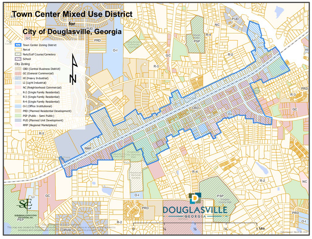
The TCMU zoning district will only be permitted in the designated area in and adjacent to downtown as illustrated on the map labeled "Table 4.10."
Table 4.10. Town Center Mixed Use District Map.
(Ord. No. O-2023-29, § 1, 6-20-23)
Sec. 4.11. - NRC neighborhood residential commercial.
A.
Purpose. The NRC neighborhood residential commercial district is intended to provide medium-intensity retail and encourage residential use either as single- or mixed-use development, while also supporting missing middle housing developments and walkability.
B.
Development plan required. The development standards shall be determined by a development plan. The development plan must be reviewed and approved by the community development director or their designee. The development plan will be evaluated as part of the rezoning process and before any land disturbance permits may be issued. The development plan will be approved as a condition of zoning. At minimum, the development plan shall include the following elements:
1.
Analysis of existing conditions. The analysis of existing conditions shall include a boundary survey and topographic map of the site at minimum one inch equals 40 feet scale. It shall include all-natural features, all manmade features, bodies of water, riparian areas, easements, and adjacent rights-of-way to be moved, altered, or retained. It shall also include a narrative indicating past and present uses of the site and the incidences of any historic or cultural landmarks either on site or adjacent to the site.
2.
Overall site plan. The overall site plan shall be a minimum scale of one inch equals 40 feet. It shall include, at minimum, building footprints, ingress, egress, density, location and number of parking spaces, open space, height, rights-of-way, building setbacks, buffers, landscape strips, location of overhead and underground utilities, amenity areas, water retention/detention areas, designated land use mix, distance between the proposed development and community facilities, and proposed amenities.
3.
Setbacks and parking provisions will be considered during the development plan review process.
4.
Phasing plan. Should a NRC zoning district require two years or longer to complete, the applicant shall provide a phasing plan to be approved by the community development director or his or her designee.
5.
Architectural pattern book. An architectural pattern book shall be approved as a condition of zoning. The architectural pattern book shall include elevations of all proposed buildings with a narrative description of building materials, fencing, and screening guidelines, proposed public furniture and/or art, and a photometric lighting plan with sample fixtures.
C.
Lot development standards.
D.
Land use mix. A NRC development must contain at least two types of land use that are not otherwise allowed together in another zoning district or two types of residential density. Each NRC development is anticipated to include a mix of land uses as identified in the table below. The intent of allowing non-residential uses is to create a node of an intense neighborhood-oriented retail and services primarily for the convenience of those in and directly adjacent to the NRC district. Non-residential development must be at a scale and type that is compatible with the residential component of the development.
E.
Supplemental regulations.
1.
Supplemental use regulations shall be as established in article 2, use regulations and restrictions as based on section 2.02, allowed uses.
2.
Lighting: Each commercial and mixed-use lot are responsible for providing outdoor lighting at the developer's expense. Lighting must be downcast and directed away from abutting properties.
3.
Parking shall be located in the rear and side yards only.
4.
Any business in this district that contains other businesses within the same primary use and occupying the same space, such as a grocery store with a branch bank or fast-food restaurant inside, shall be considered a single business establishment.
5.
Uses in the neighborhood residential commercial district will be exempt from the off- street parking requirements as noted in section 8.01.
6.
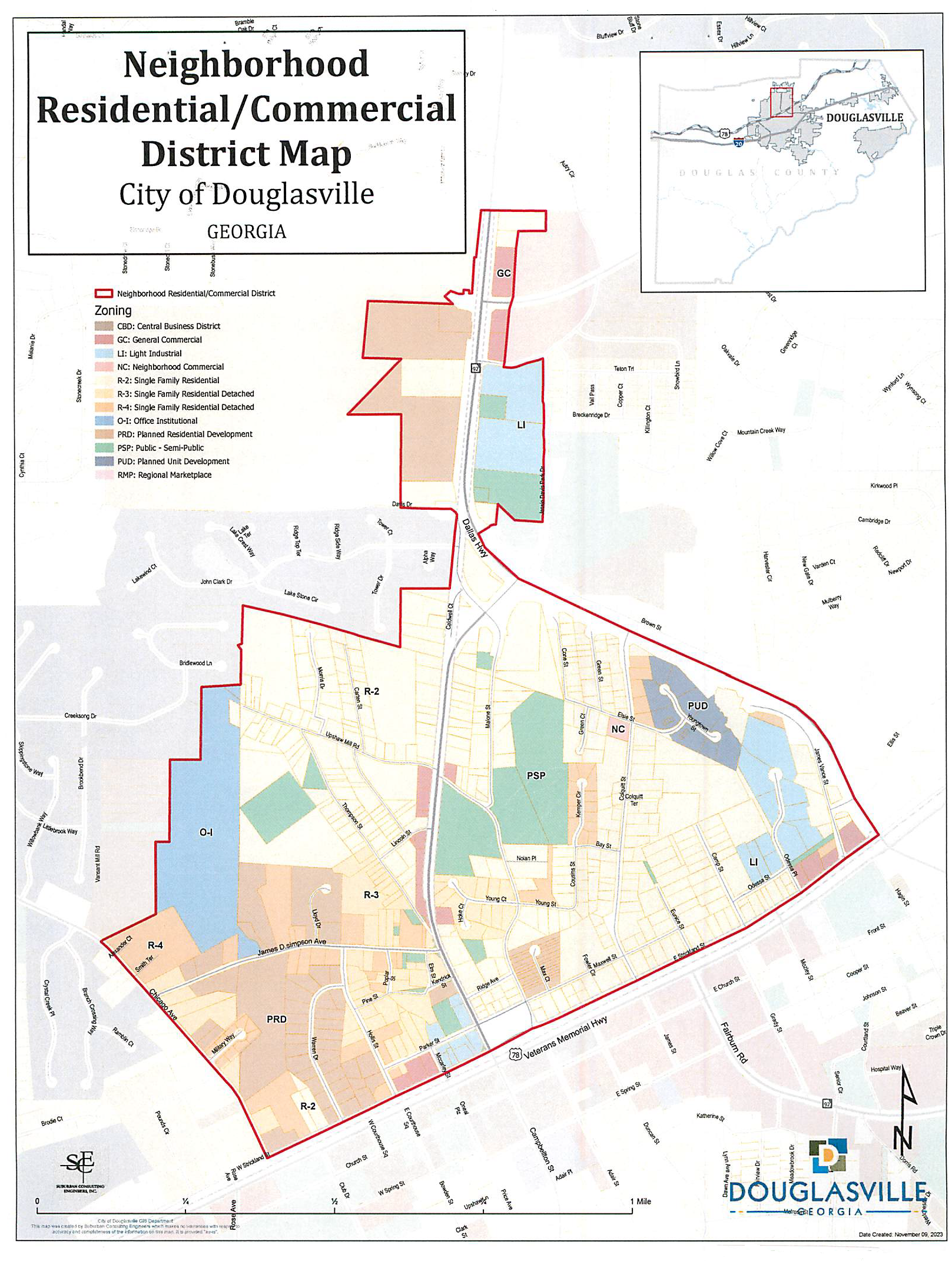
The neighborhood residential commercial district will only be permitted in the designated area in illustrated on the map labeled "Neighborhood Residential/Commercial District Map."
F.
The NRC zoning district will only be permitted in the designated area as illustrated in Exhibit A: "Table 4.11 - Neighborhood Residential/Commercial District Map."
Table 4.11. Neighborhood Residential/Commercial District Map.
(Ord. No. O-2024-2, § 3, 1-16-24; Ord. No. O-2025-39, § 4, 11-3-25)