
Downers Grove City Zoning Code
ARTICLE 28
IV Special Purpose Districts
Sec 28.4.010 D, Downtown Districts
- List. The village’s downtown zoning districts are listed in Table 4-1. When this zoning ordinance refers to “downtown” zoning districts or to “D” districts, it is referring to the districts in Table 4-1.
Table 4-1: Downtown Zoning DistrictsMap Symbol District Name DC Downtown Core DB Downtown Business DT Downtown Transition - Description
- DC, Downtown Core. The DC, Downtown Core, zoning district regulations are intended to maintain and promote a vibrant and compact core within the downtown area for shopping, dining and entertainment with residential uses above. The district regulations are further intended to encourage a broad range of uses and high-quality development. The DC district is designed for the types of development appropriate in the downtown area.
- DB, Downtown Business. The DB, Downtown Business, zoning district regulations are intended to maintain and promote a vibrant and compact downtown area for living, shopping, dining and entertainment. The district regulations are further intended to encourage a broad range of uses and high-quality development. The DB district is designed for the types of development appropriate in the downtown business area. It is intended to be mapped only in the area shown on the zoning map as of June 7, 2005, except that:
- the DB Downtown Business district may be mapped on property contiguous to that area on property classified as of June 7, 2005, within the DT district; and
- upon a finding by the village council that there exists specific extraordinary circumstances, the DB district may be mapped on property classified within other zoning districts abutting the existing DB District.
- DT, Downtown Transition. The DT, Downtown Transition, zoning district regulations are intended to accommodate and promote transitional land uses and development patterns between the DB or DC zoning district and nearby low-density residential areas. The regulations are intended to help prevent intensive downtown development from encroaching into stable residential areas and to prevent low-density residential development from encroaching into the downtown area. The DT district is intended to be mapped only abutting the DB or DC district.
- Allowed Uses. Principal uses are allowed in downtown districts in accordance with Table 5-1. Only one principal building may be located on a single lot in the D districts.
- Lot and Building Regulations. The lot and building regulations of Table 4-2 apply to all principal uses and structures in D districts, except as otherwise expressly stated in this zoning ordinance. General exceptions to lot and building regulations and rules for measuring compliance can be found in Article XIV of this Chapter. Additional regulations governing accessory uses and structures can be found in DGMC Section 28.6.010. See also Figure 2-1.
Table 4-2: D District Lot and Building RegulationsRegulations DC DB DT L1 Minimum Lot Area (square feet) Detached house - - 7,500 Attached house (applies to development not individual units) - - 10,500 Two-unit house (applies to development not individual units) - - 10,500 Apartment/condo
(applies to development not individual units)- - 10,500 Other nonresidential buildings/uses - - 7,500 Minimum Lot Area per Dwelling Unit (square feet) 900 800 1,800/4,000[1] L2 Minimum Lot Width (feet) - - 50 Minimum Building Setbacks (feet) S1 Street - -[2] 10[3] S2 Side (interior) - -[4] 5 S3 Rear - -[5] 20 Build-to Zone Minimum/maximum (feet) 0/5 0/10 - Minimum percent of building in primary street BTZ 80 80 - Minimum percent of building in secondary street BTZ 30 30 - Maximum Floor Area Ratio Apartment/condo - - 2.5 Nonresidential - - 2.5 C Maximum Building Coverage (% of lot, principal + accessory) - - - Building Height (feet) Maximum 40/3[7] 70 36/3[6][8] Minimum 24/2[9] 32 -
[1] Attached house and apartment-condo/detached house and two-unit house.
[2] When the extension of a front or street side lot line coincides with a front or street side lot line of an abutting R-zoned lot, a street setback must be provided on the DB-zoned lot. The street setback in such cases must extend at least thirty-five feet (35') from the abutting R-zoned lot and be at least as deep as the street setback required on the abutting R-zoned lot. A street setback at least eight feet (8') feet in depth must be provided along the remainder of the front or street side lot line. See Figure 4-1.
[3] No street setback required if street lot line abuts DB zoning districts.
[4] A side setback is required when abutting the side or rear lot line of an R-zoned lot. The setback must be at least as deep as the side setback required on the abutting R-zoned lot, plus one foot (1') of additional setback for each foot of building height in excess of twenty feet (20'). See Figure 4-2.
[5] A rear setback is required when abutting the side or rear lot line of an R-zoned lot. When abutting the rear lot line of an R-zoned lot, the setback must be at least twenty feet (20') in depth, plus one foot of additional setback for each foot of building height in excess of twenty feet (20'). When abutting the side lot line of an R-zoned lot, the setback must be at least as deep as the side setback required on the abutting R-zoned lot, plus one foot (1') of additional setback for each foot of building height in excess of twenty feet (20'). See Figure 4-3.
[6] Detached houses, attached houses and two-unit houses subject to thirty-five foot (35') maximum height.
[7] Maximum height is forty feet (40') or three (3) stories, whichever is less.
[8] Maximum height is thirty-six feet (36') or three (3) stories, whichever is less.
[9] Minimum height is twenty-four feet (24') or two (2) stories, whichever is more.
Figure 4-1: DB District Street Setback Abutting R-Zoned Lot
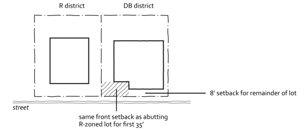
Figure 4-2: DB District Side Setback Abutting R-Zoned Lot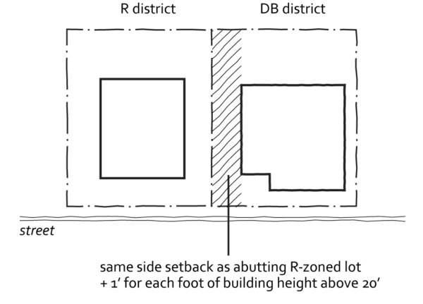
Figure 4-3: DB District Rear Setback Abutting R-Zoned Lot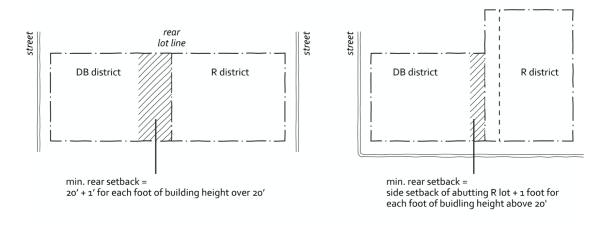 (Ord. No. 5706, 7/10/18)
Sec 28.4.020 INP, Institutional And Public Districts
- Mapping. The INP, Institutional and Public zoning district designations may be applied regardless of ownership of the land on which the use is located. INP zoning designations are not intended to be applied to land owned by a governmental or institutional entity but used for non-governmental service or non-institutional use.
- INP-1, Neighborhood-scale Institutional and Public District
- Purpose. The INP-1, Neighborhood-scale Institutional and Public district, is intended to accommodate small-scale, low-intensity public, civic, and institutional uses that are commonly found in or near residential neighborhoods.
- Allowed Uses. Principal uses are allowed in INP-1 districts in accordance with Table 5-1. Multiple principal uses and buildings are allowed on a single lot in the INP-1 district.
- Lot and Building Regulations
- Maximum District Area. In order to maintain the intended neighborhood-scale character of the INP-1 district, the maximum contiguous INP-1 zoned area may not exceed four (4) acres.
- Setbacks and Other Lot and Building Regulations. The size, location, and design of all buildings, structures, activity areas and other site improvements must comply with the lot and building regulations of the most restrictive abutting zoning district, except that no minimum lot area, minimum lot width or street frontage requirements apply in an INP-1 district.
- Other Regulations. Development in an INP-1 district is subject to all other applicable regulations of this zoning ordinance, including parking, landscaping, sign and other regulations of general applicability.
- INP-2, Campus-scale Institutional and Public District. The INP-2, Campus-scale Institutional and Public district, is intended to accommodate development and expansion of large public, civic and institutional uses, while minimizing the potential for adverse impacts on surrounding areas.
- Allowed Uses. Principal uses are allowed in the INP-2 district in accordance with Table 5-1. Additional uses may be approved in the INP-2 district only if expressly approved as part of an institutional master plan. Multiple principal uses and buildings are allowed on a single lot in the INP-2 district.
- Development Review
- Applicability. Unless otherwise expressly exempted, development review and approval is required before the issuance of any building or development permit in the INP-2 district. To comply with the development review requirements of this Section, applicants have the option of:
- securing special use approval for all proposed building development activities in the INP-2 district; or
- submitting and securing approval of an overall institutional master plan in accordance with the requirements of this Section.
- Exemptions. The following are exempt from the development review requirements of this section:
- development that complies with a valid, approved institutional master plan;
- interior building alterations if the alteration will not result in an increase in the number of employees or the creation of or need for additional parking spaces; and
- exterior building modifications that will not result in an increase in the number of employees or the creation of or need for additional parking spaces.
- Applicability. Unless otherwise expressly exempted, development review and approval is required before the issuance of any building or development permit in the INP-2 district. To comply with the development review requirements of this Section, applicants have the option of:
- Lot and Building Regulations
- Transitional Areas. The size, location, and design of all buildings, structures, activity areas and other site improvements located within one hundred fifty feet (150') of the boundary of any R zoning district, are subject to the abutting R district’s lot and building regulations, except that no minimum lot area, minimum lot width or street frontage requirements apply in the INP-2 district.
- Interior Site Areas. Areas of an INP-2-zoned site located more than one hundred fifty feet (150') from the boundary of an R zoning district are governed by the regulations approved at the time of special use or institutional master plan approval, whichever is applicable. Institutional master plans and special use applications must include the applicant’s detailed description of the regulations proposed to be used.
- Institutional Master Plans
- Purpose. Institutional master plan requirements provide a framework for development of large public, civic and institutional uses in campus-like settings. Approval of an institutional master plan is intended to protect the character and integrity of adjacent areas while allowing flexibility in site development and design that is not possible when development occurs on a lot-by-lot or building-by-building basis.
- Planning Area. An institutional master plan must include all land located within the proposed INP-2 district and depict all land uses within the area extending out at least five hundred feet (500') from the INP-2 district boundary.
- Existing Property and Uses. The institutional master plan must include a description of land, buildings, and other structures occupied by the institution as of the date of submission of the institutional master plan. At the discretion of the Community Development Director, the following information may be required:
- illustrative site plans showing the footprints of each building and structure, together with roads, sidewalks, parking, landscape features and other significant site improvements;
- land and building uses;
- gross floor area;
- building height;
- landscaping and lighting; and
- off-street parking and loading facilities.
- Uses and Development Envelope. The institutional master plan must include a description of all proposed land uses to be allowed and the land area and development envelope within which future development will occur. The development envelope shall be described in narrative and through the use of drawings or models. At the discretion of the Community Development Director, the plan may include the following in describing the development envelope:
- floor area ratio (far);
- average daily and peak-hour traffic;
- height;
- setbacks;
- total site area of open space; and
- total number of motor vehicle and bicycle parking spaces to be provided.
- Transportation Management Plan. At the discretion of the Community Development Director, the institutional master plan may include a transportation and parking management plan that identifies any traffic mitigation measures to be used.
- Nonmotorized Circulation Plan. At the discretion of the Community Development Director, the institutional master plan may include a nonmotorized circulation system plan.
- Approval Procedures. Institutional master plans require review and approval in accordance with the PUD procedures of DGMC Section 28.12.040.
(Ord. No. 5471, § 1, 7/21/15, Ord. No. 5706, 7/10/18)
Sec 28.4.030 PUD, Planned Unit Development Overlay District
- Purpose
- General. The PUD, Planned Unit Development, Overlay district is intended to accommodate development that may be difficult if not impossible to carry out under otherwise applicable zoning district standards and that result in public benefits that are at least commensurate with the degree of development flexibility provided. Examples of the types of development that may be appropriate for PUD approval include the following:
- Enhanced Protection of Natural Resource Areas. Developments that offer enhanced protection of natural resources and sensitive environmental features, including streams, floodplains, wetlands and woodlands.
- Energy Conservation/Sustainability. Developments that achieve extremely high levels of energy conservation and developments that achieve extremely high levels of sustainability, as evidenced by commitment to attain at least LEED Gold or equivalent ratings by recognized green building organizations.
- Housing Variety. Developments that offer a range of housing options that offer a variety of lifestyle choices to meet the needs of different age groups and household types.
- Mixed- and Multi-use Developments. Developments that contain a complementary mix of residential and nonresidential uses or that provide for a range of land use types.
- Comprehensive Plan. Developments that are consistent with and help advance the goals and policies of the comprehensive plan.
- Objectives. Different types of PUDs will achieve different planning goals. In general, however, PUDs should include elements that further some or all of the following objectives:
- implementation of and consistency with the comprehensive plan and other relevant plans and policies;
- flexibility and creativity in responding to changing social, economic and market conditions allowing greater public benefits than could be achieved using conventional zoning and development regulations;
- efficient and economical provision of public facilities and services;
- variety in housing types and sizes to accommodate households of all ages, sizes, incomes and lifestyle choices;
- compact, mixed-use development patterns where residential, commercial, civic and open spaces are located in close proximity to one another;
- a coordinated transportation system that includes an interconnected hierarchy of facilities for motorized and non-motorized travel;
- high-quality buildings and improvements that are compatible with surrounding areas, as determined by their arrangement, massing, form, character and landscaping;
- the protection and enhancement of open space amenities and natural resource features;
- the incorporation of sustainable development features including green infrastructure practices in landscapes and parking area, to maximize the aesthetic and water quality benefits of best practices in stormwater management; and
- attractive, high-quality landscaping, lighting, architecture and signage, including the use of native landscaping that reflects the unique character of the Village and the surrounding area.
- General. The PUD, Planned Unit Development, Overlay district is intended to accommodate development that may be difficult if not impossible to carry out under otherwise applicable zoning district standards and that result in public benefits that are at least commensurate with the degree of development flexibility provided. Examples of the types of development that may be appropriate for PUD approval include the following:
- Procedure. PUDs must be reviewed and approved in accordance with the procedures of DGMC Section 28.12.040.
- Zoning Map
- Approved PUDs must be identified on the zoning map by appending the map symbol “PUD” as a suffix to the base zoning district classification, as in “R-4/PUD.”
- All properties classified by ordinance or resolution as a planned development prior to the effective date of this ordinance are reclassified as a Planned Unit Development (PUD) subject to the regulations established as part of their previous approvals.
- Developer’s Statement of Intent. Each PUD application must include a written explanation from the applicant describing how the proposed development provides greater benefits to the Village than would a development carried out in accordance with otherwise applicable zoning ordinance standards. The statement must also include a comparison of the proposed development with the standards of the base zoning district and the comprehensive plan.
- Regulations and Standards Eligible for Modification. Unless otherwise expressly approved by the Village Council as part of the PUD approval process, PUDs are subject to all applicable standards of this zoning ordinance. The Village Council is authorized to approve PUDs that deviate from strict compliance with specified zoning regulations and development standards if they determine that the resulting project satisfies the approval criteria of DGMC Section 28.12.040(c)(5).
- Lot and Building Regulations. The lot and building regulations of the base zoning district may be modified as part of the PUD approval.
- Allowed Uses. The uses to be allowed in a PUD must be identified as part of the PUD approval process along with all applicable conditions or supplemental use regulations that apply to such uses. Unless otherwise expressly stated, the Village Council may, through the PUD approval process, approve use types that are not allowed in the underlying zoning district as a means of accommodating mixed-use developments, housing diversity, economic development opportunities and promoting other Village policies.
- Parking and Loading. Off-street parking and loading requirements may be modified when the Village Council determines that modified requirements are in keeping with projected parking and loading demand of the proposed development, that other means of meeting access demand will be provided or that the requested modifications will better meet the purpose of the PUD overlay.
- Infrastructure and Public Improvement Standards. Alternatives to otherwise “standard” infrastructure and public improvement standards (e.g., streets, sidewalks, stormwater management) may be approved when the Village Council determines that such alternative designs would better meet the purpose of the PUD overlay.
(Ord. No. 5471, § 2, 7/21/15)
Sec 28.4.040 F, Fairview Districts
(a) List: The Village’s Fairview Districts are listed in Table 4-3. When this zoning ordinance refers to “Fairview” zoning districts or “F” districts, it is referring to the districts in Table 4-3. Table 4-3: Fairview Zoning Districts
| Map Symbol | District Name |
| FC | Fairview Core |
| FB | Fairview Business |
| FT | Fairview Transition |
(b) Description
(1) FC, Fairview Core. The FC, Fairview Core, zoning district regulations are intended to maintain and promote a vibrant and compact core within the Fairview area for living, shopping, dining, entertainment with residential uses above. The district regulations are further intended to encourage a broad range of uses and high-quality development. The FC district is designed for the types of development appropriate in the Fairview Core area.
(2) FB, Fairview Business. The FB, Fairview Business, zoning district regulations are intended to maintain and promote a vibrant Fairview area for living, shopping, dining, and entertainment. The district regulations are further intended to encourage a broad range of uses and high-quality development, with a density that is less than the Fairview Core. The FB district is designed for the types of development appropriate in the Fairview Business area
(3) FT, Fairview Transition. The FT, Fairview Transition, zoning district regulations are intended to accommodate and promote transitional land uses and development patterns between the FC or FB zoning district and nearby low-density residential areas. The regulations are intended to help prevent intensive Fairview development from encroaching into residential areas. The FT district is intended to be mapped only abutting the FC or FB district.
(c) Allowed Uses. Principal uses are allowed in Fairview districts in accordance with Table 5-1. Only one (1) principal building may be located on a single lot in the F districts.
(d) Lot and Building Regulations. The lot and building regulations of Table 4-4 apply to all principal uses and structures in F districts, except as otherwise expressly stated in this zoning ordinance. General exceptions to lot and building regulations and rules for measuring compliance can be found in Article XIV of this Chapter. Additional regulations governing accessory uses and structures can be found in DGMC Section 28.6.010. See also Figure 2-1
Table 4-4: F District Lot and Building Regulations Regulations
| Regulations | FC | FB | FT | |
| L1 | Minimum Lot Area (square feet) | |||
| Detached house | - | - | 7,500 | |
| Attached house | - | - | 8,000 | |
| Attached house (applies to development not individual units) | - | - | 10,500 | |
| Two-unit house (applies to development not individual units) | - | - | 10,500 | |
| Apartment/condo (applies to development not individual units) | - | - | 7,500 | |
| Other nonresidential buildings/uses | ||||
| Minimum Lot Area per Dwelling Unit (square feet) | ||||
| Detached house | - | - | 7,500 | |
| Attached house | - | - | 2,500 | |
| Two-unit house | - | - | 5,250 | |
| Apartment/condo | 800 | 1,000 | 1,000 | |
| Other buildings/uses | - | - | - | |
| L2 | Minimum Lot Width (feet) | |||
| Detached house | - | - | 50 | |
| Attached house | - | - | 80 | |
| Two-unit house | - | - | 80 | |
| Apartment/condo | - | - | 80 | |
| Other buildings/uses | - | - | 50 | |
| Minimum Building Setbacks (feet) | ||||
| S1 | Street | [1] | [1] | 25 |
| S2 | Side (interior)(% lot width/feet, whichever is greater) | [2] | 10/5[5] | 10/5 |
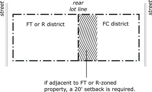
| S3 | Rear | [3] | 10 [6] | 20 |
| Build-to-Zone | ||||
| Minimum/maximum (feet) | 0/5 | 0/10 | - | |
| Minimum percent of building in primary street BTZ | 80 | 80 | - | |
| Minimum percent of building in secondary street BTZ | 30 | 30 | - | |
| Maximum Floor Area Ratio | ||||
| Apartment/condo | - | - | - | |
| Nonresidential | - | - | - | |
| C | Maximum Building Coverage (% of lot, principal + accessory) | - | - | 40% |
| Building Height (feet) | ||||
| Maximum | 60/7[7] | 48/4 [4][8] | 35 | |
| Minimum | 24/2 | - | - | |
[1] If adjacent to FT or R-zoned property, a twenty-five foot (25’) setback is required for the first thirty-five feet (35’) from the FT property line. [2] If adjacent to FT or R-zoned property, a ten percent (10%) of lot width or five foot (5’) setback of abutting FT or R district is required, whichever is greater. [3] If adjacent to FT or R zoned property, a twenty foot (20’) setback is required. [4] Where the rear yard of the property is located adjacent to the railroad right-of-way, a height bonus of twelve feet (12’) or one (1) story is permitted for portions of the building that are setback a minimum of half the lot depth. [5] If adjacent to FC, no side setback is required. [6] If adjacent to FC or railroad right-of-way, no rear setback is required. [7] Maximum height is sixty feet (60’) or five (5) stories, whichever is less. For all areas that are within thirty-five feet (35’) of FT or R zoned lot, the maximum height is thirty-five feet (35’). [8] Maximum height is forty-eight feet (48’) or four (4) stories, whichever is less. For all areas that are within thirty-five feet (35’) of an FT or R zoned lot, the maximum height is thirty-five feet (35’).
Figure 4-1: FC or FB Districts Street Setback Abutting FT or R-Zoned Lot
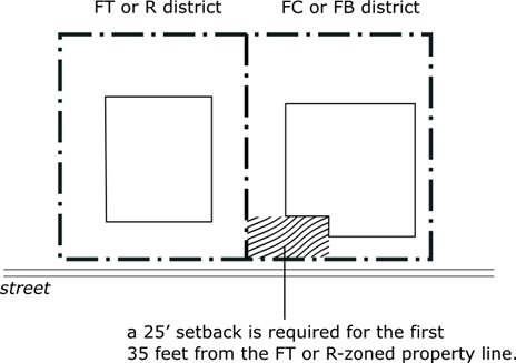
Figure 4-2: FC Districts Side Setback Abutting FT or R-Zoned Lot
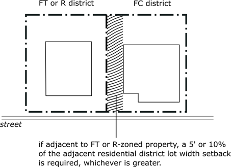
Figure 4-3: FC Districts Rear Setback Abutting FT or R-Zoned Lot
(e) Affordable Housing Developments. The purpose of this subsection (e) is to encourage the development of Inclusive Dwelling Units within the Fairview Districts (F Districts) by providing certain incentives to the developers of eligible developments. As used herein, “Affordable Housing Program” means (1) a program that is subject to the rules and regulations promulgated under Title 47, Chapter II of the Illinois Administrative Code and administered by the Illinois Housing Development Authority (“IHDA”) or (2) a program that is devoted to the providing affordable housing to low-income households and very-low income households and is administered by the Federal Department of Housing and Urban Development (“HUD”). As used herein, “Inclusionary Dwelling Unit” shall mean a dwelling unit that is subject to the requirements of an Affordable Housing Program.
a. Eligible Developments. To be eligible to receive the benefits set forth in subsection (e)(ii) below, a development must meet the following eligibility requirements:
1. The development must result in the construction of five or more (5) dwelling units, or the renovation or reconstruction of over fifty percent (50%) of the total square footage of an existing structure that results in a minimum of five (5) or more dwelling units.
2. The development, or any Inclusive Dwelling Units located therein, must be subject to an Affordable Housing Program that:
a) is designed to provide affordable housing to Low-Income Households and Very-Low Income Households, as determined by the U.S. Housing & Urban Development’s Annual Income Limits; and
b) is subject to the approval and oversight of IHDA or HUD, as the case may be, for a period of at least ten (10) years from the issuance of a certificate of occupancy for the last Inclusive Dwelling Unit constructed.
3. Throughout the duration of the ten (10) year period described in subsection (i)(2)(b) above, the owner of the development must annually certify with the Village’s Director of Community Development that the development, or the Inclusive Dwelling Unit(s) located therein, as the case may be, is/are in compliance with the requirements of the relevant IHDA or HUD Affordable Housing Program, and, upon request, provide to the Director of Community Development proof of such compliance.
4. All Inclusive Dwelling Units must be located within the same building that qualifies for the density bonus provided for in subsection (e)(ii).
b. Incentives for Inclusive Dwelling Units. Developments that meet the eligibility requirements set forth in subsection (e)(i) above receive the following benefits:
1. A density bonus that is equal to one (1) additional Inclusive Dwelling Unit for every five (5) dwelling units required pursuant to subsection (i)(1) above; provided that the maximum number of dwelling units in a development shall not exceed one hundred twenty percent (120%) of the total number of dwelling units otherwise authorized under the applicable Fairview District regulations.
a) In implementing this density bonus, the requirements of Section 28.4.040(d) may be varied in the sole discretion of the Director of Community Development without additional justification provided that any modification of said regulations shall not violate or be contrary to considerations of public health, safety and welfare of the inhabitants of the residential development or the community at large:
i) Minimum lot area.
ii) Minimum lot frontage.
2. A pro rata waiver, or partial waiver, of building permit fees, demolition fees, plan review fees, storm sewer and water connection fees, for the Inclusive Dwelling Units constructed within the development. Customary fees shall apply to all other dwelling units.