Zoneomics Logo
search icon

Eastpointe City Zoning Code

ARTICLE 12

- ZONING PLAN REVIEWS

Sec. 12.01.- Intent statement.

A)

Purpose. The purpose of a zoning plan review is to ensure project compliance with the City of Eastpointe's zoning ordinance, along with other applicable ordinances and laws (e.g., Michigan's Building Code), all of which protect the health, safety, and well-being of a community.

B)

All projects require a zoning plan review. No building can be erected, moved, relocated, or structurally altered and there cannot be a change or addition of use, nor expansion or reduction of off-street parking, and no filling, excavation or grading can be undertaken until a required plan has been submitted for review and approval, as specified in this section.

(Ord. of 11-13-2023)

Sec. 12.02. - Types of zoning plans and reviews.

A)

Types of zoning plans and reviews. There are two types of zoning plans and reviews in the city:

1)

Planning commission site plans. Planning commission site plan projects involve major new construction and special planning processes such as special land use reviews, variances and planned unit development.

a)

All projects require a planning commission site plan, unless specified otherwise by the zoning administrator and unless the project falls within one of the administrative plan categories.

2)

Administrative sketch plans. Administrative sketch plan projects involve minor new construction and changes in site exterior, temporary uses, re-occupancies. Additionally, sketch plans are used for projects featuring new construction of one- to two-family structures and accessory structures.

B)

Discretion of the zoning administrator. The zoning administrator makes the final determination on the type of zoning plan review required and the criteria needed for each plan. The administrator has the right to waive and add additional criteria to a zoning plan review.

(Ord. of 11-13-2023)

Sec. 12.03. - Types of projects for zoning plans.

Development Review Types of Projects Review Authority Contents
Administrative Sketch Plan Renovation/Construction
• Renovation, addition to or construction of a one- to two-family structure or any residential structure up to 3,500 SF.
• Construction of a new accessory structure.
• Change in building height that does not add floor area.
• Projects that involve minor modifications and do not require special land use or variance. Minor modifications are defined are a change to an existing building that does not increase the footprint by more than 25%.
Building Official/Zoning Administrator/City Planner Plans must be drawn to scale. See criteria listed in the following sections. Additional requirements are at the discretion of the Zoning Administrator or their designee.
Temporary Uses
• Temporary uses and structures (including outdoor sales and dining).
Exterior Site Improvements
• Change in building height that does not add floor area.
• Infrastructure and paving improvements including sidewalks and pathways.
• Landscape updates, including but not limited to excavating, filling, removing soil.
• Non-structural architectural design changes to non-residential uses.
• Modification, resurfacing or expansion of existing off-street parking, stacking spaces or loading and unloading areas less than 10%.
• Construction, relocation or erection of signs, screening walls, fences, walls, waste receptacles, sidewalks, antennas, lights, poles, cooling/heating or other mechanical equipment.
• Modifications to comply with accessibility requirements.
Planning Commission Site Plan New Construction
• Projects that involve (not minor) new construction.
Planning Commission Plans require a certified land survey stamped and sealed by a licensed architect/engineer/builder/land surveyor and landscape architect.
Special Planning Process
• Projects that involve a special land use, variance and Planned Unit Development.
Intensified Uses
• Change of use to a more intensive use, which may result in changes in parking, hours of operation, physical character of the site.


(Ord. of 11-13-2023; Ord. No. 24-1238, 6-4-2024)

Sec. 12.04. - Required plan elements.

The zoning administrator has final discretion over zoning plan submission criteria and requiring applicants to bring their property closer into compliance with zoning ordinance standards, such as architectural details. For most accurate information, reach out to the planning and zoning department. See overview of criteria below.

In the table below, the following colors represent the criteria required for an administrative sketch plan and planning commission site plan.

• Light gray: Administrative sketch plan, and planning commission site plan

• Medium gray: Planning commission site plan

APPLICATION DATA
Requirements
One pdf copy and one paper copy of the site/sketch plan (additional copies shall be provided upon request).
Review fee.
Completed application form. Form includes proof of ownership. If the applicant is not the owner, a written explanation of their legal relationship shall be submitted. Other form requirements: written project description; contact information for all parties involved in project; and a proposed timeline of project completion.


DESCRIPTIVE AND IDENTIFICATION DATA
Requirements
Project title, street address and parcel number.
Location map showing relationship to streets, major thoroughfares, adjacent properties and north point.
Legal property description.
Property Size: Acres, square feet, dimensions.
Zoning classification of petitioner's parcel and all abutting parcels.
Written project description including proposed uses of buildings and site improvements. Include estimate number of employees, if applicable.
Name, address, phone number of owner/lessee and professional who prepared the plans.
Seal of registered architect, landscape architect, land surveyor, or engineer that prepared the plan.
Proposed time of project completion and phasing schedule.
Note indicating any variances previously received.
Note indicating additional use standards.


GENERAL SITE DATA
Requirements
North point and scale drawn no less than 1" = 30'. Sites greater than three acres must be drawn at a scale not less than 1" = 50'.
Date of preparation of drawings and revisions.
Location of all existing and proposed lot lines, lot dimensions, property lines, easements, right-of-way, road centerlines.
Location and/or size and depth (±) of all existing sewer, water, gas, telephone, and electrical utility lines, and associated structures, both on-site and adjacent to the site.
Verification of ownership of all existing utilities and/or rights-of-way.
All existing (recorded) easements for utilities and/or rights-of-way.
Location of any 100-year floodplain and floodway locations present on the subject property, or within 50 feet of the subject property.
Location of any known or anticipated wetlands present on the subject property, or within 50 feet of the subject property.
Topography on the site and within 100 ft of the site at two ft contour intervals, referenced to a U.S.G.S. benchmark.
Note indicating any anticipated changes in terms of dust, odor, smoke, fumes, noise, light, etc.
Assessment of potential impacts from the use, storage, processing, or movement of hazardous materials or chemicals, if applicable.


BUILDING FORM AND DESIGN STANDARDS
Requirements: Article 7
Front, side, and rear yard setbacks.
Distances between existing and/or proposed buildings.
Location, dimensions, height, and number of stories for all existing and/or proposed structures.
Façade and ground floor heights.
Building façade elevations for each side of the building indicating the type of building materials, colors, height, architectural detail and wall lengths. Note, be mindful to avoid blank walls.
Primary entrance details.
Percentage of first floor and additional floors glass windows.
Floor Plan.
Gross floor area and usable floor area of all existing and/or proposed structures.
For multiple-family structures, include a schedule of dwelling units indicating the total number of units broken down by the number of bedrooms and keyed to the buildings.
Schedule showing maximum allowable lot coverage and proposed lot coverage.
Other pertinent features, including entrance details, decks, porches, fences, flag poles, mailboxes or other structures.
Method of solid waste collection. For waste receptacles, provide location, detail, and method of screening for the enclosure.
Rooftop equipment and the method of screening.


PARKING & CIRCULATION
Requirements: Article 9
Parking lot layout showing the dimensions of the parking bays, maneuvering lanes, islands, turnarounds, the location of directional signage, and pavement markings. Space layout cannot impede circulation.
Location and type of surfacing for all pavement areas and curbs.
Location and dimensions of barrier-free spaces and barrier-free ramps.
Table showing the total number of parking spaces required and proposed. Include the calculations used to determine the number of parking spaces.
Location and dimensions of any loading and unloading spaces, service areas, and/or stacking spaces.
Location and width of access drives and abutting streets and sidewalks, including radii information.
Illustration of route and dimensions for turning movements of expected truck traffic, tankers, delivery vehicles, waste receptacle vehicles, etc.
Location and width of existing and/or proposed sidewalks.
Demonstration that all pedestrian walking lanes are safe and provide uninterrupted path to entrance.
Area designated for "snow storage".
Note indicating that approaches to roads under the jurisdiction of Macomb County are required to meet County standards and permit requirements.
Note indicating that approaches to roads under the jurisdiction of MDOT are required to meet State of Michigan standards and permit requirements. A note to that effect must be provided.
Letter from the road agency with jurisdiction indicating the approval of the location and geometrics of any proposed ingress/egress.


LANDSCAPE & SCREENING
Requirements: Article 10
Location of all existing and proposed landscaped areas, including trees and shrubs green roofs, rainwater storage systems and areas of permeable surfacing that are intended to provide stormwater treatment or control functions, if applicable.
Linear length (in feet) of road frontage.
Landscape Schedule indicating the type, size, and quantity of plant and tree materials. Calculations used to determine the quantity of trees and shrubs required.
Off-street parking lots with 20 or more spaces must dedicate at least 5% of total parking area to interior landscaping islands. Each island must be a minimum of 150 SF and contain at least 1 deciduous tree, covered with mulch, grass or groundcover OR show the green infrastructure alternatives, such as green roofs, permeable surfaces, rain gardens etc.
Written description indicating the landscape maintenance procedures.
Note indicating that all landscaping shall be kept in a neat, orderly, and healthy growing condition, free of debris and refuse.
Note indicating that pruning shall be minimal to ensure the proper maturation of plants.
Note indicating that all landscape areas will be irrigated by an automatic, underground irrigation system.
Note indicating tree and shrub planting details.
Cross-sections illustrating relationship between proposed grades, materials, landscaping, screening, etc.
Location and description of existing and proposed screening walls and fences, including dimensions, placement, relationship to grading, materials and color. Review city's standards in article 10 for more information on screening devices required for parking lots and from residential uses.


LIGHTING
Requirements: Article 7
Location, type, and height of all outdoor lighting.
Photometric Plan.
Manufacturers cut-sheets for all proposed outdoor light fixtures.


SIGNAGE
Requirements: Article 11
Location and illumination of all proposed signage and sign structures.
Note indicating that "No signage has been approved as part of this Site Plan Approval, and prior to erecting a sign, an application and appropriate documentation and submissions must be made to the Building Department for review, approval, and the issuance of a sign permit."


ENGINEERING INFORMATION
Requirements
Proposed grade elevations showing all high points, low points, and grade changes on the site, including the grades of the property corners and along the perimeter of the site.
Finish grades of the building corners, driveways, sidewalks, parking areas, culvert inverts, ditch or swale lines, and along the right-of-way. Clearly differentiate from existing grade elevations by underlining, boxing, or some other means.
Schematic layout of the location and/or size and depth of all proposed sewer, water, gas, telephone, and electrical utility lines, and associated structures, both on-site and adjacent to the site.
Length, size, and slope of the pipe to be used for each of the proposed storm sewer, sanitary sewer, and watermain lines.
Type of pipe to be used for each of the proposed storm sewer, sanitary sewer, and watermain lines.
Rim and invert elevations of all proposed structures for each of the proposed storm sewer, sanitary sewer, and watermain lines.
Invert elevation at the building and at the point of connection for the main sanitary sewer line.
Bedding and backfill requirements for each of the proposed storm sewer, sanitary sewer, and watermain lines.
Profile views of all proposed storm sewer, sanitary sewer, and watermain lines.
Depth of the lead at the easement or right-of-way line from the final grade.
Note indicating the proposed water service to the building, and the size.
Location of fire hydrants and gate valves.
Storm sewer calculations must be provided for all sites.
Soil erosion and sedimentation control measures.
Proposed pavement specifications and/or cross-section detail.
Acceleration, deceleration, and passing lanes and tapers on major thoroughfares, as required by MDOT or Macomb County.
Written description of utility easements.
Written detailed cost estimate for the construction of the proposed sanitary sewer or watermain.
List of all public improvements as result of this project.


(Ord. of 11-13-2023; Ord. No. 24-1238, 6-4-2024)

Sec. 12.05. - Review standards.

In the process of reviewing the sketch plan and site plan, consider the following standards:

A)

Application, descriptive and general site data. The proposed use has the potential to be compatible with the zoning district and surrounding uses. The plan submission provides all basic site information in a visually legible manner.

B)

Building form and design standards. Building form and design must relate to and be harmonious with the surrounding neighborhood in terms of texture, scale, mass, proportion, materials, and color. Buildings and structures must meet or exceed setback standards, build-to lines, height and other dimensional standards, and so placed to preserve environmentally sensitive areas.

C)

Parking and circulation. The pedestrian and vehicular circulation system planned for the proposed development must be in the best interest of the public health, safety, and welfare in regard to on-site circulation and the overall circulation of the neighborhood and community. Attention must be directed to the ingress/egress access points, maneuvering lane, turning movements, loading areas, street and alley intersections. The parking pattern proposed shall be in the best interest of the public health, safety, and welfare in regard to size, layout and quantity, and the location of parking facilities will not be detrimental to nearby developments, properties, or public streets.

D)

Landscaping and screening. Walls, earth berms, planting screens or combinations act as buffers to provide a more compatible, safer and visually attractive physical separation between various land use types. Where necessary, these devices create a definitive site improvement, thereby minimizing the impact that one type of land use may have on another. General landscaping enhances the appearance, character and value of property while having a positive impact on the community. Landscaping breaks up masses of paved and building areas and provides a cooling effect, encourages the preservation of existing vegetation where possible, and can provide a physical separation between pedestrian and vehicle traffic.

E)

Lighting. Encourage site lighting that will be attractive to the eye while at the same time adequately illuminating a site for safety and convenience. It is further the intent of this section to discourage excessively bright and harsh site illumination that creates undesirable halo effects on the property, diminishes the residential environment and presents a potential hazard to vehicle and pedestrian traffic on abutting streets and sidewalks.

F)

Signage. Site signing must meet the requirements of the zoning ordinance and must be approved by the director of public services.

G)

Engineering information. Utility services, including sanitary, water and storm runoff, must not exceed the existing or planned capacity of such services, and shall be developed in the best interest of the public health, safety, and welfare of the community. The proposed development must be designed and located so that public services, including streets and sidewalks, police and fire protection, and public schools have sufficient capacity to properly serve the development, and so that such services will not be adversely affected by the proposed development.

(Ord. of 11-13-2023)

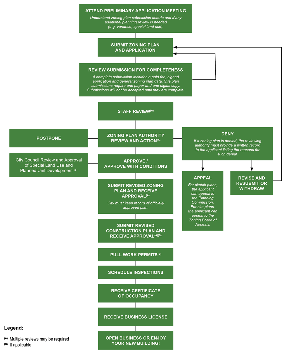
Sec. 12.06. - Zoning plan review process.

A)

Process overview. See flow chart below.

B)

Pre-application meetings. Prior to beginning any development or zoning plan process in the city, applicants are encouraged to meet with city staff for a conceptual review of the proposed project. This meeting can help promote a smooth approval process once a formal application is submitted. Please contact the planning department to schedule a meeting and discuss what to bring to the meeting and what to expect. Bring a preliminary sketch of the project to the meeting (hand-drawings are acceptable).

It is at the discretion of zoning administrator to determine if a fee must be paid to attend the pre-application meeting. If a meeting is larger in scope and requires the attention of the city engineer, then a fee must be paid, as stated in the fee schedule.

C)

Decision statement. The planning commission must state, in the record of its proceedings, the grounds for the actions taken concerning each site plan submitted for its approval and list any conditions imposed.

D)

Performance guarantee. The planning commission may require a performance guarantee to be deposited with the community development department at the time of issuance of the building permit to ensure completion of the proposed project in accordance with MCL 125.3505.

(Ord. of 11-13-2023)

Sec. 12.07. - Procedures after plan approval.

A)

Final approved plan. The applicant must submit a final approved zoning plan with the changes required by the zoning administrator and the planning commission and list any conditions as a note on the plan, before receiving a work permit or submitting construction drawings. The final plan is a requirement of the planning process, and no project can move forward without an authorized final plan. Final plans are authorized by the zoning administrator.

B)

Approval expiration. The approval of a zoning plan shall be effective for a period of 12 months from the date of such approval. Approval dates are the date the site plan was approved, either with or without conditions, by the planning commission (if it is a site plan) or by the zoning administrator (if it is an administrative sketch plan). If a building permit has been obtained, construction has commenced, and an extension is requested by the applicant during the initial 12-month approval period, and if the extension is granted pursuant to subsection C, the zoning plan approval may be extended for up to 12 months, otherwise the zoning plan shall be null and void. In such a case, the applicant shall be required to obtain a new zoning plan approval as specified in this article.

C)

Approval extensions. Administrative sketch plans shall not be granted an extension. An extension of up to 12 months for an approved planning commission site plan may be granted by the planning commission. An extension may be granted provided the approved site plan continues to adequately represent current conditions on and surrounding the site, and that the site plan conforms to the standards of the city regulations in affect at the time of the applicant's request for an extension.

D)

Site maintenance after approval.

1)

It is the responsibility of the owner of a property for which zoning plan approval has been granted to maintain the property in accordance with the approved plans, including all site design elements and improvements, on a continuing basis until the property is razed, new zoning regulations supersede the regulations upon which plan approval was based, or a new plan is approved.

2)

Any property owner who fails to maintain an approved zoning plan in full compliance with approvals granted by the city according to the provisions of these regulations, is in violation of these regulations and required to return the site conditions consistent with the approved plans or they will lose their zoning plan approval and risk the loss of their certificate of occupancy and business license.

E)

Revocation. Any approved zoning plans may be revoked by the planning commission if construction on the site is not completed or is not progressing in a manner consistent with the approved plans. In such a case, the plan will be placed on the agenda of a planning commission meeting for consideration. The city must give written notice to the applicant at least ten days prior to the meeting. The CED director, other city staff, the applicant, and other interested persons shall be allowed to present information and testimony to the planning commission. If the planning commission finds that an inconsistency or violation of the approved site plan exists at the time of the hearing, then, by a majority vote of attending members, the planning commission may revoke the approval of the plan and order the site returned to its original condition by a date certain. Failure to comply with such an order is a violation of these regulations.

F)

Modification to approved plan. A previously approved plan may be subsequently modified, subject to the review and approval requirements of this article based on the scope of the proposed modifications. It is up to the zoning administrator to decide if a revised zoning plan must receive administrative or planning commission approval.

(Ord. of 11-13-2023; Ord. No. 24-1238, 6-4-2024)