
Enoch City Zoning Code
12.2400 SUBDIVISION
APPLICATIONS
12.2400.2401 PURPOSE OF ORDINANCE
The purpose of this Chapter is to comply with Utah Code (notably §10-9a-6), establish an efficient method for reviewing subdivision applications, and promote the health and general welfare of the City’s current and future residents.
12.2400.2402 SCOPE AND PROHIBITIONS
- This Chapter applies to all applications or petitions to subdivide land in the City, regardless of the intended use (commercial, residential, etc.). The requirements of this Chapter do not apply retroactively to subdivision applications or petitions that were approved by the City prior to the enactment of this ordinance.
- No land shall be subdivided which is located wholly or in part in Enoch, Utah, except in compliance with this Chapter and according to Utah State Code as adopted and amended.
- Subdividing Land. It shall be unlawful for any person to subdivide for the purpose of transferring, selling, conveying or assigning any tract or parcel of land which is located wholly or in part in the municipality, except in compliance with this Ordinance.
- Subdivisions. It shall be unlawful for any person to sell or exchange any parcel of land which is a part of a subdivision of land or recorded in the office of the County Recorder as a subdivision unless the subdivision has been approved by the municipality and meets the provisions of this Ordinance.
12.2400.2403 INTERPRETATION AND CONFLICT OF LAWS
Where any provision in this Subdivision Chapter conflicts with state law, state law shall prevail. Where any provision in this Subdivision Chapter conflicts with other ordinances enacted by the City, the provisions in this Subdivision Chapter shall prevail unless the City intended such conflicting ordinances not in this Chapter to amend this Chapter.
12.2400.2404 DEFINITIONS
The following definitions shall be used in the interpretation of this Chapter and chapters 12.2500, 12.2600, 12.2700, 12.2800, and 12.2900. All definitions included in the Enoch Zoning Ordinance (Title 12) shall also apply to this Chapter where and when needed.
- Available Sewer. An existing sewer into which domestic sewage from a proposed subdivision can drain by gravity.
- City Engineer. A designated Engineer or authorized representative employed by or officially representing Enoch, Utah.
- Collector Street. A street, existing or proposed, of considerable continuity which serves or is intended to serve as the principal traffic-way between large and separated areas or districts and which is the main means of access to a major street system.
- Commission’s Authorized Representative. Any City employee or official who has been designated by the Planning Commission and approved by the Local Governing Body to represent the City in enforcing or carrying out the functions of the Planning Commission as set forth in this Ordinance.
- Completion Assurance. Improvement completion assurance means an irrevocable letter of credit, escrow bond, cash bond, or combination bond posted by a developer to guarantee the proper completion of required improvements.
- Easement. A quantity of land set aside or over which a liberty, privilege or advantage in land without profit, existing distinct from the ownership of land, is granted to the public or some particular person or part of the public.
- Engineer. The engineer or surveyor engaged by the subdivider/developer to prepare a final plat or to compile such data as may be required in connection therewith in accordance with the provisions of this Ordinance.
- Improvement Plan. a plan to complete permanent infrastructure on the subdivision that is essential for the public health and safety or that is required for human occupation and that an applicant must install in accordance with public installation and inspection specifications for public improvements and as a condition of recording a subdivision plat.
- Intervening Property. Property located between the existing city utilities and public service facilities, and the property under development.
- Land Use Application. An application required by the City and submitted by a land use applicant to obtain a land use approval; this does not mean an application to enact, amend, or repeal a land use regulation.
- Land Use Authority. An individual, board, or commission appointed or employed by a municipality to make land use decisions.
- Major Street. A street, existing or proposed which serves or is intended to serve as a major traffic-way and is so designated on the Circulation Map in the General Plan.
- Metes & Bounds. The description of a lot or parcel of land by courses and distances.
- Minor Street. A street, existing or proposed, which is supplementary to a collector street and of limited continuity which serves or is intended to serve the local needs of a neighborhood.
- Minor Subdivision. A subdivision (actual or proposed) that (A) contains 4 or fewer lots and (B) is not traversed by the mapped lines of a proposed road.
- On-Site Facilities. Facilities installed in, under, or upon the public streets, or rights-of-way within or on the perimeter of the subdivision or development site.
- Off-Site Facilities. Facilities designed or located so as to serve other property outside the boundaries of the subdivision.
- Oversize Facility. Facilities with added capacity designed to serve other property outside the boundaries of the subdivision or development site.
- Plat. An instrument subdividing property into lots as depicted on a map or other graphic representation of land that a licensed professional land surveyor makes and prepares in accordance with §10-9a-603 or §57-8-13 of Utah State Code (as amended).
- Review Period. The total time a preliminary or final subdivision application is in the process of City review and applicant revision, including all review cycles.
- Subdivider/Developer. Any individual, firm, association, syndicate, co-partnership, corporation, trust, or other legal entity that creates or develops a subdivision for himself or for another.
- Subdivision. Any land that is divided, subdivided, or proposed to be divided into two or more lots or other division of land for the purpose, whether immediate or future, for offer, sale, lease, or development either on the installment plan or upon any and all other plans, terms, and conditions.
- Subdivision includes:
- The division or development of land, whether by deed, metes and bounds description, devise and testacy, map, plat, or other recorded instrument, regardless of whether the division includes all or a portion of a parcel or lot; and
- Except as provided below, divisions of land for residential and nonresidential uses, including land used or to be used for commercial, agricultural, and industrial purposes.
- Subdivision does not include:
- A bona fide division or partition of agricultural land for the purpose of joining one of the resulting separate parcels to a contiguous parcel of unsubdivided agricultural land, if neither the resulting combined parcel nor the parcel remaining from the division or partition violates an applicable land use ordinance;
- A boundary line agreement recorded with the County Recorder’s Office between owners of adjoining parcels adjusting the mutual boundary in accordance with §10-9a-524 of Utah State Code (as amended) if no new parcel is created;
- A recorded document, executed by the owner of record revising the legal descriptions of multiple parcels into one legal description encompassing all such parcels or joining a lot to parcel;
- A boundary line agreement between owners of adjoining subdivided properties adjusting the mutual lot line boundary in accordance with §10-9a-524 and §10-9a-608 of Utah State Code (as amended) if no new dwelling lot or housing unit will result from the adjustment and the adjustment will not violate any applicable land use ordinance;
- A bona fide division of land by deed or other instrument if the deed or other instrument states in writing that the division is in anticipation of future land use approvals on the parcel or parcels does not confer any land use approvals, and has not been approved by the land use authority;
- A parcel boundary adjustment;
- A lot line adjustment;
- A joining of one or more lots to a parcel;
- A road, street, or highway dedication plat;
- A deed or easement for a road, street, or highway purpose; or
- Any other division of land authorized by law.
- Subdivider/Developer’s Authorized Representative. Any person who has been designated by the subdivider/developer in writing, which designation has been filed with the Commission as the authorized person to represent the subdivider/developer.
- Zoning Ordinance. The Zoning Ordinance (Title 12) of Enoch City, Utah.
12.2400.2405 SUBDIVISION LAND USE AUTHORITY
- The Land Use Authority for both preliminary and final applications under this Chapter is the City Engineer. For purposes of subdivision applications, the City Engineer shall be responsible for the following, but may delegate any responsibility to the City Manager:
- Rendering land use decisions related to applications under this Chapter.
- Reviewing all applications under this Chapter in an impartial manner and according to the standards and deadlines described in this Chapter.
- Holding a public hearing for preliminary applications when required by this Chapter.
- Providing feedback to applicants on their applications in the manner required by this Chapter.
- Scheduling and holding a pre-application meeting with potential applicants as required by this Chapter.
- Keeping subdivision application forms (both preliminary and final) and related informational material up to date and publicly accessible and distributing such forms and materials to potential applicants.
- Providing notice to entities and parties as required by this Chapter.
- Signing final application approvals as required by this Chapter.
- Ensuring that documents are properly recorded with the County as required by this Chapter.
- As subdivision application decisions are administrative, not legislative, the Land Use Authority is authorized to make any land use decision described by this Chapter without City Council approval.
- Except when operating as the Appeal Authority, the City Council shall not require the Land Use Authority to approve or deny an application under this Chapter.
12.2400.2406 SUBDIVISION APPEAL AUTHORITY
- The Appeal Authority for City decisions relating to this Chapter, except where otherwise noted, is the City Council.
- The Appeal Authority shall hear appeals on final decisions made by the Land Use Authorities and shall hear complaints about the conduct of the Land Use Authorities in administering the provisions of this Chapter.
- A party appealing or complaining of a Land Use Authority’s decision under this Chapter must exhaust its remedies under this section (by appealing or complaining to the Appeal Authority) before bringing an action against the City in a court of law.
- A party who has submitted a subdivision application or petition may appeal or complain to the Appeal Authority under this Chapter. In such an appeal or complaint, the party may appeal or complain only regarding the Land Use Authority’s treatment of that party’s own application; a third party may not appeal or complain of Land Use Authority decisions or conduct.
- A party desiring to appeal or complain of a Land Use Authority decision shall submit to the Appeal Authority the following in writing:
- A brief explanation of the relief the party is seeking, the reason the party submitted its application or petition, the Land Use Authority’s decision and treatment of the application or petition, and why the applicant believes the Land Use Authority misapplied the provisions of this Chapter or abused the discretion given it by this Chapter.
- The most recent version of the application or petition the party submitted.
- Any supplemental documentation or information that the Appeal Authority requests.
- All appeals and complaints must be emailed or mailed to the City Recorder using the Recorder’s official City address and/or email account listed on the City website.
- After receiving a complete appeal or complaint in accordance with this Section, the Appeal Authority shall deliver a decision to the applicant, in writing, no later than 30 calendar days after the Appeal Authority receives the appeal or complaint.
12.2400.2407 APPLICATION PROCESS AND REQUIREMENTS
- The City shall not approve, nor shall a party record, any plat or other creating instrument for a new subdivision under this Chapter unless the party has properly applied under this Chapter and received both a preliminary approval and a final approval from the respective Land Use Authorities.
- To considered complete, a preliminary subdivision application must include at least the following elements:
- An approved land use application that describes how the property will be used after it is subdivided.
- If the intended use is permitted by right under City ordinances, the land use application must include citations to the specific ordinance(s) that the applicant believes authorizes the intended use.
- If the intended use requires a conditional use permit or is otherwise conditioned on City approval, the land use application must include an approved, City-issued permit authorizing the intended use. Should an applicant seek a use permit concurrently with a related subdivision application, the subdivision application shall be considered incomplete until the use permit is issued.
- If the intended use is prohibited under City ordinances and requires a variance, the land use application must include an approved, City-issued variance authorizing the intended use. Should an applicant seek a variance concurrently with a related subdivision application, the subdivision application shall be considered incomplete until the variance is issued.
- A plat. The plat must be drawn to scale, in detail, and in accordance with generally accepted surveying standards and the acceptable filing standards of the County Recorder’s Office. The plat must include:
a. The proposed name and general location of the subdivision, in bold letters at the top of the plat. The proposed subdivision name must be distinct from any subdivision name on a plat recorded in the County Recorder's Office.
b. The boundaries, course, numbering, and dimensions of all proposed parcels. All lots should be consecutively numbered.
c. The lot or unit reference; block or building reference; street or site address; street name or coordinate address; acreage or square footage for all parcels, units, or lots; and length and width of the blocks and lots intended for sale.
d. The parcel numbers of all adjoining property owners of record, or the names of adjoining developments and the names of adjoining streets.
e. The address and phone number of the land surveyor and/or engineer who prepared the plat.
f. Sufficient data acceptable to the City Engineer to readily determine the location, bearing and length of all lines on the plat, and to reproduce such lines upon the ground, and the location of all proposed monuments, including contours at appropriate intervals.
g. Whether any parcel is intended to be used as a street or for any other public use.
h. The names, numbers, widths, lengths, bearings, and curve data on centerlines for all proposed streets, alleys, and easements (if applicable). All proposed streets shall be numbered and named in accordance with the City’s adopted addressing system.
i. The location of existing streets, easements, water bodies, streams, and other pertinent features such as wetlands, buildings, parks, cemeteries, drainage ditches, irrigation ditches, fences, and bridges.
j. The location and width of existing and proposed streets, curbs, gutters, sidewalks, easements, alleys, other public ways and easements and proposed street rights-of-way and building setback lines.
k. Every existing right-of-way and recorded easement located within the plat for underground, water, and utility facilities.
l. Any known and unrecorded water conveyance facility located, entirely or partially, within the plat, including sanitary sewers, storm drainage facilities, fire hydrants, and pumping stations.
m. Location and size of all proposed water, secondary water, sanitary sewer, storm sewer, irrigation or drainage ditch piping or other subsurface improvements, including detailed provisions for collecting and discharging surface water drainage.
n. Whether any parcel is reserved or proposed for dedication for a public purpose.
o. The location and dimensions of all property proposed to be set aside for park or playground use, or other public or private reservation, with designation of the purpose thereof and conditions, if any, of the dedication or reservation.
- A stormwater drainage plan provided in accordance with City Engineering Standards and Enoch City storm drain system master plans.
- A water modeling analysis using Enoch City’s Water model covering the primary and secondary water needs and likely impact of the intended subdivision use on the City and surrounding area.
- Wastewater modeling analysis using Enoch City’s Wastewater model covering the wastewater needs and likely impact of the intended subdivision use on the City and surrounding area.
- A soils report from a qualified soils engineer identifying the types of soils within the proposed subdivision area and identifying any soils constraints on the proposed subdivision.
- A traffic study, if one is required by an applicable UDOT Access Management Plan or if the Land Use Authority informs the potential applicant during or after a pre-application meeting (but before the applicant applies) that one is required.
- An improvement plan, created in accordance with applicable portions of chapters 12.2500 and 12.2700 of this Title, for all public improvements proposed by the applicant or required by City ordinances.
- In addition to the requirements in chapters 12.2500 and 12.2700, the improvement plan must contain an engineer’s estimate of the cost of completing the required improvements.
- Certifications, including:
a. An affidavit from the applicant certifying that the submitted information is true and accurate.
b. The signature of each owner of record of land described on the plat, signifying their dedication and approval of the plat.
c. Certification that the surveyor who prepared the plat:
- Holds a license in accordance with Utah Code 58-22; and
- Either
- Has completed a survey of the property described on the plat in accordance with state requirements and has verified all measurements; or
- Has referenced a record of survey map of the existing property boundaries shown on the plat and verified the locations of the boundaries; and
- Has placed monuments as represented on the plat.
- Three 11”x17” printed copies of the preliminary plat.
a. An electronic copy of all plans in PDF format.
b. Payment of any application-processing fees required by the City.
- To be considered complete, a final subdivision application must include all the same elements as the preliminary application—except for the improvement plan—, plus the following:
- Land Use Authority approval of the applicant’s preliminary application.
- A completion assurance for public improvements, or a statement that all public improvements will be completed before development occurs on the proposed subdivision and before the applicant records the plat, as required by chapter 12.2600 of this Title.
- Payment of a Water Acquisition Fee or binding documents enacting a Water Right Transfer as described in 12.2400.2413 and 14.100.113.
- A Preliminary Title Report or Title Insurance Policy for the land to be subdivided verifying property ownership.
- As applicable, formal, irrevocable offers for dedication to the public of streets, City uses, utilities, parks, easements, or other spaces.
- If the plat is to be part of a community association, signed and binding documents conveying to the association all common areas.
- Copies, including:
- Two paper copies (24” x 36”) of the final plat;
- One electronic copy of the final plat in AutoCAD format (DWG or DXF), Geodatabase format (GDB), or Shapefile format (SHP), with a projection assigned to the file(s) and with the proper metadata that describes what coordinate system/projection the data is assigned to; and,
- Electronic final plats submitted in AutoCAD, Geodatabase, or Shapefile format shall include dedicated data layers representing tracer wire. These layers shall identify wire routing and connection points linked to corresponding utility features; and,
- A PDF document of the final plat and all other plans and supporting documents required by this Chapter.
- The Land Use Authority shall produce, maintain, and make available to the public a list of the specific items that comprise complete preliminary and final applications and a breakdown of any fees due upon submission or approval of the applications.
- The Land Use Authority may require, and the applicant shall provide, additional information beyond the requirements of this Section or those published by the Land Use Authority relating to an applicant’s plans to ensure compliance with municipal ordinances and approved standards and specifications for construction of public improvements.
12.2400.2408 PRE-APPLICATION MEETING
- A party intending to submit a subdivision application under this Chapter may request a pre-application meeting with the Land Use Authority for the purpose of reviewing any element of the party’s proposed subdivision application (preliminary or final). The proposed application need not be complete for purposes of this meeting and may—if the party desires—be limited to a concept plan.
- If a party requests a pre-application meeting, the Land Use Authority shall schedule the meeting within 15 business days after the request. The meeting shall be scheduled at the earliest convenient opportunity, and, at the option of the party requesting the meeting, shall occur within 20 business days after scheduling.
- The Land Use Authority (or a member of the body that makes up the Land Use Authority) shall conduct the meeting, provide feedback on materials as requested by the party, and shall provide or have available on the municipal website the following at the time of the meeting:
- Copies of applicable land use regulations,
- A complete list of standards required for the project, and
- Relevant application checklists.
12.2400.2409 NOTICE TO AFFECTED ENTITIES
- Within 15 calendar days after receiving a complete subdivision application under this Chapter, the City Manager or designee shall provide written notice of the proposed subdivision to the facility owner of any known water conveyance facility located, entirely or partially, within 100 feet of the subdivision plat.
- To determine whether any water conveyance facility is located within 100 feet of a proposed subdivision, the City Manager or designee shall review information:
- From the facility owner under Utah Code §10-9a-211, using mapping-grade global positioning satellite units or digitized data from the most recent aerial photo available to the facility owner;
- From the state engineer's inventory of canals; or
- From a licensed surveyor who has consulted with a representative of an existing water conveyance facility that services an area near the land the application concerns.
- To give water conveyance facilities time to provide feedback on subdivision applications, the Land Use Authority shall not approve a preliminary (or related final) subdivision application under this Chapter sooner than 20 calendar days after the applicant submits a complete application. This waiting period does not apply to revised applications the applicant may submit during the application review process.
- A water conveyance facility owner’s failure to provide comments to the Land Use Authority about a subdivision application does not affect or impair the Land Use Authority’s authority to approve the subdivision application.
12.2400.2410 REVIEW
- The respective Land Use Authorities shall review all subdivision applications in accordance with the requirements of this Section before approving or denying those applications.
- For both preliminary and final applications, the review process begins when an applicant submits a complete application.
- The Land Use Authority shall not review an incomplete subdivision application, except to determine whether the application is complete.
- If the Land Use Authority determines that an application is incomplete, it shall notify the applicant of the incompleteness, highlighting any insufficiencies and explaining that the application will not be reviewed until completed.
- For both preliminary and final applications, after the applicant submits a complete application, the Land Use Authority shall review and provide feedback to the applicant in a series of “review cycles.”
- A review cycle consists of the following phases:
- Phase #1: The applicant submits a complete application (or, if after the first cycle, submits a revised version of the complete application).
- Phase #2: The Land Use Authority reviews the application in detail and assesses whether the application conforms to local ordinances.
- Phase #3: The Land Use Authority responds to the applicant, citing any missing requirements or areas of noncompliance and providing a detailed list of necessary revisions to the applicant. For any required modification or addition to the application or request for more information, the Land Use Authority shall be specific and include citations to ordinances, standards, or specifications that require the modification and shall provide the applicant with an index of all requested modifications or additions.
- Phase #4: The applicant revises the application, addressing each comment or requirement the Land Use Authority made. The applicant must submit both revised plans and a written explanation in response to the municipality’s review comments, identifying and explaining the applicant’s revisions and reasons for declining to make revisions, if any. This written explanation shall be comprehensive and specific, including citations to applicable standards and ordinances and an index of requested revisions or additions for each required correction. If the applicant fails to respond to a comment made by the Land Use Authority in its review, the review cycle is not complete and will remain open until the applicant addresses all comments.
Table A – Review Cycles, Hearings, and Timelines by Subdivision Use Type
Use Type
Approval Stage
Max Review Phases
City Turnaround Deadline*
All Uses
Preliminary
4
15 Business Days
All Uses
Final
2
20 Business Days
*Describes the total time (per review cycle) the City may take to complete the review phases.
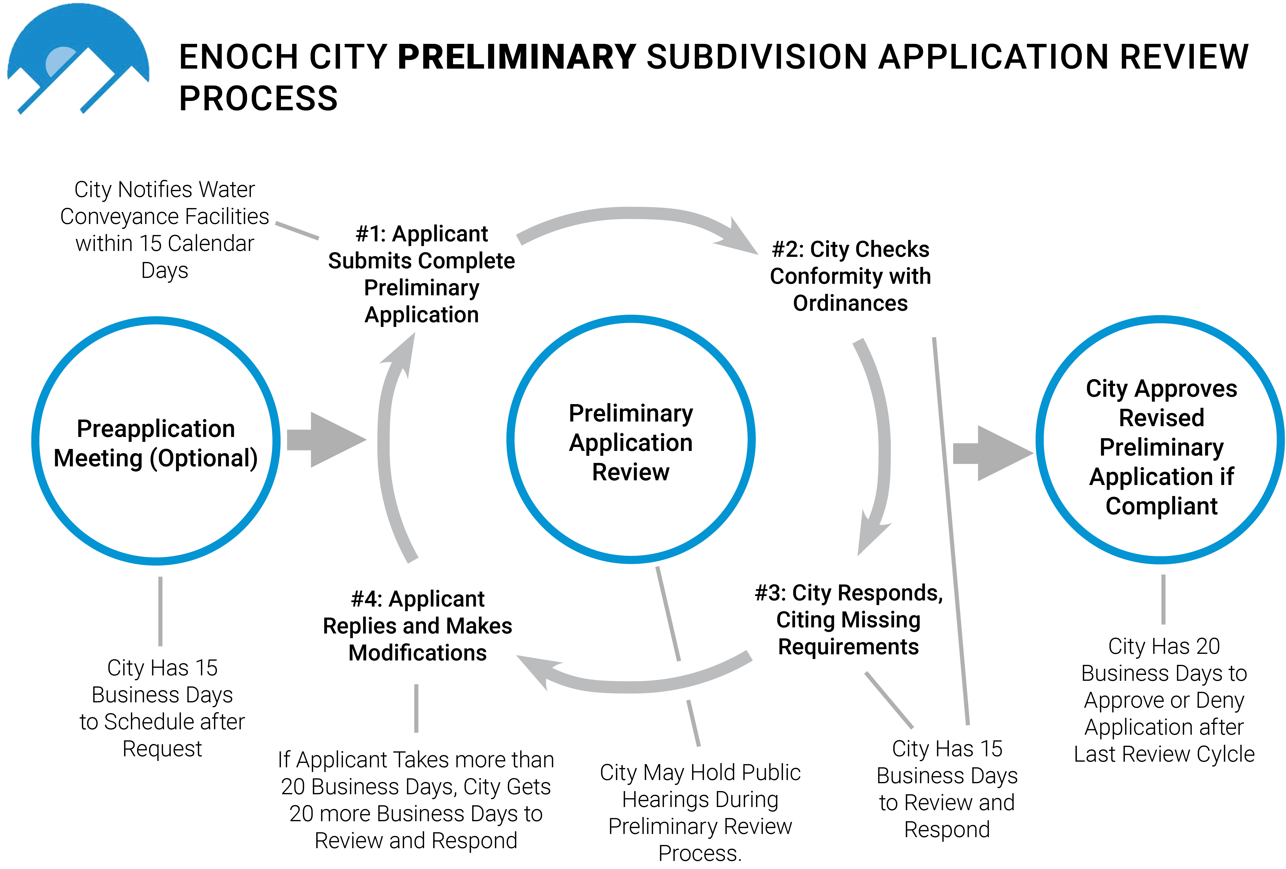
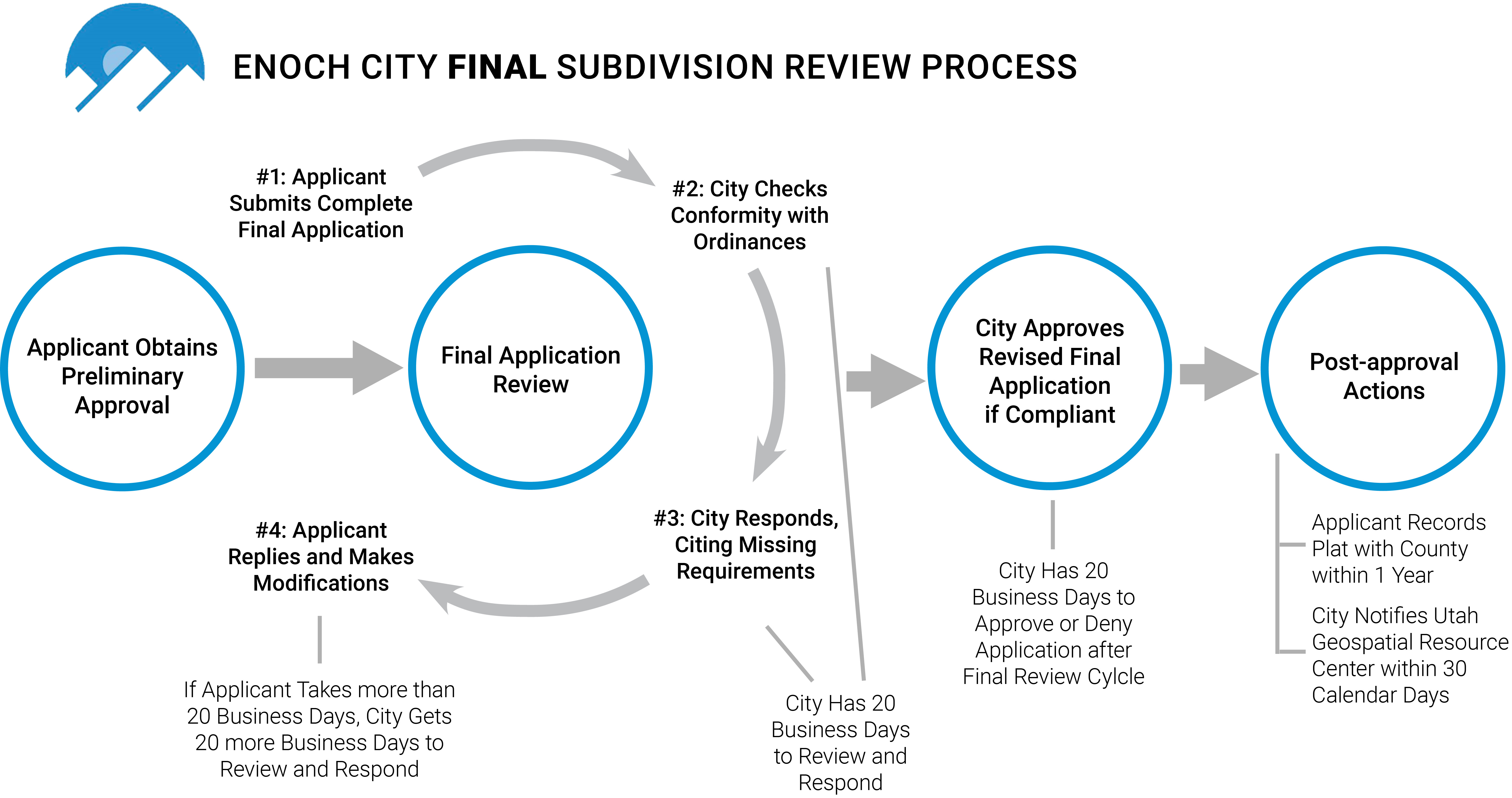
- A Land Use Authority (and other City representatives or agents) shall adhere to the maximum number of review cycles and the review deadlines described in Table A, except as described below. If no further revisions are needed, a Land Use Authority may end a review period early and approve or deny the preliminary or final application.
- If the applicant makes a material change to a preliminary or final application not requested by the municipality at any point in the review process, the Land Use Authority may restart the review process, but only with respect to the portion of the application that the material change substantively affects.
- If an applicant does not submit a revised application (beginning Phase #1 of the next review cycle or triggering a Land Use Authority decision) within 20 business days after the municipality requires a modification or correction (in Phase #3 of the past review cycle), the municipality shall have an additional 20 business days to review and respond to the application (completing Phases #2 and #3 of the next review cycle).
- This provision notwithstanding, any subdivision application affecting property within identified geological hazard areas is exempt from review cycle restrictions and requirements.
- When a preliminary or final application’s review period ends, the Land Use Authority shall approve or deny the respective preliminary or final application within 20 business days.
- If the Land Use Authority has not approved or denied the application within 20 business days after the allotted review cycles are complete, the applicant may request a decision. After such a request, the municipality shall, within 10 business days:
- For a dispute arising from the subdivision improvement plans, assemble an appeal panel in accordance with Utah Code §10-9a-508(5)(d) to review and approve or deny the revised set of plans; or
- For a dispute arising from the subdivision ordinance review, advise the applicant, in writing, of the deficiency in the application and of the right to appeal the determination to the designated Appeal Authority.
- After the Land Use Authority provides comments in the last allotted review cycle for a final application, the municipality shall not require further modifications or corrections to the application unless those modifications or corrections are needed to protect public health and safety or to enforce state or federal law or unless the review cycle reset due to the applicant making a material change that the Land Use Authority did not request.
- With the exception of modifications or corrections that are needed to protect public health and safety, that are needed to enforce state or federal law, or that arise from the review cycle being reset, the municipality waives noncompliant subdivision-related requirements that the Land Use Authority does not identify during the review process.
- The applicant shall make reasonable changes, unless prohibited otherwise by a contract or deed, to the subdivision application to accommodate the water conveyance facility to the extent required by Utah Code §73-1-15.5.
- The municipality may conduct one or more public hearings (up to the number described in Table A) during the review period for a preliminary subdivision application.
- The purpose of these public hearings is to ask questions of the applicant and receive commentary on the technical aspects of the application from affected entities, interested parties, and the public.
- If the municipality elects to hold a public hearing, the hearing must occur before the end of the Land Use Authority’s review period (end of Phase #3 of the last preliminary review cycle). Scheduling issues shall not extend the review and approval deadlines in this Chapter.
- The municipality shall not hold a public hearing during the review period for a final application under this Chapter.
- Other chapters of this Title notwithstanding, the Land Use Authority shall approve or deny preliminary and final applications under this Chapter after reviewing the complete applications as described in this Section.
12.2400.2411 APPROVAL
- The Land Use Authorities shall approve any complete preliminary and final applications made under this Chapter that comply with applicable municipal ordinances.
- The Land Use Authority shall issue all approvals in writing and shall certify the approved final plat, either by signing the plat directly or by attaching a signed certification to the plat.
12.2400.2412 POST-APPROVAL ACTIONS
- The applicant shall record the approved final plat with the County Recorder’s Office within 365 calendar days after the municipality approves the final application, provided that the applicant has completed any improvements or posted any performance guarantee required by City ordinances or described in the improvement plan the applicant submitted. The applicant shall not record the approved final plat until such improvements are completed or guaranteed in compliance with City ordinances and the applicant’s improvement plan.
- An approved final plat not properly recorded within the timeline specified in 12.2400.2412.A is void, unless the City Council approves an extension.
- The Land Use Authority shall submit to the Utah Geospatial Resource Center (so the subdivision can be included in the 911 database), within 30 calendar days after approving a final application, either:
- An electronic copy of the approved final plat; or
- Preliminary geospatial data that depict any new streets and situs addresses proposed for construction within the bounds of the approved final plat.
- The Land Use Authority shall, if requested by the Utah Geospatial Resource Center:
- Coordinate with the Utah Geospatial Resource Center to validate the information the municipality submitted about the final plat; and
- Assist the Utah Geospatial Resource Center in creating electronic files that contain the information described in the final plat for inclusion in the unified statewide 911 emergency service database.
12.2400.2413 WATER RIGHTS
Enoch City Water Connection Policy
Enoch City has limited water rights. Enoch City provides culinary and irrigation water for residential, commercial, and industrial uses consistent with City ordinance. There are limited water rights in the Cedar City area, and these resources are shared by Enoch City, Cedar City, the Central Iron County Water Conservancy District, agriculture, private owners, and private water corporations.
Enoch City is experiencing sustained residential, commercial, and industrial growth, and growth necessitates acquisition of additional water rights.
The State of Utah Water Engineer has determined that the water rights in the Cedar Valley Aquifer have been fully appropriated and has closed the basin to future appropriation of water rights.
The State Engineer has studied the aquifer and determined the estimated safe yield for the groundwater basin is 21,000 acre-feet per year. The estimated current average depletion from the groundwater basin is 28,000 acre-feet per year. The average actual depletion must be reduced by 7,000 acre-feet per year to balance recharge and depletion amounts in this groundwater basin. To accomplish this goal, the State Engineer has instituted a Groundwater Management Plan (GMP).
A. Purpose
Any person who desires or is required to secure a new connection to the municipal water system shall file a written and signed connection application provided by Enoch City staff with the Water Department.
All property that has not previously deeded water rights shall be required to deed water rights either at the time the property subdivides or when the property applies for a building permit. For residential property, water rights shall be deeded at the time of subdivision. If a residential property has previously been subdivided and no water rights have been provided, then water rights shall be deeded upon the application for a building permit. For commercial or industrial property, water rights shall be deeded upon the application for a building permit.
Nothing in this ordinance shall require deeding of water rights when a building permit is pulled for repair, remodel, or expansion of a building that has already been granted a building permit, whether before or after the effective date of this ordinance.
This ordinance is intended to acquire water rights one time only. Nothing herein shall be construed to require a property that has previously complied with this ordinance to deed additional water rights.
B. Amount of Water Required
For property located in single-family housing zone designations, and for single-family dwellings located in any other zones, each unit shall be assessed:
· 0.88 acre-feet of Agricultural water, or
· 0.50 acre-feet of Municipal & Industrial (M&I) water.
For commercial and industrial properties, the water right requirement will be calculated based on the size of the water meter required to serve the proposed use on the property. If the water meter size is augmented solely for fire suppression purposes, then the water right will be calculated based on the size of the meter that would be required absent fire suppression needs.
Properties with Both Culinary & Secondary Water. Applicants seeking to approve properties, with a single-family unit, and with both Culinary and Secondary water meters are subject to the following:
· The Water Acquisition Fee & Water Right for a new water connection on such properties shall be equal to the value of a full acre foot, on such a property shall be as follows: .3 AF of Enoch City Water Right, corresponding to the culinary water, which are not transferable and shall remain with the property, and .7 AF of Enoch City Water Right, corresponding to the Secondary Water, which are not transferable and shall remain with the property.
· The Conservation Tier Schedule for such properties shall be permanently assigned as follows: The .3 AF of Culinary water shall be set at the Conservation Tier of “CUL,” and subject to the corresponding “CUL” water rates. The Secondary water shall be set at the Conservation Tier of “SEC,” and shall be subject to the corresponding SEC water rates. Properties in Enoch City with both a Culinary water meter and a Secondary water meter, will receive an Enoch City water bill separately designating the rates for each water meter.
C. Water Right Deed
Applicants may satisfy the City’s water dedication requirement by deeding one of the following:
· Priority Water Right:
A water right with a priority date on or before July 25, 1934.
· Priority Water Right:
A water right with a priority date after July 25, 1934, only if:
It has at least 10 years remaining before curtailment under the State Engineer’s Groundwater Management Plan for the Cedar City Valley Aquifer.
Water Acquisition Fee (Cash Payment Requirement for Non-Priority Rights)
- For deeds involving Non-Priority Water Rights, a Water Acquisition Fee must be paid based on the appraised value of a one-acre-foot Priority Water Right (north of Highway 56, prefix 73, priority before July 25, 1934).
- The fee is calculated at 1% of the Priority Water Right’s appraised value for each full year remaining before curtailment under the State Engineer’s Plan. (See “Water Rights Acquisition Fee Chart 2022” below)
Appraised values are updated by the City Council as needed, typically every six months.
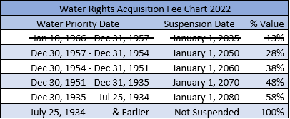
Note: Water rights that are expected to be curtailed within 10 years of the deed date will not be accepted.
Applicants must also provide:
· Proof of recent beneficial use
· Proof of ownership through a complete chain of title
· Payment of all costs associated with deeding and deeding the water right
· Water rights must originate from the Cedar City Valley Drainage north of Highway 56 (water right prefix 73)
D. Process to Deed Water Rights
1. The Applicant shall submit a title report showing:
o Type of water right
o Ownership of the right
o Any liens or encumbrances
2. The Applicant shall provide a title insurance policy in an amount adequate to cover the appraised value of the water rights.
3. A deed and Deed Addendum conveying ownership of the water rights to Enoch City shall be completed and recorded by the City before approval of a building permit application.
4. If the water right is supplemental, recharge/recovery, or otherwise not a primary underground well source, the Applicant must obtain an approved change application from the State Engineer prior to subdivision or building permit approval, defining:
o Sole supply
o Established diversion and depletion limitations
E. Exemptions. The following are exempt from the Water Acquisition Fee.
- Open space exemptions. If at the time of final plat approval, or pulling of a building permit, land is deeded to Enoch City as a dedicated street or for undeveloped open space, parks and recreation, or placed in a conservation easement that complies with the provisions of Title 57, Chapter 18, Sections 1 through 7, Utah Code Annotated, 1953 as amended, then that acreage is not subject to the requirements of this ordinance that mandate the deeding of water rights or payment of fees. Additionally, if land in a subdivision is to be held as common area and is undeveloped and/or unirrigated, then that land is not subject to the requirements of this ordinance that mandate the payment of Water Acquisition Fees.
- Public lands exemption. If at the time of annexation, the annexed property is owned by the Bureau of Land Management or the U.S. Forest Service then that acreage is not subject to the requirements of this ordinance that mandate the deeding of water rights. This exception only applies to annexation and not when the property is platted as a residential subdivision or receives a building permit.
- City Exemption. Enoch City is not required to deed water or pay a fee if the City develops land. A purchaser of property from the City will have to pay the Water Acquisition Fee to the City consistent with this ordinance.
F. Water Acquisition Fee Schedule and Tier System. An Applicant seeking approval of a single-family lot development must first designate a Conservation Tier and pay the corresponding Water Acquisition Fee with 88/1000 (.88) AF of Agriculture water right or 50/100 (.50) AF of Municipal & Industrial water right for each single-family lot. The selected Conservation Tier will establish the lot owner’s expected water use, and the corresponding Water Acquisition Fee, and the resulting water rates.
- The Water Acquisition Fee Schedule indicates the Water Acquisition Fee for each Conservation Tier that could be selected, as a percentage of a full, one-acre-foot, Priority Water Right, and the corresponding water use.
- The Conservation Tier Schedule indicates the lot owner’s expected water use and resulting water rate. Enoch City will, from time to time, change such water rates and penalties for each Tier.
- Properties with Both Culinary & Secondary Water. Applicants seeking to approve properties with a single-family unit and with both Culinary and Secondary water meters are subject to the following. The Water Acquisition Fee for a new water connection on such properties shall be equal to the value of a full, one acre, Priority Water Right. However, the Enoch City Water Rights assigned to such a property shall be as follows: 30% of the AF of Enoch City Water Right, corresponding to the culinary water, which are not transferable and shall remain with the property, and 70% of the AF of Enoch City Water Right, corresponding to the Secondary Water, which are not transferable and shall remain with the property. The Conservation Tier Schedule for such properties shall be permanently assigned as follows: The 30% AF of Culinary water shall be set at the Conservation Tier of “CUL,” and subject to the corresponding “CUL” water rates. The Secondary water shall be set at the Conservation Tier of “SEC,” and shall be subject to the corresponding SEC water rates. Properties in Enoch City with both a Culinary water meter and a Secondary water meter, will receive an Enoch City water bill separately designating the rates for each water meter.
G. Multi-Residential Developments. Applicants seeking approval of a Multi-Residential Development must provide an engineered Annual Water Estimate, illustrating the total annual, acre-feet of water estimated to be used by the Development (“Annual Water Estimate”), to be reviewed and approved by Enoch City. The initial Water Acquisition Fee and Water Right and the subsequent water rate will be calculated based on this determination. For purposes of this Annual Water Estimate, the number of Multi-Residential Units should be multiplied by .3 acre-feet of water, and each sq/ft of proposed grass should be divided by 10,057, to derive the Development’s Annual Water Estimate, in terms of Acre Feet (i.e.: a twenty-unit subdivision (20 units x .3 = 6AF) with 10,000 square feet of grass (10,000 sq/ft grass / 10,057 = .994AF) would have a 6.994AF Annual Water Estimate). The Water Acquisition Fee and Water Right will be determined by multiplying the Annual Water Estimate by the priority Water Right Value (i.e.: a Development with a 6.994AF Annual Water Estimate will pay 6.995 multiplied by the Conservation MFD Tier, which is 100% of the appraisal Priority Water Right). The Development would subsequently pay for water at a rate of 6.994AF multiplied by the Tier 1 Rate (i.e. a MRD that is estimated to use 6.994AF of water annually will pay 6.994 times the Tier 1 Rate).
- The Water Rights assigned to a Multi-Family Development will be assigned under the “MFD” Conservation Tier. These Water Rights are not transferable and must remain assigned to the Development. If any Multi-Family Development is ever found to use more water or have more square footage of grass than the Annual Water Estimate, that property will be required to pay an additional Water Acquisition Fee to address the extra water used.
H. Commercial, Industrial, and Manufacturing Developments. Applicants seeking approval for commercial, industrial, or manufacturing developments must provide an engineered Annual Water Estimate, illustrating the total, annual, acre feet of water estimated to be used for each lot, to be reviewed and approved by Enoch City. The initial Water Acquisition Fee with Water Right and the subsequent water rate will be calculated based on this determination. For purposes of this Annual Water Estimate, the engineer must determine the various uses and estimate the amount of water to be used for the property, including the proposed square footage of grass, which should be divided by 10,057, to derive the total annual, number of acre feet of water used for grass areas. The Water Acquisition Fee and Water Right will be determined by multiplying the Annual Water Estimate by the appraised Priority Water Right. The subsequent water rate will likewise be determined by multiplying the Annual Water Estimate by the Tier 1 Rate. The Water Rights assigned to a Commercial, Industrial, or Manufacturing lot will be assigned under the “Com” Conservation Tier. These Water Units are not transferable and must remain assigned to the property. If any Commercial, Industrial, or Manufacturing property is ever found to use more water or have more square footage of grass than the Annual Water Estimate, that property will be required to pay an additional Water Acquisition Fee with Water Right(s) to address the extra water used.
I. Institutional Properties. Applicants seeking approval of Institutional Developments, including schools, religious buildings, and other properties of nonprofit organizations, must present an engineered Annual Water Estimate, illustrating the total, annual acre feet of water estimated to be used for such property, to be reviewed and approved by Enoch City. The initial Water Acquisition Fee & Water Right and the subsequent water rate will be based upon this determination. For purposes of this Annual Water Estimate, the engineer must determine the various uses and estimate the amount of water to be used for the property, including the proposed square footage of grass, which should be divided by 10,057, to derive the total annual, number of acre feet of water used for grass areas. The Water Acquisition Fee & Water Right will be determined by multiplying the Annual Water Estimate by the appraised Priority Water Right. The subsequent water rate will likewise be determined by multiplying the Annual Water Estimate by the Tier 1 Rate. The Water Rights assigned to an Institutional property will be assigned under “INS” Conservation Tier. These Water Rights are not transferable and must remain assigned to the property. If any Institutional property is ever found to use more water or have more square footage of grass than the Annual Water Estimate, that property will be required to pay an additional Water Acquisition Fee with Water Right(s) to address the extra water used.
12.2400.2414 MINOR SUBDIVISION
Applications for minor subdivisions, as defined in 12.2400.2404, must comply with all provisions of this Title, except that:
- Applications for minor subdivisions are exempt from the application requirements of 12.2400.2407.B.2-12, -C.2, and -C.7 of this Chapter, provided that they include a meets-and-bounds description of the subdivision and include proof that:
- The minor subdivision is not traversed by the mapped lines of a proposed (but not yet dedicated) street as shown in the City’s General Plan;
- The minor subdivision has been approved by the culinary water authority and the sanitary sewer authority; and
- The minor subdivision is located in a zoned area and either conforms to all applicable land use ordinances or has properly received a variance.
- If the applicant for a minor subdivision notifies the City that development of the proposed subdivision is not imminent, then the applicant and current and future landowners of the subdivision shall not be required to complete public improvements or post a performance guarantee for improvements otherwise required under this Title until development begins. The landowner must complete any required public improvements, or post an appropriate performance guarantee, before making any other developments on the subdivided land.

