
Fontana City Zoning Code
ARTICLE IX
OVERLAY DISTRICTS
Sec. 30-621. - Purpose.
The purpose of this article is to create overlay districts that establish additional use regulations and development standards for specific types of use and specific areas of the City requiring special consideration in the development process. The regulations established in this article for the overlay districts shall apply in addition to the regulations established for the underlying zone districts.
Sec. 30-622. - Overlay districts.
(a)
Medical center overlay district. A district that may overlay any medical center complex.
(b)
Utility corridor overlay district. A district that is intended to provide for appropriate development within or near those areas containing easements for public utilities.
(c)
Hillside overlay district. A district that protects the public health and safety, minimizes environmental impacts, and requires development to conform to the natural topography of hillside areas.
(d)
Auto center overlay district. A district that is intended to promote new car and truck sales adjacent to the 1-210 Freeway.
(e)
Warehousing distribution/logistics overlay district (Sierra Avenue). A district that provides for the limited, well planned and orderly development of warehousing distribution/logistics uses on properties within the light industrial (M-1) zone as provided for in Section 30-532 et seq. Unlike other overlay districts in this division, this overlay identifies a geographic area where such uses may be allowed subject to a separate zone change request to establish the overlay on one or more parcels eligible to receive it.
(f)
Valley business park overlay district. The intent of the valley business park overlay is to provide for a well-planned and orderly development of business park and warehousing distribution uses on parcels within the M-1 zone located on designated areas within the adopted overlay that are generally located on the south side of Valley Boulevard.
(g)
Emergency shelter overlay district. A district that provides for seamless incorporation of emergency, supportive, and transitional housing opportunities on specific properties within the light industrial (M-1) zoning district to house individuals at risk of homelessness with such needs for no more than a six-month period, as required by Government Code § 65583(a)(4) and 65583(a)(5).
(h)
(R-4) overlay district. The intent of the R-4 overlay district is to provide areas for the potential development at the multi-family residential (R-4) density of 24.1 du/ac to 39 du/ac for multi-family development in close proximity to transit routes and convenience uses in recognition of the need for affordable housing.
(Ord. No. 1889, § 5(Exh. A), 2-22-22)
Sec. 30-623. - Medical center overlay district regulations.
The following provisions apply to projects that meet the definition of a medical center as described in Article I of this chapter. These provisions apply in addition to the provisions in the underlying zoning district. If the provisions of this division are in conflict with the provisions in the underlying zoning district, the provisions of this division shall apply.
Sec. 30-624. - Uses permitted.
Any use permitted in the underlying zoning district shall be permitted in the medical center overlay district. Additional uses, which may be allowed in the underlying zone, shall include:
(1)
Psychiatric care.
(2)
Nutrition, pregnancy, health, and drug, tobacco, and alcohol cessation classes and services.
(3)
Twenty-four-hour emergency room and ambulance drop-off.
(4)
Bi-weekly farmers market events, duration of which will be no more than five hours per event, not to exceed more than ten hours per calendar month.
(5)
Additional hospital staff events, such as health fairs, employee recognition events, etc., shall be allowed two events per calendar month, not to exceed more than ten hours per calendar month.
(6)
Weekly or permanent use of MRI, lithotriptor, or other types of large equipment, and their buildings and/or mobile transport trailers. Permanent buildings for these types of equipment to be calculated as hospital support.
(7)
Other uses not listed here that may approved at the discretion of the Director of Community Development.
Sec. 30-625. - Design review required.
Any proposal within the medical center overlay district which may or may not involve the issuance of a building permit for the construction or reconstruction of a habitable structure greater than 50,000 square feet shall be subject to the design review process and approval by the Planning Commission.
Sec. 30-626. - Development standards and design guidelines.
(a)
Floor area ratio. Floor area ratio (FAR) shall not exceed 0.75:1.
(b)
Maximum height. The building height of any structure within the medical center overlay district shall not exceed 125 feet.
(c)
Street frontage. A minimum setback of 20 feet shall be required between the front property line and the building. This area shall be landscaped with one tree for each 15 feet of street frontage and three shrubs for each tree. Clustering may be permitted on a case-by-case basis. The Director of Community Development shall have the authority to review and approve alternatives to the required landscaping requirements.
(d)
Yards abutting residential districts. A minimum ten-foot wide landscaped strip shall be provided as a buffer along all yard areas abutting a residential district. This area shall contain a minimum of one tree for each 25 linear feet of lot line and three shrubs for each tree. A combination of trees and shrubs shall provide appropriate screening as approved by the Director of Community Development on a case-by-case basis.
(e)
Landscaping of parking lots. One tree shall be provided for each five parking spaces. Trees which provide a shading canopy at maturity are preferred for parking lot use.
(f)
Landscaping for parking structures. An attractive landscaping strip shall be provided on all sides of the structure where possible. One tree shall be provided for each 15 feet of perimeter of the structure. These trees shall be distributed evenly throughout the subject landscape area subject to staff review and Director of Community Development approval. Trees shall border the parking structure and shall be of a species that will obtain a mature height. Additionally, all sides of a parking structure shall be screened by vines or other decorative screening approved by the Director of Community Development. The Director of Community Development shall have the authority to review and approve alternatives to the required landscaping requirements.
(g)
Other setback areas. Not less than one tree shall be provided for each 250 square feet of other required landscaped area on the lot. A minimum of three shrubs shall be provided for each tree. Trees and shrubs shall be provided in all remaining landscape areas in such a way to reinforce the architectural and overall design intent of the project.
(h)
Required trees and shrubs. The Director of Community Development shall have the authority to review and approve alternatives to the required landscaping requirements.
(i)
Parking area landscaping. A total of ten percent of the total interior of the off-street parking area shall be landscaped. For landscaping purposes, parking area calculations shall include aisles, access drives, stalls, maneuvering areas, and landscaping contained within the parking and circulation area and site perimeter landscaping adjacent to parking and circulation areas, but shall not be included in any street areas otherwise required by this article.
(j)
Required parking spaces.
(1)
Medical offices shall be parked at a ratio of one space per 200 square feet, plus one space per 250 square feet of floor area within the administrative office buildings.
(2)
Hospitals shall be parked at a ratio of one space per 2.5 beds plus one space per two employees on the maximum shift for the hospital building(s).
(3)
Off-street loading space(s) shall be provided as required in Article XI of this chapter. The Planning Commission may approve alternative off-street loading spaces based upon a parking utilization study and the recommendation of the Director of Community Development and Traffic Engineer.
(4)
The Planning Commission may approve alternative off-street parking spaces based upon a parking utilization study and the recommendation of the Director of Community Development.
(k)
Handicap standards. Handicapped regulations shall be determined by the Americans with Disabilities Act (ADA) and Title 24 in effect at the time of building permits.
(l)
Parking lot standards. The provisions and requirements of Table 30-692 shall apply to all parking lot standards except as provided herein for compact parking.
(m)
Compact parking spaces. Compact parking spaces shall be permitted up to a maximum of 25 percent, or a percentage as appropriate based upon a parking vehicle study, as reviewed and approved by the Director of Community Development. Each compact parking space shall have dimensions of nine feet wide by 16 feet long. Each such compact stall shall be marked as a compact parking space with either signage or stenciled pavement markings.
(n)
Temporary construction trailers. A trailer used for construction offices is permitted for the duration of construction at the site subject to staff review and the approval of the Director of Community Development, and shall include the following conditions:
(o)
[Location.] Trailer(s) shall be located on the same or adjacent premises as the construction site.
(p)
[Duration of use.] Trailer(s) shall be used only during the period of construction. All trailers shall be removed from the site prior to final project inspection of the project.
(q)
Temporary events. Bi-weekly farmers market events, and a maximum of two employee or health-related events for a total of 20 hours of medical center related events per month are permitted without obtaining a temporary use permits with the following conditions:
(1)
All events shall comply with the conditions specified in Article II (temporary use permits).
(2)
All events shall be restricted to the medical center overlay district.
(3)
A temporary use permit shall be required for more than 20 hours of medical center related events per month.
(r)
Walls and fences. The maximum height of a wall or fence shall not exceed eight feet in height.
(s)
Signs. Signs shall be established as part of a sign program administered by the City.
Sec. 30-627. - Utility corridor overlay district regulations.
The following provisions apply to all properties that are designated "(blue)" on the zoning map. These provisions apply in addition to the provisions in the underlying zoning district. If the provisions of this division are in conflict with the provisions in the underlying zoning district, the provisions of this division shall apply.
Sec. 30-628. - Uses permitted.
Any use permitted in the underlying zoning district shall be permitted in the utility corridor overlay district subject to an approved conditional use permit.
Sec. 30-629. - Development standards and design guidelines.
The development standards and design guidelines applicable to the underlying zoning district shall apply in the utility corridor overlay district except that more restrictive standards may be applied if it is determined that the standards of the underlying zoning district do not adequately buffer adjacent development from any negative impacts of development within the utility corridor overlay district.
Sec. 30-630. - Hillside overlay regulations.
(a)
Purpose and goals. The purpose of the hillside overlay district is to achieve the following goals:
(1)
To protect the public health and safety by preserving steep hillsides in open space and by minimizing geological hazards, erosion and other potential dangers associated with hillside areas.
(2)
To minimize potential impacts to endangered, threatened or rare species of flora and fauna.
(3)
To ensure that any permitted hillside development conforms to the character of the natural topography and that the visual impacts of grading are softened by requiring designs which incorporate slope undulation, blending and other features to reflect the natural terrain.
(b)
Hillside protection policies. City policies aimed at achieving the hillside protection goals set out in subsection (a) of this section shall be as follows:
(1)
Development restrictions in steep areas. Development should be restricted in steep areas in order to ensure development safety and limit the amount of grading required for development. Further, the City discourages development on prominent ridges, public views, and prominent ridgeline features. The City instead encourages development on those hillside areas that are a reasonable distance below prominent ridges in order to preserve and protect in their natural state those prominent ridges within the City.
(2)
Limitations on earth movement. The amount of earth movement for hillside development should be limited both in quantities moved within a site, in order to limit landform alteration, and quantities imported or exported, in order to limit dirt hauling on City streets.
(3)
Contouring of manufactured slopes. Manufactured slopes should be designed to resemble natural hillside contours and should blend with natural terrain where the two join in order to visually integrate development into the natural hillside.
(4)
Slope and retaining wall heights. The height of manufactured slopes and retaining walls should be restricted in order to limit the size and accompanying visual impacts of manmade slopes and structures on the hillside.
(5)
Landscaping and other visual mitigation. Intensive slope landscaping and other mitigation measures should be required in order to screen and soften the intrusive appearance of hillside building and grading.
(6)
Protection of biological resources. Development impacts to endangered, threatened or rare species of flora and fauna and sensitive biological habitats shall be avoided or mitigated, consistent with state and federal definitions and regulations, in order to preserve environmental quality and diversity.
(c)
Definitions. In addition to the definitions contained in this title, the words and phrases set forth below, shall, for the purposes of this chapter, be given the following meanings, unless the content clearly requires otherwise:
Average slope means the slope, in percent, calculated using the following formula: Average slope = (0.00229 x I x L)/A, where, using a topographic map, "I" is the contour interval in feet, "L" is the combined length of contour lines in feet, and "A" is the gross area of the lot in acres.
Contour means a line drawn on a plan that connects all points of equal elevation.
Fill means a deposit of earth material placed by artificial means.
Natural slope means the slope of a lot or portion thereof that is not manufactured or manmade (consisting wholly or partially of either cut or filled material).
Pad means an area on a lot upon which a building or structure may be placed.
Prominent ridge means any ridgeline that affords significant public vistas or views and stands out as a prominent feature of a hillside area.
Slope means an inclined ground surface of a lot, or portion of a lot, the inclination of which is expressed as a ratio of horizontal distance (run) to vertical distance or change in elevation (rise). The percent of any given slope is determined by dividing the rise by the run multiplied by 100. Also see "average slope."
(d)
Applicability. The provisions in this division apply to all properties that are designated in the hillside overlay district on the zoning map. These provisions apply in addition to the provisions in the underlying zoning district. If the provisions of this division are in conflict with the provisions in the underlying zoning district, the provisions of this division shall apply.
Sec. 30-631. - Application and procedures.
(a)
Review procedures. All projects within a hillside overlay district and located on a lot with a slope of ten percent or greater shall be subject to review and approval of a hillside development permit (HDP) by the Director of Community Development or the Planning Commission in accordance with the provisions contained in this section. This requirement applies to all permits, including, but not limited to, grading permits, building permits, tentative parcel maps, tentative tract maps, conditional use permits, approved specific plans, planned unit developments, administrative site plan review, design review projects and associated plan review.
(1)
Staff review. The Director of Community Development shall review development proposal applications and impose conditions deemed appropriate under the circumstances described in this subsection. Projects that require grading for large flat areas, including, but not limited to, such items as tennis courts may be referred to the Planning Commission if determined necessary by the Director of Community Development.
a.
The average natural slopes on the lot are less than 15 percent.
b.
The final grading resulting in fills or excavations less than five feet in vertical depth, at their deepest point, measured from the natural ground surface.
c.
The excavations or fills, or any combination thereof, on any portion of a site, are less than 2,500 cubic yards.
(2)
Planning Commission review. The Planning Commission shall review development proposal applications and impose conditions deemed appropriate under the circumstances described in this subsection.
a.
The average natural slopes on the lot are equal to or greater than 15 percent.
b.
The final grading resulting in fills or excavations equal to or greater than five feet in vertical depth, at their deepest point, measured from the natural ground surface.
c.
The excavations or fills, or any combination thereof, on any portion of a site, are equal to or greater than 2,500 cubic yards.
d.
Any fill or excavation that will encroach onto or alter a natural drainage channel, blue line stream, waters of the United States, or other watercourse (prohibited unless alternative drainage is proposed).
e.
The application requires Planning Commission approval for development entitlements.
f.
The application has been referred to the Planning Commission by the Director of Community Development.
(b)
Interpretation of standards. If ambiguity arises concerning interpretation of the provisions contained in this division, the Director of Community Development shall review such instances to determine compliance with the provisions contained within this section or the matter may be referred to the Planning Commission for consideration.
(c)
Biotic resources management plan. The application shall be accompanied by a biotic resources management plan to be reviewed by City staff or a City hired consultant. The plan will be part of an initial study per CEQA. The plan shall include the following:
(1)
Biotic assessment. A complete assessment of flora and fauna within and adjacent to the project area, with particular emphasis upon identifying endangered, threatened, and locally unique species as well as sensitive and critical habitats.
(2)
Impacts. A discussion of direct, indirect and cumulative impacts anticipated to adversely affect biological resources.
(3)
Mitigation measures. An identification of effective mitigation measures to specifically affect such impacts to a level of insignificance. Besides impacts to the biotic resources identified above, mitigation measures shall also address potential adverse impacts from any increased runoff, sedimentation, soil erosion and urban pollutants on streams, watercourses, and sensitive habitats on or near the project site.
(4)
No net loss of sensitive habitats. The identified mitigation measures shall observe the state and federal policy of habitat values. In addition, a discussion of alternatives to not only minimizes adverse impacts to wildlife but also to include direct benefit to wildlife and wildlife habitat shall be included. Stream buffer areas and their maintenance in a natural condition through nonstructural flood control methods shall be incorporated into projects affecting watercourses to continue their high value as wildlife corridors.
(5)
Permits. If required by state and federal law, a discussion of the necessary biological permits (California Department of Fish and Game, State Fish and Game Code § 1600 or United States Army Corps of Engineers/Department of the Interior Fish and Wildlife Service, Clean Water Act Section 404) shall be included in the biotic resources management plan. The requirements of the California Environmental Quality Act and Guidelines shall also be incorporated into the plan.
(6)
Archaeological/historic/paleontological report. A site-specific archaeological/historic/paleontological report shall be presented for approval, which shall include identification of such resources on a project site; analysis of potential adverse impacts to such resources; and identification of effective mitigation measure to level potential adverse impacts to a level of insignificance.
(d)
Fire management plan/high fire severity zone. The application shall be accompanied by a fire management plan/fuel modification plan. These plans shall be submitted to the Planning Division incorporating the City's standard format and include, at a minimum, the following:
(1)
Special building standards. Such features should include at a minimum, one-hour-rated exteriors, non-flammable wood or plastic material on exteriors, double pane or tempered glazing, solid core doors, non-wood garage doors, no non-fire rated plastic or vinyl window frames, proper screening and orientation of vents, non-combustible/non-plastic decking and patio covers, no plastic and no combustible rain gutters.
(2)
Fuel modification zones. The fuel modification zone shall incorporate a vegetation management zone around all structures. The recommended vegetation management zones around property lines are as follows: in the northern area of the City, 300-foot wide zones are required; in the Jurupa Mountains, 200-foot wide zones are required.
(3)
Special building setbacks. The fire management plan shall incorporate minimum building set backs and building separation requirements.
(4)
Maintenance. The fuel modification plan shall include a maintenance plan for all designated fuel modification zones.
(e)
Fencing and landscaping plans. Prior to the issuance of any building permit for any building or structure to be located within any hillside overlay district, a fence and landscape plan shall be submitted to the Community Development Department for review and approval. The fencing and landscaping plans shall include fire retardant materials and plantings, with irrigation systems and conservation measures to provide for the natural habitat and erosion control.
Sec. 30-632. - Uses permitted.
Any use permitted in the underlying zone district shall be permitted in the utility corridor overlay district, provided except as provided in this section.
Sec. 30-633. - Development standards and design guidelines.
(a)
Standards dependent upon slope. The following table establishes the maximum number of residential units per lot, maximum amount of grading per lot, and special provisions.
* Resulting fractions above 0.5 shall be rounded off to the next highest whole number.
(b)
Site design and architectural controls. The Director of Community Development shall require that the following architectural requirements are met:
(1)
Site design. The dimensions of a building must parallel to natural contour and shall be maximized in order to limit the amount of cutting and filling and to better fit the building to the natural terrain of the lot. Design of buildings shall be sensitive to the natural terrain, and the buildings shall be located so as to minimize necessary grading and preserve natural features. City policy requires that views of significant visual features, as seen from both within and outside a hillside area, be preserved. To further that policy, the following provisions shall be taken into consideration:
a.
Buildings and structures shall be oriented to allow and/or preserve view opportunities (view sheds). To this end, any person or persons applying for a building permit to construct, alter, enlarge or in anyway modify any structure shall demonstrate via a line of sight analysis that the construction, alteration, enlargement or modifications shall not in anyway restrict, block or alter the view shed from an existing residential structure. The line of site analysis shall be submitted concurrently with any application for development, alterations, expansion, etc., and is subject to review and approval by the Director of Community Development.
b.
Any significant public vista or view corridor as seen from a secondary, collector or major arterial right-of-way shall be protected;
c.
Development within the hillside overlay district lots shall utilize variable setbacks, multiple orientations and other site planning techniques to preserve open space, protect natural features and provide views to residents; and
d.
Development of prominent ridges is discouraged due to its potential harmful impact to significant public views and prominent ridgeline features. The City instead encourages development on those hillside areas that are a reasonable distance below prominent ridges in order to preserve and protect in their natural state.
(2)
Architectural controls. Each building or structure located within a hillside overlay district lot shall observe the following:
a.
No portion or architectural feature of a home shall exceed a height of 25 feet as measured from the natural grade at the point of measurement;
b.
All structures shall comply with the following:
1.
A building or structure shall be terraced to follow the slope of the pad.
2.
Appropriate architectural treatment shall be provided to all sides of each building or structure visible from adjacent properties, roadways, and public rights-of-way to ensure compatibility with adjacent uses.
3.
Exterior flood lighting for safety shall be shielded so as not to spill light on adjacent properties.
4.
Rooflines shall be accessible from at least two locations.
5.
Skirting of all support structures from view of any public right-of-way or adjoining property shall be required.
(c)
Retaining walls. Retaining walls associated with a building pad shall be located as follows:
(1)
Upslope (from a building or structure) walls shall not exceed four feet in height. Terraced retaining structures may be utilized when separated by a minimum of three feet and appropriate landscaping as approved by the Director of Community Development.
(2)
Down slope (from a building or structure) walls shall not exceed three feet in height. Where an additional retained portion of the lot is necessary due to unusual or extreme conditions, such as lot configuration, steep slope or road design, then the use of terraced retaining structures shall be considered on an individual lot basis. Terraced walls shall not exceed three feet in height and shall be separated by a minimum of three feet, with appropriate landscaping as approved by the Director of Community Development.
(d)
Guidelines in general. The following general guidelines are intended to assist those persons attempting to obtain development permits for hillside overlay district lots:
(1)
The form, mass and profile of the individual buildings, structures and architectural features should be designed to blend with the natural terrain and preserve the character and profile of the natural slope. Some techniques that may be considered include:
a.
Split pads, stepped footings and grade separations to permit the structure to step up the natural slope;
b.
Detaching parts of a dwelling such as a garage; and
c.
Avoidance of the use of gable ends on downhill elevations. The slope of the roof should be oriented in the same direction as the natural slope and should not exceed natural slope contour by more than 20 percent.
(2)
Excessive cantilevers on downhill elevations shall be avoided. The Planning Commission shall review on a case-by-case basis all proposed development incorporating a cantilevered structure, based upon a recommendation by the Director of Community Development.
(3)
The utilization of below grade rooms to reduce effective bulk and to provide energy efficient and environmentally desirable spaces. However, the visible area of the building shall be minimized through a combined use of regrading and landscaping techniques.
(4)
The use of roofs, on lower levels for decking shall be encouraged.
(5)
Building materials and color schemes should blend with the natural landscape of earth tones and natural, native vegetation growth.
(e)
Fencing. Walls and fences shall be approved on the fencing and landscaping plan if they are within the height limits applicable to walls and fences in this section and the R-1 zoning district. Wood fences shall not be permitted within any hillside overlay district. Walls and/or fences shall be constructed of masonry, decorative block, river rock or similar material as approved by the Director of Community Development.
(f)
Special regulations relative to domestic animals. The development of hillside areas for residential purposes may pose a threat to domestic animals which are kept out of doors, including dogs, cats, rabbits, horses and other domestic animals normally associated with single family residences. Hillside areas are home to several predatory species of animals such as coyotes, mountain lions, snakes and other such animals that prey on domestic animals kept as pets or for recreational uses. Therefore, the City encourages that owners of domesticated animals provide all reasonable protection to such animals in the event that they are allowed or kept out of doors and, therefore, subject to predatory animals that inhabit hillside areas.
(g)
Fire protection/suppression. Any development within a hillside overlay district shall comply with all applicable regulations of the Fontana Fire District and fire hazard overlay district.
Sec. 30-635. - Description of auto center overlay district boundary.
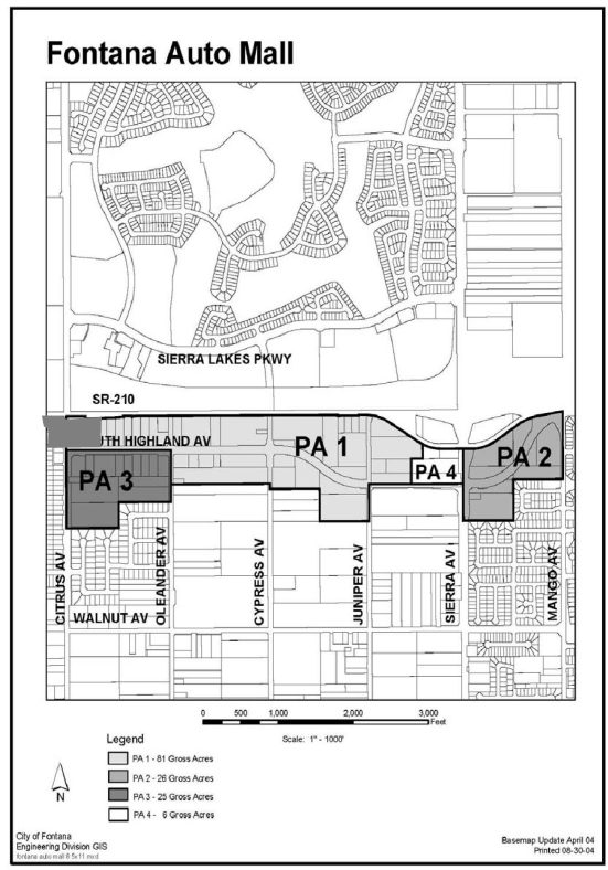
The Fontana Auto Center Overlay District is defined by those boundaries identified in the overlay district map (Figure 1). The project area is divided into four separate planning areas. Planning area 1 contains approximately 81.5 gross acres and is generally located adjacent to the south side of the 210 Foothill Freeway, along both sides of South Highland Avenue, between Sierra Avenue on the East and Citrus Avenue on the West. Planning area 2 contains approximately 11.5 gross acres and includes the existing shopping center on the northeast corner of Sierra Avenue and South Highland Avenue, adjacent to the 210 Foothill Freeway, within the Walnut Village Specific Plan Area. Planning area 3 contains approximately 25 gross acres and is located between Citrus Avenue and Oleander Avenue, south of South Highland Avenue. Planning area 4 contains approximately 6.5 gross acres and is located at the northwest corner of Sierra Avenue and South Highland Avenue.
(Ord. No. 1955, § 4(Exh. A), 9-10-24)
Sec. 30-636. - Purpose and intent.
(a)
The Fontana Auto Center Overlay District is intended to reserve certain specified properties for certain types of uses within the four planning areas. Planning area 1 is reserved primarily for automobile retail sales, service and related uses. Planning area 2 is reserved primarily for gas stations and restaurants. Planning area 3 allows all uses within both planning areas 1 and 2. Planning area 4 allows new vehicle dealerships and a variety of conditionally permitted uses that are complimentary to the adjacent planning area 1.
The overlay district promotes the development of a coordinated and well-planned "auto center." It would consist primarily of new car and truck dealerships, many of which would have direct frontage along the south side of the 210 Freeway.
Planning area 2, located within the Walnut Village Specific Plan Area would contain gas stations, a car wash, food court, restaurants, drive-through fast food and other related commercial uses needed to support the auto center.
These four planning areas will have unique design features that enhance the major gateways into the northern part of Fontana from the 210 Freeway. This includes:
• Architectural styles that complement adjacent developing areas;
• A defined landscape plant palette along the public rights-of-way and required setback areas;
• Coordinated auto display areas along South Highland Avenue, Sierra Avenue and Citrus Avenue;
• A common design theme for certain signage, hardscape treatments, lighting and water features;
• Edge treatments along the 210 Freeway frontage that present a positive image for the City; and
• Enhanced corner statements at Sierra Avenue and South Highland Avenue, Citrus Avenue and South Highland Avenue, and the 210 Freeway and Sierra Avenue.
The use of the development standards and design guidelines contained herein are intended to foster the following objectives for development within the overlay district:
(1)
Encourage the consolidation of automobile dealerships into an "auto center" that encourages shopping at multiple, adjacent dealerships.
(2)
Provide for adequate circulation that allows safe and easy access from the adjacent 210 Freeway, Sierra Avenue and Citrus Avenue, on to South Highland Avenue.
(3)
Provide development standards that set forth requirements for high quality site planning and design, architecture, landscaping, hardscape, lighting and water features, that results in a sense of quality and vitality in northern Fontana.
(4)
Provide for appropriate signage designed to meet the identification and advertising needs of the automobile dealerships and other allowed uses within the overlay district, while presenting a coordinated design theme that is pleasing to the public.
(5)
Provide minimum development standards to which all construction within the overlay district must adhere.
(6)
Ensure adequate protection for existing adjacent residential uses in Walnut Village Specific Plan and east of Citrus Avenue.
(b)
All projects within the four planning areas involving new construction are required to be in compliance with the development standards and design guidelines set forth within the Fontana Auto Center Overlay District. The design guidelines are intended to provide direction to developers within the overlay district to encourage the orderly and harmonious design of structures, landscaping, hardscape, signage, lighting, water features, walls, fences and accessory structures. The guidelines establish a standard for design quality while maintaining flexibility for individual expression and imaginative design solutions.
Sec. 30-637. - Definitions.
All words and phrases used in the Fontana Auto Center Overlay District shall have the same meaning as contained within the Fontana Municipal Code, unless the context requires clarification from City staff and/or elected and appointed officials.
Sec. 30-638. - Fontana auto center overlay district project area boundary.
The map entitled "Fontana Auto Center Overlay District" is adopted as a part of this overlay district (Figure 1) and defines the boundaries of the four planning areas.
Sec. 30-639. - Authority and requirements.
The Fontana Auto Center Overlay District shall be applied to those properties located within the overlay district area, in addition to the land use regulations set forth in Chapter 30 of the Fontana Municipal Code. This overlay district modifies certain regulations contained in Chapter 30 of the Code, as enumerated herein. If there is a conflict with Chapter 30, the overlay district shall prevail.
Figure 1. Fontana Auto Center Overlay District Planning Area Boundaries Map
(Ord. No. 1880, § 6(Exh. A), 1-25-22; Ord. No. 1909, § 4(Exh. A), 12-13-22; Ord. No. 1955, § 4(Exh. A), 9-10-24; Ord. No. 1880, § 6(Exh. A), 1-25-22)
Sec. 30-640. - Permitted uses.
The overlay district permits only the following land uses.
(1)
Planning area 1—Auto center.
a.
Principal uses.
1.
New vehicle dealerships oriented primarily toward the sale of new passenger vehicles and light-to-medium weight trucks [less than 22,000 pounds gross vehicle weight (GVW)].
b.
Accessory uses. As an integral part of, but accessory to the operation of a new vehicle dealership, the following uses shall be permitted subject to approval through the design review process:
1.
Vehicle parts and accessories supply and sales as an integral, but secondary part of operating a new vehicle sales facility.
2.
Vehicle service and repair as an integral, but secondary part of operating a new vehicle sales facility.
3.
Used vehicle sales as an integral, but secondary part of operating a new vehicle sales facility.
4.
Vehicle leasing and rentals as an integral, but secondary part of operating a new vehicle sales facility.
5.
Utility infrastructure.
6.
Other accessory uses as determined by the Director of Planning to be substantially compatible with the principal permitted use of new vehicle dealerships.
c.
Conditionally permitted uses.
1.
Collision repair and auto body work.
2.
Paint spray booths.
3.
Specialty vehicle sales, including recreational vehicles and motorcycles.
4.
Other uses as determined by the Director of Planning to be substantially compatible with the principal permitted use of new vehicle dealerships.
d.
Prohibited uses.
1.
Any use of land not specifically identified in this overlay for planning area 1 is expressly prohibited from the Fontana Auto Center Overlay District.
2.
Any use not fully enclosed within a building except vehicle sales, display and storage areas.
3.
All uses of land that are found by the Planning Commission or City Council to be objectionable by reason of noise, odor, dust, smoke, vibration or similar causes shall be prohibited pursuant to Chapter 30 of the Fontana Municipal Code.
(2)
Planning area 2—Auto center supporting uses. The Walnut Village Specific Plan designates planning area 2 for general commercial uses. The following overlay district principal uses and conditionally permitted uses are consistent with the land uses allowed by the specific plan:
a.
Principal uses.
1.
Sit-down restaurant.
2.
Food court.
3.
Sit-down fast food restaurant (excludes drive-thrus).
b.
Accessory uses.
1.
Utility infrastructure.
c.
Conditionally permitted uses. The following uses are permitted only after a conditional use permit has been approved by the City:
1.
Gas station.
2.
Car wash.
3.
Drive-through fast food restaurant.
4.
Vehicle parts, supplies, accessories stores and installations.
5.
Vehicle leasing and rental.
6.
Other uses as determined by the Director of Planning to be substantially compatible with the principal permitted uses.
d.
Prohibited uses.
1.
Any use of land not specifically identified in this overlay for planning area 2 is expressly prohibited from the Fontana Auto Center Overlay District.
2.
All uses of land that are found by the Planning Commission or City Council to be objectionable by reason of noise, odor, dust, smoke, vibration or similar causes shall be prohibited pursuant to Chapter 30 of the Fontana Municipal Code.
(3)
Planning area 3—Auto center and auto center supporting uses. Planning area 3 allows all uses within planning areas 1 and 2.
a.
Principal uses.
1.
New vehicle dealerships oriented primarily toward the sale of new passenger vehicles and light-to-medium weight trucks (less than 35,000 pounds gross vehicle weight (GVW).
2.
Sit-down restaurant.
3.
Food court.
4.
Sit-down fast food restaurant (excludes drive-thrus).
5.
Grocery store.
6.
Other uses as determined by the Director of Planning.
b.
Accessory uses. As an integral part of, but accessory to the operation of a new vehicle dealership, the following uses shall be permitted subject to approval through the design review process:
1.
Vehicle parts supply and sales as an integral, but secondary part of operating a new vehicle sales facility.
2.
Vehicle service and repair as an integral, but secondary part of operating a new vehicle sales facility.
3.
Used vehicle sales as an integral, but secondary part of operating a new vehicle sales facility.
4.
Vehicle leasing and rentals as an integral, but secondary part of operating a new vehicle sales facility.
5.
Carwash, but secondary part of operating a new vehicle sales facility.
6.
Other accessory uses as determined by the Director of Planning to be substantially compatible with the permitted use.
c.
Conditionally permitted uses. The following uses are permitted only after a conditional use permit has been approved by the City:
1.
Specialty vehicle sales, including recreational vehicles and motorcycles.
2.
Seniors housing.
3.
Gas station.
4.
Car wash.
5.
Drive-through fast food restaurant.
6.
Vehicle parts, supplies, accessories stores and installations.
7.
Vehicle leasing and rental.
8.
Hotel.
9.
Other uses as determined by the Director of Planning to be substantially compatible with the principal permitted use of new vehicle dealerships.
d.
Prohibited uses.
1.
Any use of land not specifically identified in this overlay for planning area 3 is expressly prohibited from the Fontana Auto Center Overlay District.
2.
Any use not fully enclosed within a building except vehicle sales, display and storage areas.
3.
All uses of land that are found by the Planning Commission or City Council to be objectionable by reason of noise, odor, dust, smoke, vibration or similar causes shall be prohibited pursuant to Chapter 30 of the Fontana Municipal Code.
(4)
Planning area 4—Auto center and auto center complimentary uses.
a.
Principal uses.
1.
New vehicle dealerships oriented primarily toward the sale of new passenger vehicles and light-to-medium weight trucks (less than 22,000 pounds gross vehicle weight (GVW).
b.
Accessory uses. As an integral part of, but accessory to the operation of a new vehicle dealership, the following uses shall be permitted subject to approval through the design review process:
1.
Vehicle parts and accessories supply and sales as an integral, but secondary part of operating a new vehicle sales facility.
2.
Vehicle service and repair as an integral, but secondary part of operating a new vehicle sales facility.
3.
Used vehicle sales as an integral, but secondary part of operating a new vehicle sales facility.
4.
Vehicle leasing and rentals as an integral, but secondary part of operating a new vehicle sales facility.
5.
Carwash, but secondary part of operating a new vehicle sales facility.
6.
Other accessory uses as determined by the Director of Planning to be substantially compatible with the principal permitted use of new vehicle dealerships.
c.
Conditionally permitted uses.
1.
Sit-down restaurant.
2.
Hotel.
3.
Specialty vehicle sales, including recreational vehicles and motorcycles.
4.
Automobile, passenger van, and pick-up truck rated one-ton or less (carrying weight) rental.
5.
Other retail uses as determined by the Director of Planning to be substantially compatible with the principal permitted use of new vehicle dealerships.
d.
Prohibited uses.
1.
Any use of land not specifically identified in this overlay for planning area 4 is expressly prohibited from the Fontana Auto Center Overlay District.
2.
Any use not fully enclosed within a building except vehicle sales, display and storage areas.
3.
All uses of land that are found by the Planning Commission or City Council to be objectionable by reason of noise, odor, dust, smoke, vibration or similar causes shall be prohibited pursuant to Chapter 30 of the Fontana Municipal Code.
(Ord. No. 1880, § 6(Exh. A), 1-25-22)
Sec. 30-641. - Plan review.
Design review and/or a conditional use permit approval shall be required for all projects located within the overlay district pursuant to the requirements of Chapter 30 of the Fontana Municipal Code. Projects under 10,000 square feet in size can be approved administratively by City staff.
Sec. 30-642. - Site planning.
Site planning shall involve careful consideration of the project site, adjacent properties and how the project fits into the overall context of the Fontana Auto Center Overlay District.
(1)
Planning area 1—Auto center.
a.
Locate structures and vehicle display areas on each site to enhance the architecture of the auto dealership building and to maximize vehicle displays.
b.
The location of structures shall take into consideration the existing and/or future location of buildings on adjoining properties. Solid block walls adjacent to the 210 Freeway right-of-way are prohibited. Solid block walls that divide adjacent auto dealerships are discouraged, unless controlled pedestrian and vehicle connections are provided for.
c.
Vehicular access and circulation within auto dealerships shall be controlled with properly sized and spaced drive aisles to ensure safe ingress and egress.
d.
All service bays shall be located in such a manner so they are not visible from any public right-of-way, including the 210 Freeway.
e.
All dealerships shall provide attractive, direct and safe pedestrian access and circulation. There should also be convenient pedestrian connections between dealerships.
f.
Locate customer-oriented uses on the ground level of all auto dealership buildings. Business office space and other uses not dependent on customer traffic should be located on upper levels.
g.
There shall be a coordinated landscape setback for all dealerships along South Highland Avenue, Cypress Avenue, Juniper Avenue, Oleander Avenue, and any new streets constructed within the overlay district.
h.
There shall be coordinated, elevated vehicle display pads for all dealerships located along South Highland Avenue. The vehicle display pads are allowed to encroach within the landscape setback area along South Highland Avenue.
i.
Textured hardscape is required at all major driveway entrances and on vehicle display pads.
j.
On-site exterior lighting shall comply with lighting criteria, as set forth within this overlay district. Creative lighting designs and reinforcement of lighting intensity for highlighting purposes of vehicle pad displays, signage and other merchandising areas are encouraged.
k.
Vehicle loading and unloading shall be provided on-site. Access to loading and service bays should be separated from customer parking areas wherever feasible. Adequate stacking distance shall be provided on-site for car carrier trucks. Adequate stacking distance is also required on-site when the dealership is closed and gates are locked.
l.
There shall be coordinated edge treatments along the 210 Freeway right-of-way and between dealerships that enhances the visual appearance of this Gateway area into northern Fontana. Solid masonry block walls are not allowed along the Freeway right-of-way. The edge treatment shall consist of decorative pilasters connected by tubular wrought iron fencing.
m.
The intersections of Sierra Avenue/South Highland Avenue, and Citrus Avenue/South Highland Avenue shall have special corner focal point treatments with Gateway features that include theme landscaping, water features, display pads, arches and appropriate monument signage.
(2)
Planning area 2—Auto center supporting uses.
a.
Allow uses that complement and provide service to the auto center dealerships.
b.
Development proposed on the southeast side of South Highland Avenue in planning area 2 must demonstrate compatibility with adjacent and nearby Walnut Village Specific Plan residences through creative site planning, setbacks, landscaping and other design and land use considerations.
c.
Design all gas stations "reversed out" with building facilities backed up to the right-of-way setback line and the pump islands to the interior.
d.
The location of structures shall take into consideration the existing and/or future location of buildings on adjoining properties. Solid block walls between adjacent uses are discouraged and pedestrian connections are encouraged.
e.
There shall be a coordinated landscape setback for all uses along South Highland Avenue, and any new streets constructed within planning area 2.
f.
Textured hardscape is required at all major driveway entrances.
g.
On-site exterior lighting shall comply with lighting criteria, as set forth within this overlay district.
h.
There shall be coordinated edge treatments along the 210 Freeway right-of-way between Sierra Avenue and Mango Avenue that enhances the visual appearance of this Gateway area into Northern Fontana. Solid masonry block walls are not allowed along the Freeway right-of-way.
i.
The intersections of Sierra Avenue and South Highland Avenue shall have special corner focal point treatments with Gateway features that include theme landscaping, water features, arches and appropriate monument signage.
(3)
Planning areas 3 and 4. All site planning criteria for planning areas 1 and 2 apply to planning areas 3 and 4.
Sec. 30-643. - Minimum development standards.
The minimum site development standards listed in this section shall only apply to the specific planning area within the overlay district.
(1)
Planning area 1—Auto center development standards.
a.
Building and parking setbacks.
1.
All buildings and parking, except for vehicle display pads and allowed monument signs, shall be setback from all street property lines as follows:
Sierra Avenue: 25 Feet
Citrus Avenue: 15 Feet
South Highland Avenue: 15 Feet
Secondary Streets: 10 Feet
Collector Streets: 10 Feet
Local Streets: 10 Feet
2.
Vehicle display pads shall have no required setback and shall be allowed to encroach into the landscape setback. Adequate site distance must be demonstrated at street intersections and driveway entrances for each vehicle display pad. Display pads shall not exceed 14 inches in height as measured from the sidewalk grade.
3.
Monument signs are required to be set back a minimum of five feet from the street property line.
b.
Building height.
1.
Buildings and other structures shall not exceed a maximum of 60 feet in height as measured from the top of curb located adjacent to the street property line to the highest building ridge.
c.
Lot coverage.
1.
No more than 50 percent of the net lot area may be covered with buildings or other structures.
d.
Off-street parking and circulation.
1.
Required off-street parking spaces for vehicle dealerships shall be provided at the following ratios:
Show Room: One space per 300 square feet.
Service Area: One space per 300 square feet.
Outdoor Display: One space per 2,500 square feet.
Employees: One space per employee on the maximum shift.
Note: Service department parking/stacking is counted and included as required parking spaces.
2.
Except for vehicle display pads, all parking spaces shall be a minimum of nine feet wide and 19 feet deep.
3.
Drive aisle widths are required to be 26 feet wide, unless otherwise required by the San Bernardino County Fire Department.
4.
Driveway approaches on South Highland Avenue are required to be 55 feet deep to allow for adequate stacking distance if entry gates are closed. Driveways must demonstrate adequate turning movement widths for car carrier trucks, per the City of Fontana Traffic Engineer.
e.
Landscaping.
1.
All vehicle dealerships shall have a minimum of 15 percent landscaping of the net project site (minus the dealership building footprint). A maximum of seven percent of the required landscape area can be provided as decorative hardscape, including vehicle display pads and driveway approaches.
2.
Required setback areas shall be landscaped with trees, shrubs, plants, grasses and hardscape as set forth within the overlay district landscape design guidelines plant palette.
3.
There shall be a five-foot landscape setback between abutting auto dealership display areas.
f.
Lighting.
1.
On-site lighting plans shall be submitted showing the design, intensity, layout and exact fixture mounting.
2.
Lighting plans shall be consistent with the lighting design criteria and guidelines set forth within this overlay district.
3.
Shielded fixtures that direct all lighting downward shall illuminate areas used for vehicle display.
4.
"Front row" on site dealership lighting closest to South Highland Avenue shall not exceed 20 feet in height and shall have no more than three fixtures per standard at a minimum of 30 feet on center. The interior of the display area shall be illuminated by fixtures no closer than 60 feet to the front line of display lights. These fixtures shall be on standards no higher than 28 feet, they shall be spaced no closer than 60 feet on center, and shall have no more than four fixtures per standard.
5.
Service, storage and employee parking areas shall have light standards no taller than 20 feet in height.
6.
All lighting fixtures shall be properly shielded to prevent off-site glare. Spot fixtures shall only be downward directed, except at strategic vehicle pad displays, monument signs and other landscape locations along the project's perimeter.
7.
Strings of incandescent fixtures are not allowed in any exterior dealership area.
g.
Walls, fences and screening. Walls and fences constructed on an interior lot line, at the rear of the required landscape setback area, or along the 210 Freeway right-of-way shall comply with the development standards set forth herein.
1.
Walls shall not exceed eight feet in height, except that within the required building and parking landscaped setback, vehicle pad display areas, walls may not exceed three feet in height.
2.
All perimeter walls and fences shall be designed to be consistent with the design guidelines set forth herein.
3.
Chain link fencing and all types of barbed wire are prohibited, except that chain link fencing is allowed during construction for security purposes.
4.
The Freeway edge treatment shall consist of eight-foot tall pilasters at 30 feet on center with tubular or wrought iron fencing between pilasters. These pilasters shall be consistent with the design as set forth within the auto center design guidelines.
5.
Pilasters located within 90 feet of South Highland Avenue shall also be eight-foot tall at 30 feet on center with tubular or wrought iron fencing between pilasters. These pilasters will also be covered with flagstone that matches the monument sign flagstone required along South Highland Avenue, consistent with the design as set forth within the auto center design guidelines.
6.
Solid eight-foot tall block walls located within the interior of auto dealerships are permitted, provided they are not visible from the public rights-of-way. Security walls that are visible from public rights-of-way shall consist of solid walls limited to three feet in height with pilasters on top that are limited to five feet in height (eight feet total height) and tubular or wrought iron fencing between pilasters.
7.
All service, trash and employee parking areas shall be screened from view from all public streets by walls and approved fencing. No storage areas shall be visible from any public right-of-way, including the 210 Freeway.
8.
Roof mounted mechanical equipment shall be screened and not be visible from any public rights-of-way, including the 210 Freeway. Roof mounted equipment screening techniques shall involve an integrated architectural design element which is compatible with the architectural design of the dealership building.
9.
Solid block walls eight feet tall are required on the property line adjacent to A.B. Miller High School and Warren Ruble Middle School.
h.
Sound attenuation.
1.
All air compressor exhaust stacks shall contain noise-muffling devices.
2.
Exterior loud speakers shall not be mounted higher that ten feet above finished grade, and shall be oriented toward the interior of each dealership.
(2)
Planning area 2—Auto center supporting uses.
a.
Building setbacks.
1.
All buildings and parking areas, except for allowed monument signs, shall be setback from all street property lines as follows:
Sierra Avenue: 25 Feet
South Highland Avenue: 20 Feet
Mango Avenue: 15 Feet
210 Freeway Right-of-way: 5 Feet
2.
Monument signs are required to be set back a minimum of five feet from the street property line, and must comply with site distance traffic standards at all street corners and driveway entrances.
b.
Building height.
1.
Buildings and other structures shall not exceed a maximum of 60 feet as measured from the top of curb located adjacent to the street property line to the highest building ridge.
c.
Lot coverage:
1.
No more than 50 percent of the net lot area may be covered with buildings or other structures.
d.
Off-street parking and circulation.
1.
Required off-street parking spaces for retail shall be provided at the ratio set forth in Chapter 30 of the Fontana Municipal Code.
2.
All parking spaces shall be a minimum of nine feet wide and 19 feet deep.
3.
Drive aisle widths are required to be 26 feet wide unless otherwise required by the San Bernardino County Fire Department.
e.
Landscaping.
1.
All retail commercial uses shall have a minimum of 15 percent landscaping of the net project site (minus the building footprint).
2.
Required setback areas shall be landscaped with trees, shrubs, plants, grasses and hardscape as set forth within the overlay district landscape design guidelines plant palette.
3.
For projects that are adjacent to the 210 Freeway right-of-way, there shall be a minimum five-foot wide landscape strip planted with trees and shrubs.
4.
Solid block walls adjacent to the 210 Freeway right-of-way are prohibited. The Freeway edge treatment shall consist of eight-foot tall pilasters at 30 feet on center with tubular or wrought iron fencing between pilasters. These pilasters shall be consistent with the design as set forth within the auto center design guidelines.
f.
Lighting.
1.
On-site lighting plans shall be submitted showing the design, intensity, layout and exact fixture mounting. Lighting plans shall be reviewed City Staff.
2.
Lighting plans shall be consistent with the lighting design criteria and guidelines set forth within this overlay district.
3.
Shielded fixtures shall direct all lighting downward, and shall illuminate areas used for parking and driveways.
4.
All exterior areas shall have light standards no taller than 20 feet in height.
5.
All lighting fixtures shall be properly shielded to prevent off-site glare. Spot fixtures shall only be downward directed, except at strategic areas such as monument signs and other landscape locations along the project's perimeter.
6.
Strings of incandescent fixtures are not allowed in any exterior commercial area.
g.
Walls, fences and screening. Walls and fences constructed on an interior lot line, at the rear of the required landscape setback area, or along the 210 Freeway right-of-way shall be in keeping with the development standards set forth herein.
1.
Walls shall not exceed eight feet in height, except that within the required building and parking landscaped setback, walls may not exceed three feet in height.
2.
All walls shall be constructed of split face or masonry material that is compatible with the building design.
3.
Chain link fencing and all types of barbed wire are prohibited, except that chain link fencing is allowed during construction for security purposes.
4.
All service and trash enclosure areas shall be screened from view from all public streets by walls and approved fencing, wherever feasible. No storage areas shall be visible from any public right-of-way, including the 210 Freeway.
5.
Solid block walls are prohibited. Wall edge treatments shall consist of eight-foot tall pilasters at 30 feet on center with tubular or wrought iron fencing between pilasters. These pilasters shall be consistent with the design as set forth within the auto center design guidelines.
6.
Roof mounted mechanical equipment shall be screened and not be visible from any public rights-of-way, including the 210 Freeway. Roof mounted equipment screening techniques shall involve an integrated architectural design element which is compatible with the architectural design of the commercial building.
h.
Sound attenuation.
1.
A drive-through lane is not permitted adjacent to any parcel of land that is zoned for residential use.
(3)
Planning areas 3 and 4.
a.
All minimum site development standards listed in planning areas 1 and 2 apply to planning areas 3 and 4.
(Ord. No. 1880, § 6(Exh. A), 1-25-22; Ord. No. 1906, § 70, 10-25-22; Ord. No. 1951, § 4(Exh. A), 5-28-24)
Sec. 30-644. - Signs and site advertising regulations.
(a)
Purpose and intent. Signage and site advertising are key factors and an important aspect of the auto center project. Freeway oriented signs, dealership and other business identification signs, directional signs, banners and other types of advertising are critical to the success of the auto center. The purpose and intent of the signs and advertising regulations section of the Fontana Auto Center Overlay District are:
• To promote the economic success of the Fontana Auto Center;
• To set forth a coordinated signage and advertising program for the overlay district that identifies this area as a major gateway into northern Fontana;
• To safeguard and enhance property values;
• To protect public and private investments in property and buildings;
• To preserve and enhance the appearance of Fontana as a place to live and work, and as an attraction to non-residents who come to visit, shop or recreate;
• To encourage sound signing practices as an aid to businesses and for conveying information to the public;
• To prevent excessive and confusing sign displays;
• To reduce hazards to motorists and pedestrians;
• To promote public health, safety and general welfare by regulating and controlling all matters relating to signage and advertising;
(b)
Authority and requirements. The Fontana Auto Center Overlay District Sign and Advertising Standards shall be applied to those properties located within the overlay district area, in addition to the sign and advertising regulations set forth in Chapter 3 of the Fontana Municipal Code. This overlay district modifies certain regulations contained in Chapter 3 of the Code, as enumerated herein. If there is a conflict with Chapter 3, the overlay district standards shall prevail.
No sign shall be erected, re-erected, constructed, installed or altered except as provided for in these development regulations, and/or Chapters 3 and 30 of the Fontana Municipal Code. A sign permit must be obtained from the Building and Safety Division prior to the construction or installation of all permanent and temporary signs within the overlay district.
No sign shall be erected or used for business purposes of any kind, except such signs that are located on the place of business, and used solely for the naming, designating, or identifying that specific business, enterprise, product or services available on and within the premises.
The Fontana Auto Center Overlay District is designated, and shall be considered a "commercial complex." All applications for approval of signs shall be submitted to the City in the form of a design review sign application. The sign application shall outline and present the type, size, height, composition, location, color and design of all signs, banners and other types of exterior advertising to be constructed or installed. No sign, banners or other advertising shall be installed unless it conforms to an approved design review sign permit.
(c)
Permitted signs. All permitted signs shall file an application for, and obtain an approved design review sign permit. A sign permit must be obtained from the Building and Safety Division prior to the construction or installation of any permitted permanent and temporary signs within the Fontana Auto Center Overlay District.
(1)
Planning area 1—Auto center signage standards.
a.
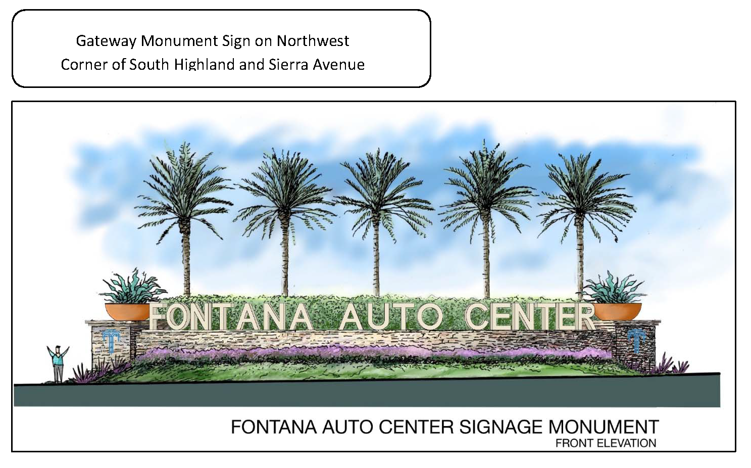
Auto center identification sign. The overall freestanding auto center identification sign with an electronic message board is allowed within the overlay district. This sign is allowed subject to the approval of a conditional use permit. This identification sign's location, size, height, design, composition, message board size, copy, area of copy, colors and materials shall be part of the conditional use permit application. At a minimum, the auto center identification sign shall identify the "Fontana Auto Center" and the "Fontana Promenade," and shall include an electronic message board.
b.
Auto center gateway signs. One monument sign located at the northeast corner of South Highland and Citrus Avenue up to 30 feet tall that identifies the individual auto dealership name brand or their logo/symbol, per the design guidelines set forth in the Fontana Auto Center Overlay District. The maximum size of the dealership's combined name and logo on these monument signs is 36 square feet.
1.
Temporary auto center gateway signs may be permitted prior to the construction of the permanent auto center gateway sign(s) as described above; one temporary sign shall be permitted at the end of the auto center on Citrus Avenue.
i.
The temporary auto center gateway sign shall be removed, prior to the issuance of a building permit for the permanent sign.
ii.
The sign permitted in the above provision shall provide direction and identification only to dealerships located in the auto center overlay district.
iii.
Each individual auto dealership's name brand and/or their logo/symbol may be located on each temporary sign.
iv.
The size of the temporary auto center gateway sign shall not exceed ten feet in height and the width shall not be more than four feet.
v.
The temporary sign shall be designed, constructed and installed to the satisfaction of the Director of Community Development as a design review sign on forms provided by the Planning Division.
c.
Building mounted signs. One wall sign is allowed per elevation fronting a parking lot or street that identifies the dealership's brand name and the dealership's logo or symbol. The maximum size of the signs and/or logo that fronts the 210 Freeway or South Highland Avenue is 400 square feet, provided the 400 square foot requirement for elevations facing South Highland Avenue is not exceeded, a secondary wall sign may be permitted provided it identifies only the ownership name or city. The maximum size of the signs and/or logo on any other elevation is limited to a total of 250 square feet. The maximum height is 40 feet on the building.
d.
Monument signs. One monument sign is allowed for each 200 linear feet of frontage that identifies the dealership's name and their logo or symbol. The maximum height is 12 feet above finished grade. The maximum size of the monument sign is 36 square feet, excluding the required design theme base. This monument sign is required to be set back a minimum of five feet from the street property line and must comply with site distance traffic standards. The design of the base of all monument signs must comply with the coordinated design theme set forth in the following design guidelines for the Fontana Auto Center Overlay District.
e.
Pylon signs. One main brand pylon sign shall be allowed for each dealership. Each dealer will be allowed to choose one of the following height and location requirements: a) a pylon sign not to exceed 30 feet in height with a maximum 100 square feet sign face abutting the I-210 Freeway; b) a pylon sign not to exceed 40 feet in height with a maximum 144 square feet sign face abutting the south edge of the freeway frontage road (old Highland Avenue); c) a pylon sign not to exceed 50 feet in height with a maximum 225 square feet sign face located a minimum 75 feet from the 1-210 freeway. Note that the 50-foot pylon sign is meant to be located adjacent to the rear of the main building and is in no case allowed between the main building and South Highland Avenue.
f.
Service department directional signs. Up to three wall mounted directional signs indicating service department entrance and exit lanes or other additional services, such as oil change or quick lube are allowed above the entrance of the service department. The maximum letter height of each sign shall not exceed two feet or exceed 34 square feet in area.
g.
On-site signs. On-site signs that identify the service and parts departments, and auto display area signs that identify specific types of vehicles. The maximum size of each on-site sign is 16 square feet.
h.
Vehicle display pad signs. One dealership vehicle brand logo or symbol is allowed on the front of the vehicle display pad. Each display pad at prominent corners shall also have a city designed and approved sign that states "Fontana Auto Center." The maximum size of the vehicle logo/symbol is five square feet.
i.
Window signs. Window signs provided that not more than 25 percent of the window area is obscured.
j.
Directional signs. Directional signs for customer parking, service entrance and auto carrier trucks are allowed in required setback areas, subject to City approval. The size, location, height, design, color and materials of each proposed directional sign is subject to approval as a part of the design review sign permit process. The maximum size of each on-site sign is 15 square feet.
k.
Temporary signs. One temporary sign can also be allowed to acknowledge future dealership locations. "Future home of" signs are required to be removed prior to the issuance of the certificate of use and occupancy. Temporary for sale or lease signs are allowed.
l.
Banners. Banners attached to on-site light standards are allowed. Light standard banners shall not add any height above the light fixtures, and are limited to five square feet in size. Banners attached to the main dealership building, interior walls or trees are not allowed.
(2)
Planning area 2—Auto center supporting uses.
a.
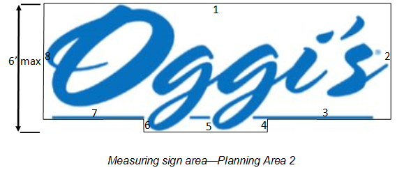
Freeway pylon sign. Sign area shall be calculated by enclosing the extreme limits of all letters, logo, or other display within a single continuous perimeter composed of square or rectangles with no more than eight lines.
1.
The freeway pylon sign requires a design review by the Planning Commission that may be approved, conditionally approved, or denied, as provided in Chapter 30, subject to the following requirements:
i.
Incorporate the logo and/or project identity of the center as well as the City of Fontana logo and name.
ii.
Be double faced and sited perpendicular to the I-210 Freeway.
iii.
Only businesses and/or tenants within the shopping center shall be allowed on the freeway pylon sign.
iv.
The freeway pylon sign can incorporate up to six tenant names.
v.
Maximum tenant letter height shall be six feet for a single-line copy sign and a maximum height of seven feet for a double-line copy sign. Channel letters are required.
vi.
Maximum freeway sign height shall be 60 feet from finished grade. An additional five-foot height increase may be approved by the Planning Commission if the sign incorporates the city name at the top of the sign.
vii.
Maximum sign area shall be 250 square feet per sign face.
viii.
Colors on the sign and structural members should be harmonious with one another and relate to the dominant colors of the other structures on the site.
b.
For all other signs within Planning Area 2, the standards, regulations and control of the location, size, type and number two shall be governed by the provisions of the sign criteria set forth in Chapter 3 and design review criteria in Chapter 30 of the Fontana Municipal Code.
(3)
Planning area 3—Auto center and supporting uses.
a.
The standards, regulations and control of the location, size, type and number of signs located within planning area 3 shall be governed by the provisions set forth in Section 30-644(c), and by the sign criteria set forth in Chapter 3 and design review criteria in Chapter 30 of the Fontana Municipal Code.
(4)
Planning area 4—Auto center and complimentary uses.
a.
The standards, regulations and control of the location, size, type and number of signs located within planning area 4 shall be governed by the provisions set forth in Section 30-644(c), and by the sign criteria set forth in Chapter 3 and design review criteria in Chapter 30 of the Fontana Municipal Code.
(d)
Prohibited signs. The following types of signs are expressly prohibited within the Fontana Auto Center Overlay District:
(1)
Roof signs.
(2)
Flashing signs.
(3)
Projecting signs.
(4)
Portable signs.
(5)
Revolving signs.
(6)
Painted signs.
(7)
Animated signs, except for the City's overall freeway identification sign.
(8)
Strings of flags or banners between light fixtures, trees or buildings.
(9)
Banners that add height to light standards.
(e)
Signs not subject to the design review sign permit process. The following types of signs do not require permits from the City:
(1)
The changing of advertising copy or messages on electronic message boards.
(2)
Window signs that do not obscure over 25 percent of the total window area.
(3)
Real estate signs, City traffic control signs and City directional signs.
(4)
Non-advertising signs of utility companies on equipment cabinets and meters.
Sec. 30-645. - Design guidelines.
The following Fontana Auto Center Overlay District Design Guidelines set forth conceptual design sketches for prominent areas within the overlay district. The design guidelines address the following key areas within the auto center overlay district:
(1)
Gateway corner treatments—Corner of Sierra Avenue and South Highland Avenue;
(2)
Auto center corner treatment for the Northwest corner of Sierra Avenue and South Highland Avenue;
(3)
Planning area 2 corner treatment;
(4)
South Highland Avenue design concepts;
(5)
South Highland Avenue monument signs;
(6)
South Highland Avenue vehicle display pads;
(7)
Freeway edge treatment—View from the Freeway;
(8)
Freeway edge treatment—Pilaster design;
(9)
Pilaster design within 90 feet of South Highland Avenue.
In addition to these conceptual design sketches, these design guidelines contain a landscape plant palette (Appendix A), and an exterior lighting study (Appendix B). The plant palette sets forth guidelines for plantings at main intersections, near entry monuments, and along the 210 Freeway right-of-way. It also provides color photographs of the trees, plants and shrubs included in the plant palette. The exterior lighting study sets forth suggested lighting guidelines and restrictions, common area lighting strategies and specifications for lighting fixtures.
Gateway corner treatments
Auto center corner treatment—Northwest corner of Sierra Avenue and South Highland Avenue
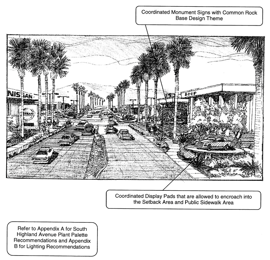
South Highland Avenue design concepts—View looking west within the auto center
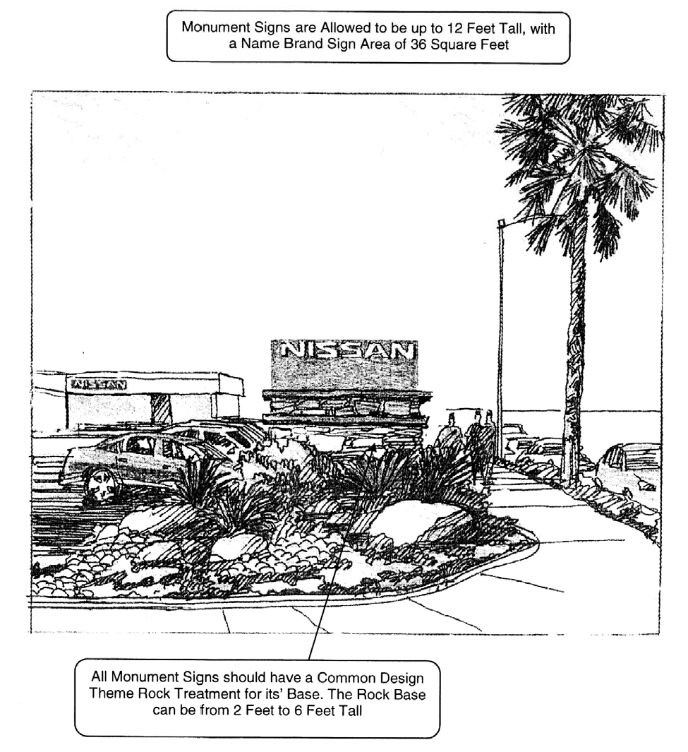
South Highland Avenue monument signs—Name brand signs
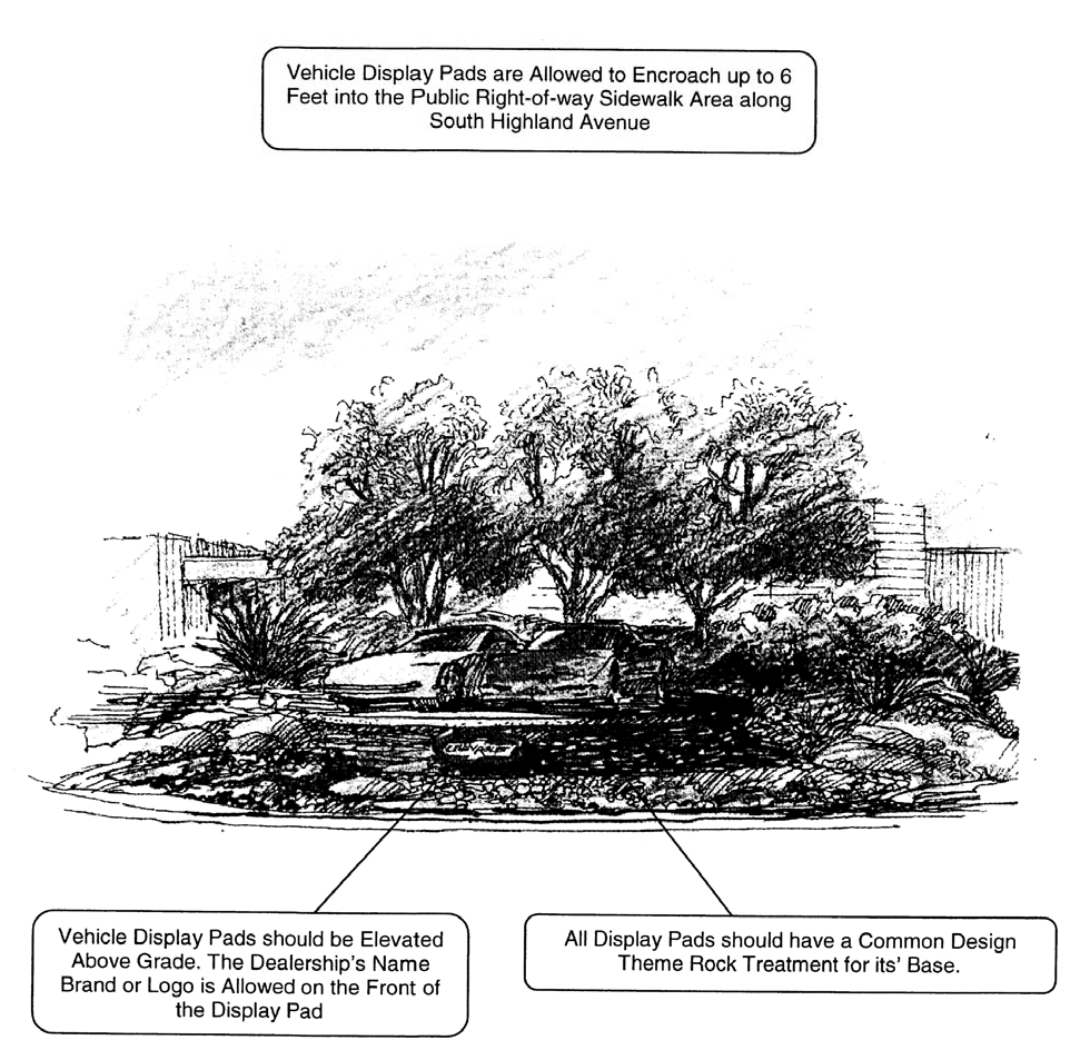
South Highland Avenue vehicle display pads
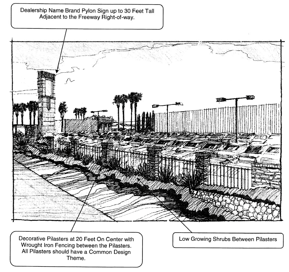
Freeway edge treatment—View from the Eastbound Foothill Freeway
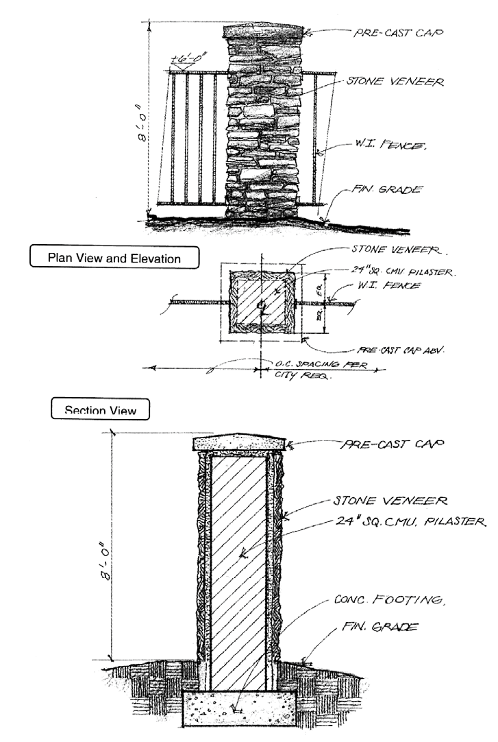
Pilaster design within 90 feet of South Highland Avenue
Sec. 30-646. - Warehousing distribution/logistics overlay district regulations.
(a)
Applicability. The provisions of this division may be applied to any property with a general plan land use designation of regional mixed use (RMU), and a zoning designation of regional mixed use (R-MU), located on the east side of Sierra Avenue and north of Interstate 210 (I-210) as identified in Figure 1.
Figure 1
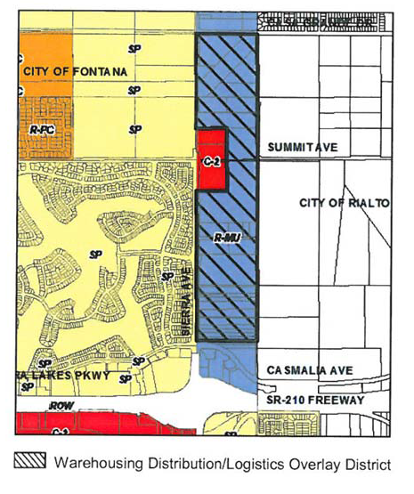
(b)
Relation to underlying zoning. The warehousing distribution/logistics overlay district is a flexible designation that is intended to apply in conjunction with, or as an alternative to the provisions in the underlying zoning. When utilized in conjunction with the underlying zone, if the provisions of this division are in conflict with the provisions of the underlying zoning district, the provisions of this division shall apply.
(c)
Intent. The intent of the warehousing distribution/logistics overlay district is to provide for the limited, well planned and orderly development of warehousing distribution/logistic uses on properties within the R-MU zone located on the east side of Sierra Avenue, north of Interstate 210 (I-210), and south of Casa Grande Drive. Additionally, the further intent of this overlay district is to eliminate or adequately mitigate adverse impacts on the community related to such developments and, therefore, projects taking advantage of the overlay development regulations shall be required to provide access to Mango Avenue, thereby limiting and/or prohibiting access onto Sierra Avenue, unless otherwise approved by the Planning Commission and/or the City Council.
(d)
Access. In line with Section 30-646(c), to further ensure the intent of the warehousing distribution/logistics overlay district, Mango Avenue, a collector street as classified in the City's general plan circulation master plan, shall be required to be constructed from Casmalia Avenue to Summit Avenue prior to the establishment of any proposed project-level development, to the satisfaction of the City Engineer. This requirement is to provide an alternate route to Sierra Avenue for properties within the overlay district as a connection to Interstate 210 (I-210). For the purpose of this section, Mango Avenue need not be developed to its ultimate right-of-way width but must otherwise be constructed to a minimum roadway width to provide for two-way truck traffic and any other circulation needs such as maintenance vehicle turn outs, emergency vehicles, etc., as determined by the City Engineer.
(Ord. No. 1830, § 8(Exh. A), 6-9-20)
Sec. 30-647. - Uses permitted.
(a)
General. Any use permitted in the underlying zoning district shall be permitted in the warehousing distribution/logistics overlay district, subject to Section 30-647(b).
(b)
Warehousing distribution/logistics. The following warehousing distribution/logistics uses require a conditional use permit (CUP):
(1)
Warehousing, standard;
(2)
Warehousing, with distribution;
(3)
Warehousing, high-cube;
(4)
Similar uses as determined by the Director of Community Development to be compatible pursuant to Article II, Division 16, Other Uses to be Determined by the Director of Community Development.
(c)
Prohibited uses. The following uses are specifically prohibited:
(1)
Any use not permitted in the underlying zoning district;
(2)
Multi-family dwellings;
(3)
Senior housing;
(4)
Day care/child care;
(5)
Day care/child care 24-hour;
(6)
Other uses deemed incompatible by the Director of Community Development pursuant to Article II, Division 16, Other Uses to be Determined by the Director of Community Development.
(Ord. No. 1830, § 8(Exh. A), 6-9-20)
Sec. 30-648. - Zone change required.
An application for a change of zone to establish the warehousing distribution/logistics overlay district on one or more parcels eligible to receive the overlay, shall be filed with the Planning Division pursuant to Article II, Division 7 of this Code.
(Ord. No. 1830, § 8(Exh. A), 6-9-20)
Sec. 30-649. - Design review or administrative site plan review required.
Any development proposal within the warehousing distribution/logistics overlay district shall be subject to a design review or administrative site plan review process pursuant to Article II, Divisions X and XI et seq. of this Code.
(Ord. No. 1830, § 8(Exh. A), 6-9-20)
Sec. 30-650. - Development standards and design guidelines.
(a)
General. The development standards and design guidelines in this division shall be minimum requirements for warehousing distribution/logistics type uses. Those standards and guidelines not fully addressed in this section shall be as otherwise stated in the appropriate section(s) of the Fontana Municipal Code, including, but not limited to, Section 30-479 et seq., Section 30-520 et seq., Section 30-664 et seq., and Section 30-679 et seq. of this Code. When this division provides for discretionary authority on the part of the Director of Community Development, Planning Commission, or City Council, that discretion may be exercised to impose more stringent requirements, if deemed necessary, to accomplish the overall intent/objective of the warehousing distribution/logistics overlay district.
(b)
Minimum lot size.
(1)
The minimum lot size shall be four acres.
(c)
Lot dimensions.
(1)
The minimum lot dimensions shall be:
a.
Minimum width of 300 feet.
b.
Minimum depth of 300 feet.
(d)
Maximum building height.
(1)
The maximum building height shall be 60 feet.
(e)
Maximum lot coverage.
(1)
The maximum lot coverage shall be 50 percent.
(f)
Floor-area ratio (FAR).
(1)
The maximum base FAR shall be 0.50.
(g)
Building setbacks. All required yard areas (setbacks) shall be clear of all structures and other required site features such as parking areas, loading areas, fire lanes, etc., and shall be landscaped and maintained in a neat, healthy, aesthetically pleasing condition in accordance with the landscaping provisions of this division. Due to the lot configuration and depth of parcels eligible to receive the overlay district, for the purpose of this division, all buildings are assumed to be fronting on Sierra Avenue.
(1)
Minimum front yard setbacks.
a.
The minimum front yard setback for Sierra Avenue shall be 40 feet.
b.
The minimum front yard setback for Casa Grande Avenue shall be 40 feet.
c.
The minimum front yard setback for Mango Avenue shall be 15 feet.
d.
The minimum front yard setback for lots abutting local streets shall be 15 feet.
(2)
Minimum rear yard setbacks.
a.
The minimum rear yard setback for parcels abutting Sierra Avenue shall be 40 feet.
b.
The minimum rear yard setback for parcels abutting Casa Grande Avenue shall be 40 feet.
c.
The minimum rear yard setback for parcels abutting Mango Avenue shall be 15 feet.
d.
For lots abutting R-MU zoning districts, or any residential district, the minimum rear yard setback shall be 40 feet. For lots abutting C-2 zoning districts, the minimum rear yard setback shall be 15 [feet]. This setback may be increased to provide an appropriate separation between uses in order to protect the public health, safety, and welfare if alternative means of providing separation are not practical.
(3)
Minimum interior side yard setbacks.
a.
The minimum side yard setback for parcels abutting Sierra Avenue shall be 40 feet.
b.
The minimum side yard setback for parcels abutting Casa Grande Avenue shall be 40 feet.
c.
The minimum side yard setback for parcels abutting Mango Avenue shall be 15 feet.
d.
For lots abutting M-1 zoning districts, or any residential district, the minimum interior side yard setback shall be 40 feet. For lots abutting C-2 zoning districts, the minimum interior side yard setback shall be 15 [feet]. This setback may be increased to provide an appropriate separation between uses in order to protect the public health, safety, and welfare if alternative means of providing separation are not practical.
(h)
Parking and drive aisle setbacks (yard areas).
(1)
Street yard (measured from property line).
a.
The minimum setback for lots abutting Sierra Avenue shall be 40 feet.
b.
The minimum setback for lots abutting Casa Grande Avenue shall be 40 feet.
c.
The minimum setback for lots abutting Mango Avenue shall be 15 feet.
d.
The minimum setback for lots abutting local streets shall be 15 feet.
(2)
Rear yard.
a.
The minimum setback for lots abutting Sierra Avenue shall be 40 feet.
b.
The minimum setback for lots abutting Casa Grande Avenue shall be 40 feet.
c.
The minimum setback for lots abutting Mango Avenue shall be 15 feet.
d.
The minimum setback for lots abutting local streets shall be 15 feet.
e.
For lots abutting R-MU zoning districts, or any residential district, the minimum rear yard setback shall be 40 feet. For lots abutting C-2 zoning districts, the minimum rear yard setback shall be 15 [feet]. This setback may be increased to provide an appropriate separation between uses in order to protect the public health, safety, and welfare if alternative means of providing separation are not practical.
(3)
Interior side yard.
a.
For lots abutting R-MU zoning districts, or any residential district, the minimum interior side yard setback shall be 20 feet. For lots abutting C-2 zoning districts, the minimum interior side yard setback shall be 15 [feet]. This setback may be increased to provide an appropriate separation between uses in order to protect the public health, safety, and welfare if alternative means of providing separation are not practical.
(i)
Parking location. Off-street parking shall be located at the rear of the building, but may be considered elsewhere if its use is to further set back buildings from adjacent and/or surrounding sensitive uses (e.g., residential uses across a public right-of-way). Furthermore, visitor and/or employee parking may be located at the front of the building adjacent to the main entry. Service and loading areas may be located at the sides and rear of the building, except where such building sides are adjacent to a public right-of-way.
(j)
Parking and loading requirements. The following are regulations for off-street parking and loading. They identify required number of parking and loading spaces for all new development projects and those proposing substantial modifications to existing buildings. For all parking and loading-related information or regulations not specifically addressed in this section, refer to Section 30-679 et seq. of this Code.
(1)
General parking and loading requirements.
a.
Methods of calculation.
1.
Multiple uses. If more than one use is located on a site, the total number of required off-street parking and loading spaces shall be the sum of the requirements for the various uses computed separately. If individual uses on the same site have a floor area less than that for which loading spaces would be required, then the total gross floor area of all uses on the site or lot shall be used in determining the required number of loading spaces.
2.
Fractional number. Whenever the computation of the required number of off-street parking or loading spaces results in a fractional number, one additional space shall be required for a fraction of .5 or more, but shall not be required for a fraction of .4 or less.
b.
Off-site location. Required off-street parking spaces shall be located on the same parcel as the use that they are intended to serve, unless reciprocal parking and access agreements are recorded between multiple parcels on the same site.
c.
Shared use facility. Required off-street parking and loading spaces may be considered as providing parking or loading spaces for another use where joint facilities serving more than one use contain no less than the total number of spaces deemed necessary for each individual use added together with other uses. Where adjoining uses on the same site have different hours of operation with minimal conflict, the Director of Community Development may determine that some or all of the same spaces may be counted as satisfying the requirements for both uses, provided that the number of spaces shall not be less than the number prescribed for the use requiring the greater number.
(2)
Required number of parking spaces.
a.
Each land use shall provide the number of off-street parking spaces indicated in Table 1—Parking Requirements by Land Use, except as otherwise may be determined by the Director of Community Development per Section 30-650(j)(1)(c) above.
(3)
Required number of loading spaces.
a.
Each land use shall provide the number of off-street parking spaces indicated in Table 2—Loading Space Requirements by Land Use. Requirements for uses not specifically listed shall be determined by the Director of Community Development based upon the requirements for comparable uses and upon the particular characteristics of the proposed use. For other standards (e.g., size of loading spaces, location, turning radius, etc.), refer to Section 30-704 et seq. of this Code.
Note: A tractor trailer loading space shall be a minimum of 12 feet wide by 70 feet long with a minimum 14 feet overhead clearance.
(k)
Fences, walls, and screening. The following are standards and guidelines for fences, walls, and screening.
(1)
Heights. Fences and walls may not exceed eight feet in height when located in a required side or rear yard, and may not exceed three and one-half feet in height when located in any required setback adjacent to a street. In the latter case, however, a fence with a maximum height of eight feet as measured from the sidewalk elevation may be permitted where required for security purposes. Such fencing shall not interfere with or obstruct the line-of-sight for motorists. Incidental outdoor storage areas, and loading areas and doors shall be screened from the public right-of-way by an eight foot high solid block masonry wall (see Table 3). Additional screening may be required and shall not interfere with or obstruct the line-of-sight for motorists.
Note(s):
(1) All fences and walls shall be finished on both sides with a decorative material (e.g., stucco, split-face, and/or slump stone).
(2) All fences and walls shall not interfere with or obstruct the line-of-sight for motorists.
(2)
All warehousing distribution/logistics uses adjoining or abutting a residential zoning district shall be screened by a solid masonry wall not less than eight feet in height. However, in the front yard area abutting the residential lot, the wall may be lower as determined through the site plan review process.
(3)
Electric fences, barbed wire fencing, chain link, wood and/or similar fencing materials are prohibited.
(4)
Fences and walls shall be compatible in terms of design and materials with the main structures on the site.
(5)
Roof-mounted and ground-mounted mechanical equipment, utilities, storage, and solid waste storage areas shall be screened from adjoining properties and public rights-of-way by a visual barrier (e.g., wall, fence, landscape material, etc.) to the satisfaction of the Director of Community Development.
(6)
No loading bays shall be permitted facing Sierra Avenue or Casa Grande Avenue to eliminate noise and negative visual impacts.
(7)
All loading bays shall be completely screened, and a sight-line analysis shall be taken from public right-of-way(s) to demonstrate such screening of all bays. Such analysis shall at a minimum contain a site plan and cross section graphics demonstrating the line of sight from the right-of-way to the loading areas at six feet above the right-of-way surface at three points: The centerline of the right-of-way and the property lines on either side of the right-of-way. The graphics shall be to scale, fully dimensional, and contain all building elevations, berms, walls, landscaping, setbacks, fences, and other structures as they are being proposed to be built.
(8)
All incidental storage of materials, including trucks, shall be screened from adjoining properties and public rights-of-way by a visual barrier (e.g., wall, fence, etc.) to the satisfaction of the Director of Community Development. Furthermore, such storage shall not be located on any required parking area.
(l)
Building orientation.
(1)
All buildings shall be sited and oriented to reduce noise, light and glare, visual and other conflicts. For example, loading areas shall be located in areas where noise from such operations will not adversely impact adjacent, noise sensitive uses.
(2)
Placement of the industrial buildings shall provide the most aesthetic public views. Open work areas shall be located away from public views.
(m)
Landscaping.
(1)
Landscaping shall be used alone or in conjunction with other features (e.g. open space buffer, topography) to reduce potential visual and light and glare conflicts.
(2)
Landscape setbacks along public rights-of-way shall incorporate landscape buffers with undulating and variable height earth-mounding (berms), and/or low walls, preferably in a three-tier planting design.
(n)
Design guidelines. The design guidelines in this subsection shall apply to all warehousing distribution/logistics projects within the overlay district. Those design guidelines not fully addressed in this section shall be as otherwise stated in the appropriate section(s) of this Code, including, but not limited to, Section 30-479 et seq., Section 30-520 et seq., Section 30-664 et seq., and Section 30-679 et seq. of this Code.
(1)
Site design.
a.
Site layout.
1.
The arrangement of multiple buildings and associated circulation, and parking areas should reflect a well-organized site plan.
2.
Site development may utilize variations on building placement and landscaping when located near a public street.
3.
The design and location of accessory buildings (e.g., security kiosks, maintenance buildings, and outdoor equipment enclosures) shall be incorporated into and be compatible with the overall design of the project and the main buildings on the site.
4.
With the exception of security kiosks, accessory buildings shall be located as far back from the front and street side yard setback area as possible.
5.
Sea/train-type metal containers are prohibited.
6.
Incidental outdoor storage, work, and loading areas shall be incorporated within the building design and located to the rear or side of buildings unless such building side(s) are adjacent to a public street where it would be prohibited.
b.
Courtyards and plazas.
1.
Buildings should be arranged to create opportunities for open space amenities (e.g., plazas, courtyards, outdoor eating areas, etc.). See Figure 2.
Figure 2
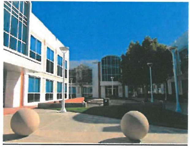
(2)
Building orientation.
a.
The organization of buildings, parking areas, and landscaping shall recognize the existing characteristics of the site and shall relate to the surrounding development in scale and character.
b.
Buildings should be oriented in a manner that takes advantage of passive solar design.
c.
Buildings shall be oriented to provide a buffer between sensitive uses (i.e. residential, schools, parks, and medical facilities) and outdoor work areas, loading, and incidental storage.
(3)
Site elements.
a.
Fences and walls.
1.
Walls and fencing materials shall consist of wrought iron, tubular steel, stone, stucco, or brick, and shall be compatible with the overall design character/style of the development. The use of chain-link fence and similar materials is prohibited. See Figures 3 and 4.
Figure 3
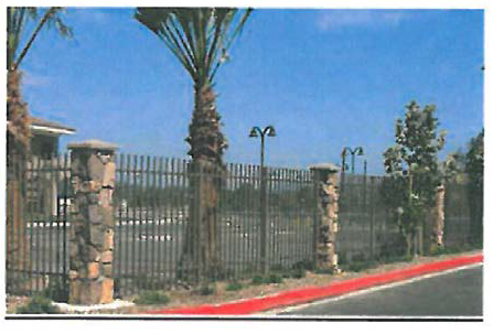
Figure 4
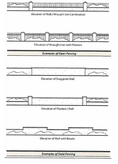
2.
Walls and fences shall be integrated with landscaping along the base of the wall or fence.
3.
Wall heights and surfaces shall be articulated with varying facade depths or pilasters to promote architectural interest, and shall include a cap along the top of the wall.
4.
Landscaping shall be used in combination with walls and fences to visually soften blank surfaces and to deter graffiti. Additionally, all walls shall have an anti-graffiti coating to further deter graffiti, to the satisfaction of the City. See Figure 5.
Figure 5
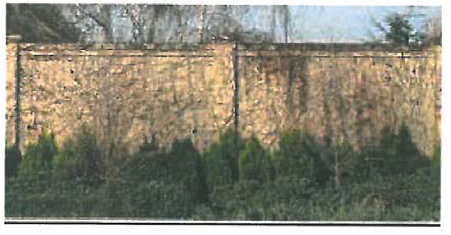
b.
Screening.
1.
Loading bays and service areas shall be completely screened from public right-of-way(s) by building placement and/or decorative walls. Landscaping may be used in addition to such building placement and/or walls, but shall not be the sole means of screening. A sight-line analysis shall be taken from public right-of-way(s) to indicate screening of all items.
2.
Trash storage enclosures and outdoor mechanical equipment shall be completely screened from public view.
3.
Roof-mounted equipment shall be screened from public view through use of parapet walls or other approved screening devices. Special consideration shall be given to the screening of roof-mounted equipment on building rooftops that are visible from the public right-of-way. See Figure 7.
Figure 7
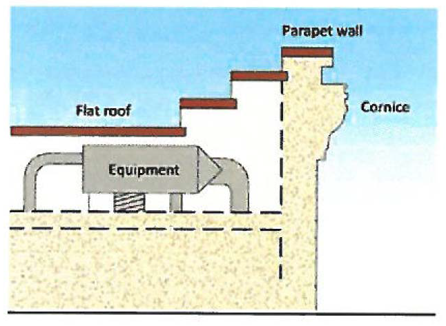
c.
Lighting.
1.
Outdoor lighting plans shall take into consideration the location and potential growth pattern of nearby trees (existing and planned) so that appropriate lighting levels are maintained over time.
2.
Energy efficiency shall be considered through use of proper light location and placement, as well as use of energy-efficient bulbs and/or fixtures.
3.
Lighting fixtures shall include hoods or other design techniques to reduce glare and light pollution, especially along major streets, and to prevent light spillover onto adjacent properties.
4.
Lighting shall be provided in project entryways, walkways, and parking lots to promote safety.
5.
Lighting may be mounted on poles or bollards, affixed to building walls, or placed within paved or landscaped areas. Appropriate materials and construction methods shall be used to ensure proper function of project lighting fixtures.
6.
Decorative light fixtures shall be consistent with the architectural design of the building.
7.
Truck and truck trailer parking areas shall incorporate lighting to increase real and perceived security.
(4)
Parking and access.
a.
Parking.
1.
Parking lots shall not be the dominant visual element on the site.
2.
Surface parking areas shall integrate trees and landscape improvements to reduce the heat island effect and to promote better visual aesthetics.
3.
Large parking lots (usually over 100 spaces) shall be divided into multiple, smaller areas and provided with canopy trees located throughout the parking area to reduce the effects of heat and the visual impacts of large parking areas.
4.
Parking lot design shall include water quality storm water facilities consistent with City standards. See Figure 8.
Figure 8
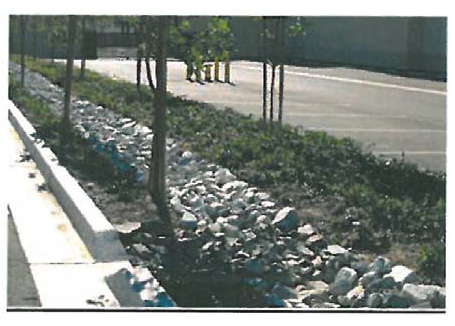
b.
Access.
1.
The use of common (shared) access points and driveways is required for all service and loading areas pursuant to Traffic Engineering's Standard Plan No. 701 Access Management Requirements, to reduce curb cuts along streets. Additionally, placement of vehicle access points close to building entries shall be avoided to minimize pedestrian and vehicular conflicts.
2.
Entry drives shall be clearly marked by special features, (e.g., enhanced paving, prominent landscape features, low-level decorative walls, and well-designed monument-type signs). See Figure 9.
Figure 9
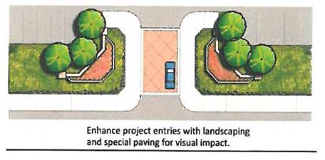
(5)
Architecture.
a.
Mass and scale.
1.
The mass and scale of the buildings shall respect the visual and physical relationship to the adjacent buildings and surrounding sensitive uses. Taller building elements shall be placed towards the center of the site, with lower elements adjacent to surrounding properties.
2.
Buildings shall be stepped back when adjacent to or in close proximity to sensitive uses (e.g. residential, schools, etc.).
3.
Vertical and horizontal offsets shall be provided to reduce the visual bulk of the building. See Figure 10.
Figure 10
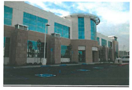
b.
Building facades.
1.
Building facades shall incorporate architectural elements such as windows, pillars, and wall plane breaks to minimize blank walls, to create visual interest, and to reduce the opportunity for graffiti.
2.
All building elevations, whether front, side, or rear shall be architecturally detailed.
3.
Architectural accents (e.g., cornices, tiles, trim around windows, grooves in building faces, accent band details, bulkheads, etc.) shall be used to create variation along building facades. See Figure 11.
Figure 11
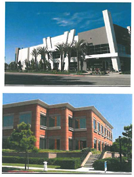
4.
Roofs shall be designed as an integral component of building form, mass, and facade. Building form shall be enhanced by sloped or offset roof planes, eave heights, and rooflines. See Figure 12.
Figure 12
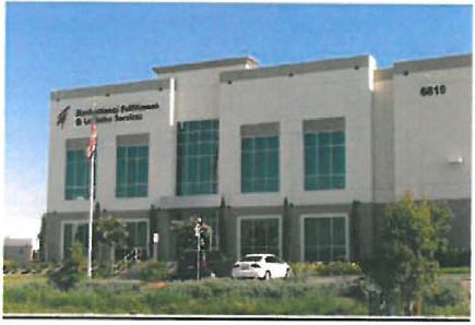
c.
Colors and materials.
1.
Colors and materials for all structures on-site should consist of earth tones. Use of different colors and materials or textures is strongly encouraged.
2.
Building materials shall be durable and able to withstand long-term exposure to the elements.
3.
Large expanses of smooth material (e.g., concrete) shall be broken up with expansion joints, reveals, or changes in texture and color.
(6)
Landscaping.
a.
Landscaping shall be in scale with adjacent structures, streets, and public spaces, and be sized appropriately when fully grown.
b.
Landscaped areas should incorporate a three-tiered planting system:
1.
Ground cover and flowering plants;
2.
Shrubs and vines; and,
3.
Trees.
c.
Development on corner lots shall be enhanced with a combination of specimen trees, accent plantings, upgraded perimeter wall surfaces, hardscape treatments and landscape lighting adjacent to the street intersection.
d.
Drought-tolerant and low-maintenance trees, vines, and groundcovers shall be used on-site. Drip irrigation systems shall be installed to ensure the highest possible level of water conservation.
e.
Setbacks adjacent to sensitive uses shall include dense landscaping to provide visual screening and noise attenuation.
f.
Landscaped berms along site edges shall be used to screen parking, loading and service areas and to serve as a sound reduction measure. See Figure 13.
Figure 13
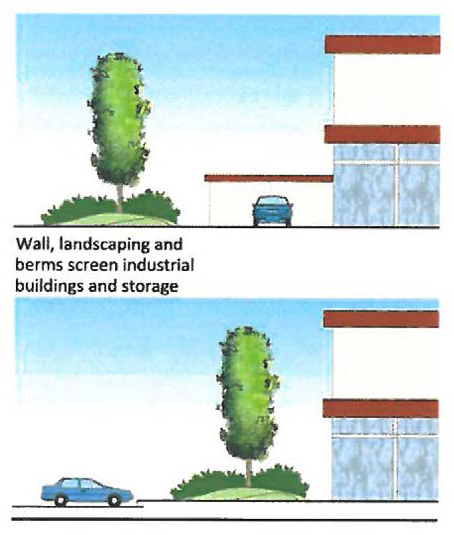
g.
Surface parking lots shall be well-landscaped to reduce heat island effect and visually reduce the expanse of paved area.
h.
Pervious paving materials are strongly encouraged for sidewalks, pathways, and parking lots or other paved surfaces on-site.
i.
An automatic irrigation system using current equipment and technology shall be provided for planted areas.
j.
Run-off retention and on-site water filtration/stormwater treatment features and bioswales should be a part of the overall landscape design, and can also serve as buffering methods for adjacent businesses. See Figure 14.
Figure 14
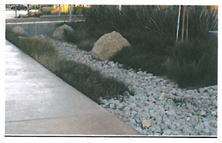
k.
Trees shall be selected and placed to provide canopy and shade for walkways, pedestrian open spaces, and parking areas.
l.
Tree and shrub planting shall be in large masses.
m.
Plant material selected shall be suited to the specific soil and micro climatic conditions.
(Ord. No. 1667, § 3(Exh. A), 8-14-12; Ord. No. 1830, § 8(Exh. A), 6-9-20; Ord. No. 1865, § 8(Att. 2), 3-23-21)
Sec. 30-651. - Emergency shelter overlay district (ESO) regulations.
(a)
Applicability. The provisions of this division shall apply to light industrial (I-L) land use designations as specified in Figure 1.
Figure 1
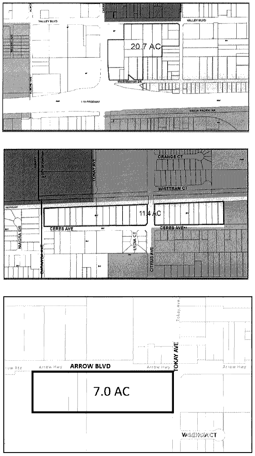
(b)
Relation to underlying zoning. The emergency shelter overlay district is a flexible designation that is intended to apply in conjunction with, or as an alternative to the provisions in the underlying zoning. When utilized in conjunction with the underlying zone, if the provisions of this division are in conflict with the provisions of the underlying zoning district, the provisions of this division shall apply.
(c)
Intent. The intent of the emergency shelter overlay district is to provide for supportive and transitional housing uses on specific properties within the light industrial (M-1) zoning district. Additionally, the further intent of this overlay district is to allow emergency shelters without a conditional use permit or other discretionary permit in accordance with Government Code § 65583. Recognizing the need for available and affordable sites for establishment of emergency shelters and other transitional housing types outside of the traditional locations in commercial districts, the emergency shelter overlay district provides areas and districts for the development of new emergency and supportive housing to be integrated with commercial and light industrial uses and existing social services throughout the City. The purpose of the designated boundaries (area of applicability) is to maximize the potential for provision of emergency shelter and support services throughout the City of Fontana.
(d)
Definitions.
Emergency shelters. The California Health and Safety Code (§ 50801(e)) defines "emergency shelter" as housing with minimal supportive services for homeless persons that is limited to occupancy of six months or less by a homeless person. No individual or household may be denied emergency shelter because of an inability to pay.
Single room occupancy. Typically, a single-room occupancy (SRO) unit is a multiple tenant building that houses one or two people in individual rooms (sometimes two rooms, or two rooms with a bathroom or half bathroom), or to the single room dwelling itself. SRO tenants typically share bathrooms and/or kitchens, while some SRO rooms may include kitchenettes, bathrooms, or half-baths. Most SRO units are small, with a gross floor area of less than 400 square feet. Each dwelling unit is restricted to occupancy by no more than two persons and is offered on a monthly rental basis or longer.
Supportive housing. Under the housing element law, supportive housing is defined as housing with no limit on length of stay that is occupied by a target population, and that is linked to onsite or offsite services that assist the supportive housing resident in retaining the housing, improving his or her health status, and maximizing his or her ability to live and, when possible, work in the community (California Health and Safety Code § 50675.14(b)).
Transitional housing. The California Health and Safety Code (§ 50675.2) defines "transitional housing" and "transitional housing development" as buildings configured as rental housing developments, but operated under program requirements that call for the termination of assistance and recirculation of the assisted unit to another eligible program recipient at some predetermined future point in time, which shall be no more than six months. This definition of transitional housing does not encompass all transitional housing facilities, particularly those that operate as group quarters or community care facilities that charge fees rather than rents.
(Ord. No. 1932, § 4(Exh. A), 12-12-23)
Sec. 30-652. - Administrative site plan review required.
Any development proposal within the emergency shelter overlay district shall be subject to an administrative site plan review process pursuant to Article II, Division 10 et seq. of this Code.
Sec. 30-653. - Emergency shelters.
The following standards shall be required for development or establishment of emergency shelters in the ESO district:
The following development standards shall apply.
(1)
[Density of residents.] The maximum resident density shall be one resident per 150 square feet, up to a maximum of 60 residents in a single shelter.
(2)
[Number of staff.] The facility shall be staffed with one staff person per 15 occupied beds and shall be awake during the hours of operation.
(3)
Waiting/intake area. The shelter may have a waiting and intake area no larger than 100 square feet combined;
(4)
On-site manager. The shelter must have at least one on-site manager at all times during hours of operation.
(5)
Distance requirements. The distance between emergency shelters shall be a minimum of 300 feet. No emergency shelter shall be located within 300 feet of any public park and/or school.
(6)
Security. The emergency shelter shall provide a security plan that ensures the safety of the residents, visitors and employees. The plan shall be reviewed by the Chief of Police or his designee and shall include, but is not limited to, the following:
a.
Color, security surveillance system with recording capability;
b.
On-site security guard(s), the number of security guards shall be based on the following ratio of one guard for every ten patrons.
c.
Adequate external lighting shall be provided for security purposes. The lighting shall be stationary, directed away from adjacent properties.
(7)
Length of stay. Emergency shelter shall only be provided for a time period of six months for any individual resident.
(8)
Laundry facility. The shelter shall provide on-site laundry facilities or services adequate for the number of residents.
(9)
Outdoor activities. Any emergency shelter adjacent to a residential use shall limit outdoor activities to the following hours: 8:00 a.m. to 9:00 p.m. Monday through Sunday.
(10)
Pay phone. There shall not be any outdoor public telephones on the site nor along the public right-of-way.
(11)
Signage. No signs are permitted on the property relating to its use as a shelter for the homeless;
(12)
Bathroom facilities. Each emergency shelter shall provide facilities for personal care (i.e., bathroom and shower facilities).
(13)
Toilets. No outdoor toilets are allowed on the site unless during construction or a special event;
(14)
Shelter provider. The agency or organization operating the emergency shelter shall comply with the following requirements:
a.
Staff and services shall be provided to assist residents of the shelter in obtaining permanent housing and income;
b.
A written management plan including, as applicable, provision for staff training, neighborhood outreach, security, screening of residents to ensure compatibility with services provided at the facility, and for training, counseling, and treatment outreach programs for residents;
(15)
Facility layout. Living, dining, and kitchen areas shall be physically separated from sleeping areas.
(16)
Sleeping area. Each emergency shelter shall provide at least 35 square feet of sleeping area per bed.
(17)
Litter and graffiti. The owner/operator shall:
a.
Maintain the exterior of the premises, including signs and accessory structures, free of litter and graffiti at all times;
b.
Provide for daily removal of trash from the premises and abutting sidewalks or alleys within 20 feet of the premises; and
c.
Remove graffiti within 48 hours of written notice from the City.
(18)
Controlled access. The facility and/or the premises shall be accessed by one entrance.
(19)
Property maintenance. The agency shall ensure that the facility is clean and litter-free at all times. The grounds shall be landscaped with materials which are compatible with the surrounding neighborhood and maintained in a trim and weed-free state. The structure shall be painted and maintained such that it is compatible with structures existing in the surrounding neighborhood.
(Ord. No. 1708, Exh. A, § 6, 10-28-14)
Sec. 30-654. - Transitional housing facilities.
The following development standards shall apply.
(1)
Establishment. A management plan form shall be obtained, completed in detail, and returned to the City of Fontana's Community Development Department for review and approval. The transitional housing program management plan is a detailed analysis of how an agency intends to operate and maintain a transitional housing facility in accordance with existing city ordinances and the criteria contained in this section.
(2)
Qualifications. The applicant shall be a qualified agency with knowledge, understanding, and demonstrable experience in the operation and management of a transitional housing facility.
(3)
Client screening. The agency should establish a screening process, similar to standard renting procedures, which includes letter(s) of reference, verification of employment, and determination of tenant ability to pay rent. The tenants should agree to participate in the daily maintenance of the transitional housing facility, and in an orientation/training process provided by the facility aimed at promoting their transition toward stability.
(4)
Maximum client stay. Clients should be limited to a maximum stay of six months.
(5)
Rent structure. The facility shall provide transitional housing below the median rent level within the City of Fontana.
(6)
Property maintenance. The agency shall ensure that the facility is clean and litter-free at all times. The grounds shall be landscaped with materials which are compatible with the surrounding neighborhood and maintained in a trim and weed-free state. The structure shall be painted and maintained such that it is compatible with structures existing in the surrounding neighborhood.
(7)
Agency services. The agency shall identify in the management plan the services which are available to clients off-site, and shall demonstrate the client's ability to transport one's self to the site where services are provided.
(Ord. No. 1708, Exh. A, § 6, 10-28-14)
Sec. 30-655. - General development standards and design guidelines.
(a)
General. The development standards and design guidelines in this division shall be minimum requirements for emergency shelters, supportive and transitional housing type uses. Those standards and guidelines not fully addressed in this section shall be as otherwise stated in the appropriate section(s) of the Fontana Municipal Code, including, but not limited to, Section 30-664 et seq., and Section 30-679 et seq. of this Code.
Table 30-655.A.
Lot Dimensions, Building Height and Maximum Intensity
(b)
Building setbacks. All required yard areas (setbacks) shall be clear of all structures and other required site features such as parking areas, loading areas, fire lanes, etc., and shall be landscaped and maintained in a neat, healthy, aesthetically pleasing condition in accordance with the landscaping provisions of this division. Setback may be increased to provide an appropriate separation between uses in order to protect the public health, safety, and welfare if alternative means of providing separation are not practical.
Table 30-655.B
Yard Area-Building Setbacks
(c)
Parking and loading requirements. Off-street parking shall be located at the rear or side of the building, but may be considered elsewhere at the discretion of the Director of Community Development. Visitor parking may be located at the front of the building adjacent to the main entry. Service and loading areas may be located at the sides and rear of the building, except where such building sides are adjacent to a public right-of-way.
(d)
Parking. The following are regulations for off-street parking and loading. They identify required number of parking and loading spaces for all new development projects and those proposing substantial modifications to existing buildings. For all parking and loading-related information or regulations not specifically addressed in this section, refer to Section 30-679 et seq. of this Code.
Table 30-655.C
Minimum Number of Parking Spaces Required
(1)
Parking and access.
a.
Parking lots shall not be the dominant visual element on the site.
b.
Surface parking areas shall integrate trees and landscape improvements to reduce the heat island effect and to promote better visual aesthetics.
c.
Parking lot design shall include water quality storm water facilities consistent with City standards. See Figure 1.
Figure 1
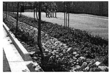
(e)
Fences, walls, and screening. The following are standards and guidelines for fences, walls, and screening.
Table 30-655.D
Standards for Fences, Walls and Screening
(1)
Fences and walls.
a.
Walls and fencing materials shall consist of wrought iron, tubular steel, stone, stucco, or brick, and shall be compatible with the overall design character/style of the development. The use of chain-link fence and similar materials is prohibited.
b.
Walls and fences shall be integrated with landscaping along the base of the wall or fence.
c.
Wall heights and surfaces shall be articulated with varying facade depths or pilasters to promote architectural interest, and shall include a cap along the top of the wall.
d.
Landscaping shall be used in combination with walls and fences to visually soften blank surfaces and to deter graffiti. Additionally, all walls shall have an anti-graffiti coating to further deter graffiti, to the satisfaction of the City. See Figure 2.
Figure 2
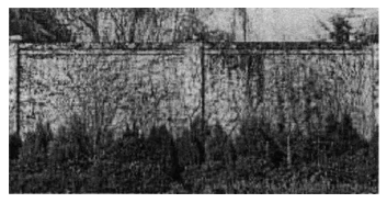
(f)
Landscaping. Those standards and guidelines not fully addressed in this section shall be as otherwise stated in the appropriate section(s) of the Fontana Municipal Code, including, but not limited to, Section 30-664 et seq., of this Code.
(1)
Landscaping shall be used alone or in conjunction with other features (e.g. open space buffer, topography) to reduce potential visual and light and glare conflicts.
(2)
Landscape setbacks along public rights-of-way shall incorporate landscape buffers with undulating and variable height earth-mounding (berms), and/or low walls, preferably in a three-tier planting design.
(3)
Landscaping shall be in scale with adjacent structures, streets, and public spaces, and be sized appropriately when fully grown.
(4)
Landscaped areas should incorporate a three-tiered planting system:
a.
Ground cover and flowering plants;
b.
Shrubs and vines; and,
c.
Trees.
(g)
Site design.
(1)
Courtyards and plazas.
a.
Buildings should be arranged to create opportunities for open space amenities (e.g., plazas, courtyards, outdoor eating areas, etc.).
(2)
Building orientation.
a.
The organization of buildings, parking areas, and landscaping shall recognize the existing characteristics of the site and shall relate to the surrounding development in scale and character.
b.
Buildings should be oriented in a manner that takes advantage of passive solar design.
c.
Buildings shall be oriented to provide a buffer between sensitive uses (i.e. residential, schools, and parks).
(3)
Site elements.
a.
Screening.
1.
Loading areas shall be completely screened from public right-of-way(s) by building placement and/or decorative walls. Landscaping may be used in addition to such building placement and/or walls, but shall not be the sole means of screening. A sight-line analysis shall be taken from public right-of-way(s) to indicate screening of all items.
2.
Trash storage enclosures and outdoor mechanical equipment shall be completely screened from public view.
3.
Roof-mounted and ground-mounted mechanical equipment utilities, storage, and storage areas shall be screened from public right-of-way by a visual barrier (e.g., wall, fence, landscape material, parapet walls etc.) or other approved screening devices. Special consideration shall be given to the screening of roof-mounted equipment on building rooftops that are visible from the public right-of-way. See Figure 3.
Figure 3
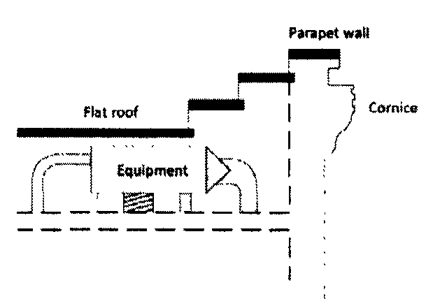
(4)
Lighting.
a.
Outdoor lighting plans shall take into consideration the location and potential growth pattern of nearby trees (existing and planned) so that appropriate lighting levels are maintained over time.
b.
Energy efficiency shall be considered through use of proper light location and placement, as well as use of energy-efficient bulbs and/or fixtures.
c.
Lighting fixtures shall include hoods or other design techniques to reduce glare and light pollution, especially along major streets, and to prevent light spillover onto adjacent properties.
d.
Lighting shall be provided in project entryways, walkways, and parking lots to promote safety.
e.
Lighting may be mounted on poles or bollards, affixed to building walls, or placed within paved or landscaped areas. Appropriate materials and construction methods shall be used to ensure proper function of project lighting fixtures.
f.
Decorative light fixtures shall be consistent with the architectural design of the building.
(5)
Architecture.
a.
Mass and scale.
1.
The mass and scale of the buildings shall respect the visual and physical relationship to the adjacent buildings and surrounding sensitive uses. Taller building elements shall be placed towards the center of the site, with lower elements adjacent to surrounding properties.
2.
Buildings shall be stepped back when adjacent to or in close proximity to sensitive uses (e.g. residential, schools, etc.).
3.
Vertical and horizontal offsets shall be provided to reduce the visual bulk of the building.
b.
Building facades.
1.
Building facades shall incorporate architectural elements such as windows, pillars, and wall plane breaks to minimize blank walls, to create visual interest, and to reduce the opportunity for graffiti.
2.
All building elevations, whether front, side, or rear shall be architecturally detailed.
3.
Architectural accents (e.g., cornices, tiles, trim around windows, grooves in building faces, accent band details, bulkheads, etc.) shall be used to create variation along building facades.
4.
Roofs shall be designed as an integral component of building form, mass, and facade. Building form shall be enhanced by sloped or offset roof planes, eave heights, and rooflines.
(Ord. No. 1708, Exh. A, § 6, 10-28-14; Ord. No. 1865, § 8(Att. 2), 3-23-21)
Sec. 30-656. - Fire hazard overlay district regulations.
(a)
Applicability. The fire hazard overlay provisions shall apply in areas so designated on the current general plan land use map. The fire hazard overlay shall initially be based on the 2008 very high fire hazard severity zones map from the California Department of Forestry and Fire Protection (Cal FIRE) and on such other subsequent maps or evidence as deemed appropriate by the City.
(b)
Purpose. The fire hazard overlay district is created to provide greater public safety to City residents and structures in areas prone to wildfires, by establishing development standards for these areas.
(c)
Fuel modification zone plan. Each new tentative tract map application, tentative parcel map application, or design review application within the overlay zone shall include a fuel modification zone (FMZ) plan, plotted to the same scale as the preliminary grading plans and site plans, showing all fuel modification areas as required. The fuel modification zone plan shall be submitted as part of a project concurrently with the aforesaid entitlement applications, to the Community Development Department and shall be reviewed and deemed acceptable by the Fontana Fire Protection District prior to such applications being approved. The fuel modification zone plan shall address the standards referenced in Section 30-658 below, and shall contain the following items:
(1)
The natural ungraded slope contour of the land within the project and in the areas adjacent to the project; and
(2)
Locations of all onsite as well as offsite fuel modified areas; and
(3)
Fire department access to the project and access to the fuel modified area as described in Section 30-658; and
(4)
The treatment and maintenance of all fuel modified areas; and
(5)
The soil erosion and sediment control measures to alleviate permanent scarring and accelerated erosion, if required; and
(6)
A legend with symbols of all fire resistive landscape plant materials used.
(7)
When applicable, a landscaping and irrigation plan shall be submitted for the fuel modification zone.
(d)
Construction plans. Each new building permit application for a new single family and multifamily dwelling, or any other new construction project within a residentially zoned property, shall include the information required in Section 30-656(c)(1) through (7) above, either on a grading plan, a site plan, or a separate fuel modification zone plan as part of the project concurrently with building construction plans. Such information shall be reviewed and approved by the Fontana Fire Protection District prior to such permits being issued.
The fuel modification zone shall be installed prior to the issuance of the certificate of occupancy.
(e)
Fire protection district standards. The Fire Chief or Fire Marshal of the Fontana Fire Protection District shall have the authority to create local guidelines and standards that pertain to the types of acceptable vegetation and maintenance of fuel modification zones, as well as requirements for fire access roadways and fire protection systems within the fire hazard overlay.
(f)
Additions, alterations, enlargements, or reconstructions. When an area of an addition, alteration, enlargement or reconstruction of an existing structure equals or exceeds 50 percent of the existing square footage of the structure, the construction requirement provisions of this Section 30-656 shall apply to the entire structure impacted by such addition, alteration, enlargement, or reconstruction.
(g)
Definitions. In addition to the definitions contained in this Title, the words and phrases set forth below, shall, for the purposes of this division, be given the following meaning, unless the content clearly requires otherwise:
Development perimeter means the portion of a development that is nearest the limits or boundary of the development project and nearest any surrounding undeveloped natural or maintained open space. The location of the development perimeter for each development project shall be determined by the Fontana Fire Protection District.
Fuel modification zone means a portion of land, between the perimeter of a development and undeveloped land or open space; where combustible vegetation has been removed, modified by cutting or thinning, or partially or totally replaced with approved fire-resistant plant material in order to provide a level of protection to structures from wildfires.
Fire protection plan means a development project specific plan or study that is prepared by a consultant approved by the Fontana Fire Protection District Fire Chief or Fire Marshal. The fire protection plan shall address fire protection impacts and recommended mitigation, as part of an "Alternate Protection Measures" submittal per Section 30-656(e)(3).
Sec. 30-657. - Uses permitted.
(a)
Permitted uses. Any use permitted in the underlying zoning district shall be permitted in the fire hazard overlay district.
(b)
Applicability of land use zoning district standards and other overlay standards. The development standards established by a land use zoning district and any applicable overlay shall apply, except as modified by this section.
Sec. 30-658. - Development standards and design guidelines.
(a)
Site and emergency access. Each development project, except for a development project located exclusively on a cul-de-sac, shall have a minimum of two points of vehicular ingress and egress, designed to applicable City street standards. The fire protection district may authorize one point of vehicular ingress and egress access to be an emergency vehicle access (EVA) only route with a minimum 26-foot wide paved driving surface, if the fire protection district first makes each of the following findings:
(1)
Two points of full vehicle access are impractical due to characteristics of the land or are physically infeasible, as determined by the Fire Chief; and
(2)
Legal agreements have been made to reasonably ensure that the emergency vehicle access will be maintained; and
(3)
The emergency vehicle access route will provide adequate vehicular ingress and egress during emergencies; or
(4)
Alternate protection measures have been submitted and approved in accordance with the provisions of Section 30-656(e).
(b)
Culs-de-sac. The length of a cul-de-sac shall not exceed 350 feet in length, except as allowed by this section.
(1)
A cul-de-sac may exceed 350 feet in length, but shall not exceed 600 feet in length if the Fire Chief of the Fontana Fire Protection District makes the following findings:
a.
The cul-de-sac is situated and designed so that each parcel taking access from it is not contiguous to or exposed to fire hazard areas, and that the extension of the cul-de-sac will not increase the exposure of buildings to wildfires; and
b.
The total number of dwelling units taking access from the cul-de-sac is no more than 15 dwelling units; and
c.
Alternate protection measures have been submitted and approved in accordance with the provisions of Section 30-656(e).
(c)
Fuel modification zones.
(1)
Permanent fuel modification zones. A permanent fuel modification area shall be required around a development project or portions thereof that are in the fire hazard overlay, for the purpose of fire protection. In no case shall fuel modification zones be less than 100 feet in width, as measured from the side or rear property lines of private lots. Fuel modification zones shall be allowed to be designated on City owned and maintained open space, commonly owned open space maintained by a Home Owners Association (HOA), or on City or HOA maintained easements on private property adjacent to new development projects. Fuel modification zones shall not be allowed to be designated on privately owned open space on individual lots within a new development project except as approved on a fire protection plan described in Section 30-656(e). Fuel modification zones shall be within the project boundary (onsite) and shall not be designated on parcels of land adjacent to the project (off-site) unless the following findings are made by the Director of Community Development and the Fire Chief or Fire Marshal:
a.
The approval of such off site fuel modification zones would be necessary to achieve consistency with the land use designation, density and zoning of the properties being developed; and
b.
An easement is recorded on adjacent parcels, to the satisfaction of the City and the fire protection district, that designates fuel modification areas and specifies the maintenance that is to occur in these areas, and grants permission of all parties performing maintenance; and
c.
A recorded agreement is formed and signed by all parties that will hold all City personnel harmless of liability while performing maintenance; and
d.
A recorded agreement together with a community facilities district or other tax assessment is established to the satisfaction of the City and the fire protection district that will fund bi-annual inspections of all fuel modification zones as well as provisions for maintenance by the City upon documented default of any private party performing the maintenance.
(2)
Temporary fuel modification zones. When fuel modification zones are required on adjacent parcels of land on which the current land use designation and zoning allows for development in the future, temporary fuel modification zones may be allowed to be used with the approval of the Community Development Director and the Fire Chief. When a development project is phased, individual phases may be required to provide temporary fuel modification areas, where the development perimeter of a phase is contiguous to a subsequent phase of a project, which in its undeveloped state is a hazardous fire area. The requirements for a temporary fuel modification area shall be based upon the same considerations described in Section 30-656(c)(1), above, for permanent fuel modification zones.
(3)
Perimeter access to fuel modified and fire hazard areas. Each development project shall provide adequate vehicular access for fire fighting vehicles into fuel modified areas from the boundary of the project, along the portion of the development perimeter that is adjacent to either an existing or proposed fuel modified area, or a fire hazard area. Provisions shall be made, and shall be required where necessary, through conditions, covenants, and restrictions recorded on each parcel within the development project, for the continual maintenance of paved roadways intended to provide the access, in order for them to remain unobstructed, in drivable condition, and meet all other Fontana Fire Protection District regulations. Perimeter access shall be provided through either of the following measures, or through alternate measures in compliance with Section 30-656(e):
a.
A fire vehicle and apparatus access road along the development perimeter, or portion thereof that is exposed to a fire hazard must meet the following criteria:
1.
The road shall be capable of supporting fire-fighting equipment, shall be at least 20 feet in width, and shall not exceed a maximum grade of 14 percent.
2.
The road may have gates installed at the entrances at the development perimeter per the requirement of the fire protection district.
b.
Fire vehicle and apparatus access roadways, situated between lots at the development perimeter or portion thereof that is exposed to a fire hazard, and which are accessible to firefighting equipment shall consist of the following standards:
1.
Such roadways shall be spaced at intervals of no more than 350 feet apart as measured along each street.
2.
Such roadways shall be at least 12 feet in width, with a maximum grade not to exceed 14 percent, and capable of supporting fire fighting vehicles. Such roadways may have gates installed at the entrances at the development perimeter per the requirements of the fire protection district.
(4)
All new development within the fire hazard overlay district shall comply with current California Building Standards Codes, including the provisions of the California Building Code (CBC) Chapter 7A (Materials and construction methods for exterior wildfire exposure).
(d)
Fences.
(1)
Where wood or vinyl fencing is used, there shall be a minimum five-foot separation between the wood or vinyl fencing and the wall of the nearest structure. Fencing within the five-foot separation area shall be of noncombustible materials.
(2)
Fences or walls required adjacent to fuel modification areas or wildfire prone areas as conditions of approval for a development project shall be constructed of masonry per the California Building Code.
(3)
Where side and rear yards are enclosed by walls or fencing, gates shall be provided on both side yards for emergency access to the rear yard.
(e)
Alternate Protection Measures.
(1)
Purpose. The purpose of this section is to allow greater design flexibility than would otherwise be permitted, and to more practically achieve the purposes of the fire hazard overlay district. Upon the agreement of both the Director of Community Development and the Fire Chief or Fire Marshal of the Fontana Fire Protection District, the substitution of alternate protection measures as documented in an approved fire protection plan may be substituted for otherwise applicable requirements if it is found that they provide the same or a greater level of protection from wildfires and other natural hazards, and that they will fulfill the same purpose as the established standard or requirement.
(2)
Applicability. The provisions of Section 30-656(e) alternate protection measures shall apply only to the standards and requirements of:
a.
Site and emergency access.
b.
Length of culs-de-sac.
c.
Width and treatment of fuel modification zones.
d.
Perimeter access to fuel modified and fire hazard areas.
(3)
Substitution of alternative protection measures for development standards and requirements.
a.
If alternative protection measures are proposed, the Fire Chief or Fire Marshal of the fire protection district shall determine, with specific consideration of the effect of the proposed alternative protection measures, whether the proposed development project has adequate provisions for fire protection, including the ongoing maintenance of fuel modified areas. The fire protection district shall give consideration to the recommendations of the fire protection plan and make each and all of the following findings:
1.
The approved alternative protection measures meet the intent of, and serve the same purpose as, all of the established standards and requirements; and
2.
The approved alternative protection measures provide the same or a greater level of protection or are as effective as the established standards or requirements; and
3.
There are clear and substantial reasons for utilizing the alternative protection measures, because they provide for a more efficient and economic use of the site, or provide for a superior design in terms of safety and efficiency, in the opinion of the Fire Chief, Fire Marshal, and the Community Development Director.
b.
If the fire protection district makes a positive determination in compliance with this section, such alternate protection measures shall be approved and signed by the fire protection district prior to approval of the project and may be substituted for specific requirements of this Code and the established standards of the district.
Sec. 30-659. - Business park and warehousing distribution overlay district—Valley Boulevard regulations.
Figure 1
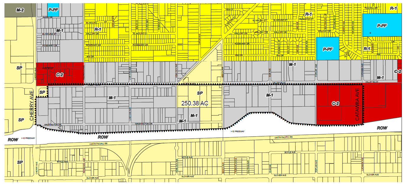
(a)
Applicability. The provisions of this division may be applied to any property with a general plan land use designation of light industrial use (I-L), and a zoning designation of light industrial use (M-1), that is located on the south side of Valley Boulevard, north of Interstate 10 (I-10), west of Catawba Avenue, and east of Cherry Avenue as identified in Figure 1.
(b)
Relation to underlying zoning. The business park and warehousing distribution overlay district—Valley Boulevard (valley business park overlay) is a flexible designation that is intended to apply in conjunction with, or as an alternative to the provisions in the underlying zoning. When utilized in conjunction with the underlying zone, if the provisions of this division are in conflict with the provisions of the underlying zoning district, then the provisions of this division shall apply.
(c)
Intent. The intent of the valley business park overlay is to provide for a well-planned and orderly development of business park and warehousing distribution uses on properties within the M-1 zone located on the south side of Valley Boulevard, north of Interstate 10 (I-10), west of Catawba Avenue, and east of Cherry Avenue. The vision of this district is to improve the visual aesthetics along the I-10, Valley Boulevard and other areas and encourage economic growth with business parks and warehouses.
(d)
Valley overlay warehousing distribution definition. For the purpose of this division, the term "warehousing distribution" uses shall mean warehouse/distribution facilities used for the storage and/or consolidation of manufactured goods (and to a lesser extent, raw materials) before their distribution to retail locations or other warehouses. Warehouse/distribution centers are generally greater than 100,000 square feet in size, with a land coverage ratio of approximately 50 to 60 percent, and a dock to high-loading-door ratio of approximately 1:5,000—10,000 square feet. They are characterized by a small employment count due to a high level of automation; significant movement and storage of products, materials, or equipment; truck activities frequently outside of the peak hour of the adjacent street system; and good freeway access. They are further characterized by the presence of third-party logistics companies who are neither the manufacturer of the goods to be distributed nor the end user of the goods, but are rather the independent distributor of such goods.
(e)
Business park definition. For the purpose of this division, the term "business park" means a group of two or more buildings on a single or multiple contiguous parcels of land, that are planned, developed, and operated as an integrated site with shared common areas with special attention given to circulation, parking, utility needs, aesthetics, and compatibility located within the valley business park overlay. The office uses that are permitted are those permitted in the underlying zoning of M-1.
(Ord. No. 1830, § 8(Exh. A), 6-9-20)
Sec. 30-660. - Uses permitted.
(a)
General. Any use permitted in the underlying zoning district shall be permitted in the business park and warehousing distribution overlay district—Valley Boulevard, subject to Section 30-647(b).
(b)
Warehousing distribution allowed with a conditional use permit:
(1)
Warehousing, with distribution with high-cube warehouse facilities.
(c)
Prohibited uses:
(1)
Any use not listed in the underlying zoning district or specified in this division are prohibited.
(2)
Other uses deemed incompatible by the director pursuant to Section 30-223.
(Ord. No. 1830, § 8(Exh. A), 6-9-20)
Sec. 30-661. - Zone change required.
An application for a change of zone to establish the valley business park overlay on one or more parcels eligible to receive the overlay, shall be filed with the Planning Division pursuant to Section 30-40 et seq. of this Code.
(Ord. No. 1830, § 8(Exh. A), 6-9-20)
Sec. 30-662. - Design review or administrative site plan review required.
Any development proposal within the valley business park overlay shall be subject to a design review or administrative site plan review process pursuant to Article II, Divisions X and XI et seq. of the Zoning and Development Code.
(Ord. No. 1830, § 8(Exh. A), 6-9-20)
Sec. 30-663. - Development standards and design guidelines.
(a)
General. The development standards and design guidelines in this division shall be minimum requirements for valley business park overlay type uses. Those standards and guidelines not fully addressed in this section shall be as otherwise stated in the appropriate section(s) of the Fontana Municipal Code, including, but not limited to, Sections 30-520 et seq., 30-664 et seq., and 30-679 et seq. of this Code. When this division provides for discretionary authority on the part of the Director of Community Development, Planning Commission, or City Council, that discretion may be exercised to impose more stringent requirements, if deemed necessary, to accomplish the overall intent/objective of the valley business park overlay.
(b)
Maximum building height.
(1)
The maximum building height shall be 60 feet.
(c)
Maximum lot coverage.
(1)
The maximum lot coverage shall be 60 percent.
(d)
Floor-area ratio (FAR).
(1)
The maximum base FAR shall be 0.55.
(e)
Minimum lot size.
(1)
Lots must be a minimum of one acre.
(f)
Building setbacks. All required yard areas (setbacks) shall be clear of all structures and other required site features such as parking areas, loading areas, etc., and shall be landscaped and maintained in a neat, healthy, aesthetically pleasing condition in accordance with the landscaping provisions of this division.
(1)
The minimum building setback for Valley Boulevard and Cherry Avenue shall be 30 feet.
(2)
The minimum building setback for Poplar Avenue and Beech Avenue shall be 25 feet.
(3)
The minimum building setback for the I-10 Freeway shall be 40 feet.
(4)
The minimum building setback for lots abutting collector streets shall be 20 feet.
(5)
The minimum building setback for local streets shall be 15 feet.
(6)
The minimum building interior building setback shall be 20 feet for property lines adjacent to parcels with residential uses including nonconforming residential uses. There shall be no other interior setback requirements.
(7)
These setback requirements may be increased to provide an appropriate separation between uses in order to protect the public health, safety, and welfare if alternative means of providing separation are not practical.
(g)
Parking and drive aisle setbacks (landscape setback area).
(1)
The minimum landscape setback for Valley Boulevard and Cherry Avenue shall be 30 feet.
(2)
The minimum landscape setback for the I-10 Freeway shall be ten feet.
(3)
The minimum landscape setback for Poplar Avenue and Beech Avenue shall be 25 feet.
(4)
The minimum landscape setback for lots abutting collector and local streets shall be 20 feet.
(5)
These setback requirements may be increased to provide an appropriate separation between uses in order to protect the public health, safety, and welfare if alternative means of providing separation are not practical.
(6)
Interior landscape setback:
a.
Interior landscape setbacks for lots adjacent to residential uses, including nonconforming, shall be ten feet.
b.
Other interior landscape setbacks shall be five feet.
(h)
Parking location and buffering. The placement of buildings and parking lots should emphasize the attractive designs of buildings with less emphasis on parking lots. Off-street parking shall be buffered from the right-of-way through landscaping and building placement. Furthermore, visitor and/or employee parking may be located at the front of the building adjacent to the main entry. Service and loading areas may be located at the sides and rear of the building, and must be completely screened when located adjacent to a public right-of-way.
(i)
Parking and loading requirements. The following are regulations for off-street parking and loading. They identify required number of parking and loading spaces for all new development projects and those proposing substantial modifications to existing buildings. For all parking and loading-related information or regulations not specifically addressed in this section, refer Article XI et seq. of this Code.
(1)
General parking and loading requirements.
a.
Methods of calculation.
1.
Multiple uses. If more than one use is located on a site, the total number of required off-street parking and loading spaces shall be the sum of the requirements for the various uses computed separately. If individual uses on the same site have a floor area less than that for which loading spaces would be required, then the total gross floor area of all uses on the site or lot shall be used in determining the required number of loading spaces.
2.
Fractional number. Whenever the computation of the required number of off-street parking or loading spaces results in a fractional number, one additional space shall be required for a fraction of .5 or more, but shall not be required for a fraction of .4 or less.
b.
Off-site location. Required off-street parking spaces shall be located on the same parcel as the use that they are intended to serve, unless reciprocal parking, shared parking or access agreements are recorded between multiple parcels on the same site.
(2)
Required number of parking spaces.
a.
Each land use shall provide the number of off-street parking spaces indicated in Table 1—Parking Requirements by Land Use, except as otherwise may be determined by the Director of Community Development per Section 30-663(i)(1)(b) above.
Table 1
(3)
Required number of loading spaces.
a.
Each land use shall provide the number of loading spaces indicated in Table 2—Loading Space Requirements. Requirements for uses not specifically listed shall be determined by the Director of Community Development based upon the requirements for comparable uses and upon the particular characteristics of the proposed use. For other standards (e.g., size of loading spaces, location, turning radius, etc.), refer to Section 30-679 et seq. of this Code.
Table 2
(Tractor trailer loading spaces shall be a minimum of 12 feet wide by 70 feet long with a minimum 14 feet clearance.)
(j)
Fences, walls, and screening. The following are standards and guidelines for fences, walls, and screening. Fences, walls, and screening must meet the aesthetic requirements of Section 30-663(n)(3)(a) below.
(1)
Heights.
a.
Front setback area: Solid fencing/wall shall not be allowed to go above a maximum height of 42 inches.
b.
Side and rear setback areas: Solid fencing/wall may not exceed eight feet in height when located behind the required front, side or rear yard, and may not exceed three and one-half feet in height when located in any required setback adjacent to a street.
c.
Screening walls: Refer to Table 3.
Table 3
(2)
Electric fences, barbed wire fencing, chain link, wood and/or similar fencing are prohibited.
(3)
Fences and walls shall be compatible in terms of design and materials with the main structures on the site.
(4)
Roof-mounted and ground-mounted mechanical equipment, utilities, storage, and solid waste storage areas shall be screened from adjoining properties and public rights-of-way by a visual barrier (e.g., wall, fence, landscape material, etc.) to the satisfaction of the Director of Community Development.
(k)
Screening loading bays and storage areas.
(1)
All loading bays shall be completely screened and a sight-line analysis shall be taken from public right-of-way(s) to demonstrate such screening of all bays. Such analysis shall at a minimum contain a site plan and cross section graphics demonstrating the line of sight from the right-of-way to the loading areas at six feet above the right-of-way surface at three points: The centerline of the right-of-way and the property lines on either side of the right-of-way. The graphics shall be to scale, fully dimensional, and contain all building elevations, berms, walls, landscaping, setbacks, fences, and other structures as they are being proposed to be built.
(2)
All incidental storage of materials, including trucks, shall be screened from adjoining properties and public rights-of-way by a visual barrier (e.g., wall, fence etc.) to the satisfaction of the Director of Community Development. Furthermore, such storage shall not be located on any required parking area.
(3)
Walls and fences must meet the design criteria of Section 30-663(n)(3)(a).
(l)
Building orientation.
(1)
All buildings shall be sited and oriented to reduce noise, light and glare, visual and other conflicts. For example, loading areas shall be located in areas where noise from such operations will not adversely impact adjacent, noise sensitive uses.
(2)
Placement of the industrial buildings shall provide the most aesthetic public views and de-emphasize parking areas. Open work areas shall be located away from public views.
(m)
Landscaping.
(1)
Landscaping shall be used alone or in conjunction with other features (e.g. open space buffer, topography) to reduce potential visual and light and glare conflicts.
(2)
Landscape setbacks along public rights-of-way shall incorporate landscape buffers with undulating and variable height earth-mounding (berms), and/or low walls, preferably in a three-tier planting design.
(n)
Design guidelines. The design guidelines in this subsection shall apply to all warehousing distribution and business park projects within the valley business park overlay. Those design guidelines not fully addressed in this section shall be as otherwise stated in the appropriate section(s) of this Code, including, but not limited to, Section 30-479 et seq., Section 30-520 et seq., 30-664 et seq., and Section 30-679 et seq. of this Code. For the purposes of creating an attractive aesthetic environment, buildings are assumed to be fronting the I-10 Freeway with an attractive design.
(1)
Site design.
a.
Site layout.
1.
The layout shall emphasize enhancing the visual aesthetics along the I-10 Freeway by having business parks and warehouses fronting the I-10 Freeway. The Director may allow loading dock areas to front the I-10 Freeway with the following findings:
i.
The guidelines related to fences and walls in Section 30-663 are met.
ii.
The designs of the screening of fences and walls enhance the visual aesthetics of the site.
2.
The arrangement of multiple buildings and associated circulation, and parking areas should reflect a well-organized site plan.
3.
Site development may utilize variations on building placement and landscaping when located near a public street.
b.
Accessory structures.
1.
The design and location of accessory buildings (e.g., security kiosks, maintenance buildings, and outdoor equipment enclosures) shall be incorporated into and be compatible with the overall design of the project and the main buildings on the site.
2.
With the exception of security kiosks, accessory buildings shall be located as far back from the front and street side yard setback area as possible.
3.
Sea/train-type metal containers are prohibited.
4.
Incidental outdoor storage, work, and loading areas shall be incorporated within the building design and located to the rear or side of buildings unless such building side(s) are adjacent to a public street where it would be prohibited.
c.
Courtyards and plazas.
1.
Buildings should be arranged to create opportunities for open space amenities (e.g., plazas, courtyards, outdoor eating areas, etc.). See Figure 2.
Figure 2
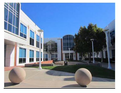
(2)
Building orientation.
a.
The organization of buildings, parking areas, and landscaping shall recognize the existing characteristics of the site and shall relate to the surrounding development in scale and character.
b.
Buildings should be oriented in a manner that takes advantage of passive solar design.
c.
Buildings shall be oriented to provide a buffer between sensitive uses (i.e. residential, schools, parks, and medical facilities) and outdoor work areas, loading, and incidental storage.
(3)
Site elements.
a.
Fences and walls.
1.
Walls and fencing materials shall consist of decorative wrought iron, tubular steel, stone, stucco, or brick, and shall be compatible with the overall design character/style of the development. The use of chain-link fence and similar materials is prohibited. See Figures 3 and 4.
Figure 3
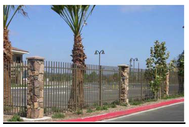
Figure 4
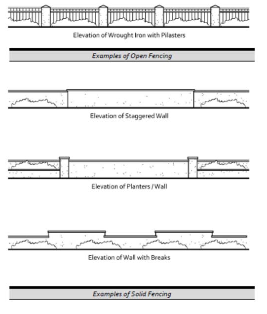
2.
Chain link fences, wood fences, electric fences, razor and barbed wire fences are prohibited.
3.
Walls and fences shall be integrated with landscaping along the base of the wall or fence.
4.
Wall heights and surfaces shall be articulated with varying facade depths or pilasters to promote architectural interest, and shall include a cap along the top of the wall.
5.
Landscaping shall be used in combination with walls and fences to visually soften blank surfaces and to deter graffiti. Additionally, all walls shall have an anti-graffiti coating to further deter graffiti, to the satisfaction of the City. See Figure 5.
Figure 5
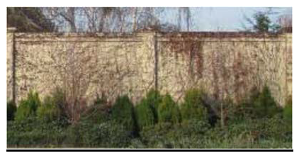
b.
Screening.
1.
Loading bays and service areas shall be completely screened from public right(s)-of-way by building placement and/or decorative walls. Landscaping may be used in addition to such building placement and/or walls, but shall not be the sole means of screening. A sight-line analysis shall be taken from public right(s)-of-way to indicate screening of all items. The design standards in Section 30-663 must be met.
2.
Trash storage enclosures and outdoor mechanical equipment shall be completely screened from public view.
3.
Roof-mounted equipment shall be screened from public view through use of parapet walls or other approved screening devices. Special consideration shall be given to the screening of roof-mounted equipment on building rooftops that are visible from the public right-of-way. See Figure 6.
Figure 6
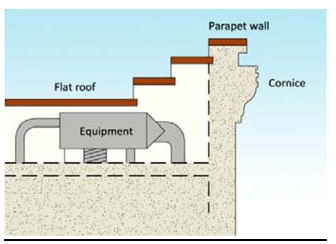
c.
Lighting.
1.
Outdoor lighting plans shall take into consideration the location and potential growth pattern of nearby trees (existing and planned) so that appropriate lighting levels are maintained over time.
2.
Energy efficiency shall be considered through use of proper light location and placement, as well as use of energy-efficient bulbs and/or fixtures.
3.
Lighting fixtures shall include hoods or other design techniques to reduce glare and light pollution, especially along major streets, and to prevent light spillover onto adjacent properties.
4.
Lighting shall be provided in project entryways, walkways, and parking lots to promote safety.
5.
Lighting may be mounted on poles or bollards, affixed to building walls, or placed within paved or landscaped areas. Appropriate materials and construction methods shall be used to ensure proper function of project lighting fixtures.
6.
Decorative light fixtures shall be consistent with the architectural design of the building.
7.
Truck and truck trailer parking areas shall incorporate lighting to increase real and perceived security.
(4)
Parking and access.
a.
Parking.
1.
Parking lots shall not be the dominant visual element on the site.
2.
Surface parking areas shall integrate trees and landscape improvements to reduce the heat island effect and to promote better visual aesthetics.
3.
Large parking lots (usually over 100 spaces) shall be divided into multiple, smaller areas and provided with canopy trees located throughout the parking area to reduce the effects of heat and the visual impacts of large parking areas.
4.
Parking lot design shall include water quality storm water facilities consistent with City standards. See Figure 7.
Figure 7
b.
Access.
1.
The use of common (shared) access points and driveways is required for all service and loading areas pursuant to Traffic Engineering's Standard Plan No. 701 Access Management Requirements, to reduce curb cuts along streets. Additionally, placement of vehicle access points close to building entries shall be avoided to minimize pedestrian and vehicular conflicts.
2.
Entry drives shall be clearly marked by special features, (e.g., enhanced paving, prominent landscape features, low-level decorative walls, and well-designed monument-type signs). See Figure 8.
Figure 8
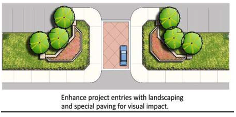
(5)
Architecture.
a.
Mass and scale.
1.
The mass and scale of the buildings shall respect the visual and physical relationship to the adjacent buildings and surrounding sensitive uses. Taller building elements shall be placed towards the center of the site, with lower elements adjacent to surrounding properties.
2.
Buildings shall be stepped back when adjacent to or in close proximity to sensitive uses (e.g. residential, schools, etc.).
3.
Vertical and horizontal offsets shall be provided to reduce the visual bulk of the building. See Figure 9.
4.
Every building shall have a celebrated entry at the entrance of the building which shall include elements such as up lighting, tall landscaping, and/or architecture elements accentuated at the entry of the building.
Figure 9
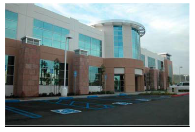
b.
Building facades.
1.
Building facades shall incorporate architectural elements such as windows, pillars, and wall plane breaks to minimize blank walls, to create visual interest, and to reduce the opportunity for graffiti.
2.
All building elevations, whether front, side, or rear shall be architecturally detailed.
3.
Architectural accents (e.g., cornices, tiles, trim around windows, grooves in building faces, accent band details, bulkheads, etc.) shall be used to create variation along building facades. See Figure 10.
Figure 10
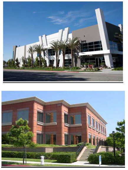
4.
Roofs shall be designed as an integral component of building form, mass, and facade. Building form shall be enhanced by sloped or offset roof planes, eave heights, and rooflines. See Figure 11.
Figure 11
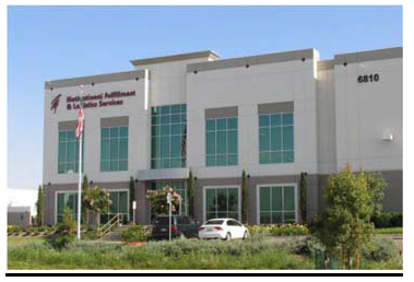
c.
Colors and materials.
1.
Colors and materials for all structures on-site should consist of earth tones. Use of different colors and materials or textures is strongly encouraged.
2.
Building materials shall be durable and able to withstand long-term exposure to the elements.
3.
Large expanses of smooth material (e.g., concrete) shall be broken up with expansion joints, reveals, or changes in texture and color.
(6)
Landscaping.
a.
Landscaping shall be in scale with adjacent structures, streets, and public spaces, and be sized appropriately when fully grown.
b.
Landscaped areas should incorporate a three-tiered planting system:
1.
Ground cover and flowering plants;
2.
Shrubs and vines; and,
3.
Trees.
c.
Development on corner lots shall be enhanced with a combination of specimen trees, accent plantings, upgraded perimeter wall surfaces, hardscape treatments and landscape lighting adjacent to the street intersection.
d.
Drought-tolerant and low-maintenance trees, vines, and groundcovers shall be used on-site. Drip irrigation systems shall be installed to ensure the highest possible level of water conservation.
e.
Setbacks adjacent to sensitive uses shall include dense landscaping to provide visual screening and noise attenuation.
f.
Landscaped berms along site edges shall be used to screen parking, loading and service areas and to serve as a sound reduction measure. See Figure 12.
Figure 12
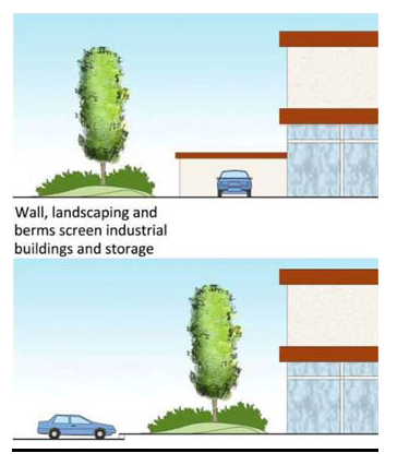
g.
Surface parking lots shall be well-landscaped to reduce heat island effect and visually reduce the expanse of paved area.
h.
Pervious paving materials are strongly encouraged for sidewalks, pathways, and parking lots or other paved surfaces on-site.
i.
An automatic irrigation system using current equipment and technology shall be provided for planted areas.
j.
Run-off retention and on-site water filtration/stormwater treatment features and bioswales should be a part of the overall landscape design, and can also serve as buffering methods for adjacent businesses. See Figure 13.
Figure 13
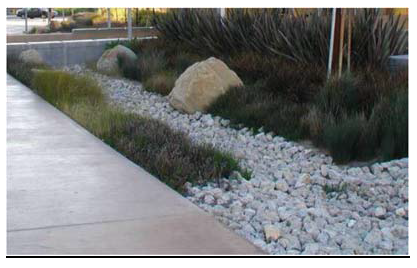
k.
Trees shall be selected and placed to provide canopy and shade for walkways, pedestrian open spaces, and parking areas.
l.
Tree and shrub planting shall be in large masses.
m.
Plant material selected shall be suited to the specific soil and micro climatic conditions.
(Ord. No. 1830, § 8(Exh. A), 6-9-20; Ord. No. 1865, § 8(Att. 2), 3-23-21)
Sec. 30-663.1. - R-4 overlay district regulations.
(a)
Applicability. The provisions of this division shall apply to the parcels specified in Figure 1.
Figure 1
(b)
Relation to underlying zoning. The R-4 overlay district is a flexible designation that is intended to apply as an alternative to the provisions of the underlying zoning.
(c)
Intent. The intent of the R-4 overlay district is to provide areas for the potential development of affordable housing in close proximity to transit routes and convenience uses in recognition of the need for affordable medium/high density housing.
(Ord. No. 1889, § 5(Exh. A), 2-22-22)
Sec. 30-663.2. - Uses permitted.
Any use permitted in the underlying zoning district shall be permitted along with any use listed in Table 30-453 (Uses Permitted Within Mixed Use Development Projects).
(Ord. No. 1889, § 5(Exh. A), 2-22-22)
Sec. 30-663.3. - General development standards and design guidelines.
General. The development standards and design guidelines applicable to the R-4 overlay shall be consistent with the development standards and design guidelines referenced to R-4 as stated in Section 30-445, Section 30-446, Section 30-447, Section 30-448, Section 30-449, Section 30-450, Section 30451, Section 30-452, Section 30-453, Section 30-454, Section 30-455, and Section 30-456 of this Code.
(Ord. No. 1889, § 5(Exh. A), 2-22-22)
Sec. 30-663.4. - Applicability.
The entertainment center overlay district shall apply to all properties within the boundaries as depicted in the maps under Section 30-663.6 of this division. The regulations established in this overlay district amend certain provisions of this Zoning and Development Code, as expressly set forth within this division. Compliance with the Zoning and Development Code and the West End Specific Plan is required. Where inconsistencies arise between the Zoning and Development Code and the West End Specific Plan, the regulations of this overlay district shall govern.
(Ord. No. 1969, § 4(Exh. A), 5-27-25)
Sec. 30-663.5. - Purpose and intent.
(a)
The entertainment center overlay district is intended to create entertainment destinations that attracts both residents and tourists, thereby enchanting the City's economic vitality and cultural appeal. Targeting these planning areas for commercial/entertainment development along with public art generates visits, foot traffic, economic activity and contribute to placemaking.
(b)
The standards and requirements are intended to provide direction to developers within the overlay district to encourage themed entertainment areas to create a sense of place where patrons visit and gather. The requirement of this overlay establishes uses that are conducive to commercial/entertainment along with City of Fontana/Route 66 branding while maintaining flexibility for individual expression and imaginative design solutions.
(Ord. No. 1969, § 4(Exh. A), 5-27-25)
Sec. 30-663.6. - Entertainment center overlay district boundary.
The maps entitled planning areas 1 through 3 are adopted as a part of this overlay district (Figures 1—3) and defines the boundaries of the three planning areas.
Figure 1: Planning Area 1 Valley Boulevard & Sierra Avenue
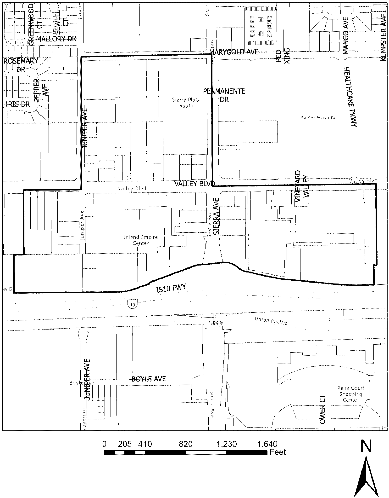
Figure 2: Planning Area 2 Foothill Boulevard & Sierra Avenue
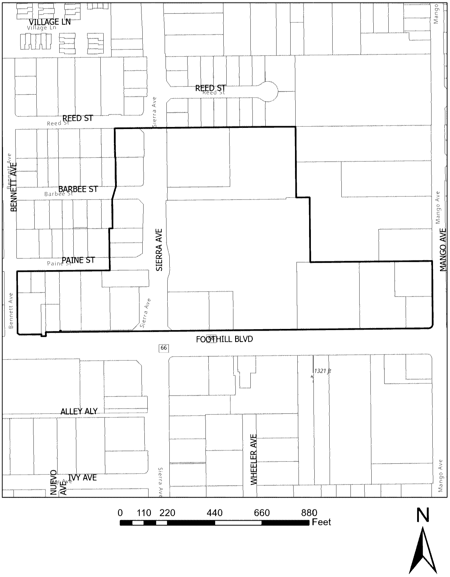
Figure 3: Planning Area 3 Foothill Boulevard & Cherry Avenue
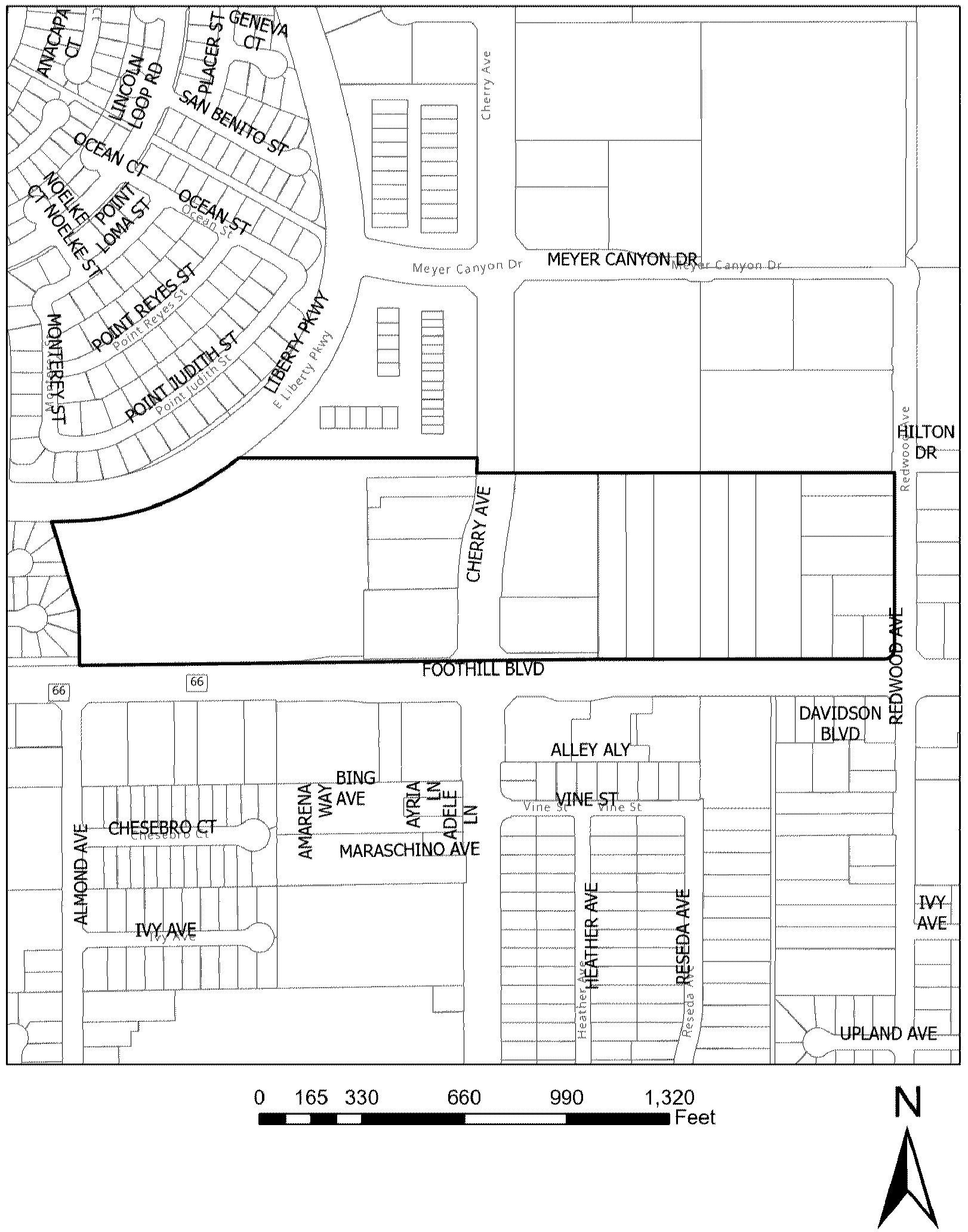
(Ord. No. 1969, § 4(Exh. A), 5-27-25)
Sec. 30-663.7. - Permitted uses.
(a)
Uses marked with an asterisk "*" indicate that the use is not permitted on the ground floor for building(s) that are developed with two or more floors.
(b)
Planning area 1 Valley Boulevard and Sierra Avenue areas.
(1)
Principal permitted uses.
a.
Administrative and professional offices.*
b.
Alcohol beverage sales.
1.
On-site sales (with sit down restaurant—Bona fide public eating place).
c.
Antiques retail sales (excludes pawn shop and subleases).
d.
Art gallery.
e.
Bakery (with primary retail sales).
f.
Cannabis (see Chapter 33).
g.
Cigar sales only (excludes smoke shops).
h.
Florist.
i.
Food hall/food court.
j.
Hotels.
k.
Jewelry sales and repair (excludes pawn shops).
l.
Medical services:
1.
Acupuncture.*
2.
Counseling or psychology.*
3.
Dermatology.*
4.
Hearing aids.*
5.
Homeopathy.*
6.
Medical or dental* (excludes acute care, surgery centers, urgent care, and hospitals).
7.
Optometry sales.*
8.
Physical therapy.*
9.
Sports therapy.*
m.
Multi-family/mixed use development* (only allowed if permitted by underlying zone).
n.
Museums and galleries.
o.
Personal services:
1.
Barber or hair salon.*
2.
Body art (tattooing, body piercing, and/or permanent cosmetics).*
3.
Day spa.
4.
Med spa.*
5.
Nail salon.*
6.
Skin care.*
p.
Pet sales and supplies (without outdoor storage).
q.
Recreation and entertainment.
1.
Batting cages.
2.
Bowling.
3.
Billiards and pool halls.
4.
Commercial recreation (i.e. tennis, go-kart, miniature golf).
5.
Escape rooms.
6.
Game rooms and amusement arcades.
7.
Health and fitness clubs.
8.
Hobby supply stores.
9.
Roller hockey facilities.
10.
Skating.
r.
Restaurant without drive thru facilities (including cafes, ice cream shop, confectionary/dessert shop, and similar).
s.
Retail sales/general merchandise.
t.
Sporting goods and equipment (excludes gun sales).
u.
Studio:
1.
Art.
2.
Cooking classes.
3.
Dance classes.
4.
Martial arts.
5.
Music school.
6.
Recording/film.*
7.
Pilates, yoga, barre.
v.
Theatres (live stage and movie) and concert halls.
w.
Other similar uses which the Director of Planning finds compatible with the permitted uses described herein, consistent with the purpose and intent of the planning area and not a of a type to affect adversely the use of adjoining properties. Application for determination of similar uses shall be submitted to the Planning Department for review and consideration.
(2)
Minor use permit uses.
a.
Alcohol beverage sales.
1.
On-site sales: Bar, lounge, or nightclub (with or without entertainment).
2.
Off-site sales (no tasting room) no convenience store.
3.
On- or off-site sales (with tasting room) no convenience store.
4.
Micro-brewery with tasting room.
5.
Micro-winery with tasting room.
6.
Micro-distillery (spirits) with tasting room.
b.
Café (cyber, animal, gaming).
(3)
Conditionally permitted uses.
a.
Cigar lounge/hookah lounge/smoking room.
b.
Massage/acupressure.*
c.
Nightclub.
d.
Public assembly/auditoriums/meeting halls/religious facilities.
(c)
Planning area 2—Foothill Boulevard and Sierra Avenue.
(1)
Principal permitted uses.
a.
Administrative and professional offices.
b.
Alcohol beverage sales.
1.
On-site sales (with sit down restaurant—Bona fide public eating place).
c.
Antiques retail sales (excludes pawn shop and subleases).
d.
Art gallery.
e.
Bakery (with primary retail sales).
f.
Cannabis (see Chapter 33).
g.
Cigar sales only (excludes smoke shops).
h.
Florist.
i.
Food halls/food court.
j.
Hotels.
k.
Jewelry sales and repair (excludes pawn shops).
l.
Medical services:
1.
Acupuncture.
2.
Counseling or psychology.
3.
Dermatology.
4.
Hearing aids.
5.
Homeopathy.
6.
Medical or dental (excludes acute care, surgery centers, urgent care, and hospitals).
7.
Optometry sales.
8.
Physical therapy.
9.
Sports therapy.
m.
Multi-family/mixed use development* (only allowed if permitted by underlying zone).
n.
Museums and galleries.
o.
Personal services:
1.
Barber or hair salon.
2.
Body art (tattooing, body piercing, and/or permanent cosmetics).*
3.
Day spa.
4.
Med spa.
5.
Nail salon.
6.
Skin care.
p.
Pet sales and supplies (without outdoor storage).
q.
Recreation and entertainment.
1.
Batting cage.
2.
Bowling.
3.
Billiards and pool halls.
4.
Commercial recreation (i.e. tennis, go-kart, miniature golf).
5.
Escape rooms.
6.
Game rooms and amusement arcades.
7.
Health and fitness clubs.
8.
Hobby supply stores.
9.
Roller hockey facilities.
10.
Skating.
r.
Restaurant without drive thru facilities (including cafes, ice cream shop, confectionary/dessert shop, and similar).
s.
Retail sales/general merchandise.
t.
Sporting goods and equipment (excludes gun sales).
u.
Studio:
1.
Art.
2.
Cooking classes.
3.
Dance classes.
4.
Martial arts.
5.
Music school.
6.
Recording/film.
7.
Pilates, yoga, barre.
v.
Theatres (live stage and movie) and concert halls.
w.
Other similar uses which the Director of Planning finds compatible with the permitted uses described herein, consistent with the purpose and intent of the planning area and not a of a type to affect adversely the use of adjoining properties. Application for determination of similar uses shall be submitted to the Planning Department for review and consideration.
(2)
Minor use permit uses.
a.
Alcohol beverage sales.
1.
On-site sales: Bar, lounge, or nightclub (with or without entertainment).
2.
Off-site sales (no tasting room) no convenience store.
3.
On- or off-site sales (with tasting room) no convenience store.
4.
Micro-brewery with tasting room.
5.
Micro-winery with tasting room.
6.
Micro-distillery (spirits) with tasting room.
b.
Café (cyber, animal, gaming).
(3)
Conditionally permitted uses.
a.
Cigar lounge/hookah lounge/smoking room.
b.
Massage/acupressure.
c.
Nightclub.
d.
Public assembly/auditoriums/meeting halls/religious facilities.
(d)
Planning area 3—Foothill Boulevard and Cherry Avenue.
(1)
Principal permitted uses.
a.
Administrative and professional offices.
b.
Alcohol beverage sales.
1.
On-site sales (with sit down restaurant—Bona fide public eating place).
c.
Antiques retail sales (excludes pawn shop and subleases).
d.
Art gallery.
e.
Bakery (with primary retail sales).
f.
Cannabis (see Chapter 33).
g.
Cigar sales only (excludes smoke shops).
h.
Florist.
i.
Food hall/food court.
j.
Hotels.
k.
Jewelry sales and repair (excludes pawn shops).
l.
Medical services:
1.
Acupuncture.
2.
Counseling or psychology.
3.
Dermatology.
4.
Hearing aids.
5.
Homeopathy.
6.
Medical or dental (excludes acute care, surgery centers, urgent care, and hospitals).
7.
Optometry sales.
8.
Physical therapy.
9.
Sports therapy.
m.
Multi-family/mixed use development* (only permitted if allowed by underlying zone).
n.
Museums and galleries.
o.
Personal services:
1.
Barber or hair salon.
2.
Body art (tattooing, body piercing, and/or permanent cosmetics).
3.
Med spa.
4.
Nail salon.
5.
Skin care.
6.
Day spa.
p.
Pet sales and supplies (without outdoor storage).
q.
Recreation and entertainment.
1.
Bowling.
2.
Batting cages.
3.
Billiards and pool halls.
4.
Commercial recreation (i.e. tennis, go-kart, miniature golf).
5.
Escape rooms.
6.
Game rooms and amusement arcades.
7.
Health and fitness clubs.
8.
Hobby supply stores.
9.
Other indoor or outdoor amusement (i.e., go-kart, miniature golf).
10.
Roller hockey facilities.
11.
Skating.
r.
Restaurant without drive thru facilities (including cafes, ice cream shop, confectionary/dessert shop, and similar).
s.
Retail sales/general merchandise.
t.
Sporting goods and equipment (excludes gun sales).
u.
Studio.
1.
Art.
2.
Cooking classes.
3.
Dance classes.
4.
Martial arts.
5.
Music school.
6.
Recording/film.
7.
Pilates, yoga, barre.
v.
Theatres (live stage and movie) and concert halls.
w.
Other similar uses which the Director of Planning finds compatible with the permitted uses described herein, consistent with the purpose and intent of the planning area and not a of a type to affect adversely the use of adjoining properties. Application for determination of similar uses shall be submitted to the Planning Department for review and consideration.
(2)
Minor use permit uses.
a.
Alcohol beverage sales.
1.
On-site sales: Bar, lounge, or nightclub (with or without entertainment).
2.
Off-site sales (no tasting room) no convenience store.
3.
On- or off-site sales (with tasting room) no convenience store.
4.
Micro-brewery with tasting room.
5.
Micro-winery with tasting room.
6.
Micro-distillery (spirits) with tasting room.
b.
Café (cyber, animal, gaming).
(3)
Conditionally permitted uses.
a.
Cigar lounge/hookah lounge/smoking room.
b.
Restaurant drive-thru food establishment.
c.
Massage/acupressure.
d.
Nightclub.
e.
Public assembly/auditoriums/meeting halls/religious facilities.
(Ord. No. 1969, § 4(Exh. A), 5-27-25)
Sec. 30-663.8. - Public art purpose and intent.
(a)
Purpose and intent. Public art are key factors and an important aspect of creating and contributing to a sense of place and themed areas. The purposed and intent of public art is:
(1)
To promote an identity/sense of place for each planning area in the entertainment center overlay district;
(2)
To preserve and enhance the appearance of Fontana [as] a place to live and recreate and as an attraction to visitors who come to visit, shop, eat, or recreate; and
(3)
To set forth a coordinated theme for the overlay districts by requiring an administrative site plan review.
(Ord. No. 1969, § 4(Exh. A), 5-27-25)
Sec. 30-663.9. - Public art.
(a)
Public art definition. Artwork intended for public display and accessible to the general public prepared by an artist. Decorative or functional elements which are designed by the building architect as opposed to an artist are not considered art. Artwork includes but is not limited to a painting, mural, inscription, stained glass, fiber work, statue, relief or sculpture, monument, fountain, arch, or other structures intended for ornament or commemoration. Also included in this definition is any installation that is technological in nature or includes carvings, murals, mosaics, mobiles, photographs, drawings, collages, prints, crafts, both decorative and can include clay, fiber, wood, metal, glass plastics, and other materials. Works of art shall be permanent.
(b)
Applicability. All development projects located within entertainment center overlay district that is subject to a design review is required to provide public art or pay a public art fee.
(c)
Application submittal requirements. An administrative site plan, minor application is required for the installation of public art. The administrative site plan, minor application for the public art shall be submitted in conjunction with the planning entitlements to develop the site and completion of the public art shall be completed prior to certificate of occupancy. As a part of the applications the following items shall be submitted:
(1)
Landscape and/or site plans indicating the location and orientation of the on-site artwork that integrates the artwork into the overall project design;
(2)
A sample, model, photograph or drawings of the proposed on-site artwork;
(3)
Material samples and finishes if appropriate;
(4)
The artist's resume and portfolio of past work, which demonstrates competency with the materials and forms proposed for the on-site artwork proposal;
(5)
A written statement by the artist describing the on-site artwork, as well as a discussion of the manner in which the proposed on-site artwork meets the findings established by Section 30-663.9(f);
(6)
A maintenance plan for the maintenance of the on-site artwork; and
(7)
Any such additional information or material as may be required by the Planning Director.
(d)
Requirements for public art.
(1)
Planning area 1—Valley Boulevard and Sierra Avenue areas. artwork in planning area 1 is required to contributes to Fontana historical agricultural or steel mill (Henry J. Kaiser's) themes.
(2)
Planning area 2—Foothill Boulevard and Sierra Avenue and Planning area 3—Foothill Boulevard and Cherry Avenue. Artwork in planning areas 2 and 3 shall incorporate a Route 66 theme.
(3)
Public art can incorporate elements that also serve a specific function (such as fencing, railing, lighting, or gates) but in order to be considered public art, they must be designed by a professional visual artist and custom fabricated for the site and visible from public views.
(4)
Materials, structural and surface components that are inherently resistant to theft, vandalism, weathering, and excessive maintenance or repair costs shall be utilized.
(5)
Location. Public art must be located in areas clearly visible from the public street or sidewalk, in publicly accessible outdoor areas, or public accessible lobby areas.
(e)
Disqualifying characteristics for public art:
(1)
Directional elements such as super graphics or signage are not allowed except where these elements are: integral parts of the original artwork, executed by the artist in unique or limited editions, contribute to a Route 66/Fontana theme as required in the planning areas as required in Section 30-663.9(e)a and b.
(2)
Artwork that incorporates the tenant/business logos, branding, images, text or other elements that relate directly to a specific business's or organization's branding or marketing themes is not permitted.
(3)
Art objects which are mass-produced and of standard design such as playground equipment, trellises, or fountain pieces are not permitted.
(4)
Decorative or functional elements which are designed by the building architect as opposed to an artist are not permitted.
(5)
Landscape design except where it is designed by an artist and is integral part of the artwork are not permitted.
(6)
Temporary art exhibitions are not permitted.
(f)
Findings of approval for administrative site plan, minor.
(1)
The artist has demonstrated qualifications to complete the proposed on-site artwork with the highest professional standards.
(2)
The artwork contributes to the themes and meetings the requirements of Section 30-663.9(d).
(3)
There is sufficient public visibility and accessibility to the on-site artwork, and the proposed on-site artwork is compatible with and harmonious with the development project and surrounding environment.
(4)
The proposed on-site artwork is durable and cost effective to maintain using ordinary methods of maintenance.
(5)
The budget for the proposed on-site artwork and any in-lieu fees proposed by the applicant is equivalent to or exceeds the required program allocation.
(g)
All property owners are responsible for maintaining the artwork in clean, undamaged condition for the lifetime of the artwork.
(h)
Public art example.
(1)
Figure 1.
(Ord. No. 1969, § 4(Exh. A), 5-27-25)