
Fruita City Zoning Code
CHAPTER 17
03 - ZONING DISTRICTS
17.03.010 - GENERALLY.
In order to ensure that all development is consistent with the goals and objectives of the Fruita Comprehensive Plan and this chapter, it is necessary and proper to establish a series of zone districts to ensure that each permitted and conditional use is compatible with surrounding land uses, is served by adequate public facilities and is consistent with the natural environment and natural resources surrounding the City.
A.
Unless expressly exempted, all regulations in this chapter are subject to provisions of other applicable City, county, or state laws and regulations, and where the provisions of this chapter impose a greater restriction than required by other land use regulations, the provisions of this title shall govern.
B.
In their application and interpretation, the provisions of this chapter shall be considered minimum requirements. Nothing herein shall impair the obligations of or interfere with private agreements or covenants in excess of the minimum requirements. Where this title imposes a greater restriction than that imposed by existing contract, covenant or deed, the provisions of this title shall control.
C.
District graphics depicting basic dimensional requirements shall be used for reference only. Dimensions shall be measured as defined in text of this title, including exceptions, development standards, and definitions for terms of measurement (height, setbacks, lot, etc.).
(Ord. 2021-06 [17.07]; Ord. 2021-21)
17.03.020 - ZONE DISTRICTS ESTABLISHED.
The City is hereby divided into several zones.
A.
Base Zone Districts. Base zone districts are established initially by the adoption of the City's Official Zone District Map and subsequently approved through a rezoning (see Section 17.09.070). Such approval authorizes the full range of development allowed by the standards applicable to the base zone district.
1.
Within certain base zone districts, there are illustrations to articulate the different dimensional allowances. Illustrations are intended only to show general characteristics of the dimensional requirements in a zone district, and do not show specific requirements related to locations or buildings. If a standard shown in an illustration is inconsistent with the respective table of dimensional standards, the standards in the table shall govern.
B.
Overlay Zone Districts. Overlay zone districts are established initially by the adoption of the City's Official Zone District Map and subsequently approved through a rezoning (see Section 17.09.070). These zones are superimposed over one (1) or more underlying base zone districts or planned unit development zone districts.
C.
Planned Unit Development Districts. Planned unit development (PUD) districts are established by the City's approval of a PUD rezoning (see Section 17.19). Development in a PUD district is subject to the standards included in or referenced in an approved PUD plan.
D.
Future Land Use Districts. Future land use districts are intended for lands not currently within City limits, but will be used to coordinate planning activities with the County and for annexations.
(Ord. 2002-27; Ord. 2004-19; Ord. 2016-04; Ord. 2021-06, [17.07]; Ord. 2021-21)
17.03.030 - OFFICIAL ZONE DISTRICT MAP.
The location and boundaries of the zones established by this chapter are shown on the "Official Zone District Map" of the City of Fruita. Said Official Zoning Map, together with all data shown thereon and all amendments thereto, is, by reference, hereby incorporated into this chapter. Changes in zones shall be made according to the requirements of this title.
A.
Zone District Boundaries. Except where otherwise indicated, zoning boundaries shall follow municipal corporation limits, section lines, lot lines, centerlines of watercourses, and right-of-way centerlines or extensions thereof.
1.
In unsubdivided land or where a zoning boundary divides a lot or parcel, the location of such boundary, unless indicated by dimensions, shall be determined by scale of the Official Zoning Map.
2.
Where a zoning boundary coincides with a right-of-way line and said right-of-way is subsequently abandoned, the zoning boundary shall then follow the zoning of the property to which the vacated right-of-way is connected.
3.
Land not part of public rights-of-way and which is not indicated as being in any zoning boundary shall be considered to be included in the most restrictive abutting zone, even when such zone is separated from the land in question by a public right-of-way.
4.
When any parcel of land contains more than one (1) Base Zone District, the more restrictive requirements shall apply.
B.
Boundary Clarifications. When there is a discrepancy on the map or the map does not reflect recent changes, the Director shall determine the zone district boundary. Any appeal of the Directors determination of a zone district boundary shall be heard by the City Council per Chapter 17.25.
(Ord. 2002-27; Ord. 2003-13, S7; Ord. 2004-19; Ord. 2016-04, S1; Ord. 2021-06, [17.07]; Ord. 2021-21)
17.03.040 - APPLICATION OF ZONE DISTRICT REGULATIONS.
Except as hereinafter provided, within the municipal boundaries of the City:
A.
No building or structure shall be erected or placed and no existing building or structure shall be moved, removed, altered or extended, nor shall any land, building or structure be used for any purpose or in any manner other than as provided among the uses listed in Chapter 17.05 (Land Use/Zoning Table) and the zoning requirements and regulations for the zone in which such land, building or structure is located.
B.
No building or structure shall be erected or placed nor shall any existing building or structure be moved, removed, altered, replaced or extended, nor shall any open space surrounding any building or structure be encroached upon or reduced in any manner except in conformity with the lot area, lot coverage, setback and height provisions set forth in the zone in which such land, building or structure is located.
C.
No lot area, frontage, yard or other open space or parking space provided around any building or structure for purposes of compliance with provisions of this title shall be considered as providing lot area, frontage, yard or other open space for any other building or structure on the same lot or on any other lot.
D.
Wastewater Access.
1.
Connection to the City's wastewater collection and treatment system is required for all single-family residential lots smaller than three (3) acres in size. Larger lots may be required for multi-family and non-residential developments that do not connect to the City's wastewater collection and treatment system. All uses with existing individual sewage disposal systems that require repair or replacement or are part of a larger development plan and are within four hundred (400) feet of the existing City wastewater collection system, as measured to the closest property line, shall connect to the City system. All property to be annexed with existing land uses using individual sewage disposal systems must connect to the City wastewater collection system if they are within four hundred (400) feet or will be within four hundred (400) feet of a City wastewater collection system once the development to be annexed is completed. For developments without access to the City's sanitary sewer system (farther than four hundred (400) feet away), the minimum lot size is required to be no less than three (3) acres. Larger lots may be required for certain non-residential land uses. There may be no more than one (1) septic system on any single parcel.
E.
Schedule of Density/Height/Bulk/Location Requirements in Zones.
1.
Maximum or desired density may not be achievable on every lot or parcel, as the development must conform to applicable setbacks, coverage, parking, drainage, public improvements, landscaping and other code requirements.
2.
For the purpose of calculating density in the DMU, one-half of the land area of all adjoining rights-of-way may be included in the gross lot area. The area of the right-of-way shall not be included to determine compliance with minimum lot area requirements, setbacks, or any other required measurement.
3.
Standards containing a slash (x/y) indicate standards for primary buildings (x) and accessory buildings (y).
4.
Accessory buildings can be up to the maximum height limit for the zone when located within the primary building setbacks.
5.
Lot coverage requirements do not apply to townhouses or condominiums, which instead are determined through the subdivision process.
6.
All lots shall have access from the street.
7.
Structures, lots, and land uses lawfully established prior to the effective date of this Code may continue pursuant to Chapter 17.27.
8.
The abbreviation "du" or "DU" refers to dwelling units per acre.
(Ord. 2002-27; Ord. 2004-19; Ord. 2016-04; Ord. 2021-06, [17.07]; Ord. 2021-21)
17.03.050 - RESIDENTIAL ZONE DISTRICTS.
Residential zone districts are established to provide for a variety of neighborhoods in a range of densities to accommodate the different character areas of the City. These are considered base zone districts.
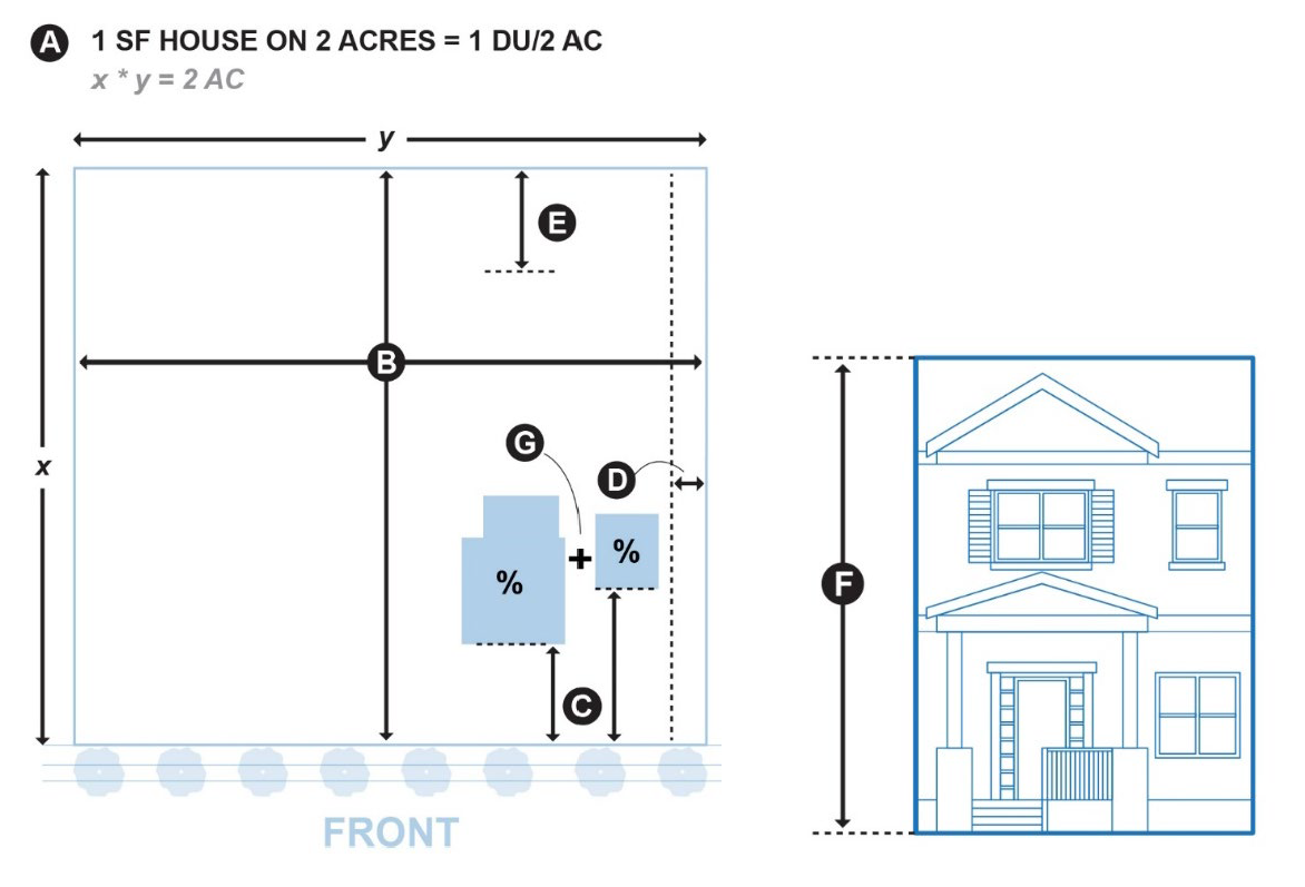
A.
Rural Estate (RE). The purpose of the RE zone is to allow low density residential uses compatible with rural areas. Areas in this zone district serve as a transition between open and resource lands and increased development in the City. Cluster developments are not encouraged in this zone district, and City sewer is not typically provided due to the low density nature of the development.
1.
Dimensional and Other Standards.
2.
Illustrations.
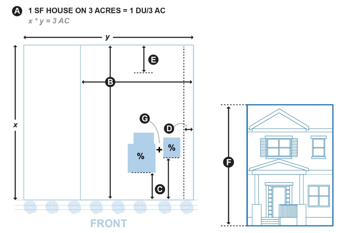
3.
On properties that are used mainly for agricultural uses in the Rural Estate (RE) zone any structures used mainly for agricultural purposes (e.g., silos and barns) are exempt from the height limits for structures.
B.
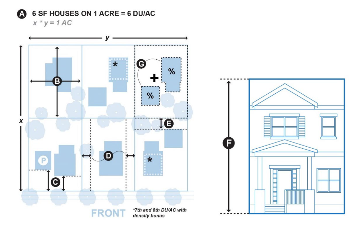
Community Residential (CR). The purpose of the CR zone is to allow for moderate density detached single-family residential neighborhoods with the inclusion of other housing types such as attached dwelling units (e.g. apartments and townhouses). Innovative neighborhood design is encouraged in this zone district to provide opportunities for housing diversity. This area is served by public utility infrastructure and is appropriate for density of four (4) to eight (8) DU per acre.
1.
Dimensional and Other Standards.
2.
Illustrations.
C.
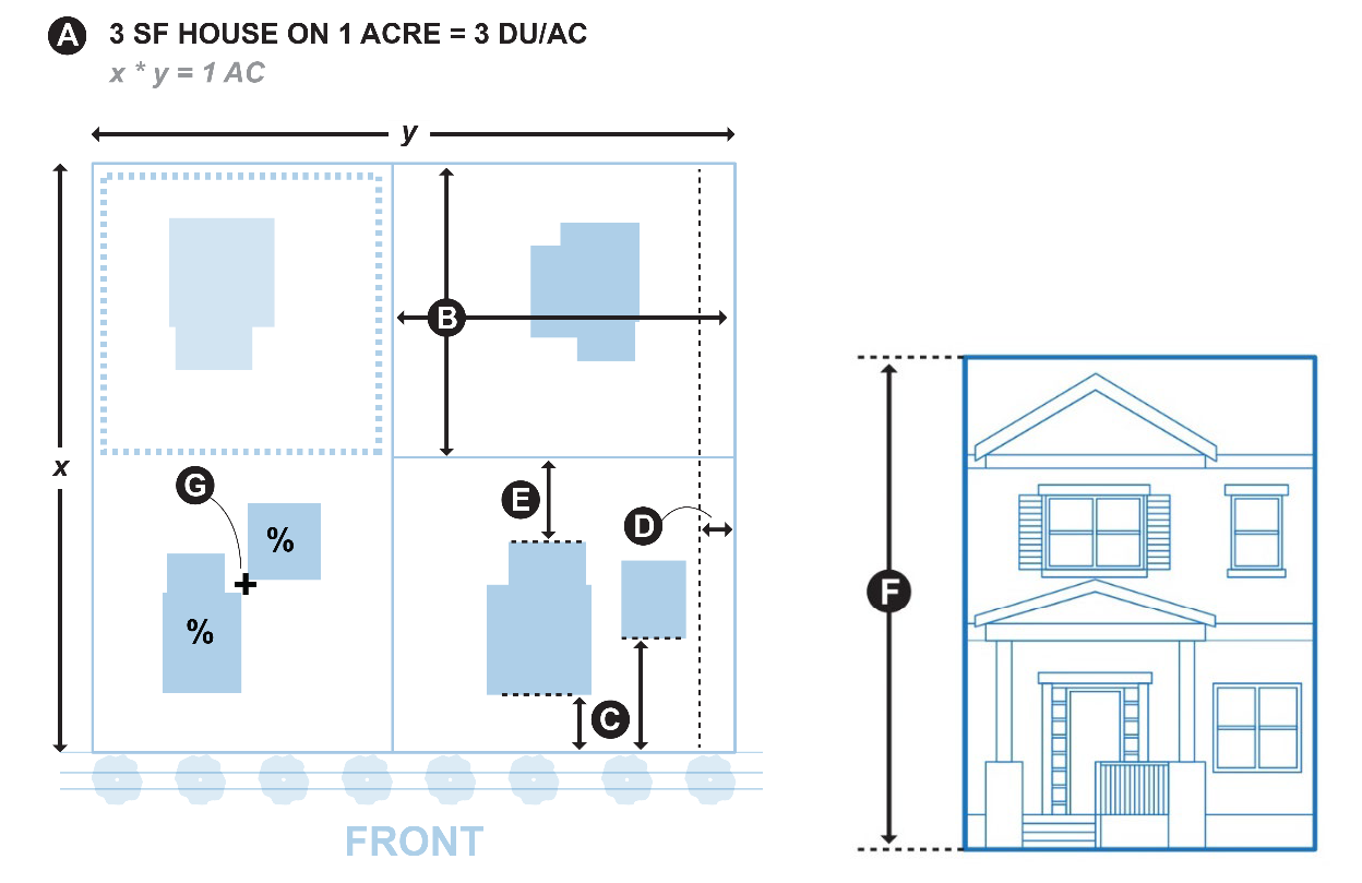
Large Lot Residential (LLR). The purpose of the LLR zone is to allow larger lot developments in the same areas as the CR zone and other areas as appropriate. Areas in this zone district are typically served by public utility infrastructure, and a density of two (2) to three (3) DU per acre is appropriate.
1.
Dimensional and Other Standards.
2.
Illustrations.
D.
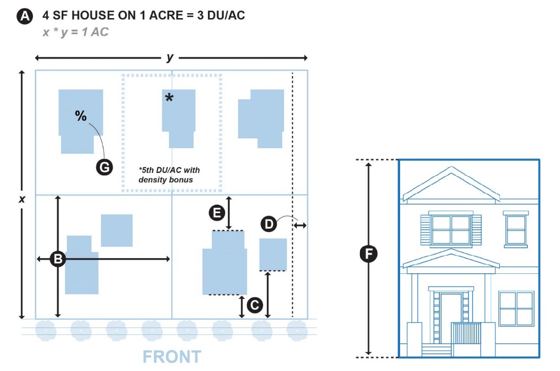
South Fruita Residential (SFR). The purpose of the SFR zone is to allow a variety of low to moderate density residential areas compatible with existing low density development, the Colorado National Monument and the Colorado River. Due to its location near the Colorado River and in the one hundred-year flood plain, the area is most suitable to a density of two (2) to five (5) DU per acre.
1.
Dimensional and Other Standards.
2.
Illustrations.
E.
Monument Preservation (MP). The MP zone is intended to provide a recreational and environmental buffer between the Colorado National Monument and Bureau of Land Management lands, and urban development with low intensity uses that preserve open space quality. This zone district should be limited to areas immediately adjacent to the Colorado National Monument. Environmentally constrained lands are not appropriate for this zone district.
1.
Dimensional and Other Standards.
2.
Illustrations.
(Ord. 1996-30 S1 S2 S3 S6; Ord. 2002-27; Ord. 2003-13, S2 S3 S4; Ord. 2004-19; Ord. 2016- 04 Ord. 2021-06, [17.07]; Ord. 2021-21)
17.03.060 - COMMERCIAL AND MIXED-USE ZONE DISTRICTS.
Commercial and Mixed-Use zone districts are established to provide for a variety of commercial areas suited to the difference neighborhoods and commercial needs if the City. The intent of these zones is to consolidate complimentary commercial uses in areas or nodes that are served by roads and sidewalks. These are considered base zone districts.
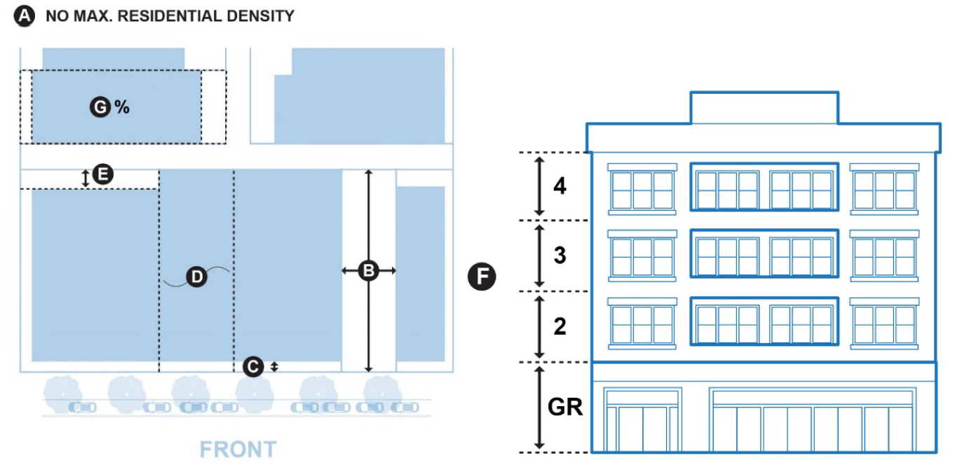
A.
Downtown Mixed Use (DMU). The purpose of the DMU zone is to maintain and enhance downtown as a vibrant, pedestrian-oriented commercial and residential area and as the civic heart of the community. Mixed-use development, such as commercial on the ground floor and residential above the ground floor is encouraged within this zone. The intent of this zone with regard to housing is to allow existing residential uses and provide housing options within walking distance of commercial and civic uses without compromising the integrity of the downtown commercial core.
1.
Dimensional and Other Standards.
2.
Illustrations.
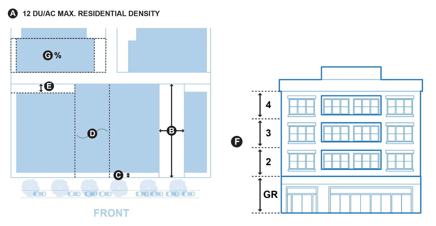
B.
Commercial-1 (C-1). The C-1 zone is intended for land uses that are compatible with the future vision for the State Highway 6/50 Corridor. The area is appropriate for local-serving businesses such as restaurants, retail stores, and services. Multi-family residential uses are encouraged in this zone. Development should have appropriate access, landscaping, frontage improvements, setbacks, screening and multi-modal access and connectivity.
1.
Dimensional and Other Standards.
2.
Illustrations.
C.
Commercial-2 (C-2). The C-2 zone is intended to accommodate commercial development in appropriate areas with appropriate access, landscaping, frontage improvements, setbacks, screening and multi-modal access and connectivity. This zone district provides allowances for uses and dimensions that are larger in scale than those allowed downtown.
This area has good access to I-70, and is appropriate for uses that serve residents, tourists, an pass-through traffic. Parcel sizes are larger than in the downtown and C-1 zone district, and may accommodate more parking.
1.
Dimensional and Other Standards.
2.
Illustrations.

(Ord. 1996-30 S4 S6; Ord. 2002-27; Ord. 2003-13, S5; Ord. 2004-19; Ord. 2016-04; Ord. 2018-26; Ord. 2021-06, [17.07]; Ord. 2021-21)
17.03.070 - INDUSTRIAL ZONE DISTRICTS.
The Industrial Zone District is established to encourage non-polluting industrial and research and development activities designed to meet acceptable state and locally established standards for noise, dust, effluent (e.g., sewage pre-treatment), odor, and other impacts typically associated with industrial uses. These are considered Base Zone Districts.
A.
Dimensional and Other Standards.
(Ord 1996-30 S6; Ord. 2004-19; Ord. 2021-06 [17.07]; Ord. 2021-21)
17.03.080 - GOVERNMENT ZONE DISTRICTS.
Special zone districts provide opportunities for community facilities as well as preservation of critical open spaces and habitats. These are considered Base Zone Districts.
A.
Community Services and Recreation (CSR). The purpose of the CSR zone is to provide public and private recreational land, facilities, schools, fire stations, libraries, fairgrounds and other public and quasi-public lands and buildings. The zone includes open space areas, which are set aside to prevent environmental damage to sensitive areas and to limit development in areas that are unsuitable for development due to flooding or geologic hazards. The CSR zone may be applied to parks, outdoor recreation facilities, open space corridors, environmental areas, trails, recreational facilities, and similar areas. The CSR zone helps implement the open space, trails and parks policies of the City's Master Plan.
1.
Dimensional and Other Standards.
(Ord. 2002-27; Ord. 2003-13, S6; Ord. 2004-19; Ord. 2016-04 S1 Ord. 2018-11 S2; Ord. 2021-06, [17.07]; Ord. 2021-21)
17.03.090 - OVERLAY ZONE DISTRICTS.
Overlay zone districts are superimposed over portions of one (1) or more underlying base zone districts or PUD districts in order to supplement those regulations with additional standards that address area-specific conditions, features, or plans.
A.
Neighborhood Commercial Overlay (NCO). The Neighborhood Commercial Overlay provides for additional commercial businesses in certain portions of the DMU and Zone District. This overlay is intended to enable small-scale businesses that fit in the neighborhood context, by allowing a diversity of business uses.
1.
Dimensional and other standards
(Ord. 2021-06, [17.07]; Ord. 2021-21)
17.03.100 - PLANNED UNIT DEVELOPMENTS.
Planned Unit Developments (PUDs) are created to allow maximum flexibility in uses and dimensions in exchange for community benefits by designing quality developments that could not be achieved by strict adherence to the requirements of this title. PUDs shall be approved pursuant to the requirements in Section 17.19.
A.
Modification of Development Standards.
1.
At the time of zoning a PUD, the City Council may modify the specifications, standards, or requirements of this title. The PUD approval shall indicate which standards are being modified, and any standard not listed as being modified shall be assumed to use that of the base zone district or overlay zone district.
2.
At the time of zoning a PUD, the City Council may modify the permitted and prohibited uses. If uses are not modified, the uses in a PUD shall comply with those of the base zone district and overlay zone district.
(Ord. 2002-27; Ord. 2004-19; Ord. 2021-06, [17.07]; Ord. 2021-21)
17.03.110 - FUTURE LAND USE DISTRICTS.
Future land use districts are created as a planning tool to address the City's three (3) mile planning area.
A.
Future Land Use (FLU). The purpose of the FLU zone is to enable planning for future annexations and to coordinate development pressures and planning needs with Mesa County. Development parameters are intended to support large lots and agricultural uses and allow low density residential uses compatible with rural areas.
1.
Dimensional and Other Standards.
2.
On properties that are used mainly for agricultural uses in, any structures used mainly for agricultural purposes (e.g., silos and barns) are exempt from the height limits for structures.
(Ord. 2016-04, S1; Ord. 2021-06, [17.07]; Ord. 2021-21)