
Georgetown City Zoning Code
CHAPTER 11
ENVIRONMENTAL PROTECTION
SECTION 11.01.- PURPOSE
A.
This chapter is adopted to provide environmental protection within the City's jurisdiction and protect the natural and ecological resources that are essential elements of the City's health and community character by reducing negative impacts from the following concerns:
1.
Paved surfaces, automobiles, buildings, and other improvements produce increases in air temperatures, a problem especially noticeable in this southern region, whereas plants have the opposite effect through transpiration and the creation of shade.
2.
Likewise, impervious surfaces created by development generate greater water runoff causing problems from contamination, erosion, and flooding. Preserving and improving the natural environment and maintaining a working ecological balance are of increasing concern.
3.
The fact that the use of landscape elements can contribute to the processes of air purification, oxygen regeneration, water absorption, water purification, and noise, glare and heat abatement as well as the preservation of the community's aesthetic qualities indicates that the use of landscape elements is of benefit to the health, welfare, and general well being of the community and, therefore, it is proper that the use of such elements be required.
B.
In addition to the requirements of this chapter, environmental preservation is directly or indirectly addressed in other chapters of this Unified Development Code, including but not limited to Chapter 8, Tree preservation, landscaping, and fencing; and Section 13.05, Parkland.
SECTION 11.02. - IMPERVIOUS COVER
These impervious cover limitations are adopted to minimize negative flooding effects from stormwater runoff and to control, minimize, and abate water pollution resulting from urban runoff of rainwater or other non-point specific sources, pursuant to Texas Water Code § 26.177.
SECTION 11.04. - STORMWATER MANAGEMENT SYSTEM REQUIREMENTS
No Site Plan, plat, subdivision, or Stormwater Permit may be approved unless the project meets the minimum requirements of this Code in making adequate provision for control of the quantity of stormwater runoff to the benefit of both future owners of property within the subdivision and other lands within the watershed.
SECTION 11.06. - CONSERVATION SUBDIVISIONS
This section is intended to encourage conservation subdivisions within the City limits and the City's ETJ in order to protect natural resources, conserve valuable open space, reduce erosion and sedimentation, preserve riparian corridors, provide for walking trails, protect the community water supplies, reduce infrastructure, preserve prime agricultural land, provide smaller streets with less environmental disturbance, and plan for overall watershed protection. In an effort to achieve these goals, the City is encouraging developments in areas that are intended for low-density single-family residential to be designed in a manner consistent with the conservation design standards outlined below.
SECTION 11.07. - WATER QUALITY REGULATIONS FOR PROPERTY LOCATED OVER THE EDWARDS AQUIFER RECHARGE ZONE[1]
Editor's note— Ord. No. 2015-14, § 3(Exh. A), adopted February 24, 2015, repealed and reenacted Section 11.07 in its entirety to read as herein set out. Formerly, Section 11.07 pertained to similar subject matter, and derived from Ord. No. 2014-103, § 3(Exh. A), adopted December 9, 2014. To preserve the style of this Unified Development Code, and at the discretion of the editor, the provisions originally enacted by Ord. No. 2015-14 as Sections 11.07.001—11.07.008 have been redesignated as Sections 11.07.010—11.07.080.
Sec. 11.01.010. - Authority.
The provisions of this chapter are adopted pursuant to Texas Local Government Code chs. 211 and 212, Texas Water Code, Texas Health and Safety Code, the rules and regulations of the Texas Commission on Environmental Quality, the United States Environmental Protection Agency, and the City Charter.
Sec. 11.01.020. - Applicability.
All development in the City and extraterritorial jurisdiction shall comply with the impervious cover limitations and stormwater control requirements and tree/natural resource preservation requirements of this section and Chapter 8.
Sec. 11.01.030. - Compliance.
A.
Within City.
Compliance with the requirements of this chapter will be achieved in the City through Site Plan review and Stormwater Permit approval for any new development project, and by requiring any compliance during Subdivision Plat review.
B.
Within Extraterritorial Jurisdiction.
Compliance with the requirements of this chapter will be achieved in the extraterritorial jurisdiction of Georgetown through Stormwater Permit approval for a development project and by requiring any compliance during Subdivision Plat review.
Sec. 11.02.010. - Impervious Cover Limitation.
Impervious cover limitations apply to all properties in the city limits and the city's extraterritorial jurisdiction (ETJ).
A.
Non-Residential Development.
Non-residential development in the City limits shall follow the provisions below. All development in the ETJ shall follow the provisions in Section 11.02.010.C. below.
1.
Over the Edwards Aquifer.
If the property is located over the Edwards Aquifer Recharge or Contributing Zones, the maximum impervious coverage for the subdivision must follow the calculation described in Subsections a., b., and c. below. Once the maximum percentage for the gross subdivision has been determined, the plat shall denote the maximum per lot within the subdivision. Within a subdivision, impervious cover percentages per lot may vary, provided that the subdivision maximum, per the following calculation, is not exceeded.
a.
Subdivisions Less Than or Equal to Five Acres: The impervious cover maximum allowance is 70 percent (70%).
b.
Subdivisions Greater Than Five Acres: For subdivisions greater than five acres, the impervious cover maximum allowance changes with the total acreage of the subdivision. The impervious cover maximum is 70 percent (70%) of the first five acres and 55 percent (55%) of the remaining acreage, as shown below:
Impervious Cover % = [0.70 x 5 acres] + [0.55 x (Total Acreage - 5 acres)] / Total Acreage x 100
c.
For properties over the Edwards Aquifer Recharge or Contributing Zones, waivers to the 55 percent (55%) limit may be granted in accordance with Section 11.02.020, but in no case shall the gross impervious cover exceed 70 percent (70%) including all waivers.
d.
For properties in the Downtown Overlay District, impervious cover may be increased to 95 percent (95%) if approved by the Development Engineer based on capacity in the downtown regional stormwater ponds.
2.
Not Over the Edwards Aquifer.
If the property is not located over the recharge or contributing zones, the maximum allowable impervious cover percentages in Table 11.02.010 shall apply. All maximum percentages are established by district, regardless of use.
Table 11.02.010.A: Impervious Cover (max. %) for Non-Residential Zoning Districts
3.
Exceptions to Non-Residential Limitations.
a.
Impervious cover credits are established for all properties, regardless of size and location, in Section 11.02.010.D. below.
b.
For conservation subdivisions in non-residential zoning districts, a bonus of ten percent (10%) per subdivision is granted for all properties. For example, 60 percent (60%) where the maximum is 50 percent (50%) or 80 percent (80%) where a zoning district maximum is 70 percent (70%).
c.
For properties in MU or TOD Districts, the standards established Section 4.07.040 and Section 4.11 shall govern in lieu of Table 11.02.010.
B.
Residential Development.
Residential development in the City limits shall follow the provisions below. All development in the ETJ shall follow the provisions in Section 11.02.010.C. below.
1.
Except as provided in Subsections 2.b. and 2.c. below, impervious cover for development located in residential zoning districts shall be calculated on a per subdivision basis and shall not exceed the limits set forth in Table 11.02.010.B. All maximum percentages are established by district, regardless of use. The limits in Table 11.02.010.B apply to all development located in residential zoning districts over any part of the Edwards Aquifer in the table below.
Table 11.02.010.B: Impervious Cover (max. %) for Residential Zoning Districts
2.
Exceptions for Residential Zoning Districts.
a.
Impervious cover credits are established for all properties, regardless of size and location, in Subsection D. below.
b.
For Conservation Subdivisions in Residential Zoning Districts, a bonus of ten percent (10%) per subdivision is granted for all properties.
c.
For Workforce Housing Development in MF-1 or MF-2 Districts, a bonus of up to twenty percent (20%) per site is granted with the provision of twenty percent (20%) of the units restricted as Workforce Housing.
C.
Within the ETJ.
Properties located in the ETJ must comply with the following provisions:
1.
Over Edwards Aquifer.
If the property is located over the Edwards Aquifer Recharge or contributing zones, the following shall apply:
a.
Single-family residential development without public wastewater service shall not exceed 40 percent (40%) impervious cover. Single-family and two-family residential development with public wastewater service shall not exceed 45 percent (45%) impervious coverage.
b.
Non-residential development shall follow the subdivision calculation described in subsections i., ii., and iii. below. Once the maximum percentage for the gross subdivision has been determined, the plat shall denote the maximum per lot within the subdivision. Within a subdivision, impervious cover percentages per lot may vary, provided that the subdivision maximum, per the following calculation, is not exceeded.
i.
Subdivisions Less Than or Equal to Five Acres: The impervious cover maximum allowance is 70 percent (70%).
ii.
Subdivisions Greater Than Five Acres: For subdivisions greater than five acres, the impervious cover maximum allowance changes with the total acreage of the subdivision. The impervious cover maximum is 70 percent (70%) of the first five acres and 55 percent (55%) of the remaining acreage, as shown below:
Impervious Cover % = [0.70 x 5 acres] + [0.55 x (Total Acreage - 5 acres)] / Total Acreage x 100
iii.
For properties over the Edwards Aquifer Recharge or Contributing Zones, waivers to the 55 percent (55%) limit may be granted in accordance with Section 11.02.020, but in no case shall the gross impervious cover exceed 70 percent (70%), including all waivers.
2.
Not Over Edwards Aquifer.
a.
Single-family residential development without public wastewater service shall not exceed 40 percent (40%) impervious cover. Single-family and two-family residential development with public wastewater service shall not exceed 45 percent (45%) impervious coverage.
b.
All other development shall not exceed 70 percent (70%) impervious coverage.
D.
Impervious Cover Credits.
1.
Credit for Parkland.
Parkland to be dedicated shall be counted toward pervious area.
2.
Credit for Arterial and Major Collector Streets.
The area of arterial and major collector streets shown on the thoroughfare plan and located within the subdivision shall be deleted from the calculation of gross area and impervious cover.
3.
Credit for Residential Swimming Pools.
For RE, RL and RS Districts, 100 percent (100%) of the square footage of the water surface area of a residential swimming pool shall be counted as a pervious surface. This does not include the apron of the pool, surrounding patio, or decking, all of which will count towards the impervious cover total.
4.
Credit for Places of Worship.
Impervious coverage for places of worship, for the RL, RE, RS, TF, TH, and MF Districts, shall be a maximum of 55 percent (55%). This coverage can be increased to a maximum of 70 percent (70%) provided the development meets the waiver criteria in Section 11.02.020. Places of worship in all other circumstances shall follow the applicable requirements of Section 11.02.
5.
Credit for Public Trails and Sidewalks.
Public trails and sidewalks do not count against the maximum impervious cover percentage but shall be accounted for in stormwater calculations.
(Ord. No. 2014-30, § 2(Exh. A), 5-27-2014; Ord. No. 2016-17, § 2(Exh. A), 3-8-2016; Ord. No. 2017-15, § 2, 2-28-2017; Ord. No. 2025-54, § 5(Exh. D), 9-9-2025)
Sec. 11.02.020. - Waiver of Impervious Cover Limitations.
The Director shall increase the amount of impervious cover as specifically listed below, upon verification by the Development Engineer that the development meets the waiver criteria. No combination of waivers may allow impervious cover to exceed the maximum provided. Partial credit of each of the following waivers may be granted.
A.
Approved Waivers.
1.
Low Impact Site Design (Seven Percent (7%)).
a.
The Director shall increase the amount of permitted impervious cover by seven percent (7%) if the development provides low impact development site design features such as:
i.
Dry wells or infiltration trenches to capture rooftop and driveway runoff;
ii.
Rainwater harvesting;
iii.
Preserving stream buffers and riparian corridors;
iv.
Bio-retention facilities placed around the perimeter of parking lots;
v.
Wet ponds; and
vi.
Using grassed filter strips and vegetated swales in place of traditional curb-and-gutter type drainage systems.
b.
The low impact site design features above must meet the following provisions:
i.
Accepted low impact development designs must be utilized, following the guidelines and standards adopted by the Texas Commission on Environmental Quality.
ii.
The applicant is responsible for providing sufficient design information for the Development Engineer to examine and verify the improvement.
iii.
The applicant must provide a binding maintenance agreement.
2.
Parking Lot Design (Five Percent (5%)).
The Director shall increase the amount of permitted impervious cover by five percent (5%) if the development provides a parking lot design that breaks up the parking area into areas separated by planted or natural landscaping features. The applicant must provide an alternative parking plan as described in Section 9.02.050, and may be able to also receive a reduction of required off-street parking requirements if approved by the Director.
3.
Preservation of Natural Areas (Seven Percent (7%)).
The Director shall increase the amount of permitted impervious cover by seven percent (7%) if the development retains all of its buffer areas in natural preserve areas, and provides an agreement that such areas shall not be irrigated, fertilized, or insecticide or herbicide applied to such areas. Where additional landscaping in buffer or other common areas is required, such landscaping shall meet xeriscaping standards for low water use. Buffer areas will prevent erosion, trap sediment, filter runoff and function as a floodplain in high water periods and where adjacent to creeks or rivers.
4.
Over-Provision of Landscaping (Three Percent (3%)).
The Director may consider an increase to the amount of permitted impervious cover by three percent (3%) if the development exceeds the total amount of landscaping plants and trees required by Section 8.04 by 30 percent (30%). The types of plants and trees shall be a mix of annuals and perennials, evergreen and deciduous and may be planted anywhere on the site.
5.
Tree Preservation (Five Percent (5%)).
The Director shall increase the amount of permitted impervious cover up to five percent (5%) for the preservation of protected trees beyond the amount required by Subsection 8.02.030.E. A one percent (1%) increase in impervious cover may be granted for each percentage of protected trees preserved beyond the minimum required. For example, a site required to preserve a minimum of 30 percent (30%) of total protected trees may receive a three percent (3%) impervious cover bonus by preserving 33 percent (33%) of the protected trees on a site. Preserved trees meeting the definition of this waiver shall be included and identified in the tree preservation plan and shall meet all other applicable provisions of Chapter 8. The maximum impervious cover shall not exceed that specified in Section 11.02.010.
6.
Landscaping in the Extraterritorial Jurisdiction (Seven Percent (7%)).
The Director may consider an increase to the amount of permitted impervious cover by seven percent (7%) for development in the extraterritorial jurisdiction that shows compliance with the landscaping requirements of Section 8.04.
7.
Plant Materials Classified as Low Water Users (Three Percent (3%)).
The Director may consider an increase in the amount of permitted impervious cover by up to three percent (3%) for the use of plant materials classified as low water users. A one percent (1%) increase in impervious cover may be granted for every additional ten percent (10%) of the total plants used classified as low water users.
B.
Low Impact Construction Practices Required.
Any reduction in impervious cover limitations by the Director will require that the applicant utilize TCEQ (Texas Commission on Environmental Quality or successor agency) temporary erosion control practices during construction. Such practices will minimize disturbance to only areas that are undergoing active construction and avoid compaction of lawns and greenways with construction equipment. Specification notes shall be included on the Construction Plans delineating compliance with these requirements.
(Ord. No. 2021-62, § 2(Exh. D), 9-14-2021)
Sec. 11.03.010. - Industrial Uses.
A.
The on-site manufacture of hazardous materials over the Edwards Aquifer Recharge Zone is prohibited. For the purposes of this section, the term "hazardous materials" is defined to include the following:
1.
"Hazardous substances," as that term is defined in the Comprehensive Environmental Response, Compensation, and Liability Act ("CERCLA"), 42 U.S.C. Sec. 9601(14), and the related regulations; and
2.
Gasoline or any other petroleum product or by-product;
3.
"Toxic substances," as that term is defined in the Toxic Substances Control Act ("TSCA") 15 U.S.C. Secs. 2601, et seq., and the related regulations; and
4.
"Insecticides," "fungicides," or "rodenticides" as those terms are defined in the Federal Insecticide, Fungicide or Rodenticide Act ("FIFRA") 7 U.S.C. Sec. 136 et seq., and the related regulations.
B.
An applicant proposing any Industrial use, as defined in the City's Comprehensive Plan, and which is not completely enclosed within a building or buildings, must provide a pollutant attenuation plan which:
1.
Proposes methods to capture all surface water run-off from developed areas to contain and filter pollutants generated on-site.
2.
Controls dust and other particulate matter generated on site to meet Texas Commission on Environmental Quality standards.
C.
The design of storage facilities for hydrocarbon or hazardous substances, including leak detection systems, spill containment areas or other control measures shall meet the following requirements:
1.
Underground Storage Facilities.
Facilities for the underground storage of static hydrocarbon or hazardous substances shall be of double walled construction or of an equivalent method approved by the Utilities Director. Methods for detecting leaks in the wall of the storage facility shall be included in the facility's design and reviewed prior to issuance of appropriate permits for construction.
2.
Above Ground Storage Facilities.
All above ground storage facilities shall meet the requirements of Section 8.04.055, Georgetown Code of Ordinances.
D.
All transport facilities for hydrocarbons and hazardous substances shall be approved by the Utilities Director.
Sec. 11.04.010. - General Requirements.
It shall be the responsibility of the subdivider to design and construct a system for the collection and conveyance of all stormwater run-off flowing onto and generated within the subdivision in accordance with:
A.
Any specific or general requirements of these regulations;
B.
The City of Georgetown Drainage Criteria Manual;
C.
Chapter 15.44, Flood damage prevention, of the Georgetown Municipal Code;
D.
Good engineering practices;
E.
City-approved plans, including any regional stormwater plans; and
F.
The principles of stormwater law established by the Texas Water Code.
G.
The preservation of existing trees.
Sec. 11.04.020. - Basic Design Objectives.
In general, the stormwater management system shall be designed and constructed in a manner which promotes the development of a network of both natural and built drainage ways throughout the community and so as to:
A.
Retain natural flood plains in a condition that minimizes interference with flood water conveyance, floodwater storage, aquatic and terrestrial ecosystems, and ground and surface water.
B.
Reduce exposure of people and property to the flood hazard and nuisance associated with inadequate control of run-off.
C.
Systematically reduces the existing level of flood damages.
D.
Ensure that corrective works are consistent with the overall goals of the City.
E.
Minimize erosion and sedimentation problems and enhance water quality.
F.
Protect environmental quality, social well being, and economic stability.
G.
Plan for both the large flooding events and the smaller, more frequent flooding by providing both major and minor drainage systems.
H.
Minimize future operational and maintenance expenses.
I.
Reduce exposure of public investment in utilities, streets, and other public facilities (infrastructure).
J.
Minimize the need for rescue and relief efforts associated with flooding and generally undertaken at the expense of the public.
K.
Acquire and maintain a combination of recreational and open space systems utilizing flood plain lands.
L.
Preserve natural drainage patterns and limit the amount of impervious cover so as to prevent erosion, maintain infiltration and recharge of local seeps and springs, and attenuate the harm of contaminants collected and transported by stormwater. Overland sheet flow shall be maintained whenever possible and the dispersion of run-off back to sheet flow shall be a primary objective of drainage design for the subdivision as opposed to concentration of flows in storm sewers and drainage ditches.
Sec. 11.04.030. - General Design Requirements.
A.
The storm drainage system shall be separate and independent of any sanitary sewer system and its use shall not interfere with the operation and maintenance of road networks or utility systems.
B.
Each lot, site, and block within the subdivision shall be adequately drained as prescribed in the City's Drainage Criteria Manual and the City's Construction Standards and Specifications for Roads, Streets, Structures, and Utilities. Any use of retaining walls or similar construction shall be indicated on the Preliminary Plat and the Utilities Director may require Construction Plans, for such structure.
C.
No approval shall be issued which would permit building within a regulatory floodway of any stream or watercourse. The City may, when it deems necessary for the protection of the health, safety, or welfare of the present and future population, prohibit the subdivision and/or development of any property, which lies within a designated regulatory floodway of any stream or watercourse.
D.
No lot or building site shall derive sole access to a public street across a waterway unless such access shall be constructed to remain open under design storm conditions as prescribed in the City's Drainage Criteria Manual.
E.
Areas subject to inundation under design storm conditions shall be indicated with the minimum floor elevation of each lot so affected on a certified copy of the Preliminary Plat submitted for filing. The appropriate final action authority for plat approval may, when it deems necessary for the protection of the health, safety, or welfare of the present and future populations, place restrictions on the subdivision, regarding the design and use of areas within a drainageway. The final action authority shall not approve any subdivision of land within any stream or watercourse unless the applicant demonstrates that the subdivision and all development anticipated therein will comply with the requirements of this Code.
F.
Design of all drainage facilities, including detention and water quality ponds, streets, inlets, storm sewers, outfall, drainage berms, culverts, ditches, and other associated improvements shall conform to the City's Drainage Criteria Manual, the City's Construction Specifications and Standards Manual, and the following general design standards.
1.
Setbacks.
a.
Detention and water quality ponds shall be setback a minimum of 10 feet from any public street right-of-way for a planting buffer area, the requirements of which are provided in Subsection 2. Detention and water quality ponds within a street setback shall be designed to the greatest extent possible to conform to the natural terrain of the land and, if possible, in curvilinear, non-rectangular shapes.
b.
Detention and water quality ponds shall not be located within any Gateway Overlay District landscape setback/buffer.
c.
All ponds shall be set back at least 20 feet from a platted residential lot.
d.
Detention and water quality ponds located within any setback shall be designed with a vegetated slope not to exceed 3:1 and shall not include structural walls.
2.
Walls, Trees, and Fencing.
a.
Structural walls of detention and water quality ponds that are located within 125 feet of a street or residential lot and visible from either at a six-foot-tall vantage point shall be either constructed or faced with stone, brick or similar masonry product.
b.
Shade Trees shall be planted within the street setback buffer area, spaced a minimum of 30 feet apart, installed with at least five feet of pervious area in all directions, shall be irrigated, and depicted on the Construction Plans. When the tree planting area conflicts with utilities, the buffer area and pond(s) shall be pushed back in order to accommodate.
c.
Fencing is allowed around detention and water quality ponds only if the fencing is constructed of wrought iron or tubular steel or other similar product, not to include chain link fencing. Detention and water quality ponds shall be buffered from a public street with Shade Trees.
3.
Separate ponds for each lot within a subdivision may be utilized if they are designed with a curvilinear contoured shape, do not require fencing, utilize vegetated slope not to exceed 3:1, and do not use structural walls.
4.
A Subdivision Variance to these requirements may be requested pursuant to Section 3.22 of this Code.
G.
Projected runoff rates for the design of drainage facilities shall be based on the expected ultimate developed state of the upstream contributing area. Said ultimate developed state shall be based on the maximum intensity allowable under the UDC, the Comprehensive Plan, and approved plans within the contributing area.
H.
Design of major drainage ways through a subdivision and major structures such as box culverts or bridges across a major drainage channel shall be coordinated with the requirements of the Williamson County Health District when any portion of the subdivision lies outside the City limits, and when applicable, a letter requesting a local floodplain map amendment from the Federal Emergency Management Agency (FEMA) shall be provided prior to final Construction Plan approval.
(Ord. No. 2017-15, § 2, 2-28-2017)
Sec. 11.04.040. - Building Permits and Utility Connections.
A.
Plans submitted for building permits and/or utility connections shall include the necessary drainage related facilities designed and provided for in compliance with this Code and the City's Drainage Criteria Manual. The following types of construction are exempt from this requirement:
1.
Single-family and two-family residential construction;
2.
Permanent new buildings or additions less than 144 square feet;
3.
Any other project that does not increase the total amount of impervious cover; and
4.
Those projects already in compliance with this Code.
B.
Plans and design calculations for all drainage facilities shall be submitted to the Development Engineer prior to issuance of any permit within the development or subdivision.
(Ord. No. 2017-15, § 2, 2-28-2017)
Sec. 11.04.050. - Drainage Easements.
The requirements set forth herein are not intended to be exhaustive and wherever it is necessary to make additional requirements in order to maximize the effectiveness of the drainage plan in question, such requirements shall be made by the Commission.
A.
General Requirements.
Where a subdivision is traversed by a watercourse, drainage way, channel, or stream or where a detention/filtration facility is required, there shall be provided a stormwater easement or drainage right-of-way conforming substantially to the lines of such watercourse or facility, and of such width and construction to contain the design storm and required freeboard. When parking lots or other approved use areas serve a dual function, including detention, those areas shall be designated on the plat as detention areas. The drainage must, at a minimum, be maintained by an open channel with landscaped banks having adequate width to contain the volume of flow generated by the design storm under ultimate development conditions.
B.
Design Requirements.
1.
Where topography or other conditions are such as to make impractical the inclusion of drainage facilities within the road right-of-way, as determined by the Development Engineer, perpetual unobstructed easements at least 15 feet in width for such drainage facilities shall be provided across property outside the road lines and with satisfactory access to the road. Easements shall be recorded by separate instrument and indicated on the plat. Drainage easements shall be carried from the road to a natural watercourse or to other drainage facilities.
2.
When a proposed drainage system will carry water across private land outside the subdivision, drainage easements shall be secured and recorded by separate instrument in the property records of Williamson County and drawn on the Construction Plans.
3.
Low lying lands along watercourses subject to flooding or overflowing during storm periods shall be preserved and retained in their natural state as drainage ways except where modification can be shown to benefit the community and as approved by the City Council. All development activity within the regulatory floodplain must comply with City and Federal Emergency Management Agency (FEMA) floodplain management regulations.
4.
All sedimentation, filtration, detention, and/or retention basins and related appurtenances shall be situated within a drainage easement that is recorded by separate instrument in the property records of Williamson County. The owners of the tracts upon which are located such easements, appurtenances, and detention facilities shall maintain same and be responsible for their upkeep. Notice of such duty to maintain shall be shown on the plats.
(Ord. No. 2017-15, § 2, 2-28-2017)
Sec. 11.06.010. - Applicability.
A.
General Requirements.
The provisions of this Section 11.06 apply to any property in the city limits and the ETJ that will be developed as conservation subdivisions with centralized wastewater collection and treatment services (i.e., wastewater service provided by the City or another qualified regional service provider).
B.
Incentives.
Properties developing under the provisions of this Section 11.06 will be eligible for development incentives including increased density, alternative street standards with less pavement surface and grading, flexible lot standards with shorter setbacks, increased impervious cover bonuses, connection to organized wastewater systems, and flexible stormwater design.
C.
Properties in ETJ Served by Septic Systems.
Property located outside of the City limits that will not be developed with collectivized wastewater systems are not eligible for the incentives or provisions associated with this Section.
D.
Limit on Wastewater Service.
Property developed under this Section 11.06 may be allowed to connect to the City's wastewater system, in compliance with the utility extension policies of this Code and all other applicable City ordinances and policies, for the level of demand not to exceed that stated in the City's Comprehensive plan for the type of land use category applicable to the property shown on the City's Future Land Use Plan.
(Ord. No. 2017-15, § 2, 2-28-2017)
Sec. 11.06.020. - Application Requirements.
A.
Site Analysis Map Required.
The Applicant shall prepare and submit a Site Analysis Map prior to the submittal of an application for Preliminary Plat or Site Plan, whichever comes first. The Planning Director shall consider approval of the Site Analysis Map, using the criteria established in Section 11.06.010. The purpose of the Site Analysis Map is to ensure that the important site features have been adequately identified prior to the creation of the site design, the proposed open space set-aside will meet the requirements of this section, and whether the site is a candidate for development using conservation subdivision design principles. The Site Analysis Map can be prepared by a licensed landscape architect, geologist, professional engineer, surveyor or other professional, set forth in the Development Manual. The Site Analysis Map shall include, but not be limited to, the following features, if applicable:
1.
Property boundaries;
2.
The FEMA floodplain, additional streams, rivers, lakes, wetlands, and other hydrologic features;
3.
Topographic contours of no less than ten-foot intervals;
4.
Probability of Karst features;
5.
Probability of endangered or threatened species habitat;
6.
General vegetation characteristics of the land (trees, understory brush, groundcover, etc.);
7.
Existing roads, structures, and utility easements;
8.
Historical or archaeological sites;
9.
Agricultural land in current or historical farming use;
10.
Potential connections with existing or future green-space and trails.
B.
Conservation Open Space Management Plan Required.
A conservation open space management plan, as described below, shall be prepared and submitted concurrently with the Preliminary Plat and be referenced to in a plat note. This conservation open space management plan ("plan") shall:
1.
Allocate responsibility and state guidelines for the maintenance, cost and operation of the open space and any facilities located thereon, including provisions for ongoing maintenance, the source of funding and for long-term capital improvements;
2.
Provide for enforcement of the plan;
3.
Determine whether or not structures to be built within the plat(s) will be designated "green design" (as defined in Section 11.06.040);
4.
Provide that any changes to the plan be reviewed and approved by the City Council of the City of Georgetown; and
5.
Include a provision stating that, in the event that the guidelines described in the plan have not been met, the City may assume or assign responsibility for its maintenance and may enter the premises and take corrective action, the costs of which may be charged to the owner(s).
C.
Instrument of Permanent Protection Required.
An instrument of permanent protection, such as a conservation easement, deed restriction or other permanent restrictive covenant, as described below, shall be placed on the open space prior to the recordation of the Final Plat. A plat note referencing this instrument shall be included on the Preliminary and Final Plats. This instrument can be:
1.
A permanent conservation easement in favor of:
a.
A land trust or similar conservation-oriented non-profit organization with legal authority to accept such easements. The organization shall be bona fide and in perpetual existence and the conveyance instruments shall contain an appropriate provision for retransfer in the event the organization becomes unable to carry out its functions;
b.
A homeowner's association, provided that membership is mandatory; or
c.
A governmental entity with an interest in pursuing goals compatible with the purposes of this ordinance. If the entity accepting the easement is not the City, then a third right of enforcement favoring the City shall be included in the easement; or
2.
Another equivalent legal tool that provides permanent protection, if approved by the City.
(Ord. No. 2017-15, § 2, 2-28-2017)
Sec. 11.06.030. - Conservation Open Space.
A.
Standards to Determine Conservation Open Space.
The conservation open space shall comprise at least 35 percent (35%) of the gross tract area, including parkland dedication, described in Section 13.05. Parkland dedication is permitted and encouraged to be within or directly adjacent to the conservation open space.
1.
The following are considered primary conservation areas and are required to be included within the conservation open space, unless the applicant demonstrates that this provision would constitute an unusual hardship and be counter to the purposes of this article, as determined by the Director.
a.
The regulatory 100-year floodplain, as defined by the City Drainage Manual;
b.
Buffers of at least 25 feet on both sides of the floodplain for all perennial and intermittent streams in a drainage basin of 20 acres and greater;
c.
Wetlands that meet the definition used by the Army Corps of Engineers pursuant to the Clean Water Act;
d.
Karst cave features and buffers;
e.
Endangered or threatened species habitat; and
f.
Archaeological sites, cemeteries, and burial grounds;
2.
The following are considered secondary conservation areas and may be included within the conservation open space, if necessary or desired.
a.
Existing healthy, native forests of at least one acre contiguous area;
b.
Meadows, woodlands, wildlife corridors, game preserves, or similar conservation-oriented areas;
c.
Other significant natural features and scenic view sheds such as ridge lines, peaks, and rock outcroppings, particularly those that can be seen from public roads;
d.
Agriculture, horticulture, forestry, or pasture uses.
e.
Easements for drainage, access, underground utility lines, etc.;
f.
Other conservation-oriented uses and/or structures compatible with the purposes of this chapter;
g.
Walking or bicycle trails, either existing or proposed;
h.
Nonstructural stormwater management practices, addressed in Section 11.05.050.
3.
The conservation areas shall be depicted on the Preliminary and Final Plats.
4.
Management practices shall be defined by the potential use(s) at the time of submittal of the conservation open space management plan.
B.
Restricted Uses of Conservation Open Space.
The following are prohibited and restricted uses of the primary and secondary conservation areas, unless the applicant demonstrates that these provisions would constitute an unusual hardship and be counter to the purposes of this article, as determined by the director.
1.
Prohibited Uses in Conservation Open Space.
a.
Golf courses;
b.
Roads, parking lots and impervious surfaces, unless allowed by another provision within Section 11.06 or for the specific use of maintaining street connectivity;
c.
Wastewater disposal, except for irrigation use in public parks or roadways; and
d.
Agricultural activities not conducted according to acceptable management practices.
2.
Additional Restrictions on Use of Conservation Open Space.
a.
At least 50 percent (50%) of the conservation open space shall be in a contiguous tract.
b.
The conservation open space should adjoin any neighboring areas of open space, other protected areas or non-protected natural areas that could be candidates for protected open space in the future.
c.
A buffer of at least 100 feet shall be required between residential structures and agricultural uses unless that use is a tree farm, community garden, orchard, or other compatible agricultural use, as determined by the Director. This buffer should consist of trees, native grasses, shrubs, and/or a windbreak and can be included in the designated open space. Roads or other types of buffers can be substituted if deemed sufficient by the Director.
d.
The conservation open space should be directly accessible to the largest practicable number of lots within the subdivision. Non-adjoining lots shall be provided with safe, convenient access to the Open Space. See example diagram below.
e.
Tree survey requirements of Section 8.02 will be waived for those areas defined as primary conservation open space.
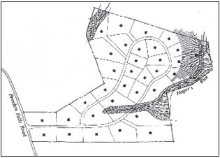
Conventional Lot Diagram
Sec. 11.06.040. - Impervious Cover.
A.
Maximum Impervious Cover.
Impervious cover shall not exceed 50 percent (50%) of gross property acreage for any use.
1.
See the conservation subdivision dimensional standards table in Section 11.06.070 for specific lot dimensional standards.
2.
All other impervious cover limitations in Section 11.02 shall apply here, except those stated in Table 11.06.070 and Table 11.06.071.
3.
Dedicated parkland, trails (public or private), streets classified as collectors and arterials on the Thoroughfare Plan, or historical/archaeological structures do not count against the total impervious cover.
B.
Green Design Bonus.
An impervious cover bonus to 55 percent (55%) gross property acreage may be received for "green design" if all building construction satisfies minimum "certified" requirements of U.S. Green Building Council's final adopted LEED guidelines or NAHB Green Building Guidelines, as certified by the buildings' architect and reviewed by the City Building Plans Examiner. Applications seeking certification for green design shall so state. A green design requirement shall be memorialized in a plat note on the Preliminary and Final Plats, and shall be a condition in the conservation open space management plan.
Sec. 11.06.050. - Stormwater Management.
A.
Detention.
To the extent possible, detention ponds shall be designed to manage stormwater within the entire conservation subdivision, unless otherwise approved by the City's Development Engineer.
1.
All detention ponds shall be designed as an integral part of the landscape, including a slope no greater than 3:1, no concrete except at the outlet and/or the inlet, and no requirement for or installation of barrier fencing. All detention ponds shall be designed to have minimal amount of land disturbance (based on commercially reasonable standards) as a part of its construction. All ponds shall meet all requirements of the City Drainage Manual.
2.
If barrier fencing is required, such fencing shall be wrought iron or other decorative fencing and shall be buffered from the street view by planting shrubs and vines that will, at maturity, screen at least 60 percent (60%) of the view of the fence.
B.
Water Quality.
To the extent possible, water quality ponds shall be designed to manage stormwater within the entire conservation subdivision, unless otherwise approved by the City's Development Engineer. All water quality ponds will be designed according to current Texas Commission on Environmental Quality (TCEQ) Standards for a Permanent Best Management Practice.
1.
Water quality shall be provided by one or more of the following methods:
a.
Extended detention basins (only when associated with a wet basin or pond);
b.
Grassy swales;
c.
Vegetative filter strips;
d.
Aqualogic cartridge systems;
e.
Wet basins;
f.
Constructed wetlands; or
g.
Bioretention.
2.
All water quality facilities shall be designed as an integral part of the landscape, including a slope no greater than 3:1, no concrete except at the outlet and/or the inlet, and no requirement for or installation of barrier fencing. All water quality facilities shall be designed to have minimal amount of land disturbance (based on commercially reasonable standards) as a part of its construction.
3.
If barrier fencing is required, such fencing shall be wrought iron or other decorative fencing and shall be buffered from the street view by planting shrubs and vines that will, at maturity, screen at least 60 percent (60%) of the view of the fence.
Sec. 11.06.060. - Geometric and Pavement Standards.
Local streets within conservation subdivisions may be constructed to an alternative cross-section, as described in Section 12.04.030. Streets should, when possible, parallel existing tree lines, minimize construction and grading costs, promote pedestrian movement and minimize crossing of primary conservation areas. In addition, streets should be shorter and narrower than traditional streets to lessen impervious cover and combine gentle curves and grade changes with traffic calming measures for safety purposes.
(Ord. No. 2017-15, § 2, 2-28-2017)
Sec. 11.06.070. - Conservation Lot Development Standards.
Conservation lot development standards establish lot sizes and certain restrictions for all residential and non-residential conservation development within the City. The tables below replace tables in Section 6.03 in Chapter 6. All other language and sections of Chapter 6 apply here. All properties must comply with the impervious cover limitations established in Section 11.02, except those stated in the table below.
Table 11.06.070: Housing Type Dimensional Standards
* Minimum lot widths on cul-de-sac lots may be reduced between 25 feet and 50 feet at the front property line provided that the minimum required lot width is provided at the front setback line.
** Side setbacks may be reduced to less than six feet, subject to required minimum fire flow.
Table 11.06.071: Non-Residential Lot and Dimensional Standards
* For projects over the Edwards Aquifer please refer to Section 11.02.
Sec. 11.07.010. - Applicability.
A.
The regulations of this Section apply to all property within the corporate limits of the City and its extraterritorial jurisdiction ("ETJ"), to the extent allowable by State law, located within the recharge zone of the Edwards Aquifer, as that term is defined in Title 30, Texas Administrative Code § 213.3 and § 213.22, except as noted below. Property within the Edwards Aquifer Recharge Zone ("EARZ") is determined by the most current official map of the relevant zone located in the Texas Commission on Environmental Quality office for Region 11.
B.
Section 11.07.030, as described herein, does not apply to occupied sites as this term is defined in this Section. Property with an occupied site should be in accordance with the Federal standards as referenced in this Section.
(Ord. No. 2015-14, § 3(Exh. A), 2-24-2015)
Sec. 11.07.020. - Definitions.
The following words and phrases, when used in this Section, shall have the meanings respectively ascribed to them in this subsection, except when the context otherwise requires:
Bank (of a stream). The ordinary high water mark of a stream, not the floodplain boundaries, as determined by the appropriate authority.
Best Management Practices (BMPs). For this Section only, BMPs has that meaning ascribed to it in Title 30, Texas Administrative Code § 213.3(5), as may be amended and as further defined herein.
Development Engineer. A professional engineer licensed by the State of Texas and designated to serve in the capacity of the Development Engineer for duties specified in the City Code of Ordinances and Unified Development Code.
Geologic Assessment. A report prepared by a geologist pursuant to Title 30, Texas Administrative Code § 213.5 and containing the additional information required by this Section.
Geologist. A licensed professional geoscientist who has training and experience in ground water hydrology and related fields that enable that individual to make sound professional judgments regarding the identification of sensitive features, such as springs and streams.
Licensed Professional Geoscientist. A geoscientist who maintains a current license through the Texas Board of Professional Geoscientists in accordance with its requirements for professional practice.
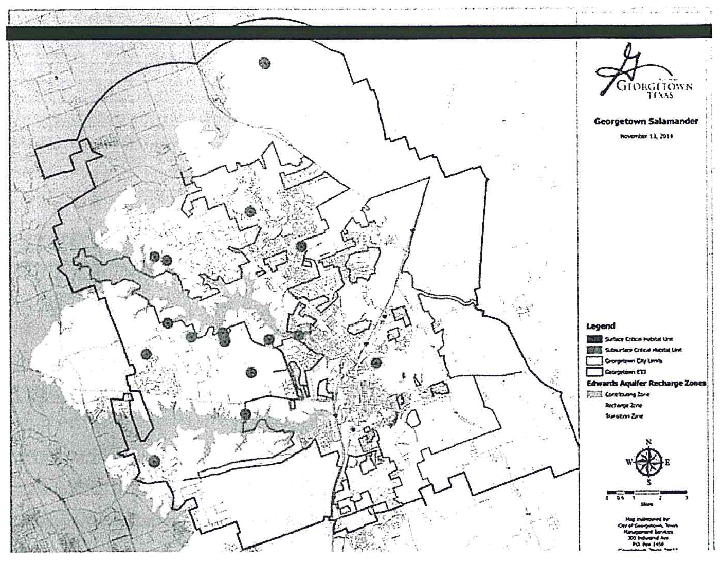
Occupied Site. Any spring identified as a critical habitat unit by the United States Fish and Wildlife Service for the Georgetown Salamander (Eurycea naufragia), and include the following: Cobb Well, Cobb Springs, Cowen Creek Spring, Bat Well Cave, Walnut Spring, Twin Spring, Hogg Hollow Spring, Cedar Hollow Spring, Knight (Crockett Garden) Spring, Cedar Breaks Hiking Trail Spring, Water Tank Cave, Avant's (Capitol Aggregates), Buford Hollow Springs, Swinbank Spring, Shadow Canyon, San Gabriel Spring, and Garey Ranch Springs. The locations of the Occupied Sites are shown on the map incorporated below.
Recharge Zone. That portion of the City and its ETJ that overlays the EARZ as defined in Title 30, Texas Administrative Code § 213.3, as may be amended.
Regulated Activity. Shall have that meaning ascribed to it by Title 30, Texas Administrative Code § 213.3(28), as may be amended.
Spring. Any natural setting or location where ground water flows to the surface of the earth from underground frequently enough to support spring associated vegetation such as ferns, watercress and Texas sedge.
Stream. A flow of surface water sufficient to produce a defined natural channel or bed. A defined natural channel or bed is an area that demonstrates clear evidence of the passage of water.
(Ord. No. 2015-14, § 3(Exh. A), 2-24-2015)
Sec. 11.07.030. - Spring Buffer and Stream Buffer Protection.
A.
Spring Buffer.
1.
A spring buffer is established within 164 feet (or 50 meters) of the approximate center of a spring outlet in the EARZ that is identified in a geologic assessment. The spring buffer shall not include pre-existing development.
2.
No regulated activities may be conducted within the spring buffer except for the following and subject to the stated restrictions:
a.
Properly permitted maintenance of existing improvements;
b.
Scientific monitoring of water quality;
c.
Fences above the normal high water mark of a stream if such fences comply with applicable floodplain regulations;
d.
Subject to stream buffer limitations, below, parks and open space development limited to trails, benches, trash cans and pet waste facilities; provided that trails shall not be located within the ordinary high water mark of a stream and shall be limited to trails for walking, jogging and non-motorized biking; and
e.
Wastewater infrastructure installed roughly parallel to a stream provided that such infrastructure is installed on the side of the stream opposite the spring and is installed no closer than 25 feet from the bank of the stream; provided that wastewater infrastructure shall not cross a stream associated with a spring within the spring buffer.
B.
Stream Buffer.
1.
A stream buffer is established for all streams in the EARZ that is identified in a geologic assessment. The boundaries of the stream buffer are as follows:
a.
For streams draining more than 64 acres and less than 320 acres, the boundaries of the stream buffer coincide with the boundaries of the FEMA one percent (1%) floodplain or a calculated one percent (1%) floodplain, whichever is smaller. In the absence of a FEMA floodplain and a calculated floodplain, the stream buffer under this subsection (a) shall be a minimum of 200 feet wide with at least 75 feet from the centerline of the stream.
If a property owner only controls one side of a stream, then the minimum buffer shall be 100 feet from the centerline of a stream, or along the FEMA one percent (1%) floodplain or a calculated one percent (1%) floodplain, if available.
b.
For streams draining more than 320 acres but less than 640 acres, the boundaries of the stream buffer coincide with the boundaries of the FEMA one percent (1%) floodplain or a calculated one percent (1%) floodplain, whichever is smaller. In the absence of a FEMA floodplain and a calculated floodplain, the stream buffer under this subsection (b) shall be a minimum of 300 feet wide with at least 100 feet from the centerline of the stream.
If a property owner only controls one side of a stream, then the minimum buffer shall be 150 feet from the centerline of a stream, or along the FEMA one percent (1%) floodplain or a calculated one percent (1%) floodplain, if available.
c.
For streams draining 640 acres or more, the boundaries of the stream buffer coincide with the boundaries of the FEMA one percent (1%) floodplain or a calculated one percent (1%) floodplain, whichever is smaller. In the absence of a FEMA floodplain and a calculated floodplain, the stream buffer under this subsection (c) shall be a minimum of 500 feet wide with at least 200 feet from the centerline of the stream.
If a property owner only controls one side of a stream, then the minimum buffer shall be 250 feet from the centerline of a stream, or along the FEMA one percent (1%) floodplain or a calculated one percent (1%) floodplain, if available.
2.
No regulated activity may be conducted within the stream buffer other than:
a.
Properly permitted maintenance of existing improvements;
b.
Scientific monitoring of water quality;
c.
Fences above the normal high water mark of a stream if such fences comply with applicable floodplain regulations; and
d.
The construction of the following improvements, subject to the stated restrictions:
i.
Wastewater facilities, provided that wastewater utilities shall not be located below the normal high water elevation within the channel of a stream except at crossings of a stream;
ii.
Underground utilities other than wastewater facilities provided that such underground utilities may only be installed at stream crossings, or at intervals no closer than 400 feet apart;
iii.
Parks and open space development limited to trails, benches, trash cans and pet waste facilities; provided that trails shall not be located within the ordinary high water mark of a stream and shall be limited to trails for walking, jogging and non-motorized biking.
iv.
Water quality or flood control systems, provided that measures are taken in the construction of such water quality or flood control systems to minimize the impact to the stream buffer;
v.
Public projects that enhance or recharge the Edwards Aquifer, provide flood prevention, and similar capital improvements;
vi.
Remediation of altered floodplain to its natural limits;
vii.
Arterial, collector and local residential streets crossing a Stream provided that:
(A)
A floodplain with a drainage area greater than 640 acres may only be crossed by arterial streets;
(B)
A floodplain with a drainage area between 320 acres and 640 acres may only be crossed by arterial and collector streets;
(C)
A floodplain with a drainage area up to 320 acres may be crossed by arterial, collector, or local residential streets; and
(D)
A street required for a secondary access, or as required by the currently adopted fire code regulations, is exempt from this subsection.
C.
All spring and stream buffers, as described herein, shall be shown on all plats, Site Plan and infrastructure Construction Plans, to include Stormwater Permits and building permits when applicable.
D.
Exemptions.
1.
The spring buffer and stream buffer requirements of Section 11.07.030 do not apply to an occupied site as this term is defined in this Section. Regulated activity on a tract of land with an occupied site, or within 984 feet (or 300 meters) of an occupied site, should be in accordance with the standards outline in UDC Appendix A.
2.
In the event that the owner of property opts to request a variance from the standards outlined in UDC Appendix A to the Adaptive Management Working Group, it shall be the responsibility of the owner of property to submit to the City of Georgetown revised plans in accordance with the results of the variance request.
E.
Variances.
1.
An owner of property of a tract of land with a spring or stream may request a variance from the spring and/or stream buffer requirements of this subsection to the Planning and Zoning Commission.
2.
The Planning and Zoning Commission may consider and take final action on a variance request in accordance with the powers and duties in Section 2.05.010.A.6 of this Code.
F.
Appeal.
Any person aggrieved by an administrative decision pertaining to this subsection may appeal to the Planning and Zoning Commission in accordance with Section 3.14 of this Code.
(Ord. No. 2015-14, § 3(Exh. A), 2-24-2015)
Sec. 11.07.040. - Water Quality Best Management Practices.
A.
For all regulated activities within the Recharge Zone, the following regulations apply:
1.
Permanent structural water quality controls for a project shall remove eighty-five percent (85%) of total suspended solids for the entire project and shall be certified by a licensed professional engineer.
2.
No regulated activity shall cause any increase in the developed flow rate for the two-year, three-hour storm.
3.
All development projects, including, but not limited to, individual home sites, shall implement temporary BMPs to minimize sediment runoff.
4.
New roadways or expansions to existing roadways that provide a capacity of 25,000 vehicles per day that are located on the Recharge Zone shall provide for spill containment as described in the optional enhanced measures of the Edwards Aquifer Protection Program.
5.
All permanent BMPs with an overt physical presence shall have signage that clearly identifies the purpose of the permanent BMP and the party responsible for maintenance.
6.
Maintenance plans for permanent BMPs shall be recorded in the Official Records of Williamson County.
(Ord. No. 2015-14, § 3(Exh. A), 2-24-2015)
Sec. 11.07.050. - Geologic Assessment.
A.
The owner of property who submits a development application for a regulated activity on a tract of land located over the EARZ shall submit a geologic assessment with the plat application.
B.
In the event that the subject property was platted prior to December 9, 2014, or meets the plat exceptions of this Code, a geologic assessment shall be submitted with the first required development application for the regulated activity. Development applications include Construction Plans, Site/Construction Plans, Stormwater Permits, and building permits (only single-family and two-family residential on a tract of land that meets the plat exceptions of this Code).
C.
No development application for property located over the EARZ may be approved until a geologic assessment has been accepted by the Development Engineer or his designee.
D.
The geologic assessment must contain all of that information required by Title 30, Texas Administrative Code § 213.5. Additionally, the geologic assessment must:
1.
Identify all springs and/or streams on the subject property, or certify that no springs or streams exist on the subject property;
2.
Describe any spring and/or stream on the subject property, including determining the location of any spring outlet or stream;
E.
Subsequent applications required to develop the subject property will not require a new geologic assessment provided the regulated activity, as submitted in the application, is consistent with the accepted geologic assessment. Any deviations will result in the need to submit an updated geologic assessment prior to final approval of the application.
F.
Exemptions.
1.
A geologic assessment shall not be required for regulated activity that meets all of the following criteria:
a.
Proposed development is single-family residential or two-family residential; and
b.
Subject property is located on an individual lot that is less than five acres; and
c.
Subdivision (to include Replat) is five lots or less, and no more than five gross acres; and
d.
Subject property is located within a drainage area that is less than 64 acres.
2.
Regulated activity that meet all of the criteria above must submit with the required development application a letter signed by a professional engineer certifying the drainage area and identifying any springs on the subject property. In the event that springs exist, the project engineer must identify applicable buffers on the plans.
(Ord. No. 2015-14, § 3(Exh. A), 2-24-2015)
Sec. 11.07.060. - Acknowledgement Form.
A.
The owner of property who submits a development application for a regulated activity on a tract of land located over the EARZ shall submit an acknowledgement form in accordance with the provisions of this subsection.
B.
The owner of property shall through a completed acknowledgement form, acknowledge and certify the following:
1.
The regulated activity, as proposed, complies with the water quality best management practices regulations of this Section; and
2.
The subject property has an occupied site, is located within 984 feet of an occupied site, or has a springs or stream located more than 984 feet from an occupied site; and
3.
The regulated activity, as submitted, complies with the rules and regulations of this Section.
C.
A completed, signed and notarized acknowledgement form shall be submitted with the plat, Construction Plan, Site/Construction Plan, Stormwater Permit, and building permit (single-family and two-family residential on a tract of land that is exempt from the plat requirements of this Code) applications.
D.
The development application to the City of Georgetown shall be deemed incomplete if the acknowledgement form is not completed, signed and notarized.
E.
After the completeness review (Section 3.02.040) of a development application subject to subparagraph (A) above, the director or his/her designee shall provide a copy of the acknowledgement form to the Williamson County Conservation Foundation Adaptive Management Working Group.
(Ord. No. 2015-14, § 3(Exh. A), 2-24-2015)
Sec. 11.07.070. - Water Quality Management Plan.
A.
The City shall adopt a water quality management plan for all areas within the Recharge Zone. Such management practices will include, but not be limited to, public education and outreach, hazardous waste education, integrated pest management, illicit discharge detection and elimination, construction-site storm-water runoff control, post-construction storm-water management, and pollution prevention for municipal operations including City and County maintenance activities in the ETJ.
B.
The City's adopted storm water management plan, as amended, shall serve as the water quality management plan for purposes of this Section, unless stated otherwise.
(Ord. No. 2015-14, § 3(Exh. A), 2-24-2015)
Sec. 11.07.080. - Williamson County Conservation Foundation Adaptive Management Working Group.
An Adaptive Management Working Group has been established by the Williamson County Conservation Foundation to review data on a regular basis and make recommendations for specific changes in management directions related to the Federal standards for occupied sites. The Adaptive Management Working Group duties include, but are not limited to, development of an annual report regarding the preservation of the Georgetown Salamander, continuous monitoring of the Georgetown Salamander, assessment of research priorities, adaptive management of preservation of the Georgetown Salamander and the effectiveness of achieving the above objectives. The City Manager will appoint two City employees with appropriate technical expertise in the fields of planning and development and system engineering as members to the Adaptive Management Working Group. The efforts of the Adaptive Management Working Group will be led by the Williamson County Conservation Foundation staff.
(Ord. No. 2015-14, § 3(Exh. A), 2-24-2015)