
Georgetown City Zoning Code
CHAPTER 4
ZONING DISTRICTS
SECTION 4.01.- ESTABLISHMENT OF ZONING DISTRICTS
The following zoning districts may be established for the City as authorized by the City Charter and Texas Local Government Code ch. 211.
Table 4.01.010: Zoning Districts
(Ord. No. 2014-30, § 2(Exh. A), 5-27-2014; Ord. No. 2015-49, § 2(Exh. A), 9-22-2015)
SECTION 4.04. - ZONING DISTRICT PURPOSE STATEMENTS
This Section describes, in purpose statements, the Zoning Districts established in Section 4.01 and 4.02. Each district is divided into unofficial categories intended to distinguish similar districts. Special development types that may be applied to more than one district are described in Section 4.05.
SECTION 4.05. - SPECIAL DEVELOPMENT TYPES
This section establishes two types of development that may be applied across more than one zoning district.
SECTION 4.06. - PLANNED UNIT DEVELOPMENT DISTRICT
This section establishes procedures and requirements of a Planned Unit Development District. Planned Unit Developments may be established in any location and may include more than one base zoning district.
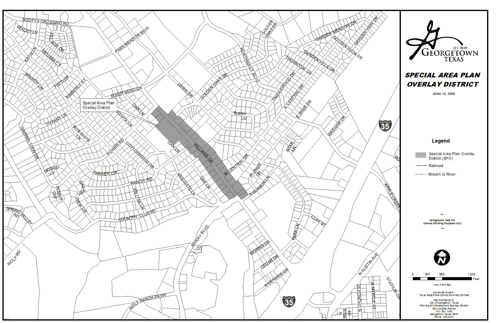
SECTION 4.07. - SPECIAL AREA PLAN OVERLAY DISTRICT
This section contains specific standards for designated Special Area Plan (SP) Overlay Districts. The standards for this section must be met in addition to any standards of the underlying district.
SECTION 4.08. - HISTORIC OVERLAY DISTRICTS[1]
Editor's note— Ord. No. 2015-34, § 2(Exh. A), adopted May 12, 2015, repealed and reenacted Section 4.08 in its entirety to read as herein set out. Formerly, Section 4.08, §§ 4.08.010, 4.08.020, pertained to the Downtown Overlay District, and derived from original codification.
SECTION 4.09. - MIXED USE DISTRICT[2]
How to Use This Code
For all Users:
This Code forms an integral part of the City of Georgetown Unified Development Code (UDC), although it may be published as a separate stand-alone document.
You should familiarize yourself with the intent and the general organizational framework of this Code by reading Sections 4.09.010 and Section 4.09.030.
If you need to subdivide or plat your land:
You should make sure that your land has been zoned as a MIXED USE DISTRICT, and that there is an adopted REGULATING PLAN in place for the entire District. If you would like to subdivide or re-plat an existing block or lot, refer to Subdivision of Lots, Section 4.09.050.F.
If you want to build or establish a particular use on your property:
Step One: Refer to the REGULATING PLAN for your District in order to determine your parcel's SUB-DISTRICT.
Step Two: Refer to Figure 4.09.051 for a table of uses permitted in the various SUB-DISTRICTS. Section 16.03 in the UDC may be helpful in determining the appropriate Use Category for your proposed use.
Step Three: If your proposed use is listed as L (Limited) in your SUB-DISTRICT, make sure you comply with the corresponding Specific Notes described in Section 4.09.050.D.
Step Four: Once you have determined that your use is permitted, ensure that your project complies with the SUB-DISTRICT Development Standards, Figure 4.09.052, and the STREET TYPE Development Standards, Figure 4.09.061. It may be helpful to refer to Section 4.09.050.G, which provides a one-page summary of the major regulations for each SUB-DISTRICT.
Step Five: All developments must also comply with Section 4.09.070, Parking; Section 4.09.080, Architectural Requirements; Section 4.09.090, Landscaping; and Section 4.09.100, Signage and Graphics.
If you want to change your SUB-DISTRICT:
Review the standards listed in Section 4.09.030.G to ensure that your proposed change complies with them. If so, you will need to make an application for a Map Amendment in accordance with Section 4.09.020.B.
(Ord. No. 2015-34, § 2(Exh. A), 5-12-2015)
Editor's note— Ord. No. 2015-34, § 2(Exh. A), adopted May 12, 2015, repealed the former Section 4.09, §§ 4.09.010—4.09.040 in its entirety, which pertained to the Old Town Overlay District, and derived from original codification. Subsequently, said ordinance redesignated the provisions of former Section 4.11, §§ 4.11.010—4.11.100 as Section 4.09, §§ 4.09.010—4.09.100.
SECTION 4.10. - COURTHOUSE VIEW PROTECTION OVERLAY DISTRICT[3]
Editor's note— Ord. No. 2015-34, § 2(Exh. A), adopted May 12, 2015, repealed the former Section 4.10, §§ 4.10.010, 4.10.020 in its entirety, which pertained to the Historic Overlay District, and derived from original codification. Subsequently, said ordinance redesignated the provisions of former Section 4.12, §§ 4.12.010—4.12.040 as Section 4.10, §§ 4.10.010—4.10.040.
SECTION 4.11. - GATEWAY OVERLAY DISTRICT[4]
This section establishes that certain roadways within the City limits shall be considered gateways into Georgetown and properties fronting such roadways shall be subject to special landscaping and design standards.
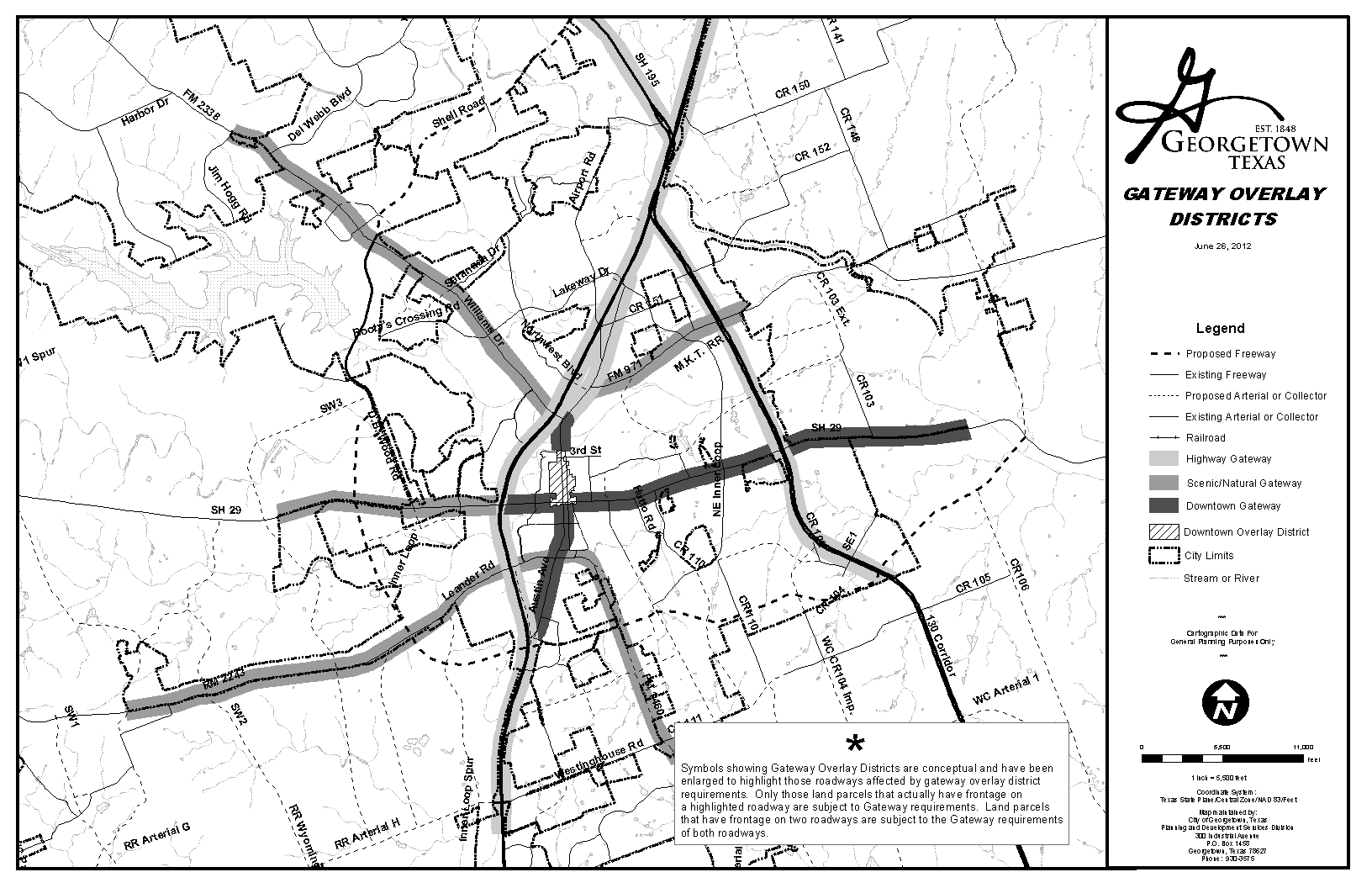
This map is available for viewing at the office of the Planning Department or as a downloadable map at http://maps.georgetown.org. The map is simply a graphical depiction of each corridor; it does not infer boundaries or a hierarchy of roadways for determining the gateway classification.
Purpose and Intent.
The purpose of the Gateway Overlay districts (Gateways) is to protect and enhance the entrance corridors to the City and Downtown with landscaping, setbacks, and special design standards. The intent of the Gateways is to establish entrance corridors that herald the approach to the City, define the arrival to a destination, and link common elements together.
(Ord. No. 2015-34, § 2(Exh. A), 5-12-2015; Ord. No. 2021-62, § 2(Exh. B), 9-14-2021)
Editor's note— Ord. No. 2015-34, § 2(Exh. A), adopted May 12, 2015, redesignated the provisions of former Section 4.13, §§ 4.13.010—4.13.030 as Section 4.11, §§ 4.11.010—4.11.030. The user's attention is also director to the editor's note at Section 4.09.
Sec. 4.02.010. - Official Zoning Map.
A.
The City is hereby divided into the above zoning districts, as shown on the Official Zoning Map, which, together with all explanatory matter thereon, is hereby adopted by reference and declared to be a part of this Unified Development Code (Code). The Official Zoning Map shall be identified by the signature of the Mayor, attested by the City Secretary, and bearing the Seal of the City of Georgetown under the following words:
"This is to certify that this is the Official Zoning Map referred to in Section _______ Ordinance No. _______ of the City of Georgetown, Texas."
B.
If, in accordance with the provisions of this Code and Texas Local Government Code § 211.006, as amended, changes are made in the district boundaries or other matter portrayed on the Official Zoning Map, such changes shall be entered on the Official Zoning Map within five business days after the amendment has been approved by the City Council and signed by the Mayor.
C.
Approved zoning changes shall be entered on the Official Zoning Map by the appropriate City department and the City shall maintain records identifying the ordinance number making such changes.
D.
No change of any nature shall be made on the Official Zoning Map or matter shown thereon except in conformity with procedures set forth in this Unified Development Code. Any unauthorized change shall be null and void and have no force or effect.
E.
Regardless of the existence of purported copies of the Official Zoning Map which may from time to time be made or published, the Official Zoning Map, which shall be located in the office of the Planning and Development Department, shall be the final authority as to the current zoning status of land and water areas, buildings, and other structures in the City.
Sec. 4.02.020. - Digital Mapping.
Digital maps, created through the use of geographical information system technology, containing registration points recorded on the Texas State Plane Coordinate System, as amended, may be used in the administration and enforcement of this Unified Development Code. Digital mapping will not replace the paper originals of official maps, but may represent the most accurate and up-to-date information in between printings.
Sec. 4.02.030. - Replacement of Official Zoning Map.
A.
In the event that the Official Zoning Map becomes damaged, destroyed, lost, or difficult to interpret because of the nature and/or number of changes and additions, the City Council shall, by ordinance, adopt a new Official Zoning Map, which shall supersede the prior Official Zoning Map. The new Official Zoning Map may correct drafting or other errors or omissions in the prior Official Zoning Map, but no such correction shall have the effect of amending the original Official Zoning Map or any subsequent amendment thereof. The new Official Zoning Map shall be identified by the signature of the Mayor, attested by the City Secretary, and bearing the Seal of the City and date under the following words:
"This is to certify that this Official Zoning Map supersedes and replaces the Official Zoning Map adopted (date of adoption of map being replaced) as part of Ordinance No. _______ of the City of Georgetown, Texas."
B.
Unless the prior Official Zoning Map has been lost or has been totally destroyed, the prior map or any significant parts thereof remaining, shall be preserved, together with all available records pertaining to its adoption or amendment.
C.
The City shall initiate creation of a revised Official Zoning Map consistent with the provisions of this Code.
Sec. 4.02.040. - Rules for Interpretation of District Boundaries.
Where uncertainty exists as to the boundaries of districts as shown on the Official Zoning Map, the following rules shall apply:
A.
Boundaries indicated as approximately following the center lines of streets, highways or alleys shall be construed to follow such center lines.
B.
Boundaries indicated as approximately following platted lot lines shall be construed as following such lot lines.
C.
Boundaries indicated as approximately following City limits shall be construed as following such City limits.
D.
Boundaries indicated as following railroad lines shall be construed to be midway between the rails of the main line.
E.
Boundaries indicated as following shorelines shall be construed to follow such shorelines, and in the event of change in the shoreline shall be construed as moving with the actual shoreline. Boundaries indicated as approximately following the center lines of streams, rivers, canals, lakes, or other bodies of water shall be construed to follow such center lines.
F.
Boundaries indicated as parallel to or extensions of features indicated above shall be so construed. Distances not specifically indicated in a classification amendment shall be determined by the scale of the map.
G.
Where physical features, such as streets, railroad lines, rivers, streams and such, existing on the ground are at variance with those shown on the Official Zoning Map or in other circumstances not covered above, the Director shall make a written interpretation of the district boundaries.
Sec. 4.02.050. - Uniform Application of District Regulations.
No building, structure, or land shall hereafter be used or occupied, and no building or structure or part thereof shall hereafter be erected, constructed, reconstructed, moved, or structurally altered except in conformity with all the zoning regulations herein specified for the district in which it is located.
Sec. 4.03.010. - Initial Default Zoning.
All new territory hereinafter annexed to the City shall have the initial zoning of Agriculture (AG) Zoning District classification unless another zoning classification that is consistent with the Future Land Use Plan is proposed by the property owner(s) or the Director. For a zoning to AG, there shall be no special action or hearing required to zone the property after or during the annexation process. For any zoning classification other than AG, the procedures of Chapter 3.06 shall be followed (i.e., notice of zoning, hearing ordinance adoption). Newly annexed property may begin rezoning procedures to any zoning district during or upon completion of annexation process, but may not be approved until annexation is completed.
Sec. 4.04.010. - Residential Districts.
A.
Residential Estate District (RE).
The Residential Estate District (RE) is intended for areas of very low density single-family residential use and associated uses. The district has a lot size minimum of one acre to retain a rural character and is appropriate where topography or lack of public utilities and services may necessitate a low density.
* For uses allowed in the RE District, see Section 5.02.
* For lot and design standards, see Section 6.03.
B.
Residential Low Density District (RL).
The Residential Low Density District (RL) is intended for areas of low density single-family residential use and associated uses. The RL District is intended to allow larger lots than in the RS District with a minimum of 10,000 square feet. The pattern of residential development and land use closely matches that of the Residential RS District.
* For uses allowed in the RL District, see Section 5.02.
* For lot and design standards, see Section 6.03.
C.
Residential Single-Family District (RS).
The Residential Single-family District (RS) is intended for areas of medium density with a minimum lot size of 5,500 square feet. The RS District contains standards for development that maintain single-family neighborhood characteristics. The District may be located within proximity of neighborhood-friendly commercial and public services and protected from incompatible uses. All housing types in the RS District shall use the lot, dimensional and design standards of the District.
* For uses allowed in the RS District, see Section 5.02.
* For lot and design standards, see Section 6.03.
D.
Two-Family District (TF).
The Two-Family District (TF) is intended for two-family dwellings that are located on one lot. The TF District also includes single-family attached and single-family detached development and associated uses. Two-family and single-family dwellings are permitted on individual lots, but the lot, dimensional and design standards are intended for two dwellings in one structure on a single lot. The TF District is a moderate density District that may be used to separate residential areas zoned RE, RL, or RS from higher density residential and commercial areas.
* For uses allowed in the TF District, see Chapter 5.
* For lot and design standards, see Section 6.03.
E.
Townhouse District (TH).
The Townhouse District (TH) is intended for townhouse and attached single-family development. The TH District is appropriate for infill development as well as a transition from residential areas to non-residential areas. This District is also appropriate in areas designated on the Future Land Use Plan as one of the Mixed Use Land Use categories. In the TH District, townhomes shall be located on individual lots.
* For uses allowed in the TH District, see Chapter 5.
* For lot and design standards, see Section 6.03.
F.
Low Density Multifamily District (MF-1).
The Low Density Multifamily District (MF-1) is intended for attached and detached multifamily residential development, such as apartments, condominiums, triplexes, and fourplexes, at a density not to exceed 14 dwelling units per acre. The MF-1 District is appropriate in areas designated on the Future Land Use Plan as high density residential or one of the mixed-use categories, and may be appropriate in the moderate density residential area based on location, surrounding uses, and infrastructure impacts. Properties zoned MF-1 should have convenient access to major thoroughfares and arterial streets and should not route traffic through lower density residential areas. The MF-1 District is appropriate adjacent to both residential and non-residential districts and may serve as a transition between single-family districts and more intense multifamily or commercial districts.
* For uses allowed in the MF-1 District, see Chapter 5.
* For lot and design standards, see Section 6.03.
G.
High Density Multifamily District (MF-2).
The High Density Multifamily District (MF-2) is intended for attached multifamily residential development, such as apartments and condominiums, at a density not to exceed 24 dwelling units per acre. The MF-2 District is appropriate in areas designated on the Future Land Use Plan as high density residential or one of the mixed-use categories. Properties zoned MF-2 should have direct access to major thoroughfares and arterial streets and should not route traffic through lower density residential areas. The MF District is appropriate adjacent to both residential and non-residential districts and may serve as a transition between single-family districts and more intense commercial districts.
* For uses allowed in the MF-2 District, see Chapter 5.
* For lot and design standards, see Section 6.03.
H.
Manufactured Housing District (MH).
The Manufactured Housing District (MH) is intended for the development of manufactured, HUD-code mobile home parks and subdivisions. Manufactured housing subdivisions include individually platted lots for sale within the subdivision, for the placement of manufactured housing. The District also includes manufactured housing parks, as defined in this Code. The Manufactured Housing District establishes special area and design requirements for both parks and subdivisions, as well as yard requirements for individual lots. Both parks and subdivisions provide open space and recreational areas appropriate for the acreages and number of units contained.
* For uses allowed in the MH District, see Chapter 5.
* For lot and design standards, see Section 6.03.
(Ord. No. 2014-30, § 2(Exh. A), 5-27-2014)
Sec. 4.04.020. - Non-Residential Districts.
A.
Neighborhood Commercial District (CN).
The Neighborhood Commercial District (CN) is intended to provide areas for small-scale office and commercial activities such as the sale of convenience goods and personal service businesses that primarily serve adjacent residential areas. No uses that adversely affect the health, safety, welfare, or residential character of neighborhoods are allowed. Neighborhood commercial areas are generally located within neighborhoods and have pedestrian access to adjacent residential areas.
* For uses allowed in the CN District, see Chapter 5.
* For lot and dimensional standards, see Section 7.03.
* For building and site design standards, see Sections 7.04 and 7.05.
B.
Local Commercial District (C-1).
The Local Commercial District (C-1) is intended to provide areas for commercial and retail activities that primarily serve residential areas. Uses should have pedestrian access to adjacent and nearby residential areas, but are not appropriate along residential streets or residential collectors. The district is more appropriate along major and minor thoroughfares and corridors.
* For uses allowed in the C-1 District, see Chapter 5.
* For lot and dimensional standards, see Section 7.03.
* For building and site design standards, see Sections 7.04 and 7.05.
C.
General Commercial District (C-3).
The General Commercial District (C-3) is intended to provide a location for general commercial and retail activities that serve the entire community and its visitors. Uses may be large in scale and generate substantial traffic, making the C-3 District only appropriate along freeways and major arterials.
* For uses allowed in the C-3 District, see Chapter 5.
* For lot and dimensional standards, see Section 7.03.
* For building and site design standards, see Sections 7.04 and 7.05.
D.
Office District (OF).
The Office District (OF) is intended to provide a location for offices and related uses. The uses allowed have relatively low traffic generation. Small areas of the OF District may be appropriate adjacent to most residential uses and as a transition between residential areas and commercial areas.
* For uses allowed in the OF District, see Chapter 5.
* For lot and dimensional standards, see Section 7.03.
* For building and site design standards, see Sections 7.04 and 7.05.
E.
Industrial District (IN).
The Industrial District (IN) is intended to provide a location for manufacturing and industrial activities that may generate some nuisances. Traffic generation will likely include heavy vehicles, making access to an arterial or freeway necessary. Unless separated by a major roadway, the Industrial District is not appropriate adjacent to any residential uses.
* For uses allowed in the IN District, see Chapter 5.
* For lot and dimensional standards, see Section 7.03.
* For building and site design standards, see Sections 7.04 and 7.05.
Sec. 4.04.030. - Special Purpose Zoning Districts.
A.
Agriculture District (AG).
The Agriculture District (AG) is intended to allow large rural residential development, agricultural and farming uses and may include lands that are relatively undeveloped. The AG District is also the default district for land newly annexed into the City, but not yet placed in an appropriate zoning classification. For these reasons, the AG District may contain a wide variety of residential and non-residential uses. The AG District may take on characteristics of either a residential or a non-residential zoning district and certain design criteria may be required depending on the use.
* For uses allowed in the AG District, see Chapter 5.
* For lot and dimensional standards, see Section 6.03.
* For building and site design standards, see Sections 7.04 and 7.05.
B.
Business Park District (BP).
The Business Park District (BP) is intended to provide a location for office, research, and light industrial uses typically located as part of a large development. The BP District may be appropriate adjacent to residential areas, provided that there is adequate buffering and pedestrian and vehicular access to the residential area for workers in the business park. The BP District typically has more traffic than in an office area, but fewer heavy vehicles than in an industrial area. The Business Park District is a special purpose district because it has a minimum size acreage for limited complementary uses that may expand with the size of the park. Larger parks often include commercial activities such as restaurants, banks, day care and similar uses that are intended to serve the on-site community and may include some limited high-density residential.
* For uses allowed in the BP District, see Chapter 5.
* For lot and dimensional standards, see Section 7.03.
* For special design standards for BP, see Section 7.03.040.
* For building and site design standards, see Sections 7.04 and 7.05.
C.
Public Facilities District (PF).
The Public Facilities District (PF) is intended to provide a location for government and other public or quasi-public facility operations. These may include schools, public parks, hospitals, airports, government offices, churches and other related uses, but would not include industrial facilities or storage yards. Some uses allowed in this district might generate heavy traffic volumes and high-intensity operations. The PF District shall contain uses that are allowed in both residential and non-residential districts and is subject to non-residential design and landscaping standards for compatibility with nearby or adjacent residential uses.
* For uses allowed in the PF District, see Chapter 5.
* For lot and dimensional standards, see Section 7.03.
* For building and site design standards, see Sections 7.04 and 7.05.
D.
Planned Unit Development District (PUD).
The Planned Unit Development District (PUD) is intended to allow flexibility in planning and designing for unique or environmentally sensitive properties and that are to be developed in accordance with a common development scheme. PUD zoning is designed to accommodate various types of development, including multiple housing types, neighborhood and community retail, professional and administrative areas, industrial and business parks, and other uses or a combination thereof. A PUD may be used to permit new or innovative concepts in land use and standards not permitted by zoning or the standards of this Code. Although greater flexibility is given to allow development in a PUD that would not otherwise be allowed, procedures and standards are established in this Code that are intended to ensure against misuse.
* For special requirements of a PUD District, see Section 4.06.
(Ord. No. 2015-48, § 2(Exh. A), 9-22-2015)
Sec. 4.04.040. - Mixed-Use Zoning Districts.
A.
Mixed Use Downtown District (MU-DT).
The Mixed Use Downtown District (MU-DT) is intended to provide a location for a mix of land uses including general commercial and retail activities, office as well as single-family and multi-family in the downtown area. Developments in the MU-DT District are typically smaller in size and scope although there may be occasionally heavy traffic. The Mixed Use Downtown District is only appropriate in the traditional downtown area of Georgetown. Properties in MU-DT shall meet the design requirements of the Downtown Overlay District and the Historic District Design Guidelines.
* For uses allowed in the MU-DT District, see Chapter 5.
* For lot and dimensional standards, see Section 7.03.
* For building and site design standards, see Sections 7.04 and 7.05.
* For Downtown Overlay District design standards, see Section 4.08.
* See also the Downtown Master Plan in the Comprehensive Plan.
* See also the Historic District Design Guidelines, referenced in Section 1.14.
B.
Mixed Use Development District (MU).
The Mixed Use Development District (MU) is intended to provide development standards to promote a dense and active mixed use urban environment that incorporates residential and non-residential uses. The MU District shall be used only in conjunction with the procedures in Section 4.11 and is not intended to accommodate a mix of uses in traditional zoning districts. The district is appropriate in, but not limited to, areas designated as Specialty Mixed Use, Mixed-Use Neighborhood Center, and Mixed-Use Community in the 2030 Future Land Use Plan. The MU District contains a series of sub-districts that differ in size, scale, design, and allowed uses, to be established as part of a regulating plan prior to zoning approval. The development standards for the MU District also apply to Transit Oriented Development (TOD), which is a specific type development allowed in the MU District.
The Mixed Use Development District also allows for a mixed-use development of limited size and scope that requires only one sub-district. Typically, these are projects that have a distinct development plan that does not fit a base zoning district or is limited in developable area. The Urban Village and Urban Neighborhood sub-districts, as defined in Section 4.11, are the only allowable sub-districts for this type of proposal. All requirements of the sub-district and other applicable standards of the MU District apply.
* For specific standards of the MU District, see Section 4.11. Due to the length of Section 4.11, it may be incorporated into the Code by reference and used as a separate document.
(Ord. No. 2015-34, § 2(Exh. A), 5-12-2015; Ord. No. 2021-53, § 7(Exh. F), 7-27-2021)
Sec. 4.04.050. - Overlay Zoning Districts.
A.
Special Area Plan Overlay District (SP).
The Special Area Plan Overlay District (SP) is intended to provide use and development standards that implement a special area plan. The SP District is appropriate for allowing the gradual transition of primarily residential areas to mixed-use while protecting the built environment. The SP District differs from the PUD District in that it is intended to apply to already-developed areas owned by more than one individual.
* For specific standards of the SP District, see Section 4.07.
B.
Historic Overlay Districts.
The City of Georgetown recognizes that as a matter of public policy the protection, enhancement, and perpetuation of landmarks and districts of historical and cultural importance and significance is necessary to promote the economic, cultural, educational, and general welfare of the public. Historic overlay districts are created to:
• Protect and enhance the landmarks and districts which represent distinctive elements of Georgetown's historic, architectural, and cultural heritage;
• Foster civic pride in the accomplishments of the past;
• Protect and enhance Georgetown's attractiveness to visitors and the support and stimulus to the economy thereby provided;
• Insure the harmonious, orderly, and efficient growth and development of the city that is sensitive to its historic resources;
• Promote economic prosperity and welfare of the community by encouraging the most appropriate use of historic properties within the city; and
• Encourage stabilization, restoration, and improvements of such properties and their values by offering incentives for rehabilitation and preservation.
1.
Downtown Overlay District (D).
The Downtown Overlay District is intended to protect the aesthetic and visual character of the Town Square and downtown Georgetown through the establishment of two distinct zones, designated as Area 1 (Town Square Historic District) and Area 2 (remainder of the Downtown Overlay District).
2.
Old Town Overlay District (OT).
The Old Town Overlay District is intended to preserve and protect historic structures, maintain a residential appearance along South Austin and University Avenues, and maintain the integrity of the historic character in the area commonly referred to as Old Town.
3.
Designated Historic District (H).
The Designated Historic District is intended to preserve areas, structures, and landmarks of historical or cultural significance. Each designated district may have specific standards unique to the district.
a.
Town Square Designated Historic District (H-TS)
4.
Historic Landmark Designation (HL)
The purpose of the historic landmark designation is to protect, preserve and enhance buildings or structures of historical, architectural or cultural importance or value to the City of Georgetown.
* For Specific Standards of the Historic Overlay Districts, see Section 4.08.
C.
Courthouse View Protection Overlay District (CVP).
The Courthouse View Protection Overlay District (CVP) is intended to preserve views of the Williamson County Courthouse from various locations along corridors in Georgetown.
* For specific standards of the Courthouse View Protection Overlay District, see Section 4.12.
D.
Gateway Overlay District (G).
The Gateway Overlay District (G) is intended to enhance the entry corridors to Georgetown. Various corridors into the city are designated for the purpose of applying additional landscaping and design standards.
* For specific standards of the Gateway Overlay District, see Section 4.13.
(Ord. No. 2015-34, § 2(Exh. A), 5-12-2015)
Sec. 4.05.010. - Housing Diversity Development.
To encourage Housing Diversity developments, this Code allows flexibility to the development standards and allowable housing types for developments that foster housing diversity. Housing Diversity developments may be located in the RL, RS, TF, and TH Districts and shall include at least three types of housing identified in Table 6.08.020, although a greater variety is encouraged. In addition, the Director is authorized to consider alternative standards that would result in projects that meet the intent, if not the letter, of the provisions of this Code in order to attain housing diversity.
Housing Diversity lot and dimensional standards can be found in Section 6.07.020.
Sec. 4.05.020. - Conservation Subdivision Development.
To encourage conservation subdivision developments, this Code allows flexibility to development standards in all zoning districts for developments that use conservation development practices in order to: protect natural resources, conserve valuable open space, reduce erosion and sedimentation, preserve riparian corridors, provide for walking trails, protect the community water supplies, reduce infrastructure, preserve prime agricultural land, provide smaller streets with less environmental disturbance, and plan for overall watershed protection. Attempting to achieve these objectives using the process established in Section 11.06 of this Code qualifies a development as a conservation subdivision eligible for the incentives and flexible development standards.
Conservation Subdivision lot and dimensional standards can be found in Section 11.06.
Sec. 4.05.030. - Multi-Lot Unified Development.
To encourage Multi-Lot Unified Development, this Code allows flexibility in certain setback development standards for proposed unified developments across multiple abutting properties with similar and compatible uses and zoning districts. Properties of a Multi-Lot Unified Development may be developed in accordance with the following provisions:
A.
Multi-Lot Unified Developments may be located in the following zoning districts: Townhouse (TH), Low Density Multi-family (MF-1), High Density Multi-family (MF-2),Neighborhood Commercial (CN), Local Commercial (C-1), General Commercial (C-3) Office (OF), Industrial (IN), Agriculture (AG), Business Park (BP), and Public Facilities (PF). Multi-Lot Unified developments shall not be permitted in any single-family or two-family residential zoning districts.
B.
A Multi-Lot Unified Development shall be documented under a single development application, either a Subdivision Plat and/or a Site Development Plan, as established in this Code. The development application must clearly identify the boundaries of each individual lot or parcel, and overall boundary of the property subject to the Multi-Lot Unified Development application.
C.
All lots or parcels within the boundaries of the Multi-Lot Unified Development must be developed in accordance with the approved plat or Site Development Plan. Any deviations will result in the submittal, review and approval of a new development application.
D.
The City may require a private ingress, egress, cross-access and parking easement over and across the parking areas and roadways within the boundaries of the Multi-Lot Unified Development to ensure adequate off-street parking, as well as safe vehicle, emergency and pedestrian access for the properties.
* Multi-Lot Unified Development lot and dimensional standards can be found in Sections 6.07 and 7.03.
(Ord. No. 2015-49, § 2(Exh. A), 9-22-2015)
Sec. 4.06.010. - General Provisions.
A.
Compatibility with Base Zoning District.
A PUD is designed to be used in conjunction with a designated base zoning district. An application for PUD zoning shall specify the base district(s) and the uses proposed. If no base zoning exists, the base zoning shall be that zoning designation that is most similar to or compatible with the uses proposed for the PUD. Any uses not permitted in the base district shall be specifically identified. The standards and requirements of the specified base district shall apply unless specifically superseded by the standards and requirements of the PUD Development Plan.
B.
Compliance with Applicable City Codes.
The granting of a PUD Zoning District shall not relieve the developer from complying with all other applicable sections of this Code, and other Codes and Ordinances of the City, unless such relief is specified in the approved Development Plan.
C.
Development Plan Required.
An application for the establishment of a PUD District shall be accompanied by a development plan that meets the requirements of this section. The development plan shall become a part of the PUD ordinance, if approved by the City Council.
D.
Development Plan.
1.
Development requirements for the PUD District shall be set forth in the Development Plan and meet the approval criteria detailed in Section 3.06.040. The Development Plan is intended to capture how and why the particular project is of exceptional quality and cannot be met by base zoning district requirements. At a minimum, the Development Plan shall explain the purpose and intent of the PUD, detailed description of the project, and a specific development design plan, in addition to how the PUD may deviate from the minimum standards set forth in this Code.
2.
The PUD zoning application shall include written justification as to why any such Code deviations listed in the Development Plan are necessary because of the unique characteristics of the site, the needs of the proposed project, or other exceptional circumstances. Such deviations should be intended to provide an unconventional, cohesive, and well-planned layout design scheme, and should not be proposed to simply avoid the requirements of this Code.
3.
Developments with PUD zoning may vary in size and scope and the Development Plan should reflect the scale and detail desired in the district. A Development Plan should generally include allowed and/or prohibited land uses, parks/open space/natural features, density, traffic circulation/streets/access, building and site design standards and/or schematics, and other pertinent information. A full or partial traffic impact analysis may be required depending on the impact to the public roadway system. The Planning Director retains full discretion to require the necessary detail and information needed to justify the proposed PUD development plan.
4.
Revisions to the adopted Development Plan shall require an amendment to the PUD ordinance to be processed pursuant to this Code. If the Director determines that a proposed revision is a minor revision, the Director may consider such a revision in connection with approval of a Plat or Site Plan pursuant to this Code.
(Ord. No. 2015-48, § 2(Exh. A), 9-22-2015)
Sec. 4.07.010. - Designation of SP District.
A.
The SP District may be established in any base District other than the PUD or IN District. An SP District may be established over more than one base district.
B.
The SP District will be established only by action of the City Council, following the procedures for establishment of a Planned Unit Development, with the Director acting as the applicant.
Sec. 4.07.020. - Permitted Uses.
Any use permitted in the underlying base districts shall also be permitted in an SP District, unless otherwise limited by the particular SP District regulations.
Secs. 4.07.030, 4.07.040. - Reserved.
Editor's note— Ord. No. 2015-49, § 2(Exh. A), adopted September 22, 2015, repealed the former Sections 4.07.030 and 4.07.040 in their entirety, which pertained to Area Plans Established, and Standards for the Williams Drive SP, respectively, and derived from original codification.
Sec. 4.08.010. - Designation of a Historic Overlay District.
A.
A Historic Overlay District may be established over any base zoning district within the city limits and may be established over more than one base zoning district.
B.
Creation or expansion of a Historic Overlay District requires approval by the City Council, following the procedures for a Zoning Map Amendment in Section 3.06.
C.
Consideration of Standards for a Designated Historic District.
The following shall be considered when developing standards for a Designated Historic District:
1.
The findings adopted by the City Council for a specific Designated Historic District shall define the scope of the City's interest in protecting the historic resource and shall provide the guidelines to be used, along with the applicable regulations, in considering whether to grant or deny a certificate of appropriateness.
2.
HARC may develop and the City Council may approve supplemental guidelines as it may deem necessary to implement the regulations of a particular designated historic district or the findings applicable to the designation of a particular designated historic district. Such guidelines may include, but are not limited to, the following:
a.
Charts or samples of acceptable materials for siding, foundations, roofs, or other parts of buildings;
b.
Illustrations of appropriate architectural details;
c.
Numerical specifications of appropriate rhythms or proportions;
d.
Specifications of appropriate relationships to streets, sidewalks, other structures, and buildings;
e.
Illustrations of appropriate porch treatments or entrances; or
f.
Illustrations of appropriate signage or street furniture.
(Ord. No. 2015-34, § 2(Exh. A), 5-12-2015)
Sec. 4.08.020. - Historic Overlay Districts Established.
The Historic Overlay Districts are established as follows. Each Historic Overlay District includes all the land within the boundary of the district shown on the Official Zoning Map.
A.
Downtown Overlay District.
The Downtown Overlay District was established by the City Council as part of adoption of Ordinance No. 2001-48 on August 28, 2001 and expanded with the adoption of Ordinance No. 2014-86, adopted on October 28, 2014. The district is divided into two distinct zones, designated as Area 1 (the Town Square Historic District) and Area 2. The Downtown Overlay District is generally bounded by the river to the north, the lots fronting the south side of University Avenue to the south, Martin Luther King, Tr., Street to the west, and Myrtle Street to the east. The Downtown Overlay District abuts, but does not include, the Old Town Overlay District. The precise boundaries are depicted on the map incorporated below.
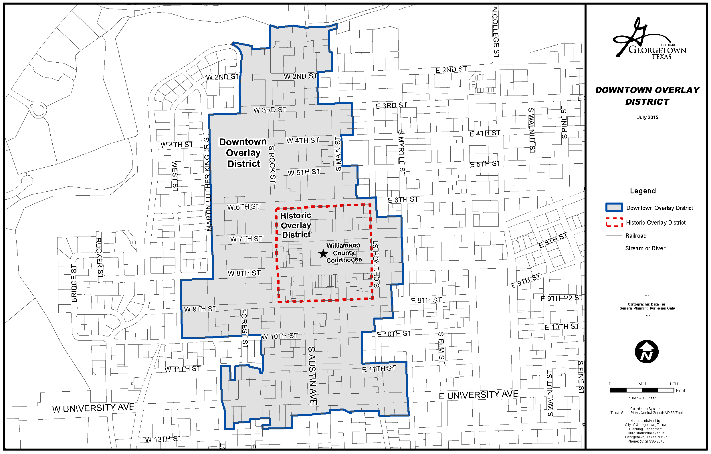
This map is available for viewing at the Planning Department office or as a downloadable map at http://maps.georgetown.org.
B.
Old Town Overlay District.
The Old Town Overlay District was established by the City Council as part of adoption of Ordinance No. 2004-22 on April 13, 2004. The Old Town Overlay District is generally bounded on the north by 2nd Street; on the east by Holly Street, the railroad tracks, University Avenue, and Hutto Road; on the south by 17th, 18th, and 19th Streets; and on the west by the properties on the western side of Austin Avenue and the boundaries of the Downtown Overlay District. The Old Town Overlay District abuts, but does not include the Downtown Overlay District. The precise boundaries are depicted on the map incorporated below.
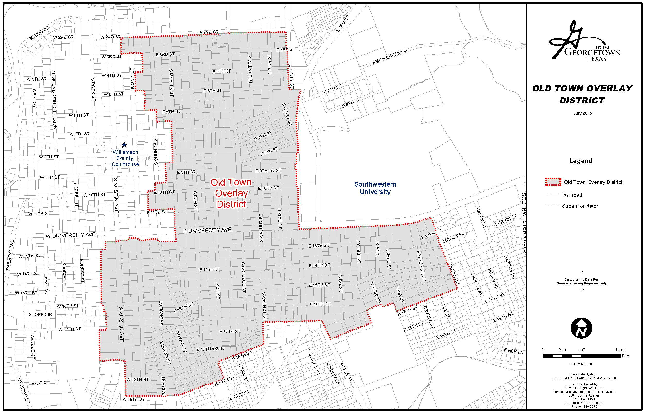
This map is available for viewing at the Planning Department office or as a downloadable map at http://maps.georgetown.org.
C.
Designated Historic Districts.
Designation of a Historic District shall be established and governed in accordance with this Code. This subsection contains all designated Historic Districts under this Code. Designated Historic Districts are as follows:
1.
Town Square Historic District.
The City Council designated the Town Square Historic District by the adoption of Ordinance No. 2001-48, the confines of which are defined as follows: All lots in Blocks 37, 38, 39, 40, 41, 50, 51, and 52 of the City of Georgetown, Texas, according to the map or plat thereof of record and which lots are all of those properties on the nine blocks surrounding and including the property that may commonly be referred to as the Public Square or Court House Square of the City of Georgetown, Williamson County, Texas. The precise boundaries are depicted on the map incorporated below.
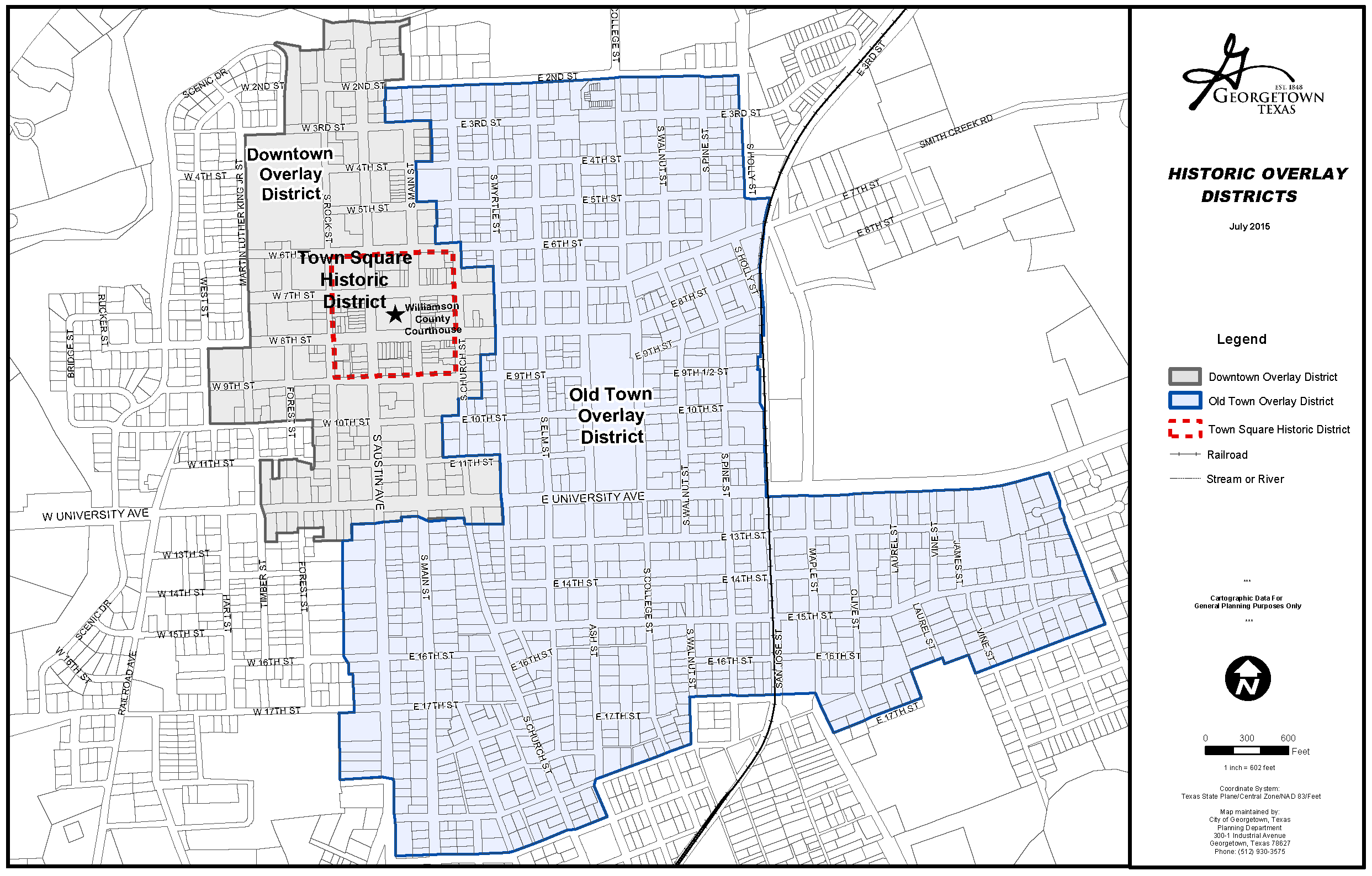
This map is available for viewing at the Planning Department office or as a downloadable map at http://maps.georgetown.org.
D.
Historic Landmark Designation.
Designation of a Historic Landmark shall be established and governed in accordance with this Code. Buildings or structures to be protected, preserved, restored and enhanced as a historic resource and in the interest of the culture, prosperity, education, and welfare of the City of Georgetown may be designated as a Historic Landmark by ordinance of the City Council. Upon designation of a building or structure as a Historic Landmark, the City Council shall cause this designation to be recorded in the official public record of real property of Williamson County and the City of Georgetown official's zoning map. All zoning maps shall reflect historic landmarks by inclusion of the words "Historic Landmark" (HL) as a prefix to its use designation in accordance with this Code.
(Ord. No. 2015-34, § 2(Exh. A), 5-12-2015; Ord. No. 2021-53, § 8(Exh. G), 7-27-2021)
Sec. 4.08.030. - Certificate of Appropriateness Required.
All new buildings and changes to existing buildings located in a Historic Overlay District, designated as a Historic Landmark, or located in a National Register of Historic Places of the US National Park Service are subject to the Certificate of Appropriateness provisions of Section 3.13 of this Code. Any activity requiring review of a Certificate of Appropriateness per Section 3.13 of this Code will be subject to this Section and the Historic District Design Guidelines adopted by the City of Georgetown.
(Ord. No. 2015-34, § 2(Exh. A), 5-12-2015; Ord. No. 2019-21, § 2(Exh. A), 4-9-2019; Ord. No. 2021-53, § 8(Exh. G), 7-27-2021)
Sec. 4.08.040. - Applicability of Historic Overlay District Standards.
A.
Each designated Historic Overlay District may have unique standards that are described in the adopting ordinance for that district.
B.
The development and design standards contained within this Section are intended to supplement any development and design standards of an underlying base zoning district. The standards of the underlying base zoning district, as well as those of any other applicable overlay district, shall remain in effect unless superseded by specific standards of the applicable historic overlay district.
C.
In the event of a conflict between the development regulations of the underlying zoning district and the provisions of this Section, the provisions of this Section shall apply.
D.
Any regulations for a specific Historic Overlay District shall apply to all properties or structures wholly contained within that district and to those portions of any property or district located within the district.
E.
All uses permitted or conditionally permitted in the underlying zoning districts shall continue to be permitted or conditionally permitted, respectively, unless otherwise specified in the specific standard for the overlay district. HARC shall not have the authority to approve the specific use of a site.
(Ord. No. 2015-34, § 2(Exh. A), 5-12-2015; Ord. No. 2019-21, § 2(Exh. A), 4-9-2019)
Sec. 4.08.050. - General Guidelines Applicable to All Historic Overlay Districts.
A.
The historic character of a building or structure should be retained and preserved. The removal of historic materials or alteration of features and spaces that characterize a building or structure should be avoided.
B.
Each building or structure should be recognized as a physical record of its time, place, and use. Changes that create a false sense of historical development, such as adding conjectural features or architectural elements from other structures, should not be undertaken.
C.
Most buildings or structures change over time; those changes that have acquired historic significance in their own right should be retained and preserved.
D.
Distinctive features, finishes, and construction techniques or examples of craftsmanship that characterize a building or structure should be preserved.
E.
Deteriorated historic features should be repaired rather than replaced. Where the severity of deterioration requires replacement of a distinctive feature, the new feature should match the old in design, color, texture, and other visual qualities and, where possible, materials. Replacement of missing features shall be substantiated by documentary, physical, or pictorial evidence.
F.
Chemical or physical treatments, such as sandblasting, that cause damage to historic materials should not be used. The surface cleaning of structures, if appropriate, should be undertaken using the gentlest means possible.
G.
Significant archeological resources affected by a project should be protected and preserved. If such resources must be disturbed, mitigation measures should be undertaken.
H.
New additions, exterior alterations, or related new construction should not destroy historic materials that characterize the building or structure. The new work should be differentiated from the old and shall be compatible with the massing, size, scale, and architectural features to protect the historic integrity of the building or structure and its environment.
I.
New additions and adjacent or related new construction should be undertaken in such a manner that if removed in the future, the essential form and integrity of the historic property and its environment would be unimpaired.
J.
Maintaining and repairing features is preferred over replacing features as to maintain the high-quality materials, character, and embodied energy of historic buildings and to reduce the amount of waste that goes to a landfill. However, if features are deteriorated beyond repair in-kind replacement using new components that match the original in form, finish, and materials is favored. Substitute materials should be used only on a limited basis and only when they will match the appearance and general properties of the historic material and will not damage the historic resource.
(Ord. No. 2015-34, § 2(Exh. A), 5-12-2015; Ord. No. 2019-21, § 2(Exh. A), 4-9-2019)
Sec. 4.08.060. - Demolition by Neglect.
A.
An owner of a building or structure designated as a historic landmark or located in a historic overlay district, or person with interest in the real property, shall not allow such structure to fall into a serious state of disrepair so as to result in deterioration which would, in the judgment of the Historic Preservation Officer and the Building Official, produce a detrimental effect upon the life and character of the structure itself.
B.
The Building Official and Historic Preservation Officer of the City of Georgetown shall determine the "serious state of disrepair" in accordance with the most current form of the International Property Maintenance Code. Examples of such deterioration include, but are not limited to, the following:
1.
Deterioration of walls or other vertical supports;
2.
Deterioration of roofs or other horizontal members;
3.
Deterioration of exterior chimneys;
4.
Deterioration or crumbling of exterior stucco or mortar;
5.
Ineffective waterproofing of exterior walls, roof or foundations, including broken windows or doors;
6.
Deterioration of exterior walls, doors, windows, or other means of interior access, so as to create a danger of trespassing;
7.
Deterioration of plumbing and electrical systems affecting the exterior of the structure; or
8.
A hazardous condition resulting from the deterioration of any exterior feature, which might indicate that demolition is necessary for the public safety.
C.
A property owner, or person with interest in the real property, who is in violation of this Section shall be subject to enforcement measures under Section 15.02.030 of this Code.
D.
Should compliance with this Section require more than ordinary maintenance and repair, the provisions of Section 3.13, Certificate of Appropriateness, shall be applicable.
(Ord. No. 2015-34, § 2(Exh. A), 5-12-2015)
Sec. 4.08.070. - Standards Specific to the Downtown Overlay District.
This Section contains specific development and design standards applicable to properties located in the Downtown Overlay District of the City of Georgetown.
A.
Building Height.
1.
Building height in the Downtown Overlay District shall not exceed 40 feet, unless a Certificate of Appropriateness is approved by HARC in accordance with the procedures set forth in Section 3.13 of this Code.
2.
Buildings located along the portion of Austin Avenue that lies within the boundaries of the Downtown Overlay District shall be at least two usable stories in height with an overall building height of not less than 20 feet, subject to compliance with the Courthouse View Protection Overlay District of Section 4.10. However, HARC may approve a Certificate of Appropriateness in accordance with the procedures set forth in Section 3.13 of this Code.
B.
Setbacks.
Building setbacks adjacent to public rights-of-way in the Downtown Overlay District shall generally be assumed to be zero feet or "built to" the right-of-way line. Such setbacks shall be reviewed on a case-by-case basis in accordance with the adopted Historic District Design Guidelines.
C.
Parking.
There shall be no off-street parking requirement in Area 1 of the Downtown Overlay District, except as required by Section 5.04.020.M.2 of this Code. In Area 2 of the Downtown Overlay District, the parking standards of Table 9.02.030.A shall apply. Alternative parking plans, as described in Section 9.02.060 of this Code, may be considered.
D.
Signs.
The sign standards shall be those contained within the Historic District Design Guidelines. In the event that no standards exist, the standards in this Code shall apply, and may be modified in order to more accurately reflect the express language or the intent of the design guidelines in regard to signs.
(Ord. No. 2015-34, § 2(Exh. A), 5-12-2015; Ord. No. 2019-21, § 2(Exh. A), 4-9-2019; Ord. No. 2021-53, § 8(Exh. G), 7-27-2021)
Sec. 4.08.080. - Standards Specific to the Old Town Overlay District.
This Section contains specific development and design standards applicable to properties located in the Old Town Overlay District of the City of Georgetown.
A.
Parking.
The parking standards of Table 9.02.030A shall apply. Alternative parking plans, as described in Section 9.02.060 of this Code, may be considered.
B.
Signs.
The sign standards contained within the Historic District Design Guidelines shall apply. In the event that no standards exist, the standards of this Code shall apply and may be modified in order to more accurately reflect the express language or the intent of the design guidelines with regard to signs.
C.
Building Height.
1.
Buildings within the Old Town Overlay District shall not exceed 30 feet in height. However, a Certificate of Appropriateness may be approved in accordance with Section 3.13 of this Code to allow utilization of the height limitation of the underlying zoning district.
2.
Maximum building height at the prescribed setback of the underlying base zoning district shall not exceed 15 feet. For each additional three feet of setback from the property line, the building may increase in height by five feet. However, a Certificate of Appropriateness may be approved in accordance with Section 3.13 of this Code to allow building heights in excess of this requirement.
D.
Setbacks.
Setbacks shall be that of the underlying base zoning district. However, for residential structures in the Old Town Overlay District, a Certificate of Appropriateness may be approved in accordance with Section 3.13 of this Code to allow a residential structure to encroach into a required setback.
E.
Floor-to-Area Ratio.
The floor-to-area-ratio (FAR) within the Old Town Overlay District shall not exceed 0.45, unless a Certificate of Appropriateness is approved in accordance with Section 3.13 of this Code.
(Ord. No. 2015-34, § 2(Exh. A), 5-12-2015; Ord. No. 2021-53, § 8(Exh. G), 7-27-2021)
Sec. 4.08.090. - Standards Specific to Designated Historic Districts.
A.
Town Square Designated Historic District.
The Town Square Historic District shall follow the standards set forth for the Downtown Overlay District.
(Ord. No. 2015-34, § 2(Exh. A), 5-12-2015)
Sec. 4.08.100. - Standards Specific to Historic Landmark Designation.
A.
Design, alterations, additions and maintenance of a building or structure designated as a Historic Landmark shall be in keeping with applicable guidelines of the Historic District Design Guidelines as adopted by the City Council.
B.
Buildings, structures or sites designated as a Historic Landmark shall follow the standards set forth of the applicable underlying and overlay zoning districts.
(Ord. No. 2015-34, § 2(Exh. A), 5-12-2015; Ord. No. 2021-53, § 8(Exh. G), 7-27-2021)
Sec. 4.09.010. - Intent.
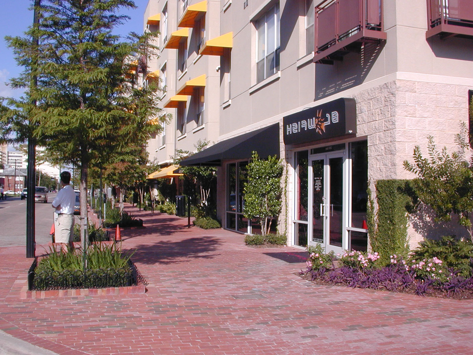
This amendment to the Unified Development Code of the City of Georgetown, Texas, pertaining to Mixed Use Development Districts (herein also referred to as "this Code"), provides development standards to promote a dense and active mixed use urban environment. To that end, this Code is based on the following general principles:
1.
The distribution and relative density/intensity of development is organized along a continuum that progresses from rural (least intense) to an urban center (most intense).
2.
A District is organized as a series of neighborhood units, or pedestrian sheds, each centered on a common destination that is located within a five-minute walk of any point in the neighborhood.
3.
Land uses should be mixed together and well integrated in close proximity to create a true urban area complete with both daytime and evening activities.
4.
Development intensity and urban character are matched to a classification of street types that are defined by their pedestrian oriented qualities.
5.
Building forms and massing should address the fronting streets directly with minimal setbacks and active occupied frontages that support enhanced pedestrian activity.
6.
Parking should be de-emphasized by locating it at the interior of blocks, behind principal building facades, by consolidating into structures whenever possible, and by several strategies designed to reduce the overall quantity of parking required.
7.
The buildings should reinforce the pedestrian experience and respond to the human scale by such devices as facade modulation, differentiation of the base zone, and provision of such elements as display windows, balconies, arcades, awnings, etc.
8.
Landscaping should concentrate on enhancing the streetscape experience and shading the pedestrian, with larger consolidation of green space into usable parks and plaza areas.
9.
Incentives are included to promote development according to these principles rather than conventional, low intensity suburban development.
(Ord. No. 2015-34, § 2(Exh. A), 5-12-2015)
Sec. 4.09.020. - General Provisions.
A.
Language Conventions.
1.
Provisions activated by certain auxiliary verbs are to be read as follows:
"Shall" indicates a mandatory provision.
"Should" indicates a recommended provision.
"May" indicates an optional provision.
2.
BOLD CAPS indicates a term that is defined in Subsection C. below and has a meaning particular to this Code.
3.
Illustrations and Tables appear throughout this Code. They are all referred to as Figures and are numbered according to the corresponding Section number, so that any Figures appearing in this Section, for example, would be numbered 4.09.021, 4.09.022, and so on.
4.
Certain terms may be abbreviated as follows:
Director means the Director of Planning and Development.
District means the area within the boundaries of any adopted MIXED USE DISTRICT.
P and D means the Department of Planning and Development.
This Code refers to this document, Section 4.09 of the UDC.
UDC means the Unified Development Code of the City of Georgetown.
5.
Written language takes precedence over graphics in the event of any discrepancy.
B.
Administrative Provisions.
1.
Administration. The provisions of this Code shall be administered and enforced by the Director in accordance with the application and approval procedures defined in Chapter 3 of the UDC.
2.
Applicability. This Code applies to any new development in a MIXED USE DISTRICT as well as any redevelopment or remodeling that alters the existing building footprint or massing. Interior remodeling or exterior modifications of a largely cosmetic nature need not comply with the provisions of this Code.
3.
Submittals. In addition to the normally required submittals for development approval, the developer shall include adequate documentation to show compliance with the requirements set forth within this Code.
4.
An EXCEPTION to any of the provisions of this Code may be requested, in accordance with the appropriate procedure described in Chapter 3 of the UDC, as referenced below.
Three levels of EXCEPTION are recognized:
a.
An Administrative EXCEPTION in a minor change to any provision of this Code that maintains the intent of the code. The procedure is described in Section 3.16 of the UDC. The Director may, at his/her sole discretion, determine whether the requested change qualifies as an Administrative EXCEPTION, or must comply with the more stringent requirement of a Major EXCEPTION.
b.
A Major EXCEPTION is a change to any code provision that would require a public hearing process for Planning and Zoning Commission approval, with appeal to City Council.
c.
A Map Amendment is any change to the Regulating Plan, i.e. a change in boundaries, street alignment, block layout, or SUB-DISTRICT. Map Amendments shall follow the procedure outlines in Section 3.06 of the UDC.
C.
Definitions.
Terms requiring interpretation specific to this Code are defined below. These definitions are supplemental to those in the UDC, Chapter 16, and take precedence in the event of conflict.
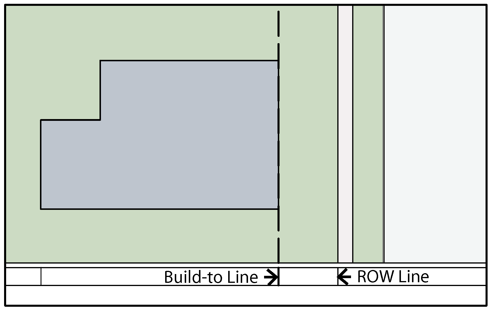
Build-to Line
BOUTIQUE HOTEL means a small hotel, generally less than 50 rooms, with a unique location or building, and not part of a large hotel chain.
BUILD-TO LINE means that line to which the placement of the building frontage is mandatory.
BUILDING FRONTAGE means that portion of a building's facade that fronts on a street and encompasses the ground floor elevation as well as any other floors forming a pedestal.
Building frontage shown shaded
CHAPELS means a small congregational space, generally with fewer than 100 seats, intended for private meditation and small scale devotional services.
COMMON DESTINATION means an area of focused community activity defining the approximate center of a PEDESTRIAN SHED. A Common Destination may include one or more of the following uses: a civic building or park, a neighborhood service commercial center, or a transit stop.
COMMUTER RAIL STATION means a facility that allows for the boarding/unboarding of a commuter train. Consists of, at minimum, a boarding platform, but may also contain other associated uses such as ticket offices, waiting rooms, service retail, etc.
COMMUNITY GARDEN means a piece of land managed and cultivated by a group of people, generally by dividing it into small allotments. It may be incorporated as part of a larger public open space, or may be a stand-alone facility; in either case, it counts as open space.
ELEVATED BUILDING means a building that is partially or wholly constructed over a parking area. A building that is elevated not more than four feet shall not be considered an "elevated building" for purposes of this Code.
EXCEPTION is an approved change to any provision of this Code. EXCEPTIONS may be Administrative or Major, and must be approved in accordance with the procedures referenced in Section 4.09.020.B.
LOT FRONTAGE means the portion of the lot abutting a public right-of-way. Where more than one side of a property abuts a public right-of-way, one frontage shall be designated as the primary lot frontage; generally, this will be the frontage on the highest ranked street.
MIXED USE BUILDING means a building containing two or more of any permitted uses, stacked vertically. An example of a mixed use building is one that contains ground floor retail and upper floor offices or residential or both.
MIXED USE DISTRICT means an area designated on the current Future Land Use Plan as mixed use, and that has adopted a REGULATING PLAN in compliance with this Code.
PEDESTRIAN SHED means an area, approximately circular, centered on a COMMON DESTINATION. It represents all points within a five-minute walk of the COMMON DESTINATION.
PLAYGROUND means an open space designed and equipped for the recreation of children.
PUBLIC OPEN SPACE means one of several types of outdoor spaces meant to be publicly accessible and used for recreation or simply to provide a relief and counterpoint to densely developed areas. They may vary greatly in size, design, and function based on the nature of the surrounding context.
REGULATING PLAN means a graphic map of a District that serves as the official zoning map and complies with the provisions of Section 4.09.040.
SETBACK means the required minimum front, side, or rear yard distance between a building or structure and the property line or private street easement line.
STREET TYPE means the classification of a street within a District according to the design characteristics of the zone between the curb and the building faces. The specific Street Types are described in Section 4.09.060.
SUB-DISTRICT means that portion of the property within a District that is designated to meet a specific set of regulations, analogous to a Zoning District in the UDC. The various Sub-Districts are described in Section 4.09.030 and the primary regulations that apply to each Sub-District are described in Section 4.09.050.
TRANSECT means a framework that organizes types, or character, of development along a continuum that progresses from the rural (least intense) to the city center (most intense).
(Ord. No. 2015-34, § 2(Exh. A), 5-12-2015)
Sec. 4.09.030. - Organizing Framework.
A.
Adoption of MIXED USE DISTRICTS.
This Code applies to any MIXED USE DISTRICT that formally adopts this Code as its zoning regulations. The basic steps in the adoption process are as follows:
1.
A MIXED USE DISTRICT shall be applicable to any one of various Mixed Use classifications on the Future Land Use Plan of the City of Georgetown. Note that many of these are indicated as a general location, i.e., at a key intersection, and that the specific boundaries of such Districts will require more detailed planning in order to establish definite boundaries.
2.
All of the property within a proposed MIXED USE DISTRICT shall undertake a master planning exercise resulting in the creation of a REGULATING PLAN meeting the requirements of Section 4.09.040 of this Code.
3.
Upon approval of the REGULATING PLAN, all of the property within a proposed MIXED USE DISTRICT shall be re-zoned to MU - Mixed Use or TOD - Transit Oriented Development in accordance with the process defined for a Zoning Map Amendment in Chapter 3, Applications and Permits, of the UDC, and in compliance with the comprehensive plan.
B.
Organizing Framework.
This Code is based on the organization of development along a smooth continuum, or TRANSECT that progresses from rural (least intensive) to urban (most intensive). Various conditions along this TRANSECT are codified here as zoning SUB-DISTRICTS.
Accordingly, the SUB-DISTRICTS defined here progress from an intensive Town Center (TC) condition to a more typically suburban General Neighborhood (GN) condition. Additionally, this Code defines a Highway Corridor (HC) to accommodate uses that typically gravitate to busy arterial highways.
This Code regulates development by correlating form and function. The function of a given development parcel is determined by its SUB-DISTRICT. The form is determined by the classification of the STREET TYPE fronting the parcel. SUB-DISTRICT and STREET TYPE are correlated in accordance with Figure 4.09.031.
Figure 4.09.031 Organizing Framework
Shaded area indicates a permitted combination
1.
The SUB-DISTRICT regulates the following development parameters:
a.
Use
b.
Intensity and/or density of use
c.
Lot coverage
d.
Building height
Specific Standards are defined in Section 4.09.050, SUB-DISTRICT Standards.
2.
The STREET TYPE regulates the following development parameters:
a.
Front setback or build-to zone.
b.
Frontage width and standards for street level occupancy.
c.
Parking and driveway location.
d.
Curb Cuts.
Specific Standards are defined in Section 4.09.060, Streets and Blocks.
3.
SUB-DISTRICTS and STREET TYPES are identified on the REGULATING PLAN, a diagram showing the physical disposition and extent of these elements within a District's Boundaries.
4.
The REGULATING PLAN also identifies locations and sizes of PUBLIC OPEN SPACE, which is classified into certain types based on size, characteristics, and location. Standards for PUBLIC OPEN SPACE are defined in Part F of this Section.
5.
The intent of this Code is that stormwater detention and water quality facilities are provided on a District-wide basis, thereby relieving individual development parcels from having to make any such provisions. Space for this purpose shall be shown within the areas designated as Open Space on the REGULATING PLAN if the District-wide improvements for this purpose have not been completed as of the adoption of this Code.
6.
Architectural features of the buildings, as well as ancillary elements such as landscaping and signage, will have varying requirements based on both SUB-DISTRICT and STREET-TYPE.
C.
REGULATING PLAN Required.
No parcel within a Mixed Use District may be developed without the creation and adoption of a REGULATING PLAN governing all properties within the District. The REGULATING PLAN shall conform to the Standards defined in Section 4.09.040, REGULATING PLAN.
D.
SUB-DISTRICTS.
The following SUB-DISTRICTS of a Mixed Use District are defined:
Town Center
1.
TC (Town Center) - Generally, those properties directly adjacent to, and within one block of a mass transit stop. TC allows for a broad range of uses with a pedestrian orientation at street level. TC allows for intensive use of the site.
Mixed Use
2.
UV (Urban Village) - Generally, those properties fronting on a designated 'A' Street as defined in Section 4.09.030.E below, although it may also occur along a 'B' Street. UV is intended to provide for a wide range of uses well integrated in close proximity. UV should provide for a lively pedestrian experience with a bias to commercial uses at the street level.
Urban Neighborhood
3.
UN (Urban Neighborhood) - Generally, those properties fronting on a designated 'B' Street as defined in Section 4.09.030.E below, although it may also occur along a 'C' Street. UN allows for residential uses ranging from multi-family to dense single-family, as well as limited commercial uses such as live/work units, small scale professional office, bed-and-breakfast lodging, and neighborhood service commercial.
General Neighborhood
4.
GN (General Neighborhood) - Generally, single-family residential properties fronting on a designated 'C' Street as defined in Section 4.09.030.E below. This may also include live-work units and garage apartments complying with this Code.
Highway Corridor
5.
HC (Highway Corridor) - Generally, properties fronting on a major thoroughfare or limited access highway. HC is intended to accommodate conventional highway oriented commercial development, although it should provide for sensitive transitions to adjacent Sub-Districts.
E.
STREET TYPES.
This Code recognizes that many of the key unifying and character-defining features of a neighborhood or urban area are determined by the design and function of the streets. In order to simplify what could easily be an unlimited number of variations, this Code classifies STREET TYPE according to the characteristics of the zone between the curb and the building face. Thus, an 'A' Street, for example, would always have the fundamental characteristics described below, but may vary in numbers of lanes, right-of-way width, presence of center median, etc. Refer to Section 4.09.060.D for Street Design Standards.
The following STREET TYPES are defined:
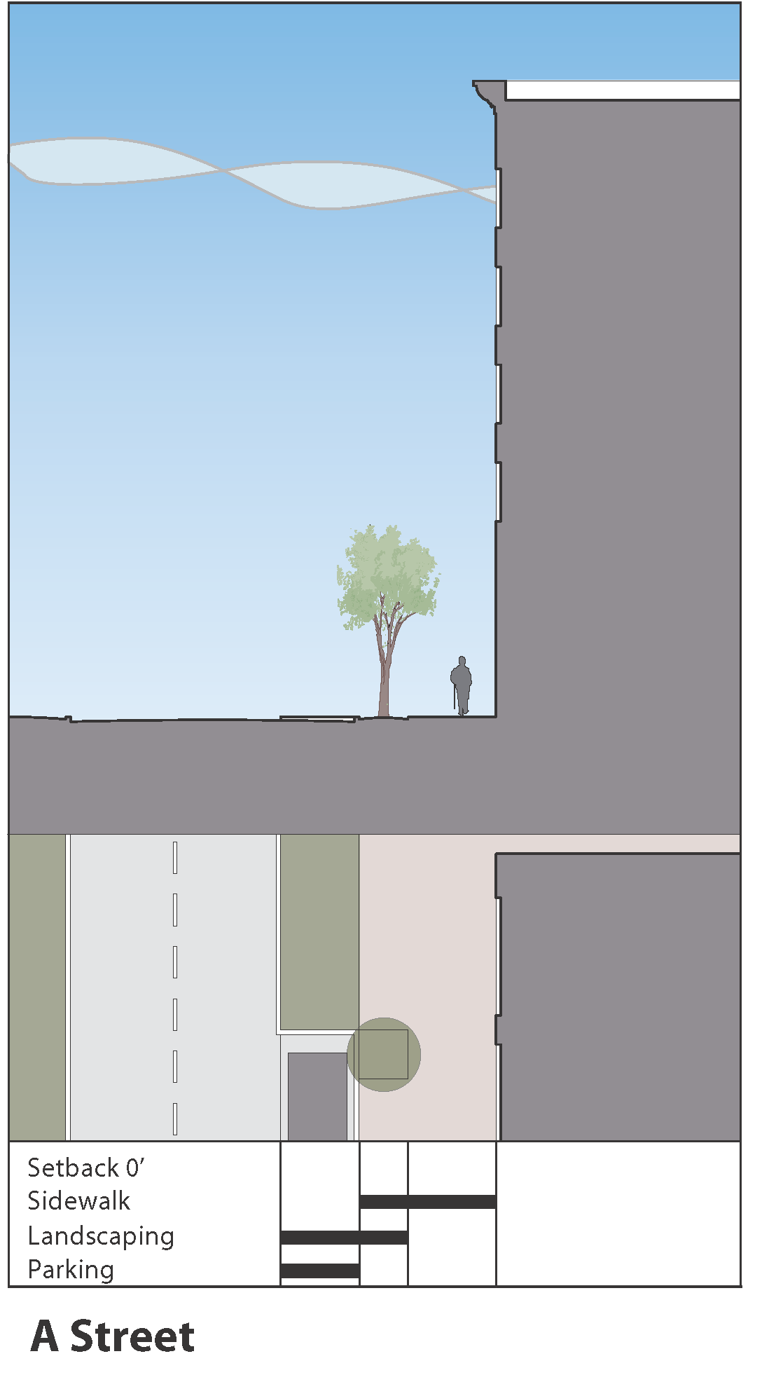
1.
A Streets are urban, pedestrian friendly, mixed-use streets characterized by:
a.
Wide sidewalks, at least eight feet wide, and even exceeding 15 feet in special circumstances.
b.
Building faces placed at the right-of way line.
c.
Primarily commercial uses at the street level, with a high degree of access, visibility, and permeability.
d.
On-street parking is highly recommended, either in angled or parallel form.
e.
Driveway cuts are highly restricted.
f.
Landscaping is generally limited to evenly spaced, contained tree wells.
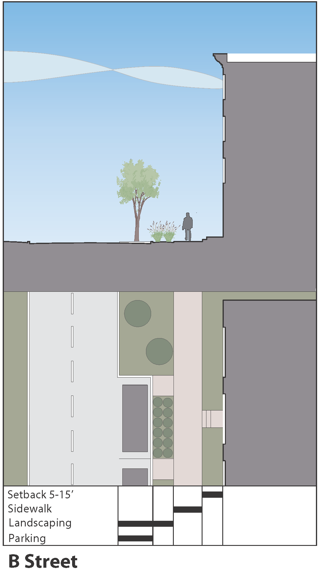
2.
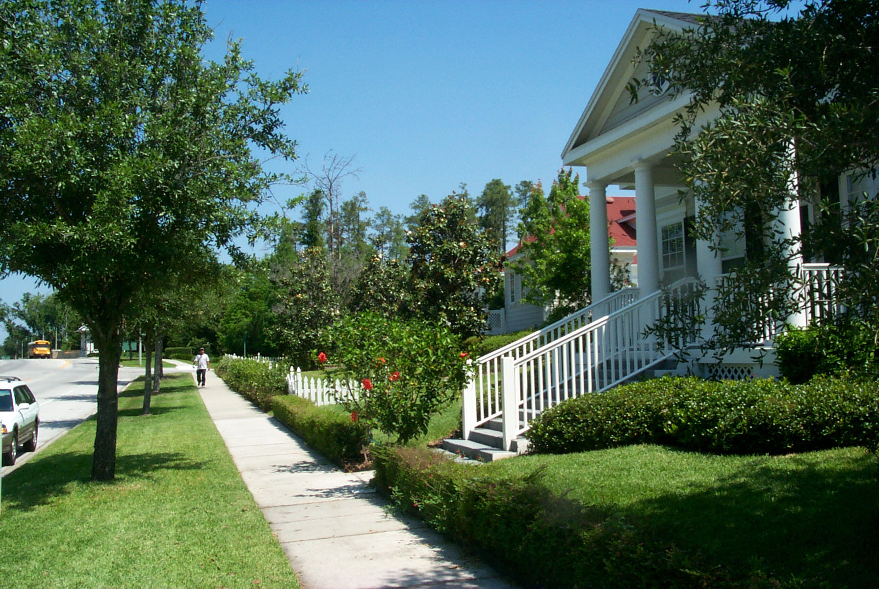
B Streets are also urban and pedestrian-friendly, but are more residential in nature, characterized by:
a.
Wide sidewalks, ranging from six to eight feet.
b.
Building faces placed between five and 15 feet of the right-of-way line.
c.
The building frontage zone consist of a combination of entry stoops, landscaped yards, and patio areas.
d.
On-street parallel parking is recommended.
e.
Driveway cuts are highly restricted.
f.
Landscaping shall occur between the curb and sidewalk and should consist of either evenly spaced tree wells or a continuous planting strip.
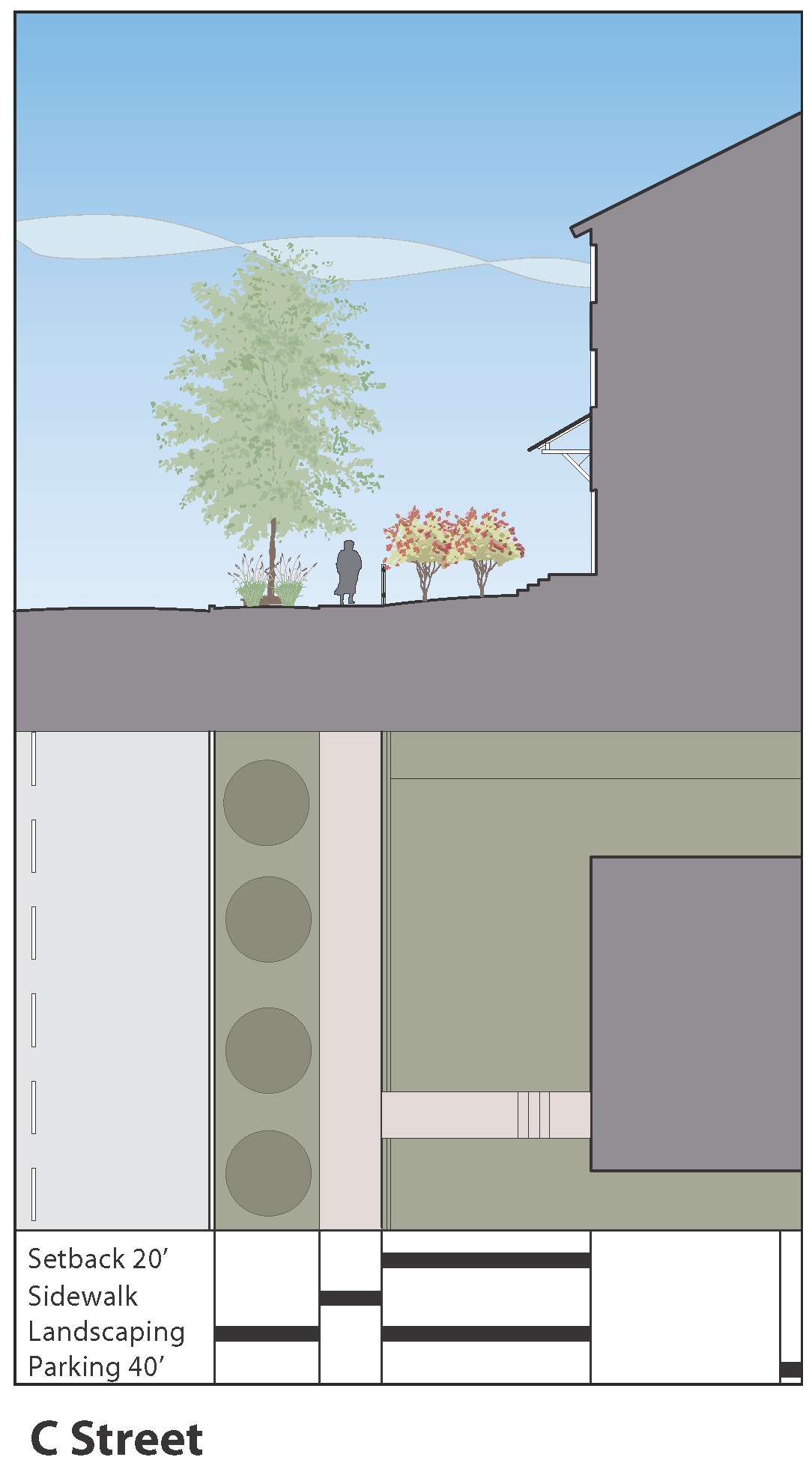
3.
C Streets are typical residential neighborhood streets, characterized by:
a.
Sidewalks in the range of five to six feet wide.
b.
Building faces at a consistent setback of 20 feet.
c.
A consistent front yard condition, which may be fenced in certain neighborhoods.
d.
On-street parallel parking is recommended.
e.
Driveway cuts are permitted only where prevailing lot widths are over 50 feet. When lot widths are equal to or less than 50 feet the lot Shall be accessed from an alley.
f.
A continuous planting strip between the curb and sidewalk.
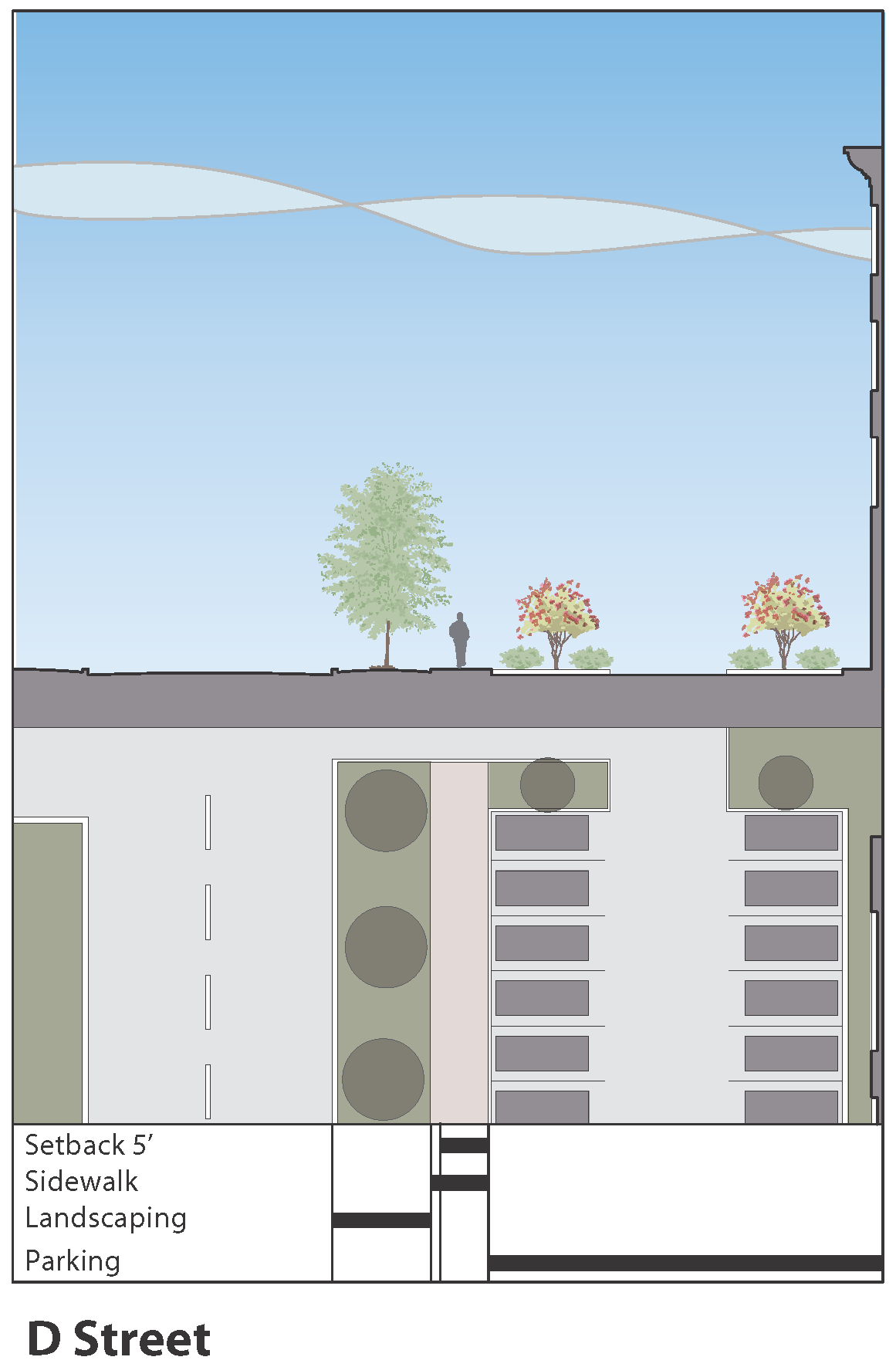
4.
D Streets are the back, or service streets that serve more intensive urban areas, and are characterized by:
a.
May only occur within one block of an A or B Street.
b.
Minimal requirements for setbacks or parking disposition.
c.
Are intended primarily for vehicular and service access and have a minimum curb cuts distance of 50 feet from street intersection.
d.
May have on-street parking to contribute to overall parking supply.
5.
E Streets are conventional thoroughfares or arterial streets, characterized by:
a.
Relatively high traffic volume at higher speeds, although they may have a slower service road adjacent to the parcel frontages.
b.
Buildings set back behind parking, although a consistent building line is established in order to facilitate pedestrian cross-access among buildings.
c.
Few driveway cuts, with required cross access of parking areas.
6.
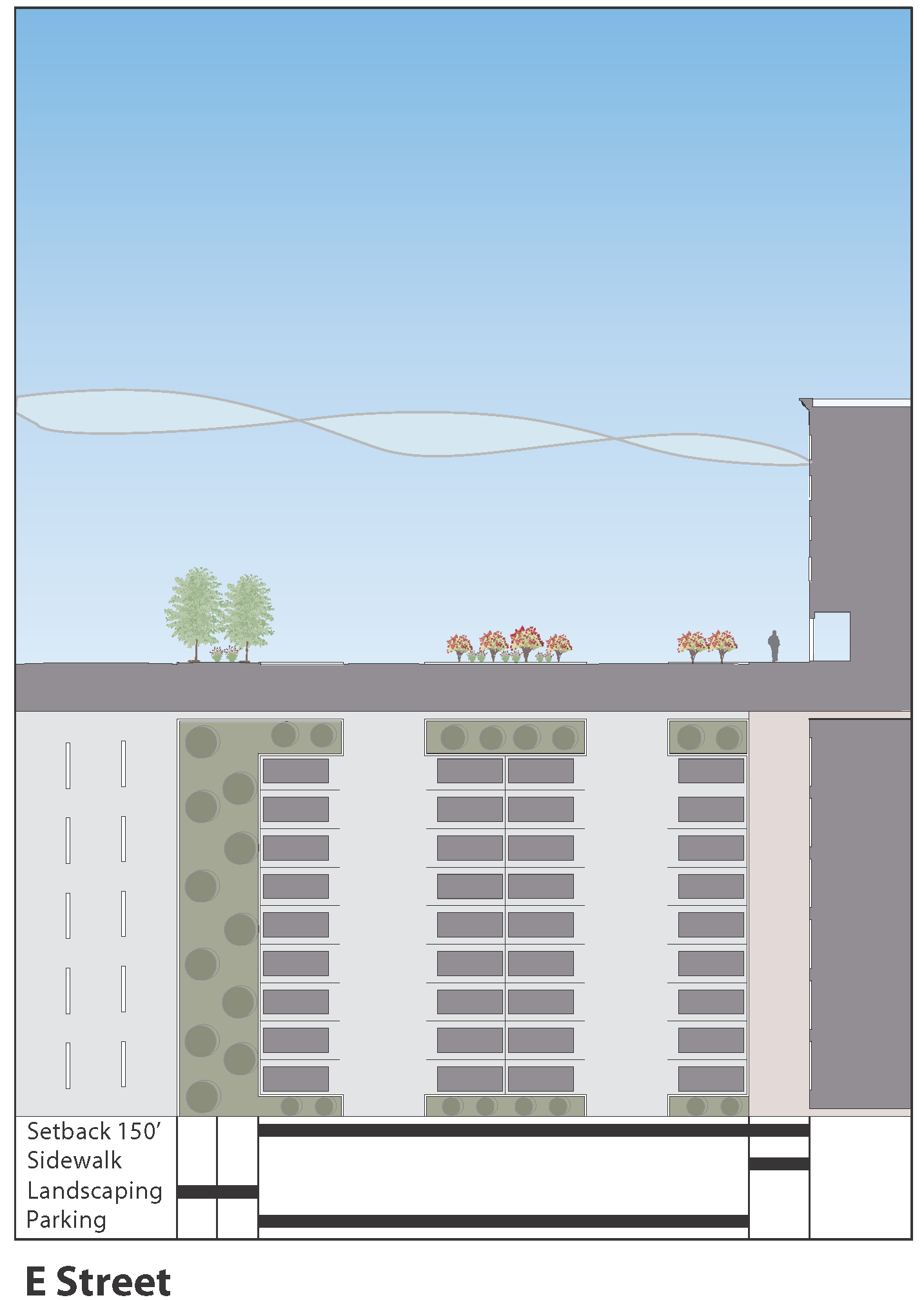
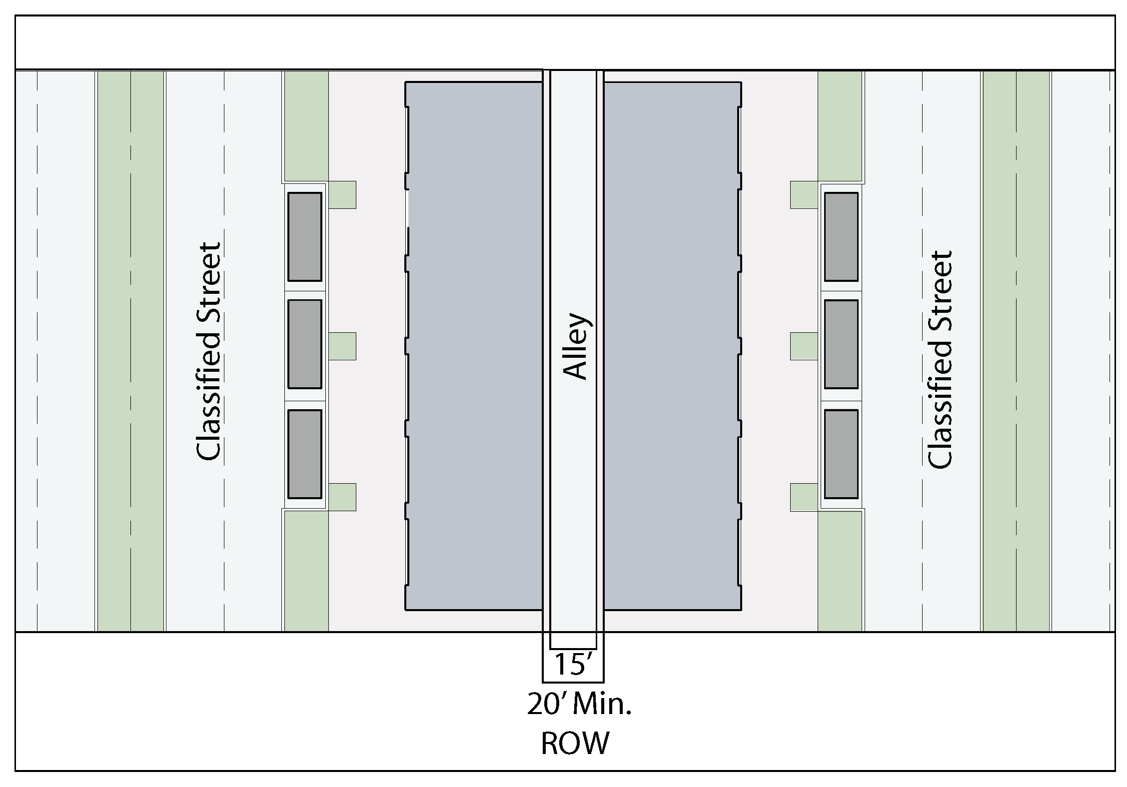
Alleys, though strongly encouraged, are not considered a STREET TYPE in the sense that they do not define a parcel frontage. They will always occur parallel to a classified street, except as provided in paragraph C below. Figures 4.09.032-4.09.033.
a.
Alleys shall have a minimum right-of-way width of 20 feet, with a minimum 15 feet of pavement width.
b.
Alleys may remain private, in which case they shall be platted as permanent easements and shall be maintained by a homeowners' association.
c.
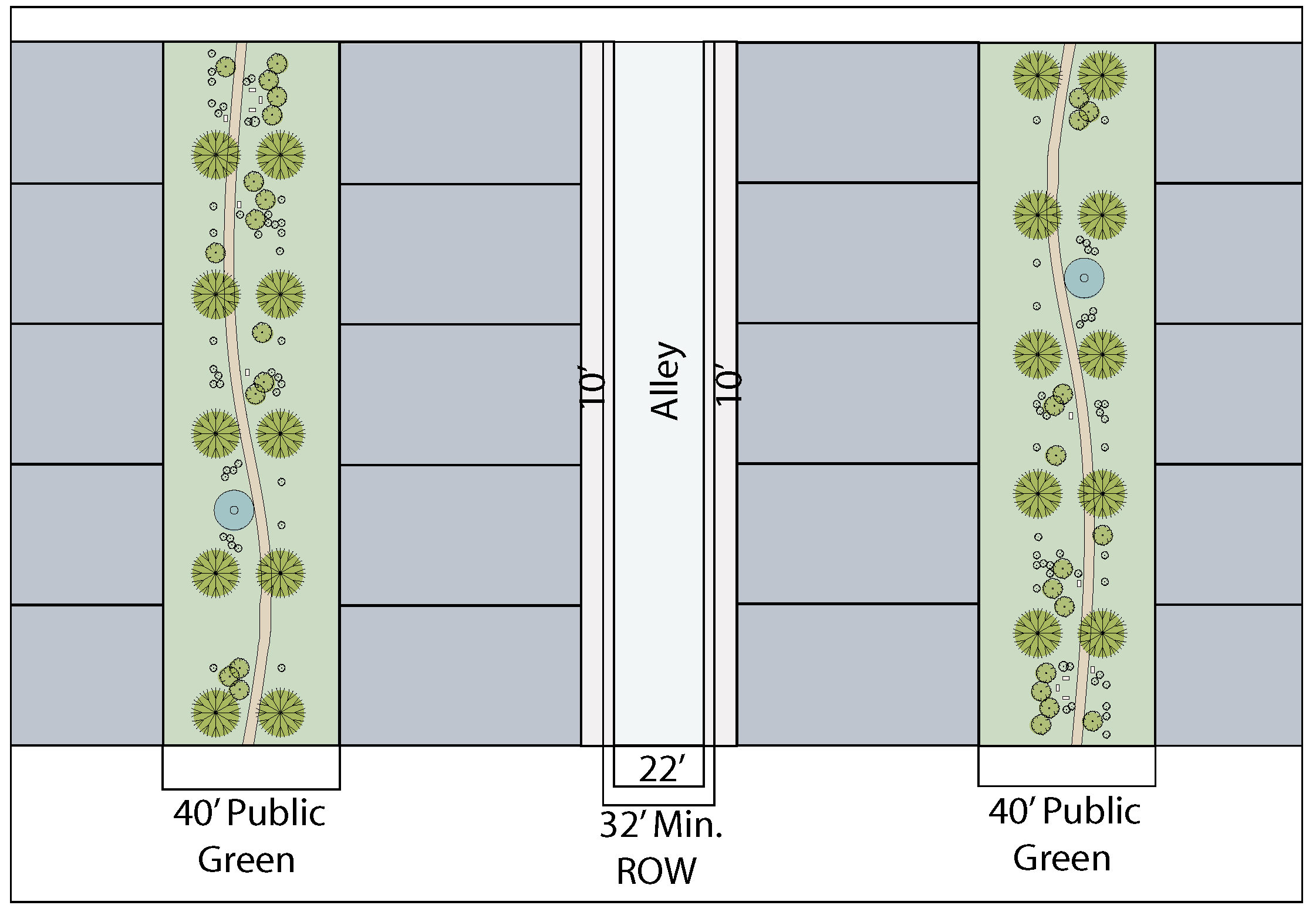
An alley may serve as the only vehicular access to a residential lot provided that:
i.
The lot fronts on a public green or pedestrian mews of at least 40 feet in width, measured between building faces.
ii.
The alley shall have a minimum right-or-way width of 32 feet, with a minimum pavement width of 22 feet. All structures shall set back a minimum of ten feet from the alley right-of-way.
iii.
The alley shall be a public right-of-way and shall not allow parking on the pavement.
F.
PUBLIC OPEN SPACE.
A neighborhood or urban district requires a certain amount of PUBLIC OPEN SPACE in order to function properly and provide the full range of human amenities. This Code classifies PUBLIC OPEN SPACE into the following types:
Regional Park
1.
Regional Park. A large, relatively unstructured open area available as a natural reserve, or for passive recreation. It may also have recreational facilities such as sports fields, pools, etc, in a portion of the area. It may be linear, such as when occurring along a stream or greenbelt, and may also serve as a stormwater detention area. Usually occurs in less dense areas of development. Generally larger than five acres in size, can be much larger.
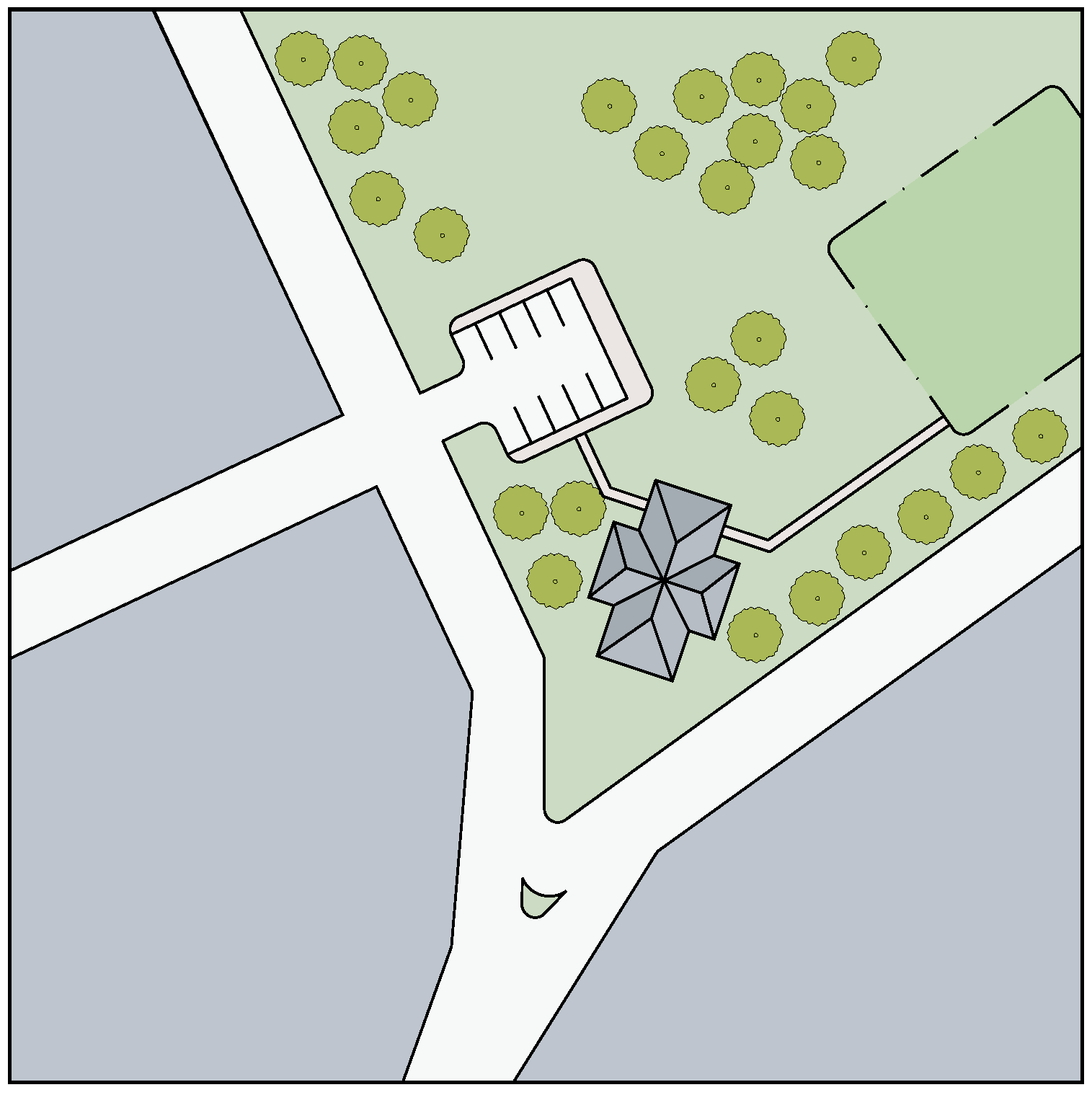
Neighborhood Park
2.
Neighborhood Park. A defined open space used primarily for passive recreation, although it may include some recreational facilities. Usually located within a predominantly residential neighborhood, and may serve as the COMMON DESTINATION for a PEDESTRIAN SHED. Generally ranges from one to five acres in size, although it may be larger in special circumstances.
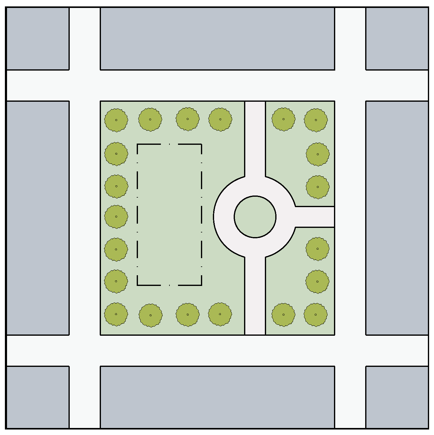
Square
3.
Square. A well-defined open space used for passive recreation and civic purposes. Generally located in denser areas of development and should be defined by building frontages on all sides. Should occur near the center of the urban activity and adjacent to at least one of the principal A or B Streets. Most of the area is landscaped, although it should contain a network of footpaths, benches, and other pedestrian amenities. Generally of a formal design. Ranges in size from one-half acre to about three acres, although it may be larger if designed as a major civic focal point.
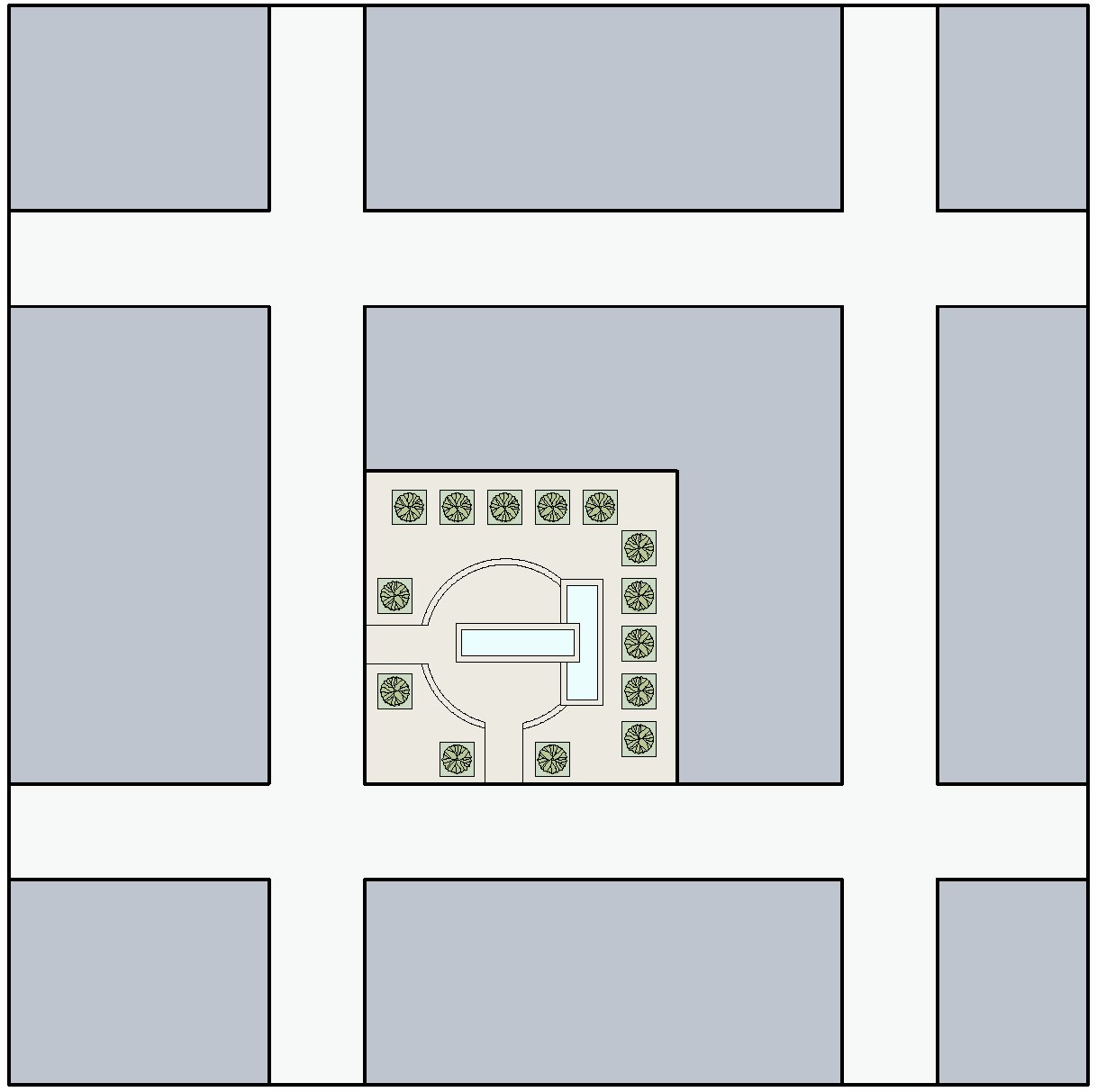
Plaza
4.
Plaza. A relatively small, well-defined open space used for civic purposes. Occurs in areas of dense development. Defined by building frontages, which should address the plaza as if it were an A Street. Predominantly hardscaped, although it may contain formal planting beds and regularly spaced tree wells. Minimum of 10,000 square feet in area, and generally no larger than one full block of the prevailing block size.
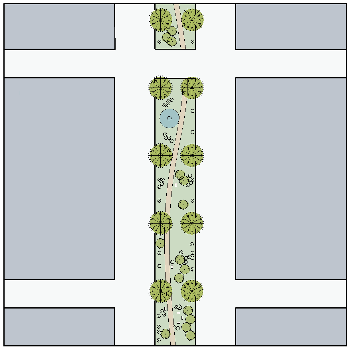
Esplanade
5.
Esplanade. A linear open space used to define a focal spine or primary avenue within a street network. Should be lined with evenly spaced rows of trees, with a footpath through the middle. May contain benches, gazebos, and other pedestrian amenities. Minimum width of 50 feet and minimum length of three blocks.
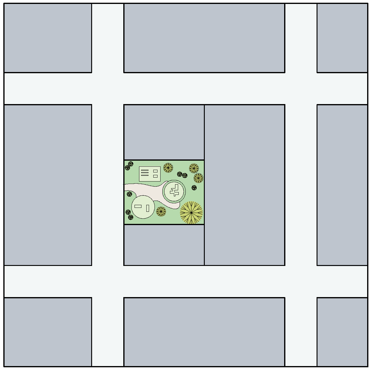
Playground
6.
Playground. An open space designed and equipped for the recreation of children. Should occur primarily in residential areas. May occupy part of a block or be included in a Neighborhood or Regional Park. No minimum or maximum size.
G.
Changes in SUB-DISTRICT.
Individual Parcels may apply for a change in SUB-DISTRICT in accordance with the Map Amendment process outlined in Section 4.09.020.B. The proposed changes shall comply with the following criteria:
1.
Parcel changes shall be of one degree, except for HC parcels, which may change to UV (or TC, provided that they are proximate to the transit stop).
2.
The change shall apply to an entire blockface; except if the change can occur at an intervening alley.
3.
The parcels being changed shall be directly adjacent to parcels that are already classified as the proposed SUB-DISTRICT.
4.
The proposed change shall not result in a difference of two degrees across the primary fronting street.
5.
The corresponding STREET TYPE shall be compatible with the proposed SUB-DISTRICT. The developer may request to upgrade the street frontage along the entire blockface, at his expense, in order to achieve a compatible SUB-DISTRICT/STREET TYPE combination as defined in Figure 4.09.031.
H.
Early Phase Development.
It is anticipated that development in the TC and UV SUB-DISTRICTS will occur over a span of years and that some parcels may remain vacant until other parts of the District are substantially built-out. It is also the intent of this Code that smaller parcels within the TC and UV SUB-DISTRICTS should be able to build-out to their maximum potential, even if they are not able to provide the full amount of required parking on-site. Accordingly, the following principles apply, and may be formalized by appropriate Development Agreements between the City and the affected property owners:
1.
Any contiguous grouping of parcels designated as TC and UV may be considered as a unified area for the purpose of allocating the parking required for a project.
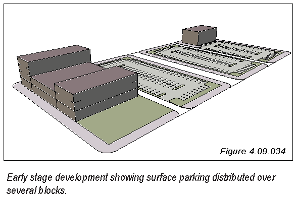
2.
Vacant parcels that may not be developed for some time may be used for surface parking in the meantime. This type of temporary parking may be considered for reduced standards for paving, landscaping, lighting, etc. on a case by case basis.
3.
Developers and landowners are encouraged to pursue interim parking arrangements among themselves in order to facilitate the earlier build-out of certain parcels.
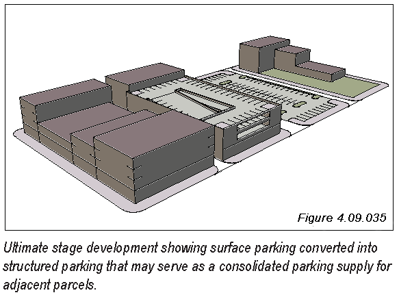
4.
Funds paid into a District Parking Fund, if such exists, may be used to make temporary parking improvements, to compensate property owners for the use of their land as parking, or for the construction of parking structures meant to serve as area-wide supplies of parking.
5.
The City may act as a facilitator in negotiating interim parking solutions, and may take an active role in the design of an overall interim parking strategy, as well as in the financing and construction of the eventual structured parking facilities.
These principles are illustrated in Figures 4.09.034—4.09.035, which show an early phase and an ultimate phase of development for a hypothetical block. In the early phase, several small parcels may develop to their full potential and have surface parking on the remainder of the block, as well as on the adjoining block. In order for the eventual full build-out to occur, some of the surface parking will be converted to structured parking that will serve the surrounding parcels.
(Ord. No. 2015-34, § 2(Exh. A), 5-12-2015)
Sec. 4.09.040. - The REGULATING PLAN.
A.
The REGULATING PLAN.
All property within a designated MIXED USE DISTRICT shall be developed in accordance with a REGULATING PLAN meeting the requirements of this Section and adopted by the City of Georgetown.
B.
Key Elements of the REGULATING PLAN.
The REGULATING PLAN shall provide for the type of dense, pedestrian and transit friendly mixed use development intended by this Code. Some of the specific elements are as follows:
1.
It recognizes all known conditions, including floodplains and all existing or proposed thoroughfare alignments. By its nature, a conforming MIXED USE DISTRICT will be located along a thoroughfare, frequently at an intersection of thoroughfares, and may also include a mass transit stop.
2.
It organizes development as a series of neighborhood units, each centered on a COMMON DESTINATION. The COMMON DESTINATION may be defined by a transit stop, a park, a neighborhood service commercial center, a civic use, or, ideally, any combination thereof. The centers are spaced so that the neighborhood units do not overlap to any great degree, and they recognize certain physical features such as a thoroughfare as a boundary.
3.
It establishes a network of streets where the A and B streets serve as the principal streets that accommodate the densest development, with other streets accommodating less intensive development. The street network allows for relatively small blocks and a high degree of connectivity.
4.
It provides for a gradual transition in development intensity and scale as one moves from a neighborhood center to the edge.
5.
It provides for a variety of commercial and residential land uses that are well integrated and interconnected within a compact and walkable area, and defines locations for PUBLIC OPEN SPACE.
6.
It accommodates stormwater detention and water quality on a District-wide basis, within the area designated as PUBLIC OPEN SPACE. Accordingly, individual development parcels within the District do not need to make any provisions for detention or water quality.
Developers should note that, while this may be the City's intent, that design or improvements for the regional detention system may not be complete at the time of initial development, in which case temporary detention provisions need to be made.
C.
REGULATING PLAN Examples.
Several examples of REGULATING PLANS are depicted in Figures 4.09.041 through 4.09.044. Each example is accompanied by a brief narrative explaining the design rationale and key features. These are intended as a general guideline for planning, as well as to demonstrate the range of possibilities. More detailed planning standards are established later in Part D of this Section.
In each case, the REGULATING PLAN identifies the Sub-Districts, the Street Types, open space, the limits of the pedestrian shed, and is planned in a manner that complies with the Planning Standards in Part D of this Section.
1.
Figures 4.09.041 and 4.09.042 depict a generic quadrant at an intersection of a major thoroughfare and a collector or minor thoroughfare. One quadrant is shown, since the thoroughfares tend to act as barriers, and each quadrant could develop independently. For the sake of simplicity, the streets are straight and orthogonal, defining rectangular blocks. The grain of the street grid is established by the nature of the thoroughfares; the posted speed of the thoroughfare requires a minimum spacing between intersecting streets or driveways. Thus, this example is characterized by the following:
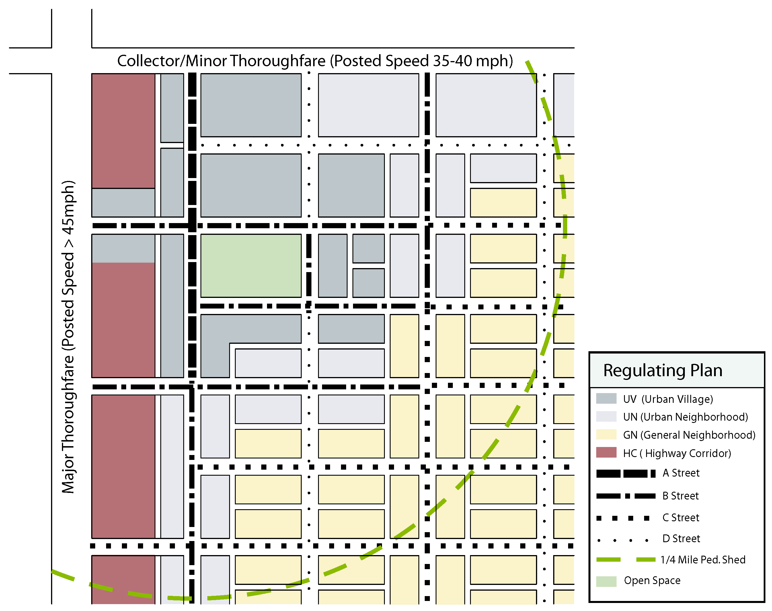
Fig. 4.09.041
a.
The parcels fronting on the major thoroughfare are reserved for HC - Highway Commercial. Busy highways like this are not conducive to small scale mixed use, and can accommodate larger, vehicle-intensive uses.
b.
The parcels fronting on the minor thoroughfare could be more pedestrian-friendly in nature, and could be replicated on the opposite side, defining the thoroughfare as a neighborhood Main Street.
c.
The more intensive Sub-Districts are concentrated near the intersection, and are focused around an open square. The scale transitions to less intensity and more residential in nature as one moves further from the intersection.
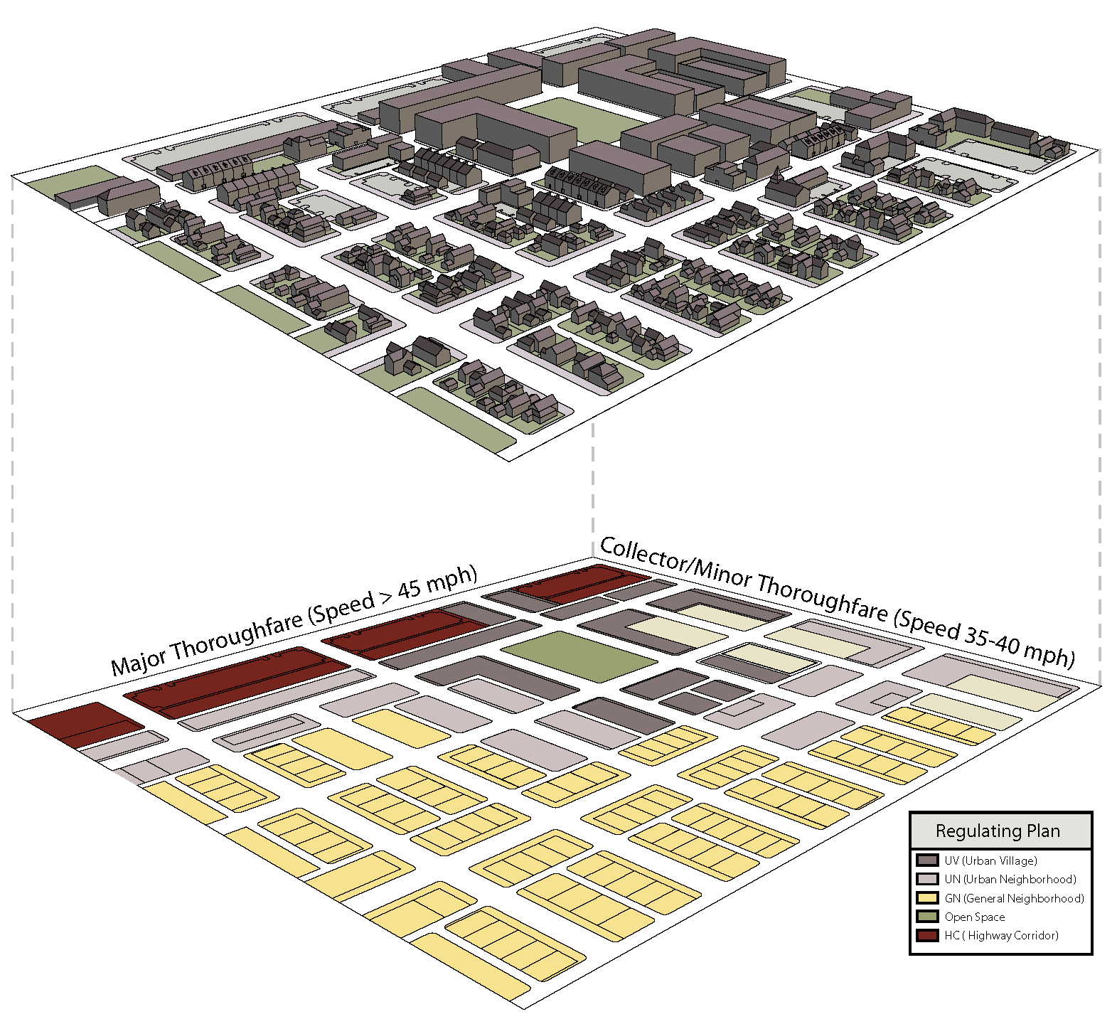
Fig. 4.09.042 A generic quadrant of a Regulating Plan, shown with a possible development
scenario above.
2.
Figure 4.09.043 demonstrates how a less rigid and rectilinear grid of streets could be incorporated. In this case, the intersection is of two major thoroughfares, so the development is more internalized within the quadrant, and focuses on a diagonal boulevard with a landscaped esplanade. The uses are more mixed near the intersection, then transition gradually to townhomes and small commercial uses before becoming predominantly residential in the lower right corner.
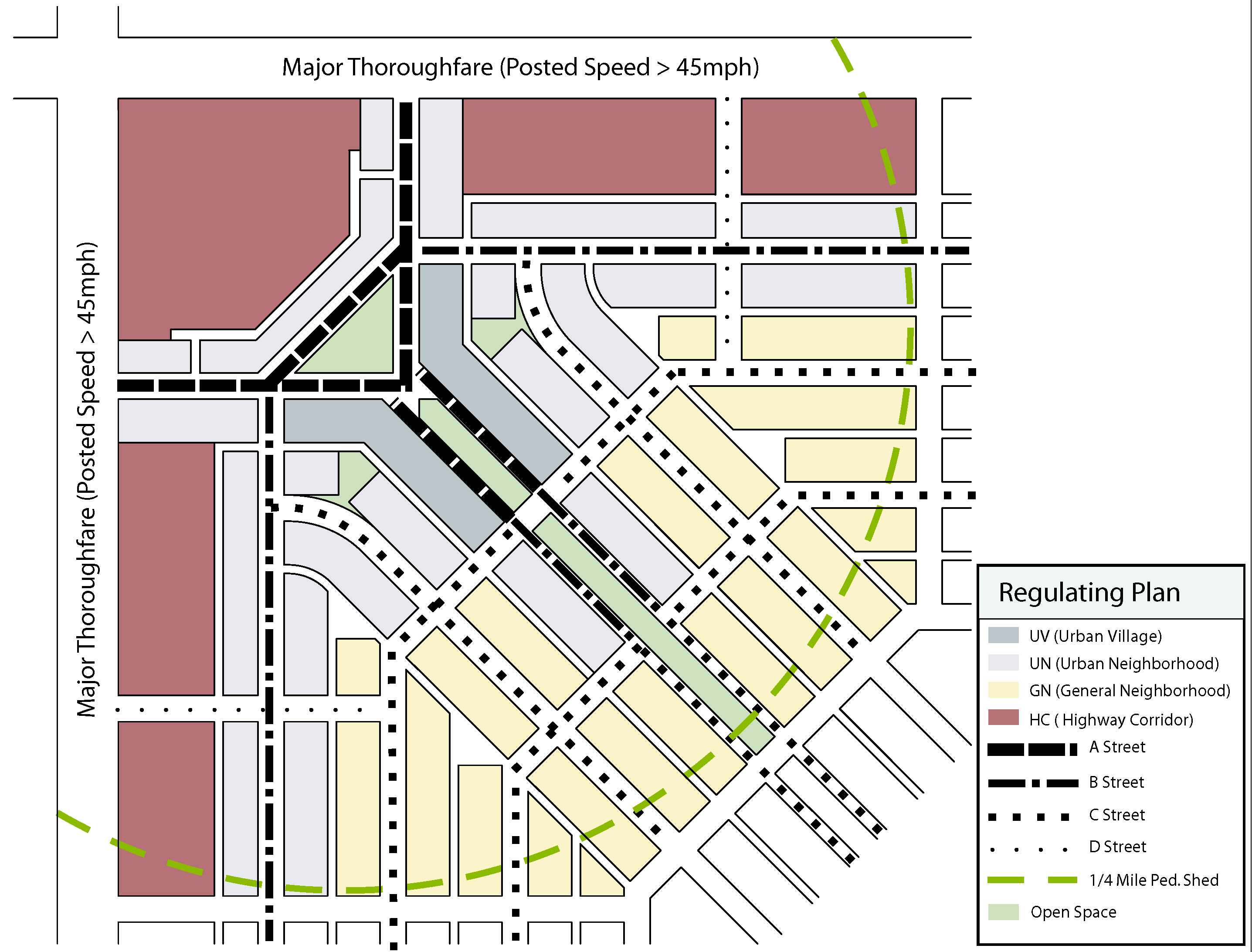
Fig. 4.09.043
3.
Figure 4.09.044 shows a less idealized situation, and one that will more likely reflect real-world conditions. This neighborhood centers on a UV - Urban Village area along a principal axis punctuated by a roundabout. A cross-axis of lesser intensity runs along an esplanade and terminates with civic uses at either end. Residential is distributed throughout, but is always within an easy walk of the mixed use center. All of the internal streets will have relatively light traffic, with the more auto-intensive uses located along the major thoroughfare.
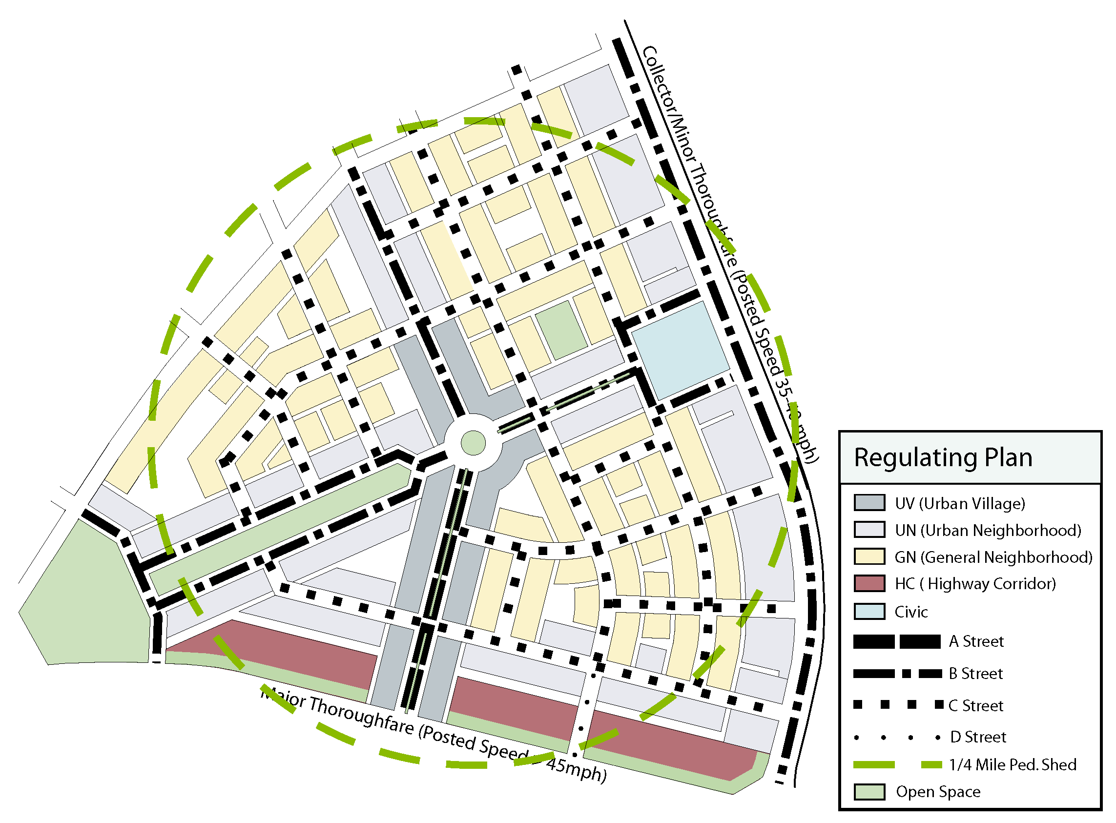
Fig. 4.09.044
D.
Planning Standards.
The REGULATING PLAN shall meet the following minimum requirements:
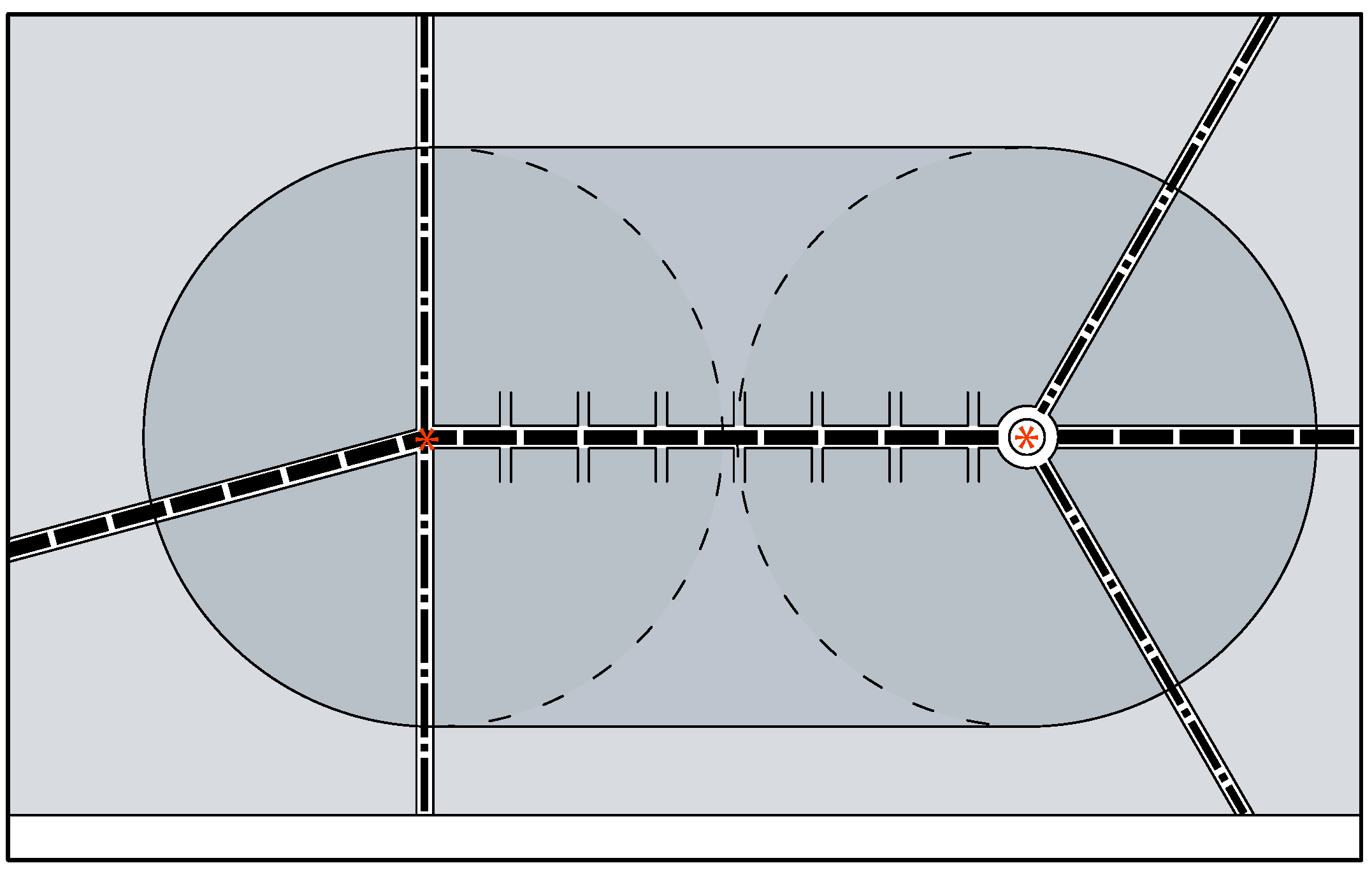
Pedestrian Shed Fig. 4.09.045
1.
Extent. A REGULATING PLAN shall apply to an entire District and shall be designed in a comprehensive and coordinated manner.
2.
PEDESTRIAN SHEDS. A REGULATING PLAN shall identify and locate PEDESTRIAN SHEDS, each centered on a COMMON DESTINATION, generally community focal points such as neighborhood service commercial uses, parks, schools, or civic centers. See Figure 4.09.042.
a.
A PEDESTRIAN SHED consists of an area enclosed by a radius of one-quarter mile (1,320 feet). For graphic purposes, they shall be drawn as circles centered on the appropriate COMMON DESTINATION.
b.
A Transit Stop shall be considered a large PEDESTRIAN SHED, which allows for a radius of one-half mile (2,640 feet).
c.
Other centers may be defined according to the overall size of the area being planned. No more than 20 percent (20%) of the area within the REGULATING PLAN may occur outside of a PEDESTRIAN SHED. Separate PEDESTRIAN SHEDS shall overlap each other by no more than 400 feet.
d.
In certain cases, a pedestrian shed may be oval in shape, when the centers define the endpoints of a featured A street. See Figure 4.09.045.
3.
Street Network. A REGULATING PLAN shall define a street network and classify all proposed streets in accordance with the classification system defined in Section 4.09.030, Organizing Framework.
a.
Each COMMON DESTINATION shall be approached by at least one A or B Street.
b.
D Streets shall only be located within one block of an A or B Street. They are intended only as the service street for an A or B Street, and will generally be parallel to the street they serve.
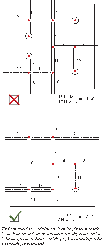
c.
Streets should form a network that allows for multiple routes between points. Cul-de-sacs are highly discouraged, and shall not occur along an A or B Street. The overall street network within a District shall have a Connectivity Ratio, as defined in Section 12.03.030 of the UDC, of at least 1.8.
d.
If a cul-de-sac provides a pedestrian/bicycle path connection to an adjacent street or another cul-de-sac, then that connection shall be counted as 0.5 link.
e.
Block Dimensions shall not exceed 600 feet along any one blockface.
f.
Blocks that are larger than the prevailing block in a neighborhood shall interrupt no more than one street in the network. The interrupted street shall not be an A or B Street.
g.
Alleys are required when any lot width on a block is less than 50 feet.
h.
Alleys are required on any block fronting an A or B Street, unless occupied by a single, full block development.
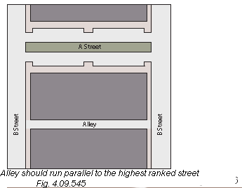
i.
Alleys shall be placed parallel to the highest ranked street. See Figure 4.09.046. Alley standards must comply with Section 12.03.020 of the UDC.
4.
Special Conditions. Figure 4.09.047 depicts an example of a Special Conditions Plan, showing elements such as:
a.
Transit stations.
b.
Parks and public open space.
c.
Civic sites.
d.
Easements and detention areas.
e.
Special urban design features such as terminated vistas and arcade frontages.
f.
A parking reserve is indicated adjacent to the transit stop. This is intended for surface parking in the short term, but can be redeveloped with buildings and structured parking.
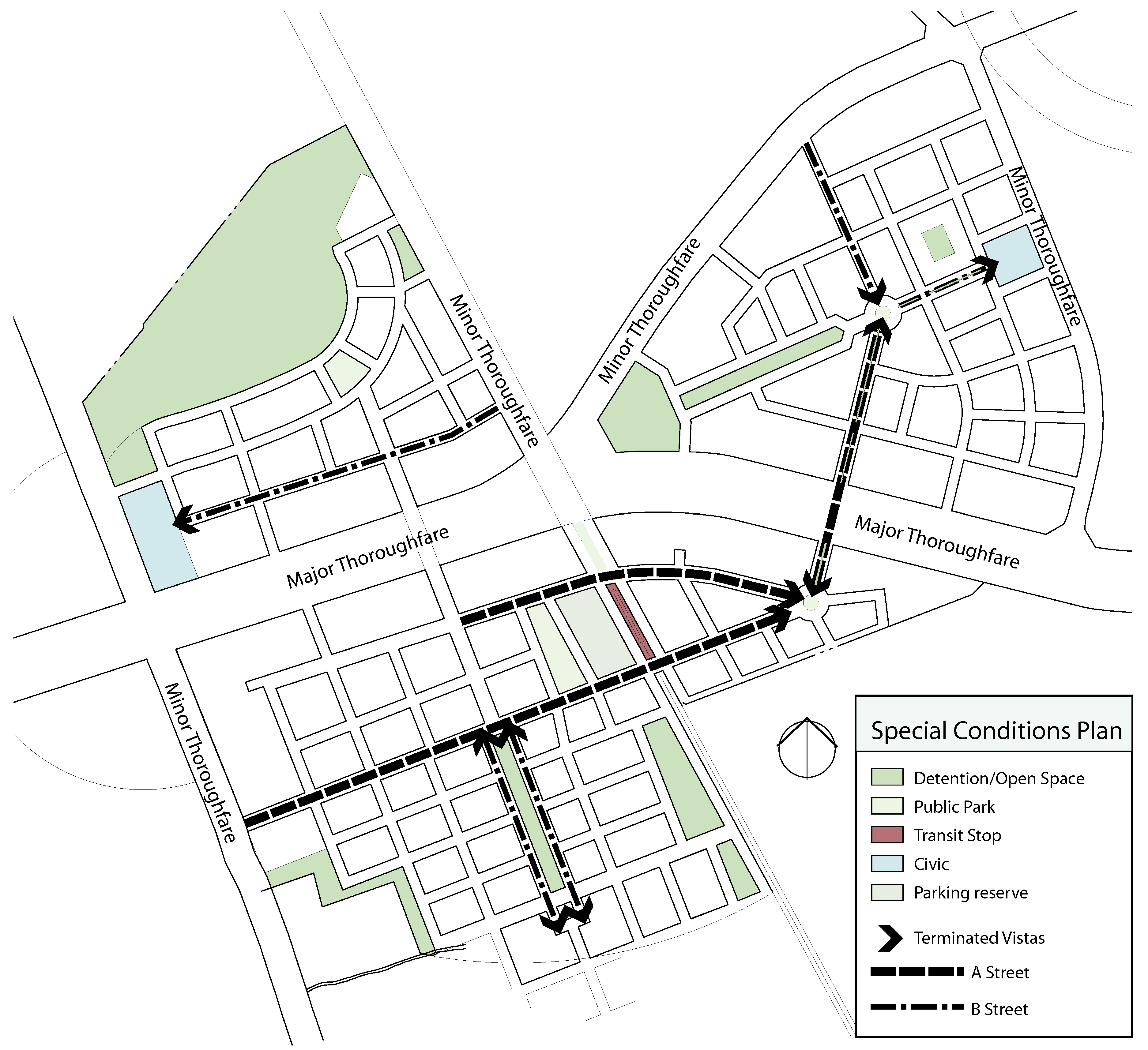
Fig. 4.09.047
5.
SUB-DISTRICTS. The blocks of developable tracts defined by the street network shall be classified into the various SUB-DISTRICTS as defined in Section 4.09.030. The allocation of SUB-DISTRICTS shall comply with the following criteria:
a.
The SUB-DISTRICT must be compatible with the enfronting STREET TYPE, as indicated in the Organizing Framework, Figure 4.09.031.
b.
All PEDESTRIAN SHEDS must contain a minimum of two different SUB-DISTRICTS.
c.
SUB-DISTRICTS shall be located relative to PEDESTRIAN SHEDS in accordance with the following criteria:
i.
TC and UV parcels shall be located entirely within a PEDESTRIAN SHED. TC parcels shall only be located within three blocks of a transit station.
ii.
A minimum of 70 percent (70%) of all UN parcels shall be located within a PEDESTRIAN SHED.
iii.
No more than 50 percent (50%) of the area within a PEDESTRIAN SHED shall be designated as GN.
d.
The following criteria apply to the distribution and adjacencies of SUB-DISTRICTS.
i.
In general, a higher intensity of SUB-DISTRICT adjacencies shall be located near the center of the PEDESTRIAN SHED, and step down gradually toward the edges.
ii.
Blocks across the street from each other shall preferably be of similar SUB-DISTRICTS, or shall differ by no more than one degree.
iii.
Where possible or practical, a change in SUB-DISTRICT shall occur across an alley rather than across a street.
6.
PUBLIC OPEN SPACE. A minimum of five percent (5%) of the total area within a District shall be set aside as PUBLIC OPEN SPACE and disposed according to the following criteria:
a.
PUBLIC OPEN SPACE shall be classified and located according to the various types defined in Section 4.09.030.F.
b.
Each Pedestrian Shed shall contain at least one PUBLIC OPEN SPACE of the appropriate type, located within 500 feet of the center.
c.
At least 50 percent (50%) of the perimeter of any neighborhood park, square, or plaza shall be bounded by public streets.
d.
A Playground shall be located within one-fourth mile (1,320 feet) of every residential lot.
e.
A District need not allocate any area for a Regional Park, provided that the overall standards for recreational space defined in the City's current Comprehensive Plan can be otherwise satisfied.
f.
Provided that all of the above criteria are satisfied, the requirements for parkland dedication defined in Section 13.05 of the UDC may be waived.
(Ord. No. 2015-34, § 2(Exh. A), 5-12-2015)
Sec. 4.09.050. - SUB-DISTRICT Standards.
A.
Intent.
A MIXED USE DISTRICT is intended to be an area that provides a range of uses capable of sustaining ordinary daily human activities within a compact and walkable neighborhood. Mixed use that integrates several categories of use within one building is encouraged. In particular, residential options beyond the conventional single-family detached house are highly encouraged.
B.
SUB-DISTRICTS.
All development parcels within a District shall be divided into SUB-DISTRICTS as defined in Section 4.09.030 D. SUB-DISTRICTS determine the following development parameters:
1.
Use.
2.
Intensity and/or density of use.
3.
Lot coverage.
4.
Building height.
C.
Use Regulations by SUB-DISTRICTS.
Permitted uses within each SUB-DISTRICT are indicated in Figure 4.09.051. The list of Uses is based on the list included in Chapter 5 of the UDC, but has several modifications, as discussed below.
1.
In some cases, the categories of uses are expanded to distinguish the specific use according to size, scale, or intensity. Thus, small scale retail uses may be permitted within a SUB-DISTRICT, but a big-box use would not be appropriate within the same SUB-DISTRICT.
2.
For specific uses within a given SUB-DISTRICT:
a.
P means the use is permitted
b.
L means it is permitted on a Limited basis, in accordance with the note referenced in the Notes column.
c.
— means the use is not permitted.
Figure 4.09.051
Permitted Uses By Sub-District
D.
Specific Notes Pertaining to the Use Regulations.
The numbered notes below correspond to the number listed in the Notes column of Figure 4.09.051.
1.
Live/work units consisting of ground level commercial space internally connected to a residential unit above are limited to no more than four units attached when occurring in UN, and must be detached when occurring in GN.
2.
UN may have any mix of residential and commercial/retail uses permitted in UV, provided that the total site area is limited to a maximum of 12,500 square feet, and is located on a corner lot.
3.
Garage apartments that are accessory to a primary use are permitted, provided that:
a.
The maximum enclosed floor area is 650 square feet.
b.
The apartment shall be located over a detached garage.
c.
At least one off-street parking space shall be dedicated for the unit.
Garage apartments complying with the above shall not count toward density calculations.
4.
Eating establishments shall not be freestanding establishments, but shall be located only within a multi-tenant structure or mixed use building. Drive-through lanes are not permitted. Eating establishments with liquor sales occurring in TC or UV are not subject to distance requirements noted in 5.02.120 of the UDC.
The location requirements listed here, however, shall not override provisions of the City Charter and Chapter 6 of the Code of Ordinances.
5.
Bars or lounges that are not an accessory use to a restaurant are permitted, provided that:
a.
The maximum floor area is 3,000 square feet.
b.
Preparation and service of at least some hot food items is required during all hours of operation.
c.
In TC and UV, the total floor area dedicated to a stage and dance floor shall not exceed ten percent (10%) of the total floor area.
d.
There shall be no appreciable sound transmission at any point outside the establishment.
e.
In TC and UV, any bar or lounge located within 300 feet of a church or school requires a Special Use Permit.
The location requirements listed here, however, shall not override provisions of the City Charter and Chapter 6 of the Code of Ordinances.
6.
Repair oriented businesses shall not occupy any ground floor frontage along A, B, or C Streets.
7.
Vehicle service uses shall comply with the following requirements:
a.
The facility shall not front on an A or B Street.
b.
All work shall take place within enclosed service bays.
c.
Free-standing facilities of a standardized prototype are not permitted.
d.
Parking and storage of cars scheduled for service shall be in a parking lot or garage visually screened from adjacent uses.
e.
The facility must be staffed during all hours of operation. Automated, self-service facilities are not permitted.
f.
Exterior storage of inventory, parts, and supplies is not permitted.
g.
The Director may add additional provisions as a condition for approval.
8.
Sales of new automobiles is permitted, subject to the following requirements:
a.
This is not intended to allow for a full-service dealership, rather, it will allow for a dealership to establish a small satellite presence within a traditional retail environment. The facility shall function essentially as an in-line retail tenant.
b.
The facility is limited to an enclosed showroom. All vehicles on display shall be limited to the showroom floor. No other inventory may be housed on site.
c.
Sales offices and supporting uses such as restrooms and break rooms shall occupy no more than 25 percent (25%) of the overall floor area of the facility.
d.
The showroom may front on an A or B Street, subject to meeting the glazing/fenestration and public access requirements for such frontages and presenting an attractive display environment.
e.
The facility must be staffed and open to the public during reasonable daytime hours of operation.
f.
No service work, test drives, vehicle make ready, or delivery may occur at the facility.
g.
The Director may add additional provisions as a condition for approval.
9.
Heliports are permitted as an accessory use in HC, subject to obtaining a Special Use Permit as described in Chapter 3 of the UDC.
10.
Self-Storage may be integrated into a multi-story building, but may have no more than an entry lobby limited to a maximum of 40 feet along a street frontage. Said lobby shall, to the greatest practical extent, be configured as a storefront retail operation.
11.
Sales of pre-owned vehicles are permitted only as an accessory use in a new vehicle dealership.
12.
Vehicle rental or leasing in TC or UV is permitted subject to the following requirements:
a.
This is intended to allow for small scale convenience rental facilities rather than a normal "rental lot."
b.
Only the enclosed office/counter facility may front on an A or B street.
c.
Vehicle inventory may be housed within a parking garage, and may be remotely located from the office.
d.
The Director may add other provisions as a condition for approval.
E.
Development Standards.
The standards indicated in Figure 4.09.052 shall apply to all development within the District.
Figure 4.09.052
Sub-District Development Standards
Numbers indicated in parentheses, e.g. (1), refer to a specific note as enumerated below:
1.
Note that SUB-DISTRICTS have minimum density requirements (the first number) as well as a maximum.
2.
Residential density in the TC and UV SUB-DISTRICTS is limited only by the combination of lot coverage and building height. However, residential projects in these districts must include publicly accessible commercial uses along the principal street frontage.
3.
Parcels in GN or HC may increase lot coverage to 65 percent (65%) by complying with the approved criteria listed in Section 11.02.020 of the UDC.
4.
For purposes of the height calculation, any minor appurtenances set back at least 20 feet from the edge of the main building mass, e.g., elevator penthouses or roof-mounted equipment, need not be counted. Such minor appurtenances may not project more than 15 feet above the principal roof line.
5.
Buildings in the TC or UV shall have a minimum of two stories.
6.
Ground floor commercial use is required in TC.
7.
Ground floor commercial use is required on A Street frontage in UV, optional otherwise.
F.
Subdivision of Lots.
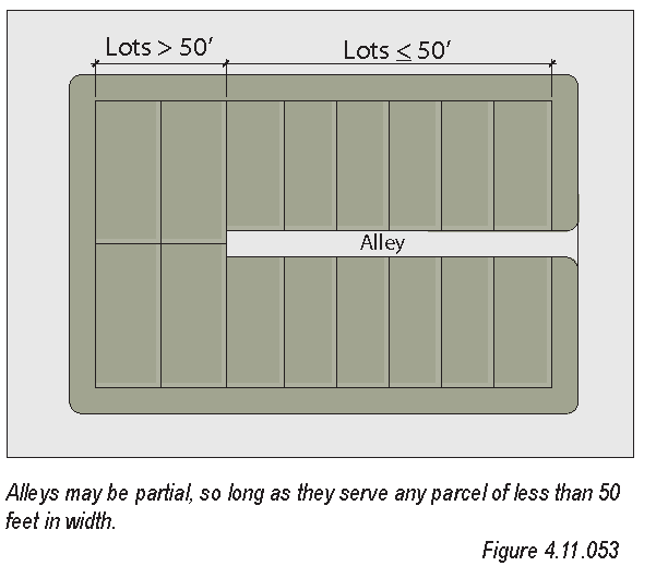
1.
Full-block developments are permitted in TC, UV, and HC SUB-DISTRICTS.
2.
There is no minimum or maximum required lot size, provided that:
a.
All Lots shall have a minimum 20 feet of frontage on a street or public green. The minimum street frontage is waived for residential lots fronting on a pedestrian mews or green, provided that each lot is served by an enhanced alley meeting the requirements of Section 4.09.030.E.6.
b.
Any block with a parcel having less than 50 feet of frontage shall have an alley extending at least to serve the rear of the parcel. See Figure 4.09.053.
3.
A diversity of lot sizes on a block is encouraged in all SUB-DISTRICTS.
G.
Summary of Regulations and Examples.
The following pages depict prototype development for each SUB-DISTRICT. They show, in perspective view and plan view, a typical block built out in accordance with the intent of this Code.
The Column on the right side of the page summarizes the key provisions of this Code, as well as identifying some special conditions. These pages should be used as a guideline to help the user visualize the intent of this Code, as well as to direct the user to specific references in the regulations.
TC - Town Center Example
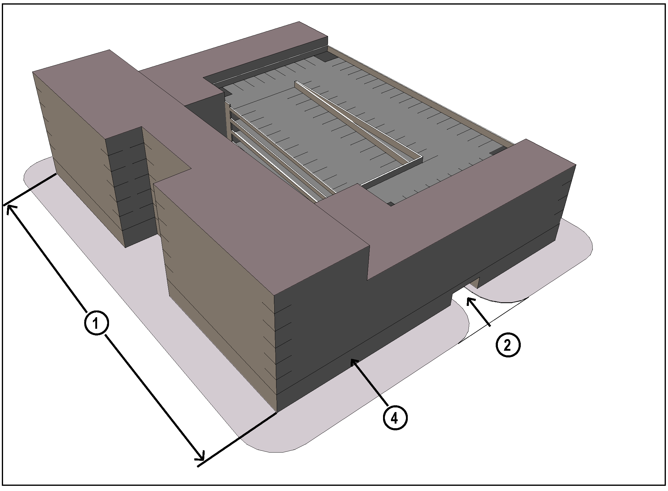
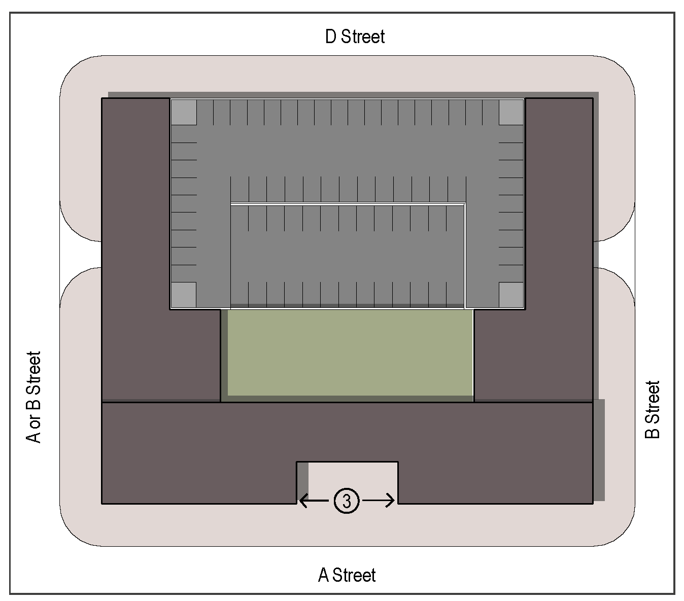
UV - Urban Village Example
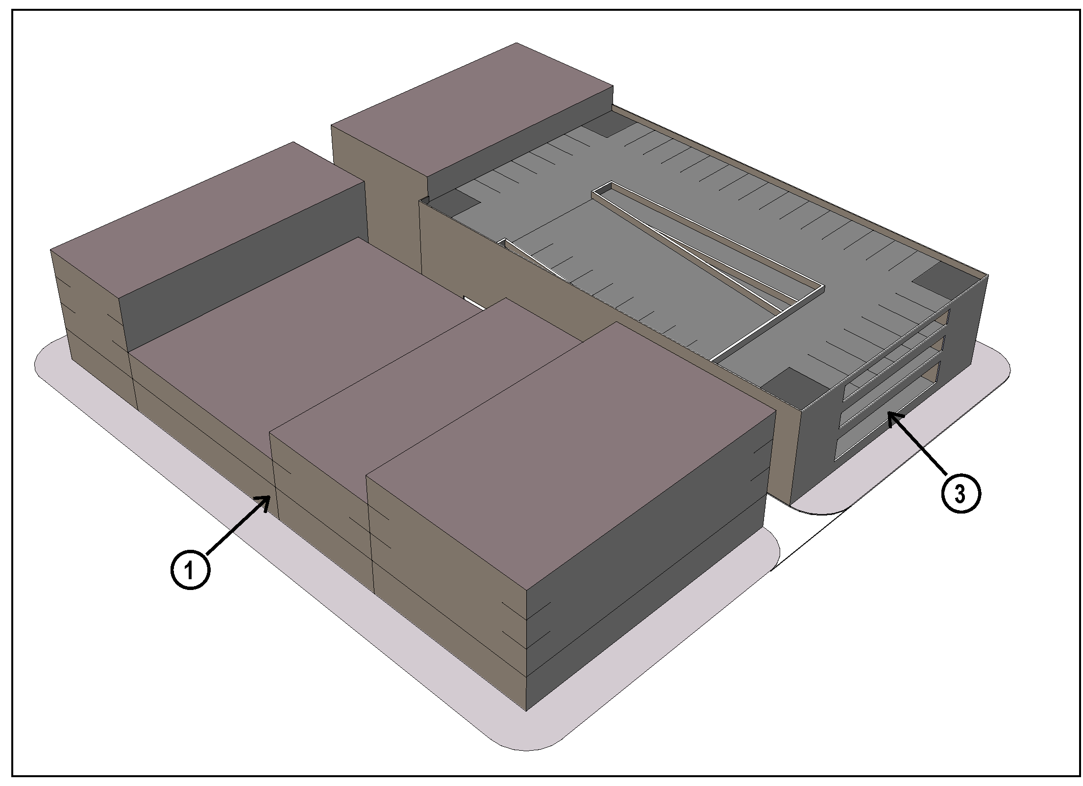
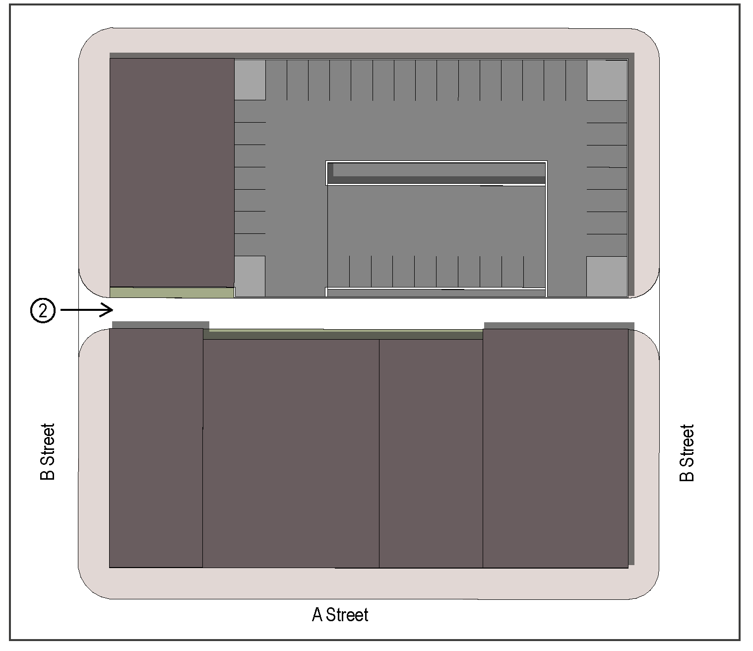
UN - Urban Neighborhood Example
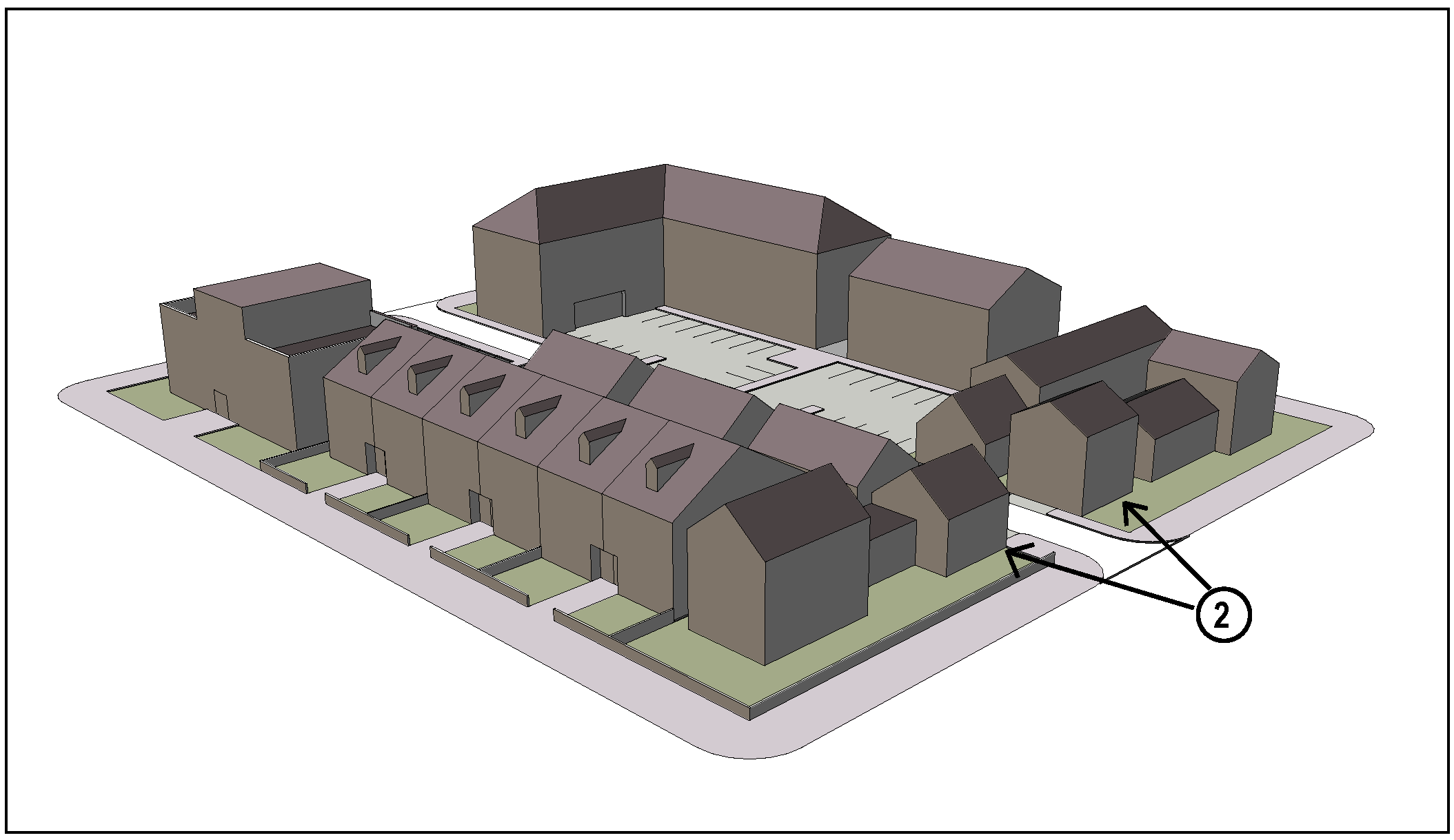
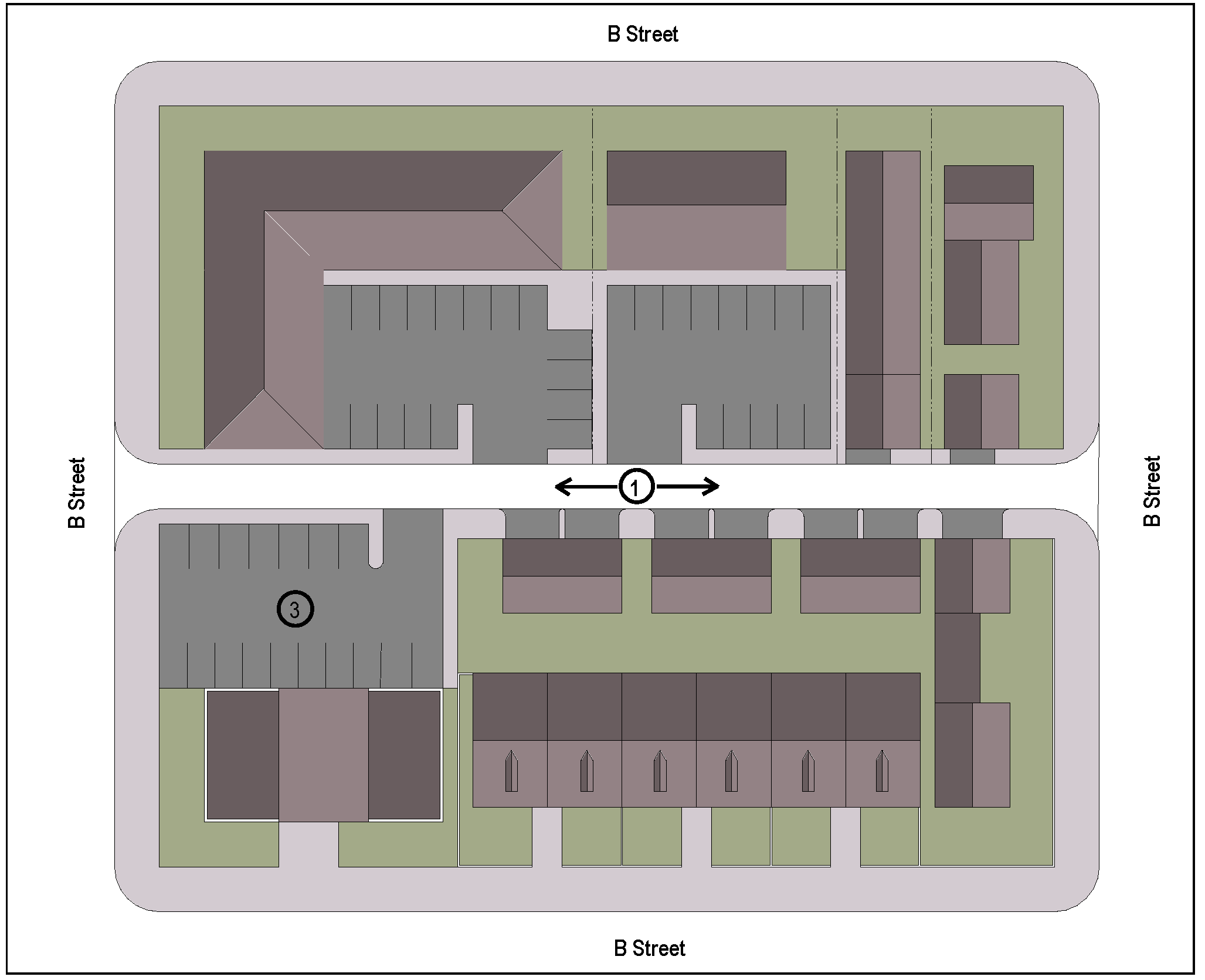
GN - General Neighborhood (Alley Loaded) Example
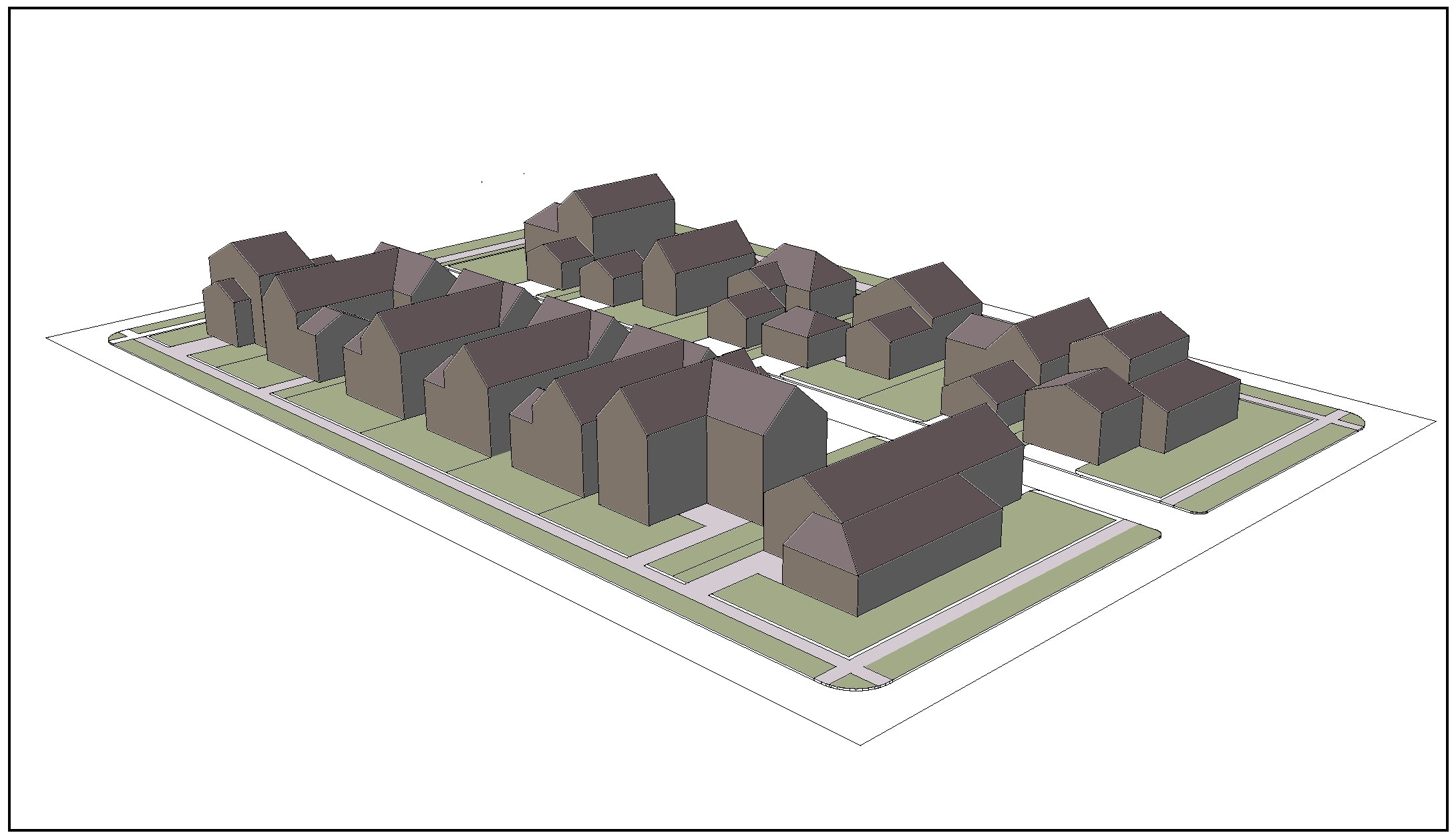
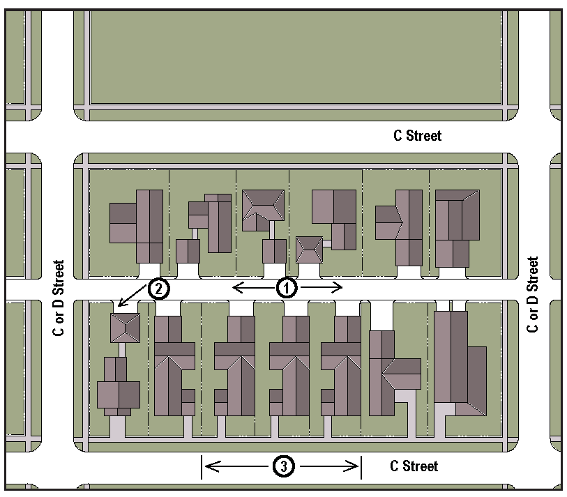
GN - General Neighborhood (Street Loaded) Example
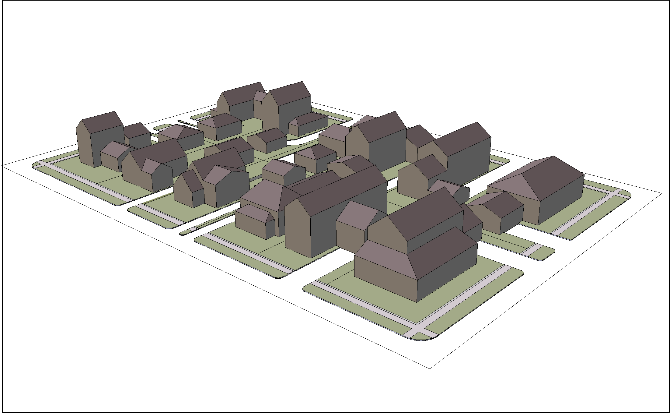
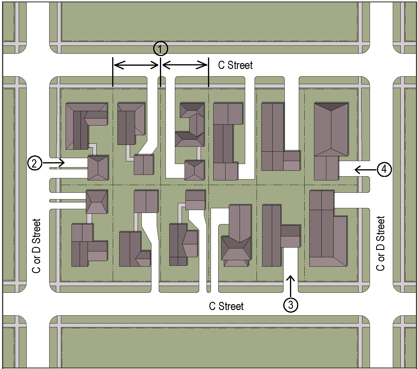
HC - Highway Commercial Example
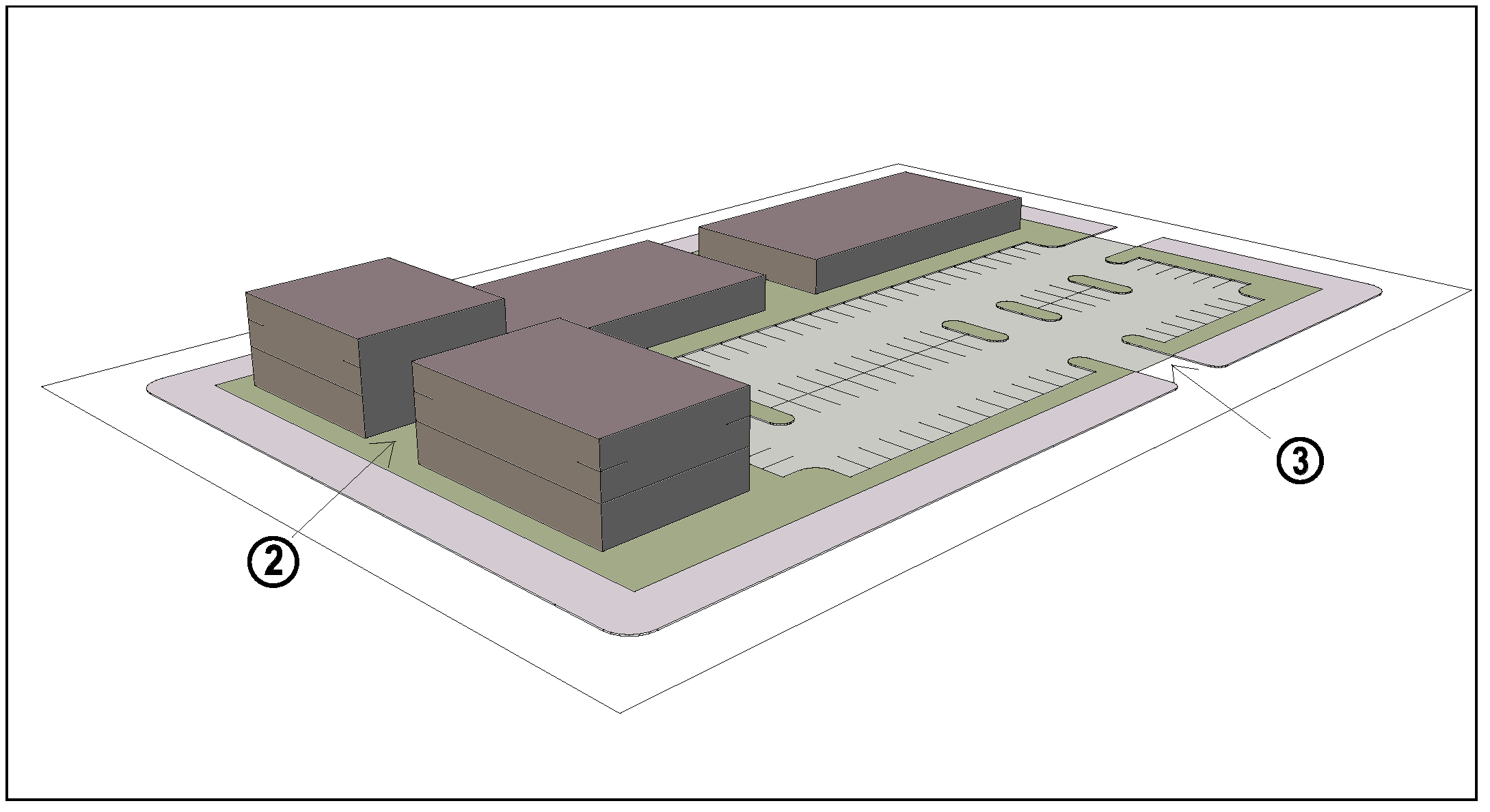
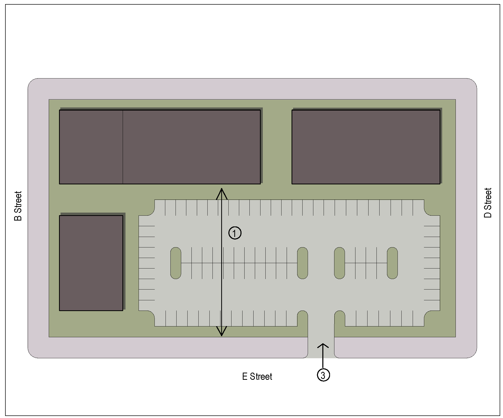
(Ord. No. 2015-34, § 2(Exh. A), 5-12-2015)
Sec. 4.09.060. - Streets and Blocks.
A.
Intent.
This Code classifies the streets in the District according to various qualitative characteristics that determine suitability for denser, mixed use development that promotes a human-scaled, pedestrian-friendly street life. Some development parameters are determined by the enfronting street classification in order to integrate the function of the street and the buildings; this also encourages the development of both sides of the street in a consistent manner.
B.
Development Standards.
The standards indicated in Table 4.09.061 shall apply to all development within the District.
1.
Corner lots shall consider their highest ranked street frontage (A is ranked higher than B, etc.) as their primary frontage. The side street frontage shall be developed according to the standards in Figure 4.09.061, based on the classification of the side street.
2.
For parcels with multiple street frontages of differing classification, the highest ranking street frontage takes precedence in cases where it can be shown to be impractical to simultaneously meet the standards of each street frontage.
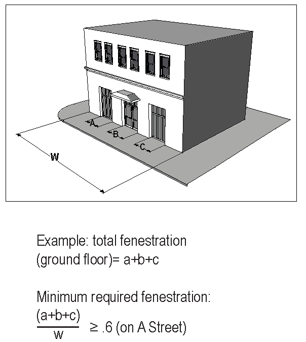
3.
Street Level Fenestration. A minimum percentage of the lineal width of the street frontage on all streets shall be open or glazed. Reflective or strongly tinted glazing is not permitted. The minimum aggregate width of openings is as follows:
a.
A Streets: Minimum 60 percent (60%) of building frontage.
b.
B Streets: Minimum 50 percent (50%) of building frontage for commercial uses; minimum 35 percent (35%) of building frontage for residential uses.
c.
C Streets: Minimum 35 percent (35%) of building frontage.
d.
Upper level fenestration shall be a minimum of 20 percent (20%) of the building frontage.
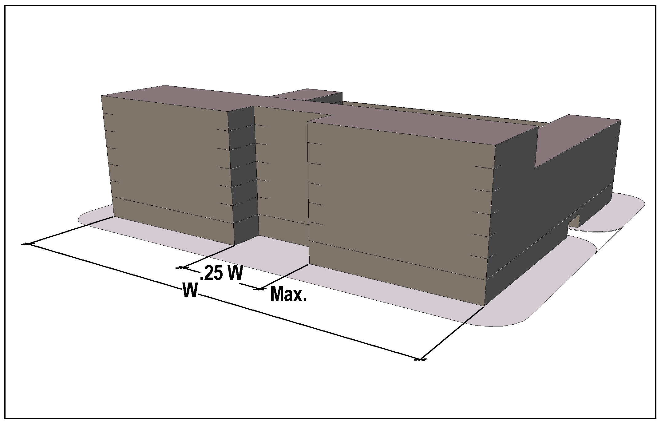
Permissible Courtyard Setbacks
4.
Courtyard Setbacks. A maximum of 25 percent (25%) of the required frontage on A and B Streets may be set back to form an open courtyard or plaza space. Such spaces shall comply with the following criteria:
a.
Space shall be a minimum of 25 feet wide and ten feet deep.
b.
Space shall be continuously open to the public.
c.
Building faces defining the court space shall be considered as street frontage for purposes of the minimum opening requirements stipulated above.
d.
The concentration of glazing on the courtyard elevations does not reduce the minimum glazing requirements for the street elevations.
C.
Street Classification.
All streets within the District shall be classified according to an A, B, C, D, or E designation, as defined in Section 4.09.030.E
Figure 4.09.061
Street Type Development Standards
Notes to Figure 4.09.061:
1.
For D Streets, this distance is a minimum setback.
2.
Minimum fenestration on B street frontages is 50 percent (50%) for commercial uses, 30 percent (30%) for residential uses.
3.
Parking Structures may encroach on the parking setback up to the front build-to line, provided that the design of the garage complies with Subsection 4.09.070.D.2.
4.
Parking setback on C Street may be reduced to 20 feet for corner lots if the parking and driveway addresses the side street.
5.
If a parcel has alley access, no front curb cut is permitted.
6.
One alley cut per block face is permitted; no more than three per block, total. Full-block developments may have one curb cut per block face to allow access to a parking lot or garage, no more than three per block, total.
7.
Interior lot line may be reduced to zero feet on one side only for zero-lot-line homes.
8.
For full-block developments, or parcels that extend through an entire block, there is no rear setback; the build-to line for the appropriate street type shall be observed.
9.
Rear setback may be reduced to five feet for a detached accessory building with a height of no more than 25 feet, provided that the garage, if present, is accessed from the front or the side.
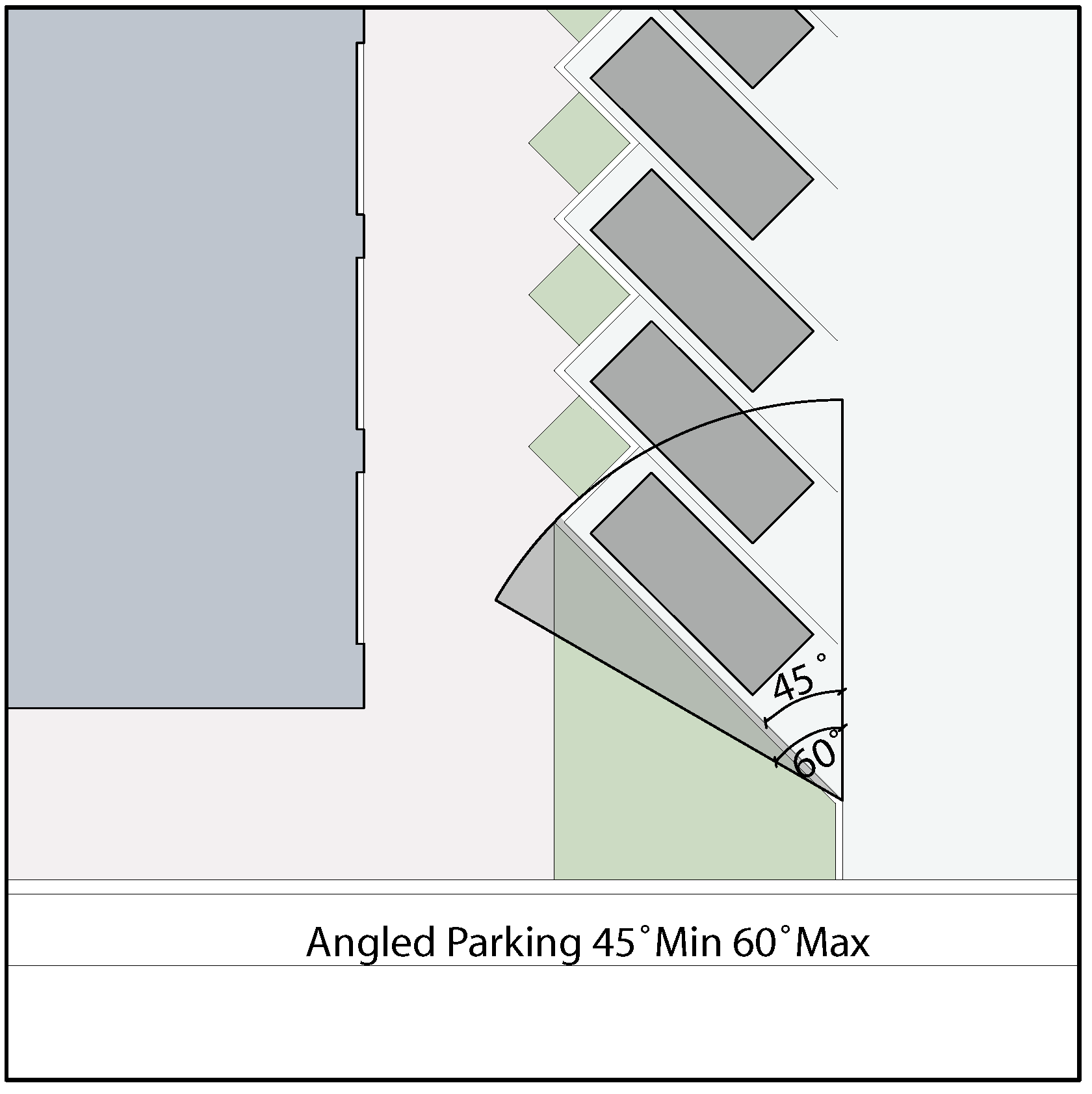
Fig. 4.09.063
D.
Street Design Standards.
The following design standards apply to all streets within the District, except for E Streets. These standards are not meant to be exhaustive; rather, they are intended to establish minimum requirements to achieve an overall design consistency.
Dimensions are measured to the back of curb or to the centerline of lane, as appropriate.
1.
Roadways. The following standards apply to all streets except E Streets:
a.
Posted speed shall be a maximum of 30 miles per hour.
b.
Maximum width of any vehicular moving or turning lane shall be 11 feet.
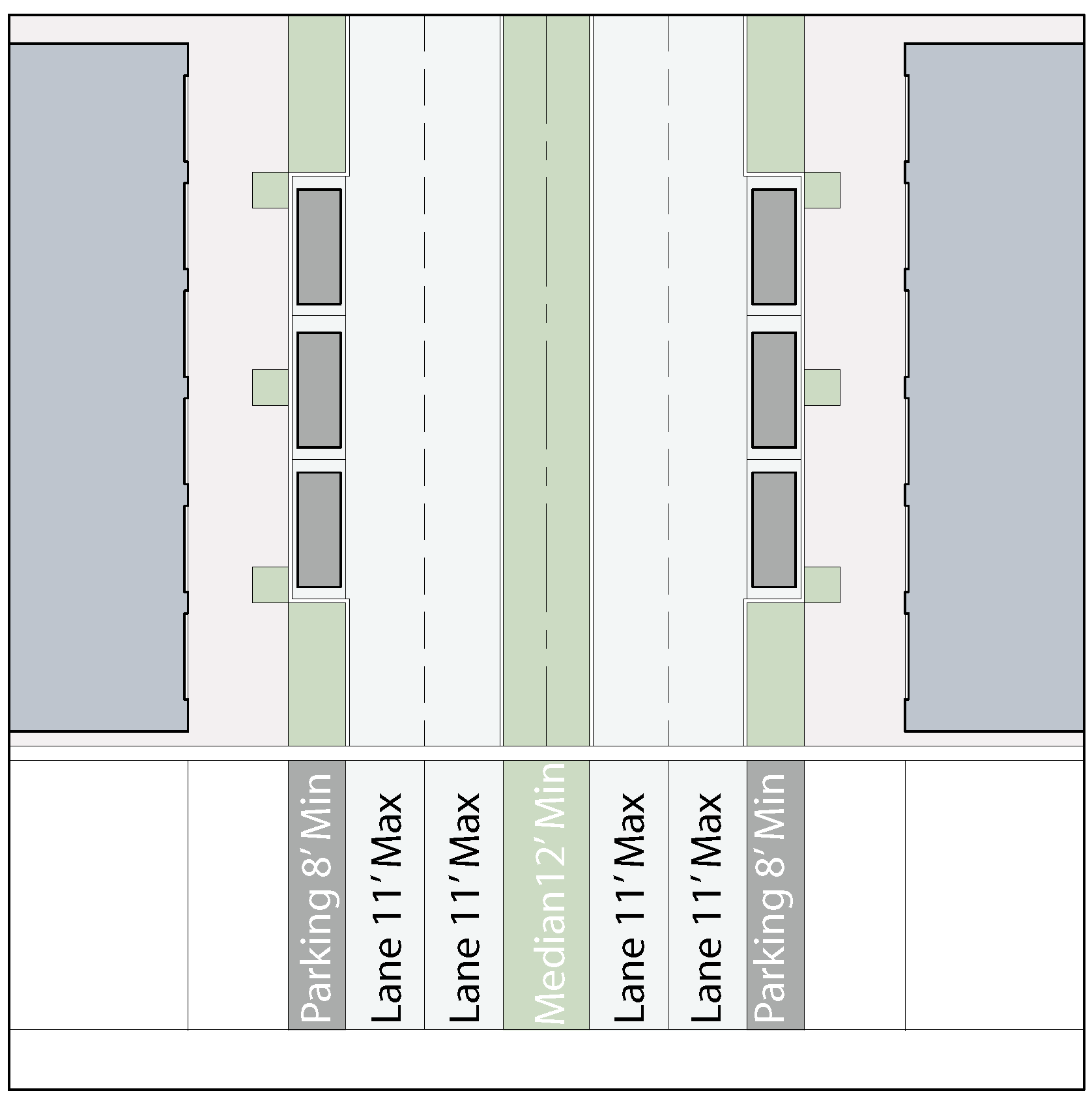
Fig. 4.09.064
c.
Minimum width of any curbside parallel parking lane shall be eight feet.
d.
Angled head-in parking may be used where sufficient width of right-of-way exists to allow parking dimensions in accordance with generally accepted engineering standards. Parking angle may vary from 45 to 60 degrees. Ninety-degree parking shall not be used within a street right-of-way. Figure 4.09.063
e.
Where bicycle lanes are desired, they should occur between the curb and the right-of-way line in a manner that allocates sufficient space for pedestrians, landscaping, and bicycles with minimal conflicts.
f.
Center medians, where provided, shall be a minimum of 12 feet wide. Center medians are encouraged when feasible. Figure 4.09.064
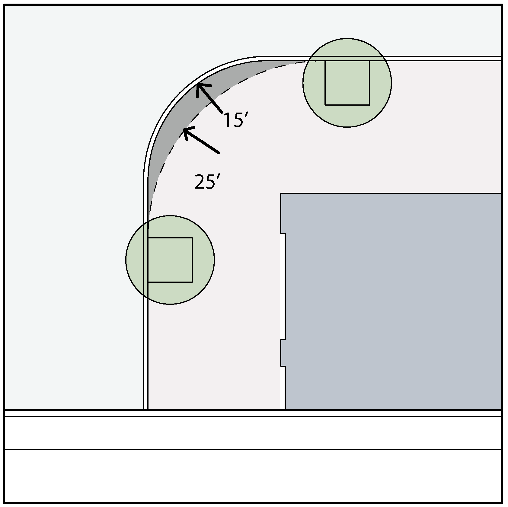
Fig. 4.09.065
g.
Pavement radii shall be a maximum of 15 feet at street intersections and ten feet at driveway connections. Designs may exceed these maximums (for example, at the intersection of major thoroughfares) but should endeavor not to exceed these maximums without cause. Figure 4.09.065. (Curb radiuses of less than 25 feet shall be provided with a rollover curb.)
h.
No above ground obstructions, i.e., trees, lampposts, fire hydrants, etc., shall be permitted street side of a 25-foot radius at street intersections and a 15-foot radius at driveway connections.
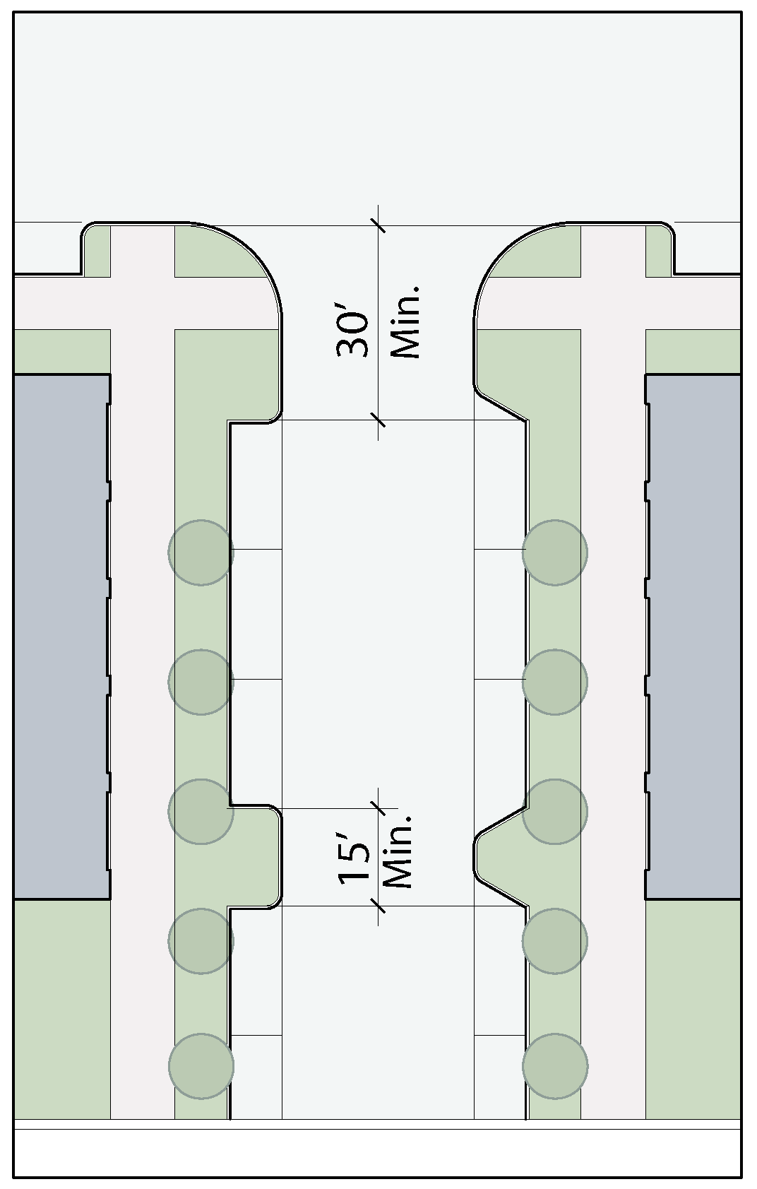
Fig. 4.09.066
2.
Sidewalks. Sidewalks shall be provided at all lot frontages.
a.
Minimum sidewalk width shall be five feet. For A Streets, minimum sidewalk width shall be eight feet where possible. When a sidewalk is intended as a multi-use path, the minimum width shall be 12 feet.
b.
On A and B Street frontages with predominantly retail uses at the ground level, the sidewalk width should increase as needed to abut the building face directly.
3.
Curbside Parking. Curbside parking should be provided wherever possible on A and B Streets.
a.
Curbside parking lane should be designated as a dedicated use zone by the use of bulb-outs that clearly distinguish the parking from the moving lanes.
b.
Minimum length of any bulb-out, measured parallel to the right-of-way line, shall be 15 feet when occurring at mid-block, or 30 feet at street intersections. The measured length of a bulb-out may include any angled curb segments, if provided. Figure 4.09.066
c.
Parallel parking spaces shall be grouped together between bulb-outs. There shall be a minimum of two and a maximum of six spaces in any one group. Angled parking shall be grouped a minimum of three and a maximum of eight spaces between bulb-outs.
d.
Grouping of spaces should be based on achieving a deliberate rhythm along the block face, so that, for example, bulb-outs occur at mid block, or at the third points, or some other discernable rationale. Where a rhythm has already been established on the opposite side of the street, the parking pattern, shall, to the greatest practical extent, mirror the established rhythm.
4.
Right-of-Way Landscaping. The area between the curb and the sidewalk shall be landscaped in accordance with the following guidelines:
a.
The type of landscaping shall be appropriate to the width available between the curb and the edge of sidewalk:
i.
Less than six feet: Low ground cover, may be augmented by small scale trees. In general, landscape strips of less than five feet in width are discouraged.
ii.
Over six feet: Low ground cover, augmented by larger scale trees.
iii.
Placement of any landscape materials shall maintain all required sight distances and comply with the appropriate visibility standards.
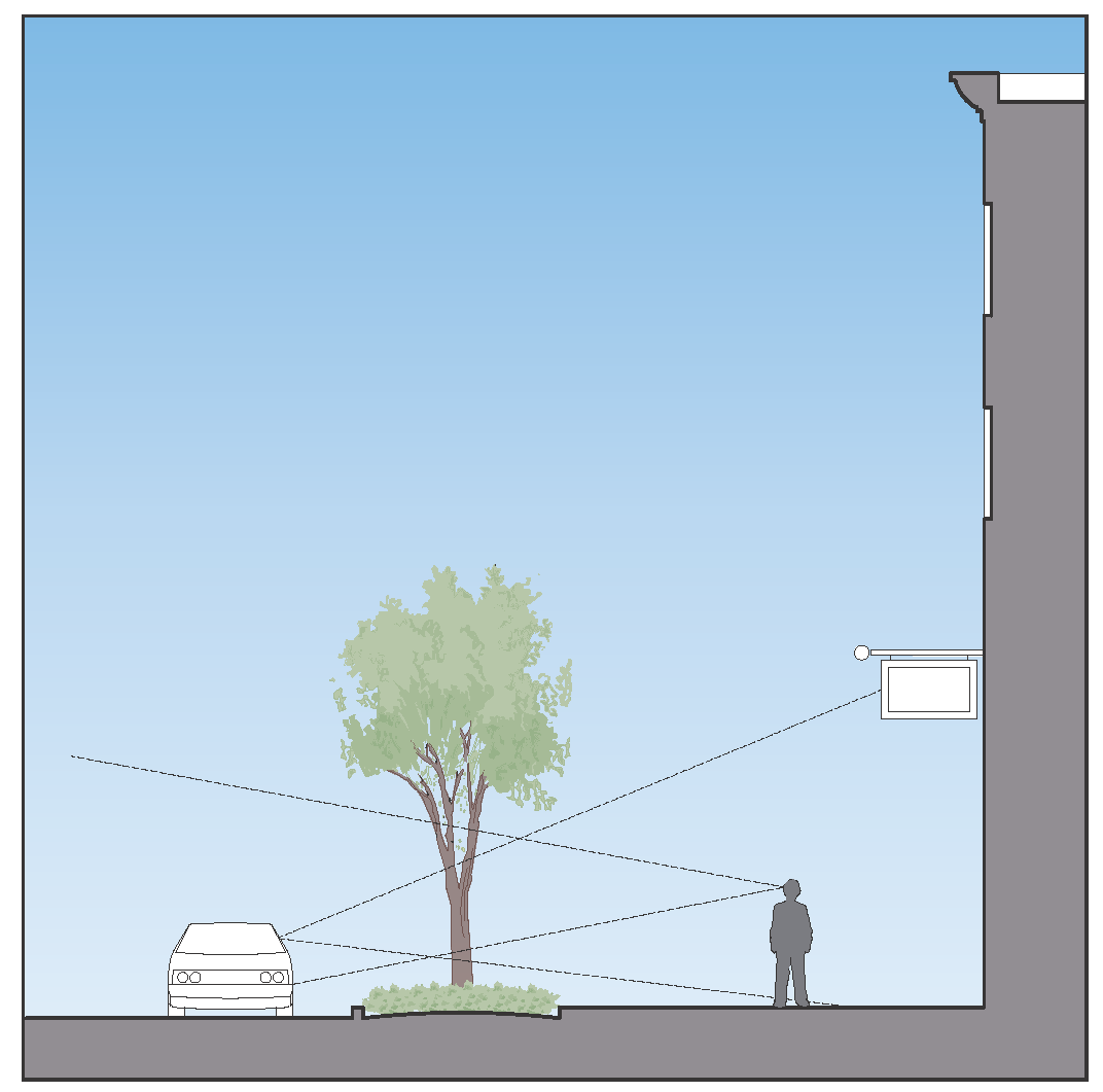
Fig. 4.09.067
b.
In general, landscaping along A and B Streets, or along other principal pedestrian walks, shall leave a relatively unobstructed horizontal view from normal vantage points. Dense ground covers shall remain low, and tree canopies should be well above head height. Figure 4.09.067
c.
Linear landscape elements along all streets should exhibit regular spacing and consistent size. Trees should be selected for their ability to shade the sidewalk.
d.
The amount of landscape elements should relate to the development context. Along A and B Streets in a fairly urban commercial setting with minimal setbacks, a predominance of paving with regularly spaced trees is appropriate, while along C Streets with larger setbacks, larger landscape beds with more planting would be called for.
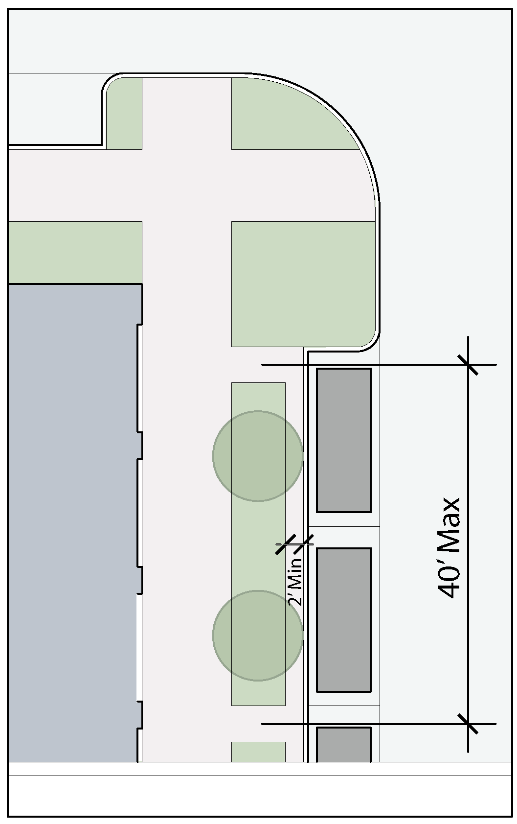
Fig. 4.09.068
e.
The linear elements should be augmented by accent landscaping at special features such as street intersections, entry courts, bulb-outs between parking lanes, and other such areas where opportunities for larger landscaped areas present themselves. These areas may incorporate a number of enhancements, including beds for seasonal color, benches, fountains, or public art.
f.
Where curbside parking abuts a landscape strip, the following should be provided:
i.
A continuous paving strip abutting the back of curb, minimum two feet wide, for the convenience of persons exiting the passenger side of a parked vehicle. Figure 4.09.068
ii.
Regularly spaced paved crossovers connecting the curb and the sidewalk. Spacing should be coordinated with the specific streetscape design, but should generally not exceed 40 feet.
5.
Hardscape and Street Furniture. A District may establish design standards for such elements as brick pavers, light fixtures, waste receptacles, benches, etc. Any such elements to be provided as part of a development shall conform to the applicable standard specification.
(Ord. No. 2015-34, § 2(Exh. A), 5-12-2015)
Sec. 4.09.070. - Parking.
A.
Required On-Site Parking.
All new development in a District shall provide on-site parking in accordance with the provisions of Chapter 9 of the UDC. When calculating the required parking, fractional spaces shall be rounded up or down to the nearest whole number.
B.
Allowable Reductions in Required On-Site Parking.
The required amount of on-site parking, as calculated in Subsection A above, may be reduced in accordance with any of the following provisions. These provisions may be applied cumulatively.
1.
Curbside Parking. The developer may provide curbside parallel parking spaces for any A or B Street frontage abutting the site. This parking will count towards the required amount of on-site parking in a 1 to 1 ratio, e.g., ten curbside parking spaces would reduce the on-site parking requirement by ten spaces. A minimum of four curbside parking spaces must be provided to be eligible for this reduction.
2.
Parking Ratio Buy-Down. In certain Districts, the City may choose to establish a parking management area. In such cases, the developer may buy down the required amount of parking by paying a stipulated sum per reduced space into a district parking fund. The parking may only be bought down to a required minimum ratio as specified in Figure 4.09.071 in the column marked "MU District."
a.
District Parking Fund. The City may establish a district parking fund for the purposes of managing and providing parking solutions for the District as a whole. Buy-down payments shall be allocated to this fund, which can only be used within the District for the intended purposes.
b.
Payment Per Space Reduced: Amount will be established upon the creation of a parking management area.
c.
The City may, from time to time, but no more frequently than annually, adjust the buy-down payment as needed.
Figure 4.09.071
Allowable Parking Ratios
Example: A 10,000 square foot office building would require 40 (10,000/250) parking spaces under the UDC. The total required parking for this building in the District could be "bought-down" to 29 spaces [(10,000/350)-(or any number between 29 and 40)] by paying the specified amount for each space reduced.
Figure 4.09.072
Shared Parking Divisors
3.
Shared Parking. For mixed uses on the same site, the parking may be shared among the uses in accordance with the following provisions:
a.
Calculate parking required for each use separately.
b.
Refer to Table 4.09.072 for the permissible shared parking divisor for any two uses. The minimum shared parking requirement is determined by dividing the sum of the parking required for each use independently by the divisor indicated for that particular combination of uses.
c.
For developments that mix three or more uses on a site, a shared parking reduction shall only be permitted for one combination of uses. The developer may use whichever combination yields the largest reduction in required parking, and then add the parking required for the other uses.
d.
The shared parking benefit is intended for uses that are well integrated and in close proximity. For larger sites with different uses physically and geographically separated, the Director may reduce or deny the allowable shared parking benefit.
e.
Regardless of the result of the shared parking calculation, the total parking on a site shall not be reduced to an amount less than that required for any use by itself.
4.
Connections to Adjacent Parking. Parking areas of adjacent properties are encouraged to interconnect to facilitate cross access and traffic flow through parking lots. Parking areas designed to connect to adjoining or future adjoining lots shall be granted a five percent (5%) reduction in the amount of required parking. This five percent (5%) reduction shall be deducted from the final calculated parking requirement, after all other eligible reductions are taken into consideration.
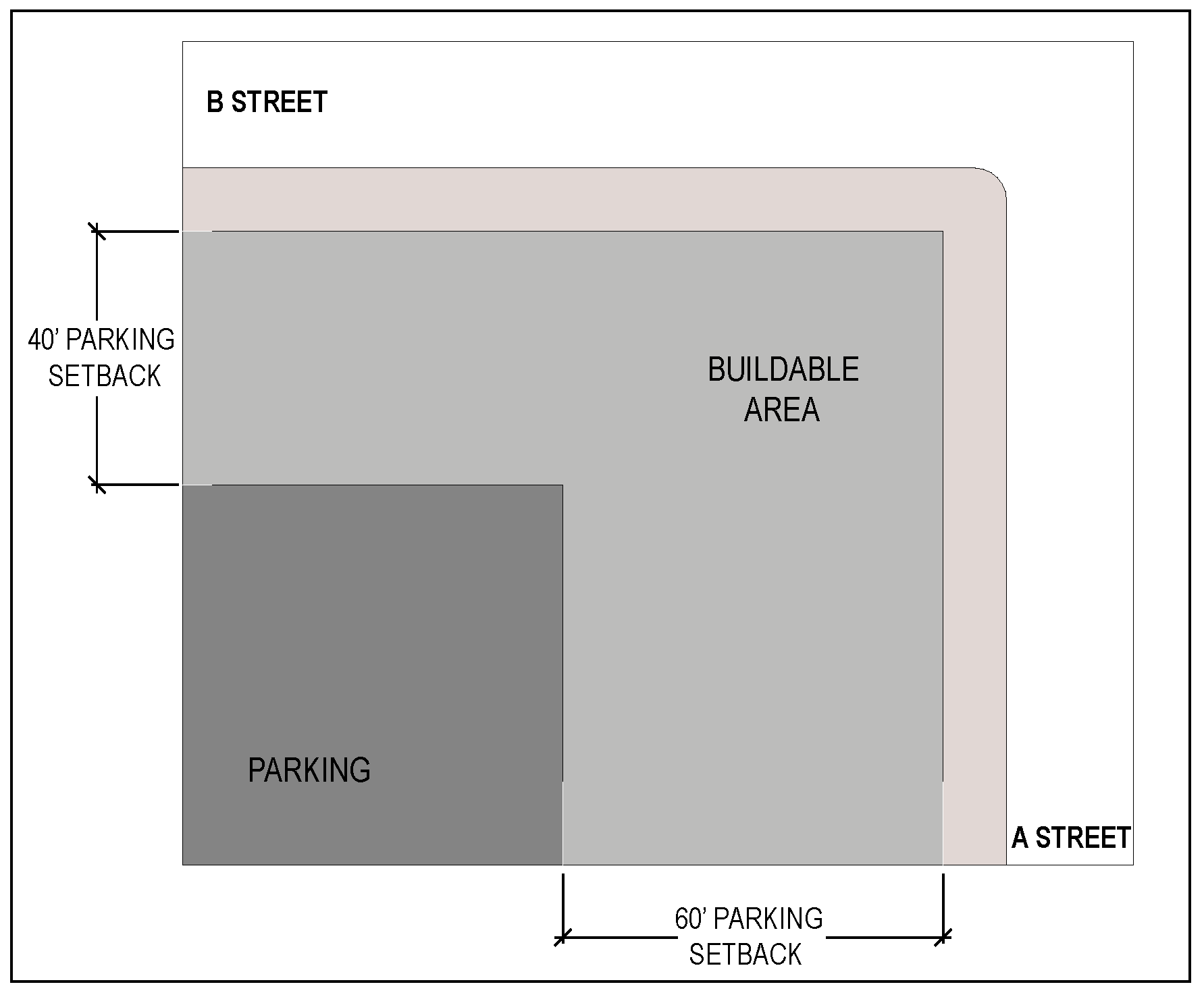
Fig. 4.09.072
C.
Design of Surface Parking Areas.
1.
Surface parking areas shall be set back a minimum of 60 feet from any A or B Street frontage, and a minimum of five feet from any C or D Street frontage, and shall, to the greatest extent practicable, be located behind the principal building face. In cases where the build-to requirements for a secondary frontage are waived (refer to Section 4.09.060 C,) the parking setback on a B Street may be reduced to a ten-foot landscape buffer. Figures 4.09.072 - 4.09.075
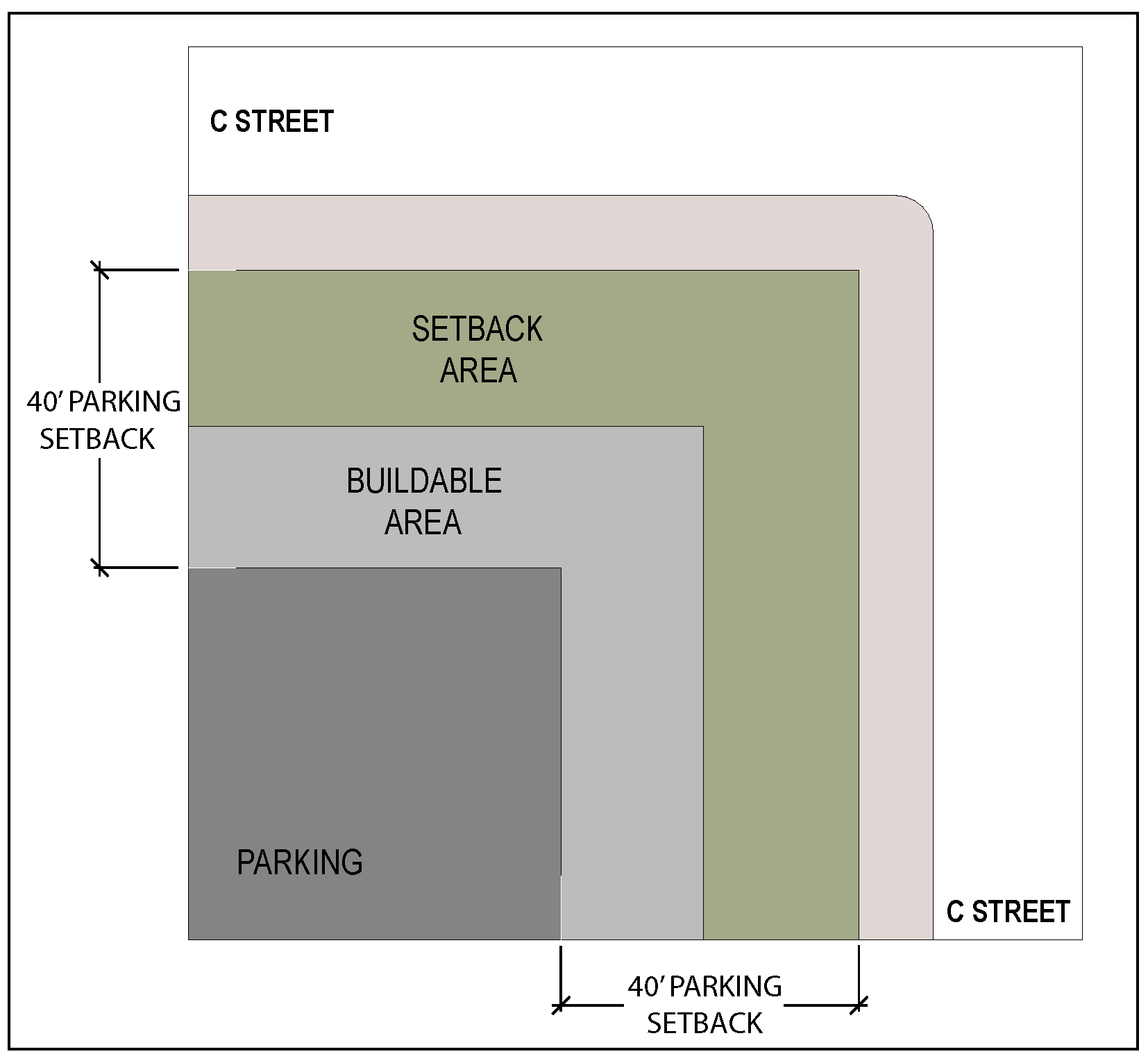
Fig. 4.09.073
2.
Surface parking areas shall be separated from public rights-of-way by landscape buffers and shall have internal landscaping in accordance with the provisions of Section 4.09.090 of this Code.
3.
Surface parking areas shall, to the greatest extent practicable, interconnect with parking areas on adjacent sites. The coordinated design and placement of parking areas, including the consolidation of driveway cuts, is highly encouraged.
4.
Requirements for other elements such as paving materials, lighting, drainage, etc. shall be as required by the UDC.
Temporary parking areas may have relaxed requirements for paving, landscaping, etc. to be evaluated and approved on a case by case basis.
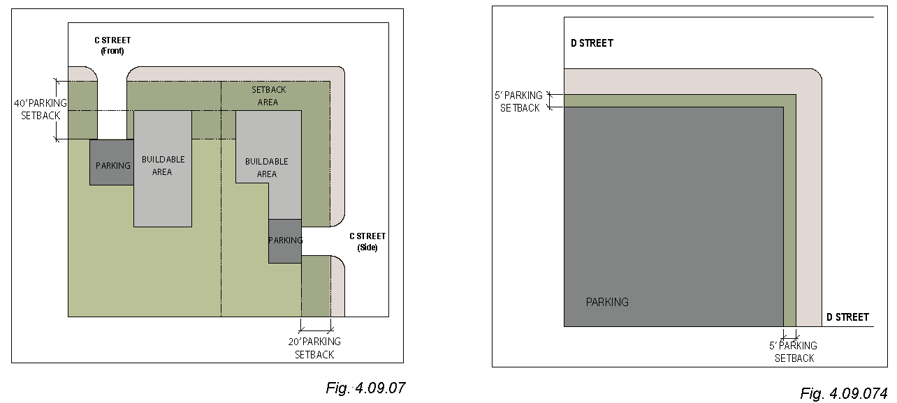
D.
Design of Parking Structures.
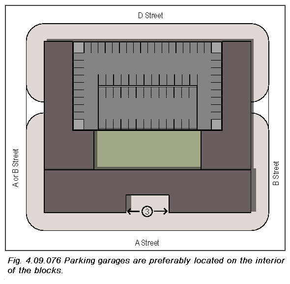
1.
Parking garages are required to be located at the interiors of blocks by complying with the required parking setbacks noted in Figure 4.09.061. Parking structures should be screened from view from the street rights-of way by being placed behind or within the principal building form. Figure 4.09.076
2.
B Streets shall have no parking structure frontage on the ground floor. For any parking garage fronting on a B Street, the ground floor street frontage must be enclosed and occupied by some commercial use other than parking for a minimum depth of 20 feet. A parking access drive may be located along such frontages, but is limited to a width not to exceed 30 feet, including any associated attendant booths, ticket pedestals, etc., and may occur only once per blockface.
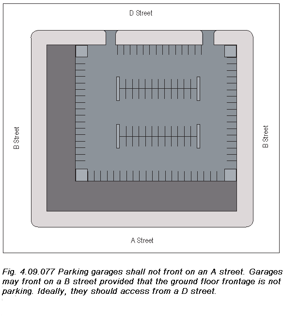
3.
Elevated buildings, i.e., buildings where the occupied space is located above a ground floor parking area, shall have occupied ground floor space on A and B Street frontages as described in Item (2) above.
4.
Upper floor elevations of parking garages fronting on B Streets shall be treated with a high-quality architectural design and finish intended to mitigate the appearance of an open parking garage. No sloping ramps, spandrel elements, etc., shall be visible at such frontages.
(Ord. No. 2015-34, § 2(Exh. A), 5-12-2015)
Sec. 4.09.080. - Architectural Requirements.
A.
Intent.
Buildings shall be of substantial design and construction using high quality materials and workmanship, be site responsive, recognize local character, and have architectural features and patterns that provide visual interest from the perspective of the pedestrian.
This section augments the requirements of Chapter 7, Site Design Standards, of the UDC, which apply to any construction within a District.
B.
Street Frontage.
1.
A minimum percentage of the lineal frontage shall be open or glazed according to the STREET TYPE classification. Glazing shall be clear or lightly tinted. Reflective glass is not permitted. Refer to Figure 4.09.061.
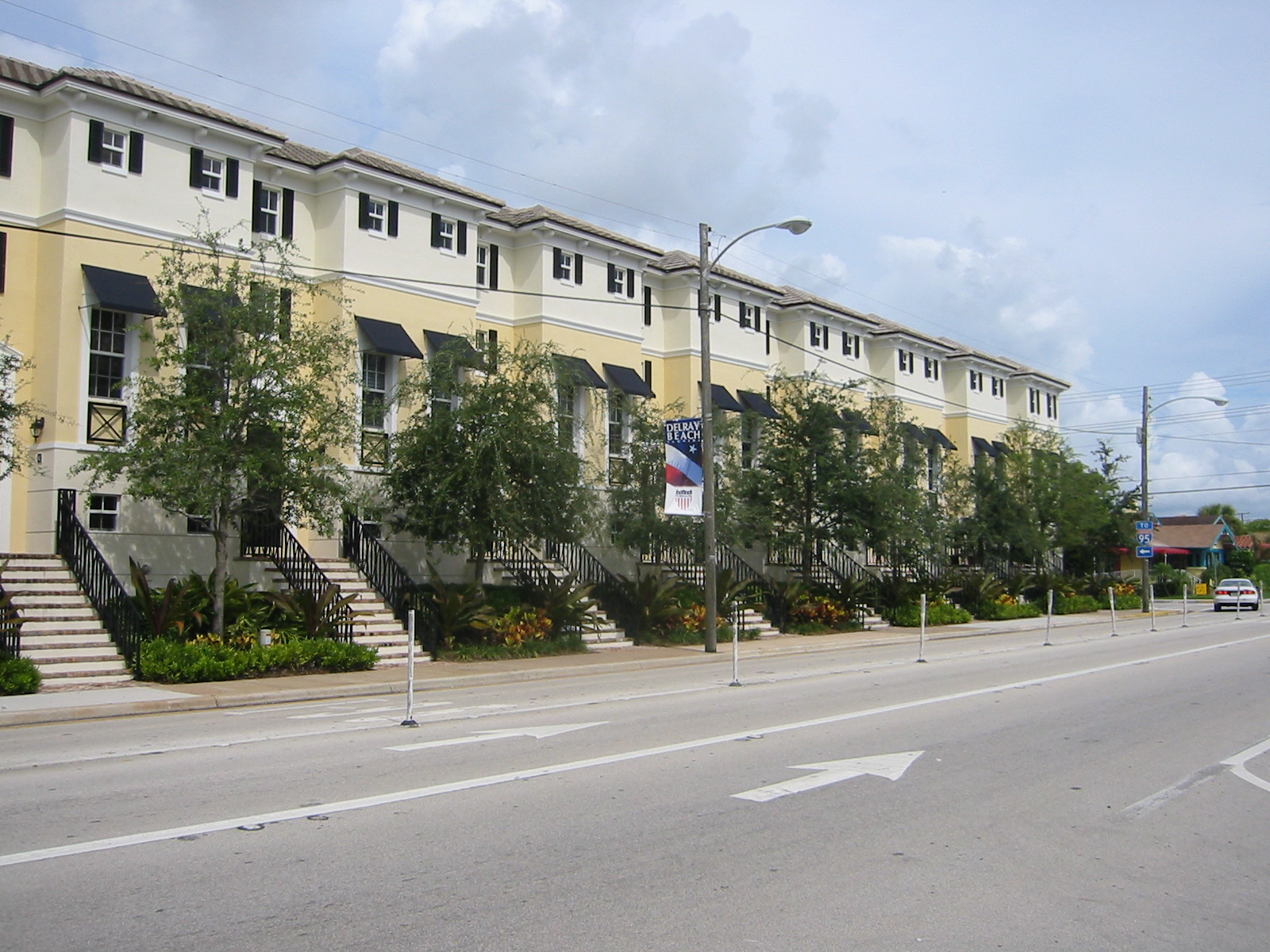
Fig. 4.09.081
2.
Storefronts and display windows are encouraged along A Street frontages. There should be at least one entrance accessible to the public for every 60 feet of frontage.
3.
Building entrances should be architecturally emphasized.
4.
The ground floor along A and B street frontages shall be architecturally distinguished from the upper floors by such means as a change in material, scale of openings, change of plane, string courses, etc.
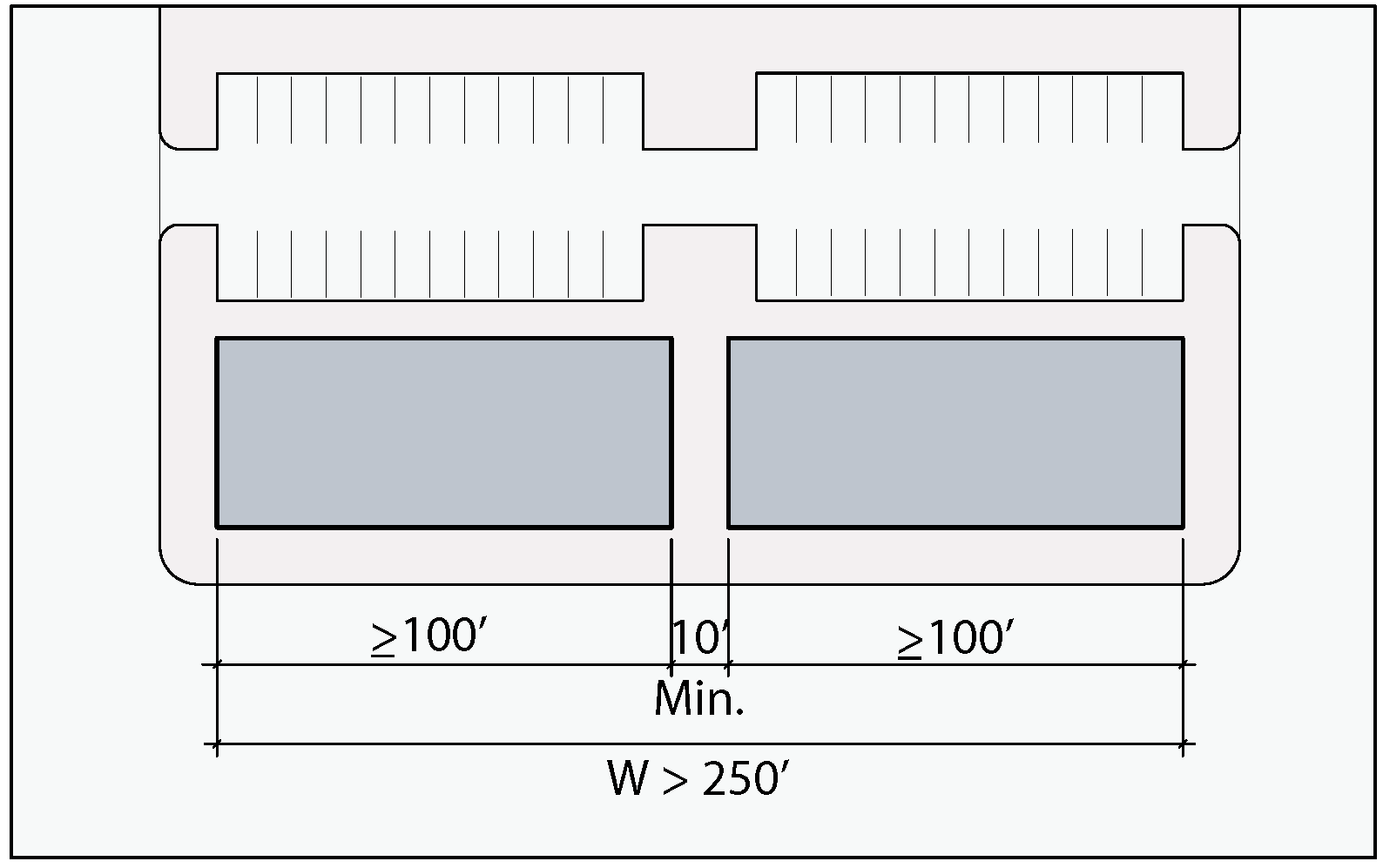
Fig. 4.09.082
5.
Residential uses at street level shall have front porches or stoops. Units containing ground floor space shall have an entrance facing the street. Figure 4.09.081
6.
A continuous building frontage in excess of 250 feet long shall include a public pedestrian passageway between the street frontage and the rear of the building, a minimum of ten feet wide, ten feet high, and located no closer than 100 feet to either end of the building. Figure 4.09.082. The passageway should be designed with storefront fenestration, entrances, etc. to minimize the "corridor" effect.
C.
Massing and Composition.
1.
Buildings should be composed of simple rectilinear forms. Overly complex or fragmented volumes should be avoided. Elements such as side wings, porticos, etc., should be clearly expressed as subordinate to the main building volume. Figures 4.09.083 - 4.09.085.
2.
Roofs may be composed of a variety of pitched roof designs, or may be flat. Flat roofs shall be screened by parapets at all street elevations. Variations in roof form and profile are encouraged for large roof areas.
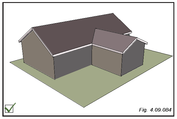
3.
Large, blank, undifferentiated wall surfaces should be avoided. At least 25 percent (25%) of the overall wall area should contain openings or some other means of architectural embellishment.
4.
Overly repetitive or monotonous facade design is discouraged. No horizontal length or uninterrupted curve of a facade should exceed 100 feet without a change in plane, material, rhythm, or scale. Elements intended to add scale and rhythm, such as balconies, awnings, dormers, etc., are encouraged.
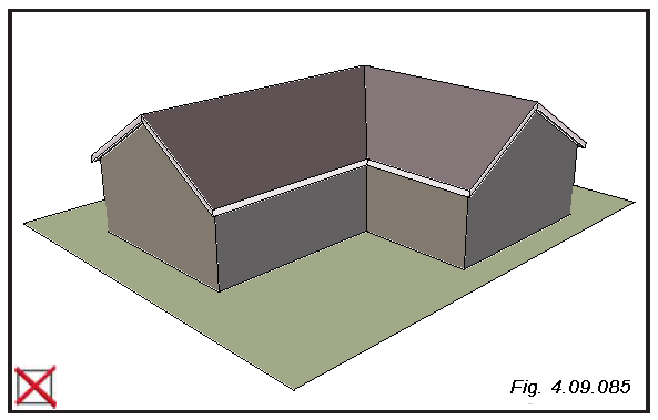
5.
Unsightly service and support elements such as loading docks, mechanical equipment, waste containers, etc., shall be located at the sides or rear of the buildings and shall be screened from public view by appropriate means. Refer to Section 8.09 of the UDC for additional standards for screening.
6.
In special situations, architectural requirements may be waived for artistic merit, subject to the review of an independent peer group. A request for such a waiver must be made in writing to the Director, stating the reasons for the request.
D.
Materials and Finishes.
1.
Exterior walls may be finished in any of the following materials:
a.
Modular unit masonry, either brick or concrete masonry.
b.
Stucco and Exterior Insulated Finish Systems (EIFS). EIFS should be used as a subordinate element for certain accent purposes and shall not be used at the ground floor of A or B frontages.
c.
Stone in a variety of textures and Ashler coursing patterns.
d.
Architectural precast concrete panels (commercial or mixed use buildings).
e.
Cut or dressed stone panels.
f.
Curtain wall systems, provided that at least two panel materials are included, or provided that the curtain wall forms an accent element (commercial or mixed use buildings).
g.
Cementitious lap siding (smaller scale residential buildings). Wood siding should be avoided.
h.
Pre-finished metal panels (commercial or mixed use buildings). Corrugated metal panels may be used as an accent material.
2.
Roofs may be constructed of any of the following materials:
a.
Clay or cement tile in a variety of patterns: barrel, s-shaped, mission, etc.
b.
Galvanized metal and pre-finished metal panels in standing seam, batten seam, or Bermuda pattern.
c.
Dimensional composition shingles (smaller scale residential buildings)
d.
Flat roofs may be of any built-up or membrane roofing system.
3.
Windows and doors in a wide variety of materials and styles are permitted.
a.
Mirrored and reflective glass is not permitted.
b.
Residential sliding glass doors are not permitted on street facades.
c.
Glass block may be used for architectural accents only.
4.
Paving and Sidewalks. Sidewalks on A and B street frontages shall consist of enhanced paving materials to be selected from the following list:
a.
Concrete with integral color tone.
b.
Stamped patterned concrete.
c.
Brick or concrete pavers.
d.
Clay tile.
e.
Cut stone with an appropriately abrasive finish.
f.
Washed terrazzo.
g.
Plain concrete is acceptable when arranged in panels framed by other materials such as brick.
5.
Accessory Buildings.
a.
Buildings that are subordinate to the principal use on the site shall not be placed on the primary (highest ranked) frontage.
b.
Accessory buildings shall be architecturally compatible with the principal building.
c.
Accessory buildings shall only occur on residential lots. Subordinate buildings on commercial or mixed use parcels are considered as any other building.
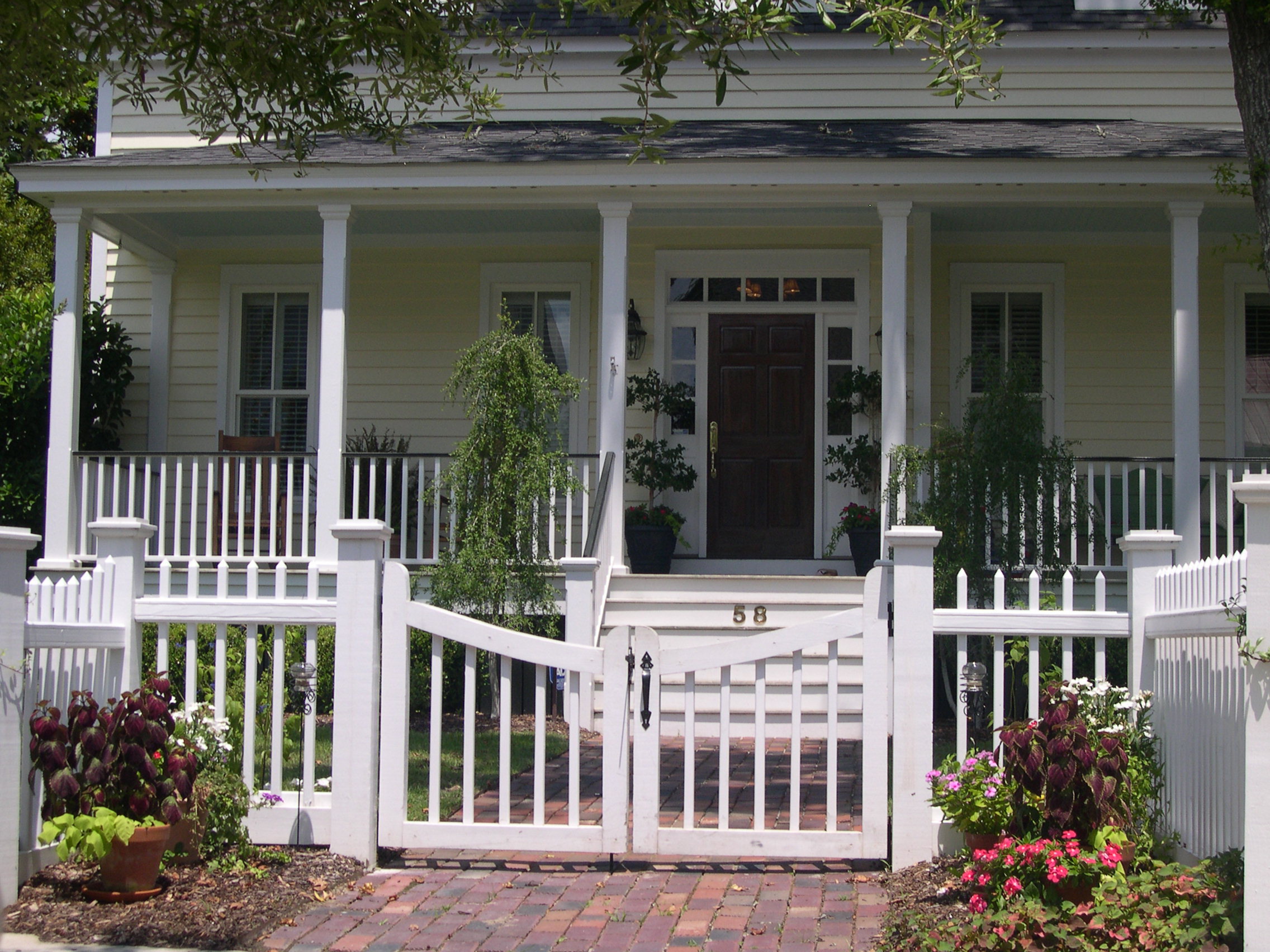
Fig. 4.09.086
6.
Fencing. Fencing may be used to define yard areas subject to the following provisions:
a.
Fencing on A frontages is limited to courtyards, parking entrances, and other special conditions. In general, no fencing is permitted between the building face and the sidewalk, except ground floor residential occupancies may be fenced.
b.
Fencing on B frontages is permitted at ground floor residential occupancies. These fences may not be opaque.
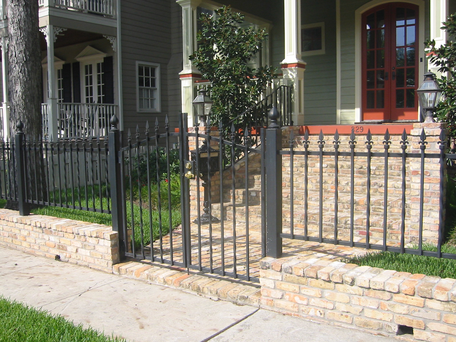
Fig. 4.09.087
c.
Opaque fencing is permitted only to screen unsightly elements such as mechanical equipment or dumpsters and shall occur only on side or rear exposures.
d.
Street frontage fencing for all residential uses shall not exceed 48 inches in height. All other fencing shall not exceed six feet in height.
e.
Preferred fencing material is painted metal picket fencing. Wood picket fencing may be used on C Street frontages only. Ornamental wrought iron panels and accents are also permissible. Fence panels may be separated by solid piers of brick, stone, or stucco spaced at regular intervals. Figures 4.09.086 - 4.09.087
f.
Prohibited fence materials include chain link, wire mesh, barbed wire, plastic, and corrugated metal panels.
(Ord. No. 2015-34, § 2(Exh. A), 5-12-2015)
Sec. 4.09.090. - Landscaping.
A.
Intent.
Landscaping should be appropriate for an urban context, emphasizing the built environment rather than camouflaging it. Landscaping does play an important supporting role, however, in providing shade, visual and textural relief, and recreational opportunities. Landscape design should adhere to the following principles:
1.
Landscaping at A Street frontages is intended primarily to enhance the pedestrian experience and should consist of regularly spaced shade trees and low ground cover plantings. For retail frontages, minimal or no landscaping should occur between the sidewalk and the building face. In general, pedestrians should have a clear line of sight at eye level between building faces on either side of the street.
2.
On A and B Streets, landscaping should play a supporting role, and help to accent and enhance the architecture. In general, the screening of the building face with planting is neither appropriate nor desirable, with the exception of parking garages.
3.
For D and E Streets, or for unsightly service and support functions, landscaping may be used as buffer and screen elements.
4.
Open space should be consolidated into usable park and green spaces.
B.
Design Standards.
These design standards are to be used in conjunction with the requirements of Chapter 8, Landscaping and Buffering, of the UDC. For example, detailed requirements for primary landscaping of open space and the recommended plant list remain applicable. In general, this Code provides for an alternative standard that may be used in lieu of the existing standard, as noted below.
1.
Landscaping Principles. The components of a landscape plan, as described in Section 8.02.020, are generally affirmed, with the following qualifiers:
a.
Primary landscape areas, particularly in the denser areas of a District, will necessarily be limited by the higher degree of impervious area permitted in this Code.
b.
The landscaping of parking lots is less important than placing the parking lots in discrete and unobtrusive locations. In denser, more urban areas, certain landscaping requirements are waived, as noted below.
c.
Bufferyards are not required between adjacent SUB-DISTRICTS. In general, these transitions are treated as a back-to-back condition that mitigates any incompatibilities.
2.
PUBLIC OPEN SPACE. This Code is designed to place buildings close to public streets, rather than to surround buildings with yard areas. This will allow for the consolidation of the required open space into usable areas. General requirements for the allocation and placement of PUBLIC OPEN SPACE are described in Section 4.09.030.F. The following standards apply:
a.
Access. The space must be for general public use at all times, with no restrictions to access. At least two sides shall front on a public way.
b.
Size. Surface area shall be in accordance with the standards of Section 4.09.030.F, with a minimum dimension of 50 feet along any side. The area classified as open space must be open from the ground to the sky, except that up to ten percent (10%) of the area may be covered by shade structures or service buildings.
c.
Location. Open space is most effective when contrasted against an urban context, and when defined by buildings on several sides. Open space should not be located near other open spaces. Open spaces should also be used to mark significant intersections or as forecourts for civic buildings or other buildings with a high degree of public access.
d.
Frontage. Any building face that fronts on a Square or a Plaza shall be treated as if it is fronted on an A or B Street, as appropriate for the particular situation.
e.
Design. Wide latitude is afforded the designer, but the design should be sensitive to local conditions and context. Whatever the design, the open space should be usable, people-friendly, and responsive to the local climate. Large, undifferentiated expanses of pavement or landscaped areas intended primarily for ornamental use should be avoided.
3.
Buffers. Landscape buffers shall be provided as described below:
a.
The minimum width of the landscaped buffer strip between surface parking areas and an abutting public right-of-way shall be five feet. These buffer strips shall be planted as low hedges or screens. Where they occur adjacent to a public sidewalk, they should also include regularly spaced trees to provide shade.
b.
The width of the landscaped strip of land located between parking areas and abutting private property shall be three feet. Depending on the abutting use, this buffer may be planted as a hedge, lawn, or bed.
c.
The area between the building face and the sidewalk shall be landscaped in a manner appropriate for its use. In general, a combination of lawns and beds should be used, accented by trees, if space permits. Hardscape may also be used.
4.
Landscaping of Parking Lots.
a.
Parking lots that have no side exposed to any street other than a D Street may waive all landscaped islands within the lot, as well as any edge buffers.
b.
Parking lots fronting on E Streets shall have a landscaped setback zone. Parking lots on E Streets and occurring in front of the primary building shall comply with all requirements for Parking Lot Landscape as described in Section 8.06 of the UDC.
5.
Street Trees. Street tree planting shall comply with Section 8.05, Street Trees, of the UDC.
(Ord. No. 2015-34, § 2(Exh. A), 5-12-2015)
Sec. 4.09.100. - Signage and Graphics.
A.
Intent.
Signage in a District shall direct people's attention to the businesses and amenities of the area, particularly from a pedestrian's perspective, and to assist in creating a lively urban environment. Elements such as banners and flags are encouraged, subject to compliance with an adopted design standard.
B.
Commercial Sign Types.
This Code permits a number of functional sign types to be located on the various STREET TYPES as indicated in Figure 4.09.101
1.
All signs permitted under this Code require a sign permit.
2.
This Section defines standards for the specific sign types permitted within the various SUB-DISTRICTS. Certain provisions of Chapter 10, Sign Standards, of the UDC remain in effect, including the following:
a.
Section 10.01, General.
b.
Section 10.03, Signs Exempt from Regulations.
c.
Section 10.04, Signs Prohibited Under this Code.
d.
Section 10.05, Sign Lighting Standards.
e.
Section 10.07, Temporary Signs.
Figure 4.09.101
Signage and Graphics Use
C.
Commercial Sign Standards.
Fig. 4.09.102
1.
Building Sign. The developer of a building may give the building a name, or the major tenant of a building may place his name on the building, according to the following specifications: Figure 4.09.102
a.
Placement: near the top of building, above the top floor windows, but below the eaves, if any. Sign shall be directly on the wall surface, and the background shall be the building wall. Signs may be placed on a maximum of two building sides, and shall face a public street.
b.
Dimensions: a maximum of 50 square feet for each sign permitted, and lettering shall be a maximum of 30 inches in height. The sign may include a logo, which will be counted toward the allowable area.
c.
Metal, stone, plaster, or durable synthetic materials.
d.
Lighting: Signs may be front lit, back lit, or internally lit. No neon lighting is permitted.
e.
Design: sign should be consistent with the building architecture. No moving message signs are permitted.
Fig. 4.09.103
2.
Sign Band. This type of sign is intended primarily for retail uses at street level to draw the attention of pedestrians and drivers. Figure 4.09.103
a.
Placement: On the primary building face between first and second floor window openings. The sign band shall be an integral part of the facade composition; the building wall may serve as the sign background. The bottom of the sign band shall be a minimum of ten feet above grade.
b.
Dimensions: Limited to two square feet per linear foot of street facade. Individual elements or letters are limited to 18 inches in height.
c.
Materials: Metal, stone, wood, paint, carved, plaster, or durable synthetic materials.
d.
Lighting: Front lit, back lit, or internally lit. Neon is not permissible.
e.
Design: Sign band shall be considered as an integral element of the building facade and be consistent with the building's architecture. Consistency of the sign band in a single building is required.

Fig. 4.09.104
3.
Bracket or Blade Sign. These may be used in place of a sign band or in addition, if located in an arcade or if not in conflict with the sign band. Figure 4.09.104
a.
Placement: Perpendicular to the primary building facade, may be held by brackets, cantilevered, or suspended under a soffit, must allow a minimum clearance above the sidewalk of ten feet.
b.
Dimensions: Maximum of six square feet, may project a maximum of four feet from the building face, letters may have a maximum height of 12 inches, logos or artwork may be a maximum of 18 inches in any dimension.
c.
Materials: Metal, wood, or durable synthetic materials.
d.
Lighting: Externally or internally lit.
e.
Design: May be double faced, may include symbols such as barber poles, but shall otherwise be essentially two-dimensional.
Fig. 4.09.105
4.
Post Sign. These are generally used in more residential areas for small scale retail or office uses. Figure 4.09.105
a.
Placement: Within front yard areas, close to the property line and the main building approach. Perpendicular to the ground, may be parallel or perpendicular to the primary building facade.
b.
Dimensions: Sign panel is limited to a maximum of six square feet; overall height is limited to four feet above grade.
c.
Materials: Metal, wood.
d.
Lighting: Externally lit, on ground or projecting from top of sign. Internal lighting is not permitted.
e.
Design: Sign shall be essentially two dimensional, and may be double faced. Sign panel may feature artwork or logos in a two dimensional graphic layout.
f.
Configuration: Double post with framed panel or offset single post with bracketed or suspended panel. Single post with centered panel is not permitted.

Fig. 4.09.106
5.
Monument Sign. These signs are limited to the highway frontage on parcels in the HC SUB-DISTRICT. Standards shall comply with Freestanding Monument Sign as defined for the C-1, MU-DT, C-3, BP, and IN Districts in Section 10.06 of the UDC. Figure 4.09.106
Fig. 4.09.107
6.
Window Sign. These signs are intended for the pedestrian. They include applied graphics such as name, hours of operation, telephone numbers, and street numbers. Figure 4.09.107
a.
Placement: On storefront windows and doors, may be applied to interior surface of glass only. Shall not substantially obscure visibility through the window.
b.
Dimensions: Graphics are limited to a maximum of 15 percent (15%) of the total glass area, letters may have a maximum height of six inches.
c.
Materials: Stick on vinyl or plastic.
d.
Lighting is not permitted.
e.
Design: Simple and understated, limited to conveying the necessary information.
Fig. 4.09.108
7.
Sidewalk Sign. This type of sign includes movable sandwich boards and menu cases, and is intended to accent a lively, pedestrian streetscape. Figure 4.09.108
a.
Placement: An the sidewalk, provided it does not interfere with pedestrian movement. Must be removed when business is not open.
b.
Dimensions: Sandwich boards shall not exceed eight square feet per face, be no taller than four feet and no wider than two and one-half feet. Menu cases shall not exceed two square feet in area.
c.
Materials: Sandwich boards may be made of wood, chalkboard, or finished metal. Menu cases must be shallow glass fronted cases.
d.
Lighting: Menu cases may be externally lit.
8.
Pole Sign. This type of sign is only permitted on IH-35 frontage in accordance with the requirements of Section 10.17 of the UDC.
(Ord. No. 2015-34, § 2(Exh. A), 5-12-2015)
Sec. 4.10.010. - Purpose and Intent.
The Williamson County Courthouse provides a cultural, symbolic, and historic resource unique to the City. Residents, visitors, and the traveling public currently enjoy broad views of the Courthouse Dome from several corridors. The purpose of this section is to ensure that future development along the identified view corridors does not lead to the loss of the views of the Courthouse Dome. It is the intent that these broad views be protected, to the extent feasible, by means of careful siting of buildings and with consideration given to how the overall height of buildings impact those views. Compliance with the requirements of this section will be verified during the Site Plan process.
(Ord. No. 2015-34, § 2(Exh. A), 5-12-2015)
Sec. 4.10.020. - Applicability.
Where Site Plan review is required in accordance with Section 3.09, the Courthouse View Protection Overlay shall be applied to all properties within the view corridors listed below. The areas within the corridors listed below are not exact and are depicted graphically on the Courthouse View Protection Overlay District Map. The Planning and Development Department shall confirm applicability at a parcel level.
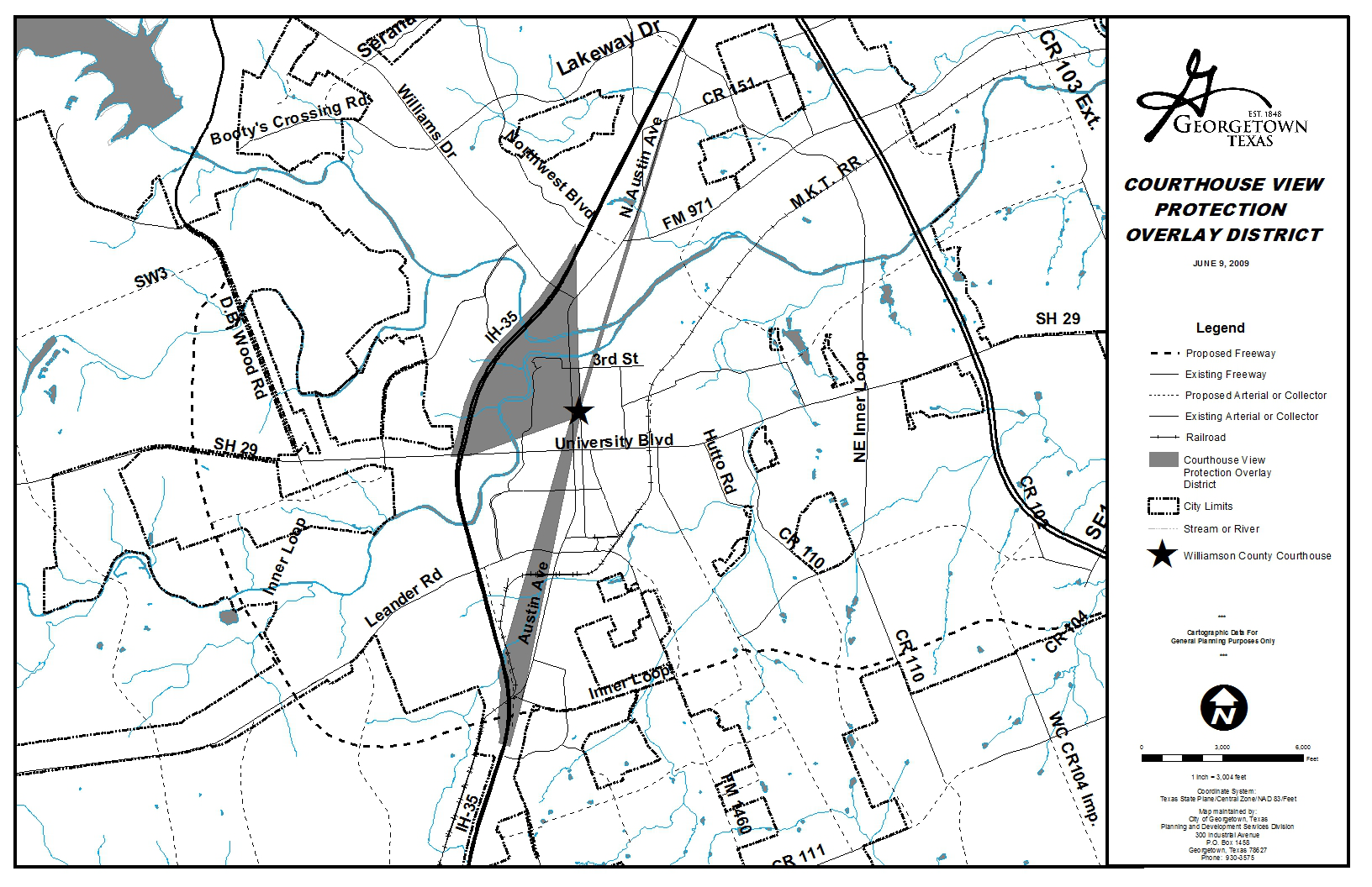
This map is available for viewing at the Planning and Development Department or as a downloadable map at http://www.georgetown.org/maps.overview.php.
A.
I-35 View Corridor.
1.
Properties located in the shaded areas between the Williamson County Courthouse, the western (southbound) lanes of I-35 south of Northwest Boulevard beginning at 393 North I.H. 35 to the intersection at State Highway 29 (University Avenue), and
2.
Properties lying within the protected view corridor along I.H.-35 from the State Spur 26 (Austin Avenue) Overpass to the Courthouse Dome.
B.
Austin Avenue View Corridor.
1.
Properties within the protected view corridor projecting north from the Williamson County Courthouse to State Spur 158 (Austin Avenue) at F.M. 971 and continuing north to County Road 151 the width of the State Spur 158 (Austin Avenue) right-of-way, and
(Ord. No. 2015-34, § 2(Exh. A), 5-12-2015; Ord. No. 2025-08, § 2(Exh. A), 3-11-2025)
Sec. 4.10.030. - Maximum Height Determination Required.
All properties are permitted to build a structure of a single story, which is designed to minimize the impact on the protected view. All other structures proposed within the view corridors may not exceed the height of the plane delineating the corridor as determined by the height calculation formula in Section 4.10.030.C.3. below. The maximum height permitted is the lesser of either the base zoning district maximum height or the maximum height permitted in this section.
A.
Application for Height Determination.
Prior to Site Plan application, properties within the Courthouse View Protection Overlay District proposing to build a new structure or expand an existing structure shall submit an application for height determination to establish the requirements of this district as they may relate to a specific property.
An application form shall be submitted including the required calculations showing the elevations of the review site, view point, proposed height of building, and distances from view point to review site to the Courthouse, which establishes the allowable height according to the height calculation formula. An aerial map of the proposed site and Courthouse and view point elevations may be obtained from the City. For specific definitions of the terms of this section, refer to Chapter 16 of this Code.
B.
Elevation Study Required.
As part of the height determination review, sites that lie within the Courthouse View Protection Overlay District shall be required to submit an elevation study illustrating the potential impact of all buildings in the project on the protected view of the Williamson County Courthouse Dome.
C.
Review Elements.
Review of the application for height determination and associated elevation study shall consider the following elements:
1.
Height.
Within the Courthouse View Protection Overlay District, structure height shall be limited to avoid blocking the view to the Williamson County Courthouse Dome. Examples of design techniques to meet this requirement include:
a.
Overall reduction of height; and
b.
Stepping back the building height.
2.
Location.
Within the Courthouse View Protection Overlay District, structures shall be located to minimize the possible impact on the view to the Williamson County Courthouse Dome. Location of parking as it relates to the building shall be designed to best preserve the view of the Courthouse. Examples of techniques to avoid location impacts include:
a.
Relocation of building on the site outside the view corridor; and
b.
Cutting off building corners.
3.
Height Calculation Formula.
The height calculation formula is used to determine structure height for projects within the Courthouse View Protection Overlay District. An example of the formula can be found in the Development Manual. The height calculation formula is as follows:
• Tan of angle = A/B = E/F (TAN Deg = A/B = E/F)
• Tan of angle x F=E (TAN Deg x F=E)
• E - D = G.
• Combined formula (A/B x F) - D = G (allowable height)
(Ord. No. 2015-34, § 2(Exh. A), 5-12-2015)
Sec. 4.10.040. - Courthouse View Determination.
Upon completion of the administrative review and height determination the Director shall make a final determination. The applicant may request a Courthouse View Administrative Exception, using the procedures of Section 3.16, if strict application of the provisions of this section would not be consistent with the Purpose of the Overlay District due to unique topographical or physical characteristics of the subject site. In consideration of an Exception, the burden of proof shall be on the applicant to demonstrate that the proposed exception is consistent with the criteria contained in this section. The Director shall consider the following criteria in determining the Administrative Exception:
A.
Granting the Administrative Exception would not adversely affect any identified public view corridor; and
B.
Granting the Administrative Exception would be in the public interest and consistent with the Purpose of the Overlay District.
(Ord. No. 2015-34, § 2(Exh. A), 5-12-2015; Ord. No. 2022-89, § 2(Exh. A), 11-22-2022)
Sec. 4.10.050. - Courthouse View Corridor Waiver.
Upon completion of the administrative review and height determination the Director shall make a final determination. The applicant may request relief from the requirements of the Courthouse View Corridor using the procedures of 3.27.
(Ord. No. 2022-89, § 2(Exh. A), 11-22-2022)
Sec. 4.11.010. - Applicability.
The Gateway Overlay districts shall be designated on both side of the specific corridors listed in Section 4.11.020, and shall have a width of 100 feet measured from the edge of the right-of-way. Properties within the Gateway Overlay districts shall follow the design standards in Section 4.11.030 and landscaping provisions set forth in Section 8.04.050 at the time of development. Gateway planting requirements may be credited toward the landscape requirements in accordance with Chapter 8. Where the requirements of this section and the underlying zoning district conflict, the standards of this section shall apply. If another zoning overlay district exists on the property, the more stringent standards shall apply.
(Ord. No. 2015-34, § 2(Exh. A), 5-12-2015; Ord. No. 2021-62, § 2(Exh. B), 9-14-2021)
Sec. 4.11.020. - Gateway Corridors.
The following corridors include roadways that are considered gateways into the community. Each Gateway category represents different roadways in town and may contain differing landscape buffer sizes and landscaping/design requirements. The relevant Gateway landscape buffer shall be shown on a plat and/or Site Development Plan as a landscape easement. The landscape buffer shall be considered to begin at the right-of-way line of each applicable roadway, regardless of the distance from the actual road. When Gateway corridors intersect or abut each other, the centerline of the roadway shall be used to determine the division of the corridor.
A.
Highway Gateways—25-Foot Landscape Buffer.
The purpose of the Highway Gateway is to positively reflect the image of the City by enhancing development with well designed Site Plans and landscaping while maintaining a safe and effective interstate highway. Site design proposals along the highway gateways shall break up large masses of parking and pavement with well planned open space components. Additionally, careful analysis is required of view corridors from the highway. Strategically placed tree groupings should be located to frame desired views while screening parking areas. Highway Gateways include both the highway's main lanes and designated frontage roads.
1.
Interstate Highway 35.
2.
State Highway 195.
3.
State Spur 158 (North Austin Avenue).
4.
State Highway 130.
B.
Scenic/Natural Gateways—25-Foot Landscape Buffer. The purpose of the Scenic/Natural Gateway is to reflect the natural characteristics of the land. These Georgetown roadways are prominent arterials and growth zones leading into the City. The purpose of the design standards for the Scenic/Natural Gateway corridors is to maintain the existing informal character as they develop. For developments that occur along the Scenic/Natural Gateways, designers shall integrate the natural characteristics of the land into the landscape design. Informal tree massings, planting of under story trees, incorporation of native stones and boulders and use of native grasses and wildflowers are examples of how to blend required plantings with native plantings.
1.
F.M. 2243 (Leander Road).
2.
State Highway 29 (University Avenue), west of the intersection of I.H. 35 and east of the intersection of Southwestern Boulevard.
3.
State Spur 26 (South Austin Avenue).
4.
F.M. 2338 (Williams Drive).
5.
F.M. 971.
6.
F.M. 1460.
C.
Downtown Gateways—Ten-Foot Landscape Buffer.
The purpose of the Downtown Gateway standards is to enhance and unify the appearance of the major roadways adjacent to, and directly leading into downtown Georgetown. Because of the close proximity to the Downtown District, the appearance of the Downtown Gateway shall reflect a relatively formal, urban extension of the downtown and visually enhance its aesthetic appearance. In order to establish the formal appearance, trees shall be evenly spaced and located equal distance behind the property line. Although the intent for the Downtown Gateway corridors is to establish a consistent, formal landscape appearance, the design standards are not intended to adversely affect existing trees along the roadways. Variations to these standards are allowed to provide for the preservation of existing trees.
All non-residential properties in Downtown Gateways are subject to special setback design requirements, denoted in Subsection 4.11.030.B.
1.
South Austin Avenue, beginning north of the intersection of F.M. 1460/F.M. 2243 (Leander Road) and ending at the southern boundary of the Downtown Overlay District.
2.
North Austin Avenue, beginning at the northern boundary of the Downtown Overlay District and ending at the intersection of F.M. 2338 (Williams Drive).
3.
State Highway 29 (University Avenue), beginning at the western boundary of the Downtown Overlay District and ending at the intersection of I.H. 35.
4.
State Highway 29 (University Avenue), beginning at the eastern boundary of the Downtown Overlay District and ending at the intersection of Southwestern Boulevard.
(Ord. No. 2015-34, § 2(Exh. A), 5-12-2015; Ord. No. 2021-62, § 2(Exh. B), 9-14-2021)
Sec. 4.11.030. - Gateway Design Standards.
A.
Landscaping Standards.
Calculation of required landscaping must comply with Section 8.04.050, Gateway Overlay District landscape. Where regulations and requirements for Gateways and the another zoning district conflict, the more restrictive regulations shall apply.
B.
Special Setbacks in the Downtown Gateway.
1.
For all non-residential properties in the Downtown Gateway, regardless of zoning district, the front setback is zero. For purposes of this setback, the property line will be replaced with the edge of the gateway landscape buffer.
2.
Parking is prohibited between the front building line and edge of the Gateway landscape buffer.
3.
The front building line shall comprise of a minimum of forty percent (40%) of the primary facade of the primary building.
4.
Features allowed between the front building line and the landscape buffer shall be limited to those allowed in Subsection 7.02.030 C.4.
5.
Fencing shall meet the requirements in Section 8.07.030.
C.
Sidewalks.
Sidewalks shall be required in accordance with Table 12.03.020. All sidewalks shall be constructed and designed to coordinate the location of any new sidewalks and to tie into existing sidewalks. If the sidewalk lies within the Gateway landscape buffer, some portion of the site's required landscaping shall be located between the sidewalk and the designated right-of-way. Properties in the Downtown Gateway require construction of a minimum six-foot sidewalk. Scenic and Highway Gateways require sidewalks, where applicable, in accordance with Section 12.02.
D.
Parking.
No parking will be allowed within a Gateway landscape buffer and all screening of adjacent parking will be in accordance with Section 8.04.070.
E.
Site Limitations.
1.
Drainage facilities are not allowed within a Gateway landscape buffer except those that are necessary to convey drainage in the shortest possible route to or from the street right-of-way, if determined to be required by the Development Engineer. If determined to be necessary in such instances, the drainage facilities shall follow the design requirements in Section 11.04. Drainage facilities include all detention ponds, water quality ponds, outlet structures, drainage berms, improved channels or other improvements associated with the drainage improvements.
2.
Dumpsters and mechanical equipment are not allowed in the front, side, or rear setback if the setback is directly adjacent to a Gateway roadway.
3.
All utilities installed for the development shall be located underground. The developer shall not have to retrofit existing utilities.
4.
No service areas or service drives shall be permitted to front a Gateway roadway.
F.
Boundary Walls.
Residential boundary walls may be required, as described in Section 8.07.060.
(Ord. No. 2015-34, § 2(Exh. A), 5-12-2015; Ord. No. 2021-62, § 2(Exh. B), 9-14-2021)