
Georgetown City Zoning Code
CHAPTER 12
PEDESTRIAN AND VEHICLE CIRCULATION
SECTION 12.02. - COMPREHENSIVE PLAN THOROUGHFARES
Regional thoroughfares provide linkages within the community and throughout the region. The City's Comprehensive Plan includes an Overall Transportation Plan that is developed in conjunction with the Capital Area Metropolitan Planning Organization's (CAMPO) long-range plan. Goals from the Overall Transportation Plan include:
A.
Improve the local street system, including new thoroughfare linkages to enhance connectivity, improved and coordinated traffic signalization, and access management standards.
B.
Provide a functional, integrated, multi-modal transportation system with a variety of choices.
C.
Reduce reliance on single-occupant automobile traffic and enhance bicycle and pedestrian mobility and accessibility by encouraging compact land use development.
D.
Provide for a high degree of safety for motorists, transit users, pedestrians and bicyclists.
E.
Discourage primary traffic routing through local streets.
F.
Preserve right-of-way for roadway development and expansion.
(Ord. No. 2017-15, § 2, 2-28-2017; Ord. No. 2023-44, § 5(Exh. C), 8-22-2023)
SECTION 12.03. - LOCAL AND NEIGHBORHOOD STREETS
The neighborhood street network shall form an organized, connected pattern that defines the community both functionally and visually. When possible, streets should be designed to respect natural features and topography to reduce grading, promote pedestrian movement, and minimize crossing of open space. In addition, streets should generally be short in length, include cross-street access, and incorporate traffic calming design elements to promote safety and discourage speeding. Local and Neighborhood streets serve both residential and non-residential uses.
(Ord. No. 2017-15, § 2, 2-28-2017)
SECTION 12.04. - ALTERNATIVE STREETS
Alternative street designs may be warranted at times when streets are located in areas that call for contextual solutions based on density, land use, and pedestrian environment.
(Ord. No. 2017-15, § 2, 2-28-2017)
SECTION 12.05. - SUBDIVISION AND STREET DESIGN
To further the goals of the Overall Transportation Plan of an interconnected street network, new streets shall be integrated into existing and planned streets. New subdivisions shall account for primary and secondary entry points into a subdivision, connect to streets stubbed from adjacent properties, and provide for a neighborhood street layout focused on the safety of vehicles, bicycles, and pedestrians. Street network connections shall be made based on the number of proposed residential or commercial lots/units, the size and configuration of the land, and the type of streets constructed. Connection locations shall be depicted on the Preliminary Plat, concept plan, if applicable, and any associated phasing plans, and shall conform to the standards detailed below.
(Ord. No. 2017-15, § 2, 2-28-2017)
SECTION 12.06. - DESIGN AND TECHNICAL STANDARDS
Streets shall be designed in accordance with the design speed standards established in this Chapter in conjunction with the American Association of State Highway and Transportation Officials (AASHTO) Manual, as amended. When listed in this Section, the published standard shall apply. When this Section is silent, the AASHTO standard shall apply.
A.
Street Curves and Geometry.
1.
Vertical curves shall be designed in accordance with AASHTO standards.
2.
Horizontal curves shall be separated by a minimum tangent of 100 feet for Comprehensive Plan Streets and 50 feet for all other streets.
3.
Reverse curves shall be separated by a minimum tangent of 100 feet. Super-elevated curves shall not be allowed.
4.
Horizontal tangents approaching an intersection shall be a minimum of 50 feet in depth.
5.
Street landings shall be a minimum of 30 feet in depth with a grade of less than two percent (2%) approaching an intersection.
6.
Grade breaks shall not exceed one percent (1%) without a vertical curve.
7.
Longitudinal grade shall be a minimum of one-half percent (0.5%) for streets using a curb and gutter drainage system. Maximum grade shall conform to AASHTO criteria for all Comprehensive Plan Streets and shall not exceed fifteen percent (15%) for all other streets.
8.
Roundabouts and traffic circles shall be designed to accommodate emergency service vehicles and busses. Encouraged on local streets, roundabouts shall require approval by the Development Engineer for a collector-level street or higher classification.
9.
Collectors shall generally follow a direct path and shall not turn in a perpendicular manner after a stop or 90 degree bend, nor shall a collector end in a cul-de-sac or other permanent turn-around.
10.
Exceptions to these standards, in addition to the design speeds for streets may be considered by the Development Engineer on a case-by-case basis. Approved design speeds differing from the statutory prima facie speed limits shall require signage in accordance with the Texas Manual on Uniform Control Devices.
B.
Intersection Alignment.
1.
All streets shall intersect at a 90-degree angle. Deviations up to 15 degrees may be considered by the Development Engineer on a case-by-case basis where existing conditions will not permit.
2.
New streets and driveways intersecting a street across from existing street or driveway shall be aligned with the existing street or driveway on center line with dimensions and bearings to show relationship. In unique circumstances where the Development Engineer determines that precise alignment of driveways, Local Streets, or Residential Collectors is impossible due to natural features or other unique elements of the land, such off-sets may be included provided the distance between center lines is not less than 125 feet.
C.
Turning Radius.
1.
Local street intersections with another local street shall include a minimum curb radii of 15 feet. All collector street intersections with both local streets and other collectors shall include a minimum curb radii of 25 feet. All arterial street intersections with any type of street shall include a minimum curb radii of 30 feet.
2.
Cul-de-sac streets shall have a minimum 60-foot right-of-way and a 50-foot paved radius for single-and two-family uses, and 70-foot right-of-way and 60-foot paved radius for all other uses. Culs-de-sac shall include a 25-foot inside, 50-foot outside turning radius. Hammerheads and other turnaround alternatives shall meet the standards provided in the adopted Fire Code.
3.
Street intersections containing one or more Neighborhood Collector and higher-classification streets shall include 25-foot right-of-way flares. The 25 feet is measured along the tangents from the point of intersection of the two right-of-way lines.
D.
Intersection Visibility and Sight Triangle.
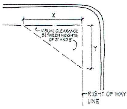
1.
Per AASHTO, a sight triangle visibility easement shall be established at all street intersections to ensure street visibility. The minimum area shall measure 25 feet along the right-of-way in each direction from the projected intersection (shown as "x" and "y" in the graphic). At the intersection of two local streets, the sight triangle shall be measured per AASHTO.
2.
Within the sight triangle, no construction, planting, grading or other natural or manmade object, including signs and human advertising, that interferes with street visibility shall be permitted between the heights of three and eight feet, measured from the crown of the street, except as approved by the Development Engineer.
3.
The Development Engineer has the authority to extend the sight triangle based on speeds, pedestrian facilities, and location of the painted stop bar at the intersecting street. Furthermore, the Development Engineer may make a determination that objects interfering with street visibility shall be removed or otherwise altered to restore visibility.
E.
Street Curbs.
1.
Approved street curb types are vertical, mountable, and ribbon curbs. Each curb type shall be appropriate for the street classification, speed, drainage collection and meet the requirements of this Chapter. All curbs, gutters, and inlets shall be designed and constructed in accordance with the Construction Manual.
2.
Comprehensive Plan Streets, Neighborhood Collectors, and any street within a Residential Rural/Estate Subdivision may include ribbon curbs with approved drainage plans. All other streets shall be constructed with mountable or vertical curbs unless approved by the Development Engineer.
3.
Local Streets and Residential Collectors may be constructed with either a mountable curb or vertical curb. Local Street cross-sections shall be in accordance with Table 12.03.030.
4.
Mountable and ribbon curbs require a clear zone safety separation between sidewalks and sidepaths, in accordance with Section 12.07.
5.
Curb Basis for all streets shall be a minimum of nine feet, measured from the back-of-curb to the right-of-way line, to ensure that utilities, grading and drainage can be adequately provided. Unless otherwise specified, the adjacent property owner is responsible for maintenance of all pervious surface within this area, including grass, landscaping, trees, etc. per City Code Section 8.20.100. Encroachments into the right-of-way such as trees, landscaping, signage, and irrigation shall require a License to Encroach unless specified by plat or maintenance agreement.
F.
Street Lights.
1.
Street lights shall be provided and installed by the subdivider on all public and private streets located at intervals not exceeding 300 feet, at all street intersections, and at the terminus of a cul-de-sac, except as otherwise specified herein. Subdivision of lots that do not require new streets shall also provide street lights along existing streets if street lights are non-existent. The lighting type, size of luminaire, mounting poles, location, and installation procedures shall be determined by the City's Electrical Engineer or designee, in accordance with the standards in the Construction Manual.
2.
In a Residential Rural/Estate Subdivision, installation of street lights shall only be required at the entrances to the subdivision. The subdivider shall be responsible for the installation and capping of electrical conduits at all street intersections and culs-de-sac within the subdivision so as to allow for future installation of street lights. Elevated metering transmission structures may be required within the subdivision to transmit utility meter readings.
3.
In the Downtown Overlay District, street lights shall be provided using either the antique lighting or standard light poles painted "Dark Green" in accordance with the Downtown Master Plan and the Construction Manual.
G.
Street Trees.
Trees are an important part of the streetscape and, when desired, should be planted according to the context of a street. Shade trees required by this Code or desired by the homeowner shall typically be planted outside of the right-of-way in the front yard except where otherwise restricted in this Code. Shade trees planted within the right-of-way in the optional Local Street—Tree Option cross section shall be considered a public improvement for construction purposes and be planted between a vertical curb and sidewalk in accordance with the following criteria:
1.
Six-foot minimum separation from both the curb and the sidewalk or sidepath with a modular suspended pavement framing system;
2.
Eight-foot minimum separation with plastic root barriers; or
3.
Ten-foot minimum separation between back of curb and sidewalk or sidepath with no root barrier.
4.
Approved Ornamental Trees shall not require root barrier treatments.
5.
Approved Tree species shall be spaced approximately 40 feet apart, unless otherwise approved by the Urban Forester on the Construction Plans.
6.
All street trees shall be irrigated and maintained by the adjacent property owner, property owner association, or special district, as designated in a plat note.
7.
A maintenance agreement, license agreement and plat notes shall be established prior to recordation of the final plat for the subdivision. The maintenance agreement shall dictate that repair to curbs, sidewalks or sidepaths attributed to street tree root damage shall be the responsibility of the adjacent property owner, property owner associated, or special district, as designated.
H.
Mailbox Kiosks.
Communal mailbox kiosks facing a public street shall be provided direct pedestrian access from the public sidewalk or sidepath, be set back from the public sidewalk or sidepath so as not to impede the walkway and provide either two pull-in parking spaces or a temporary loading zone that adequately accommodates two vehicles. The right-of-way for the adjacent public street shall be sized appropriately for such features.
I.
Construction Entrances.
Construction entrance/exit locations must be specified for all subdivision development. Construction traffic for subdivision public improvements shall not be routed through adjacent neighborhood streets except on rare occasions at the approval of the Development Engineer.
J.
Street Naming.
1.
Streets shall be named according to the City's Addressing and Naming Policy.
2.
Streets shall be named so as to provide continuity of name with existing streets and so as to prevent conflict with identical or similar names within the county.
3.
Driveways or approved private streets serving more than one internal lot that connect to an Arterial street shall be named and signed according to the City's Addressing and Street Naming Policy.
K.
Traffic Calming.
1.
Traffic calming measures shall be implemented at each intersection along local streets. For local streets with block lengths exceeding 500 feet, a minimum of one traffic calming device shall be installed within each block, with placement at intervals not exceeding 500 feet from the nearest intersection. The Development Engineer reserves the authority to approve deviations from the 500-foot spacing requirement based on site-specific conditions.
a.
Horizontally deflecting traffic calming measures include: curb extensions/ bulb-outs/ chokers, chicanes, raised median islands, traffic circles, and roundabouts.
b.
Cul-de-sac—Cul-de-sac or streets that will not be extended with future development may be considered as qualifying traffic calming elements.
c.
Ninety-degree (90°) knuckles may be considered as qualifying traffic calming elements.
L.
Deceleration and Left Turn Lanes.
1.
Any development proposing a new driveway or street connection to a major roadway within the City limits, as listed in Section 12.02.03 shall be required to construct a deceleration and left turn lane at the point of connection. In cases where the proposed development does not directly connect to a major roadway listed in Section 12.02.03, and the added trips is 50 or greater during peak hour, a deceleration lane and a left-turn lane shall be required at the nearest intersection with the major roadway.
a.
For developments not connecting to City limits or right-of-way, the requirement, design, and installation shall conform to the requirements outlined in the TxDOT Access Management Manual and TxDOT Roadway Design Manual (TxDOT Standards). In cases where the proposed development does not directly connect to a major roadway listed in Section 12.02.03, and the added trips are 50 or greater during peak hour within the City limits or right-of-way, a deceleration lane and a left-turn lane shall be required at the intersection with the nearest major roadway.
2.
Deceleration and left turn lane shall meet TxDOT Roadway Design Manual.
3.
The Development Engineer may modify length for deceleration lane that cannot meet TxDOT standards due to site constraints.
M.
School Zone.
1.
Any development that includes a public or private school shall be required to design and construct a designated school zone to ensure the safety of students, pedestrians, and other roadway users.
2.
The school zone shall include, at a minimum:
a.
School zone signage consistent with the Texas Manual on Uniform Traffic Control Devices (TMUTCD);
b.
Flashing beacons, if warranted by a traffic engineering study;
c.
Reduced speed limits during designated school hours, subject to approval by the City;
d.
High-visibility crosswalks and ADA-compliant curb ramps;
e.
Continuous sidewalk connectivity to adjacent street networks;
f.
Advance warning signs and school zone pavement markings;
g.
Pedestrian and bicycle infrastructure appropriate to the context, including but not limited to bike racks, crossing guards, and protected crossings.
3.
The applicant shall coordinate the design of the school zone with the Development Engineer, the Transportation Manager and the applicable school district.
4.
A School Access and Circulation Plan shall be required to determine specific traffic control measures and internal circulation needs.
5.
All school zone infrastructure shall be constructed and fully operational prior to the opening of the school or as otherwise approved by the City.
(Ord. No. 2017-15, § 2, 2-28-2017; Ord. No. 2024-10, § 3(Exh. A), 2-27-2024; Ord. No. 2025-54, § 10(Exh. I), 9-9-2025)
SECTION 12.08. - DRIVEWAY STANDARDS
All driveways accessing a street shall require a permit through either a Building Permit, Stormwater Permit, Site Development Plan, or Driveway Access Permit, in accordance with this Code. The Development Engineer may use discretion on exact driveway spacing distance and location, where warranted. A lot approved in accordance with this Code has the right to at least one driveway access point, which may or may not be full-access depending on conditions. A driveway may provide access to no more than four lots before a street is required.
(Ord. No. 2017-15, § 2, 2-28-2017)
Sec. 12.01.010. - Purpose.
An integrated and interconnected vehicle, pedestrian, and bicycle transportation network is essential for the effective and reliable movement of people and goods. The standards in this Chapter ensure that streets function in an interdependent manner, provide for accessibility and walkability, plan for emergency services, and provide continuous and logical transportation routes. Streets shall be planned and constructed so that their arrangement, size, character, and design is considered in relation to streets, topography, public safety and convenience, and an appropriate relationship with the built environment. The City's Comprehensive Plan shall guide the location and functionality of the transportation network.
(Ord. No. 2017-15, § 2, 2-28-2017; Ord. No. 2023-44, § 5(Exh. C), 8-22-2023)
Sec. 12.01.020. - Authority.
The provisions of this Chapter are adopted pursuant to Texas Local Government Code chs. 211 and 212, and the City Charter.
(Ord. No. 2017-15, § 2, 2-28-2017)
Sec. 12.01.030. - Applicability.
A.
The standards of this Chapter apply to development within the corporate limits and Extraterritorial Jurisdiction (ETJ) of the City of Georgetown.
B.
No subdivision, Site Development Plan or Stormwater Permit shall be approved until conformance to the standards of this Code are demonstrated.
C.
All required transportation improvements shall be designed in accordance with this Code and as detailed in the adopted Construction Specifications and Standards Manual ("Construction Manual"), as amended, or any other adopted construction standards provided by the Development Engineer. When the standards of this Code and the Construction Manual conflict, the more stringent provision shall apply.
(Ord. No. 2017-15, § 2, 2-28-2017)
Sec. 12.01.040. - Subdivision Variance.
A Subdivision Variance, pursuant to Section 3.22 of this Code, may be requested to the provisions of this Chapter except Section 12.06, Design and Technical Standards, and 12.09, Traffic Impact Analysis.
(Ord. No. 2017-15, § 2, 2-28-2017)
Sec. 12.02.010. - General.
The precise alignment of thoroughfares included in the Overall Transportation Plan may be varied to allow for locational adjustments that would increase the compatibility of the right-of-way with natural or man-made features such as steep slopes, waterways, wildlife habitats, historic structures, existing development, or existing streets. In unique circumstances, at the discretion of the Director, the amount of right-of-way expansion may be reduced to accommodate natural or man-made features such as steep slopes, waterways, wildlife habitats, historic structures, or existing development. Thoroughfares that are located in the Downtown Overlay District and are constrained by historical patterns of development may be considered on a case-by-case basis by the Director and may not conform to the ultimate street sections identified in Table 12.02.030.
(Ord. No. 2017-15, § 2, 2-28-2017)
Sec. 12.02.020. - Developer Responsibilities.
It is necessary and desirable to obtain right-of-way for the public street network to support the needs of the community. Developers share the responsibility of providing adequate streets through compliance with the minimum standards governing internal and perimeter streets, and the requirement of the Transportation Impact Fee in Chapter 12.46 of the Code of Ordinances if within the service area boundaries pursuant to Section 12.46.060 of the Code of Ordinances. The developer shall be responsible for the dedication and improvement of internal and adjacent Future Mobility Plan thoroughfares in accordance with the standards of the street classifications described in this Section. The requirement for dedication and improvement of internal and adjacent thoroughfares does not reduce the requirement for payment of a Transportation Impact Fee, except for when such improvements qualify for and are recorded as a credit in a credit agreement pursuant to the requirements of Section 12.46.120 of the Code of Ordinances.
The developer is responsible for all costs of materials, design, and construction of the public improvements required by this Code.
A.
The continuation of all existing streets and those included in the Future Mobility Plan, approved plat, concept plan, or other City-approved document depicting a planned street shall be provided by the developer.
B.
Minimum right-of-way standards shall be in accordance with Table 12.02.030. If the thoroughfare is a boundary street, one-half of the balance between the street's existing right-of-way and the street/intersection right-of-way required shall be required per Table 12.02.030. Where the thoroughfare is internal to the property, the full section of right-of-way shall be required.
C.
Improvements to Future Mobility Plan streets, in accordance with Subsection 12.09.030.F., shall be the responsibility of the developer unless otherwise provided. A developer is not responsible for construction of any bridge structure at the boundary of the subdivision if the bridging of such a street does not immediately connect to the network. A contribution towards the future construction of the bridge may be required, as determined by a Traffic Impact Analysis if the cumulative requirement to build the bridge and other transportation requirements of this Code exceed the approximation of the roughly proportionate impact of the development.
D.
There must be a rough proportionality between the traffic impacts created by a new development and the associated mitigation requirements. The cumulative transportation requirements of a development as a condition of development approval may not exceed the roughly proportionate impact of the development. The approximation of the roughly proportionate impact of a development are established as the "maximum assessable transportation impact fee" per Section 12.46.040 of the Code of Ordinances. When a development is phased, the proportionality of requirements shall be assessed on the cumulative impacts of all phases of development.
(Ord. No. 2017-15, § 2, 2-28-2017; Ord. No. 2023-44, § 5(Exh. C), 8-22-2023; Ord. No. 2025-54, § 6(Exh. E), 9-9-2025)
Sec. 12.02.030. - Comprehensive Plan Streets.
The following table provides general standards for typical Comprehensive Plan regional transportation facilities. All rights-of-way listed in the table are minimum dimensions and additional right-of-way and/or easements may be required by the Development Engineer due to drainage, utilities, or construction necessity. Street width dimensions are measured from back-of-curb to back-of-curb and include travel lanes, bicycle lanes, and curb and gutter. Landscape lots and commercial signage are prohibited within any part of the right-of-way of a comprehensive plan street or trail. Full dimensional cross-sections for each street classification and corridor-specific alternatives can be found in the Chapter 12 Appendix. Utility assignments can be found within the Construction Manual.
Table 12.02.030 Comprehensive Plan Street and Trail Standards
Table Notes
1.
Design and geometry of all streets, including speed adjustments, can be found in Section 12.06.
2.
Right-of-way at intersections for Arterial streets are increased according to the table for a distance of 200 feet from the right-of-way of the intersecting street.
3.
Bicycle lanes are to be combined with sidewalks into a sidepath. The Clear Zone shall meet the TxDOT Design Manual.
4.
The City may consider alternative striping on all comprehensive plan roadways to allow for on-street parking, narrower lane widths, alternative bike lane design, etc. whether in an interim or permanent situation. In the event that the City adopts a specific street corridor design or overlay that differs from the design standards in Section 12.02 and 12.03, any approved cross-section(s) associated with that street can be found in the Chapter 12 Appendix.
5.
Street width does not include median width.
*
2000 passenger cars per hour per lane (pcphpl)
(Ord. No. 2017-15, § 2, 2-28-2017; Ord. No. 2023-44, § 5(Exh. C), 8-22-2023; Ord. No. 2024-10, § 3(Exh. A), 2-27-2024)
Sec. 12.03.010. - Developer Responsibilities.
The developer shall be responsible for the dedication and improvement of all local and neighborhood streets in accordance with the standards of the street classifications described in the following section. Where existing right-of-way does not meet the minimum standards, right-of-way shall be dedicated to meet the minimum requirement. The developer shall provide for the continuation of all existing streets and those included in the Overall Transportation Plan, approved plat, concept plan, or other City-approved document depicting a planned street. The developer is responsible for all costs of materials, design, and construction of the public improvements required by this Code.
(Ord. No. 2017-15, § 2, 2-28-2017)
Sec. 12.03.020. - Public and Private Streets.
All newly created streets shall be constructed to local street standards. Private streets shall include a street maintenance agreement, in a form acceptable to the City, tied to the approved final plat. Alleys shall be privately owned and maintained. All subdivisions, regardless of the use of a public or private street, shall meet the street network requirements of Sec. 12.05.010.
(Ord. No. 2017-15, § 2, 2-28-2017; Ord. No. 2023-44, § 5(Exh. C), 8-22-2023)
Sec. 12.03.030. - Local and Neighborhood Streets.
The following table provides general standards for local and neighborhood streets. Average Daily Trips (ADT) are utilized as a planning tool for a projected development, while Level of Service (LOS) is used as a measurement of functioning roadway adequacy once the street is in operation. All rights-of-way listed in the table are minimum dimensions and additional right-of-way and/or easements may be required by the Development Engineer due to drainage, utilities, or construction necessity. Street width dimensions are measured from back-of-curb to back-of-curb and include travel lanes, parking lanes, and curb and gutter. Full dimensional cross-sections for each street classification can be found in the Chapter 12 Appendix and utility assignments can be found within the Construction Manual.
Table 12.03.030 Local and Neighborhood Street Standards
Table Notes
1.
Local Streets require curb type in accordance with Subsection 12.06.E.
2.
Residential Lanes require companion alleys to provide access to the lots fronting on the lane. Cut-out parallel parking for temporary loading and visitor parking is allowed with additional right-of-way.
3.
Sidewalks in the Downtown Overlay shall follow width, materials, and standards in Subsection 12.04.030.B.
4.
Sidewalk clear zone (separation from curb) varies by the size of tree wells described in Subsection 12.06.G. Sidepath clear minimum 5 feet from face of curb.
5.
Residential Collectors are subject to the driveway separation requirements pursuant to Section 12.08.
6.
Neighborhood Collectors shall not have residential lots fronting on the street, nor permitted access to residential lots. Only access to parkland, amenity centers, or common areas is permitted.
(Ord. No. 2017-15, § 2, 2-28-2017; Ord. No. 2024-10, § 3(Exh. A), 2-27-2024; Ord. No. 2025-54, § 7(Exh. F), 9-9-2025)
Sec. 12.04.010. - Residential Rural Estate Streets.
A.
Streets.
Local Streets within a Residential Rural/Estate subdivision may be constructed to a 26-foot street width. Within the City's designated fire service area, on-street parking is restricted in accordance with the adopted fire code. Rural/Estate streets located in the ETJ may be designed to 25 mph speeds and constructed with a ribbon curb to allow for sheet flow or open-ditch stormwater drainage. Rural/Estate Streets in the ETJ require a stop condition every 1,500 feet which include, but is not limited to, a stop or yield sign, roundabout, or other approved traffic-calming measure.
B.
Sidewalks.
Sidewalks within Residential Rural/Estate subdivisions shall be constructed on both sides of all collector-level and higher-classification streets, including perimeter Arterial streets. Sidewalks may be located within a public utility easement and may meander in and out of the right-of-way. Sidewalks within a Residential Rural/Estate subdivision shall be constructed at the time of street improvements and shall not be deferred to the building permit. An alternative pedestrian plan including a trail system in lieu of sidewalks may be considered by the Director. Maintenance of the sidewalks shall be determined upfront by the governmental entity responsible for the street.
(Ord. No. 2017-15, § 2, 2-28-2017)
Sec. 12.04.020. - Local Street—Street Tree Alternative.
Street trees are permitted in a street right-of-way only when planted in a street right-of-way approved for street trees. All other trees planted along streets shall be located in the front yard of the lot. Trees approved for designated street rights-of-way shall be planted within a parkway strip that is sized and equipped with designated root barrier treatments in accordance with Section 12.06.
(Ord. No. 2017-15, § 2, 2-28-2017)
Sec. 12.04.030. - Downtown Overlay District Streets.
All streets and sidewalks located within the Downtown Overlay District shall comply with the Downtown Master Plan, as amended. Within the Downtown Overlay District, the developer shall be responsible for the dedication of one-half of the remaining right-of-way and construction of landscaping, sidewalks, lighting and other features of the Downtown Master Plan, where such improvements are non-existent or in need of re-construction. If a development is approved for parking to be located within the right-of-way, the developer shall be responsible for any necessary paving and/or intersection improvements to conform to the standards of Subsection A. below.
The Director may consider a lesser right-of-way and/or street design when existing structures, trees, or other objects preclude the expansion to the minimum right-of-way. In such instance, the Director may consider reduced lanes, alternative on-street parking configurations, or other alternative design.
A.
Street Standards.
1.
All local streets located within the Downtown Overlay District shall meet the minimum right-of-way and pavement widths in Table 12.03.030. Downtown Local Streets shall be designed with parallel parking inset by intersection bulb-outs on each side of the street and one travel lane in each direction.
2.
Streets uniquely identified within the Downtown Master Plan shall be dedicated and constructed according to the cross-section in the Downtown Master Plan.
3.
Intersection crosswalks shall be constructed, at a minimum, as Type B crosswalks, as depicted in the Chapter 12 Appendix. Street lighting shall be in accordance with Section 12.06 of this Code.
B.
Sidewalks and Trees.
1.
Sidewalks located within the Downtown Overlay District shall be at least six feet wide and constructed according to the design standards of a Level III Sidewalk, as described in the Downtown Master Plan and depicted in the Construction Manual. Level III sidewalks shall include a four-foot vegetated strip between the curb and sidewalk when not adjacent to head-in or angled street parking. If a sidewalk is identified in the Downtown Master Plan as a Level I or II sidewalk, it shall be constructed accordingly.
2.
Street Trees shall be required at a general spacing of 40 feet for Shade Trees and 20 feet for Ornamental Trees. The Director may consider alternative spacing, species, and location based on existing conditions. Shade Trees shall be planted in a parkway strip or tree well that is sized and equipped with underground root barrier treatments in accordance with Section 12.06. Approved Ornamental Trees shall not require root barrier treatments.
(Ord. No. 2017-15, § 2, 2-28-2017)
Sec. 12.04.040. - Conservation Subdivision Streets.
Local Streets within a designated Conservation Subdivision (per Section 11.06 of this Code) may be constructed to a 26-foot street width. Within the City's designated fire service area, on-street parking is restricted in accordance with the adopted fire code. The parking lane shall be inset from the travel lanes using bulb-out curb design measuring 15x6 feet at each intersection and at 300-foot intervals. The City may consider limited drainage alternatives such as bioswales and landscaped filtration techniques in conjunction with ribbon curbs for Conservation Subdivision Streets.
(Ord. No. 2017-15, § 2, 2-28-2017)
Sec. 12.04.050. - Context Sensitive Streets.
The City's Overall Transportation Plan encourages design flexibility for comprehensive plan streets to accommodate the existing built environment or desired development. Context Sensitive Street (CSS) alternative cross-sections are provided within this Code to account for settings that contain a mixture of uses, densities, and building types that may affect pedestrian and bicycle patterns, speed limits, and on-site parking options. As an alternative to the standard street types for comprehensive plan roads and neighborhood streets, the CSS cross-sections identified in the Chapter 12 Appendix and in a Mixed-Use (MU) Zoning District per Section 4.09 of this Code may be considered as design options for development with this Code.
(Ord. No. 2017-15, § 2, 2-28-2017)
Sec. 12.05.010. - Street Network Connections.
A.
Connections to Major Streets.
All non-residential and residential lots and multi-family complexes shall have direct or indirect access to an existing major street, defined as a Major Collector, Minor Arterial and Major Arterial. Table 12.05.010 is used to determine how many connections to an existing major street(s) are required, based on the number of lots or units. For the purposes of this Section, lots and multi-family units are interchangeable for determining connections to existing major streets. Multi-family developments do not require more than two total connections.
Table 12.05.010
If a subdivision or multi-family development does not directly connect to an existing major street, the number of connections can be satisfied through existing local streets as long as there are enough distinct, continuous routes to a major street through adjacent development to meet the requirements. In that situation, the number of lots in the table shall encompass the total accumulated number of lots or units sharing the street connections to the major street(s), regardless of subdivision boundary.
B.
Street Network Connections Required.
A proposed subdivision or development shall provide connections to the public street network in accordance with Table 12.05.020, through either existing streets or by future street stubs to an adjacent property. The minimum connections in Table 12.05.020 may be increased by further requirements in this Section, such as intersection spacing and street connectivity ratio. For the purposes of this Section, lots and multi-family units are interchangeable for determining connections to existing major streets. Multi-family developments do not require more than two total connections.
Table 12.05.020
C.
Additional Street Connection Requirements.
1.
All existing streets in adjoining areas shall be connected and continued into the new subdivision in alignment therewith, regardless of the number of street connections required. Practical downsizing or upsizing of street widths, speeds, and design will be reviewed and permitted at the discretion of the Development Engineer.
2.
Whenever existing or future street connections are required, the right-of-way shall be extended and all public improvements constructed to the property line boundary.
3.
The Director can require that a proposed future street connection be shifted to a more suitable location in order to minimize block length, discourage cut-through traffic, align compatible uses, preserve trees, prevent reserve strips, and increase the likelihood of ultimate connection.
4.
All Major Collector-designated streets and higher classifications shall connect or stub on both ends to an existing or planned collector or higher-level street. All other collectors should generally connect to another collector although, on a case-by-case basis, exceptions can be considered through an Administrative Exception.
5.
A street stub cannot be used as the basis of lot frontage and/or access for an adjoining lot. Street stubs are intended only to continue through such property.
6.
Streets that are planned to extend in the future shall be constructed with temporary turn-arounds when the street stub exceeds 150 feet in length and shall be depicted on the plat as a temporary easement. The following note should be placed on the plat: "Crosshatched area is temporary easement for turn-around until street is extended." Temporary dead-end streets shall not exceed 500 feet. Reserve strips at the end of streets are prohibited.
7.
All street network connections shall be provided prior to the final phase of development.
8.
A platted residential lot or portion thereof may not be used as a means to connect a proposed street to an existing street or cul-de-sac in order to satisfy the requirements of this Section if the existing street was not intended to connect to the adjacent land.
9.
In addition to the minimum street network connection requirements, intersection spacing and connectivity provisions in Section 12.05.020 may increase the total connections required.
D.
Street Connection Credits.
Credits toward the minimum number of street connections are applicable only after the second existing street connection has been satisfied. A Neighborhood Collector counts as two local street connections and a Major Collector or higher-classification street counts as three local street connections, whether they are constructed as either an existing or future street connection.
(Ord. No. 2017-15, § 2, 2-28-2017)
Sec. 12.05.020. - Streets and Blocks.
A.
Intersection Spacing.
Intersection spacing shall not exceed the lengths specified in Table 12.03.030 and adhere to the following measurement and calculation standards:
1.
Intersection spacing shall apply independently to each side of a street and shall be measured independently on each side of a street along the right of way boundary to the centerlines of two through-streets, both on the same side of the street segment to be measured.
2.
Cul-de-sac and other non through-streets do not apply as an intersection when measuring length of spacing. Measurement will continue along the right-of-way boundary inclusive of non through-street right-of-way.
3.
Intersection spacing shall apply beyond each individual subdivision and measurements shall be continued into the adjacent subdivision.
4.
Intersection spacing requirements do not apply to Major Collector and higher-classification streets.
B.
Mid-Block Pedestrian Connection.
Where intersection spacing is 1,000 feet or greater in length, a minimum 15-foot wide pass-through lot shall be required near the mid-point of the block. The pass-through lot shall connect on both ends to a public street and shall be owned and maintained by a designated property owner's association or similar entity. Within the lot, a minimum six-foot wide sidewalk shall be constructed in an access easement and connect on either end to public sidewalks.
C.
Culs-de-sac.
A residential cul-de-sac shall not exceed 20 total lots or 500 feet in length, whichever is less. A cul-de-sac exceeding 15 lots shall provide pedestrian access from the end of the cul-de-sac through to the nearest public street, public school, sidewalk or trail, provided that such connection is located within the same subdivision. A pass-through lot containing a minimum six-foot sidewalk in a public access easement shall connect on both ends to a public street and shall be owned and maintained by a property owner's association. A residential cul-de-sac is permitted only within a subdivision that has more than one public street connection and shall not take access off of an arterial street.
D.
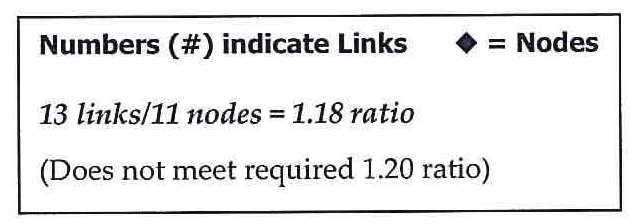
Street Connectivity.
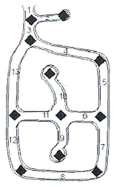
The street network for any subdivision with internal roads or access to any public road shall achieve a connectivity ratio of not less than 1.20. A Connectivity Ratio is achieved by taking the number of street links divided by the number of nodes or end links, including cul-de-sac heads. A node is the terminus of a street or the intersection of two or more streets. A link is any portion of a street defined by a node at each end or at one end. Streets intersecting to an external collector or arterial street are not considered nodes, but are considered links. Street stubs to an adjacent property are considered links, but alley intersections are not. The adjacent graphic and sample calculation shows how the street connectivity ratio for a subdivision shall be calculated.
(Ord. No. 2017-15, § 2, 2-28-2017; Ord. No. 2025-54, § 8(Exh. G), 9-9-2025)
Sec. 12.05.030. - Inter-Parcel Connectivity.
All new non-residential development, regardless of zoning district, that requires a Site Development Plans and/or Stormwater Permits that require off-street parking and driveways shall provide driveway connections to adjacent non-residential zoned or developed properties or properties within the ETJ with a non-residential Future Land Use designation parallel to any street fronting the development, whether such property is developed or undeveloped. Access Easements shall be provided where necessary to achieve such a connection. The Director may consider the following through an administrative exception:
A.
Adjust connection locations and consider alternative connections where practical.
B.
Remove the requirement for interparcel connectivity when determined by the Director connectivity is not feasible or desirable from a community perspective.
If denied by the Director, the applicant may apply for a subdivision waiver.
(Ord. No. 2017-15, § 2, 2-28-2017; Ord. No. 2025-54, § 9(Exh. H), 9-9-2025)
Sec. 12.05.040. - Exceptions.
Exceptions to the requirements of Section 12.05 may be considered by Administrative Exception, Subdivision Variance, or by the abandonment of a right-of-way, in compliance with this Code and the City's Municipal Code.
A.
Administrative Exception.
The Director may consider an Administrative Exception during subdivision plat or site plan review for the following situations only: If a natural or man-made barrier such as a highway, railroad, floodplain, or severe topography would hinder the possibility of connection. The administrative exception shall not apply to meeting the minimum connections to an existing major street, as specified in Table 12.05.010. All other exceptions shall be processed as a Subdivision Variance or Street Abandonment.
B.
Subdivision Variance.
A Subdivision Variance pursuant to Section 3.22 can be considered for proposed and required street connections. The applicant shall demonstrate that all other administrative options have been exhausted. The following are eligible for Subdivision Variance consideration:
1.
Number of required connections, type of street connection, land use compatibility, or location.
2.
A local street that would connect a commercial/industrial development to a residential development. In such instance, the applicant that is required or is proposing to make such a connection is eligible to apply for the subdivision variance and must ensure that removal of such a connection does not cause detrimental effects to the streets in the adjacent subdivision.
3.
A connection that would cause an existing local street to exceed the Average Daily Trip (ADT) projection specified in Table 12.03.030 and cause the Level of Service (LOS) on the existing street to fall to Level "D" or worse, as determined through a Traffic Impact Analysis (TIA). The variance should be considered when efforts to re-route traffic, alter street classifications, or consider alternative connections have been exhausted.
C.
Street Abandonment.
If not otherwise eligible for a Subdivision Variance or exception provided for in this Section, a City-approved public street or street stub that is proposed by any party to be closed, disconnected or never connected to another public street shall be submitted to the City Council for consideration of abandonment, following the procedures in the City's Municipal Code. No public street, right-of-way, or street approved by a plat shall be abandoned by the City or County if not in accordance with this Code. The City and County will collectively determine whether to abandon the portion of a public street that exists or is planned to be in both jurisdictions.
(Ord. No. 2017-15, § 2, 2-28-2017)
Sec. 12.07.010. - General.
All sidewalks, sidepaths, shared use paths and trails identified in this Code, the City's Sidewalk Master Plan, Future Mobility Plan, Parks, Recreation and Open Space Master Plan Element, Trails Master Plan, Downtown Master Plan, and any other relevant plan shall be constructed in accordance with this Code. Public sidewalks, sidepaths, shared use paths and trails do not count against the maximum impervious cover percentage required in Section 11.02 of this Code.
A.
Public Sidewalks and Sidepaths.
1.
Sidewalks and sidepaths shall be constructed on both sides of all streets, including frontage roads, at the minimum widths described in Tables 12.03.030 and 12.04.020 of this Code. Sidewalks shall be constructed consistent with the Construction Manual and in conformance with the requirements of the Americans with Disabilities Act (ADA).
2.
Sidewalks and sidepaths may be located within the street's public utility easement or right-of-way and may meander in and out of either as approved by the Development Engineer. If located within the PUE, a public access easement shall be granted by either the recording of a plat or separate instrument, and shall be identified on any subsequent plans.
3.
Sidewalks and sidepaths shall be installed and meet clear zone requirements per the TxDOT Roadway Design Manual and shall be separated a minimum of six feet from the back of a ribbon curb and four feet from the back of a mountable curb on local streets, in addition to the Sidewalk Clear Zone minimums provided in Tables 12.02.030 and 12.03.010. Sidewalks have no required separation from vertical curbs on a typical local street.
4.
Construction of public sidewalks on single-family and two-family lots may be deferred to the building permit, built to the standards and specifications at the time of the permit. Sidewalks and sidepaths located in common areas, parks and along Neighborhood Collectors shall be constructed at the time of street improvements.
5.
Pedestrian accessways shall be provided from the public sidewalk and sidepaths to the main entrance of each building or to a sidewalk leading to the main entrance.
6.
Sidewalks and sidepaths located within the Downtown Overlay District shall comply with the design standards in Section 12.04 of this Code and the Downtown Master Plan, as amended.
7.
Sidewalks and sidepaths constructed as infill, retrofitted, or rehabilitation projects should follow the standards of this Chapter where practical to do so, but consideration shall be given to the existing conditions of the built and natural environment when locating such sidewalks and sidepaths.
B.
Public Trails.
Regional Trails depicted on the Trails Master Plan shall be dedicated and constructed at the time of development as a public improvement in the general locations and alignments depicted therein.
1.
If the trail is not located on public property, a minimum of 20 feet of right-of-way or public access easement, shall be dedicated as approved by the Director of Parks and Recreation.
2.
The trail shall be a minimum of ten feet in width, constructed to the standards depicted in the Trails Master Plan, or otherwise approved by the Director of Parks and Recreation.
3.
A trail constructed to the City's trail standards may be constructed within the right-of-way or public utility easement as a substitute for a sidepath if the Trails Master Plan designates a trail along the street.
C.
On-Street Bicycle Lanes.
Bicycle facilities are required along Major Collectors and Arterials at the minimum widths specified in Table 12.02.030. On Arterial streets, bicycle accommodations are recommended in a side path off of the vehicular travel lanes for the safety of the cyclists, though the approved cross-sections in Appendix A allow for on-street striped lanes as well. Design and construction of all bicycle facilities shall meet or exceed standards set forth in the City's Future Mobility Plan.
D.
Sidewalk Fund.
A designated City fund, entitled "Sidewalk Fund," shall hold any financial contributions paid in accordance with the provisions in this Code. Funds shall be held in trust by the City to be used exclusively for the purpose of purchasing and/or equipping public streets for sidewalks or sidepaths.
E.
Alternative Pedestrian Improvements.
1.
Alternative locations or design variation(s) of sidewalks, sidepaths, pedestrian access facilities, or hike and bike trails to a standard that deviates from the Construction Manual can be requested to the Development Engineer. If approved, ownership and maintenance shall be transferred to the property owner or property/homeowner association and recorded by separate instrument, along with a public access agreement.
2.
When an administrative alternative cannot be achieved, a Subdivision Variance pursuant to Section 3.22 may be requested for either fees-in-lieu of construction, delay of construction, or waiver. Justifications for the variance include, but are not limited to, the location of the facility in relation to the existing or planned pedestrian network, the need for the facility, and/or topography/natural features. Prior to approval of the Final Plat, Site Development Plan, or other applicable approval stage, payment of any required fees shall be provided for deposit into the Sidewalk Fund at a cost not to exceed one hundred twenty-five percent (125%) of the estimated construction plan costs, as approved by the Development Engineer. A request may be made to City Council for City participation in any pedestrian improvements required by this Chapter.
(Ord. No. 2017-15, § 2, 2-28-2017; Ord. No. 2023-44, § 5(Exh. C), 8-22-2023; Ord. No. 2024-10, § 3(Exh. A), 2-27-2024; Ord. No. 2025-54, § 11(Exh. J), 9-9-2025)
Sec. 12.08.010. - Residential Driveways.
1.
Single-family and two-family platted lots shall only take access from an alley, local street, residential lane, or residential collector and shall not take access road that contains a County number (Ex. CR 425), arterial, or highway.
2.
Residential driveways on a local street serving single-family or two-family lots shall be separated from a street intersection by a minimum of 50 feet, measured from the right-of-way to the center of the driveway. Residential lots with frontage on more than one non-intersecting street shall take access from the street with the lower classification, if applicable.
3.
Residential driveways on a Residential Collector serving single-family or two-family lots shall be spaced a minimum of 70 feet on center and shared driveways are not permitted.
Exceptions to this provisions include:
a.
Does not apply to alley-loaded only lots fronting on Residential Collectors.
b.
Does not apply if less than twenty-five percent (25%) of the linear street frontage contains front-loaded lots.
c.
Distance separation may be reduced to 55 feet if only one side of the street is front-loaded or if the street is divided by a median.
d.
A platted lot that is 90 feet or greater in width located on a collector-level or higher street may be allowed a second driveway access point irrespective of the 70-foot separation provision, in full accordance with all setback provisions.
e.
Slip roads that provide public access along a private driveway serving multiple residential lots, provided that the slip road access to the collector meets the separation.
(Ord. No. 2017-15, § 2, 2-28-2017)
Sec. 12.08.020. - Non-Residential Driveways.
1.
Non-Residential driveways shall be no wider than 30 feet, except where a median is present within the driveway. When a median is desired or required, the driveway width shall not exceed 45 feet and the median shall be constructed with a mountable curb. On streets operated by the Texas Department of Transportation (TxDOT), the Development Engineer may defer to TxDOT in circumstances where these standards are not practical.
2.
Non-Residential full-access driveways shall be separated from a street intersection and from other driveways in accordance with Table 12.08.020, measured on center or from the right-of-way to the center of the driveway. Minimum separation for right-in, right-out-only driveways shall be determined by the Development Engineer on a case-by-case basis, but in no case be spaced less than 200 feet from a street or driveway.
3.
Where multiple access points to a site or are desired, the Development Engineer shall have the authority to require the consolidation, closure, or relocation of an existing or planned driveway, even if consistent with the minimum spacing in Table 12.08.020.
4.
Non-Residential driveways on double-frontage lots located in a Residential Zoning District shall have offsetting access points from opposing streets to inhibit cut-through traffic.
5.
A Driveway Access Permit may require an engineering study or a Traffic Impact Analysis in accordance with Section 3.19 of this Code.
Table 12.08.020 Driveway Spacing
* The standards in this table are derived from the City of Georgetown Driveway Spacing Study, adopted July 2001 and based on AASHTO sight distance standards; and the City of Georgetown Access Management Policy, adopted December 2003.
(Ord. No. 2017-15, § 2, 2-28-2017; Ord. No. 2023-44, § 5(Exh. C), 8-22-2023)
Sec. 12.09.010. - Purpose.
To ensure that development impacts are mitigated through specified constructed public improvements and/or financial contributions thereto and that such requirements are proportional to the traffic demands created by a new development. There must be a rough proportionality between the traffic impacts created by a new development and the associated impact requirements placed on the property owner.
(Ord. No. 2017-15, § 2, 2-28-2017)
Sec. 12.09.020. - Applicability.
The road adequacy regulations in this Section apply to land development activities within the City limits and within the City's extraterritorial jurisdiction, as specified in this Section. In addition to these road adequacy regulations, Transportation Impact Fees, as required in Chapter 12.46 of the Code of Ordinances, shall be required for land within the transportation service areas as defined in Section 12.46.060 of the Code of Ordinances.
(Ord. No. 2017-15, § 2, 2-28-2017; Ord. No. 2023-44, § 5(Exh. C), 8-22-2023)
Sec. 12.09.030. - Traffic Impact Analysis.
A.
When Required.
1.
A Traffic Impact Analysis shall be required with any application for a subdivision, Site Plan, Stormwater Permit, or Driveway Permit, for which the proposed development generates traffic in excess of 2,000 average daily trips, based upon the latest edition of the Institute of Transportation Engineers (ITE) Trip Generation Manual. When a development is within the transportation service areas as defined in Chapter 12.46.060 of the Code of Ordinances, a Traffic Impact Analysis shall only be required when the proposed development generates traffic in excess of 5,000 daily trips. In the event that specific land uses for the development are not specified at the time of subdivision or plat application, the daily trip generation rate for the most intensive land use from the ITE Manual for the land use classification of the application shall be used to compute the estimated average daily trips.
2.
The Traffic Impact Analysis (TIA) shall be prepared by a licensed professional in accordance with standard transportation engineering practices for purposes of determining the adequacy of the road network to serve the proposed development, and whether off-site road dedication and improvements should be made to mitigate the effects of the development proposed in the application.
3.
An initial Traffic Impact Analysis shall be submitted with the first application for the development that triggers the requirement. An updated Traffic Impact Analysis shall be submitted with each Final Plat submitted for approval and shall be generally consistent with the initial Traffic Impact Analysis. The initial Traffic Impact Analysis shall be updated whenever a subdivision plat or Site Plan is modified to authorize more intensive development.
B.
Study Scope.
When a Traffic Impact Analysis is required, the scope of the analysis shall be determined during a scoping meeting with the Development Engineer. The scoping meeting may occur during any required pre-application meeting, but may also be scheduled after an initial pre-application meeting. No application requiring a Traffic Impact Analysis may be made until the scope of the required analysis has been determined. The Development Engineer may involve representatives of or request assessments from other agencies and departments. The elements to be determined during the scoping session shall include the following.
1.
Definition of Impact Area.
The points of access and key streets and intersections that may be affected by development of the subject tract constitute the impact area. Traffic recorder and turning movement assessment locations shall be determined.
2.
Period of Analysis.
Periods of analysis shall include: average daily traffic, peak AM and PM, or weekend peak hour.
3.
Analysis Scenarios.
Scenarios for analysis include: existing conditions, opening year conditions with and without development, and ten years after opening with and without development.
4.
Process.
Process for determining trip generation and distribution including: trip generation category, diversion assumptions, distribution assumptions, and capacity analysis.
5.
Growth Rate Assumption.
The rate of growth assumed in background traffic assumptions.
6.
Future Development.
Planned developments in the area that have been approved or are under review.
C.
Traffic Study Elements.
A letter report or special report shall only include those elements agreed upon in the scoping meeting. A full Traffic Impact Study shall include the following elements.
1.
Existing Condition Survey.
a.
Street System Description.
The street system shall be described including geometric features, lane usage, traffic control, signage, sight distances, and adjacent uses and curb cuts.
b.
Traffic Volumes.
Existing traffic volumes shall be provided for the impact area including both ADT (Average Daily Traffic) and "Design" peak hour volumes. ADT shall be derived from the latest available counts taken by the City or Texas Department of Transportation. Peak hour volumes shall be obtained from field counts. Data shall be adjusted for daily and seasonal variations. Turning movement counts for the peak hour shall be provided for critical intersections. Peak hour periods shall be as determined at the scoping meeting.
c.
Capacity Analysis.
Existing capacity of signalized and unsignalized intersections.
d.
Other.
Other items may be required at the discretion of the Director depending upon the type and scale of the project. These may include but are not limited to: queue length analysis, pedestrian counts, accident data, traffic speeds (both 50th and 85th percentile), and stopping sight distances.
2.
Future Without Development.
Capacity analysis is to be provided for opening year and plus ten-year for key intersections (and street segments where appropriate) without the development but including any planned developments. The analysis shall be based upon the Highway Capacity Manual or other methodologies approved in advance by the Director.
3.
Future with Development.
a.
Projections of the daily and peak hour traffic generation of the project shall be made using the latest edition of the ITE Trip Generation Manual unless the Director determines that locally derived data will provide more accurate forecasts. Data from similar facilities may be used where the information is not available from ITE.
b.
The projected trips shall be distributed onto the road network as agreed in the scoping meeting.
c.
Capacity analysis for opening year and plus ten-year for key intersections (and street segments where appropriate).
d.
Special analysis as may be required to determine warrants for signalization, minimum safe sight distances, gap analysis, turning radius requirements, queue length analysis, turning lane length analysis, curb cut locations, or similar requirements.
4.
Mitigation Plan.
Where the analysis indicates that the project will create deficiencies in the impact area, improvements shall be recommended which shall include projected cost estimates. The design of improvements shall be in accordance with specifications of the Development Engineer and, where appropriate, the Texas Department of Transportation. The mitigation plan shall also include any dedications necessary to comply with the Minimum Road Standards described below. Where-the final approval authority for any procedure determines that a mitigation plan is not adequate to address the traffic impacts of the project, it may serve as a basis for denial of the permit or subdivision plat. Mitigation plans shall identify improvements that are eligible for TIF credits per Chapter 12.46 of the Code of Ordinance. All improvements identified shall be required, subject to the roughly proportionate impact of development.
E.
Consultants.
The City may require that an independent licensed professional traffic engineer be hired by the applicant to perform the required Traffic Impact Analysis or to review all or part of a study prepared by the applicant's consultants.
F.
Minimum Road Standards.
All applications for plat approval, Site Plan approval, or PUD rezoning shall provide for adequate roads to support proposed development through compliance with the following minimum standards governing dedication and improvement of internal streets and adjacent thoroughfares. For purposes of this Section "adjacent thoroughfares" shall include thoroughfares abutting the proposed subdivision, whether located within the boundaries of the subdivision or within public rights-of-way.
1.
Standards and Specifications.
The property owner shall dedicate and improve all required rights-of-way for internal streets and adjacent thoroughfares required by these regulations in accordance with the classification of streets contained in the Comprehensive Plan.
2.
Dedication and Improvement of Internal Roadways and Adjacent Thoroughfares.
a.
The property owner shall dedicate and improve one-half of the right-of-way necessary to meet the specification in the Comprehensive Plan.
b.
The City may require additional land and improvements for rights-of-way for adjacent thoroughfares where necessary to achieve adequacy of the road network and where such additional land and improvements are proportional to the traffic impacts generated by the proposed development, depending on factors such as the impact of the development on the adjacent thoroughfare, the timing of development in relation to need for the thoroughfare, and the likelihood that adjoining property will develop in a timely manner.
c.
In the case of adjacent frontage or service roads for State and Federally designated highways, the property owner shall dedicate sufficient right-of-way and make authorized improvements in order to provide an adequate road network to serve the development.
3.
Substandard Street Improvements.
Where an existing thoroughfare that does not meet the City's right-of-way or design standards abuts a proposed new development, the City may require the property owner to dedicate the right-of-way for a standard thoroughfare width, and to improve the street according to the dimensions and specifications in the Comprehensive Plan or Sections 12.02 and 12.03 of this Code, depending on factors such as the impact of the development on the thoroughfare, the timing of development in relation to need for the thoroughfare, and the likelihood that adjoining property will develop in a timely manner.
4.
Capital Improvements Plan for Roads.
A road improvement may be considered adequate for an application if the required improvement is included, funded, and approved in the City's, County's or State's two-year capital improvements plan for roads or if the improvement is included, funded, and approved in the City's, County's, or State's three- to five-year capital improvements plan for roads, provided that the applicant agrees to phase development to conform to such scheduled improvement. This Section shall not be construed to prevent the City from requiring dedication of rights-of-way for such roads or from assigning trips to such roads in a traffic impact study in order to determine a development project's proportionate costs of improvements.
5.
Participation in Costs of Improvements.
The City may participate in the costs of improvements required by this Section in order to achieve proportionality between the traffic impacts created by the proposed development and the obligation to provide adequate streets. In such cases, the property owner shall be responsible for the entire initial costs of road improvements, including design costs. Reimbursement of the City's agreed share of the costs shall be made as funds become available. The construction of improvements and the provisions for participation in costs by the City shall be included in a subdivision improvement agreement.
G.
City Evaluation and Action.
The City shall evaluate the adequacy of the Traffic Impact Analysis prepared by the applicant. Based upon such evaluation, the City shall determine (1) whether the application may be approved in the absence of dedication of rights-of-way or construction of improvements to each affected thoroughfare, and (2) the extent of the applicant's obligations to make such dedications or improvements. The City shall condition the approval of the subdivision application on one or more of the following performances by the applicant:
1.
Delay or phasing of development until thoroughfares with adequate capacity or intersection improvements are constructed;
2.
A reduction in the density or intensity of the proposed development sufficient to assure that the road network has adequate capacity to accommodate the additional traffic to be generated by the development;
3.
The dedication or construction of thoroughfares or traffic control improvements needed to mitigate the traffic impacts generated by the proposed development.
H.
Deferral of Obligation.
Upon request of the applicant or property owner, the obligation to dedicate or improve thoroughfare rights-of-way or to make intersection improvements imposed on an application may be deferred to a later stage of the development process.
As a condition of deferring the obligation to dedicate rights-of-way for or to improve thoroughfares, which deferral shall be in the sole discretion of the City, the City shall require the developer to execute a subdivision improvement agreement specifying the amount and timing of the rights-of-way dedication or improvements to thoroughfares.
I.
Cash Contributions.
In lieu of the obligation to dedicate or improve thoroughfares or make traffic control improvements to achieve road adequacy, the applicant may propose to make equivalent cash contributions based upon the development project's proportionate share of the costs of improvements, which the City in its sole discretion may accept in satisfaction of road adequacy standards in this Section. Any funds accepted by the City shall be earmarked for construction of the improvements for which the contribution was made.
J.
Options.
Whenever the proposed development's share of the costs of a thoroughfare or traffic control improvement needed to mitigate traffic generated by the development is less than one hundred percent (100%), the City in its sole discretion may do the following:
1.
Participate in the excess costs; or
2.
Aggregate the costs of improving multiple thoroughfares or intersections identified in the Traffic Impact Analysis, and require improvements to only some of the thoroughfares or intersections affected by the development.
K.
Appeal of Traffic Impact Analysis Conditions.
Any appeal of a disapproved or denied final action resulting, in full or in part, from a determination that the Mitigation Plan was insufficient shall include the following.
1.
The appeal shall allege that recommended conditions requiring dedication or construction of thoroughfares or traffic control improvements are not roughly proportional to the nature and extent of the traffic impacts on the road network created by the development being proposed.
2.
The appeal may also allege that the imposition of the conditions deprives the owner of the economically viable use of the land or of a vested property right.
3.
The applicant shall provide a study in support of the appeal including the following information:
a.
Total vehicle miles of road capacity utilized by the proposed development, employing average trip length and equivalency Tables provided by the City.
b.
Total vehicle miles of road capacity supplied by proposed dedications of rights-of-way or improvements to thoroughfares.
4.
The City Council, shall consider the appeal and determine whether the street or traffic control dedication and construction requirements are roughly proportional to the nature and extent of the impacts on the road network created by the development proposed. If the petition also alleges that the proposed dedication or construction requirements constitute a deprivation of economically viable use or of a vested property right, the Hearing body also shall consider such issues. Following such determinations, the appeal Hearing body may take any of the following actions regarding the road adequacy portion of the appeal only:
a.
Deny the appeal, upon determining that the required dedications of rights-of-way for or improvements to thoroughfares or traffic control improvements are roughly proportional to the nature and extent of the impacts created by the development, and order that such dedication or improvements be made as a condition of approval of the subdivision application.
b.
Deny the appeal, finding that the dedication or improvement requirements are inadequate to achieve road adequacy, and either deny the subdivision application or require that additional dedications of rights-of-way dedication for or improvements to thoroughfares or traffic control improvements, be made as a condition of approval of the application.
c.
Grant the appeal and waive in whole or in part any dedication or construction requirement that is not roughly proportional; or
d.
Grant the appeal and direct that the City participate in the costs of acquiring rights-of-way or constructing improvements sufficient to achieve proportionality.
(Ord. No. 2017-15, § 2, 2-28-2017; Ord. No. 2023-44, § 5(Exh. C), 8-22-2023)