
Gonzales City Zoning Code
Sec. 22-5.5
Subdivision regulations.
(22-5.5)(a)
General provisions.
(22-5.5)(a)(1)
Title. This section shall be known as the "subdivision code for the City of Gonzales, Louisiana" and may be cited and referred to as "this subdivision code."
(22-5.5)(a)(2)
Authority. This subdivision code is adopted pursuant to the authority granted by R.S. 33:112 et seq.
(22-5.5)(a)(3)
Applicability.
a.
The provisions of this subdivision code apply to the subdivision of all land within the city. No subdivision of land shall be undertaken without prior authorization pursuant to this subdivision code.
b.
This chapter shall not apply to:
1.
Land in subdivisions previously legally recorded, except in the case of resubdivision;
2.
The subdivision of land to be used as cemeteries, except the preliminary plat thereof;
3.
The subdivision of land to be used solely for the placement, construction, installation or erection of utility sites, including but not limited to, telecommunication, water, sewer, electrical and cable television utility sites.
(22-5.5)(a)(4)
Effective date. This subdivision code was adopted on December 12, 2016, and became effective on [insert date].
(22-5.5)(a)(5)
Purpose.
a.
This subdivision code is adopted for the purpose of guiding development in accordance with the city comprehensive plan and existing and future needs of the city in order to protect, promote and improve the public health, safety, morals, convenience, order, appearance, prosperity and general welfare.
b.
The regulations hereby enacted are designed to exercise the full range of authority available to the city under Louisiana law to:
1.
Promote the public health, safety and general welfare, while recognizing the rights of real property owners, by adopting a subdivision ordinance.
2.
Help achieve the goals, objectives and policies of the city comprehensive plan.
3.
Establish reasonable standards of design and procedures for subdivisions and resubdivisions in order to further the orderly layout and use of land, and to ensure proper legal descriptions and monumenting of subdivided land.
4.
Facilitate the adequate and efficient provision of transportation, water, wastewater, drainage, schools, parks, playgrounds, recreation and other public facilities and services by providing a means for regulating the impact of development on community infrastructure.
5.
Provide the most beneficial relationship between the uses of land and buildings and the circulation of automobile traffic and pedestrians throughout the city, and to secure safety from natural disaster, fire, and other dangers by providing for the proper location and width of streets, sidewalks, and buildings.
6.
Provide for a range of open spaces through the most efficient design and layout of the land.
7.
Ensure that land is subdivided only when subdivision is necessary to provide for uses of land for which market demand exists and which are in the public interest.
8.
Promote the orderly division of land and remedy problems associated with inappropriately subdivided lands, including excessive subdivision, partial subdivision, scattered subdivision, or low-grade subdivision.
9.
Carry out such other purposes in the public interest as may be specifically cited in this subdivision code.
(22-5.5)(a)(6)
Intent. This subdivision code is intended to provide a mechanism for implementing the following goals:
a.
Protecting the natural environment and visual character of the region.
b.
Creating a range of housing opportunities and choices.
c.
Creating mixed use, walkable and bikeable neighborhoods.
d.
Fostering distinctive, attractive communities with a strong sense of place.
e.
Making development decisions predictable, fair and cost effective.
f.
Preserving open space, farmland, rural character, natural beauty and critical environmental areas.
g.
Providing a variety of transportation choices and transportation corridors that are planned in context with character of the area.
h.
Strengthening and directing development towards existing communities.
i.
Taking advantage of compact building design where infrastructure is in place.
(22-5.5)(a)(7)
Minimum requirements. The requirements of this subdivision code shall be considered as the minimum requirements for the promotion of the public health, safety and general welfare.
(22-5.5)(a)(8)
Conflicting provisions.
a.
All subdivisions must comply with relevant federal and state regulations. Whenever any provision of this subdivision code imposes a greater requirement or a higher standard than is required in any federal or state statute or regulation, the provisions of this subdivision code shall govern unless preempted by federal or state law.
b.
It is not the intent of this subdivision code to interfere with or annul any easements, covenants, or other agreements between parties; provided that where this subdivision code imposes a greater restriction upon the use and dimensions of buildings, structures, or land, or requires larger open spaces than are imposed or required by other ordinances, regulations, or permits, or by easements, covenants, or agreements, the provisions of this subdivision code shall govern, except where expressly qualified in this subdivision code.
(22-5.5)(a)(9)
Severability. Should any provision of this subdivision code be decided by the courts to be unconstitutional or invalid, that decision shall not affect the validity of this subdivision code other than the part decided to be unconstitutional or invalid.
(22-5.5)(b)
Subdivision standards.
(22-5.5)(b)(1)
Applicability. The regulations of this section apply to all development within the city.
(22-5.5)(b)(2)
Improvements.
a.
Before installing any public improvements, the applicant shall file complete construction plans covering all required improvements, utility easement location and such other plans and documents as may be required by the administrator. The applicant shall enter into a contract with the city approved as to form and legality by the city attorney, to make, install and complete or guarantee all required improvements and dedicate all required easements.
b.
Prior to issuance of any building permit, the applicant shall either have installed improvements specified in this subdivision code as shown on approved construction drawings or guaranteed the installation of improvements specified under this subdivision code by a bond with surety accepted by the city council.
c.
All improvements and construction required under this subdivision code shall conform to all standards and specifications of the city pertaining to the construction of any facilities regulated by the city design standards manual.
d.
No public services or utilities may be extended or furnished to any development until the applicant has either installed the improvements specified in this code as shown on approved construction drawings or guaranteed the installation of improvements specified under this subdivision code.
e.
All required improvements shall be designed and installed so as to provide for a system of utilities, stormwater and streets and to create continuity of improvements between adjacent properties. Required pedestrian, vehicle, water and wastewater improvements shall be extended to and through to the edges of the proposed subdivision.
(22-5.5)(b)(3)
Easements and dedication. All dedications of property to the city for public purposes shall be made formally through a written certification pursuant to R.S. 33:5051, except that, at the city discretion, the grant of an easement may be taken for the following purposes: recreational easements, conservation easements, emergency access easements, or public utility easements. All dedications in fee and grants of easements shall be free of liens and encumbrances except for those that the city, in its discretion, determines would not conflict with the intended ownership and use.
(22-5.5)(c)
Blocks and cul-de-sacs.
(22-5.5)(c)(1)
Block and cul-de-sac standards.
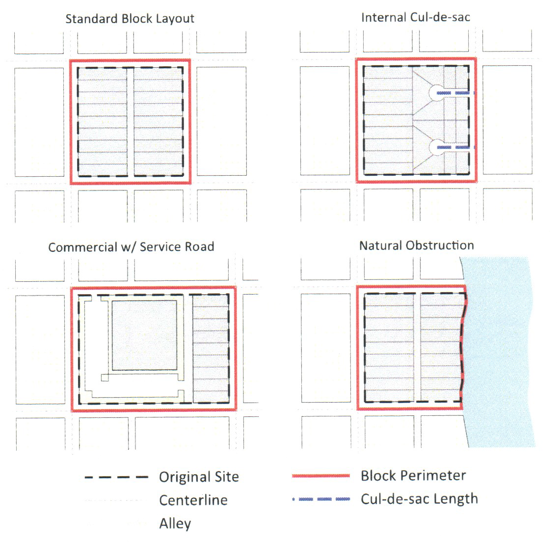
a.
The following table establishes the maximum block perimeter and maximum cul-de-sac length by zoning district for complete blocks, partial blocks and cul-de-sacs:
b.
The maximum block perimeter may be extended by ten (10) percent, if the block includes a pedestrian passage that connects two (2) streets provided the passage is a minimum of ten (10) feet wide and accessible at all times to the general public.
c.
Any single non-industrial block face longer than eight hundred (800) feet must include a pedestrian passage near the center of the block with a minimum servitude of fifteen (15) feet that connects two (2) streets. This servitude shall be dedicated for public use (utility, passage, etc.). In this servitude, no structure above ground level will be allowed. A paved sidewalk having a minimum of four (4) feet and a maximum of six (6) feet in width, and a minimum of four (4) inches in depth shall be required in this servitude in residential subdivisions only.
(22-5.5)(c)(2)
Block and cul-de-sac measurements.
a.
Generally.
1.
The administrator may approve exemptions to the maximum block perimeter in the event that slopes in excess of twenty-five (25) percent; freeways; waterways, railroad lines; preexisting development; conservation areas, open space, and easements are determined to make the block perimeter maximum unfeasible.
2.
A block may be broken by a civic building or open space, provided the lot is at least fifty (50) feet wide and provides pedestrian access through the lot.
b.
Complete blocks.
1.
A block is bounded by either a publicly-dedicated street, a private drive or private street that meets the requirements for a publicly-dedicated street.
2.
A block perimeter is measured along the centerline of intersecting streets that encompass the block.
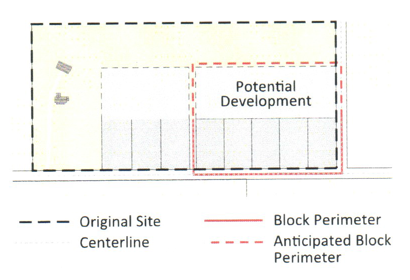
c.
Partial blocks. If the scale of a proposed subdivision does not generate the need for a complete block, then street stubs may be required at certain locations to allow for future connections.
1.
Narrow site subdivision.
i.
As an alternative to a cul-de-sac, a subdivider may provide a street stub to serve future development.
ii.
The street stub shall be located so that future development may connect to the street stubs in such a way as to form a block equal to or less than the maximum block perimeter allowed under section 22-5.5(c)(1) block and cul-de-sac standards.
iii.
The depth assumed for the potential development area shall be equal to or greater than the partial block depth proposed in the subdivision.
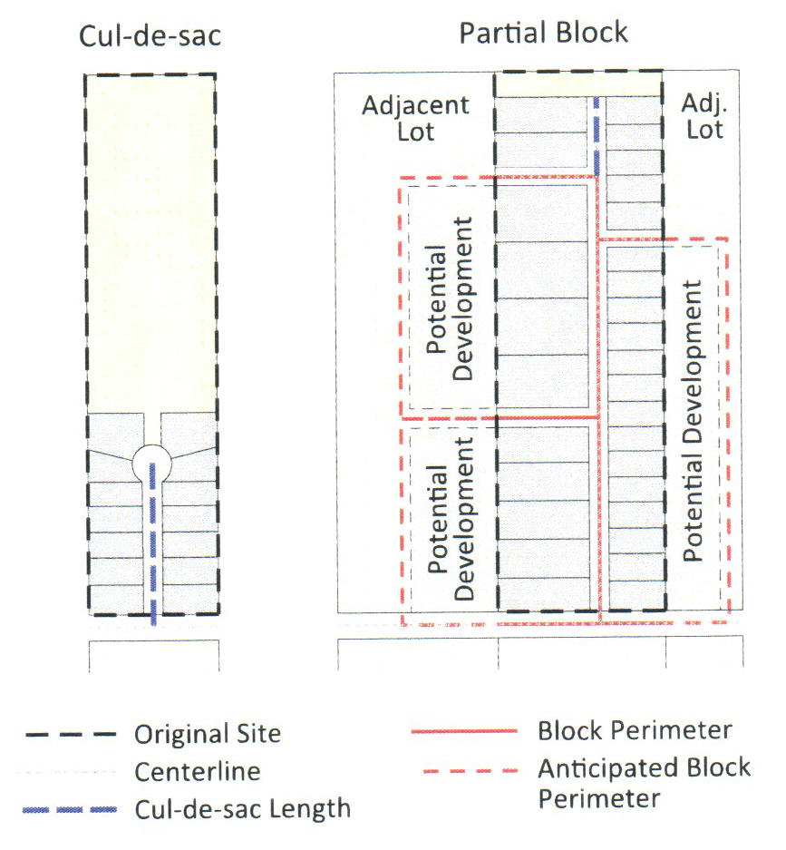
2.
Wide site subdivision.
i.
As an alternative to a cul-de-sac, a subdivider may choose to provide a street stub to serve future development.
ii.
The street stub shall be located so that future development may connect to the street stub in such a way as to form a block equal to or less than the maximum block perimeter allowed under section 22-5.5(c)(1) block and cul-de-sac standards.
iii.
The depth assumed for the potential development area shall be equal to or greater than the partial block depth proposed in the subdivision.
d.
Cul-de-sacs.
1.
All cul-de-sacs shall have a maximum length in accordance with section 22-5.5(c)(1) and a minimum turning radii of thirty-three (33) feet.
2.
Cul-de-sac length is measured along the center line of the cul-de-sac from the center of the intersection to the center of the turnaround.
3.
A cul-de-sac shall terminate with a permanent turn-around with curb treatment consistent with the street design.
4.
The applicant shall provide for perpetual maintenance of any unpaved landscaped island through a property owners association or other acceptable organization.
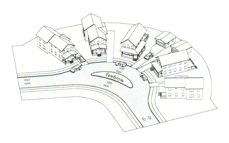
5.
The following alternatives to cul-de-sacs may be approved by the planning commission at the time of subdivision:
i.
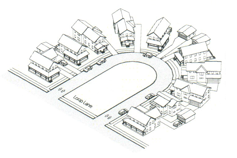
Eyebrow. An eyebrow is a rounded expansion of a street beyond the normal curb line. An eyebrow must have a landscaped island and is only allowed in the suburban context.
ii.
Loop lane. A loop lane is a two-way street, no portion of which may be more than the maximum allowable cul-de-sac length from the abutting street right-of-way. The interior landscaped area must at least have an average width of seventy-five (75) feet.
iii.
T-turnaround. If a T-turnaround is approved by the city engineer, it shall be eighty (80) feet long and twenty (20) feet wide.
(22-5.5)(d)
Street and alley standards.
(22-5.5)(d)(1)
Purpose. The master street plan identifies the location and type of roadway facilities that are needed to meet projected growth and ensure mobility and access for the public. The objective of the master street plan is to ensure adequate right-of-way is preserved to allow for orderly and efficient roadway expansion if needed.
(22-5.5)(d)(2)
Applicability. The following street types apply to the construction of new streets and the reconstruction of existing streets.
(22-5.5)(d)(3)
Street types established. The following street types are established, and are shown on the map in the comprehensive plan adopted on August 24, 2015, which is herein made a part of this chapter and is on file in the clerk's office:
a.
Arterials serve major centers of metropolitan areas, provide a high degree of mobility and can also provide mobility through rural areas. Unlike their access-controlled counterparts, abutting land uses can be served directly. Forms of access include driveways to specific parcels and at-grade intersections with other roadways.
b.
Collectors serve a critical role in the roadway network by gathering traffic from local roads and funneling them to the arterial network. Within the context of functional classification, collectors are broken down into major collectors and minor collectors.
c.
Local roads are not intended for use in long distance travel, except at the origin or destination end of the trip, due to their provision of direct access to abutting land. Local roads are often designed to discourage through traffic. As public roads, they should be accessible for public use throughout the year.
(22-5.5)(d)(4)
General. The applicant shall be responsible for the dedication and improvement of the streets and streetscapes in accordance with the standards of this code.
a.
Construction standards. The standards for the construction of pavement on all streets shall be in accordance with the specifications established by the city.
b.
Streetscapes. The applicant shall be responsible for the improvement and maintenance of all streetscapes, including, but not limited to, street trees, sidewalks, and planting areas abutting the applicant's property.
c.
Payment-in-lieu. If determined by the city council that construction of improvements at the time of development would result in the improvement of less than one-half (½) of a linear block face; an equivalent payment in lieu of construction may be required. The payment shall be deposited by the city in an interest bearing account for the improvement of the street and streetscape and shall be applied only to the cost of such improvements in the future.
d.
Extent of right-of-way. Where determined appropriate by the city council, any pedestrian zone and planting zone may occur on private property subject to an easement for public access.
(22-5.5)(d)(5)
Right-of-way requirements.
a.
Master street plan minimum widths.
b.
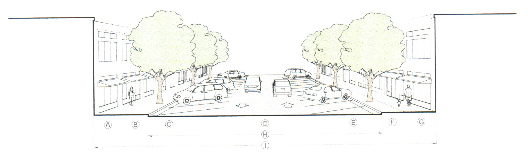
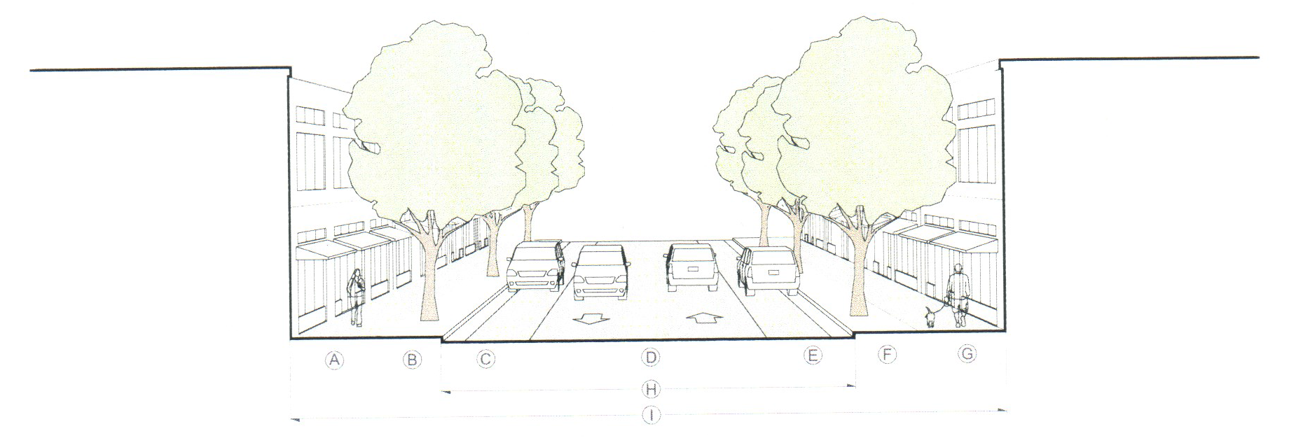
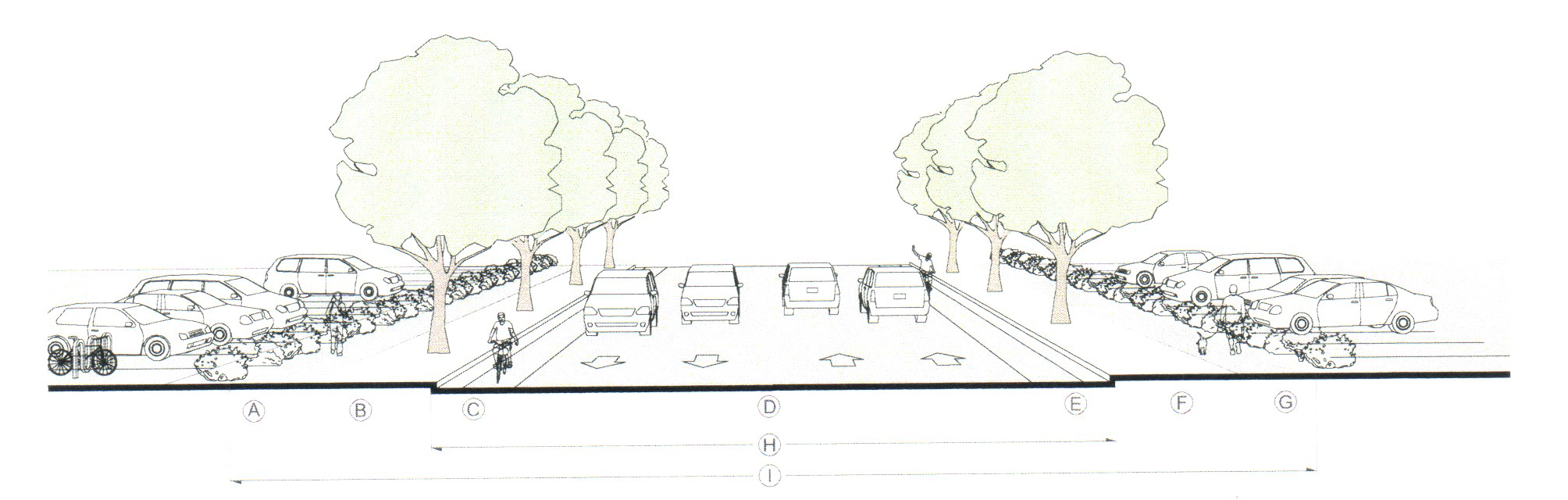
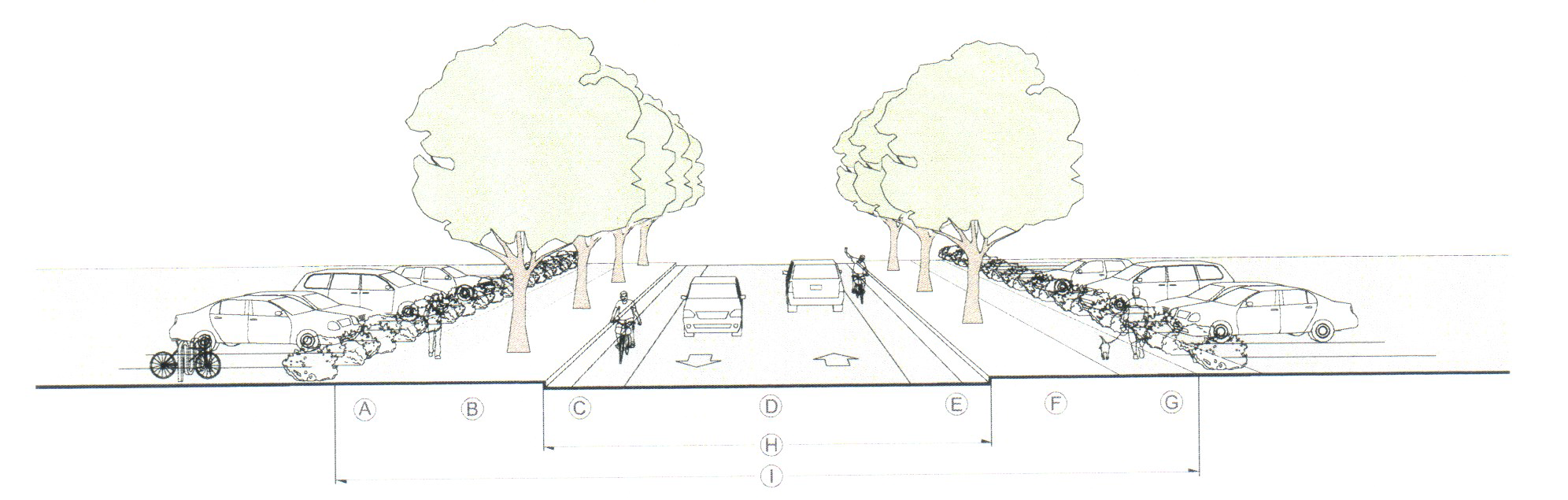
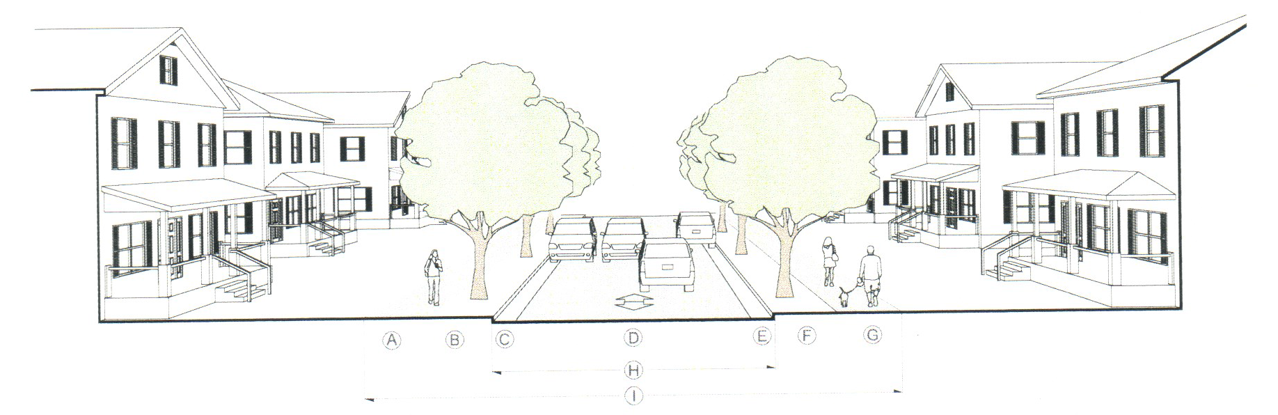
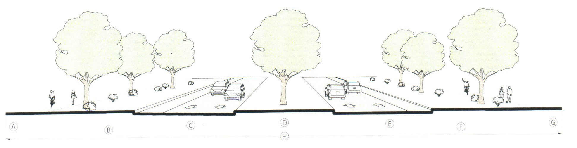
Master street plan cross-section requirements. The following complete street cross-sections apply to the construction of new streets and the reconstruction of existing streets and are allowed in the master street plan type designated. Alternative cross-sections, including parking angles other than shown (such as reverse angle parking), may be approved by the city engineer.
1.
Mixed use, angle (60-degree) parking.
* Arterials may require bulb-outs to accommodate tree plantings.
2.
Mixed use, parallel parking.
3.
Commercial arterial.
4.
Commercial collector.
5.
Residential collector.
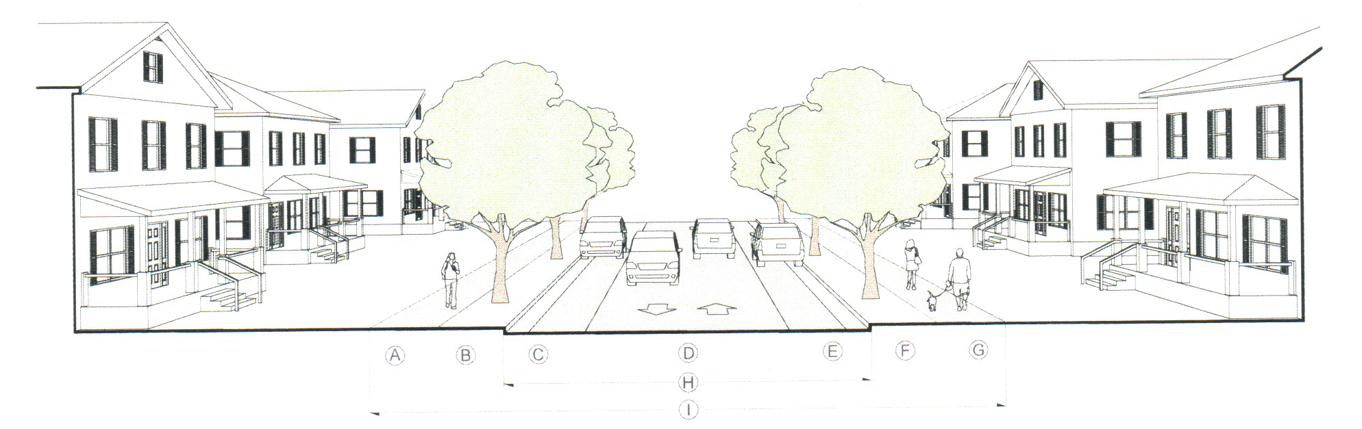
6.
Local.
7.
Parkway.
22-5.5(d)(6)
Alley standards.
a.
An alley may serve as the primary vehicular access to a lot or building, but an alley should not provide the sole public right-of-way frontage for a parcel of land. Alleys shall only be granted in cases where access management standards deny parcel owners driveway access to existing city streets.
b.
Alleys should connect to a public street at each end and should not terminate in permanent dead ends. In special circumstances, the city engineer may consider alleys that only intersect public streets at one (1) end.
c.
Alleys should intersect public streets at a 90-degree angle where practical. In no case shall the intersecting angle be less than seventy-five (75) degrees as measured from centerline of intersecting street.
d.
Alleys shall meet the following minimum requirements:
e.
All alleys shall be improved by paving the full width and length of the alley right-of-way.
f.
Alleys shall be no longer than 750 feet unless the proposed alley connects two (2) existing public streets and is approved by the city engineer.
g.
Access is allowed to and from a fully improved alley, but on-street parking within any portion of the alley right-of-way is prohibited. "No Parking" signs are required to be installed by the developer. The signs should be located at the alley/street intersections.
h.
Alleys shall generally be designed with an inverted crown section storm drain system. Alley runoff must be collected within a subsurface drainage system and not allowed to run off from the right-of-way. The minimum alley cross slope shall be two and one-half (2½) percent.
i.
Alleys shall generally be linear in design, but the city engineer may consider alleys with horizontal curves greater than two hundred (200) feet on a case-by-case basis.
j.
All alley infrastructure including subsurface drainage within the alley right-of-way will be privately owned and maintained unless dedicated to the city by means of an approved final plat. The developer shall install signs indicating private street, no public maintenance, and the city shall have no liability for:
1.
Maintenance of the alley pavement section.
2.
Patrolling the alley.
3.
Drainage of stormwater or other surface runoff from such alley onto abutting property.
(22-5.5)(d)(7)
Street layout.
a.
All street Intersections shall approximate right angles.
b.
Streets shall be aligned to join with planned or existing streets.
c.
Street offsets shall be approved by the city engineer. Street jogs with centerline offsets of less than one hundred twenty-five (125) feet shall be prohibited.
d.
Existing street stubs, contiguous to the subject property, shall be connected to the proposed street system.
(22-5.5)(d)(8)
Neighborhood access.
a.
Open access. Developments shall provide roadways that remain permanently open to the public and provide community-wide access as part of an overall connected street network.
b.
Connections. Applicants for the subdivision of land shall be required to provide sufficient external access points to the existing or future roadway network as follows; however, in the event of any conflict between the provisions of this section and section 22-5.5(c) blocks and cul-de-sacs, the provisions of section 22-5.5(c) shall control.
1.
Any residential subdivision of greater than thirty (30) units shall include at least two (2) access points. The second access may consist of a street stub with a T-turnaround.
2.
Any residential subdivision of greater than sixty (60) units shall include at least two (2) access points. Street stub shall not be considered part of the two (2) access points.
3.
Residential subdivisions of one hundred (100) or more units shall provide at least three (3) separate access points.
4.
Access points onto a state roadway require an approved permit from DOTD.
5.
A hardship waiver of these standards may be granted by the planning commission during approval of the preliminary subdivision plat only in extreme cases where limited frontage, natural features (slope, topography, bodies of water), or similar circumstances preclude the required connections and there is no substantial impact noted regarding emergency service delivery.
c.
Street stubs.
1.
Street stubs into adjacent properties may be required to ensure adequate circulation. Existing street stubs, contiguous to the subject property, shall be connected to the proposed street system.
2.
When connections to anticipated or proposed surrounding streets are required under section 22-5.5(c) blocks and cul-de-sacs, the right-of-way shall be extended and the street developed to the property line of the subdivided property at the point where the connection to the anticipated or proposed street is expected.
3.
The city engineer may require a temporary turnaround at the end of any street stub when such turnarounds appear necessary to accommodate emergency or service vehicles. No temporary street stub shall be permitted in excess of three hundred fifty (350) feet.
4.
A hardship waiver of the requirements for street stubs may be granted by the planning commission during approval of the preliminary subdivision plat only in extreme cases where limited frontage, natural features (slope, topography, bodies of water), or similar circumstances preclude the required connections and there is no substantial impact noted regarding emergency service delivery.
d.
Access connections.
1.
When a subdivision that involves the creation of one or more new street(s) borders on or contains an existing collector roadway as identified in the master street plan, no direct driveway access may be provided from lots within the subdivision.
2.
When a subdivision abuts or contains an existing or proposed collector roadway, the planning commission may require:
i.
Marginal access streets, reverse frontage with non-access reservation along the rear property line, deep lots with rear service alleys, or such other treatment as may be necessary for adequate protection of residential properties and to afford separation of through and local traffic.
ii.
The dedication of additional right-of-way, if the existing access street has width less than the minimum established herein.
3.
In special cases, where in the opinion of the planning commission the requirements of safety demand, especially where subdivisions front on heavily traveled thoroughfares, such thoroughfare may be designated as limited access roads, and in such cases, local traffic roads shall be required adjoining and paralleling the thoroughfare, with access there to at specific intervals only.
4.
When a property is part of a larger development, access consideration will be for the entire development, and separate access connections(s) shall not be provided to the highway for out lot parcels.
5.
Each property or group of adjacent properties with a single owner or development plan shall be granted no more than one (1) access connection, unless the proposed connection centerlines are a minimum of four hundred (400) feet from each other and from existing intersections.
6.
A property on a corner of two (2) intersecting roadways may be permitted two (2) access connections provided that the access connection on the major roadway is right-in/right-out only and the access connections are determined to be safe and efficient by a licensed engineer.
7.
Access connections should be constructed as near as practical to the geometrical center of the property frontage in order to maximize spacing. When a property is a corner lot at an intersection of two (2) roadways, priority should be given to locating the access connection as far as possible from the existing roadways, even if spacing of the access connections cannot be maximized.
8.
The throat length is the distance between the right-of-way and the parking lot (first place where a driver must make a decision to turn) served by an access connection. Throat length shall be no less than twenty (20) feet for a low volume access (less than one hundred fifty (150) peak hour vehicles in both directions). Medium traffic volume access (one hundred fifty (150) to four hundred (400)) peak hour vehicles in both directions) shall have a throat length no less than sixty (60) feet. High volume access (over four hundred (400) peak hour vehicles in both directions) shall have a throat length determined by traffic study performed by a licensed engineer.
9.
Driveways: Parking spaces shall not be laid out in such a way that vehicles must back out directly into traffic on collector, arterial or major streets.
(22-5.5)(d)(9)
Dead-end streets and alleys.
a.
With the exception of street stubs to permit future street network extension, dead-end streets are prohibited.
b.
Dead-end alleys must be approved by the city engineer.
(22-5.5)(d)(10)
Private streets. Private streets and drives may be permitted subject to meeting the requirements of this code and the conditions set forth below.
a.
Private streets shall be the principal access between a public street and platted lots that do not abut a public street. Such private streets are not dedicated to the public and shall not be publicly maintained. The term "private street" may include both the pavement and areas of streets, drives, alleys or service roads within a development.
b.
The private streets shall be owned and maintained by a property owners association. The property owners association shall maintain all private streets to equivalent or better standards as the connecting public streets.
c.
All private streets shall meet the dimensional standards identified in section 22-5(d) street and alley standards.
d.
All private streets shall be constructed to equal or exceed the base materials, compaction, and final surfacing standards for public streets and must be certified as such by the applicable city engineer.
e.
A private street shall be labeled on the final plat.
(22-5.5)(d)(11)
Street names. Street names shall be approved by the city. The applicant shall propose street names for new streets which will be considered with respect to the following criteria:
a.
Proposed streets obviously in alignment with existing and named streets shall bear the names of existing streets. In no case shall the name for the proposed streets duplicate existing street names irrespective of the suffix used.
b.
Streets lying on approximately the same line shall have the same name unless the intervening space between the separate parts is greater than one thousand (1,000) feet.
(22-5.5)(d)(12)
Sidewalks.
a.
Sidewalks shall be installed in accordance with the applicable street standards established in section 22-5(d) street and alley standards.
b.
All sidewalks and curb ramps shall be constructed by the developer in accordance with the city design standards manual.
c.
New sidewalks must transition to any existing sidewalks.
(22-5.5)(d)(13)
Clear sight distance.
a.
For approach speeds of thirty (30) miles per hour or less, no minimum sight distance is required.
b.
For approach speeds of thirty-five (35) miles per hour or greater, or when conditions such as significant changes in grade are present, or when determined by the city engineer, sight distance shall meet the most recent AASHTO standards.
c.
Excluding street trees and necessary utility or traffic structures, it shall be unlawful to construct or allow to remain, any fence, sign, movable object, hedge, shrub, or other plants that exceed thirty-six (36) inches in height and obstruct any identified clear sight area at street intersections or driveway and street intersections.
d.
All street trees encroaching into the clear sight area shall be maintained by the abutting property owner and shall be kept free of foliage for eighty (80) inches measured up from the adjacent road surface.
(22-5.5)(e)
Utilities.
(22-5.5)(e)(1)
General.
a.
All lots shall be connected to the public water and wastewater systems unless otherwise approved by the city council.
b.
Applicant to pay costs. Unless an alternative financing mechanism is approved, any applicant connecting to the public water or wastewater systems shall pay all costs associated with such connection, including but not limited to:
1.
Water mains, customer services, meter boxes, valves, fittings, fire hydrants and all appurtenances to make a complete operating water system within the subdivision or other development;
2.
A complete wastewater system including laterals and mains, manholes, clean-outs, customer service, tees, lift stations, force mains, lines, and all appurtenances; and
3.
Stormwater improvements as required or according to plans adopted.
(22-5.5)(e)(2)
Water.
a.
It shall be the responsibility of the applicant to provide a connection to a public water supply system, if available within three hundred (300) feet of the subdivision approved by the city engineer.
b.
The design and construction of any connection to a public water system shall comply with city and the Louisiana Department of Health regulations covering extension of public water systems.
c.
Water systems shall be of sufficient size to furnish adequate domestic water supply and to furnish fire protection and water services to all lots serviced.
d.
Fire flows are required to conform to the city's fire department standards. Water as-built drawings shall be provided and shall show the fire water distribution system as well as the location of hydrants to be installed.
(22-5.5)(e)(3)
Wastewater treatment.
a.
When a public wastewater system is within one-fourth (¼) mile to a proposed subdivision, the subdivider shall provide public wastewater facilities to each lot.
b.
The design and construction of any connection to a public wastewater system shall comply with city and Louisiana Department of Health regulations covering extension of public wastewater systems and of the state board of health and shall be constructed under the supervision of and approved by the city engineer.
c.
Wastewater as-built drawings shall be provided.
d.
The subdivider shall provide wastewater systems of the diameter necessary to serve the subdivision. The subdivider shall provide for wastewater service to the boundary of his property for any future upstream development but shall only be required to pay for that portion of capacity equal to or less than a 12-inch diameter pipe serving upstream development.
(22-5.5)(e)(4)
Stormwater. A contour map should be prepared for the area comprising the subdivision and all additional area necessary to include all waterbeds which drain into the property to be developed. In the design of the drainage for the subdivision, all East Ascension Drainage District regulations shall govern. Provision should be made to adequately take care of adjacent watershed areas after development of the area, and where ditches and canals are used, adequate servitudes shall be provided for future needs.
(22-5.5)(e)(5)
Electric and other utilities.
a.
All new electric service shall be placed underground. Temporary construction service may be permitted above ground.
b.
All other utilities, including but not limited to natural gas, telephone and cable, shall be located underground.
c.
The applicant shall make the necessary arrangements including the provision of any easements to or any construction or installation charges with each of the serving utilities for the installation of such facilities and shall be subject to all applicable laws and regulations for their construction.
d.
All above ground utilities and all above ground transformers, switching boxes, terminal boxes, meter cabinets, pedestals, ducts, and other facilities necessarily appurtenant to utilities shall be placed in a screened location approved by the city. Such locations shall remain clear of any sidewalk, bicycle or pedestrian way.
e.
Electric transmission or distribution feeder lines and communication long-distance trunk or feeder lines and necessary appurtenances may be placed above the ground. Such facilities shall be placed within easements or public rights-of-way. All poles and lines remain clear of any sidewalk, bicycle or pedestrian way.
(Ord. No. 4002, 12-12-16)