
Hampton City Zoning Code
ARTICLE 5
- RESIDENTIAL DISTRICTS
Sec. 5-1.- RA Residential-Agricultural District.
A.
Purpose. It is the intent of this district to preserve the mixed agricultural and residential character of land which serves as a transition between rural land and land which is becoming urban in character.
B.
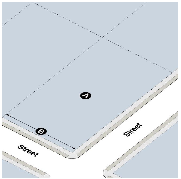
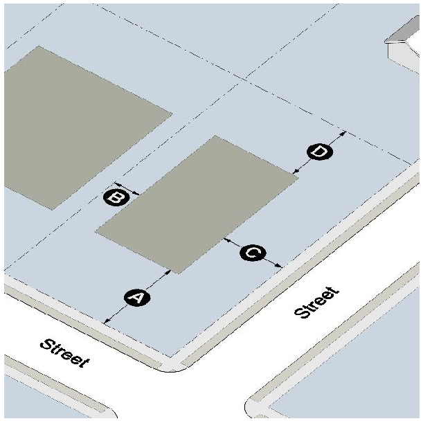
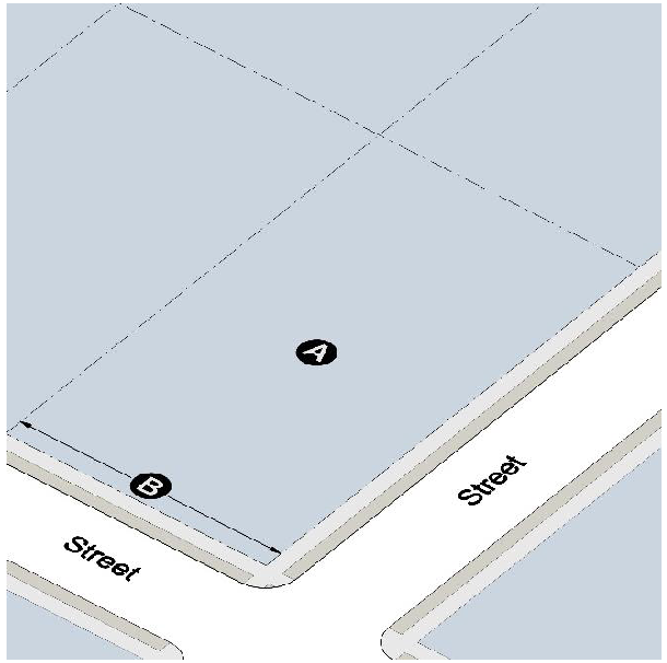
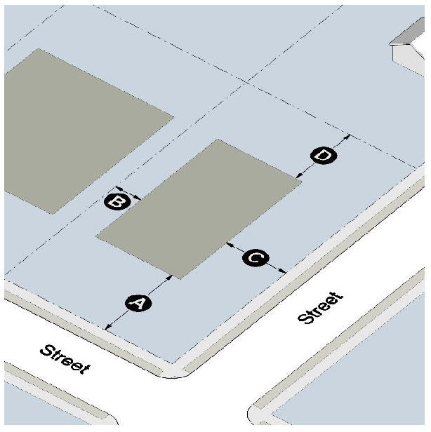
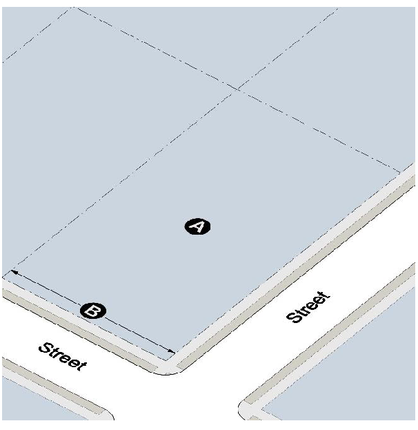
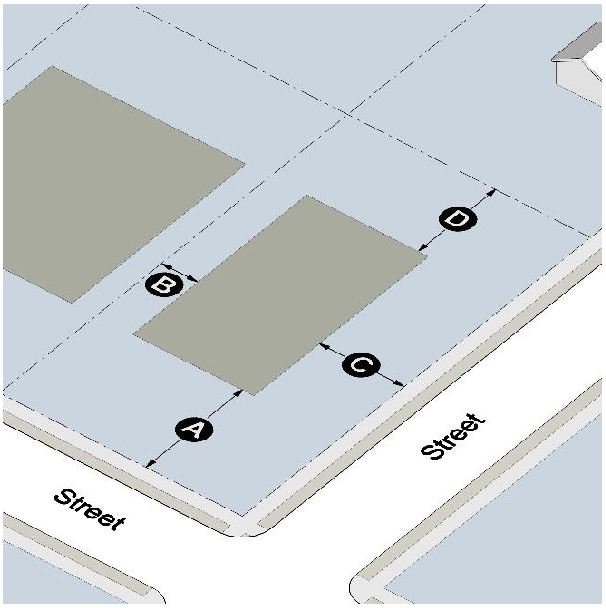
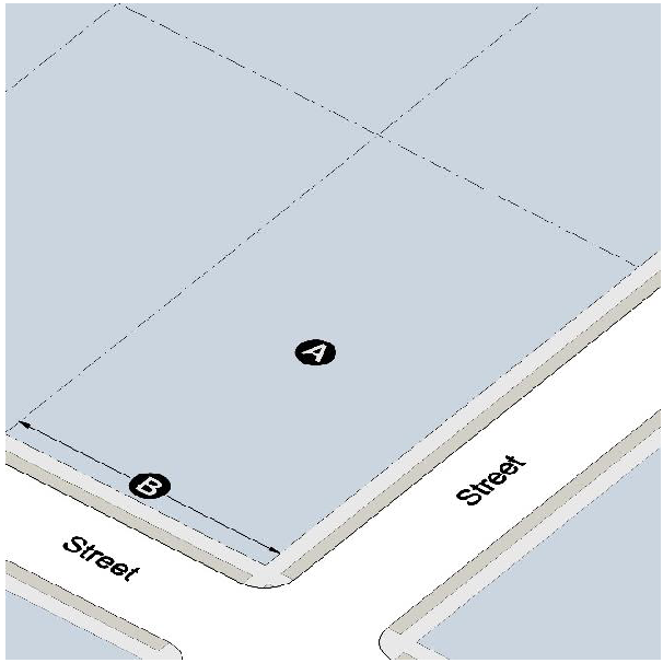
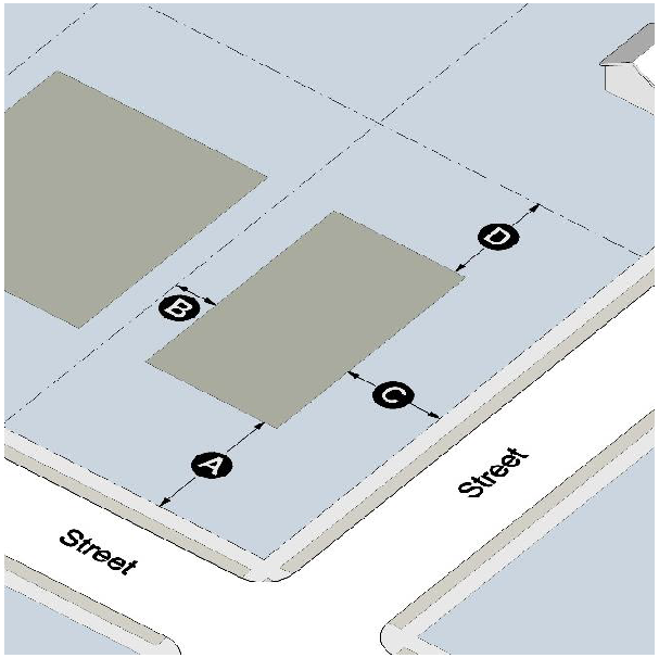
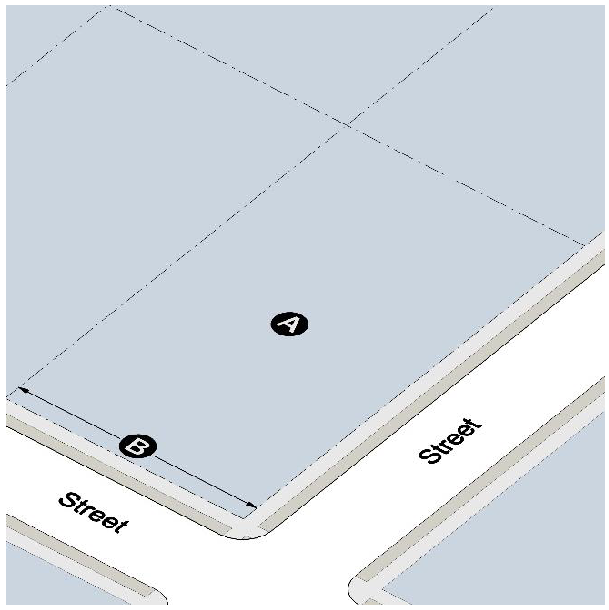
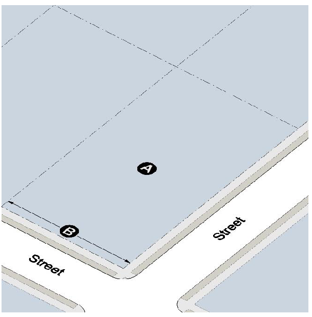
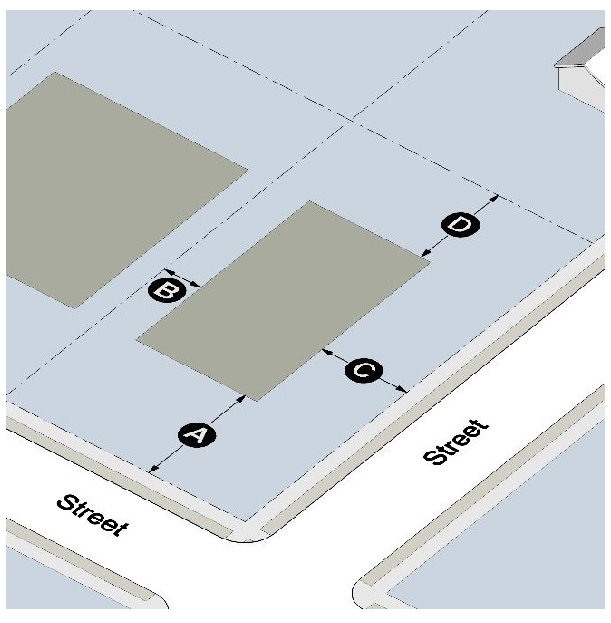
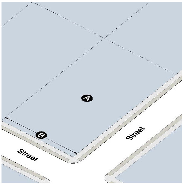
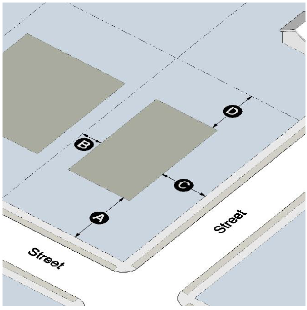
Lot standards.
C.
Building placement.
D.
Height and floor area.
1.
Maximum height: 35 feet.
2.
Minimum floor area (heated space): 2,200 square feet.
(Ord. No. 457, § 1, 8-14-18)
Sec. 5-2. - R-1 Single-Family Residential District.
A.
Purpose. It is the intent of this district to provide for single-family residential dwellings of a low density character on individual lots.
B.
Lot standards.
C.
Building placement.
D.
Height and floor area.
1.
Maximum height: 35 feet.
2.
Minimum floor area (heated space): 2,200 square feet.
(Ord. No. 457, § 1, 8-14-18)
Sec. 5-3. - R-2 Single-Family Residential District.
A.
Purpose. It is the intent of this district to provide for single-family dwellings of a moderate density character on individual lots.
B.
Lot standards:
* 30,000 sq. ft. for lots utilizing a septic tank, per Section 3-8.
C.
Building placement.
D.
Height and floor area.
1.
Maximum height: 35 feet.
2.
Minimum floor area (heated space): 1,800 square feet.
(Ord. No. 457, § 1, 8-14-18)
Sec. 5-4. - R-3 Single-Family Residential District.
A.
Purpose. It is the intent of this district to provide for single-family dwellings of a moderate density character on individual lots.
B.
Lot standards:
* 30,000 sq. ft. for lots utilizing a septic tank, per Section 3-8.
** 125 feet for lots utilizing a septic tank, per Section 3-8.
C.
Building placement.
D.
Height and floor area.
1.
Maximum height: 35 feet.
2.
Minimum floor area (heated space): 1,400 square feet.
(Ord. No. 457, § 1, 8-14-18)
Sec. 5-5. - R-4 Single-Family Residential District.
A.
Purpose. It is the intent of this district to provide for infill single-family dwellings on small lots.
B.
Lot standards:
* 30,000 sq. ft. for lots utilizing a septic tank, per Section 3-8.
** 125 feet for lots utilizing a septic tank, per Section 3-8.
C.
Building placement.

D.
Height and floor area.
1.
Maximum height: 35 feet.
2.
Minimum floor area (heated space): 1,400 square feet.
E.
Other requirements:
1.
All developments with 2 or more lots must provide parking access from a rear alley or a shared driveway.
(Ord. No. 457, § 1, 8-14-18)
Sec. 5-6. - PD Planned Development District.
A.
Purpose. It is the purpose of the Planned Development district to encourage the development of residential land uses within the framework of a master development plan. The PD district is designed to provide flexibility in the application of development standards and site design when approved according to a master development plan in a manner to promote the conservation of natural environment, more efficient use of land, and efficiency in the extension of public streets and utilities.
B.
Objectives. To carry out the purpose of this section, a PD district must provide the following, as appropriate:
1.
A range in the types of residences including sizes and type of housing, types of ownership and community facilities available.
2.
Conservation of natural topographical and geological features with emphasis on:
i.
Conservation of existing surface and subsurface water resources;
ii.
Preservation of major trees and other significant natural environmental features;
iii.
Prevention of soil erosion;
iv.
Conservation of wetlands, stream buffers, and floodplains.
3.
An efficient network of public streets and utilities appropriate to serve the residences within the PD district.
4.
A master development plan to guide the PD with specific development objectives included in restrictive covenants.
C.
Definitions. For the purpose of this section, the following terms shall have the meaning immediately set forth after the term:
1.
Master development plan. A written and graphic submission for a planned development which represents a tract of land, proposed subdivision, the location and bulk of buildings and other structures, density of development, public and private streets, parking facilities, common open space, public facilities and all covenants relating to use thereof. The master development plan is submitted in conjunction with a rezoning application for the PD district.
2.
Open space. Land within or related to a development, not individually owned or dedicated for public use, which is designed and intended for the common ownership and use by the residents of the developments and may include complementary structures and improvements as are necessary and appropriate.
D.
Ownership types. These include all types of residential development including, but not limited to, single-family, duplex, apartments, townhouses, rental, such that ownership may be fee simple, lease purchase, leased or rented, and there is common ownership of open spaces, recreation facilities, public streets and parking areas.
E.
Maximum density. Maximum allowable net useable density is the total number of dwelling units or housing structures per unit of land based on the net land area minus roads, detention ponds, wetlands, floodplains, and stream buffers.
F.
Preliminary plat. A preliminary plat/plan is a plan showing the detailed design and layout of a subdivision of land, prepared for the purpose of development and which shall include all improvements and shall meet all requirements specified in Appendices A & B of the City zoning codes.
G.
Land use plan. The comprehensive long-range plan containing policies to guide the growth and development of the city, which includes the analysis, recommendations and proposals for the city's population, economy, housing, transportation, community facilities and land use.
H.
Professional consultant. The person who is a registered design professional who prepared the plan, within the scope of their respective legal responsibilities.
I.
General requirements for a planned development district:
1.
Area. The minimum area required for a PD district shall be ten contiguous acres of land. The planning and zoning commission and the City Council may consider projects with less acreage where the applicant can demonstrate that a smaller parcel will meet the purpose and objectives of the PD district.
2.
Ownership. The tract of land proposed for PD development shall be in one ownership, or if in several ownerships, the application for zoning amendment shall be filed jointly by all of the owners of the properties included in the plan. Any subsequent change in owners of the properties involved, or in anyone having a legal or equitable interest in the property, shall be reported to Community Development Department. Failure to provide information on property ownership status shall result in the Community Development Department and city council withdrawing approval.
3.
Location of PD district. The PD district shall be applicable to areas where public water and sewerage facilities are available and installed.
4.
Permitted uses: Only residential uses are allowed. Residences may be of a variety of housing types (single-family detached, duplex, cottage, townhouses, and multiple-family residential developments) and ownership types. The PD district must be for a combination of at least two of the following development types: single-family detached, duplex, cottage, townhouses, and multiple-family residential developments.
5.
Minimum lot width: 20 ft for cottage and townhomes, 40 ft for single-family detached rear loaded, 60 ft for single-family front loaded, and 100 ft for duplex and multi-family; Minimum front yard: 10 ft for rear loaded product and 20 ft for front loaded product; Minimum side yard: 10 ft for detached single-family product; 0 ft for attached product, and 15 ft for duplex and multi-family residential; Minimum rear yard: 20 ft; Maximum height: 35 ft.
6.
Minimum floor area (heated space): 1,400 sq. ft for single family residence; 1,000 sq. ft. for townhouse and cottage; 2,400 sq. ft for total dwelling for duplex; and for multi-family residence: 900 sq. ft. for one-bedroom unit; 1,200 sq. ft for two-bedroom unit, and 200 sq. ft. for each additional bedroom.
7.
Off-street parking must be provided and accessed from alleys in situation where rear loaded product is utilized.
8.
Each dwelling unit for a duplex must be separately metered for all utilities.
9.
Cottage:
i.
All units must front a public street or a landscape courtyard of at least 40 feet in width and 3,000 sq. ft in total area;
ii.
All units must be detached dwelling units and units shall not be vertically mixed;
iii.
Maximum density: 8 dwellings units per net usable acre.
10.
Multifamily residence:
i.
No development shall have more than 250 units.
ii.
Maximum density: 8 dwellings units per net usable acre.
11.
Public buildings and recreation facilities for use of the residents of the PD is permitted. The restrictions as to the use of these facilities shall be set forth in the covenants and restrictions for the PD development.
J.
Application procedure:
1.
Preliminary plat. Before an application for rezoning to a PD is authorized, the applicant shall submit a preliminary plat for review by the planning and zoning department. The department shall coordinate review of the plan and provide a report to the City Council The plan shall be submitted to the City Council for review at a schedule Council meeting. The City Council shall review the plan and provide comments and recommendations within 30 days.
2.
Rezoning: Following preliminary concept plan review and approval by the City Council, the developer of the PD project may apply for rezoning pursuant to the requirements of Appendix A, Section 12-7 (Rezoning Requests and Text) of this Zoning Ordinance.
i.
The preliminary plat which incorporates the comments and modifications made by the City Council in its review of the preliminary plat shall be submitted with the application for rezoning.
ii.
A written report shall be submitted by the applicant which contains the following information concerning the preliminary plat:
1.
General description of the proposal.
2.
Detailed legal description.
3.
Proposed standards for development, including restrictions on the use of the property, density standards, yard requirements and restrictive covenants.
4.
Proposed dedication or reservation of land for public use, including public streets, easements, parks and school sites.
5.
Exceptions or variations from the requirements of the zoning ordinance and subdivision ordinance, if any, for that area being requested.
6.
Plans for the provision of utilities, including water, sanitary sewer and drainage facilities and appropriate calculations regarding the sizing of drainage areas and pipes.
7.
A report from the Henry County Water and Sewerage Authority and/or (as applicable) the city water department indicating the adequacy of sanitary sewer and water services.
8.
Plans for the protection of abutting properties.
9.
Plans for the maintenance of common open space areas.
10.
Tables showing the total number of acres in the proposed development and the percentage designation for each type of proposed land use, including public facilities. Information shall be provided in net acres.
11.
Tabulations of the overall net density.
12.
An explanation of phasing or stages of the PD project.
13.
Adequacy and arrangement of vehicular traffic access and circulation including intersections, road widths, channelization structures and traffic controls.
14.
Adequacy and arrangement of pedestrian traffic access and circulation including separation of pedestrian from vehicular traffic, and pedestrian convenience.
15.
Location, arrangement, appearance and sufficiency of off-street parking and loading.
16.
Location, arrangement, size and placement of buildings, lighting and signs.
17.
Certification by the applicant that a professional consultant is being utilized in the planning process for the PD project, including preparation of the application.
18.
Planned development projects for which 2,000 or more average daily vehicle trips will be generated and/or which at least 20,000 gallons per day of sewage treatment plant capacity will be required to submit with the application an environmental impact report. The report shall follow the format prepared by the planning and zoning department. The report shall objectively discuss positive and negative impacts of the proposed development on land uses; public water and sewerage facilities; traffic patterns, volumes and road improvements; storm drainage facilities, school enrollment; tax base and economic base; natural vegetation; wildlife habitat; and area appearance and aesthetics. The report shall be prepared by a professional consultant.
In reviewing the application for PD preliminary plat, the planning board and City Council shall consider those items listed in Appendix A, Section 12-7(F) concerning zoning map amendments.
The consideration of a PD district approval or disapproval and master development plan shall also include, but not be limited to the following:
(1)
Relation to the land use plan;
(2)
Adequacy and arrangement of vehicular traffic access and circulation including intersections, road widths, channelization structures and traffic controls;
(3)
Adequacy and arrangement of pedestrian traffic access and circulation including separation of pedestrian from vehicular traffic, and pedestrian convenience;
(4)
Location, arrangement, appearance and sufficiency of off-street parking and loading;
(5)
Location, arrangement, size and placement of buildings(s), lighting and signs;
(6)
Arrangement of landscape features and buffer areas;
(7)
Adequacy of public water supply;
(8)
Adequacy of stormwater and sanitary waste disposal facilities; and Adequacy of structures, roadways, in areas with moderate to high susceptibility to flooding and ponding and/or erosion.
Sec. 5-7. - RD Residential Duplex District.
A.
Purpose. It is the intent of this district to provide for duplexes on individual lots.
B.
Lot standards:
C.
Building placement.
D.
Height and floor area.
1.
Maximum height: 35 feet.
2.
Minimum heated floor area: 1,200 square feet per dwelling unit, 2,400 square feet for total dwelling.
E.
Other requirements.
1.
Each dwelling unit must be separately metered for all utilities.
(Ord. No. 457, § 1, 8-14-18)
Sec. 5-8. - MR-1 Townhouse and Cottage Court District.
A.
Purpose. It is the intent of this district to provide for the development of townhouses and cottage courts at moderate to high densities.
B.
Development standards.
1.
Maximum density: 8 dwelling units per net useable acre.
2.
Minimum lot width: 20 feet.
3.
Frontage. All units must front a public street or a landscaped courtyard of at least 40 feet in width and 3,000 square feet in total area.
4.
Minimum front yard: 10 feet.
5.
Minimum side yard: 10 feet.
6.
Minimum distance between buildings: none.
7.
Minimum rear yard: 20 feet.
8.
Maximum height: 46 feet.
9.
Minimum floor area (heated space): 1,000 square feet.
10.
All off-street parking must be accessed from alleys.
11.
Cottage court standards. All units must be detached dwelling units. Units shall not be vertically mixed.
C.
Miscellaneous provisions.
1.
No more than 40 percent of the net useable acreage shall be covered with buildings or impervious surface.
2.
In the event of a conflict between this section and any other code provision, the terms of this section shall control.
(Ord. No. 457, § 1, 8-14-18)
Sec. 5-9. - MR-2 Multifamily Residence District.
A.
Purpose. It is the intent of this district to provide for the development of multiple-family residences at moderate to high densities.
B.
Development standards.
1.
Maximum allowed density: 8 dwelling units per net useable acre, except that there shall be no maximum residential density on lots that are lots of record as of the effective date of this Ordinance and that are 2 acres or less in size.
2.
Minimum lot width: 100 feet.
3.
Minimum front yard: 30 feet.
4.
Minimum side yard: 20 feet.
5.
Minimum distance between buildings: 20 feet.
6.
Minimum rear yard: 40 feet.
7.
Maximum height: 36 feet.
8.
Minimum floor area (heated space): 900 square feet for a one-bedroom unit; 1,200 square feet per two-bedroom unit; (and for three- or more bedroom units,) 200 additional square feet per bedroom.
C.
Miscellaneous provisions.
1.
No more than 40 percent of the net useable acreage shall be covered with buildings or impervious surface.
2.
No development shall have more than 250 units.
3.
In the event of a conflict between this section and any other code provision, the terms of this section shall control.
(Ord. No. 457, § 1, 8-14-18)
Sec. 5-10. - RMH Residential Manufactured Home District.
A.
Purpose. It is the purpose of this district to accommodate manufactured home developments in accordance with the procedures, requirements, and limitations set forth herein. Within such developments, manufactured home developments may be established subject to the requirements and limitations set forth in these and other regulations of the City of Hampton. It is intended that such manufactured home developments shall be so located, designed, and improved as to provide a desirable residential environment, protection from potentially adverse neighboring influences, protection from adjacent residential properties, and access for vehicular traffic without traversing local public streets in adjoining residential neighborhoods.
B.
Site standards:
C.
Lot standards:
D.
Building placement.
E.
Height and floor area.
1.
Maximum height: 35 feet.
2.
Minimum heated floor area: 1,080 square feet.
F.
Miscellaneous provisions.
1.
All manufactured homes shall provide documentation of compliance with the National Manufactured Home Construction and Safety Standards or compliance with specifications presented by the American National Standards Institute.
2.
For all units built since June 15, 1976, documentation of compliance with the National Manufactured Home Construction and Safety Standards (United States Department of Housing and Urban Development certification) shall be required.
3.
For all units built prior to June 15, 1976, documentation of compliance with specifications prescribed by the American National Standards Institute shall be required.
4.
Each manufactured home space within a manufactured home park shall be clearly delineated and shall abut a paved public street of not less than 26 feet in width.
5.
Each manufactured home shall provide an area for the storage of boats, travel trailers, and/or other vehicles. This storage area shall be adequate to serve the needs of the home and shall be enclosed by a fence. Storage other than listed in this paragraph shall be enclosed in a building.
6.
Each lot shall be defined by a marker at each corner. Precise engineering of lot limits is not required.
7.
Each lot shall provide a paved concrete or all-weather patio area having a minimum area of 200 square feet.
8.
No manufactured home or structure shall be located within 25 feet of any drive within the manufactured home park.
9.
Within 60 days of the siting of a manufactured home on its lot, the undercarriage of said manufactured home shall be concealed from view through the use of permanent, nonflammable construction materials.
10.
A decorative perimeter fence may be required by the Zoning Administrator where deemed necessary for the safety of the residents of the manufactured home park.
G.
Structural provisions.
1.
Each manufactured home unit shall be installed on a concrete pad foundation, of which the base block shall be solid and equal in size to the pier block size (a minimum of 8 inches by 8 inches by 16 inches). The top course of the foundation shall be a solid cap block with a minimum dimension of 4 inches by 8 inches by 16 inches. The manufactured home unit shall be installed true and plumb. The tongue and wheels shall be removed.
2.
Each manufactured home in a manufactured home park shall be provided with safety tie-downs. The ties shall consist of wire cable or rust-resistant steel straps, and withstand a minimum stress of 4,800 pounds. The cable or strap shall be secured to the manufactured home frame and the anchor with a yoke-type fastener and tensioning device, but not with hook-end turnbuckles. Manufactured homes having factory installed over-the-top tie-downs shall have these ties secured to the anchors in addition to the frame ties. Manufactured homes which do not have factory installed over-the-top tie-downs shall be provided with same by the homeowner prior to occupancy. Double-wide manufactured homes do not require over-the-top tie downs, but are subject to the frame tie requirements applicable to single-wide manufactured homes. Four over-the-top and frame and tie combinations are required for single-wide manufactured homes 60 feet or less in length. Acceptable types of anchors include expanding anchors, screw augers and concrete deadmen. Auger-type anchors shall be installed to a depth of four feet minimum in the ground. All anchors shall be designated to withstand a pull of 4,800 pounds.
H.
Utility provisions.
1.
All utilities shall be located underground.
2.
Each manufactured home shall be equipped with a fire extinguisher and smoke alarms of a design or type approved by the state fire marshal, provided by park owner.
3.
An electrical outlet supplying both 60 and 150 amperes of service shall be provided for each manufactured home space. All such outlets shall be weather-proof, and installations shall meet the requirements of the National Electrical Code.
4.
All private streets, driveways, and pedestrian walkways within the manufactured home park shall be lighted between sunset and sunrise with electric lights emitting light at an intensity of at least 5,000 lumens, and the light poles shall be no more than 250 feet apart.
I.
Sanitation provisions.
1.
Garbage and refuse collection facilities shall be provided by management of the manufactured home park.
2.
Each manufactured home space shall be provided with a garbage container with a tight-fitting cover. The container shall be kept in sanitary condition and shall be stored at least three inches off the ground, preferably on a metal rack or hanger for such purpose. Waste shall be removed from the premises and disposed of often enough to prevent creating a nuisance or health hazard and to ensure that the garbage shall not overflow.
3.
No open fires or burning of leaves or other refuse shall be permitted within the boundaries of any manufactured home park.
J.
Recreation and buffer areas:
1.
A minimum of ten percent of the gross acreage of the manufactured home park shall be set aside for recreational use by residents of the manufactured home park. Said recreational park shall be one contiguous tract or several tracts, each no smaller than one-half acre and located within the manufactured home park in such a manner as to be convenient to all of its residents. Public rights-of-way shall not be included in this percentage. No more than 20 percent may lie in the flood hazard area. If the park management fails to maintain open spaces, the City may provide this service and file a lien against the property owner. The recreational park shall be located on land suitable for park development and shall contain a sufficient amount of play equipment designed for school age children.
2.
A buffer area having a minimum width of 40 feet shall be provided so as to provide a continuous buffer along all side and rear yards of any manufactured home park.
3.
A buffer area having a minimum depth of 200 feet shall extend along the entire frontage of any manufactured home park where it abuts a public thoroughfare.
4.
All buffer areas shall comply with provisions of Section 3-16.
K.
Pre-application meeting. Prior to filing a formal application for a manufactured home development, the applicant shall meet with planning staff to review sketch development plans to determine conformance with provisions of this section. A single manufactured home to be located on an individual lot is exempt from this requirement.
L.
Approval of manufactured home development. An application for approval of a manufactured home development will be reviewed by the Community Development Department to determine compliance with provisions of this Appendix. If a rezoning is not necessary, approval is subject to compliance with these provisions, and may be granted administratively by the Zoning Administrator.
M.
Applicability. This district shall only be located on parcels that abut an arterial street.
(Ord. No. 457, § 1, 8-14-18)
Sec. 5-11. - Allowed Uses.
A.
In order to regulate a variety of similar uses, use categorizes have been established for principal uses. Principal and accessory uses allowed by district are shown in the table below. All uses are subject to all applicable requirements of this Ordinance.
1.
Permitted Use (P). Indicates a use is permitted in the respective district.
2.
Conditional Use (CU). Indicates a use may be permitted in the respective district only where approved by the City Council.
3.
Use Not Permitted. A "-" in a cell indicates that a use is not permitted in the respective district.
B.
A use not specifically listed is prohibited unless the Zoning Administrator determines the use to be part of a use category as described below. If a proposed use is not listed in a use category, but is similar to a listed use, the Zoning Administrator may consider the proposed use part of that use category. When determining whether a proposed use is similar to a listed use, the Zoning Administrator must consider the following criteria:
1.
Actual or projected characteristics of the proposed use;
2.
Amount of site area or floor area and equipment devoted to the proposed use;
3.
Sales volume;
4.
Type of customer;
5.
Number of employees;
6.
Hours of operation;
7.
Building and site arrangement;
8.
Types of vehicles used and their parking requirements;
9.
Number of vehicle trips generated;
10.
How the proposed use is advertised;
11.
Likely impact on surrounding properties;
12.
Whether the activity is likely to be found independent of the other activities on the site.
C.
Where a use not listed is found by the Zoning Administrator not to be similar to any other permitted use, the use is only permitted following a text amendment per Section 12-7.
D.
When a proposed zoning decision relates to an amendment of the zoning ordinance to revise one or more zoning classifications or definitions relating to single-family residential uses of property so as to authorize multifamily uses of property pursuant to such classification or definitions, or to grant blanket permission, under certain or all circumstances, for property owners to deviate from the existing zoning requirements of a single-family residential zoning, such zoning decision must be adopted in accordance with O.C.G.A. § 36-66-4(h).
(Ord. No. 457, § 1, 8-14-18; Ord. No. 554, § 2, 8-17-21; Ord. No. 2023-07, § 1(Exh. A), 6-13-23)