
Hampton City Zoning Code
ARTICLE 8
- OVERLAY DISTRICTS
Sec. 8-1.- Conservation Residential Subdivision Overlay.
A.
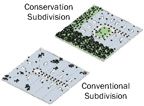
Purpose. The purpose of the Conservation Residential Subdivision overlay district is to promote the health, safety and general welfare of the present and future inhabitants of the City of Hampton by allowing flexibility in the design of certain subdivisions from standard regulations to support permanent protection of green space. The specific purposes of a Conservation Residential Subdivision district include:
1.
To provide single-family residential subdivisions which permit flexibility of design in order to preserve environmentally sensitive areas and create efficient uses of land.
2.
To preserve green space and unique or sensitive natural resources such as lakes or streams, flood hazard areas, wetlands, streams, steep slopes, woodlands, wildlife habitats, historic features, and unique topography.
3.
To permit clustering of dwellings and structures on less environmentally sensitive soils in order to reduce the amount of paved surfaces, utilities, earthwork, and other land disturbing activities.
4.
To reduce erosion and sedimentation by minimizing land disturbance and removal of vegetation in residential developments.
5.
To conserve a portion of otherwise developable property as green space in perpetuity.
6.
To promote interconnected greenways and corridors throughout the City of Hampton.
7.
To promote linking of greenways and corridors between the City of Hampton and neighboring jurisdictions.
8.
To encourage interactions of persons living in the resulting residential community by clustering dwellings and orienting them closer to the street, providing public gathering places and encouraging use of parks and community facilities as focal points in the neighborhood.
9.
To conserve scenic views and reduce perceived density by promoting views of green space from arterial and collector streets.
10.
To preserve important historical and archaeological sites.
11.
To promote other purposes of this Zoning Ordinance, the Subdivision Regulations, the Soil Erosion and Sediment Control Ordinance, and other ordinances and policies of the City of Hampton.
B.
Procedures. Applications for conservation residential subdivisions as a conditional use shall be processed in the same manner as an application for a zoning map amendment. CRS plats shall be processed in the same manner as a standard subdivision plat. An approved final plat shall have an additional marking of CRS, symbolizing the use of conservation residential subdivision development standards.
C.
Applicability. Conservation residential subdivisions are allowed as a conditional use permit in R-1, R-2, and R-3 districts.
D.
Definitions. For purposes of this section, the following terms shall have the meaning prescribed:
1.
Conservation easement. A nonpossessory interest of a holder in real property imposing limitations or affirmative obligations for the purposes of which include retaining or protecting natural, scenic, green, or open areas of real property, assuring its availability for agricultural, forest, recreational, or green space use, protecting natural resources, maintaining or enhancing air or water quality, or preserving the historical, architectural, archaeological, or cultural aspects of real property.
2.
Conservation residential subdivision (CRS). A single-family residential subdivision design which concentrates lots, dwellings, streets, utilities, and related development activities on the more suitable and less environmentally sensitive areas of the site, thereby preserving the steep slopes, wetlands, unsuitable soils, stream corridors, and otherwise environmentally sensitive areas in a natural or undisturbed state. A CRS allows for a higher density than allowed by the underlying zoning classification of the property, and smaller lot sizes in order to preserve the environmentally sensitive areas in dedicated, perpetual green space.
3.
Green space. An area of land within the subdivision boundary which shall remain in a permanent undeveloped condition except for amenity areas. The ownership, uses, limitations of use and maintenance of such land shall be determined through a written management plan to be approved by the City of Hampton at or before approval of the final plat for property which has been approved for a conditional use for a CRS.
4.
Holder. A governmental body empowered to hold an interest in real property under the laws of this state or the United States; or a charitable corporation, charitable association, or charitable trust, the purposes of powers of which include retaining or protecting the natural, scenic, or green space values of real property, assuring the availability of real property for agricultural, forest, recreational, or green space use, protecting natural resources, maintaining or enhancing air or water quality, or preserving the historical, architectural, archaeological, or cultural aspects of real property.
5.
Master development plan. A site plan that depicts the proposed subdivision layout including lot dimensions, right-of-way (street) layout, parking facilities, sidewalks, multi-use paths, detention or retention facilities, green space area including any physiographic characteristics, buffers, and amenities. The master development plan shall also provide the amount of land in 100-year flood hazard area, rights-of-way, detention or retention ponds, nonresidential lands, public lands, net usable acres, and amount of green space. Furthermore, the master development plan shall state the proposed density; percentage of impervious surfaces; and any other information required by the City.
6.
Pocket parks. Parks for active or passive use consisting of no less than one-quarter of a net useable acre (or 14,250 square feet). The purpose of pocket parks is to provide green space for recreational use within walking distance of most residences especially those located farthest from amenity areas or access to green space.
7.
Third party right of enforcement. The right provided in a conservation easement to enforce any of its terms granted to a governmental body, charitable corporation, charitable association, or charitable trust, which, although eligible to be a holder, is not a holder.
E.
Lot standards. The following lot standards shall apply, but overall site density shall not exceed that specified in subsection (J).
F.
Minimum site area: 10 acres.
G.
Maximum property size: None, although City Council reserves the right to restrict the number of acres that may be dedicated for CRS use on a case-by-case basis.
H.
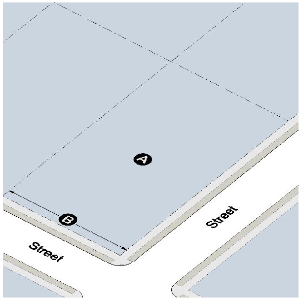
Building placement. The front, rear, side, and side street setback shall be 50 percent of that required in the underlying zoning.
I.
Height and floor area.
1.
Maximum height: 35 feet.
2.
Minimum floor area (heated space): 1,200 square feet.
J.
Density restrictions. The density shall not exceed the following limits depending on the zoning of the property:
1.
R-1 district: Maximum of 1.5 dwelling units per net useable acre.
2.
R-2 district: Maximum of 3 dwelling units per net useable acre.
3.
R-3 district: Maximum of 5.45 dwelling units per net useable acre.
4.
If the tract on which a CRS is to be developed consists of different single-family residential districts, then the net density for the entire tract shall not exceed 150 percent of that which would have been allowed had each district been separately developed as a CRS. The applicant shall provide the net density calculations for each tract in the master development plan, but may, at the City Council's discretion, subdivide the entire property based on an average of the permissible densities for each tract.
K.
Minimum development standards.
1.
Forty percent of the net usable acres shall be permanently protected as green space as described elsewhere in this section.
2.
A 100-foot undisturbed buffer shall be maintained along all exterior streets and a 50-foot undisturbed buffer along the perimeter of the property in accordance with the following requirements. These required buffers are in addition to and shall not be included in required lot setbacks or count toward the required green space.
i.
If the property is wooded and the timber has not been cut in the past five years, the required buffers shall remain undisturbed.
ii.
If timber on the property has been cut within the last five years or if the property is partially wooded and partially open or entirely open, the required buffers in the wooded area shall be undisturbed and buffers in open or timbered areas shall be enhanced with a planted vegetative buffer. Said vegetative buffer shall consist of a minimum of four rows of trees planted with 20-foot separation between trees and staggered so as to provide vegetative screen. Three-quarters of the trees must be shade trees. Existing trees in the buffer area shall be incorporated into the buffer.
3.
Decorative streetlights are required.
4.
Underground utilities are required.
5.
All off-street parking must be accessed from alleys.
6.
Multi-use paths are required. Such paths shall be constructed to connect each residential lot to the largest portion of green space and required amenities located in the subdivision. Multi-use paths may not be constructed in lieu of streets or alleyways; however, private alleyways may be counted toward the multi-use path requirement where at least a ten-foot wide easement is granted for public use and the private alleyway is clearly marked for multi-use or shared space. Multi-use paths shall be a minimum of ten feet in width.
L.
Road stub outs required: The developer shall provide 50 feet to 60 feet wide stub outs for future road interconnectivity between the CRS and adjacent developments. The number and location of said stub outs shall be determined by the Zoning Administrator and indicated on both the preliminary and final subdivision plats. The developer shall either, as determined by the Zoning Administrator, construct said road stub outs (including curb, gutters, and sidewalks) or deposit the cost of such construction with the City in escrow for future construction of said stub outs.
M.
Conservation protection implementation. The subdivider, developer, or property owner shall submit a written management plan for the green space areas prior to the approval of the final plat. The management plan shall include:
1.
Provisions for the use, restrictions of use, ownership, maintenance, and perpetual preservation of the green space areas;
2.
Allocation of responsibility and establishing guidelines for the maintenance and operation of the green space and any facilities located thereon. These guidelines must include provisions for ongoing maintenance and for long-term capital improvements if any;
3.
Estimates of the costs and requirements needed for maintenance and operation of, and insurance for, the green space and an outline of the means by which such funding will be obtained or provided;
4.
The green space required herein shall be permanently protected in perpetuity by a conservation easement conveyed to the homeowners' association or other entity approved by the City Council prior to the sale of the first lot in such subdivision. The conservation easement shall be created subject to the provisions of O.C.G.A. § 44-10-1 et seq. All such easements shall provide for either enforcement rights or third party enforcement rights, as the case may be, vested in the homeowners' association, City Council, and in any other party approved by the City Council, and shall provide that the conservation easement may not be terminated or otherwise modified without the consent of the City Council and all entities having either a property right or enforcement right therein.
5.
The green space areas shall be owned and maintained in accordance with the following criteria; provided that the record title to the property and the conservation easement shall be held by different entities:
i.
Record title may be held by equal share of undivided interest by each lot owner; the homeowners' association; or another entity approved by the City of Hampton.
ii.
Conservation easement may be held by the homeowners' association; the City of Hampton; or another entity approved by the City of Hampton, qualified to be a holder under the Georgia Uniform Conservation Easement Act. All conservation easements shall be recorded for each parcel of land to which they apply with the Henry County Clerk of Superior Court.
iii.
Maintenance may be performed by the homeowners' association or another entity approved by the City of Hampton.
6.
Homeowners' association: In all cases, a homeowners association shall be established. Membership shall be automatic and mandatory for all lot owners in the development and their successors and the homeowners' association shall have the power to file liens to collect dues and assessments. The homeowners' association shall be formed under the provisions of O.C.G.A. § 44-3-220 et seq. and shall contain adequate provisions to qualify it as a "holder" under the Georgia Uniform Conservation Easement Act, if it is to act as a holder of the conservation easement. The homeowners association shall be responsible for the maintenance of private alleyways and amenities.
N.
Standards for determining green space.
1.
Types of green space. The types of land area included in the green space shall include the following:
i.
Flood-prone areas, flood hazard areas, and floodway;
ii.
Wetlands;
iii.
Ponds or lakes;
iv.
Perennial and intermittent streams or rivers, including their required buffer zones;
v.
Waters of the state;
vi.
Wellhead protection zones;
vii.
Slopes 25 percent and steeper;
viii.
Areas with shallow bedrock;
ix.
Areas and soils which when disturbed are prone to excessive erosion;
x.
Prime views and vistas;
xi.
Areas of historical or archeological significance;
xii.
Cemeteries;
xiii.
Populations of endangered species, or habitat for such species;
xiv.
Meadows, woodlands, wetlands, wildlife corridors, game preserves, or similar conservation-oriented areas;
xv.
Multi-use paths, private alleyways where they include multi-use paths;
xvi.
Parks, dog parks, community gardens, community greens, or children's play areas;
xvii.
Other similar areas which are less suitable for development.
2.
Non-permitted uses of green space include the following:
i.
Roads and other impervious surfaces (except for required amenities and additional amenities) unless approved by the City Council;
ii.
Other uses inconsistent with the purposes of this Zoning Ordinance or the purposes of this section.
3.
The green space shall be an integrated part of the subdivision rather than an isolated element, and fragmentation of the green space shall be minimized. No land less than 50 feet in width or smaller than 10,000 square feet shall be included as green space. Individual green space parcels generally shall be larger than three acres. Exceptions may be made for entrances to trails, pocket parks and other particular uses as deemed appropriate by the City Council.
4.
Green space shall be located, to the greatest extent practical, to provide for interconnected greenways or vegetated corridors within the City and between jurisdictions.
5.
The green space shall be directly accessible to the largest practicable number of lots within the subdivision. Non-adjoining lots shall be provided with safe, convenient access to the green space.
6.
Where practicable, green space areas shall also be configured to provide a greater buffer than the minimum stream and landscape buffers required.
7.
Utility easements shall not count toward the green space requirement.
8.
All dedications, easements, or other specific measures required to be done to meet the regulations of this section shall be completed prior to the issuance of a building permit on any lot.
O.
In the event of a conflict between this section and any other code provision, the terms of this section shall control.
(Ord. No. 457, § 1, 8-14-18)
Sec. 8-2. - Residential Senior Adult Overlay.
A.
Purpose. The Residential Senior Adult (RSA) overlay district can be appended to R-3, R-4, MR-1, or MR-2 districts. The RSA district is intended to be located in close proximity to existing or planned commercial areas. The RSA district includes development standards and provisions that are most applicable to the needs of senior adult (age 55 and over) residents.
B.
Development Standards.
1.
No more than 8 townhouse or multifamily units may be connected in a single structure.
2.
Minimum front, side, side street, and rear yards: 75 percent of that required by the underlying zoning.
C.
Miscellaneous provisions.
1.
At least one resident of each dwelling unit in the RSA overlay district must be no less than 55 years old. Additional members of a household must be no less than 35 years old.
2.
Any type of supportive services such as medical care, food preparation, or other services normally associated with an assisted living facility and/or a personal care home shall be prohibited.
3.
No more than 40 percent of the net useable acreage shall be covered with buildings or impervious surface.
4.
Homeowners Association required: In all cases, a homeowner's association shall be established and incorporated. Membership shall be automatic and mandatory for all lot owners in the development and their successors in interest. The homeowner's association shall have the power to file liens to collect dues and assessments. The homeowner's association shall be formed under the provisions of O.C.G.A. § 44-3-22 et seq. and provide for building and grounds maintenance and repair, insurance, and working capital. Said association must also include declaration and bylaws, including rules and regulations; subject to City review and approval. The declaration and bylaws shall not be enforced by the City but shall be approved with the final plat and recording. The declaration and bylaws shall, at a minimum, regulate and control the following:
i.
Maintenance of structures and grounds of all lots and common open space.
ii.
Ownership, maintenance, and access of and to driveways and parking lots.
iii.
Animals.
iv.
Signs.
v.
Exterior items such as fences, lawn ornaments and restrictions on removal of landscape areas and buffers.
vi.
Building improvements.
vii.
Outside storage.
viii.
Overnight parking of vehicles.
ix.
Decorations.
x.
Trash collection.
xi.
Restrictions/definitions on leasing of units for single-family residential uses only. No more than ten percent of the total units may be leased by individual owners at any time.
xii.
Restrictions on all units being occupied by persons age 55 and older as defined by the Fair Housing Act as may be amended from time to time.
xiii.
Accessory buildings and structures.
5.
No RSA development may be located within an existing subdivision, unless approved as a concurrent portion of a larger development.
6.
Special building provisions. All dwelling units must incorporate accessibility and lifelong home standards, as outlined in the AARP HomeFit Guide, which is hereby incorporated by reference into this section.
(Ord. No. 457, § 1, 8-14-18)
Sec. 8-3. - Towaliga River Watershed Overlay.
A.
Findings and purpose.
1.
Findings of fact. In order to provide for the health, safety and welfare of the public and a healthy economic climate within Hampton and surrounding communities, it is essential that the quality of public drinking water be assured. The ability of natural systems to filter stormwater runoff can be threatened by unrestricted urban and suburban development. Land-disturbing activities associated with development can increase erosion and sedimentation that threatens the storage capacity of reservoirs. In addition, stormwater runoff, particularly from impervious surfaces, can introduce toxicants, nutrients, and sediment into drinking water supplies, making water treatment more complicated and expensive and rendering water resources unusable for recreation. Industrial land uses that involve the manufacture, use, transport and storage of hazardous or toxic waste materials result in the potential risk of contamination of nearby public drinking water supplies.
2.
Purpose. The purpose of this section is to establish measures to protect the quality and quantity of the present and future water supply of the City of Hampton, Henry County and Clayton County; to minimize the transport of pollutants and sediment to the water supply; and to maintain the yield of the water supply watershed. This section shall apply to the portions of the following watersheds, which occur within the jurisdiction of the City of Hampton and are hereinafter identified as water supply watersheds.
B.
Definitions. Except as specifically described herein, all words in this section shall have their usual and customary meanings. The use of the singular includes the plural and the plural the singular; the present tense includes the future; the use of shall means the action is mandatory, the use of may or should means the action is optional.
1.
Authority: The use of the word "authority" shall mean the Henry County Water and Sewerage Authority or the Clayton County Water Authority.
2.
Best management practices plan (BMP plan): A plan consisting of a wide range of management procedures, activities, and prohibitions or practices which control the quality and/or quantity of stormwater runoff and which are compatible with the planned land use.
3.
Buffer: A natural or enhanced vegetated area located adjacent to reservoirs or perennial streams within a water supply watershed.
4.
City: The use of the word "city" shall mean the City Council of the City of Hampton, Georgia.
5.
Confined animal feeding operation: A building or fenced enclosure designed and used for holding or fattening of animals in preparation for market. It does not include the pasturing of animals at densities recommended by the best management practices of the Georgia Department of Agriculture as follows: horses—one per 43,560 square feet; cows—one per 43,560 square feet; sheep or goats—one per 20,000 square feet; fowl—20 per 43,560 square feet.
6.
Corridor: All land within the buffer areas established adjacent to reservoirs or perennial streams within a water supply watershed.
7.
Development or single development: Any project or group of related projects constructed or planned for construction on a single parcel or on contiguous parcels under single ownership.
8.
Enforcer: The enforcer is defined as the Zoning Administrator or their designee.
9.
Hazardous material: Any substance defined as "hazardous waste" by the Georgia Department of Natural Resources pursuant to O.C.G.A. § 12-8-60 et seq., as hereafter amended.
10.
Hazardous waste: Any solid waste which has been defined as "hazardous waste" in regulations promulgated by the Administrator of the United States Environmental Protection Agency pursuant to the Federal Act which are in force and effect on February 1, 1991, codified as 40 C.F.R. Section 261.3, as hereafter amended and any designated hazardous waste. Also any substance defined as "hazardous waste" by the Georgia Department of Natural Resources pursuant to O.C.G.A. § 12-8-60 et seq., as hereafter amended.
11.
Impervious surface: A manmade structure or surface that prevents the infiltration of stormwater into the ground below the structure or surface. Examples include, but are not limited to, buildings, roads, driveways, parking lots, decks, swimming pools or patios.
12.
Large quantity generator of hazardous waste: Any person, corporation, partnership, association or other legal entity that is defined as a "large quantity generator" by the Georgia Department of Natural Resources pursuant to O.C.G.A. § 12-8-60 et seq., as hereafter amended and that is regulated by the State of Georgia under that section.
13.
Natural vegetated area: An undeveloped area largely free from human disturbance where naturally occurring vegetation is allowed to remain undisturbed or is enhanced and maintained by human intervention. Activities specifically allowed in such an area include, but are not limited to:
i.
Conservation or preservation of soil, water, vegetation, fish, shellfish and other wildlife.
ii.
Outdoor recreational activities, including hunting, fishing, trapping, bird watching, hiking, boating, horseback riding, swimming, canoeing, skeet and trap shooting.
iii.
Education, scientific research and nature trails.
iv.
Maintenance or repair of lawfully located roads, structures and utilities used in the service of the public, provided that the work is conducted using best management practices to ensure that negative effects on the previous nature of the land shall be minimized.
v.
Limited excavating, filling and land disturbance necessary for the repair and maintenance of structures necessary to the uses permissible in the area as above.
14.
Net acreage: The total acreage of any parcel or combined parcels of land to be developed as a single project, less the sum of the following: total number of acres contained in the 100-year flood hazard area, total number of acres contained in rights-of-way, and the total number of acres contained in detention or retention ponds to be constructed.
15.
Net density: The total number of dwelling units divided by the net acreage within the boundaries of any parcel or combined parcels of land to be developed as a single project.
16.
Nonconforming use: A land use activity, building or structure legally established prior to adoption of this Ordinance, or subsequent amendment to it, that would not otherwise be permissible under the provisions of this section.
17.
Open space: For purposes of this Ordinance, "open space" shall be defined as undisturbed lands or otherwise properties set aside for recreational uses, buffers, common areas, landscape areas, as well as other uses defined under the "open space categories" described below. Buffers and wetlands, if located on lots to be conveyed to private property owners, shall not be considered as "open space." Land contained within the 100-year flood zone shall not be considered as "open space" if located on lots that are to be conveyed to private property owners. Land designated as "open space" is divided into five categories (the "open space categories" or, singularly, an "open space category"):
* Category A - wetland stream buffers; 100-year flood hazard areas, undisturbed buffers between various land uses, roadside buffers, wildlife sanctuaries, and other forms of buffers, if owned by the developer or a property owners association;
* Category B - improved and revegetated areas utilized for active recreation, such as ball fields, parks and golf courses;
* Category C - improved, active recreation areas, such as swimming pools, tennis courts and playgrounds;
* Category D - state waters, including wetlands, ponds, lakes, if owned by a developer or a property owners association; and
* Category E - land donated to a governmental entity for public use, provided such land is not located in a wetland or 100-year flood zone.
In order to calculate the total "open space," the total acreage contained within each open space category is multiplied by its respective factor, as set forth below:
* Category A factor = 1.0
* Category B factor = 0.7
* Category C factor = 0.2
* Category D factor = 0.5
* Category E factor = 2.0
18.
Overlay district: A district that applies supplementary regulations to land previously classified as belonging to a specific zoning district or land-use category.
19.
Perennial stream: A stream which flows throughout the year, as indicated by a solid blue line on United States Geological Survey (USGS) 7-Minute Topographic Series Maps (scale of 1/24,000).
20.
Reservoir boundary: The edge of a reservoir, defined by its normal pool level (elevation above mean sea level).
21.
Utility: Public or private water or sewer piping systems, water or sewer pumping stations, electric power lines, fuel pipelines, telephone lines, roads, driveways, bridges, river/lake access facilities, stormwater systems and railroads.
22.
Water quality critical area: The water quality critical area is defined as follows: (a) all land that lies adjacent to the normal pool level of a reservoir and extending either to the ridge line boundary of the watershed or 500 feet whichever is shorter; and (b) all land extending a distance of three miles upstream from the normal pool level of the reservoir that is adjacent to each perennial stream upstream from the reservoir and extending either to the ridge line boundary of the watershed on each side of the perennial stream or 500 feet, whichever is shorter.
23.
Water supply watershed: The drainage area (watershed) of lands upstream of a governmentally owned public drinking water intake or water supply reservoir or a proposed public drinking water intake or water supply reservoir.
C.
Establishment of watershed districts, descriptions, maps, critical areas and limited development areas.
1.
Designation of water supply watershed districts. The following watershed district is hereby established and designated:
i.
Towaliga River.
2.
Description of the water supply watershed district.
ii.
Towaliga River. The Towaliga River Watershed district is defined as follows: All land that lies on each side of the Towaliga River and each perennial stream that flows into the Towaliga River to the ridge line from Steel Mills Dam located just north of Locust Grove-Griffin Road to the beginning points of the Towaliga River and each perennial stream that drains into the Towaliga River in said area.
3.
Watershed district map. A map of the water supply watershed district will be maintained by the City and the authority. The city's district map will overlie the official City of Hampton Zoning Map and the said map is hereby incorporated herein and made a part of this section by reference.
4.
Water quality critical area.
iii.
Water quality critical area for the above-stated watershed districts is: (a) all land that lies adjacent to the normal pool level of a reservoir and extending either to the ridge line boundary of the watershed or 500 feet whichever is shorter; and (b) all land extending a distance of three miles upstream from the normal pool level of the reservoir that is adjacent to each perennial stream upstream from the reservoir and extending either to the ridge line boundary of the watershed on each side of the perennial stream or 500 feet, whichever is shorter.
iv.
The normal pool level elevation of the existing reservoirs of the authority are as follows:
1.
Lower Towaliga River Reservoir contour line E. 658.0; and
2.
Upper Towaliga River Reservoir contour line El. 720.0.
* Elevations are based on U.S. Geological Survey Datum.
5.
Limited development area. A limited development area is established for the remaining part of the watershed district that is located outside of the water quality critical area to the ridge line of each watershed district.
D.
Permit required.
1.
Permit requirements. Within the water supply watershed district, no land-disturbing activity, construction or other development, other than certain exempted activities identified within, may be conducted without a permit from the City and must be in full compliance with the terms of this Ordinance and chapter, and other applicable regulations, including but not limited to, the City of Hampton Subdivision Ordinance, City of Hampton Soil Erosion and Sedimentation Control Ordinance, Hampton Flood Damage Prevention Ordinance and Hampton Stormwater Management Ordinance. All activities that are not permissible as of right or as conditional use shall be prohibited.
2.
Exemptions. The following land-use activities are exempted from the development review and permit requirements of this section:
i.
Agriculture and forestry. Normal agricultural and forestry activities involving planting and harvesting of crops are exempted if they conform to best management practices established by the Georgia Department of Agriculture. Silvicultural activities must conform to best management practices by the Georgia Forestry Commission.
ii.
Mining activities. All mining activities that are permitted by the Georgia Department of Natural Resources under the Georgia Surface Mining Act, as amended, are exempted.
3.
Enforcement. The city, its agents, officers, and employees shall have authority to enter upon privately owned land for the purpose of performing their duties under this Ordinance and may take or cause to be made such examinations, surveys, or sampling as the City deems necessary. Enforcement procedures shall be as provided in section 12-2 of this Appendix.
i.
The Hampton Planning and Zoning Department is hereby designated as the administrator and enforcement authority of this section.
ii.
All applications for building permits shall be first submitted to the City of Hampton Planning and Zoning Department building department for issuance of building permits when the application is in compliance with the regulations of this section.
iii.
Agents and employees of the City and the authority and law enforcement officials of the City and other law enforcement officials having police powers shall have authority to assist the enforcer in enforcement of this section.
iv.
Any person who commits, takes part in, or assists in any violation of any provision of this section shall be fined not more than $1,000.00 for each offense. Each violation of this act shall be a separate offense, and, in the case of a continuing violation, each day's continuance shall be deemed to be a separate and distinct offense.
v.
The enforcer shall have the authority to enforce this section; to authorize issuance of permits thereunder; to address violations and to refer violations to the code enforcement department of the City; to issue citations for violation of this section; to issue administrative orders; and to commence civil and criminal actions.
vi.
The enforcer or his designee shall have the authority to issue cease and desist orders in the event of any violation of this section. Cease and desist orders may be appealed under subsection (K) hereof.
vii.
When a building or other structure has been constructed in violation of this section, the violator shall be required to remove the structure.
viii.
When removal of vegetative cover, excavation or fill has taken place in violation of this section, the violator shall be required to restore the affected land to its original contours and to restore vegetation, as far as practicable, in compliance with the Hampton Soil Erosion and Sedimentation Control Ordinance.
ix.
All costs, attorney's fees, expert witness fees and other expenses incurred by the City in connection with the enforcement of this section shall be recovered from the violator.
E.
Permit review. Applications for a development permit within the above-stated watershed districts shall include the following:
1.
Existing ordinances. Each application shall comply with all existing ordinances, amendments thereto and subsequent amendments. Said ordinances include but are not limited to, the Hampton Zoning Ordinance, the Hampton Subdivision Ordinance, City of Hampton Soil Erosion and Sedimentation Control Ordinance, the City of Hampton Flood Prevention Ordinance and the City of Hampton Stormwater Management Ordinance.
2.
Additional requirements for development of property located in the watershed districts. In addition to the requirements of each of the above referenced ordinances, site plans or construction improvements plans for development of property shall contain the following additional information:
i.
The total square feet and acres of property to be developed.
ii.
Location, dimensions and area (in square feet) of all impervious surfaces, both existing and proposed, on the site.
iii.
The distance of each impervious structure and surface to the nearest bank of an affected perennial stream and reservoir.
iv.
The location of each perennial stream that crosses or abuts the site.
v.
The location of each public reservoir that abuts the site.
vi.
The location, elevation and orientation of the 100-year floodplain on the site.
vii.
The site plan submitted shall contain a certification issued by a registered land surveyor or registered engineer verifying the location of the site as being located either within the water quality critical area, the limited development area or outside of both areas.
viii.
Location and detailed design of any spill and leak collection systems designed for the purposes of containing accidentally released hazardous or toxic materials.
3.
Additional requirements for building permits. In addition to the requirements of each of the above-referenced ordinances, the following information shall accompany each building permit requested:
i.
The total square feet and acres of property to be developed.
ii.
Location, dimensions and area (in square feet) of all impervious surfaces, both existing and proposed, on the site.
iii.
The distance of each impervious structure and surface to the nearest bank of an affected perennial stream and reservoir.
iv.
The location of each perennial stream that crosses or abuts the site.
v.
The location of each public reservoir that abuts the site.
vi.
The location and orientation of the 100-year floodplain on the site.
vii.
The site plan submitted shall contain a certification issued by a registered land surveyor or registered engineer verifying the location of the site as being located either within the water quality critical area, the limited development or outside of both areas.
viii.
Location and detailed design of any spill and leak collection systems designed for the purpose of containing accidentally released hazardous or toxic materials.
4.
Activities to comply with site development plan. All development activities or site work conducted after approval of the site plan shall conform with the specifications of said approved plans. Significant changes to the site plan, that would alter the amount and velocity of stormwater runoff from the site, increase the amount of impervious surface within the development, alter the overall density of development, result in a considerable increase in the amount of excavation, fill or removal of vegetation during construction, or otherwise result in an alteration of the overall appearance of the development as proposed, can be amended only with the approval of Hampton Planning and Zoning Department. Any such amendments shall also comply with all other applicable ordinances and laws.
5.
Exemptions from site development plan requirements.
i.
Repairs to a facility that is part of a previously approved and permitted development.
ii.
Accessory structures such as barns, sheds, or additions to single-family dwellings.
6.
Duration of permit validity.
i.
If construction described in the development permit has not commenced within 12 months from the date of issuance, the permit shall expire.
ii.
If construction described in the development permit is suspended after work has commenced, the permit shall expire 12 months after the date the work ceased. In cases of permit expiration due to abandonment or suspension of work, the landowner shall be required to restore topography to its original contours and restore vegetation as far as practicable.
F.
Land use restrictions. The following limitations on permissible uses together with the limitations on land use prescribed under the ordinances of the City of Hampton, the applicable ordinances of Henry County, the laws of the State of Georgia, the regulations of the regulatory agencies of the State of Georgia, laws of the United States of America and the regulations of the regulatory agencies of the United States of America shall apply.
1.
Within the water quality critical area. The following limitations on permissible uses shall apply to the water quality critical area:
i.
Agricultural land use. No confined animal feeding operations may be conducted within the water quality critical area.
ii.
Commercial establishments. No commercial activity may be conducted within the water quality critical area.
iii.
Fuel and chemical storage tanks. No above ground or underground fuel or chemical storage tanks shall be allowed in the water quality critical area.
iv.
Industries. No industrial activity may be conducted within the water quality critical area.
v.
Landfills and waste disposal. No landfills or wastewater disposal facilities of any kind (except for septic tanks approved by the Henry County Health Department and wastewater disposal facilities owned and operated by the authority) shall be allowed within the water quality critical area.
vi.
Office. Offices are not permissible within the water quality critical area, except for a home occupation office.
vii.
Residential land use. Single-family residential lots are permissible if acreage requirements hereinafter set forth are met. Residential lots having no less than two acres when served by a septic tank system and no less than 1.5 acres when served by a public sewer system. The minimum lot width permissible for development with septic tank systems when using a public water system is 150 feet.
viii.
Toxic and hazardous materials. No facility that stores or disposes of underground fuel or chemical storage tanks shall be allowed in the water quality critical area. No industry or business that generates hazardous waste may be located within the water quality critical area.
2.
Within the limited development area. The following limitations on permissible uses shall apply to the limited development area:
i.
Agriculture. There are no additional limitations on the type of agricultural land use permissible within the limited development area.
ii.
Commercial establishments. Commercial establishments shall only be permissible on land parcels of no less than 1.5 acres if served by a septic tank system and no less than one acre if served by a public sewer system.
iii.
Fuel and chemical storage tanks. Underground fuel and chemical storage tanks will be allowed if they meet all of the requirements set forth by the Georgia Department of Natural Resources Environmental Protection Division.
iv.
Industries. No industry that manufactures toxic or hazardous materials may be located in the limited development area. Only those industries that are not large quantity generators of hazardous waste may be located within the limited development area. Permitted industries must be located on land parcels of no less than ten acres if served by a septic tank system and no less than four acres if served by a public sewer system.
v.
Landfills and waste disposal. No landfills shall be allowed within said area. Septic tanks approved by the county health department and sewage disposal facilities owned and operated by the a public entity will be allowed in this area.
vi.
Office. Offices shall be permissible on land parcels of no less than 1.5 acres if served by a septic tank system and no less than one acre if served by a public sewer system.
vii.
Residential. Single-family residential lots are permissible if acreage requirements hereinafter set forth are met. Residential lots served by a septic tank system shall be a minimum of one acre. Residents served by public sewer system will have the density authorized under the zoning provision for which the property is zoned, however, the total impervious area of all residential developments shall not exceed 25 percent of the total development.
viii.
Toxic and hazardous materials. No facilities that dispose of toxic or hazardous waste may be located within the limited development area. No facility that manufactures, stores or disposes of toxic or hazardous waste may be located within the limited development area.
3.
Property abutting perennial streams and perennial streams crossing property located in limited development area. If a perennial stream abuts or crosses any property upon which an industrial facility, office facility, commercial facility, service facility or residential building is located, the following minimal lot sizes will be required:
i.
If served by a septic tank system:
1.
Industrial lots: Ten acres.
2.
Office lots: Two acres.
3.
Commercial establishments: Two acres.
4.
Residential: One acres.
ii.
If served by public sewer system:
1.
Industrial lots: Two acres.
2.
Office lots: One and one-half acres.
3.
Commercial establishments: One and one-half acres.
4.
Residential: The density will be that as set forth in each of the zoned residential districts; provided, however, no lot abutting said stream shall have any more than 20 percent impervious structures located thereon.
G.
Impervious surface limitations.
1.
Percentage allowed. The percentage of impervious area allowed in the water quality critical area and the limited development area are set forth below. The percentages set forth below shall be determined by the addition of all land areas to be covered by impervious structures during the development of the property (i.e., roads, public streets, driveways, houses, buildings, parking areas).
i.
Water quality critical area. No more than 20 percent of the land area of any parcel on which a new development is placed may be covered by impervious surface within the water quality critical area.
ii.
Limited development area. No more than 25 percent of the land area of any parcel on which a new development is placed may be covered by impervious surface within the limited development area.
iii.
The impervious surfaces for industrial, commercial, offices, institutional, public and multifamily residential development within the limited development area may be more than 25 percent impervious surfaces provided the following structural stormwater controls are taken:
1.
Stormwater management plan detailing the stormwater control structures proposed for the development shall be required. Said plan shall be in conformity with the requirements of the City's stormwater management ordinance, as amended from time to time. The preferred structure control is wet detention pond which shall be located on-site, or, as a part of a regional pond where available. The design standards for detention ponds intended for watershed protection shall be found in the City's Construction Standards Manual, as amended from time to time. The construction of all stormwater controls designed for watershed protections shall be completed and have received final inspection approval from the City building department prior to issuance of the certificate of occupancy for buildings or final plat approval if developed as an industrial, business or office park.
2.
Channelization of perennial streams shall be prohibited, except for road crossings, erosion and sedimentation control or stormwater management control devices.
3.
All permanent stormwater control structures and easements for maintenance and access shall be recorded in the final plat of the property in accordance with the subdivision ordinance and stormwater management ordinance. The developer shall submit a detailed long-term schedule for inspection and maintenance of stormwater control structures. The schedule shall include a legal agreement for maintenance responsibility between the local government and property owner. No final plat approval or building occupancy permit shall be issued until a fully executed maintenance agreement has been executed and accepted by the City. Inspections can include, but are not limited to:
(i)
Initial review of stormwater management plan which must occur prior to issuance of development permit or building permit.
(ii)
Inspection prior to burial of any underground drainage structure.
(iii)
Erosion and sedimentation control inspections, as required on the approved project soil erosion and sedimentation control plan, and, the City soil erosion and sedimentation control ordinance.
(iv)
A final inspection when all work including installation of drainage facilities has been completed.
(v)
Inspection prior to final subdivision plat approval for acceptance of public improvements (streets, stormwater management and drainage facilities).
(vi)
Subsequent inspections, measurement, and enforcement actions as necessary to ensure continued functioning of the facilities for stormwater management and watershed protection.
4.
A development may participate in a regional wet detention pond program which has been established by one or more public or private entities subject to the following conditions:
(i)
Runoff from the development drains into a regional stormwater management control facility approved by the City.
(ii)
An agreement between the City and the landowner has been executed which guarantees participation in the regional stormwater arrangement of the property and the detention pond.
(iii)
Construction of a regional detention pond meets or exceeds the design requirements of the City stormwater management ordinance.
5.
A development may provide an alternative method for stormwater control other than a wet detention pond provided that it is in compliance with the City stormwater management ordinance, and design criteria for pollutant removal equivalent to those associated with wet detention ponds included in the City of Hampton Construction Standards Manual, as amended.
iv.
Impervious surface setbacks.
1.
Water quality critical area. No impervious structure shall be constructed within 200 feet of the normal pool level of the reservoir or of any perennial stream located in the water critical area.
2.
Limited development area. No impervious surface shall be constructed within a 150-foot setback area on both sides of a perennial stream as measured from the stream banks in the limited development area.
2.
Impervious surface setbacks.
i.
Water quality critical area. No impervious structure shall be constructed within 200 feet of the normal pool level of the reservoir or of any perennial stream located in the water quality critical area.
ii.
Limited development area. No impervious surface shall be constructed within a 150-foot setback area on both sides of a perennial stream as measured from the stream banks in the limited development area.
3.
Vegetative setbacks/buffers.
i.
Stream buffers within water quality critical area. A natural or enhanced vegetative buffer shall be maintained for a distance of 150 feet from the normal pool level of a reservoir and 100 feet on both sides of a perennial stream as measured from the banks.
ii.
Stream buffers within the limited development area. A natural or enhanced vegetative buffer shall be maintained for a distance of 100 feet on both sides of a perennial stream as measured from the stream's banks.
iii.
Silvicultural BMPs. Notwithstanding any other provisions of this section, forestry practices, in accordance with a forest management plan that incorporates best management practices (BMPs) approved by the Georgia Forestry Commission, shall be permissible in the buffer areas. However, no trees or vegetation shall be removed any closer than 25 feet on each side of any perennial stream.
iv.
Agricultural BMPs. Notwithstanding any other provisions of this section, the continued cultivation of agricultural crops and the occasional pasturing of livestock shall be permissible within the buffer area, provided that the best management practices of the Georgia Department of Agriculture are followed.
4.
Septic tank drain field restrictions. Septic tanks and septic tank drain fields are prohibited in the setback area established in subsections (G)(2) and (3).
5.
Hazardous materials handling. New facilities located within the water supply watershed district that handle hazardous materials of a type and amounts requiring a permit from the department of natural resources or that require disposal by a hazardous materials handler permitted or licensed by the department of natural resources at a hazardous materials facility, shall perform their operations on impermeable surfaces having spill and leak collection systems. Such spill and leak collections systems shall be shown on the site plan in detail and must be approved, as part of the site plan, by the enforcer.
6.
Soil erosion and sedimentation control. All developments and land disturbing activity within the Watershed districts shall comply fully with the Soil Erosion and Sedimentation Control Ordinance of the City of Hampton.
H.
Nonconforming uses.
1.
Previous uses preserved generally. The lawful use of any building, structure or land use existing at the time of the enactment of this section may be continued, even though such use does not conform with the provisions of this section except that the nonconforming structures of use shall not be:
i.
Changed to another nonconforming use;
ii.
Re-established after discontinuance for one year;
iii.
Extended except in conformity with this section; or
iv.
Structurally altered, except for repairs necessary for the continuation of the existing use.
2.
Replacement of nonconforming uses. The replacement of nonconforming uses shall be in compliance with article VII of the Zoning Ordinance of the City of Hampton, as hereinafter amended.
3.
Application to projects partially complete. For any development which has received, before the effective date of this Ordinance, either preliminary plat approval, site plan approval, building permit or other relevant permits provided by the City and for which substantial work has been completed or substantial investment made in reliance upon such a permit, any future work included in said plat or plan may be completed without being subject to the additional regulations imposed in this section. Any significant additions, expansions, or phases that deviate significantly from said plat or plan or that have not yet received a permit shall be subject to the provisions of this section.
I.
Pre-existing conditions. All parcels of land within the Watershed districts that do not conform to the space requirements or come within the permitted uses or the minimum standards hereinafter set out shall be governed by the Hampton Zoning Ordinance as set out in this chapter, as it relates to nonconforming use activities. No property owner within said district or area, nor successors in title, who is engaged in a use which is rendered nonconforming by this section, shall be required to limit, restrict, amortize, or discontinue such use within the boundaries of his property. Nothing in this section shall require any change in development or proposed use of properties which are presently under development or preliminary plat has been submitted and approved as of the effective date of this section. All parcels of tracts of land within said district or area shall be subject to the rules and regulations of the Henry County Health Department.
J.
Variances.
1.
When issued. The City Council may authorize upon appeal in individual cases, such variances from the terms of this Ordinance as will not be contrary to the public interest where, owing to special conditions, a literal enforcement of the provisions of this section will, in an individual case, result in unnecessary hardship, so that the spirit of this Ordinance shall be observed. Such variance may be granted in such individual cases of practical difficulty or hardship only upon a finding by the enforcer that a majority of the following conditions apply:
i.
There are extraordinary and exceptional conditions pertaining to the particular piece of property in question because of its size, shape or topography;
ii.
The application of this section to this particular piece of property would create an unnecessary hardship;
iii.
Relief, if granted, would not cause substantial detriment to the water quality of [watershed] district or impair the purposes and intent of this section;
iv.
The special circumstances surrounding the request for a variance are not the result of acts by the applicant;
v.
The variance is not a request to permit a use of land, buildings or structures which is not permissible in the district involved; and
vi.
The variance will not result in an increase of the impervious surface of the development beyond that prescribed according to subsection (G).
2.
Conditions. The Hampton Planning and Zoning Department may, as a condition of variances to certain provisions of this Ordinance, require alternative measures to be taken by the applicant such that the purpose of this Ordinance may be achieved through alternative means.
3.
Stormwater treatment.
i.
To the extent any project or development receives a variance under the requirements of this Ordinance or is developed as part of a Planned Development district or in the R-3, RM and RHM districts, the preparation of a stormwater best management practices plan (BMP plan) and treatment of stormwater is required. Other types of development permitted under this Ordinance may also require a BMP plan and stormwater treatment.
ii.
If it is determined by the Henry County Water and Sewerage Authority that the proposed variance or the development may result in the degradation of water quality, a stormwater best management practices (BMP's) plan will be required. The BMP plan shall be prepared by a professional engineer and shall be designed to provide water quality treatment for the first inch of water runoff from all proposed impervious areas disturbed by the proposed project. This plan must be approved by the Hampton Planning and Zoning Department, and the Henry County Water and Sewerage Authority prior to approval of the request for variance. The BMP plan shall be included in and made a part of the stormwater management report (SWMR) that is required under the Hampton Stormwater Management Ordinance.
iii.
Elements of the BMP plan may include, but are not limited to:
* Check dams. Dams constructed across a drainage swale or ditch to minimize erosion by reducing stormwater velocity.
* Energy dissipation devices. Paved or riprapped channel sections placed below storm drain outlets to reduce flow velocity.
* Water quality inlets. Specially constructed stormwater inlets designed to remove sediment, debris, oils, and greases from stormwater.
* Such other water treatment facilities that are deemed necessary to treat the runoff water before said water enters the streams of the drainage district.
* Buffer zones. Strips of undisturbed, original land or vegetation surrounding the land-disturbed site to reduce stormwater velocities and filter pollutants.
* Grass swales and filter strips. Vegetative drainage conveyances, used in lieu of storm drains, designed to reduce flow rates and provide filtering/infiltration of stormwater.
* Dry detention ponds. Dry surface storage areas designed to collect and store stormwater runoff and to provide settling of pollutants.
* Wet detention ponds. Wet storage ponds designed to collect and store stormwater runoff and to provide settling of pollutants.
* Wetland plantings. Areas designed to collect, store, and treat stormwater runoff using appropriate wetland vegetation.
iv.
The SWMR and the BMP plan shall be submitted to the Henry County Water and Sewerage Authority ("authority") for its review. The authority's report shall determine whether or not the SWMR and the BMP plan meet the requirements of this Ordinance. No development or building permit shall be issued until the SWMR and the BMP plan has been approved by the authority. If, during the course of the development the Henry County Water and Sewerage Authority finds that the developer is in violation of the SWMR or the BMP plan, the authority will issue a stop work order. Upon the issuance of the stop work order, all development and construction on the project shall immediately cease until the developer is in full compliance with the terms of this Ordinance.
K.
Appeals. Decisions made by the enforcer may be appealed to the Hampton City Council. Notice of the appeal must be filed with the City clerk within ten days of the decision rendered by the enforcer. The notice of appeal shall contain a written statement specifying the errors made by the enforcer and the specific relief requested by the party appealing. A public hearing will be conducted by the City Council at either a regular or special called meeting of the Council. Written notice of the time and place of the hearing shall be given to the party appealing at least three days prior to the date of the hearing.
L.
Amendments. These regulations and the Watershed District Map may from time to time be amended in accordance with procedures and requirements in the general statutes.
M.
Assessment relief. Assessors and boards of assessors shall consider the requirements of these regulations in determining the fair market value of land.
N.
Separability and abrogation. All sections and subsections of this Ordinance are considered separate and distinct. Should any section, subsection, paragraph or part of this section be declared by a court of jurisdiction to be invalid for any reason, it shall not invalidate any other section, subsection, paragraph or part of this section.
(Ord. No. 457, § 1, 8-14-18)