Hayward City Zoning Code
SEC. 10-1.2600
SPECIAL DESIGN OVERLAY DISTRICT SD29
Note— Section 10-1.2630 added by Ordinance 03-11, adopted July 22, 2003. Section 10-1.2630 amended by Ordinance 05-04, adopted July 26, 2005 and became effective May 31, 2006. Section 10-1.2635 added by Ordinance 06-13, adopted July 11, 2006. Section 10-1.2640 added by Ordinance 09-07, adopted July 7, 2009. Section 10-1.2635 repealed by Ordinance 11-12, adopted October 11, 2011. Section 10-1.2615 repealed by Ordinance 12-02, adopted January 10, 2012.
SEC. 10-1.2605 - PURPOSE.
In order to provide for the conservation and compatible development of areas within the City of historic or architectural character, special requirements contained hereinafter apply in addition to the requirements of the underlying district and other design and development performance standards, including but not limited to the provisions of the Historic Preservation Ordinance (Hayward Municipal Code Chapter 10, Article 11).
SEC. 10-1.2610 - "B" STREET SPECIAL DESIGN STREETCAR DISTRICT (SD-1).
The following specific design requirements shall apply to the "B" Street Special Streetcar Design District (SD-1):
a.
Landscape.
(1)
Sycamore street trees shall be maintained and replaced if missing or deemed unhealthy by the City's Landscape Architect or a certified Arborist.
(2)
Required front yard setback, except for access driveway, shall be landscaped.
(3)
Fencing within the required front yard shall be permeable (maximum 75% solid) and a maximum height of 3 feet.
b.
Siting.
(1)
No continuous front elevations may exceed 40 feet, except for non-residential uses abutting the railroad.
(2)
Primary entrances shall be oriented toward "B" Street.
(3)
Parking shall be located to the rear of the front building.
c.
Architecture.
(1)
Except for possible flat roofs on commercial buildings abutting railroad, primary roofs shall be hip, gambrel, or gable design.
(2)
Residential entrances shall incorporate a porch, elevated at least 12 inches above the finished grade and at least 5 feet deep and 8 feet wide.
(Amended by Ordinance 24-01, adopted Jan. 23, 2024)
SEC. 10-1.2615 - MISSION CORRIDOR SPECIAL DESIGN DISTRICT (SD-2)
Note— Repealed by Ordinance 12-02, adopted January 10, 2012.
SEC. 10-1.2620 - COTTAGE SPECIAL DESIGN DISTRICT (SD-3).
This overlay district allows an historic pattern of small lot, single-family cottage development near town and transit which would otherwise be precluded by contemporary lot size, front setback, and parking requirements. Cottage development, as defined in Section 10-1.2620(b) below, may utilize lesser lot sizes and parking requirements therein; other development within this Special Design District is subject to the requirements of the underlying district. Typical pioneer cottages have a medium pitch hip or gable roofs; double-hung, vertical windows, symmetrically arranged; wide horizontal wood siding; front porches across all or most of the front elevation with decorative wood post and balustrade; exterior steps ascending from raised basement level and white picket fences. Later Victorian cottages with more decorative elements and still later Craftsman cottages have related rooflines, materials, and orientation to the street.
a.
Parameters of Cottage Development.
(1)
A cottage shall not exceed 1,200 square feet of living space or have more than 900 square feet on one floor.
(2)
Maximum Building Height: 28 feet.
(3)
Minimum Lot Size: 2,800 square feet.
(4)
Minimum Lot Width: 35 feet.
(5)
Minimum Front Setback: 10 feet.
(6)
Minimum Side Setback: 5 feet.
(7)
Minimum Rear Setback: 20 feet.
b.
Driveways and Parking. One off-street parking space per cottage is required. Driveways shall be limited to 10 feet and shall not exceed 30 percent of the lot width. Double-car garages in the front street elevation are prohibited.
c.
Fences and Street Lighting. Front fences shall be white picket fences. A pedestrian light within five feet of the sidewalk at the front entry walkway shall be provided.
d.
Architecture. New cottage development shall have horizontal wood siding on all facades, hip or gable rooflines, and a front entry porch that is at least 12 inches above the finished grade and at least 5 feet deep and 15 feet wide.
(Amended by Ordinance 24-01, adopted Jan. 23, 2024)
SEC. 10-1.2625 - CANNERY AREA SPECIAL DESIGN DISTRICT (SD-4).
Consistent with the General Plan, the purpose of the Cannery Area Special Design District (SD-4) is to implement policies embodied in the Cannery Area Design Plan. The Cannery Study Area contains older industrial uses that are surrounded by residential areas. The Design Plan envisions conversion of the industrial uses to commercial uses, residential uses, or mixed uses, as appropriate. The following design requirements shall apply to the Cannery Area Special Design District (SD-4):
a.
Design Theme. The overall layout and design of development proposed within this district shall be consistent with the provisions of the Cannery Area Design Plan.
b.
Block Pattern and Street Layout. The overall block pattern and street layout in proposed developments shall conform to the Design Concept as contained in the Cannery Area Design Plan. The design of streets and the width of the public right-of-way shall be consistent with the Park and Street Network and Street Sections and Plans as contained in the Cannery Area Design Plan.
c.
Development Densities. Densities of new development shall be consistent with the applicable General Plan designations and shall further conform to the densities specified in the Land Use plan as contained in the Cannery Area Design Plan.
d.
Live-Work Spaces. Live-work developments shall be located within designated blocks as indicated in the Cannery Area Design Plan. The design of live-work developments shall be consistent with the guidelines for Typical Blocks as contained in the Cannery Area Design Plan and with any ordinances or other guidelines that may be subsequently adopted by the City.
e.
Building Setbacks. The required setback for new development shall be 10' as indicated by the Build-to-Line shown on the Design Concept and Land Use maps in the Cannery Area Design Plan. Architectural features such as cornices, eaves, open porches, bay windows, and canopies may extend into the required front yard, as specified in the Cannery Area Design Plan.
f.
Parks and Open Space. Parks and other open space proposed within new developments shall be consistent with the Park and Street Network as contained in the Cannery Area Design Plan.
(Amended by Ordinance 24-01, adopted Jan. 23, 2024)
SEC. 10-1.2630 - MISSION-GARIN AREA SPECIAL DESIGN DISTRICT (SD-5).
The purpose of the Mission-Garin Area Special Design District (SD-5) is to ensure the orderly development of the Mission-Garin Area (see map, below), consistent with the policies and strategies contained in the General Plan and the provisions of the Hillside Design Guidelines. In this District, clustering of residential development is encouraged, with development located so as to avoid geologic hazards, minimize grading and preserve significant natural site features, such as rock outcroppings, nature trees, natural drainage courses and scenic views. Preferred hillside development includes clustering of dwelling units, whether detached or attached, separated by inter-connected natural open space or greenbelt corridors.
This District establishes the total dwelling unit potential (see table, below) for the area within the District and sets forth development standards and design guidelines that apply to future development within this District.
a.
Dwelling Unit Allocation. Development for any parcel or combination of parcels shall be consistent with the dwelling unit allocation set forth in the table below. Adjustments to the dwelling unit allocations for specific properties may be considered by the City Council based on presentation of more detailed data, findings of site-specific environmental analyses, and/or as a result of the application of the development standards outlined below during the review of individual development projects. In no case will the total number of dwelling units exceed the maximum shown for the entire District. For any parcels not specifically identified in the attached table, the number of dwelling units to be allocated shall be determined by the City Council in a manner consistent with that used for properties included in the table and supported by adequate environmental analysis.
b.
New development shall adhere to the following development standards:
(1)
Development is not permitted within areas where natural slopes are greater than 25 percent.
(2)
Grading shall be consistent with the Hillside Design Guidelines and Section 10-1.204(G).
(3)
The slope of streets shall not exceed 12 percent unless permitted by the Fire Marshall and Public Works Director.
(4)
Pedestrian pathways are required on at least one side of the street. Pedestrian links between streets shall be provided at a minimum of 750-foot intervals.
(5)
New construction, including new roadways, shall be set back at least 100 feet from the top of any creek bank.
(6)
Exposed drainage systems shall be constructed of river rock or grassy swales or similar, as approved by the Public Works Director.
(7)
Detached residential development projects shall include at least 10 percent one-story units.
(8)
Densities shall be developed to no less than 50 percent of the maximum allowable.
(9)
Three dimensional renderings are required as part of application submittals for any new development.
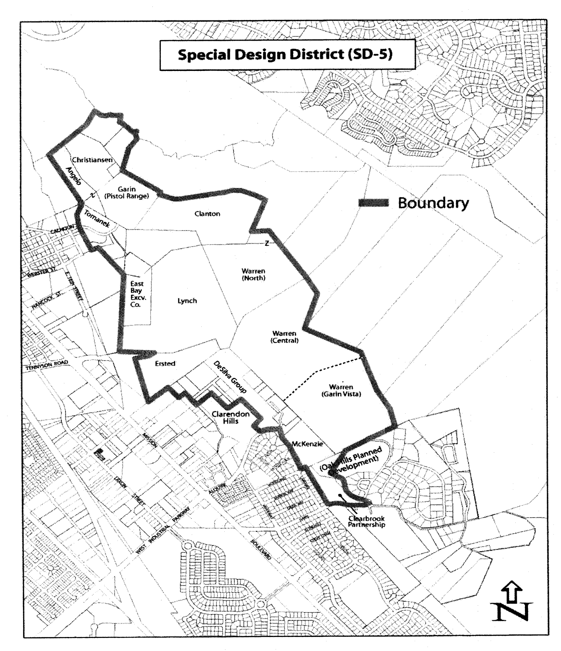
Mission-Garin Area Special Design (SD-5) District
Maximum Total Dwelling Unit Potential
The SD-5 special design district comprises approximately 363 acres. The maximum dwelling unit potential shown in the table below excludes parcels/areas totaling approximately 57 acres within the district that are considered as developed or rural home sites with little potential for subdivision due to size, slope, earthquake faults, etc.
1 Consists of the following parcels/areas: Lynch/East Bay Excavating Co./Warren (North)/Warren (Central)/DeSilva Group.
2 Does not include the potential for an additional 12 dwelling units associated with the approved Oak Hills Planned Development.
(Amended by Ordinance 24-01, adopted Jan. 23, 2024)
SEC. 10-1.2635 - SOUTH HAYWARD BART/MISSION BOULEVARD SPECIAL DESIGN DISTRICT (SD-6).
Note— Repealed by Ordinance 11-12, adopted October 11, 2011.
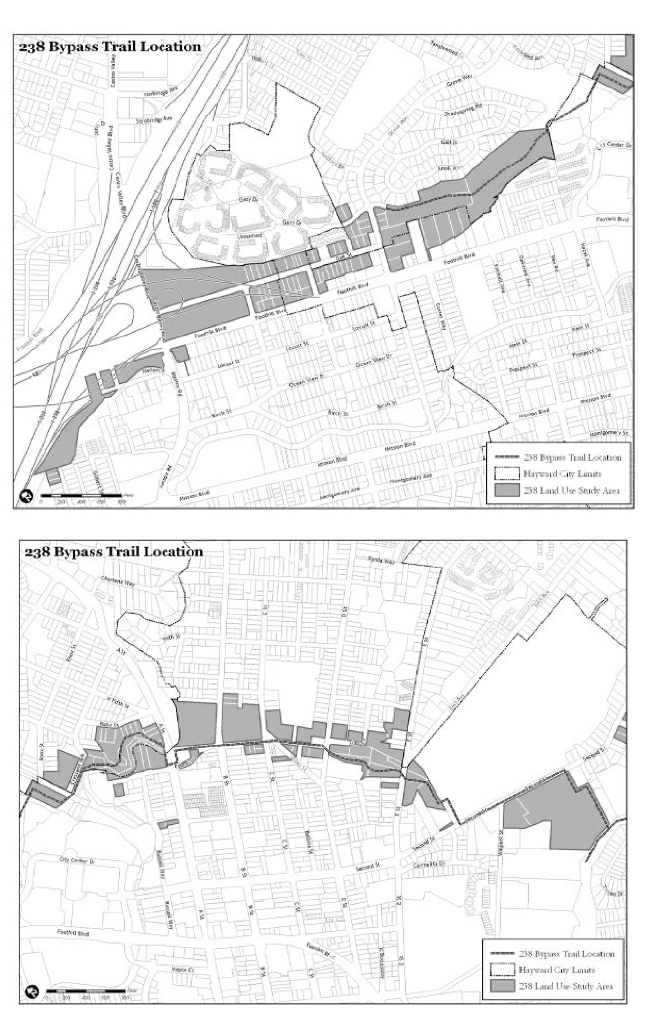
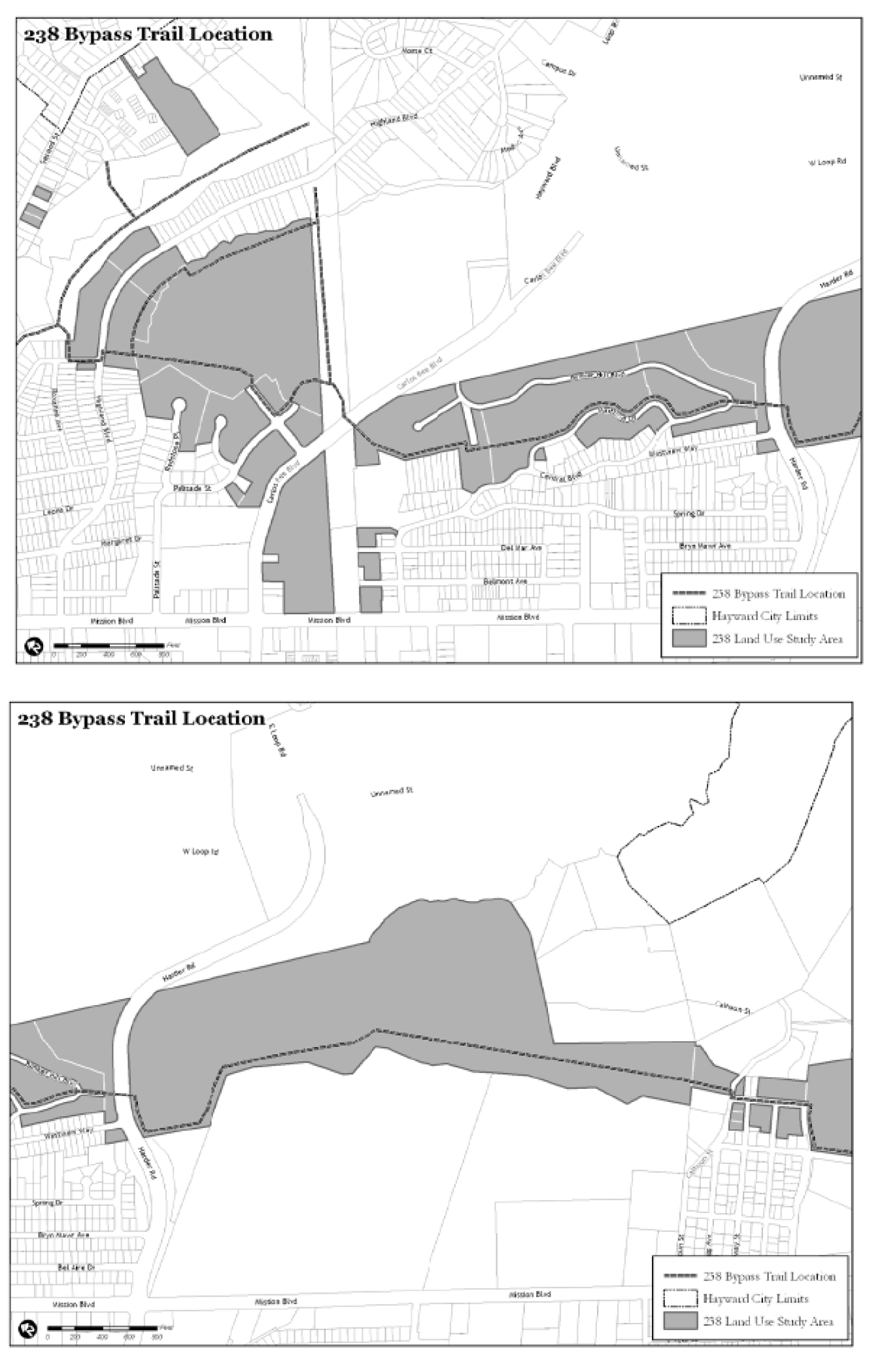
SEC. 10-1.2640 - HAYWARD FOOTHILLS TRAIL (SD-7).
The purpose of the Hayward Foothills Trail Special Design District (SD-7) is to ensure the orderly development of a continuous trail as properties involved in the 238 Bypass Land Use Study are developed. The District establishes the general location for the trail (see map, below) as well as the standards and guidelines for establishing the trail.
a.
Development Standards and Design Guidelines. The development of the trail shall adhere to the following development standards and design guidelines:
(1)
The trail shall be a 16-foot wide trail within a 20-foot wide area, to accommodate multiple users. A reduced width may be approved by the Planning Director and the Hayward Area Recreation and Park District (HARD) where the standard width is infeasible.
(2)
The trail shall be established in the locations as shown on the maps below unless an alternative route is approved by the Planning Director and HARD.
(3)
The trail design shall be approved by the Hayward Area Recreation and Park District (HARD) in accordance with the District's trail standards.
(4)
The trail shall be developed in areas where the slope is less than 25 percent.
(5)
The trail shall be a multi-use trail for pedestrian and bicycles and shall be available to the entire Hayward community as well as visitors to the Hayward community.
(6)
Residential or non-residential development adjacent to the trail shall maintain at least a ten foot setback from the edge of the trail.
(7)
Where the trail traverses individual properties, the trail shall be located in front of structures to accommodate greater visibility and easier access, for the safety of all trail users and the occupants of future developments.