
Hendersonville City Zoning Code
ARTICLE XVII
NATURAL RESOURCE PROTECTION STANDARDS
Sec. 17-1.- Purpose.
Recognizing that protection of the natural resources of the City of Hendersonville represents prudent stewardship and good business, this article is created to establish standards intended to accomplish the following:
a)
To preserve and enhance the quality of the water in creeks, streams, ponds and lakes that flow into and out of the city;
b)
To minimize future flooding problems by guiding development away from flood prone areas;
c)
To preserve the water carrying capacity of watercourses and the natural water storage capacity of the special flood hazard area;
d)
To protect land and watercourses from pollutants, sedimentation and erosion;
e)
To retain open spaces in order to protect their environmentally-sensitive character; and
f)
To protect and conserve significant natural resources from degradation due to urbanization.
Sec. 17-2. - Floodplain protection standards.
The primary objective of floodplain protection standards is to preserve and maintain the natural floodplain in an undisturbed vegetated state in order to maintain flood storage capacity, control stormwater, improve water quality and conserve plant and wildlife habitat.
17-2-1 - Development prohibited in the floodway and special flood hazard area.
Development within the floodway and special flood hazard area, as defined in section 12-2, above, shall be prohibited, except as provided in this article. For purposes of this article the term development means any man-made change to improved or unimproved real estate, including, but not limited to, buildings or other structures, mining, dredging, filling, grading, paving, excavation or drilling operations, or storage of equipment or materials.
17-2-2 - Development allowed in the floodway and special flood hazard area.
a)
Land in the floodway and special flood hazard area may be used for the following purposes, provided that such uses are designed and constructed to minimize clearing, grading, erosion and water quality degradation:
1)
Crossings by streets, driveways, culverts and railroads;
2)
Active and passive recreational activities authorized in the zoning district in which the property is situated;
3)
Intakes, docks, utilities (including water and wastewater treatment, stormwater control and sedimentation and erosion control facilities), bridges, other public facilities and water-dependent structures;
4)
Wetlands constructed or restored for mitigation purposes;
5)
Redevelopment pursuant to section 17-2-4, below; and
6)
Land within the floodway and special flood hazard area can serve to meet minimum lot size requirements if there is sufficient buildable area remaining on the tract.
b)
Land in the special flood hazard area may be used for up to 25 percent of the parking required for the development on the tract; provided, there is no increase in the elevation of the land resulting in a loss of flood storage. Furthermore, no more than one-third of the special flood hazard area on any development tract shall be used for parking. Parking in the special flood hazard area shall undergo development review in accordance with article VII, above. In considering the application for development approval, the city shall consider whether the proposed parking on the site is designed and arranged to minimize adverse environmental impact from placement of parking in the special flood hazard area and whether the proposed development would result in significant degradation of water quality, loss of significant wetlands, increase in sedimentation and erosion, increase in stormwater runoff, loss of significant plant and wildlife habitat or would otherwise constitute a threat to public safety. Where feasible, the proposed parking shall be designed making maximum use of pervious materials.
c)
Streets and driveways may run generally within special flood hazard area and parallel to the stream only where no other access to the property is feasible. Such streets and driveways shall be designed to minimize loss of flood storage.
d)
In order to allow design flexibility to achieve high quality site design and better utilization of land adjacent to the special flood hazard area, a property owner or developer may fill and/or use for development up to ten percent of the special flood hazard area contained within the boundaries of any development site upon satisfactorily demonstrating the following:
1)
The proposed fill and/or development provides for a higher quality site design and better utilization of land adjacent to the special flood hazard area than would be possible without the intrusion necessary to achieve the high quality design; and
2)
The proposed fill and/or development represents the minimum amount of special flood hazard area intrusion necessary to achieve the high quality design.
Public and private roads and sidewalks shall not count toward the allowable ten percent of the special flood hazard area on a tract that can be filled and/or used for development in accordance with section 17-2-2(d).
A property owner or developer may fill and/or use for development more than ten percent of the special flood hazard area when such would be necessary so that the property to be developed, including both the special flood hazard area and land adjacent thereto, equals one-half acre.
e)
Notwithstanding the foregoing, for parcels existing prior to the effective date of this ordinance situated entirely within the 100-year flood plain as depicted on the most recent Flood Insurance Rate Map, a property owner or developer may fill and/or use for development up to one-half acre or ten percent of such property, whichever is greater. Provided, however, in order to develop such lands, the property owner or developer must comply with all applicable regulations of the Federal Emergency Management Administration including obtaining a "no-rise" certificate, if necessary.
Furthermore, in order to qualify for the exception contained in this paragraph, proposed development shall be situated and designed in such a way as to be consistent with the purposes of this article as set forth in section 17-1, above.
f)
It is intended that this ordinance be congruous with the City of Hendersonville Flood Damage Prevention Ordinance. Therefore, any uses, development or land disturbing activity allowed by section 17-2 shall be conducted in accordance with the requirements of the flood damage prevention ordinance, including, without limitation, the requirement to obtain a "no-rise" certificate for activities within the floodway.
17-2-3 - Density credits.
The amount of land in the special flood hazard area may be credited for residential density on land adjacent to the special flood hazard area at a rate of 100 percent of that allowed by the zoning.
17-2-4 - Redevelopment in the floodway and special flood hazard area.
Historically, some areas of the city's planning jurisdiction were developed despite the fact that they lie within the 100-year floodplain. In order to address concerns about urban blight, this section allows redevelopment to occur on existing developed sites which no longer function as natural flood plain and when such redevelopment will not result in any further loss of flood-plain functionality. Where feasible, redevelopment proposals should demonstrate an improvement in the site's functionality as a flood plain. In light of this intent, redevelopment of existing developed sites shall be permitted within the floodway and special flood hazard area only when the applicant has satisfactorily demonstrated the following:
a)
The proposal is to redevelop an existing developed site as of the date of this ordinance evidenced by substantial coverage of the site by buildings, fill, gravel or paved drives or parking areas or other impervious surfaces.
b)
There shall be no loss of flood storage capacity on the site as a result of the redevelopment.
c)
The applicant, utilizing best management practices, shall reduce the post-redevelopment rate of stormwater runoff from the pre-redevelopment rate of runoff, if feasible. In any event, the post-redevelopment rate of runoff shall not be greater than the pre-redevelopment rate.
d)
The project design, including any best management practices (BMPs) will result in a project which is consistent with the purposes of the Natural Resources Protection Ordinance as stated in section 17-1, above. In this regard, the applicant shall demonstrate the following:
1)
The project shall not degrade the quality of the water in creeks, streams, ponds and lakes that flow into and out of the city.
2)
The project shall not contribute to future flooding problems.
3)
The project preserves the water carrying capacity of watercourses and the natural water storage of the special flood hazard area.
4)
The project protects land and watercourses from pollutants, sedimentation and erosion.
5)
The project retains open spaces in order to protect their environmentally-sensitive character; and
6)
The project protects and conserves significant natural resources from degradation due to urbanization.
e)
The applicant shall comply with all relevant provisions of the flood damage prevention ordinance including obtaining a no-rise certificate, if needed.
Sec. 17-3. - Stream buffer protection standards.
The primary objective of stream buffer protection standards is to maintain land adjacent to streams in an undisturbed vegetated state in order to enhance and maintain water quality, protect stream channel wetlands, minimize stormwater runoff, reduce sedimentation and erosion, conserve plant and wildlife habitat and protect wildlife movement corridors. The standards contained in this section will further this objective (1) by regulating water temperature through shading of the stream bed, (2) by limiting sedimentation from streambank erosion and stormwater flow, and (3) by supporting aquatic life through the provision of organic debris such as leaves and twigs.
17-3-1 - Applicability.
Except as modified in this section, stream buffer protection standards shall apply to all watercourses depicted as a solid blue line on the most recent USGS seven-and-one-half minute quadrangle topographic maps covering the City of Hendersonville and its area of extraterritorial jurisdiction. Stream buffers shall be clearly indicated on all development plans, including concept plans, preliminary plans and final plans, and on all preliminary and final plats.
17-3-2 - Stream buffer size.
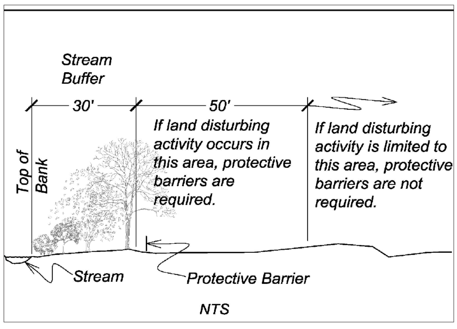
Stream buffers shall apply on each side of the stream and shall measure 30 feet horizontally from the top of the stream bank in a direction perpendicular to the stream flow.
17-3-3 - Prohibition against development within the stream buffer.
To avoid a loss of effectiveness in protecting streams, the stream buffer shall remain in natural undisturbed forest vegetation and no development or land-disturbing activities shall be undertaken therein, except as provided in section 17-3-5. Furthermore, there shall be a 20-foot transitional area immediately landward of the stream buffer which may be graded, landscaped and/or used for pedestrian or vehicular purposes so long as no impervious materials are utilized. Certain uses of land, as specified in section 17-3-5, below, may be permitted within the stream buffer so long as they meet the requirements of that section and are designed and constructed to minimize the amount of intrusion into the stream buffer and to minimize clearing, grading, erosion and water quality degradation. Nothing herein is intended to preclude the removal of downed vegetation from the stream bed in order to improve stream flow dynamics. If it is necessary to remove downed or dead vegetation, it should be cut and the root ball left in place to help maintain stability of the shoreline. Nothing herein is intended to [or shall] preclude any activity specifically authorized pursuant to Section 401 and/or Section 404 of the Clean Water Act.
17-3-4 - Stream buffer protection measures.
To prevent adverse impacts to required stream buffer areas and to assure the stream buffer remains undisturbed and protected during and after land disturbing activities and development, adequate protections shall be in place prior to and after land disturbing activities and development commences.
a)
When land disturbing activity or development is to take place within 50 feet of the outside edge of the stream buffer, temporary stream buffer protective barriers shall be in place prior to the land disturbing activity or development work commencing.
b)
Prior to commencing any land disturbing activity or development on a site, the planning director or the director's designee shall inspect and approve the installation of stream buffer protective barriers.
c)
Stream buffer protective barriers shall consist of:
1)
A fence which is at least three feet high and constructed in a post and rail configuration, using two-by-four posts and one-by-four rails;
2)
A fence with two-by-four posts placed no farther than ten feet apart covered with a four-foot orange polyethylene laminar safety fencing; or
3)
Certain erosion and sedimentation control devices such as silt fencing may also serve as the stream buffer protective barrier.
d)
All contractors shall be made aware of the stream buffer designated for protection. Unless otherwise provided by ordinance, no disturbance shall occur within the stream buffer, including the following:
1)
Clear-cutting of trees and other vegetation;
2)
Selective cutting of trees and/or the clearing of other vegetation;
3)
Removal or disturbance of existing vegetation;
4)
Grading;
5)
Filling;
6)
Storage, parking or operating motorized vehicles;
7)
Storage of debris or materials, including topsoil;
8)
Use, storage or application of herbicides and/or pesticides;
9)
Draining the stream buffer area by ditching, underdrains or other systems.
e)
Stream buffer protective barriers shall be maintained throughout the developer's activities.
f)
For planned developments and commercial uses, permanent boundary markers, in the form of signage approved by the planning department, shall be installed once the land disturbing activity or development is complete. Clearly visible stream buffer boundary markers shall be placed along the outside edge of the stream buffer and spaced at a maximum every 100 feet.
g)
Prior to issuing a certificate of occupancy for planned developments, documentation shall be in place to inform property owners of the stream buffer presence and location along with management and maintenance requirements. Documentation shall be in a form that will run with the property such as inclusion in covenants, conditions and restriction documents or deed reference.
17-3-5 - Exceptions.
Subject to prior written authorization by the planning director, the following activities may be undertaken within the stream buffer provided they meet all the standards specified herein as well as other applicable provisions of the zoning ordinance:
a)
Crossings by streets, driveways, culverts, railroads, recreational features, intakes, docks, utilities, bridges or other facilities shall be allowed provided that they are designed to minimize the amount of intrusion into the stream buffer. Streets and driveways may run generally within and parallel to the stream buffer only where no other access to the property is feasible and when their design minimizes the amount of intrusion into the stream buffer. Crossings with a width of 40 feet or more are permitted only when it has been demonstrated that there is no practical alternative.
b)
Stream buffers may be used for passive recreational activities, such as unpaved or paved trails or greenways, provided that service facilities for such activities, including but not limited to parking, picnicking and sanitary facilities, are located outside of the stream buffer. Where practical, such activities shall be kept at least 15 feet from the stream bank.
c)
Clearing and revegetating the stream buffer pursuant to a plan approved by the planning director when it has been demonstrated that such clearing and revegetation will improve stream buffer's pollutant removal efficiency.
d)
Stormwater control structures and temporary erosion control structures shall be considered utilities for the purposes of this section and may be allowed in stream buffers, provided that:
1)
The property owner or applicant demonstrates to the satisfaction of the planning director that such facilities cannot be practicably located outside of the stream buffer, and that any proposed stormwater control structure is sited and designed to minimize disturbance of the stream and stream buffer.
2)
Alternate methods of stormwater and erosion control shall be considered prior to approval of such structures in the stream buffers.
3)
A vegetated buffer of a width approved by the planning director shall be required around the stormwater control structures.
4)
Any land disturbed for these structures shall be revegetated with appropriate native species in accordance with a revegetation plan approved by the planning director.
e)
Sanitary sewer lines, on an alignment generally parallel to the stream, may be allowed in stream buffers, provided that:
1)
The property owner or applicant demonstrates in writing to the satisfaction of the director of water and sewer that the sanitary sewer lines cannot be practicably located outside of the stream buffer;
2)
Design and construction specifications minimize damage to the stream and the possibility of line leakage;
3)
The sewer line is located at least 15 feet from the top of the stream bank; and
4)
The sanitary sewer plan and a plan for revegetating the stream buffer disturbance shall be approved by the director of water and sewer.
f)
Streams may be piped, thereby exempting the piped section of the stream from stream buffer requirements, provided such piping complies with the permitting/certification requirements of the Clean Water Act and any other applicable state and federal regulations. Piping undertaken for the purpose of accommodating public roads, railroads, greenways, recreational facilities and private roads and drives should be designed so that the right-of-way or roadway-and-shoulder width is no more than is necessary considering the design capacity of the facility and so that the proposed stream piping is not substantially in conflict with the other objectives of this section. Where stream piping is approved, a vegetated buffer area or other device shall be provided at any intake or discharge structure. All buffers and physical improvements related to the stream piping shall be located entirely on the site or, pursuant to easement, on lands adjacent to the site.
g)
Selective removal of invasive exotic species in accordance with a plan approved by the planning director.
h)
View corridors are allowed so long as the soil is undisturbed and the natural forest floor, ground cover and understory vegetation are left intact. Pruning associated with the creation and maintenance of a view corridor is exempt. Thinning of the overstory and mid-canopy trees is permissible with the written authorization of the planning director.
Site plan approval by the planning director shall be required for any of the stream buffer intrusions described above. When any of the activities described above involves land clearing, the cleared area shall be revegetated pursuant to an approved plan. However, where a site plan is not required by any other provision of the zoning ordinance, the director of public works is authorized to approve plans for stream piping and erosion control structures in stream buffers.
17-3-6 - Minimum lot size requirements.
Land within the stream buffer can serve to meet minimum lot size and setback requirements if there is sufficient buildable area remaining on the lot.
17-3-7 - Diffuse flow requirement.
Diffuse flow of runoff shall be maintained in the stream buffer dispersing concentrated flow and reestablishing vegetation.
a)
Concentrated runoff from new ditches or manmade conveyances shall be converted to diffuse flow before the runoff enters the 20-foot setback area defined in section 17-3-3, above.
b)
Periodic corrective action to restore diffuse flow shall be taken if necessary to impede the formation of erosion gullies.
17-3-8 - Special provisions pertaining to certain residential uses.
For certain residential uses as prescribed herein, the stream buffer shall be reduced to 15 feet and the transitional area described in section 17-3-3 shall be reduced to 15 feet. To qualify for these special provisions, a proposed development must meet the following criteria:
a)
The lot on which the development is to occur must be a lot of record in the Henderson County Registry as of 6 September 2001.
b)
Use of the lot must be limited to a one- or two-family residential dwelling.
c)
The lot may not exceed one acre in area.
d)
The amount of impervious surface allowed on the lot shall not exceed 25 percent of the lot or 3,000 square feet, whichever is greater.
Sec. 17-4. - Exemption when existing uses are present and ongoing.
The regulations contained in this article shall not apply to portions of the stream buffer, the floodway or the special flood hazard area where a use was existing and ongoing on the effective date of this ordinance.
a)
Existing uses shall include, but not be limited to agriculture, buildings, industrial facilities, commercial areas, transportation facilities, maintained lawns, utility lines and on site sanitary sewage systems. Only the portion of the stream buffer, floodway, or special flood hazard area that contains the footprint of the existing use is exempt from this article. Activities necessary to maintain uses are allowed provided that the site remains similarly vegetated, no impervious surface is added within the stream buffer, floodway or special flood hazard area where it did not previously exist as of the effective date of this ordinance, and existing diffuse flow is maintained.
b)
A use shall be considered as existing if projects or proposed development meet at least one of the following criteria:
1)
Project requires a 401 Certification/404 Permit, and these were issued prior to the effective date of this ordinance;
2)
Projects which require a state permit, such as landfills, NPDES wastewater discharges, and road construction activities, which have begun construction or are under contract to begin construction, and which have received all required state permits prior to the effective date of this ordinance; or
3)
Projects that have been determined to have a vested right pursuant to chapter 40 of the Code of Ordinances of the City of Hendersonville.
Sec. 17-5. - Other laws and regulations.
Compliance with this article does not preclude the requirement to comply with all federal, state and local laws and regulations.
Sec. 17-6. - Varying requirements when there is an increase in functionality.
Occasionally, development sites will contain flood plain and/or stream buffers which, due to previous clearing or development, diking, erosion, or other reasons, are of limited functionality. This ordinance seeks to encourage landowners and developers to find creative means to improve these existing conditions. Accordingly, the entity with the authority to grant development authorization pursuant to article VII, above, may vary the requirements of this article when the applicant for development authorization demonstrates the proposed development, along with any management practices, will result in an increase of functionality of any regulated natural resources on the development site. Any mitigation proposed to offset loss of a natural resource regulated herein must take place on the development site itself or on neighboring properties pursuant to a recorded easement authorizing such activities.
Sec. 17-7. - Remedies for violations of the natural resources protection ordinance.
In addition to any other remedies provided in this ordinance or elsewhere, the zoning administrator is authorized to require restoration of any natural resources damaged or destroyed in violation of the provisions of this section.

