
Highlands City Zoning Code
DIMENSIONAL AND
DENSITY STANDARDS
Sec. 8.1 - General
8.1.1 Purpose
This Ordinance where applicable, shall govern lot sizes and standards and shall govern the location of the minimum building setback lines. The size, shape, and orientation of lots shall reflect due consideration to topography and drainage so as to accomplish the following goals:
A.
To make efficient and visually aesthetic use of the natural features of the landscape;
B.
To maximize visualization of permanently preserved open space;
C.
To preserve natural vegetation and ecosystems;
D.
To provide recreation areas;
E.
To provide scenic vistas; and
F.
To create diversity and originality in subdivision design, meaning lots, streets and parking areas of non-uniform size, shape, or arrangement.
8.1.2 Requirements and Exceptions
A.
Building and Structure Setbacks
1.
No part of a yard, open space, off-street parking space, or loading area required in connection with any building, structure, or use by this Ordinance shall be considered to be part of a required yard, open space, off-street parking space, or loading area for any other building, structure, or use, except for the exemption for Town of Highlands Greenway easements as listed below in Item 2.
2.
Where an easement has been granted to the Town of Highlands for the purpose of extending the Highlands Greenway, the Greenway easement or the portion of the lot dedicated as part of the Greenway shall not affect required setbacks from property lines.
a.
The request by the Town to receive an easement for the Town of Highlands Greenway will be negotiated on a project by project basis. See Sec. 10.5.2, Trails and Paths, and Sec. 12.3.4, Limited Activity Permitted Within and Adjacent to Riparian Buffers, for additional requirements for trails.
b.
See also Sec. 8.4, Watershed Overlay District, for built upon area calculations related to Highlands Greenway easements.
3.
The setback distance shall be measured horizontally from the right-of-way, road centerline, or adjoining property line to the nearest projection of the building, including any eave, dormer, deck, or other part attached thereto and any portion of the building located below grade, as illustrated by Figure 1, except measurement of distance separation required for electronic gaming operations, adult establishments, and places of adult entertainment shall be in a straight line from the closest point of the buildings in which the activities occur.
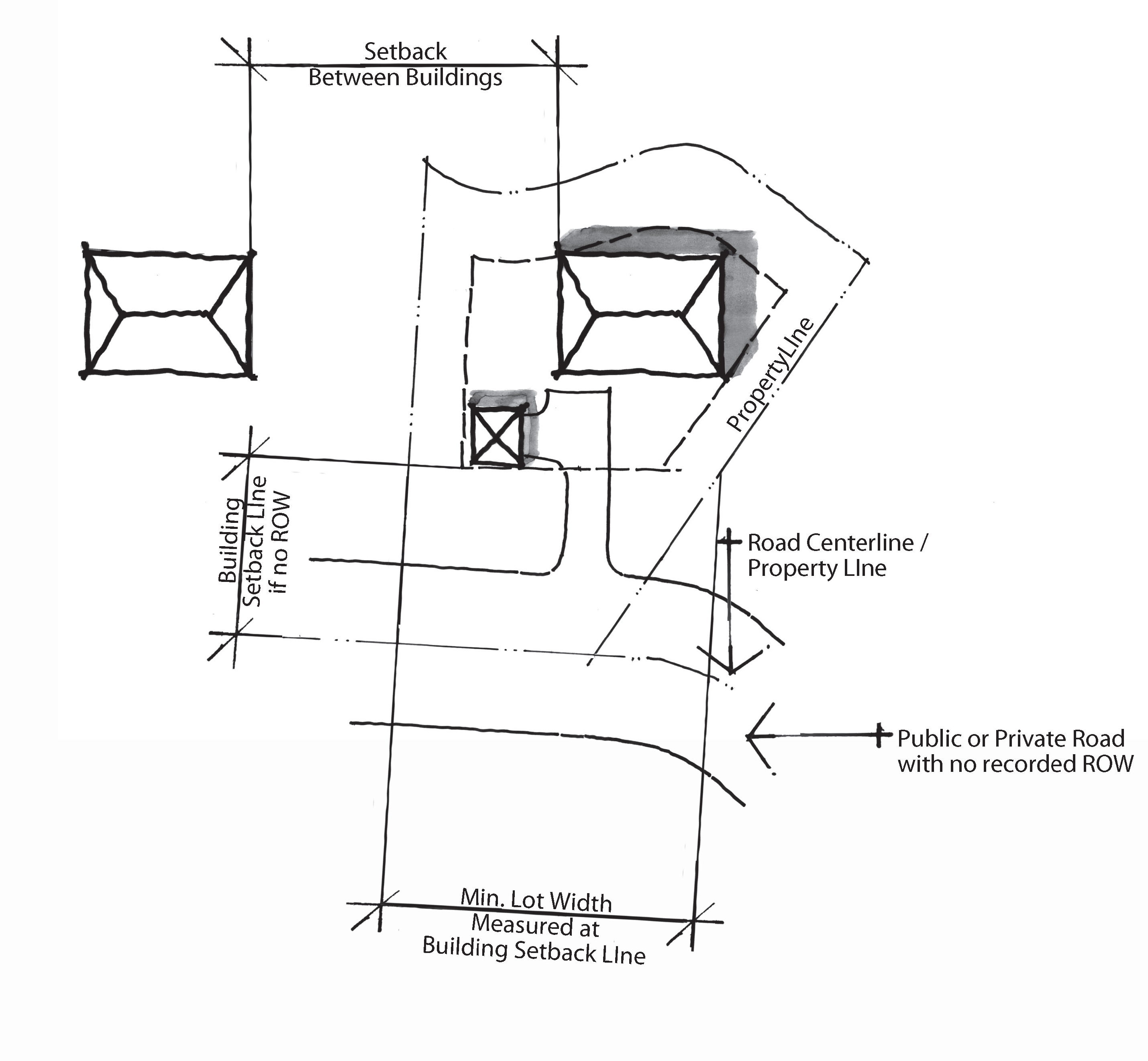
Figure 1
4.
In the event a right-of-way is not defined among the public records of Macon County, North Carolina, and: a) the road is a North Carolina or U.S. primary route; or b) the road is any other public or private road, references to dedicated public right-of-way in this Article 8, Dimensional and Density Standards, shall be measured from the centerline of the existing road as defined in the tables of this Article 8. See also Sec. 13.2.1, Sign Standards Interpretations, for additional interpretations for Signs and rights-of-way.
5.
Doors, windows, marquees, canopies or fixed awnings, and movable metal or canvas awnings shall be permitted to encroach on the setback area in the B-1 and B-2 Zoning Districts, as illustrated by Figure 2.
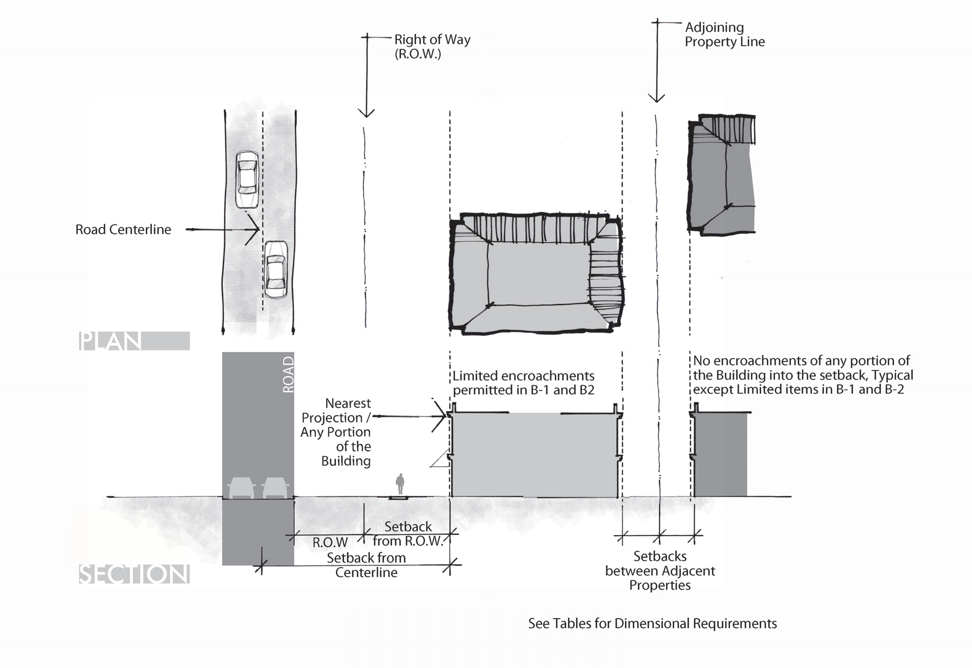
Figure 2
6.
Gazebos and other publicly owned structures used for public purposes shall be allowed with a zero setback upon resolution of the Board of Commissioners of the Town of Highlands.
7.
On the site of the Town Hall property, circumscribed by Oak Street, Maple Street and Fourth Street, there shall be a zero setback from Fourth Street and Oak Street.
8.
Zero lot line setbacks in any other development are only allowed in Planned Cluster Developments with a Special Use Permit. See Sec. 8.5, Planned Cluster Development.
9.
Fences have a minimum setback distance of twelve (12) feet from the travel way or the edge of pavement. No fence or wall shall be constructed in the right-of-way. *Note: In specific cases, due to topographical factors, the Zoning Administrator may approve a fence within the twelve-foot setback, if all other requirements can be met. See Sec. 6.3 - Residential Uses, 6.3.3 Residential Accessory Uses and Structures, (C) Fences and Walls and Sec. 6.5.2 Fences and Walls.
B.
Building Height. Building height shall not exceed the maximum height permitted, except publicly owned facilities may receive a height variance upon resolution of the Board of Commissioners of the Town.
C.
Fence Height.
1.
Five (5) feet height maximum for fences or walls. See Sec. 6.3.3 Residential Accessory Uses and Structures, (C) Fences and Walls and Sec. 6.5.2 Fences and Walls.
2.
Fences or walls shall be no greater than six (6) feet in height behind the building setback line from road right-of-way or road centerline. See Sec. 6.3.3 Residential Accessory Uses and Structures, (C) Fences and Walls and Sec. 6.5.2 Fences and Walls.
D.
Minimum Lot Size (Total Area of Parcel) and Relationship to Use. Minimum lot sizes for parcels shall meet or exceed the minimum parcel size permitted, except:
1.
A Property may be subdivided without respect to the minimum lot size required by this Ordinance for the purpose of clustering development, See Sec. 8.5, Planned Cluster Development;
2.
Residential lot sizes in each district are defined per dwelling unit, whether the dwelling is single-family or multi-family; and
3.
Any parcel of real property owned by a nonprofit visual art center situated within the Government-Institutional Zoning District may be used for nonprofit visual art center purposes provided the parcel size is not less than five (5) acres.
E.
Access to Lots and Relationship to Lot Size. See also Article 9, Parking and Loading, and Sec. 10.4, Driveway Entrances, for additional requirements.
1.
Access to each lot from street frontage shall be sufficient to allow safe passage; and
2.
Business and industrial lots shall be of sufficient size to permit off-street service facilities and access for off-street parking for vehicles by patrons and employees, as required by this Ordinance.
F.
Minimum Lot Width and Relationship to Certain Uses. Minimum lot widths for parcels shall meet or exceed the dimensional standards in this Ordinance, except the minimum lot width shall not apply to incidental apartments, single apartments and multi-family as permitted by Article 6, Use Regulations.
G.
Built-upon Limits and Built-upon Area. Built-upon limits and built-upon area apply to both specific zoning districts (watershed overlay) and specific uses (multi-family and nonprofit visual art centers). For the purpose of calculating built-upon area, total project area shall include total acreage in the tract on which the project is to be developed. See tables in Sec. 8.2, Residential Development, and Sec. 8.3, Nonresidential Development, for typical built-upon limits and see also Sec. 8.4, Watershed District Overlay, for additional requirements, where applicable.
(Amend. of 6-20-19(4))
Sec. 8.2 - Residential Development
The underlying zoning district requirements shall apply except for additional applicable requirements of Sec. 8.4, Watershed District Overlay, and Sec. 8.5, Planned Cluster Development, and unless a site specific plan is approved per Sec. 5.5, Conditional Zoning Districts Intent Statements.
(Amend. of 8-18-16(4))
8.2.1 Dimensional Standards
(Amend. of 11-17-16(5); Amend. of 6-20-19(4))
8.2.1.a Construction upon Mountain Slopes
Given the unique topographic features of Highlands and the intent to protect steep slopes as stipulated in Section 12.5.1 Steep Slope Protection the ability to adjust the front setback for residential construction is an option provided to minimize the negative impacts on slopes and ridge lines due to construction.
Option 1. Construction on natural slopes of 15% to 30% shall meet all setback requirements of this ordinance, except that the required front yard setback may be reduced to a minimum of twenty (20) feet. This twenty (20) foot setback shall be measured from the street right-of-way. In the event of the absence of a right-of-way the setback shall be measured by going fifteen (15) feet from center of the roadway and then proceeding to measure the twenty (20) foot front setback.
Option 2. Construction on natural slopes of 30.01% to 60% shall meet all setback requirements of this ordinance, except that the required front yard setback may be reduced to a minimum of fifteen (15) feet. This fifteen (15) foot setback shall be measured from the street right-of-way. In the event of the absence of a right-of-way the setback shall be measured by going fifteen (15) feet from center of the roadway and then proceeding to measure the fifteen (15) foot front setback.
Option 3. Construction on natural slopes of 60.01% or greater shall meet all setback requirements of this ordinance, except that the required front yard setback may be reduced to a minimum of ten (10) feet. This ten (10) foot setback shall be measured from the street right-of-way. In the event of the absence of a right-of-way the setback shall be measured by going fifteen (15) feet from center of the roadway and then proceeding to measure the ten (10) foot front setback.
In no instance shall any on-street parking be allowed when front setback requirements have been reduced. Furthermore, no parking shall be allowed in the front yard when Options 2 or 3 above have been selected.
(Amend. of 11-17-16(5))
Sec. 8.3 - Nonresidential Developments
The underlying zoning district requirements shall apply except for additional applicable requirements of Sec. 8.4, Watershed District Overlay, and Sec. 8.5, Planned Cluster Development, and unless a site specific plan is approved per Sec. 5.5, Conditional Zoning Districts Intent Statements. See also additional square foot requirements in Article 6, Use Regulations.
8.3.1 Dimensional Requirements
(Amend. of 6-20-19(4); Amend. of 8-21-25(2))
Editor's note— An amendment of 8-21-25(2), amended Art. 8 by deleting 8.3.2 entitled "Floor Area Ratio," which derived from an amend. of 6-20-19(4).
Sec. 8.4 - Watershed Overlay District
8.4.1 General
The underlying zoning district requirements shall apply except as applicable to the Watershed Overlay District dimensional standards outlined below.
A.
When approved as a Special Nonresidential Intensity Allocation (SNIA), nonresidential uses may be permitted up to a maximum of seventy percent (70%) built-upon area in up to five percent (5%) of the balance of the watershed which is outside the critical area. Projects must minimize built-upon surface area, direct stormwater away from surface waters, and incorporate Best Management Practices to minimize water quality impacts.
B.
Watershed overlay lot size and built-upon limits shall be determined based on the portion of the lot that is not underwater.
1.
Where public or private roads, which are existing on the date of adoption of this Ordinance, are within deeded lot lines, the area of impervious surface of the road shall be subtracted from the total area for watershed built-upon limits calculations.
2.
Parking areas shall be included in the built-upon area, whether constructed of impervious or pervious materials, except that for single-family residential dwellings, the area of any turf grass or mulch parking areas shall be subtracted from the built-upon area.
3.
Where an easement has been granted to the Town of Highlands for the purpose of extending the Highlands Greenway impervious areas within the Greenway easement shall not be subtracted from the total area for watershed built-upon limits calculations.
4.
Water surface area of swimming pools shall be considered pervious surface for the purposes of this Section and shall not be considered built-upon area.
C.
Land Allocation or Swap. [Reserved.]
8.4.2 Residential Dimensional Requirements
8.4.3 Nonresidential Dimensional Requirements
Sec. 8.5 - Planned Cluster Development
The underlying zoning district requirements shall apply in addition to applicable requirements of Sec. 8.4, Watershed District Overlay.
8.5.1 Dimensional Requirements
A.
Building setbacks between the internal lots within a planned cluster development shall conform to the applicable Zoning Districts unless a zero lot line setback is approved for the development, as illustrated by Figure 3. The distance between buildings in approved zero lot line developments shall be the minimum as outlined in Dimensional Standard table below.
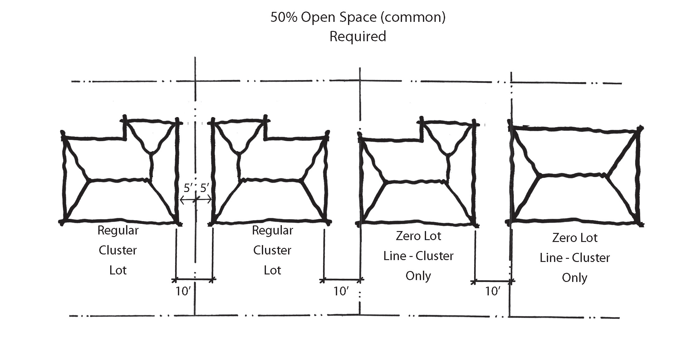
Figure 3
B.
A setback of ten (10) feet shall remain between each building.
C.
Minimum lot width and lot size shall not apply, except that the total number of clustered lots in the development shall not exceed the total number of lots allowed in either the underlying Zoning District or the Watershed Overlay District, whichever is more restrictive.
8.5.2 Common Open Space Requirements
A.
Common open space created by the cluster development shall be located as much as the natural terrain permits in one (1) contiguous area.
B.
Common open space may not contain any recreational structures unless explicitly approved by the Board of Commissioners.
C.
Required landscape buffers per Sec. 11.4, Landscape Buffers and Screening shall be included in the total area of dedicated common open space calculations.
D.
Where an easement has been granted to the Town of Highlands for the purpose of extending the Highlands Greenway, the Greenway easement or the portion of the lot dedicated as part of the Greenway shall be included in the total area of dedicated common open space calculations.
E.
Common open space may be dedicated to public or private use:
1.
If common open space is dedicated to public use—such as to the Town of Highlands, the State of North Carolina, or any other public entity—it shall be made available to and accessible to the public. The approval of a cluster subdivision plat does not constitute or effect the acceptance by the Town or the public of the dedication of any open space, and shall not be construed to do so. The Board of Commissioners may, however, in its discretion, and by separate resolution, explicitly accept any such dedication, and may also accept the responsibility to maintain such open space.
2.
If common open space is dedicated to private use, an agreement shall be prepared, and recorded with the final plat, specifying the ownership and responsibility for maintenance of the open space. Provisions for the perpetual ownership and maintenance of common open space may be accomplished by an agreement with a property owners' association or a land trust, or by other method or means approved by resolution of the Board of Commissioners.
(Amend. of 8-18-16(4))