
Highlands City Zoning Code
APPLICATIONS AND
PERMITS
Sec. 4.1 - Interpretation of this Ordinance
4.1.1 Applicability
A.
When uncertainty exists, the director of the appropriate department, or designee, as identified below, shall be authorized to make all interpretations concerning the provisions of this Ordinance. In making these interpretations, all provisions shall be:
1.
Considered as minimum requirements;
2.
Liberally construed in favor of the governing body;
3.
Deemed neither to limit nor repeal any powers granted under State statutes; and
4.
Require application of the more stringent provisions wherever the provisions of this Ordinance appear to impose conflicting provisions that cannot otherwise be reconciled.
B.
Other Interpretations. The Planning and Development Director generally shall make all interpretations of this Ordinance but shall not make interpretations of the following matters:
1.
All interpretations of matters relating to the North Carolina Building Code shall be made by Macon County or Jackson County;
2.
All interpretations of matters relating to the Public Works Specifications Manual shall be made by the Town Engineer and Public Works Director; and
3.
The Planning and Development Director may defer interpretation of additional sections of this Ordinance to appropriate Town and/or County Officials.
4.1.2 Request for Interpretation
A request for interpretation shall be submitted in writing.
4.1.3 Action by Planning and Development Director
A.
The Planning and Development Director shall:
1.
Review and evaluate the request in light of the text of this Ordinance, the Official Land Use Map and any other relevant information;
2.
Consult with Macon County or Jackson County inspection departments and coordinate with other Town staff, including the Town Attorney, as necessary; and
3.
Render an opinion.
B.
The determination shall be provided to the applicant, in writing, by personal delivery, electronic mail, or first-class mail. The notice shall be delivered to the last address listed for the owner of the affected property on the county tax abstract and to the address provided in the application or request for a determination if the party seeking the determination is different from the owner.
4.1.4 Official Record
The Planning and Development Director shall maintain an official record of all interpretations. The record of interpretations shall be available for public inspection during normal business hours.
4.1.5 Appeal
Final action on an official interpretation of this Ordinance by the Planning and Development Director may be appealed in accordance with Sec. 4.19.1, Appeal of Administration Decision to Zoning Board of Adjustment.
4.1.6 Compliance and Permit
No development or redevelopment shall occur except in compliance with the requirements of this Ordinance unless exempted. No development for which a permit is required pursuant to this Ordinance shall occur except in compliance with the provisions, conditions, and limitations of the permit. See also Sec. 15.1.2, Inspections.
4.1.7 Permit Choice and Vested Rights
A.
Findings. The General Assembly recognizes that local government approval of development typically follows significant investment in site evaluation, planning, development costs, consultant fees, and related expenses. The General Assembly finds that it is necessary and desirable to provide for the establishment of certain vested rights in order to ensure reasonable certainty, stability, and fairness in the development regulation process, to secure the reasonable expectations of landowners, and to foster cooperation between the public and private sectors in land-use planning and development regulation. The provisions of this section and G.S. 160D-108.1 strike an appropriate balance between private expectations and the public interest.
B.
Vested Rights. Amendments in land development regulations are not applicable or enforceable without the written consent of the owner with regard to any of the following:
a.
Buildings or uses of buildings or land for which a development permit application has been submitted and subsequently issued in accordance with G.S. 143-755.
b.
Subdivisions of land for which a development permit application authorizing the subdivision has been submitted and subsequently issued in accordance with G.S. 143-755.
c.
A site-specific vesting plan pursuant to G.S. 160D-108.1.
d.
A multi-phased development pursuant to subsection (f) of this section.
e.
A vested right established by the terms of a development agreement authorized by Article 10 of this Chapter.
C.
Duration of Vesting. Upon issuance of a development permit, the statutory vesting granted by subsection B of this section for a development project is effective upon filing of the application in accordance with G.S. 143-755, for so long as the permit remains valid pursuant to law. Unless otherwise specified by this section or other statute, local development permits expire one year after issuance unless work authorized by the permit has substantially commenced. A local land development regulation may provide for a longer permit expiration period. For the purposes of this section, a permit is issued either in the ordinary course of business of the applicable governmental agency or by the applicable governmental agency as a court directive. The establishment of a vested right under any subdivision of this subsection does not preclude vesting under one or more other subdivisions of this subsection or vesting by application of common law principles. A vested right, once established as provided for in this section or by common law, precludes any action by a local government that would change, alter, impair, prevent, diminish, or otherwise delay the development or use of the property allowed by the applicable land development regulation or regulations, except where a change in State or federal law mandating local government enforcement occurs after the development application is submitted that has a fundamental and retroactive effect on the development or use. Except where a longer vesting period is provided by statute or land development regulation, the statutory vesting granted by this section, once established, expires for an uncompleted development project if development work is intentionally and voluntarily discontinued for a period of not less than twenty-four (24) consecutive months, and the statutory vesting period granted by this section for a nonconforming use of property expires if the use is intentionally and voluntarily discontinued for a period of not less than twenty-four (24) consecutive months. The 24-month discontinuance period is automatically tolled during the pendency of any board of adjustment proceeding or civil action in a State or federal trial or appellate court regarding the validity of a development permit, G.S. 160D-108 Page 2 the use of the property, or the existence of the statutory vesting period granted by this section. The 24-month discontinuance period is also tolled during the pendency of any litigation involving the development project or property that is the subject of the vesting.
D.
Multiple Permits for Development Project. Subject to subsection C of this section, where multiple local development permits are required to complete a development project, the development permit applicant may choose the version of each of the local land development regulations applicable to the project upon submittal of the application for the initial development permit. This provision is applicable only for those subsequent development permit applications filed within eighteen (18) months of the date following the approval of an initial permit. For purposes of the vesting protections of this subsection, an erosion and sedimentation control permit or a sign permit is not an initial development permit.
E.
Multi-Phased Development. A multi-phased development is vested for the entire development with the land development regulations then in place at the time a site plan approval is granted for the initial phase of the multi-phased development. A right which has been vested as provided for in this subsection remains vested for a period of seven (7) years from the time a site plan approval is granted for the initial phase of the multi-phased development.
F.
Continuing Review. Following issuance of a development permit, a local government may make subsequent inspections and reviews to ensure compliance with the applicable land development regulations in effect at the time of the original application.
G.
Process to Claim Vested Right. A person claiming a statutory or common law vested right may submit information to substantiate that claim to the zoning administrator or other officer designated by a land development regulation, who shall make an initial determination as to the existence of the vested right. The decision of the zoning administrator or officer may be appealed under G.S. 160D-405. On appeal, the existence of a vested right shall be reviewed de novo. In lieu of seeking such a determination or pursuing an appeal under G.S. 160D-405, a person claiming a vested right may bring an original civil action as provided by G.S. 160D-1403.1.
H.
Miscellaneous Provisions. The vested rights granted by this section run with the land except for the use of land for outdoor advertising governed by G.S. 136-131.1 and G.S. 136-131.2 in which case the rights granted by this section run with the owner of a permit issued by the North Carolina Department of Transportation. Nothing in this section precludes judicial determination, based on common law principles or other statutory provisions, that a vested right exists in a particular case or that a compensable taking has occurred. Except as expressly provided in this section, nothing in this section shall be construed to alter the existing common law.
I.
Definitions. As used in this section, the following definitions apply:
1.
Development. Without altering the scope of any regulatory authority granted by statute or local act, any of the following:
a.
The construction, erection, alteration, enlargement, renovation, substantial repair, movement to another site, or demolition of any structure.
b.
Excavation, grading, filling, clearing, or alteration of land.
c.
The subdivision of land as defined in G.S. 160D-802.
d.
The initiation of substantial change in the use of land or the intensity of the use of land.
2.
Development permit. An administrative or quasi-judicial approval that is written and that is required prior to commencing development or undertaking a specific activity, project, or development proposal, including any of the following:
a.
Zoning permits.
b.
Site plan approvals.
c.
Special use permits.
d.
Variances.
e.
Certificates of appropriateness.
f.
Plat approvals.
g.
Development agreements.
h.
Building permits.
i.
Subdivision of land.
j.
State agency permits for development.
k.
Driveway permits.
l.
Erosion and sedimentation control permits.
m.
Sign permit.
3.
Land development regulation. Any State statute, rule, or regulation, or local ordinance affecting the development or use of real property, including any of the following:
a.
Unified development ordinance.
b.
Zoning regulation, including zoning maps.
c.
Subdivision regulation.
d.
Erosion and sedimentation control regulation.
e.
Floodplain or flood damage prevention regulation.
f.
Mountain ridge protection regulation.
g.
Stormwater control regulation.
h.
Wireless telecommunication facility regulation.
i.
Historic preservation or landmark regulation.
j.
Housing code. (2014-120, s. 16(a); 2015-246, s. 5(a); 2019-111, s. 1.1; 2020-25, s. 2.)
4.
Multi-phased development. A development containing twenty-five (25) acres or more that is both of the following:
a.
Submitted for development permit approval to occur in more than one (1) phase.
b.
Subject to a master development plan with committed elements showing the type and intensity of use of each phase. (2019-111, s. 2.4; 2020-3, s. 4.33(a); 2020-25, ss. 5(a), 50(b), 51(a), (b), (d).)
Sec. 4.2 - Common Review Procedures
4.2.1 Applicability
The review procedures described below apply to the types of applications listed below, as may be limited by the individual subsections that follow. See also Sec. 3.7.1, Summary of Review Authority Table.
(Amend. of 8-18-16(1))
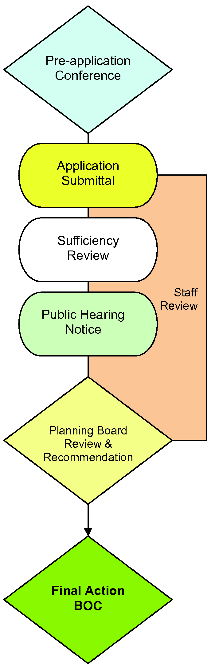
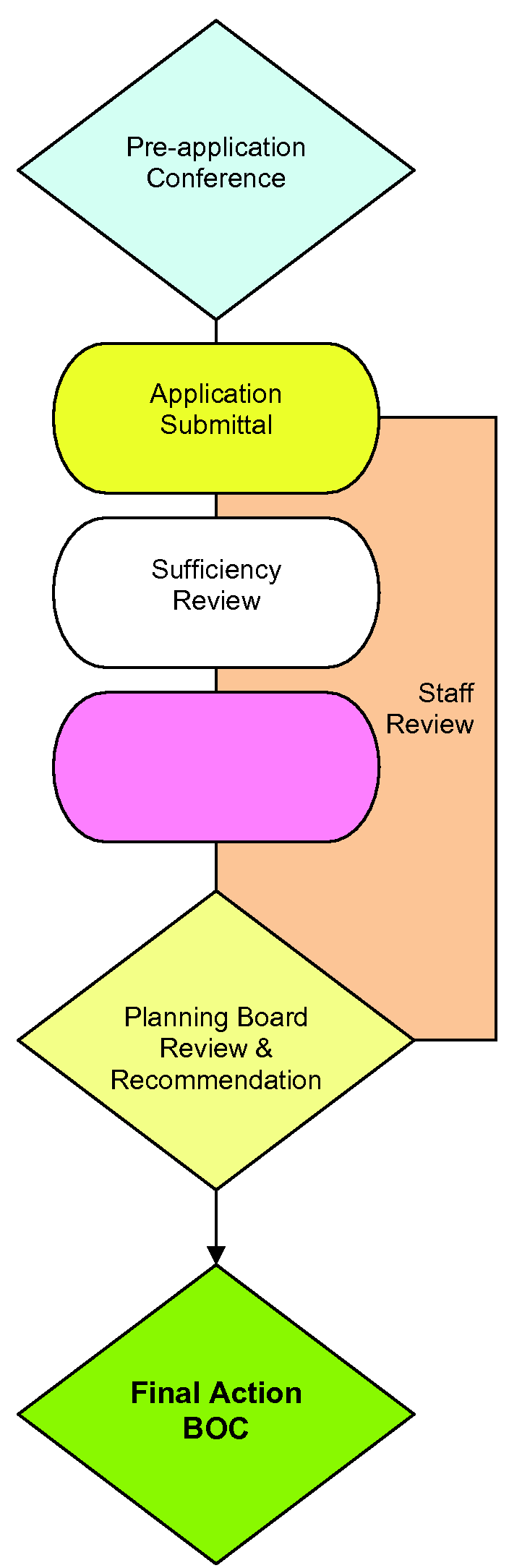
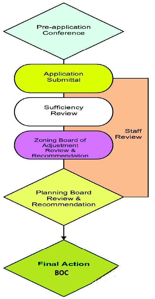
4.2.2 Pre-Application Conference
A.
Before submitting an application for development approval, it is recommended that each applicant schedule a pre-application conference with the Planning and Development Director to discuss procedures, standards and regulations required for development approval in accordance with this Ordinance.
B.
A mandatory pre-application conference with the Planning and Development Director shall be required for the following development reviews:
1.
Applications for Ordinance Amendment or Zoning Map Change;
2.
Subdivision;
3.
Applications for Special Use Permits; and
4.
Applications for Conditional Zoning.
C.
A mandatory pre-application conference with the Town Engineer and Public Works Administrator shall be required for the following development reviews:
1.
Subdivision.
2.
[Reserved.]
4.2.3 Application Requirements
The following requirements shall apply to all applications for development approval identified in Sec. 4.2.1, Applicability:
A.
Forms. Applications required under this Ordinance shall be submitted on forms and in such numbers and format as required by the appropriate checklist, unless otherwise stated in specific Sections below. The Planning and Development Director shall maintain the official forms of all permits required by this Ordinance. Permits required by the Public Works Specification Manual will be maintained by the Town Engineer and Public Works Administrator. The forms shall be available from the Town offices. All forms shall include, at a minimum, the following information provided by the applicant:
1.
Contact information for the individual or firm submitting the application;
2.
Contact information for the individual or firm on whose behalf the application is being submitted;
3.
Identification of the property affected by the application, such as legal description, address, or PIN as may be appropriate; and
4.
Any other information requested by the Planning and Development Director, or the provisions of this Ordinance.
B.
Fees. The Town has established a fee schedule for the review and approval of plans and permit applications. In establishing the fee schedule, the Town has considered and will consider in the future the administrative and personnel costs incurred for reviewing the plans and applications and for related compliance activities.
1.
All applications and fees shall be filed with the appropriate department; and
2.
Filing fees shall be established from time to time to defray the actual cost of processing the application. This may include the fees of other consultants to review applications, at the discretion of the Planning and Development Director.
C.
Applications Sufficient for Processing
1.
Applications shall contain all required information as described on forms available from each development involved in the review process, unless modified by the department, in writing, pursuant to item 2, below.
2.
The presumption shall be that all of the information required in the application forms is necessary to satisfy the requirements of this section. However, it shall be recognized that each application is unique, and therefore more or less information may be required according to the needs of the particular case. The applicant should rely on the recommendations of the appropriate department as to whether more or less information should be submitted.
3.
Once the application has been determined sufficient for processing, copies of the application shall be referred by the appropriate department to the appropriate reviewing entities.
4.
The applicant may be required to present evidence of the authority to submit an application.
5.
An application shall be considered to have been accepted for review only after it has been determined to be complete as provided above, not upon submission to the Town.
D.
Application Deadline. Applications sufficient for processing shall be submitted to the Town in accordance with the established schedule. Schedules indicating submittal dates shall be developed each year and made available to the public.
E.
Staff Consultation after Application Submitted
1.
Upon receipt of the application sufficient for processing, the Director of the appropriate department shall review the application and confer with the applicant to ensure an understanding of the applicable requirements of this Ordinance, that the applicant has submitted all of the information they intend to submit, and that the application represents precisely and completely what the applicant proposed to do.
2.
If the application is for a Special Use Permit and the applicant plans to request a waiver from the ZBA of any of the requirements listed under Sec. 4.6.2, Procedure, as allowed by item A.5 of that section, those requirements shall be identified in writing by the applicant and the Planning and Development Director shall provide to the ZBA a written letter indicating a recommendation of support for or opposition against the request for the waiver.
3.
Once the applicant indicates that the application is as complete as the applicant intends to make it, the application shall be placed before the appropriate approving authority in accordance with the standard procedures. However, if the Director of the appropriate department believes the application is incomplete, a recommendation to deny the application on this basis shall be provided to the appropriate approving authority.
F.
Related Applications
1.
Necessarily related applications for development approvals may be filed and reviewed simultaneously, at the option of the applicant. Any application that also requires a pre-requisite such as approval of Utilities before a Zoning Certificate can be issued, or variance or Special Use Permit shall not be eligible for final approval until the required variance or use permit has been granted.
2.
Related applications submitted simultaneously are subject to approval of all other related applications; denial or disapproval of any concurrently submitted application shall stop consideration of any related application until the denied or disapproved application is resolved.
G.
Phased Development Plan. A phased development plan shall be deemed approved prior to the effective date of this Ordinance if it has been approved by all necessary government units, it remains valid, unexpired, unrevoked and not otherwise terminated, and it shows:
1.
For the initial or first phase of development, the type and intensity of use for a specific parcel or parcels, including at a minimum, the boundaries of the project and a subdivision plan or site specific plan that has been approved.
2.
For any subsequent phase of development, sufficient detail so that implementation of the requirements of this Ordinance to that phase of development would not require a material change in that phase of the plan.
4.2.4 Notice and Public Hearings
Notice shall be required for applications for development approval and/or appeal as shown in the table below:
A.
Before enacting an amendment to this Ordinance, the Board of Commissioners shall hold a public hearing on it. A notice of the public hearing shall be given once a week for two (2) successive weeks in a newspaper having general circulation in the Highlands area. The notice shall be published the first time not less than ten (10) days, nor more than twenty-five (25) days before the date fixed for the hearing. The day of publication is not counted in computing these times, but the day of the hearing is included.
B.
For Zoning Map changes, the Board of Commissioners shall hold a public hearing on it. A notice of the public hearing shall be given once a week for two (2) successive weeks in a newspaper having general circulation in the Highlands area. The notice shall be published the first time not less than ten (10) days, nor more than twenty-five (25) days before the date fixed for the hearing. The day of publication is not counted in computing these times, but the day of the hearing is included. All abutting property owners shall receive written notice by first class mail to the address shown on the county tax listing. For the purpose of this section, properties are "abutting" even if separated by a street, railroad, or other transportation corridor. The notice must be deposited in the mail at least ten (10) days, but not more than twenty-five (25) days, prior to the date of the hearing. Within that same time period, the town shall also prominently post a notice of the hearing on the site that is the subject of the hearing or on an adjacent street or highway right-of-way.
C.
For Special Use Permit, Variance, and Appeal applications, public notice shall be given once, prior to the meeting, in a newspaper having general circulation in the Highlands area. All abutting property owners shall receive written notice by first class mail to the address shown on the county tax listing. The notice must be deposited in the mail at least ten (10) days, but not more than twenty-five (25) days, prior to the date of the hearing. Within that same time period, the Town shall also prominently post a notice of the hearing on the site that is the subject of the hearing or on an adjacent street or highway right-of-way.
D.
Adoption and Effect of Plans. Plans shall be adopted by the Board of Commissioners with the advice and consultation of the planning board. Adoption and amendment of a comprehensive plan is a legislative decision and shall follow the process mandated for zoning text amendments set by G.S. 160D-601. Plans adopted under this Chapter may be undertaken and adopted as part of or in conjunction with plans required under other statutes, including, but not limited to, the plans required by G.S. 113A-110. Plans adopted under this Chapter shall be advisory in nature without independent regulatory effect. Plans adopted under this Chapter do not expand, diminish, or alter the scope of authority for development regulations adopted under this Chapter. Plans adopted under this Chapter shall be considered by the planning board and Board of Commissioners when considering proposed amendments to zoning regulations as required by G.S. 160D-604 and G.S. 160D-605. If a plan is deemed amended by G.S. 160D-605 by virtue of adoption of a zoning amendment that is inconsistent with the plan, that amendment shall be noted in the plan. However, if the plan is one that requires review and approval subject to G.S. 113A-110, the plan amendment shall not be effective until that review and approval is completed.
(2019-111, s. 2.4; 2020-3, s. 4.33(a); 2020-25, ss. 11, 51(a), (b), (d); Amend. of 5-27-21(10); Amend. of 9-14-22(1), § 7)
Sec. 4.3 - Amendments to Ordinance or Zoning Map
4.3.1 Procedure for Amendment of Ordinance or Zoning Map
A.
This Ordinance, including the Zoning Map, may be amended from time to time by the Board of Commissioners, but no amendment shall become effective unless the Board of Commissioners first submits the proposed amendment(s) to the Planning Board for recommendation and comment. The Planning Board shall have thirty (30) days after any submission within which to provide a recommendation to the Board of Commissioners that addresses consistency with the current Comprehensive Plan and other matters deemed appropriate by the Planning Board, but a comment that a proposed amendment may not be consistent with the Comprehensive Plan shall not preclude consideration or approval of the proposed amendment by the Board of Commissioners. The Board of Commissioners is not bound by the recommendations, if any, of the Planning Board. If the Planning Board fails to submit a report within the thirty-day period, it shall be deemed to have recommended adoption of the requested amendment.
B.
Prior to adopting or rejecting any zoning text or map amendment, the Board of Commissioners shall approve a brief statement describing whether its action is consistent or inconsistent with an adopted comprehensive plan. The requirement for a plan consistency statement may also be met by a clear indication in the minutes of the Board Meeting that at the time of action on the amendment the Board was aware of and considered the Planning Board's recommendations and any relevant portions of an adopted comprehensive plan. If a zoning map amendment is adopted and the action is deemed inconsistent with the adopted plan, the zoning amendment shall have the effect of also amending any future land-use map in the approved plan, and no additional request or application for a plan amendment shall be required. A plan amendment and a zoning amendment may be considered concurrently. The plan consistency statement is not subject to judicial review. If a zoning map amendment qualifies as a "large-scale rezoning" under G.S. 160D-602(b), the Town Board's statement describing plan consistency may address the overall rezoning and describe how the analysis and policies in the relevant adopted plans were considered in the action taken.
C.
Before enacting an amendment to this Ordinance, the Board of Commissioners shall hold a public hearing on it as outlined in Sec. 4.2.4, Notice and Public Hearings, Item A.
D.
Any communication purporting to be a petition for a zoning amendment shall be regarded as mere notice to seek relief until it is made by formal application. Upon receipt of such communication, the interested party shall be supplied with the Town of Highlands Petition for Rezoning application form for presenting a formal petition. In no instance shall action be initiated by the property owner for a zoning amendment affecting the same parcel of property, or any part thereof, more often than once every twelve (12) months, except as permitted by Sec. 4.5.1, Applicability, of Sec. 4.5, Conditional Zoning Districts.
E.
All amendments to this Ordinance relating to Water Supply Watershed Protection must be filed with the North Carolina Division of Environmental Management, North Carolina Division of Environmental Health, and the N.C. Division of Community Assistance. Under no circumstances shall the Board of Commissioners adopt any amendments, supplements, or changes that would cause this Ordinance to violate the watershed protection rules as adopted by the North Carolina Environmental Management Commission.
F.
No amendment to zoning regulations or a zoning map that down-zones property shall be initiated nor is it enforceable without the written consent of all property owners whose property is the subject of the down-zoning amendment, unless the down-zoning amendment is initiated by the local government. For purposes of this section, "down-zoning" means a zoning ordinance that affects an area of land in one of the following ways:
1.
By decreasing the development density of the land to be less dense than was allowed under its previous usage.
2.
By reducing the permitted uses of the land that are specified in a zoning ordinance or land development regulation to fewer uses than were allowed under its previous usage.
(Amend. of 5-27-21(3); Amend. of 9-14-22(1), § 7)
4.3.2 Additional Reasonableness Statement for Rezonings
A.
When adopting or rejecting any petition for a zoning map amendment, a statement analyzing the reasonableness of the proposed rezoning shall be approved by the Board of Commissioners. This statement of reasonableness may consider, among other factors:
1.
The size, physical conditions, and other attributes of the area proposed to be rezoned;
2.
The benefits and detriments to the landowners, the neighbors, and the surrounding community;
3.
The relationship between the current actual and permissible development on the tract and adjoining areas and the development that would be permissible under the proposed amendment;
4.
Why the action taken is in the public interest; and
5.
Any changed conditions warranting the amendment.
B.
If a zoning map amendment qualifies as a "large-scale rezoning" under G.S. 160D-602(b), the Board's statement on reasonableness may address the overall rezoning.
Sec. 4.4 - Subdivision Review
4.4.1 Compliance
A.
No land shall be subdivided without first having a plat filed of such subdivision with the Macon County and/or Jackson County Register of Deeds. All plats for the subdivision of lands shall conform to the requirements of these regulations, and shall be submitted in accordance with the procedures and specifications established herein. No plat of a subdivision of land within the jurisdiction of the Town of Highlands shall be filed or recorded by the Macon County and/or Jackson County Register of Deeds until it has been submitted to the Highlands Planning Board for review and has been given final approval by the Board of Commissioners.
B.
No final plat of a subdivision within the jurisdiction of the Town of Highlands shall be recorded by the Register of Deeds of Macon County and/or Jackson County until it has been reviewed by the Planning Board and approved by the Board of Commissioners of the Town of Highlands as provided herein. To secure such approval of the final plat, the subdivider shall follow the procedure established in this Section.
C.
Furthermore, no street shall be maintained by the Town, nor street dedication be accepted for ownership and maintenance, nor water, sewer, or other Town facilities or services be extended to or connected with any subdivision for which a final plat is required to be approved, unless and until such final plat has been approved by the Board of Commissioners. See also Sec. 4.11, Infrastructure Approvals.
D.
Approval of a Preliminary or Final Plat does not relieve the applicant of the obligation to procure any other permit, as required by this Ordinance or State and Federal Law. These include, but are not limited to, Sec. 4.13, Landscape Plan Permits, Sec. 4.14, Land-Disturbing Activity Permit, Sec. 4.14.4, Erosion and Sedimentation Control Plan Requirements, Sec. 4.16, Stormwater Management Permit, and Sec. 4.17, Sign Permit, and any permit required by the North Carolina State Building Code.
4.4.2 Exemptions
A.
In accordance with G.S. 160D-802, certain divisions of land are not considered "subdivisions" nor shall they be subject to the regulations of this Ordinance.
B.
See also Sec. 4.4.10, Subdivisions Not Meeting Minimum Requirements and Sec. 2.3, Definitions.
4.4.3 Performance Guarantee
To assure compliance with G.S. 160D-804 and other development regulation requirements, a subdivision regulation may provide for performance guarantees to assure successful completion of required improvements.
For purposes of this section, all of the following apply with respect to performance guarantees:
A.
Type. The type of performance guarantee shall be at the election of the developer. The term "performance guarantee" means any of the following forms of guarantee:
1.
Surety bond issued by any company authorized to do business in this State.
2.
Letter of credit issued by any financial institution licensed to do business in this State.
3.
Other form of guarantee that provides equivalent security to a surety bond or letter of credit.
B.
Duration. The duration of the performance guarantee shall initially be one year, unless the developer determines that the scope of work for the required improvements necessitates a longer duration. In the case of a bonded obligation, the completion date shall be set one year from the date the bond is issued, unless the developer determines that the scope of work for the required improvements necessitates a longer duration.
C.
Extension. A developer shall demonstrate reasonable, good-faith progress toward completion of the required improvements that are secured by the performance guarantee or any extension. If the improvements are not completed to the specifications of the Town, and the current performance guarantee is likely to expire prior to completion of the required improvements, the performance guarantee shall be extended, or a new performance guarantee issued, for an additional period. An extension under this subdivision shall only be for a duration necessary to complete the required improvements. If a new performance guarantee is issued, the amount shall be determined by the procedure provided in subdivision (3) of this subsection and shall include the total cost of all incomplete improvements.
D.
Release. The performance guarantee shall be returned or released, as appropriate, in a timely manner upon the acknowledgement by the Town that the improvements for which the performance guarantee is being required are complete. The Town shall return letters of credit or escrowed funds upon completion of the required improvements to its specifications or upon acceptance of the required improvements, if the required improvements are subject to the Town's acceptance. When required improvements that are secured by a bond are completed to the specifications of the Town, or are accepted by the Town, if subject to its acceptance, upon request by the developer, the Town shall timely provide written acknowledgement that the required improvements have been completed.
E.
Amount. The amount of the performance guarantee shall not exceed one hundred twenty-five percent (125%) of the reasonably estimated cost of completion at the time the performance guarantee is issued. The Town may determine the amount of the performance guarantee or use a cost estimate determined by the developer. The reasonably estimated cost of completion shall include one hundred percent (100%) of the costs for labor and materials necessary for completion of the required improvements. Where applicable, the costs shall be based on unit pricing. The additional twenty-five percent (25%) allowed under this subdivision includes inflation and all costs of administration regardless of how such fees or charges are denominated. The amount of any extension of any performance guarantee shall be determined according to the procedures for determining the initial guarantee and shall not exceed one hundred twenty-five percent (125%) of the reasonably estimated cost of completion of the remaining incomplete improvements still outstanding at the time the extension is obtained.
F.
Timing. The Town, at its discretion, may require the performance guarantee to be posted either at the time the plat is recorded or at a time subsequent to plat recordation.
G.
Coverage. The performance guarantee shall only be used for completion of the required improvements and not for repairs or maintenance after completion.
H.
Legal responsibilities. No person shall have or may claim any rights under or to any performance guarantee provided pursuant to this subsection or in the proceeds of any such performance guarantee other than the following:
1.
The local government to whom the performance guarantee is provided.
2.
The developer at whose request or for whose benefit the performance guarantee is given.
3.
The person or entity issuing or providing the performance guarantee at the request of or for the benefit of the developer.
I.
Multiple guarantees. The developer shall have the option to post one type of a performance guarantee as provided for in subdivision (1) of this section, in lieu of multiple bonds, letters of credit, or other equivalent security, for all development matters related to the same project requiring performance guarantees.
J.
Exclusion. Performance guarantees associated with erosion control and stormwater control measures are not subject to the provisions of this section.
K.
The Board of Commissioners may also, in its discretion, require a performance guarantee and warranty period of one (1) year on all private streets prior to accepting them as public streets, including but not limited to all related utilities and paving. See also Sec. 4.11, Infrastructure Approvals, Sec. 10.2.3, Responsibility for Maintenance, and Sec. 10.6, Improvements and Installations.
L.
The Board of Commissioners may also, in its discretion, require a warranty period of one (1) year prior to accepting any water, sewer, or electrical system. See also Sec. 4.11, Infrastructure Approvals.
M.
At the discretion of the Stormwater Administrator, performance securities or bonds may be required for stormwater management facilities or practices until as-built plans are approved. See also Sec. 4.16, Stormwater Management Permit.
4.4.4 Preliminary Plat Requirements
All applications for subdivisions shall be addressed and submitted to the Planning Board and shall be delivered to the office of the Planning and Development Director. For all subdivisions, the subdivider shall submit an electronic copy along with twenty (20) copies twenty-four inches by thirty-six inches (24" x 36") of the preliminary plat with the application. Additional copies may be required during the preliminary plat review process if deemed necessary by the Planning Board and/or the Board of Commissioners. The deadline for subdivision applications shall be ten (10) working days prior to the regular monthly meeting of the Planning Board; applications made after that deadline shall not be considered except upon majority vote of the members of the Planning Board at the meeting.
A.
An application for subdivisions shall be made per the requirements of Section 4.2.3, Application Requirements, and shall at a minimum contain the information listed below:
1.
A plat prepared by professional land surveyor (name, seal, and registration number);
2.
The preliminary plat shall be twenty-four inches by thirty-six inches (24" x 36") in size and clearly and legibly drawn to a scale of not less than two hundred (200) feet to one (1) inch and shall be drawn on as large a sheet as is acceptable to the Register of Deeds of Macon County and/or Jackson County;
3.
Title Block, showing subdivision name; subdivider's name; north arrow; scale (denoted graphically and numerically), date of plat preparation; location of subdivision (township, county, and state);
4.
Town of Highlands "Preliminary Plat" Label of Certification, as amended, shall be completed in full. The label of certification shall be lettered or rubber-stamped on the one (1) reproducible copy in such a manner as to insure that said label will be legible on any prints made therefrom and on the two (2) additional copies;
5.
A sketch vicinity map, showing the location of the subdivision in relation to the surrounding area;
6.
The exact boundary lines of the tract to be subdivided, fully dimensioned by lengths and bearings, and the location of intersecting boundary lines of adjoining lands;
7.
The underlying zoning and any applicable overlay district, including watershed overlay district;
8.
All proposed lot lines, with approximate dimensions; lot and block numbers; all setbacks; lot sizes complying with this Ordinance, including minimum Watershed Overlay District lot size requirements; designation of any dedication of reservations to be made; and proposed use of land if other than single-family residences. See also Sec. 4.4.9, Planned Cluster Developments, for additional requirements if clustering is proposed;
9.
All proposed or required easements shall meet the requirements of Sec. 10.1.4, Required Easements, including a letter from the public service or utility provider with the preliminary plat submittal, noting the required easement width;
10.
The names and deed references (when known) of owners of adjoining properties, as well as adjoining subdivisions of record, including those proposed or under review;
11.
Significant natural features, including wooded area, marshes, major rock outcrops, lakes or streams, or other natural features affecting the site;
12.
Existing physical features, including buildings, streets, power lines, drainageways, sewer and water lines, utility easements, and Town Limit lines both on or adjacent to the land to be subdivided;
13.
Drainage system, including sketch plan of proposed drainage ways, storm sewers, culverts, retaining ponds, or areas where water is to be diverted through grading, and other evidence necessary to assure that the proposed method of drainage will meet the objectives of Article 10, Infrastructure, and Article 12, Natural Resources and Environmental Protection;
14.
Topographic contour lines at five-foot intervals, when the area to be subdivided exceeds two (2) acres or has proposed streets which will exceed eight hundred (800) lineal feet; or, alternatively, a statement by the surveyor on the plat that no roads within the subdivision exceed fourteen percent (14%) in grade;
15.
Suitability of land to be subdivided (measures taken to correct flooding, drainage, erosion, slides, or other dangers);
16.
Sidewalks, where required;
17.
Proposed streets showing, but not limited to the following: pavement width, street grades, street classifications, street lengths, street paving material, street centerline, proposed entrances including islands or short medians, proposed driveways and access to all lots and rights-of-way to be designated per the requirements of Article 10, Infrastructure;
18.
Proposed designation of streets to be "public" or private (see additional requirements under "FINAL PLAT" below);
19.
Subdivision street approval: A letter of approval for the proposed street plan, indicating that street plans have been reviewed and approved in the following manner:
a.
Plans for all subdivision streets within the Town of Highlands shall conform to the standards and specifications of the Town, as set forth in Article 10, Infrastructure and the Public Works Specifications Manual and shall have said streets reviewed and approved as outlined in Sec. 4.11, Infrastructure Approvals;
b.
Plans for all subdivision streets which are located outside of the corporate limits, but within the subdivision regulation jurisdiction, shall have said street plans, including driveway curb cuts and proposed entrance islands or medians, reviewed and approved by the District Engineer of the North Carolina Department of Transportation (NCDOT) prior to preliminary plat approval. See also, Sec. 4.11, Infrastructure Approvals; and
c.
A letter of approval from Macon County or Jackson County, depending on jurisdictional location, indicating that street names have been reviewed and approved.
20.
Required landscape and riparian buffers, to meet the requirements of Sec. 4.13, Landscape Plan Permits;
21.
Land-disturbing activity approval: A letter of approval for the proposed land-disturbing activity, indicating that proposed land-disturbing activity has been reviewed and approved, as set forth in Sec. 4.14, Land-Disturbing Activity Permits, and Article 12, Natural Resources and Environmental Protection;
22.
Utilities approval: A letter of approval for the proposed water, sewer, and electrical, per the requirements of Sec. 4.11, Infrastructure Approvals; and
23.
Proposed phasing, if any; including a complete Phased Development Plan and Phasing Schedule, including the date upon which construction is expected to begin and the date within which it is expected to be completed.
4.4.5 Preliminary Plat Review Procedures
The preliminary plat must be reviewed by the Planning Board and approved by the Board of Commissioners before improvements are made to the subdivision. Upon approval of preliminary plat, the subdivider may proceed with the installation of streets, utilities and other improvements, or guarantee their installation per Sec. 4.4.3, Performance Guarantee. See also Sec. 10.6, Improvements and Installations. The sale or transfer of lots is not permitted until improvements have been made, and final plat approved.
A.
The Planning Board shall review the preliminary plat for the purpose of making a recommendation to the Board of Commissioners regarding said plat. The Planning Board may recommend revisions which might be required in order for the subdivision to meet the requirements of this Ordinance, as well as such other revisions which are determined to be desirable. First consideration of the preliminary plat by the Planning Board shall be at the convenience of the Planning Board, but the Planning Board shall take action within thirty-two (32) days of the date of submission of the preliminary plat. Within five (5) days after taking action on the preliminary plat, the Planning Board shall notify the subdivider by letter, and the Board of Commissioners by copy of the minutes of its meeting, of its recommendation. Failure on the part of the Planning Board to take action within the prescribed period shall have the same effect as a recommendation to the Board of Commissioners that the preliminary plat be approved, and the subdivider may seek approval of the preliminary plat by the Board of Commissioners. The preliminary plat shall be forwarded to the Board of Commissioners, together with the minutes of the Planning Board's meeting, per Sec. 4.4.5, Preliminary Plat Review Procedures, Item B below.
B.
Following action on the preliminary plat by the Planning Board (or upon expiration of the period prescribed for review by that Board), the Board of Commissioners shall review the plat for compliance with this Ordinance, taking into consideration the recommendations of the Planning Board. The Board of Commissioners shall take action on the preliminary plat not less than thirty-two (32) days after receipt from the Planning Board, either approving, approving conditionally, or disapproving the plat.
C.
If the Board of Commissioners approves the preliminary plat, such approval shall be indicated on the label of certification on the two (2) copies of the plat by the Mayor, Planning Board Chairman, and the Zoning Administrator. One (1) copy shall be retained in the permanent records of the Town of Highlands, and one (1) copy shall be returned to the subdivider.
D.
If the Board of Commissioners disapproves or conditionally approves said plat, the reasons for such action shall be entered into the records of the Board. Within five (5) days following such action, copies of the Board's findings shall be transmitted to the Planning Board and the subdivider with copies of the plat. The subdivider may then make changes and submit a revised plat, which revision shall be submitted, reviewed, and acted upon by the Board of Commissioners pursuant to Sec. 4.4.5, Preliminary Plat Review Procedures, Item B above.
E.
Approval of the preliminary plat shall be valid for one (1) year, unless a written extension is granted by the Board of Commissioners on or before the one (1) year anniversary of said approval. If the final plat is not submitted for approval within said one-year period or any period of extension, the approval of the preliminary plat shall be null and void.
4.4.6 Final Plat Requirements
The final plat shall constitute only that portion of the preliminary plat which the subdivider proposes to develop at the time of submission. No final plat shall be approved unless and until the subdivider shall have installed in that area represented on the final plat all improvements required by this Ordinance, or shall have guaranteed their installation as provided in Sec. 4.4.3, Performance Guarantee. See also Sec. 10.6, Improvements and Installation. The subdivider shall submit one (1) mylar copy consistent with G.S. 47-30, and twenty (20) additional copies twenty-four inches by thirty-six inches (24" x 36") of the final plat, to the Planning Board with the application. Additional copies may be required during the final plat review process if deemed necessary by the Planning Board and/or Board of Commissioners. The final plat shall contain all of the information required in this section.
A.
A request for final plat review shall be made per the requirements of Section 4.2.3, Application Requirements, and Section 4.4.7, Final Plat Review Procedures and shall at a minimum contain the information listed below:
1.
Title Block, showing subdivision name; subdivider's name; north arrow; scale (denoted graphically and numerically), date of plat preparation; location of subdivision (township, county, and state); and name, seal, and registration number(s) of professional land surveyor preparing plat;
2.
Town of Highlands "Final Plat" Label of Certification, including Mayor, Planning Board Chairman, and Zoning Administrator signature blocks, as amended, including notarized signatures as required, shall be completed in full. The label of certification shall be lettered or rubber-stamped on the one (1) mylar copy in such a manner as to insure that said label will be legible on any prints made therefrom and on the two (2) additional copies, all twenty-four inches by thirty-six inches (24" x 36") in size;
3.
The exact boundary lines of the tract to be subdivided, fully dimensioned by lengths and bearings, and the location of intersecting boundary lines of adjoining lands;
4.
The names and deed references (when known) of owners of adjoining properties, as well as adjoining subdivisions of record, including those proposed or under review;
5.
All visible and apparent rights-of-way, watercourses, utilities, roadways, and other such improvements accurately located where crossing or forming any boundary line of the property shown; locating offset or traverse lines shall be plotted in broken lines with azimuths or courses and distances shown on the map;
6.
Sufficient engineering data to determine readily and reproduce on the ground every straight or curved boundary line, street line, lot line, right-of-way line, and easement line, including dimensions, bearings, or deflection angles; radii; central angles; and tangent distances for the centerline of curved streets and for curved property lines that are not the boundaries of curved streets;
7.
The accurate locations and descriptions of all monument markers and control points;
8.
The blocks numbered consecutively throughout the entire subdivision, and the lots numbered consecutively throughout each block;
9.
Street names and right-of-way lines of all streets and location and width of all adjacent streets and easements. Designation shall be made as to whether said streets are to be public or private, and all streets shall conform to the standards and specifications of the Town, as set forth in Article 10, Infrastructure and the Public Works Specifications Manual;
10.
Written report by the subdivider's duly qualified design professional as outlined in Sec. 10.6, Improvements and Installations;
11.
Maintenance of subdivision streets shall be as outlined in the requirements of Sec. 10.2.3, Responsibility for Maintenance. See also Item 10 above.
a.
IF PUBLIC, the Subdivider or POA is responsible for maintenance until roads are EXPLICITLY ACCEPTED FOR MAINTENANCE by the Town.
b.
IF PRIVATE, an agreement must be recorded with the final plat providing for perpetual ownership and maintenance by the POA.
12.
The location and dimensions of all rights-of-way, utility or other easements, riding trails, natural buffers, pedestrian or bicycle paths, and areas to be dedicated to public use, with the purpose of each stated; and
13.
The exact location of all stormwater management BMPs and drainage and utility easements shall be shown on final plats prepared by a registered surveyor. These plats shall contain the following statement: "This plat contains a stormwater management measure that must be maintained by the owner(s) of this land in accordance with the recorded Operations and Maintenance Agreement." See also Sec. 4.16, Stormwater Management Permit, for additional as-built requirements.
4.4.7 Final Plat Review Procedures
A.
The subdivider shall submit the final plat to the Planning Board within one (1) year of the date of the Board of Commissioners' approval of the preliminary plat unless an extension was granted, Sec. 4.4.5, Preliminary Plat Review Procedures, Item E. The Planning Board shall review the final plat for the purpose of making a recommendation to the Town Board regarding said plat. First consideration of the final plat shall be at the convenience of the Planning Board, but the Planning Board shall take action within thirty-two (32) days of the submission of the final plat. Within five (5) days after taking action on the final plat, the Planning Board shall notify the subdivider by letter, and the Board of Commissioners by copy of the minutes of its meeting, of its recommendation. Failure on the part of the Planning Board to take action within the prescribed period shall have the same effect as a recommendation to the Board of Commissioners that the final plat be approved, and the subdivider may seek approval of the final plat by the Board of Commissioners. The one (1) mylar copy and all four (4) copies of the final plat shall be forwarded to the Board of Commissioners, together with the minutes of the Planning Board's meeting, per Sec. 4.4.7, Final Plat Review Procedures, Item C below.
B.
Before acting on the final plat, the Planning Board may request reports from any person or agency directly affected by the proposed development, certifying compliance with or noting deviations from the approved preliminary plat and the requirements of this Ordinance.
C.
Following action on the final plat by the Planning Board (or upon expiration of the period prescribed for review by the Planning Board), the Board of Commissioners shall review the final plat for compliance with this Ordinance, taking into consideration the recommendation of the Planning Board. Prior to final plat approval, Sections (2), (3), and (4) of the label of certification (See Sec. 4.4.6, Final Plat Requirements, Item A.2) must be present on the one (1) reproducible copy in mylar, plus four (4) additional copies of the final plat and signed by the designated person(s). First consideration of the final plat by the Board of Commissioners shall be at the next regularly scheduled meeting of the Board that follows receipt of the notice of the Planning Board's action. The Board of Commissioners shall take action on the final plat not less than thirty-two (32) days after receipt from the Planning Board, either approving, approving conditionally, or disapproving the plat. No approval shall take place by the Board of Commissioners until the provisions of Sec. 10.6, Improvements and Installations, have been satisfactorily completed by the subdivider.
D.
If the Board of Commissioners approves the final plat, such approval shall be indicated on the label of certification on the one (1) mylar copy, plus four (4) additional copies of the plat by the Mayor, Planning Board Chairman, and Zoning Administrator. One (1) copy of the final plat shall be returned to the subdivider and one (1) copy shall be retained in the permanent records of the Town of Highlands. The one (1) mylar copy of the final plat consistent with G.S. 47-30, bearing the original signatures, seals, and notarizations required by this Ordinance and by the Macon County and/or Jackson County Register of Deeds, shall be forwarded to the Town Attorney for recording pursuant to Sec. 4.4.8, Recording of the Final Plat, along with two (2) copies.
E.
If the Board of Commissioners disapproves the final plat, the reasons for such action shall be stated in writing and entered into the records of the Board. Within five (5) days following such action, its findings shall be transmitted to the Planning Board and the Subdivider. The subdivider may then make changes and submit a revised plat, which revision shall be submitted, reviewed, and acted upon by the Board of Commissioners pursuant to Sec. 4.4.7, Final Plat Review Procedures, Item C above.
4.4.8 Recording of the Final Plat
A.
One (1) mylar copy, plus four (4) additional copies of the final plat consistent with G.S. 47-30, bearing the original signatures, seals, and notarizations required by this Ordinance and by the Macon County and/or Jackson County Register of Deeds, shall be forwarded to the Town Attorney for recording. Such plat shall be recorded within sixty (60) days of approval, and the Town Attorney shall within a reasonable time thereafter provide evidence that said plat has been recorded, said evidence to be retained in the permanent records of the Town of Highlands. Upon adoption of this Ordinance, the Register of Deeds shall not thereafter file or record a plat of a subdivision until said plat has been approved by the Board of Commissioners. Without the approval of the Board of Commissioners, the filing or recording of a subdivision plat shall be null and void.
4.4.9 Planned Cluster Developments
New planned cluster developments shall comply with all requirements of Sec. 4.4, Subdivision Review and shall be subject to all applicable development criteria of Sec. 8.5, Planned Cluster Development, in accordance with the provisions herein.
4.4.10 Subdivisions Not Meeting Minimum Requirements
Subdivisions not meeting mininum requirements shall comply with all requirements of Sec. 4.4, Subdivision Review, except for exemption listed below and shall be subject to all applicable criteria of Sec. 7.3, Nonconforming Lots, and these additional requirements.
A.
Property may be subdivided without respect to the minimum lot size as outlined in Sec. 7.3.1, Single-Family Residential Lots, Item C.
B.
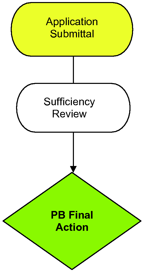
In the case of subdivisions defined by the foregoing Item A, the procedure for review and approval of subdivision plats as outlined in Sec. 4.4.5, Preliminary Plat Review Procedures, and Sec. 4.4.7, Final Plat Review Procedures, shall not apply. Instead, a plat shall be prepared of such subdivision and reviewed by the Planning Board, in accordance with the following review procedures:
1.
The Town of Highlands "Approval of Subdivision Not Meeting Minimum Lot Size" Label of Certification shall be affixed to said plat, as amended, shall be completed in full. The label of certification shall be lettered or rubber-stamped on the one (1) mylar copy in such a manner as to insure that said label will be legible on any prints made there from and on the two additional copies; all twenty-four inches by thirty-six inches (24" x 36") in size; and
2.
One (1) mylar copy plus two (2) additional copies of the final plat shall be provided to the Macon County and/or Jackson County Register of Deeds for recording by the Town of Highlands within sixty (60) days after the date of approval by the Planning Board; the Town shall retain one (1) additional copy for its records. Evidence that said plat has been properly recorded shall be filed with the Town Clerk. The Register of Deeds shall not record such a plat until said plat has been approved by the Planning Board. Without the approval of the Planning Board, the filing or recording of the plat shall be null and void.
Sec. 4.5 - Conditional Zoning Districts
4.5.1 Applicability
Conditional Zoning District decisions are legislative decisions subject to judicial review using the same procedures and standard of review as apply to general use zoning district decisions.
A.
When considering a petition for a conditional zoning district, the Board of Commissioners shall act in accordance with this Section. Notwithstanding the twelve-month prohibition in Sec. 4.3.1, Procedure for Amendment of Ordinance or Zoning Map, Item C, petitioner(s) may seek rezoning to a conditional zoning district or changes to an adopted conditional district until such time as the Board of Commissioners either denies or adopts the project as a conditional zoned district. Conditional Zoning Districts shall be allowed as outlined in Sec. 5.5, Conditional Zoning Districts Intent Statements, in accordance with the following procedures.
B.
Approval of a Conditional Zoning District does not relieve the applicant of the obligation to procure any other permit, as required by this Ordinance or State and Federal Law. These include, but are not limited to Sec. 4.7, Zoning Certification, Sec. 4.11, Infrastructure Approvals, Sec. 4.13, Landscape Plan Permits, Sec. 4.14, Land-Disturbing Activity Permits, Sec. 4.14.4, Erosion and Sedimentation Control Plan Requirements, Sec. 4.16, Stormwater Management Permit, and Sec. 4.17, Sign Permits, and any permit required by the North Carolina State Building Code.
(Amend. of 8-18-16(1); Amend. of 11-17-16(2))
4.5.2 Petition Submission Requirements
Property may be rezoned to a conditional zoning district only in response to a petition executed and submitted by all the owners of all of the property to be included in the district.
A.
An application for Conditional Zoning District shall be made per the requirements of Sec. 4.2.3, Application Requirements, and shall at a minimum contain the information listed below:
1.
A fully executed property owners' petition for conditional zoning. If the Petitioner is other than owner(s) an authorization form is required;
2.
Twenty (20) copies twenty-four inches by thirty-six inches (24" x 36") is required. It must be prepared by a professional land surveyor or engineer, legibly drawn to a scale of not less than two hundred (200) feet to one (1) inch, indicate the exact boundary lines of the parcel of property to be rezoned, list the owners names, zoning classifications, and watershed districts of the adjoining properties, and show the location of any existing buildings on the subject property;
3.
If a Conditional Zoning District is accompanied by a Site Specific Development Plan, it shall be drawn to an appropriate scale, and provide supporting information and text that specifies the actual use or uses intended for the property and any rules, regulations, and conditions that, in addition to all predetermined Ordinance requirements, will govern the development and use of the property. The following information must be provided on the Site Specific Development Plan, if applicable:
a.
A boundary survey and vicinity map showing the property's total acreage;
b.
The identity of neighboring properties;
c.
Its parcel identification number (PIN), current zoning designation and requested zoning, Watershed classification(s), and the zoning setback lines;
d.
Any adjacent streets, designated as public or private;
e.
The location of stands of old growth trees, streams, marshes, wetlands, bogs, rivers, impoundments, large rock outcroppings or other significant geological features on the subject property;
f.
All existing easements, reservations, and rights-of-way;
g.
All existing or proposed structures, showing setbacks to rights-of-way and property lines;
h.
Areas in which proposed structures will be located;
i.
Proposed use of all land and structures, including the number of residential units, the number of commercial buildings and the total square footage of any nonresidential development;
j.
All yards, buffers, screening, and landscaping required by these regulations per Sec. 4.13, Landscape Plan Permits, or proposed by the petitioner(s);
k.
All existing and proposed points of access to public streets;
l.
The location of existing and proposed storm drainage patterns and facilities intended to serve the proposed development;
m.
Parking areas showing the number and arrangement of parking spaces and driveway entrances and circulation;
n.
Proposed phasing, if any; including a complete Phased Development Plan and Phasing Schedule, including the date upon which construction is expected to begin and the date within which it is expected to be completed. Any Phasing schedule extending beyond the maximum five-year vested rights per Sec. 4.21.1, Establishment of a Vested Right for Conditional Zoning District, will require a development agreement with the Town; and
o.
The site plan shall be neatly drawn, with a north arrow, name and address of person who prepared the plan, date of the original drawing, and an accurate record of any later revisions.
4.
The Planning and Development Director has the authority to waive any application requirement where the type of use or scale of the proposal makes providing that information unnecessary or impractical;
5.
In addition to the foregoing petition requirements, the petitioner(s) shall submit a written statement with the petition analyzing the reasonableness of the proposed rezoning to a conditional zoning district. This statement shall address the compatibility of the proposed rezoning with the Comprehensive Plan, the proposed site and the surrounding area;
6.
In the course of evaluating the proposed use, the Planning and Development Director, the Zoning Board of Adjustment, the Planning Board, or the Board of Commissioners may request additional information from the petitioner;
7.
The site plan and any supporting text shall constitute part of the petition for all purposes under this Section; and
8.
The Planning and Development Director may require the petitioner to submit more than one copy of the petition and site plan for circulation to government agencies for review and comment.
B.
Approval of Petition
1.
When reviewing a petition for the reclassification of property to a conditional zoning district, proposed specific conditions to be applied to the proposed district may be submitted by the petitioner(s), the Town or its agencies, or any affected person, but only those conditions approved by the Board of Commissioners and consented to by the petitioner(s) in writing may be incorporated into this Ordinance and Zoning Map. Any such conditions should relate to the relationship of the proposed use to surrounding property, proposed support facilities such as parking areas and driveways, pedestrian and vehicular circulation systems, screening and buffer areas, the timing of development, street and right-of-way improvements, water and sewer improvements, stormwater drainage, erosion control, watershed protection, density, setbacks, structure height, the provision for open space, and other matters that the Board of Commissioners may find appropriate or the petitioner(s) may propose. The petitioner(s) shall have a reasonable opportunity to consider and respond to any such conditions prior to final action by the Board of Commissioners.
2.
A petition for reclassification of property to a conditional zoning district pursuant to this section, where such property is located partially or entirely within the Highlands Greenway, as shown on the "Town of Highlands Greenway Plan Map," shall not be granted without the dedication to the Town of Highlands of a recreation easement for a strip of property for said Greenway ranging between twenty-five (25) and fifty (50) feet in width, as determined to be necessary by the Town in its sole discretion, to promote the purposes of the Greenway project. Upon the effective date of a resolution of the Board of Commissioners that an easement dedicated to the Town of Highlands is no longer required for the Highlands Greenway, the easement shall terminate and the Town shall, upon request of the owner, and at the owner's expense, file in the Register of Deeds for Macon County or Jackson County an instrument providing for such termination as a matter of public record.
C.
Effect of Approval
1.
If property is rezoned to a conditional zoning district, the development and use of the property shall be governed by the predetermined ordinance requirements applicable to the district's category and use, the approved site plan for the district, and any additional approved rules, regulations, and conditions, all of which shall constitute the Zoning Ordinance for the approved district and are binding on the property as an amendment to this Ordinance and Zoning Map.
2.
If property is rezoned to a conditional zoning district, the petitioner shall comply with all requirements established Sec. 4.7, Zoning Certification, for obtaining a building permit and certificate of occupancy. Only those uses and structures indicated in the approved petition and site plan shall be allowed on the subject property.
D.
Amendments to Approved Conditional Zoning District
1.
Changes to an approved petition or to the conditions attached to the approved petition shall be treated the same as an application for a new conditional zoning district and shall be processed in accordance with the procedures in this Section.
E.
Review of Adopted Conditional Zoning Districts. It is intended that property shall be reclassified to a conditional zoning district only in the event of firm plans to develop the property. The Planning Board may examine the progress made toward developing the property in accordance with the approved petition and any conditions attached to the approval. If the Planning Board determines that progress has not been made in accordance with the approved petition and conditions, it may recommend in writing to the Board of Commissioners that the property be classified to another district.
(Amend. of 5-27-21(9); Amend. of 9-14-22(1), § 7)
Sec. 4.6 - Special Use Permit
4.6.1 Applications
A.
All applications for a Special Use Permit shall accompany or precede the application for a Zoning Certificate as provided in Sec. 4.7, Zoning Certification, or a Certificate of Compliance as provided in Sec. 4.7.7, Zoning Certificate of Compliance, as applicable.
B.
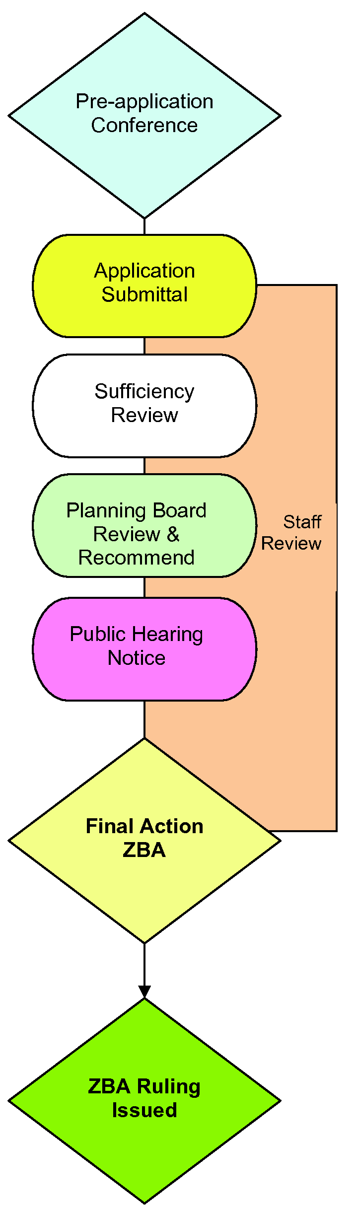
Prior to the consideration of any application for Special Use Permit as required per Article 6, Use Regulations, of this Ordinance, the Zoning Board of Adjustment shall require that an applicant submit an application to the Planning Board for review and recommendation. Special Uses which do not involve any change in the appearance of a building or premises shall not be required to be reviewed by the Planning Board. The Planning Board shall review an application at its next regularly scheduled meeting, not to exceed thirty (30) days after the date of application, and shall submit its report to the Zoning Board prior to the Zoning Board's next meeting. The Zoning Board shall not deny any application, however, on the basis of a negative recommendation from the Planning Board. In reviewing the application, the Planning Board may consider building design, relationship of building to site, relationship of project to adjoining area, landscape and site treatment, signs, lights, street hardware, miscellaneous structures, maintenance, and any other considerations it feels reasonably affect the appearance of the project.
C.
Approval of a Special Use Permit does not relieve the applicant of the obligation to procure any other permit, as required by this Ordinance or State and Federal Law. These include, but are not limited to Sec. 4.11, Infrastructure Approvals, Sec. 4.13, Landscape Plan Permits, Sec. 4.14, Land-Disturbing Activity Permits, Sec. 4.14.4, Erosion and Sedimentation Control Plan Requirements, Sec. 4.16, Stormwater Management Permit, and Sec. 4.17, Sign Permit, and any permit required by the North Carolina State Building Code.
(Amend. of 8-18-16(1))
4.6.2 Procedure
A.
All applications for a Special Use Permit shall be addressed and submitted to the Zoning Board of Adjustment and shall be delivered to the office of the Planning and Development Director. An application for Special Use Permit shall be made per the requirements of Section 4.2.3, Application Requirements, and shall at a minimum contain the information listed below. See also Item B, Multi-Family Buildings, Item C, Private Social Clubs and Item D, Nonprofit Visual Art Centers for additional Special Use Permit Requirements.
1.
A Site Plan and twenty (20) copies, drawn to an appropriate scale and supporting information and text that specifies the actual use or uses intended for the property and any rules, regulations, and conditions that, in addition to all predetermined ordinance requirements, will govern the development and use of the property. The following information must be provided on the Site Plan, if applicable:
a.
A boundary survey and vicinity map showing the property's total acreage;
b.
The identity of neighboring properties;
c.
Its zoning and Watershed classification(s), and the zoning setback lines;
d.
All adjacent streets, designated as public or private;
e.
The location of stands of old growth trees, streams, marshes, wetlands, bogs, rivers, impoundments, large rock outcroppings or other significant geological features on the subject property;
f.
All existing easements, reservations, and rights-of-way;
g.
All existing or proposed structures, showing setbacks to rights-of-way and property lines;
h.
Areas in which proposed structures will be located;
i.
Proposed use of all land and structures, including the number of residential units, the number of commercial buildings and the total square footage of any nonresidential development;
j.
All yards, buffers, screening, and landscaping required by these regulations per Sec. 4.13, Landscape Plan Permits, or proposed by the petitioner(s);
k.
All existing and proposed points of access to public streets;
l.
The location of existing and proposed storm drainage patterns and facilities intended to serve the proposed development;
m.
Parking areas showing the number and arrangement of parking spaces and driveway entrances and circulation;
n.
Proposed phasing, if any; including a complete Phased Development Plan and Phasing Schedule, including the date upon which construction is expected to begin and the date within which it is expected to be completed. Any Phasing schedule extending beyond the maximum five-year vested rights per Sec. 4.21.2, Establishment of a Vested Right for Special Use Permits, will require a Site Specific Development Plan and a development agreement with the Town; and
o.
The site plan shall be neatly drawn, with a north arrow, name and address of person who prepared the plan, date of the original drawing, and an accurate record of any later revisions.
2.
Elevations and a floor plan, indicating dimensions of the building, gross floor space, number of seats, or any other applicable information;
3.
A complete and detailed description of the use proposed, together with any other pertinent information which the applicant feels would be helpful to the Zoning Board of Adjustment in considering the application;
4.
A plan showing the size, type, and location of any signs proposed to be erected in conjunction with the use; and
5.
The Zoning Board of Adjustment may, in its sole discretion, waive the foregoing requirements where, for example, only minor construction, minor changes to parking areas, or changes only to the use of existing buildings is contemplated. See also Sec. 4.2.3, Application Requirements, Item E. Staff Consultation after Application Submitted.
B.
Upon receipt of an application for a Special Use Permit, the Zoning Board of Adjustment shall call a public hearing and shall give notice, as outlined in Sec. 4.2.4, Notice and Public Hearings. At the hearing, the applicant or designated representative thereof shall appear for the purposes of offering testimony and recommendations as to the application, and the Board shall also allot reasonable time for the expression of views by any member of the public attending the meeting in person or represented by an attorney.
C.
Prior to the public hearing before the Zoning Board of Adjustment the Planning Board shall review said request and present to the Zoning Board of Adjustment in writing its recommendation of any Special Use Permit applications received by the staff.
D.
The Zoning Board of Adjustment shall grant and issue the Special Use Permit if and only if it finds all of the following:
1.
The use will not materially endanger the public health or safety if located where proposed and developed according to the plan as submitted and approved;
2.
The use meets all required conditions and specifications;
3.
The use will not substantially injure the value of adjoining or abutting property or, in the alternative, the use is a public necessity; and
4.
The location and character of the use, as developed according to the plan as submitted and approved, will be in harmony with the area in which it is to be located and in general conformity with the plan of development of the Town and its environs.
E.
Within seven (7) days after making the decision required of it, the Zoning Board of Adjustment shall issue its written ruling, either granting or denying the Special Use Permit, and deliver copies thereof to the Planning and Development Director. The Planning and Development Director shall mail, by first class mail, to the address shown on the application, a copy of the written ruling to the applicant or his representative, but the failure to do so shall not affect the ruling.
F.
All construction approved pursuant to a Special Use Permit shall be completed in accordance with the construction schedule submitted in Sec. 4.6.2, Procedure, Item A.5, as approved by the Zoning Board of Adjustment. In the event that a significant departure from the construction schedule occurs during a project, the applicant may appear before the Board and request an amendment of the Special Use Permit. The Board may extend the construction schedule only upon a finding that delays in construction have been caused by, or are expected to be caused by, circumstances beyond the control of the applicant. Unless the construction scheduled is extended by amendment of the Special Use Permit, failure to complete construction within the approved time shall be considered a violation of the Special Use Permit, and subject to the sanctions provided in Article 15, Inspections, Violations and Enforcement.
(Amend. of 11-17-16(2))
4.6.3 Additional Application Requirements
A.
Multi-Family Buildings. An application for Special Use Permit for the Construction or Conversion of Multi-Family Buildings shall be made per the requirements of Section 4.2.3, Application Requirements, and shall at a minimum contain the information listed above in Item A, this Section as well as the following additional requirements:
1.
A current survey of the parcel as prepared by a professional land surveyor or professional engineer licensed and authorized to survey real property in North Carolina. The survey shall indicate the metes and bounds of the parcel, the total area of the parcel and expressed in square feet, the location of all public and private roads, the location of all public utility easements within the parcel or located less than fifty (50) feet from it, the location of all streams and watercourses, and the names of all adjacent property owners;
2.
A complete set of the construction plans and specifications for each building to be erected upon the parcel, the plans to include a certification of an architect or professional engineer, duly licensed by the appropriate North Carolina authority, that the plans and specifications are in accordance with all existing building, electrical, plumbing, fire, and safety codes of North Carolina and any other authority having jurisdiction over the construction of buildings. The construction plans and specifications shall clearly state the total horizontal surface area of land occupied by the multi-family building and the measurements of building height;
3.
A complete site and landscape plan showing the perimeter of the parcel, the location of all proposed improvements thereon, the location of all existing improvements thereon that shall remain upon the parcel at the time construction is completed, and the location and description of all proposed landscaping improvements and all dimensions and measurements; and
4.
A copy of the permit from the appropriate authority to construct or expand any water distribution or sewerage disposal system or, if applicable, a permit from the appropriate authority to connect to and use any existing public water supply or water treatment and disposal system.
B.
Private Social Clubs. An application for Special Use Permit for the Private Social Clubs shall be made per the requirements of Section 4.2.3, Application Requirements, and shall at a minimum contain the information listed above in Item A, this Section as well as the following additional requirements:
1.
Each application shall contain a current survey of the property showing the location on the site of all buildings or facilities;
2.
A complete description of all of the regular activities to be held at the club;
3.
A complete set of construction plans (if a new building) or floor plans (if an existing building converted to this use); and
4.
Stipulate the maximum number of members who will be permitted to join the club. If the club desires to increase the membership over the number allowed in the original permit, then the club must re-apply, and both the minimum parcel size and the amount of parking provided under Article 9, Parking and Loading, must be large enough to accommodate the increase in membership.
C.
Nonprofit Visual Art Centers. An application for Special Use Permit for the Nonprofit Visual Art Centers shall be made per the requirements of Section 4.2.3, Application Requirements, and shall at a minimum contain the information listed above in Item A, this Section as well as the following additional requirements:
1.
A current survey of the parcel as prepared by a professional land surveyor or professional engineer licensed and authorized to survey real property in North Carolina. The survey shall indicate the metes and bounds of the parcel, the total area of the parcel, and expressed in square feet, the location of all public and private roads, the location of all public utility easements within the parcel or located less than fifty (50) feet from it, the location of all perennial streams and watercourses, and the names of all adjacent property owners;
2.
A complete set of the construction plans and specifications for each building to be erected upon the parcel, the plans to include a certification of an architect or professional engineer, duly licensed by the appropriate North Carolina authority, that the plans and specifications are in accordance with all existing building, electrical, plumbing, fire, and safety codes of North Carolina and any other authority having jurisdiction over the construction of buildings. The construction plans and specifications shall clearly state the total horizontal surface area of land occupied by the visual art center building and the measurements of building height; and
3.
A complete site and landscape plan showing the perimeter of the parcel, the location of all proposed improvements thereon, the location of all existing improvements thereon that shall remain upon the parcel at the time construction is completed, and the location and description of all proposed landscaping improvements and all dimensions and measurements.
D.
Electronic Gaming Operations. An application for Special Use Permit for the Electronic Gaming Operation shall be made per the requirements of Section 4.2.3, Application Requirements, and shall at a minimum contain the information listed above in Item A, this Section as well as the following additional requirements:
1.
All applicable permits, including those for signage, must be issued to the applicant prior to the issuance of the Special Use Permit and the opening of business.
(Amend. of 8-18-16(1))
4.6.4 Additional Conditions as to Use
In addition to any other requirements provided by this Ordinance, the Zoning Board of Adjustment may, in issuing a Special Use Permit, designate additional conditions and requirements in connection with the application as will, in its opinion, assure that the use in its proposed location will be harmonious with the area in which it is proposed to be located and with the spirit of this Ordinance. All additional conditions shall be consented to in writing by the applicant and entered in the minutes of the meeting at which the permit is granted and also on the certificate of the Special Use Permit (or on the plans submitted therewith). All conditions so imposed shall run with the land and shall be binding upon the original applicant, as well as the applicant's heirs, successors, or assigns, during the continuation of the use conditionally permitted or any similar use. Conditions and safeguards imposed under this subsection shall not include requirements for which the local government does not have authority under statute to regulate nor requirements for which the courts have held to be unenforceable if imposed directly by the local government, including, without limitation, taxes, impact fees, building design elements within the scope of G.S. 160D-702(b), driveway-related improvements in excess of those allowed in G.S. 136-18(29) and G.S. 160A-307, or other unauthorized limitations on the development or use of land.
4.6.5 Sanctions
In the event of failure to comply strictly with the plans, documents, and other assurances submitted and approved with the application, or in the event of failure to comply with any conditions imposed upon the Special Use Permit as provided in Sec. 4.6.4, Additional Conditions as to Use, the permit shall thereupon immediately become void. No Zoning Certificate for further construction or Certificate of Compliance under the Special Use Permit shall be issued, and all improvements to the land which were the subject of the application shall thereupon be regarded as nonconforming and shall be subject to the sanctions provided in Article 15, Inspections, Violations and Enforcement, hereof.
(Amend. of 8-18-16(1))
4.6.6 Expiration of Special Use Permits
Unless a vested right is established for a Special Use Permit as outlined in Sec. 4.21.2, Establishment of a Vested Rights for Special Use Permits, a Special Use Permit issued in accordance with this Section shall expire if a Zoning Certificate or Certificate of Compliance for such use is not obtained by the applicant within twelve (12) months from the date of the decision. If, after commencing work under a Special Use Permit and prior to completion of the entire project, work is discontinued for a period of twelve (12) months, the Special Use Permit shall become void, and no work may be performed until a new Special Use Permit has been issued. If, after issuance of a Certificate of Compliance for a Special Use Permit, that use is discontinued for a period of twelve (12) consecutive months, the Special Use Permit shall become void, and the use may not be re-established until a new Special Use Permit has been issued. When a Special Use Permit expires, the Zoning Board shall treat re-application for a new Special Use Permit in the same manner as any other application, and the provisions of this Ordinance currently in effect shall be applicable.
Sec. 4.7 - Zoning Certification
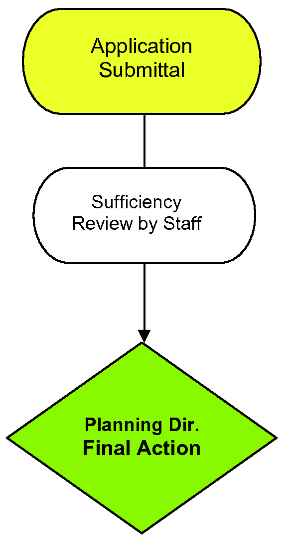
4.7.1 Applicability
No person shall commence or proceed with construction of any new building, fence or wall, as defined herein, or with the reconstruction, alteration, repair, moving, or demolition of any existing building, in any Zoning District, prior to the issuance of a Zoning Certificate, in accordance with the following procedures.
Unless provided otherwise by law, all rights, privileges, benefits, burdens, and obligations created by development approvals made pursuant to this Chapter attach to and run with the land.
4.7.2 Application Requirements
A.
Application for a Zoning Certificate shall be filed with the Planning and Development Director and may be made prior to or in conjunction with application for a permit under the North Carolina State Building Code, shall be made per the requirements of Sec. 4.2.3, Application Requirements, and shall at a minimum contain the information listed below. See also Sec. 4.7.3, Additional Requirements in Commercial Zoning Districts, and Sec. 4.7.8, Watershed Protection Permit.
1.
A Site Plan, drawn to an appropriate scale, of the parcel of property showing its actual dimensions and indicating the size, location, and distance from property lines of the proposed building, any other existing building(s), and any other improvements proposed to be accomplished, including but not limited to driveways, sidewalks, and parking areas;
2.
A drawing of the proposed building drawn to scale and in sufficient clarity and detail to indicate the nature and character of the work to be done, and consisting at minimum of a floor plan and elevations of the building (except, however, that the Planning and Development Director may approve minor construction work without compliance with this requirement);
3.
The use to which the completed project shall be devoted; and
4.
Any other information the Planning and Development Director may deem reasonably necessary to evaluate the compliance of the applicant's proposal with the provisions of this Ordinance.
B.
The Planning and Development Director shall review each element of the application and if he is satisfied that the work described therein complies with the Zoning Ordinance, he shall issue a Zoning Certificate; said Certificate may be issued prior to or in conjunction with application for a permit under the North Carolina State Building Code. After a Zoning Certificate has been issued, no changes or deviations from the terms of the application, plans, or permit shall be made until specific written approval has been obtained from the Planning and Development Director. If the Planning and Development Director finds the application to be deficient or the information contained therein to be contrary to the provisions of this Ordinance, he shall reject the application and deny the applicant's request for a Zoning Certificate in writing, setting forth the reasons for the rejection and denial.
C.
Approval of a Zoning Certificate does not relieve the applicant of the obligation to procure any other permit, as required by this Ordinance or State and Federal Law. These include, but are not limited to Sec. 4.13, Landscape Plan Permits, Sec. 4.14, Land-Disturbing Activity Permits, Sec. 4.14.4, Erosion and Sedimentation Control Plan Requirements, and Sec. 4.17, Sign Permit and any permit required by the North Carolina State Building Code.
D.
A Zoning Certificate shall expire twelve (12) months after the date of issuance if the work authorized has not been commenced. If after commencement the work is discontinued for a period of twelve (12) months, the Certificate shall immediately expire. Upon expiration, the Certificate shall become void, and no work may be performed until a new Certificate has been secured.
E.
A Zoning Certificate shall be in writing and may contain a provision requiring the development to comply with all applicable State and local laws. The Planning and Development Director may issue Zoning Certificates in print or electronic form. Any Zoning Certificate issued exclusively in electronic form shall be protected from further editing once issued.
F.
Applications for Zoning Certificates may be made by the landowner, a lessee or person holding an option or contract to purchase or lease land, or an authorized agent of the landowner. An easement holder may also apply for a Zoning Certificate for such development as is authorized by the easement.
(Amend. of 8-18-16(1); Amend. of 5-27-21(5); Amend. of 8-19-21(2))
4.7.2.1 Revocation of Zoning Certificate
In addition to initiation of enforcement actions under G.S. 160D-404, Zoning Certificates may be revoked by the Town by notifying the holder in writing stating the reason for the revocation. The Town shall follow the same development review and approval process required for issuance of the Zoning Certificate, including any required notice or hearing, in the review and approval of any revocation of that approval. Zoning Certificates shall be revoked for any substantial departure from the approved application, plans, or specifications; for refusal or failure to comply with the requirements of any applicable local development regulation or any State law delegated to the local government for enforcement purposes in lieu of the State; or for false statements or misrepresentations made in securing the approval. Any Zoning Certificate mistakenly issued in violation of an applicable State or local law may also be revoked. The revocation of a development approval by a staff member may be appealed pursuant to G.S. 160D-405. If an appeal is filed regarding a development regulation adopted by a local government pursuant to this Chapter, the provisions of G.S. 160D-405(e) regarding stays apply.
4.7.2.2 Permit Choice
If a development permit applicant submits a permit application for any type of development and a rule or ordinance is amended, including an amendment to any applicable land development regulation, between the time the development permit application was submitted and a development permit decision is made, the development permit applicant may choose which adopted version of the rule or ordinance will apply to the permit and use of the building, structure, or land indicated on the permit application. If the development permit applicant chooses the version of the rule or ordinance applicable at the time of the permit application, the development permit applicant shall not be required to await the outcome of the amendment to the rule, map, or ordinance prior to acting on the development permit. If an applicable rule or ordinance is amended after the development permit is wrongfully denied or after an illegal condition is imposed, as determined in a proceeding challenging the permit denial or the condition imposed, the development permit applicant may choose which adopted version of the rule or ordinance will apply to the permit and use of the building, structure, or land indicated on the permit application. Provided, however, any provision of the development permit applicant's chosen version of the rule or ordinance that is determined to be illegal for any reason shall not be enforced upon the applicant without the written consent of the applicant.
4.7.3 Additional Requirements in Commercial Zoning Districts
In addition to the foregoing, the following provisions shall apply to issuance of a Zoning Certificate in any commercial or other nonresidential zoning district.
A.
Development Activity
1.
No person shall commence or proceed with any grading, excavating, or underbrushing whatsoever for a building project in any commercial zoning district prior to the issuance of a Zoning Certificate. See also Sec. 4.14, Land-Disturbing Activity Permits.
2.
Pursuant to an act of the General Assembly of North Carolina, Chapter 828, House Bill 1469 (1986), no person shall remove, destroy, or severely damage, so as to cause to die, any large or medium tree eight (8) inches or more in diameter in connection with a building project in any commercial zoning district prior to the issuance of a Zoning Certificate. See also Sec. 4.12, Tree Removal Permits, and Sec. 4.14, Land-Disturbing Activity Permits.
B.
All new commercial construction, additions to existing commercial buildings, and remodeling of existing commercial buildings which would result in an increase in the number of business occupants in the buildings shall meet all zoning, parking and community appearance standards before being granted a zoning permit. If said standards are met, all "P" permitted uses shall be allowed by right. There shall be no variances granted for parking or community appearance standards.
C.
Application for a Zoning Certificate in a Commercial Zoning District shall include a Landscape and Buffer Plan per the requirements of Sec. 4.13, Landscape Plan Permits.
(Amend. of 10-18-18(1))
4.7.4 Construction or Reconstruction of Fences or Walls
No person shall commence with the construction of a fence or wall on any property without the issuance of a Zoning Certificate. Application for a Zoning Certificate shall be filed with the Planning and Development Director, and the information shall include a site plan indicating the proper setbacks, as well as a rendering of the proposed fence or wall design, including the height of the fence or wall. See Sec. 6.3.3 Residential Accessory Uses and Structures, (C) Fences and Walls and Sec. 6.5.2 Fences and Walls.
(Amend. of 6-20-19(2))
4.7.5 Structures Located Within Dedicated Rights-of-Way
A.
Certain structures are permitted to be located within dedicated rights-of-way of public or private roads without the issuance of a Zoning Certificate, provided they can be easily dismantled and relocated; do not obstruct vision, or otherwise interfere with pedestrian or vehicular traffic; and do not interfere with the public health, safety, or welfare. Such structures shall include decorative wooden fences, mailboxes, reflectors or mirrors associated with driveways, and other small decorative objects associated with residences. No temporary structures are allowed within six (6) feet of the wear surface of a road.
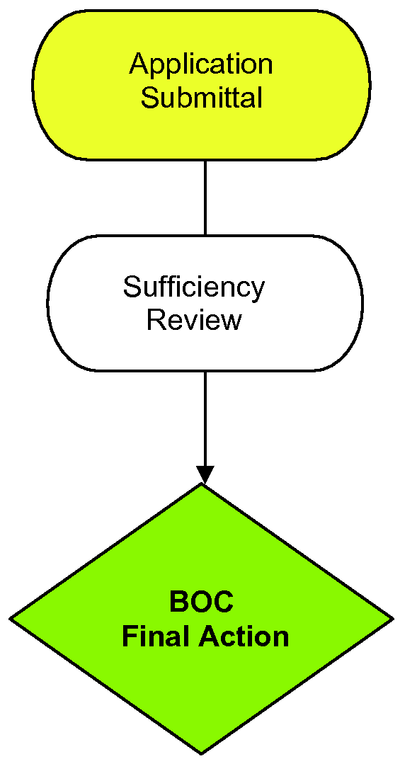
B.
Structures which are permanent and substantial, and which cannot be easily dismantled and relocated, shall not be erected within the right-of-way of any public or private road without the issuance of a Zoning Certificate. Such structures shall include permanent walls, such as those constructed of rock or railroad cross-ties; pillars; fences and gates constructed of substantial material, such as chain-link or iron; residential parking decks, whether constructed of fill dirt and retaining walls, or other methods; and private foot-[paths], golf-cart, or vehicular bridges or tunnels across rights-of-way. Required driveway entrances signs and street signs regulated by Article 10, Infrastructure, and temporary signs allowed within the dedicated rights-of-way regulated by Article 13, Sign Standards, are exempt. No Zoning Certificate shall be issued for such structures except upon resolution of the Board of Commissioners of the Town of Highlands and, in addition, the North Carolina Department of Transportation if the road is a part of the State-maintained system.
4.7.6 Structures Located in Wetlands
In addition to the requirements of Sec. 4.7.1, Applicability, of this Section, the following provisions shall apply to issuance of a Zoning Certificate for development on wetlands:
A.
Application for a Zoning Certificate in areas deemed by the Planning and Development Director to be wetlands shall include indication on the required Site Plan of any wetlands on the property and any areas to be disturbed.
B.
If the application proposes the disturbance of any areas identified as wetlands, the Planning and Development Director shall not issue a Zoning Certificate until the applicant has submitted an application to the U.S. Army Corps of Engineers and received the appropriate permit from that organization.
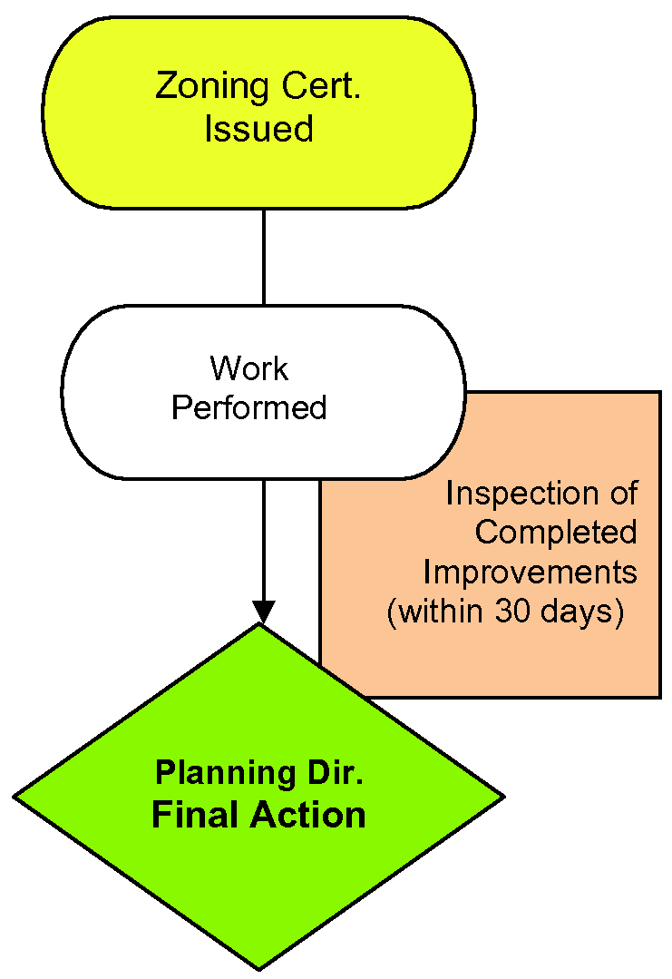
4.7.7 Zoning Certificate of Compliance
See also Sec. 4.7.9, Watershed Protection Occupancy Permit.
A.
If any repairs, improvements, or alterations shall be performed upon any premises for which a Zoning Certificate shall be issued, a Certificate of Compliance shall be secured from the Planning and Development Director within thirty (30) days from the completion thereof.
B.
The Certificate of Compliance shall certify that the Planning and Development Director has inspected the completed improvements and that the improvements, together with the proposed use thereof, are in conformity with the Zoning Certificate and the provisions of this Ordinance.
C.
No new building or part thereof may be occupied, and no addition or enlargement of any existing building may be occupied, and no existing building that has been altered or moved may be occupied until the Certificate of Compliance has been issued.
D.
The Planning and Development Director may, in his discretion, issue a Temporary Certificate of Compliance permitting occupancy of specified portions of an uncompleted building or project for a limited time provided the following conditions are met:
a.
The initial temporary Certificate of Compliance time shall be stipulated and shall not exceed six (6) months, if the Planning and Development Director finds that the portion of the building or project may be safely occupied prior to the final completion of the entire building or project. The Planning and Development Director may renew, at his discretion, the Temporary Certificate of Compliance for one additional extension of not more than four (4) months. No further extensions shall be granted.
b.
The applicant shall provide a professional cost estimate for work to be completed.
c.
The applicant shall provide cash, certified check, bond or Irrevocable Letter of Credit (bond or letter of credit must be approved by the Town attorney) for 125% of the cost estimate.
d.
Applicant's bond or letter of credit must be good for a minimum of 30 days longer than the Temporary Certificate of Compliance. If cash or certified check is used the applicant must provide a letter of understanding that the Town has the authority to disburse said money to complete the project if work is not complete within approved time frame.
(Amend. of 8-18-16(1); Amend. of 10-20-16(1))
4.7.8 Watershed Protection Permit
A.
In addition to the requirements of Sec. 4.7, Zoning Certification, within any Watershed Overlay District defined by this Ordinance, no development shall occur, nor shall any building be erected, moved, enlarged or structurally altered, nor shall any building permit be issued, nor shall any change in the use of any building or land be made, until a Watershed Protection Permit has been issued by the Watershed Administrator. No Watershed Protection Permit shall be issued except in conformity with the provisions of this Ordinance.
B.
Application for a Watershed Protection Permit may be filed in conjunction with Zoning Certificate, and must meet all of the requirements of Sec. 4.7.2, Application Requirements, and shall contain the additional information listed below:
•
The dimensions of any portion of a development that is impervious or partially impervious, with the total area of built-upon development calculated if applicable.
C.
A Watershed Protection Permit shall expire per the procedures outlined in Sec. 4.7.2, Application Requirements, Item D.
4.7.9 Watershed Protection Occupancy Permit
A.
In addition to the requirements of Sec. 4.7.7, Zoning Certificate of Compliance, within any Watershed Overlay District defined by this Ordinance, the Watershed Administrator shall issue a Watershed Protection Occupancy Permit certifying that all requirements of this Ordinance have been met prior to the occupancy or use of a building hereafter erected, altered, or moved, and/or prior to the change of use of any building or land. No Watershed Protection Occupancy Permit shall be issued until an inspection of the premises has been made by the Watershed Administrator pursuant to Sec. 15.1.2, Inspections.
B.
No building or structure which has been erected, moved, or structurally altered may be occupied until the Watershed Administrator has approved and issued a Watershed Protection Occupancy Permit.
C.
If the Watershed Protection Occupancy Permit is denied, the Watershed Administrator shall notify the applicant in writing stating the reasons for denial.
(Amend. of 8-18-16(1))
Sec. 4.8 - Outdoor Display
4.8.1 Applicability
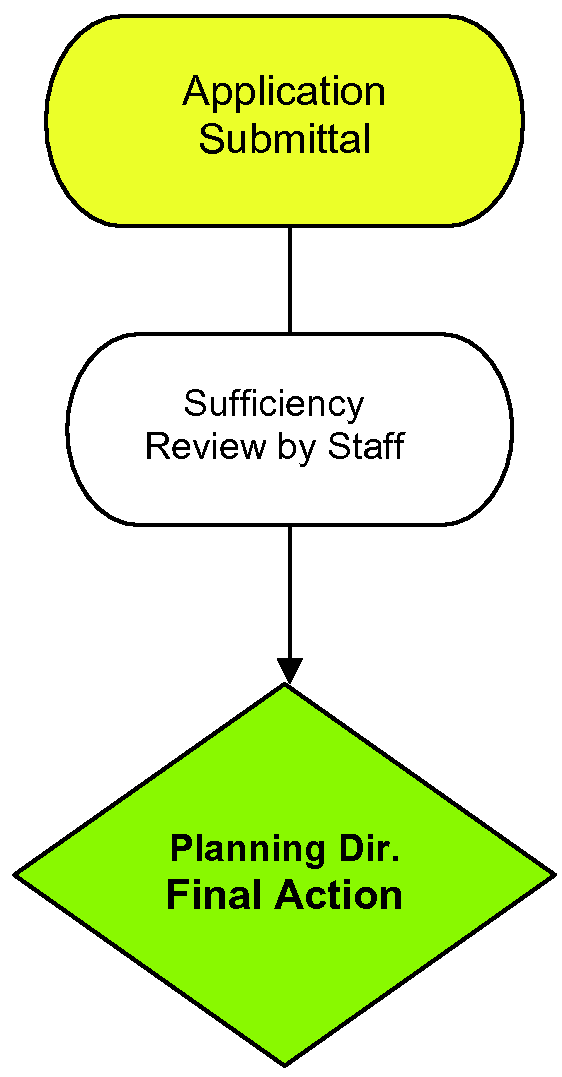
Outdoor display shall be allowed in specific Zoning Districts as outlined in Sec. 6.5.4, Outdoor Display of Merchandise, in accordance with the following procedures.
(Amend. of 8-18-16(1))
4.8.2 Application Requirements
An application for outdoor display shall be made per the requirements of Sec. 4.2.3, Application Requirements, and shall at a minimum contain the information listed below:
A.
The name, address and phone number of the commercial establishment;
B.
The name, address and phone number of the business owner;
C.
A recent survey of the subject property, showing the proposed area for the outdoor display and the location of existing public and private sidewalks and walkways;
D.
A description of the general nature of the items to be displayed; and
E.
A recent photograph from all adjacent streets of the subject property and the adjoining properties with the same street frontage.
Sec. 4.9 - Tower and Antennae Use Certificate
4.9.1 Applicability
New Wireless Communication Faciliites shall be allowed as outlined in Sec. 6.6, Wireless Communication Facilities, in accordance with the following procedures and shall be subject to all applicable development criteria of Sec. 10.7, Wireless Communication Facilities, and Article 11, Landscape, Screening and Buffers, and Article 13, Sign Standards.
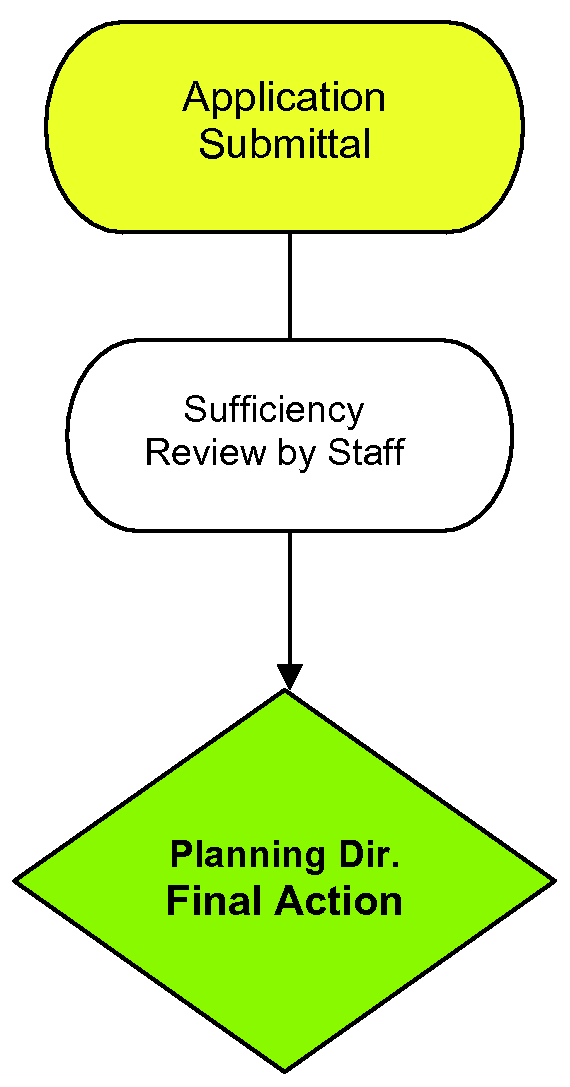
A.
Wireless Communication Facilities subject to Planning and Development approval.
1.
Attachments to existing Support Structures or Attached Wireless Communication Facilities. Antenna attachments onto existing Support Structures or Attached Wireless Communication Facilities shall be permitted by administrative approval of the Planning and Development Director.
2.
Attachments on lands identified in Table A, Sec. 6.6.3, Preferred Location for Wireless Communication Facilities and Applicability. Antenna attachments or Wireless Communication Facilities with support structures located on lands identified in Table A, Sec. 6.6.3 shall be permitted by administrative approval of the Planning and Development Director.
B.
Wireless Communication Facilities subject to Zoning Board of Adjustment approval. All other Wireless Communication Facilities are subject to the requirements of a Sec. 4.6, Special Use Permit, as well as the specific requirements below in Sec. 4.9.2, Application Requirements.
4.9.2 Application Requirements
A.
An application for tower and antennae shall be made per the requirements of Sec. 4.2.3, Application Requirements, and shall at a minimum contain the information listed below:
1.
The name, phone number, address of the owner of the property, if they are not the owner of the Wireless Communication Facilities;
2.
The name, phone number, address of the owner of the Wireless Communication Facilities;
3.
A location map for the Wireless Communication Facility noting either it is:
a.
An attachment to existing support structures or attached Wireless Communication Facilities; or
b.
An attachment to lands.
4.
A Site Plan drawn to an appropriate scale and showing or containing the following information demonstrating compliance with the applicable development standards of this Ordinance. This includes but is not limited to:
a.
Proposed structure height;
b.
Required setbacks;
c.
A planting plan showing the required landscape buffer and any other screening, including proposed berms and fencing;
d.
Any other supporting details or information related to the proposed aesthetics, placement, materials and colors, lighting and signage; and
5.
Any other related information requested by the Planning and Development Director shall be supplied by the applicant as part of the application.
B.
Applicants for facilities described in Sec. 4.9.1, Applicability, Item B above, shall provide the Town with adequate information to establish that the lands identified in Table A cannot be made suitable for Wireless Communication Facility locations. Proposals shall not be approved unless the applicant can demonstrate that such facilities cannot be accommodated on existing or approved towers, buildings, or alternative structures within a one-half-mile search radius of the proposed wireless communications facility due to one or more of the following reasons:
1.
The planned equipment would exceed the structural capacity of the existing or approved tower, building or structures, as documented by a qualified and licensed North Carolina professional engineer, and the existing or approved tower, building, or structure cannot be reinforced, modified, or replaced to accommodate planned or equivalent equipment at a reasonable cost;
2.
The planned equipment would cause interference materially impacting the usability of other existing or planned equipment at the tower, building, or other structure, as documented by a qualified and licensed North Carolina engineer, and the interference cannot be prevented at a reasonable cost;
3.
Existing or approved towers, buildings, or other structures within the search radius, or combinations thereof, cannot accommodate the planned equipment at a height necessary to function reasonably, as documented by a qualified and licensed North Carolina professional engineer; and
4.
Other unforeseen reasons make it infeasible to locate the planned telecommunication equipment upon an existing or approved tower, building, or other structure.
Sec. 4.10 - Shared Parking for Restaurants
4.10.1 Applicability
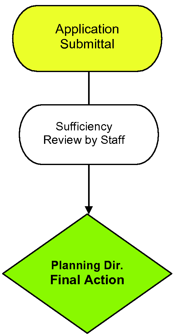
Public Parking and Dual-Use Parking Spaces shall be allowed in specific Zoning Districts as outlined in Sec. 9.2, Shared Parking for Restaurants, in accordance with the following procedures.
4.10.2 Dual-Use Parking Application Requirements
An application for dual-use shall be made per the requirements of Sec. 4.2.3, Application Requirements, and shall at a minimum contain the information listed below:
A parking study and a Site Plan, drawn to an appropriate scale, prepared by the applicant, at the applicant's expense, which shall contain the following information and locations:
A.
All parking spaces on the property owned by the restaurant;
B.
All parking spaces to be designated as Dual-Use Parking Spaces on property owned by others;
C.
The schedule when the Dual-Use Parking Spaces will be used;
D.
A statement, with supporting information, showing that the sharing of the Dual-Use Parking Spaces will not result in conflicting or overlapping usage of the parking facilities;
E.
Proof of the lease as outlined in Sec. 9.2.3, Use of Dual-Use Off-Street Parking; and
F.
Any other related information deemed necessary by the Planning and Development Director.
4.10.3 Public Parking Spaces Application
An application for public parking spaces shall be made per the requirements of Section 4.2.3, Application Requirements, and shall at a minimum contain the information listed below:
A.
A Site Plan, drawn to an appropriate scale, and showing or containing the following information:
1.
The floorplan of the restaurant, showing existing and proposed seating areas (both indoor and outdoor);
2.
A notation of the existing square feet of the interior area of the restaurant;
3.
Adjacent street names;
4.
Existing parking (both public and private);
5.
Location of Public Parking Spaces requested to be utilized;
6.
Identification of land uses of adjacent properties;
7.
The Macon County property identification number (PIN) of the restaurant parcel.
B.
The street address of the restaurant;
C.
A statement of the number of employees on the restaurant's largest shift; and
D.
Any other related information requested by the Planning and Development Director shall be supplied by the applicant as part of the application.
E.
If the restaurant is located in a shopping center or unified development, the following additional information shall be provided with the Public Parking Spaces application and shown on the Site Plan:
1.
The location of all common parking areas;
2.
The total number of common parking spaces;
3.
The location of all parking spaces in the common parking area that are allocated to the restaurant;
4.
The number of parking spaces in the common parking area that are allocated to the restaurant;
5.
The area, in square feet, of all other uses in the shopping center; and
6.
The parking requirements of all other uses in the shopping center.
Sec. 4.11 - Infrastructure Approvals
4.11.1 Applicability
Streets, sidewalks, trails and related facilities as outlined in Article 10, Infrastructure, and electrical service, water service and sewer service as outlined in the Public Works Specifications Manual, shall be allowed in accordance with the following procedures.
4.11.2 Prior Approval
A Certificate of Compliance, per the requirements of Sec. 4.7.7, Zoning Certificate of Compliance, shall be secured from the Planning and Development Director before the making of a permanent connection to electrical service, water service, or sewer service.
(Amend. of 8-18-16(1))
4.11.3 Performance Bond
A.
The Board of Commissioners, at their discretion, may require the submittal of a performance security or bond with surety, cash escrow, letter of credit or other acceptable legal arrangement prior to issuance of a preliminary plat or other site plan or permit approval in order to ensure that the infrastructure for a subdivision, or conditional zoning district are installed by the permit holder as required by the approved plans and permits.
B.
The amount of an installation performance security shall be the total estimated construction cost of the approved infrastructure, plus twenty-five percent (25%).
4.11.4 Procedure
The procedures below only apply to Board of Commissioners review of streets, electrical service, water service and sewer service for consideration of Preliminary Plat submittal as outlined in Sec. 4.4.4, Preliminary Plat Requirements, or review of information as required in Sec. 4.5, Conditional Zoning Districts, or Sec. 4.6, Special Use Permits or any other Site Plan reviews performed by the Planning and Development Director, in order to assist the review authority with consideration of the application requirements. Additional infrastructure requirements, including forms, fees and deadlines are outlined in the Public Works Specifications Manual.
A.
Streets. Plans for all streets within the Town of Highlands shall conform to the standards and specifications of the Town, as set forth in Article 10, Infrastructure, and the Public Works Specifications Manual. The subdivider shall provide proof of the following:
1.
Town of Highlands Streets: All streets which are subject to the review authority of the Town of Highlands, as established by Sec. 10.1.2, Infrastructure Review Authority.
a.
Plans for all proposed Town of Highlands streets, whether designated "public" or "private," pursuant to this Ordinance shall be prepared by a duly qualified registered North Carolina professional engineer, professional land surveyor or landscape architect and the engineer, surveyor or landscape architect shall perform services only in their area of competence and shall verify that the design of all street facilities and practices meets the submittal requirements for complete applications, that the designs and plans are sufficient to comply with applicable standards and policies found in this Ordinance and other standards of the Town, and that the designs and plans ensure compliance with the requirements of this Ordinance.
b.
The plan shall be forwarded to the Town Engineer and Public Works Director, or his or her authorized representative qualified to review such plans as designated by the Town of Highlands for review and recommendation, at the subdivider's expense. The Town Engineer or his designee shall submit a written report to the Town certifying that the plans meet the standards and specifications of the Town, as set forth in Article 10, Infrastructure, and the Public Works Specifications Manual.
c.
At the same time, the subdivider's qualified design professional shall establish and submit an inspection schedule for the improvements installations, including any proposed phasing. See also Sec. 10.6, Improvements and Installations.
d.
No work shall commence on the installation of public or private streets until the report of the Town Engineer or his designee has been received and the preliminary plat has been approved by the Board of Commissioners.
2.
NCDOT Streets: Plans for all such streets shall be reviewed and approved by the District Engineer of the NCDOT prior to preliminary plat approval, so that said streets, when constructed and completed, will be eligible for acceptance into the State Highway System.
B.
Water and Sewer
1.
Where a public water or sewer system is proposed, the developer must provide sketch plans prepared by a N.C. professional engineer and letter of approval from the appropriate State agency indicating that such plans have been reviewed and approved by the administrators of the system(s) and the appropriate State agency. Plans shall show water and sewer system layouts (excluding individual wells and septic systems), showing the location of lines, line sizes, approximate location of manholes, pumps, hydrants, force mains, and the connection of the proposed system(s) with existing systems.
2.
Where public water or public sewer is not available for each lot in the subdivision and individual systems will be used, a letter of approval from the Macon County and/or Jackson County Health Department shall be submitted with the preliminary plat, indicating that each lot has adequate land area and soil conditions to accommodate the proposed methods of water supply and sewage disposal.
C.
Electrical. A letter of approval from the Town Engineer shall be submitted with the preliminary plat.
(Amend. of 8-18-16(1))
Sec. 4.12 - Tree Removal Permits
4.12.1 Applicability
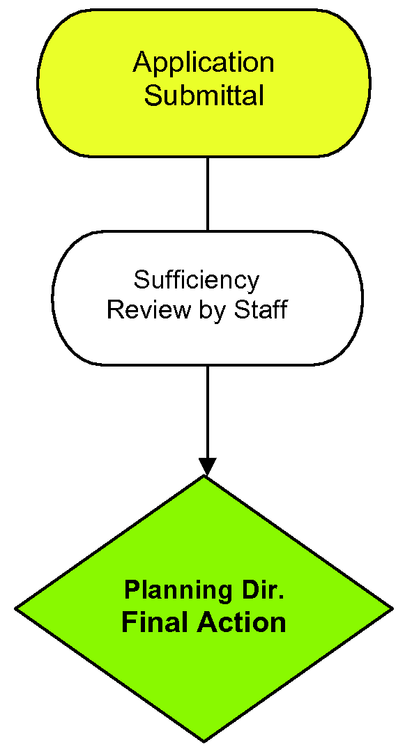
Tree removal where land-disturbing activity is planned for development shall be as outlined in Sec. 4.14, Land-Disturbing Activity Permits. Where no commercial building project is approved, tree removal in any commercial or other nonresidential district shall be as outlined in Sec. 11.2.2, Tree Protection, and in accordance with the following procedures.
4.12.2 Application Requirements
An application for tree removal shall be made per the requirements of Section 4.2.3, Application Requirements, and shall at a minimum contain the information listed below:
A.
A Site Plan, drawn to an appropriate scale, prepared by the applicant, at the applicant's expense, which shall contain the following information:
1.
Locations and species of tree(s) proposed to be removed; and
2.
Locations and species of required replacement tree(s); and
3.
Locations and types of tree protection devices to be provided around adjacent trees on the property that could potentially be damaged.
B.
A statement, with supporting information; identify why the tree is to be removed:
1.
Reason for removal must comply with Sec. 11.2.2, Tree Protection.
C.
Any other related information deemed necessary by the Planning and Development Director.
(Amend. of 8-21-14)
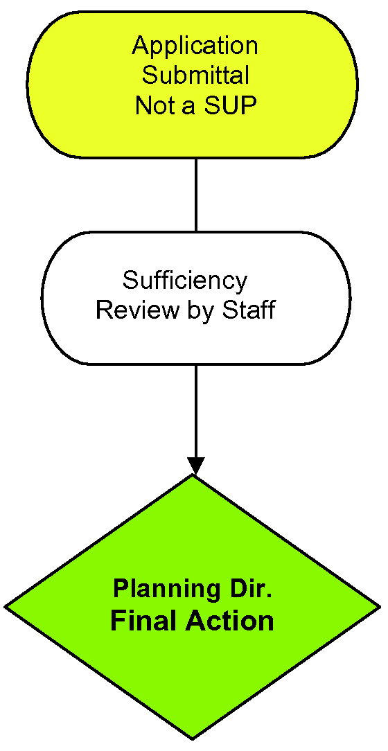
Sec. 4.13 - Landscape Plan Permits
4.13.1 Applicability
Vehicular Use Landscape and Landscape Buffer Plans shall be required as outlined in Article 11, Landscape, Screening and Buffers, in accordance with the following procedures:
A.
Approval for Permitted Uses. For permitted uses, landscape and buffer plans shall be approved by the Planning and Development Director.
B.
Approval for Special Uses. For uses permitted upon issuance of a Special Use Permit, such plans shall be approved by the Zoning Board of Adjustment as outlined in Sec. 4.6, Special Use Permit.
4.13.2 Application Requirements
A.
An application for a landscape permit shall be made per the requirements of Sec. 4.2.3, Application Requirements, Sec. 11.3, Vehicular Use Area Landscaping, and Sec. 11.4, Landscape Buffers and Screening, and shall at a minimum contain the information listed below:
1.
The name, phone number, address of the owner of the property;
2.
The name, phone number, address of the contractor to do the landscape work;
3.
A location map for the project;
4.
A Site Plan drawn to an appropriate scale;
5.
All required landscape areas, landscape strips and landscape buffers shall be noted including required width and plant quantity calculations;
6.
All existing trees and shrubs to be saved. For property of more than one-half (½) acre, groups of existing trees or shrubs in close proximity that the owner plans to save may be designated on the plan by predominant type, estimated number, and average diameter;
7.
All trees and shrubs to be newly planted. A plant legend shall be provided including the botanical and common names of proposed trees and shrubs and the minimum plant sizes at installation; and
8.
Any other related information deemed necessary by the Planning and Development Director.
Sec. 4.14 - Land-Disturbing Activity Permits
4.14.1 Applicability
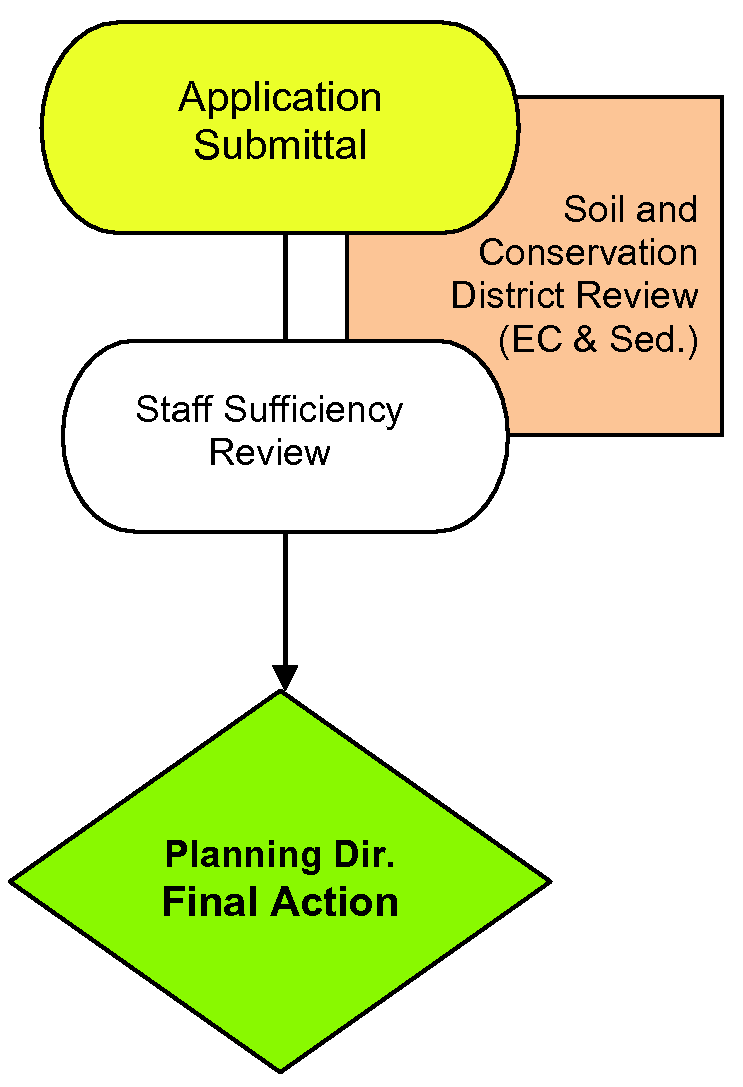
A.
Certain land-disturbing activities shall be allowed without a land-disturbing activity permit as set forth in Sec. 12.4.3, Scope and Exclusions, however land-disturbing activities described in Sec. 12.4.3, Item C.6, shall require a waiver of permit from the Planning and Development Director. See also Sec. 4.18, Variances. Land-disturbing activity requiring a permit shall be allowed in accordance with the following procedures.
B.
Prior Plan Approval. No person shall initiate any land-disturbing activity that requires a permit unless thirty (30) or more days prior to initiating the activity, a plan for the activity is filed with and approved by the Town. An Erosion and Sedimentation Control Plan may be filed less than thirty (30) days prior to initiation of a land-disturbing activity if the plan is submitted under an approved express permit program, and the land-disturbing activity may be initiated and conducted in accordance with the plan once the plan has been approved. The land-disturbing activity shall be conducted in accordance with the approved erosion and sedimentation control plan. See also Sec. 4.14.4, Erosion and Sedimentation Control Plan Requirements.
C.
Table
* Unless the activity is allowed without a land-disturbing activity permit as set forth in Sec. 12.4.3, Scope and Exclusions.
4.14.2 Application for Land-Disturbing Permit
Application for a land-disturbing permit shall be made on the proper form obtainable at the Town office and shall be accompanied by a site plan indicating the nature and location of all land-disturbing activities proposed for the site that may cause or contribute to soil erosion and sedimentation, together with adequate erosion control measures. The site plan shall be detailed enough to enable the Planning and Development Director to determine the extent of the land-disturbing activity proposed, and may be filed in conjunction with application for a Zoning Certificate pursuant to Sec. 4.7, Zoning Certification. A physical inspection of the site may also be conducted prior to issuance of the permit. See also Sec. 4.14.3, Steep Slope Protection Plan Requirements, for additional requirements that may be required before a land-disturbing permit is issued.
A.
Content. An application for land-disturbing activity shall be made per the requirements of Section 4.2.3, Application Requirements, and shall at a minimum also contain the information listed below. Plans described in items B and C below need not be prepared by an engineer.
1.
The name, phone number, address of the owner of the property;
2.
The name and phone number of the grading contractor who will do the work on the property, and documentation that the grading contractor holds a current Macon County or Jackson County grading license;
3.
The watershed district in which the property is located;
4.
The total disturbed area in square feet;
5.
The name of the adjoining stream or lake;
6.
The nature of the land-disturbing activity;
7.
The greatest slope of the area to be disturbed.
B.
For areas less than one (1) acre, as outlined in Sec. 4.14.1, Applicability, Item C, Table, submit Site Plan per Sec. 4.14.3, Steep Slope Protection Site Plan Requirements, where required; and
C.
For areas more than one (1) acre or of any size between sixty and one hundred percent (60 - 100%) slope, as outlined in Sec. 4.14.1, Applicability, Item C, Table, complete and submit an Erosion and Sedimentation Control Plan and accompanying documents per Sec. 4.14.4, Erosion and Sedimentation Control Plan Requirements.
4.14.3 Steep Slope Protection Site Plan Requirements
See Sec. 12.5.1, Steep Slope Protection, for each defined category. Where steep slope protection is applicable, an application for land-disturbing activity shall be made per the requirements of Section 4.2.3, Application Requirements, and shall at a minimum contain the information listed below.
A.
Category 1. The plan shall be drawn to an appropriate scale and show:
1.
The boundaries of the tract;
2.
The topography and degree of slope;
3.
The location of all existing structures and roads on the tract;
4.
The boundary of the area to be disturbed; and
5.
The location of all structures and roads to be installed on the tract.
B.
Category 2. In Category 2, the person wishing to conduct the land-disturbing activity shall file a plan containing the same information required in Category 1, with the following additional information:
1.
Statement of measures to be used to further the basic control objectives;
2.
Statement of other best management practices to be employed;
3.
Detail and locations of wire backed silt fencing;
4.
Driveway detail, including length, gradient and paving materials specifications; and
5.
Ground cover planting schedules.
C.
Category 3. For any land-disturbing activity in Category 3, regardless of size, the person wishing to conduct the LDA shall submit a soil and erosion control plan as required in the following Section of this Ordinance and meet all of the requirements listed in Category 2 above.
4.14.4 Erosion and Sedimentation Control Plan Requirements
At least thirty (30) days prior to commencing or undertaking a land-disturbing activity that will uncover or disturb more than one (1) acre of a tract or a land-disturbing activity of any size if it occurs within Steep Slope Protection Category 3, the person shall file three (3) copies of a proposed erosion and sedimentation control plan ("plan") with the office of the Planning and Development Director and one (1) copy of the proposed plan with the Macon or Jackson Counties Soil and Water Conservation District. The Town shall forward to the Director of the North Carolina Division of Water Quality one (1) copy of each plan for a land-disturbing activity that involves the utilization of ditches for the purpose of de-watering or lowering the water table of the tract.
A.
General - Contents of Plan. The proposed plan shall be prepared per the requirements of the Town of Highlands "Erosion and Sedimentation Control Plan Preliminary Review Checklist", as amended. A copy of the current checklist shall be kept on file by the Town and shall be distributed to each person who wishes to submit a proposed plan. The plan shall be drawn to an appropriate scale and at a minimum contain the information listed below:
1.
All information required in Sec. 4.14.2, Application for Land-Disturbing Permit, Item A, Content;
2.
General site features;
3.
Site drainage features;
4.
Required design calculations;
5.
Erosion control measures;
6.
Vegetative stabilization;
7.
Plan designer's signature and date.
B.
Additional Documents. Along with submission of the Plan, the applicant shall submit the following information:
1.
Required narratives;
2.
Completed Financial Responsibility Form;
3.
Bid specifications for erosion control; and
4.
Construction sequence.
C.
Financial Responsibility/Ownership. "Financial Responsibility/Ownership Form" on the checklist will be signed by the person financially responsible for the land-disturbing activity or his attorney in fact. The statement shall include the mailing and street addresses of the principal place of business of: (1) the person financially responsible, (2) the owner of the land, and (3) any registered agents. If the person financially responsible is not a resident of North Carolina, a North Carolina agent must be designated in the statement for the purpose of receiving notice of compliance or noncompliance with the plan, the Sediment Pollution Control Act of 1973, this article, or rules or orders adopted or issued pursuant to this article. If the applicant is not the owner of the land to be disturbed, the draft erosion and sedimentation control plan must include the owner's written consent for the applicant to submit a draft erosion and sedimentation control plan and to conduct the anticipated land-disturbing activity.
D.
Environmental Policy Act Document. Any plan submitted for a land-disturbing activity for which an environmental document is required by the North Carolina Environment Policy Act (G.S. 113A-1 et seq.) shall be deemed incomplete until a complete environmental document is available for review by the Town. The Town shall promptly notify the person submitting the plan that the thirty-day time limit for review of the plan pursuant to this article shall not begin until a complete environmental document is available for review.
E.
Soil and Water Conservation District Comments. The district shall review the plan and submit any comments and recommendations to the Town within twenty (20) days after the district received the plan, or within any shorter period of time as may be agreed upon by the district and the Town. Failure of the district to submit its comments and recommendations within twenty (20) days or within any agreed-upon shorter period of time shall not delay final action on the plan.
F.
Deadline for Decisions on Proposed Plans. The Town will review each complete plan submitted to them and within thirty (30) days of receipt thereof will notify the person submitting the plan in writing that it has been approved, approved with modifications, approved with performance reservations, or disapproved. Failure to approve, approve with modifications, or disapprove a complete plan within thirty (30) days of receipt shall be deemed approval.
G.
Deadline for Decisions on Revised Plans. The Town will review each revised plan submitted to it and within fifteen (15) days of receipt thereof and will notify the person submitting the plan in writing that it has been approved, approved with modifications, approved with performance reservations, or disapproved. Failure to approve, approve with modifications, or disapprove a revised plan within fifteen (15) days of receipt shall be deemed approval.
H.
Approval. The Town shall only approve a plan upon determining that it complies with all applicable State and local regulations for erosion and sedimentation control. The Town will not approve any plan that does not comply with all applicable Federal and State laws, regulations and rules. The Town shall condition approval of all plans upon the applicant's continuing compliance with Federal and State water quality laws, regulations and rules. The Town may establish an expiration date, not to exceed three (3) years, for plans approved under this article.
I.
Disapproval for Content. The Town may disapprove a plan or revised plan based on its content. A disapproval based upon a plan's content must specifically state in writing the reasons for disapproval.
J.
Other disapprovals. The Town may disapprove a plan for the following reasons not based upon the content of the plan:
1.
Where implementation of the plan would result in a violation of the rules adopted by the North Carolina Environmental Management Commission to protect riparian buffers along surface waters.
2.
Where the applicant, or a parent, subsidiary, or other affiliate of the applicant:
a.
Is conducting or has conducted land-disturbing activity without an approved plan, or has received notice of violation of a plan previously approved by the commission or a local government pursuant to the Sediment Pollution Control Act of 1973, and has not complied with the notice within the time specified in the notice;
b.
Has failed to pay a civil penalty assessed pursuant to the Sediment Pollution Control Act of 1973, or a local ordinance adopted pursuant to the Sediment Pollution Control Act of 1973 by the time the payment is due;
c.
Has been convicted of a misdemeanor pursuant to G.S. 113A-64(b), or any criminal provision of a local ordinance adopted pursuant to the Sediment Pollution Control Act of 1973; or
d.
Has failed to substantially comply with state rules or local ordinances and regulations adopted pursuant to the Sediment Pollution Control Act of 1973.
K.
For disapprovals not based upon the content of a proposed plan, an applicant's record may be considered for only the two (2) years prior to the application date.
L.
In the event a disapproval is not based upon the content of a proposed plan, the Town shall notify the Director of such disapproval within ten (10) days. The Town shall advise the applicant and the Director in writing as to the specific reasons that the plan was disapproved.
M.
Notice of Activity Initiation. At least ten (10) days prior to the undertaking of a land-disturbing activity requiring a permit or plan, the person conducting the land-disturbing activity shall notify the Town of the date that the land-disturbing activity shall commence.
N.
Preconstruction Conference. When deemed necessary by the Town, a preconstruction conference may be required.
O.
Display of Plan Approval. A plan approval issued under this article shall be prominently displayed or kept on file at the job site until all construction is complete, all permanent sedimentation and erosion control measures are installed and the site has been stabilized.
P.
Revised Plan. After approving a plan, if the Town either upon review of such plan or on inspection of the job site, determines that a significant risk of accelerated erosion or off-site sedimentation exists, or that the plan is inadequate to meet the requirements of this article, the Town shall require a revised plan. Pending the preparation of the revised plan, work shall cease or shall continue under conditions outlined by the Town or other appropriate authority.
Q.
Amendment to a Plan. Applications for amendment of a plan in written and/or graphic form may be made at any time under the same conditions as the original application. Until such time as said amendment is approved by the Town, the land-disturbing activity shall not proceed except in accordance with the plan as originally approved.
R.
Failure to File a Plan. Any person engaged in land-disturbing activity who fails to file a plan in accordance with this article, or who conducts a land-disturbing activity except in accordance with provisions of an approved plan shall be deemed in violation of this article.
S.
Inspections by landowner. Where inspections are required by G.S. 113A-54.1(e), the following apply:
1.
The person who performs the inspection shall make a record of the site inspection by documenting the following items:
a.
All of the erosion and sedimentation control measures, practices and devices, as called for in a construction sequence consistent with the approved erosion and sedimentation control plan, including but not limited to, sedimentation control basins, sedimentation traps, sedimentation ponds, rock dams, temporary diversions, temporary slope drains, rock check dams, sediment fence or barriers, all forms of inlet protection, storm drainage facilities, energy dissipaters, and stabilization methods of open channels, that have initially been installed and do not significantly deviate (as defined in Sub-item (1)(e) of this Rule) from the locations, dimensions and relative elevations shown on the approved erosion and sedimentation plan. Such documentation shall be accomplished by initialing and dating each measure or practice shown on a copy of the approved erosion and sedimentation control plan or by completing, dating and signing an inspection report that lists each measure, practice or device shown on the approved erosion and sedimentation control plan. This documentation is required only upon the initial installation of the erosion and sedimentation control measures, practices and devices as set forth by the approved erosion and sedimentation control plan or if the measures, practices and devices are modified after initial installation;
b.
The completion of any phase of grading for all graded slopes and fills shown on the approved erosion and sedimentation control plan, specifically noting the location and condition of the graded slopes and fills. Such documentation shall be accomplished by initialing and dating a copy of the approved erosion and sedimentation control plan or by completing, dating and signing an inspection report;
c.
The location of temporary or permanent ground cover, and that the installation of the ground cover does not significantly deviate (as defined in Sub-item (1)(e) of this Rule) from the approved erosion and sedimentation control plan. Such documentation shall be accomplished by initialing and dating a copy of the approved erosion and sedimentation control plan or by completing, dating and signing an inspection report;
d.
That maintenance and repair requirements for all temporary and permanent erosion and sedimentation control measures, practices and devices have been performed. Such documentation shall be accomplished by completing, dating and signing an inspection report (the general stormwater permit monitoring form may be used to verify the maintenance and repair requirements); and
e.
Any significant deviations from the approved erosion and sedimentation control plan, corrective actions required to correct the deviation and completion of the corrective actions. Such documentation shall be accomplished by initialing and dating a copy of the approved erosion and sedimentation control plan or by completing, dating and signing an inspection report. A significant deviation means an omission, alteration or relocation of an erosion or sedimentation control measure that prevents the measure from performing as intended.
2.
The documentation, whether on a copy of the approved erosion and sedimentation control plan or an inspection report, shall include the name, address, affiliation, telephone number, and signature of the person conducting the inspection and the date of the inspection. Any relevant licenses and certifications may also be included. Any documentation of inspections that occur on a copy of the approved erosion and sedimentation control plan shall occur on a single copy of the plan and that plan shall be made available on the site. Any inspection reports shall also be made available on the site.
3.
The inspection shall be performed during or after each of the following phases of a plan:
a.
Installation of perimeter erosion and sediment control measures;
b.
Clearing and grubbing of existing ground cover;
c.
Completion of any phase of grading of slopes or fills that requires provision of temporary or permanent ground cover pursuant to G.S. 113A-57(2);
d.
Completion of storm drainage facilities;
e.
Completion of construction or development; and
f.
Quarterly until the establishment of permanent ground cover sufficient to restrain erosion or until the financially responsible party has conveyed ownership or control of the tract of land for which the erosion and sedimentation control plan has been approved and the agency that approved the plan has been notified. If the financially responsible party has conveyed ownership or control of the tract of land for which the erosion and sedimentation control plan has been approved, the new owner or person in control shall conduct and document inspections quarterly until the establishment of permanent ground cover sufficient to restrain erosion.
T.
Performance Guarantee. The Planning and Development Director shall require security to assure performance of the conditions of the Erosion and Sedimentation Control Plan whenever the Planning and Development Director determines that the activity is in excess of one (1) acre or it is determined that the activity may result in significant off-site damage.
1.
The Applicant shall be required to file with the Town a performance security or bond with surety, cash escrow, letter of credit or other acceptable legal arrangement in an amount not less than five hundred dollars ($500.00) nor more than five thousand dollars ($5,000.00) per acre of disturbed area as set forth in the erosion and sedimentation control plan. Said amount shall be deemed sufficient by the Planning and Development Director to cover all cost of protection or other improvements required for conformity with standards specified in this Ordinance.
2.
Security shall be released when the Planning and Development Director has certified that all of the requirements of this chapter have been met. Release of security in approved phased developments, with approved phased erosion and sedimentation control plans, may be granted upon a phase-by-phase basis when each phase has been certified as meeting all requirements of this chapter.
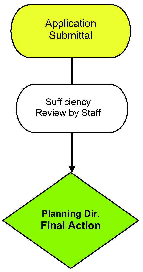
Sec. 4.15 - Dam Impoundment Draining Permit[1]
4.15.1 Applicability
A.
Draining of Dam Impoundments shall be allowed within Town Jurisdiction, in accordance with the following procedures. The owner or his agent shall not proceed with the draining without issuance of an impoundment draining permit from the Watershed Administrator.
l.
Before the owner of any dam drains an impoundment, he or she shall first notify the Town's Watershed Administrator in writing not less than thirty (30) days prior to doing so. This notification will specify the following:
a.
The name of the impoundment, if any;
b.
The location of the impoundment;
c.
The surface area of the impoundment;
d.
The size of the contributing drainage area.
2.
In order to be issued an Impoundment Draining Permit the applicant shall provide the Watershed Administrator two (2) signed copies of written permission by the following regulatory entities:
a.
The regional office of the Army Core of Engineers.
b.
The regional Office of the North Carolina Department of Environmental Quality (NCDEQ).
c.
The regional office of the United States Fish and Wildlife Service.
The contact information for both regulatory offices are below:
Asheville US Army Corps of Engineers Regional Office
151 Patton Avenue, Room 208
Asheville, North Carolina 28801-5006
Phone: (828) 271-7980
Fax Number: (828) 281-8120
Asheville NCDEQ Regional Office
2090 U.S. 70 Highway Swannanoa, NC 28778-8211
Phone: (828) 296-4500
Fax: (828) 299-7043
Asheville Ecological Services Field Office
160 Zillicoa St.
Asheville, NC 28801
Phone: (828) 258-3939
Fax: (828) 258-5330
B.
Upon receiving said permissions, an Impoundment Drainage Permit will be granted and be valid for twelve (12) months. The permit holder shall also be required to notify the Town of any permit time restrictions placed by any regulatory agency and will be held also to those restrictions.
(Amend. of 5-24-18(1); Amend. of 8-19-21(1))
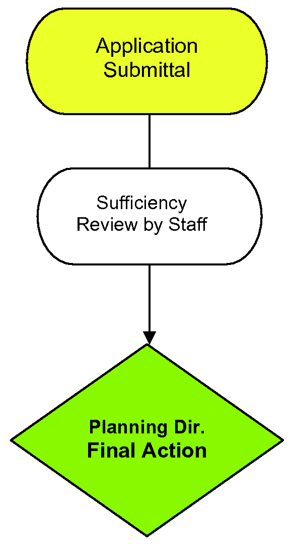
Editor's note— Section 4.15 formerly consisted of §§ 4.15.1 and 4.15.2 which was amended in its entirety by an amendment dated May 24, 2018(1), as herein set out.
Sec. 4.16 - Stormwater Management Permit
4.16.1 Performance Security for BMP Installation
A.
Requirement. The Stormwater Administrator, at his or her discretion, may require the submittal of a performance security or bond with surety, cash escrow, letter of credit or other acceptable legal arrangement prior to issuance of a permit in order to ensure that the structural BMPs are installed by the permit holder as required by the approved stormwater management plan and permit.
B.
Amount. The amount of an installation performance security shall be the total estimated construction cost of the structural BMPs approved under the permit, plus twenty-five percent (25%).
C.
Uses of Performance Security
1.
Forfeiture Provisions. The performance security shall contain forfeiture provisions for failure, after proper notice, to complete work within the time specified, or to initiate or maintain any actions which may be required of the applicant or owner in accordance with this Ordinance, approvals issued pursuant to this Ordinance, or an Operations and Maintenance Agreement established pursuant to this Ordinance.
2.
Default. Upon default of the owner to construct, maintain, repair and, if necessary, reconstruct any structural BMP in accordance with the applicable permit or Operations and Maintenance Agreement, the Stormwater Administrator shall obtain and use all or any portion of the security to make necessary improvements based on an engineering estimate. Such expenditure of funds shall only be made after requesting the owner to comply with the permit or Operations and Maintenance Agreement. In the event of a default triggering the use of installation performance security, the Town of Highlands shall not return any of the unused deposited cash funds or other security, which shall be retained for maintenance.
3.
Costs in Excess of Performance Security. If the Town of Highlands takes action upon such failure by the applicant or owner, the Town of Highlands may collect from the applicant or owner the difference between the amount of the reasonable cost of such action and the amount of the security held, in addition to any other penalties or damages due.
4.
Refund. Within sixty (60) days of the final approval, the installation performance security shall be refunded to the applicant or terminated, except any amount attributable to the cost (plus twenty-five percent [25%]) of landscaping, installation, and ongoing maintenance associated with the BMPs covered by the security. Any such landscaping shall be inspected one (1) year after installation with replacement for compliance with the approved plans and specifications and, if in compliance, the portion of the financial security attributable to landscaping shall be released.
4.16.2 Stormwater Permit, Plan Submittal and Review
A.
Stormwater Permit
1.
A stormwater permit is required for all development and redevelopment which disturbs one (1) acre or more and for all commercial development and redevelopment which creates more than eight thousand (8,000) square feet of new impervious area, unless exempt pursuant to this Ordinance. For all activities which are subject to this Ordinance, no person shall initiate, proceed, or undertake any land-disturbing or development activity for which a permit is required without first being issued a written stormwater control permit.
2.
All required applications must be received and permits must be obtained prior to the start of the work. These may include, but are not limited to, Sec. 4.4, Subdivision Review; Sec. 4.14, Land-Disturbing Activity Permits; Article 16, Flood Damage Prevention Ordinance; Building Permits and Inspections; NCDOT; N.C. Division of Water Quality; U.S. Army Corps of Engineers; and NCDENR-Dam Safety.
3.
A stormwater permit shall govern the design, installation, and construction of stormwater management and control practices on the site including structural and non-structural BMPs and elements of site design for stormwater management.
4.
The permit is intended to provide a mechanism for the review, approval, and inspection of the approach to be used for the management and control of stormwater for development or redevelopment consistent with the requirements of this Ordinance, whether the approach consists of structural BMPs or other techniques such as low-impact or low-density design. The permit does not continue in existence indefinitely after the completion of the project; rather, compliance after project construction is assured by the maintenance provisions of this Section of this Ordinance.
5.
The approval of the stormwater permit shall require an enforceable restriction on the property usage that permanently runs with the land including but not limited to, recorded drainage and utility easements and/or protective covenants, to ensure that future development and redevelopment maintains the site consistent with the approved plans.
4.16.3 Stormwater Permit Application
A.
Content
1.
The Stormwater Administrator shall establish requirements for the content and form of all Stormwater Permit Applications and establish submittal checklists.
2.
An application for stormwater permit shall be made per the requirements of Section 4.2.3, Application Requirements, and at a minimum, the stormwater permit application shall describe in detail how post development stormwater runoff will be controlled and managed, the design of all stormwater facilities and practices, and how the proposed project will meet the requirements of this Ordinance.
3.
The submittal shall include all of the information required in the submittal checklists established by the Stormwater Administrator.
B.
Preparer. The stormwater permit application and stormwater design plans pursuant to this Ordinance shall be prepared by a qualified registered North Carolina professional engineer or landscape architect and the engineer or landscape architect shall perform services only in their area of competence and shall verify that the design of all stormwater management facilities and practices meets the submittal requirements for complete applications, that the designs and plans are sufficient to comply with applicable standards and policies found in the North Carolina Stormwater BMP Design Manual and other standards of the Town, and that the designs and plans ensure compliance with the requirements of this Ordinance.
C.
Fees. The Town's Board of Commissioners shall establish permit review fees applicable to the specific new development, or redevelopment. Additional permit reviews fees may be required for permit reviews that are contracted to another local government or private entity.
D.
Schedule. The Stormwater Administrator shall establish a submission and review schedule for applications. The schedule shall establish deadlines by which complete applications must be submitted for the purpose of ensuring that there is adequate time to review applications and that the various stages in the review process are accommodated.
E.
Submittal. Applications shall be submitted to the Stormwater Administrator pursuant to the application submittal schedule in the form established by the Stormwater Administrator, along with the appropriate fees established pursuant to this Ordinance.
1.
An application shall be considered as timely submitted only when it contains all elements of a complete application pursuant to this Ordinance, along with the appropriate fees. If the Stormwater Administrator finds that an application is incomplete, the applicant shall be notified of the deficient elements and shall be provided with an opportunity to submit a complete application.
2.
However, the submittal of an incomplete application shall not suffice to meet a deadline contained in the submission schedule established above.
F.
Review. The Stormwater Administrator shall review the application for completeness and determine whether the application complies with the requirements of this Ordinance.
G.
Approval. If the Stormwater Administrator finds that the application complies with the requirements of this Ordinance, the Stormwater Administrator shall approve the application. The Stormwater Administrator may impose conditions of approval as needed to ensure compliance with this Ordinance. The conditions shall be included as part of the approval.
H.
Effect of Approval. Approval authorizes the applicant to go forward with only the specific plans and activity authorized in the permit. The approval shall not be construed to exempt the applicant from obtaining other applicable approvals from local, state, and federal authorities. Proper design is the responsibility of the engineer or landscape architect who submits the plans irrespective of any approval of the Stormwater Administrator.
I.
Time Limit/Expiration. An approved plan shall become null and void if the applicant has failed to make substantial progress on the site within one (1) year after the date of approval. The Stormwater Administrator may grant a single, one-year extension of this time limit, for good cause shown, upon receiving a written request from the applicant before the expiration of the approved plan.
J.
Failure to Comply. If the Stormwater Administrator finds that the application fails to comply with the requirements of this Ordinance, the Stormwater Administrator shall notify the applicant in writing and shall indicate how the application fails to comply. The applicant shall have an opportunity to submit a revised application.
K.
Revision and Subsequent Review. A complete revised application shall be reviewed by the Stormwater Administrator after its re-submittal and shall be approved, approved with conditions, or disapproved. If a revised application is not re-submitted within thirty (30) calendar days from the date the applicant was notified, the application shall be considered withdrawn and a new submittal for the same or substantially the same project shall be required along with the appropriate fee for a new submittal.
L.
Concept Plan and Pre-submittal Meeting. Before a Stormwater Permit Application is deemed complete, the Stormwater Administrator or developer may request a pre-submittal meeting on a concept plan for the stormwater management system to be utilized in the proposed development or redevelopment project. This pre-submittal meeting should take place at the time of the preliminary plan of subdivision or other early step in the development process. The purpose of this meeting is to discuss the post construction stormwater management measures necessary for the proposed project, as well as to discuss and assess constraints, opportunities, and potential approaches to stormwater management designs before formal site design engineering is commenced. To accomplish this goal, the following information should be included in the concept plan, which should be submitted in advance of the meeting:
1.
Existing conditions/proposed site plans;
2.
Natural resources inventory; and
3.
Stormwater management system concept plan.
M.
Enforceable Restrictions. The approval of the stormwater permit shall require enforceable restrictions on the property usage that permanently run with the land, including recorded easements, recorded deed restrictions, and protective covenants, to ensure that future development and redevelopment maintains the site consistent with the approved plans and permit.
4.16.4 Operations and Maintenance Agreement
A.
Private Development. Prior to the conveyance or transfer of any private lot or building site to be served by a structural BMP pursuant to this Ordinance and prior to issuance of any permit for development or redevelopment requiring a structural BMP pursuant to this Ordinance, the applicant or owner of the site must execute an Operations and Maintenance Agreement that shall be binding on all subsequent owners of the site, portions of the site, and lots or parcels served by the structural BMP. Until the completion of all structural BMPs and final approval of the Stormwater Administrator, the original owner or applicant shall have full responsibility for the provisions of the maintenance agreement. As property, sites, or lots are transferred in ownership the responsibility for carrying out the provisions of the Operations and Maintenance Agreement shall be shared on an equal basis based on an equitable distribution of the land to all owners.
B.
Public Development. BMPs that are constructed on public land or within public rights-of-way or within public easements shall be maintained by the public body with ownership/jurisdiction of the subject land or public rights-of-way according to standards set by this Ordinance and administered by the Stormwater Administrator.
C.
Agreement Requirements.
1.
A standard form of the Operations and Maintenance Agreement shall be developed by the Stormwater Administrator and Town Attorney adequate to be used as the base agreement for all such maintenance agreements. The Operations and Maintenance Agreement shall require the owner or owners to maintain, repair, and, if necessary, reconstruct the structural BMP(s) and shall state the terms, conditions, and schedule of maintenance for the structural BMP(s). In addition, it shall grant the Town of Highlands a right of entry in the event that the Stormwater Administrator has reason to believe it has become necessary to inspect, monitor, provide maintenance, provide emergency repair, or reconstruct the structural BMP(s); however, in no case shall the right of entry, of itself, maintenance, emergency repair, or reconstruction confer an obligation on the Town of Highlands to assume responsibility for the ongoing operations and maintenance of the structural BMP(s).
2.
The Operations and Maintenance Agreement must be approved by the Stormwater Administrator prior to plan approval and it shall be referenced on the final plat and shall be recorded with the County Register of Deeds upon final plat approval. A copy of the recorded Operations and Maintenance Agreement shall be given to the Stormwater Administrator after being recorded.
D.
Construction of Stormwater Management Measures
1.
Stormwater management facilities shall be constructed in accordance with approved plans and maintained in proper working condition. The applicant or property owner is responsible for ensuring that the construction of stormwater drainage structures and stormwater management measures is completed in accordance with the approved plan and specifications.
2.
Inspections which may be performed by the Town of Highlands during construction will not relieve the applicant or property owner of the responsibility to install stormwater management and drainage facilities in accordance with the approved plan.
3.
Revisions which affect the intent of the design or the capacity of the system shall require prior written approval by the Stormwater Administrator.
4.16.5 As-Built and Final Plat Requirements
A.
Upon completion of a project and before a certificate of occupancy shall be granted, the applicant shall certify that the completed project is in accordance with the approved stormwater management plans and shall submit actual "as built" plans for all stormwater management measures after final construction is completed.
B.
The "as built" plans shall show the final structural configuration for all stormwater management facilities and practices and the field location, size, depth, and planted vegetation of all measures, controls, and devices, as installed. The engineer or landscape architect responsible for the design of the stormwater management measures and plans shall certify, under seal, that the as-built stormwater measures, controls and devices are in compliance with the approved stormwater management plans and designs and with the requirements of this Ordinance. A final inspection and approval by the Stormwater Administrator shall occur before the release of any performance securities as may be required.
4.16.6 Function of BMP(s) as Intended
The owner of each structural BMP installed pursuant to this Ordinance shall maintain and operate it so as to preserve and continue its function in controlling stormwater quality and quantity at the degree or amount of function for which the structural BMP was designed. If upon inspection by the Stormwater Administrator, it is determined that structural BMPs are not being properly maintained by the owner or maintainer of public or private lands, a written report by the Stormwater Administrator outlining the needed corrective action shall be delivered to the owner or maintainer of public or private lands requesting corrective action. Failure to respond shall result in enforcement action according to Article 15, Inspections, Violations and Enforcement, of this Ordinance.
4.16.7 Annual Maintenance Inspections
Inspections shall be conducted as prescribed by the Operations and Maintenance Agreement. The person, association, or agency responsible for maintenance of any structural BMP installed pursuant to this Ordinance, shall submit to the Stormwater Administrator an annual inspection report from one (1) of the following persons performing services only in their area of competence: a qualified registered North Carolina professional engineer or landscape architect; or person certified by the North Carolina Cooperative Extension Service for stormwater treatment practice inspection and maintenance. The inspection report shall contain all of the following:
A.
The name and address of the land owner;
B.
The recorded book and page number of the plat showing all structural BMPs;
C.
A statement that an inspection was made of all structural BMPs;
D.
The date the inspection was made;
E.
A statement that all inspected structural BMPs are performing properly and are in compliance with the terms and conditions of the approved Operations and Maintenance Agreement required by this Ordinance; and
F.
Signature and seal of a registered engineer or landscape architect, or person certified by the North Carolina Cooperative Extension Service for stormwater treatment practice inspection and maintenance.
All inspection reports shall be on standard forms developed by the Stormwater Administrator. An original inspection report shall be provided to the Stormwater Administrator beginning one (1) year from the date of the as-built certification and each year before the month and day of the as-built certification. If upon inspection it is determined that improvements need to be made prior to certification, improvements shall be made by the property owner to bring the structural BMP(s) back into compliance with the approved plans. After improvements are made and the certification is completed, the Stormwater Administrator may field verify that the site does comply with the approved plans.
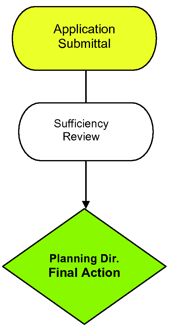
Sec. 4.17 - Sign Permit
4.17.1 Applicability
A.
Certain signs shall be allowed without sign permits as set forth in Article 13, Sign Standards. Signs requiring permits shall be allowed in accordance with the following procedures.
B.
With the exception of outdoor advertising signs, any substantial change in the copy of a sign, such as change of the name of a business, shall require application for a new Sign Permit at the prevailing permit fee; no permit shall be issued in the event of such a change in copy unless the sign complies with the current provisions of this Ordinance.
4.17.2 Permanent Sign Application Requirements
An application for permanent sign permits shall be made per the requirements of Section 4.2.3, Application Requirements, and shall at a minimum also contain the information listed below:
A.
The name of the owner of the sign and the property;
B.
A drawing of the sign identifying its size and height;
C.
A site plan indicating its location on the business premises and relation to any adjacent rights-of-way and method of illumination; and
D.
Whatever other information the Planning and Development Director deems necessary to ensure compliance with these regulations.
4.17.3 Temporary Sign Application Requirements
Applies only to Sec. 13.5.1, Temporary Regulated Signs Requiring a Permit, Item C.
An application for temporary sign permits shall be made per the requirements of Section 4.2.3, Application Requirements, except for additional requirements listed below for temporary signs for Planned Developments:
A.
A permit shall be issued only upon proof of a building permit having been issued by the Macon County or Jackson County Building Department for the development of common or community facilities to include, but not limited to, entrance features, or other facilities relating to the overall development; or final plat approval by the Town of Highlands;
B.
The term of the temporary sign permit shall be a period of three (3) years from the date of issuance of the permit; and
C.
A permit may be renewed for one additional two (2) year period by application to the Planning and Development Director.
Sec. 4.18 - Variances
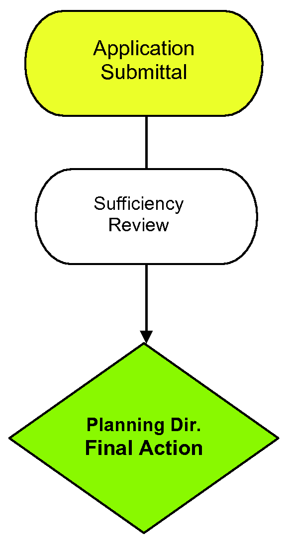
4.18.1 Administrative Variances
The following administrative variances are allowed per the requirements of these specific sections. All other variances are subject to Zoning Board of Adjustment Approval per the requirements of Sec. 4.18.2, Variances, to this Ordinance. A monthly list of variances and the reasons for the variances shall be added to the monthly zoning report to the Board of Commissioners:
A.
Reduction of required parking up to twenty percent (20%). See Sec. 9.1, Off-Street Parking Requirements and Standards, Sec. 9.1.1, General, Item B.4, Exceptions.
B.
Alternative parking or driveway surface material. See Sec. 9.1.5, Paving, Striping and Signage, Item C, Alternative Surface.
C.
Shared driveway. See Sec. 10.4.1, Driveway Entrance Requirements, Item B, Shared Driveways.
D.
Signs with angle projections up to forty-five degrees (45%). See Sec. 13.2.1, Sign Standards Interpretations, Item B.
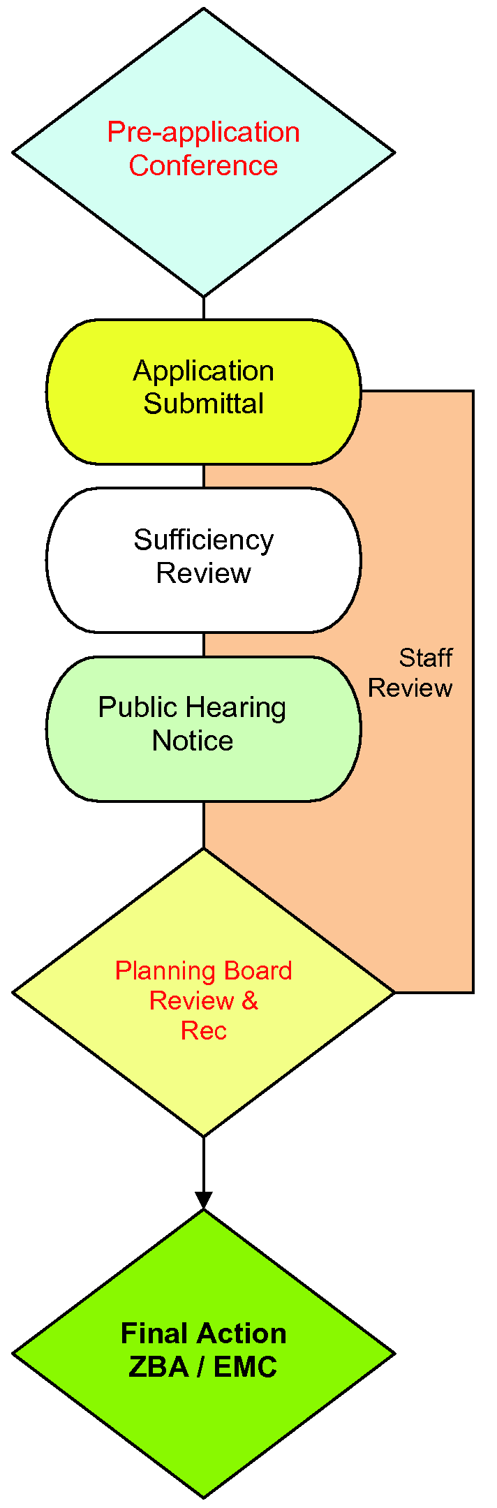
4.18.2 Zoning Board of Adjustment Variances
A.
All applications for variances, other than Administrative, shall be addressed and submitted to the Zoning Board of Adjustment and shall be delivered to the office of the Planning and Development Director. Upon receipt of an application for a variance, the Zoning Board of Adjustment shall call a public hearing and shall give notice, as outlined in Sec. 4.2.4, Notice and Public Hearings. Applications for a variance shall be made on the proper form obtainable from the Planning and Development Director and shall include the following information (some of these requirements may be waived as may be applicable, such as for changes of use in existing buildings involving no expansions in building or parking areas, etc.):
1.
A Site Plan, including twelve (12) copies and an electronic copy, drawn to an appropriate scale and supporting information and text that specify the actual use or uses intended for the property. The site plan shall be neatly drawn, with north arrow, name and address of person who prepared the plan, date of the original drawing, and an accurate record of any later revisions. The following information must be provided on the site plan, if applicable:
a.
Indicating the property lines of the parcel upon which the use is proposed;
b.
The identity of neighboring properties;
c.
All adjacent streets, designated as public or private;
d.
All existing or proposed structures, showing setbacks to rights-of-way and property lines;
e.
Parking areas showing the number and arrangement of parking spaces and driveway entrances; and
f.
Utilities and surface water drainage; and significant natural features, such as wooded areas, streams, ponds, or marshes.
2.
Elevations and a floor plan, indicating dimensions of the building, gross floor space, number of seats, or any other applicable information.
3.
A complete and detailed description of the use proposed, together with any other pertinent information which the applicant feels would be helpful to the Zoning Board in considering the application.
B.
When unnecessary hardships would result from carrying out the strict letter of the ordinance, the Zoning Board of Adjustment shall vary any of the provisions of the ordinance upon a showing of all of the following:
1.
Unnecessary hardship would result from the strict application of the ordinance. It shall not be necessary to demonstrate that, in the absence of the variance, no reasonable use can be made of the property.
2.
The hardship results from conditions that are peculiar to the property, such as location, size or topography. Hardships resulting from personal circumstances, as well as hardships resulting from conditions that are common to the neighborhood or the general public, may not be the basis for granting a variance.
3.
The hardship did not result from actions taken by the applicant or the property owner. The act of purchasing property with knowledge that circumstances exist that may justify the granting of a variance shall not be regarded as a self-created hardship.
4.
The requested variance is consistent with the spirit, purpose, and intent of the ordinance, such that public safety is secured, and substantial justice is achieved. No change in permitted uses may be authorized by variance. Appropriate conditions may be imposed on any variance, provided that the conditions are reasonably related to the variance.
C.
In granting the variance, the Board may attach thereto such conditions regarding the location, character, and other features of the proposed building, structure, or use as it may deem advisable in furtherance of the purpose of this Ordinance.
D.
The Zoning Board of Adjustment shall refuse to hear an appeal or an application for a variance previously denied if it finds that there have been no substantial changes in conditions or circumstances bearing on the appeal or application.
E.
A variance issued in accordance with this Section shall expire if a Zoning Certificate or Certificate of Compliance and/or, in a Watershed Overlay District, a Watershed Protection Permit and a Watershed Protection Occupancy Permit is not obtained by the applicant for such use within twelve (12) months from the date of the decision.
F.
If an application calls for the granting of a Major Variance as defined, the Zoning Board of Adjustment shall hear the application in accordance with Sec. 4.18.2, Zoning Board of Adjustment Variances, and shall either deny or grant the application according to the same criteria defined therein. If the Board decides in favor of granting a major variance, such variance shall only become effective upon the approval of the North Carolina Environmental Management Commission, in accordance with the following procedure:
1.
The Board shall prepare a preliminary record of the hearing with all deliberate speed, and shall forward such record to the North Carolina Environmental Management Commission for its review. The preliminary record of the hearing shall include, at minimum:
a.
The variance application;
b.
The hearing notices;
c.
The evidence presented;
d.
Motions, offers of proof, objections to evidence, and rulings on them;
e.
Proposed findings and exceptions; and
f.
The proposed decision, including all conditions proposed to be added to the permit.
2.
If the North Carolina Environmental Management Commission concludes from the preliminary record that the variance qualifies as a major variance and that the property owner can secure no reasonable return from, nor make any practical use of the property unless the proposed variance is granted, and the variance, if granted, will not result in a serious threat to the water supply, then the North Carolina Environmental Management Commission shall approve the variance as proposed or approve the proposed variance with conditions and stipulations. The North Carolina Environmental Management Commission shall prepare a decision and send it to the Zoning Board of Adjustment.
3.
If the Commission concludes from the preliminary record that the variance qualifies as a major variance and that, the property owner can secure a reasonable return from or make a practical use of the property without the variance or, the variance, if granted, will result in a serious threat to the water supply, then the Commission shall deny approval of the variance as proposed. The Commission shall prepare a decision and send it to the Zoning Board of Adjustment.
G.
Appeals from the North Carolina Environmental Management Commission must be filed with the Superior Court as a petition for writ of certiorari within thirty (30) days from the date of the decision.
4.18.3 Variances to Stormwater Management Regulations
A.
Statutory Exceptions. Notwithstanding Sec. 12.7.3, Applicability and Jurisdiction, Item D, Exemptions to Applicability, exceptions from the thirty-foot WS-III and fifty-foot WS-II landward location of built-upon area requirement of all perennial and intermittent surface waters as well as the deed restrictions and protective covenants requirements of Sec. 12.7.5, Stormwater Quality Design Standards, Item J, may be granted in any of the following instances:
1.
When there is a lack of practical standard alternatives for a road crossing, railroad crossing, bridge, airport facility, or utility crossing as long as it is located, designed, constructed, and maintained to minimize disturbance, prevent contamination of surface waters, protect against erosion and sedimentation, have the least adverse effects on aquatic life and habitat, and protect water quality to the maximum extent practicable through the use of BMPs;
2.
When there is a lack of practical implementation for standard stormwater treatment measures.
B.
Alternative measures shall be located, designed, constructed, and maintained to minimize disturbance, prevent contamination of surface waters, protect against erosion and sedimentation, have the least adverse effects on aquatic life and habitat, and protect water quality to the maximum extent practicable;
C.
The implementation of the alternative stormwater treatment measures shall not disturb existing vegetation to the maximum extent possible;
D.
Minor understory may be disturbed in order to accommodate these alternative measures. Trees and shrubs shall be placed to maximize screening where the encroachment causes negative visual impacts; and
E.
When there is a lack of practical standard alternatives for utilities including, but not limited to, water, sewer, electric, or gas construction including a maintenance corridor, the property owner shall locate, design, and construct the utility to minimize disturbance, prevent contamination of surface waters, protect against erosion and sedimentation, have the least adverse effects on aquatic life and habitat, and protect water quality to the maximum extent practicable through the use of BMPs.
A lack of practical standard alternatives may be shown by demonstrating that, considering the potential for a reduction in size, configuration, or density of the proposed activity and all alternative designs, the basic project purpose cannot be practically accomplished in a manner which would avoid or result in other adverse impact to surface waters.
Sec. 4.19 - Appeals
4.19.1 Appeal of Administrative Decision to Zoning Board of Adjustment
A.
Types of Appeals. The Zoning Board of Adjustment shall hear and decide all appeals from requirements of this Ordinance and review any order, requirement, decision, or determination made by the Planning and Development Director and Stormwater Administrator. In deciding appeals, it may hear both those based upon an allegedly improper or erroneous interpretation of the ordinance and those based upon alleged hardship resulting from strict interpretation of this Ordinance.
B.
Procedure for Filing Appeals
1.
No appeal shall be heard by the Zoning Board of Adjustment unless a written notice of appeal is filed within thirty (30) days after the interested party or parties receive notice of the order, requirement, decision, or determination by the Planning and Development Director and Stormwater Administrator. Appeals shall be made upon the form furnished for that purpose, and all information required thereon shall be complete before an appeal shall be considered as having been filed. In the absence of evidence to the contrary, notice given pursuant to G.S. 160D-403(b) by first-class mail is deemed received on the third business day following deposit of the notice for mailing with the United States Postal Service.
2.
Appeals shall be addressed and submitted to the Zoning Board of Adjustment and shall be delivered to the office of the Planning and Development Director and Stormwater Administrator. All documents, pleadings, and transcripts or certified copies thereof, constituting the record upon which the action being appealed from was taken, shall forthwith be transmitted to the Zoning Board of Adjustment by the Planning and Development Director and Stormwater Administrator. Upon service of the notice of appeal, accompanied by the supporting documents, upon the Chairman or Vice Chairman of the Zoning Board of Adjustment, the Board shall forthwith fix a date within a reasonable time thereafter for the hearing of the appeal or for a hearing upon any other matter properly referred to it; the Zoning Board of Adjustment shall call a public hearing as outlined in Sec. 4.2.4, Notice and Public Hearings, shall give due notice thereof to the parties in interest, and render a decision upon the same within a reasonable time after the hearing. At the hearing, any party may appear in person or be represented by his authorized agent or attorney.
3.
The official who made the decision or the person currently occupying that position, if the decision maker is no longer employed by the Town, shall be present at the evidentiary hearing as a witness.
C.
The decision of the Zoning Board of Adjustment shall be filed in the office of the Planning and Development Director or the Stormwater Administrator, and a copy shall be mailed by registered, certified mail return receipt requested, to every party who has filed a request for such copy with the Secretary or Chairman of the Zoning Board of Adjustment at the time of the hearing of the case. The mailing address of such requestor shall be set forth on such request.
4.19.2 Appeal of Land Disturbance Permit Decision to Board of Commissioners
A.
Land-disturbing Activities Plan and Permit Appeals. Except as provided in item 5 below, the appeal of a disapproval or approval with modifications of a plan, and the denial of an application for a land-disturbing permit, (all being referred to herein as a "rejection") shall be governed by the following provisions:
1.
A rejection by the Town shall entitle the person submitting the plan to a public hearing if such person submits to the Town a written demand for a hearing within thirty (30) days after receipt of written notice of the rejection;
2.
A hearing held pursuant to this section shall be conducted by the Town's Board of Commissioners within twenty (20) days after the date of the submission of the written demand for a hearing;
3.
The Town's Board of Commissioners will render its final decision on any plan within twenty (20) days of the public hearing;
4.
If the Town upholds the rejection following the hearing, the aggrieved person shall then be entitled to appeal the Town's decision to the North Carolina Sedimentation Control Commission as provided in G.S. 113A-61(c) and 15A NCAC 4B.0118(d); and
5.
In the event that a plan is disapproved pursuant to Sec. 4.14.4, Erosion and Sedimentation Control Plan Requirements, Item J, Deadline for Decisions on Revised Plans, the applicant may appeal the Town's disapproval of the plan directly to the North Carolina Sedimentation Control Commission.
6.
The official who made the decision or the person currently occupying that position, if the decision maker is no longer employed by the Town, shall be present at the evidentiary hearing as a witness.
4.19.3 Appeal of Zoning Board of Adjustment Decision
Appeals from the Zoning Board of Adjustment shall be taken to the appropriate court of record within thirty (30) days as provided in G.S. 160D-1405(d).
4.19.4 Appeal of Board of Commissioners Zoning Decisions
Appeals from legislative zoning decisions by the Board of Commissioners shall be to the appropriate court of record within sixty (60) days as provided for in G.S. 1-54.1.
4.19.5 Stays
An appeal of a notice of violation or other enforcement order stays enforcement of the action appealed from and accrual of any fines assessed during the pendency of the appeal to the board of adjustment and any subsequent appeal in accordance with G.S. 160D-1402 or during the pendency of any civil proceeding authorized by law or appeals therefrom, unless the official who made the decision certifies to the board after notice of appeal has been filed that, because of the facts stated in an affidavit, a stay would cause imminent peril to life or property or, because the violation is transitory in nature, a stay would seriously interfere with enforcement of the development regulation. In that case, enforcement proceedings are not stayed except by a restraining order, which may be granted by a court. If enforcement proceedings are not stayed, the appellant may file with the official a request for an expedited hearing of the appeal, and the board shall meet to hear the appeal within fifteen (15) days after the request is filed.
Sec. 4.20 - Expiration or Extensions
Certain permits do expire within a fixed time frame. Unless otherwise specified in this Ordinance or as provided for by State law, any order or decision or the Zoning Board of Adjustment granting an exception, Special Use Permit, or a variance shall expire if a building permit or certificate of occupancy for such use is not obtained by the applicant within twelve (12) months from the date of the decision.
4.20.1 Table
(Amend. of 8-18-16(1); Amend. of 8-19-21(5); Amend. of 5-27-2021(12))
Sec. 4.21 - Statutory Vested Rights Determination
4.21.1 Establishment of a Vested Right for Conditional Zoning District
An approved Conditional Zoning District accompanied by a Site Specific Vesting Plan establishes vested rights pursuant to G.S. 160D-108.1, for the period of two (2) years from the date of approval by the Board of Commissioners, except that such vested rights may be altered as allowed by G.S. 160D-108.1. Vested rights shall remain effective beyond the end of the period of time established pursuant to this Section for any buildings or uses for which a valid building permit has been issued during the vested rights period, so long as such building permit is valid.
(Amend. of 8-18-16(1); Amend. of 5-27-21(12))
4.21.2 Establishment of a Vested Right for Special Use Permits
A.
An applicant for a Special Use Permit may also apply to establish a "vested right" in accordance with G.S. 160D-108.1. Such vested right shall confer upon the property owner the right to undertake and complete the development and use of the property under the terms and conditions of the Special Use Permit issued in conjunction therewith, and shall preclude any zoning action of the Town of Highlands which would change, alter, impair, prevent, diminish, or otherwise delay the development or use of the property as set forth in said Permit. The establishment of a vested right shall not preclude, however, the application of overlay zoning that imposes additional requirements but does not affect the allowable type or intensity of use; nor shall it preclude the application of ordinances or regulations that are general in nature and are applicable to all property subject to land-use regulation by the Town of Highlands, such as the North Carolina State Building Code. Otherwise, any applicable new or amended regulation shall become effective with respect to property for which a vested right has been established only upon the expiration or termination of the vested right in accordance with paragraph (C) of this Section.
B.
In order to establish a vested right, an applicant shall submit a "Site Specific Development Plan" as defined by Section 4.6.2, Procedure, of this Ordinance. Each map, plat, site plan, or other document submitted evidencing a site specific plan shall contain the following notation: "APPROVAL OF THIS PLAN ESTABLISHES A VESTED RIGHT UNDER N.C.G.S. G.S. 160D-108.1. UNLESS TERMINATED AT AN EARLIER DATE, THE ZONING VESTED RIGHT SHALL BE VALID UNTIL (DATE)"
C.
A right which has been vested shall remain vested for a period of two (2) years, and shall not be extended by any amendment or modification of the site specific plan approved by the Board. Notwithstanding Sec. 4.6.6, Expiration of Special Use Permits, the Special Use Permit issued in conjunction with the vested right shall be valid during this entire period of time. A right which has been vested, together with the Special Use Permit which has been issued in conjunction therewith, shall expire or terminate as follows:
1.
At the end of the applicable vesting period with respect to buildings and uses for which no valid Zoning Certificate applications have been filed;
2.
With the written consent of the affected property owner;
3.
Upon findings, by ordinance and after notice and a public hearing as outlined in Sec. 4.2.4, Notice and Public Hearings, that natural or manmade hazards on or in the immediate vicinity of the property, if uncorrected, would pose a serious threat to the public health, safety, and welfare if the project were to proceed in accordance with said Permit;
4.
To the extent that the affected property owner receives compensation for all costs, expenses, and other losses incurred by the landowner—including, but not limited to, all fees paid in consideration of financing—and all architectural, planning, marketing, legal, and other consultant's fees incurred after approval of said Permit, together with interest thereon at the legal rate until paid, but not including any diminution in the value of the property which is caused by such action;
5.
Upon findings, by ordinance and after notice and a public hearing on it as outlined in Sec. 4.2.4, Notice and Public Hearings, that the property owner or his representative intentionally supplied inaccurate information or made material misrepresentations which affected the approval by the Zoning Board of said Permit; and
6.
Upon the enactment or promulgation of a State or federal law or regulation which precludes development as contemplated in said Permit, in which case the Zoning Board may modify the affected provisions upon a finding, by ordinance and after notice and a public hearing on it as outlined in Sec. 4.2.4, Notice and Public Hearings, that the change in State or federal law has a fundamental effect on the Permit.
D.
In all other respects, the provisions of this Ordinance governing application for a Special Use Permit shall apply to the establishment of a vested right. Specifically, no vested right may be established except upon the calling of a public hearing and giving of notice required as outlined in Sec. 4.2.4, Notice and Public Hearings. The Zoning Board may also, in conjunction with the Special Use Permit issued together with the vested right, designate additional conditions and requirements in connection with the application in accordance with Sec. 4.6.4, Additional Conditions as to Use. Nothing in this Section shall exempt the site specific plan from subsequent review by the Zoning Board to ensure compliance with the terms and conditions of the original approval, provided that such review is not inconsistent with the original approval. Nothing in this chapter shall prohibit the revocation of the original approval in accordance with Sec. 4.6.5, Sanctions, nor exempt the property owner from the penalties and remedies provided for in Article 15, Inspections, Violations and Enforcement.
(Amend. of 8-18-16(1); Amend. of 5-27-21(12))
4.21.3 Vested Rights for Multi-Phased Developments
A multi-phased development is vested for the entire development with the land development regulations then in place at the time a site plan approval is granted for the initial phase of the multi-phased development. A right which has been vested as provided for in this subsection remains vested for a period of seven (7) years from the time a site plan approval is granted for the initial phase of the multi-phased development.