
Highlands City Zoning Code
NATURAL RESOURCES
AND ENVIRONMENTAL PROTECTION
Sec. 12.1 - General
This Article is not intended to modify or repeal any provision of State or Federal Law. The requirements of this Article are in addition to the other provisions of law. Where any provision of this Article imposes restrictions different from those imposed by any other State or Federal Law, whichever provision is more restrictive or imposes higher protective standards for human or environmental health, safety, and welfare shall control.
Sec. 12.2 - Flood Damage Prevention
Floodplain management in the Town of Highlands is regulated by Article 16, Flood Damage Prevention Ordinance.
Sec. 12.3 - Riparian Buffers
12.3.1 Purpose and Intent
This Section applies to LDAs and other improvements to land lying adjacent to all lakes and natural watercourses.
12.3.2 Exemptions
Projects on, over or under water. This provision shall not apply to a land-disturbing activity in connection with the construction of facilities to be located on, over, or under a lake or natural watercourse.
12.3.3 Riparian Buffer Zones and Measurement
Unless otherwise provided in Item C, Undisturbed Trout Buffer, of this Section, the width of a buffer zone is measured horizontally from the edge of the water landward to the nearest edge of the disturbed area as illustrated by Figure 1.

Figure 1
A.
Minimum Vegetative Buffer. No land-disturbing activity during periods of construction or improvement to land shall be permitted in proximity to a lake or natural watercourse unless a buffer zone is provided landward along the margin of the watercourse of sufficient width to confine visible siltation within the twenty-five percent (25%) of the buffer zone nearest the land-disturbing activity as illustrated by Figure 2.
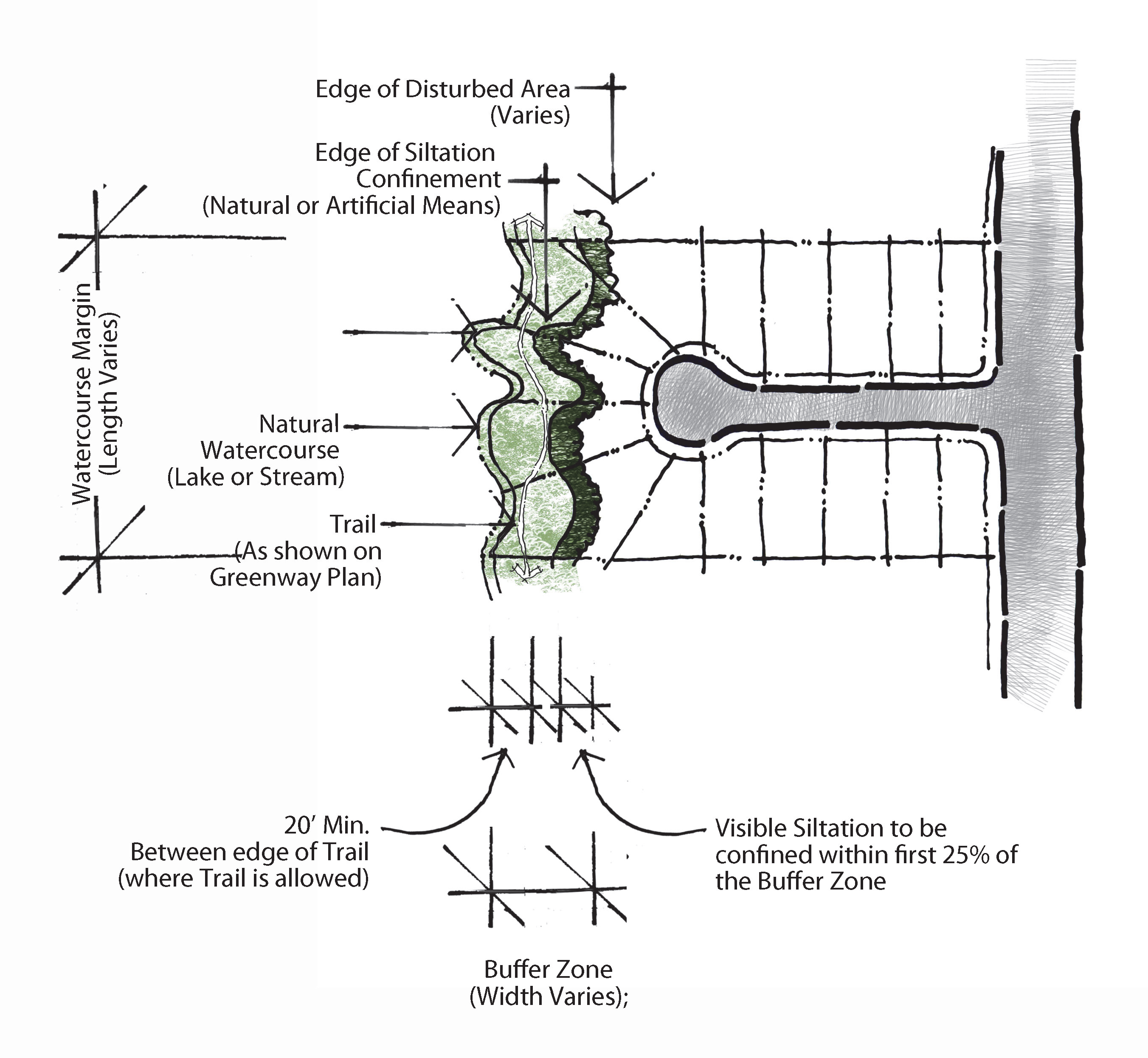
Figure 2
B.
Watershed Overlay Vegetative Buffer. A vegetative buffer for development activities is required landward along all perennial and intermittent surface waters indicated on the most recent versions of U.S.G.S. 1:24,000 (7.5 minute) scale topographic maps for these Overlay Districts:
1.
Within the WS-III-BW Watershed Overlay District, a minimum thirty-foot vegetative buffer; and
2.
Within the WS-II-BW, WS-II-CA and WS-III-CA a minimum fifty-foot vegetative buffer.
A perennial or intermittent surface water shall be deemed present if the feature is approximately shown on either the most recent version of the soil survey map prepared by the Natural Resources Conservation Service of the United States Department of Agriculture (U.S.D.A.) or the most recent complete version of the 1:24,000 scale (7.5 minute) quadrangle topographic maps prepared by the United States Geologic Survey (U.S.G.S.).
C.
Undisturbed Trout Buffer
1.
Waters that have been classified as trout waters by the Environmental Management Commission shall have an undisturbed buffer zone twenty-five (25) feet wide or of sufficient width to confine visible siltation within the twenty-five percent (25%) of the buffer zone nearest the land-disturbing activity, whichever is greater.
2.
Trout buffer measurement. The twenty-five-foot minimum width for an undisturbed buffer zone adjacent to designated trout waters shall be measured horizontally from the top of the bank to the nearest edge of the disturbed area.
12.3.4 Limited Activity Permitted Within and Adjacent to Riparian Buffers
These activities should minimize built-upon surface area, direct runoff away from the surface waters and maximize the utilization of stormwater Best Management Practices. These activities are permitted within the Standard or Watershed Overlay Buffers only. They are not permitted in the Undisturbed Trout Buffer except as listed in Items B.2 and E below:
A.
No new development is allowed in the Minimum Vegetative Buffer or Watershed Overlay Buffer except for water dependent structures and public projects such as road crossings and greenways where no practical alternative exists;
B.
Trails and paths as shown on the Town of Highlands Greenway Plan Map are allowed to be installed within a fifty-foot buffer minimum areas under the following conditions:
1.
For all Riparian Buffers other than Trout Buffers, a minimum twenty-foot vegetative buffer must be preserved undisturbed between the perennial stream and the nearest edge of the Greenway;
2.
For Trout Buffers, a minimum twenty-five-foot undisturbed buffer must be preserved between the perennial stream and the nearest edge of the trail or path; and
3.
Trail and paths shall be constructed per standards in Sec. 10.5.2, Trails and Paths;
C.
Desirable artificial streambank or shoreline stabilization is permitted;
D.
Such buffers shall be composed of any of the recommended locally adapted and native species. This plant list shall be maintained in the office of the Planning and Development Director; and
E.
The Environmental Management Commission may approve plans that include land-disturbing activity along trout waters when the duration of said disturbance would be temporary and the extent of said disturbance would be minimal.
1.
Limit on land disturbance. Where a temporary and minimal disturbance has been permitted as an exception to the trout buffer, land-disturbing activities in the buffer zone adjacent to designated trout waters shall be limited to a maximum of ten percent (10%) of the total length of the buffer zone within the tract to be disturbed such that there is not more than one hundred (100) linear feet of disturbance in each one thousand (1,000) linear feet of buffer zone. Larger areas may be disturbed with the written approval of the Environmental Management Commission.
2.
Limit on temperature fluctuations. No land-disturbing activity shall be undertaken within a buffer zone adjacent to designated trout waters that will cause adverse temperature fluctuations in the trout waters, as set forth in 15 NCAC 2B.0211 "Fresh surface Water Classification and Standards."
12.3.5 Preservation of Riparian Buffers
A.
"Buffers" must be perpetually maintained and preserved. Buffers shall be maintained in a healthful and sound condition at all times to meet the criteria of this Section. Buffers shall be noted on one (1) of the following documents as a condition of approval:
1.
Conservation Easement;
2.
Duly Recorded As Built Site Plan; or
3.
Restrictive Deed Covenant.
B.
Where a subdivision is traversed by a stream or drainage-way, an easement shall be provided of adequate buffer width and conforming with the lines of such stream for the purpose of transporting stormwater.
C.
See also Sec. 10.1.4, Required Easements.
Sec. 12.4 - Soil Erosion and Sedimentation Control
12.4.1 General
In order to prevent soil erosion and sedimentation pollution of streams, springs, flat water bodies, or other drainage networks, the subdivider, Planning Board and/or the Board of Commissioners, shall show proof of an Erosion and Sedimentation Control Plan which has been approved by the State or local agency having jurisdiction, in accordance with the Sedimentation Pollution Control Act of 1973. Should such legislation or implementing regulations be altered, amended, revised, etc., such changes shall be automatically incorporated into the provisions of this Ordinance.
12.4.2 Purposes
This Article is adopted for the purposes of regulating certain land-disturbing activity to control accelerated erosion and sedimentation in order to prevent the pollution of water and other damage to lakes, watercourses, and other public and private property by sedimentation; and establishing procedures through which these purposes can be fulfilled.
12.4.3 Scope and Exclusions
A.
Geographical Scope of Regulated Land-Disturbing Activity. This Article shall apply to all land-disturbing activities within the territorial jurisdiction of the Town, and as allowed by agreement between local governments, the extent of annexation or other appropriate legal instrument or law.
B.
Permit Requirement for All Land-Disturbing Activity. Except for the activities expressly excluded by the provisions herein below, no person shall undertake any land-disturbing activity subject to this Article without first obtaining a permit therefor from the Town.
C.
Activities Not Governed by this Article. Notwithstanding the general applicability of this Article to all land-disturbing activity, and subject to the additional requirements concerning Steep Slope Development, this Article shall not apply to the following types of land-disturbing activity:
1.
An activity, including breeding and grazing of livestock, undertaken on agricultural land for the production of plants and animals useful to man, including, but not limited to:
a.
Forage and sod crops, grain and feed crops, tobacco, cotton, and peanuts;
b.
Dairy animals and dairy products;
c.
Poultry and poultry products;
d.
Livestock, including beef cattle, sheep, swine, horses, ponies, mules, and goats;
e.
Bees and apiary products; and
f.
Fur producing animals.
2.
An activity undertaken on forestland for the production and harvesting of timber and timber products and conducted in accordance with Best Management Practices set out in Forest Practice Guidelines Related to Water Quality, as adopted by the North Carolina Forest Service. If land-disturbing activities undertaken on forestland for the production and harvesting of timber and timber products is not conducted in accordance with Forest Practice Guidelines Related to Water Quality, the provisions of this Article shall apply to such activity and any related land-disturbing activities on the tract.
3.
An activity for which a permit is required under the Mining Act of 1971, G.S. 74-76 et seq.
4.
A land-disturbing activity over which the State has exclusive regulatory jurisdiction as provided in G.S. 113A-56(a).
5.
An activity that is essential to protect human life during an emergency.
6.
Land-disturbing activities of less than three thousand (3,000) square feet in area for relatively minor land-disturbing activities, such as the installation of a driveway or a septic system, and where, in the opinion of the Planning and Development Director, because of limited scope of activity, lack of proximity to a watercourse, relatively low slope of land, or other factors, there is little likelihood of soil erosion or sedimentation. The person proposing to conduct the land-disturbing activity shall submit a letter to the Planning and Development Director requesting the waiver of permit. Additional information shall be provided as requested by the Planning and Development Director as necessary to render an opinion. See also Sec. 12.4.3, Scope and Exclusions, Item H.
D.
Borrow and Waste Areas. When the person conducting the land-disturbing activity is also a person conducting a borrow or waste disposal activity, or an affiliate of such person, if the borrow area is being used to obtain materials for the subject site, or the waste area is being used for disposal of materials from the subject site, such borrow and/or waste areas shall be considered as part of the land-disturbing activity, provided, however that borrow areas regulated by the provisions of the Mining Act of 1971, and landfills regulated by the Department's Division of Waste Management shall not be considered as part of the land-disturbing activity.
E.
Access and Haul Roads. Temporary access and haul roads, other than public roads, constructed or used in connection with any land-disturbing activity shall be considered a part of such activity.
F.
Operations in Lakes or Natural Watercourses. Land-disturbing activity in connection with construction in, on, over, or under a lake or natural watercourse shall minimize the extent and duration of disruption of the stream channel. Where relocation of a stream forms an essential part of the proposed activity, the relocation shall minimize unnecessary changes in the stream flow characteristics. See also Sec. 12.1, General, and Sec. 12.3, Riparian Buffers.
G.
Steep Slope Protection. The rules related to Sec. 12.5, Steep Slope Protection, apply to land-disturbing activities and construction of any kind, including new construction, renovations, demolitions, grading, and road construction.
H.
No Relief of Responsibility. In no instance, whether or not a site plan has been waived or a permit issued, shall a property owner or person conducting a land-disturbing activity be relieved from complying with the basic control objectives as defined in this Article.
I.
Protection of Property. Persons conducting land-disturbing activity shall take all reasonable measures to protect all public and private property from damage caused by such activity.
J.
More Restrictive Rules Shall Apply. Whenever conflict exists between the provisions of this Section (12.4) and Federal, State, or County laws, Ordinance, or rules, the more restrictive provision shall apply.
12.4.4 Mandatory Standards for Land-Disturbing Activity
No land-disturbing activity subject to the control of this Article shall be undertaken except in accordance with the following mandatory standards:
A.
Graded Slopes and Fills. The angle for graded slopes and fills shall be no greater than the angle that can be retained by vegetative cover or other adequate erosion control devices or structures. In any event, slopes left exposed will, within twenty-one (21) calendar days of completion of any phase of grading, be planted or otherwise provided with temporary or permanent ground cover, devices, or structures sufficient to restrain erosion. The angle for graded slopes and fills must be demonstrated to be stable. "Stable" means the condition where the soil remains in its original configuration, with or without mechanical constraints.
B.
Fill Material. Unless a permit from the NCDENR Division of Waste Management to operate a landfill is on file for the subject site, acceptable fill material shall be free of organic or other degradable materials, masonry, concrete and brick in sizes exceeding twelve (12) inches, and any materials which would cause the site to be regulated as a landfill by the State of North Carolina.
C.
Ground Cover. Whenever land-disturbing activity of any size is undertaken on a tract, the person conducting the land-disturbing activity shall install erosion and sedimentation control devices and practices that are sufficient to retain the sediment generated by the land-disturbing activity within the boundaries of the tract during construction upon and development of said tract, and shall plant or otherwise provide a permanent ground cover sufficient to restrain erosion after completion of construction or development. Except as provided in Sec. 12.4.7, Design and Performance Standards - HQW Zones, Item E, Ground cover, provisions for a ground cover sufficient to restrain erosion must be accomplished within fifteen (15) working days or ninety (90) calendar days following completion of construction or development, whichever period is shorter.
D.
Stormwater Outlet Protection. Stream banks and channels downstream from any land-disturbing activity shall be protected from increased degradation by accelerated erosion caused by increased velocity of runoff from the land-disturbing activity.
12.4.5 Basic Erosion and Sedimentation Control Objectives
An Erosion and Sedimentation Control Plan may be disapproved if the plan fails to address the following basic control objectives:
A.
Identify Critical Areas. On-site areas that are subject to severe erosion, and off-site areas that are especially vulnerable to damage from erosion and/or sedimentation, are to be identified and receive special attention.
B.
Limit Time of Exposure. All land-disturbing activities are to be planned and conducted to limit exposure of uncovered ground to the shortest feasible time.
C.
Limit Exposed Areas. All land-disturbing activities are to be planned and conducted to minimize the size of the area of uncovered ground to be exposed at any one (1) time.
D.
Control Surface Water. Surface water runoff originating upgrade of exposed areas shall be controlled in such a way as to minimize to the greatest extent possible erosion and sediment loss during the period of exposure of ground on the subject site.
E.
Identify Critical Areas. All land-disturbing activity is to be planned and conducted so as to prevent damage to off-site properties through sedimentation.
F.
Identify Critical Areas. When the increase in the velocity of stormwater runoff resulting from a land-disturbing activity is sufficient to cause accelerated erosion of the receiving watercourse, the plan will include measures to control the velocity to the point of discharge so as to minimize accelerated erosion of the site and increased sedimentation of the stream.
12.4.6 Design and Performance Standards - General
Except as provided in Sec. 12.4.7, Design and Performance Standards - HQW Zones, Item B, erosion and sedimentation control measures, structures, and devices shall be planned, designed, and constructed to provide protection from the runoff of a 10-year storm as defined in this Ordinance.
12.4.7 Design and Performance Standards - HQW Zones
In high quality water (HQW) zones, the following design standards shall apply to the portion of the land-disturbing activity within the HQW zone:
A.
Limit on Uncovered Area. Uncovered areas in HQW zones shall be limited at any time to a maximum total area of twenty (20) acres within the boundaries of the tract. Larger areas may be uncovered within the boundaries of the tract with the written approval of the Director of the Division of Land Resources of the Department of Environment and Natural Resources.
B.
Maximum Peak Rate of Runoff Protection. Erosion and sedimentation control measures, structures, and devices within HQW zones shall be planned, designed and constructed to provide protection from the runoff of a 25-year storm as defined in this Ordinance.
C.
Settling Efficiency. Sediment basins within HQW zones shall be designed and constructed such that the basin will have a settling efficiency of at least seventy percent (70%) for the forty (40) micron (0.04 millimeter) size soil particle transported into the basin by the runoff of that 2-year storm that produces the maximum peak rate of runoff as calculated according to procedures in the United States Department of Agriculture Soil Conservation Service's "National Engineering Field Manual for Conservation Practices" or according to procedures adopted by any other agency of this State or the United States or any generally recognized organization or association.
D.
2:1 Grade. Newly constructed open channels in HQW zones shall be designed and constructed with side slopes no steeper than two (2) horizontal to one (1) vertical (2:1) if a vegetative cover is used for stabilization, unless soil conditions permit a steeper slope, or where the slopes are stabilized by using mechanical devices, structural devices or other acceptable ditch liners. In any event, the angle for side slopes shall be sufficient to restrain accelerated erosion.
E.
Ground Cover. Ground cover sufficient to restrain erosion must be provided for any portion of an land-disturbing activity in a HQW zone within fifteen (15) working days or sixty (60) calendar days following completion of construction or development, whichever period is shorter.
12.4.8 Design and Performance Standards - Stormwater Outlet Protection
The following design standards shall apply to stormwater outlet protection. See also Sec. 12.7, Stormwater Management, for additional requirements as applicable:
A.
Post-Construction Velocity. The post-construction velocity of the 10-year stormwater runoff in the receiving watercourse to the discharge point shall not exceed the greater of:
1.
The velocity established by the maximum permissible velocities table set out within this subsection; or
2.
The velocity of the ten-year storm runoff in the receiving watercourse prior to development.
3.
If condition (1) or (2) of this Section cannot be met, then the receiving watercourse to and including the discharge point shall be designed and constructed to withstand the expected velocity anywhere the velocity exceeds the "prior to development" velocity by ten percent (10%).
B.
Maximum Permissible Velocities Table. The following is a table for maximum permissible velocity for stormwater discharges in feet per second (F.P.S.) and meters per second (M.P.S.):
Source - Adapted from recommendations by Special Committee on Irrigation Research, American Society of Civil Engineers, 1926, for channels with straight alignment. For sinuous channels, multiply allowable velocity by 0.95 for slightly sinuous, by 0.9 for moderately sinuous channels, and by 0.8 for highly sinuous channels.
D.
Acceptable Management Measures. Measures applied alone or in combination to satisfy the intent of this Section are acceptable if there are no objectionable secondary consequences. The Town recognizes that the management of stormwater runoff to minimize or control downstream channel and bank erosion is a developing technology. Innovative techniques and ideas will be considered and may be used when shown to have the potential to produce successful results. Some alternatives, while not exhaustive, are as follows:
1.
Avoid increases in surface runoff volume and velocity by including measures to promote infiltration to compensate for increased runoff from areas rendered impervious;
2.
Avoid increases in stormwater discharge velocities by using vegetated or roughened swales and waterways in place of closed drains and high velocity paved sections;
3.
Provide energy dissipaters at outlets of storm drainage facilities to reduce flow velocities to the point of discharge;
4.
Protect watercourses subject to accelerated erosion by improving cross sections and/or providing erosion-resistant lining; and
5.
Upgrade or replace the receiving device structure, or watercourse such that it will receive and conduct the flow to a point where it is no longer subject to degradation from the increased rate of flow or increased velocity.
12.4.9 Responsibility for Maintenance
A.
Maintenance During Development. During the development of a site, the person conducting the land-disturbing activity shall install and maintain all temporary and permanent erosion and sedimentation control measures as required by the approved plan or any provision of this Ordinance.
B.
Maintenance Post Development. After site development, the landowner or person in possession or control of the land shall install necessary additional measures and maintain existing permanent erosion and sediment control measures necessary to comply with the basic control objectives set forth herein.
C.
Maintenance Exceptions. This requirement shall not apply to such measures as have been installed within a road or street right-of-way or easement accepted for maintenance by the Town or NCDOT.
D.
Additional Measures. Whenever the Town determines that significant erosion and sedimentation is occurring as a result of land-disturbing activity, despite application and maintenance of protective practices, and despite the approval of a plan, the person conducting the land-disturbing activity shall immediately take such measures as are adequate to stop such erosion and sedimentation.
Sec. 12.5 - Steep Slope Protection
12.5.1 Steep Slope Protection
The following additional requirements shall apply to all new construction situated on a slope. No development shall be undertaken that increases the surface runoff reaching adjacent or surrounding property as a consequence of the development:
A.
Categories. The applicable category is determined by the degree of slope.
1.
Category 1. Zero (0) to thirty percent (30%) slopes, for any land-disturbing activity in which three thousand (3,000) square feet or more of ground will be uncovered.
2.
Category 2. Thirty to sixty percent (30—60%) slopes, for any land-disturbing activity, regardless of size.
3.
Category 3. Sixty to one hundred percent (60—100%) slopes, for any land-disturbing activity, regardless of size.
B.
Percentage of Slope. The percent of slope of a tract shall be determined by the greatest percentage of slope within any contiguous ten percent (10%) portion of the tract. Existing contours are required to be shown for a plan, and the percentage of slope shall be calculated based upon the contours shown.
1.
This percentage shall be determined initially by the person proposing to conduct a land-disturbing activity on the tract, and such person shall show the slope percentage on the application for a land-disturbing permit.
2.
In the event of a disagreement between the Town and such person as to the percent of slope, the Town may require a topographical survey, and the completion of the survey shall be a condition of the Town's taking any further action concerning an application for a permit.
C.
Category 1 Requirements. At a minimum, disturbance in Category 1 will require the basic control measures. The builder/owner will submit a site plan for review to the Planning and Development Director. Additional information shall be provided as requested by the Planning and Development Director as necessary to render an opinion as to other requirements.
D.
Category 2 Requirements
1.
Basic Control Measures, as described is Section 12.4.5 of this Ordinance.
2.
Other Best Management Practices to be employed:
a.
No increase of surface runoff to adjacent or surrounding property for the 2-year and 10-year, 6-hour storm event as a consequence of development;
b.
Surface runoff shall be controlled on-site by implementing one (1) or more NCDWQ approved Best Management Practices or alternative BMP approved by the Town of Highlands;
c.
Approved BMPs include bio-retention areas and rain gardens, infiltration trenches and wells, level spreaders and riparian buffers, reinforced grassy swales, and riprap; and
d.
The owner/builder shall include both temporary and permanent site specific BMPs.
3.
Post development velocity and shear stress of the 10-year, 6-hour storm runoff to adjacent or surrounding properties should not exceed the greater of the following:
a.
Maximum permissible velocity and shear stress for the receiving soil type;
b.
The velocity and shear stress of the runoff from the 10-year, 6-hour storm event to the adjacent or surrounding property prior to the development; and
c.
All discharge channels or conveyances shall be designed to withstand the expected post construction 10-year, 6-hour storm velocity and shear stress.
4.
Wire backed silt fencing shall be installed on the downhill periphery of any area of disturbed earth.
a.
The fencing shall extend a minimum of twenty-four (24) inches above ground with the bottom of the fence buried six to nine (6—9) inches below ground on the uphill side of the fence and packed down to prevent blowouts;
b.
For heavy runoff areas, bales of straw may be required in conjunction with the silt fencing. Silt fencing shall be installed immediately following tree removal and before earth is disturbed; and
c.
Silt fences shall be maintained throughout construction until the disturbed area is permanently stabilized.
5.
Driveways must be roughed-in prior to the start of construction including appropriate installed BMPs and a binder coat of asphalt applied to the driveway surface for the duration of the construction;
6.
Completed driveways must be paved with asphalt or concrete;
7.
Driveways longer than forty-five (45) feet may require one (1) or more cross driveway water traps with grates that direct the stormwater runoff to an approved BMP such as a rain garden or infiltration system. See also maximum gradient allowed for driveways in Sec. 10.4.1, Driveway Entrance Requirements; and
8.
Permanent ground cover must be installed per the requirements of, and approved by, the Planning and Development Director.
E.
Category 3 Requirements. For any land-disturbing activity in District 3, regardless of size, the person wishing to conduct the land-disturbing activity shall submit a soil and erosion control plan for permit as defined in this Ordinance and meet all of the requirements listed in Category 2 above.
Sec. 12.6 - Stormwater Management[1]
12.6.1 Findings of Fact
It is hereby determined that:
Development and redevelopment alter the hydrologic response of local watersheds and increase stormwater runoff rates and volumes, flooding, soil erosion, stream channel erosion, nonpoint and point source pollution, and sediment transport and deposition, as well as reduce groundwater recharge. These changes in stormwater runoff contribute to increased quantities of water-borne pollutants and alterations in hydrology that are harmful to public health and safety as well as to the natural environment. These effects can be managed and minimized by applying proper design and well-planned controls to manage stormwater runoff from new development sites.
Therefore, the Town of Highlands establishes this set of water quality and water quantity requirements to meet the requirements of State and Federal law regarding control of stormwater runoff and discharge. For the Operations and Maintenance Agreement Requirements, see Article 4, Applications and Permits, Sec. 4.16.4, Operations and Maintenance Agreement.
(Amend. of 8-18-16(6); Amend. of 5-24-18(2))
12.6.2 Purpose
The purpose of these requirements is to protect, maintain, and enhance the public health, safety, environment, and general welfare by establishing minimum requirements and procedures to control the adverse effects of increased post development stormwater runoff and nonpoint and point source pollution associated with new development and redevelopment, as well as illicit discharges into the Town of Highlands municipal separate storm sewer system (MS4). It has been determined that proper management of construction-related and post development stormwater runoff will minimize damage to public and private property and infrastructure, safeguard the public health, safety and general welfare, and protect water and aquatic resources. These requirements establish stormwater management requirements and controls to prevent surface water quality degradation and reduce erosion and sediment transport to the extent practicable in the streams and lakes within the Town limits. This Section seeks to meet this purpose by fulfilling the following objectives:
A.
Minimize increases in stormwater runoff from new development or redevelopment to the maximum extent practicable for the applicable design storm in order to reduce flooding, siltation, streambank erosion, increases in stream temperature, and to maintain the integrity of stream channels and aquatic habitats.
B.
Minimize increases in non-point and point source pollution caused by stormwater runoff from development or redevelopment that would otherwise degrade local water quality. Minimize the total volume of surface water runoff that flows from any specific site during and following development in order to replicate pre-development hydrology to the maximum extent practicable through the use of structural and nonstructural stormwater management Best Management Practices (BMPs).
C.
Establish minimum post development stormwater management standards and design criteria for the regulation and control of stormwater runoff quantity and quality.
D.
Establish design and review criteria for the construction, function, and use of structural stormwater BMPs that may be used to meet the minimum post-development stormwater management standards.
E.
Ensure that structural and nonstructural stormwater BMPs are properly maintained and pose no threat to public health or safety.
F.
Establishing provisions for the long-term responsibility for and maintenance of structural and nonstructural stormwater BMPs to ensure that they continue to function as designed, are maintained appropriately, and pose no threat to public safety.
(Amend. of 5-24-18(2))
12.6.3 Applicability and Jurisdiction
A.
Applicable Lands. Beginning with and subsequent to its effective date, these requirements are applicable to all new development and redevelopment located within the Town Limits, including, but not limited to, site plan applications, subdivision applications, larger common plans of development or sale and grading unless exempt pursuant to Item C, Larger Common Plan of Development or Sale, below, of this Section.
B.
No building, structure, or land shall be used, occupied, or altered and no building, structure, or part thereof shall be erected, constructed, reconstructed, moved, enlarged, or structurally altered unless in conformity with all the provisions of this Ordinance and all other applicable regulations except as otherwise provided in this Ordinance.
C.
Larger Common Plan of Development or Sale. A Larger Common Plan of Development or Sale is anywhere multiple separate and distinct construction or land-disturbing activities will occur under one (1) plan. A plan includes any announcement or piece of documentation (including, but not limited to, a sign, public notice or hearing, sales announcement, advertisement, loan application, drawing, permit application, zoning request, or design) or physical demarcation (including, but not limited to, boundary signs, lot stakes or surveyor markings) indicating that construction activities may occur on a specific piece of land.
D.
Exemptions to Applicability. All development and redevelopment are subject to these requirements except those which, as of the effective date of this Ordinance fit into one (1) of the following categories:
1.
Cumulatively disturbs less than one (1) acre and is not part of a larger common plan of development or sale. Development and redevelopment that disturb less than one (1) acre are not exempt if such activities are part of a larger common plan of development or sale, even though multiple, separate, or distinct activities take place at different times on different schedules;
2.
Commercial development and commercial redevelopment which creates less than eight thousand (8,000) square feet of new impervious area;
3.
Activities that are exempt from permit requirements of Section 404 of the Federal Clean Water Act as specified in 40 CFR 232 (primarily ongoing farming and forestry activities) are exempt from the provisions of this Ordinance;
4.
Have been issued a Certificate of Building Code Compliance;
5.
Have a valid building permit;
6.
Are included on a valid preliminary subdivision plan; or
7.
That phase of development would require a material change in that phase of the plan.
(Amend. of 5-24-18(2))
12.6.4 Stormwater Design and Standards
Stormwater Design Standards are established for the purpose of promoting sound development practices with respect to minimizing impacts from new development and are not intended to prohibit the use of innovative and alternative techniques that demonstrate the ability to successfully achieve the objectives of this Section. Land development activities shall be performed in such a manner as to minimize the degradation of the receiving waters and protect existing developments. All activities that meet the applicability requirement of this Section shall adhere to the following provisions for managing stormwater runoff as a minimum:
A.
Hydrological and Hydraulic analysis shall be performed in a manner acceptable to and with results reproducible by the Stormwater Administrator. Appropriate rainfall/runoff calculations include the TR-55 method, and HEC-1 and HEC-HMS models and other appropriate methods including the Soil Conservation Service Curve Numbers and on a limited basis the Rational Method. All models and methods should receive prior approval from the Stormwater Administrator before they are employed.
B.
The rainfall data for the Town of Highlands shall be the latest information from the National Oceanic and Atmospheric Administration (NOAA). The Town of Highlands, North Carolina rainfall data is determined from the current NOAA National Weather Service Precipitation Frequency Data Server (PFDS).
C.
The North Carolina General Statute 143-215.23 (the Dam Safety Law of 1967) and any subsequent revisions shall be adhered to when applicable.
D.
In all instances, stormwater management facilities and devices shall be designed to compliment a development and the surrounding community. If ponds are used, they shall be incorporated into the development and landscaped as an amenity. See Also Article 11, Landscape, Screening and Buffers.
E.
Temporary sediment and erosion control facilities used during construction may be converted to permanent stormwater management facilities after construction is completed.
F.
All projects must adhere to the guidelines outlined in 15A NCAC 02H.1000.
(Amend. of 5-24-18(2))
12.6.5 Stormwater Quality Design Standards
A.
Required for all development and redevelopment which disturbs one (1) acre or more.
B.
Required for all commercial development and commercial redevelopment which creates eight thousand (8,000) square feet or more of new impervious area.
C.
Stormwater quality BMPs are designed to control and treat the runoff from the 1-year, 1-hour storm event.
D.
All stormwater quality BMPs used to meet the requirements of this Section shall be designed to have a minimum of eighty-five percent (85%) average annual removal for Total Suspended Solids (TSS).
E.
Areas designated as open space that are not or will not be disturbed, developed or redeveloped do not require stormwater runoff treatment.
F.
Where any stormwater quality BMP utilizes a temporary water quality storage pool as a part of its designed treatment system to treat the stormwater quality volume from the 1-year, 1-hour storm event:
1.
The drawdown time shall be a minimum of forty-eight (48) hours and a maximum of one hundred twenty (120) hours;
2.
The minimum draw down orifice size shall be two (2) inches or equivalent; and
3.
The post development peak flow rate of the water quality volume discharge shall not exceed the pre development 1-year, 24-hour peak discharge rate.
G.
No one (1) water quality BMP shall receive runoff from a developed or redeveloped area greater than three (3) acres. However, the total drainage area for BMPs used in series can exceed this three (3) acre maximum.
H.
Residential subdivisions should utilize stormwater quality BMPs as part of the larger plan of development when applicable.
I.
All built-upon area shall comply with riparian buffer requirements of Sec. 12.3, Riparian Buffers. An exception to this requirement may be allowed when site-specific determination is made using North Carolina Division of Water Quality-approved methodology.
J.
No stormwater quality BMPs shall incorporate natural streams to provide treatment volumes.
(Amend. of 5-24-18(2))
12.6.6 Stormwater Discharges
A.
Prohibited Discharges. No person shall cause or allow the discharge, emission, disposal, pouring, or pumping directly or indirectly to any stormwater conveyance, the waters of the State, or upon the land in a manner and amount that the substance is likely to reach a stormwater conveyance or the waters of the State unless permitted by an NPDES Permit. Prohibited substances and discharges include, but are not limited to:
1.
Wastewater lines (such as from washing machines);
2.
Sanitary sewer lines;
3.
Food waste;
4.
Oil;
5.
Grease;
6.
Household, industrial, and chemical waste;
7.
Anti-freeze;
8.
Animal waste;
9.
Paints;
10.
Paint wash water;
11.
Garbage;
12.
Litter;
13.
Swimming pool discharges;
14.
Leaves;
15.
Grass clippings;
16.
Dead plants; and
17.
Sediment.
B.
Allowable Discharges. Non-stormwater discharges associated with the following activities are allowed provided that they do not significantly impact water quality:
1.
Drinking water line flushing;
2.
Discharge from emergency fire fighting activities;
3.
Irrigation water;
4.
Diverted stream flows;
5.
Uncontaminated groundwater;
6.
Uncontaminated pumped groundwater;
7.
Discharges from potable water sources;
8.
Residential foundation/footing drains;
9.
Air conditioning condensation;
10.
Uncontaminated springs;
11.
Uncontaminated water from crawl space pumps;
12.
Individual noncommercial car washing operations;
13.
Flows from riparian habitats and wetlands;
14.
Street wash water; and
15.
Other non-stormwater discharges for which a valid NPDES discharge permit has been authorized and issued by the U.S. Environmental Protection Agency or by the State of North Carolina, provided that any such discharges to the municipal separate storm sewer system (MS4) shall be authorized by the Town of Highlands.
C.
Illicit Connections. Connections to any public or private stormwater conveyance system that allows the discharge of non-stormwater, other than the exclusions described in this Ordinance, are unlawful. Prohibited connections include, but are not limited to, industrial/commercial floor drains, wastewater or sanitary sewers, wash water from commercial vehicle washing operations or steam cleaning operations and wastewater from septic systems.
D.
Time Period for Removal. The Stormwater Administrator shall designate the time period within which the connection shall be removed. In setting the time limit for compliance, the Stormwater Administrator shall take into consideration:
a.
The quantity and complexity of the work;
b.
The consequences of delay;
c.
The potential harm to the environment, to the public health, and to public and private property; and
d.
The cost of remedying the damage from the connection due to delay.
E.
Spills/Accidental Discharges
1.
Accidental spills or leaks of illicit polluting substances released, discharged to, or having the potential to be released or discharged to a stormwater conveyance system, shall be contained, controlled, collected, and properly disposed. All affected areas shall be restored to their pre-existing condition. Persons in control of the illicit polluting substances immediately prior to their release or discharge, and persons owning the property on which the illicit substances were released or discharged, shall immediately notify the Town of Highlands of the release or discharge, as well as making any required notifications under State and Federal law. The notification shall include the location of the discharge, type of pollutant, volume or quantity discharges, time of discharge, and the corrective actions taken.
2.
Notification shall not relieve any person of any expenses related to the restoration, loss, damage, or any other liability which may be incurred as a result of said spill or leak, nor shall such notification relieve any person from other liability which may be imposed by State or other law.
(Amend. of 5-24-18(2))
12.6.7 Stormwater Quality Design Manual
A.
The Town of Highlands shall utilize the latest edition of the North Carolina Department of Environment and Natural Resources (NCDENR) Division of Water Quality (DWQ) Stormwater Best Management Practices Design Manual as the Stormwater Quality Design Manual.
B.
Stormwater management practices that are designed, constructed, or maintained in accordance with the Stormwater Design Manual are presumed to comply with these requirements. However, the Stormwater Administrator shall have the right to consult other engineers and duly qualified professionals and to impose any conditions or require any modifications deemed necessary to meet the purpose, intent, and requirements of this Section.
(Amend. of 5-24-18(2))
12.6.8 Stormwater Quantity Design Standards
All development and redevelopment which disturbs one (1) acre or more and all commercial development and commercial redevelopment which creates eight thousand (8,000) square feet or more of new impervious area, unless exempt pursuant to this Section, shall adhere to the following provisions:
A.
Minimum Design for Stormwater Conveyance Systems:
1.
Storm sewer collection systems (drainage parallel to road) shall be designed to pass the peak flows from the 2-year, 6-hour storm event;
2.
Cross drainage systems that do not convey intermittent or perennial streams shall be designed to pass the peak flow rates from the 10-year, 6-hour storm event;
3.
Cross drainage systems conveying intermittent or perennial streams, shall be designed pass peak flow rates for the 50-year, 24-hour storm event. Where practicable, use bottomless single span structures;
4.
Driveway pipes that do not convey intermittent or perennial streams shall be designed to pass the peak flow rates from the 2-year, 6-hour storm event with a minimum pipe size of fifteen (15) inches; and
5.
Materials of construction and design standards for stormwater conveyance systems for NCDOT roads, including culverts, pipes, inlets, junctions, ditches, and swales shall be designed to meet the guidelines outlined by the NCDOT Guidelines for Drainage Studies and Hydraulic Design.
B.
Residential development control of peak discharge flow rates. The post development peak flow rates discharged from residential developments shall not exceed the pre-development peak discharge rates for the 2-year, 24-hour storm event and the 10-year, 24-hour storm event.
C.
Residential subdivisions should utilize water quantity control BMPs as part of the larger plan of development when applicable.
D.
Non-residential development control of peak discharge flow rates. The post development peak flow rates discharged from non-residential developments shall not exceed the pre-development peak flow rates for the 2-year, 10-year and the 25-year, 24-hour storm event.
E.
Stormwater management facilities, structures, devices, and methods used shall be planned, designed, constructed, and maintained so as to provide effective protection from peak runoff rates.
F.
Stormwater Management Facilities designed to control peak discharge flow rates:
1.
Stormwater management facilities shall be utilized to mitigate the pre-development and post development peak flow rate difference;
2.
The calculated difference in the peak runoff rate from the post development peak flow rates, less the pre-development shall determine the size of detention structures;
3.
The temporary storage capacity shall be restored within seventy-two (72) hours;
4.
Requirements of the Dam Safety Act shall be met when applicable;
5.
The emergency overflow outlet must be designed to safely pass the 100-year, 24-hour storm event peak discharge; and
6.
No one (1) stormwater management facility shall receive runoff from a developed or redeveloped area greater than three (3) acres. However, the total drainage area from BMPs used in series (i.e., integrated) can exceed this three-acre maximum.
G.
The impoundment of stormwater runoff may be incorporated in the design of stormwater conveyance structures, engineered stormwater BMP's, and ponds. These structures may be located on- or off-site. All off-site areas must be secured through proper easements or title documents as appropriate. See also Sec. 10.1.4, Required Easements.
H.
In all instances engineered stormwater management facilities and devices shall be designed to blend with the development and the surrounding community. If ponds are installed and used as a stormwater management facility, such areas shall be landscaped as amenities or hidden from view. See also Sec. 11.4.2, Landscape Buffer Table.
(Amend. of 5-24-18(2))
12.6.9 Uniform Watershed Development Analysis for Peak Discharge Control
A.
The requirements, or portions thereof, for stormwater detention to control peak discharge, except for stormwater quality treatment (Section 12.6.9. A.5), may be waived by the Stormwater Administrator if it can be shown by detailed engineering calculations and analysis acceptable to the Stormwater Administrator that one (1) of the following exists:
1.
The installation of stormwater management facilities would have insignificant effects on reducing downstream flood peak flow rates and water surface elevations;
2.
Stormwater management facilities are not needed to protect downstream developments and the downstream drainage system has sufficient capacity to receive any increase in runoff for the design storm;
3.
It is not necessary to install stormwater management facilities to control post development peak discharge rates at the exit to a proposed development and installing such facilities would increase flood peak flow rates and or water surface elevations at some downstream locations; or
4.
The Stormwater Administrator determines that stormwater management facilities are not needed to control post development peak discharge rates and installing such facilities would not be in the best interest of the Town; and
5.
No waiver shall be allowed for Stormwater quality treatment requirements in Sec. 12.6.5, Stormwater Quality Design Standards.
B.
The requirements, or portions thereof, of Sec. 12.6.7, Stormwater Quality Design Manual, may not be waived if the Stormwater Administrator determines that not controlling peak flow rates would increase known flooding problems, or exceed the capacity of the downstream drainage system.
C.
A waiver shall only be granted after a written request is submitted by the applicant containing descriptions, drawings, and any other information that is necessary to evaluate the proposed development or redevelopment. A separate written waiver request shall be required if there are subsequent additions, extensions, or modifications which would alter the approved stormwater runoff characteristics of the development or redevelopment receiving a waiver.
D.
For all stormwater management facilities, a hydrologic/hydraulic study shall be done showing how the drainage system will function with and without the proposed facilities. For such studies the following land use conditions shall be used. Existing land use data shall be taken from the most recent aerial photograph and field checked and updated.
E.
For the design of the facility outlet structure, use developed land use conditions for the area within the proposed development and existing land use conditions for upstream areas draining to the facility.
F.
For any analysis of flood flows downstream from the proposed development, use existing land use conditions for all downstream areas.
(Amend. of 5-24-18(2))
Editor's note— An amendment adopted May 24, 2018(2), deleted § 12.6 entitled "Draining of Impoundment Regulations," which derived from an amendment adopted Aug. 18, 2016(6), and further renumbered existing §§ 12.7—12.7.9 as §§ 12.6—12.6.9, as herein set out below.