
Jenks City Zoning Code
ARTICLE 8
- SUBDIVISION STANDARDS
Sec. 16-8-1.- Purpose.
The purpose of this article is:
(A)
To establish reasonable rules and regulations governing the subdivision, development and platting of land, the preparation of plats, the location and extension of streets and highways, the installation of utilities and the provision of necessary public grounds for parks, playgrounds and public open space;
(B)
To promote and protect the public health, safety and general welfare, to conserve, protect and enhance property values and to secure the efficient use of land;
(C)
To discourage scattered development beyond existing public utilities and to facilitate the adequate provision of public improvements;
(D)
To assure the development of land for optimum use with necessary protection against deterioration and obsolescence;
(E)
To limit and control the pollution of the environment that can be caused by inadequate or incomplete urban development;
(F)
To provide common grounds of understanding and a sound working relationship between the City and the subdivider; and
(G)
To implement the goals and objectives of the Comprehensive Plan.
(Ord. No. 1581, § II, 4-5-2022)
Sec. 16-8-2. - General Subdivision Standards.
(A)
Land Suitability.
(1)
General Land Suitability. Land which the Planning Commission finds to be unsuitable for subdivision or because of flooding, improper drainage and erosion, adverse topography, steep slopes, or rock formations, shall not be subdivided or developed unless adequate steps are taken by the subdivider and approved by the Planning Commission to resolve the hazards created by the unsuitable land conditions.
(2)
Unsuitable Land for Subdivision. Land which the Planning Commission finds to be unsuitable for development within a proposed subdivision because of flooding, improper drainage and erosion, adverse topography, steep slopes, or rock formations, and not detrimental to the development of the subdivision, shall be set aside for uses as permitted by the Planning Commission.
(B)
Zoning District Compliance. No subdivision shall be approved unless it conforms to all of the requirements of this UDO. Whenever there is a discrepancy between minimum standards or dimensions noted in this article and those contained in other chapters of this UDO, building codes or other adopted regulations, codes or ordinances, the most restrictive shall apply.
(C)
Comprehensive Plan Conformance.
(1)
All proposed subdivisions shall conform to the most recently adopted Comprehensive Plan.
(2)
The arrangement, character, extent, width, grade, and location of all streets shall conform to all the elements of the Comprehensive Plan and shall be designed in accordance with sound planning and engineering principles as well as the improvement provisions outlined in this article.
(3)
Permanent Markers and Monuments.
(a)
Permanent reference markers shall be placed at the intersection of the centerlines of rights-of-way. There shall be in each subdivision a minimum of two such monuments. If no two of the intersection monuments are within line-of-sight to each other, an additional marker shall be placed on right-of-way centerline so as to establish a straight line which can be seen line-of-sight from one end to the other. An additional such marker shall be placed at the center point of the turn-around in each cul-de-sac. These markers shall be in the form of a non-corrosive metal plate and each shall be stamped with a cross at the point of the intersection and the elevation to the tenth of a foot.
(b)
Permanent reference markers shall be placed at each turning point in the boundary of the subdivision. These markers shall be a 24-inch long iron pipe or bar of at least one-half inch diameter, to be set in concrete.
(c)
Permanent reference markers shall be placed at a minimum of two corners of each lot in an addition. The markers shall be at least 24 inches long and at least one-half inch in diameter made of iron pipe or bar and driven into unexcavated soil.
(d)
Permanent reference markers shall be placed at the points of curvature and points of tangency of all inside and outside rights-of-way lines, and at the point of intersection of the outside line of a curve in street right-of-way. These markers shall be a 24-inch long iron pipe or bar of at least one-half inch diameter to be driven into unexcavated soil.
(e)
The location of all permanent markers shall be shown on the face of the record plat.
(4)
Street Designations and Names.
(a)
Street Designations. When the applicable conditions are met, the following designations shall be used for all streets:
(I)
North—South streets:
Avenue: A North-South road longer than 500 feet.
Drive: A curvilinear road primarily oriented north/south.
Terrace: A minor avenue.
Loop: A short avenue that begins and circles back to terminate on a North-South avenue.
(II)
East—West streets:
Street: An East-West road longer than 500 feet.
Lane: A curvilinear road primarily oriented east/west.
Circle: A short street that begins and circles back to terminate on an East-West street.
Place: A minor street.
(III)
Other designations:
Boulevard: A local road divided by a median.
Court: A cul-de-sac.
Highway: A designated state or federal highway.
Interstate: A road of the highest order, characterized by limited access and wide right-of-way.
(IV)
Court: A cul-de-sac.
(V)
Drive: A curvilinear road of more than 500 feet in length.
(VI)
Highway: A designated state or federal highway.
(VII)
Interstate: A road of the highest order, characterized by limited access and wide right-of-way.
(VIII)
Lane: A curvilinear road of less or equal to 500 feet in length.
(IX)
Loop: A short avenue that begins and circles back to terminate on a North-South avenue.
(X)
Place: A minor street.
(XI)
Street: An East-West road longer than 500 feet.
(XII)
Terrace: A minor avenue
(b)
Street Names.
(I)
Street names shall meet the naming convention established by the City Engineer and shall not:
(i)
Exceed 14 characters in length, excluding street-type designation;
(ii)
Contain hyphens, apostrophes or other non-letter characters;
(iii)
Exceed two words in length, excluding street-type designation;
(iv)
Contain directional prefixes or suffixes (i.e., north, south, east, and west);
(v)
Be phonetically similar to other street names in the City of Jenks (i.e., Shadow - Chateau, Parakeet - Park Heat, Grade - Grate);
(vi)
Have the same name but different street type designation (i.e. Willow Drive - Willow Court); or
(vii)
Duplicate facilities or geographic locations (i.e. Basketball Court, Bowling Alley).
(II)
Street names within a subdivision shall have a consistent theme (i.e. tree species, names of artists, bird species).
(Ord. No. 1581, § II, 4-5-2022; Ord. No. 1644, § II, 6-18-2024)
Sec. 16-8-3. - General Design Standards.
(A)
Design Criteria Manual. The City Engineer is authorized to develop, adopt, and amend from time to time, Engineering and Design Standards for the design, installation, and construction of public utilities. All subdivisions and the installation of all public utilities within any development shall comply with the requirements established in the Engineering Design Criteria, as amended from time to time.
(Ord. No. 1581, § II, 4-5-2022)
Sec. 16-8-4. - Subdivision Procedures.
(A)
Types of Subdivision of Land.
(1)
Lot Split.
(2)
Minor Subdivisions.
(a)
Lot Combination.
(b)
Other Subdivision Corrections.
(3)
Major Subdivisions.
(a)
Preliminary Plat.
(b)
Final Plat
(B)
General Subdivision Procedures.
(1)
Application Submittal.
(a)
All land subdivision applications shall be submitted to the City Planner and be accompanied by a fee as set forth in the Master Fee Schedule.
(b)
After the receipt of the application, the City Planner shall review the application to determine that all required information has been submitted and notify the applicant of completeness or deficiencies.
(c)
Failure to cure the deficiencies within six months from notification of such deficiencies shall be deemed abandonment of the application without further notice from the City.
(d)
A pre-platting conference shall be required before the submittal of any Major Subdivision application.
(2)
City Planner Report.
(a)
After the determination of completeness, the subdivision application shall be reviewed by the City Planner pursuant to the criteria set forth in this article per application type.
(b)
The City Planner shall meet with the Technical Advisory Committee as needed to review the subdivision application.
(c)
The City Planner shall prepare and issue a report to the applicant identifying issues of concern to be addressed as well as a recommendation for approval, approval with conditions, or denial.
(d)
The City Planner shall forward their report to the applicant for review.
(3)
Revised Application.
(a)
The applicant shall revise the application as necessary based on the issues of concern identified by the City Planner in their report.
(b)
The revised application shall be accompanied by a letter explaining how all of the issues of concern have been addressed and detailing any other changes that have been made to the application.
(c)
The applicant shall submit the revised application to the City Planner who shall review the revised application for the purpose of ensuring that all required information has been provided and that all issues of concern have been addressed. Once it is determined that all required information has been submitted and all issues of concern addressed, the application shall be referred to the next step in the process. If the City Planner determines that the required information and/or issues of concern have not been addressed, the City Planner shall notify the applicant of such deficiencies.
(d)
Failure to cure the deficiencies within six months from notification of such deficiencies shall be deemed abandonment of the application without further notice from the City.
(4)
Next Steps. Once the City Planner has determined that all required information has been submitted and all issues of concern have been addressed, the application subdivision application shall proceed to the next steps in the review process. The review procedures for lot splits are established in section 16-8-4(C), the review procedures for Minor Subdivisions are established in section 16-8-4(D), and the review procedures for Major Subdivisions are established in section 16-8-4(E).
(C)
Lot Splits. Subdivisions containing three or fewer lots defined as "lot splits" in these regulations, may be excepted by City Council from all or part of the procedural provisions applicable for Major or Minor Subdivisions. The number of lots for purposes of determination of status as a lot split shall be counted cumulatively from the date of adoption of these regulations with respect to each parcel, provided that for the preservation of the spirit of these regulations, any and all parcels that have been similarly divided upon review of the Planning Commission under the provisions of previous subdivision regulations shall be counted into the cumulative total for the determination of eligibility for consideration of a request for treatment as a lot split.
(1)
Lot Split Review Requirements.
□ Lot split application is complete.
□ Lot split fees paid.
□ Scaled drawing of lot split(s) provided.
□ Drawing shows all existing and proposed lot lines.
□ Drawing shows adjacent streets and street widths.
□ Drawing shows existing access limitations.
□ Drawing shows a north arrow and map scale.
□ Lot dimensions and area either conform with UDO requirements of Variance of zoning code requirements have been obtained by Jenks Board of Adjustment.
□ Public water and/or sanitary sewer is not available (appropriate tests shall be conducted by health department of its assigns to determine the proposed lots' suitability for a private sewer disposal device).
□ If the lot split results in inadequate access to utility easements, dedication of easement has been provided.
□ If the lot split results in inadequate access to public street, dedication of right-of-way has been provided.
(2)
Procedure.
(a)
Application for Lots Splits. Applications for lots splits shall include a scaled drawing showing:
□ All existing and proposed lot lines,
□ All existing buildings, and
□ All improvements and their distances from lot lines, adjacent streets and street widths, existing access limitations,
□ A north arrow, and map scale.
(b)
City Action on Lot Splits. The City Planner, upon receiving a lot split application shall visually inspect the tract being split, notify the Planning Commission of the proposed lot split, review the proposed lot split in regard to the requirements of this UDO, prepare a recommendation concerning the proposed lot split and submit the matter for Planning Commission review and approval. If the lot split is approved by the Planning Commission and if a conveyance of interest of the created parcels is presented, the "Lot Split Approval Stamp" shall be affixed to the instrument of the transfer of interest and signed by the City Planner. Should the Planning Commission recommend that a lot split proposal be denied, the applicant may appeal to the Board of Adjustment for relief. Such appeal shall be by written petition and shall be accompanied by a fee as prescribed by ordinance.
(3)
Approval Guidelines. Approval or denial of lot splits shall be based on the following conditions:
(a)
Lot Characteristics.
□ Lot dimensions and area shall either conform with UDO requirements or a Variance must be obtained from the Board of Adjustment.
□ Where public water and/or public sanitary sewer is not available, appropriate tests shall be conducted by the health department or its assigns to determine the proposed lots suitability for a private sewage disposal device. Each proposed lot shall meet the minimum standards of the health department.
(b)
Easements. Where a lot split will result in a lot having inadequate access to utility easements, dedication of easements will be required in accordance with the requirements of the Planning Commission.
(c)
Access and Streets.
□ Where a tract to be split is controlled by non-access provisions, no lot shall be approved where such provision will preclude access for said lot.
□ The splitting of land shall provide each lot with access to a public street or highway, so that the convenience of the lot owner or user is assured.
□ Where land to be split contains, within its boundaries, areas designated for street right-of-way on the Jenks City-County Major Street and Highway Plan, the split shall not be approved where street rights-of-way fail to conform to said plan except, upon a finding that:
(i)
All utilities are in place and the additional right-of-way is not required for utility placement and,
(ii)
The public has, by virtue of statutory easement suitable roadway dedication, right-of-way sufficient to allow the placement of pavement of a width necessary to meet the standards of the street plan for the particular street involved.
(D)
Minor Subdivisions.
(1)
Purpose. A Minor Subdivision is a subdivision in which any of the following conditions exist:
(a)
Subdivisions resulting in more than three but less than six lots and the entire property to be subdivided is ten acres or less,
(b)
Subdivision solely for the creation of public right-of-way or other public tracts,
(c)
Consolidation (such as a lot combination or lot tie) of two or more lots on a filed final plat into fewer lots,
(d)
Lot line or boundary adjustments to a filed final plat, or
(e)
Correction of errors or omissions on a filed final plat, such as legal description errors, typographical and mapping errors, lot identification errors, and surveyor corrections.
(2)
Minor Subdivision Review Criteria.
(a)
Comprehensive Plan Alignment. The Minor Subdivision is consistent with the goals, objectives, and policies set forth in the Comprehensive Plan and other adopted plans and policy documents of the City.
(b)
UDO Compliance. The Minor Subdivision is consistent with the provisions of the UDO and the governing district.
(c)
Lot Characteristics.
□ Lot dimensions and area shall either conform with the requirements of this UDO or a Variance of such requirements must be obtained from the Board of Adjustment.
□ Where public water and/or public sanitary sewer is not available, appropriate tests shall be conducted by the health department or its assigns to determine the proposed lots suitability for a private sewage disposal device. Each proposed lot shall meet the minimum standards of the health department.
(3)
Easements. Where a Minor Subdivision will result in a lot having inadequate access to utility easements, dedication of easements will be required in accordance with the requirements of the City Planner and the Planning Commission.
(4)
Access and Streets.
(a)
Where a tract to be split is controlled by non-access provisions, no lot shall be approved where such provision will preclude access for said lot.
(b)
The splitting of land shall provide each lot with access to a public street or highway, so that the convenience of the lot owner or user is assured.
(c)
Where land to be split contains, within its boundaries, areas designated for street right-of-way on the Jenks City-County Major Street and Highway Plan, the split shall not be approved where street rights-of-way fail to conform to said plan except, upon a finding that:
□ All utilities are in place and the additional right-of-way is not required for utility placement and,
□ The public has, by virtue of statutory easement suitable roadway dedication, right-of-way sufficient to allow the placement of pavement of a width necessary to meet the standards of the street plan for the particular street involved.
(5)
Action by the Planning Commission. The Planning Commission shall evaluate the proposed Minor Subdivision, and after consideration of the City Planner report shall approve, approve with modifications, or deny the Minor Subdivision based on the applicable review criteria and in accordance with applicable state law.
(E)
Major Subdivisions.
(1)
Purpose. A Major Subdivision is a subdivision which does not meet the criteria for a Minor Subdivision as detailed in section 16-8-4(D)(1).
(2)
Major Subdivision Review Criteria.
(a)
Comprehensive Plan Alignment. The Major Subdivision is consistent with the goals, objectives, and policies set forth in the Comprehensive Plan and other adopted plans and policy documents of the City.
(b)
UDO Compliance. The Major Subdivision is consistent with the provisions of the UDO and the governing district.
(3)
Platting Requirement. For any land which has been rezoned upon application, no building permit shall be issued until that portion of the tract on which the permit is sought has been included within a subdivision plat or replat, as the case may be, submitted to the Planning Commission for their review and recommendation, approved by the City Council, and filed of record in the office of the County Clerk where the property is situated.
(4)
Preplatting Conference. The purpose of the preplatting conference is two-fold, as described in this subsection.
(a)
The conference provides the City the opportunity to describe the community's vision to the applicant.
(b)
The conference gives the applicant an opportunity to discuss their development plans, explain how the plans will further the community's vision, and obtain input and direction from staff. The Planning Commission and City Council may be involved early in the process. The ultimate goal of this process is to help the applicant develop a plan that fosters the community's vision, while minimizing the cost to the applicant.
(c)
Preplatting Conference. The mandatory discussion is for following:
□ Lot dimensions and area conform with UDO requirements and Comprehensive Plan,
□ General topography of the tract,
□ Existing adjoining developments,
□ Existing streams, floodplains, and storm drainage (if any),
□ Existing public and private utilities and easements,
□ Proposed land use (i.e. residential, commercial, parks, schools, drainage detention facilities).
□ Proposed layout of streets, lots and blocks,
□ Proposed subdivision name,
□ Name, address and telephone of tract landowner and subdivider,
□ Any other pertinent information, including a statement or a layout describing or depicting how proposed utilities are to be handled.
(5)
Preliminary Plat. The purpose of the preliminary plat application is to provide the City with an overall plan for the proposed development.
(a)
Preliminary Plat Review Requirements. The preliminary plat shall show or be accompanied by the following:
□ The name and address of the owner or owners of the land to be subdivided, the name and address of the subdivider if other than the owner and the name and address of the land surveyor,
□ The date of preparation of the plat, north arrow, and scale (written and graphic presentation),
□ Key or location map showing location of subdivisions within the mile section,
□ An accurate legal description of the property,
□ The location and dimensions of all boundary lines of the proposed subdivision to the nearest one-hundredth foot,
□ The names of all adjacent subdivisions and the names, locations and widths of all existing and proposed streets, easements, drainage ways and other public ways, adjacent to the property,
□ The locations and widths of easements of all oil, gas and petroleum products pipelines and of existing utilities on or adjacent to the property,
□ The location and description of all existing structures, water bodies and watercourses,
□ The areas subject to flooding based upon the regulatory flood plain boundary,
□ The names, locations and widths of all proposed streets, confirm types of streets and compliance with section 16-8-8,
□ The location and dimension of all proposed streets, drainage ways, pedestrian ways, bike paths, parks, playgrounds, public ways, or other public or private reservations,
□ All proposed lots progressively numbered and building setback lines,
□ Blocks progressively numbered,
□ A topographic map of the subdivided area with contour lines having two-feet contour intervals based on United States Coastal and Geodetic Survey datum,
□ Any other information as may be deemed by the Planning Commission as reasonably necessary for the full and proper consideration of the proposed subdivision,
□ Conforms to Subdivision Regulations for design and layout,
□ Connects with current and anticipated future abutting development(s),
□ Lot dimensions and shapes facilitate private use and infrastructure placement,
□ Takes advantage of existing environmental features of the property,
□ Underground Mines. The subdivider shall locate mines under a proposed subdivision and designate the location of the same on the subdivision plat. The location of the mines shall be based upon information and/or techniques which have been approved in advance by the City Engineer which are reasonably calculated to accurately locate mines and their depths.
(i)
The City Engineer may recommend that the City Council prohibit the erection of structures over the mine locations if the mines cannot be collapsed and the material compacted to City Engineer specifications or if, because of the shallow depth of the mine or its size, the mine would have the potential for cave-in. Appropriate building setbacks may be required upon the lots. The City Engineer may require other conditions to be met by the subdivider, based upon the location of the mines and any subsurface investigation reports, which would assist in preventing cave-ins under areas upon which structures may be erected.
(ii)
The City Engineer may require that any streets or utility easements which may be dedicated to the City of Jenks or the public, either not be located over mines, or the mines collapsed and compacted to City Engineer Specifications, or additional bonding requirements imposed upon the subdivider to repair or reroute streets or utility easements in the event of cave-ins under the same.
(iii)
All mine entrances shall be sealed and closed to the specifications of the City Engineer.
(b)
Additional Engineering Review Items:
□ Are all lots serviced with public street access?
□ Are off-site access requirements and/or Limits of Access (LA/LNA) shown for driveways and streets onto an arterial street?
□ Is there conformity to INCOG's published Major Street and Highway Plan, including street names and connections to existing and/or future street?
□ Are all lots serviced with water and are adequate easements dedicated for water?
□ Are all lots serviced with sanitary sewer and are adequate easements dedicated for sanitary sewer?
□ Is the detention area identified as a separate area within the plat? It may consist of one or more platted lots, a separate block, or it may be identified as a reserve area.
□ Does the plat provide an accessway at least 20 feet wide to the required detention area? Access may be provided by frontage on a dedicated public street to the detention area.
□ If the detention facility is approved by the City to serve areas outside the subdivision in which it is located, have the additional areas been specifically identified in the dedication?
□ Does the ownership and maintenance responsibility for detention facility remain with the private sector if the facility is an integral usable part of the development? In all other cases, the detention facility will be dedicated to the public and the public will be responsible for the maintenance thereof. In the event the detention facility, as a result of drainageway improvements, becomes unnecessary, the facility by action of the City of Jenks shall revert to the person firm or corporation making such dedication or his heirs, successor or assignees.
(c)
Recommendation by the Planning Commission. The Planning Commission shall evaluate the proposed Major Subdivision preliminary plat, and after consideration of the City Planner report, make a recommendation to the City Council to approve, approve with modifications, or deny the Major Subdivision preliminary plat based on the applicable review criteria. The Planning Commission shall transmit a report containing its recommendation to approve, approve with modifications, or deny the Major Subdivision preliminary plat to the City Council.
(d)
Action by City Council. The City Council shall evaluate the proposed Major Subdivision preliminary plat, and after consideration of the Planning Commission's recommendation, the City Planner report, and the applicable review criteria, may approve, approve with modifications, or deny the Major Subdivision preliminary plat in accordance with applicable state law.
(6)
Final Plat. The purpose of the final plat application is to complete the Major Subdivision of land consistent with the approved Preliminary Plat.
(a)
Final Plat Review Requirements. The final plat shall contain the following:
□ The plat title which shall include the name of the subdivision, "An addition to the City of Jenks, Tulsa County, Oklahoma," the section, township, and range in which the addition is located, and an accurate legal description of the property.
□ The location and description of all section corners and permanent survey monuments in or near the tract, to at least one of which the subdivision shall be referenced.
□ The date of preparation of the plat, the scale which shall be written and graphically presented and north arrow.
□ The name and address of the owner(s) of land to be platted, the name and address of the subdivider if other than the owner and the name and address of the land surveyor.
□ The key or location map showing in a small scale including: the subdivision location, other subdivisions in the area, and major streets in the area.
□ The size in acres and total number of lots in the subdivision.
□ The names and boundaries of abutting subdivisions or boundaries of abutting properties if not platted.
□ Required dimensions shall be in feet and decimals thereof and in degrees and minutes, as follows:
(i)
The radii, arcs, points of tangency, points of intersection and central angles for curvilinear streets and radii for all property returns,
(ii)
The boundary lines of the land being subdivided fully dimensioned,
(iii)
The boundary lines and widths of all proposed streets and alley fully dimensioned,
(iv)
Lines of all proposed lots fully dimensioned, except where a lot line meets a street line at a right angle, the angle or bearing value may be omitted,
(v)
The boundary lines of any property which is offered for dedication to public use fully dimensioned by lengths and bearings with the area marked as to its intended public use,
(vi)
The locations of easements for public utilities and building setback lines with dimensions and widths and clearly identified,
(vii)
Easements, if already of record, shall be shown as above with dimensions to locate it with respect to the subdivision,
□ Blocks. Blocks progressively numbered and all lots within such blocks progressively numbered,
(i)
The location of the base line and base line monuments,
(ii)
Any other information as may be deemed by the City Council as reasonably necessary for the full and proper consideration of the proposed subdivision,
(iii)
Conforms to Subdivision Regulations for design and lay-out,
(iv)
Minimizes likely development cost for Owner's development goals,
(v)
Connects with current and anticipated future abutting development(s),
(vi)
Lot dimensions and shapes facilitate private use and infrastructure placement,
(vii)
Takes advantage of existing environmental features of the property.
□ Additional Engineering Checklist Items: See section (5)(b).
(b)
Record Plat Document Review Requirements.
□ Marginal lines, standard certificates and approval forms may be printed or legibly stamped on the plat with permanent opaque black ink.
□ The following certifications shall be shown on the record plat:
(i)
The owner's(s') certificate and dedication of all public ways, parks, public facilities and easements.
(ii)
The certificate for release of mortgage for land dedicated to the public.
(iii)
Reference to any separate instruments which directly affect the land being subdivided, including restrictive covenants filed in the office of the County Clerk.
(iv)
The certificate of the City Council approving the plat and accepting dedications of public ways, public lands and easements.
(v)
The certificate by as bonded abstractor, attorney, or title insurance company of the last grantees of record owning the entire interest in the property being subdivided plus holders of mortgages and liens filed of record.
(vi)
The certificate of notice of the platting of the property to the holders of mortgages and liens against the property.
(vii)
The certificate by the County Treasurer that all land taxes have been paid on the property.
(c)
Review and Recommendation by Planning Commission. After the determination of completeness by the City Planner, the Major Subdivision final plat application shall be reviewed by the Planning Commission to ensure the application conforms to the approved preliminary plat, addresses all conditions of approval required by the City Council as part of the preliminary plat approval, and meets all applicable review criteria. Based on their review, the Planning Commission shall recommend that City Council approve or deny the final plat.
(d)
Review and Approval by City Council. After the review and recommendation by the Planning Commission, the Major Subdivision final plat application shall be reviewed by the City Council to ensure the application conforms to the approved preliminary plat, addresses all conditions of approval required as part of the preliminary plat approval, and meets all applicable review criteria. Based upon their review, and the Planning Commission's recommendation to approve or deny, City Council shall approve or deny the final plat.
(e)
Correction of Deficiencies and Abandonment. If denied, the City Council shall report the deficiencies to the applicant. The applicant shall have six months from the date of notification of the deficiencies to correct the deficiencies; otherwise, the Major Subdivision final plat will be considered abandoned without further notice from the City.
(7)
Time Limit. The required improvements shall be completed within two years from the approval of the record plat by the City Council unless extended by the City Council for cause.
(8)
Vacated Plats. The vacation of a plat by District Court action or by written instrument as provided by Title 11 O.S. § 42-101 et seq., shall remove the obligation to construct required improvements.
(9)
Platting Waiver. The City Council, pursuant to their exclusive jurisdiction of subdivision plats, may remove the platting requirement upon a determination that the above-stated purposes have been achieved by the previous platting or could not be achieved by a plat or replat.
(Ord. No. 1581, § II, 4-5-2022; Ord. No. 1624, § VI, 10-17-2023)
Sec. 16-8-5. - Infrastructure Acceptance Requirements.
(A)
Construction or Installation. Following the approval of the construction plans by the City Engineer, the subdivider shall complete in a manner satisfactory with the City Engineer all required improvements and said improvements shall be free and clear of all liens, claims and encumbrances. No building construction shall be permitted on any lot to or on which improvements have not been completed in accordance with the provisions of these regulations and no municipal utility service will be furnished to such lot. A maximum of 15 percent of associated building permits may be issued prior to the completion and acceptance of required improvements, as approved by designated City staff if the subdivider shall guarantee to complete all improvements required by these regulations and other ordinances in a manner satisfactory to the City Engineer. To secure this surety, the subdivider shall provide, subject to the approval of the designated City staff, one of the following guarantees:
(1)
Commercial Surety Performance and Payment Bond. The subdivider shall be required to obtain a security bond from a surety bonding company authorized to do business in the State of Oklahoma. The bond shall be filed with the City Clerk and shall be payable to the City of Jenks. The amount of the bond shall be a 100 percent surety and sufficient to cover one and one-half times the entire cost, as estimated by the subdivider and approved by the City Engineer, of installing all specified improvements. The duration of the bond shall be until such time as the improvements are accepted by the City in accordance with this section.
(2)
Cash Escrow Account. The subdivider shall deposit cash, or other instrument readily convertible into cash at face value, either with the City, or in escrow with a bank. The use of any instrument other than cash, and, in the case of an escrow account, the bank with which the funds are to be deposited, shall be subject to the approval of the City Council. The amount of the deposit shall be at least equal to one and one-half time[s the] cost, as estimated by the subdivider and approved by the City Engineer, of installing all required improvements. The subdivider shall also file with the City Clerk an agreement between the financial bank and himself guaranteeing the following:
(a)
That the funds of said escrow account shall be held in trust until released by the City Council when the obligation is complete, and may not be used or pledged by the subdivider as security in any other matter during that period; and,
(b)
That in the case of a failure, as determined by the City Council, on the part of the subdivider to complete said improvements, then the bank shall immediately make the funds in said account available to the City for use in the completion of those improvements.
(3)
In those cases where improvement guarantees have been made under this section, the amount of the guarantee may be reduced in proportion to improvements completed and accepted by the City in compliance with this section. In no case, however, shall the guarantee be reduced to less than 15 percent of the original guaranteed amount.
(B)
Inspection and Certification.
(1)
The City Engineer, or other knowledgeable official of the City of Jenks, shall inspect the construction of the required improvements for defects. Upon completion of the improvements, the City Engineer shall enter into the official record of the City of Jenks, a statement either certifying that the improvements have been completed in accordance with the City of Jenks Design Criteria and Technical Specifications or that the improvements are defective, listing the defects.
(2)
Upon completion of the improvements, the subdivider and his engineer shall enter into the official record of the City of Jenks "as built construction plans" and a statement stipulating the following:
(a)
That all required improvements are complete.
(b)
That these improvements are in compliance with these regulations and the City of Jenks Design Criteria and Technical Specifications.
(c)
That the subdivider knows of no defects in the improvements.
(d)
That these improvements are free and clear of any encumbrance or lien (except development loans).
(3)
The City Council may, at its discretion, accept any portion of the required improvements, provided that all statements specified above have been received for that portion of the improvements and that "as built plans" have been submitted.
(4)
City Council shall declare whatever security has been pledged as a guarantee to be forfeited if any portion of the required improvements shall fail to be accepted for dedication as outlined above within the allocated time period (two years from the date of record plat approve), either for reasons of incompletion or for reason of substandard construction. Where the Council is not already in possession of said guarantee, it shall immediately take the actions necessary to obtain it. Upon receipt of these securities, the Council shall use them, or the proceeds from their sale, to finance the completion of subject improvements or the rebuilding of such improvements to the proper specifications. Any unused portion of these securities shall be returned to the subdivider, bonding company, or crediting institution, as is appropriate.
(C)
Maintenance Bond. Regardless of the guarantee chosen by the subdivider to secure the contract, prior to acceptance of required improvements by the City Council, the subdivider shall be required to obtain a maintenance bond from a surety bonding company authorized to do business in the State of Oklahoma. The bond shall be filed with the City Clerk and shall be payable to the City. The amount of the bond shall be equal to 50 percent of the entire cost of materials for all water lines, sewer lines, paving, grading and drainage improvements. The duration of the maintenance bond shall be one year from the date of acceptance of said improvements by City Council.
(Ord. No. 1581, § II, 4-5-2022)
Sec. 16-8-6. - Maintenance and Supervision.
(A)
Where a subdivision contains sewers, sewage treatment facilities, water supply systems, parks and grounds held in common, or other physical facilities necessary or desirable for the welfare of the area, or that are of common use or benefit which are not or cannot be satisfactorily maintained by an existing public agency, provision shall be made for a Property Owner Association (POA) or other mechanism which is acceptable to the City for the proper and continuous operation, maintenance, and supervision of such facilities. Maintenance shall include perimeter screening, mowing and landscaping along arterial streets. Membership dues in the POA shall be set which are appropriate to the maintenance requirements. It shall be mandatory that all property owners in the subdivision become members of the POA. A copy of the agreements providing for the proper and continuous operation, maintenance and supervision of such facilities shall be presented to the Planning Commission at the time of final platting and shall be filed of record with the plat of the land thereof.
(Ord. No. 1581, § II, 4-5-2022)
Sec. 16-8-7. - Circulation and Connectivity.
(A)
Major Street and Highway Plan.
(1)
Conformity.
(a)
The street layout in any development shall conform to the arrangement, width, and location of public streets indicated on the INCOG Major Street and Highway plan. Whenever a tract of land included within a proposed subdivision includes any part of the arterial or collector systems as designated on the INCOG Major Street and Highway plan, the subdivider shall be required to dedicate and plat the arterial or collector right-of-way. The City Engineer shall determine the necessary improvements to arterial or collector rights-of-way to protect public health, safety, and welfare.
(b)
Developments that embrace only one side of an existing or planned arterial or collector right-of-way will only be required to dedicate and plat additional right-of-way for that portion of street with which the development has frontage. The City Engineer shall determine the necessary improvements to arterial or collector rights-of-way to protect public health, safety, and welfare.
(2)
Street Stubs.
(a)
In new developments, the subdivider is required to terminate streets as stubs at the outer perimeter boundaries of the development based on the criteria below. If the street in question meets at least two of the criteria, then the street must be built to an appropriate collector street standard:
(I)
The street intersects directly with any street designated as an arterial street and provides access to an area with an overall density of ten dwelling units per acre or provides access to more than 150 dwelling units.
(II)
The street by its general configuration, in relationship to the existing development of the area, serves any collector function.
(III)
The street extends into an undeveloped area in such a manner as to serve any future collector function.
(IV)
The street serves as the primary access to a significant nonresidential, institutional, or recreational land as well as an access to a residential area of 20 or more acres.
(b)
Street stubs shall be clearly demarcated and identified for future street extension by street signage.
(c)
All stub streets shall conform to the City's adopted version of the International Fire Code.
(3)
Street Standard. In new developments, new streets not identified on the INCOG Major Street and Highway Plan must be built to an appropriate collector street standard if they meet any of the following criteria:
(a)
The street intersects directly with an arterial street and provides access to an area with an overall density of ten dwelling units per acre or provides access to more than 150 dwelling units.
(b)
The street by its general configuration, in relationship to the existing development of the area, in effect serves a collector function.
(c)
The street extends into an undeveloped area in such a manner as to serve a future collector function.
(d)
The street serves as the primary access to a significant nonresidential, institutional, or recreational land, as well as an access to a residential area of 20 or more acres.
(B)
Right-of-Way Widths. The minimum right-of-way widths of proposed streets shall be as detailed in Table 16-8-7(B).
(C)
Paving Widths. The minimum paving widths from curb face shall be as detailed in Table 16-8-7(C).
(D)
Private Street Entrance Requirements.
(1)
All private street entrances shall be on arterial or collector streets only.
(2)
All private street entrances (at the gate) shall have entrance and exit lanes, with lanes being at least 14 feet wide.
(3)
The call box shall be a minimum of three car lengths (60 feet) from the ultimate curb of the adjacent arterial street.
(4)
All private street exits on arterial streets shall have two lanes for outbound traffic and one lane for inbound traffic.
(5)
Pedestrian access shall be provided near the main entrance and be shown on the site plan.
(6)
If private street entrances have a structure (or cover) over the driving lane, the vertical clearance shall be at least 14 feet.
(7)
Gates for gated communities shall be shown in the site plan and set back as follows.
(a)
Forty feet from the edge of the paving to the keypad.
(b)
Forty feet from the keypad to the gate.
(8)
Private streets intersecting with any public street shall have a turn-around before the gate entrance that provides 38-foot minimum from the entrance face of curb on the control panel island to the face of curb on the outside of the exit lane. The turn-around shall provide space between control panel-island and gate or gate-island for at least a full size passenger vehicle to make the turn-around in one fluid motion.
(9)
Access to all emergency and service delivery vehicles shall be guaranteed at all entrances by the homeowners association. These vehicles include, but are not limited to, the following agencies: Police, Fire, Ambulance, Street/Stormwater, Utilities and General Services, refuse pickup, mail delivery, municipal and county inspections (code) departments, other municipal and government agencies, utility companies (electric, gas, telephone, cable TV, water, sewer), etc. The Subdivider and the homeowners association shall provide insurance indemnification for any loss to any government vehicles.
(10)
All current security codes, passwords/numbers and devices necessary to allow instant access shall comply with the requirements set out by the City of Jenks public safety officials.
(E)
Traffic Impact Analysis (TIA).
(1)
Purpose.
(a)
TIAs are used to evaluate whether the scale of subdivision, whether commercial or residential, is appropriate for a particular site and what improvements may be necessary, on and off the site, to provide safe and efficient access and traffic flow. TIA is an essential part of the subdivision review process to assist subdividers and the City in making land use decisions involving subdivisions.
(b)
As a specialized study that evaluates the effects of a subdivision's traffic on the surrounding transportation infrastructure, the TIA helps identify where the subdivision may have a significant impact on safety, traffic, and transportation operations, and provides a means for the subdivider and City to mitigate these impacts.
(2)
Threshold. A subdivider is required to provide a TIA and is responsible for all associated costs in the following instances:
(a)
If the nature of the proposed subdivision is such that the number of trips it can be expected to generate equals or exceeds 150 new peak hour trips, or
(b)
When the City Engineer determines:
(I)
That traffic generated by the proposed subdivision will substantially impact an intersection or a roadway segment already identified as operating at a failing level of service (LOS),
(II)
That traffic generated by the proposed subdivision may create a hazard to public safety, or
(III)
That traffic generated by the proposed subdivision will substantially change the off-site transportation system or connections to it.
(F)
Vehicular Connectivity.
(1)
General Street Layout.
(a)
In general, streets should be designed and located so that they relate to the topography, preserve natural features such as streams and tree growth, and provide adequate public safety and convenience for motorists, cyclists, and pedestrians alike.
(b)
The proposed street layout shall also be coordinated with the existing street system of the surrounding area. Where a through street or a series of streets establishes a connection between two public streets, such street shall be a public street.
(2)
Continuation of Adjoining Street Systems. Vehicular connections from adjacent property (street stub-outs) must be utilized unless the City Planner or City Engineer deems the connection impractical due to topographic conditions, environmental constraints, property shape or property accessibility.
(3)
Border Streets.
(a)
Where a plat borders or contains a railroad right-of-way, drainage way, open space area or limited access highway right-of-way, the City Council may require a service or access street parallel to and on each side of such right-of-way or areas.
(b)
Whenever a plat borders or contains an existing or proposed arterial street, the City Council may require service streets, deep lots or other treatment as may be necessary for adequate protection of residential properties and to separate through and local traffic.
(4)
Through Traffic.
(a)
Minor streets shall be planned so as to discourage their use by non-local traffic.
(b)
Residential collector streets shall be planned so as to discourage their use by nonresidential traffic.
(5)
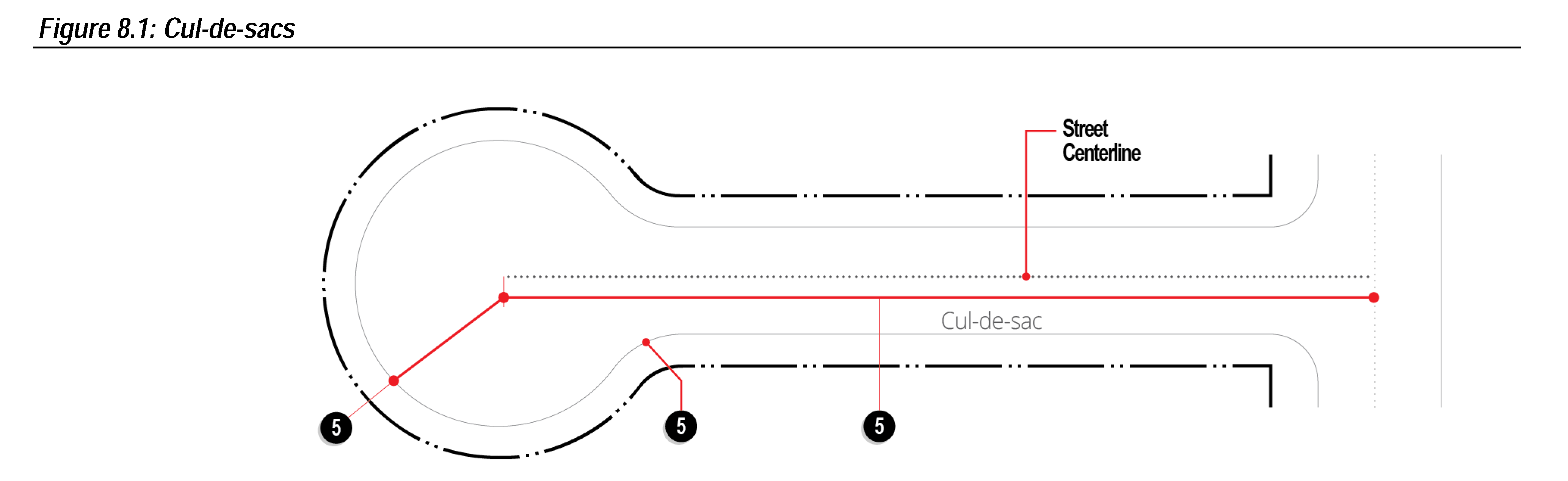
Cul-de-sacs. Cul-de-sacs shall not exceed 500 feet in length, measured from the entrance to the center of the turn-around, shall have a turn-around radius at the property line of not less than 50 feet and shall have a curb radius of not less than 40 feet.
(6)
Base Line. The subdivider shall form a base line from which future surveys are to be made. The point or points where the base line may be found shall be distinguished on the plat or map.
(7)
Intersections.
(a)
Streets shall be designed to intersect at right angles.
(b)
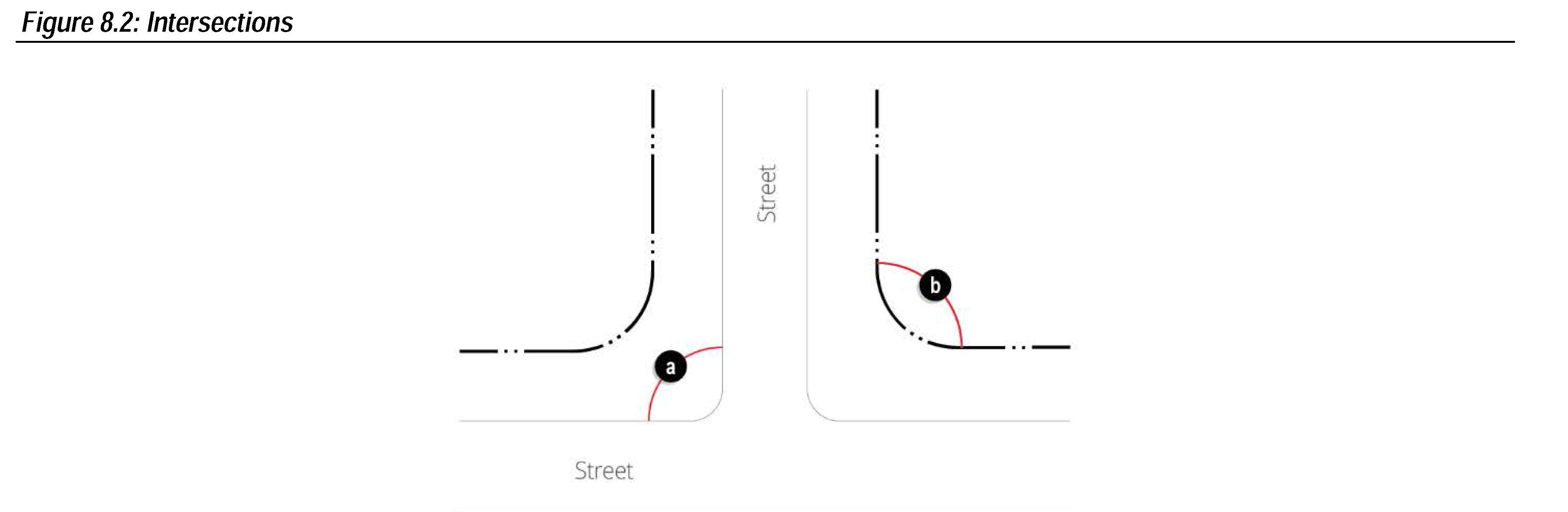
Property lines at minor street intersections shall be rounded with a minimum radius of 25 feet. Property lines at street intersections involving major streets and highways shall be rounded with a minimum radius of 30 feet.
(8)
Half Streets. The dedication of half streets shall not be permitted.
(9)
Dead End Streets. Dead end streets shall not be permitted except where same will be eventually extended in adjacent unplatted areas. Such temporary dead-end streets shall terminate with a turn-around.
(10)
Blocks.
(a)
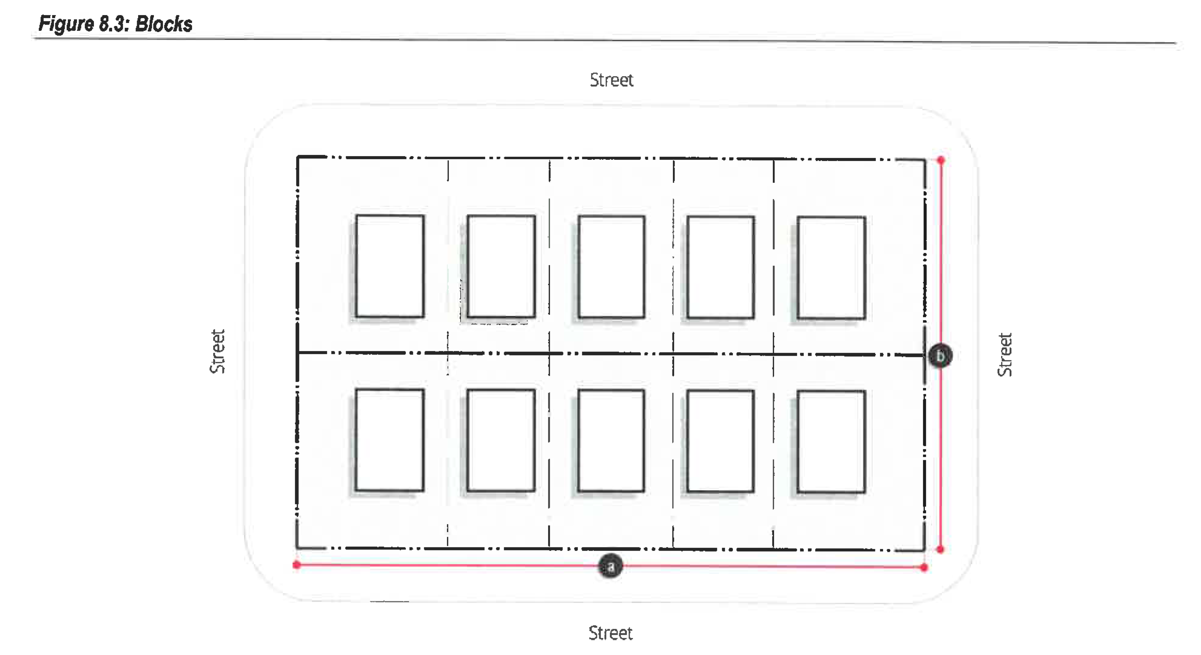
Length.
(I)
Blocks in residential subdivisions shall not exceed 800 feet in length.
(II)
Blocks in nonresidential subdivisions shall not exceed 1,320 feet in length.
(b)
Width. Blocks shall have sufficient width to provide for two tiers of lots of appropriate depth, except on the boundaries of a proposed subdivision, or where required to separate and discourage through traffic between residential subdivisions and nonresidential subdivisions.
(11)
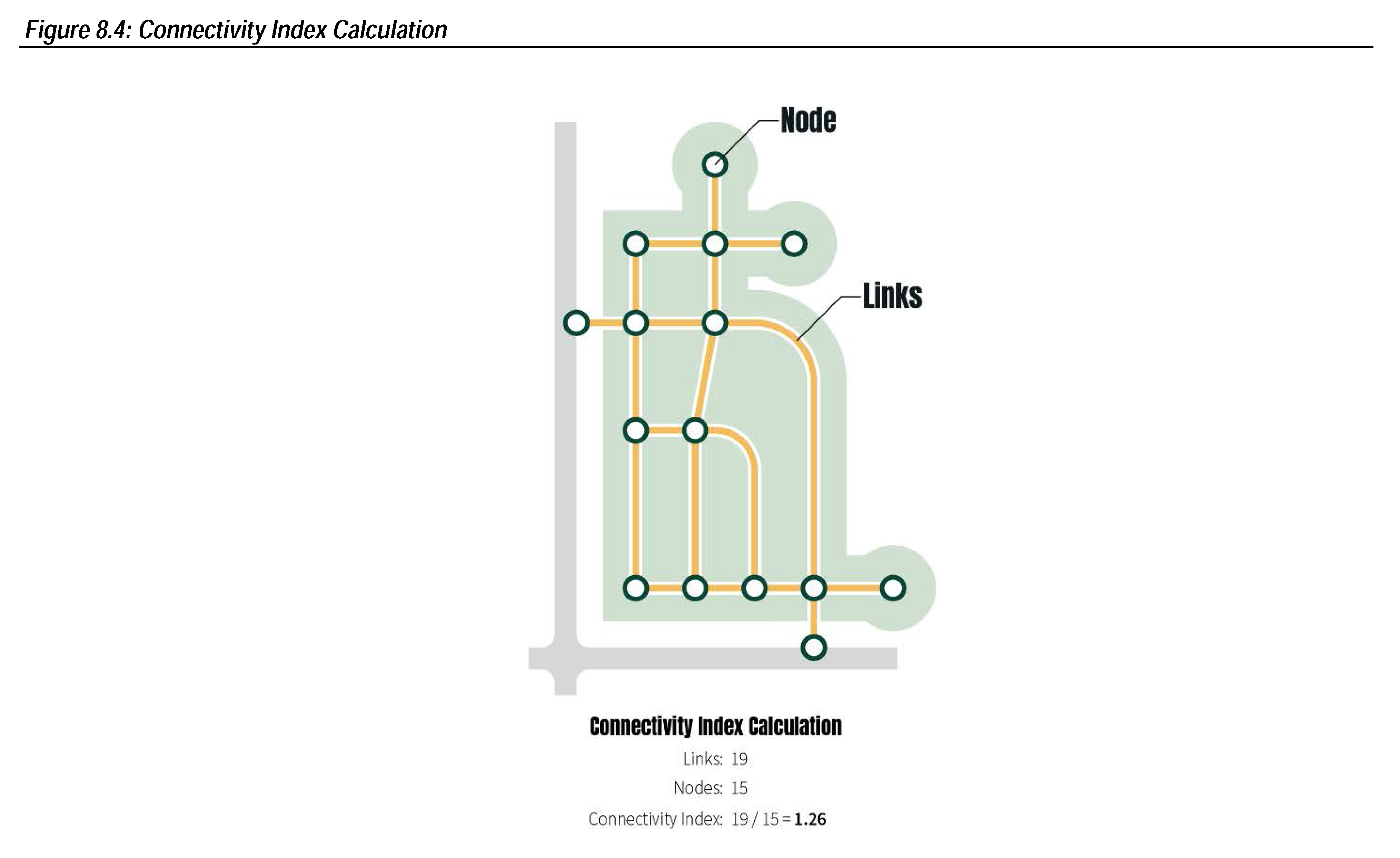
Connectivity Index. A connectivity index shall be used to determine the adequacy of street layout design. A connectivity index is calculated as the ratio of the number of street links (road sections between intersections) in the subdivision street layout divided by the number of street nodes (intersections and cul-de-sac heads). Streets within a subdivision shall have a minimum connectivity index measurement of one and two-tenths.
(G)
Light Pole Layout.
(1)
Light poles shall be located within the dedicated right-of-way.
(2)
Each intersection shall have a light on one of the corners.
(3)
Mid-block light poles shall be located near the mid-point locations on blocks 600 to 800 feet in length. For blocks 900 feet or longer, light poles shall be located at a minimum distance of every 300 feet.
(4)
Cul-de-sac shall have a light pole if the street length is at least 300 feet.
(5)
A light pole layout plan for the subdivision shall comply with the above spacing requirements and be provided to the City Engineer for approval at least one week in advance of a meeting with the Technical Advisory Committee, in which the plat will be reviewed.
(6)
Upon approval by the City Engineer, the City Engineer will submit the light pole layout plan to the appropriate electrical utility provider.
(Ord. No. 1581, § II, 4-5-2022; Ord. No. 1624, § VI, 10-17-2023)
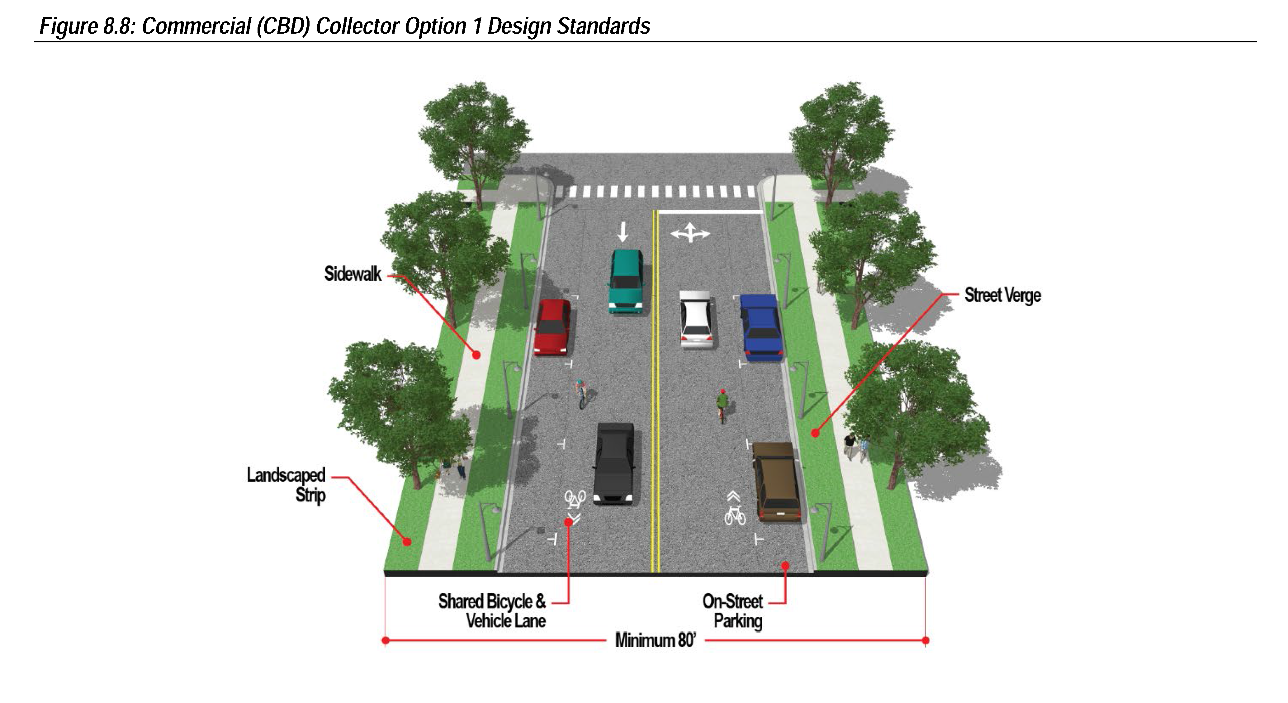
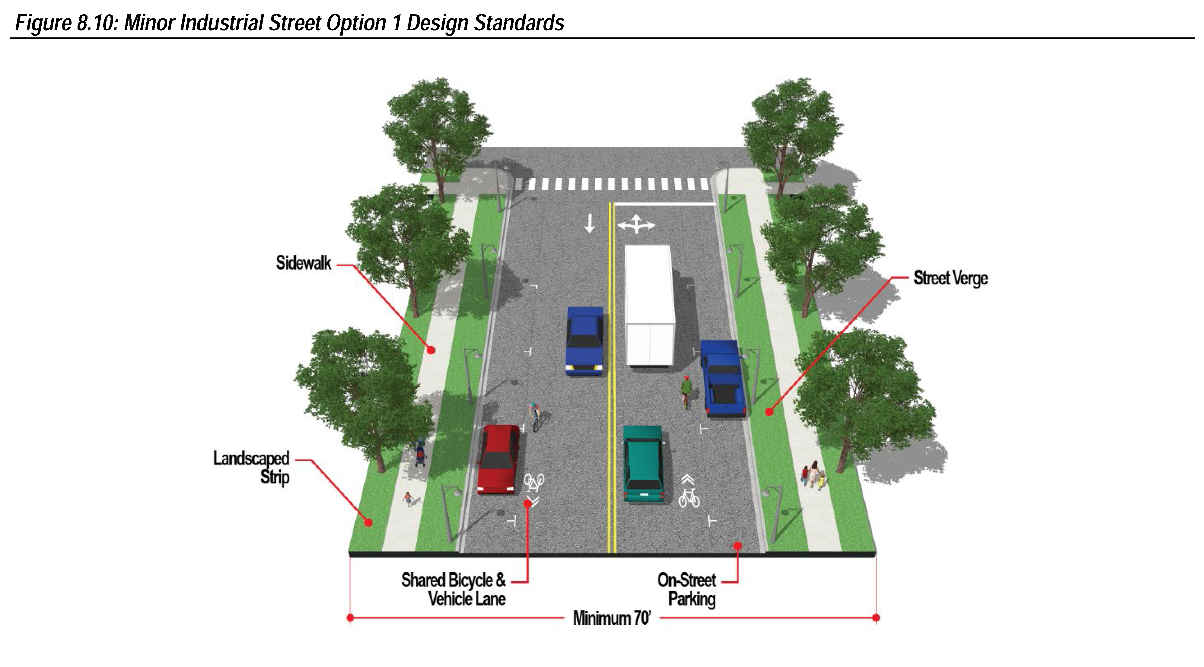
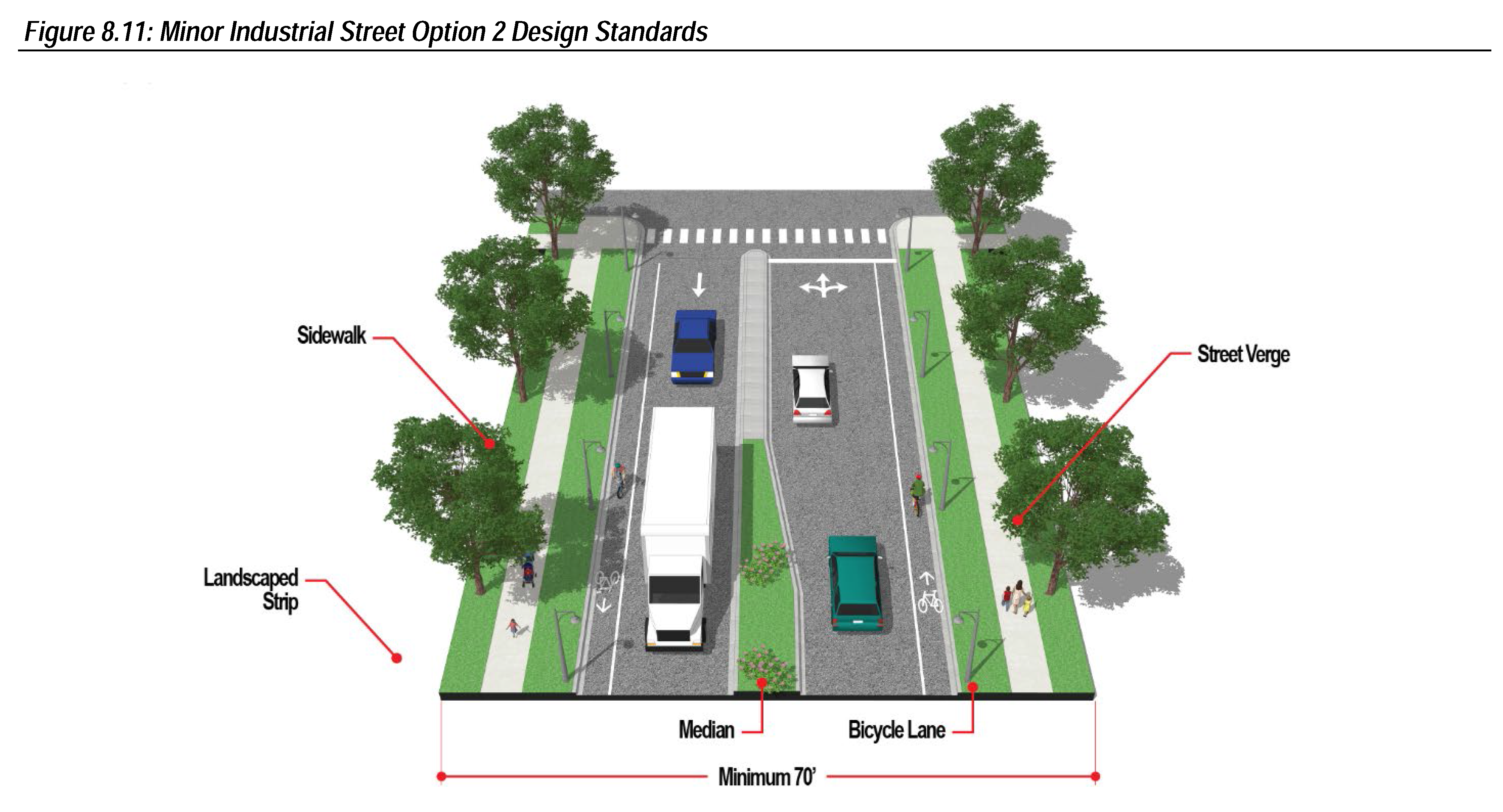
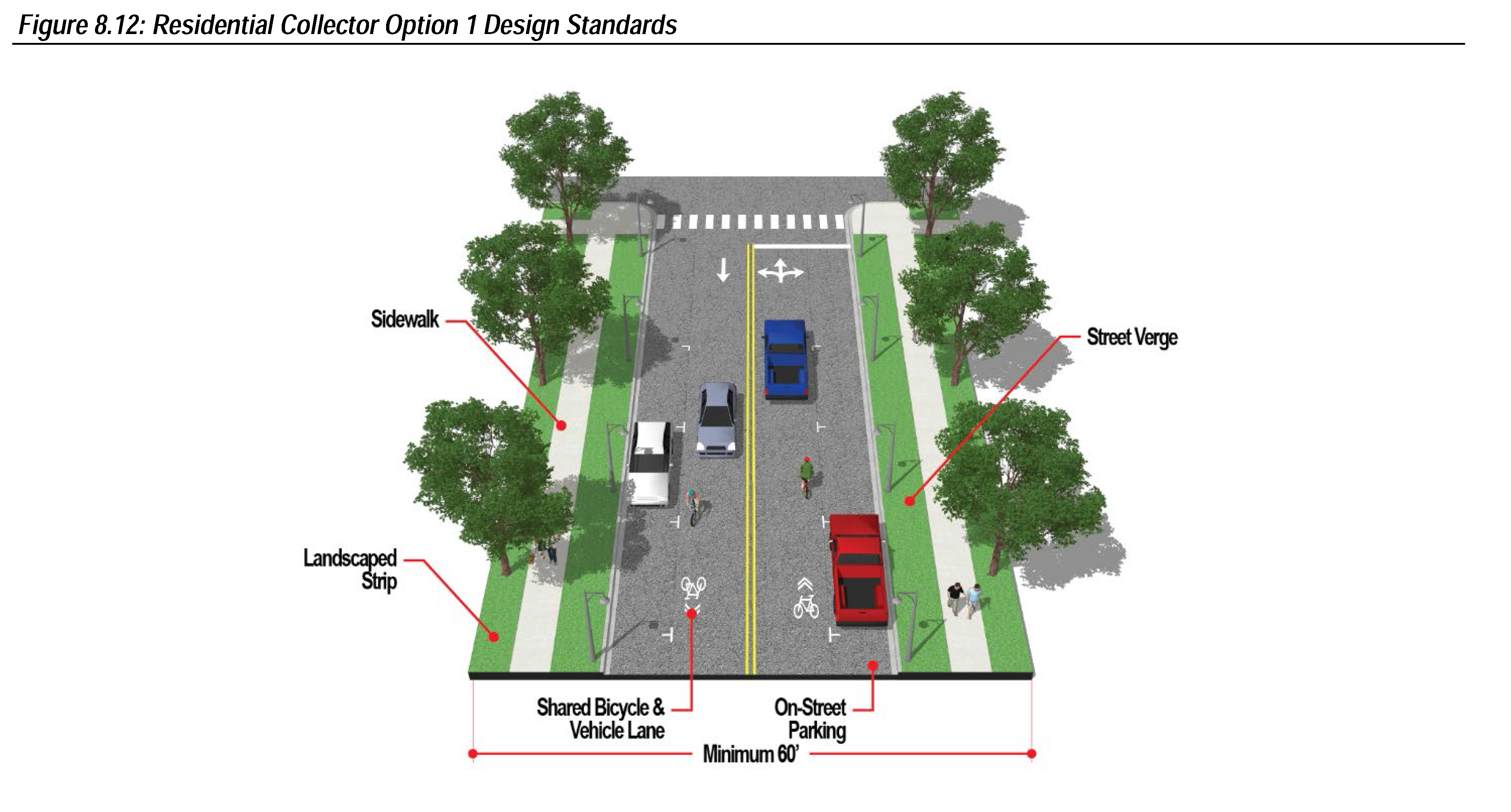
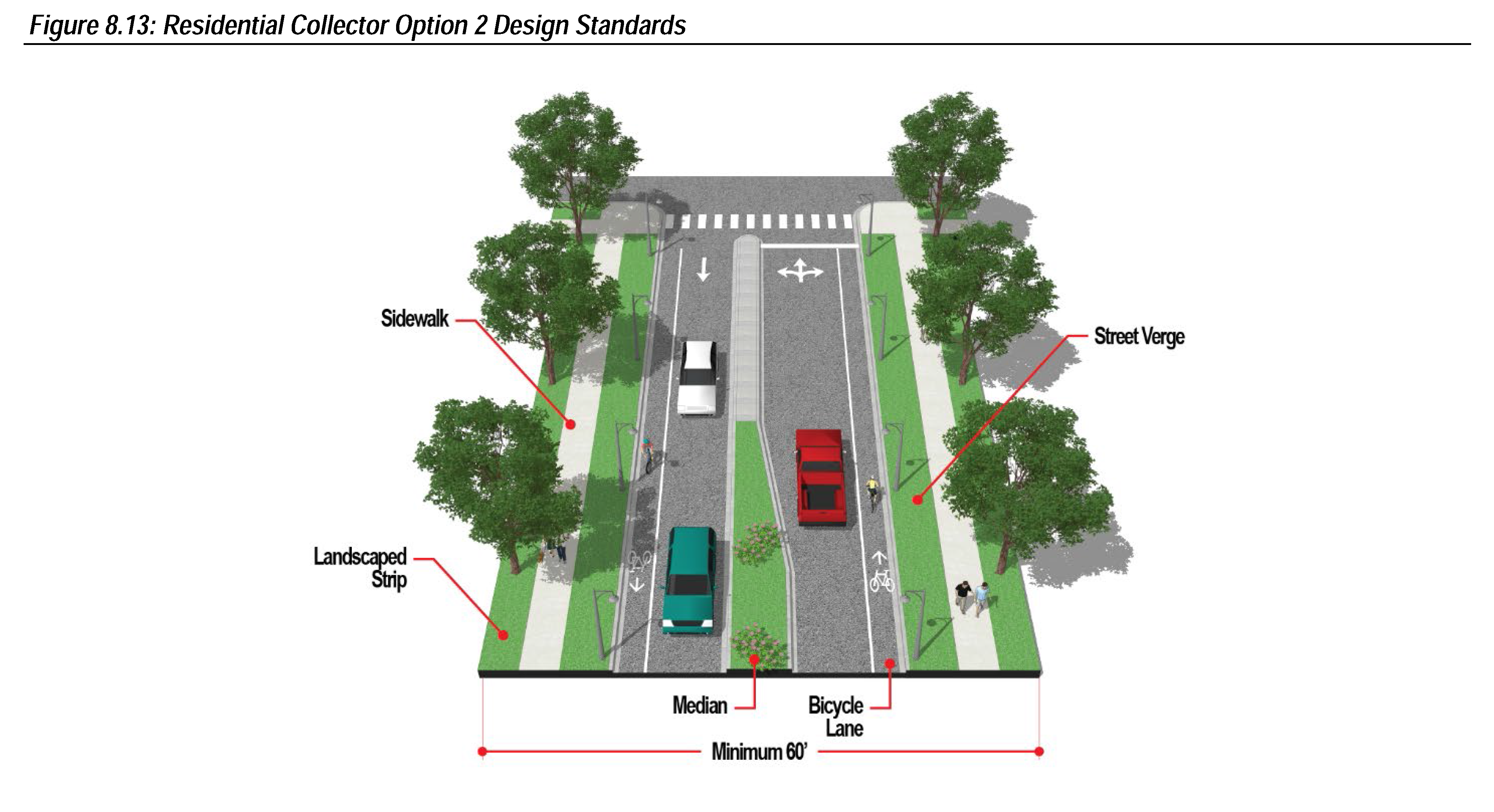
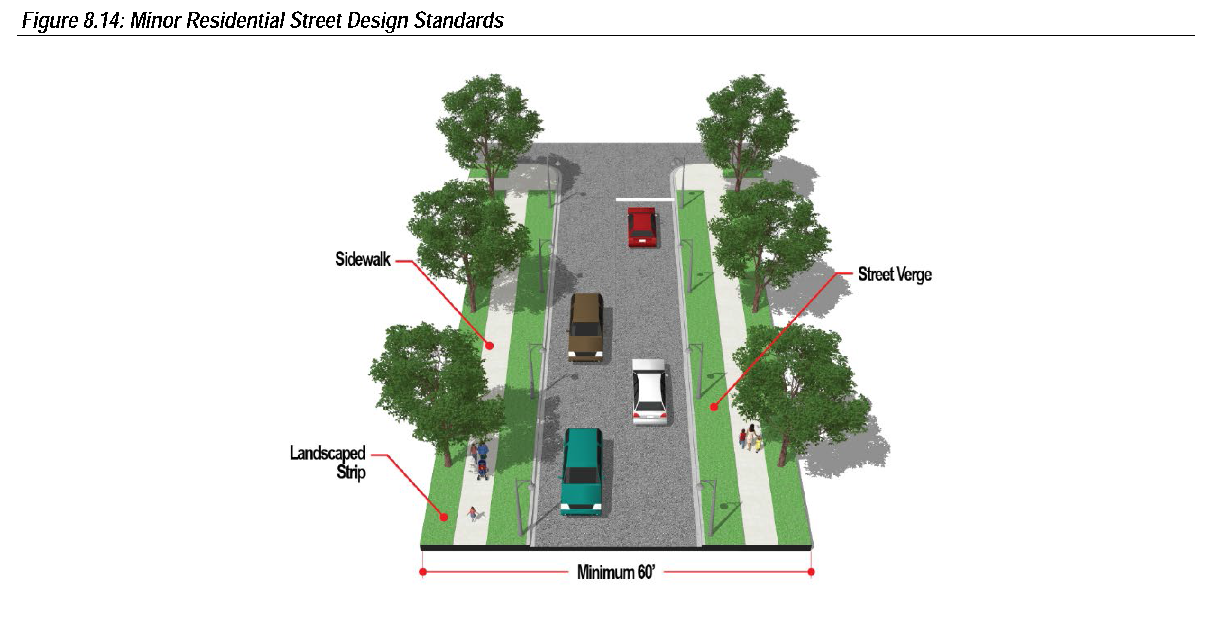
Sec. 16-8-8. - Street Design Standards.
(A)
Traffic Calming Devices. The use of traffic calming devices such as raised intersections, landscaping bulb-outs, and traffic circles are encouraged as alternatives to conventional traffic control measures.

(B)
Street Markers and Traffic Control Signs. All street markers and traffic control signs posted in accordance with the Manual of Uniform Traffic Control Devices shall be installed by the subdivider prior to the issuance of any certificates of occupancy for any building on that street.
(C)
Sidewalk.
(1)
A sidewalk with a minimum width of five feet shall be required on both sides of all streets.
(2)
If the parkway is utilized as a rain garden, the sidewalk shall be a minimum of three inches higher than the height of the curb.
(D)
Street Verge. A street verge with a minimum width of five feet shall be located between the back of curb and the sidewalk along both sides of all streets. Street verges shall be planted with turf grass or utilized as a rain garden.
(E)
Landscape Strip. A landscape strip with a minimum width of five feet shall be located between the sidewalk and the property line along both sides of all streets. Landscape strips shall be planted with either street trees or utilized as a rain garden as detailed below.
(1)
Street Trees.
(a)
A minimum of one canopy tree shall be planted every 40 feet.
(b)
Where overhead utility line conflicts are present, a minimum of one understory tree shall be planted every 20 feet.
(c)
The spacing of street trees shall take into consideration local conditions and clear vision triangles.
(2)
Rain Garden. Requirements for street trees may be waivered if the landscape strip is designed as a rain garden as approved by the City Engineer.
(F)
Utility Location. Utilities shall be located in the street verge along both sides of all streets.
(G)
On-Street Parking.
(1)
On-street parking shall be parallel.
(2)
On-street parking spaces shall have the following minimum dimensions:
(a)
Width: Eight feet.
(b)
Length: Twenty-three feet.
(3)
On-street parking spaces shall be delineated with striping with a minimum width of four inches.
(4)
The surfacing material of on-street parking spaces shall be textured to visually delineate parking spaces from drive aisles.
(H)
Medians.
(1)
Medians shall be improved with a mountable curb with a minimum height of nine inches and a gutter with a minimum width of nine inches.
(2)
Medians shall taper to a minimum of four feet at intersections.
(3)
The minimum width of medians shall be as established per street type in Table 16-8-8(H).
(I)
Median Landscaping.
(1)
Medians that are equal to or less than ten feet wide shall be planted with a minimum of 15 shrubs or native grasses every 50 linear feet.
(2)
Medians that are greater than ten feet wide shall be planted with a minimum of one canopy tree and 15 shrubs or native grasses every 50 linear feet.
(J)
Bicycle Facilities.
(1)
Bicycle lanes, with a minimum width of four feet.
(2)
Shared bicycle and vehicle lanes and bike lanes shall be delineated in accordance with NACTO standards.
(K)
Required Street Design Elements. Required street design elements shall be as established per street type in Table 16-8-8 (K). A "•" indicates a required element. If options are provided for a street type, the City Engineer shall determine which option is required.


(L)
Alleys.
(1)
Commercial and Industrial. Alleys may be required by City Council in commercial and industrial zoned properties to provide service access, off-street loading and unloading, parking and access for police and firefighting services. Alleys serving commercial and industrial zoned properties shall not be less than 30 feet in width of right-of-way.
(2)
Residential. Alleys are encouraged in residentially zoned properties and when provided shall be not less than 20 feet in width of right-of-way.
(3)
Alignment. Horizontal changes in alignment shall be gradual and at intersection corners shall have a radius of 20 feet to permit safe vehicular turning movements.
(4)
Dead End. Dead end alleys shall be avoided where possible, but where unavoidable, as determined by the City Engineer and City of Jenks Public Safety, shall be provided with an adequate vehicle turn-around at the terminus as deemed appropriate by the City Engineer and City of Jenks Public Safety.
(5)
Obstructions. No obstructions shall be permitted in areas reserved for alleys.
(M)
Access.
(1)
Each lot, tract, or parcel shall be provided with access to a public street, approved private street, or highway.
(2)
Non-access provisions controlling ingress and egress to streets may be required by City Council to assure traffic safety and to relieve congestion at intersections.
(3)
The minimum distance between access points are as specified in Table 16-8-8(M) unless otherwise approved by the City Engineer.
(Ord. No. 1581, § II, 4-5-2022)
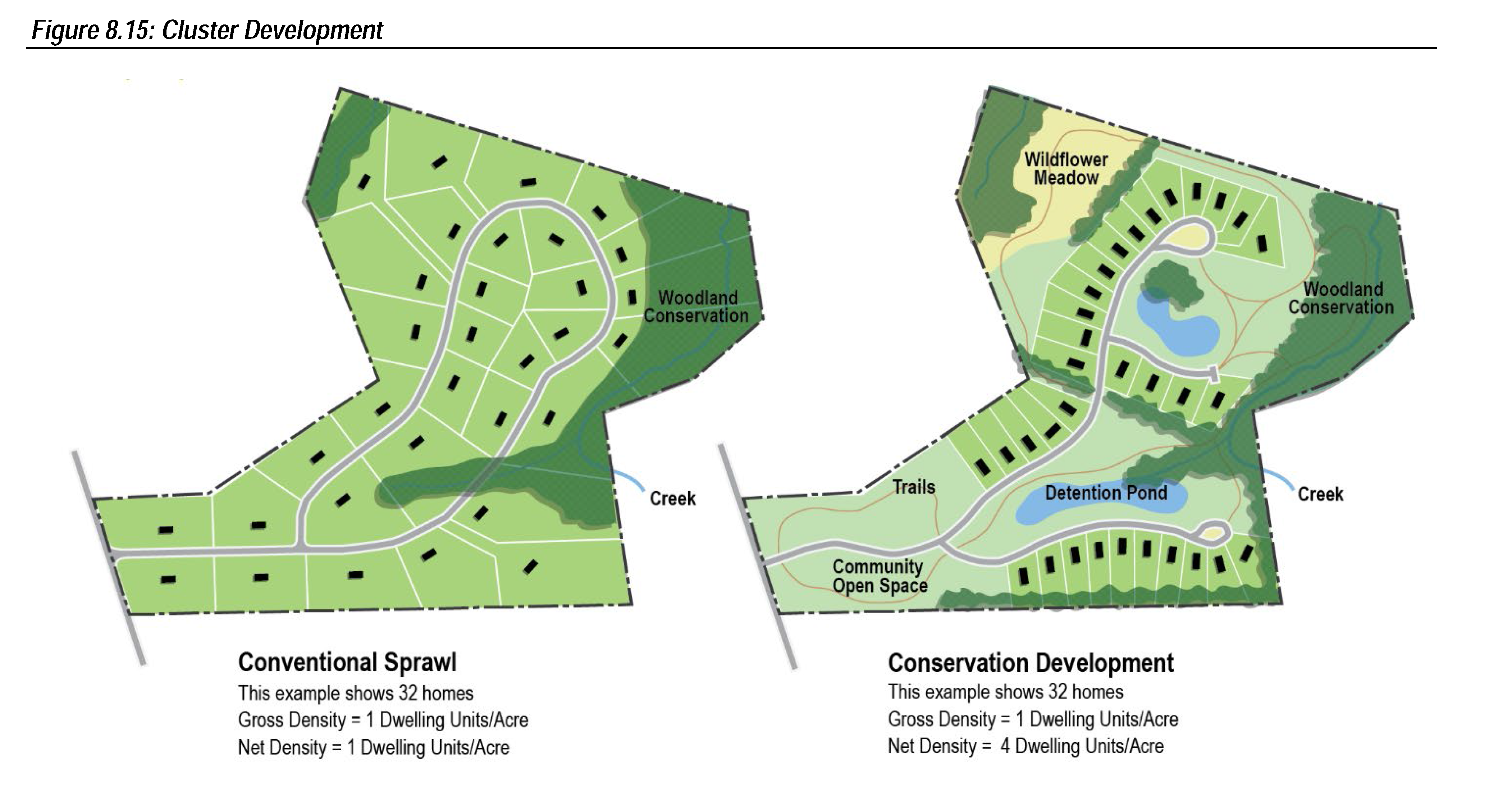
Sec. 16-8-9. - Cluster Development.
Cluster development is allowed in residential subdivisions in the RS1, RS2, RS3, and RD districts to encourage and accommodate, in a unified project, creative and imaginative approaches to development that preserve sensitive natural areas.
(A)
Resources to be Conserved. To qualify for cluster development any land located in a special flood hazard area, as determined by the Federal Emergency Management Agency, shall be placed in a conservation easement.
(B)
Maximum Density per Acre. The gross density of a cluster development shall not exceed the maximum dwelling units per acre detailed in Table 16-8-9(B).
(C)
Maximum Dimensional Standards Reduction. The dimensional standards established in Table 16-3-1(A) may be reduced by 30 percent or by the cumulative total land area to be placed in a conservation easement, whichever is less.
(D)
Density Bonus. The maximum gross density per acre, per district may be exceeded by a maximum of 30 percent if a minimum of one of the following sensitive natural areas are placed in a conservation easement. The maximum allowed density bonus shall be as determined by the City Council and shall be directly tied to the amount of land area placed in a conservation easement.
(1)
Wetlands,
(2)
Native landscapes,
(3)
Mature tree stands,
(4)
Prime farmland,
(5)
Critical habitat, and/or
(6)
Other as approved by the City Planner.
(Ord. No. 1581, § II, 4-5-2022)
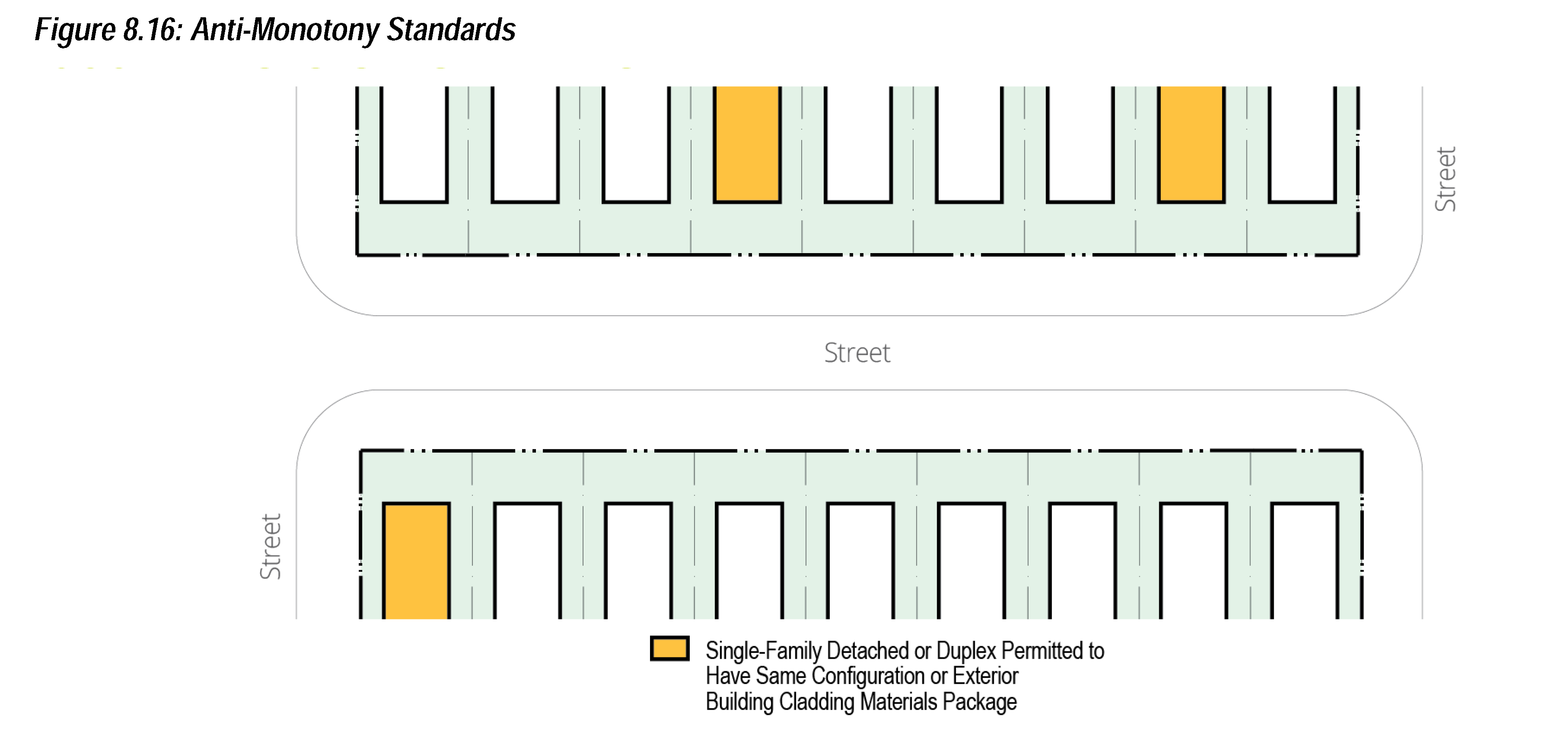
Sec. 16-8-10. - Anti-Monotony Standards.
No single-family detached house or duplex in a residential subdivision in the RS1, RS2, RS3, or RD districts shall have the same configuration or exterior building cladding materials package, excluding roof materials, as any other single family detached house or duplex within three houses on either of the subject property or on any of the five single-family detached houses or duplexes directly across the street from the subject property. These standards shall not supersede private covenants.
(Ord. No. 1581, § II, 4-5-2022)
Sec. 16-8-11. - Parkland Provision.
Residential subdivisions with a dwelling unit density greater than one unit per acre shall be required to provide, improve, and privately maintain parkland or pay a fee in lieu to the City of Jenks in accordance with the standards established in this section.
(A)
Private Parkland Provision.
(1)
Five and one-half acres of parkland shall be provided per every 1,000 persons projected to occupy the fully developed subdivision. To determine the number of persons projected to occupy the fully developed subdivision the subdivider shall submit a projected persons study based on occupancy data of similar housing types in subdivisions in communities approved by the City Planner.
(2)
Parkland shall be located outside of special flood hazard areas, wetlands, and areas of steep slope, and shall not be used for on site stormwater management or other utility functions. Parkland may be located within reserve areas as approved by the City Planner and City Engineer.
(3)
All areas to be reserved for private parkland shall be indicated on the preliminary plat in order that it may be determined that the requirements of this Subsection have been met.
(B)
Private Parkland Improvement. Private parkland shall be graded, seeded, and improved with curb, gutter, sidewalks, and recreational equipment. The subdivider shall be required to spend a minimum of $2,251.00 per acre on private parkland improvements.
(C)
Private Parkland Maintenance. A homeowner's association or similar legal entity shall be established and responsible for the maintenance of the private parkland in perpetuity.
(D)
Fee in Lieu. The City Council may require a subdivider to pay a fee in lieu of providing and improving parkland. The fee for the provision of parkland shall be calculated by multiplying the fair market value of land in the City of Jenks at the time of preliminary plat approval with the number of acres of required parkland dedication detailed in subsection (A) above. The fee for the improvement of parkland shall be the per acre cost detailed in subsection (B) above.
(Ord. No. 1581, § II, 4-5-2022)
Sec. 16-8-12. - Easements.
(A)
Types of Easements.
(1)
Utility Easements.
(a)
On individual lots, where alleys are not provided, City Council may require easements of a minimum width of 11 feet along each rear lot line and of a minimum width of ten feet along each side lot line as recommended by the Technical Advisory Committee for public and private utilities.
(b)
Easements of a minimum width of 17.5 feet shall be required along the perimeter of a subdivision for public and private utilities.
(2)
Drainage Easements. City Council may require drainage easements as recommended by the City Engineer. All drainage easements for facilities shall be of such dimensions so as to allow equipment access for construction and maintenance of the facility.
(3)
Fence Easement. City Council may require easements of ten feet along the perimeter of the fence, inclusive of any utility easement. The purpose shall be for the repair of subdivision perimeter fencing.
(4)
Sign Easement. City Council may require an easement of an adequate size to accommodate the placement of a subdivision entry sign and any appurtenant components and to allow for the repair and maintenance of such features.
(5)
Landscape Easement. City Council may require easements to accommodate landscape features. The width of the required easement shall depend on the transition zone type required depending on the adjacent land use as specified in section 16-6-3(F)(2).
(6)
Cross Access Easement. City Council may require easements of an adequate width to accommodate vehicular cross access maneuvering lanes as specified in section 16-6-1(D)(2).
(7)
Conservation Easement. City Council may require easements of an adequate size to accommodate natural resources to be conserved in cluster developments as specified in section 16-8-9.
(8)
Parkland Easement. City Council may require easements of an adequate size to accommodate the parkland required per number of subdivision residents as specified in section 16-8-11(A).
(B)
Easement and Public Right-of-Way Closure. City Council may by ordinance close to the public use any public way or easement whenever deemed necessary or expedient.
(1)
Procedure.
(a)
The City of Jenks shall give written notice of any proposed closing of a public way or easement to any holder of a franchise or others determined by the governing body to have a special right or privilege granted by ordinance or legislative enactment to use the public way or easement at least 30 days prior to the passage of any ordinance providing for closing of a public way or easement.
(b)
The City of Jenks shall retain the right to reopen the public way or easement without expense to the City. The public way or easement may be reopened under the following circumstances:
(I)
Whenever City Council deems it necessary, or
(II)
An application of the property owners owning more than one-half in area of the property abutting the public way or easement previously closed is filed with the governing body.
(c)
Closing of the public way or easement shall not affect the right to maintain, repair, reconstruct, operate, or remove utility, public service corporation, or transmission company facilities of service therein, nor shall a closing affect private ways existing by operation of law unless released in writing executed by the owners thereof.
(2)
Easement and Public Right-of-Way Vacation. Applicants should notify City in their application whether they intend to seek judicial vacation of the easement or public way. City Council may consent to an easement or public way vacation if there is no present or future reason to reopen or use the public way or easement as a public way or easement.
(a)
Upon approval of the closure, the owner of any real estate to which any public way or easement, or any part thereof, has heretofore reverted or may hereafter revert by closing may commence an action to vacate the easement or public way in Tulsa County District Court pursuant to state statute.
(Ord. No. 1581, § II, 4-5-2022)
Sec. 16-8-13. - Floodplain Areas and Flood Damage Prevention.
(A)
Floodplain Areas. Areas identified by the Federal Emergency Management Agency as floodplains shall not be subdivided into lots, tracts, or parcels unless:
(1)
Improvements are made to the City Engineer's and Building Inspector's requirements to render such land safe for residential or other use.
(2)
The intended use of the land is permitted by City ordinance or permitted by an approved Special Exception or Variance as outlined by this UDO.
(B)
Flood Damage Prevention. All subdivisions shall be designed to minimize flood losses and shall conform to the Flood Damage Prevention regulations contained in section 16-6-8 of this UDO.
(C)
Low Impact Development. Some of the existing natural site features typically protected through the use of Low Impact Development (LID) techniques are wetlands, floodplains, forested areas, hillsides, riparian corridors and existing soils. There are a variety of LID design alternatives that allow professionals in the land development field the flexibility to implement LID stormwater design elements. The various LID practices can be used alone or in series to maximize benefits to the site. In most cases, some type of structural drainage systems will also be required to be implemented in conjunction with LID element.
(1)
Objectives. The objectives of this section are.
(a)
To establish criteria by which an LID strategy can be measured and implemented through use of the criteria in the LID chapter of the Design Criteria Manual.
(b)
To strive to maintain and restore natural rainwater absorption and infiltration processes,
(c)
To strive to maintain pre-development hydrologic conditions,
(d)
To filter pollutants from stormwater runoff thereby improving water quality and positively impacting the region's ponds, rivers, lakes, streams and groundwater,
(e)
To reduce stormwater runoff intensity and velocity,
(f)
To preserve riparian banks and beds, and reduce sedimentation that impairs water quality,
(g)
To promote the widespread use of LID practices integrated with conventional stormwater engineering,
(h)
To protect the safety and welfare of citizens, property owners, and businesses by minimizing the negative impacts of stormwater discharge from land development.
(2)
LID Principles.
(a)
Define and locate critical resource areas during the project planning stage, such as; wetlands, riparian zones and soils with infiltration capacities.
(b)
Minimize impervious surfaces such as streets, driveways and parking areas.
(c)
Minimize direct connection of impervious areas which convey runoff directly to wetlands or water courses.
(d)
Attenuate stormwater flow through a diverse system of collection and infiltration.
(3)
Applicability.
(a)
Development Approval. The Design Criteria Manual provides guidelines and criteria for implementing LID design principles for a development and contains maintenance requirements for LID elements. The standards and guidelines in the Design Criteria Manual shall apply in all cases where a subdivider chooses to utilize LID to obtain Administrative, Planning Commission or City Council approval for their project.
(b)
Engineering Approval. The City Engineer, or their designee, will administer this chapter and shall be responsible for final approval of all LID systems and structures. With the approval of the City Engineer, LID systems and structures may be implemented.
(4)
LID Site Design Strategies.
(a)
Definition. For the purposes of this chapter Low Impact Development (LID) is a stormwater management strategy concerned with maintaining, restoring or replicating the natural hydrologic functions of a site, where possible, by employing a variety and combination of natural and built features that reduce the volume and velocity of stormwater runoff, filter out its pollutants, and facilitate the infiltration of water into the ground.
(b)
Site Design Strategies. Generally, site design strategies will address the arrangement of buildings, roads, parking areas, and other features, and the conveyance of stormwater runoff across the site. LID site design strategies are intended to complement the natural and built environment while minimizing the generation of runoff. Site design strategies should address some or all of the following considerations:
(I)
Necessary grading and land disturbance should be designed to encourage sheet flow and lengthen stormwater flow paths.
(II)
Natural drainage divides should be maintained to keep flow paths dispersed.
(III)
Areas of impervious surfaces should be separated and stormwater should be conveyed across vegetated areas. This assists runoff filtration and encourages infiltration.
(IV)
Distribute small-scale LID strategies across the development site in order to maximize benefits.
(V)
To the maximum extent possible, treat pollutant loads where they are generated.
(VI)
Preserve naturally vegetated areas and soil types that slow runoff, filter pollutants and facilitate infiltration.
(VII)
LID systems and structures should be integrated into the natural and built landscape with attention to flow paths, infiltration areas and the use of appropriate native plant materials.
(c)
Site Design Elements. In addition to water quality impacts, LID site design elements when successfully implemented, perform three necessary functions; filtration and infiltration, capture and re-use and reductions in impervious surfaces.
(5)
Maintenance of LID Systems and Structures.
(a)
Removal and Modification of LID Systems and Structures. LID systems and structures may only be modified or removed with the approval of the City Engineer, who shall determine the LID system or structure does not function as a part of the stormwater management system. The applicant may be required to provide supporting data and calculations that justify the removal of the LID systems or structures.
(b)
Exemptions from Maintenance Agreements and Inspections. LID systems and structures that are not designed as part of a development and are instead utilized on a site by site basis (i.e., use of a rain barrel at a single family home, or individual rain gardens or filter strips on a site) shall not be required to submit a formal maintenance and inspection agreement, unless the function of the LID system or structure is found to be essential to accommodating the stormwater needs of the property or surrounding properties by the City Engineer.
(Ord. No. 1581, § II, 4-5-2022)