
Jersey Village City Zoning Code
ARTICLE VII
STREET SYSTEM STANDARDS6
Cross reference— Streets, sidewalks and other public places, ch. 58.
Sec. 14-171.- Permit to construct public improvements.
(a)
Required. A person commits an offense if he constructs, alters or removes any public improvement without a permit for the work from the city.
(b)
Application procedures. The developer shall submit an application for the permit on standard forms provided by the city. The application shall be accompanied by three complete sets of proposed construction documents. Such plans and one set of construction cost estimates shall bear the seal of an engineer registered in the state, and shall be prepared in accordance with the latest city standards.
(c)
Issuance and fees. A permit for construction, alteration or removal of public improvements can be issued upon approval of the engineered plans and cost estimates (see subsection (d) of this section) for the work and payment of a plan checking and inspection fee in accordance with the duly adopted schedule of fees.
(d)
Construction documents.
(1)
Street construction documents. The developer shall submit separate street plans with a plan and profile of all proposed streets or roads with centerline and top of curb grades, ditch flowline and tops of ditch grades, and showing existing and proposed surface profiles. Each sheet shall include north point, scale, date and benchmark description to sea level datum. Scales shall be one inch equals 40 or 50 feet horizontally and one inch equals four, five or ten feet vertically. Each plan shall show all existing and proposed public improvements (drainage, sewer, water, etc.) within the limits of the street construction. The typical cross section of proposed streets showing the width of roadways and type of pavement and location and width of sidewalks shall be shown. Each plan shall show the seal and signature of the registered professional engineer who prepared the plans.
(2)
Grading plan. The developer shall submit a plan of the entire tract depicting the final grading contours and elevations, earthwork, quantities (cut and fill), slopes, retaining walls, drainage patterns, finished floor elevations of all existing structures, minimum floor elevations of all future structures and any other information considered necessary by the city at a scale of one inch equals 100 feet minimum.
(3)
Design summary. The developer shall submit a separate report entitled "Engineering Design Summary" with final plans and specifications for construction of public improvements and shall summarize calculations and such other engineering information pertaining to the major items of design significance as may be necessary in the city's review of the plans and specifications to determine whether the facilities proposed for construction have been designed in accordance with the intent of the city's design criteria. Calculations shall include drainage facilities, water demand, sewage flows and any others considered necessary by the city.
(4)
Format.
a.
The developer shall submit all improvement plans to the city on sheets 24 inches by 36 inches. A binding margin shall be provided of not less than 1½ inches on the left side of the sheet and margins not less than one-half inch on the three other sides.
b.
Upon approval by the city of the engineering plans and conditional approval of the final subdivision plat, the developer will be issued a permit to construct public improvements.
c.
Upon completion of the required public improvements, the developer's engineer registered in the state shall present to the city on high quality, reproducible drafting film (four mils thick) complete as-built plans for all paving, drainage structure, storm drains, water lines and sewer lines within 30 days of the completion of each contract. The engineer registered in the state shall confirm in writing that the as-built documents are in fact true representations of the actual construction.
d.
The city shall not accept ownership or maintenance of any public improvements until the developer submits all final plats, all as-built documents relating to the project to the city and a one-year maintenance bond.
(Ord. No. 95-04, § 1(600), 2-20-95)
Sec. 14-172. - General principles of street system layout.
(a)
The developer shall locate and align streets to conform to the comprehensive plan of the city. Streets shall be designated and designed according to their expected traffic capacity and function (see figure 14-4).
Figure 14-4 Street System Layout
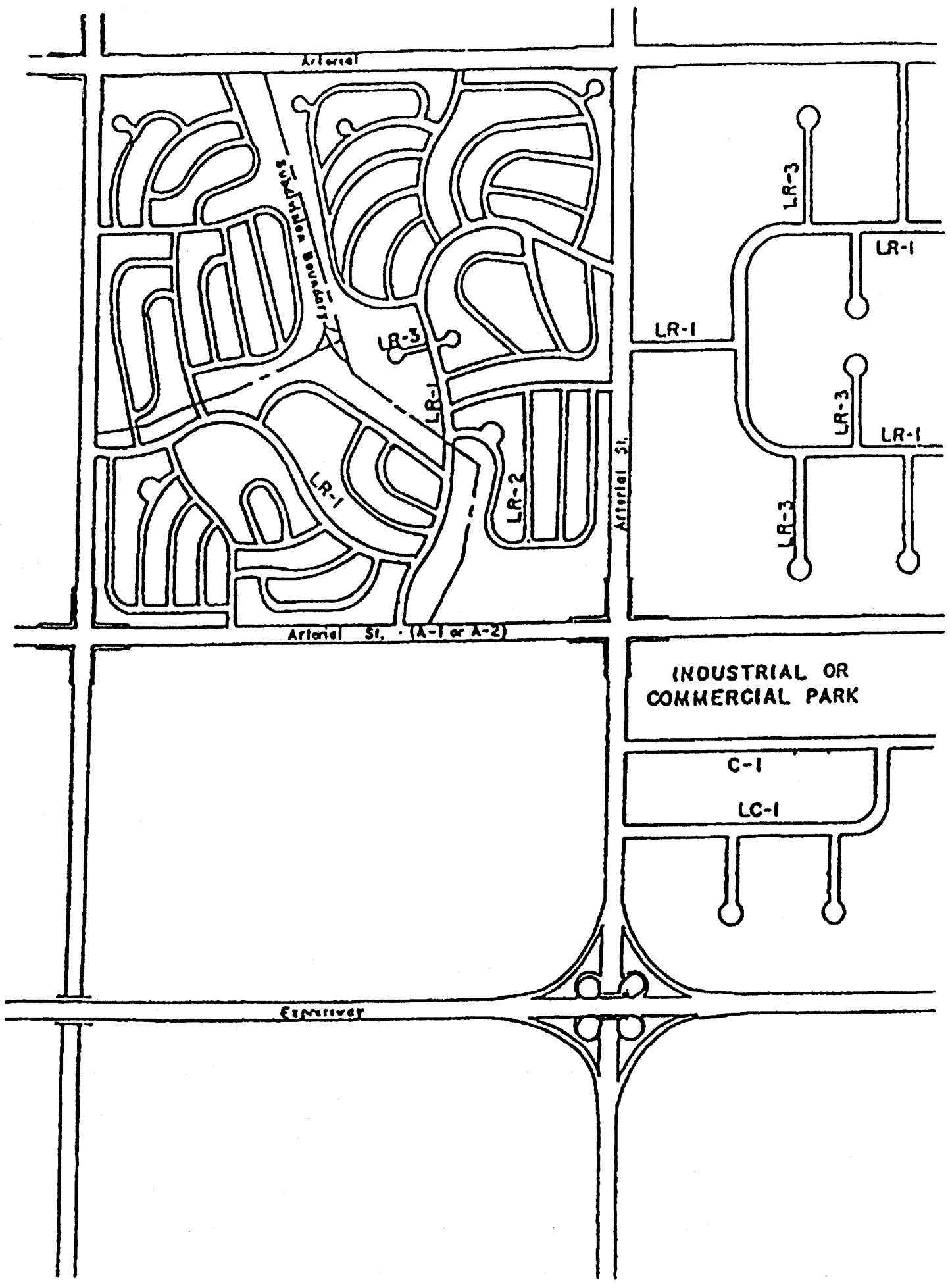
Figure 14-4 Street system layout
(b)
Classification of street system. The roadways within the city are classified according to the type of service and the expected traffic capacity to be provided. Each roadway classification has its own general design criteria and primary function. These functional classifications are used in subsection (c) of this section in describing the official city map and standards for construction, design and right-of-way dedication (refer to subsection (e) of this section). Table 14-3 provides a summary of street volume operating ranges by street classification.
TABLE 14-3
FUNCTIONAL DESIGN CAPACITY OF STREETS
(c)
Official city map. The official city map and any amendments thereto, adopted by the city council as a part of the comprehensive plan, is hereby made a part of this chapter. The map is the basis for all decisions regarding classification, reservation or dedication of rights-of-way which may be required in other sections of this chapter.
(d)
Construction and design standards. All roads, sidewalks, parking lots or other required paving shall conform to the construction and design standards of the city. These standards are adopted by reference in sections 14-184 and 14-185.
(e)
Dedication of street rights-of-way.
(1)
The dedication and/or reservation for acquisition of pedestrian and/or vehicular rights-of-way shall be required of owners or developers of properties. This is necessary and desirable to lessen or control the impact upon the transportation system created by development.
(2)
Street right-of-way widths shall meet the requirements established in table 14-5. Minimum required right-of-way shall be determined by the functional classification of the street as shown on the official street map and the adopted transportation plan.
(3)
Required street right-of-way shall be either dedicated by plat or deed to the city or the anticipated right-of-way area shall be reserved for future acquisition. If reserved for future acquisition, no physical improvements such as buildings, parking lots, landscaping or stormwater retention facilities shall be allowed within the area so reserved. All setbacks shall be calculated from the anticipated right-of-way line.
(Ord. No. 95-04, § 1(601), 2-20-95; Ord. No. 99-17, § 7, 8-16-99)
Sec. 14-173. - Street access.
(a)
Direct public access. All public streets shall have direct access to another public street.
(b)
Primary access. Primary access to large subdivisions, commercial tracts and industrial tracts shall be provided from public streets designed to carry fairly high traffic loads such as arterials and collectors. Residential tracts shall be protected from the adverse effects of through traffic by locating lots facing local streets.
(c)
Points of access. The developer shall provide a street system within the development with at least one point of access to a public street adjacent to the development; provided, however, that developments containing 150 dwelling units or more shall provide at least two points of access to adjacent public streets.
(Ord. No. 95-04, § 1(602), 2-20-95)
Sec. 14-174. - Location of public streets.
(a)
The developer shall submit a design for the system of streets within a subdivision development. Certain streets should be planned to carry large volumes of through traffic (arterials, collectors) while other streets (locals) should be laid out to provide access within a development. Arterial and collector streets, if located within a residential subdivision, should follow the continuity of city streets leading to or from the development and should provide for extensions into adjacent tracts. The city shall determine the final location of all public streets.
(b)
Local streets shall be designed to service only the development in which they are contained. In locating local streets, the developer shall:
(1)
Create building lots of desirable elevation, size, shape and orientation;
(2)
Discourage through traffic;
(3)
Ensure access by firefighters, police and other emergency services to all areas of the tract; and
(4)
Ensure vision clearance.
(Ord. No. 95-04, § 1(603), 2-20-95)
Sec. 14-175. - Intersection of public streets.
(a)
Generally. The developer shall keep the number of intersections to a minimum consistent with traffic needs. The number of streets permitted to converge at a single intersection shall be minimized. Intersecting streets shall be designed so that they intersect at right angles with variations not to exceed 15 degrees. If jogs are necessary, the developer shall connect the streets by means of diagonal curve or line; that is, the street shall be curved as it approaches the intersection, in order to effect a nearly right-angle alignment to the greatest extent possible. Intersections shall be staggered or offset only if the distance between street centerlines is at least 125 feet.
(b)
Local to collector/arterial intersections. Local streets intersecting a collector or arterial street shall have a tangent section of centerline at least 50 feet in length, measured from the right-of-way line of the higher traffic volume street; however, no such tangent is required if the minor street curve has a centerline radius greater than 400 feet with the center located in the higher traffic volume street right-of-way line.
(c)
Sight triangle.
(1)
In order to provide a clear view of intersecting streets, there shall be a triangular area of clear vision formed by two intersecting streets. The size of the triangular area is based on street classification.
(2)
On any portion of a lot that lies within the triangular area shown in figure 14-5, nothing shall be erected, placed, planted or allowed to grow in such a manner as to materially impede vision between a height of three feet and eight feet above the grade at the two street centerlines.
(3)
The triangular area shall be formed by a point on each proposed street centerline located 100, 160 or 200 feet from the intersection of the street centerlines, as indicated in figure 14-5, and a third line connecting the two points.
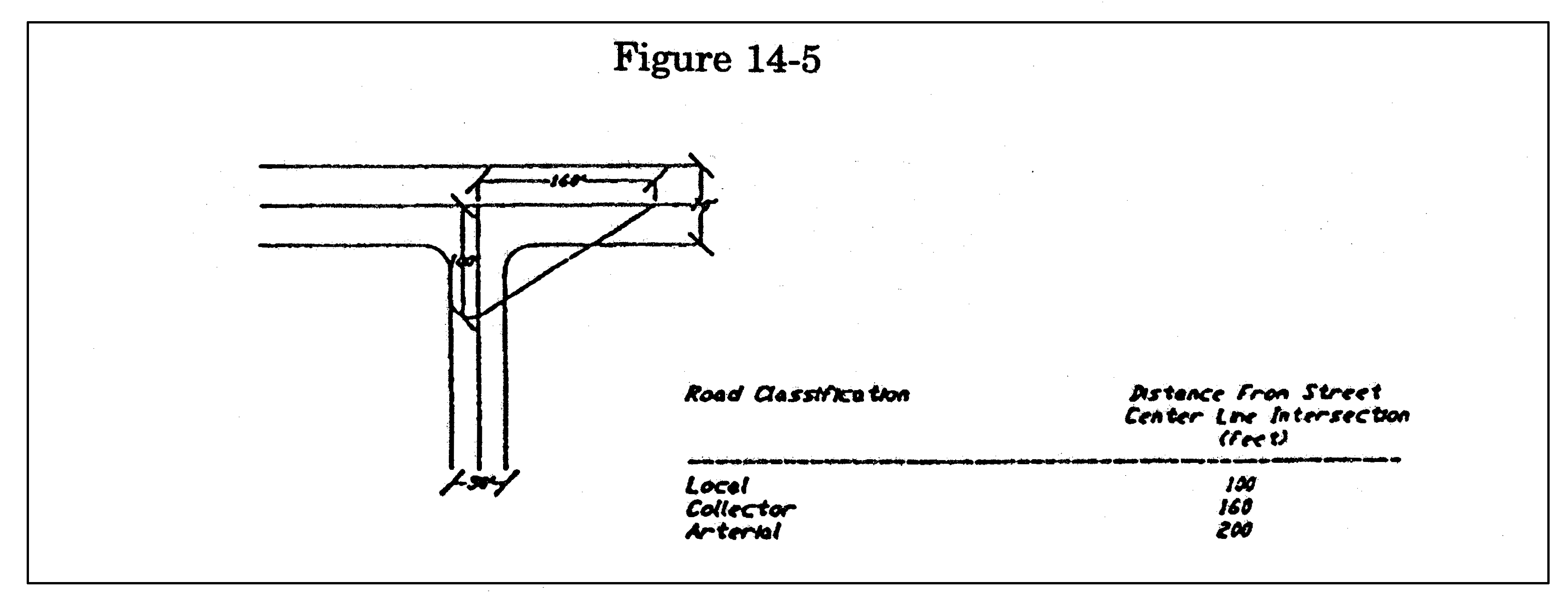
Figure 14-5 Sight Triangle
(d)
Location of intersections.
(1)
Arterial streets. The maximum distance between streets (centerline to centerline measurement) intersecting arterial streets shall be 1,800 feet; the minimum distance shall be 800 feet.
(2)
Collector streets. The maximum distance between streets (centerline to centerline measurement) intersecting collector streets shall be 1,000 feet; the minimum distance shall be 600 feet.
(3)
Local streets. The maximum distance between streets (centerline to centerline measurement) intersecting local streets shall be 1,000 feet; the minimum distance shall be 200 feet.
(Ord. No. 95-04, § 1(604), 2-20-95; Ord. No. 01-30, § 12, 10-15-01)
Sec. 14-176. - Sidewalks.
The developer shall install, at a minimum, four feet wide sidewalks along all streets. Sidewalk improvements shall be constructed according to the adopted standards of the city.
(Ord. No. 95-04, § 1(605), 2-20-95)
Sec. 14-177. - Half-streets.
Half-streets are prohibited. The developer shall construct full street improvements for any development.
(Ord. No. 95-04, § 1(606), 2-20-95)
Sec. 14-178. - Reserve access strips.
The developer shall not reserve ownership of strips of land at the end or alongside offered or existing streets for the purpose of controlling access to property unless the reserve access strip is dedicated to the public under conditions approved by the city.
(Ord. No. 95-04, § 1(607), 2-20-95)
Sec. 14-179. - Alleys.
Public alleys shall be prohibited. If secondary access is provided, the developer shall construct private alleys to meet or exceed private street standards contained in section 14-182.
(Ord. No. 95-04, § 1(608), 2-20-95)
Sec. 14-180. - Street lighting standards.
(a)
Location. The developer shall install decorative streetlights conforming to city standards and designed in accordance with recommendations of the Illuminating Engineering Society of North America at all street intersections, at the end of all cul-de-sac or dead end streets, and at all significant changes in direction of the roadway.
(b)
Installation. The developer shall install streetlights with underground wiring throughout the development. Streetlights shall be 100-watt, high-pressure sodium, 9,500 lumen, Postop style luminaires mounted to 14-foot Traditionaire poles. The developer shall pay for the purchase and installation of all streetlights.
(c)
Engineered plans and approvals. The developer shall show streetlight locations and intensities on the utility layout master plan (see subsection 14-55(2)a.6.ii.) for approval by the city and CenterPoint Energy or its successors. The city will accept street lighting installations upon receipt of a written recommendation from CenterPoint Energy or its successors.
(d)
Ownership and maintenance. All streetlights installed according to this section shall be and shall remain the property of CenterPoint Energy or its successors.
(Ord. No. 95-04, § 1(609), 2-20-95; Ord. No. 99-17, §§ 8, 9, 8-16-99; Ord. No. 05-05, § 1, 2-21-05)
Sec. 14-181. - Cul-de-sac and dead-end public streets.
(a)
General standards. The developer shall design cul-de-sac streets to prohibit future extensions by arranging lots around the turnaround. The developer shall construct a circular turnaround conforming to city standards for all cul-de-sac and dead-end public streets. The cul-de-sac turnaround shall have a pavement radius of 50 feet and a right-of-way radius of 60 feet. The developer shall not design or construct a dead-end street unless it is intended to connect with a future street on adjacent land. The developer shall construct temporary turnarounds within the standard right-of-way at the end of any dead-end street. In a commercial/industrial development, however, construction of a temporary turnaround may be waived if adequate alternatives are available for vehicles to turn around.
(b)
Length. The length of cul-de-sac and dead-end streets is the distance from the right-of-way line of the intersecting street along the centerline of the cul-de-sac or dead-end street to the center of the circular turnaround. The maximum length of cul-de-sac and dead-end streets shall be related to the expected traffic volume, expressed in vehicle trips per day (VTD), of the street at the time of full development. The developer shall furnish the city all necessary data to substantiate the length of the proposed street. VTD for residential areas shall be based on an average of five trips per day per dwelling unit. The maximum length of any cul-de-sac or dead-end street shall be:
(Ord. No. 95-04, § 1(610), 2-20-95)
Sec. 14-182. - Private streets.
(a)
Generally. The developer shall design and construct private streets in accordance with this section. Private streets shall be designated by plat and may be used only within the following types of developments: Unified developments (see section 14-135(b) where the lot or tract is retained under one ownership or multiple ownerships through undivided interests; mobile home parks (see section 14-132(g)) and recreational vehicle parks (see section 14-133(3)).
(b)
Layout. The developer shall design private streets to:
(1)
Provide adequate vehicular access to all buildings and facilities within the boundaries of the development;
(2)
Provide adequate interior traffic circulation and access to all buildings by firefighting personnel and equipment;
(3)
Allow for the smooth flow of vehicular traffic, avoiding such traffic hazards as closely offset intersections; and
(4)
Provide direct access to the existing public street system adjacent to the tract boundaries.
(c)
Intersections with public streets. Private streets shall not be direct (straight line) projections of any public street. The private street shall offset a minimum distance of 125 feet centerline to centerline from any public street intersection. Intersections of all private streets with public streets shall be at right angles with variations not to exceed 15 degrees. Right angle intersections of private streets shall have a 20-foot radii for the pavement edge at all corners. Acute angle intersections shall have 25 foot radii for the pavement edge at the acute corner on both public and private streets. The portion of a private street within a public street right-of-way, shall be designed and constructed by the developer in accordance with city driveway standards (see section 14-282).
(d)
Access. The developer shall provide a street system within the development with at least one point of access to a public street adjacent to the development; provided, however, that developments containing 150 dwelling units or more shall provide at least two points of access to adjacent public streets. Private streets shall serve only the land within each development. The developer shall not extend private streets into adjacent tracts under a different ownership or a different property owners association.
(e)
Maintenance. Maintenance of private streets and private street signs shall be the responsibility of property owners within the development. The property owners shall be legally bound together by deed restriction, contract, property owners association, corporation or other organization that has as one of its purposes the continued care and maintenance of all commonly owned property within the development, including the private streets and private street signs.
(f)
Design and construction standards.
(1)
Design. The developer shall design private streets according to the standards established for local public streets (see sections 14-184 and 14-185).
(2)
Pavement width. The minimum unobstructed width of any private street shall not be less than 28 feet. If parking is proposed along the private street, the developer shall widen the street to accommodate such parking.
(3)
Access easements required. The developer shall locate private streets within private access easements (see section 14-62 for dedicatory statement) of sufficient size to accommodate the private streets and related construction and maintenance activities.
(4)
Cul-de-sac and dead-ends. Cul-de-sac and dead-end private streets shall be terminated by a circular turnaround having a paving radius of not less than 50 feet.
(5)
Construction. The developer shall construct private streets according to the standards for pavement and base for local public streets as established in section 14-185(b).
(g)
Street lighting. The developer shall provide adequate lighting along all private streets so spaced and equipped with luminaries at such mounting heights as will provide the average levels of illumination as defined in section 14-180.
(Ord. No. 95-04, § 1(611), 2-20-95; Ord. No. 01-30, § 8, 10-15-01)
Sec. 14-183. - Street names.
(a)
Public street names. The developer shall name public streets in conformance with the criteria established in this subsection:
(1)
Names of new streets, not extensions of existing streets, shall not duplicate any existing street name in the city or county.
(2)
If a new street is a direct or logical extension of an existing street, the existing street name shall be used.
(3)
Street name suffixes such as place, court, circle and loop shall be designated on streets that are cul-de-sac or loop streets. Suffixes such as boulevard, parkway, expressway and drive shall be confined to designated arterial or collector streets. Suffixes such as highway or freeway shall be used only on designated highways or freeways falling under the jurisdiction of the state department of transportation.
(4)
Street name prefixes such as North, South, East and West may be used to clarify the general location of the street; however, such prefixes shall be consistent with the existing and established street naming and address numbering system of the general area in which the street is located.
(5)
Alphabetical and numerical street names shall not be designated on any development plan unless the street is a direct extension of an existing street with that name.
(6)
Street names shall fit in with the names of existing streets in the area, and should, if possible, be named in a manner to provide direction to the general public (i.e. Park Street, Library Avenue, Museum Drive).
(7)
Streets should not be named as a memorial to or in honoraria of a person, either living or deceased, unless the person being so honored has, in the opinion of the city council, made significant contributions to the betterment of the city, state or nation. Streets, once named, may not be renamed without a three-fourths majority of the city council.
(b)
Private street names.
(1)
Private street names shall conform to the same standards applicable to public street names and the following additional criteria:
a.
The developer shall provide signs for all private streets; the signs shall conform in size, height and material to city standards.
b.
Private streets shall be designated as ways and the suffix "private" shall be an integral part of any street sign (Example: Scenic Way (Private)).
c.
The background color for any private street sign shall be brown.
(2)
No private street name shall be changed without approval of the city.
(3)
No private street sign shall be installed without the approval of the city.
(4)
Private street signs not established in conformance with the provisions of this section and installed within the right-of-way of any public street may be removed from the public street right-of-way without notice.
(Ord. No. 95-04, § 1(612), 2-20-95)
Sec. 14-184. - Geometric criteria.
Sec. 14-185. - Street structural thickness design.
(a)
Engineered design of street structural section. Except as provided by subsection (b) of this section, the developer shall have an engineer registered in the state design the street structural sections (structural thickness) in accordance with:
(1)
Portland Cement Association, Rigid Pavement Design Method; or
(2)
Any other design methods not specifically mentioned in this article may be used, with prior approval of the city.
TABLE 14-6
STREET DESIGN BY EQUIVALENT AXLE LOADS
(20-YEAR DESIGN LIFE)
(b)
Soils testing and subgrade stabilization.
(1)
The developer shall submit to the city a soil test report for each 1,000 square yards of paved surface proposed or for each type of soil encountered in the subgrade.
(2)
The developer shall submit to the city the following data as part of the soil test report:
a.
Soil classification;
b.
Optimum moisture/density (Modified Proctor, ASTM D 1557);
c.
Atterberg Liquid Limits and Plasticity Index (P.I.);
d.
Stabilization requirements for subgrade soil (percent lime for clay or percent cement for sandy soils), if street structural section is to be designed by an engineer;
e.
All tests shall be performed by a certified testing laboratory approved by the city.
(3)
The developer shall stabilize all subgrade soils with a P.I. of 20 or more:
a.
If the standard structural section design for paved local streets is used, five percent lime by weight may be used; otherwise,
b.
The developer shall have a certified testing laboratory conduct lime (or other approved material) series test to determine the percent of stabilizing agent necessary to lower the P.I. below 20.
(4)
Native soils with a P.I. of less than 20 may be used as subgrade material as long as they can meet the city's compaction requirements (see subsection (c)(1) of this section). The developer may add a stabilizing agent (lime, cement, etc.) as recommended by soils analysis, to such low P.I. soil to aid in compaction.
(5)
Subgrade soils evaluation shall generally apply to the top six inches of soil measured down from the proposed subgrade surface.
(c)
Other basic criteria.
(1)
The developer shall compact all subgrade and individual layers of base and paving materials to 95 percent relative density, Modified Proctor Test.
(2)
The total design thickness of the street structural section shall be rounded up to the nearest whole inch.
(3)
The developer shall completely clear and grub the area within the street right-of-way prior to construction of any street improvements.
(4)
Any other design methods not specifically mentioned in this chapter may be used with prior approval of the city.
(5)
The design requirements set forth in this section are minimum design standards. The city reserves the right to require additional precautions or treatments consistent with sound engineering practice to provide for conditions not specifically covered in this section.
(Ord. No. 95-04, § 1(614), 2-20-95; Ord. No. 99-17, § 10, 8-16-99)
Sec. 14-186. - Figure 14-6 arterial streets (major and minor).
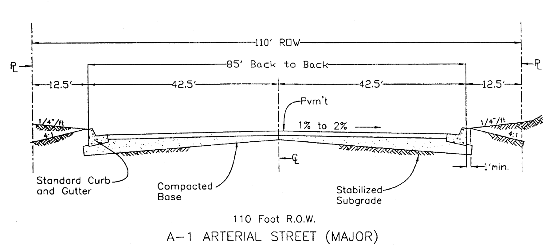
arterial streets
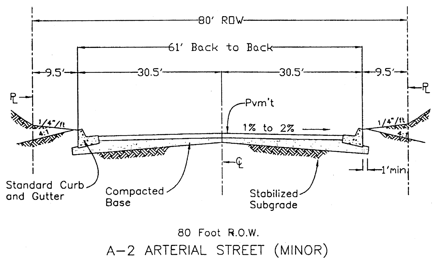
arterial streets
(Ord. No. 95-04, § 1(fig. 6-3), 2-20-95; Ord. No. 99-17, § 11, 8-16-99)
Sec. 14-187. - Figure 14-7 local commercial street; residential street.
C-1 Collector
R-1 Residential
(Ord. No. 95-04, § 1(fig. 6-4), 2-20-95; Ord. No. 99-17, § 12, 8-16-99)
Secs. 14-188—14-205. - Reserved.
Editor's note— Ord. No. 01-30, § 1, adopted Oct. 15, 2001, repealed §§ 14-188, 14-189, which pertained to Figures 14-8 and 14-9 re certain types of streets, derived from Ord. No. 95-04, § 1(Figs. 6-5 and 6-6), adopted Feb. 20, 1995.