
Kennesaw City Zoning Code
CHAPTER 3
PROTECTION OF NATURAL FEATURES AND RESOURCES
3.00.00 - GENERALLY
A.
The provisions set forth in Chapter 3 are intended to protect the natural features and natural resources within The City of Kennesaw, and to implement policies in the Comprehensive Plan. The natural features and natural resources included in Chapter 3 are the floodplain, soil erosion and sedimentation control, water supply and watersheds, wetlands, river corridors, and stream buffers.
B.
Definitions: The following words, terms and phrases, when used in this section, shall have the meanings ascribed to them in this subsection:
Accessory Structure or Facility: A structure which is on the same parcel of property as the principal structure and the use of which is incidental to the use of the primary structure.
Addition (to an existing building): Any walled and roofed expansion to the perimeter or height of a building in which the addition is connected by a common load-bearing wall other than a firewall. Any walled and roofed addition which is connected by a firewall or is separated by an independent perimeter load-bearing wall shall be considered New Construction.
Appeal: A request for a review of the City of Kennesaw's interpretation of or decision with respect to any provision of an ordinance or code to the applicable appeals body.
Area of Shallow Flooding: A designated "AO", "AH", "AR/AO", "AR/AH" zone on a community's Flood Insurance Rate Map (FIRM) with a one percent or greater annual chance of flooding to an average depth of one to three feet where a clearly defined channel does not exist, where the path of flooding is unpredictable and indeterminate, and where velocity flow may be evident. Such flooding is characterized by ponding or sheet flow.
Area of Special Flood Hazard: the land subject to one percent or greater chance of flooding in any given year. This includes all floodplain and flood prone areas at or below the base flood elevation (including A, A1-30, A-00, AE, AE, AH, and AR on the FHBM or the FIRM), all floodplain and flood prone areas as referenced in Section 3.01.01 D. All streams with a drainage area of 100 acres or greater shall have the area of special flood hazard delineated.
Base Flood: The flood having a one percent chance of being equaled or exceeded in any given year, also known as the 100-year flood.
Base Flood Elevation: The highest water surface elevation anticipated at any given point during the base flood.
Basement: Any area of a building having its floor subgrade (below ground level) on all sides.
Building: See definition of "structure".
City of Kennesaw: A municipal corporation chartered pursuant to the laws of the State of Georgia, any department, board, or commission of such city, any elected or appointed official, or any employee or designee thereof.
Development: Any man-made change to improved or unimproved real estate including but not limited to buildings or other structures, mining, dredging, filling, clearing, grubbing, grading, paving, any other installation of impervious cover, excavation or drilling operations or storage of equipment or materials.
Elevated Building: A non-basement building which has its lowest elevated floor raised above the ground level by foundation walls, shear walls, posts, piers, pilings, or columns.
Existing construction: Any structure for which the "start of construction" commenced before August 1, 1980.
Existing Manufactured Home Park or Subdivision: A manufactured home park or subdivision for which the construction of facilities for servicing the lots on which the manufactured homes are to be affixed (including at a minimum the installation of utilities, the construction of streets, and final site grading or the pouring of concrete pads) is completed before August 1, 1980.
Expansion to an Existing Manufactured Home Park or Subdivision: Refers to the preparation of additional sites by the construction of facilities for servicing the lots on which the manufactured homes are to be affixed, including the installation of utilities, the construction of streets, and either final site grading or the pouring of concrete pads.
FEMA: The Federal Emergency Management Agency.
Flood or Flooding: A general and temporary condition of partial or complete inundation of normally dry land areas from: (1) The overflow of inland or tidal waters; or (2) The unusual and rapid accumulation or runoff of surface waters from any source.
Flood Insurance Rate Map (FIRM): An official map of a community, issued by the Federal Insurance Administration, delineating the areas of special flood hazard and/or risk premium zones applicable to the community.
Flood Insurance Study (FIS): The official report by the Federal Insurance Administration evaluating flood hazards and containing flood profiles and water surface elevations of the base flood.
Floodplain or Flood-prone Area: Any land area susceptible to being inundated by water from any source (see definition of "flooding").
Floodproofing: Any combination of structural and non-structural additions, changes, or adjustments to structures which reduce or eliminate flood damage to real estate or improved real property, water and sanitary facilities, structures and their contents.
Floodway or Regulatory Floodway: The channel of a river or other watercourse and the adjacent land areas that must be reserved in order to discharge the base flood without cumulatively increasing the water surface elevation more than a designated height.
Functionally Dependent Use: A use which cannot perform its intended purpose unless it is located or carried out in close proximity to water. The term includes only docking facilities, port facilities that are necessary for the loading and unloading of cargo or passengers, and ship building and ship repair facilities, but does not include long-term storage or related manufacturing facilities.
Future-conditions Flood: The flood having a one percent chance of being equaled or exceeded in any given year based on future-conditions hydrology. Also known as the 100-year future-conditions flood.
Future-conditions Flood Elevation: The highest water surface elevation anticipated at any given location during the future-conditions flood.
Future-conditions Floodplain: Any land area susceptible to flooding by the future conditions flood.
Future-conditions Hydrology: The flood discharges associated with projected land-use conditions based on a community's zoning maps, comprehensive land-use plans, and/or watershed study projections, and without consideration of projected future construction of stormwater management (flood detention) structures or projected future hydraulic modifications within a stream or other waterway, such as a bridge and culvert construction, fill, and excavation.
Highest Adjacent Grade: The highest natural elevation of the ground surface, prior to construction, adjacent to the proposed foundation of a building.
Historic Structure: any structure that is: (a) Listed individually in the National Register of Historic Places (a listing maintained by the U.S. Department of Interior) or preliminarily determined by the Secretary of the Interior as meeting the requirements for individual listing on the National Register; (b) Certified or preliminarily determined by the Secretary of the Interior as contributing to the historical significance of a registered historic district or a district preliminarily determined by the Secretary to qualify as a registered historic district; (c) Individually listed on a state inventory of historic places and determined as eligible by states with historic preservation programs which have been approved by the Secretary of the Interior; or (d) Individually listed on a local inventory of historic places and determined as eligible by communities with historic preservation programs that have been certified either: (1) by an approved state program as determined by the Secretary of the Interior, or; (2) directly by the Secretary of the Interior in states without approved programs.
Local permitting authority: The City of Kennesaw to include without limitation, individuals from public works, zoning, or building departments, environmental specialist or code enforcement as applicable.
Lowest Floor: The lowest floor of the lowest enclosed area, including basement. An unfinished or flood resistant enclosure, used solely for parking of vehicles, building access, or storage, in an area other than a basement, is not considered a building's lowest floor, provided that such enclosure is not built so as to render the structure in violation of other provisions of this ordinance.
Manufactured Home: A structure, transportable in one or more sections, which is built on a permanent chassis and is designed for use with or without a permanent foundation when attached to the required utilities. The term manufactured home does not include a recreational vehicle.
Mean Sea Level: The datum to which base flood elevations shown on a community's Flood Insurance Rate Map (FIRM) are referenced. For purposes of this ordinance the term is synonymous with National Geodetic Vertical Datum (NGVD) and/or the North American Vertical Datum (NAVD) of 1988.
National Geodetic Vertical Datum (NGVD) as corrected in 1929 is a vertical control used as a reference for establishing varying elevations within the floodplain.
New Construction: For floodplain management purposes, any structure for which the "start of construction" commenced after August 1, 1980 and includes any subsequent improvements to the structure.
New manufactured home park or subdivision: A manufactured home park or subdivision for the construction of facilities for servicing the lots on which the manufactured homes are to be affixed (including at a minimum, the installation of utilities, the construction of streets, and either final site grading or the pouring of concrete pads) is completed on or after August 1, 1980.
North American Vertical Datum (NAVD) of 1988 is a vertical control used as a reference for establishing varying elevations within the floodplain.
Owner: The legal or beneficial owner of a site, including but not limited to, a mortgagee or vendee in possession, receiver, executor, trustee, lessee or other person, firm or corporation in control of the site.
Permit: The permit issued by the City of Kennesaw to the applicant which is required prior to undertaking any development activity under this ordinance.
Recreational Vehicle: A vehicle which is:
(a)
Built on a single chassis;
(b)
400 square feet or less when measured at the largest horizontal projection;
(c)
Designed to be self-propelled or permanently towable by light duty truck; and
(d)
Designed primarily not for use as a permanent dwelling but as temporary living quarters for recreational, camping, travel, or seasonal use.
Site: The parcel of land being developed, or the portion thereof on which the development project is located.
Start of Construction: (for other than new construction or substantial improvements under the Coastal Barrier Resources Act (Pub. L. 97-348)), includes substantial improvement, and means the date the permit was issued, provided the actual start of construction, repair, reconstruction, rehabilitation, addition placement, other improvement was within 180 days of the permit date. The actual start means the first placement of permanent construction of the structure on a site, such as the pouring of slabs or footings, installation of piles, the construction of columns, or any work beyond the stage of excavation, or the placement of a manufactured home on a foundation. Permanent construction does not include initial land preparation, such as clearing, grading and filling; nor does it include the installation of streets and/or walkways; nor does it include excavation for a basement, footings, piers or foundations or the erection of temporary forms; nor does it include the installation on the property of accessory buildings, such as garages or sheds not occupied as dwelling units or part of the main structure. For a substantial improvement, the actual start of construction means the first alteration of any wall, ceiling, floor, or other structural part of a building, whether or not that alteration affects the external dimensions of the building.
Structure: For floodplain management purposes, a structure is a walled and roofed building, including a gas or liquid storage tank that is principally above ground, as well as a manufactured home.
Subdivision: The division of a tract or parcel of land resulting in one or more new lots or building sites for the purpose, whether immediately or in the future, of sale, other transfer of ownership or land development, and includes divisions of land resulting from or made in connection with the layout or development of a new street or roadway or a change in an existing street or roadway.
Substantial Damage: Damage of any origin sustained by a structure whereby the cost of restoring the structure to its before damaged condition would equal or exceed 50 percent of the market value of the structure before the damage occurred.
Substantial Improvement: Any combination of repairs, reconstruction, rehabilitation, addition, or other improvement of a structure, the cost of which equals or exceeds 50 percent of the market value of the structure prior to the "start of construction" of the improvement. This term includes structures which have incurred "substantial damage" regardless of the actual amount of repair work performed. The term does not, however, include either (1) any project improvements of a structure to correct existing violations of state or local health, sanitary, or safety code specifications which have been identified by the local code enforcement official and which are the minimum necessary to assure safe living condition; (2) any alteration of a historic structure, provided that the alteration will not preclude the structure's continued designation as a historic structure.
Substantially Improved Existing Manufactured Home Park or Subdivision: Where the repair, reconstruction, rehabilitation or improvement of the streets, utilities and pads equals or exceeds 50 percent of the value of the streets, utilities and pads before the repair, reconstruction or improvement commenced.
Variance: A grant of relief from the requirements of this ordinance.
Violation: The failure of a structure or other development to be fully compliant with the community's floodplain management regulations. A structure or other development without the elevation certificate, other certificates, or other evidence of compliance required in this ordinance is presumed to be in violation until such time as that documentation is provided.
(Ord. No. 2018-20, 8-20-18; Ord. No. 2020-13, § 1(Exh. A), 11-16-20)
3.01.00 - FLOOD DAMAGE PREVENTION[2]
Editor's note— Ord. No. 2018-20, adopted Aug. 20, 2018, amended § 3.01.00 in its entirety to read as herein set out. Former § 3.01.00 pertained to similar subject matter.
3.02.00 - SOIL EROSION, SEDIMENTATION AND POLLUTION CONTROL ORDINANCE
Title
Now, therefore, be it ordained, by the City of Kennesaw, this ordinance will be known as the City of Kennesaw "Soil Erosion, Sedimentation and Pollution Control Ordinance."
3.07.00 - LANDSCAPING AND TREE REQUIREMENTS[3]
Editor's note— Ord. No. 2015-14, Att., adopted Dec. 21, 2015, repealed the former § 3.07.00, and enacted a new section as set out herein. The former § 3.07.00 pertained landscaping, buffers, and tree conservation and replacement.
City of Kennesaw Tree Species Selection List
3.01.01 - Generally
A.
Purpose and Intent. The purpose of this ordinance is to protect, maintain and enhance the public health, safety, environment and general welfare and to minimize public and private losses due to flood conditions in flood hazard areas, as well as to protect the beneficial uses of floodplain areas for water quality protection, streambank and stream corridor protection, wetlands preservation and ecological and environmental protection by provisions designed to:
1.
Require that uses vulnerable to floods, including facilities which serve such uses, be protected against flood damage at the time of initial construction or upon being rebuilt;
2.
Restrict or prohibit uses which are dangerous to health, safety and property due to flooding or erosion hazards, or which increase flood heights, velocities, or erosion outside the standards set forth herein;
3.
Control filling, grading, dredging and other development, which may increase flood velocities, flood damage or erosion;
4.
Prevent or regulate the construction of flood barriers which will unnaturally divert flood waters or which may increase flood hazards to other lands;
5.
Limit the alteration of natural floodplains, stream channels, and natural protective barriers which are involved in the accommodation of flood waters; and,
6.
Protect the stormwater management, water quality, streambank protection, stream corridor protection, wetland preservation and ecological functions of natural floodplain areas.
B.
Applicability. This ordinance shall be applicable to all FEMA's Special Flood Hazard Areas, future conditions floodplains, areas hydraulically adjacent to the future conditions and basins 100 square acres or more.
C.
Designation of Ordinance Administrator. The Public Works Director or his/her designee is hereby appointed to administer and implement the provisions of this ordinance.
D.
Basis for area of special flood hazard—Flood area maps and studies. For the purposes of this ordinance, the following is adopted and incorporated herein by reference:
1.
The Flood Insurance Study (FIS), dated October 5, 2018 with accompanying maps and other supporting data and any revision thereto are hereby adopted by reference. For those lands acquired by the City of Kennesaw through annexation, the current effective FIS and data for Cobb County, Georgia, dated October 5, 2018 with accompanying maps and other supporting data and any revision thereto are hereby adopted by reference.
2.
Other studies, which may be relied upon for the establishment of the base flood elevation or delineation of the base floodplain with the approval of the City of Kennesaw.
E.
Compatibility with other regulations. This ordinance is not intended to modify or repeal any other ordinance, rule, regulation, statute, easement, covenant, deed restriction or other provision of law. The requirements of this ordinance are cumulative of and in addition to the requirements of any other ordinance, rule, regulation or other provision of law, and where any provision of this ordinance imposes restrictions different from those imposed by any other ordinance, rule, regulation or other provision of law, whichever provision is more restrictive or impose higher protective standards for human health or the environment shall control and be applicable.
F.
Severability. The Mayor and Council of the City of Kennesaw hereby declare their intention to be that the sections, paragraphs, sentences, clauses and phrases of this ordinance be severable, and in any section, paragraph, sentence, clause and phrase of this ordinance shall be judged, decreed, or declared by a court of competent jurisdiction to be invalid or unconstitutional, such judgment shall not affect or invalidate any of the remaining sections, paragraphs, sentences, clauses or phrases of this ordinance since the remainder of this ordinance would have been adopted and enacted by the Mayor and City Council without the inclusion of any such unconstitutional or invalid section, paragraph, sentence, clause or phrase.
G.
Warning and disclaimer of liability. The degree of flood protection required by this ordinance is considered reasonable for regulatory purposes and is based on scientific and engineering considerations. Larger floods can and will occur; flood heights may be increased by manmade or natural causes. This ordinance does not imply that land outside the areas of special flood hazard or uses permitted will be free from flooding or flood damages. This ordinance shall not create nor impose liability on the part of the City of Kennesaw nor on any officer or employee thereof for any flood damages that result from adherence to or reliance on this ordinance or any administrative decision lawfully rendered hereunder.
(Ord. No. 2018-20, 8-20-18; Ord. No. 2020-13, § 1(Exh. A), 11-16-20)
3.01.02 - Permit Procedures and Requirements
A.
Permit Application Requirements. No owner or developer shall perform any development activities on a site where an Area of Special Flood Hazard is located without first meeting the requirements of this ordinance prior to commencing the proposed activity.
Unless specifically excluded by this ordinance, any landowner or developer desiring a permit for a development activity shall submit to the City of Kennesaw a permit application on a form provided by the City of Kennesaw for that purpose.
No permit will be approved for any development activities that do not meet the requirements, restrictions and criteria of this ordinance.
B.
Floodplain Management Plan Requirements. An application for a development project with any Area of Special Flood Hazard located on the site will be required to include a floodplain management/flood damage prevention plan. This plan shall include the following items:
1.
Site plan drawn to scale, which includes but is not limited to:
(a)
Existing and proposed elevations of the area in question and the nature, location and dimensions of existing and/or proposed structures, earthen fill placement, amount and location of excavation material, and storage of materials or equipment;
(b)
For all proposed structures, spot ground elevations at building corners and 20-foot or smaller intervals along the foundation footprint, or one foot contour elevations throughout the building site;
(c)
Proposed locations of water supply, sanitary sewer, and utilities;
(d)
Proposed locations of drainage and stormwater management facilities;
(e)
Proposed grading plan;
(f)
Base flood elevations and regulatory flood elevations;
(g)
Boundaries of the base flood floodplain and regulatory floodplain;
(h)
If applicable, the location of the floodway; and
(i)
Certification of the above by a registered professional engineer or surveyor.
2.
Building and foundation design detail, including but not limited to:
(a)
Elevation in relation to mean sea level (or highest adjacent grade) of the lowest floor, including basement, of all proposed structures;
(b)
Elevation in relation to mean sea level to which any non-residential structure will be flood-proofed;
(c)
Certification that any proposed non-residential flood-proofed structure meets the criteria in Sections 3.01.06 B.2.b. and 3.01.06 E.2;
(d)
For enclosures below the base flood elevation, location and total net area of foundation openings as required in Section 3.01.06 A. 5.
(e)
Design plans certified by a registered professional engineer or architect for all proposed structure(s).
3.
Description of the extent to which any watercourse will be altered or relocated as a result of the proposed development;
4.
Hard copies and digital files of computer models, if any, copies of work maps, comparison of pre-and post-development conditions base flood elevations, regulatory flood elevations, flood protection elevations, Special Flood Hazard Areas and regulatory floodway widths, flood profiles and all other computations and other information similar to that presented in the FIS;
5.
Copies of all applicable State and Federal permits necessary for proposed development; and
6.
All appropriate certifications required under this ordinance.
7.
The approved floodplain management/flood damage prevention plan shall contain certification by the applicant that all development activities will be done according to the plan or previously approved revisions. Any and all development permits and/or use and occupancy certificates or permits may be revoked at any time if the construction and development activities are not in strict accordance with approved plans.
(Ord. No. 2018-20, 8-20-18; Ord. No. 2020-13, § 1(Exh. A), 11-16-20)
3.01.03 - Construction Stage Submittal Requirements
A.
For all new construction and substantial improvements on sites with a floodplain management/flood damage prevention plan, the permit holder shall provide to the City of Kennesaw a certified as-built Elevation Certificate or Flood-proofing Certificate for non-residential construction including the lowest floor elevation or flood-proofing level immediately after the lowest floor or flood-proofing is completed. A final Elevation Certificate shall be provided after completion of construction including final grading of the site. Any lowest floor certification made relative to mean sea level shall be prepared by or under the direct supervision of a registered land surveyor or professional engineer and certified by same. When flood-proofing is utilized for non-residential structures, said certification shall be prepared by or under the direct supervision of a licensed professional engineer or architect and certified by same using FEMA Floodproofing Certificate. This certification shall also include the design and operation/maintenance plan to assure continued viability of the flood-proofing measures.
B.
Any work undertaken prior to approval of these certifications shall be at the permit holder's risk. The City of Kennesaw shall review the above referenced certification data submitted. Deficiencies detected by such review shall be corrected by the permit holder immediately and prior to further work being allowed to proceed. Failure to submit certification or failure to make the corrections required hereby shall be cause to issue a stop work order for the project.
(Ord. No. 2018-20, 8-20-18; Ord. No. 2020-13, § 1(Exh. A), 11-16-20)
3.01.04 - Duties and Responsibilities of the Administrator
Duties of the City of Kennesaw shall include, but shall not be limited to:
1.
Review all development applications and permits to assure that the requirements of this ordinance have been satisfied and to determine whether proposed building sites will be reasonably safe from flooding;
2.
Require that copies of all necessary permits from governmental agencies from which approval is required by Federal or state law, including but not limited to Section 404 of the Federal Water Pollution Control Act Amendments of 1972,33 U.S.C. 1334, be provided and maintained on file;
3.
When Base Flood Elevation data or floodway data have not been provided, then the City of Kennesaw shall require the applicant to obtain, review and reasonably utilize any base flood elevation and floodway data available from a Federal, state or other sources in order to meet the provisions of Sections 3.01.05 and 3.01.06.
4.
Review and record the actual elevation in relation to mean sea level (or highest adjacent grade) of the lowest floor, including basement, of all new or substantially improved structures;
5.
Review and record the actual elevation, in relation to mean sea level to which any substantially improved structures have been flood-proofed;
6.
When flood-proofing is utilized for a non-residential structure, the City of Kennesaw shall obtain certification of design criteria from a registered professional engineer or architect;
7.
Notify affected adjacent communities and the Georgia Department of Natural Resources prior to any alteration or relocation of a watercourse and submit evidence of such notification to the Federal Emergency Management Agency (FEMA);
8.
Where interpretation is needed as to the exact location of boundaries of the Areas of Special Flood Hazard (e.g., where there appears to be a conflict between a mapped boundary and actual field conditions) the City of Kennesaw shall make the necessary interpretation. Any person contesting the location of the boundary shall be given a reasonable opportunity to appeal the interpretation as provided in this ordinance. Where floodplain elevations have been defined, the floodplain shall be determined based on flood elevations rather than the area graphically delineated on the floodplain maps;
9.
All records pertaining to the provisions of this ordinance shall be maintained in the office of the City of Kennesaw and shall be open for public inspection.
10.
Coordinate all FIRM revisions with the GA DNR and FEMA, and
11.
Review variance applications and make recommendations to the Mayor and City Council.
12.
Review proposed development to assure that all necessary permits have been received from those governmental agencies from which approval is required by Federal or State law, including but not limited to Section 404 of the Federal Water Pollution Control Act, Amendment 1972, 33 U.S.C. 1334.
(Ord. No. 2018-20, 8-20-18; Ord. No. 2020-13, § 1(Exh. A), 11-16-20)
3.01.05 - Standards for Development
A.
Definition of Floodplain Boundaries
1.
Studied "A" zones, as identified in the FIS, shall be used to establish base flood elevations whenever available.
2.
For Special Flood Hazards Areas and flood prone areas, the regulatory flood elevations shall be determined by a registered professional engineer or registered land surveyor using the most current FEMA data.
B.
Definition of Floodway Boundaries
1.
The width of a floodway shall be determined from the FIS or FEMA approved flood study.
2.
Following a pre-development conference with the Public Works Director or his/her designee, the boundaries or limits of the floodway shall be shown on both the development and stormwater management site plans containing existing topographic information.
C.
General Standards
1.
No construction or structures, including grading, filling, cutting or displacement of earth shall be allowed within the regulatory floodplain that could result in any of the following:
a.
Raising the regulatory flood elevation beyond the boundaries of the ownership of the property being developed unless contained in a drainage easement obtained by the developer;
b.
Reducing the regulatory flood storage capacity. All compensation for storage capacity shall occur either within the boundaries of ownership of the property being developed, or within a permanent, recorded flood control easement, and shall be within a reasonable proximity to the location of the encroachment. Acceptable means of providing required compensation include: lowering of natural ground elevations within the floodplain; or, lowering of adjoining land areas to create additional floodplain; or raising of the regulatory flood elevation within the boundaries of ownership of the property being developed. All cut areas are to be graded to a slope of no less than 1.0 percent. In no case shall any required compensation be provided via bottom storage or by excavating below the elevation of the top of the natural (pre-development) stream channel unless such excavation results from the widening or relocation of the stream channel. A hydrological analysis will be required by the owner or developer to determine the volume of flood storage created by raising the regulatory flood elevation;
c.
Changing the flow characteristics of the waters of the regulatory flood as they pass both the upstream and the downstream boundaries of the property. Verification shall be provided via a step-backwater analysis; or
d.
Creating hazardous or erosion-producing velocities, or resulting in excessive sedimentation. In all cases effective transitions must be provided such that flow velocities occurring on both upstream and downstream properties are not increased or decreased.
2.
All proposed development or redevelopment shall have public utilities and facilities, such as sewer, gas, electrical and water system located and constructed to minimize flood damage.
3.
Any significant changes or revisions to the flood data adopted herein and shown on the FIRM shall be submitted as a Conditional Letter of Map Revision (CLOMR) or Conditional Letter of Map Amendment (CLOMA), whichever is applicable. The CLOMR submittal shall be subject to approval by the City of Kennesaw using the community consent forms (FEMA) before forwarding the submittal package to FEMA for final approval. The responsibility for forwarding the CLOMR to FEMA and for obtaining the CLOMR approval shall be the responsibility of the applicant. Within six months of the completion of construction, the applicant shall submit as built surveys, which demonstrate general conformance to the approved designs as submitted in the CLOMR application. A Letter of Map Revision (LOMR) or Letter of Map Amendment (LOMA) must be issued by FEMA before the final plat can be approved or a certificate of occupancy can be issued. Significant changes or revisions shall be defined as any change to the FIRM easily observed when plotted at a scale of 1 inch = 1,000 feet. The changes or revisions may be due to, but are not limited to, more current and/or superior topographic information or compensatory cut and fill grading done as a part of the development.
D.
Engineering Study Requirements for Floodplain Encroachments. An engineering study is required, appropriate to the proposed development activities on the site, whenever a development proposes to disturb the regulatory floodplain. This study shall be prepared by a currently registered Professional Engineer in the State of Georgia and made a part of the application for a permit. This information shall be submitted to and approved by the Public Works Director or his/her designee, prior to the approval of any permit, which would authorize the disturbance of land located within the floodplain. Such study shall include:
1.
Description of the extent to which any watercourse or floodplain will be altered or relocated as a result of the proposed development;
2.
Step-backwater analysis, using a method approved by the City of Kennesaw. Cross-sections submitted by the applicant and flow information will be obtained whenever available. Computations will be shown duplicating FIS results and will then be rerun with the proposed modifications to determine the new base flood and regulatory flood profiles;
3.
Floodplain storage calculations based on cross-sections (at least one every 100 feet) showing existing and proposed floodplain conditions to show that regulatory floodplain storage capacity would not be diminished by the development;
4.
If changes to the regulatory flood elevation are proposed, profiles of the channel showing the existing and proposed regulatory flood elevations must be provided; and,
5.
The study shall include a preliminary plat, grading plan, or site plan, as appropriate, which shall clearly define all floodplain encroachments, and the location, method, and time frame for proposed mitigation.
E.
Floodway Encroachments. Located within areas of special flood hazard are areas designated as floodway. A floodway may be an extremely hazardous area due to velocity floodwaters, debris or erosion potential. In addition, floodways must remain free of encroachment in order to allow for the discharge of the base flood without increased flood heights. Therefore the following provisions shall apply:
1.
Encroachments are prohibited, including earthen fill, new construction, substantial improvements or other development within the regulatory floodway, except when required for the construction of bridges, culverts, roadways and utilities-including communication lines, water, sanitary sewer, stormwater sewer, natural gas and electrical utilities-provided it is demonstrated through hydrologic and hydraulic analyses performed in accordance with standard engineering practice that the encroachment for bridges, culverts, roadways and utilities shall not result in any increase to the pre-project base flood elevations, floodway elevations, or floodway widths during the regulatory or base flood discharge. A registered professional engineer must provide supporting technical data and certification thereof; and,
2.
If the applicant proposes to revise the floodway boundaries, no permit authorizing the encroachment into or an alteration of the floodway shall be issued by the City of Kennesaw until an affirmative conditional letter of map revision (CLOMR) or conditional letter of map amendment (CLOMA), whichever is applicable, is issued by FEMA.
F.
Maintenance Requirements. Any development or redevelopment platted after adoption of this ordinance will be required to submit a flood plain management plan to the Planning and Zoning Administrator or his/her designee. The property owner shall be responsible for continuing maintenance as may be needed within an altered or relocated portion of a floodplain on his property so that the flood-carrying or flood storage capacity is not diminished. The City of Kennesaw may direct the property owner or successor-in-title at no cost to the City of Kennesaw, to restore the flood-carrying or flood storage capacity of the floodplain if the owner has not performed maintenance as required by the approved floodplain management plan on file with the City of Kennesaw.
G.
Floodplain Compensation. To be determined by the Public Works Director or his/her designee.
(Ord. No. 2018-20, 8-20-18; Ord. No. 2020-13, § 1(Exh. A), 11-16-20)
3.01.06 - Provisions for Flood Hazard Reduction
A.
General Standards. In all areas of special flood hazard, the following provisions apply:
1.
New construction of principal buildings (residential or non-residential), including manufactured homes, shall not be allowed within the limits of the floodplain;
2.
Substantial improvements of existing structures shall be anchored to prevent flotation, collapse or lateral movement of the structure;
3.
Substantial improvements of existing structures shall be constructed with materials and utility equipment resistant to flood damage;
4.
Substantial improvements of existing structures shall be constructed by methods and practices that minimize flood damage;
5.
Elevated buildings. All new construction and substantial improvements of existing structures that include any fully enclosed area located below the lowest floor formed by foundation and other exterior walls shall be designed so as to be an unfinished or flood resistant enclosure. The enclosure shall be designed to equalize hydrostatic flood forces on exterior walls by allowing for the automatic entry and exit of floodwater.
a.
Designs for complying with this requirement must either be certified by a currently licensed professional engineer in the state of Georgia or currently licensed architect in the state of Georgia or meet the following minimum criteria:
i.
Provide a minimum of two openings having a total net area of not less than one square inch for every square foot of enclosed area subject to flooding;
ii.
The bottom of all openings shall be no higher than one foot above grade; and,
iii.
Openings may be equipped with screens, louvers, valves or other coverings or devices provided they permit the automatic flow of floodwater in both directions.
b.
So as not to violate the "lowest floor" criteria of this ordinance, the unfinished or flood resistant enclosure shall only be used for parking of vehicles, limited storage of maintenance equipment used in connection with the premises, or entry to the elevated area; and,
c.
The interior portion of such enclosed area shall not be partitioned or finished into separate rooms.
6.
All heating and air conditioning equipment and components, all electrical, ventilation, plumbing, and other service facilities shall be designed and/or located so as to prevent water from entering or accumulating within the components during conditions of flooding;
7.
Manufactured homes shall be anchored to prevent flotation, collapse, or lateral movement. Methods of anchoring may include, but are not limited to, use of over-the-top or frame ties to ground anchors. This standard shall be in addition to and consistent with applicable State requirements for resisting wind forces;
8.
All proposed development shall include adequate drainage and stormwater management facilities per the requirements of the City of Kennesaw to reduce exposure to flood hazards;
9.
New and replacement water supply systems shall be designed to minimize or eliminate infiltration of flood waters into the system;
10.
New and replacement sanitary sewage systems shall be designed to minimize or eliminate infiltration of flood waters into the systems and discharges from the systems into flood waters;
11.
On-site waste disposal systems shall be located and constructed to avoid impairment to them or contamination from them during flooding;
12.
Other public utilities such as gas and electric systems shall be located and constructed to avoid impairment to them, or public safety hazards from them, during flooding;
13.
Any alteration, repair, reconstruction or improvement to a structure which is not compliant with the provisions of this ordinance, shall be undertaken only if the non-conformity is not furthered, extended or replaced; and
14.
If the proposed development is located in multiple flood zones, or multiple base flood elevations cross the proposed site, the higher or more restrictive base flood elevation or future-condition elevation and development standards shall take precedence.
B.
Building Standards For Structures And Buildings Within The Future-Conditions Floodplain.
1.
Residential buildings.
a.
New construction. New construction of principal residential structures shall not be allowed within the limits of the future-conditions floodplain unless all requirements of Paragraphs C, D and E of Section 3.01.05 have been met. If all of the requirements of Paragraphs C, D and E of Section 3.01.05 have been met, all new construction shall have the lowest floor, including basement, elevated no lower than three (3) feet above the base flood elevation or one (1) foot above the future-conditions flood elevation, whichever is higher. Should solid foundation perimeter walls be used to elevate the structure, openings sufficient to automatically equalize the hydrostatic flood forces on exterior walls shall be provided in accordance with standards of Section 3.01.06 A.5.a.
b.
Substantial improvements. Substantial improvement of any principal residential structure shall have the lowest floor, including basement, elevated no lower than three (3) feet above the base flood elevation or one (1) foot above the future-conditions flood elevation, whichever is higher. Should solid foundation perimeter walls be used to elevate a structure, openings sufficient to automatically equalize the hydrostatic flood forces on exterior walls shall be provided in accordance with standards of Section 3.01.06 A.5.a.
2.
Non-residential buildings.
a.
New construction. New construction of principal non-residential structures shall not be allowed within the limits of the future-conditions floodplain unless all requirements of Paragraphs C, D and E of Section 3.01.05 have been met. If all of the requirements of Paragraphs C, D and E of Section 3.01.05 have been met, all new construction shall have the lowest floor, including basement, elevated no lower than one (1) foot above the base flood elevation or at least as high as the future-conditions flood elevation, whichever is higher. Should solid foundation perimeter walls be used to elevate the structure, openings sufficient to automatically equalize the hydrostatic flood forces on exterior walls shall be provided in accordance with standards of Section 3.01.06 A.5.a. New construction that has met all of the requirements of Paragraphs C, D and E of Section 3.01.05 may be floodproofed in lieu of elevation. The structure, together with attendant utility and sanitary facilities, must be designed to be watertight to one (1) foot above the base flood elevation, or at least as high as the future-conditions flood elevation, whichever is higher, with walls substantially impermeable to the passage of water and structural components having the capability of resisting hydrostatic and hydrodynamic loads and the effect of buoyancy. A licensed professional engineer or architect shall certify that the design and methods of construction are in accordance with accepted standards of practice for meeting the provisions above, and shall provide such certification to the City using the FEMA Flood-proofing Certificate along with the design and operation/maintenance plan.
b.
Substantial improvements. Substantial improvement of any principal non-residential structure located in A1-30, AE, or AH zones, may be authorized by the City to be elevated or floodproofed. Substantial improvements shall have the lowest floor, including basement, elevated no lower than one (1) foot above the level of the base flood elevation or at least as high as the future-conditions flood elevation, whichever is higher. Should solid foundation perimeter walls be used to elevate the structure, openings sufficient to automatically equalize the hydrostatic flood forces on exterior walls shall be provided in accordance with the standards of subsection 3.01.06 A5. Substantial improvements may be flood-proofed in lieu of elevation. The structure, together with attendant utility and sanitary facilities, must be designed to be water tight to one (1) foot above the base flood elevation, or at least as high as the future-conditions flood elevation, whichever is higher, with walls substantially impermeable to the passage of water, and structural components having the capability of resisting hydrostatic and hydrodynamic loads and the effect of buoyancy. A licensed professional engineer or architect shall certify that the design and methods of construction are in accordance with accepted standards of practice for meeting the provisions above, and shall provide such certification to the City of Kennesaw using the FEMA Flood-proofing Certificate along with the design and operation/maintenance plan.
3.
Accessory structures and facilities. Accessory structures and facilities (i.e., barns, sheds, gazebos, detached garages, recreational facilities and other similar non-habitable structures and facilities) which meet the requirements of Paragraphs C, D and E of Section 3.01.05 and are permitted to be located within the limits of the future-conditions floodplain shall be constructed of flood-resistant materials and designed to provide adequate flood openings in accordance with Section 3.01.06 A.5.a. and be anchored to prevent flotation, collapse and lateral movement of the structure.
4.
Standards for recreational vehicles. All recreational vehicles placed on sites must either:
a.
Be on the site for fewer than 180 consecutive days and be fully licensed and ready for highway use (a recreational vehicle is ready for highway use if it is licensed, on its wheels or jacking system, attached to the site only by quick disconnect type utilities and security devices, and has no permanently attached structures or additions);
b.
Meet all the requirements for Residential Buildings - Substantial Improvements Section 3.01.06 B.1.a., including the anchoring and elevation requirements.
c.
No recreational vehicle may be used for long-term or permanent residential housing.
5.
Standards for Manufactured Homes.
a.
New manufactured homes shall not be allowed to be placed within the limits of the future-conditions floodplain unless all requirements of Paragraphs C, D and E of Section 3.01.05 have been met. If all the requirements of Paragraphs C, D and E of Section 3.01.05 have been met, all new construction and substantial improvement shall have the lowest floor, including basement, elevated no lower than three (3) feet above the base flood elevation or one (1) foot above the future-conditions flood elevation, whichever is higher. Should solid foundation perimeter walls be used to elevate the structure, openings sufficient to automatically equalize the hydrostatic flood forces on exterior walls shall be provided in accordance with standards of Section 3.01.06 A.5.a.
b.
Manufactured homes placed and/or substantially improved in an existing manufactured home park or subdivision shall be elevated so that either:
(i)
The lowest floor of the manufactured home is elevated no lower than three (3) feet above the future-conditions flood elevation, whichever is higher; or
(ii)
The manufactured home chassis is elevated and supported by reinforced piers (or other foundational elements of at least an equivalent strength) of no less than 36 inches in height above grade.
c.
All manufactured homes must be securely anchored to an adequately anchored foundation system to resist flotation, collapse and lateral movement in accordance with standards of Section 3.01.06 A.(7).
C.
Building Standards For Structures And Buildings Authorized Adjacent To The Floodplain
1.
Residential buildings. For new construction and substantial improvement of any principal residential building or manufactured home, the elevation of the lowest floor, including basement and access to the building, shall be at least three (3) feet above the base floor elevation or one (1) foot above the regulatory flood elevation, whichever is higher. Should solid foundation perimeter walls be used to elevate the structure, openings sufficient to automatically equalize the hydrostatic flood forces on exterior walls shall be provided in accordance with the standards of subsection 3.01.06 A5., "Elevated Buildings."
2.
Non-residential buildings. For new construction or substantial improvement of any principal non-residential building, the elevation of the lowest floor, including basement and access to the building, shall be at least one (1) foot above the level of the base flood elevation or at least as high as the regulatory flood elevation, whichever is higher. Should solid foundation perimeter walls be used to elevate the structure, openings sufficient to automatically equalize the hydrostatic flood forces on exterior walls shall be provided in accordance with standards of subsection 3.01.06 A5., "Elevated Buildings."
D.
Building Standards for Residential Single-Lot Developments on Streams Without Established Base Flood Elevations and Floodway (A-Zones). For a residential single-lot development not part of a subdivision that has Areas of Special Flood Hazard, where streams exist but no base flood data have been provided (A-Zones), the City shall review and reasonably utilize any available scientific or historic flood elevation data, base flood elevation and floodway data, or future-conditions flood elevation data available from a Federal, State, or local or other source, in order to administer the provisions and standards of this ordinance. If data are not available from any of these sources, the following provisions shall apply:
1.
No encroachments, including structures or fill material, shall be located within an area equal to twice the width of the stream or fifty (50) feet from the top of the bank of the stream, whichever is greater.
2.
In special flood hazard areas without base flood or future-conditions flood elevation data, new construction and substantial improvements shall have the lowest floor of the lowest enclosed area (including basement) elevated no less than three (3) feet above the highest adjacent grade at the building site. Flood openings sufficient to facilitate automatic equalization of hydrostatic flood forces shall be provided for flood prone enclosures in accordance with Section 3.01.06 A.5.a.
E.
Building Standards For Streams Without Established Base Flood Elevations And/or Floodway (A-Zones). Located within the areas of special flood hazard, where streams exist but no base flood data has been provided (A-Zones) -or- where base flood data has been provided but a floodway has not been delineated, the City of Kennesaw shall review and reasonably utilize any available scientific or historic base flood elevation or regulatory flood elevation and floodway data available from a federal, state, or other source, in order to administer the provisions and standards of this section. If sufficient data is not available from these sources, then the City of Kennesaw may accept a hydrologic assessment performed and sealed by a registered professional engineer to determine the regulatory flood and floodway elevations. If further assessment is deemed necessary by the City of Kennesaw, it shall be carried out by a city approved engineer at applicant's expense.
F.
Building Standards For Areas Of Shallow Flooding (AO-Zones). Areas of special flood hazard may include designated "AO" shallow flooding areas. These areas have base flood depths of one to three feet above ground, with no clearly defined channel. In these areas the following provisions apply:
1.
All new construction and substantial improvements of residential and non-residential structures shall have the lowest floor, including basement, elevated to the flood depth number specified on the flood insurance rate map (FIRM), above the highest adjacent grade. If no flood depth number is specified, the lowest floor, including basement, shall be elevated at least three feet above the highest adjacent grade. Flood openings sufficient to facilitate automatic equalization of hydrostatic flood forces shall be provided in accordance with the standards of Section 3.01.06 A.5.a.;
2.
New construction and substantial improvement of a non-residential structure may be flood-proofed in lieu of elevation. The structure, together with attendant utility and sanitary facilities, must be designed to be water tight to the specified FIRM flood level plus one foot above the highest adjacent grade, with walls substantially impermeable to the passage of water, and structural components having the capability of resisting hydrostatic and hydrodynamic loads and the effect of buoyancy. A licensed professional engineer or licensed architect in the state of Georgia shall certify that the design and methods of construction are in accordance with accepted current standards of practice, and shall provide such certification to the City using the FEMA Floodproofing Certificate along with the design and operation/maintenance plan; and
3.
Drainage paths shall be provided to guide floodwater around and away from any proposed structure and shall be shown on all construction documents.
G.
Standards for Subdivisions and other development.
1.
All subdivision proposals shall identify the special flood hazard area and provide base flood and regulatory flood elevation data;
2.
All subdivision plans will provide the elevation of proposed structure(s) and pad(s). If the site is filled above the base flood or regulatory flood elevation, the lowest flood and pad elevations shall be certified by a registered professional engineer or surveyor and provided to the City of Kennesaw;
3.
All subdivision proposals shall be designed in such a manner as to be consistent with the need to minimize flood damage;
4.
All subdivision proposals shall have public utilities and facilities such as sewer, gas, electrical and water systems located and constructed to minimize flood damage; and
5.
All subdivision proposals shall have adequate drainage provided to reduce exposure to flood hazards.
H.
Standards for Utilities
1.
All new and replacement water supply and sanitary sewerage systems shall be designed to minimize or eliminate:
a.
Infiltration of flood waters into the systems; and
b.
Discharges from the systems into flood waters.
2.
On-site waste disposal systems (e.g. septic systems) shall be located outside the floodplain to avoid impairment to them, or contamination from them during flooding.
I.
Standards For Dam Break Flood Zone. No occupied structure shall be allowed to be constructed within the dam break flood zone as identified in the inundation map of the Emergency Action Plan (EAP).
(Ord. No. 2018-20, 8-20-18; Ord. No. 2020-13, § 1(Exh. A), 11-16-20)
3.01.07 - Variance Procedures
The following variance and appeals procedures shall apply to an applicant who has been denied a permit for a development activity, or to an owner or developer who has not applied for a permit because it is clear that the proposed development activity would be inconsistent with the provisions of this ordinance. A request for a variance may be submitted by an applicant who has been denied a permit by the City of Kennesaw, or by an owner or developer who has not previously applied for a permit for the reasons stated herein above.
1.
Requests for variances from the requirements of this ordinance shall be submitted to the City of Kennesaw. All such requests shall be heard and decided in accordance with procedures to be published in writing by the City of Kennesaw. At a minimum, such procedures shall include notice to all affected parties and the opportunity to be heard.
2.
Any person adversely affected by any decision of the City of Kennesaw shall have the right to appeal such decision to the Mayor and Council as established by the City of Kennesaw in accordance with procedures to be published in writing by the Mayor and Council. At a minimum, such procedures shall include notice to all affected parties and the opportunity to be heard.
3.
To the extent provided by law, any person aggrieved by the decision of the Mayor and Council may appeal such decision to the Superior Court of Cobb County in the manner provided by law under O.C.G.A. tit. 5, ch. 3.
4.
Variances may be issued for the repair or rehabilitation of Historic structures upon a determination that the proposed repair or rehabilitation will not preclude the structure's continued designation as an Historic structure, and the variance issued shall be the minimum necessary to preserve the historic character and design of the structure.
5.
Variances may be issued for development necessary for the conduct of a functionally dependent use, provided the criteria of this Section are met, no reasonable alternative exists, and the development is protected by methods that minimize flood damage during the base flood and create no additional threats to public safety.
6.
Variances shall not be issued within any designated floodway if any increase in flood levels during the base flood discharge would result.
7.
In reviewing such requests, the City of Kennesaw and Mayor and Council shall consider all technical evaluations, relevant factors, and all standards specified in this and other sections of this ordinance.
8.
Conditions for Variances:
(a)
A variance shall be issued only when there is:
(i)
a finding of good and sufficient cause;
(ii)
a determination that failure to grant the variance would result in exceptional hardship; and,
(iii)
a determination that the granting of a variance will not result in increased flood heights, additional threats to public safety, extraordinary public expense, or the creation of a nuisance.
(b)
The provisions of this ordinance are minimum standards for flood loss reduction; therefore, any deviation from the standards must be weighed carefully. Variances shall only be issued upon determination that the variance is the minimum necessary, considering the flood hazard, to afford relief; and, in the instance of a Historic structure, a determination that the variance is the minimum necessary so as not to destroy the historic character and design of the building.
(c)
Any applicant to whom a variance is granted shall be given written notice specifying the difference between the base flood elevation and the elevation of the proposed lowest floor and stating that the cost of flood insurance will be commensurate with the increased risk to life and property resulting from the reduced lowest floor elevation.
(d)
The City Clerk of the City of Kennesaw shall maintain the records of all appeal actions and report any variances to the Federal Emergency Management Agency upon request.
9.
Any applicant requesting a variance shall, from the time of the request until the time the request is acted upon, submit such information and documentation as the City of Kennesaw and Mayor and Council shall deem necessary to the consideration of the request.
10.
Upon consideration of the factors listed above and the purposes of this ordinance, the City of Kennesaw and the Mayor and Council may attach such conditions to the granting of variances as they deem necessary or appropriate, consistent with the purposes of this ordinance.
11.
Variances shall not be issued "after the fact."
(Ord. No. 2018-20, 8-20-18; Ord. No. 2020-13, § 1(Exh. A), 11-16-20; Ord. No. 2023-16, § 2, 8-21-23)
3.01.08 - Violations, Enforcement and Penalties
Any action or inaction which violates the provisions of this ordinance or the requirements of an approved stormwater management plan or permit, may be subject to the enforcement actions outlined in this Section. Any such action or inaction which is continuous with respect to time is deemed to be a public nuisance and may be abated by injunctive or other equitable relief. The imposition of any of the penalties described below shall not prevent such equitable relief.
A.
Notice of Violation: If the City determines that an applicant or other responsible person has failed to comply with the terms and conditions of a permit, an approved stormwater management plan or the provisions of this ordinance, it shall issue a written notice of violation to such applicant or other responsible person. Where a person is engaged in activity covered by this ordinance without having first secured a permit therefor, the notice of violation shall be served on the owner or the responsible person in charge of the activity being conducted on the site. The notice of violation shall contain:
1.
The name and address of the owner or the applicant or the responsible person;
2.
The address or other description of the site upon which the violation is occurring;
3.
A statement specifying the nature of the violation;
4.
A description of the remedial measures necessary to bring the action or inaction into compliance with the permit, the stormwater management plan or this ordinance and the date for the completion of such remedial action;
5.
A statement of the penalty or penalties that may be assessed against the person to whom the notice of violation is directed; and
6.
A statement that the determination of violation may be appealed to the Superior Court of Cobb County in the manner provided by law under O.C.G.A. tit. 5, ch. 3.
B.
Penalties: In the event the remedial measures described in the notice of violation have not been completed by the date set forth for such completion in the notice of violation, any one or more of the following actions or penalties may be taken or assessed against the person to whom the notice of violation was directed. Before taking any of the following actions or imposing any of the following penalties, the City shall first notify the applicant or other responsible person in writing of its intended action, and shall provide a reasonable opportunity, of not less than ten (10) days (except, that in the event the violation constitutes an immediate danger to public health or public safety, 24 hours' notice shall be sufficient) to cure such violation. In the event the applicant or other responsible person fails to cure such violation after such notice and cure period, the City may take any one or more of the following actions or impose any one or more of the following penalties.
1.
Stop Work Order — The City may issue a stop work order which shall be served on the applicant or other responsible person. The stop work order shall remain in effect until the applicant or other responsible person has taken the remedial measures set forth in the notice of violation or has otherwise cured the violation or violations described therein, provided the stop work order may be withdrawn or modified to enable the applicant or other responsible person to take the necessary remedial measures to cure such violation or violations.
2.
Withhold Certificate of Occupancy — The City may refuse to issue a certificate of occupancy for the building or other improvements constructed or being constructed on the site until the applicant or other responsible person has taken the remedial measures set forth in the notice of violation or has otherwise cured the violations described therein.
3.
Suspension, Revocation or Modification of Permit — The City may suspend, revoke or modify the permit authorizing the development project. A suspended, revoked or modified permit may be reinstated after the applicant or other responsible person has taken the remedial measures set forth in the notice of violation or has otherwise cured the violations described therein, provided such permit may be reinstated (upon such conditions as the City may deem necessary) to enable the applicant or other responsible person to take the necessary remedial measures to cure such violations.
4.
Civil Penalties — In the event the applicant or other responsible person fails to take the remedial measures set forth in the notice of violation or otherwise fails to cure the violations described therein within ten (10) days, or such greater period as the City shall deem appropriate (except, that in the event the violation constitutes an immediate danger to public health or public safety, 24 hours' notice shall be sufficient) after the City has taken one or more of the actions described above, the City may impose a penalty not to exceed $1,000 (depending on the severity of the violation) for each day the violation remains un-remedied after receipt of the notice of violation.
5.
Criminal Penalties — For intentional and flagrant violations of this ordinance, the City may issue a citation to the applicant or other responsible person, requiring such person to appear in the Municipal Court to answer charges for such violation. Upon conviction, such person shall be punished by a fine not to exceed $1,000 or imprisonment for 60 days or both. Each act of violation and each day upon which any violation shall occur shall constitute a separate offense.
(Ord. No. 2020-13, § 1(Exh. A), 11-16-20; Ord. No. 2023-16, § 3, 8-21-23)
3.02.01 - Definitions
A.
The following definitions shall apply in the interpretation and enforcement of this ordinance, unless otherwise specifically stated:
1.
Best Management Practices (BMPs): These include sound conservation and engineering practices to prevent and minimize erosion and resultant sedimentation, which are consistent with, and no less stringent than, those practices contained in the 'Manual for Erosion and Sediment Control in Georgia' published by the Commission as of January 1 of the year in which the land-disturbing activity was permitted.
2.
Board: The Board of Natural Resources.
3.
Buffer: The area of land immediately adjacent to the banks of state waters in its natural state of vegetation, which facilitates the protection of water quality and aquatic habitat.
4.
Certified Personnel: A person who has successfully completed the appropriate certification course approved by the Georgia Soil and Water Conservation Commission.
5.
City: Shall mean the city of Kennesaw, Georgia.
6.
Coastal Marshlands: Shall have the same meaning as in O.C.G.A. 12-5-282.
7.
Commission: The Georgia Soil and Water Conservation Commission (GSWCC).
8.
CPESC: Certified Professional in Erosion and Sediment Control with current certification by EnviroCert, Inc., which is also referred to as CPESC or CPESC, Inc.
9.
Cut: A portion of land surface or area from which earth has been removed or will be removed by excavation; the depth below original ground surface to the excavated surface. Also known as excavation.
10.
Department: The Georgia Department of Natural Resources (DNR).
11.
Design Professional: A professional licensed by the State of Georgia in the field of: engineering, architecture, landscape architecture, forestry, geology, or land surveying; or a person that is a Certified Professional in Erosion and Sediment Control (CPESC) with a current certification by EnviroCert, Inc. Design Professionals shall practice in a manner that complies with applicable Georgia law governing professional licensure.
12.
Director: The Director of the Environmental Protection Division, City of Kennesaw, or its/their designee or authorized representative.
13.
District: The Cobb County Soil and Water Conservation District, or its designee.
14.
Division: The Environmental Protection Division (EPD) of the Department of Natural Resources.
15.
Drainage Structure: A device composed of a virtually nonerodible material such as concrete, steel, plastic or other such material that conveys water from one place to another by intercepting the flow and carrying it to a release point for storm water management, drainage control, or flood control purposes.
16.
Erosion: The process by which land surface is worn away by the action of wind, water, ice or gravity.
17.
Erosion, Sedimentation and Pollution Control Plan: A plan required by the Erosion and Sedimentation Act, O.C.G.A. Title 12, Chapter 7, that includes, as a minimum protections at least as stringent as the State General Permit, best management practices, and requirements in Chapter 3.02.03(C) of this ordinance.
18.
Fill: A portion of land surface to which soil or other solid material has been added; the depth above the original ground surface or an excavation.
19.
Final Stabilization: All soil disturbing activities at the site have been completed, and that for unpaved areas and areas not covered by permanent structures and areas located outside the waste disposal limits of a landfill cell that has been certified by EPD for waste disposal, 100% of the soil surface is uniformly covered in permanent vegetation with a density of 70% or greater, or landscaped according to the Plan (uniformly covered with landscaping materials in planned landscape areas), or equivalent permanent stabilization measures as defined in the Manual (excluding a crop of annual vegetation and seeding of target crop perennials appropriate for the region). Final stabilization applies to each phase of construction.
20.
Finished Grade: The final elevation and contour of the ground after cutting or filling and conforming to the proposed design.
21.
Grading: Altering the shape of ground surfaces to a predetermined condition; this includes stripping, cutting, filling, stockpiling and shaping or any combination thereof and shall include the land in its cut or filled condition.
22.
Ground Elevation: The original elevation of the ground surface prior to cutting or filling.
23.
Land-Disturbing Activity: Any activity which may result in soil erosion from water or wind and the movement of sediments into state waters or onto lands within the state, including, but not limited to, clearing, dredging, grading, excavating, transporting, and filling of land but not including agricultural operations as described in Chapter 3.02.02(A)(5).
24.
Larger Common Plan of Development or Sale: A contiguous area where multiple separate and distinct construction activities are occurring under one plan of development or sale. For the purposes of this paragraph, "plan" means an announcement; piece of documentation such as a sign, public notice or hearing, sales pitch, advertisement, drawing, permit application, zoning request, or computer design; or physical demarcation such as boundary signs, lot stakes, or surveyor markings, indicating that construction activities may occur on a specific plot.
25.
Local Issuing Authority: The governing authority of any county or municipality which is certified pursuant to subsection (a) O.C.G.A. 12-7-8.
26.
Metropolitan River Protection Act (MRPA): A state law referenced as O.C.G.A. 12-5-440 et. seq., which addresses environmental and developmental matters in certain metropolitan river corridors and their drainage basins.
27.
Natural Ground Surface: The ground surface in its original state before any grading, excavation or filling.
28.
Nephelometric Turbidity Units (NTU): Numerical units of measure based upon photometric analytical techniques for measuring the light scattered by finely divided particles of a substance in suspension. This technique is used to estimate the extent of turbidity in water in which colloidally dispersed or suspended particles are present.
29.
NOI: A Notice of Intent form provided by EPD for coverage under the State General Permit.
30.
NOT: A Notice of Termination form provided by EPD to terminate coverage under the State General Permit.
31.
Operator: The party or parties that have: (A) operational control of construction project plans and specifications, including the ability to make modifications to those plans and specifications; or (B) day-to-day operational control of those activities that are necessary to ensure compliance with an erosion, sedimentation and pollution control plan for the site or other permit conditions, such as a person authorized to direct workers at a site to carry out activities required by the erosion, sedimentation and pollution control plan or to comply with other permit conditions.
32.
Outfall: The location where storm water in a discernible, confined and discrete conveyance, leaves a facility or site or, if there is a receiving water on site, becomes a point source discharging into that receiving water.
33.
Permit: The authorization necessary to conduct a land-disturbing activity under the provisions of this ordinance.
34.
Person: Any individual, partnership, firm, association, joint venture, public or private corporation, trust, estate, commission, board, public or private institution, utility, cooperative, state agency, municipality or other political subdivision of the State of Georgia, any interstate body or any other legal entity.
35.
Phase or Phased: Sub-parts or segments of construction projects where the sub-part or segment is constructed and stabilized prior to completing construction activities on the entire construction site.
36.
Project: The entire proposed development project regardless of the size of the area of land to be disturbed.
37.
Properly Designed: Designed in accordance with the design requirements and specifications contained in the "Manual for Erosion and Sediment Control in Georgia" (Manual) published by the Georgia Soil and Water Conservation Commission as of January 1 of the year in which the land-disturbing activity was permitted and amendments to the Manual as approved by the Commission up until the date of NO! submittal.
38.
Roadway Drainage Structure: A device such as a bridge, culvert, or ditch, composed of a virtually nonerodible material such as concrete, steel, plastic, or other such material that conveys water under a roadway by intercepting the flow on one side of a traveled roadway consisting of one or more defined lanes, with or without shoulder areas, and carrying water to a release point on the other side.
39.
Sediment: Solid material, both organic and inorganic, that is in suspension, is being transported, or has been moved from its site of origin by wind, water, ice, or gravity as a product of erosion.
40.
Sedimentation: The process by which eroded material is transported and deposited by the action of water, wind, ice or gravity.
41.
Soil and Water Conservation District Approved Plan: An erosion, sedimentation and pollution control plan approved in writing by the Cobb County Soil and Water Conservation District, or its designee.
42.
Stabilization: The process of establishing an enduring soil cover of vegetation by the installation of temporary or permanent structures for the purpose of reducing to a minimum the erosion process and the resultant transport of sediment by wind, water, ice or gravity.
43.
State General Permit: The National Pollution Discharge Elimination System (NPDES) general permit or permits for storm water runoff from construction activities as is now in effect or as may be amended or reissued in the future pursuant to the state's authority to implement the same through federal delegation under the Federal Water Pollution Control Act, as amended, 33 U.S.C. Section 1251, et seq., and subsection (f) of Code Section 12-5-30.
44.
State Waters: Any and all rivers, streams, creeks, branches, lakes, reservoirs, ponds, drainage systems, springs, wells, and other bodies of surface or subsurface water, natural or artificial, lying within or forming a part of the boundaries of Georgia which are not entirely confined and retained completely upon the property of a single individual, partnership, or corporation.
45.
Structural Erosion, Sedimentation and Pollution Control Practices: Practices for the stabilization of erodible or sediment-producing areas by utilizing the mechanical properties of matter for the purpose of either changing the surface of the land or storing, regulating or disposing of runoff to prevent excessive sediment loss. Examples of structural erosion and sediment control practices are riprap, sediment basins, dikes, level spreaders, waterways or outlets, diversions, grade stabilization structures and sediment traps, etc. Such practices can be found in the publication Manual for Erosion and Sediment Control in Georgia.
46.
Trout Streams: All streams or portions of streams within the watershed as designated by the Wildlife Resources Division of the Georgia Department of Natural Resources under the provisions of the Georgia Water Quality Control Act, O.C.G.A, 12-5-20, in the rules and regulations for Water Quality Control, Chapter 391-3-6 at www.epd.georeia.gov. Streams designated as primary trout waters are defined as water supporting a self-sustaining population of rainbow, brown or brook trout. Streams designated as secondary trout waters are those in which there is no evidence of natural trout reproduction, but are capable of supporting trout throughout the year. First order trout waters are streams into which no other streams flow except springs.
47.
Vegetative Erosion and Sedimentation Control Measures: Measures for the stabilization of erodible or sediment-producing areas by covering the soil with:
a.
Permanent seeding, sprigging or planting, producing long-term vegetative cover, or
b.
Temporary seeding, producing short-term vegetative cover; or
c.
Sodding, covering areas with a turf of perennial sod-forming grass.
Such measures can be found in the publication Manual for Erosion and Sediment Control in Georgia.
48.
Watercourse: Any natural or artificial watercourse, stream, river, creek, channel, ditch, canal, conduit, culvert, drain, waterway, gully, ravine, or wash in which water flows either continuously or intermittently and which has a definite channel, bed and banks, and including any area adjacent thereto subject to inundation by reason of overflow or floodwater.
49.
Wetlands: Those areas that are inundated or saturated by surface or ground water at a frequency and duration sufficient to support, and that under normal circumstances do support a prevalence of vegetation typically adapted for life in saturated soil conditions. Wetlands generally include swamps, marshes, bogs, and similar areas.
(Ord. No. 2018-09, Exh. A, 6-4-18)
3.02.02 - Exemptions
This ordinance shall apply to any land-disturbing activity undertaken by any person on any land except for the following:
1.
Surface mining, as the same is defined in O.C.G.A. 12-4-72, "The Georgia Surface Mining Act of 1968";
2.
Granite quarrying and land clearing for such quarrying;
3.
Such minor land-disturbing activities as home gardens and individual home landscaping, repairs, maintenance work, fences, and other related activities which result in minor soil erosion;
4.
The construction of single-family residences, when such construction disturbs less than one (1) acre and is not a part of a larger common plan of development or sale with a planned disturbance of equal to or greater than one (1) acre and not otherwise exempted under this paragraph; provided, however, that construction of any such residence shall conform to the minimum requirements as set forth in O.C.G.A. 12-7-6 and this paragraph.
a.
For single-family residence construction covered by the provisions of this paragraph, there shall be a buffer zone between the residence and any state waters classified as trout streams pursuant to Article 2 of Chapter 5 of the Georgia Water Quality Control Act. In any such buffer zone, no land-disturbing activity shall be constructed between the residence and the point where vegetation has been wrested by normal stream flow or wave action from the banks of the trout waters.
b.
For primary trout waters, the buffer zone shall be at least 50 horizontal feet, and no variance to a smaller buffer shall be granted. For secondary trout waters, the buffer zone shall be at least 50 horizontal feet, but the Director may grant variances to no less than 25 feet. Regardless of whether a trout stream is primary or secondary, for first order trout waters, which are streams into which no other streams flow except for springs, the buffer shall be at least 25 horizontal feet, and no variance to a smaller buffer shall be granted.
c.
The minimum requirements of subsection (b) of O.C.G.A. 12-7-6 and the buffer zones provided by this paragraph shall be enforced by the Local Issuing Authority;
5.
Agricultural operations as defined in O.C.G.A. 1-3-3, "definitions", to include raising, harvesting or storing of products of the field or orchard; feeding, breeding or managing livestock or poultry; producing or storing feed for use in the production of livestock, including but not limited to cattle, calves, swine, hogs, goats, sheep, and rabbits or for use in the production of poultry, including but not limited to chickens, hens and turkeys; producing plants, trees, fowl, or animals; the production of aqua culture, horticultural, dairy, livestock, poultry, eggs and apiarian products; farm buildings and farm ponds;
6.
Forestry land management practices, including harvesting; provided, however, that when such exempt forestry practices cause or result in land-disturbing or other activities otherwise prohibited in a buffer, as established in paragraphs (15) and (16) of Chapter 3.02.03(C) of this ordinance, no other land-disturbing activities, except for normal forest management practices, shall be allowed on the entire property upon which the forestry practices were conducted for a period of three (3) years after completion of such forestry practices;
7.
Any project earned out under the technical supervision of the Natural Resources Conservation Service (NRCS) of the United States Department of Agriculture;
8.
Any project involving less than one (1) acre of disturbed area; provided, however, that this exemption shall not apply to any land-disturbing activity within a larger common plan of development or sale with a planned disturbance of equal to or greater than one (1) acre or within 200 feet of the bank of any state waters, and for purposes of this paragraph, "State Waters" excludes channels and drainage ways which have water in them only during and immediately after rainfall events and intermittent streams which do not have water in them year-round; provided, however, that any person responsible for a project which involves less than one (1) acre, which involves land-disturbing activity, and which is within 200 feet of any such excluded channel or drainage way, must prevent sediment from moving beyond the boundaries of the property on which such project is located and provided, further, that nothing contained herein shall prevent the Local Issuing Authority from regulating any such project which is not specifically exempted by paragraphs (A)(1), (2), (3), (4), (5), (6), (7), (9), (10) or (11) of this Chapter;
9.
Construction or maintenance projects, or both, undertaken or financed in whole or in part, or both, by the Department of Transportation, the Georgia Highway Authority, or the State Road and Tollway Authority; or any road construction or maintenance project, or both, undertaken by any county or municipality; provided, however, that construction or maintenance projects of the Department of Transportation or the State Road and Tollway Authority which disturb one or more contiguous acres of land shall be subject to provisions of O.C.G.A. 12-7-7.1; except where the Department of Transportation, the Georgia Highway Authority, or the State Road and Tollway Authority is a secondary permittee for a project located within a larger common plan of development or sale under the state general permit, in which case a copy of a notice of intent under the state general permit shall be submitted to the Local Issuing Authority, the Local Issuing Authority shall enforce compliance with the minimum requirements set forth in O.C.G.A. 12-7-6 as if a permit had been issued, and violations shall be subject to the same penalties as violations by permit holders;
10.
Any land-disturbing activities conducted by any electric membership corporation or municipal electrical system or any public utility under the regulatory jurisdiction of the Public Service Commission, any utility under the regulatory jurisdiction of the Federal Energy Regulatory Commission, any cable television system as defined in O.C.G.A. 36-18-1, or any agency or instrumentality of the United States engaged in the generation, transmission, or distribution of power; except where an electric membership corporation or municipal electrical system or any public utility under the regulatory jurisdiction of the Public Service Commission, any utility under the regulatory jurisdiction of the Federal Energy Regulatory Commission, any cable television system as defined in O.C.G.A. 36-18-1, or any agency or instrumentality of the United states engaged in the generation, transmission, or distribution of power is a secondary permittee for a project located within a larger common plan of development or sale under the state general permit, in which case the Local Issuing Authority shall enforce compliance with the minimum requirements set forth in O.C.G.A. 12-7-6 as if a permit had been issued, and violations shall be subject to the same penalties as violations by permit holders; and
11.
Any public water system reservoir.
(Ord. No. 2018-09, Exh. A, 6-4-18)
3.02.03 - Minimum Requirements for Erosion, Sedimentation and Pollution Control Using Best Management Practices
A.
General Provisions. Excessive soil erosion and resulting sedimentation can take place during land-disturbing activities if requirements of the ordinance and the NPDES General Permit are not met. Therefore, plans for those land-disturbing activities which are not exempted by this ordinance shall contain provisions for application of soil erosion, sedimentation and pollution control measures and practices. The provisions shall be incorporated into the erosion, sedimentation and pollution control plans. Soil erosion, sedimentation and pollution control measures and practices shall conform to the minimum requirements of Chapter 3.02.03(B) and (C) of this ordinance. The application of measures and practices shall apply to all features of the site, including street and utility installations, drainage facilities and other temporary and permanent improvements. Measures shall be installed to prevent or control erosion, sedimentation and pollution during all stages of any land- disturbing activity in accordance with requirements of this ordinance and the NPDES General Permit.
B.
Minimum Requirements/BMPs.
1.
Best management practices as set forth in Chapter 3.02.03(B) and (C) of this ordinance shall be required for all land-disturbing activities. Proper design, installation, and maintenance of best management practices shall constitute a complete defense to any action by the Director, LIA, or to any other allegation of noncompliance with paragraph (2) of this subsection or any substantially similar terms contained in a permit for the discharge of storm water issued pursuant to subsection (f) of O.C.G.A. 12-5-30, the "Georgia Water Quality Control Act". As used in this subsection the terms "proper design" and "properly designed" mean designed in accordance with the hydraulic design specifications contained in the "Manual for Erosion and Sediment Control in Georgia" specified in O.C.G.A. 12-7-6 subsection (b).
2.
A discharge of storm water runoff from disturbed areas where best management practices have not been properly designed, installed, and maintained shall constitute a separate violation of any land-disturbing permit issued by a Local Issuing Authority or of any state general permit issued by the Division pursuant to subsection (f) of O.C.G.A. 12-5-30, the "Georgia Water Quality Control Act", for each day on which such discharge results in the turbidity of receiving waters being increased by more than twenty-five (25) nephelometric turbidity units for waters supporting warm water fisheries or by more than ten (10) nephelometric turbidity units for waters classified as trout waters. The turbidity of the receiving waters shall be measured in accordance with guidelines to be issued by the Director. This paragraph shall not apply to any land-disturbance associated with the construction of single-family homes which are not part of a larger common plan of development or sale unless the planned disturbance for such construction is equal to or greater than five (5) acres.
3.
Failure to properly design, install, or maintain best management practices shall constitute a violation of any land disturbing permit issued by a Local Issuing Authority or of any state general permit issued by the Division pursuant to subsection (f) of Code Section 12-5-30, the "Georgia Water Quality Control Act", for each day on which such failure occurs.
4.
The Director may require, in accordance with regulations adopted by the Board, reasonable and prudent monitoring of the turbidity level of receiving waters into which discharges from land disturbing activities occur.
5.
The LIA may set more stringent buffer requirements than stated in Chapter 3.02.03(C)(15), (16) and (17), in light of O.C.G.A. § 12-7-6 (c).
C.
The rules and regulations, ordinances, or resolutions adopted pursuant to O.C.G.A. § 12-7-1 et. seq. for the purpose of governing land-disturbing activities shall require, as a minimum, protections at least as stringent as the state general permit; and best management practices, including sound conservation and engineering practices to prevent and minimize erosion and resultant sedimentation, which are consistent with, and no less stringent than, those practices contained in the Manual for Erosion and Sediment Control in Georgia published by the Georgia Soil and Water Conservation Commission as of January 1 of the year in which the land-disturbing activity was permitted, as well as the following:
1.
Stripping of vegetation, regrading and other development activities shall be conducted in a manner so as to minimize erosion;
2.
Cut-till operations must be kept to a minimum;
3.
Development plans must conform to topography and soil type so as to create the lowest practicable erosion potential;
4.
Whenever feasible, natural vegetation shall be retained, protected and supplemented;
5.
The disturbed area and the duration of exposure to erosive elements shall be kept to a practicable minimum;
6.
Disturbed soil shall be stabilized as quickly as practicable;
7.
Temporary vegetation or mulching shall be employed to protect exposed critical areas during development;
8.
Permanent vegetation and structural erosion control practices shall be installed as soon as practicable;
9.
To the extent necessary, sediment in run-off water must be trapped by the use of debris basins, sediment basins, silt traps, or similar measures until the disturbed area is stabilized. As used in this paragraph, a disturbed area is stabilized when it is brought to a condition of continuous compliance with the requirements of O.C.G.A. 12-7-1 et. seq.;
10.
Adequate provisions must be provided to minimize damage from surface water to the cut face of excavations or the sloping of fills;
11.
Cuts and fills may not endanger adjoining property;
12.
Fills may not encroach upon natural watercourses or constructed channels in a manner so as to adversely affect other property owners;
13.
Grading equipment must cross flowing streams by means of bridges or culverts except when such methods are not feasible, provided, in any case, that such crossings are kept to a minimum;
14.
Land-disturbing activity plans for erosion, sedimentation and pollution control shall include provisions for treatment or control of any source of sediments and adequate sedimentation control facilities to retain sediments on-site or preclude sedimentation of adjacent waters beyond the levels specified in Chapter 3.02.03(B)(2) of this ordinance;
15.
Except as provided in paragraph (16) and (17) of this subsection, there is established a 25 foot buffer along the banks of all state waters, as measured horizontally from the point where vegetation has been wrested by normal stream flow or wave action, except where the Director determines to allow a variance that is at least as protective of natural resources and the environment, or where otherwise allowed by the Director pursuant to O.C.G.A. 12-2-8, where a drainage structure or a roadway drainage structure must be constructed, provided that adequate erosion control measures are incorporated in the project plans and specifications, and are implemented; or where bulkheads and sea walls are installed to prevent shoreline erosion on Lake Oconee and Lake Sinclair; or along any ephemeral stream. As used in this provision, the term 'ephemeral stream 1 means a stream: that under normal circumstances has water flowing only during and for a short duration after precipitation events; that has the channel located above the ground-water table year round; for which ground water is not a source of water; and for which runoff from precipitation is the primary source of water flow, unless exempted as along an ephemeral stream, the buffers of at least 25 feet established pursuant to part 6 of Article 5, Chapter 5 of Title 12, the "Georgia Water Quality Control Act", shall remain in force unless a variance is granted by the Director as provided in this paragraph.
a.
The City mandates an additional 25 feet of undisturbed natural vegetative buffer as measured horizontally beyond the end of the state mandated 25 feet (a combined 50 feet as measured from both stream banks).
b.
In addition, the City mandates, an additional area setback be maintained of 25 feet, measured horizontally, beyond the undisturbed natural vegetative buffer (a combined 75 feet as measured from both stream banks), in which all impervious cover shall be prohibited. Within this additional setback area, grading, filling and earthmoving shall be limited to hand tool work to minimize disruption within the setback. Use of other equipment within the setback requires prior written approval of the City of Kennesaw.
16.
The following requirements shall apply to any such buffer as referenced in 15(a) above:
a.
No land-disturbing activities shall be conducted within a buffer and a buffer shall remain in its natural, undisturbed state of vegetation until all land disturbing activities on the construction site are completed.
b.
Once the final stabilization of the site is achieved, a buffer may be thinned or trimmed of vegetation as long as a protective vegetative cover remains to protect water quality and aquatic habitat and a natural canopy is left in sufficient quantity to keep shade on the stream bed; provided, however, that any person constructing a single-family residence, when such residence is constructed by or under contract with the owner for his or her own occupancy, may thin or trim vegetation in a buffer at any time as long as protective vegetative cover remains to protect water quality and aquatic habitat and a natural canopy is left in sufficient quantity to keep shade on the stream bed; and
c.
The buffer shall not apply to the following land-disturbing activities, provided that they occur at an angle, as measured from the point of crossing, within 25 degrees of perpendicular to the stream; cause a width of disturbance of not more than 50 feet within the buffer; and adequate erosion control measures are incorporated into the project plans and specifications and are implemented:
(i)
Stream crossings for water lines; or
(ii)
Stream crossings for sewer lines; and
(iii)
There is established a 50 foot buffer as measured horizontally from the point where vegetation has been wrested by normal stream flow or wave action, along the banks of any state waters classified as "trout streams" pursuant to Article 2 of Chapter 5 of Title 12, the "Georgia Water Quality Control Act", except where a roadway drainage structure must be constructed ; provided, however, that small springs and streams classified as trout streams which discharge an average annual flow of 25 gallons per minute or less shall have a 25 foot buffer or they may be piped, at the discretion of the landowner, pursuant to the terms of a rule providing for a general variance promulgated by the Board, so long as any such pipe stops short of the downstream landowner's property and the landowner complies with the buffer requirement for any adjacent trout streams.
17.
The Director may grant a variance from such buffer to allow land-disturbing activity, provided that adequate erosion control measures are incorporated in the project plans and specifications and are implemented.
a.
The following requirements shall apply to such buffer: No land-disturbing activities shall be conducted within a buffer and a buffer shall remain in its natural, undisturbed, state of vegetation until all land-disturbing activities on the construction site are completed.
b.
Once the final stabilization of the site is achieved, a buffer may be thinned or trimmed of vegetation as long as a protective vegetative cover remains to protect water quality and aquatic habitat and a natural canopy is left in sufficient quantity to keep shade on the stream bed: provided, however, that any person constructing a single—family residence, when such residence is constructed by or under contract with the owner for his or her own occupancy, may thin or trim vegetation in a buffer at any time as long as protective vegetative cover remains to protect water quality and aquatic habitat and a natural canopy is left in sufficient quantity to keep shade on the stream bed; and
c.
The buffer shall not apply to the following land-disturbing activities, provided that they occur at an angle, as measured from the point of crossing, within 25 degrees of perpendicular to the stream; cause a width of disturbance of not more than 50 feet within the buffer; and adequate erosion control measures are incorporated into the project plans and specifications and are implemented:
(i)
Stream crossings for water lines; or
(ii)
Stream crossings for sewer lines; and Ponds.
d.
When a pond, either new or existing, is incorporated into a development, the developer shall note on the plans if the pond is to be used for sediment control and/or retention during construction. If the pond is to be used for sediment control, the developer will be required to dredge, clean and grass the pond upon completion of construction of the project. Further, sediment control devices shall be required to protect downstream property during construction. If the pond is not completely contained on the owner's property, then it cannot be used to trap sediment.
e.
Lakes, either new or existing, incorporated into a development shall not be used for sediment control and will be classified and used as adjacent property; siltation thereof will be treated as a violation of this article.
f.
Hazardous sediment basins and floodwater retention structures shall be fenced and posted to avoid danger to life or property.
(Ord. No. 2018-09, Exh. A, 6-4-18)
3.02.04 - Maintenance
A.
All erosion and sedimentation control measures, whether temporary or permanent, shall be maintained by the permittee or exempted person until the areas affected by such measures are permanently stabilized.
B.
Other requirements. Nothing contained in this article shall prevent the city from adopting rules and regulations, ordinances, or resolutions that contain stream buffer requirements which exceed the minimum requirements of this Chapter.
C.
Coastal Marshlands.
1.
There is established a 25 foot buffer along coastal marshlands, as measured horizontally from the coastal marshland-upland interface, as determined in accordance with Chapter 5 of Title 12 of this title, the "Coastal Marshlands Protection Act of 1970." And the rules and regulations promulgated thereunder, except where the director determines to allow a variance that is at least as protective of natural resources and the environment, where otherwise allowed by the director pursuant to Code Section 12-2-8, where an alteration within the buffer area has been authorized pursuant to Code Section 12-5-286, for maintenance of any currently serviceable structure, landscaping, or hardscaping, including bridges, roads, parking lots, golf courses, golf cart paths, retaining walls, bulkheads, and patios; provided, however, that if such maintenance requires any land- disturbing activity, adequate erosion control measures are incorporated into the project plans and specifications and such measures are fully implemented, where a drainage structure or roadway drainage structure is constructed or maintained; provided, however, that if such maintenance requires any land-disturbing activity, adequate erosion control measures are incorporated into the project plans and specifications and such measures are fully implemented, on the landward side of any currently serviceable shoreline stabilization structure, or for the maintenance of any manmade storm-water detention basin, golf course pond, or impoundment that is located entirely within the property of a single individual, partnership, or corporation; provided, however, that adequate erosion control measures are incorporated into the project plans and specifications and such measures are fully implemented.
2.
For the purposes of this paragraph maintenance shall be defined as actions necessary or appropriate for retaining or restoring a currently serviceable improvement to the specified operable condition to achieve its maximum useful life. Maintenance includes emergency reconstruction of recently damaged parts of a currently serviceable structure so long as it occurs within a reasonable period of time after damage occurs. Maintenance does not include any modification that changes the character, scope or size of the original design and serviceable shall be defined as usable in its current state or with minor maintenance but not so degraded as to essentially require reconstruction.
D.
No land-disturbing activities shall be conducted within a buffer and a buffer shall remain in its natural, undisturbed, state of vegetation until all land-disturbing activities on the construction site are completed. Once the final stabilization of the site is achieved, a buffer may be thinned or trimmed of vegetation as long as a protective vegetative cover remains to protect water quality and aquatic habitat; provided, however, that any person constructing a single-family residence, when such residence is constructed by or under contract with the owner for his or her own occupancy, may thin or trim vegetation in a buffer at any time as long as protective vegetative cover remains to protect water quality and aquatic habitat; and
1.
The buffer shall not apply to crossings for utility lines that cause a width of disturbance of not more than 50 feet within the buffer, provided, however, that adequate erosion control measures are incorporated into the project plans and specifications and such measures are fully implemented.
2.
The buffer shall not apply to any land-disturbing activity conducted pursuant to and in compliance with a valid and effective land-disturbing permit issued subsequent to April 22, 2014, and prior to December 31, 2015; provided, however, that adequate erosion control measures are incorporated into the project plans and specifications and such measures are fully implemented or any lot for which the preliminary plat has been approved prior to December 31, 2015 if roadways, bridges, or water and sewer lines have been extended to such lot prior to the effective date of this Act and if the requirement to maintain a 25 foot buffer would consume at least 18 percent of the high ground of the platted lot otherwise available for development; provided, however, that adequate erosion control measures are incorporated into the project plans and specifications and such measures are fully implemented.
E.
Activities where the area within the buffer is not more than 500 square feet or that have a "Minor Buffer Impact" as defined in 391-3-7-.01(r), provided that the total area of buffer impacts is less than 5,000 square feet are deemed to have an approved buffer variance by rule. Bank stabilization structures are not eligible for coverage under the variance by rule and notification shall be made to the Division at least 14 days prior to the commencement of land disturbing activities.
F.
Nothing contained in O.C.G.A. 12-7-1 et. seq. shall prevent any Local Issuing Authority from adopting rules and regulations, ordinances, or resolutions which contain stream buffer requirements that exceed the minimum requirements in Chapter 3.02.03(B) and (C) of this ordinance.
G.
The fact that land-disturbing activity for which a permit has been issued results in injury to the property of another shall neither constitute proof of nor create a presumption of a violation of the standards provided for in this ordinance or the terms of the permit.
(Ord. No. 2018-09, Exh. A, 6-4-18)
3.02.05 - Application/Permit Process
A.
General.
1.
The property owner, developer and designated planners and engineers shall design and review, before submittal, the general development plans and detailed plans with the city that affect the tract to be developed and the area surrounding it. The Local Issuing Authority shall review the tract to be developed and the area surrounding it.
2.
The property owner, developer and designated planners and engineers shall consult the zoning ordinance, storm water management ordinance, subdivision ordinance, flood damage prevention ordinance, this ordinance, and any other ordinances, rules, regulations or permits, which regulate the development of land within the jurisdictional boundaries of the Local Issuing Authority. However, the owner and/or operator are the only parties who may obtain a permit.
B.
Application requirements.
1.
No person shall conduct any land-disturbing activity within the jurisdictional boundaries of the City without first obtaining a permit from the City to perform such activity and providing a copy of Notice of Intent submitted to EPD if applicable.
2.
The application for a permit shall be submitted to the City of Kennesaw Planning and Zoning Department and must include the applicant's erosion, sedimentation and pollution control plan with supporting data, as necessary. Said plans shall include, as a minimum, the data specified in Chapter 3.02.05(C) of this ordinance. Erosion, sedimentation and pollution control plans, together with supporting data, must demonstrate affirmatively that the land disturbing activity proposed will be carried out in such a manner that the provisions of Chapter 3.02.03(B) and (C) of this ordinance will be met. Applications for a permit will not be accepted unless accompanied by an electronic and Three (3) paper copies, each on 24x36 inch paper, of the applicant's erosion, sedimentation and pollution control plans. All applications shall contain a certification stating that the plan preparer or the designee thereof visited the site prior to creation of the plan in accordance with EPD Rule 391-3-7.10.
3.
In addition to the local permitting fees, a fee, in an amount determined by the mayor and council, but not to exceed Eighty Dollars ($80.00) will be charged for a land disturbance permit. In addition to the local permitting fees, fees will also be assessed pursuant to paragraph (5) subsection (a) of O.C.G.A. 12-5-23, provided that such fees shall not exceed $80.00 per acre of land-disturbing activity, and these fees shall be calculated and paid by the primary permittee as defined in the state general permit for each acre of land-disturbing activity included in the planned development or each phase of development. All applicable fees shall be paid prior to issuance of the land disturbance permit, hi a jurisdiction that is certified pursuant to subsection (a) of O.C.G.A. 12-7-8(a) half of such fees levied shall be submitted to the Division; except that any and all fees due from an entity which is required to give notice pursuant to paragraph (9) or (10) of O.C.G.A. 12-7-17(9)—(10) shall be submitted in full to the Division, regardless of the existence of a Local Issuing Authority in the jurisdiction.
4.
Immediately upon receipt of an application and plan for a permit, the Local Issuing Authority shall refer the application and plan to the District for its review and approval or disapproval concerning the adequacy of the erosion, sedimentation and pollution control plan. The District shall approve or disapprove a plan within 35 days of receipt. Failure of the District to act within 35 days shall be considered an approval of the pending plan. The results of the District review shall be forwarded to the Local Issuing Authority. No permit will be issued unless:
a.
The plan has been approved by the District, and any variances required by Chapter 3.02.03(C)(15),(16) and (17) have been obtained;
b.
All fees have been paid; and
c.
Bonding, if required as per Chapter 3.02.05(B)(6), has been obtained.
Such review will not be required if the Local Issuing Authority and the District have entered into an agreement which allows the Local Issuing Authority to conduct such review and approval of the plan without referring the application and plan to the District. The Local Issuing Authority with plan review authority shall approve or disapprove a revised Plan submittal within 35 days of receipt. Failure of the Local Issuing Authority with plan review authority to act within 35 days shall be considered an approval of the revised Plan submittal.
5.
If a permit applicant has had two or more violations of previous permits, this ordinance Chapter, or the Erosion and Sedimentation Act, as amended, within three years prior to the date of filing the application under consideration, the Local Issuing Authority may deny the permit application.
6.
The Local Issuing Authority may require the permit applicant to post a bond in the form of government approved surety, cash, irrevocable letter of credit, or any combination thereof in a minimum of One Thousand Dollars ($1,000) up to, but not exceeding, Three Thousand Dollars ($3,000.00) per acre or fraction thereof of the proposed land-disturbing activity, prior to issuing the permit. If the applicant does not comply with this Chapter or with the conditions of the permit, after issuance, the Local Issuing Authority may call the bond or any part thereof to be forfeited and may use the proceeds to hire a contractor to stabilize the site of the land-disturbing activity and bring it into compliance with the provisions of this Chapter and the terms of the permit. These provisions shall not apply unless there is in effect an ordinance or statute specifically providing for hearing and judicial review of any determination or order of the Local Issuing Authority with respect to alleged permit violations.
7.
In the event permitee is not the owner of property for which the permit is sought, the property owner shall be required to sign the permit application indicating the property owner's agreement to be bound by all permissions, terms, and conditions contained in the permit.
C.
Plan requirements.
1.
Plans must be prepared to meet the minimum requirements as contained in Chapter 3.02.03(B) and (C) of this ordinance, or through the use of more stringent, alternate design criteria which conform to sound conservation and engineering practices. The Manual for Erosion and Sediment Control in Georgia is hereby incorporated by reference into this ordinance as though fully set forth herein, and except as amended hereby or by subsequent ordinance shall provide the minimum standards for the City. The plan for the land-disturbing activity shall consider the interrelationship of the soil types, geological and hydrological characteristics, topography, watershed, vegetation, proposed permanent structures including roadways, constructed waterways, sediment control and storm water management facilities, local ordinances and State laws. Maps, drawings and supportive computations shall bear the signature and seal of the certified design professional. Persons involved in land development design, review, permitting, construction, monitoring, or inspections or any land disturbing activity shall meet the education and training certification requirements, dependent on his or her level of involvement with the process, as developed by the Commission and in consultation with the Division and the Stakeholder Advisory Board created pursuant to O.C.G.A. 12-7-20.
2.
Data Required for Site Plan shall include all the information required from the appropriate Erosion, Sedimentation and Pollution Control Plan Review Checklist established by the Commission as of January 1 of the year in which the land-disturbing activity was permitted.
D.
Permits.
1.
Permits shall be issued or denied as soon as practicable but in any event not later than forty-five (45) days after receipt by the Local Issuing Authority of a completed application, providing variances and bonding are obtained, where necessary and all applicable fees have been paid prior to permit issuance. The permit shall include conditions under which the activity may be undertaken.
2.
No permit shall be issued by the Local Issuing Authority unless:
a.
The erosion, sedimentation and pollution control plan has been approved by the District pursuant to Chapter 3.02.05(B)(4) of this ordinance.
b.
The Local Issuing Authority has affirmatively determined that the plan is in compliance with this ordinance;
c.
Any variances required by Chapter 3.02.03(C)(15),(16) and (17) are obtained;
d.
Bonding requirements, if necessary, as per Chapter 3.02.05(B)(6) are met; and
e.
All ordinances and rules and regulations in effect within the jurisdictional boundaries of the Local Issuing Authority are met.
3.
If the permit is denied or requested to be resubmitted the reason for denial or request to resubmit shall be furnished in writing to the applicant within ten (10) business days of the denial or of a request to resubmit, as applicable.
4.
Any land-disturbing activities by a local issuing authority shall be subject to the same requirements of this ordinance, and any other ordinances relating to land development, as are applied to private persons and the division shall enforce such requirements upon the local issuing authority.
5.
If the tract is to be developed in phases, then a separate permit shall be required for each phase.
6.
The permit may be suspended, revoked, or modified by the Local Issuing Authority, as to all or any portion of the land affected by the plan, upon finding that the holder or his successor in the title is not in compliance with the approved erosion and sedimentation control plan or that the holder or his successor in title is in violation of this ordinance. A holder of a permit shall notify any successor in title to him as to all or any portion of the land affected by the approved plan of the conditions contained in the permit.
7.
The LIA may reject a permit application if the applicant has had two or more violations of previous permits or the Erosion and Sedimentation Act permit requirements within three years prior to the date of the application, in light of O.C.G.A. 12-7-7 (f)(1).
8.
A permit issued by the LIA shall specify any special conditions under which the land-disturbing permit may be undertaken.
9.
No permit shall be issued unless the applicant provides a statement by Cobb County Tax Commissioner or their designee, certifying that all ad valorem taxes levied against the property and due and owing have been paid.
(Ord. No. 2018-09, Exh. A, 6-4-18)
3.02.06 - Inspection and Enforcement
A.
The Public Works Director, or its designee, will periodically inspect the sites of land-disturbing activities for which permits have been issued to determine if the activities are being conducted in accordance with the plan and if the measures required in the plan are effective in controlling erosion and sedimentation. Also, the Local Issuing Authority shall regulate primary, secondary and tertiary permittees as such terms are defined in the state general permit. Primary permittees shall be responsible for installation and maintenance of best management practices where the primary permittee is conducting land-disturbing activities. Secondary permittees shall be responsible for installation and maintenance of best management practices where the secondary permittee is conducting land-disturbing activities. Tertiary permittees shall be responsible for installation and maintenance where the tertiary permittee is conducting land-disturbing activities. If, through inspection, it is deemed that a permitee engaged in land-disturbing activities as defined herein has failed to comply with the approved plan, with permit conditions, or with the provisions of this ordinance, a written notice to comply shall be served upon that permitee. The notice shall set forth the measures necessary to achieve compliance and shall state the time within which such measures must be completed. If the permitee engaged in the land-disturbing activity fails to comply within the time specified, the permitee shall be deemed in violation of this ordinance.
B.
The Local Issuing Authority must amend its ordinances to the extent appropriate within twelve (12) months of any amendments to the Erosion and Sedimentation Act of 1975.
C.
The Public Works Department shall have the power to conduct such investigations as it may reasonably deem necessary to carry out duties as prescribed in this ordinance, and for this purpose to enter at reasonable times upon any property, public or private, for the purpose of investigation and inspecting the sites of land-disturbing activities.
D.
No person shall refuse entry or access to any authorized representative or agent of the Local Issuing Authority, the Commission, the District, or Division who requests entry for the purposes of inspection, and who presents appropriate credentials, nor shall any person obstruct, hamper or interfere with any such representative while in the process of carrying out his/her official duties.
E.
The District or the Commission or both shall semi-annually review the actions of counties and municipalities which have been certified as Local Issuing Authorities pursuant to O.C.G.A. 12-7-8 (a). The District or the Commission or both may provide technical assistance to any county or municipality for the purpose of improving the effectiveness of the county's or municipality's erosion, sedimentation and pollution control program. The District or the Commission shall notify the Division and request investigation by the Division if any deficient or ineffective local program is found.
F.
The Division may periodically review the actions of counties and municipalities which have been certified as Local Issuing Authorities pursuant to Code Section 12-7-8 (a). Such review may include, but shall not be limited to, review of the administration and enforcement of a governing authority's ordinance and review of conformance with an agreement, if any, between the district and the governing authority. If such review indicates that the governing authority of any county or municipality certified pursuant to O.C.G.A. 12-7-8 (a) has not administered or enforced its ordinances or has not conducted the program in accordance with any agreement entered into pursuant to O.C.G.A. 12-7-7(e), the Division shall notify the governing authority of the county or municipality in writing. The governing authority of any county or municipality so notified shall have 90 days within which to take the necessary corrective action to retain certification as a Local Issuing Authority. If the county or municipality does not take necessary corrective action within 90 days after notification by the division, the division shall revoke the certification of the county or municipality as a Local Issuing Authority.
(Ord. No. 2018-09, Exh. A, 6-4-18)
3.02.07 - Penalties and Incentives
A.
Failure to obtain a permit for land-disturbing activity. If any person commences any land-disturbing activity requiring a land-disturbing permit as prescribed in this ordinance without first obtaining said permit, the person shall be subject to revocation of his business license, work permit or other authorization for the conduct of a business and associated work activities within the jurisdictional boundaries of the Local Issuing Authority.
B.
Stop-work orders.
1.
For the first and second violations of the provisions of this ordinance, the Director or the Local Issuing Authority shall issue a written warning to the violator. The violator shall have three (3) days to correct the violation. If the violation is not corrected within three (3) days, the Director or the Local Issuing Authority shall issue a stop work order requiring that all work on the site be stopped until the stop work order is lifted or rescinded by the Director or the Local Issuing Authority; provided, however, that, if the violation presents an imminent threat to public health or waters of the state or if the land-disturbing activities are conducted without obtaining the necessary permit, the Director or the Local Issuing Authority shall issue an immediate stop-work order in lieu of a warning;
2.
For a third and each subsequent violation, the Director or the Local Issuing Authority shall issue an immediate stop work order; and;
3.
All stop work orders shall be effective immediately upon issuance and shall be in effect until the stop work order is lifted or rescinded by the Director or the Local Issuing Authority.
4.
When a violation in the form of taking action without a permit, failure to maintain a stream buffer, or significant amounts of sediment, as determined by the Local Issuing Authority or by the Director or his or her Designee, have been or are being discharged into state waters and where best management practices have not been properly designed, installed, and maintained, a stop work order shall be issued by the Local Issuing Authority or by the Director or his or her designee. All such stop work orders shall be effective immediately upon issuance and shall be in effect until the stop work order is lifted or rescinded by the Director or the Local Issuing Authority,
5.
Stop work orders referenced herein shall apply to all work activity on the site with the exception of the installation and maintenance of temporary or permanent erosion and sediment controls.
C.
Bond forfeiture. If, through inspection, it is determined that a permitee engaged in land-disturbing activity has failed to comply with the approved soil erosion sedimentation and pollution control plan, a written notice to comply shall be served upon that permitee. The notice shall set forth the measures necessary to achieve compliance with the plan and shall state the time within which such measures must be completed. If the permitee engaged in the land- disturbing activity fails to comply within the time specified, he shall be deemed in violation of this ordinance and, in addition to other penalties, shall be deemed to have forfeited his performance bond, if required to post one under the provisions of Chapter 3.02.05(B)(6). The Local Issuing Authority may call the bond or any part thereof to be forfeited and may use the proceeds to hire a contractor to stabilize the site of the land- disturbing activity and bring it into compliance.
D.
Monetary penalties.
1.
Any person who violates any provisions of this ordinance, or any permit condition or limitation established pursuant to this ordinance, or who negligently or intentionally fails or refuses to comply with any final or emergency order of the Director or Local Issuing Authority issued as provided in this ordinance shall be liable for a civil penalty not to exceed $2,500.00 per day for each violation, plus any surcharges or additional costs and/or fees. For the purpose of enforcing the provisions of this ordinance, notwithstanding any provisions in any City charter to the contrary, the municipal court shall be authorized to impose a penalty not to exceed $2,500.00 for each violation. Each day during which violation or failure or refusal to comply continues shall be a separate violation. The monetary penalty set forth herein is not exclusive and is cumulative to other remedies available under the laws of Georgia or City ordinance.
2.
Notwithstanding anything contained in this Chapter, there shall be a minimum penalty of $250.00 per day for each violation involving the construction of a single-family dwelling by or under contract with the owner for their own occupancy,
3.
Notwithstanding anything contained in this Chapter, there shall be a minimum penalty of $ 1,000 per day for each violation involving land-disturbing activities.
(Ord. No. 2018-09, Exh. A, 6-4-18)
3.02.08 - Education and Certification
A.
Persons involved in land development design, review, permitting, construction, monitoring, or inspection or any land-disturbing activity shall meet the education and training certification requirements, dependent on their level of involvement with the process, as developed by the commission in consultation with the division and the stakeholder advisory board created pursuant to O.C.G.A. 12-7-20.
B.
For each site on which land-disturbing activity occurs, each entity or person acting as either a primary, secondary, or tertiary permittee, as defined in the state general permit, shall have as a minimum one person who is in responsible charge of erosion and sedimentation control activities on behalf of said entity or person and meets the applicable education or training certification requirements developed by the Commission present on site whenever land-disturbing activities are conducted on that site. A project site shall herein be defined as any land-disturbance site or multiple sites within a larger common plan of development or sale permitted by an owner or operator for compliance with the state general permit.
C.
Persons or entities involved in projects not requiring a state general permit but otherwise requiring certified personnel on site may contract with certified persons to meet the requirements of this ordinance.
D.
If a state general permittee who has operational control of land-disturbing activities for a site has met the certification requirements of paragraph (1) of subsection (b) of O.C.G.A. 12-7-19, then any person or entity involved in land-disturbing activity at that site and operating in a subcontractor capacity for such permittee shall meet those educational requirements specified in paragraph (4) of subsection (b) of O.C.G.A 12-7-19 and shall not be required to meet any educational requirements that exceed those specified in said paragraph,
(Ord. No. 2018-09, Exh. A, 6-4-18)
3.02.09 - Administrative Appeal and Judicial Review
A.
Administrative remedies.
1.
The suspension, revocation, modification or grant with condition of a permit by the Local Issuing Authority upon finding that the holder is not in compliance with the approved erosion, sediment and pollution control plan; or that the holder is in violation of permit conditions; or that the holder is in violation of any ordinance; shall entitle the permittee submitting the plan or the permitee to a hearing before the Mayor and City Council of the City of Kennesaw within thirty (30) days after receipt by the Local Issuing Authority of written notice of appeal.
2.
Variances involving the first twenty-five feet (25') of undisturbed natural vegetative buffer, as measured horizontally from both stream banks, can only be granted by EPD. Appeals must be directed to that office with a copy provided to the Director and LIA.
3.
Variances involving the second twenty-five feet (25'), which is between twenty-five feet (25') to fifty feet (50'), of undisturbed natural vegetative buffer as measured horizontally from both stream banks, and activity within the third 25-foot buffer (area where no impervious cover may be installed) can be granted by the mayor and city council of the City of Kennesaw. Variances will only be considered in cases of practical difficulty or necessary hardships as outlined in the Chapter 9.02.00 et seq., variance procedures. All requirements described in Chapter 9.02.00 et seq. variance procedures must be met and the request filed with the Planning and Zoning Department to be heard by mayor and city council.
B.
Judicial review. Any person, aggrieved by a decision or order of the Local Issuing Authority, after exhausting his administrative remedies as set forth in Chapter 3.02.09, may appeal to the Superior Court of Cobb County as set forth in O.C.G.A. § 40-13-28 and O.C.G.A. tit. 5, ch. 3.
(Ord. No. 2018-09, Exh. A, 6-4-18; Ord. No. 2023-16, § 4, 8-21-23)
3.02.10 - Effectivity, Validity and Liability
A.
Effectivity. This ordinance shall become effective on the 4 th day of June 2018.
B.
Validity. If any section, paragraph, clause, phrase, or provision of this ordinance shall be adjudged invalid or held unconstitutional, such decisions shall not affect the remaining portions of this ordinance.
C.
Liability.
1.
Neither the approval of a plan under the provisions of this ordinance, grant of a permit, nor the compliance with provisions of this ordinance shall relieve any person from the responsibility for damage to any person or property otherwise imposed by law nor impose any liability upon the Local Issuing Authority or District for damage to any person or property.
2.
The fact that a land-disturbing activity for which a permit has been issued results in injury to the property of another shall neither constitute proof of nor create a presumption of a violation of the standards provided for in this ordinance or the terms of the permit.
3.
No provision of this ordinance shall permit any persons to violate the Georgia Erosion and Sedimentation Act of 1975, and as amended, the Georgia Water Quality Control Act or the rules and regulations promulgated and approved thereunder or pollute any Waters of the State as defined thereby.
(Ord. No. 2018-09, Exh. A, 6-4-18)
3.06.01 - Intent and Purpose
The intent of this article is to provide procedures and standards for review and approval of use of all land which is in the drainage basin of any tributary which flows into the Chattahoochee River. It is the purpose of this ordinance to promote the public health, safety and general welfare and to minimize public and private losses due to erosion, reduction of stream quality and vitality, or changes in hydraulic characteristics in specific areas by provisions designed to:
1.
Restrict or prohibit land disturbing activities, adjacent to tributary streams, which lead to increases in erosion or to increased flood heights and velocities;
2.
Control the alteration of natural floodplains, stream channels, and natural protective barriers;
3.
Preserve and protect water and land resources in the Chattahoochee River watershed by protecting fish and wildlife habitats, water quality, preventing erosion of stream banks or siltation of streams, and maintaining cool water temperatures and adequate food supplies;
4.
Protect, conserve, and promote the orderly and efficient development of water and land resources.
This section is adopted pursuant to the requirements of O.C.G.A. § 12-5-453(a).
3.06.02 - Establishment of a Tributary Protection Area
The "Chattahoochee River Tributary Protection Area" hereinafter referred to as the "protection area;" is defined and established to be the stream channel and all the land within the 1st Class stream boundary and 2nd Class stream boundary of all 1st Class and 2nd Class flowing tributaries of the Chattahoochee River downstream from Buford Dam and upstream from Peachtree Creek as indicated on the Chattahoochee Tributary Map.
3.06.03 - Permit
No person shall engage in any land disturbing activity or otherwise alter the hydraulic or vegetative characteristics of a protection area within a 1st Class stream boundary or a 2nd Class stream boundary of any 1st Class or 2nd Class stream as identified on the Chattahoochee Tributary Map without first having obtained a development permit from the zoning administrator.
3.06.04 - Exceptions
The provisions of this section shall not apply to:
1.
Any public agency or its contractor exempted by law from the application of this ordinance;
2.
Any person performing work within a right-of-way of any public agency pursuant to a permit issued by such public agency;
3.
Emergency work necessary to preserve life or property. When emergency work is performed under this section the person performing it shall report the pertinent facts relating to the work to the zoning administrator within three days after commencement of the work and shall thereafter obtain a development permit and perform such work as may be determined to be reasonably necessary to correct any impairment such emergency work may have caused to the water quality, stability, or water conveyance capacity of the protection area;
4.
Work consisting of the operation, repair or maintenance of any lawful use of land existing on the date of adoption of this ordinance or January 1, 1984, whichever is earlier;
5.
Any project which had a development plan approved by any officer, department, board or bureau of the City of Kennesaw on or before January 1, 1984.
3.07.01 - Purpose
The purposes of this chapter are to:
1.
Protect and maintain the urban forest by managing the impact of development.
2.
Preserve the environmental and aesthetic assets of the community by requiring tree planting and landscaping for development.
3.
Provide protection from removal for all trees, without a permit, within the city unless exempted.
4.
Provide the necessary information to facilitate development project design, plan review, and enforcement processes in order that the provisions of the ordinance are administered in the most effective, efficient and economical manner.
(Ord. No. 2015-14, Att., 12-21-15)
3.07.02 - Application
The terms, provisions and standards of this Chapter shall apply to any activity, private and/or governmental, on real property, which requires the issuance of a land disturbance permit or creates a land disturbance through the use of motorized vehicles within the City of Kennesaw. (Chapter 46, Article III)
(Ord. No. 2015-14, Att., 12-21-15)
3.07.03 - Definitions
The following words, terms and phrases, when used in this article, shall have the meanings ascribed to them in this section, except where the context clearly indicates a different meaning:
Buffer. Any visual buffer or screening required by this chapter or any other pertinent section of the city zoning regulations.
City or the words "the city" means the City of Kennesaw, Georgia or any designated employee thereof.
Critical Root Zone (CRZ) means the minimum area beneath a tree which must be left undisturbed in order to preserve a sufficient root mass to give a tree a reasonable chance of survival. The CRZ will typically be represented by a concentric circle centering on the tree's trunk with a radius equal in feet to one and one-half times the number of inches of the trunk diameter.
Clearing. The removal of trees or other vegetation of two inches dbh or greater.
Diameter at Breast Height (DBH). The diameter or width of the main stem of a tree as measured 4.5 feet above the natural grade at its base. Whenever a branch, limb, defect or abnormal swelling of the trunk occurs at this height, the diameter at breast height (dbh) shall be measured at the nearest point above or below 4.5 feet at which a normal diameter occurs.
Director means the Director of Public Works or his/her designee.
Existing Density Factor (EDF) means density of existing trees to be conserved on a site.
Landscape Plan. A map and supporting documentation which describes for a particular site where vegetation is to be retained or provided in compliance with the requirements of this chapter. The landscape plan shall include any required buffer elements.
Pervious Area means an area of a parcel that allows the penetration, percolation or soaking of rain water into the ground. Also known as "Green Area" or "Green Space".
Street Yard means an area of a lot which lies between the street right-of-way line and the actual front wall line of the building, as such building wall line extends from the outward corners of the building, parallel to the street, until such imaginary extensions of such front building wall lines intersect the side property lines. In determining the actual building wall of the building for the purposes of this definition, steps and unenclosed porches shall be excluded, but such building wall line shall follow and include the irregular indentations of the building. A front building wall is a building wall fronting on a street. On corner lots the street yard shall consist of all the area of such lot between all abutting street right-of-way lines and their corresponding actual front building wall lines, as such lines are extended in the manner provided in this definition. When there are multiple buildings on a lot, the street yard shall consist of all the area of the lot between the street right-of-way line and an imaginary line beginning at one side of the property line, running parallel to the street, connecting to the front most corner of the building wall fronting the street and nearest such side property line, then following and connecting the front most walls of all buildings fronting on the street, and then extending to the other side property line, running parallel to the street. If a building has a rounded front, the front building wall corners shall be the points closest to the side boundaries; provided, however, that isolated buildings (e.g., fast food restaurants in a shopping center, photo processing drop-offs, bank drive-through, etc.) shall not be considered in delineating the street yard. Notwithstanding all of the foregoing, on land used only for parking purposes or only as a commercial or private parking lot, the street yard shall consist of the area between the street right-of-way line and the back property line.
Tree Density Factor (TDF) means the minimum number of trees required to be maintained on a developed site.
(Ord. No. 2015-14, Att., 12-21-15)
3.07.04 - General Provisions Tree Removal and Permit Requirements
1.
A Tree Removal Permit shall be obtained prior to the removal of any tree (DEAD or ALIVE) from all residential and/or commercial property located within the city limits.
a.
A Permit Application is available on-line from the City Website or can be picked up at the Public Works Department.
b.
Properties within the Historic District shall comply with Chapter 4.02.01 in addition the requirements outlined in this Section.
i.
Applicants shall be required to pay an application fee for a Certificate of Appropriateness when applying for a permit within the Historic District in an amount as set forth by the city.
ii.
All applications shall be reviewed by the Historic Preservation Committee.
2.
Removal of Trees on Residential Properties.
a.
A permit is required for the removal of any tree five (5) inches in diameter and larger (measured at 4.5 feet above the ground). Trees smaller than 5 inches in circumference (measured at 4.5 feet above the ground) are not regulated.
b.
Removal of trees within common areas of residential neighborhoods such as clubhouses, tennis courts, pools, neighborhood entrances, etc. will be treated as commercial properties.
3.
Removal of Trees on Commercial Sites
a.
A permit shall be secured prior to the commencement of any planting, removal, trimming, or cutting of trees subject to this chapter. For purposes of this subsection, a landscape plan approved in writing by the City constitutes a permit.
b.
No land disturbance permit for full site development shall be issued without it being determined that the proposed development is in compliance with the provisions of these regulations and Chapter 46, Article III.
c.
The City shall have the authority to review all requests for permits to grant or deny permits or attach reasonable conditions to the permits.
d.
Permits are not required for city, county and state department of transportation projects so long as tree preservation and protection requirements are included in the project.
(Ord. No. 2015-14, Att., 12-21-15)
3.07.05 - Landscape Plan Required
1.
Landscape plans shall be provided for all projects that exceed one (1) acre. The landscaping plan shall be prepared by, and bear the seal of, a landscape architect or professional engineer licensed to practice in the State of Georgia prior to the issuance of a building permit.
2.
The landscape plan shall:
a.
Be drawn to scale and include property boundaries, north arrow, graphic scale, and date.
b.
Include a vegetation survey, including an aerial photograph which outlines the subject site, provided at the same scale as the landscape plan.
c.
Delineate existing and proposed structures, parking spaces, driveways and other vehicular use areas, sidewalks, utilities, easements, height and voltage of power lines on the property or adjacent property.
d.
Critical layout dimensions for trees, plant beds and landscape features.
e.
Method(s) to protect and relocate trees and native plant communities during construction.
f.
Indicate the common and scientific name and quantity of plants to be installed.
g.
Identify all landscape features and non-living landscape materials.
h.
Show all areas of vegetation required to be preserved by law, including but not limited to trees, specimen trees, native plant species, native habitats and wetlands.
i.
Illustrate geologic, historic and archeological features to be preserved.
j.
Depict stormwater retention/detention areas and areas excluded from maximum permitted lawn area.
k.
Irrigation system details, if irrigation is provided.
(Ord. No. 2015-14, Att., 12-21-15)
3.07.06 - Vegetation and Tree Survey
1.
A vegetation survey shall be provided for all sites at the same scale as the landscape plan. The vegetation survey shall be accompanied by an aerial photograph which outlines the subject site without obscuring its features.
2.
All trees that are to be counted toward meeting density requirements must be inventoried. Trees in other protected zones; such as stream buffers and flood plains need not be inventoried.
3.
Sampling methods may be used to determine tree densities for large forested areas, subject to prior written approval of the City. Written guidelines for performing sample inventories can be obtained from the Director.
4.
Accurate locations for specimen trees shall be shown on the plan with an indication of whether they are to be retained or removed.
5.
Delineate all ground cover types (including pasture or forest) on the site and a general description of the types of trees and range of tree sizes in each forest-cover type [e.g. mixed pine and upland hardwoods 12 to 20 inches DBH].
(Ord. No. 2015-14, Att., 12-21-15)
3.07.07 - Density Factor Analysis
A.
Overview
1.
A basic requirement of this Chapter is that all applicable sites maintain a minimum number of trees on the developed site, based on pervious (green) area.
2.
The Tree Density requirement shall be met independent of whether a site had trees prior to development. The density may be achieved by counting existing trees to be conserved, planting new trees or some combination of the two.
B.
Tree Density Factor
1.
The tree density factor is dependent on the pervious area available based on the following equation: Tree Density Factor = Pervious Area (in square feet) ÷ 2750.
C.
Existing Density Factor (EDF)
1.
Trees that exist in any 100-year flood plain, stream buffers, wetland, or utility easements, cannot be counted toward meeting tree density requirements. These areas shall not be included in the "Pervious Area".
2.
The EDF is calculated by dividing the diameter of each tree by 12, i.e., a 12-inch tree has a value of one (1) tree, a 24-inch tree has a value of two (2) trees. No trees less than 5 inches in diameter shall be counted as an existing tree.
3.
Specimen Trees
a.
Some trees on a site warrant special consideration and encouragement for conservation. These trees are referred to as specimen trees.
b.
The following criteria shall be used to identify specimen trees. Both the size and condition criteria must be met for a tree to qualify.
i.
Over story hardwoods and non-pine softwoods: seventeen (17) inch diameter or larger;
ii.
Over story pines: thirty (30) inch diameter or larger;
iii.
Understory trees: eight (8) inch diameter or larger.
c.
Condition criteria
i.
Life expectancy of greater than fifteen (15) years;
ii.
Relatively sound and solid trunk with no extensive decay;
iii.
No more than one (1) major and several minor dead limbs (hardwoods only);
iv.
No major insect or pathological problem.
d.
Conservation. In order to encourage the conservation of specimen trees and the incorporation of these trees into the design of projects, additional density credit will be given for specimen trees which are successfully saved by a design feature specifically designated for such purpose. Credit for any specimen tree thus saved would be one and one-quarter (1¼) times the assigned unit value for existing trees.
e.
Removal and Replacement.
i.
If a specimen tree is to be removed, a plan or written document indicating the reason for the removal shall be submitted to the Director for approval.
ii.
Specimen trees must be replaced by species with comparable growth rate and potential for comparable size and quality.
iii.
Any specimen tree removed without the required review and approval of the Director shall be replaced by trees with a total density equal to three (3) times the unit value of the tree removed. If a tree is removed without approval and there is no evidence of its condition, size alone will determine whether the tree was of specimen quality. The CRZ of the specimen tree shall remain pervious.
D.
Replacement Density Factor
1.
Additional (Tree) Density Factor (ADF) is the number of new trees to be planted on a site.
2.
Calculate the ADF by subtracting the EDF from the TDF (ADF= TDF - EDF).
3.
All replacement trees shall be, at a minimum, from 3-inches to 4-inches in diameter.
4.
Any number or combination of transplant-sized trees can be used as long as the total Tree Density Factor units will equal or exceed the TDF, the trees are included on the attached list, and the species mix is acceptable to the City.
E.
Additional Density Requirements
1.
Subdivision and multi-family developments
a.
Every lot in a subdivision shall have a minimum number of trees:
i.
Lot Area Less than 0.20 acres: 2 trees
ii.
Lot Area Larger than 0.2 acres: No. of Trees = area of lot (acres to one decimal point) × 10
b.
These trees can be counted as part of the required trees (TDF).
c.
At least twenty (20) percent of the required trees, and a minimum of one tree, must be planted in the front street yard area.
d.
This requirement shall apply to the owner/developer or homebuilder, whoever is responsible for obtaining the certificate of occupancy for the individual lot.
e.
Subdivision amenity/recreation areas shall meet all tree ordinance density requirements as part of the overall subdivision.
2.
Commercial and Industrial Developments
a.
A sufficient number of trees must be planted in interior portions of parking lots to achieve a minimum ratio of one (1) tree per twelve (12) parking spaces.
b.
In addition, every parking space must be within fifty (50) feet of the trunk of a tree to assure uniform distribution of trees throughout the parking area.
c.
Any redevelopment project which results in the removal and resurfacing of fifteen (15) percent or more of an existing parking lot (other than sealing or patching), must retrofit the entire parking lot to meet the tree planting standard in the previous paragraph.
d.
All street yards shall be planted with one tree for each thirty-five (35) linear feet exclusive of driveways, access ways and sight distance triangles. Trees planted to meet the parking lot and street yard requirements must meet or exceed the minimum standards specified under this section, but there may be an additional requirement if the TDF requirement is met elsewhere on the site.
3.
Out parcels that are part of larger shopping or commercial centers shall meet all tree density requirements separate from the overall shopping center.
4.
Grading only permits
a.
Grading projects, for which no full site plans have been submitted for review by the City, are subject to the same buffer requirements as development or redevelopment projects.
b.
The grading plan shall conform to the review requirements as set forth in the UDC Chapter 10.
c.
An estimated completion date must be noted on the plan. Buffer areas that must be landscaped shall be planted at the completion of the grading projects or postponed to an appropriate planting season, provided that appropriate performance security arrangements are made in accordance with Chapter 10.10.04. Planted buffers are subject to maintenance inspection procedures.
5.
Speculative grading may be postponed for up to six months provided that appropriate performance security arrangements are made in accordance with this Section.
6.
Tree Density requirements for additions to existing projects may be met in one of the following ways:
a.
Calculate the area of any new land disturbance and/or improvements and add replacement trees based on that area (existing trees elsewhere on the site may not be counted with this option); or,
b.
Base density requirements on the total site area and count any existing trees on the site (subject to all restrictions noted elsewhere in these standards).
7.
Phased projects.
a.
If a tract is to be developed in phases, a separate permit shall be required for each phase as appropriate.
b.
Density calculations must be based on a site area established for each phase line or construction limit line. Existing trees to be counted toward meeting the density requirements must be within the limits of the phase line.
c.
Time limit on approval. A permit shall be valid for 12 months. In the event the permittee has not begun the permitted work within 12 months, the permit shall lapse and a new permit must be obtained before work can begin. Once work is begun under a valid permit the permittee may continue the permitted work until the work is completed. Any permit, including grandfathered projects, will automatically lapse after 12 months of inactivity, unless the developer has obtained an extension from the director.
(Ord. No. 2015-14, Att., 12-21-15)
3.07.08 - Conservation of Mature Trees
A.
Developers shall make all reasonable efforts to protect retained mature trees' critical root zones on the site using tree save fence or other approved method during the construction within the development site and abutting properties according to the following guidelines:
1.
On lots and subdivisions of one (1) acre or more,
a.
The applicant shall identify environmentally sensitive areas as part of the site plan design.
b.
Such areas shall include wetlands, flood plains, permanent and intermittent streams with associated buffers, mature stands of trees and other significant aspects of the natural environment on the site.
c.
Limits of disturbance to these areas shall be established and detailed on the site plan.
d.
In order to protect the more environmentally sensitive areas, development shall be confined to the portion of the lot required for the intended construction.
e.
These limits also to apply to priority trail and green space corridors as defined by the greenway and trail plan established by the City.
2.
On lots and subdivisions of less than one (1) acre,
a.
Root save areas shall be established in the setback and required yard areas to preserve mature trees in those areas.
b.
Grading, trenching, or other land disturbance in these areas shall be limited to necessary storm drainage improvements, erosion control measures and access to streets, sidewalks, driveways, utility connections (power, water, cable) or other features required by code.
3.
A maximum of ten (10%) percent of the trees in a designated 100-year flood plain, but outside applicable stream buffer zones, may be approved for removal or destruction. Recompense to the tree bank for trees removed or destroyed in designated wetlands or flood plain shall be calculated separately and multiplied by a factor of five (5) before being added to the recompense for other areas of the site.
(Ord. No. 2015-14, Att., 12-21-15)
3.07.09 - Maintenance of Trees
A.
The city requires a surety for landscape performance and maintenance related to development or redevelopment of property. These requirements are defined in Section 80-184 of the City of Kennesaw Code of Ordinances.
B.
The developer shall be responsible for maintaining the health of all replacement trees and landscape vegetation for a period of one (1) year from the date of the last certificate of occupancy issued for the subdivision or project.
C.
The developer shall replace any tree that dies, becomes significantly deformed in growth, or becomes diseased during this time period.
(Ord. No. 2015-14, Att., 12-21-15)
3.07.10 - Tree Conservation Standards
A.
Tree Inventories and Surveys
1.
All trees that are to be counted toward meeting density requirements shall be inventoried. Trees in other protected zones; such as stream buffers and flood plains need not be inventoried.
2.
Sampling methods may be used to determine tree densities for large forested areas, subject to prior approval of the City. Written guidelines for performing sample inventories can be obtained from the Director.
3.
Specimen trees shall be shown on the plan with an indication of whether they are to be retained or removed. Accurate locations are requested when the conservation of a specimen tree is questionable or when a site design alteration is feasible. Approximate locations are acceptable otherwise.
4.
Projects over one (1) acre must provide a landscape plan delineating all ground cover types (including pasture or forest) on the site and a general description of the types of trees and range of tree sizes in each forest-cover type [e.g. mixed pine and upland hardwoods 12 to 20 inches DBH].
5.
Any specimen tree that has a surveyed location shown on the plan will receive one and one-quarter (1¼) the normal unit value credit if there is to be no construction activity in that tree's CRZ. These trees must be represented on the plan by a circle the size of the CRZ.
(Ord. No. 2015-14, Att., 12-21-15)
3.07.11 - Buffer Zones
1.
All properties zoned commercial, office institutional, and industrial zoned shall establish a buffer along any property line that abuts a residential district. This standard also applies to screening from residential property separated by right-of-way and transmission easements.
2.
All properties zoned mixed use and multi-family shall establish a buffer zone along any property line abutting a single family residential district. This standard also applies to screening from single family residential property that is separated by right-of-way and transmission easements.
3.
Buffer zones shall incorporate tree specimens that will provide total screening of activity from property lines.
4.
Combination of berms, hedges and tree installation to accomplish the intent of these standards shall be approved by the Director. Installation height for trees in these zones shall be at least five feet and be of an evergreen variety.
5.
Landscaping buffer zones will meet the following minimum widths for each district:
3.07 LI and HI - 50 feet
3.08 PVC, PSC, HGB, GC - 40 feet
3.09 CRC, NRC - 35 feet
3.10 RM-8, RM-12, MHP - 25 feet
3.11 OI, NS - 20 feet
3.12 PUD-RRA-4, FST, HPV, UVC - 10 feet
3.13 SLO - 10 feet
3.14 HIS See historic district regulations
6.
For subdivisions, all buffers shall be delineated on the final plat and identified as tree conservation easements. Final plats shall also identify any individual lots with other tree conservation and/or planting requirements. These lots shall be identified on the plat with a symbol and a corresponding note indicating the homebuilder's responsibility for such tree conservation and/or planting requirements.
Protection of Trees during Construction
1.
Developers shall make all reasonable efforts to protect retained trees during the construction process, including, but not limited to, the following measures:
a.
Placing protective barriers around trees, and marking such areas with "tree save area" signs;
b.
Not grading, excavating, or locating utilities within the trees' critical root zone (CRZ);
c.
Maintaining the CRZ as a pervious surface; and,
d.
Maintaining the topsoil in the CRZ and preventing siltation.
2.
Tree protection devices shall be installed prior to the issuance of a land use permit for any clearing and/or grading. Tree protection shall consist of chain link fencing, orange laminated plastic fencing supported by posts, rail fencing, or other equivalent restraining material. Tree protection devices shall remain in functioning condition throughout all phases of development and shall be subject to inspection by the Director. (See Figure).
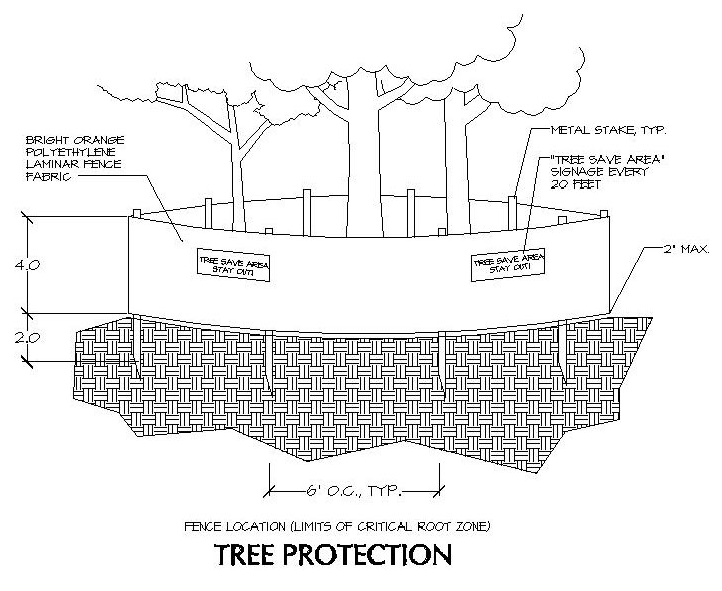
(Ord. No. 2015-14, Att., 12-21-15; Ord. No. 2021-07, § 6(Exh. C), 6-21-21)
3.07.12 - Tree Replacement Standards
A.
Tree replacement plans should be prepared with appropriate consideration given to the function of trees in the urban landscape. Every effort should be made to maximize the environmental benefit of the plant material.
B.
Planting Specifications.
1.
Trees selected for planting must be free from injury, pests, disease, nutritional disorders, or root defects, and must be of good vigor in order to ensure a reasonable expectation of survival.
2.
Standards for transplanting shall be in keeping with those established in the International Society of Arboriculture publication, Tree and Shrub Transplanting Manual, or similar publication. Reference the American Association of Nurserymen publication, American Standard for Nursery Stock (ANSI Z60, 1973), for plant material quality specifications. Reference the Manual of Woody Landscape Plants (Michael Dirr, 1983 Castle Books), or similar publication, for information on tree species site requirements.
C.
Species.
1.
Species must be selected from the "Kennesaw Tree Species Selection List" shown in Appendix A. All trees shall be quality specimens and ecologically compatible with the intended growing site.
2.
Flowering ornamental species are typically not acceptable for use in meeting density requirements.
3.
When less than ten (10) trees are shown to be planted on a project, one (1) species of tree may be specified. When ten (10) to fifty (50) trees are shown, a minimum of three (3) species of trees is required. When more than fifty (50) trees are shown, a minimum of five (5) species of trees is required.
4.
Where summer shading is required or recommended, the use of deciduous over story tree species is necessary.
D.
Parking Lots and Street Yards.
1.
All root zones must be a minimum of eight (8) feet in width (measured from back-of-curb where curbing is installed or edge or pavement otherwise).
2.
The root zone for over story trees must be a minimum of 200 square feet. If that area is shared with other trees, add 100 square feet for each additional tree.
3.
The root zone for understory trees must be a minimum of 100 square feet. If that area is shared with other understory trees, add fifty (50) square feet for each additional tree.
4.
Parking lot islands, peninsulas and medians must have clean, cultivated soil to a total depth of two and one-half (2½) feet. Native subsoil, free of construction debris and litter, is acceptable in parking lot islands, peninsulas and medians if the entire area is amended with appropriate soil improvements and thoroughly tilled. Otherwise, loamy topsoil is required.
5.
Parking lot islands, peninsulas and medians must be mulched with four (4) inches of suitable mulch material, replaced as needed. To discourage soil compaction from pedestrian traffic, these areas may be planted with low evergreen shrubs but not with grass.
6.
Light poles are prohibited in parking lot islands, peninsulas and medians unless a plan is submitted by the lighting contractor showing minimum impact to the root zone.
7.
No fastigiated (narrow-crowned) varieties of trees are permissible in parking lots.
8.
Trees planted to meet parking lot and street yard requirements must be over story trees, a minimum of three (3) inches in diameter.
9.
The use of at-grade planting areas in parking lots to promote storm water runoff and to supplement irrigation needs is encouraged, provided that the trees planted there will not be adversely impacted and that the system is designed by a licensed, professional civil engineer.
10.
Where street yard trees will be planted near the edge of pavement of a public street with a design speed of forty-five (45) mph or higher, or in areas beneath overhead utility lines, the use of an understory species is required.
E.
Root Barriers. Root barriers are required in parking lot islands, peninsulas, medians and alongside sidewalks. Root barriers must be commercially produce for the purpose of deflecting tree roots downward. Root barriers are typically made of polypropylene, polyethylene, or polystyrene, at least 0.060 inches thick, with vertical root guides every six (6) inches. Root barrier products should specify use as a tree root barrier.
F.
Irrigation. Newly planted trees and existing trees subjected to construction impacts, typically need supplemental watering when rainfall is inadequate. Commercial project applicants should be prepared to discuss how trees are to be watered during their establishment or transition period, and may be required to submit a maintenance schedule. Their plan should indicate the method of irrigation that is proposed.
G.
Public Streets Rights-of-Way.
1.
No Trees may be planted within publicly-maintained street rights-of-way.
H.
Subdivisions.
1.
Trees shown to be planted in common areas within a subdivision (outside of amenity areas) shall be planted by the subdivision owner/developer. These trees must be in place before the final plat is approved.
2.
Trees shown to be planted on individual lots must be planted by the owner/homebuilder. These trees must be in place before the certificate of occupancy for the affected lot is approved.
(Ord. No. 2015-14, Att., 12-21-15)
3.07.13 - Alternative Compliance
1.
In situations where the tree conservation and replacement requirements cannot be met because a project site will not bear the required density of trees, a request for alternative compliance may be submitted to the Director. In no instance shall more than fifty (50) percent of the required site density factor be met through alternative compliance.
2.
Parking Lot and Street Yard Requirements.
a.
If sufficient cause is demonstrated that the parking lot and street yard planting requirements cannot be met, a request for alternative compliance which is equal to (or exceeds) the minimum requirements may be submitted to the Director.
b.
Sufficient cause is deemed to be when enforcing any of the parking lot or street yard requirements would cause the applicant to violate any state or federal law or any City ordinance or zoning stipulation specific to the applicant.
c.
A land disturbance permit will only be issued after the Director has approved and received the necessary documentation and funds if required.
3.
Alternative compliance methods include the following.
a.
Off-site Planting.
•
The off-site location, if at all possible, should be in the same area of the city as the project site and shall be on public property.
•
A tree replacement plan, meeting all applicable standards in these guidelines, must be reviewed and approved by the Director before any work is started.
•
The following note must be shown on the approved plan: "A tree replacement plan addendum for this project shall be submitted to the Director at least thirty (30) days prior to requesting a final inspection. This plan shall include the species, size and location of trees to be planted off-site to meet the tree density deficit shown. Release of this project is subject to approval of this plan as well as verification of the installation of the trees."
b.
City Tree Bank Fund. The City will accept contributions to the tree bank fund which will be used for the sole purpose of planting trees and landscaping material on public property. The locations of plantings will be determined by the Director. Calculating contribution amounts are as follows:
i.
Contribution calculations are based on a tree unit value of $400.00 each, representing material costs, labor, maintenance and guarantee for trees planted.
ii.
To determine the appropriate contribution, first calculate the tree density factor deficit (TFD) or unit value that cannot be planted-on site then multiply by $400.00 per tree.
iii.
Fund administration. The City Tree Bank fund will be administered by the City.
(Ord. No. 2015-14, Att., 12-21-15)
3.07.14 - Public Tree Protection and Care
A.
Except as hereinafter provided, no person except a public utility shall cut, prune, injure or remove any living tree on or in a public highway, right-of-way, public park, public place, triangle, sidewalk, or other public property; or cut or disturb or interfere in any way with the roots of any tree on public property; or spray with any chemical insecticide or herbicide or other oils or whitewash any tree on public property; or place any wire, rope, sign, poster, barricade, or other fixture on a tree or tree guard on public property; or injure, misuse or remove any device placed to protect any such tree, or for any entity, utility, citizen, or tree care company or government to trench, cut, grade, clear, or fill within the critical root zone of any public tree without the expressed written consent of the Director.
B.
It shall be unlawful as a normal practice for any person, firm, or government entity/department to top any street tree, park tree, or other tree on public property. Trees severely damaged by storms or other causes, or certain trees under utility wires or other obstructions where other pruning practices are impractical may be exempted from this provision of this ordinance by receipt of written consent of the Director for each instance allowing such actions.
C.
The city shall have the right to plant, prune, maintain and remove trees, plants and shrubs within the rights-of-way of all streets, parks, squares, and public grounds, as may be necessary to insure public safety and wellbeing.
D.
All tree work taking place on public property being conducted by contractors, sub-contractors, or county/city employees will conform to International Society of Arboriculture and ANSI 300 and Z-133 arboricultural standards for tree work.
E.
It may become necessary, from time to time for emergency crews to prune or remove trees to provide for public safety or restore phone or electrical service. Such an action may be conducted by government, emergency or public utility crews without permit so as to allow immediate action to prevent damage or correct a condition which may pose a hazard to life or property. The Director shall be notified of any such action within 24 hours of the action being initiated, by the entity taking such action, for each instance of action.
(Ord. No. 2015-14, Att., 12-21-15)
3.07.15 - Notification and Penalties for Damaging Trees on Public Property
A.
Any person who shall injure, damage or destroy any public tree situated upon the public right-of-way of any street, alley, sidewalk, park or other public property within the city shall promptly notify the Director of such fact and shall, within such reasonable time as specified by the Director, repair or replace the same to the satisfaction of the Director.
B.
Should the person fail or refuse to repair or replace the damaged or destroyed trees or plants within such reasonable time, the Director shall do or cause to be done the necessary repairing or replacement, and the costs of this work shall be recovered from the person responsible for the damage or destruction by, a proper action of law. In any such action, "The Guide for Establishing Values of Trees and Other Plants," published by the Council of Trees and Landscape Appraisers, current edition, shall form the basis for establishing any monetary damages due for damage or destruction to the tree. In addition, the City may recover any other damages or losses to which it is entitled by law.
(Ord. No. 2015-14, Att., 12-21-15)