
Kennesaw City Zoning Code
CHAPTER 6
INFRASTRUCTURE IMPROVEMENTS
Engineering Technical Standards
(Ord. No. 2012-03, 5-7-12)
6.00.00 - STREETS[12]
Editor's note— Ord. No. 2018-21, § 1(Exh. A), adopted Oct. 15, 2018, amended § 6.00.00 in its entirety to read as herein set out. Former § 6.00.00 pertained to similar subject matter and derived from Ord. No. 2012-03, adopted May 7, 2012.
6.02.00 - TRANSPORTATION AND PARKING FACILITY[13]
Editor's note— Ord. No. 2018-21, § 1(Exh. B), adopted Oct. 15, 2018, amended § 6.02.00 in its entirety to read as herein set out. Former § 6.02.00 pertained to similar subject matter.
6.03.00 - STREET LIGHTS[14]
Editor's note— Ord. No. 2018-07, adopted April 2, 2018, amended § 6.03.00 in its entirety to read as herein set out. Former § 6.03.00 pertained to similar subject matter and derived from Ord. No. 95-11, §§ 2—5, 7—9, 12, adopted May 1, 1995; and Ord. No. 2007-09, § 1, adopted Feb. 5, 2007.
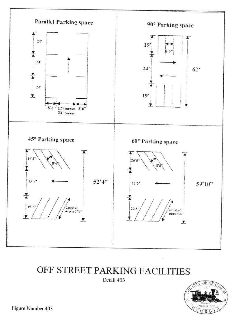
6.06.00 - OFF-STREET PARKING FACILITIES
GENERAL DESIGN REQUIREMENTS
6.07.00 - PARKING LOT DESIGN AND DRIVEWAY STANDARDS
General. These provisions shall be used on all developments, private property and City right-of-way. These off street parking rules shall apply to any parking area where three or more vehicle stalls are required. Parking lots should be graded and drained to allow for the disposal of all surface water accumulated within the area and should be arranged and identified so as to provide for an orderly, safe loading or unloading, parking and storage of all vehicles.
(Ord. No. 2006-06, § 1(18-47), 2-21-06)
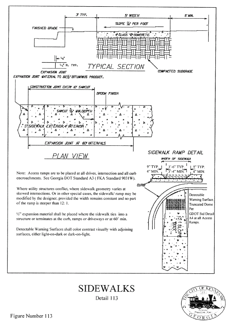
6.08.00 - SIDEWALKS AND PATHWAYS
The City is actively pursuing the continuation of an integrated and multi-modal transportation system that promotes compliance with the Federal Clean Air Act by emphasizing the need to create increased pedestrian travel opportunities by expanding the sidewalk network and developing a pathway program. Whenever possible, developers will be encouraged to construct sidewalk along the right-of-way abutting their developments. The pathway program takes pedestrian access one step further by providing safe, convenient access to activity centers such as schools, parks, and shopping centers in an effort to encourage pedestrian and non-motorized vehicular travel. The county will support and encourage a viable network of off-street travel routes that can reduce the need for and volume of vehicular traffic throughout the county.
6.09.00 - BUS SHELTERS
The City of Kennesaw does not operate a transit system. Cobb County has adopted Cobb Community Transit Accessibility Guidelines and Performance Specifications for Bus Pads and Shelters. This standard, and as may be amended from time to time, is adopted for purposes of privately and publicly constructed bus pads and shelters constructed within Cobb County. A copy may be obtained through the Department of Transportation.
6.11.00 - STORM DRAINAGE SYSTEMS[15]
Editor's note— Ord. No. 2012-03, adopted May 7, 2012, deleted the §§ 6.11.00—6.11.11, and enacted new sections as set out herein. The former provisions pertained to similar subject matter. These provisions bore no history note.
6.14.00 - STRUCTURAL RETAINING WALLS
When permanent grades are proposed with a resulting slope steeper than one-foot vertical for every two feet of horizontal displacement (2:1), an appropriate retaining structure shall be designed to reinforce or retain the resulting embankment. The structure shall be designed by a registered professional engineer to be constructed of reinforced concrete or other masonry materials designed by a registered professional engineer. Initiate latest revision O.S.H.A., or as may be amended from time to time. An engineered design may be substituted for the reinforced concrete design if the specific vendor has a pre-qualified acceptance from the City. All structural components of the wall shall meet the minimum building codes for the proposed use.
When the necessity for an earth retaining structure is required for a vertical displacement of 30 inches or less, appropriate landscaping timbers, or approved equal, may be employed if no permanent structure is supported by the soil retained by the retaining wall. The use of railroad cross ties or other timber products will only be allowed in these instances as per detail.
All wall designs must demonstrate complete dimensions for line and grade. Wall design will consider foundation drainage and select backfill material for the proposed conditions.
Walls shall be located in such a fashion to not encroach upon existing or proposed drainage easements, drainage courses or floodplains to encumber the natural flow of surface runoff of storm water. Walls shall be located at a distance from such watercourses to allow for anticipated future maintenance of the easement to prevent a safety hazard to the maintenance workers or to jeopardize the structural integrity of the wall.
Walls that are not attached to the permitted structure and require a foundation shall be permitted as a freestanding structure and shall be inspected as prescribed by the permitting procedure. Walls will be inspected for conformance with the approved design. Any deviation from the approved design will require the engineer of record to submit a certification of the non-conforming structure along with supporting calculations to indicate that the construction is consistent with the initial design parameters. In the event the inspector has not been provided ample opportunity to inspect the structure, the contractor must provide a certification of the construction by the engineer of record and geotechnical reports for concrete testing for strength, reinforcing steel specifications. Failure to comply with the requirements of this section will require that the remaining work cease and/or removal of nonconformance until the adequacy of structural integrity is demonstrated to the satisfaction of the City.
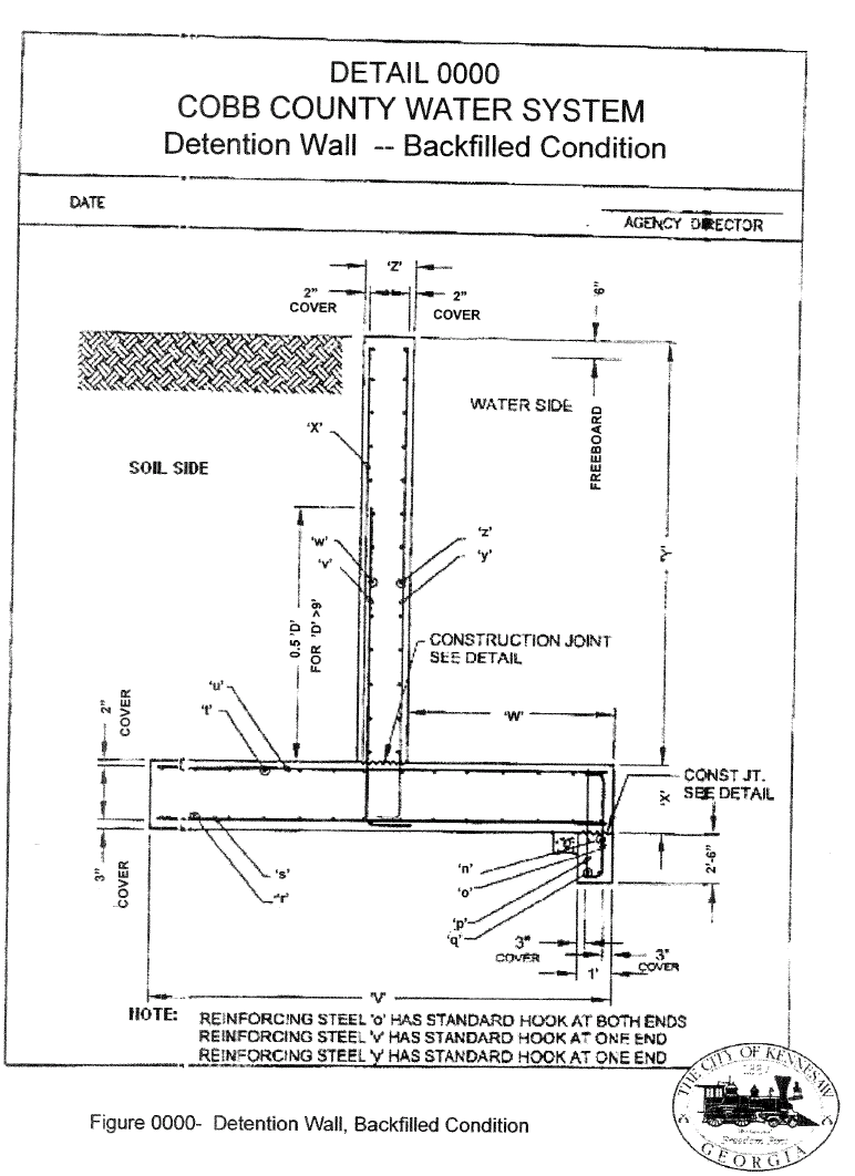
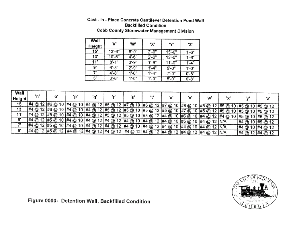
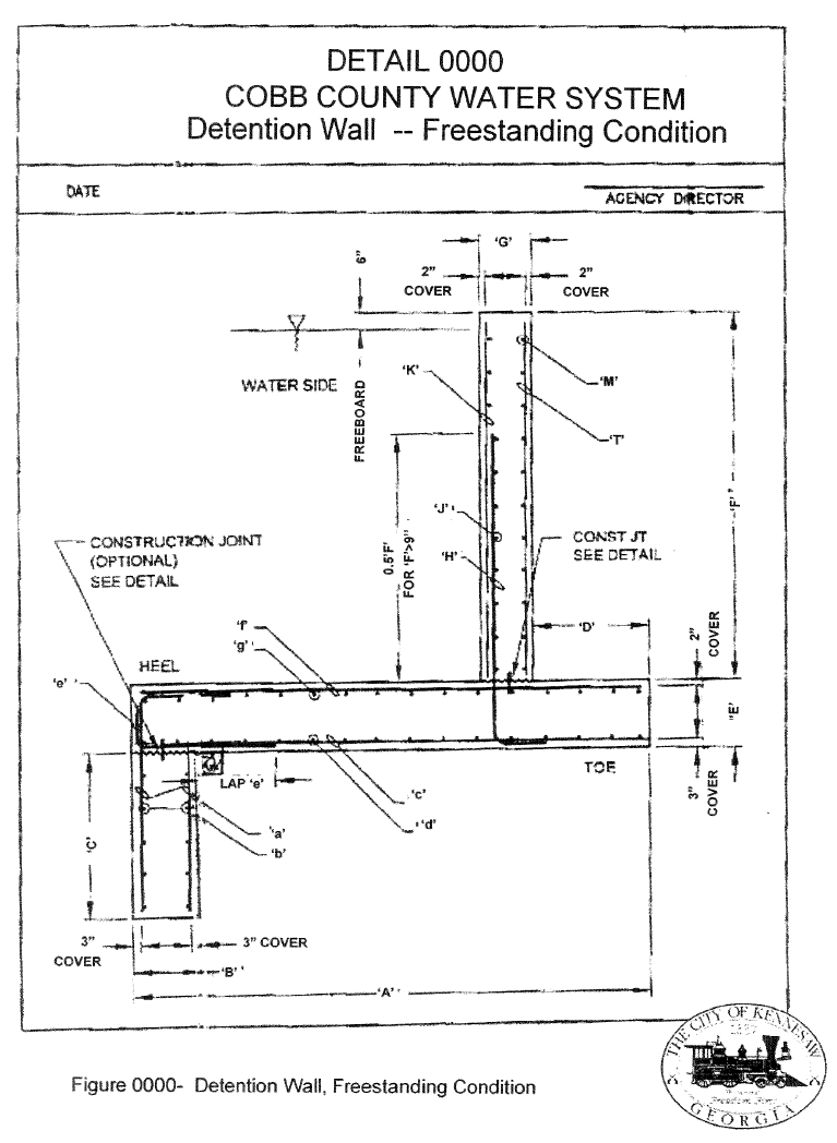
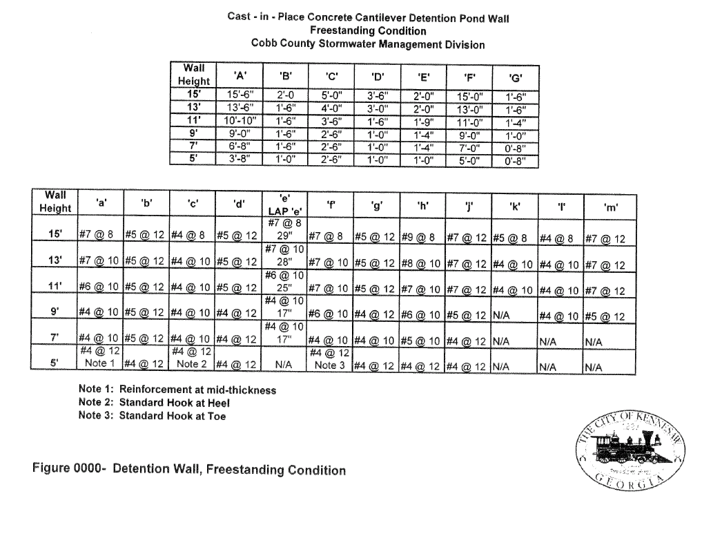
Retaining walls that are proposed for the purpose of storm water detention must be designed to demonstrate that the walls are capable of a hydrostatic load as measured from the top of the foundation footing to the highest elevation along the top of the wall. The hydrological design must allow for a free board dimension of one foot and an emergency overflow capacity equal to the allowable peak discharge for the 100-year storm event. The routing calculations should not take into account the existence of the emergency overflow. Place the overflow device above the projected 100-year flood elevation within the detention area.
Any construction that may impact or be within the right-of-way of an existing or proposed water or sanitary sewer easement must be approved by Cobb County Water.
6.16.00 - CEMETERIES
In the event a cemetery or burial site is located on or adjacent to the property, the developer is required to adhere to the following:
1.
Prepare a site plan identifying the full boundaries with a metes and bounds description.
2.
Provide a fifty (50) foot natural undisturbed natural buffer from the common property line; or a 50-foot undisturbed natural buffer around the perimeter of the outermost burials of the cemetery; whichever provides the greatest protection for the cemetery. The outermost burials to be determined by a professional archaeologist. The archaeology survey will locate all grave shafts and define the burial boundary as well as the fence line. Member(s) of the Cemetery Preservation Commission (or approved staff member appointed by Public Works Director) must be present during archeology survey.
3.
Lots adjacent to fifty (50) foot undisturbed natural buffer shall have some or the entire required setback in addition to the buffer.
4.
The fifty (50) foot undisturbed natural buffer shall be recorded as a conservation easement with the City Of Kennesaw Cemetery Preservation Commission having third party right of enforcement.
5.
Provide uninhibited daylight access to the cemetery via a twenty (20) foot graveled easement to the cemetery from the nearest public road. The outer boundaries of this easement may be landscaped.
6.
A plat to be prepared by a registered surveyor denoting the location of all grave shafts, the fifty (50) undisturbed buffer, the fence line as determined by the archaeology survey and the access easement.
7.
The archeology survey and plat must be submitted to the Cobb County Cemetery Preservation Commission three (3) business days prior to any zoning hearing or plan review, as may apply.
8.
Provide and install an orange protective fence on the outer perimeter of the fifty (50) undisturbed natural buffer before beginning construction. This fence shall be maintained throughout the life of the project. At completion of the project, the orange protective fence shall be removed from the premises. A sign stating Cemetery Preservation Buffer- Do Not Disturb shall be erected at fifty (50) foot intervals along the outer perimeter of the buffer. At the completion of the project, these signs may be maintained or replaced by the City of Kennesaw Cemetery Preservation Commission.
9.
Provide at least a permanent six (6) foot chain link fence with gate on the fence line determined by the archaeology survey or on the common property line between the cemetery and the development whichever provides the greater protection for the cemetery before beginning construction.
10.
Fence must be 9 gauge with top rail and fence post must be set in concrete. Fence may be upgraded to vinyl coated chain link and/or wrought iron.
11.
Comply with State and local laws and ordinances.
12.
All cemetery preservation requirements must be Site Plan specific.
6.17.00 - UTILITIES
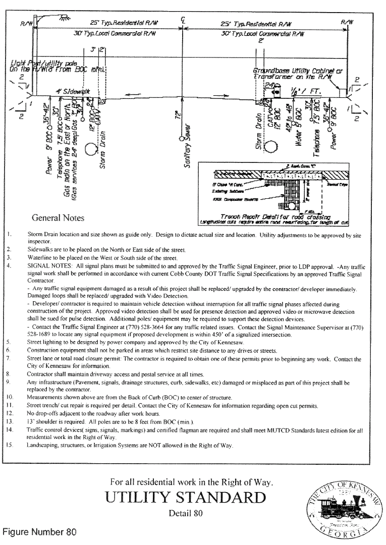
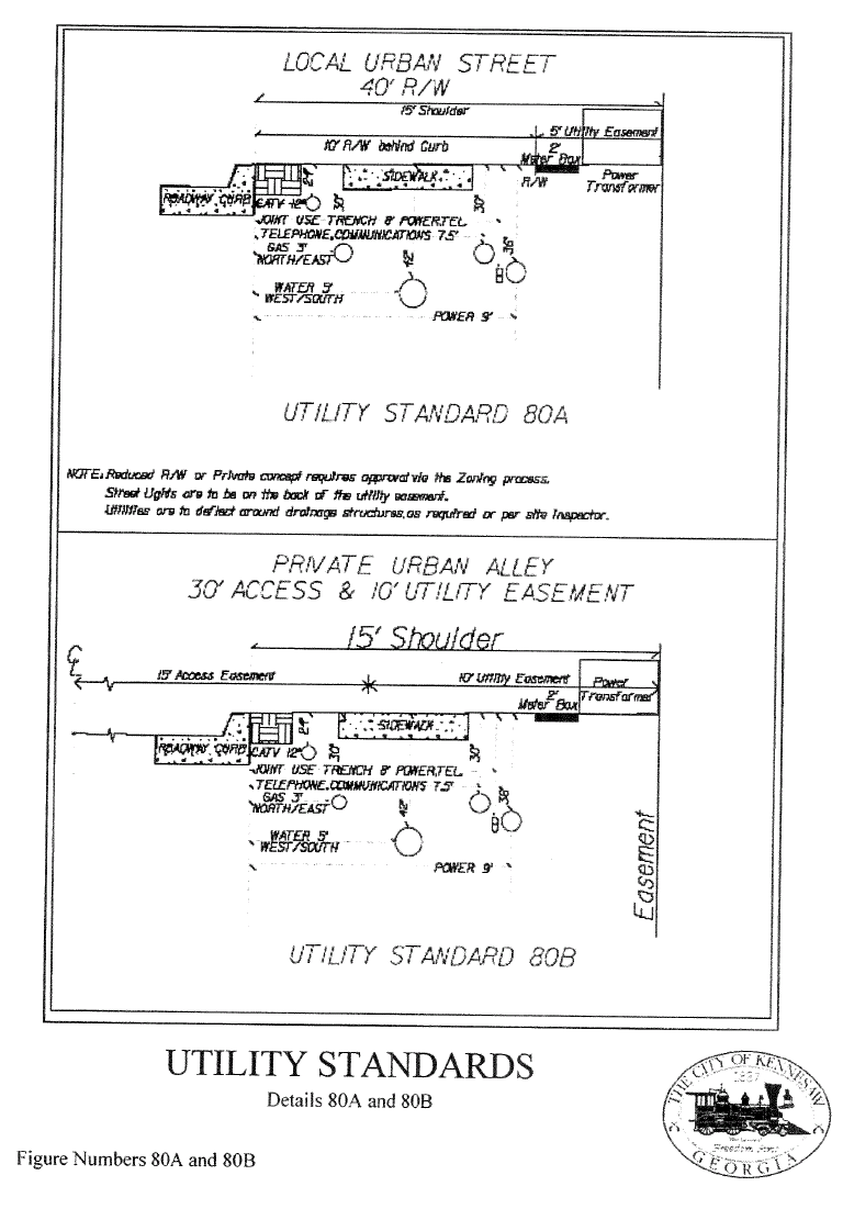
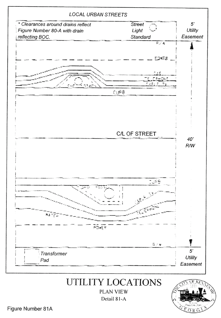
City of Kennesaw has adopted the Georgia Department of Transportation, Utility Accommodation Policy and Standards, Section 3 - Rules for Issuing Permits (as may be amended from time to time). Please see Volume 2, Section 508, Materials Specifications and Standard Details.
1.
For damage prevention purposes, all utility locations within a street right-of-way shall correspond to the utility location cross section in Standard Details 80, 80a, 80b, 81, 81a and 82.
2.
On residential streets constructed without curb and gutter, the utility depths shall be increased by one foot to allow for the realignment of the ditches without damaging the utilities. The developer is encouraged to coordinate with the City of Kennesaw Public Works.
3.
Southern Bell requests to be moved from 18" BOC (back of curb) to 7½' BOC and from 24" deep to 30" deep to accommodate the gas service crossings.
4.
CATV requests to be moved from 5" BOC to 12" BOC and from 18" deep to 24" deep.
5.
Power requests to be moved from 8' BOC to 9' BOC with power transformer being flush with back of the right-of-way.
6.
Gas requests to remain at 36" BOC and 30" deep and will raise service laterals from 30" deep to 24" deep.
7.
Water requests to remain at 5' BOC and 42" deep.
8.
Utility companies may utilize a joint trench for utility installation. If a joint trench is used, its depth shall be that of the utility in the trench required to place its lines at the greatest depth. Joint trench placement may be specified or random placements.
9.
All contractors, developers, utility companies, and the "general digging public" are encouraged to abide by the OCGA 9 (25). The UPC number is (404) 623-4344; (800) 282-7411.
10.
All privately owned equipment or utilities, with the exception of residential mailboxes, shall be allowed on public right-of-way by special permit only. A special permit must be approved by the Public Work Director and Kennesaw Building Official.
11.
Any utility installed on the City's right-of-way under special permit shall be equipped with a tracing or locating mechanism. As an example, any non-conductive conduit shall be equipped with a minimum size 16 gauge corrosion-resistant tracer wire to aid in locating the utility. The wire shall extend along the tributary conduit to a point four feet off of the right-of-way.
12.
Water and sewer service lateral locations are to be permanently marked on the curb under which they cross.
13.
Any contractor operating within the City shall sign a statement to acknowledge receipt of this new regulation as a condition of obtaining a business license to operate within City. Contractors shall provide a 24-hour contact telephone number to the Georgia UPC.
14.
Responsibility for the location of any utility placed on the City right-of-way under special permit rests solely upon the owner of the utility. Any damage repair to non-permitted utilities shall be the responsibility of the owner of the utility.
15.
The design and construction specifications for all-public water and sanitary sewer facilities shall conform to the specifications of the Cobb County Water System or applicable authority, i.e., water meters should back-up to the property line.
16.
Storm drains and cul-de-sacs shall off-set the right-of-way to accommodate utilities. See Standard Details 80 and 81.
17.
All streetlights shall be placed at the property line.
18.
The standard color codes adopted by the American Public Works Association and the Georgia Utilities Coordinating Committee shall be utilized for any necessary marking of underground utility lines. The color scheme is as follows:
19.
All utility manholes and valve boxes shall be brought to the finished grade within the roadway section. Manhole covers and splice boxes placed within the sidewalk zone shall be constructed to be flush mounted with the finished sidewalk.
20.
Utility poles and transformers shall be located as near as possible to the frontage line. Wherever practical, utility poles or transformers shall not be located on the same lot corner as water service.
6.19.00 - GATED COMMUNITIES
Gated communities must be developed in accordance with the following minimum requirements:
All private roads must be designed and constructed according to City standards.
Gates must be set back a minimum of 50 feet from public right-of-way. Minimum gate width must equal the required road width plus the width of any utility easements present, but in no case shall the width be less than 30-feet (including 14-feet of clearance width), provided, however, that the required gate width may be accomplished through the combination of adjacent entrance and exit gates of equal width.
Gate width and placement must be reviewed by, and are subject to approval by, both the City and County Public Safety Agency (including Fire Marshall's Office).
All gates must be "manned" 24 hours a day, seven days a week.
Arrangements for access through the gate for emergency service vehicles must be reviewed by, and are subject to approval by Cobb County Public Safety (including Fire Marshall's Office). Necessary arrangements may include Knox-fire boxes for keyed/keyless entry, keypad code entry, occupant telephone authorized entry, and/or automatic gate opening upon power disconnect.
Arrangements for access through the gate for non-emergency service vehicles must be reviewed by, and are subject to approval by the City. Non-emergency public service vehicles include, but are not limited to, mail delivery, garbage pickup, public utility meter reading, and public utility maintenance. Necessary arrangements may include, but are not limited to: access easements for refuse collection vehicles and appropriate utility easements for public utility development and maintenance. Gates may not restrict access to any public right-of-way or publicly owned property within the proposed development.
The City must be properly indemnified against any liability resulting from the proposed development including damage from or broken utilities, fines associated with damaged or broken utilities. This indemnification shall be evidenced by:
1.
The Release and Indemnity Agreement placed on the plat.
2.
A separate release and indemnity agreement executed by the developer.
3.
A clause in each deed of conveyance by the developer for each lot in the subdivision acknowledging the release and indemnity agreement.
4.
Assumption of liability of the release and indemnity agreement by the Homeowners' Association.
5.
Assumption of liability of the release and indemnity agreement in the Protective Covenants, which shall become part of the covenants of the subdivision. The developer's liability shall end three years after the last lot has been sold by the developer, provided that there are then no pending or threatened claims against the developer, the County or the Homeowners' Association. All language for liability agreements and covenants shall read as required by the City Attorney's Office.
The developer shall grant such easements to the appropriate governing authority or Utility Company as is necessary for public purposes regarding said community.
In the event that the developer does not obtain any approval required hereunder, same shall not alleviate the requirement of obtaining such approval.
Via a written Memorandum of Agreement in a form satisfactory to the City Attorney, and compliance by the developer with the requirements of O.C.G.A. 40-6-3 (a) (6) as it may be amended from time to time, the developer, for itself and its successors in title, shall grant the City the authority to enforce all local ordinances and state laws, including the state Uniform Rules of the Road and necessary and required easements, within the gated community. The following standards shall be used by City of Kennesaw when considering any request for gated communities:
1.
The number of units in the development shall not be excessive as identified on the Future Land Use Map of the City Comprehensive Plan.
2.
The developer must demonstrate adequate provision for perpetual maintenance of the private road and any other infrastructure associated with the development, including but not limited to a note on the plat and a clause in each deed of conveyance by the developer for each lot in the subdivision acknowledging the perpetual maintenance of the private road (and other private infrastructure) by the Homeowners' Association.
3.
The developer must demonstrate an adequate strategy for necessary emergency access.
4.
The private road and gate must not unreasonably impede the logical future development of public roads in the vicinity of the project.
5.
The private road and gate must not unreasonably restrict public access to sites of cultural, historical, or natural significance.
6.
The private road and gate must not unreasonably restrict previously established pedestrian access.
7.
The establishment of gated communities must not have unreasonable negative effects on the health and welfare of the community or the good order of the City and/or County.
6.00.01 - General
The character, width, grade, and location of all public streets shall conform to the standards in these Regulations and shall be considered in their relation to existing and planned streets, to topographical conditions, to public convenience and safety, and in their appropriate relation to the proposed uses of the land to be served by such streets. Construction and material specifications for streets shall conform to the standard specifications of the city, Cobb Department of Transportation (CDOT) and Georgia Department of Transportation (GDOT) in use at the time for roads, except as may otherwise be stated herein. Specifications and design criteria stated herein are for planning purposes. A Waiver from the standards will be considered on a case-by-case basis and it is the responsibility of the developer to articulate a substantial justification for deviating from such standards in the concept and preliminary design stages. Any such waiver will be subject to approval by the Public Works Director or designee. Substantial justification for deviating from the utility standards shall be demonstrated through an engineering report that certifies compliance with the standard has the effect of materially inhibiting the provider's technology or service and deviation from the standard is necessary to feasibly provide such technology or service.
A.
Thoroughfares in developments shall be planned in conformity with the Comprehensive Plan, and the Major Thoroughfare Plan. These streets classified, or designated to be classified, as an arterial, major collector, or minor collector shall be developed per Section 6.04.00.
B.
The proposed development's street layout shall be coordinated with the street system of the surrounding area or with plans for streets in said area on file with the City, if any.
C.
If the developer desires to provide for street access to an adjoining property, proposed streets shall be extended by dedication to the boundary of such property and a temporary paved turn-around provided.
(Ord. No. 2018-21, § 1(Exh. A), 10-15-18; Ord. No. 2019-06, § 2(Exh. B), 9-16-19)
6.00.02 - Permits Required; Obstructions
A.
No person, partnership, corporation, or their agents or employees or contractors shall remove, cut, dig into, tear up or make or cause to be made any opening or excavation in any public street, public road, public alley, public way, public ground, public sidewalk or City-owned easement or fill or alter any culvert or construct or install additions or extensions to its existing facilities within the City without a permit issued by the Public Works Director or his or her designee.
B.
The applicant or applicant's contractor shall submit to the City a written request for a construction/street excavation permit and a plan of the proposed alteration, extension, or addition showing its location and details of construction, including specified depth, method of excavation, open cut or boring, provisions of restoration and whatever the City would deem necessary for review and consideration.
C.
It shall be unlawful to place or maintain, or cause to be placed or maintained, in any of the streets or in any of the easements, or on any of the public sidewalks of the City, any obstruction of any kind or character whatever, except by the consent of the Mayor and Council or a designated officer of the City.
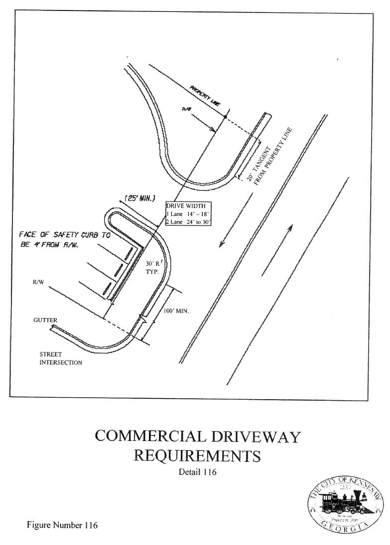
D.
It shall be unlawful for any property owner, lessee or tenant to construct, establish, open, grade or cause to have constructed, or in any manner to form or use a driveway or other opening from private property into any street, highway or thoroughfare in the city or entered upon across any sidewalk in the city, without first obtaining a permit for such work from the mayor and council or designated city officer. When such permit is issued, the owner, lessee, tenant or other constructing party shall conform to all requirements of the standard specifications of the city in use at the time for that portion of the driveway from the curb or gutter line to the property line, and such constructing party shall conform to all grades established and other special requirements in effect at the time. In no event, however, shall any driveway be constructed in the city so as to prevent or obstruct the free flow or passage of water in the gutters of any streets in the city, or in any streets themselves having no gutters constructed thereon.
(Ord. No. 2018-21, § 1(Exh. A), 10-15-18)
6.00.03 - Applicant Requirements
A.
Any person obtaining a permit as provided herein agrees, as a condition of the issuance of the permit, to indemnify and hold harmless the City against any claims or expenses, including attorney's fees, for bodily injury or property damage for accidents or occurrences arising out of such person's operations. Before a permit for excavating or opening any street or public way may be issued, the applicant must sign a statement in that it will indemnify and save harmless the city, its officers, agents and employees from all liability for accidents and damage caused by any of the work covered by its permit, that it will fill up and place in good and safe condition all excavations and openings made in the street, that it will replace and restore the pavement over any opening it may make as near as can be to the state and condition in which it found it and keep and maintain the same in such condition, normal wear and tear excepted, to the satisfaction of the City for a period of one (1) year, that it will pay all fines imposed upon it for any violation of any rule, regulation, or ordinance governing street openings or drain laying adopted by the city, and that it will repair any damage done to existing improvements during the progress of the excavation in accordance with the ordinances, rules, and regulations of the city. Such statement shall also guarantee that if the City shall elect to make the street repair, the person opening the street will pay all costs of making such repair and of maintaining the same for one (1) year.
B.
Whenever the City finds that any such work has become defective within one (1) year of the date of completion, it shall give written notice thereof to the contractor or to its surety stating the defect, the work to be done, the cost thereof, and the period of time deemed by the City to be reasonably necessary to complete said work. After receipt of such notice, the contractor or the surety shall, within the time specified, repair the defect or indemnify the City for the cost of doing the work as set forth in the notice.
C.
Upon written request by the applicant, the city, in its sole discretion, may waive some of the requirements under this ordinance when such requirements are deemed by the City to be inapplicable or unnecessary due to the nature of the work involved.
(Ord. No. 2018-21, § 1(Exh. A), 10-15-18)
6.00.04 - Street Repair; Utility Placement, Excavation Cut and Engineering Details
A.
When any part of any street, sidewalk, alley or other public place of the City shall be torn or dug up for any purpose, the person making that excavation, or opening shall have the duty of refiling the excavation or opening so as to restore it to essentially the same condition that existed prior to the excavation or opening. Any person neglecting, refusing or failing to comply with any provision of this section shall be guilty of a violation thereof; and where any neglect, refusal or failure is continued, after notice from the public works department, every day's continuance thereafter shall constitute a separate and distinct offense.
B.
The following specifications shall be used for asphalt and fill dirt reparations of all City streets and public properties after any excavations have been made, including all utilities.
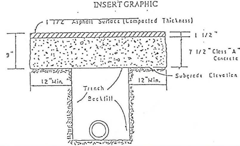
1.
Trenches shall be excavated to a width not to exceed 12 inches on each side of the pipe diameter of 24 inches or less and not to exceed 15 inches on each side of the pipe for pipe diameters greater than 24 inches. Trench walls shall be as nearly vertical as possible.
2.
Backfill shall be dense graded aggregate or sand. Dense graded aggregate shall be placed in maximum six-inch loose lifts and mechanically compacted. Sand may be compacted by placing in maximum 12-inch loose lifts and then flooded or jetted in place where satisfactory drainage is provided for free water.
3.
Backfilling up to sub grade elevation shall be completed prior to excavation for the additional 12 inches of concrete on each side of the trench.
4.
The applicant will be held responsible during the ensuing five years for proper backfilling and replacement of surface. During the five-year period after the cut is made, any pavement settlement shall be immediately repaired in an approved manner at the expense of the applicant.
5.
Concrete pavements shall be repaired in the same manner as described in this section except that the thickness of concrete shall be the same as the surrounding pavement.
(Ord. No. 2018-21, § 1(Exh. A), 10-15-18)
6.00.05 - Protection of Excavations and Liable
A.
It shall be unlawful for any person who obtains a permit herein to do any excavation of any kind which may create or cause a dangerous condition in or near any street, alley, sidewalk or public place of the City without placing and maintaining proper guardrails and signal lights or other warnings at, in or around the work, sufficient to warn the public of any excavation work, and to protect all persons using reasonable care from injuries on account of such work.
B.
All necessary precautions shall be taken to guard the public effectively from accidents or damage to persons or property through the period of the work.
1.
Every excavation shall be enclosed with sufficient barriers; warning signs, lights, and other such other traffic control devices as may be required by the Public Works Director and shall conform to the latest edition of the "Manual on Uniform Traffic-Control Devices." Warning lights shall be electrical markers or flashers used to indicate a hazard to traffic and pedestrians from sunset of each day to sunrise of the next day. Electrical markers or flashers shall emit light at sufficient intensity and frequency to be visible at a reasonable distance for safety. Reflectors or reflecting material may be used to supplement, but not to replace light sources.
2.
Unless otherwise approved, a minimum of one (1) lane of traffic in each direction shall be provided. Every effort shall be made on the part of the applicant to provide reasonable access to all properties adjacent to its project. In the event traffic is limited to less than one (1) lane in each direction, a flagman or temporary traffic control signal shall be provided so as to safely cycle traffic in each direction past the work area.
C.
Each person making such opening shall be held liable for all damages, including costs incurred by the City in defending any action brought against it for damages as well as cost of any appeal, that may result from the neglect by such person or his/her employees of any necessary precaution against injury or damage to persons, vehicles, or property of any kind.
(Ord. No. 2018-21, § 1(Exh. A), 10-15-18)
6.00.06 - Inspections
The City shall inspect all streets, gutters, curbs, surface water drainage systems, wastewater drainage systems, paving standards and other such improvements before and after any pipe is covered or excavation is backfilled. All work performed in any street or other public way that involves the construction or reconstruction of paving, sidewalks, driveways, curbs, gutters, sewers and waterlines, after the same has been opened or excavated, shall be inspected by the Public Works Director or his/her designee.
1.
All excavations or openings in any part of a street, sidewalk, alley or other public place shall be restored to essentially the same condition that existed prior to the excavation or opening.
2.
All driveways shall be constructed so as to prevent or obstruct the free flow or passage of water in the gutters of any streets in the city, or in any streets themselves having no gutters constructed thereon.
3.
The person to whom such permit is issued shall be responsible for all defects in excavations occurring within one year from the completion of the work and shall be liable for all damages resulting from such defects.
4.
The person to whom such permit is issued shall remain liable to the City for one year after the inspection.
(Ord. No. 2018-21, § 1(Exh. A), 10-15-18)
6.02.01 - Right-of-Way
Minimum Right-Of-Way Per Street Classification*
* Additional street right-of-way width may be required to be dedicated at intersections or other locations fronting the property where turning lanes, storage lanes, medians, or realignments are required for traffic safety and minimum right-of-way standards would be inadequate to accommodate the improvements. Right-of-way variable depending upon roadway design and Public Works Director approval.
(Ord. No. 2018-21, § 1(Exh. B), 10-15-18)
6.02.02 - Design Standards for Streets
A.
The arrangements, character, extent, width, grade and location of all streets shall conform to the major thoroughfare plan for the city and shall be considered in their relation to existing and planned streets, to topographical conditions, to public convenience and safety and in their appropriate relation to the proposed uses of the land to be served by such streets.
B.
Where such is not shown in the major thoroughfare plan for the city, the arrangement of streets in a subdivision shall either:
1.
Provide for the continuation of appropriate projection of existing streets in surrounding areas at the same or greater width, but in no case less than the required minimum width; or
2.
Conform to a plan for a neighborhood approved or adopted by the planning commission to meet a particular situation where topographical or other conditions make continuance or conformance to existing streets impracticable.
C.
Minor streets shall be so laid out that their use by through traffic will be discouraged.
D.
Where a subdivision contains a dead-end street other than a cul-de-sac, the planning commission may require the subdivider to provide a temporary vehicular turnaround within the right-of-way, when the planning commission considers such to be necessary for effective traffic circulation.
E.
Where a subdivision abuts or contains an existing or proposed major street, the planning commission may require acceleration/deceleration lanes, double frontage lots with screen planting contained in a nonaccess reservation along the rear property lines, deep lots with rear service drives or such other treatment as may be necessary for adequate protection of residential properties and to afford separation of through and local traffic.
F.
Where a subdivision borders on or contains a railroad right-of-way or limited access highway right-of-way, the planning commission may require a street approximately parallel to and on each side of such right-of-way, at a distance suitable for the appropriate use of the intervening land, as for park purposes in residential districts, or industrial purposes in appropriate districts. Such distances shall also be determined with due regard for the requirements of approach grades and future grade separations.
G.
Street jogs with centerline offsets of less than 125 feet shall not be permitted. Alleys or service drives may be required on any lots to be used for multiple-family, commercial or industrial developments, but shall not be provided in residential blocks except where the subdivider produces evidence satisfactory to the planning commission of the need for alleys or service drives.
H.
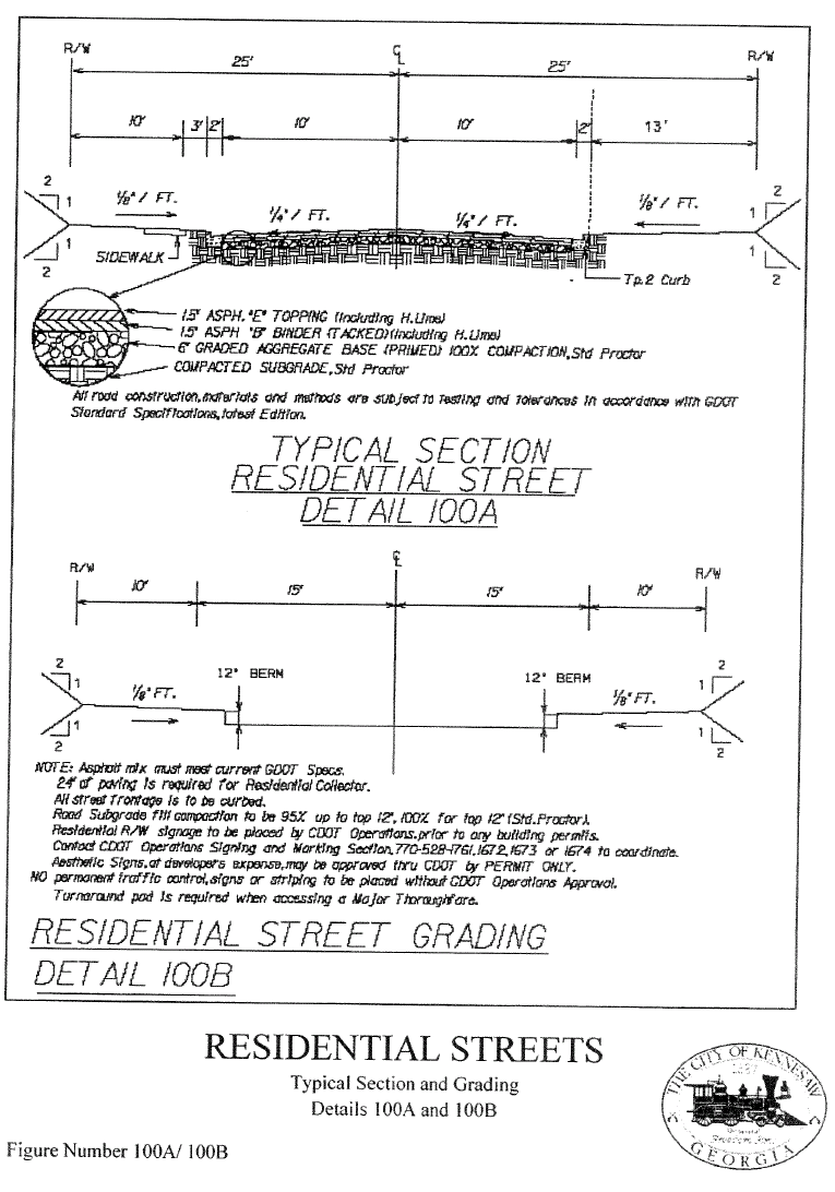
Paving widths shall be no less than as follows, measured from back of curb to back of curb:
(Ord. No. 2018-21, § 1(Exh. B), 10-15-18)
6.02.03 - Additional Right-of-Way and/or Pavement Widths
A.
Right-of-way for all abutting and internal public streets, existing and proposed, may be dedicated in accordance with the street classifications as shown on the Major Thoroughfare Plan, and as contained in these Regulations, or as otherwise required by the Public Works Director.
B.
On any existing street that abuts a property, one-half of the required width of right-of-way shall be dedicated to the City as measured from the centerline of the roadway.
C.
Right-of-way miters are required at all intersections to provide area for adequate utility location and maintenance. Twenty (20) foot miters shall be provided at the right-of-way intersection of any major thoroughfare. Ten (10) foot miters shall be provided at the right-of-way intersection of any local and collector roads.
D.
If a new street or thoroughfare is funded by the City, CDOT, or GDOT to adjoin or traverse the property, the proposed road right-of-way shall be incorporated into the development plans of the property in accordance with these regulations. These right-of-way requirements shall govern except where there exist clearly defined plans of the City, CDOT, or GDOT which require additional right-of-way. In that case, the greater right-of-way requirements shall govern.
E.
Any development with property fronting on an existing City road for which there exists clearly defined plans by CDOT, GDOT or the City may be required to provide road improvements associated with the defined plans. In such cases, in lieu of the design and construction, at the discretion of the Public Works Director, the developer shall escrow the dollar equivalency of required improvements (including curbing, utility relocation, and drainage structures), as estimated by the developer and verified by the Public Works Department. These funds shall be deposited in the appropriate road construction account prior to the approval of development improvements or within 30 days of City award of a construction contract, whichever occurs first.
(Ord. No. 2018-21, § 1(Exh. B), 10-15-18)
6.02.04 - Right-of-Way Encroachment and Maintenance
A.
No property owner, lessee, tenant or other person shall place or plant shrubberies, trees, or erect a fence closer than one foot to the edge of any of street, sidewalk easement, or the right-of-way on which their property abuts, except by consent of the Public Works Director or his designee.
B.
The property owner, lessee, or tenant shall be responsible for maintaining, in a clean and sanitary condition, the sidewalks, ditches, curbs and gutters, driveway pipes, drainage pipes and unpaved/undeveloped portion of rights-of-way or easement abutting such premises.
(Ord. No. 2018-21, § 1(Exh. B), 10-15-18)
6.02.05 - Roadway/Lane Widths
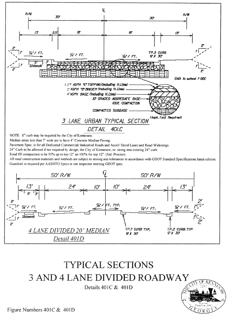
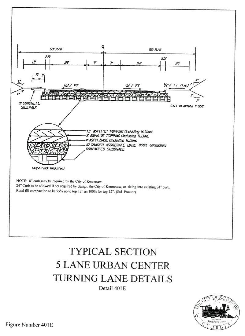
A minimum of twelve (12) foot travel lanes is required on all streets except local residential which require eleven (11) foot travel lanes. Roadway widths and lane assignments are typically based upon the functional classification of said roadway; for Major Thoroughfares see Section 6.04. The following table indicates these minimum requirements per roadway classification. Widths shown are measured from back of curb to back of curb.
Roadway width and design may be variable based upon current and/or proposed operational characteristics of the roadway and is subject to City and/or CDOT or GDOT review and approval. Median divided roadways may be required with left-run bays and median breaks in lieu of center two (2) way left turn lanes.
(Ord. No. 2018-21, § 1(Exh. B), 10-15-18)
6.02.06 - Improvements Along State Highways
For any development that abuts a state highway or other right-of-way controlled by the State of Georgia, improvements to the roadway and the location and design of any street or driveway providing access from the state highway shall comply with the standards and requirements of GDOT. A permit for the proposed access or improvements shall be required to have been approved by the GDOT and incorporated into the construction drawings for the project prior to issuance of a development permit by the City. A copy of the drawings approved by CDOT and/or GDOT is required to be submitted to Public Works Department prior to final plan approval.
(Ord. No. 2018-21, § 1(Exh. B), 10-15-18)
6.02.07 - Improvements Along Cobb County Highways
For any development that abuts a Cobb County road or other right-of-way controlled by Cobb County, improvements to the roadway and the location and design of any street or driveway providing access from a Cobb County highway shall comply with the standards and requirements of CDOT. A permit for the proposed access or improvements shall be required to have been approved by the CDOT and incorporated into the construction drawings for the project prior to issuance of a development permit by the City.
(Ord. No. 2018-21, § 1(Exh. B), 10-15-18)
6.02.08 - Improvements Along City Highways
For any development that abuts a City street or right-of-way, improvements to the roadway and the location and design of any street or driveway providing access from the City street shall comply with City standards and requirements. A permit for the proposed access or improvements shall be required to have been approved by the City and incorporated into the construction drawings for the project prior to issuance of a development permit by the City.
(Ord. No. 2018-21, § 1(Exh. B), 10-15-18)
6.02.09 - Super Elevation and Run-Off
Widening sections along existing streets shall be designed reflecting existing curvature and super elevation, if any, unless the existing street has been included in a specific design by the City, CDOT and/or GDOT which calls for different standards, in which case the project will be coordinated with the overall design (excluding local residential streets).
Roadway edge curves shall be provided for tangent run out (bringing edge from a normal crown to centerline elevation) and super elevation run-off (from the end of tangent run out to the point of design super elevation) in accordance with design standards of AASHTO, latest edition.
(Ord. No. 2018-21, § 1(Exh. B), 10-15-18)
6.02.10 - Unimproved Road
If a subdivision and/or development have access to a substandard street (i.e., a dirt or gravel road), the following improvements shall be considered through a Development Agreement:
A.
If the abutting substandard street provides the primary means of access to the development and is dirt or gravel, the developer shall upgrade the street to the classification of the roadway from the end of the improvements required to the nearest standard paved road along the route of primary access.
B.
Where lots do not front onto, but the access is other than primary, in addition to the road widening requirements abutting the development access, a drainage ditch, shoulder, and adequate base shall be provided and the roadway shall be paved to a minimum width of twenty-six (26) feet.
C.
Where lots do not front onto, but the access is other than primary, in addition to the road off-site improvements required above, shall at a minimum result in a full-section roadway meeting the requirements of a local residential rural roadway of twenty-six (26) feet, edge to edge of pavement, with drainage ditches as needed. Responsibilities shall be as follows:
1.
The developer shall design the road and provide the labor, equipment, and materials required for roadway improvements and necessary drainage improvements.
2.
All rights-of-way required for these off-site improvements shall be considered in the Development Agreement.
(Ord. No. 2018-21, § 1(Exh. B), 10-15-18)
6.02.11 - Intersection Design
For an intersection that contains at least one street classified in the Major Thoroughfare Plan, refer to Section 6.04.00.
(Ord. No. 2018-21, § 1(Exh. B), 10-15-18)
6.02.12 - Angle of Intersection
Intersections shall be at right angles and shall not be at an angle of less than 75° for reasons of safety, topography, interference with utilities, or separation from other driveways.
(Ord. No. 2018-21, § 1(Exh. B), 10-15-18)
6.02.13 - Intersection Radius
Intersection radii for all streets shall be measured at the back of curb or edge of pavement, if no curb exists. The minimum roadway radii for the intersection of local and residential collector streets, is 25 feet. When a local or residential collector intersects a higher classification of roadway, the radii shall be a minimum of 30 feet. Larger radii may be required for streets intersecting at an angle of less than 90° or when a vehicle and operating circumstances dictate. The radii can be reduced a maximum of five feet for the following reasons:
1.
Separation from street or
2.
Removal of obstruction
(Ord. No. 2018-21, § 1(Exh. B), 10-15-18)
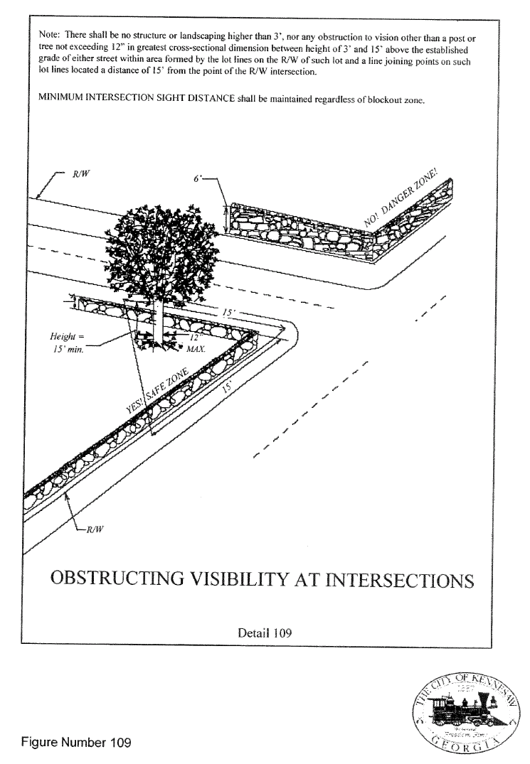
6.02.14 - Intersection/Corner Sight Distance
A.
Intersections shall be designed with adequate corner sight distance for each street, which approaches a street of higher street category. Where necessary, back slopes shall be flattened and horizontal or vertical curves lengthened.
B.
The minimum corner sight distance requirement shall be calculated per Chapter 6 of the UDC.
(Ord. No. 2018-21, § 1(Exh. B), 10-15-18)
6.02.15 - Vertical Alignment/Intersection Approaches
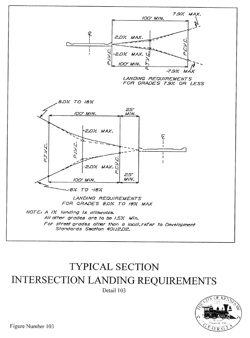
A.
For the intersections of local and residential collector streets, a leveling of the street at a grade not exceeding 2 percent shall be provided for a minimum tangent length of 25 feet. Exemptions are allowed for topographic considerations as determined by the design professional and the Public Works Director.
B.
As a street approaches an intersection with a street classified in the Major Thoroughfare Plan, the approach shall be in accordance with the CDOT standards.
C.
Tangent length is measured from edge of pavement of the intersecting street to the point of curvature in the approaching street.
D.
This grade for the landing may be 1 percent.
(Ord. No. 2018-21, § 1(Exh. B), 10-15-18)
6.02.16 - Horizontal Alignment/Intersection Approaches
A.
New local streets, which approach an intersection with a street in a higher category on a horizontal curve having a centerline radius less than 240 feet, shall provide a tangent section of roadway at least 30 feet long. The tangent length shall be measured along the centerline of the street from the right-of-way line of the intersecting street extending to the point of tangency with the centerline of the curve section.
B.
Minor and Major Collector classified streets in the Major Thoroughfare Plan shall provide tangent sections at intersections with streets in equal or higher categories as needed to provide adequate stopping sight distances at their design speeds as stated in Chapter 6, Maximum Grades.
(Ord. No. 2018-21, § 1(Exh. B), 10-15-18)
6.02.17 - Storm Water Design for Intersections
For intersections classified under the Major Thoroughfare Plan, sheet or concentrated flows of water will not be permitted through the intersection.
(Ord. No. 2018-21, § 1(Exh. B), 10-15-18)
6.02.18 - New/Proposed Streets—General
A.
All proposed new streets shall be designed and constructed to the standards contained in these Regulations in accordance with the classification of said streets.
B.
The arrangement of local streets shall permit practical patterns, shapes, and sizes of development parcels. Street layout must strike a balance with proposed land use so as to not unduly hinder the development of land. Distances between streets, angles of intersections, numbers of streets, and related elements all have a bearing on efficient lot layout of an area.
(Ord. No. 2018-21, § 1(Exh. B), 10-15-18)
6.02.19 - Local Residential Streets
A.
Local streets shall be so laid out that cut through routes are not created. Where this cannot be accomplished optional traffic calming features will be considered by the Public Works Director.
B.
Local residential streets shall be 26 feet wide as measured from back of curb to back of curb. This provides for an 11-foot lane in each travel direction.
(Ord. No. 2018-21, § 1(Exh. B), 10-15-18)
6.02.20 - Non-Residential Local Streets
Local non-residential streets shall be laid out so that use by through traffic will be discouraged. The functional and operational characteristics of the roadway shall be to provide access to adjacent non-residential lots.
(Ord. No. 2018-21, § 1(Exh. B), 10-15-18)
6.02.21 - Minor and Major Collector Streets
Collector streets shall be provided to channel through traffic movements within a development as part of or in addition to the current thoroughfare network. Actual classification of said roadway will be determined by the Public Works Director after review of the functional and operational characteristics of the roadway and adequate traffic study including, but not limited to trip generation data, as provided by the developer.
(Ord. No. 2018-21, § 1(Exh. B), 10-15-18)
6.02.22 - Private Streets
A.
The developer shall grant such easements as required to the appropriate governing authority or Utility Company as is necessary for public purposes.
B.
The private road must not unreasonably restrict public access to sites of cultural, historical, or natural significance, previously established pedestrian access and must not have unreasonable negative effects on the health and welfare of the community or the good order of the City.
C.
All private streets should have a minimum right-of-way of as noted in Section 6.02.01
D.
All private streets shall be built to City Public Street standards
(Ord. No. 2018-21, § 1(Exh. B), 10-15-18)
6.02.23 - Street Names and Addresses
A.
Street Names. The Community Development Department has the responsibility of maintaining the street addressing system throughout the city, and coordinates with the following: Atlanta Gas Light Co., Atlanta Regional Commission, AT&T Broadband, BellSouth, Cobb EMC, Cobb County Fire Department , Cobb County Schools, Cobb County Tax Assessor's Department, Cobb County Water Department, Cobb County Voters registration, Georgia Power Co., U.S. Post Office, City of Kennesaw 911 Emergency, Kennesaw Planning and Zoning Department, Kennesaw Public Works Department, Kennesaw Utility Billing Department, Kennesaw Parks and Recreation Department, and Kennesaw Business License Department. The goal is to ensure that addresses are assigned and properly maintained in a logical, sequential order for the purposes of locating property anywhere in the county. An accurate addressing system facilitates quicker response times for emergency services, and provides efficient mail delivery. Correct property identification is also necessary for locating utilities.
B.
Street numbers and addresses shall be assigned, changed and/or corrected where deemed necessary to assure the health, safety, and welfare of all City residents and property owners. Street numbers shall be posted and maintained in a prominent place on the property (i.e. Building façade, mail box, signage, etc.), which is visible from the street providing public access. The numbers shall be posted in the following manner:
1.
For residential properties, in figures at least one inch (1") high with a contrasting background; and
2.
For commercial properties, in figures at least two inches (2") high with a contrasting background.
C.
Cobb County and the City of Kennesaw utilizes a grid system for assigning street names and numbers. The reference point (or zero point) of the grid is located at the Marietta Square in the county seat of Marietta, Georgia. The base line between north and south part of the county is at Whitlock Avenue. The base line between the east and west part of the County is at Church Street. Directional base lines are extended to the county's boundaries thus creating four quadrants designed N.E., N.W., S.E., and S.W. Street numbers increase as one moves away from the base lines.
D.
Street Numbering Procedures. All property address numbers are assigned by the Community Development Department. Typically, a property located on the right side of a street is given an even number as numbers increase. Numbers are always referenced from the address grid base lines. Generally, address numbers will increase sequentially as they move away from the zero point and the base lines and will decrease as they move toward the zero point and the base lines.
E.
Street Naming and Selection Procedures
1.
All street names are subject to the approval of the Mayor and City Council. The following guidelines are used when assigning street names:
a.
Proposed streets that are obviously in alignment with other existing, named streets shall bear the names of such existing streets. Once a name is assigned to any alignment, it may not change anywhere along the extension of that alignment.
b.
Except within the same project, no proposed street name shall duplicate an existing street name within Cobb County regardless of the use of any suffix such as "street," "avenue," "boulevard," "drive," "place," "way," "court," or other designation.
c.
All streets shall bear the proper quadrant suffix (ie. N.E., N.W., S.E., S.W.).
d.
Proposed new names shall be reviewed for correct usage and reasonable meanings consistent with the language used. Such review shall also include correct spelling.
e.
Street names shall not include directional words such as north, south, east or west.
f.
A street name should be pleasant sounding, appropriate and easy to read so the public and children, in particular, can communicate the name in an emergency situation.
g.
Street names tending to be confused as homonyms (similar names spelled differently) are not acceptable.
h.
Names derived from a foreign language are unacceptable.
i.
Names that tend to be slurred, or have pronunciations that run together are unacceptable.
j.
Street names with the same theme (ie. flower, states, etc) are suggested for naming streets in an entire subdivision, as means of general identification, rather than duplicating the conventional name differentiated only by the street type (suffix).
F.
Addressing for Commercial Properties.
1.
A current "Full Site" Land Disturbance Permit (LDP) for the parcel proposed for development must be issued by the Community Development Department. This is required before a request for a street address will be processed. An approved copy of the site plans for the project must be presented at the time of application, or the 6-digit LDP number must be made available for reference.
2.
A field check of the property may be necessary if a proper address cannot be established. Property is typically identified by legal description (i.e. land district, land lot and parcel location). The site plans for a project are examined; the property is located on the tax map; and the correct address number range is established.
3.
A street number conforming to sequential order established by the grid system is selected. If the number has not been duplicated anywhere in the city, an official property address is issued to the parcel.
G.
Addressing for residential properties. For new residential subdivision, street names are determined during the preliminary plat review and approval process. Names are only approved if the street name, including street type (suffix) is unique within the city.
For a single family residential property located outside of a subdivision, the following process will apply:
1.
A site plan based on a recent survey must be provided. The tract must be a legal "lot of record" as recorded by plat in the Office of the Clerk of Superior Court.
2.
The site plan must be approved by the Community Development Department for applicable zoning requirements.
3.
The driveway location for the property must be approved by the Public Works Department for access onto a minor, major or arterial road.
4.
Since this type of tract is not typically a candidate for a LDP and does not come through the formal plan review process, it must be reviewed individually on a case by case basis. Each property is unique and may be subject to further review and requirements (i.e. City or State stream buffers, floodplain areas, variance stipulation, septic or sewer approval, etc.)
5.
A field check of the property may be necessary to ensure the new street address is in sequence. When appropriate number is determined, an official property address notice is issued.
(Ord. No. 2018-21, § 1(Exh. B), 10-15-18)
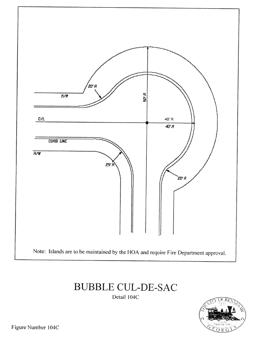
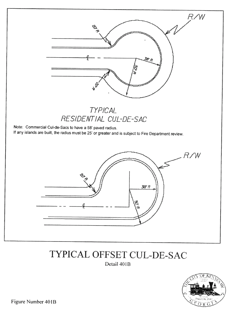
6.02.25 - Cul-de-Sacs
A.
Dead end streets designed to have one end permanently closed shall provide a cul-de-sac turnaround. Cul-de-sacs shall conform to the layout and dimensional requirements as shown in the Standard Details - 104A, 104B, or 104C meet the design standards of 104A, 104B, or 104C with the exception for the standard 104D.
B.
Commercial cul-de-sacs shall have a minimum 50' paved radius. Industrial cul-de-sacs shall meet the same design standards but have a minimum 60' paved radius.
C.
Non-standard cul-de-sacs will be evaluated individually and may be constructed with a landscaped island (subject to approval by the Fire Marshall) to be maintained by the Homeowners Association in perpetuity.
(Ord. No. 2018-21, § 1(Exh. B), 10-15-18)
6.02.26 - Minimum Centerline Offsets and Intersection Separation
Streets shall either directly align or have offsets of a minimum of 125 feet for intersecting streets on opposite sides of the through street and a minimum of 250 feet for streets on the same side of the through street, as measured between centerlines of said streets.
(Ord. No. 2018-21, § 1(Exh. B), 10-15-18)
STREET GRADES AND DESIGN SPEEDS
6.02.27 - Minimum Grades
Minimum grade for all streets shall be 1½ percent. Grades of less than 1½ percent may be approved by the Public Works Director, based on adequate engineering designs, where at least 1½ percent cannot reasonably be achieved due to topographical limitations imposed by the land. In such cases, an as-built drawing and such computations as necessary shall be provided after construction to establish that the street will drain in accordance with these regulations. Street sections where unacceptable pooling, excessive spread at catch basins, or other hazardous conditions occur shall be reconstructed or otherwise improved to eliminate such conditions.
(Ord. No. 2018-21, § 1(Exh. B), 10-15-18)
6.02.28 - Maximum Grades
Maximum grade for all local residential streets shall be 18 percent. Grades between 14 and 18 percent shall require an "as graded" survey prior to the installation of the curb or utilities
Maximum grade on any cul-de-sac turnaround shall be limited by drainage concerns.
Maximum grade in excess of those listed above may be approved by the Public Works Director in order to address topographical safety, hydrological, and environmental concerns.
(Ord. No. 2018-21, § 1(Exh. B), 10-15-18)
6.02.29 - Vertical Alignment
Vertical alignment must be designed in conjunction with the horizontal alignment. All changes in street profile grades having an algebraic difference greater than 1 percent shall be connected by a parabolic curve.
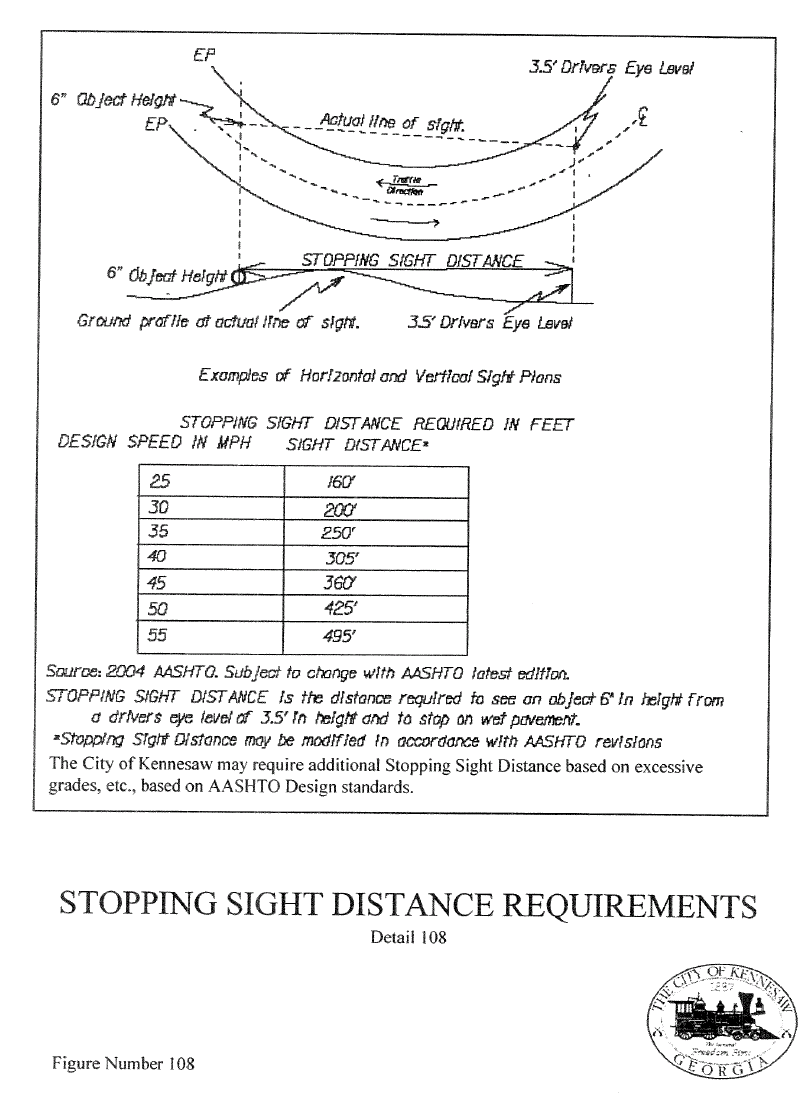
Minimum safe stopping sight distance is a direct function of the design speed of 25 mph in residential and 35 mph in local, non-residential, and commercial areas. A height of eye of 3½ feet and height of object of ½-foot is used to determine safe stopping sight distance. See Standard Detail 108.
The minimum length of vertical curve required for safe stopping sight distance shall be calculated using AASHTO "Policy on Geometric Design of Highways and Streets", latest edition.
(Ord. No. 2018-21, § 1(Exh. B), 10-15-18)
6.02.30 - Horizontal Alignment
For streets classified by the Major Thoroughfare Plan, see Cobb County Development Standards Section 401.20.
HORIZONTAL CURVES
A minimum tangent is required between reverse curves to facilitate steering and control. Between reverse horizontal curves there shall be not less than the minimum centerline tangents shown in the following table. Compound radii curves are prohibited, except local residential streets.
TANGENTS
(Ord. No. 2018-21, § 1(Exh. B), 10-15-18)
6.02.31 - Pavement Specifications
MINIMUM CONSTRUCTION STANDARDS*
* NOTE: Unless otherwise specified by Public Works, CDOT or GDOT.
Pavement of sections of existing roads of less than 4' in width which cannot be properly compacted, shall have a minimum of 6" Class "B" concrete base and 1" asphaltic topping.
Engineers can submit alternate but equivalent pavement designs.
(Ord. No. 2018-21, § 1(Exh. B), 10-15-18)
6.02.32 - Curbs and Gutters
All new streets or street widening sections shall be provided with curb and gutter. All gutters shall drain positively with no areas of ponding.
(Ord. No. 2018-21, § 1(Exh. B), 10-15-18)
6.02.33 - Curbing
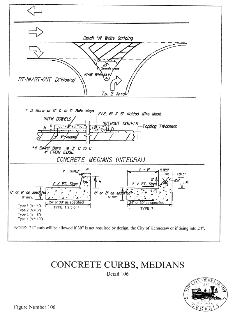
A.
Concrete shall be Class "A" (as defined by GDOT) and have a minimum strength of 3,000 psi at 28 days.
B.
Typical minimum section (residential subdivision only) shall be 6" x 24" x 12" for vertical curb (see Standard Detail 106) unless otherwise specified by CDOT or GDOT. A six (6") inches by thirty (30") inches by twelve (12") inches section may be required on non-residential local and collector roads.
C.
½-inch expansion joints or pre-molded bituminous expansion joint material shall be provided at all structures and radius points and at intervals not to exceed 250 feet in the remainder of the curb and gutter as shown on Standard Detail 106.
D.
When the development ties into existing curbing, the curb and gutter shall match the existing width.
E.
Where driveway access must be made through existing curbing, the curbing must be saw cut 2' wider than the driveway throat on either side and the driveway throat curbing extended to the point of saw cut and completed with a finished joint.
(Ord. No. 2018-21, § 1(Exh. B), 10-15-18)
6.02.34 - Minimum Grades
Curb and gutter shall be set true to line and the grade of the street, horizontally field staked, and finished to the section shown on the plans. Along the widening section of a road, which Public Works has identified for resurfacing within one year of the construction, the grade of the new gutter shall be placed one inch above the widening pavement grade in areas where drainage will not be adversely affected.
Line and grade shall be set by developers' engineer or surveyor.
(Ord. No. 2018-21, § 1(Exh. B), 10-15-18)
6.02.35 - Other Requirements
Inferior workmanship or unprofessional construction methods resulting in unacceptable curb and gutter will be cause for rejection of the finished work.
Disturbed areas along all curbing shall be back-filled, stabilized, and grassed.
(Ord. No. 2018-21, § 1(Exh. B), 10-15-18)
6.02.36 - Sub-Grade Preparation
A.
Sub-grade preparation on all non-local streets shall be in accordance with GDOT specifications and these regulations. Sub-grade preparation for local streets shall meet and pass proof roll testing.
B.
If any section of the sub-grade is composed of topsoil, organic, or other unsuitable or unstable material, such material shall be removed and replaced with suitable material and then thoroughly compacted as specified for fill, or stabilized with stone or a geo-textile or geo-grid.
C.
Fill shall be placed in uniform, horizontal layers not more than eight inches thick (loose measurement). Moisture content shall be adjusted as necessary to compact material to 95 percent of maximum dry density except for the top twelve inches, which shall be compacted to 100 percent of maximum dry density.
D.
After the earthwork has been completed, all storm drainage, water, and sanitary sewer utilities have been installed within the right-of-way as appropriate, and the back-fill in all such ditches thoroughly compacted, the sub-grade shall be brought to the lines, grades, and typical roadway section shown on the plans.
E.
Utility trenches cut in the sub-grade shall be back-filled as specified herein. Compaction tests at the rate of one per 150 feet of trench shall be provided to verify compaction.
F.
The sub-grade must pass proof roll testing regardless of compaction test prior to placement of the base material. With the approval of the Kennesaw Public Works and Community Development Department, a geo-textile or grid may be used to stabilize a sub-grade that does not pass proof-rolling.
G.
Provisions shall be made to drain low points in the road construction when the final paving is delayed. A break in the berm section is required when the curbing has not been constructed. After installation, drainage under the curb is required.
(Ord. No. 2018-21, § 1(Exh. B), 10-15-18)
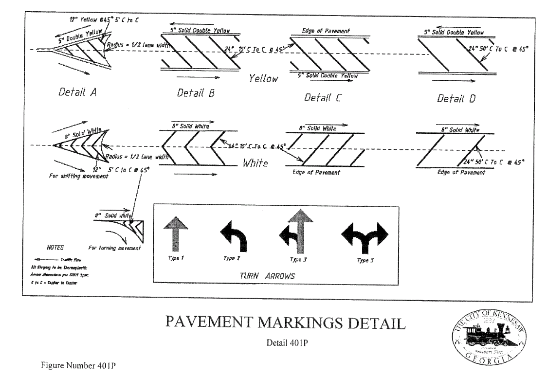
6.02.37 - Signing and Striping
Traffic Control Devices (signs and pavement markings) are normally provided by the City for local residential streets to be dedicated to the City for maintenance. On major thoroughfares, non-residential development, and private roads signs and pavement markings are to be provided by the developer. Traffic control devices must comply with the MUTCD and be approved by Public Works. No traffic control devices shall be installed without prior approval by Public Works. The developer shall provide and install all traffic control devices (signs and pavement), marking for streets not dedicated to the City for maintenance. All traffic control devices must comply with the MUTCD, City, CDOT, and GDOT design and installation standards. Decorative sign ownership and maintenance of these traffic control devices shall be transferred to the Home Owners Association at an appropriate time.
(Ord. No. 2018-21, § 1(Exh. B), 10-15-18)
6.02.38 - Street Signs
Streets dedicated to the City for maintenance shall be identified by signage of white lettering on green background. Private owned/maintained streets shall be identified by signage having white lettering on blue background.
(Ord. No. 2018-21, § 1(Exh. B), 10-15-18)
6.02.39 - Blocks
A.
The lengths, widths and shapes of blocks shall be determined with regard to:
1.
Provision of adequate building sites suitable to the special needs of the type of use contemplated;
2.
Zoning requirements as to lot sizes and dimensions, unless a planned unit development is contemplated;
3.
Needs for convenient access, circulation, control and safety of street traffic; and
4.
Limitations and opportunities of topography.
B.
In general, residential blocks shall not be greater than 1,800 feet in length or less than 600 feet in length. In blocks over 1,000 feet long, the planning commission may, when existing or proposed public gathering places so justify, require public crosswalks across the block.
C.
The depth of residential blocks shall be sufficient to allow two tiers of lots, unless prohibited by natural or manmade barriers, or unless one tier backs onto a line of another person's property, provided that this shall not prevent the inclusion with the subdivision plan of blocks of greater width including super blocks. Super blocks may contain public or joint use areas, such as parks and playgrounds, and shall be covered by adequate maintenance agreements if not dedicated and accepted for public maintenance.
(Ord. No. 2018-21, § 1(Exh. B), 10-15-18)
6.02.40 - Lots
A.
Insofar as practical, side lot lines shall be perpendicular or radial to street lines. Each lot shall abut upon a public street.
B.
The size, shape and orientation of every lot shall be subject to approval of the planning commission for the type of development and use contemplated. No lot shall be more than six times as deep as it is wide at the building setback line, unless excepted by the planning commission.
C.
Every residential lot shall conform to the minimum dimension and area requirements of the zoning ordinance, provided that every lot not served by a public sewer or community sanitary sewage system and/or public water shall meet the dimension and area requirements of the health department.
D.
Additional building setback lines shall conform to front yard and building setback requirements of the zoning ordinance, unless excepted by the planning commission.
E.
Size, shape and arrangement of commercial and industrial lots, where platted, shall be subject to the approval of the planning commission, provided that approval is not granted under the provisions of section 80-114.
F.
Double frontage, unless required by the planning commission, shall be prohibited except where essential to provide separation of residential development from traffic arteries or to overcome specific disadvantages of topography orientation and property size. A planting screen reservation of at least ten feet, and across which there shall be no right of access, may be required along the line of lots abutting such a traffic artery or other disadvantageous use.
G.
Lot remnants (lots below minimum area or width left over after subdividing tracts of land) shall be prohibited. Such remnant areas shall be added to adjacent lots, rather than remain as unusable parcels.
H.
The subdividing of the land shall be such as to provide each lot with direct abutting access to an existing public street or to a street contained within the proposed subdivision.
I.
The subdividing of land adjacent to or surrounding an existing or proposed lake shall be such that lots abutting the lake shall be drawn to the centerline of the lake. Such requirements may be waived upon submittal to the planning commission of an acceptable method for the maintenance of the lake and any recreational operations to be provided thereon.
(Ord. No. 2018-21, § 1(Exh. B), 10-15-18)
6.03.01 - Street Light District
(a)
Authority: The governing authority of the City of Kennesaw is granted supplementary powers pursuant to Ga. Const. Art. IX, § II, ¶ 3(a)(4) to provide street light services within corporate limits. Further, the City is granted powers with respect to its municipal street system to provide lighting on any public road located within its corporate limits. O.C.G.A. § 32-4-92(a)(9). Further, Ga. Const. Art. IX, § II, ¶ VI permits the City to create a special district for the provision of local government services within such district and allows a fee to be collected within such district to pay, wholly or partially, the cost of providing such services therein. Such special district may be created and fees collected by municipal ordinance.
(b)
Purpose: The governing authority of the City of Kennesaw does hereby declare that it shall promote the health, safety, and general welfare of the citizens of the City by providing for street lights in public rights-of-way. The governing authority of the City finds that it is in the best interest of the citizens of Kennesaw and to those visiting the City of Kennesaw that the City provide a street light system that is functional, operational, aesthetically pleasing and uniform throughout the City. The maintenance of street lights in the public rights-of-way provides illumination for vehicular and pedestrian commuters in the City to navigate and travel to and from their respective destinations along and across the public rights-of-way during non-daylight hours. Further, street lights provide illumination for citizens to access (ingress and egress) and frequent commercial and residential establishments within the City during non-daylight hours. Further, the illumination provided by street lights during non-daylight hours may help to reduce crime by discouraging criminal behavior in areas that are lighted throughout areas of the City. The City finds that the cost to provide street lights within the City rights-of-way should be borne by all property owners that receive the public benefit of street lights Citywide.
(c)
Creation: The governing authority of the City does hereby create a special street light district pursuant to Ga. Const. Art. IX, § II, ¶ VI as amended from time to time. The boundaries of said district are the same as the corporate limits of the City of Kennesaw as they currently exist on the date of the adoption of this ordinance.
(d)
Annexation and Deannexation: Upon the annexation of any territory into the City following the adoption of this ordinance, the boundaries of the street light district shall extend to include the territory so annexed and all territory so annexed shall thereafter be subject to the terms of this article. Upon the dennaxation of any territory out of the City, the boundaries of the street light district shall be reduced to exclude the territory so deannexed and all territory so deannexed shall thereafter not be subject to the terms of this article.
(e)
Cost: The governing authority of the City does hereby declare that the cost for the creation and maintenance of the street light district shall be a service, as authorized by Ga. Const. Art. IX, § II, ¶ VI, and not a tax. A street light district special revenue fund shall be created and revenues from the street light district program will be deposited into that special revenue fund. Such revenue shall be used exclusively for any direct and indirect costs and expenses related to the City's street light district program, including but not limited to, the cost to purchase street lights on the public right-of-way and to supply electricity to street lights in the public right-of-way in the district.
(f)
Service Fee: Each owner of each parcel of land contained in the street light district, unless exempted herein, is required to pay a monthly service fee to the City's street light district special revenue fund, as such fee is determined from time to time by the Mayor and City Council. A 'parcel of land' or 'parcel' for purposes of this Article means any plot, lot, or acreage shown as a unit on the latest county tax assessment records that has its own individually assigned tax parcel number.
(g)
Calculation of Service Fee: The fee calculation for each parcel will be based on the amount the City actually paid to Georgia Power Company and Cobb EMC for street light services and structures during the twelve months preceding each budget year for which the fee is calculated and approved by the Mayor and City Council.
(1)
The manner in which the parcel is developed will determine the method of calculation to determine the amount of the service fee. The Public Works Director will take an annual inventory of all property types throughout the City including commercial (single and multi-unit parcels), industrial (single and multi-unit parcels), residential (single and multi-unit parcels) and institutional;
(2)
All single family residential parcels will be charged a flat fee;
(3)
All multi-family parcels will be charged a flat fee based on the number of units developed on that parcel minus 10% (to account for non-leased or vacant units);
(4)
All commercial, industrial, and institutional parcels (single parcel and multi-unit parcels) will be charged a per-acre fee based on the average number of total units developed divided by the total number of acres.
(h)
Exemptions: The following parcels are exempt from having to pay the street light service fee: (1) any parcel of land that is undeveloped; (2) any parcel of land that is developed but which has not obtained a certificate of occupancy at the time the fee is collected by the City; (3) any parcel of land whose owner has obtained a temporary suspension by the Director of Public Works; and 4) parcels that comprise common areas owned by homeowner and property owner associations.
(1)
Temporary Suspension: A single family residential parcel, a single commercial parcel, a single industrial parcel, or a single institutional parcel of land that is developed but not occupied for more than three consecutive months is eligible for a temporary suspension by the Director of Public Works from the monthly street light district fee. Process: An owner or owner's representative may make application with the Director on forms provided by the Department for the temporary suspension. The application shall include an affirmative and sworn statement by the parcel owner, or his/her representative, that the property will be unoccupied and vacant for at least three consecutive months.
(2)
Expiration: The suspension under this section automatically expires whenever the parcel becomes occupied or within twelve months following the granting of the suspension, whichever occurs first. To the extent the property remains unoccupied upon the expiration of the suspension, a new application for a temporary suspension must be filed with the Department in order to remain suspended from the payment of the fee.
(3)
Resuming collection: Once the suspension under this section expires, the City shall thereafter resume collection of the monthly service fee to the City's street light district special revenue fund for that parcel.
(4)
No retroactive application: Fee waivers shall not apply retroactively and the City is under no obligation to refund the special street light district fees already received.
(i)
Administrative Remedy for multi-family residential parcel whose vacancy rate based on non-leased units is more than 10%: An owner or owner's representative of a multi-family residential parcel whose vacancy rate based on non-leased units is more than 10% for six consecutive months may make application with the Public Works Director for an adjustment of its monthly fee to be based on number of units actually occupied. The request for adjustment shall include an affirmative and sworn statement by the parcel owner, or his or her representative, that the multi-unit residential parcel has more than 10% of its units vacant based on non-leased units for six consecutive months. To the extent that an adjustment is made by the Public Works Director, the adjusted monthly fee is effective for six months.
(j)
Collection: The City shall collect the street light service fee on all non-exempt parcels through the City's monthly billing statement.
(1)
The street light district service account shall be in the name of the parcel owner, even if the structure located on the parcel is leased to a tenant. The parcel owner shall be responsible for paying the monthly fee.
(2)
The fee shall be paid by the due date and interest may accrue and be assessed against the parcel's account for all payments made after the due date. A service charge shall be assessed for all dishonored checks or dishonored credit card charges in the amount equal to any charge incurred by the City in connection with same.
(3)
If the account becomes delinquent for more than four months, a lien may be placed against the parcel and any further delinquencies may result in the City foreclosing on the property.
(Ord. No. 2018-07, 4-2-18)
6.03.02 - Conformance by developers; acceptance of public right-of-way
(a)
The owner, developer, or any other person or entity developing a subdivision, a shopping center, industrial park, office park, apartment complex or like development constructing new streets or roads to be dedicated to the City or utilize existing City roads or any combination thereof shall be required to provide street lights which conform to all standards provided in this article.
(b)
The City will not accept any streets for dedication unless the provisions of this article are complied with. The Public Works Director shall not recommend the acceptance of any public streets or roads proposed to be dedicated to the City for perpetual ownership and maintenance until such time as the street lights conform to the approval street light layout. Unless waived by the Public Works Director, the developer, at the time of submitting the final plat to the City, shall:
(1)
Submit a final street light layout prepared by the utility company which will provide the lighting service showing the exact location of street lights within the development. For residential subdivisions, this drawing must be approved by the public works department prior to obtaining any building permit within the subdivision. For nonresidential developments, the drawing must be approved by the public works department and payment made for installation of standards/poles prior to acceptance by the city of any streets or roads for public maintenance. Fixtures and standards/poles installed or used shall be approved by the utility company, which will be responsible for the maintenance of the facilities.
(2)
Pay all costs for standards/poles, fixtures and any other related items or materials necessary for the installation.
(3)
Submit proof of payment for complete installation to the public works department.
(4)
Submit a copy of an executed agreement with the utility company for complete maintenance of all installations.
(5)
Submit an executed contract between the homeowners' association and an independent electrical contractor for complete maintenance and/or replacement of such lighting, equipment and wiring.
(6)
The following requirements are minimum requirements pertaining to street lighting. The Public Works Department or the City may require additional information or conditions prior to final approval:
i)
Lighting plan drawn to scale showing the location of all proposed lights, including all nearby City and County streets;
ii)
Arrangement of all poles;
iii)
Height of all poles;
iv)
Type of electrical service (underground or overhead);
v)
Number of luminaries per pole;
vi)
Mounting heights of luminaries;
vii)
Wattage of proposed lights;
viii)
Mounting angle of fixtures;
ix)
Lamp source to be used;
x)
Photograph of the light to be utilized must be attached to the final plans.
(Ord. No. 2018-07, 4-2-18)
6.03.03 - Standards; Approval by Director
(a)
Safe Use of Roadways: Street lights to be installed within or outside of public rights-of-way for whatever purpose shall be installed and operated in such a manner so as to prevent glare from being a nuisance, or creating a hazard, or interfering with the normal use of adjacent residential property or the public rights-of-way. Lighting shall be established in such a way that the quiet use and enjoyment of adjacent properties are not adversely affected, and that roadways and safe use thereof are not adversely affected.
(b)
Illumination:
1.
In order to ensure adequate illumination of public rights-of-way and promote safety and security, the American National Standard Practice for Roadway Lighting of the Illuminating Engineering Society, as approved by the American National Standards Institute latest edition, as amended, is adopted as the standard for the installation and operation of lighting in the City on rights-of-way in the City, subject to the following recommended minimum standards.
2.
A .2 minimum foot candle level is recommended for pedestrian lighting and street scape lighting projects.
3.
A 1.0 minimum foot candle level is recommended for parking areas and multi-family residential developments using mounting heights in the range of 25-30 feet using an LED fixture. A .5 minimum foot candle level is recommended for parking areas and multi-family residential developments using a decorative post top style lighting application.
(c)
Subdivisions: The lighting plan shall provide that lighting be located at all subdivision entrances, cul-de-sacs, and intersections and pole locations every third lot line, as such location is permissible by the design.
(d)
Mounting Height: The fixtures shall be mounted on a minimum of 16 and 25 feet above the ground for post top and regular street lamps, respectively, and each fixture shall have appropriate arm length to illuminate the street. Mounting heights in subdivisions should not exceed 16 feet.
(e)
Lights at Intersections: The City may require, in addition to other requirements, a light to be located at any or all street intersections within any development.
(f)
Parking lots: In order to ensure adequate illumination of parking lots and promote safety and security, the Parking Lot Design Guide standards set forth for Basic Enhanced Security, Security, and High Security as set forth in the Illuminating Engineering Society Lighting Handbook (IESNA), latest edition, as amended, is adopted a the standard for the installation and operating of lighting in parking lots in the City.
(g)
Discretion to Approve Plans: Notwithstanding the objective standards contained in this ordinance, the Director is authorized, in his or her discretion, to vary from those standards and approve lighting plans that are consistent with the objectives and goals of this ordinance, which include, but are not limited to: 1) to locate street lights on lot lines; 2) to eliminate glare of lights existing on commercial property to negatively impact the use and enjoyment of adjacent residentially used property; 3) to provide adequate illumination for safe use of streets, sidewalks and parking areas; and 4) to maintain uniform and aesthetically pleasing lighting system throughout the City.
(Ord. No. 2018-07, 4-2-18)
6.03.04 - Appeal
Any applicant aggrieved by a decision of the Director made under this Article may appeal that decision to the Board of Construction Appeals pursuant to Section 10.05.01 of the Unified Development Code within 30 days of the Director's decision. Any such appeal shall be made in writing and sent via statutory overnight delivery to the Director.
(Ord. No. 2018-07, 4-2-18)
6.04.01 - Process
Roadways, streets, or highways that are shown on the Cobb County Major Thoroughfare Plan to be classified as arterials, major collectors, or minor collectors shall conform to this section. Also, new roadways that the County determines to be classified as major thoroughfares shall conform to this section. All roadways proposed for industrial use shall conform to this section.
Because major thoroughfares carry a higher volume of traffic and a higher rate of speed than the lower classified roadways, the planning, design, and construction of these roadways must conform to higher standards.
A.
New, modified, or improved major thoroughfares must be coordinated with the existing Major Thoroughfare Plan and all future planned roadways on file with the County, State, or City.
B.
The design of the roadway shall be performed by an engineering firm pre-qualified with CDOT and/or GDOT who shall become pre-qualified prior to performing the services involved. Both maintains a list of pre-qualified engineering firms for all the categories of roadway, bridge, environmental, surveying, traffic engineering, and geotechnical services involved with roadway projects.
C.
The plan review process shall be as follows:
1.
Concept Plan & Traffic Study
2.
Preliminary Engineering
3.
Right-of-Way Plans
4.
Final Construction Plans (including pavement design)
D.
Plans shall conform to the CDOT, GDOT Specifications, and AASHTO Policy on Geometric Design of Highways and Streets. The design shall utilize the GDOT construction standards and details.
E.
If the County is to fund, participate, or otherwise share the cost of any part of the construction of the roadway or related infrastructure, the design services must conform to Cobb's standard Consultant Services Agreement, latest revision.
F.
If the County is to administer the construction contract (bid the project) the plans shall be prepared in accordance with all chapters of the Cobb DOT Roadway Plans Preparation Manual, latest edition.
6.04.02 - Specifications
Specifications and design criteria stated herein are for planning purposes. Design exceptions will be considered on a case-by-case basis and it is the responsibility of the developer and his engineer to identify the exceptions in the concept and preliminary design stages. Exceptions/variances will be subject to approval by the Public Works Director.
A.
Right-of-Way
MINIMUM RIGHT-OF-WAY PER ROADWAY CLASSIFICATION
1.
Additional right-of-way width may be required to be dedicated at intersections or other locations where turning lanes, medians, traffic signal poles and controllers, or other improvements are required and the minimum right-of-way standard would be inadequate to accommodate the improvements.
2.
For existing roadways being improved or modified where the proposed centerline of the pavement to right-of-way is less than ½ the width shown herein, the additional width will be required for all property fronting the roadway.
3.
Right-of-way mitres are required at all intersections and are dependent on the size of the intersection curb radii.
4.
Permanent and temporary easements will be required and shall conform to the City of Kennesaw UDC Standards.
5.
Deeding of right-of-way is covered in Dedication of Right-of-Way and Easements Section.
B.
Roadway/Lane Width
1.
Roadway widths curb, and gutter dimensions are based on the Functional Classification of the Roadway. Lane widths for non-residential roads shall be (13) thirteen feet unless otherwise approved by the Public Works Director.
2.
One way, single access lane shall be (20) twenty feet back of curb to back of curb, unless otherwise approved by the Public Works Director.
3.
If any part of the roadway improvements is within the limits of CDOT and/or GDOT jurisdiction, the lane widths shall comply with the County's or State's requirements.
4.
For right-of-way and lane width requirements for multi-lane urban section streets, see Standard Details.
C.
Intersection Design
1.
Angle of intersection
2.
Intersections for new roadways shall not be at an interior angle less than 85° unless the intersection is otherwise warranted and approved for a stop-and-go traffic signal in which case the minimum angle shall be 80°.
3.
Intersections of existing roadways shall be reviewed on a case-by-case basis using AASHTO, latest edition guidelines.
4.
Intersection radius
5.
Intersections radii for new roadways shall be as follows:
35' for Minor Collectors
40' for Major Collectors
50' for Arterials
6.
Larger radii will be required if channelized right turn lanes are proposed.
7.
Larger radii will be required if the intersecting angle of the roadways is less than 85°.
8.
Traffic Signals
9.
Intersections on thoroughfares with another roadway classified as a major thoroughfare shall require a traffic study utilizing Highway Capacity Software and the MUTCD, latest editions, signal warrants. Additional intersections may require a traffic study pursuant to Cobb County or GDOT traffic study requirements.
6.04.03 - Maximum Grades and Super elevation
6.04.04 - Pavement Sections
(Per GDOT Specifications)
* Additional structural pavement section may be required by Kennesaw Public Works.
6.04.05 - Bikeways
The Cobb County Bikeway Plan shall be reviewed by the developer and his engineer and incorporated into the concept stage of the plan preparation. If bikeways are to be provided, three to four feet of additional pavement width on both sides of the roadway will be required. Additional right-of-way may be required. Residential subdivisions shall be excluded.
6.04.06 - Non-Motorized Accommodation
The City encourages non-motorized accommodation (i.e., bicycle, pedestrians, etc.) design in accordance with routes designated on the adopted Cobb County Bicycle Plan.
6.05.01 - General
A.
Driveways provide access to property and are a service to the traveling public. However, vehicles entering or leaving driveways may disrupt the flow of traffic on streets and cause accidents, thereby infringing on the rights of the public to travel the roadway. All driveways should be restricted to locations where movements into and out of them can occur in a safe and orderly manner.
B.
Because of their simple appearance, driveways often do not receive sufficient design consideration. At the least, driveways should always be designed to eliminate or minimize opposite lane encroachment while entering and exiting property.
C.
All driveways are to be designed and constructed to provide turning radii for appropriate design vehicles sufficient to minimize adjacent lane encroachment. For commercial driveway requirements see Standard Detail 116.
D.
All driveways are to be designed and constructed with sidewalk transitions as appropriate.
E.
All driveways are to be considered low volume intersections and to comply with minimum Intersection/Corner Sight Distance requirements of these regulations.
F.
Additional guidance is available in GDOT document "Driveway and Encroachment Control".
6.05.02 - Access From Thoroughfare Streets
A.
In order to provide ease and convenience in ingress/egress to private property and the maximum safety with the least interference to the traffic flow on thoroughfares, there shall be the minimum number of access points to adequately serve the development. The number and location of driveways shall be regulated.
B.
When property frontage is less than 200 feet, only one driveway shall be considered for approval. Additional entrances/exits for property having street frontage in excess of 200 feet may be considered by Public Works Director upon a showing that such additional entrances/exits are necessary and would not increase traffic congestion or otherwise reduce the safety and convenience of the traveling public.
C.
To allow for proper corner clearance, the minimum tangent curb length between a driveway radius and an intersection shall be 100 feet.
D.
If the closest intersection is or is likely to be signalized, traffic movements to and from any driveway within 250 feet of an intersection with (as measured from the point of tangency) a collector or an arterial shall be limited to right turns only.
6.05.03 - Access Limitations for Development Adjacent to Thoroughfares
A.
All access points and driveways adjacent to thoroughfares may be subject to further restriction and consideration as may be deemed necessary by the CDOT and/or GDOT and/or Public Works Director to insure safe, functional design and efficient operation of the thoroughfares. A maximum number of 200 residential dwelling units shall be allowed one street outlet on an existing public street. If a second access to an existing public road is not available or, in the opinion of Public Works Director, would encourage non-residential traffic to traverse the development, a single entrance may be allowed if designed with sufficient right-of-way and improvements to provide a protected left-turn lane, subject to the approval of CDOT and/or GDOT.
B.
For non-residential developments, improvements to provide a separate left-turn lane shall be considered on a case-by-case basis.
C.
Access to all residential lots shall be from interior subdivision streets or roads where possible. Exceptions are subject to approval from the Public Works Director. Subdivisions of three or less lots may be exempted upon approval by the Public Works Director with proper consideration of safety, hydrological, and environmental concerns.
D.
Catch basins should not be installed within access/driveway radii (turning radii).
6.05.04 - Service Drives
A.
Where a development borders on or contains a limited access roadway right-of-way, or arterial road right-of-way, GDOT, CDOT, and/or Public Works Director may require a service drive or suitable provisions for future service drives approximately parallel to and on each side of such right-of-way, at a distance suitable for the appropriate use of the intervening land. Distances involving rights-of-way shall also be determined with due regard for the requirements of approach grades and future grade separations.
B.
All driveways along designated thoroughfares with existing or planned service roads shall access to such service roads. To gain temporary direct access to the thoroughfare, the developer shall construct the section of the service road adjacent to the development. The service road section shall be located where planned. Any right-of-way not previously dedicated shall be dedicated prior to consideration of a temporary driveway approval providing direct access to the thoroughfare.
6.05.05 - Driveways; Permit to Construct
A.
It shall be unlawful for any property owner, lessee or tenant to construct, establish, open, grade or cause to have constructed, or in any manner to form or use a driveway or other opening from private property into any street, highway or thoroughfare in the City or entered upon across any sidewalk in the city, without first obtaining a permit for such work from the Public Works Director or his designee.
B.
When such permit is issued, the permittee shall conform to all requirements of the standard specifications of the City, Cobb County and Georgia Department of Transportation (GDOT) in use at the time for that portion of the driveway from the curb or gutter line to the property line, and such constructing party shall conform to all grades established and other special requirements in effect at the time.
C.
In no event, shall any driveway be constructed in the City so as to prevent or obstruct the free flow or passage of water in the gutters of any streets in the city, or in any streets themselves having no gutters constructed thereon.
MEDIAN OPENINGS
6.05.06 - Location
No median opening shall be spaced at a distance less than 660 feet from any other median opening (measured from nose to nose) unless specifically approved by the Public Works Director.
6.05.07 - Design Criteria
All median openings shall include at least 200 feet storage with 100 feet transition unless otherwise approved by the Public Works Director.
6.05.08 - Building Setbacks Adjacent to Thoroughfares
Any building constructed along a thoroughfare as defined by the Cobb County Major Thoroughfare Plan, latest edition, shall have a minimum setback from the required right-of-way as required by the UDC.
6.05.10 - Residential Driveways
Residential driveways provide a primary means of access to single-family residential uses.
Along collector and arterial roadways, residential driveways are to be designed and constructed to the following standards. GDOT Standard # 6050 may be substituted, if prior approval is made by the Public Works Director.
1.
Width - Minimum 12', Maximum 24' on right-of-way
2.
Radii or flare - Minimum 5'
3.
Spacing from street intersection - Minimum 50'
4.
Angle of intersection with street/roadway - Approximately right angled 80 o to 100 o
5.
Corner/intersection sight distance - To comply with corner/intersection sight distance requirements of roadway intersected with the driveway as per these regulations.
6.
Landing grade - Compatible with shoulder grade
7.
Length - A minimum of 25' or to the edge of the County or State, or City right-of-way, whichever is greater, shall be paved with a treated hardened surface.
8.
Maximum 10 percent on driveways.
Rural residential driveways may be constructed with an asphalt pavement section, if approved by the Public Works Director.
6.05.11 - Driveway Drainage Pipes
A residential driveway constructed at a location along a roadway shall have a ditch along the roadside for the purpose of collecting, channeling, and controlling storm water runoff. In addition to the design and construction requirements, rural residential driveways shall be constructed with culverts to conduct storm water underneath the driveway and shall be:
1.
Concrete pipe, or other type of culvert approved by the Public Works Director;
2.
Sized to accommodate the 25-year storm, as a minimum;
3.
Provided with flare-end/or headwall sections at the inlet and outlet;
4.
Of sufficient length to accommodate a minimum of 2-foot shoulders at each end of the driveway with a maximum side slope of 3:1 to the bottom of the ditch line; and,
5.
Installed in a ditch of minimum 2-foot wide flat bottom with sides sloped at a grade no greater than 2:1 stabilized with acceptable vegetation.
6.05.12 - Non-Residential Driveways
Driveways servicing developments shall provide uninterrupted ingress/egress to and from the site. The minimum distance required is measured from the street right-of-way line at the ingress/egress to the outer edge of any interior service drive or parking space with direct access to such driveway as measured perpendicularly from the street. The length of the uninterrupted ingress/egress is determined by the maximum peak hour volume of the facility in which the driveway is provided and as shown in the table below. The developer shall provide this information.
Non-residential driveways shall not be designed or marked to allow more than one lane of traffic to exit onto a street simultaneously, unless such driveway is channelized in accordance with traffic engineering design principles as applicable when designing channelized street intersections.
As may be requested, left-turn driveway lanes shall be a minimum of 12 feet wide and provide a minimum 150 feet storage with 100 feet transition.
Non-Residential driveways are to be constructed to the following standards:
1. Width - Minimum 24' two way access
*Maximum 32' two way access
Minimum 14' one-way access
Maximum 18' one-way access
2. Radii - Minimum 30'
Maximum 50'
3.
Spacing from street intersection - Minimum one hundred (100) feet tangent
4.
Composition - Shall meet or exceed the same specification as the connecting public roadway
5.
Drainage - Consistent with existing drainage plan of the connecting public roadway unless other improvements are required for safety, hydrological and environmental considerations
6.
Angle of intersection with roadway - Approximately right angled 80 o to 100 o
7.
Corner/intersection sight distance - To comply with corner/intersection sight distance requirements of roadway intersected with the driveway as per these regulations
8.
Landing grade - +2 percent of intersecting roadway within the right-of-way
Driveway designs other than as provided within these regulations, i.e., median divided or additional lanes, are subject to consideration of the CDOT, GDOT, or Public Works Department.
6.05.13 - Acceleration/Deceleration Lanes/Roadway Improvements Along Existing Streets
A.
The City shall require a deceleration and/or acceleration lane for all developments unless otherwise approved by the Public Works Director. Requirements for constructing the lane(s), by the Public Works Department includes (but are not limited to) sight distance, posted speed limit, classification of the existing street, volumes on the existing street, volumes to be generated by the development, vertical curvature, horizontal curvature, length of property road frontage, hydrological, and environmental concerns.
B.
During the evaluation of the development's entrance, additional improvements, such as tapers, left turn lanes, bypass lanes, median modification, or other facilities, may be required to enhance safety and operations. The developer should contact Kennesaw Public Works Department at the earliest possible time to request the evaluation so the appropriate construction plans are prepared and submitted through the plan review process.
6.06.01 - Street Access
Each building shall be located on a lot or parcel, which abuts a public street for at least 50 feet. Access to a public street by means of a recorded access easement may be permitted if approved by the Zoning Administrator and Public Works Director.
6.06.02 - Street Access - Curb Cuts in Residential Districts
Curb cuts for service drives, entrances, exits, and other similar facilities on public streets in Residential Districts shall not be located within one hundred (100) feet of any intersection or within 40 feet of another curb cut. A curb cut shall be no greater than 40 feet in width and no closer than 20 feet to any property line.
6.06.03 - State Highway Department Approval
All entrances or exits of any street or drive, public or private, from or to any State highway shall be approved by GDOT prior to the construction of such street or drive, or the issuance of any development permit for any improvement to be served by such street or drive, but permit approval shall not be held longer than 30 days. A copy of the approval shall be provided to the Public Works Department before any work is done.
6.06.04 - Corner Visibility Clearance
In any district no fence, structure sign, planting, or other obstruction (above a height of three feet) shall be placed and/or maintained within 15 feet of the intersection of the right-of-way lines extended of two streets or of a street intersection with a railroad right-of-way.
6.06.05 - Off-Street Automobile Parking
Off-street automobile parking shall be provided in accordance with all applicable provisions of this section.
6.06.06 - Design Standards
All parking facilities, including entrances, exits, and maneuvering areas shall comply with the following provisions:
1.
Shall have access to a public street;
2.
Shall be graded and paved, including access drive(s), and be curbed when needed for effective drainage control;
3.
Shall have all spaces marked with paint lines, curbstones, or other similar designations;
a.
Each space set at a 90° angle shall have not less than 162 square feet and shall not be less than 8 feet 6 inches wide and 19 feet deep, exclusive of passageways, which shall be not less than 24 feet wide;
b.
Each space set at a 60° angle shall have not less than 176 square feet and shall be not less than 8 feet 6 inches wide and 20 feet 8 inches deep, exclusive of passageways, which shall be not less than 18 feet 6 inches wide; each space set at a 45° angle shall have not less than 165 square feet and shall be not less than 8 feet 6 inches wide and 19 feet 5 inches deep, exclusive of passageways, which shall be not less than 13 feet 6 inches wide;
4.
There shall be adequate interior drives to connect each space with a public street;
5.
Shall be drained to prevent damage to abutting properties or public streets;
6.
Lighting shall be provided if the facilities are to be used at night. Such lighting shall be arranged and installed not to reflect or causes glare on abutting properties or roadways and shall be subject to the lighting standards.
7.
Any parking areas within the required front yard of any RM or office district shall not be closer than ten feet to any public right-of-way.
8.
No parking or loading area shall be established in the required front yard of any "R" District except for a single-family residential use; no more than 35 percent of the required front yard may be used for parking and total impervious surface in such case.
9.
The parking area shall be separated from sidewalks and streets by a strip of land at least ten feet wide as measured from the edge of pavement reserved as open space and planted in grass.
10.
Surfaces for parking spaces and areas are to be installed by a professional contractor and have a smooth finish that does not create any tripping hazards or irregular textured surface that may cause injury.
11.
The provisions of subsections above shall not apply to single-family residential uses where three (3) or less spaces are required, except that it shall have access to a public street.
6.06.07 - Location
All parking facilities shall be located in accordance with the following provisions:
1.
The required space shall be provided on the same plot with the use it serves, except as provided herein;
2.
If vehicular parking or storage space required cannot be reasonably provided on the same lot on which the principal use is conducted, the Zoning Administrator and Public Works Director may permit such space to be provided on other off-street property provided such space lies within 400 feet of the main entrance to such principal use. Such vehicular parking space shall be associated with the permitted use and shall not hereafter be reduced or encroached upon in any manner; and
3.
The required parking space for any number of separate uses may be combined in one lot, but the required space assigned to one use may not be assigned to another use at the same time, except that one-half of the parking space required for religious assemblies, theaters, or assembly halls whose peak attendance will be at night or on Sunday may be assigned to a use which will be closed at night or on Sundays.
(Ord. No. 2015-05, § 11, 4-20-15)
6.06.08 - Location and Surface of Parking Areas
The parking of any vehicle, including but not limited to recreational vehicles as defined in section 1.09.02, motorized homes, private passenger vehicles, commercial vehicles, boats, with or without trailers, campers, and utility trailers, on any lot in any district on other than a surface treated and hardened to accommodate such vehicle is prohibited except as provided herein. In addition, parking of vehicles in a residentially zoned district shall be located on a hardened treated surfaced driveway or in a carport or garage. A treated or hardened surface shall be defined as concrete or asphaltic pavement. Alternative paving materials/designs may be approved by the Public Works Director.
(Ord. No. 2015-11, 11-16-15)
6.06.09 - Required Spaces - Table 6.06.09A
The number of parking spaces or area required for a particular use shall be as follows:
Table 6.06.09A: PARKING REQUIREMENTS
(Ord. No. 2012-03, 5-7-12; Ord. No. 2015-05, § 12, 4-20-15; Ord. No. 2016-18, § 6, 8-15-16; Ord. No. 2020-09, § 4, 8-17-20; Ord. No. 2021-07, § 11(Exh. F1), 6-21-21)
6.06.10 - Restricted Parking Areas for Business and Industrial Uses
The establishment and operation of a restricted parking area shall be permitted in such parts of any residential district except the HPV, R-40, R-30, R-20, R-15, R-12, and R-10 districts as abut, either directly or across an alley or street, a commercial or industrial district subject to the conditions and requirements of this section.
A.
The parking lot shall be accessory to and for use in connection with one (1) or more business or industrial establishments located in an adjoining commercial or industrial district.
B.
Such parking lot shall be situated on premises which have an area of not less than 6,000 square feet, which shall be at least fifty (50) feet either contiguous to or across an alley or street from a commercial or industrial district.
C.
Such parking lot shall be used solely for the parking of passenger vehicles.
D.
No commercial repair work or service of any kind other than emergency repairs shall be conducted on such parking lot.
E.
No sign of any kind, other than those designating entrances, exits and use, shall be maintained on such parking lot.
F.
A buffer shall be provided along all side and rear lot lines.
G.
No charge shall be made for parking except directly to the business or industrial establishments in the adjoining district who are using the lot to meet the parking space requirements of this ordinance.
H.
Each entrance and exit to and from such parking lot shall be at least twenty (20) feet distant from any adjacent property located in any residential district.
I.
The location and design of entrances, exits, surfacing, marking, and lighting shall be subject to the approval of the City Engineer and Planning Commission.
J.
Such parking lot shall have all spaces adequately marked with paint lines, curb stones or other similar designations.
K.
Such parking lot shall be permanently maintained by the owners or the tenants for their invitees and/or licenses so long as the use exists.
L.
After giving thirty (30) days written notice of any violation of the provisions of this section, the building official may revoke a permit granted for a restricted parking lot.
(Ord. No. 2021-07, § 12(Exh. F2), 6-21-21)
6.06.11 - Off-Street Loading and Unloading Space
Every building or structure used for business, trade or industry hereafter erected, shall provide space as indicated herein for the loading and unloading of vehicles off the street or public alley. Such space shall have access to an alley, or if no alley exists, to a street. For the purposes of this section, an off-street loading space shall have minimum dimensions of twelve (12) feet by forty (40) feet, exclusive of adequate access drives and maneuvering space, and an overhead clearance of fourteen (14) feet in height above the alley or street grade.
A.
Retail business: One (1) space for each 3,000 square feet of floor area, or fraction thereof.
B.
Wholesale and industry: One (1) space for each 10,000 square feet of floor area, or fraction thereof.
C.
Truck terminal: Ample space to accommodate the maximum number of trucks loading, unloading or stored at any time.
6.07.01 - Sub-Grade Design
A.
Sub-grade preparation should be completed according to the City of Kennesaw Developmental Standards.
B.
Grading and compaction of the area should be completed so as to eliminate yielding or pumping of soil.
C.
Sub-grade must be uniform and have a minimum of 95 percent standard proctor density.
D.
Unsuitable soil shall be removed from the area. If unsuitable soil cannot be removed from the area due to environmental conditions, a soil reinforcement mat and additional gravel stone base shall be used to meet the required compaction density.
(Ord. No. 2006-06, § 1(18-48), 2-21-06)
6.07.02 - Drainage
A.
Off-street parking areas should be designed and graded in such a manner as to dispose of all surface water accumulation from within the area. Drainage over sidewalks or onto adjacent property shall not be permitted. A storm water drainage management plan shall be required for all new off-street parking areas. This plan may include detention areas within the parking lot.
B.
Off-street parking should be designed for a maximum six percent slope and a minimum two percent slope. Driveways are recommended to not exceed an eight percent slope. Driveways may drain surface water to the street drainage system or to the site the driveway is serving and is located on.
(Ord. No. 2006-06, § 1(18-48), 2-21-06)
6.07.03 - Pavement Requirement for Parking Lots
Rigid and flexible pavement design life should be for 20 years. Pavement thickness for parking lot areas shall be as follows:
1.
Rigid pavement design: Portland cement concrete type A
Class A - General purpose concrete 3000 PSI
2.
Flexible pavement design: Hot mix asphalt shall be per the thickness charts below.
(Ord. No. 2006-06, § 1(18-49), 2-21-06)
6.07.04 - Areas Subject to Light Loads
Parking lots subject to 200 or fewer autos per day and/or two or less trucks per day or equivalent axle loads, as determined by the Director of Public Works, shall be subject to the following requirements:
Table 1 Light Loads
(Ord. No. 2006-06, § 1(18-50), 2-21-06; Ord. No. 2012-03, 5-7-12)
6.07.05 - Reserved.
Editor's note— Ord. No. 2012-03, adopted May 7, 2012, deleted § 6.07.05, which pertained to areas subject to moderate loads and derived from Ord. No. 2006-06, §(18-51), adopted Feb. 21, 2006.
6.07.06 - Areas Subject to Moderately Heavy Loads
The pavement for entrances, perimeter travel lanes, frontage roads, trash dumpster sites, and delivery truck parking as well as approach areas to these spaces must be increased in thickness to prevent pavement failure caused by weight and dynamic loading. These areas should be constructed with thickness that will support this special type of pavement loading. Failure to provide this could result in severe pavement failure.
Table 2 Moderately Heavy Loads
(Ord. No. 2006-06, § 1(18-52), 2-21-06; Ord. No. 2012-03, 5-7-12)
6.07.07 - Areas Subject to Heavy Loads
Industrial parking lots/truck stops, and those areas designed primarily for trucks, require a thicker pavement. For those parking lots greater than 200 trucks per day, as determined by the Director of Public Works, shall be subject to the following requirements:
Table 3 Heavy Loads
(Ord. No. 2006-06, § 1(18-53), 2-21-06; Ord. No. 2012-03, 5-7-12)
6.07.08 - Curb and Guttering Options
A.
Where possible off-street parking and associated driveways, access roadways and frontage roads are required to have curb and gutter.
B.
All concrete curbing shall be at least three feet from any wall, fence, property line, walkway, or structure where parking, driveways, or aisles are located.
C.
All concrete curbing shall be designed and constructed in accordance with the City development standards.
(Ord. No. 2006-06, § 1(18-54), 2-21-06)
6.07.09 - Additional Driveways
The provisions of this section shall be applied on all requests for driveways that are not part of a site plan under a current plan review/approval process.
1.
An "Additional Driveway Request Form" must be completed and submitted to the building services department. This submittal shall include a scaled drawing or sketch with the dimensions of the parcel and requested driveway.
2.
There is a $25.00 fee per residential driveway and a $50.00 fee per commercial driveway requested.
3.
The Public Works Director shall be responsible for the review of all requests.
4.
Construction shall not begin on any driveway request until the request has been approved by the Public Works Director. Any construction started before the request has been approved shall be required to be returned to the original condition of the parcel prior to construction.
(Ord. No. 2006-06, § 1(18-55), 2-21-06)
6.07.10 - Visibility at Intersections
On a corner lot in the city, no plant, structure, fence, wall, sign or other obstruction to vision shall be placed or maintained within the triangular area formed by the intersection of street right-of-way lines and a straight line connecting points on said street lines, each of which is twenty-five (25) feet distance from the point of intersection.
6.07.11 - Functional Elements of On-Site Circulation System
An on-site circulation plan shall be prepared and submitted to the City for developments.
6.08.01 - General Sidewalk Requirements
When a subdivision project abuts a public right-of-way, sidewalks shall be required for a length equal to the distance of the required road improvements along the road frontage. Sidewalks will be required to be constructed on both sides of the road (if development abuts both sides of the road) when the road is classified as an arterial, major collector, or minor collector roadway by the Thoroughfare Plan. Sidewalks shall be constructed on all remaining streets that qualify for such requirements under the Sidewalk Ordinance. Sidewalk location and orientation may be altered under site-specific conditions at the discretion of the Director of Public Works.
1.
Amenity areas must be accessible by sidewalks from the nearest sidewalk in the subdivision. All sidewalks must be installed prior to the acceptance of the subdivision by the City unless a performance security or letter of intent is in place at the time of acceptance.
2.
Sidewalks will not be required in subdivisions zoned to an R-80 classification or approved for a rural road classification and will be considered exempt.
3.
Sidewalks will be constructed to the specification as shown on Standard Detail #113 and located a minimum of three feet back of the curb. Sidewalks location can be varied at the discretion of the Public Works Director.
4.
Sidewalks shall have a minimum width of four (4) feet for interior residential streets, five (5) feet for exterior and non-residential or as required by ADA or the Georgia Accessibility Code.
•
The concrete shall have a compressive strength of 3,000 pounds per square inch at 28 days and a minimum depth of four inches.
•
Builders are required to install sidewalk per City of Kennesaw Sidewalk Standards prior to issuance of a Certificate of Occupancy.
6.08.02 - General Pathway Requirements
When a subdivision project includes a creek with associated floodplain, the City may require the developer to convey a twenty (20) foot section of flood plain along the creek as public right-of-way in an effort to develop a network of pathways along the creeks throughout the City. When a subdivision project includes multiple or long cul-de-sacs, the City will encourage the developer to convey a twenty (20) foot permanent public access easement between lots; connecting cul-de-sacs to other cul-de-sacs, other subdivisions, and other existing pedestrian access facilities.
The dedicated public right-of-way or permanent public access easement for the pathway will have a width of twenty (20) feet.
6.08.03 - Accessibility Requirements
Georgia law relating to the access to and use of facilities by persons with disabilities is set forth at O.C.G.A. Sec. 30-3-1, et seq. The law "is intended to eliminate, insofar as possible, unnecessary physical barriers encountered by individuals with disabilities or other individuals, and whose use of government buildings and facilities by the public is restricted."
Local governing authorities, including the City of Kennesaw, are responsible for the administration and enforcement of the Code with regard to all government and public buildings and facilities which are not under the jurisdiction of the Safety Fire Commissioner or Board of Regents. O.C.G.A. Sec. 30-3-7:
I.
Adoption & Incorporation by Reference of State Statutes.
A.
State Statute (O.C.G.A. Sec. 30-3-1, et seq.) The Georgia Accessibility Code, O.C.G.A. Sec. 30-3-1, et seq., is adopted and included, in its entirety, by reference, and made part of City of Kennesaw Standards and Specifications. A brief overview is included for ease of access. Copies of the Georgia law may be found in O.C.G.A.
B.
Safety Fire Commissioner Rules & Regulations. The Rules & Regulations of the Georgia Safety Fire Commissioner, authorized pursuant to O.C.G.A. Sec. 30-3-7 (h) as may be amended from time to time, are also adopted and included in their entirety, by reference, and made part of City of Kennesaw Development Standards and Specifications. An overview is included for ease of access.
II.
Summary of Statutory Requirements
A.
State Statutes: O.C.G.A. Sec. 30-3-1, et. seq.
1.
Building Permit Requirements: Architect's Seal. Pursuant to the Georgia Accessibility Statute, no building permit for buildings or facilities to be approved by the local governing authority may be approved unless the plans and specifications conform to the requirements of O.C.G.A. Secs. 30-3-3 and 30-3-5 and unless the architect or engineer responsible for preparation of the plans and specifications affixes that person's seal to such plans. The affixing of the seal of the architect to the plans constitutes a certification that to the best of that person's knowledge, information, and belief, they have been prepared in conformity with Sections 30-3-3 and 30-3-5. (See O.C.G.A. Sec. 30-3-7 (c))
2.
Standards and Specifications. The standards and specifications for compliance as set forth in O.C.G.A. 30-3-3 and 30-3-5 are as follows:
a.
OCGA Sec. 30-3-3. This section provides that permits for construction or renovation of government buildings, public buildings and other facilities after July 1, 1995 may be approved only if the plans and specifications, at a minimum, comply with ADAAG standards (or more restrictive rules and regulations adopted by the Georgia Safety Fire Commissioner). The section further specifies standards and specifications for buildings permitted prior to July 1, 1995.
b.
O.C.G.A. Sec. 30-3-5. Specific amenities required to be provided. This section identifies specific amenities required to be provided to make buildings and facilities accessible to and usable by individuals with disabilities, including requirements for accessible parking spaces; accessible entrances; accessible toilet rooms, bathrooms, bathing facilities and shower rooms; and accessible seating, tables, and work surfaces in a reasonable number.
Safety Fire Commissioner Rules and Regulations. Copies of the Safety Fire Commissioner's Rules and Regulations, Chapter 120-3-20, may be obtained from the State Safety Fire Commissioner's Office. A copy is on file in the Kennesaw Community Development Department, and in the County ADA Coordinator's Office.
6.10.01 - [Utility Easements]
Easements to facilitate underground installation of multiple utilities for new development that improves multiple parcels will be required for all new development located in all zoning districts.
(Ord. No. 2015-11, 11-16-15)
6.11.01 - Applicability and Exemptions.
All development in the City of Kennesaw, and in those other jurisdictions which by special agreement with the City of Kennesaw apply City of Kennesaw Standards shall comply with these standards. Exceptions will be considered by the Public Works Director only in those cases involving the legitimate bequest of property for reasonably continuous use by the original recipient by subdivision under the current Zoning Regulations, or where these standards would apply to private roads or driveways where a single residence is constructed on property not a part of or outside of a subdivision, upon written request of the property owner to said Director. No other exceptions to these minimum standards will be considered by the City.
(Ord. No. 2012-03, 5-7-12)
6.11.02 - Applications/Permit Process.
All drawings and calculations must be signed and sealed by a design professional registered to practice in the State of Georgia. Submittal shall be made to the Community Development Department either independently or as a part of an overall project. Once demonstration has been made of a workable system, Site Plan Review shall not unreasonably withhold a Land Disturbance Permit for the work to be done.
(Ord. No. 2012-03, 5-7-12)
6.11.03 - Inspection.
The City of Kennesaw may periodically inspect the work in progress and completed for compliance with the City of Kennesaw minimum standards and the approved drawings.
(Ord. No. 2012-03, 5-7-12)
6.11.04 - Stormwater Facility Operation Permit.
An Operating Permit will be issued for each stormwater system that requires regular operation and maintenance activities. The Permit will outline the operating activities required of the permittee and penalties for non-compliance. The duration of the permit will be five (5) years, with yearly reporting to the Public Works Department, required of the permittee. Each renewal will require a fee to cover yearly monitoring of the facility. The renewal application must be filed in time to re-issue the permit prior to the expiration of the previous permit.
(Ord. No. 2012-03, 5-7-12)
6.11.05 - Storm Drainage System Design.
Standards to be used in designing system:
A.
Sizing and location of all drainage structures shall be the responsibility of a registered design professional subject to approval by the Public Works Director or his/her designee.
B.
Storm drainage pipes shall be sloped to maintain a minimum flow velocity of three (3) feet per second (fps) so sediment will not collect. Exit velocities of eight (8) fps or greater from outlet headwalls will require energy dissipation devices beyond the normal six (6) times diameter length of rip-rap. Unimproved ditch velocities shall be maintained below five (5) fps velocity.
C.
Storm drainage pipes shall be sloped at a minimum of one percent (1%). Maximum slopes for concrete storm drainage pipes shall be ten percent (10%). Storm drainage pipes on grades steeper than ten percent (10%) shall outfall into a drop structure with a least one (1) section of outlet pipe sloped on greater than two percent (2%) (drop structures must be properly anchored down).
D.
Georgia Department of Transportation (GDOT), current Roadway and Bridge Standard Plan 1030D, shall be used in determining class (RCP) or gauge (CMP) of pipe under fill and method of back-filling, subject to the stipulations contained herein.
E.
Inlet spacing shall be performed using FHWA's HEC-12 software or approved alternate.
F.
Minimum design allowance for inlet clogging is fifteen percent (15%).
G.
Manning's roughness coefficient ("n"-value) for pavement inlet-design shall be no smaller than 0.016.
H.
Gutter spreads shall be limited to one-half (½) the travel lane or eight feet (8'), whichever is less. Drainage formula used in determining size of drainage structure shall be determined by the design professional.
I.
The Rational Method shall use the twenty-five (25) year storm or rain event as the minimum design frequency. Stormwater handled in this manner shall be water internal to the specific subdivision only.
J.
The Flood Damage Prevention Ordinance (Section 3.02.00) designates each headwater pool created during a one hundred (100) year storm as a one hundred (100) year floodplain equal to the one hundred (100) year floodplain as established and designated by FEMA.
K.
All subdivision drainage systems, both piped and channelized, receiving stormwater from off-site (outside the bounds of the subdivision specific) shall be designed to handle and transport through the subdivision the one hundred (100) year storm. This design must address all necessary adjustments to channels, pipe sizes, lots, and any infrastructure of the subdivision specific.
L.
Catch basins and/or drop inlets shall be designed by the developer's engineer to the GDOT Standard Plans 1033D, 1034D, 1019 and subject to final approval by the City of Kennesaw Stormwater Management Division.
M.
Grated inlets in unpaved areas are not recommended. Raised lid area drains are preferred in unpaved areas.
N.
Catch basins in accepted subdivisions handling street water shall be designed to handle a ten (10) year storm considering bypass, as prescribed in FHWA's Hydraulic Engineering Circular 12 (HEC-12). Maximum allowable gutter spread shall be one-half (½) the travel lane width or eight feet (8'), whichever is less.
O.
Catch basins outside of accepted subdivisions handling street water shall be designed to handle a ten (10) year storm considering bypass, as prescribed on the major collectors by the GDOT design requirements. Maximum allowable gutter spread shall be one-half (½) the travel lane width or eight feet (8'), whichever is less.
P.
Maximum inlet spacing, unless a different spacing is supported by design calculations approved by the Public Works Director or his or her designee, shall not exceed the following:
1.
Five hundred feet (500') on grades up to seven percent (7%);
2.
Four hundred feet (400') on grades from seven percent (7%) to ten percent (10%);
3.
Two hundred fifty feet (250') on grades over ten percent (10%).
Q.
Demonstration shall be made that the one hundred (100) year storm event runoff will track through the development along the drainage routes assigned by the site specific hydrology study.
R.
A certification of the pipe specifications for each pipe shall be required before installation.
(Ord. No. 2012-03, 5-7-12)
6.11.06 - Storm drain pipes.
A.
A minimum size of eighteen inch (18") diameter pipe is required under public streets and within City dedicated drainage easements.
B.
All pipe within City rights-of-way shall be reinforced concrete pipe (RCP) except for the outfall pipe going from the last structure, perpendicular to the roadway, toward the system outfall may be Aluminum Corrugated Metal Pipe (ACMP).
C.
Minimum wall thickness for ACMP is twelve (12) gauge.
D.
No ACMP is permitted on a live stream. For the purpose of this requirement live streams are defined as any continuously flowing stream, which intercepts more than a one-quarter (¼) square mile (one hundred sixty (160) acres) drainage area.
E.
High-density polyethylene pipe (HDPE) pipe will be permitted under the following conditions:
1.
Must have granular backfill to the top of the pipe;
2.
Depths no greater than ten feet (10') as measured to the invert of the pipe;
3.
Installation must be outside of roadway right-of-way;
4.
Watertight bell and spigot gasketed joints must be provided;
5.
Thirty-six inch (36") diameter or greater must be inspected and certified by a geotechnical engineer or a manufacturer's representative; and,
6.
Smoothbore bore pipe only.
F.
Concrete or solid masonry headwalls of an approved type are required on inlet and outlet ends of the pipe. Steel flared end sections are not permitted. Only concrete flared end sections will be accepted. Standard step bevel end treatment may be approved on large diameter (sixty inches (60") or larger) storm drains where the perimeter is secured with grouted rip-rap or poured in place concrete.
G.
No ACMP will be permitted if depth as measured to the invert of the pipe is greater than fifteen (15) unless the individual exceptional instance is specifically approved in writing by the Public Works Director or his/her designee.
H.
Extend outfalls fifty feet (50') beyond the front building setback line for pipes thirty inches (30") or smaller.
I.
Maximum continuous length of pipe without a point of access (i.e., manhole or junction box) shall be three hundred feet (300') for pipes forty-eight inches (48") and smaller.
J.
Junction boxes having a manhole-type frame and cover access at grade to the pipe shall be constructed at all changes in horizontal or vertical alignment to meet the requirement of GDOT Standard 1030D.
K.
The one hundred (100) year headwater pool shall be determined at each proposed and/or modified cross-drainage structure.
L.
Emergency flow-bypass or emergency overflow relief shall be provided at the elevation of the one hundred (100) year headwater pool to convey flow through (or over) the impoundment structure in instances where the cross drainage structure intercepts a live stream, as defined above.
(Ord. No. 2012-03, 5-7-12)
6.11.07 - Storm Water Detention Facilities
A.
Each project shall provide stormwater controls such that predevelopment peak flow rates are maintained, unless otherwise approved by Division Manager of Stormwater Management or his/her designee
B.
Storms with a statistical rate of return of two (2), five (5), ten (10), twenty-five (25), fifty (50), and one hundred (100) years shall be evaluated and controls created to attenuate peak flows.
C.
Responsibility for calibration and application of the empirical equations rests with the design engineer.
D.
Times of concentrations of less than ten (10) minutes for existing/undeveloped conditions are not acceptable for design nor are runoff percentages CN's higher than fifty-five (55) for on-site area, without supporting documentation acceptable to the City of Kennesaw Stormwater Management Division.
E.
Hydrologic calculations must employ an engineering methodology currently recognized and accepted within the industry. This methodology must include a hydrograph routing analysis, which generates an inflow hydrograph to the detention pond to create an outflow hydrograph. Multiple inflow hydrographs shall be combined on a real time basis. Multiple outflow hydrographs shall be combined on a real time basis. Multiple detention ponds in series must be routed from one to the next and so on throughout.
F.
A hydrograph routing analysis shall be submitted for all proposed areas drainage structures, which intercept more than three hundred twenty (320) acres (one-half (½) square mile).
G.
Where existing developed sites are changed, only those portions of the site, which are unchanged, are "grandfathered" as existing conditions for allowable runoff calculations. That is, impervious areas will be grandfathered as "existing conditions" in only those areas that are not changed, modified, or improved and constitute less than forty percent (40%) of the total impervious area. The calculated allowable flow from all areas razed and reformed must be considered in the undeveloped condition.
(Ord. No. 2012-03, 5-7-12)
6.11.08 - Stormwater Hydrologic Methodology.
A.
The design professional engineer may utilize any industry-accepted methodology for creating hydrologic design which routes a hydrologic model of the storm through the detention pond and outlet control structure and generates a related hydrologic model for output. All storms from two (2) year to the one hundred (100) year event shall be analyzed and controlled such that corresponding peak flows leaving the site are not increased.
B.
To expedite City of Kennesaw's review, the hydrologic study for the project must include the listing of input parameters:
1.
Drainage areas in acres;
2.
Time of concentration/lag time;
3.
Amount or percentage of impervious area within the drainage area both before and after the project;
4.
Length, in feet, of all drainage system improvements along the route; and,
5.
Soil Conservation Services (SCS) curve numbers estimates for before and after project conditions.
C.
Analysis of stream flow and backwater elevations shall be consistent with FEMA's accepted methodologies whether or not the project is within a Federal Emergency Management Agency (FEMA) Flood Zone. The U.S. Army Corps of Engineers' standard step HEC II analysis, HEC RAS or approved equal shall be utilized. Routing of flood waters through an impoundment using a hydrologic model (to justify attenuated peak flows, for example) may be allowed, subject to approval of the Public Works Director or his or her designee
(Ord. No. 2012-03, 5-7-12)
6.11.09 - Stormwater Quality/Quantity Control Facilities.
A.
The City of Kennesaw requires each new project to create adequate stormwater controls using Best Management Practices (BMPs). Use of BMPs to enhance water quality and to comply with the Clean Water Act (CWA) is Federally mandated. The City of Kennesaw will utilize the Georgia Stormwater Management Manual, Volumes I and II, as standards for compliance with the required BMPs.
B.
Water quality BMPs as recommended in the Georgia Stormwater Management Manual, Volumes I and II shall be utilized for any project that requires a land disturbance permit.
C.
The total directly connected impervious surface area within its development, including all public and private structures, roadways, utilities, and other facilities shall not exceed twenty-five percent (25%) of the total area.
D.
Green Infrastructure/Low Impact Development (GI/LID) design principles are encouraged.
E.
Impervious surfaces can be considered disconnected from the drainage system if the runoff from the impervious surface flows over a minimum of twenty-five feet (25') of pervious surfaces (non-concentrated flow) or if the runoff from one and two-tenths inches (1.2") of rainfall is treated by one of the following water quality best management practices as approved by the Public Works Director or his/her designee:
1.
Wet Ponds (extended detention for less that twenty (20) acres);
2.
Constructed Wetland;
3.
Dry swales;
4.
Sand Filter;
5.
Bio-retention;
6.
Vegetated Filtration Systems;
7.
Dedicated recorded greenspace conservation areas;
8.
Donated (Fee Simple) floodplain land and/or stream buffers;
9.
Any other best management practice approved by the Public Works Director or his/her designee.
F.
Residential detention facility and/or dam and outlet control structure shall be located outside the boundaries of a permitted building lot. Setbacks and density calculations for permitted building lots, which abut a residential detention facility, shall not be adversely affected by the boundaries of the residential detention facility. A detention pond shall be defined as any dam or roadway embankment with a control structure on the upstream side. (This does not apply to roadway detention areas.) Headwater pools created by restrictive culverts are not considered as detention facilities for the purposes of this section.
G.
Access shall be provided via a graded and grassed roadway not less than twenty feet (20') wide and minimum grade practical. Said access must connect the detention pond lot to a public right-of-way. In the event that the detention pond is not accessible via City-owned property to a public right-of-way, the City of Kennesaw will not accept for maintenance; the pond/facility will be privately owned and maintained. Privately maintained ponds within residential projects must be so noted on final plats, including deed covenants and must provide and access easement.
H.
Access to the facility and/or dam and outlet energy dissipater from the public roadway shall occur on City-owned land and shall not occur on any permitted building lot. Access must be used exclusively for access to detention facility even though other utility easements may cross it.
I.
Permanent drainage easements of twelve feet (12') in width shall be recorded around all detention ponds at or above the one hundred (100) year pool elevation.
J.
Detention facilities will not be allowed within any FEMA "A"-numbered or "AE" designated flood zone or the City of Kennesaw Flood Damage Prevention Ordinance flood hazard area without obtaining prior written permit approval from the City of Kennesaw Stormwater Management Division.
K.
Roadway Detention will be allowed on the upstream side of a subdivision street or public road subject to Corp. of Engineer/Ga. Environmental Protection Division approval and, providing that the outlet control structure is located outside of the right-of-way and the roadway shoulder is not impacted. Area must be undisturbed, no grading will be allowed, and must be accessible from the public right-of-way and identified on the final plat with a permanent access and maintenance easement surrounding the headwater pool.
L.
Publicly owned and maintained roadways are not permitted across permanent impoundment structures that have a permanent pool (water) level.
M.
Dams may be created across streams provided all appropriate required State and Federal permits are obtained on all properties affected, including backwaters inundation by a flood pool, are under the control or joint control of the developer of said dam. Backwater elevations upstream and off-site cannot be increased without obtaining flood easements from the affected property owners. In addition, FEMA permitting is required for any dam crossing a regulated floodplain.
N.
Existing lakes and ponds provide a mitigating influence on stormwater flow by attenuating flood peaks. For this reason, the City of Kennesaw may require that each property owner maintain the lake or pond now existing on his/her property. Prior written permission from the Public Works Director or his/her designee is required to remove said lake or pond and the flood attenuating benefits that they provide. The City of Kennesaw will require a pre and post development sediment range survey for any existing lake or pond within the drainage basin that is downstream of a proposed project.
O.
Each residential detention facility, which is normally dry, and is in excess of six (6) vertical feet as measured from the crest of the dam to the invert of the pond, shall be fenced using chain link fencing (or approved alternate) complying in material and installation with Section 643 of the GDOT Standard Specifications for Road and Bridge Construction, current edition, except as follows:
1.
Height shall be six feet (6').
2.
Access gate shall have a clear opening width of twelve feet (12'), made of two (2) panels, which shall be centered upon the access road.
3.
Any chain link fencing around detention facilities required by these standards which is located within three hundred feet (300') of any public roadway classified other than a local residential street within the proposed project, must be vinyl coated.
4.
Fencing shall be mounted to provide a minimum twelve foot (12') wide access surrounding the detention pond at top of the bank and shall be located at the crest of the dam. Fencing shall not extend across any spillway opening or downstream channel.
5.
Fencing is also required in cases where detention ponds are constructed using vertical walls with wall heights in excess of four feet (4') (as measured from the top of the wall to the bottom of the pond). Fences shall be installed around the wall in such a manner as to deter access to the top of the wall and to deter someone from falling off the wall.
6.
Fencing of commercial and industrial detention facilities is also required as specified above.
7.
Any detention facility proposed for the exterior boundary of a project which will abut an existing, residential structure, shall provide a ten foot (10') landscape buffer.
8.
As a minimum, developments shall provide facility systems established to provide water quality improvements. This may be accomplished through the appropriate use of BMPs and natural wetland filtration buffers.
9.
Exceptions to fencing will be considered on a case-by-case basis if it can be demonstrated there is no drowning potential for children.
P.
Detention can be waived in certain instances, e.g., fee in lieu of detention, large lot sizes with small house, enhanced canopy/green space, as evaluated on a case-by-case basis.
Q.
The Public Works Director or his or her designee may grant variances to these standards on a case-by-case basis.
(Ord. No. 2012-03, 5-7-12)
6.11.10 - Storm Drainage Easements.
All permanent easements shall be:
A.
A minimum of ten feet (10') for piped easements;
B.
A minimum of twenty feet (20') wide for open channel;
C.
Defined as ten feet (10') on each side of the centerline of drainage course;
D.
Wide enough to allow for full depth excavation of pipe within the side slope limitations of the Trench Ordinance. Nominally, this requires the drainage easement to be four (4) times the depth of the pipe. As an alternative for consideration, engineers can submit concrete pipe designs.
(Ord. No. 2012-03, 5-7-12)
6.11.11 - Combined Easement for Sanitary and Pipe Storm Drainage.
Combined easement for both sanitary sewer and piped storm drainage shall be:
A.
Minimum width of thirty feet (30');
B.
If the storm drainage system consists of an open channel and a sanitary sewer easement;
C.
Minimum construction easement width shall be forty feet (40');
D.
City Code prohibits any structure being built within ten feet (10') of a permanent sewer easement on front and rear setbacks or within two feet (2') on side setbacks. A waiver of setback requirements can be obtained on a case-by-case basis from the Public Works Director or his or her designee
(Ord. No. 2012-03, 5-7-12)
6.11.12 - Minimum Easement Width.
A.
Actual easement shall provide for fully excavated trench with two to one (2:1) side slopes to IE (Invert Elevation) of pipe. Engineers can submit concrete pipe and alternate designs.
B.
A drainage swale shall provide for collection of stormwater to an easement.
(Ord. No. 2012-03, 5-7-12)
6.11.13 - Record Drawings.
Record drawings of Storm Drain systems installed in new developments must be submitted prior to approval of the Final Plat.
(Ord. No. 2012-03, 5-7-12)
6.12.01 - Applicability
This section shall apply to all current and potential users of the Cobb County Water System including users outside the County who, by contract or agreement with the County, utilize the services of the Cobb County Water System. Except as otherwise provided herein, the Director or his designated representative shall administer, implement and enforce the provisions of the section. Cobb County Water System Sewer and Water Specifications, Appendix B, provide additional details for designing, constructing, and inspecting sewer and water systems. All Water and Sanitary Sewer Systems must be reviewed/approved by Cobb County Water System.
6.12.02 - Street Cuts
All major street crossings should be bored and cased per City and GDOT standards. If a bore cannot be made, the Public Works Department must permit the street cut.
6.13.01 - Fences
No fence or wall (other than subdivision entrance walls, retaining walls, noise abatement walls or tennis court fences) shall be more than eight feet in height in rear and side yard areas. New fences constructed in residentially zoned districts will not exceed four feet in height when fence is located in front yard area and no higher than eight feet when located in side and rear yard areas. All new fences will be made of solid weather resistant material including but not limited to wrought iron, wood and alternative materials and will be subject to architectural review by the planning and zoning administrator. Chain link fencing can be used on commercial and residentially zoned property if not visible from the right-of-way. No fence or wall constructed on private property shall be located on public right-of-way. Should a fence be erected in error within the right-of-way, the city shall not be responsible for replacing or repairing the illegal structure. Barbed wire fencing components shall not be used in residentially zoned property. All new fencing will be required to obtain a building permit under the building services department. Location map, dimension and material information will be required as part of the building permit application process. All fences will be installed with finished side facing adjoining property and rights-of-way. All fences will be oriented on property so that structural posts will not be visible. All fencing installed on property located in the Historic District will be subject to the adopted Historic Design Standards.
(Ord. No. 2015-11, 11-16-15)
6.13.02 - Buffers and Berms
Landscape buffers and screening requirements are not applicable to residential zoning classifications of R-40, R-30, R-20, R-15 and R-12. Landscape buffers and screening requirements are required for all other residential zoning classifications. Landscape buffers and screening requirements are required for all non-residential zoning classifications. The buffering and screening requirements for applicable zoning classifications are listed within the individual zoning classification regulations of the City's UDC.
Parcels of land being developed may have zoning stipulation(s) that require buffering or screening. The official records in the Zoning Department should be checked prior to purchasing or developing land.
(Ord. No. 2021-07, § 13(Exh. F3), 6-21-21)
6.13.03 - Mailboxes
Mailboxes shall be constructed in accordance with approved materials and standards as required by the Postmaster General and the U.S. Postal Service. Installation location shall be compatible with Standard Design 80. Intersection sight distance and sidewalks shall not be obstructed by mailbox installation. Intersection sight distance and sidewalks shall not be obstructed by mailbox installation on one-way streets, all mailboxes will be installed on the right side of the street as traffic flows.
6.13.04 - Irrigation Systems
Irrigation systems shall be constructed outside the right-of-way. Any damage by the City to improperly located systems shall be the sole responsibility of the owner.
6.15.02 - General Criteria
A.
City of Kennesaw Dam Regulations shall apply to all new, rebuilt, or modified storm water impoundments, including appurtenant works, with the exception of:
1.
Any Category I Dam requiring permitting under the control of the Georgia Safe Dams Program;
2.
Any dam owned and operated by any department or agency of the United States Government;
3.
Any newly constructed dam financially assisted by the United States Natural Resource Conservation Service or any other department or agency of the United States Government when such department or agency designed or approved plans and supervised construction and maintains a regular program of inspection of the dam;
4.
Any dam licensed by the Federal Energy Regulatory Commission or for which a license application is pending with the Federal Energy Regulatory Commission; and
5.
Any dam currently constructed and operating is hereby grandfathered in its present state with the owner assuming all rights, responsibilities, and liabilities thereof. Any existing dam that is modified, other than for maintenance activities, becomes subject to these requirements.
B.
All new dams of 25 vertical feet in height (or greater), impoundments containing a maximum storage volume of at least 100 acre-feet, or dams which have been ruled Category II by the Safe Dams Program shall be designed and constructed according to Category I Spillway Standards, as promulgated by the Safe Dams Program under the direction of a Georgia Licensed Civil Engineer and a Georgia Licensed Geotechnical Engineer, both experienced in the design and construction of dams. All dam heights will be measured from the streambed at the downstream toe to the top of dam.
C.
Prior to construction of any dam over 15 vertical feet or any dam impounding more than 50 acre-feet, the contractor shall provide the City sufficient documentation of his/her qualifications to construct dams.
D.
A pre-design meeting shall be held with representatives of the plan review committee, to review any proposed dam or proposed dam changes for any dam over 15 vertical feet or impounding more than 50 acre-feet.
E.
Depending on the level of downstream risk and size of impoundment, the City may require a dam breach analysis to be submitted for any proposed or existing dam impacting a proposed development, utilizing the National Weather Service's DAMBREAK Program or other methodology approved by the Georgia Safe Dams Program. A DAMBRK analysis will be required for all Category I and II dams. When a dam breach analysis is required by Cobb County, as a minimum a sunny day dam breach analysis shall be performed under full pool conditions.
F.
Guidelines are available from the State of Georgia Safe Dams Program (EPD) to assist the design/construction professional. Dam design documents shall include, but not be limited to:
1.
Technical specifications;
2.
Hydrology/hydraulic report;
3.
Geotechnical report (with borrow study applicable);
4.
Drainage basin map with land use and land improvement parameters;
5.
Existing topography of site;
a.
Dam ;hg;= Plan view
= Sections at all critical points
= Details, complete
6.
Names and professional seals of design civil engineer and geotechnical engineer with 24-hour contact; and
7.
Designated contractor, if available.
Because of the variables associated with selecting spillway(s), outlet device(s) or appurtenant structure(s) to suit a given site condition, the design consultant is responsible for the selection, subject to the review and approval of the plan review committee. The Committee will include in its consideration the ease of maintenance, longevity of the system, blockage potential, and practicality of operations.
No orifice shall be less than 3 inches in diameter unless it is installed to meet a State or local requirement.
All risers (standpipes) shall be equipped with a debris deflector (trash rack) and an anti-vortex device. To facilitate outlet operation, curved or inclined trash racks designed to allow debris to rise with the water level are preferred. In all cases, trash racks shall be either hinged or removable to facilitate maintenance operations. Corrugated metal pipe is not permitted for standpipes.
Spillways: Every dam shall be provided with a principal spillway, fully capable of passing at least the 50-year flood, with excess spillway capacity provided by the emergency spillway(s) capable of handling excess flows up to the design storm. The principal spillway can be sized for floods of less magnitude than the 50-year flood only if the emergency spillway is appropriately armored against scour with concrete or other suitable lining as protection against more frequent usage.
Principal Spillway: All spillways shall be analyzed (hydraulically rated) for both inlet and outlet control conditions using appropriate tail water ratings. If a control-box or weir-box is affixed, then the total system (inlet control box and outlet conduit) shall be hydraulically rated to determine the stage-discharge relationship.
Emergency Spillway(s): For every type of water impounding facility, a planned safe flow path must be provided for conveyance of flows of water in an emergency. In many instances, this function can be provided through installation of an emergency spillway. Emergency spillways may be excavated open channels, either vegetated or paved with reinforced concrete, weir sections of concrete walls, or appropriately designed conduit.
Any portion of an open channel spillway excavated into a dam embankment or other fill section must be paved with reinforced concrete equipped with appropriate seepage controls, under drainage, and cut-off walls.
Any portion of any spillway excavated into undisturbed residual soil shall be vegetated in accordance with the practices described in the "Manual for Erosion and Sediment Control in Georgia" or protected against scour and erosion by other suitable measures if vegetation does not provide adequate stabilization. If the spillway is activated by storms smaller than the 50-year frequency, then vegetation alone will not be considered sufficient protection against scour according to these standards.
A 12-foot combined drainage and permanent access easement shall be established around the pond at the 100-year pool level or at the elevation of top of dam, whichever is greater to provide access and permanently prevent usage or modification of this flood storage area. A 12-foot combined easement shall also be provided along the toe of the dam. A 20-foot access easement from the public right-of-way shall be provided.
Emergency Draining of the Lake: Upon obtaining evidence which indicates that a potentially hazardous condition may exist, such as:
•
Excessive leakage transporting soil from the dam interior (i.e., piping);
•
Slope failure, excessive scouring, or other apparent soil instability;
•
Longitudinal cracks, bulging, or shifts in alignment;
•
Excessive sloughing or seepage; or
•
Failure of the spillways and/or outlet devices to function properly (due to cloggage, damage, or other deficiency).
The Public Works Director has the authority to order the immediate and complete draining of the lake in whatever manner deemed necessary at the time and to require the owner to keep the pool down until remedial work, as is deemed most appropriate to create a safe dam condition, is completed and approved by the City.
All lakes shall have a permanent lake drain.
No public roadways shall be constructed over any permanent water impoundment structure. Private roadways and driveways over any permanent impoundment structure (including full indemnification to the County) shall be reviewed on a case-by-case basis by the Public Works Department (access for public safety vehicles must be addressed in said indemnification).
No utilities are permitted to pass through any dam, either longitudinally or transversely, unless approved by the City.
6.15.03 - Specific Criteria
(Dams with vertical heights less than or equal to 6 feet.)
Earthen Dams: Any earth fill dam equal to or less than 6 feet in height is an exempt structure according to Georgia Safe Dams Act. The following minimum design criteria shall apply:
Design shall be by a professional engineer registered and licensed to practice engineering in the State of Georgia;
Plans shall be submitted to the City for review and comment;
Construction shall be performed by a qualified contractor who has sufficient skills and experience to perform this work;
Design storm shall be at least SCS 24-hour 100-year event or equivalent approved by the City;
A minimum freeboard of two feet is required from the design flood pool to the top of the dam;
All soil shall be CL or ML material, compacted to 95 percent standard proctor; and
Side slopes shall be no steeper than 3:1 unless approved by the City. Under no circumstance shall the slope exceed 2:1.
B. Reinforced concrete or masonry dam:
1.
Design and construction supervision must be performed by a civil engineer licensed to practice in the State of Georgia. Construction verification checklist to be submitted to Public Works Director or his or her designee.
2.
Design shall address and account for overturning, sliding uplift and seepage with adequate safety factor (2.0 for over-turning, 1.5 for sliding) and adequate freeboard (0.5 feet above 100-year pool). Steel design shall conform to American Concrete Institute Code. Uplift loads can be reduced by 70 percent, if an under draining system is provided. Construction verification checklist must be provided by design engineer or approved alternate.
3.
Design storm shall be at least SCS twenty-four (24) hour one hundred (100) year event or equivalent approved by Public Works Director or his or her designee.
(Dams with vertical heights between 6 and 25 feet with less than100 acre-feet of storage)
Earthen Dam:
Design, construction supervision, and certification of completion according to plans and specifications to be by civil engineer and a geotechnical engineer both licensed to practice in the State of Georgia.
Design shall conform to the requirements of a Category I Spillway Standards Dam as classified by the Georgia Safe Dams Office and as published in "Georgia Safe Dams Act and Rules for Dam Safety," Act No. 796, as amended to date.
Design storm shall be at least 25 percent of the Probable Maximum Precipitation (6 hour) storm event.
Principal spillway shall be adequate to handle at least the 50-year flood.
Emergency spillway(s) as a minimum shall be adequate to handle flows in excess of the 50-year flood, up to the ¼ PMP.
Front and back slopes shall not be steeper than 3:1 unless design includes a slope stability analysis, which confirms and documents that a steeper slope will be stable. In no condition, however, will a slope steeper than 2:1 be permitted.
All organics and topsoil shall be removed from the entire footprint of the dam and the foundation certified by a geotechnical engineer (PE).
Earthen fill shall be CL or ML material approved for use by geotechnical engineer (PE), placed, and compacted to not less than 95 percent standard proctor under said engineer's direction.
Compaction records accompanied by a geotechnical engineer's certification that soil compaction meets this specification should be forwarded to the City.
The low-level outlet (lake drain) shall be concrete pressure pipe or ductile iron pressure pipe, cradled in concrete. Bedding shall be in concrete poured the full width of the exposed trench and as a minimum, up to the spring line of the pipe. Pipe and joints shall be rated for internal pressures exceeding that of the design storm and shall meet or exceed ASTM 361 or AWWA C-301. Corrugated metal pipe is not allowed.
A lake drain may also be comprised of a valve-operated siphon system designed by a registered civil engineer licensed in the State of Georgia. Piping for a siphon system shall be schedule 80 PVC in conformance with current state standards or ductile iron with mechanical joints or PV joints with adequate strength and anchoring to sustain the water forces incumbent with operation.
Freeboard of a dam, above the design storm maximum pool, shall be 3.0 feet in lieu of fetch calculations of wave height justifying a lesser freeboard. The City reserves the right to require additional freeboard above the nominal 3-feet requirement, if supported by fetch calculations.
Crest width shall be not less than 12.0 feet.
Reinforced Concrete or Masonry Dam:
Design, construction supervision, and certification of completion according to plans and specifications to be by design civil engineer and a geotechnical engineer both licensed to practice in the State of Georgia.
Design shall address and account for overturning, uplift, and seepage with adequate safety factory and adequate freeboard.
All slab on grade concrete, including concrete footings, shall be designed and constructed to control seepage and piping of foundation soil along the underside of the slab in incorporating cutoff walls or other appropriate measures.
Design storm shall be as specified by the City of Kennesaw and Cobb County Storm Water Division. Generally, at least 25 percent of the Probable Maximum Precipitation 6-hour storm event (¼ PMP) is required.
Principal spillway shall be adequate to handle at least the 50-year flood unless the emergency spillway is appropriately armored against scouring.
Emergency spillway shall be adequate to handle flows in excess of the 50-year flood, up to the 6-hour PMP.
Freeboard of a dam, above the design storm maximum pool, shall be 3.0 feet in lieu of fetch calculations of wave height justifying a lesser freeboard. Additional freeboard above the nominal 3 feet required, if supported by fetch calculations.
Design shall conform to the requirements of a Category I Spillway Standards Dam as classified by the Georgia Safe Dams Office and as published in "Georgia Safe Dams Act and Rules for Dam Safety," Act No. 796, as amended to date.
All organics and topsoil shall be removed from the entire footprint of the dam and the foundation certified by a geotechnical engineer (PE).
Earthen fill (if any) shall be subject to the criteria specified above for earthen embankments.
Required 28-day compressive strength for concrete is 3000 psi.
(Ord. No. 2012-03, 5-7-12)
6.15.04 - Temporary Pool Impoundments
Normally dry storm water storage basins - impound storm water temporarily, i.e., dry detention ponds.
6.15.05 - General Criteria
Design to be by registered civil engineer licensed to practice in the State of Georgia.
Detention pond dams equal to or greater than 15 feet in height or greater than 50 acre feet of storage must conform to the corresponding design criteria for permanent impoundments, as referenced above. Smaller detention pond, refer to Storm Water Management section for guidance.
The following criteria apply to dry detention pond dams less than 15 feet high and less than 50 acre feet:
1.
Design storm shall be at least the 100-year storm.
2.
Multi-frequency outflow control shall be provided for the 2-year, 5-year, 10-year, 25-year, 50-year, and 100-year frequency storms per the current City of Kennesaw Storm Water Management Ordinance.
3.
Principal spillway shall be adequate to handle at least the 25-year flood.
4.
Emergency spillway(s) shall be provided to handle flows in excess of the 25-year flood, up to the 100-year flood.
5.
No orifice shall be less than 3 inches in diameter unless it is installed to meet a State or local requirement.
6.
Install fencing around all ponds deeper than 6 feet as measured vertically from the crest of the dam down to the invert of the lowest control structure. Gates are to be at least 12-feet wide to permit access for maintenance equipment. The City is not responsible for the replacing of any non-permitted structures or plantings destroyed, removed, or otherwise damaged during maintenance operations. Fencing shall not be installed across spillways or drainage ways.
7.
A 12-foot combined drainage and permanent access easement shall be established around the pond at the 100-year pool level or at the elevation of top of dam, whichever is greater to provide access and permanently prevent usage or modification of this flood storage area. A 12-foot combined easement shall also be provided along the toe of the dam. A 20-foot access easement from the public right-of-way shall be provided.
6.15.06 - Specific Criteria
Earthen Dam:
Front slope shall not be steeper than 2.5:1 unless design includes a slope stability analysis, which confirms and documents that a steeper slope will be stable. In no condition, however, can any slope be steeper than 2:1.
All organics and topsoil shall be removed from the entire footprint of the dam and the foundation inspected and approved by the geotechnical licensed, qualified engineer prior to fill placement.
Earthen fill shall be CL or ML material approved for use by a geotechnical engineer (PE) and placed and compacted to not less than 95 percent Standard Proctor under said engineer's direction.
Freeboard of a dam, above the 100-year design storm maximum pool, shall be 2.0 feet in lieu of fetch calculations of wave height justifying a lesser freeboard. Cobb County reserves the right to require additional freeboard above the nominal two feet requirement, if supported by fetch calculations.
Crest width shall be not less than 12.0 feet, unless approved by the City of Kennesaw and Cobb County Storm Water Division.
Reinforced Concrete or Masonry Dams:
Design shall address and account for overturning, uplift, and seepage with adequate safety factor (2.0 for overturning, 1.5 for sliding) and adequate freeboard (0.5 feet above 100-year). Steel design shall conform to American Concrete Institute Code. Uplift loads can be reduced by 70 percent, if an under draining system is provided. Construction verification checklist must be provided by design engineer or approved alternate.
All slab on grade concrete, including concrete footings, shall be designed and constructed to incorporate appropriate cutoff walls.
In no condition can any fill slope (if any) be steeper than 2:1.
All organics and topsoil shall be removed from the entire footprint of the dam and the foundation inspected and approved by the City prior to gravity dam concrete or masonry placement.
Earthen fill (if required) shall be approved for use by a geotechnical engineer (PE) and placed and compacted to not less than 95 percent Standard Proctor under said engineer's direction.
Freeboard of a dam, above the 100-year design storm maximum pool, shall be 2.0 feet along any earth fill sections of the dam, in lieu of fetch calculations of wave height justifying a lesser freeboard. City reserves the right to require additional freeboard above the nominal two feet requirement, if supported by fetch calculations. Freeboard for the concrete section of the dam shall be a minimum of 0.5 feet.
Required 28 day compressive strength for concrete is 3000 psi.
6.18.01 - Project Design
•
Design of project shall conform to the requirements of the Cobb County zoning regulations and to the standard design specifications.
6.18.02 - Monuments
•
Permanent bench markers shall be placed at all land lot corners on the boundary of the property being developed. These markers are to be concrete with brass markings. Placement (to be verified by visual inspections) to extend no less than 6 inches above the finished grade.
NOTE: Set as witness to existing pins.
•
All other corners shall be marked with an iron pin, ½-inch diameter, 24 inches long, and driven to extend no less than one inch above the finished grade.
6.18.03 - Easements
•
Easements shall be cleaned and opened at the time of development to control surface water run-offs. Run-off slope and side slopes are to be specified by the developer's engineer, according to good engineering practice.
•
Permanent sanitary sewer easements of 20 feet in width shall be provided for necessary lines.
•
Buildings shall not be located closer than 10 feet from the edge of any permanent sanitary sewer easement without approval from the Public Works Division.
•
Easements for sanitary sewers and drainage purposes shall not overlap unless approved by the Public Works Division.
•
Drainage easements shall be provided where the project is traversed by a watercourse, drainage way, natural stream, or channel. Easements shall conform substantially to the limits of such watercourse plus any additional width as is necessary to accommodate future construction as recommended by the Storm Water Division.
•
Drainage easements within the project and off the dedicated street right-of-way shall be clearly defined on the final plat of the project. The owner of this property shall be required to keep the easement open and free of undue obstructions at all times.
•
All easements shall be cleared of debris, excess dirt, and other materials. The ground shall be smoothed down and grassed within 10 days of completing construction work. The use of sediment control measures may be required to protect the area until a vegetative cover is obtained.
6.18.04 - Street Names
•
All street names are subject to the approval of the Community Development Agency and shall be done in accordance with Chapter 6, Section 6.02.22.
6.18.05 - Property Address
•
Property address numbers shall be provided by the Community Development Department.
6.18.06 - Sidewalks
•
Sidewalks of an approved design shall be required on residential streets per sidewalk requirements addressed in this chapter.
6.18.07 - Suitability of Land
•
Such land deemed unsuitable for residential purposes may be set aside for such uses that shall not be harmed by the existing condition of the land. (See FEMA floodplain regulations)
6.18.08 - Utilities
•
The design and construction specifications for all public utilities shall conform to the standard design specifications by the applicable agency.
6.18.09 - Variances
Where the sub-divider can show that a provision of the regulations would cause unnecessary hardship if strictly adhered to and/or where, because of topographical or other conditions peculiar to the site, and/or where, in the opinion of the Mayor and Council a departure may be made without adversely affecting applicable City regulation, the Mayor and Council appeals' decision for authorization shall be noted on the final plat before approval of the plat.
6.18.10 - Zoning or Other Regulations
No final plat affected by an existing zoning ordinance shall be approved unless it conforms to such ordinance. Whenever there is a discrepancy between minimum standards of dimensions noted in these regulations and those contained in the zoning regulations, building code, or any other official regulation in Cobb County, the highest standard shall apply.
6.20.01 - Declaration of Findings and Purpose, Scope, Definitions
A.
Intent and Purpose. The City is vitally concerned with the use, construction within, and occupancy of all Rights-of-way in the City as such Rights-of-way are a valuable and limited resource which must be utilized to promote the public health, safety, welfare, economic development of the City and to protect public work infrastructure. Therefore, the City, under the authority of the Laws and Constitution of the State of Georgia, including but not limited to Ga. Const. Art. 9, §§ 2 and 3; O.C.G.A. § 36-35-3; and O.C.G.A. § 32-4-92(10), has adopted this ordinance for the purpose of regulating public and private entities which use the City Rights-of-way.
B.
Scope. The provisions of this ordinance shall apply to all Utilities and Facilities occupying the Rights-of-way as provided herein.
C.
Definitions. For the purposes of the administration, interpretation, or enforcement of the Utility Accommodation Ordinance, the following terms, phrases, words, and their derivations have the meanings set forth herein. The words "shall" and "will" are mandatory and "may" is permissive. Words not defined shall be given their common and ordinary meaning. References hereafter to "Sections" are, unless otherwise specified, references to Sections in this ordinance. Defined terms remain defined terms whether or not capitalized.
1.
City means the City of Kennesaw, Georgia;
2.
Codified Ordinances means the Codified Ordinances of the City of Kennesaw, Georgia;
3.
Construct means, but shall not be limited to, dig, bore, tunnel, trench, excavate, obstruct, install or remove signs or Facilities, other than landscaping or ornamental plantings, in, on, above, within, over, below, under, or through any part of the Rights-of-way. Construct shall also include the act of opening and/or cutting into the surface of any paved or improved surface that is any part of the Right-of-way;
4.
Construction means, but shall not be limited to, the act or process of digging, boring, tunneling, trenching, excavating, obstructing, installing or removing signs or Facilities, other than landscaping or ornamental plantings, in, on, above, within, over, below, under, or through any part of the Rights-of-way. Construction shall also include the act of opening, boring and/or cutting into the surface of any part of the Right-of-way;
5.
Director means the Director of Public Works Department of the City of Kennesaw, Georgia, or his or her designee;
6.
Emergency means a sudden or unforeseen occurrence involving a clear or imminent danger to life, health, property; or interruption of Utility services; or repairs to transportation facilities that require immediate attention.
7.
Facility or Facilities means any tangible thing, including but not limited to pipes, mains, conduits, cables, wires, poles, towers, traffic and other signals, and other equipment, appurtenances, appliances and future technology of any Utility seeking to locate or already located in, on, along, over, or under any part of the Rights-of-way within the City;
8.
Facilities Representative(s) means the specifically identified agent(s) of a Utility who is/are authorized to direct field activities of that Utility and serve as official notice agent(s) for Facilities' related information. The Utility shall be required to make sure at least one (1) of its Facilities Representatives is available at all times to receive notice of, and immediately and directly respond to, Facilities-related emergencies or situations;
9.
FCC means the Federal Communications Commission or any successor thereto;
10.
Utility Permit means an authorization given by the City which grants permission to conduct specific regulated activities on, in, over, under or within any public right-of-way, and which may be subject to conditions specified in a written document or in a related provision of this ordinance;
11.
Right(s)-of-Way means the real property owned and controlled by a governmental agency for maintaining public infrastructure, including streets, sidewalks, pathways, mass transit rail line, drainage ditches and structures, shoulders, traffic control devices and vegetative buffers. The width of the right-of-way outside the pavement of any given street or road can be determined by the City Public Works Department;
12.
Service(s) means the offering of any service by a Utility for a fee directly to the public, or to such classes of users as to be effectively available directly to the public, or alternatively, the provision of any service by a Utility between two or more points for a proprietary purpose to a class of users other than the general public;
13.
Street or Streets means a dedicated and accepted right-of-way for vehicular traffic, whether designated as a highway, thoroughfare, land, road, boulevard, or otherwise;
14.
Transfer means the disposal by the Utility, directly or indirectly, by gift, assignment, sale, merger, consolidation, or otherwise, of more than fifty percent (50%) at one time of the ownership or controlling interest in the Facilities, or of more than fifty percent (50%) cumulatively of such interests in the Facilities to a corporation, partnership, limited partnership, trust, or association, or person or group of persons acting in concert;
15.
Unused Facilities means Facilities located in the Rights-of-way which have remained unused for twelve (12) months and for which the Utility is unable to provide the City with a plan detailing the procedure by which the Utility intends to begin actively using such Facilities within the next twelve (12) months, or that it has a potential purchaser or user of the Facilities who will be actively using the Facilities within the next twelve (12) months, or, that the availability of such Facilities is required by the Utility to adequately and efficiently operate its Facilities;
16.
Utility or Utilities means any privately, publicly or cooperatively owned line, facility, or system for producing, transmitting or distributing communications, telecommunications, cable television, power, electricity, light, heat, gas, oil products, water, steam, clay, waste, storm water not connected to highway drainage, and other similar services and commodities, including river gages, fire and police signals, and street lighting systems, which directly or indirectly serve the public. The term "Utility", when capitalized, may also be used to refer to the owner of any above described utility or utility facility.
(Ord. No. 2018-08, § 1, 4-2-18)
6.20.02 - Utility Permit
A.
Utility Permit Required. It shall be unlawful for any Utility to excavate or to construct, install, maintain, renew, remove or relocate Facilities in, on, along, over or under the right-of-way of the City without a Utility Permit from the Public Works Department in accordance with the terms of this ordinance.
B.
Permit Procedure. Utility Permits shall be obtained from the Director of Public Works, or his/her designee upon application made on forms prescribed by the Public Works Department. The written application shall include the following:
1.
The name and principal office address of the Utility;
2.
The nature, extent, and location of any work proposed to be done, along with satisfactory plans as attachments showing in detail the location of the proposed Facility, Facilities, or operations as described in the application. The plans shall show the size or capacity of Facilities to be installed; their relationship to Street features such as right-of-way lines, pavement edge, structures, etc., horizontal and vertical clearance to critical elements of the roadway and any other information necessary to evaluate the impact on the Street and its operation;
3.
The name and address of the person or firm who is to perform such work;
4.
The name, street address, email address if applicable and telephone and facsimile numbers of one (1) or more Facilities Representative(s);
5.
The projected dates for the work to be initiated and completed;
6.
An indemnity bond or other acceptable security in an amount to be set by the City for damages incurred to any part of the City road system or other City property or to any city employee or member of the public caused by activity or work of the Utility performed under authority of the permit issued;
7.
A copy, if requested, of the Registrant's certificate of authority (or other acceptable evidence of authority to operate) from the Georgia Public Service Commission and/or the FCC and any other similar approvals, permits, or agreements;
8.
A copy, if requested and if applicable documentation (i.e. Resolution, Lease Right-of-Way Agreement) that authorizes the Utility to use or occupy the Right-of-way for the purpose described in the application; and
9.
A copy, if applicable, of documentation demonstrating that the Utility has written permission from privately-owned utility pole or facility owners that are located in the Right-of-way to locate or co-locate Facilities thereon.
C.
Permit Fees. Fees shall be determined by the Director, subject to the approval by resolution of the Mayor and City Council. A fee schedule shall be available at the offices of the Director and the City Clerk and open for public inspection.
D.
Issuance of Permit. The Director may issue a Utility Permit if the Director determines the Utility has satisfied the following requirements:
1.
Issuance of the Utility Permit is consistent with this ordinance and any other applicable local, state and federal regulation;
2.
The Utility has submitted a complete Application and has secured all certificates and other authorizations required by law, if applicable, in order to construct Facilities in the manner proposed by the Utility;
3.
The impacts on public safety, visual quality of the streets, traffic flow, and other users of the Right-of-way have been minimized giving due consideration to the scope, difficulty, duration, construction, and future maintenance of the project for which the Utility Permit is being issued; and
4.
The placement of the Facilities under the Utility Permit complies with any applicable documentation authorizing the Utility to occupy the Right-of-Way (i.e. Resolution, Lease, Right-of-Way Agreement).
E.
Emergency Situations.
1.
Each Utility shall, as soon as reasonably practicable, notify the Director of any event regarding its Facilities which is considered to be an Emergency. The Utility may proceed to take whatever actions are necessary in order to respond to the Emergency and abate the situation. A Utility who engages in an emergency response shall take all reasonable precautions to avoid and minimize damage to any existing Facilities.
2.
In the event that the City becomes aware of an Emergency related to a Facility located in the Right-of-way, the City may take whatever action it deems necessary in order to respond to the Emergency, including, but not limited to, cutting or moving or removing any of the Facilities. The City shall not incur any liability to the Utility for taking such emergency action(s), and the cost of such action(s) taken by the City shall be paid by each Utility involved by the Emergency.
F.
Effective Period of Permit.
1.
Each Utility Permit shall have a set commencement and expiration date based on information provided in the Utility's Permit application.
2.
The Utility Permit shall remain in place until Construction is completed or until its expiration date unless the Utility is in default. The Director may give written notice of default to a Utility if it is determined that a Utility has:
a.
Violated any provision or requirement of the issuance or acceptance of a Utility Permit application or any law of the City, state, or federal government;
b.
Attempted to evade any provision or requirement of this ordinance;
c.
Engaged in any fraud or deceit in connection with the Application or the Utility Permit;
d.
Made a material misrepresentation or omission of fact in connection with the Application or the Utility Permit;
e.
Unused Facilities located in the Right-of-way.
G.
Termination for Cause. If a Utility fails to cure a default after notice is provided to the Utility by the City, then such default shall be a material breach and the City may exercise any remedies or rights it has at law or in equity to terminate the Utility Permit. If the Director decides there is cause or reason to terminate, the following procedure shall be followed:
1.
The Director shall serve a Utility with a written notice of the reason or cause for proposed termination and shall allow a Utility a minimum of fifteen (15) business days to cure the breach.
2.
If the Utility fails to cure within fifteen (15) business days, the Director may declare the Utility Permit terminated.
H.
Expiration of Utility Permit. If construction under the Utility Permit is not initiated within six (6) months of the date of issuance, the Utility Permit will automatically expire and shall be null and void without further action by the City.
I.
Indemnification. Any Utility obtaining a Utility Permit as provided in this ordinance agrees, as a condition of the issuance thereof, to indemnify and hold the City harmless against any claim of liability or loss from personal injury or property damage resulting from or arising out of the negligence or willful misconduct of the Utility, its employees, contractors, or agents, including accidents or occurrences arising out of such Utility's operations under the Utility Permit. In addition, the Utility must sign a statement affirming that it will indemnify and save harmless the City, its officers, agents and employees from all liability for accidents and damage (personal and property) caused by any of the work covered under the Utility Permit, that it will fill up and place in good and safe condition all excavations and openings made in the street, that it will replace and restore the pavement over any opening it may made as near as can be to the state and condition in which it found it and keep and maintain the same in such condition, normal wear and tear excepted, to the satisfaction of the City.
J.
Insurance. Any Utility obtaining a Utility Permit as provided in this ordinance shall obtain and carry insurance per Section 3.5 (as amended from time to time) of the State of Georgia Department of Transportation Utility Accommodation Manual relating to certification of insurance, policy provisions, coverage and any other insurance requirement under the Manual.
K.
Performance bond. The City reserves the right, pursuant to Section 3.5.F (as amended from time to time) of the State of Georgia Department of Transportation Utility Accommodation Manual, to require a performance bond, a letter of credit, or letter of escrow, as a condition of the Utility Permit.
(Ord. No. 2018-08, § 1, 4-2-18)
6.20.03 - Required Minimum Standards
A.
Utility Accommodation Manual Adopted. The 2016 Utility Accommodation Policy and Standards manual, including all references contained therein to codes, rules, regulations, schedules, forms and appendix items, except Appendix B (Permit Forms and supporting Documents), promulgated by the State of Georgia Department of Transportation, as may be amended from time to time is hereby adopted by reference and incorporated in this ordinance as if fully set forth herein, subject to the amendments and modification contained herein. A copy of the manual shall be maintained at the offices of the Director or his/her designee and open for public inspection. Any conflicts between the provisions of this ordinance and the manual shall be resolved in favor of the manual. References to State personnel, agencies, and fees shall be interpreted, where required, as meaning the City of Kennesaw municipal equivalents.
B.
Protection of Traffic and Roadway. The normal operation of the Utility that is subject to the Utility Permit cannot interfere with the use of any portion of the City street system or any City extension of a county public road. Unless specifically in the Utility Permit, no Utility may occupy the City Rights-of-way unless sufficient space is available so that the free flow and safety of traffic and other capacity considerations are not unduly impaired and the installation does not prevent the City from reasonably maintaining the streets, structures, traffic control devices and other appurtenant Facilities, and further provided that maintenance and operations of the Facilities do not jeopardize the traffic, street structure, other users of the right-of-way or the right-of-way itself.
C.
Grading: If the grades or lines of any street within the City Right-of-way are changed at any time by the City during the term of the Utility Permit and this change involves an area in which the Utility's Facilities are located, then the Utility shall, at its own cost and expense and upon the request of the City giving at least 60-days written notice, protect or promptly alter or relocate the Facilities, or any part thereof, so as to conform with such new grades or lines. In the event the Utility refuses or neglects to so protect, alter, or relocate all or part of the Facilities, in addition to any other remedy allowed by law, the City shall have the right to break-through, remove, alter, or relocate all or any part of the Facilities without any liability to the Utility and the Utility shall promptly pay to the City the costs incurred in connection with such breaking-through, removal, alteration, or relocation. If the Utility has entered into a franchise agreement with the City and that agreement contains provisions that govern the relocation of facilities, the franchise agreement relocation provisions control over this paragraph.
D.
Installation of Poles and Other Wire holding Structures and Relocation. No placement of any pole or wire holding structure of the Utility is to be considered a vested interest in the Right-of-way, and such poles or structures are to be removed, relocated underground, or modified by the Utility at its own expense whenever the City determines that the public convenience would be enhanced thereby. The Facilities shall be so located and installed as to cause minimum interference with the rights and convenience of adjacent property owners.
E.
Blasting or Excavating. As provided in O.C.G.A § 25-9-6 (the Georgia Utility Facility Protection Act) and other applicable state law currently in place or as amended, no Utility shall commence, perform, or engage in blasting or in excavating with mechanized excavating Facilities unless and until the Utility planning the blasting or excavating has given 48 hours' notice by submitting a locate request to the Utility Protection Center, beginning the next Working Day after such notice is provided, excluding hours during days other than Working Days. In addition, the Utility shall comply in all respects with the provisions of O.C.G.A. § 25-9-6 in connection with such blasting or excavating activity.
F.
Protection. No Utility is allowed to engage in Construction of any kind which may create or cause a dangerous condition in or near any street, alley, sidewalk or public place of the City without first placing and maintaining proper guardrails, signal lights, or other appropriate warnings as the circumstances may command, in or around the Construction work site, sufficient to warn the public of any such Construction, and to protect all persons using reasonable care from injuries on account of such Construction.
(Ord. No. 2018-08, § 1, 4-2-18)
6.20.04 - Restoration of Property
A.
Responsibility for Costs. Each Utility shall be responsible for the cost of repairing any Facilities in the Rights-of-way and adjoining property or other Facilities which it or its Facilities damage. A Utility shall be obligated, at its own cost and expense, to replace, restore, or repair, any Street, Facilities, or property or structure thereon, thereunder, there over or adjacent thereto that may be disturbed or damaged as a result of the Construction or installation, operation, upgrade, repair or removal of Facilities.
B.
Condition. The Utility shall replace, restore, or repair to a condition as good as or better than its condition before the work performed by the Utility that caused such disturbance or damage.
1.
The Utility is responsible for the proper backfilling and replacement of the surface of the Right-of-way. Any pavement settlement shall be immediately repaired at the expense of the Utility.
2.
The Utility shall conduct any such restoration so as to not obstruct the free flow or passage of water in the gutters of any streets in the City.
3.
The Utility performing the work under the Utility Permit shall be responsible for all defects in workmanship and shall be liable for all damages resulting from such defects.
C.
Reimbursement for Costs. If the Utility does not commence such replacement or repair after fifteen (15) business days following written notice by the Director, the City or the owner of the affected structure or property may make such replacement or repair and the Utility shall reimburse the actual cost of the same within thirty (30) calendar days of the City or the owner giving notice to the Utility of the actual cost. Such notice by the City or property owner may be accompanied with supporting documentation justifying the actual cost.
D.
Penalty. Any Utility neglecting, refusing, or failing to comply with any provision of this Chapter shall be guilty of a violation thereof; and where any neglect, refusal, or failure is continued, after notice from the Public Works Department, every day's continuance thereafter shall constitute a separate and distinct offense for which the Utility shall be liable.
(Ord. No. 2018-08, § 1, 4-2-18)
6.20.05 - Inspection
A.
Time for Inspection. The Utility shall make the Construction site available to the Director and to all others as authorized by law for inspection at all reasonable times during the execution and upon completion of the Construction.
B.
Stop Work Order. At any time, including the time of inspection, the Director may order the immediate cessation of any work which poses a serious threat to the health, safety, or welfare of the public, violates any law, or which violates the terms and conditions of the Utility Permit and/or this ordinance or issue an order to correct work which does not conform to the Utility Permit and/or applicable standards, conditions or codes.
C.
Notice of Completion. When the Construction under any Utility Permit is completed, the Utility shall notify the Director in writing.
(Ord. No. 2018-08, § 1, 4-2-18)
6.20.06 - Obstructions, Transfers, Signs
A.
Obstructions. It shall be unlawful for any person to place or maintain, or cause to be placed or maintained, in any of the streets or in any of the easements, or on any of the public sidewalks of the city an obstruction of any kind or character whatever, except by the consent of the mayor and council or a designated officer of the City, except in the case of an Emergency as defined herein.
B.
Transfer or Lease. The Utility shall notify the City in writing of any transfer or lease of its Facilities that are the subject of a Utility Permit under this ordinance. Such notice shall be given to the City no later than 30 days following any such transfer or lease. The notice shall include: (a) the name, address, telephone, and contact name of the person or company to whom the interest in the Facility was transferred or leased; (b) a copy of the document evidencing such transfer or lease; and (c) a copy of documentation that the Utility to whom the Facilities were transferred or leased (in whole or in part) has the legal authority to locate or co-locate on the Right-of-way, and if applicable, to locate or co-locate on public or privately owned Facilities located in the Right-of-way.
C.
Signs. All signs shall conform to the Manual on Uniform Traffic Control Devices for Streets and Highways, 2009 Edition (including Revision 1 dated May 2012 and Revision 2 dated May 2012) as promulgated by the United States Department of Transportation and Federal Highway Administration (MUTCD), as the MUTCD is amended and/or revised from time to time. The Utility shall be required to give the City written notice at least one week prior to the erection of any signs in the Right-of-way. Such signs shall be subject to the City requiring relocation and/or removal of same.
(Ord. No. 2018-08, § 1, 4-2-18)
6.20.06 - Penalties
A.
Every Utility convicted of a violation of any provision of this ordinance shall be obligated to pay a civil fine not exceeding one thousand dollars ($1,000.00) per violation plus applicable surcharges. Each act of violation and each day upon which any such violation shall occur shall constitute a separate offense. In addition to the penalty prescribed above, the City may pursue other remedies at its election, including but not limited to abatement of nuisance, injunctive relief, or termination of the Utility Permit.
(Ord. No. 2018-08, § 1, 4-2-18)
6.20.07 - Other Provisions
A.
Severability. If any section, subsection, sentence, clause, phrase, or portion of this ordinance is for any reason held invalid or unconstitutional by any court or administrative agency of competent jurisdiction, such portion shall be deemed a separate, distinct and independent provision and such holding shall not affect the validity of the remaining portions thereof.
B.
Reservation of Regulatory and Police Powers. The City by issuing a Utility Permit under this ordinance, does not surrender or to any extent lose, waive, impair, or lessen the lawful powers and rights, which it has now or may be hereafter vested under the Constitution and Laws of the United States, State of Georgia and the City Charter, and under the provisions of the City's Codified Ordinances to regulate the use of the Rights-of-way. The Utility, by applying for and being issued a written Utility Permit, is deemed to acknowledged that all lawful powers and rights, regulatory power, or police power, or otherwise as are or the same may be from time to time vested in or reserved to the City, shall be in full force and effect and subject to the exercise thereof by the City at any time. A Utility is deemed to acknowledge that its interests are subject to the regulatory and police powers of the City to adopt and enforce general ordinances necessary to the safety and welfare of the public and is deemed to agree to comply with all applicable general laws enacted by the City pursuant to such powers.
C.
Compliance. No Utility shall be relieved of its obligation to comply with any of the provisions of this ordinance by reason of any failure of City to enforce compliance.
D.
Appeal of Administrative Decision. Any Utility aggrieved by a decision of the Director made under this ordinance may appeal that decision to the Board of Construction Appeals pursuant to Section 10.05.01 of the Unified Development Code within 30 days of the Director's decision. Any such appeal and shall be in writing and sent to the Director.
E.
Ordinance Headings. Ordinance headings are for convenience only and shall not be used to interpret any portion of this ordinance.
F.
Notice. All notices to the City or the Director required under this ordinance shall be made in writing and shall be sent via statutory overnight delivery to the Director.
(Ord. No. 2018-08, § 1, 4-2-18)
6.21.01 - Declaration of Findings and Purpose, Scope, Definitions
A.
Intent. The Georgia General Assembly enacted the Streamlining Wireless Facilities and Antennas Act, O.C.G.A. § 36-66C-1 et. seq. (hereinafter the "Act") during the 2019 legislative session to streamline the deployment of wireless broadband in the public rights of way; to provide for definitions; to require certain meetings between applicants and authorities before applications are submitted under the Act; to provide the manner in which the Act may be implemented; to provide rate and fee caps and the process to be followed for the removal of small wireless facilities; to authorize wireless providers to collocate small wireless facilities on authority poles and decorative poles in the right of way subject to administrative review and to occupy the right of way for certain uses, including certain placements of poles and certain collocations of small wireless facilities, subject to administrative review; to provide a permit application process with certain exemptions and certain limitations on an authority's use and administration of the right of way; to provide certain time frames and other requirements for the application process, permits, relocations, reconditioning, make-ready work, abandonment, imminent risks to public safety, repair of damage to the right of way, and notices; to require certain applications for other uses to comply with applicable law; to require an applicant to comply with certain requirements in the right of way; to provide for certain requirements in historic districts; to provide a process by which an authority may propose alternative locations for new poles in the right of way in areas zoned for residential use; to provide for certain requirements for decorative poles; to provide for consolidated applications and the tolling of application processing once certain volumes have been reached; to provide for a process for the resolution of conflicting application requests; to provide for indemnification by wireless providers and limitations of liability for authorities and their officers, employees, or agents; to provide that, absent an agreement to the contrary, an authority may not require a wireless provider to provide services unrelated to the collocation for which approval is sought; to address the applicability of the Act to agreements between authorities and wireless providers entered into before October 1, 2019; to provide that, except to the extent authorized by federal law, nothing in the Act authorizes the state or any political subdivision thereof, including an authority, to require small wireless facility deployment or to regulate wireless services; to address any perceived conflicts between the Act and Chapter 66B of Title 36 of the Official Code of Georgia; to address the law applicable to certain activities relating to wireline backhaul facilities; to provide that the approval of certain activities relating to small wireless facilities shall not authorize for the provision of communications services; to provide for certain limitations on the regulation of certain communications facilities and the regulation and imposition of a tax, fee, or charge on certain communication facilities; to provide that the Act shall not apply to an authority to the extent such authority uses communications facilities to provide free Wi-Fi services to the public; to provide that nothing in the Act relieves any person of any duties provided for in Chapter 9 of Title 25; to provide for related matters; to provide for effective dates; to repeal conflicting laws; and for other purposes.
B.
Scope, Purpose and Exemptions.
1.
The Act provides in O.C.G.A. § 36-66C-7(j) that an authority shall approve an application to locate or collocate small wireless facilities and poles in the City right of way unless the requested collocation of a small wireless facility or the requested installation, modification, or replacement of a pole or decorative pole fails to, among other things, 1) comply with any objective, reasonable, and nondiscriminatory aesthetic and structural requirements for location or collocation in a historic district; or 2) comply with any objective, reasonable aesthetic and structural requirements for location or collocation on a decorative pole per O.C.G.A. § 36-66C-10 and § 36-66C-12 respectively.
2.
The purpose and scope of this ordinance is to enact objective, reasonable, and nondiscriminatory aesthetic and structural requirements for the location or collocation of small wireless facilities and poles in the City historic district and to enact objective, reasonable aesthetic and structural requirements for the location or collocation on a decorative pole.
3.
An applicant making application to seek a permit under the Act to collocate small wireless facilities or related poles and infrastructure in the City right of way is exempt from complying with the permit requirements under Section 6.20.00 (City Utility Accommodation Ordinance) to the extent that such requirement involves a request to locate small wireless facilities or related poles and infrastructure in the City right of way. The City recognizes that the Act legislates a permit process and other requirements surrounding small wireless facilities and related infrastructure and poles in the City right of way and therefore, to the extent that the Act contains procedures, process, restrictions and the like relating to small wireless facilities and poles in the City right of way, those procedures and processes govern.
C.
Definitions. For the purposes of the administration, interpretation, or enforcement of this ordinance and the Act, the City adopts the definitions contained in the Act, which are set forth below:
1.
'Administrative review' means review by an authority, including authority staff, of an application to determine whether the issuance of a permit is in conformity with the applicable provisions of this chapter.
2.
'Antenna' means:
a.
Communications equipment that transmits, receives, or transmits and receives electromagnetic radio frequency signals used in the provision of wireless services or other wireless communications; or
b.
Communications equipment similar to equipment described in subparagraph (A) of this paragraph used for the transmission, reception, or transmission and reception of surface waves.
Such term shall not include television broadcast antennas, antennas designed for amateur radio use, or satellite dishes for residential or household purposes.
3.
'Applicable codes' means uniform building, fire, safety, electrical, plumbing, or mechanical codes adopted by a recognized national code organization to the extent such codes have been adopted by the state or an authority or are otherwise applicable in the jurisdiction in which the application is submitted.
4.
'Applicant' means any person that submits an application.
5.
'Application' means a written request submitted by an applicant to an authority for a permit to:
a.
Collocate a small wireless facility in a right of way; or
b.
Install, modify, or replace a pole or decorative pole in a right of way on which a small wireless facility is or will be collocated.
6.
'Authority' means any county, consolidated government, or municipality or any agency, district, subdivision, or instrumentality thereof. Such term shall not include an electric supplier.
7.
'Authority pole' means a pole owned, managed, or operated by or on behalf of an authority. Such term shall not include poles, support structures, electric transmission structures, or equipment of any type owned by an electric supplier.
8.
'Class I Authority' means any county which has 100,000 parcels or more of real property within the unincorporated area of such county, any consolidated government which has 100,000 parcels or more of real property within the consolidated area, or any municipality which has 100,000 parcels or more of real property within the municipality.
9.
'Class II Authority' means any county which has at least 10,000 parcels but less than 100,000 parcels of real property within the unincorporated area of such county, any consolidated government which has at least 10,000 parcels but less than 100,000 parcels of real property within the consolidated area, or any municipality which has at least 10,000 parcels but less than 100,000 parcels of real property within the municipality.
10.
'Class III Authority' means any county which has less than 10,000 parcels of real property within the unincorporated area of such county, any consolidated government which has less than 10,000 parcels of real property within the consolidated area, or any municipality which has less than 10,000 parcels of real property within the municipality.
11.
'Collocate' or 'collocation' means to install, mount, modify, or replace a small wireless facility on or adjacent to a pole, decorative pole, or support structure.
12.
'Communications facility' means the set of equipment and network components, including wires and cables and associated equipment and network components, used by a communications service provider to provide communications services.
13.
'Communications service provider' means a provider of communications services.
14.
'Communications services' means cable service as defined in 47 U.S.C. Section 522(6); telecommunications service as defined in 47 U.S.C. Section 153(53); information service as defined in 47 U.S.C. Section 153(24), as each such term existed on January 1, 2019; or wireless services.
15.
'Consolidated application' means an application for the collocation of multiple small wireless facilities on existing poles or support structures or for the installation, modification, or replacement of multiple poles and the collocation of associated small wireless facilities.
16.
'Decorative pole' means an authority pole that is specially designed and placed for aesthetic purposes.
17.
'Electric supplier' shall have the same meaning as provided in Code Section 46-3-3.
18.
'Eligible facilities request' means an eligible facilities request as set forth in 47 C.F.R. Section 1.40001(b)(3), as it existed on January 1, 2019.
19.
'Evidence of Need Report' means a report providing sufficient information to demonstrate why existing utility poles and street lights in the public right-of-way cannot reasonably accommodate the applicant's need.
20.
'Faux Street Light Facility' means a street light fixture, such as a street light standard or pole, pedestrian light, decorative street light, or decorative post-top luminaire (lamppost) which is primarily used for public lighting.
21.
'FCC' means the Federal Communications Commission of the United States.
22.
'Fee' means a one-time, nonrecurring charge based on time and expense.
23.
'Historic district' means:
a.
Any district, site, building, structure, or object included in, or eligible for inclusion in, the National Register of Historic Places maintained by the Secretary of the Interior of the United States in accordance with Section VI.D.1.a.i-v of the Nationwide Programmatic Agreement codified by 47 C.F.R. Part 1;
b.
Any area designated as a historic district under Article 2 of Chapter 10 of Title 44, the 'Georgia Historic Preservation Act'; or
c.
Any area designated as a historic district or property by law prior to the effective date of this Code section.
24.
'Law' means and includes any and all federal, state, or local laws, statutes, common laws, codes, rules, regulations, orders, or ordinances.
25.
'Metropolitan statistical area' means a standard metropolitan statistical area which is located within this state and recognized by the United States Department of Commerce, Bureau of the Census, according to the United States decennial census of 2010 or any future such census.
26.
'Micro wireless facility' means a small wireless facility not larger in dimension than 24 inches in length, 15 inches in width, and 12 inches in height that has an exterior antenna, if any, no longer than 11 inches.
27.
'Permit' means a written authorization, in electronic or hard copy format, required to be issued by an authority to initiate, continue, or complete the collocation of a small wireless facility or the installation, modification, or replacement of a pole or decorative pole upon which a small wireless facility is collocated.
28.
'Person' means an individual, corporation, limited liability company, partnership, association, trust, or other entity or organization, including an authority.
29.
'Pole' means a vertical pole such as a utility, lighting, traffic, or similar pole made of wood, concrete, metal, or other material that is lawfully located or to be located within a right of way, including without limitation a replacement pole and an authority pole. Such term shall not include a support structure, decorative pole, or electric transmission structure.
30.
'Rate' means a recurring charge.
31.
'Reconditioning work' means the activities associated with substantially painting, reconditioning, improving, or repairing authority poles.
32.
'Replace,' 'replacement,' or 'replacing' means to replace a pole or decorative pole with a new pole or a new decorative pole, similar in design, size, and scale to the existing pole or decorative pole consistent with 47 C.F.R. 1.40001(b)(7) as it existed on January 1, 2019, in order to address limitations of, or change requirements applicable to, the existing pole to structurally support the collocation of a small wireless facility.
33.
'Replacement work' means the activities associated with replacing an authority pole.
34.
'Right-of-way' has the same meaning as provided in paragraph (25) of Code Section 32-1-3; provided, however, that such term shall apply only to property or an interest therein that is under the ownership or control of an authority and shall not include property or any interest therein acquired for or devoted to an interstate highway or the public rights, structures, sidewalks, facilities, and appurtenances described in subparagraph (K) or (R) of paragraph (24) of Code Section 32-1-3.
35.
'Small wireless facility' means radio transceivers; surface wave couplers; antennas; coaxial, fiber optic, or other cabling; power supply; backup batteries; and comparable and associated equipment, regardless of technological configuration, at a fixed location or fixed locations that enable communication or surface wave communication between user equipment and a communications network and that meet both of the following qualifications:
a.
Each wireless provider's antenna could fit within an enclosure of no more than six cubic feet in volume; and
b.
All other wireless equipment associated with the facility is cumulatively no more than 28 cubic feet in volume, measured based upon the exterior dimensions of height by width by depth of any enclosure that may be used. The following types of associated ancillary equipment are not included in the calculation of the volume of all other wireless equipment associated with any such facility:
(i)
Electric meters;
(ii)
Concealment elements;
(iii)
Telecommunications demarcation boxes;
(iv)
Grounding equipment;
(v)
Power transfer switches;
(vi)
Cut-off switches; and
(vii)
Vertical cable runs for connection of power and other services.
Such term shall not include a pole, decorative pole, or support structure on, under, or within which the equipment is located or collocated or to which the equipment is attached and shall not include any wireline backhaul facilities or coaxial, fiber optic, or other cabling that is between small wireless facilities, poles, decorative poles, or support structures or that is not otherwise immediately adjacent to or directly associated with a particular antenna.
36.
'State' means the State of Georgia.
37.
'Support structure' means a building, billboard, water tank, or any other structure to which a small wireless facility is or may be attached. Such term shall not include a decorative pole, electric transmission structure, or pole.
38.
'Unipole' means a uniformly tapered pole with one or more antennas and associated equipment and cables contained within the interior of the pole, and with a radome located at the top of the pole being the same width as the pole at the point of attachment.
39.
'Wireless infrastructure provider' means any person, including a person authorized to provide telecommunications services in this state, that builds, installs, or operates small wireless facilities, poles, decorative poles, or support structures on which small wireless facilities are or are intended to be used for collocation but that is not a wireless services provider.
40.
'Wireless provider' means a wireless infrastructure provider or a wireless services provider.
41.
'Wireless services' means any services provided to the public using licensed or unlicensed spectrum, including the use of Wi-Fi, whether at a fixed location or mobile.
42.
'Wireless services provider' means a person that provides wireless services.
43.
'Wireline backhaul facility' means an aboveground or underground wireline facility used to transport communications data from a telecommunications demarcation box associated with small wireless facility to a network.
(Ord. No. 2019-06, § 1(Exh. A), 9-16-19)
6.21.02 - Historic District Standards
A.
Subject to compliance with the other regulations set forth by City Ordinance, State or Federal law, including location, siting and design standards and requirements and the issuance of a small wireless permit facility right of way placement permit pursuant to O.C.G.A. § 36-66C-1 et. seq. (and as amended from time to time) only the following types of facilities may be placed in the public right of way located in the City Historic District:
1.
Concealed attached small wireless facility mounted to one of the following types of alternative support structures:
a.
Utility pole or replacement utility pole (i.e., utility pole-mounted small wireless facility);
b.
Street light pole (i.e., streetlight-mounted small wireless facility);
c.
Traffic signal pole.
2.
Concealed freestanding support structures designed as a:
a.
Street light fixture, such as a street light standard or pole, pedestrian light, decorative street light, or decorative post-top luminaire (lamppost) which is primarily used for public lighting (i.e., faux streetlight facility); or
b.
Concealed Unipole.
B.
Siting Standards and Requirements for small wireless facilities in the City Historic District. In order to limit the proliferation of new support structures in the public right-of-way in the Historic District and so as to preserve the appearance of the public right-of-way and prevent physical or visual obstructions to pedestrian or vehicular traffic, inconveniences to public use of the right-of-way in the Historic District, safety hazards to pedestrians and/or motorists, and new visual and aesthetic impacts, a proposed small wireless facility in the City Historic District shall be sited in the public right-of-way in accordance with the siting alternatives order set forth below. In order to demonstrate that a siting is impracticable or technically infeasible, the applicant shall provide an evidence of need report to the City at its pre-application meeting or as part of the application showing why and how complying with the foregoing standard would be impractical or technically infeasible:
1.
Utility-Pole-Mounted small wireless facility. A new small wireless facility in the public rights-of-way in the City Historic District must be placed on utility poles or replacement utility poles (subject to and in accordance with the standards and regulations governing concealed utility-pole-mounted small wireless facilities and other requirements set forth herein), unless such siting is impracticable or technically infeasible as sufficiently demonstrated by an evidence of need report;
2.
Concealed Streetlight-Mounted Small Wireless Facility. When an applicant sufficiently demonstrates that there are no existing utility poles in the subject area of the public right-of-way to accommodate the proposed small wireless facility, the proposed small wireless facility shall be placed on an existing street light (subject to and in accordance with the standards and regulations governing concealed street-light-mounted small wireless facility and other requirements set forth herein), unless such siting is impracticable or technically infeasible as sufficiently demonstrated by an evidence of need report;
3.
Concealed Attached Small Wireless Facility Mounted to Traffic Signal Pole. When an applicant sufficiently demonstrates that there are no existing utility poles and street lights in the subject area of the public right-of-way to accommodate the proposed small wireless facility, the proposed small wireless facility may be placed on an existing traffic signal pole (subject to and in accordance with the standards and regulations governing concealed street-light-mounted small wireless facilities and other requirements set forth herein), unless such siting is impracticable or technically infeasible as sufficiently demonstrated by an evidence of need report; or
4.
New Concealed Freestanding Support Structures: Faux Streetlight Facility or Concealed Unipole. When a registrant sufficiently demonstrates that there are no existing utility poles, street lights or traffic signal poles in the subject area of the public right-of-way to accommodate the proposed small wireless facility, a faux streetlight facility or concealed unipole may be sited in the public right-of-way in the Historic District (subject to and in accordance with the standards and regulations governing faux streetlight facilities and concealed unipoles and other requirements set forth herein).
C.
Small Wireless Facility Equipment allowed in the Historic District. Only antennas, repeaters, radio units, equipment cabinets or pedestals, and other accessory equipment associated with small wireless facilities, which are physically much smaller and less visible and can be placed at much lower elevations than macro-cell antennas and accessory equipment, such that they can be more easily deployed with concealment enclosures and other concealment elements that blend with the non-tower support structure on or within which they are installed, may be located within the public right-of-way in the City Historic District; provided, however, a DAS hub may not be located within the public right-of-way. The foregoing provisions are provided for the purpose of generally describing in prevailing industry terminology the type of small wireless facility equipment (in terms of its size, scale, design and feasibility for location on alternative support structures or concealed freestanding support structures) allowed in public rights-of-way in the City Historic District in accordance with the further regulations provided herein; the foregoing provisions are not intended to restrict the technology used by the registrant.
D.
Concealment Elements. In order to preserve the appearance of the public right-of-way in the Historic District and minimize the visual impact of new facilities, all small wireless facilities and small wireless facility equipment located in the public rights-of-way in the Historic District shall be designed with concealment elements, as further prescribed herein. It is the intent of this ordinance to prescribe concealment elements that are technically feasible and reasonably directed to avoid or remedy the intangible public harm of unsightly or out-of-character deployments.
E.
Additional Regulations and Design Standards for Concealed Utility-Pole-Mounted Small Wireless Facilities.
1.
Location Standards. Utility-pole-mounted small wireless facilities shall be located in areas of the public right-of-way in which there are existing utility poles. Antenna(s) and pole-mounted accessory equipment of utility-pole-mounted small wireless facilities may only be located on a utility pole currently supporting such aerial lines or a replacement utility pole.
2.
Minimum Height of Utility Pole. Antenna(s) and pole-mounted accessory equipment of a utility-pole-mounted small wireless facilities may only be attached to a utility pole with a height of twenty-five (25) feet or greater, as measured from finished grade.
3.
Minimum Height Location of Antennas. Antenna(s) shall be mounted on the utility pole at a height of fifteen (15) feet or more above grade. Pole-mounted equipment cabinets/enclosures shall be mounted on the utility pole at a height of ten (10) feet or more above grade.
4.
Design Standards and Concealment Elements.
a.
General Concealment Measures. The size, shape and orientation of antenna(s) and accessory equipment mounted to a utility pole shall be consistent with the size, shape and orientation of existing utility equipment installed on the subject utility pole and other utility poles in the nearby area (within 500 linear feet of the subject utility pole and on the same side of the right-of-way). Such antenna(s) and accessory equipment shall be painted, textured, and designed in a manner consistent with the utility pole's style, color, texture and materials and otherwise camouflaged and designed to blend in with the existing utility pole such that the utility-pole-mounted small wireless facility is no more readily apparent or plainly visible from public rights-of-way than the existing utility equipment located on the utility pole.
b.
Type of Antennas; Maximum Number. No type of antenna other than a panel or whip antenna may be mounted to a utility pole unless such antenna is enclosed within a canister, radome, shroud or other similar concealment enclosures. No more than (a) four (4) side-mounted panel antennas, whip antennas, or antenna concealment enclosures, or any combination thereof, or (b) one (1) top-mounted canister, radome, shroud or similar antenna concealment enclosures with antenna(s) enclosed therein may be attached to a utility pole; provided, however, that, one (1) pole-top mounted whip antenna may be used in lieu of a side-mounted whip antenna when the other antennas or antenna concealment enclosures are side-mounted.
c.
Mounting of Antennas. A panel antenna or canister antenna (or other antenna concealment enclosure) mounted to the side of the utility pole, together with its mount, shall not extend horizontally from the side of the utility pole more than existing utility equipment with the same orientation (located on the utility pole), or more than three (3) feet, whichever is less. No antennas mounted to the side of a utility pole shall extend vertically above the height of the utility pole, other than one (1) flush-mounted whip antenna, which may extend vertically up to three (3) feet above the height of the utility pole. Alternatively, a whip antenna may be top-mounted on the utility pole but shall not extend vertically above the height of the utility pole by more than five (5) feet, and any vertical separation between the top of the pole and the base of the whip antenna shall not be plainly visible. Canisters, radomes, shrouds or other similar antenna concealment enclosures may be mounted to the side of a utility pole but shall not extend vertically above the height of the utility pole. Additionally, one (1) canister, radome, shroud or other similar antenna concealment enclosure may be top-mounted on the utility pole (vertically mounted to the top surface of the utility pole), provided that such canister, radome, shroud or other similar antenna concealment enclosure, including its mount, is centered on the top of the utility pole, is not wider than the diameter of the top of the utility pole, and does not extend vertically above the height of the utility pole by more than three (3) feet.
d.
Maximum Size of Antennas. A non-enclosed panel antenna shall be no larger than sixteen (16) inches in width and thirty (30) inches in length. A whip antenna shall be no larger than two-and-a-half (2.5) inches in diameter and five (5) feet in length.
e.
Maximum Antenna Volume. In addition to the foregoing size limitations, each antenna located on the utility pole shall either be (a) located within a canister, radome, shroud or other similar antenna concealment enclosure that is no more than three (3) cubic feet in volume, or (b) if the antenna is not enclosed within an antenna concealment enclosure, capable of fitting within an enclosure (i.e., an imaginary enclosure) that is no more than three (3) cubic feet in volume. The aggregate volume of actual concealment enclosures and/or imaginary enclosures of all antennas located on the utility pole, including any pre-existing antennas, shall not exceed six (6) cubic feet in volume.
f.
Accessory Equipment; Equipment Cabinets. All pole-mounted equipment cabinets/enclosures or, where permitted, radio units shall be flush-mounted to the utility pole. The vertical dimension of a pole-mounted equipment cabinet/enclosure (or, if permitted radio unit) shall not exceed 48 inches, and the width and depth of a pole-mounted equipment cabinet/enclosure shall not be more than twice the width (diameter) of the pole at the location of attachment. The volume of all pole-mounted equipment cabinets and accessory equipment located on the utility pole and, to the extent permitted, ground-mounted equipment cabinets and enclosures associated with wireless transmission equipment located on the utility pole, including any pre-existing wireless transmission equipment located on the utility pole, shall not exceed twenty-one (21) cubic feet.
F.
Additional Regulations and Design Standards for Concealed Streetlight-Mounted small wireless facilities.
1.
Prohibited Structures. No attached small wireless facilities may be mounted to a pedestrian light or post-top street light.
2.
Minimum Height of Streetlight Standard. Antenna(s) and pole-mounted accessory equipment of streetlight-mounted small wireless facilities may only be attached to a street light with a height of twenty (20) feet or more above grade.
3.
Minimum Height Location of Equipment Cabinets/Accessory Equipment. Pole-mounted equipment cabinets and other equipment enclosures or accessory equipment shall be mounted on the street light at a height of ten (10) feet or more above grade.
4.
Lighting, Operability and Maintenance. The streetlight-mounted small wireless facility shall not impair the existing function of the street light, including its lighting. Further, the streetlight-mounted small wireless facility must be separately metered for electric power to all wireless transmission equipment located thereon. The applicant shall be responsible for all maintenance to the wireless transmission equipment located on the street light or otherwise installed in association therewith.
5.
Design Standards and Concealment Elements.
a.
General Concealment Measures. Antenna(s) and pole-mounted accessory equipment of streetlight-mounted small wireless facilities shall be designed, camouflaged, screened and obscured from view in order to render the attached small wireless facilities as visually inconspicuous as possible. Such antenna(s) and accessory equipment shall be painted, textured, and designed in a manner consistent with the street light's style, color, texture and materials and otherwise camouflaged and designed to blend in with the existing street light in order to render the attached small wireless facilities visually inconspicuous as possible, such that the streetlight-mounted small wireless facilities is not readily identifiable or plainly visible from public rights-of-way. Antennas shall be concealed or screened by means of canisters, radomes, shrouds or other similar concealment enclosures, which shall be flush-mounted to the top of the street light pole and painted, textured, and designed in a manner consistent with the street light pole's style, color, texture and materials and otherwise camouflaged and designed to blend in with the existing street light.
b.
Type of Antennas. Only antenna enclosed within a canister, radome, shroud or other similar antenna concealment enclosure may be mounted to a street light. No more than one (1) antenna concealment enclosure may be attached to a street light standard.
c.
Mounting of Antennas. Canisters, radomes, or similar antenna concealment enclosures shall be flush-mounted (without vertical separation) to the top of the pole located above the point of attachment of the mast arm or horizontally mounted luminaire but shall not extend vertically above the height of the street light by more than three (3) feet. The canister, radome or similar antenna concealment enclosure shall be designed and camouflaged to appear as an integral part of the existing pole to which it is attached. If the diameter of an antenna concealment enclosure is greater than the diameter of the top end of the pole, the antenna concealment enclosure must be tapered in a manner consistent with style of the subject pole. Antennas shall not be mounted to the mast arm of the street light.
d.
Maximum Size of Antennas. The diameter of the canister, radome or similar antenna concealment enclosure shall not exceed the diameter of the existing pole at its mid-point.
e.
Accessory Equipment; Equipment Cabinets. Cable and conduit shall be located inside the pole and not attached to the exterior. All accessory equipment, other than antenna concealment enclosures, cables, conduit, and power meters and switches (and similar equipment installed by an electric utility), shall be located in equipment cabinets or smaller equipment enclosures. Equipment cabinets and enclosures shall be flush-mounted to the side of the street light standard. The height (length) of a pole-mounted equipment cabinet/enclosure shall not exceed 48 inches, and the width and depth of a pole-mounted equipment cabinet/enclosure shall not exceed the minimum width (diameter) of the pole at the location of attachment by more than fifty (50) percent. The volume of all pole-mounted equipment cabinets/enclosures and accessory equipment located on the street light and, to the extent permitted under state law, ground-mounted equipment cabinets/enclosures associated with the wireless transmission equipment located on the street light, including pre-existing accessory equipment located on or associated with the street light, shall not exceed seventeen (17) cubic feet.
G.
Additional Regulations and Design Standards for Concealed Attached Small Wireless Facilities Mounted to Traffic Signal Poles.
1.
General Location Standards. A small wireless facility may only be mounted on a traffic signal pole with sufficient space to accommodate the associated small wireless facility equipment, as reasonably determined and approved in writing by the Cobb County Department of Transportation (CDOT), based on the existing or planned use of the traffic signal pole, including the location of equipment used by the City (or CDOT or GDOT) for traffic control, transportation or similar public purposes. A small wireless facility shall not be mounted on a traffic signal pole when, in the reasonable opinion of the City (or, if applicable, CDOT or GDOT), it is determined that the proposed small wireless facility including its proposed location or manner of attachment, would not comply with the requirements set forth in subparagraph (b) below. Further, due to the finite amount of traffic signal poles available for attachment, applications will be denied when approval of same would effectively grant the applicant an exclusive license or right to placements on traffic signal poles within certain corridors or areas of the City.
2.
Interference with Operation and Maintenance of Traffic Signals and Other Devices. The placement of small wireless facilities on a traffic signal pole shall not obstruct, interfere with, impair or impede the use, operation or maintenance of the traffic signal pole or any equipment used by the City (or CDOT or GDOT) for traffic control, transportation or other governmental purposes, whether or not such equipment is mounted on the subject traffic signal pole, including, but not limited to, any equipment or devices used for or as part of any intelligent transportation system (ITS), dedicated short range communications (DSRC) system, vehicle detection system, video detection system, CCTV system, or transportation management system or any elements of any transportation communications network. Small wireless facilities attached to a traffic signal pole shall not obstruct, materially interfere with or adversely affect the safe and efficient maintenance, repair or installation of any infrastructure or equipment used by the City (or CDOT or GDOT) for traffic control, transportation or other governmental purposes, or otherwise compromise safety of workers maintaining, repairing or installing such infrastructure or equipment.
3.
Other Prohibited Attachments.
a.
Decorative Poles. No small wireless facilities may be attached to a traffic signal pole with a post-top luminaire or other decorative pole (decorative traffic signal pole).
b.
Mast Arm. No small wireless facility may be attached to the mast arm of a traffic signal pole.
c.
Conflicting Future Use. No small wireless facility may be attached to any space on the traffic signal pole needed or required by the City (or CDOT or GDOT) for the future expansion or placement of equipment used for traffic control, traffic management, traffic monitoring, transportation or similar public purposes.
d.
Minimum Height Location of Equipment Cabinets/Accessory Equipment. Pole-mounted equipment cabinets/shrouds or radio units shall be mounted on the traffic signal pole at a height often (10) feet or more above grade.
e.
Design Standards and Concealment Elements.
i.
General Concealment Measures. Antenna(s) and pole-mounted accessory equipment shall be designed, camouflaged, screened and obscured from view in order to render the attached small wireless facility as visually inconspicuous as possible. Such antenna(s) and accessory equipment shall be painted, textured, and designed in a manner consistent with the traffic signal pole's style, color, texture and materials and otherwise camouflaged and designed to blend in with the traffic signal pole in order to render the attached small wireless facility as visually inconspicuous as possible, such that the attached small wireless facility is not readily identifiable or plainly visible from public rights-of-way. Antennas shall be concealed or screened by means of canisters, radomes, shrouds or other similar concealment enclosures, which shall be flush-mounted to the top of the traffic signal pole and painted, textured, and designed in a manner consistent with the traffic signal pole's style, color, texture and materials and otherwise camouflaged and designed to blend in with the existing traffic signal pole.
ii.
Type of Antennas. Only antenna enclosed within a canister, radome, shroud or other similar antenna concealment enclosure may be mounted to a traffic signal pole. No more than one (1) antenna concealment enclosure may be attached to a traffic signal pole.
iii.
Mounting of Antennas. A canister, radome, or similar antenna concealment enclosure shall be flush-mounted (without vertical separation) to the top of the pole, but shall not extend vertically above the height of the traffic signal pole by more than three (3) feet. The canister, radome or similar antenna concealment enclosure shall be designed and camouflaged to appear as an integral part of the existing pole to which it is attached. If the diameter of an antenna concealment enclosure is greater than the diameter of the top end of the pole, the antenna concealment enclosure must be tapered in a manner consistent with style of the subject pole. Antennas shall not be mounted to the mast arm of the traffic signal pole.
iv.
Maximum Size of Antennas. The diameter of the canister, radome or similar antenna concealment enclosure shall not exceed the diameter of the existing pole at its mid-point.
v.
Accessory Equipment; Equipment Cabinets. Cable and conduit shall be located inside the pole and not attached to the exterior. All accessory equipment, other than antenna concealment enclosures, cables, conduit, and power meters and switches (and similar equipment installed by an electric utility), shall be located in equipment cabinets or smaller equipment enclosures. Equipment cabinets and enclosures shall be flush-mounted to the side of the traffic signal pole. The height (length) of a pole-mounted equipment cabinet/enclosure shall not exceed 48 inches, and the width and depth of a pole-mounted equipment cabinet/enclosure shall not exceed the minimum width (diameter) of the pole at the location of attachment by more than fifty (50) percent. The volume of all pole-mounted equipment cabinets/enclosures and accessory equipment located on the traffic signal pole and, to the extent permitted under this ordinance and the Act, ground-mounted equipment cabinets/enclosures associated with the wireless transmission equipment located on the traffic signal pole, including pre-existing accessory equipment located on or associated with the traffic signal pole, shall not exceed seventeen (17) cubic feet.
H.
Additional Regulations and Design Standards for Faux Streetlight Facilities.
1.
Purpose and Intent. The following regulations, standards and guidelines for the placement of faux streetlight facilities attempt to cover the large majority of situations which will occur and are general in application, particularly in regard to the location of new faux streetlight facilities in the public right-of-way. There may be instances where a proposed installation of a faux streetlight facility appears to meet the requirements set forth herein, but other prescribed considerations or regulations may make the installation inappropriate. Each requested location for placement of a faux streetlight facility is subject to the approval of the City Public Works Director and shall be reviewed by the City Public Works Director, in consultation with the City Engineer and/or the City Manager, on its own merit with regard to the policies and purposes of the Act, including, but not limited to, its impact on safety, visual quality of the public right-of-way, and the safe operation, maintenance or construction of the public right-of-way or improvements thereto and public utilities.
2.
Location Standards and Guidelines.
a.
A faux streetlight facility may only be installed in the public right-of-way in the Historic District when the location has been reviewed and approved by the City Public Works Director. In determining whether the location is appropriate, the City Public Works Director shall review the proposed location for compliance with the foregoing general standards, the additional standards and requirement set forth below, and such other applicable City, state and federal laws, codes, ordinances, regulations and policies, and further give due consideration to such other factors relevant to the protection of the public health, safety, and welfare in the use and regulation of the public rights-of-way.
b.
In addition to the standards set forth herein, the location of faux streetlight facilities, including required spacing and separation from existing or planned street lights, shall comply with all other design standards and guidelines related to street lights required by other applicable City or State laws, ordinances, codes or regulations, including design standards and guidelines that are applicable due to the proposed location lying within certain areas and corridors of the City (e.g., all Historic Districts). The spacing and separation of the faux streetlight facility from other existing or planned street lights shall be consistent and visually compatible with the existing and planned spacing of street lights located on the same side of the right-of-way; provided, however, visual compatibility may further or alternatively require that the faux streetlight facility be located in a manner consistent with the spacing and separation of existing or planned street lights located on the other side of the public right-of-way, such as requiring that the faux streetlight facility be located so as to be staggered with or opposite of street lights located on the other side of the right-of-way. When appropriate, faux street light facilities should be located midway between existing street trees located on the same side of the right-of-way when such street trees are aligned generally with existing street lights in other areas of the subject right-of-way corridor. Faux streetlight facilities shall be located to align with existing and/or planned street lights and street trees in the surrounding areas of the public right-of-way and have consistent setback distances from the curb as other street lights.
c.
In the event appropriate spacing and separation distances cannot be met, the applicant may include with its application a proposal to replace an existing street light fixture with a faux streetlight facility with a substantially similar design. A proposal to replace an existing street light fixture with a faux streetlight facility shall be subject to the approval of the Public Works Director and the owner of the street light.
3.
Height of Faux Streetlight Facility. The height of the faux streetlight facility shall comply with height requirements set forth in other applicable City regulations, policies and guidelines, including City design standards and guidelines applicable to the proposed location within the City, and/or be consistent with the height of the adjacent existing street lights that it is designed to replicate.
4.
Lighting, Operability and Maintenance. The faux streetlight facility shall function as a street light facility and comply with all City requirements applicable thereto, including, but not limited to, the lighting fixture must comply with all lighting and illumination standards required pursuant to other City laws, codes, regulations and policies. Further, the faux streetlight facility must be separately metered for electric power to its wireless transmission equipment and the lighting fixture. The applicant shall be responsible for all maintenance to and operations of the faux streetlight facility, including the operation, replacement and repair of the lighting fixture.
5.
Design Standards and Concealment Elements.
a.
Full Concealment. The faux streetlight facility shall be designed (i) in compliance with City design requirements and standards applicable to new street light fixtures generally and as further prescribed for the subject area of the right-of-way, (ii) in compliance with the specifications of street light fixtures that are planned for installation in the subject area of the right-of-way, and/or (iii) to replicate the design of existing street light fixtures in the surrounding area of the public right-of-way, such that the faux streetlight facility is indistinguishable by a casual observer from the existing, planned or other street light fixture(s) that it replicates. The size, shape, height, design, style, color, texture and materials of all components of the faux streetlight facility shall match the existing, planned or other street light fixture(s) that it replicates, and all wireless transmission equipment associated with the faux streetlight facility, other than any permitted ground-mounted equipment cabinet or electric meter, shall be concealed within the pole or post of the structure or otherwise designed and incorporated as a design element of the required style of street light fixture. When the faux streetlight facility is a replacement of an existing street light, the faux streetlight facility shall be designed to fully replicate the street light feature being replaced.
b.
Antennas. Antenna(s) shall be enclosed within a canister, radome, shroud or other similar antenna concealment enclosure designed to replicate a design element and to appear to be an integral part of the subject style of street light fixture, such that the antenna and concealment enclosure are indistinguishable from the related feature or design element of the street light fixture(s) that the faux streetlight facility is designed to replicate.
c.
Ground-Mounted Equipment Cabinets. The placement of ground-mounted equipment cabinets is subject to the regulations herein governing ground-mounted equipment.
I.
Additional Regulations and Design Standards for Concealed Unipoles.
1.
General. The installation of a concealed unipole in the public right-of-way will be permitted only when (i) the applicant sufficiently demonstrates that (a) no existing utility poles, street lights, or traffic signal poles are available for attachment and (b) the placement of a faux streetlight facility is impracticable or technically infeasible, and (ii) the concealed unipole is compatible and not out of character with the subject right-of-way corridor and the surrounding area based on its compliance with the standards and guidelines provided herein. The following regulations, standards and guidelines for the placement of concealed unipoles attempt to cover the large majority of situations which will occur and are general in application, particularly in regard to the location of such facilities in the public right-of-way. There may be instances where a proposed installation of a concealed unipole appears to meet the requirements set forth herein, but other prescribed considerations or regulations may make the installation inappropriate. Each requested location for placement of a concealed unipole is subject to the approval of the City Engineer/Public Works Director and shall be reviewed by the City Engineer/Public Works Director on its own merit with regard to the policies and purposes of the Act including, but not limited to, its impact on safety, visual quality of the public right-of-way, and the safe operation, maintenance or construction of the public right-of-way or improvements thereto and public utilities.
2.
Height. The height of a concealed unipole shall be visually compatible with other structures in the area and shall not exceed the height of other utility poles or street lights located within 500 feet of the proposed structure by more than ten (10) feet or twenty percent (20%), whichever is less; provided, however, no concealed unipole shall exceed fifty feet (50') in height.
3.
Design Standards and Concealment Elements. Concealed unipoles shall be painted, textured, and designed in a manner consistent with the style, width (pole diameter), color, texture and materials of street light poles or similar, non-wooden poles in the surrounding area so as to not be readily apparent to a casual observer; provided, however, that when a concealed unipole is located and sited so as to blend in with and utilize trees as the predominant visual backdrop or is screened by trees, the concealed unipole shall be painted a color that provides the greatest amount of visual blending or screening.
4.
Location. Where a concealed unipole is designed in a manner consistent with street light poles in the surrounding area, the concealed unipole pole shall be located in the same manner as faux streetlight facilities pursuant to this ordinance; provided, however, a concealed unipole may be placed at the midpoint lying between such spacing where same is more compatible with the existing conditions of the subject area. Additionally, a concealed unipole shall be located and sited to utilize existing natural features in the vicinity of the Historic District for which it is being proposed, including topography, trees and vegetation, to provide the greatest amount of visual screening or blending with the predominant visual backdrop. Further, a concealed unipole shall be sited to minimize adverse impacts to property site lines. A concealed unipole located in any portion of the public right-of-way adjacent to the front lot line (and if a corner lot, any side lot line with street frontage) of a property shall be located where the side lot line of the property intersects the right-of-way line (or if such side lot line were extended into the right-of-way, along such extended side lot line) if technically feasible, but in no event more than five (5) feet from such line.
J.
General Location, Siting and Design Standards for Ground-Mounted Equipment Cabinets.
1.
Purpose and Intent. For the purpose of preserving a safe traffic environment, the appearance of the right-of-way and the efficiency and economy of right-of-way maintenance, the installation of ground-mounted equipment cabinets in the City Historic District shall be avoided unless (i) the mounting of accessory equipment on the support structure is not technically feasible or (ii) the adverse impact caused by such ground-mounted equipment cabinet is no greater than the adverse impact caused by mounting an equipment cabinet on the side of the support structure in accordance with the requirement applicable thereto as set forth herein. The purpose of this Paragraph is to establish and prescribe uniform standards and controls for the location and placement of ground-mounted equipment cabinets within the public right-of-way in the Historic District in order to provide a basis for the planning of such installations when the foregoing conditions are present. These regulations, standards and guidelines for ground-mounted equipment cabinets are intended to cover most situations which will occur and are general in application, particularly in regard to the location of new ground-mounted equipment cabinets in the public rights-of-way. There may be instances where the location of a proposed installation of a ground-mounted equipment cabinet appears to meet the requirements set forth herein, but special circumstances, other considerations, or other regulations may make the location inappropriate. Each requested location for placement of a ground-mounted equipment cabinet is subject to the approval of the City Public Works Director and shall be reviewed on its own merit with regard to the foregoing general standards, including, but not limited to, its impact on safety, visual quality of the public right-of-way, and the difficulty of public right-of-way and public utility construction and maintenance, as well as the additional standards and requirements set forth herein.
2.
Authority. A ground-mounted equipment cabinet may only be installed in the public right-of-way in the Historic District when the location has been reviewed and approved by the City Public Works Director. In determining whether the location is appropriate, the City Public Works Director shall review the proposed location for compliance with the general standards, the additional standards and requirements applicable to the subject type of small wireless facility, and such other applicable City, state and federal laws, codes, ordinances, regulations and policies, and further give due consideration to such other factors relevant to the protection of the public health, safety, and welfare in relation to the use and regulation of the public rights-of-way.
3.
General Location Standards and Guidelines. A ground-mounted equipment cabinet associated with a small wireless facility shall be permitted only where consistent with the portion of the corridor in which it is to be placed, which may require that it be located underground or in alleys, screened with landscaping, or otherwise shielded from visibility. In no event may a ground-mounted equipment cabinet interfere with pedestrian or vehicular traffic. No dimension of a ground-mounted equipment cabinet (height/width/depth) shall exceed five (5) feet. Ground-mounted equipment cabinets shall be designed and placed so that the largest dimension is not vertical, and the height is such that same is not plainly visible from the roadway. Ground-mounted equipment cabinets shall only be located in areas of the public right-of-way with existing foliage or other aesthetic features that screen or obscure the view of the equipment cabinet or in which there is existing space and conditions such that landscaping can be installed to fully screen such equipment cabinet; provided, however, a ground-mounted equipment cabinet may be located adjacent to an existing utility cabinet in any area of the right-of-way in which there are aerial telecommunications and electric distribution lines. Accessory equipment and equipment cabinets not meeting the requirements hereof, may only be located on the support structure of the small wireless facility subject to and in accordance with the additional regulations set forth herein, or in flush-to-grade underground vault enclosures. Such flush-to-grade underground vault enclosures, including flush-to-grade vents, or vents that extend no more than twenty-four (24) inches above the finished grade and are screened from public view may be incorporated. Electrical meters required for the purpose of providing power to the proposed small wireless facility may be installed above ground on a pedestal in the public right-of-way provided such pedestal is designed or screened to blend in with the surrounding area and meets other applicable standards.
4.
General Design Standards for Ground-Mounted Equipment Cabinets. Subject to such additional design standards and regulations for the subject type of small wireless facility, ground-mounted equipment cabinets shall be painted, textured, and designed in a manner consistent with the style, color, texture and materials of other fixtures and features in the area in which located, or painted, textured and located to blend in with existing foliage/vegetation or additional landscaping, and otherwise camouflaged, screened and designed in such a manner to render the ground-mounted equipment cabinet as visually inconspicuous as possible, such that the ground-mounted equipment cabinet meets the visibility standard applicable to the subject type of small wireless facility, as further set forth herein. All ground-mounted equipment cabinets shall be screened by landscaping unless existing foliage and vegetation and/or other existing structures or fixtures provide sufficient screening to meet the subject standard of visibility.
5.
Ground-mounted equipment cabinets shall not be located in any area of the public right-of-way adjacent to an existing or planned sidewalk or pedestrian walkway, unless such equipment cabinet is camouflaged, screened and designed so as to render it as visually inconspicuous as possible such that it is not readily apparent or plainly visible (to a reasonable person of ordinary sensibilities) from public rights-of-way or any public place in the Historic District.
K.
General Design Standards for Pole-Mounted Equipment.
1.
Equipment Cabinets Required; Exception. All pole-mounted accessory equipment other than cables, conduit, and power meters and switches (and similar equipment installed by an electric utility) shall be placed in equipment cabinets or shrouds; provided, however, radio units may be mounted on support structures or poles without being placed within an equipment cabinet or shroud where placing the radio unit(s) within an equipment cabinet or shroud increases the visibility of the small wireless facility, is more detrimental to the visual quality of the public right-of-way or surrounding area, or has a more adverse aesthetic effect or other impact such that it is less desirable from an aesthetic, public safety or similar standpoint.
2.
Location and Design. Pole-mounted equipment cabinets or, to the extent permitted pursuant to the foregoing provisions, pole-mounted radio units shall be:
a.
placed on a support structure or pole as high as technically and legally feasible to minimize visual impacts and to avoid interfering with or creating any hazard to other public uses of the public right-of-way;
b.
located on only one (1) side of the support structure or pole;
c.
designed and placed so that the largest dimension is vertical, and the width is such that the equipment cabinets or radio units are not plainly visible from the opposite side of the support structure on which they are placed when viewed from the roadway; and
d.
installed as close to the pole as technically and legally feasible and oriented to minimize impacts to the visual profile.
L.
Standards for Replacement Utility Pole. When the modification of a utility pole is necessary to accommodate the attachment of a small wireless facility or small wireless facility equipment on the utility pole, a replacement utility pole may be installed to replace such utility pole if the following requirements are met:
1.
The replacement utility pole shall be placed no more than ten feet (10') from the original utility pole, as measured from the center-point of each pole, and aligned with the centerlines of other utility poles within the public right-of-way;
2.
The height of the replacement utility pole shall not exceed the height of the original utility pole by more than five feet (5') or ten percent (10%) of the height of the original utility pole, whichever is greater; and
3.
The existing utility pole was not installed to accommodate the attachment of a small wireless facility or small wireless facility equipment on such pole or for the primary purpose of supporting a wireless facility.
(Ord. No. 2019-06, § 1(Exh. A), 9-16-19)
6.21.03 - Decorative Pole Standards
A.
Subject to compliance with other regulations set forth by City Ordinance, State or Federal law, including location, siting and design standards and requirements and the issuance of a small wireless permit facility right of way placement permit pursuant to O.C.G.A. § 36-66C-1 et. seq. (and as amended from time to time) the following standards shall apply to the co-location of small wireless facilities on a decorative pole located within the City limits of Kennesaw:
1.
Small wireless Facility Equipment allowed to be co-located with decorative pole. Only antennas, repeaters, radio units, equipment cabinets or pedestals, and other accessory equipment associated with small wireless facilities, which are physically much smaller and less visible can be placed at much lower elevations than macro-cell antennas and accessory equipment, such that they can be more easily deployed with concealment enclosures and other concealment elements that blend with the non-tower support structure on or within which they are installed, may be co-located on a decorative pole in the City of Kennesaw; provided, however, a DAS hub may not be co-located on a decorative pole. The foregoing provisions are provided for the purpose of generally describing n prevailing industry terminology the type of small wireless facility equipment (in terms of its size, scale, design and feasibility for location on alternative support structures or concealed freestanding support structures) allowed in the public rights of way on decorative poles within the City limits of Kennesaw in accordance with further regulations provided herein; the foregoing provisions are not intended to restrict the technology used by the registrant.
2.
Concealment elements. In order to preserve the appearance of the public right of way in the City of Kennesaw and minimize the visual impact of new facilities, all small wireless facilities and small wireless facilities equipment located or co-located in the public right of way shall be designed with concealment elements, as further described herein. It is the intent of this ordinance to prescribe concealment elements that are technically feasible and reasonably directed to avoid or remedy the intangible public harm of unsightly or out-of-character deployments. The size, shape and orientation of antenna(s) and accessory equipment mounted to a decorative pole shall be consistent with the size, shape and orientation of existing utility equipment installed on the subject decorative pole and other decorative poles in the nearby area (within 500 linear feet of the subject decorative pole and on the same side of the right-of-way). Such antenna(s) and accessory equipment shall be painted, textured, and designed in a manner consistent with the decorative pole's style, color, texture and materials and otherwise camouflaged and designed to blend in with the existing decorative pole such that the decorative pole mounted small wireless facility is no more readily apparent or plainly visible from public rights of way than the existing decorative equipment located on the decorative pole.
3.
Additional Regulations and Design Standards for Concealed Decorative Pole-Mounted Small Wireless Facilities.
a.
Type of Antennas; Maximum Number. No type of antenna other than a panel or whip antenna may be mounted to a decorative pole unless such antenna is enclosed within a canister, radome, shroud or other similar concealment enclosures. No more than (a) four (4) side-mounted panel antennas, whip antennas, or antenna concealment enclosures, or any combination thereof, or (b) one (1) top-mounted canister, radome, shroud or similar antenna concealment enclosures with antenna(s) enclosed therein may be attached to a decorative pole; provided, however, that, one (1) pole-top mounted whip antenna may be used in lieu of a side-mounted whip antenna when the other antennas or antenna concealment enclosures are side-mounted.
b.
Mounting of Antennas. A panel antenna or canister antenna (or other antenna concealment enclosure) mounted to the side of the decorative pole, together with its mount, shall not extend horizontally from the side of the decorative pole more than existing utility equipment with the same orientation (located on the decorative pole), or more than three (3) feet, whichever is less. No antennas mounted to the side of a decorative pole shall extend vertically above the height of the decorative pole, other than one (1) flush-mounted whip antenna, which may extend vertically up to three (3) feet above the height of the decorative pole. Alternatively, a whip antenna may be top-mounted on the decorative pole but shall not extend vertically above the height of the decorative pole by more than five (5) feet, and any vertical separation between the top of the pole and the base of the whip antenna shall not be plainly visible. Canisters, radomes, shrouds or other similar antenna concealment enclosures may be mounted to the side of a decorative pole but shall not extend vertically above the height of the decorative pole. Additionally, one (1) canister, radome, shroud or other similar antenna concealment enclosure may be top-mounted on the decorative pole (vertically mounted to the top surface of the utility pole), provided that such canister, radome, shroud or other similar antenna concealment enclosure, including its mount, is centered on the top of the decorative pole, is not wider than the diameter of the top of the decorative pole, and does not extend vertically above the height of the decorative pole by more than three (3) feet.
c.
Maximum Size of Antennas. A non-enclosed panel antenna shall be no larger than sixteen (16) inches in width and thirty (30) inches in length. A whip antenna shall be no larger than two-and-a-half (2.5) inches in diameter and five (5) feet in length.
d.
Maximum Antenna Volume. In addition to the foregoing size limitations, each antenna located on the decorative pole shall either be (a) located within a canister, radome, shroud or other similar antenna concealment enclosure that is no more than three (3) cubic feet in volume, or (b) if the antenna is not enclosed within an antenna concealment enclosure, capable of fitting within an enclosure (i.e., an imaginary enclosure) that is no more than three (3) cubic feet in volume. The aggregate volume of actual concealment enclosures and/or imaginary enclosures of all antennas located on the decorative pole, including any pre-existing antennas, shall not exceed six (6) cubic feet in volume.
e.
Accessory Equipment; Equipment Cabinets. All pole-mounted equipment cabinets/enclosures or, where permitted, radio units shall be flush-mounted to the decorative pole. The vertical dimension of a pole-mounted equipment cabinet/enclosure (or, if permitted radio unit) shall not exceed 48 inches, and the width and depth of a pole-mounted equipment cabinet/enclosure shall not be more than twice the width (diameter) of the pole at the location of attachment. The volume of all pole-mounted equipment cabinets and accessory equipment located on the decorative pole, including any pre-existing wireless transmission equipment located on the decorative pole, shall not exceed twenty-one (21) cubic feet.
f.
Ground Mounted Equipment. Any ground mounted equipment that needs to be installed in connection with a small wireless facility co-location on or near a decorative pole in the City limits shall comply with the same general location, siting and design standards for ground-mounted equipment cabinets as referenced in Section 6.21.02 as applied to ground mounted equipment cabinets in the Historic Districts.
(Ord. No. 2019-06, § 1(Exh. A), 9-16-19)
6.21.04 - Appeals
Notwithstanding any other provision of the City Code or Unified Development Code to the contrary, any decision or determination of the Director of Public Works in the administration of this ordinance or any interpretation of the provisions hereof, may only be appealed to the City Council pursuant to Section 10.05.01 of the UDC. The decisions of the Director of Public Works, including any decision to deny, suspend or revoke a small wireless facility right-of-way placement permit for location or collocation in the City Historic District, are final and conclusive unless appealed to the Mayor and City Council. An appeal must be filed with the City within thirty (30) days of the date of the written notice of the decision being appealed. The hearing of the appeal shall occur within thirty (30) days of the receipt of the appeal, and the appeal shall be heard and decided in accordance with procedures to be published in writing by the City, which at a minimum shall include notice to all affected parties and the opportunity to be heard. The decision of the Mayor and City Council shall be final.
(Ord. No. 2019-06, § 1(Exh. A), 9-16-19)
6.21.05 - Enforcement
The City Director of Public Works shall be responsible for the administration and enforcement of this ordinance and is authorized to give any notice required by law. The remedies and penalties set forth herein are nonexclusive and the exercise of one or more of such remedies or penalties shall not preclude the exercise of another. In addition to the other remedies previously set forth herein, violations of the provisions of this Section shall be enforced, prosecuted and punished in the same manner as violations of other provisions of the UDC. Additionally, the City may take all necessary civil action to enforce the provisions hereof and may seek appropriate legal or equitable remedies or relief, including injunctive relief. The remedies set forth for in this Section are in addition to and cumulative of all other remedies provided by law.
(Ord. No. 2019-06, § 1(Exh. A), 9-16-19)
6.21.06 - Applicability and Effective Date
The City may further amend this Section as it shall find necessary in the lawful exercise of its police powers and in the management of the public rights-of-way. The provisions hereof shall be applicable to all small wireless facilities placed in the public rights-of-way in the City Historic District on or after the effective date of the ordinance adopting or amending these provisions, as applicable. Further, to the full extent permitted by state and federal law, the provisions hereof shall be applicable to all existing small wireless facilities placed in the public rights-of-way in the City Historic District prior to the effective date of the ordinance adopting or amending these provisions, as applicable, except that any provision of this article regarding the design, size, composition, or location of wireless telecommunications facilities shall not apply to any facilities lawfully placed within any City right-of-way prior to the effective date of the ordinance from which such provision is derived.
(Ord. No. 2019-06, § 1(Exh. A), 9-16-19)