
Knoxville City Zoning Code
ARTICLE 7
- FORM-BASED CODE DISTRICTS
7.0 - GENERAL PROVISIONS[2]
Editor's note— Below are the revisions to 7.0 prior to inclusion in the Knoxville Code of Ordinances. Subsequent revisions will be indicated by a parenthetical note following the revised section.
7.1 - SW SOUTH WATERFRONT ZONING DISTRICT[3]
Editor's note— Regulations for Designing the South Waterfront, adopted by the Knoxville City Council February 27, 2007. Below are the revisions to 7.1 prior to inclusion in the Knoxville Code of Ordinances. Subsequent revisions will be indicated by a parenthetical note following the revised section.
7.2 - CU CUMBERLAND AVENUE ZONING DISTRICT[4]
Editor's note— Originally adopted October 29, 2013. Below are the ordinances amending 7.2 prior to inclusion in the Knoxville Code of Ordinances. Subsequent revisions will be indicated by a parenthetical note following the revised section.
7.0.1. - INTRODUCTORY PROVISIONS
A.
Purpose and Intent
The Form Districts are intended to foster a series of mixed use, pedestrian-friendly districts for specific areas of the City upon adoption of a small area plan.
B.
Districts Established
The following Form Districts have been established as designated on the City of Knoxville Official Zoning Map.
1.
South Waterfront District (SW-).
2.
Cumberland Avenue District (CU-).
C.
How to Use this Code for New Development
1.
Step One
Determine what Form District your property is located in by going to www.kgis.org.
2.
Step Two
Once you have determined what Form District you are in you need to find out what subdistrict applies to your property. To do this you will have to look at the specific Form District Regulating Plan.
a.
For the South Waterfront District go to Sec. 7.1.3.
b.
For the Cumberland Avenue District go to Sec. 7.2.2.
3.
Step Three
Verify what type of approval process you must go through.
a.
For an application related to a single-family house or two-family duplex go to Sec. 7.0.2.E.
b.
For an application related to a multi-dwelling, mixed use or nonresidential structure go to Sec.7.0.2.F.
4.
Step Four
To establish the lot and building standards for your building or site go to the district pages for the subdistrict your property is located in (as determined in Step Two):
a.
For the South Waterfront District go to Sec. 7.1.4.
b.
For the Cumberland Avenue District go to Sec. 7.2.3.
5.
Step Five
If you are in the Cumberland Avenue District go to Sec. 7.0.3 for general rules that apply to all subdistricts. The Section includes rules for such things as: how to measure building height; what things are allowed to encroach into building setbacks; and how to measure ground floor transparency.
6.
Step Six
Determine what uses are allowed in your subdistrict.
a.
For the South Waterfront District go to Sec. 7.1.5.
b.
For the Cumberland Avenue District go to Sec. 7.2.5.
7.
Step Seven
All Form Districts are subject to a series of site development standards, which cover requirements for such things as parking, landscaping, signs, lighting, outdoor storage and the streetscape.
a.
For the South Waterfront District go to Sec. 7.1.4 thru Sec. 7.1.6.
b.
For the Cumberland Avenue District go to Sec. 7.2.6 thru Sec. 7.2.11.
8.
Step Eight
Finally, certain Form Districts have specific requirements that must also be addressed.
a.
For the South Waterfront District go to Sec. 7.1.7 thru Sec. 7.1.9 for requirements that relate to the river, stream buffers and marinas.
b.
The Cumberland Avenue District does not have any additional specific requirements.
D.
How to Use this Code for Additions to Structures or Developments
1.
For the purposes of this Section, "addition" shall mean construction that extends or increases the floor area or height of a structure. Addition shall be synonymous with the term expansion, as used in this Section. Alterations, repairs, or new construction shall not be considered an addition.
2.
Existing construction that is not modified by the addition may remain and does not have to comply with the provisions of Sections 4.0 through Section 4.3, so long as the existing construction exists legally and was properly permitted.
3.
Any addition shall comply with Subsection 7.0.1.C of this Section.
E.
How to Use this Code for Alterations to Structures or Developments
1.
For the purposes of this Section, "alteration" shall mean any change or modification in the construction of an existing structure or portion of an existing structure that may change the structure, but does not increase the overall area, height, or dimensions of the structure. Alteration may include, but is not limited to, the addition or removal of doors or windows, the extension or rearrangement of any system, the installation of equipment or fixtures, relocation of openings, or any work that reduces the load-bearing capacity of a structural member. Repair, maintenance, demolition, or additions shall not be considered an alteration.
2.
Existing construction that is not modified by the alteration may remain and does not have to comply with the provisions of Sections 4.0 through Section 4.3, so long as the existing construction exists legally and was properly permitted.
3.
Any alteration shall comply with Subsection 7.0.1.C of this Section.
F.
How to Use this Code for Repairs to Structures or Developments
1.
For the purposes of this Section, "repair" shall mean the reconstruction, replacement, or renewal of any part of existing construction or one of its constituent systems for the purpose of maintenance, with similar material while retaining sound parts or elements. Repair shall be synonymous with the terms renovation and restoration. Alterations, additions, or demolition shall not be considered repair.
2.
Existing construction that is not modified by the repair may remain and does not have to comply with the provisions of Sections 4.0 through Section 4.3, so long as the existing construction exists legally and was properly permitted.
7.0.2. - COMMON APPROVAL PROCEDURES
A.
Summary of Review Authority
The following table provides a summary of the review authority established for all Form Districts. The rules for each procedure are provided below.
■ = Decision
□ = Recommendation
[] = Public Hearing
CC = City Council
BZA = Board of Zoning Appeals
Planning Commission= Knoxville-Knox County Planning Commission
ARC = Administrative Review Committee
B.
Administrator
1.
Authority
The Administrator is the Chief Building Official for the City of Knoxville. The Administrator is responsible for the day-to-day administration and enforcement of each Form District.
2.
Delegation of Authority
The Administrator may designate any City of Knoxville or Knoxville-Knox County Planning Commission staff member to represent the Administrator in any function assigned by this Section. The Administrator remains responsible for any final action.
C.
Administrative Review Committee
1.
Authority
The City Council has delegated review of Development Plans and applications to the Administrative Review Committee. The Administrator will serve as chairman of the Administrative Review Committee and is responsible for all final actions.
2.
Composition
In addition to the Administrator, the Administrative Review Committee must consist of a representative from the following entities:
a.
Civil Engineering;
b.
Fire Department;
c.
Knoxville Utility Board;
d.
Knoxville-Knox County Planning;
e.
Plans Review and Inspection;
f.
Parks and Recreation;
g.
Public Services;
h.
Stormwater Engineering;
i.
Traffic Engineering; and
j.
Other City Staff as deemed necessary by the Administrator.
D.
Procedures of General Applicability
1.
Pre-Application Conference
a.
Prior to completion of project design and formal submittal of required application, the applicant must schedule a pre-application conference with the Administrator to discuss the procedures, standards and regulations.
b.
A request by a potential applicant must be accompanied by preliminary project plans and designs and the required filing fee.
c.
The Administrator must inform the applicant of requirements as they apply to the proposed project, provide a preliminary list of issues that will likely be of concern during formal application review, suggest possible modifications to the project, and identify any technical studies that may be necessary for the review process when a formal application is submitted. Any discussions held are not binding for either the applicant or the City.
2.
Application Requirements
a.
Forms
Applications must be submitted to the Administrator on forms and in such numbers as required by the Administrator.
b.
Fees
Filing fees have been established to defray the cost of processing an application and holding a pre-application conference, such fees as adopted by the City Council. Before review of an application, all associated fees must be paid in full.
c.
Completeness Review
i.
All applications must be sufficient for processing before the Administrator is required to review the application. Within 10 working days of the receipt of the application, the Administrator must notify the applicant in writing whether or not the application is complete or whether additional information is required.
ii.
An application is sufficient for processing when it contains all of the information necessary to decide whether or not the development as proposed will comply with all of the requirements of the Form District regulations.
iii.
The presumption is that all of the information required in the application forms is necessary to satisfy the requirements of these regulations. However, it is recognized that each application is unique, and therefore more or less information may be required according to the needs of the particular case. The applicant may rely on the recommendations of the Administrator as to whether more or less information should be submitted.
iv.
Upon receipt of a complete application, the Administrator must review the application and may confer with the applicant to ensure: an understanding of the applicable requirements of the Form District regulations; that the applicant has submitted all of the information they intend to submit; and that the application represents precisely and completely what the applicant proposes to do.
E.
Level I: Zoning Clearance Review
1.
Purpose
Zoning Clearance Review is intended to ensure that all houses and duplexes comply with the requirements of the applicable Form District.
2.
Applicability
a.
Zoning Clearance Review is required for the construction of, or an addition of greater than 50% of existing square footage to a house or duplex on an individual lot, including associated accessory structures.
b.
Where an administrative deviation is requested, the application must be reviewed pursuant to Sec. 7.0.2.F.
c.
Where a variance is requested, the application must be reviewed pursuant to Article 14. Section 3, "City of Knoxville Board of Zoning Appeals."
3.
Authority
The Administrator is authorized to approve applications for Zoning Clearance Review within a Form District. No permit may be issued from any department, including but not limited to City of Knoxville Permits and Inspections or Engineering Department, or structure or building erected, and no existing building or structure may be altered, remodeled, enlarged or extended until the Administrator has approved the application for Zoning Clearance.
4.
Pre-Application Conference
An applicant requesting Zoning Clearance Review must schedule a pre-application conference pursuant with Sec. 7.0.2.D.1.
5.
Application Requirements
An application for Zoning Clearance Review must be submitted pursuant with Sec. 7.0.2.D.2.
6.
Administrator Action
a.
Upon submission of a completed application, the Administrator must review the application for consistency with the requirements of the applicable Form District.
b.
Within ten working days after the application has been determined complete, the Administrator must approve or deny the application for Zoning Clearance Review.
7.
Approval Criteria
In approving an application for Zoning Clearance Review, the Administrator must consider the following:
a.
Compliance with all applicable Form District standards; and
b.
Compliance with all applicable Zoning Ordinance requirements.
8.
Modifications to Approved Applications
The Administrator has the authority to grant modifications to approved applications for Zoning Clearance Review pursuant to the provisions of this Section.
9.
Effect of Zoning Clearance Approval
After the approval of Zoning Clearance Review, the applicant may apply for any other permits and approvals including, but not limited to, those permits and approvals required by the Zoning Ordinance, the Subdivision regulations, the Building Code or the Stormwater and Street Ordinance.
10.
Appeals
Any person, firm or corporation aggrieved by any decision of the Administrator may appeal the decision pursuant to Article 14. Section 3, "City of Knoxville Board of Zoning Appeals."
F.
Level II: Development Plan Review
1.
Purpose
Development Plan Review is intended to ensure that all multi-dwelling, mixed use and nonresidential structures comply with the requirements of the applicable Form District.
2.
Applicability
Except for houses and duplexes on individual lots, including associated accessory structures, all new construction or expansion of an existing structure or building, is subject to the Development Plan Review process as set forth below.
3.
Authority
The Administrator, with review by the Administrative Review Committee, is authorized to approve applications for Development Plan Review. No permit may be issued from any department, including but not limited to City of Knoxville Permits and Inspections or Engineering Department, or structure or building erected, and no existing building or structure may be altered, remodeled, enlarged or extended until the Administrator has approved the Development Plan.
4.
Pre-Application Conference
An applicant requesting Development Plan Review must schedule a pre-application conference pursuant with Sec. 7.0.2.D.1.
5.
Application Requirements
An application for Development Plan Review must be submitted pursuant with Sec. 7.0.2.D.2.
6.
Administrator Action
a.
Upon submission of a completed application, the Administrator must schedule the application for review by the Administrative Review Committee. The Administrative Review Committee must review the application for consistency with the requirements of the applicable Form District.
b.
Upon completion of the review, the Administrator may meet with the applicant to discuss any changes in development design.
c.
Within 20 working days after the application has been determined complete, the Administrator must determine whether the application conforms to all requirements of the applicable Form District.
7.
Approval Criteria
In approving an application for Development Plan Review, the Administrator must consider the following:
a.
Recommendations from the Administrative Review Committee;
b.
Compliance with all applicable Form District standards;
c.
Compliance with all applicable Zoning Ordinance requirements;
d.
Compliance with all applicable Subdivision Regulations;
e.
Compliance with the Major Road Plan; and
f.
Compliance with the One Year Plan.
8.
Administrative Deviations
a.
Authority
During the Development Plan Review process, the Administrator is authorized to approve limited administrative deviations to certain provisions of the Form District regulations, where, due to special conditions, strict enforcement would be physically impractical. This optional process may occur only where the applicant requests an administration deviation to a standard as specified below.
b.
Permitted Deviations
The Administrator must review the request in light of the intent and purpose of the applicable Form District. The Administrator is authorized to approve an administrative deviation for the following standards:
i.
Minimum and Maximum Street Setback—increase or decrease of up to 10% of the permitted setback.
ii.
Build-to zone (minimum percentage of build-to)—reduction of up to 5%.
iii.
Side Setback—reduction of up to 50% of the required minimum side setback.
c.
Unlisted Standards
Any request for relief from a required standard, other than those listed above, must be reviewed pursuant to Article 14. Section 3, "City of Knoxville Board of Zoning Appeals."
i.
No variance can be granted to reduce transparency by more than 10% in the South Waterfront District.
ii.
No variance or permitted deviations can be granted to reduce minimum interior and rear setbacks of stand-alone surface parking lots in the South Waterfront District.
9.
Modifications to Approved Development Plans
The Administrator, with review by the Administrative Review Committee, has the authority to grant modifications to approved application for Development Plan Review pursuant to the provisions of this Section.
10.
Effect of Development Plan Approval
After the approval of Development Plan, the applicant may apply for any other permits and approvals including, but not limited to, those permits and approvals required by the Zoning Ordinance, the Subdivision regulations, the Building Code or the Stormwater and Street Ordinance.
11.
Appeals
Any person, firm or corporation aggrieved by any decision of the Administrator may appeal the decision pursuant to Article 14. Section 3, "City of Knoxville Board of Zoning Appeals."
G.
Level III: Alternative Compliance Review
1.
Purpose
Alternative Compliance Review is intended to allow developments and nonprohibited uses that would not otherwise be allowed under a strict interpretation of the Form District regulations but nevertheless comply with the intent of the applicable Form District and Plan. The Alternative Compliance Review mechanism is also intended to provide a process for requests by applicants for reconstruction or expansion of nonconforming structures in which nonconforming uses operate.
2.
Authority
No permit may be issued from any department, including but not limited to City of Knoxville Permits and Inspections or Engineering Department, nor structure or building erected, and no existing building or structure may be altered, remodeled, enlarged or extended until the Knoxville-Knox County Planning Commission has approved the application for Alternative Compliance after review and recommendations by the Administrator and the Administrative Review Committee.
3.
Applicability
Any development that does not meet the requirements of Sec. 7.0.2.E or Sec. 7.0.2.F, or Article 16, Section 3 "Variances" may submit an application for Alternative Compliance Review.
4.
Pre-Application Conference
An applicant requesting Alternative Compliance Review must schedule a pre-application conference pursuant with Sec. 7.0.2.D.1.
5.
Application Requirements
An application for Alternative Compliance Review must be submitted pursuant with Sec. 7.0.2.D.2.
6.
Administrator Action
a.
Upon submission of a completed application, the Administrator must schedule the application for review by the Administrative Review Committee. The Administrative Review Committee must review the application for consistency with the requirements of the applicable Form District.
b.
Upon completion of the review, the Administrator may meet with the applicant to discuss any changes in development design.
c.
The Administrator must prepare a report that reviews the application in light of comments provided by the Administrative Review Committee, and in light of the applicable Form District and Plan. The report recommendations, and any related application materials must be forwarded to the Knoxville-Knox County Planning Commission.
7.
Knoxville-Knox County Planning Commission Action
a.
The Knoxville-Knox County Planning Commission must hold a public hearing subsequent to notification consistent with its Administrative Rules and Procedures.
b.
The Knoxville-Knox County Planning Commission must approve or deny the application, or send the application back to the Administrative Review Committee for additional consideration.
c.
In the exercise of its approval, the Knoxville-Knox County Planning Commission may impose such conditions regarding the location, character or other features of the proposed buildings as it may deem advisable in the furtherance of the general purposes of the applicable Form District Plan.
8.
Approval Criteria
a.
In reviewing an application for Alternative Compliance Review in cases other than applications concerning reconstruction or expansion of nonconforming structures in which nonconforming uses operate, the Knoxville-Knox County Planning Commission must consider the following:
i.
Consistency with the applicable adopted Plan;
ii.
That the development will not have a substantial or undue adverse effect upon the neighborhood, the character of the area, traffic conditions, parking, public infrastructure, and other matters affecting the public health, safety and general welfare;
iii.
That the development will be constructed and operated to be compatible with the district;
iv.
That the proposed development can be adequately served by public facilities;
v.
That the proposed development will not result in the destruction, loss, or damage of any significant natural, scenic, or historical district, site, or feature;
vi.
Compliance with the intent of the applicable Form District and Plan;
vii.
Compliance with all applicable Zoning Ordinance requirements;
viii.
Compliance with all applicable Subdivision regulations;
ix.
Compliance with the Major Road Plan;
x.
Compliance with the One Year Plan; and
xi.
Compliance with the Stormwater and Street Ordinance.
b.
In reviewing an application for Alternative Compliance Review, in cases concerning nonconforming structures in which nonconforming uses operate, the Knoxville-Knox County Planning Commission must consider the following:
i.
That the application concerns such nonconforming structures that are proposed to be reconstructed due to a voluntary or involuntary destruction, or that are proposed to be expanded;
ii.
That the application only concerns the reconstruction or expansion of such structures that the Administrator has determined are not compliant with the dimensional, locational, or building design requirements of the applicable Form District; and
iii.
That the application demonstrates that the design of the proposed structures is compatible with the existing structures on the property and, to the maximum extent feasible, with the intent of the dimensional, locational, or building design requirements of the applicable Form District.
9.
Modifications to Approved Applications
a.
Minor Modifications
The Administrator, with the review of the Administrative Review Committee, has the authority to grant minor modifications to an approved application. The applicant must file a written application for such amendment with the Administrator. Minor modifications include, but are not limited to the following:
i.
A less than 5% change in floor area, number of units, parking area, or parking spaces;
ii.
A 10% decrease in open space; and
iii.
The minor relocation of any structure, dedicated street, easement, or landscape screen in any direction from the location shown on the approved application unless deemed by the Administrator to significantly alter the approved application.
b.
Major Modifications
If the proposed amendment is not considered a minor modification, the approved application must be amended pursuant with the procedures and standards that governed its original approval.
10.
Appeals
Any person, firm or corporation aggrieved by any decision of the Knoxville-Knox County Planning Commission may petition the decision to the City Council. Such petition must be in writing and state:
a.
The name of the owner of the subject property.
b.
A description of the subject property, including the City Block and Parcel or lot number.
c.
A statement of the petitioner's interest in the matter, including a description of affected property owned by petitioner where petitioner is not the owner of the subject property.
d.
A statement of the reason for appeal, including a map of the zoning of all property located within 300 feet of the subject property.
e.
The petition must be filed with the Knoxville-Knox County Planning Commission not more than 15 working days from the date of the Knoxville-Knox County Planning Commission decision to be considered and must be scheduled for public hearing before City Council.
f.
All petitions must be submitted on forms available at the Knoxville-Knox County Planning Commission.
g.
Knoxville-Knox County Planning Commission must mail a copy of such petition by certified mail return receipt requested to any opposing, adverse party who registered as such at the time the matter was heard by Knoxville-Knox County Planning Commission.
h.
The City Council must consider de novo in a public hearing and may affirm, modify, impose restrictions or overrule the action of the Knoxville-Knox County Planning Commission.
H.
Written Interpretations
1.
Applicability
When uncertainty exists, the Administrator, is authorized to make all interpretations concerning the provisions of a Form District.
2.
Application Requirements
An application for a written interpretation must be submitted pursuant with Sec. 7.0.2.D.2.
3.
Administrator Action
a.
The Administrator must review and evaluate the request in light of the applicable Form District and Plan, the Zoning Map, the Regulating Plan and any other relevant information;
b.
Following completion of the review and evaluation, the Administrator must render an opinion.
c.
The interpretation must be provided to the applicant in writing.
4.
Official Record
The Administrator must maintain an official record of all interpretations. The record of interpretations must be available for public inspection during normal business hours.
5.
Appeals
Any person, firm or corporation aggrieved by any decision of the Administrator may appeal the decision pursuant to Article 14. Section 3, "City of Knoxville Board of Zoning Appeals."
(Ord. No. O-154-2023, § 1, 11-28-23; Ord. No. O-9-2024, § 1, 2-7-24)
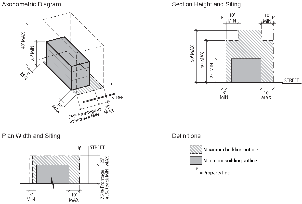
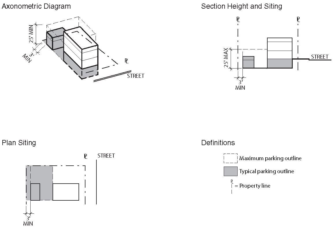
7.0.3. - GENERAL RULES OF APPLICABILITY
A.
Applicability
The following general rules of applicability apply to all Form Districts, except the South Waterfront District.
B.
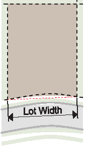
Lot Width
Lot width is the distance between the 2 side lot lines measured at the primary street property line along a straight line or along the chord of the property line on a curvilinear lot.
C.
Building Setbacks
1.
There are 4 types of building setbacks—primary street, side street, side interior and rear.
2.
Primary and side street setbacks are measured from the edge of the right-of-way.
3.
Primary and side streets are designated in each specific Form District.
4.
Side interior setbacks are measured from the side property line.
5.
Rear setbacks are measured from the rear property line or the edge of the right-of-way where there is an alley.
6.
When the side interior or rear setback is 0 or 5 feet, the building or structure must be placed on the side or rear property line or be placed a minimum of 5 feet from the side or rear property line.
7.
For developments on corner lots, the building must be located as to provide for adequate sight distance as approved by the City of Knoxville, Department of Engineering.
D.
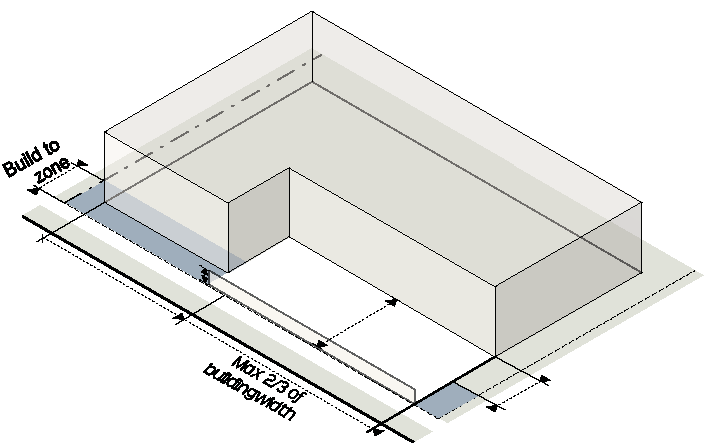
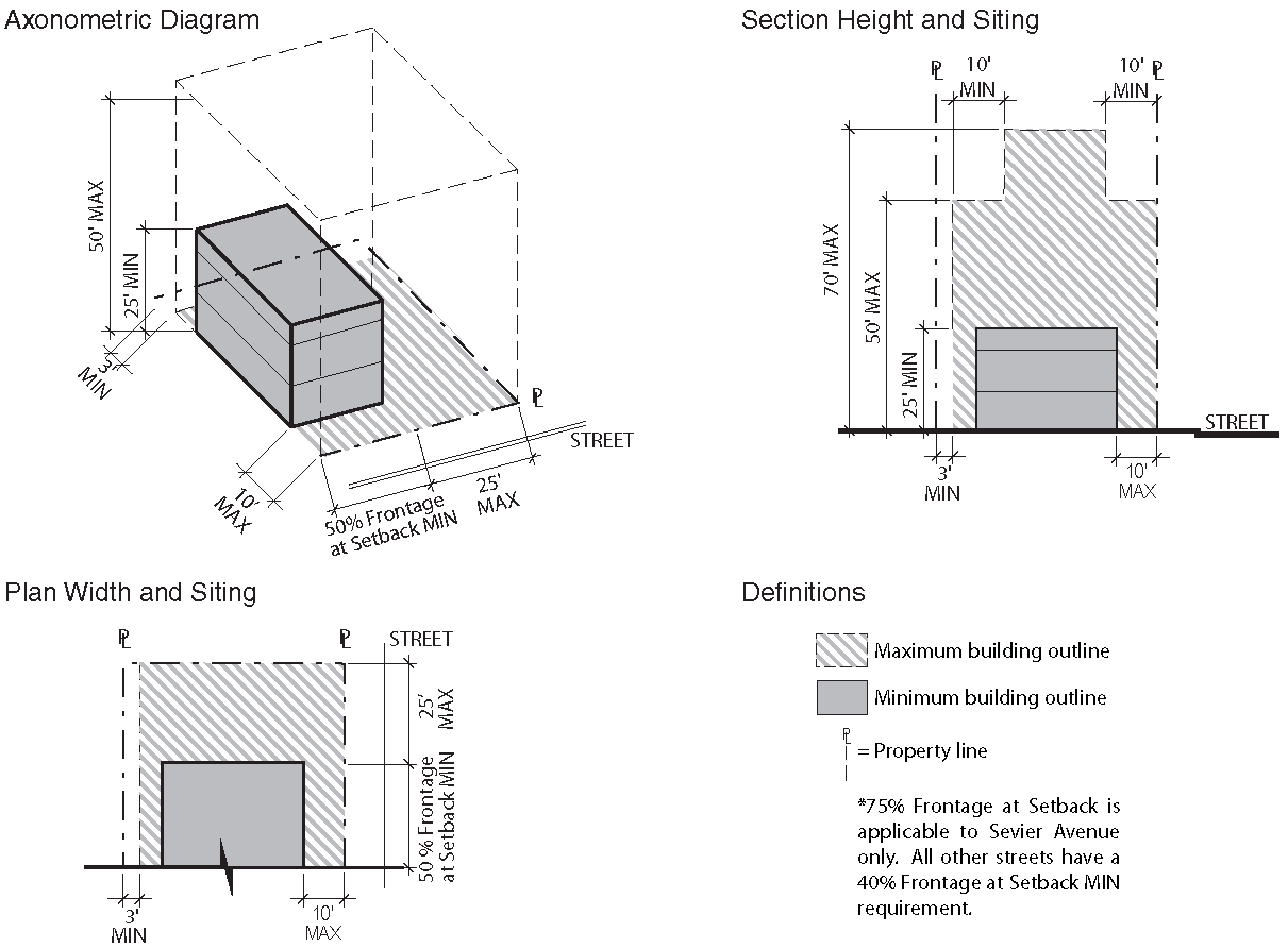
Build-To Zone (BTZ)
1.
The build-to zone is the area on the lot where a certain percentage of the front building façade must be located, measured as a minimum and maximum setback range from the edge of the right-of-way.
2.
The required percentage specifies the amount of the front building façade that must be located in the build-to zone, measured based on the width of the building divided by the width of the lot.
3.
On a corner lot, a building façade must be placed within the build-to zone for the first 30 feet along the street extending from the block corner, measured from the intersection of the 2 right-of-way lines.
4.
Outdoor seating and dining areas may qualify as building façade for the purpose of meeting the build-to requirement provided that the following standards are met:
a.
The front building façade is located no more than 10 feet behind the maximum street setback;
b.
The outdoor seating and dining area is no more than 2/3 the width of the building;
c.
The outdoor seating and dining area is no more than 16 feet deep; and
d.
The seating area is separated from the sidewalk by a wall or fence no higher than 4 feet above the sidewalk.
E.
Setback Encroachments
All buildings and structures must be located at or behind required setbacks, except as listed below. Unless specifically stated no building or structure can extend into a required easement or public right-of-way.
1.
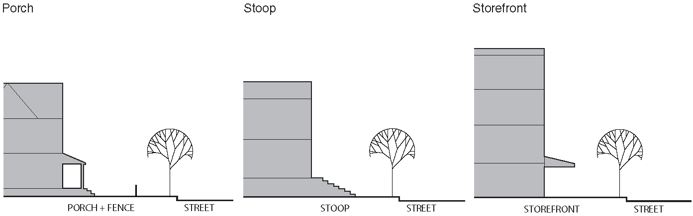
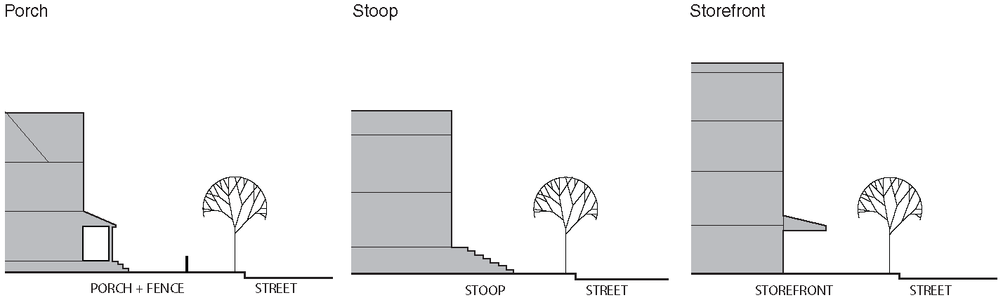
Building Features
a.
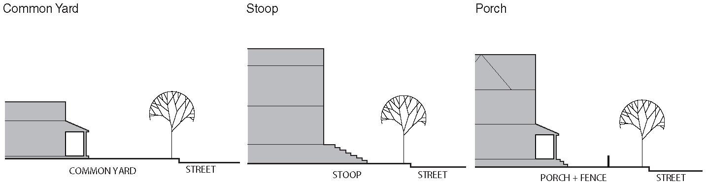
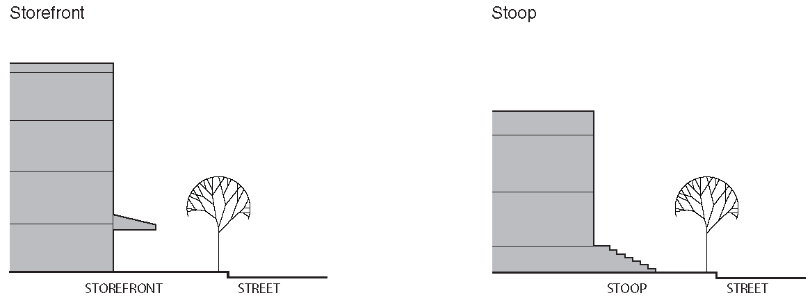
Porches, stoops, balconies, galleries and awnings/canopies can extend into a required setback under Sec. 7.2.4.
b.
Chimneys or flues may extend up to 4 feet, provided that such extension is at least 2 feet from the vertical plane of any lot line.
c.
Building eaves, roof overhangs and light shelves may extend up to 4 feet, provided that such extension is at least 2 feet from the vertical plane of any lot line.
d.
Bay windows, entrances and similar features that are less than 10 feet wide may extend up to 4 feet, provided that such extension is at least 2 feet from the vertical plane of any lot line.
e.
Unenclosed fire escapes or stairways may extend up to 4 feet into a required side or rear setback, provided that such extension is at least 5 feet from the vertical plane of any lot line.
f.
Unenclosed patios, decks or terraces may extend up to 4 feet into a required side setback, or up to 8 feet into a required rear setback, provided that such extension is at least 5 feet from the vertical plane of any lot line.
g.
Outdoor seating and dining areas may extend into a primary or side street setback.
h.
Cornices, belt courses, sills, buttresses, or other similar architectural features may project up to 1½ feet.
i.
Handicap ramps may encroach to the extent necessary to perform their proper function.
j.
Building features below and covered by the ground may encroach into any required setback.
k.
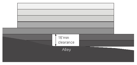
Habitable space or structured parking may encroach over an existing or proposed alley with approval of an encroachment agreement by the City, provided that the alley remains public and a minimum clear height of 16 feet is maintained for vehicles.
2.
Mechanical Equipment and Utility Lines
a.
Mechanical equipment associated with residential uses, such as HVAC units and security lighting, may encroach into a required rear or side setback, provided that such extension is at least 3 feet from the vertical plane of any lot line.
b.
Solar panels, wind turbines and rainwater collection or harvesting systems less than 10 feet in height may encroach into a required rear setback, provided that such extension is at least 5 feet from the vertical plane of any lot line.
c.
Minor structures accessory to utilities (such as hydrants, manholes, and transformers and other cabinet structures) may encroach into a required rear or side setback
d.
Mechanical equipment and utility lines below and covered by the ground may encroach into any required setback.
F.
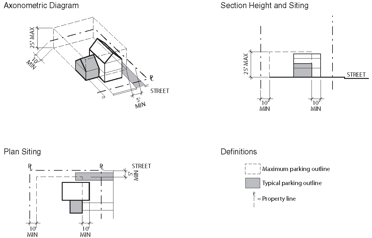
Parking Setbacks
1.
There are 4 types of parking setbacks—primary street, side street, side interior and rear.
2.
On-site surface and structured parking must be located behind the parking setback line. This requirement is not intended to restrict on-street parking.
3.
Primary and side street parking setbacks are measured from the edge of the right-of-way.
4.
Side interior setbacks are measured from the side property line.
5.
Rear setbacks are measured from the rear property line or the edge of the right-of-way if there is an alley.
6.
When the side interior or rear parking setback is 0 or 5 feet, parking spaces must be placed on the side or rear property line or be placed a minimum of 5 feet from the side or rear property line.
G.
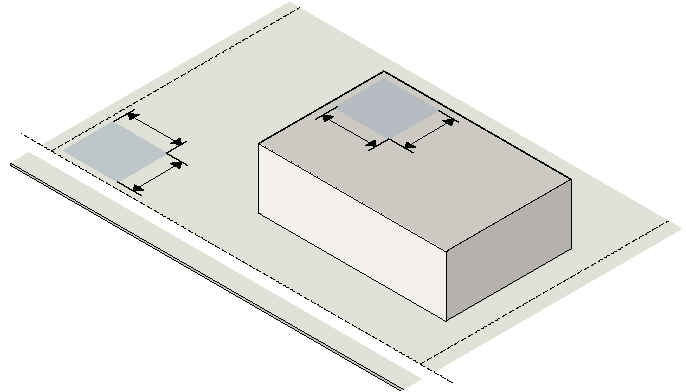
Outdoor Amenity Space
1.
Outdoor amenity space must be provided on the lot and must be available for use by the occupants of the development.
2.
Outdoor amenity space may be met in a contiguous open area or in multiple open areas on the lot; however, to receive credit the area must be at least 10 feet in width and length.
3.
Outdoor amenity space may be located at or above grade.
4.
Outdoor amenity space provided at grade cannot be built, parked or driven upon, except for emergency access and permitted temporary events.
5.
Outdoor amenity space provided above grade may be roofed but cannot be enclosed.
H.
Building Height
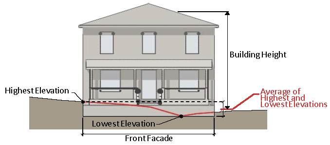
1.
Building height is measured in both the number of stories and in feet. Building height is the vertical distance from average grade to the average height of the highest roof. For roofs with less than a 4 in 12 pitch, height is measured to the highest point of the roof.
2.
Average grade is determined by calculating the average of the highest and lowest elevation along natural or improved grade (whichever is more restrictive) along the front of the building parallel to the primary street setback line.
3.
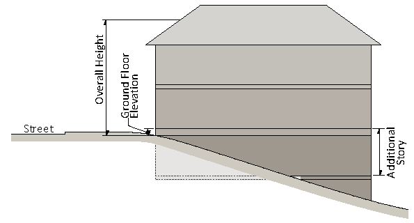
Where a lot slopes downward from the front property line, 1 story that is additional to the specified maximum number of stories may be built on the lower, rear portion of the lot.
4.
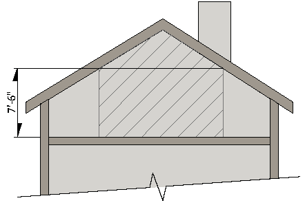
An attic does not count as a story where 50% or more of the attic floor area has a clear height of less than 7½ feet; measured from the finished floor to the finished ceiling.
5.
A basement with 50% or more of its perimeter wall area surrounded by natural grade is not considered a story.
I.
Height Encroachments
Any height encroachment not specifically listed is expressly prohibited except where the Administrator determines that the encroachment is similar to a permitted encroachment listed below.
1.
The maximum height limits do not apply to spires, belfries, cupolas, domes not intended for human occupancy; monuments, water tanks/towers or other similar structures which, by design or function, must exceed the established height limits.
2.
The following accessory structures may exceed the established height limits, provided they do not exceed the maximum building height by more than 6 feet:
a.
Chimney, flue or vent stack;
b.
Deck, patio, shade structure;
c.
Flagpole;
d.
Garden, landscaping, green roof;
e.
Parapet wall; and
f.
Solar panels, wind turbines and rainwater collection or harvesting systems.
3.
The following accessory structures may exceed the established height limits, provided they do not exceed the maximum building height by more than 10 feet, do not occupy more than 25% of the roof area, and are set back at least 10 feet from the street-side edge of the roof:
a.
Amateur communications tower;
b.
Cooling tower;
c.
Elevator penthouse or bulkhead;
d.
Greenhouse;
e.
Mechanical equipment;
f.
Skylights; and
g.
Elevator or stairway access to roof.
4.
An accessory structure located on the roof must not be used for any purpose other than a use incidental to the principal use of the building.
J.
Story Height
1.
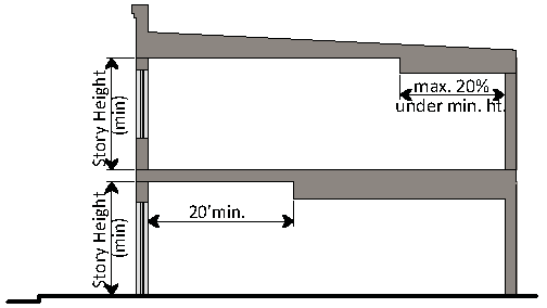
Story height is measured from the top of the finished floor to the ceiling above.
2.
Minimum ground story height applies to the first 20 feet of the building measured inward from the street facing façade.
3.
At least 80% of each upper story must meet the minimum upper story height provisions.
K.
Ground Floor Elevation
1.
Ground floor elevation is measured from the highest point of the abutting sidewalk to the highest point of the finished ground floor.
2.
Minimum ground floor elevation applies to the first 20 feet of the lot measured from the right-of-way line.
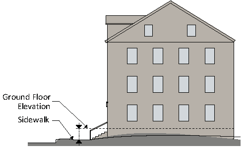
3.
On slopes greater than 6%, the ground floor elevation may not be located more than 3 feet above grade or 1 foot below grade on street-facing façades.
L.
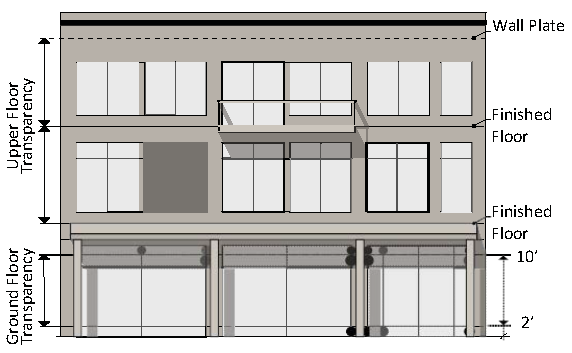
Transparency
1.
Transparency is the minimum percentage of windows and doors that must cover a ground or upper story façade.
2.
The transparency requirement on ground story façades is measured between 2 and 10 feet above the adjacent sidewalk.
3.
The transparency requirement on upper story façades is measured from the top of the finished floor to the top of the finished floor above. When there is no floor above, upper story transparency is measured from the top of the finished floor to the top of the wall plate.
4.
Glass is considered transparent where it has a transparency higher than 80% and external reflectance of less than 15%.
5.
Transparency applies to primary and side street-facing façades only.
M.
Blank Wall Area
1.
"Blank wall area" means a portion of the exterior façade of the building that does not include: windows or doors; columns, pilasters or other articulation greater than 12 inches in depth; or a substantial material change (paint color is not considered a substantial change).
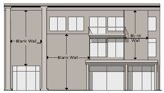
2.
Blank wall area applies in both a vertical and horizontal direction.
3.
Blank wall area applies only to ground and upper story street-facing façades.
N.
Building Entrances
1.
An entrance providing both ingress and egress, operable to residents at all times or to customers during normal business hours, is required to meet the street facing entrance requirements. Additional entrances are allowed.
2.
The entrance separation requirements must be met for each development, but are not applicable to adjacent (existing) development.
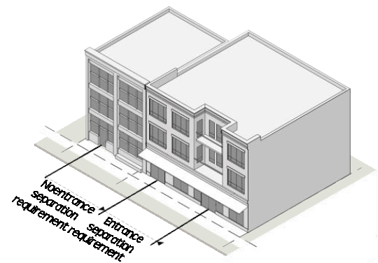
3.
An angled (clipped corner) entrance may be provided at any corner of a building along the street to meet the street entrance requirements, provided the applicable entrance spacing requirements can still be met.
O.
Building Materials
1.
Applicability
The requirements of this Section apply to all street-facing façades of a building.
2.
Primary Materials
Primary material changes must occur only at inside corners. The following materials are required for not less than 75% of the building wall surface area on each façade:
a.
Brick and tile masonry;
b.
Stone (or synthetic equivalent);
c.
Wood—clapboard or shingles;
d.
Glass curtain wall;
e.
Cementitious siding; and
f.
Stucco (cementitious finish).
3.
Accent Materials
The following materials may make up 25% of the building wall surface area on each façade:
a.
Pre-cast masonry (for trim and cornice elements only);
b.
External Insulation Finishing System—EIFS (for trim and cornice elements only);
c.
Gypsum Reinforced Fiber Concrete (GFRC—for trim elements only);
d.
Metal (for beams, lintels, trim elements and ornamentation only);
e.
Split-faced block (for piers, foundation walls and chimneys only);
f.
Wood—clapboard or shingles;
g.
Cementitious siding; and
h.
Glass block.
4.
Alternate Materials
Alternate building materials may be approved by the Administrator. New materials must be considered equivalent or better than the materials listed above, and regionally-available materials are preferred.
7.1.1. - GENERAL PROVISIONS
A.
Applicability
The requirements of this section apply to all development within the South Waterfront District as designated in Sec. 7.1.2.
B.
Purpose
The South Waterfront District carries out the policies of the South Waterfront Vision Plan by regulating development and land uses within the City's designated South Waterfront, consistent with the Vision Plan. More specifically, the South Waterfront District is intended to:
1.
Provide standards for the continuing orderly growth and development that will assist in enhancing and maintaining a distinct community identity;
2.
Create a comprehensive and stable pattern of development and land uses upon which to plan transportation, water supply, sewerage, energy, and other public facilities and utilities;
3.
Ensure that proposed development is of human scale, pedestrian-oriented, energy conserving, and is designed to create attractive streetscapes and pedestrian spaces;
4.
Minimize automobile congestion through pedestrian-oriented development, compact community form, safe and effective traffic circulation, and adequate parking facilities; and
5.
Ensure compatibility between different types of development and land uses.
C.
Conflicting Provisions
Wherever there appears to be a conflict between these district regulations and other requirements of the Zoning Ordinance or the Knoxville and Knox County Subdivision Regulations, these district regulations shall prevail. For development standards not covered in these district regulations, additional requirements may apply.
D.
Approval Procedures
Sec. 7.0.2 applies to the review of all development in the South Waterfront District.
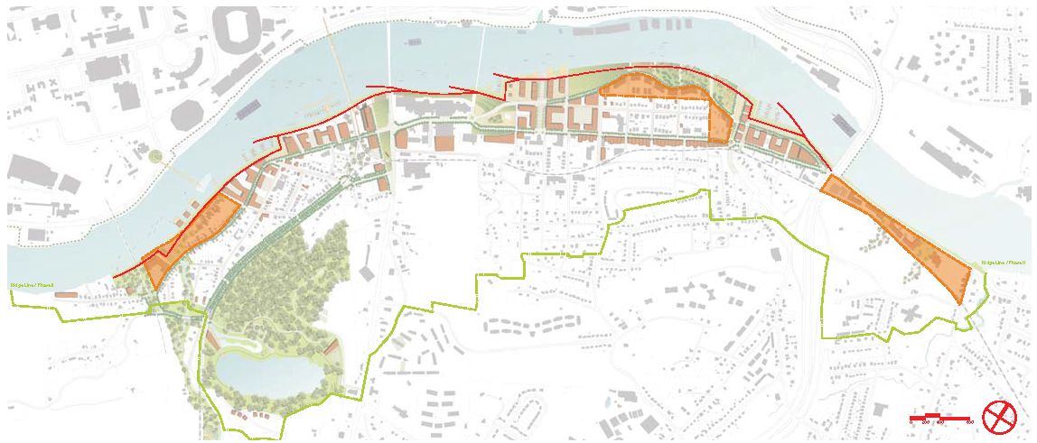
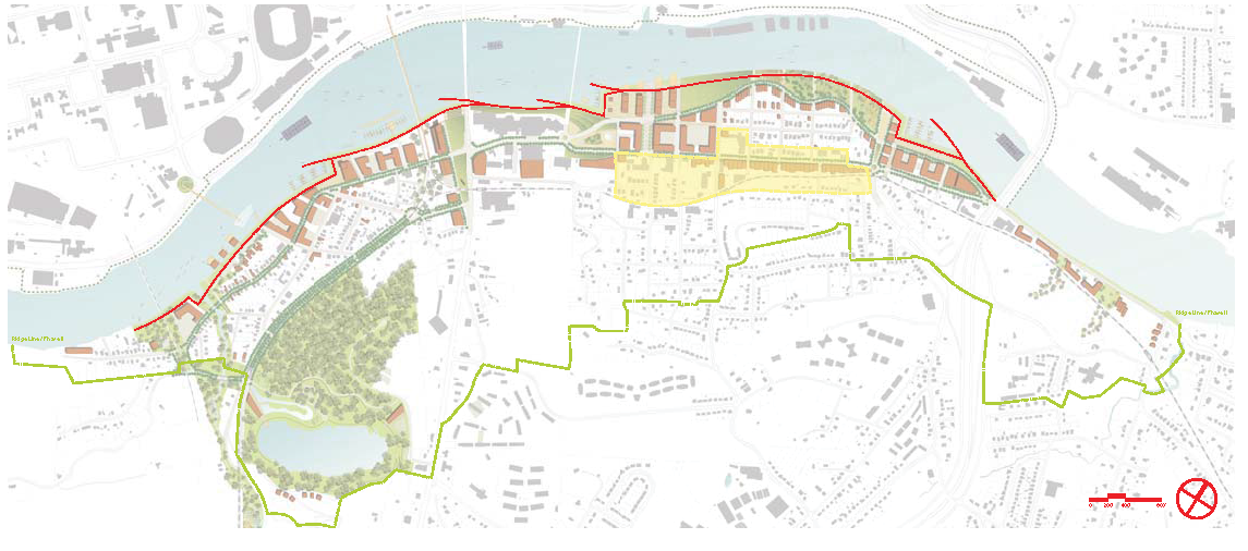
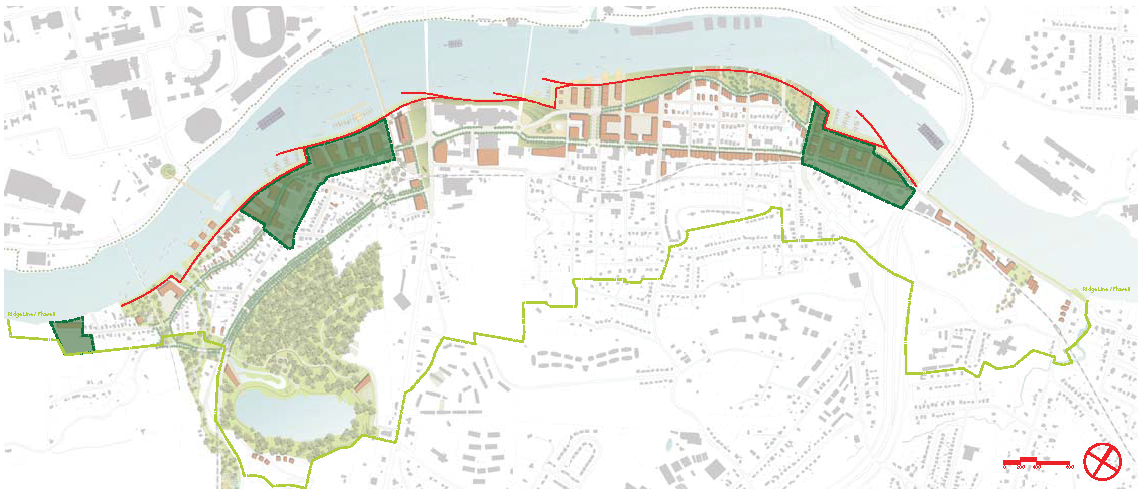
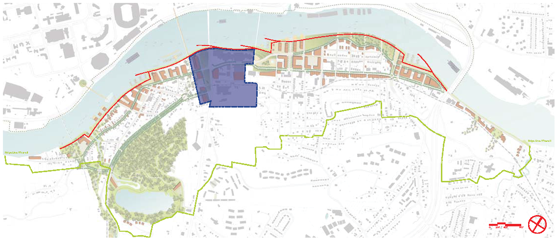
7.1.2. - VISION PLAN & REGULATING PLAN
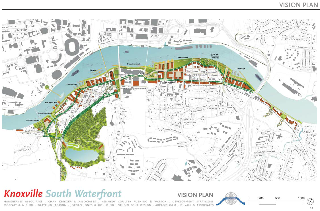
Excerpted from the VISION PLAN EXECUTIVE SUMMARY:
The Knoxville South Waterfront Vision and Action Plan is an effort to develop, through extensive public involvement, a coordinated plan and realistic series of prioritized actions to improve the waterfront area across from the downtown. The intent of the project is to revitalize the South Waterfront to a level that it is recognized as a citywide asset, attraction, and destination, while still preserving what makes the riverfront special to the neighborhoods.
The plan is not intended to be rigid and inflexible. It has been subjected to extensive review, discussion, and revision from all levels of government, local business and local communities. Three public workshops during the visioning process were well attended, with the final workshop drawing more than 500 people. The basic framework of the plan describes a series of public transportation and open space improvements designed to allow access and views to the water throughout the South Waterfront. The plan is designed to accommodate a realistic range of market driven redevelopment over the next 20 years.
The Vision Plan was adopted by the City Council on April 25, 2006.
The growth strategy for the Knoxville South Waterfront for the next 20 years includes the following:
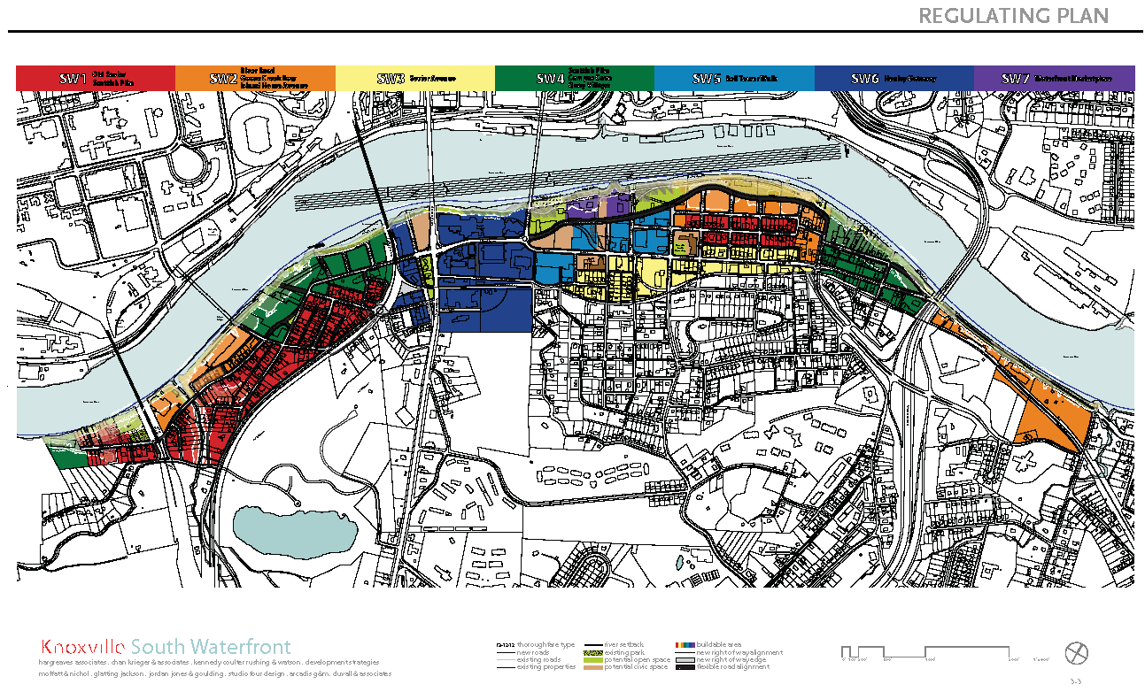
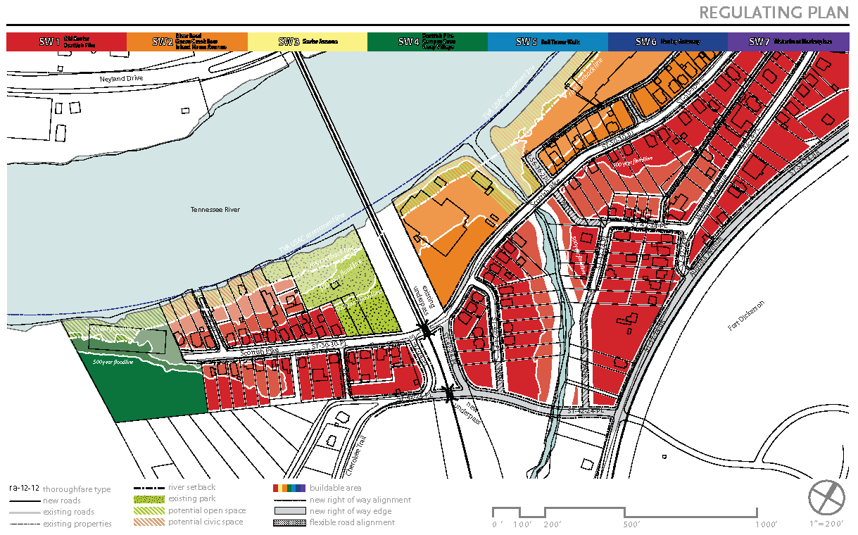
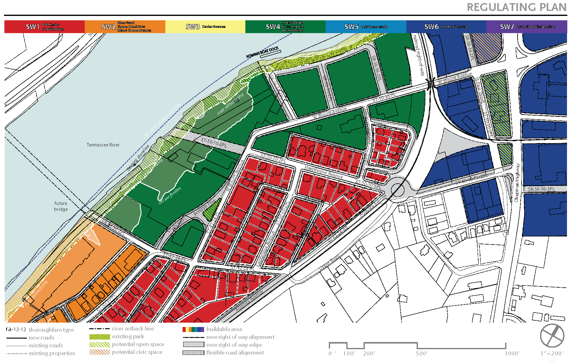
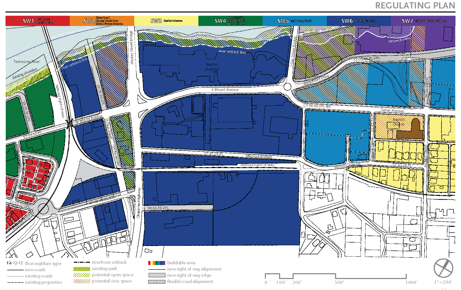
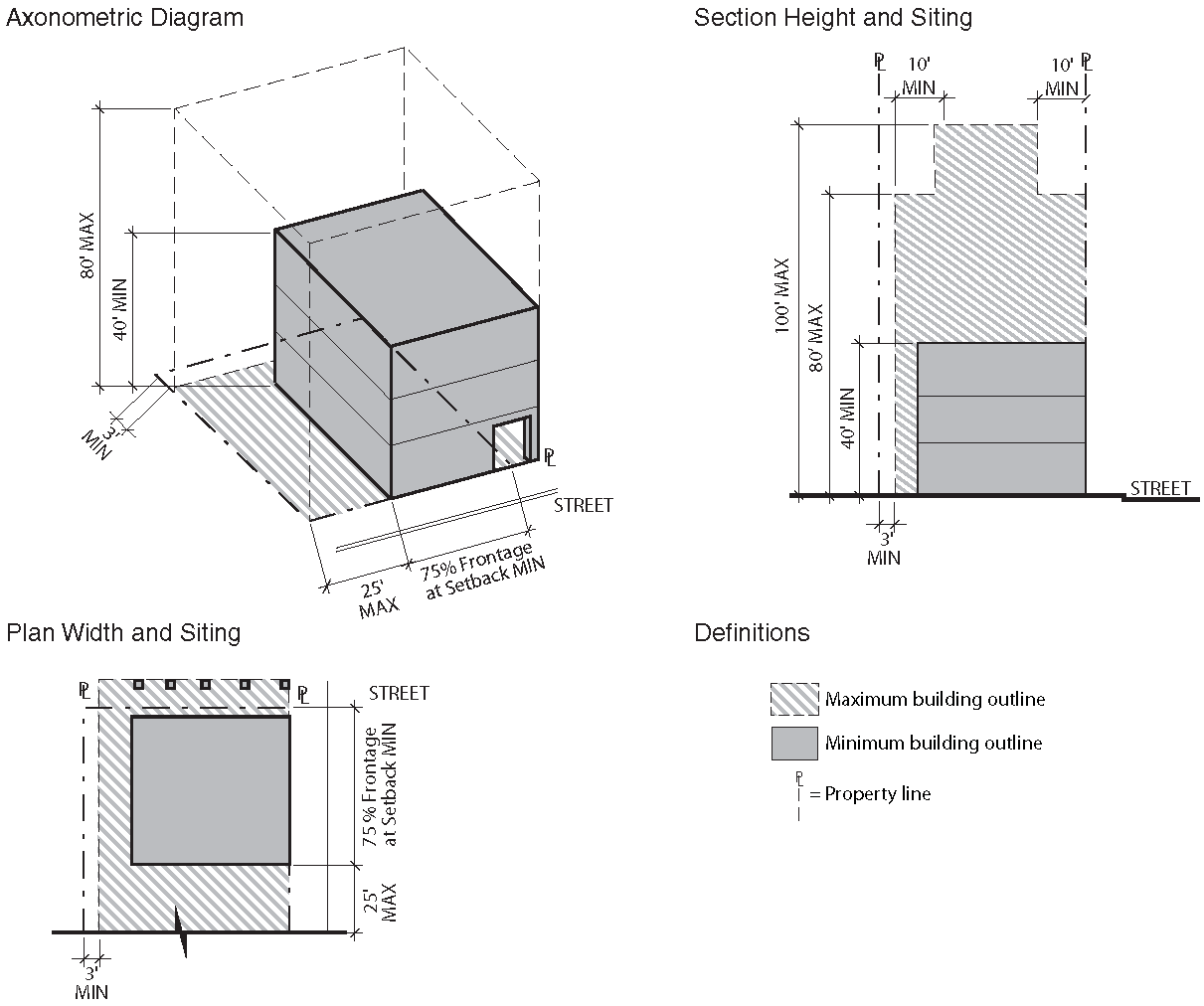
7.1.3. - PROPERTY DEVELOPMENT STANDARDS BY DISTRICT
A.
Check List
B.
SW1 Old Sevier and Scottish Pike
1.
Vision and Intent
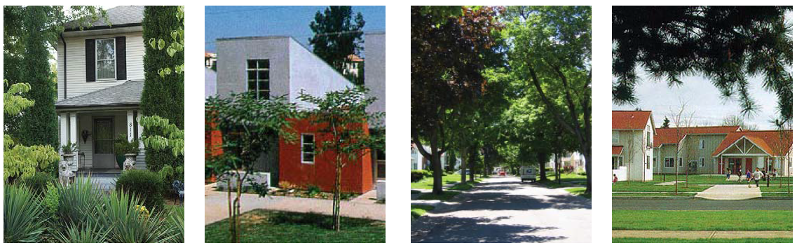
The Old Sevier and Scottish Pike areas are envisioned to conserve the "small town, neighborhood" atmosphere. New developments in these areas are encouraged to preserve and extend the existing neighborhood character and to maintain a complementary scale and density. Large-scale assemblage of residential properties or any commercial uses are prohibited. Suggested building types include detached houses, cottages, duplex houses, attached townhouses and rowhouses.
New street alignments in combination with the existing roads define important access and view corridors to the river and the bluffs. The completed road network establishes a "figure eight" loop by adding a new rail underpass to connect to August Avenue en route to Vestal. The road network links Blount Avenue to the new Waterfront Drive (east of the Gay Street Bridge) then to Sevier Avenue and Augusta Avenue. In order to alleviate Blount Avenue from congestion associated with new development, improvements to Augusta Avenue change the character of this street from a tertiary street to a significant boulevard with a bus route and close relationship to the rail line. Scottish Pike will enjoy new access to Fort Dickerson Park and a newly landscaped green corridor of Goose Creek. Proposed street right-of-ways improve pedestrian circulation as well as integrate street trees.
2.
Existing Conditions
a.
Intent
Guide site survey to assess existing site conditions for constraints and opportunities. Maintain views to river and downtown when viewed from hills behind.
b.
Topography
Consider existing topography and provide topographic survey with 2-foot contours.
c.
Existing Trees
i.
Identify all existing trees with a 6-inch minimum caliper including root zone within dripline.
ii.
Preserve a minimum of 1 healthy large canopy tree per lot, or 6 healthy trees per acre, whichever is greater.
d.
Environmental and Archaeological
i.
Comply with State and Federal requirements.
3.
Block Layout
a.
Intent
Guide lot layout and outline the maximum block perimeter and building setbacks permitted in this district to ensure walkable neighborhoods.
b.
Block Size
Maximum perimeter of 1,400 feet.
c.
Building Lines
i.
Minimum of 70 feet from normal pool EL 813.0. Refer to Sec. 7.1.6, Riverscape Standards.
d.
Proposed Subdivision and Phasing Plan
Clearly designate future phases and describe proposed subdivision plan and phasing when applicable.
4.
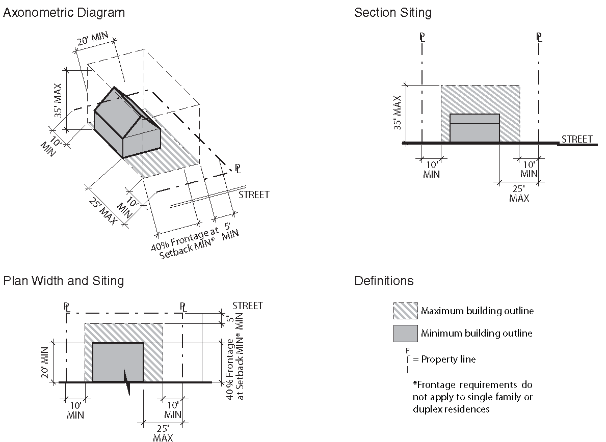
Building Siting and Configuration
Intent: Provide building configuration and design parameters.
5.
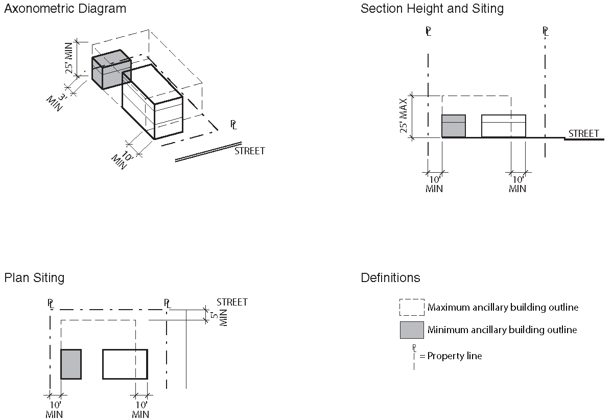
Ancillary Structures and Outdoor Spaces
Intent: Provide outdoor space configuration and design parameters.
6.
Building Frontages
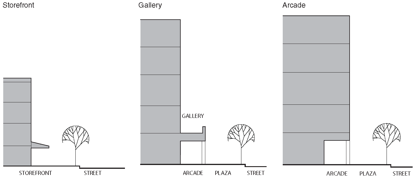
Frontage Typologies: Refer to Sec. 7.1.4.C.
7.
Off Street Parking and Loading
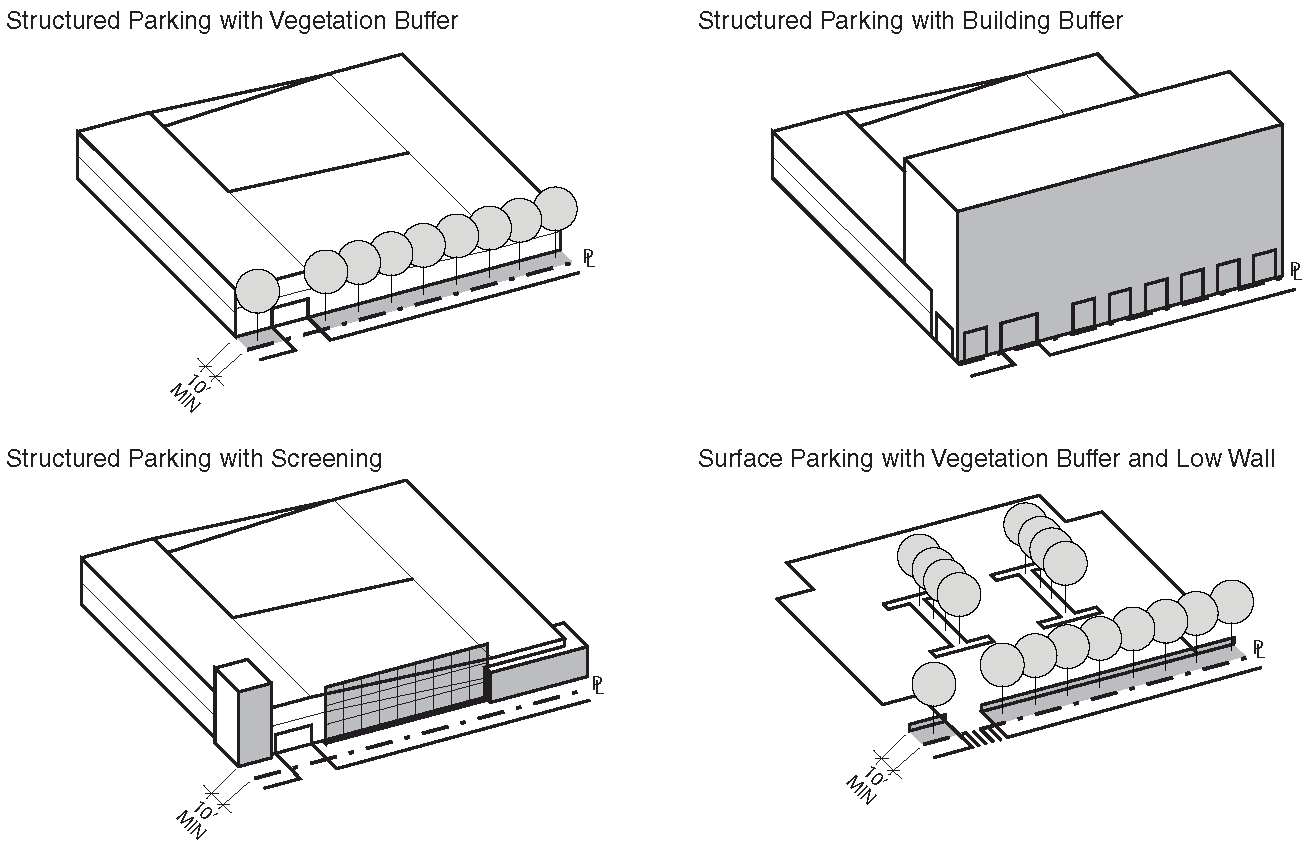
Intent: Provide with adequate parking to accommodate the district's various building types and functions. Refer to Sec. 7.1.4.D.
a.
Parking Types
Surface or Garage.
b.
Parking Spaces, Reserved and Shared
Minimum of 1 parking space per unit; Maximum of 2 parking spaces per unit.
c.
Pavements
65% minimum of uncovered surface parking shall be permeable while meeting overall stormwater requirements.
d.
Garage Location
Setback 10 feet further than building.
e.
Screening and Shading
One tree (with a 2-inch minimum caliper) is required for every 5 surface parking spaces.
f.
Accessible Spaces and Routes
Meet or exceed city accessibility standards.
g.
Driveways
i.
One on any frontage with a 15-foot maximum for one way traffic and 26-foot maximum for two way traffic.
ii.
Sidewalk materials and patterning is continuous through driveway.
h.
Garage Entry
One on any frontage.
i.
Service Loading
Not permitted.
j.
Bicycle Parking
Not required.
8.
External Elements
a.
Intent
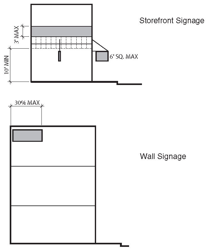
Guide the integration of external elements into property development including landscaping, utilities and lighting. Refer to Sec. 7.1.4.E, Signage and Sec. 7.1.4.F, Lighting and Noise.
b.
Proposed Topography Grades
Provide grading plan with 2-foot contours.
c.
Side or Rear Privacy Fence or Wall
Maximum of 8 feet.
d.
Front Fence or Wall
Maximum of 3 feet 6 inches in front yard or streetside of corner lot.
e.
Landscape Vegetation
i.
Minimum of 8 trees (with a 2-inch minimum caliper) per acre of area not covered by buildings.
ii.
Trees required for surface parking may be counted toward overall landscape requirement.
f.
Trash/Recycling Storage, External Mechanical Units, Electrical Units and Rain Barrels
Integrate with building design or screen/conceal from view from public street and riverwalk.
g.
Signage
House number.
9.
Sustainability
a.
Intent
Encourage longevity, durability, energy and economic efficiency as well as improved environmental conditions.
b.
Green Building and Landscape
i.
Capable of attaining the current Leadership in Energy and Environmental Design (LEED) minimal Performance Level of "Certified."
ii.
Submit completed worksheet of appropriate LEED standard to demonstrate pre-certification estimate.
c.
Reflectivity, Heat Island Reduction, Roof and Surface Lots
i.
Surface lots shall provide shade and/or use light-colored/high albedo materials with a solar reflectance of at least 0.3 (30%).
ii.
Roofs shall use an Energy Star Compliant (highly reflective) for a minimum of 75% of the roof surface.
C.
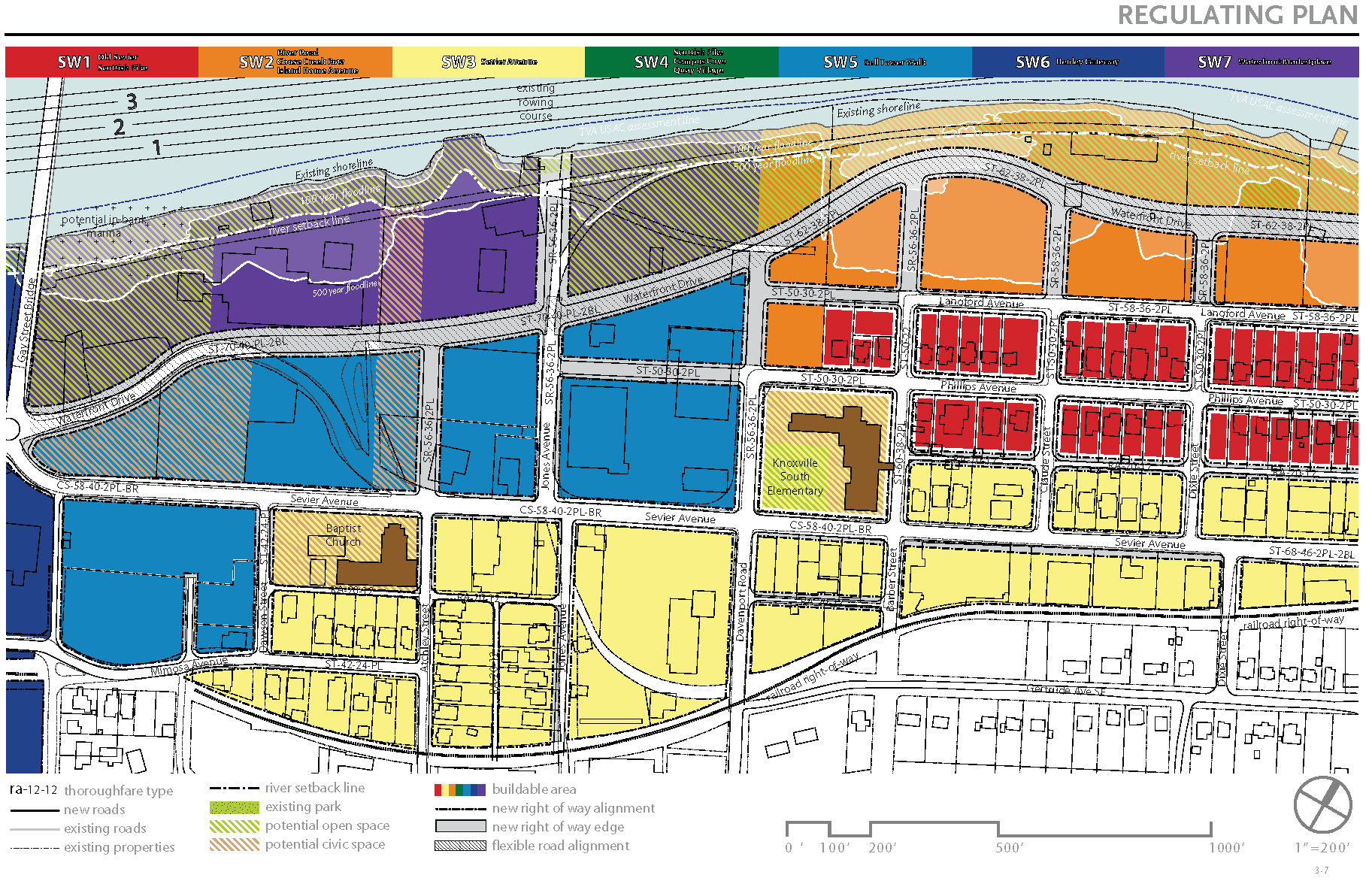
SW2 River Rd, Goose Creek Row and Island Home Ave
1.
Vision and Intent
The neighborhoods of Goose Creek, Waterfront Drive and Island Home Avenue are envisioned to have new, predominantly residential developments along the waterfront that will create a contemporary identity for the Knoxville South Waterfront. Suggested building types include duplex houses, townhouses, rowhouses and multiple unit housing. With a newly landscaped shoreline experience and a continuous riverfront setback along the river's edge, these developments provide residents spectacular vistas of the river but minimize obstructed views perpendicular to the river. The proposed River Street will be layered with modes of two-direction travel—bike lanes, on-street parking, a wide sidewalk and a well-landscaped river walk. River Street will be an important part of the "figure eight" road network making a loop from Gay Street to Sevier and Phillips Avenues.
A continuous promenade forms the northern edge of the river arboretum—the major open space of the area located in the flood plain. Residents enjoy access to a wealth of waterfront and water-based recreational activities. While these neighborhoods are primarily residential, they are located adjacent to highly-accessed public parks that boast many visitors on a daily basis and during city-wide events. Residents have access to the newly landscaped Goose Creek Green Corridor with a direct link to Fort Dickerson Quarry. Public access to the river is created along axes following the north-south streets, while on-street parking accommodates visitors to the parks and various recreational facilities. A bridge connection to the University may link the two sides of the river.
2.
Existing Conditions
a.
Intent
Guide site survey to assess existing site conditions for constraints and opportunities. Direct views to river and downtown, when viewed from neighborhoods behind.
b.
Topography
Consider existing topography and provide topographic survey with 2-foot contours.
c.
Existing Trees
i.
Identify all existing trees with a 6-inch minimum caliper including root zone within dripline.
ii.
Preserve a minimum of 1 healthy large canopy tree per lot, or 6 healthy trees per acre, whichever is greater.
d.
Environmental and Archaeological
i.
Comply with State and Federal Requirements.
3.
Block Layout
a.
Intent
Guide lot layout and outline the maximum block perimeter and building setbacks permitted in this district to ensure walkable neighborhoods.
b.
Block Size
Maximum perimeter of 1,400 feet.
c.
Building Lines
i.
Minimum of 70 feet from normal pool EL 813.0. Refer to Sec. 7.1.6, Riverscape Standards.
d.
Proposed Subdivision and Phasing Plan
Clearly designate future phases and describe proposed subdivision plan and phasing when applicable.
4.
Building Siting and Configuration
Intent: Provide building configuration and design parameters, as well as suggestions for building function.
5.
Ancillary Structures and Outdoor Spaces
Intent: Provide outdoor space configuration and design parameters.
6.
Building Frontages
Frontage Typologies: Refer to Sec. 7.1.4.C.
7.
Off Street Parking and Loading
Intent: Provide with adequate parking to accommodate the district's various building types and functions. Refer to Sec. 7.1.4.D.
a.
Parking Types
Surface lot, garages, under building garage.
b.
Parking Spaces, Reserved and Shared
Maximum of 3 parking spaces per 1,000 square feet and maximum of 2 parking spaces per residential unit.
c.
Pavements
65% minimum of uncovered surface parking shall be permeable while meeting overall stormwater requirements.
d.
Garage Location
To rear of property or underneath building.
e.
Screening and Shading
One tree (with a 2-inch minimum caliper) is required for every 5 surface parking spaces.
f.
Accessible Spaces and Routes
Meet or exceed city accessibility standards.
g.
Driveways
i.
Not permitted on principal frontage and shall be 15-foot maximum for one way traffic and 26-foot maximum for two way traffic.
ii.
Sidewalk materials and patterning is continuous through driveway.
h.
Garage Entry
From rear alley or side street.
i.
Service Loading
Permitted from rear alley or side street.
j.
Bicycle Parking
Required.
8.
External Elements
Intent: Guide the integration of external elements into property development including landscaping, utilities and lighting. Refer to Sec. 7.1.4.E, Signage and Sec. 7.1.4.F, Lighting and Noise.
a.
Proposed Topography Grades
Provide grading plan with 2-foot contours.
b.
Side or Rear Privacy Fence or Wall
Maximum of 8 feet.
c.
Front Fence or Wall
Maximum of 3 feet 6 inches.
d.
Landscape Vegetation
i.
Minimum of 8 trees (with a 2-inch minimum caliper) per acre of open space.
ii.
Trees required for surface parking may be counted toward overall landscape requirement.
e.
Trash/Recycling Storage, External Mechanical Units, Electrical Units and Rain Barrels
Integrate with building design or screen/conceal from view from public street and riverwalk.
9.
Sustainability
a.
Intent
Encourage longevity, durability, energy and economic efficiency as well as improved environmental conditions.
b.
Green Building and Landscape
i.
Capable of attaining the current Leadership in Energy and Environmental Design (LEED) minimal Performance Level of "Certified."
ii.
Submit completed worksheet of appropriate LEED standard to demonstrate pre-certification estimate.
c.
Reflectivity, Heat Island Reduction, Roof and Surface Lots
i.
Surface lots shall provide shade and/or use light-colored/high albedo materials with a solar reflectance of at least 0.3 (30%).
ii.
Roofs shall use an Energy Star Compliant (highly reflective) for a minimum of 75% of the roof surface.
D.
SW3 Sevier Avenue
1.
Vision and Intent
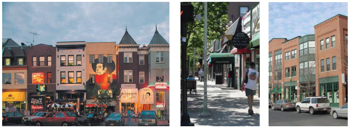
Sevier Avenue is the historic commercial heart of the Old Sevier neighborhood. It has the potential to fulfill the role of 'Main Street' in the future and become a viable commercial center for the local neighborhoods. New development in this area has a mix of commercial and retail uses on ground floors that promote both daytime and nighttime activities. Developments in this area could also house multiple residential units on the upper floors. The new mixed-use infill development will complement the existing buildings and preserve the historic character that exists. New buildings shall be built up to the street (rather than being setback from the street) to reinforce the continuity of the street wall.
Parking for new developments will be to the rear of the site as well as on-street. Existing historic buildings will be encouraged to be restored for reuse. Suggested building types that may exist in this vibrant district include mixed-use shopfront buildings and loft developments. A potential conversion of the freight rail line to light rail may provide public transportation to the area in the future.
2.
Existing Conditions and Block Layout
a.
Intent
Guide site survey to assess existing site conditions for constraints and opportunities.
b.
Topography
Consider existing topography and provide topographic survey with 2-foot contours.
c.
Existing Trees
i.
Identify all existing trees with a 6-inch minimum caliper including root zone within dripline.
ii.
Preserve a minimum of 1 healthy large canopy tree per lot, or 6 healthy trees per acre, whichever is greater.
d.
Environmental and Archaeological
i.
Comply with State and Federal Requirements.
3.
Block Layout
a.
Intent
Guide lot layout and outline the maximum block perimeter and building setbacks permitted in this district to ensure walkable neighborhoods.
b.
Block Size
Maximum perimeter of 1,400 feet.
c.
Building Lines
Minimum of 70 feet from normal pool EL 813.0. Refer to Sec. 7.1.6, Riverscape Standards.
d.
Proposed Subdivision and Phasing Plan
Clearly designate future phases and describe proposed subdivision plan and phasing when applicable.
4.
Building Siting and Configuration
Intent: Provide building configuration and design parameters, as well as suggestions for building function.
5.
Ancillary Structures and Outdoor Spaces
a.
Intent
Provide outdoor space configuration and design parameters.
b.
Ancillary/Accessory Structures
NA
c.
Ancillary/Accessory Structure Envelope
i.
Footprint/Floor Plate: NA
ii.
Front Setback: NA
iii.
Frontage at Setback: NA
iv.
Side Setback: NA
v.
Rear Setback: NA
vi.
Building Width: NA
vii.
Building Height: NA
d.
Outdoor Space Types
Roof decks, patios
e.
Usable Private Open Space
NA
6.
Building Frontages
Frontage Typologies: Refer to Sec. 7.1.4.C.
7.
Off Street Parking and Loading
Intent: Provide with adequate parking to accommodate the district's various building types and functions. Refer to Sec. 7.1.4.D.
a.
Parking Types
Surface lot, above ground structure, basement garage.
b.
Parking Spaces, Reserved and Shared
Maximum of 3 parking spaces per 1,000 square feet and maximum of 2 parking spaces per residential unit.
c.
Pavements
65% minimum of uncovered surface parking shall be permeable while meeting overall stormwater requirements.
d.
Garage Location
To rear of property or underneath building.
e.
Screening and Shading
One tree (with a 2-inch minimum caliper) is required for every 5 surface parking spaces.
f.
Accessible Spaces and Routes
Meet or exceed city accessibility standards.
g.
Driveways
i.
Driveway shall be 15-foot maximum for one way traffic and 26-foot maximum for two way traffic.
ii.
Sidewalk materials and patterning is continuous through driveway.
h.
Garage Entry
Permitted
on all frontages.
i.
Service Loading
Permitted.
j.
Bicycle Parking
Required.
8.
External Elements
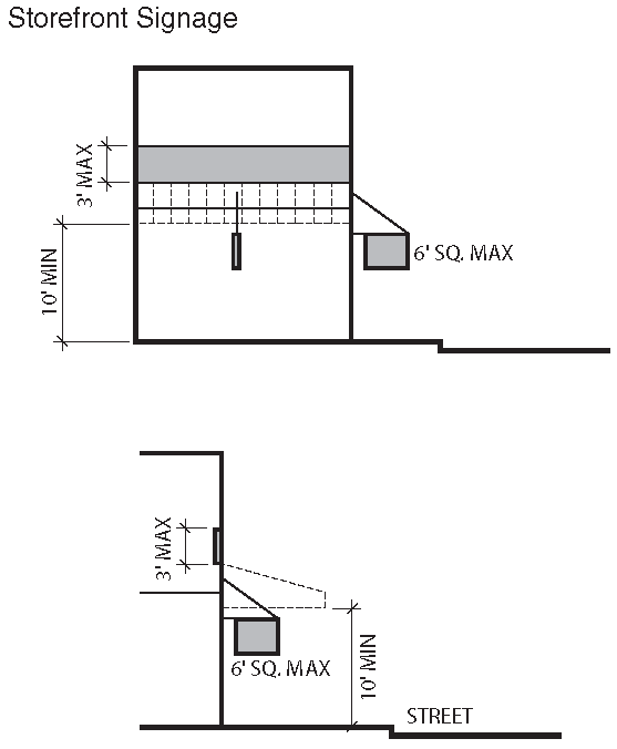
Intent: Guide the integration of external elements into property development including landscaping, utilities and lighting. Refer to Sec. 7.1.4.E, Signage and Sec. 7.1.4.F, Lighting and Noise.
a.
Proposed Topography Grades
Provide grading plan with 2-foot contours.
b.
Side or Rear Privacy Fence or Wall
Maximum of 8 feet.
c.
Front Fence or Wall
Maximum of 3 feet 6 inches.
d.
Landscape Vegetation
i.
Minimum of 8 trees (with a 2-inch minimum caliper) per acre of open space.
ii.
Trees required for surface parking may be counted toward overall landscape requirement.
e.
Trash/Recycling Storage, External Mechanical Units, Electrical Units and Rain Barrels
Integrate with building design or screen/conceal from view from public street and riverwalk.
9.
Sustainability
a.
Intent
Encourage longevity, durability, energy and economic efficiency as well as improved environmental conditions.
b.
Green Building and Landscape
i.
Capable of attaining the current Leadership in Energy and Environmental Design (LEED) minimal Performance Level of "Certified."
ii.
Submit completed worksheet of appropriate LEED standard to demonstrate pre-certification estimate.
c.
Reflectivity, Heat Island Reduction, Roof and Surface Lots
i.
Surface lots shall provide shade and/or use light-colored/high albedo materials with a solar reflectance of at least 0.3 (30%).
ii.
Roofs shall use an Energy Star Compliant (highly reflective) for a minimum of 75% of the roof surface.
E.
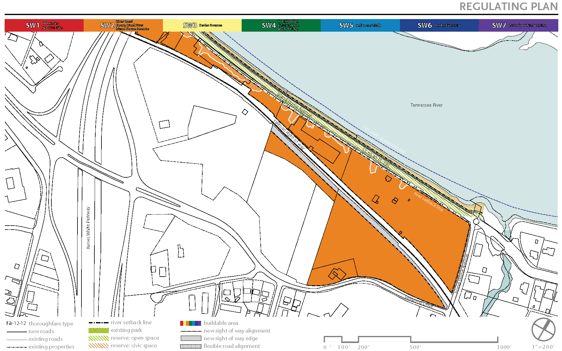
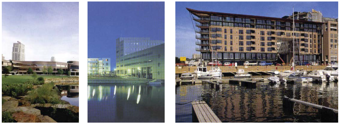
SW4 City View, Campus Cove and Quay Village
1.
Vision and Intent
These three new development districts are clustered around privately-owned but publicly-accessed marinas, lending these areas a distinctively urban character that will enliven the new Knoxville South Waterfront. Higher density and larger in scale, these buildings have a mix of uses, including office, residential, commercial and hospitality. All new developments shall integrate publicly accessible landscapes and plazas that unify the buildings with a setback from the river to accommodate a continuous promenade and marinas. View corridors and public open spaces will connect these areas to the neighborhoods, civic spaces and natural drainage ways to the river.
Parking is incorporated into the structures or housed beneath the buildings when possible. Large surface parking lots are discouraged. A possible pedestrian connection to the University of Tennessee will facilitate a continuation of the student population into the Campus Cove. The Sevier Avenue extension from the James White Parkway will be realigned with a traffic circle to improve traffic flow and create a sense of entry into the downtown. A second traffic circle will be introduced along Island Home Avenue.
2.
Existing Conditions
a.
Intent
Guide site survey to assess existing site conditions for constraints and opportunities. Direct views to river and downtown, when viewed from neighborhoods behind.
b.
Topography
Consider existing topography and provide topographic survey with 2-foot contours.
c.
Existing Trees
i.
Identify all existing trees with a 6-inch minimum caliper including root zone within dripline.
ii.
Preserve a minimum of 1 healthy large canopy tree per lot, or 6 healthy trees per acre, whichever is greater.
d.
Environmental and Archaeological
Comply with State and Federal Requirements.
3.
Block Layout
a.
Intent
Guide lot layout and outline the maximum block perimeter and building setbacks permitted in this district to ensure walkable neighborhoods.
b.
Block Size
Maximum perimeter of 1,400 feet.
c.
Building Lines
Minimum of 70 feet from normal pool EL 813.0. Refer to Sec. 7.1.6, Riverscape Standards.
d.
Proposed Subdivision and Phasing Plan
Clearly designate future phases and describe proposed subdivision plan and phasing when applicable.
4.
Building Siting and Configuration
Intent: Provide building configuration and design parameters, as well as suggestions for building function.
5.
Ancillary Structures and Outdoor Spaces
a.
Intent
Provide outdoor space configuration and design parameters.
b.
Ancillary/Accessory Structures
NA
c.
Ancillary/Accessory Structure Envelope
i.
Footprint/Floor Plate: NA
ii.
Front Setback: NA
iii.
Frontage at Setback: NA
iv.
Side Setback: NA
v.
Rear Setback: NA
vi.
Building Width: NA
vii.
Building Height: NA
d.
Outdoor Space Types
Courtyards, plazas, pools
e.
Usable Private Open Space
NA
6.
Building Frontages
Frontage Typologies: Refer to Sec. 7.1.4.C.
7.
Off Street Parking and Loading
Intent: Provide with adequate parking to accommodate the district's various building types and functions. Refer to Sec. 7.1.4.D.
a.
Parking Types
Surface lot, above ground structure, basement garage.
b.
Parking Spaces, Reserved and Shared
Maximum of 3 parking spaces per 1,000 square feet and maximum of 2 parking spaces per residential unit.
c.
Pavements
65% minimum of uncovered surface parking shall be permeable while meeting overall stormwater requirements.
d.
Garage Location
To rear or side of property or underneath building.
e.
Screening and Shading
One tree (with a 2-inch minimum caliper) is required for every 5 surface parking spaces.
f.
Accessible Spaces and Routes
Meet or exceed city accessibility standards.
g.
Driveways
i.
Driveway shall be 15-foot maximum for one way traffic and 26-foot maximum for two way traffic.
ii.
Sidewalk materials and patterning is continuous through driveway.
h.
Garage Entry
Permitted on all frontages.
i.
Service Loading
Permitted.
j.
Bicycle Parking
Required.
8.
External Elements
Intent: Guide the integration of external elements into property development including landscaping, utilities and lighting. Refer to Sec. 7.1.4.E, Signage and Sec. 7.1.4.F, Lighting and Noise.
a.
Proposed Topography Grades
Provide grading plan with 2-foot contours.
b.
Side or Rear Privacy Fence or Wall
Maximum of 8 feet.
c.
Front Fence or Wall
Maximum of 3 feet 6 inches.
d.
Landscape Vegetation
i.
Minimum of 8 trees (with a 2-inch minimum caliper) per acre of open space.
ii.
Trees required for surface parking may be counted toward overall landscape requirement.
e.
Trash/Recycling Storage, External Mechanical Units, Electrical Units and Rain Barrels
Integrate with building design or screen/conceal from view from public street and riverwalk.
9.
Sustainability
a.
Intent
Encourage longevity, durability, energy and economic efficiency as well as improved environmental conditions.
b.
Green Building and Landscape
i.
Capable of attaining the current Leadership in Energy and Environmental Design (LEED) minimal Performance Level of "Certified."
ii.
Submit completed worksheet of appropriate LEED standard to demonstrate pre-certification estimate.
c.
Reflectivity, Heat Island Reduction, Roof and Surface Lots
i.
Surface lots shall provide shade and/or use light-colored/high albedo materials with a solar reflectance of at least 0.3 (30%).
ii.
Roofs shall use an Energy Star Compliant (highly reflective) for a minimum of 75% of the roof surface.
F.
SW5 Bell Tower Walk
1.
Vision and Intent
This bustling area caters to multiple functions, including retail, entertainment, civic, cultural, and residential uses. New buildings are organized along the civic plaza called "Bell Tower Walk" and are oriented perpendicular to the river so as not to inhibit views to the river from the bluff. The Bell Tower Walk is the center of a lively area on the Knoxville South Waterfront where outdoor restaurants, fairs and musical events attract local Knoxvillians and regional visitors both day and night and year round. Bell Tower Walk creates a "window-to-the-water" from the Baptist Church on Sevier Avenue leading down to the riverfront. It will serve as the central celebratory space for the community and could be used in conjunction with marketplace piers for small-scale festivals and urban markets throughout the year. Low to mid-rise, mixed-use or multiple unit housing developments face this linear open space and are encouraged to have commercial development on the first floor. To the west of this civic plaza, a cultural center and museum overlooks an outdoor amphitheater and marina that connect to the river walk. Parking structures are housed beneath the buildings or behind them to accommodate the area's many visitors and employees.
2.
Existing Conditions and Block Layout
a.
Intent
Guide site survey to assess existing site conditions for constraints and opportunities. Allow some views to river and downtown from taller buildings, when viewed from neighborhoods behind.
b.
Topography
Consider existing topography and provide topographic survey with 2-foot contours.
c.
Existing Trees
i.
Identify all existing trees with a 6-inch minimum caliper including root zone within dripline.
ii.
Preserve a minimum of 1 healthy large canopy tree per lot, or 6 healthy trees per acre, whichever is greater.
d.
Environmental and Archaeological
Comply with State and Federal Requirements.
3.
Block Layout
a.
Intent
Guide lot layout and outline the maximum block perimeter and building setbacks permitted in this district to ensure walkable neighborhoods.
b.
Block Size
Maximum perimeter of 1,400 feet.
c.
Building Lines
Minimum of 70 feet from normal pool EL 813.0. Refer to Sec. 7.1.6, Riverscape Standards.
d.
Proposed Subdivision and Phasing Plan
Clearly designate future phases and describe proposed subdivision plan and phasing when applicable.
4.
Building Siting and Configuration
Intent: Provide building configuration and design parameters, as well as suggestions for building function.
5.
Ancillary Structures and Outdoor Spaces
a.
Intent
Provide outdoor space configuration and design parameters.
b.
Ancillary/Accessory Structures
NA
c.
Ancillary/Accessory Structure Envelope
i.
Footprint/Floor Plate: NA
ii.
Front Setback: NA
iii.
Frontage at Setback: NA
iv.
Side Setback: NA.
v.
Rear Setback: NA
vi.
Building Width: NA
vii.
Building Height: NA
d.
Outdoor Space Types
Courtyards, plazas, mall
e.
Usable Private Open Space
NA
6.
Building Frontages
Frontage Typologies: Refer to Sec. 7.1.4.C.
7.
Off Street Parking and Loading
Intent: Provide with adequate parking to accommodate the district's various building types and functions. Refer to Sec. 7.1.4.D.
a.
Parking Types
Surface lot, above ground structure, basement garage.
b.
Parking Spaces, Reserved and Shared
Maximum of 3 parking spaces per 1,000 square feet and maximum of 2 parking spaces per residential unit.
c.
Pavements
65% minimum of uncovered surface parking shall be permeable while meeting overall stormwater requirements.
d.
Garage Location
To rear or center of property or underneath building.
e.
Screening and Shading
One tree (with a 2-inch minimum caliper) is required for every 5 surface parking spaces.
f.
Accessible Spaces and Routes
Meet or exceed city accessibility standards.
g.
Driveways
i.
Driveway shall be 15-foot maximum for one way traffic and 26-foot maximum for two way traffic.
ii.
Sidewalk materials and patterning is continuous through driveway.
h.
Garage Entry
Permitted on all frontages.
i.
Service Loading
Permitted.
j.
Bicycle Parking
Required.
8.
External Elements
Intent: Guide the integration of external elements into property development including landscaping, utilities and lighting. Refer to Sec. 7.1.4.E, Signage and Sec. 7.1.4.F, Lighting and Noise.
a.
Proposed Topography Grades
Provide grading plan with 2-foot contours.
b.
Side or Rear Privacy Fence or Wall
Maximum of 8 feet.
c.
Front Fence or Wall
Maximum of 3 feet and 6 inches.
d.
Landscape Vegetation
i.
Minimum of 8 trees (with a 2-inch minimum caliper) per acre of open space.
ii.
Trees required for surface parking may be counted toward overall landscape requirement.
e.
Trash/Recycling Storage, External Mechanical Units, Electrical Units and Rain Barrels
Integrate with building design or screen/conceal from view from public street and riverwalk.
9.
Sustainability
a.
Intent
Encourage longevity, durability, energy and economic efficiency as well as improved environmental conditions.
b.
Green Building and Landscape
i.
Capable of attaining the current Leadership in Energy and Environmental Design (LEED) minimal Performance Level of "Certified."
ii.
Submit completed worksheet of appropriate LEED standard to demonstrate pre-certification estimate.
c.
Reflectivity, Heat Island Reduction, Roof and Surface Lots
i.
Surface lots shall provide shade and/or use light-colored/high albedo materials with a solar reflectance of at least 0.3 (30%).
ii.
Roofs shall use an Energy Star Compliant (highly reflective) for a minimum of 75% of the roof surface.
G.
SW6 Henley Gateway
1.
Vision and Intent
The Henley Gateway establishes a new entrance into downtown Knoxville, as well as a Chapman Highway gateway leading south to the Smoky Mountains. Capitalizing on the presence and economic opportunities of the Baptist Hospital, this area shall host multi-story office buildings, attracting new businesses to South Knoxville. A high-rise hotel with sweeping river views could accommodate business professionals as well as a multitude of city visitors.
The dominant open green space in the shape of a triangular wedge is organized according to the proposed development as well as towards Chapman Highway. The park space provides views to the river and downtown and contains a parking garage underneath. New mid-rise towers facing the park are envisioned as a compliment to the surrounding institutional uses and to the scale of the Baptist Hospital. Landscaped plazas not only provide professionals with pleasant lunchtime spaces, but also establish a pedestrian-friendly connection from City View to Bell Tower Walk and Waterfront Marketplace. A setback from the river allows for existing and new development to access a continuous Shoals Promenade Riverwalk. A potential conversion of the freight rail line to future light rail may provide public transportation to this district.
2.
Existing Conditions
a.
Intent
Guide site survey to assess existing site conditions for constraints and opportunities. Allow Some views to river and downtown from taller buildings.
b.
Topography
Consider existing topography and provide topographic survey with 2-foot contours.
c.
Existing Trees
i.
Identify all existing trees with a 6-inch minimum caliper including root zone within dripline.
ii.
Preserve a minimum of 1 healthy large canopy tree per lot, or 6 healthy trees per acre, whichever is greater.
d.
Environmental and Archaeological
Comply with State and Federal Requirements.
3.
Block Layout
a.
Intent
Guide lot layout and outline the maximum block perimeter and building setbacks permitted in this district to ensure walkable neighborhoods.
b.
Block Size
Maximum perimeter of 1,400 feet.
c.
Building Lines
Minimum of 70 feet from normal pool EL 813.0. Refer to Sec. 7.1.6, Riverscape Standards.
d.
Proposed Subdivision and Phasing Plan
Clearly designate future phases and describe proposed subdivision plan and phasing when applicable.
4.
Building Siting and Configuration
Intent: Provide building configuration and design parameters, as well as suggestions for building function.
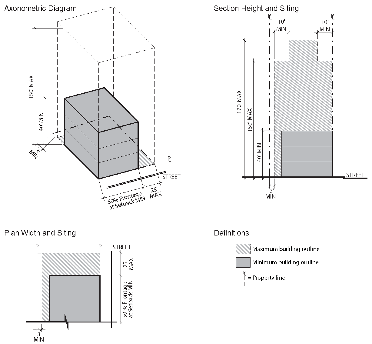
5.
Ancillary Structures and Outdoor Spaces
a.
Intent
Provide outdoor space configuration and design parameters.
b.
Ancillary/Accessory Structures
NA
c.
Ancillary/Accessory Structure Envelope
i.
Footprint/Floor Plate: NA
ii.
Front Setback: NA
iii.
Frontage at Setback: NA
iv.
Side Setback: NA
v.
Rear Setback: NA
vi.
Building Width: NA
vii.
Building Height: NA
d.
Outdoor Space Types
Rooftop landscape
e.
Usable Private Open Space
NA
6.
Building Frontages
Frontage Typologies: Refer to Sec. 7.1.4.C.
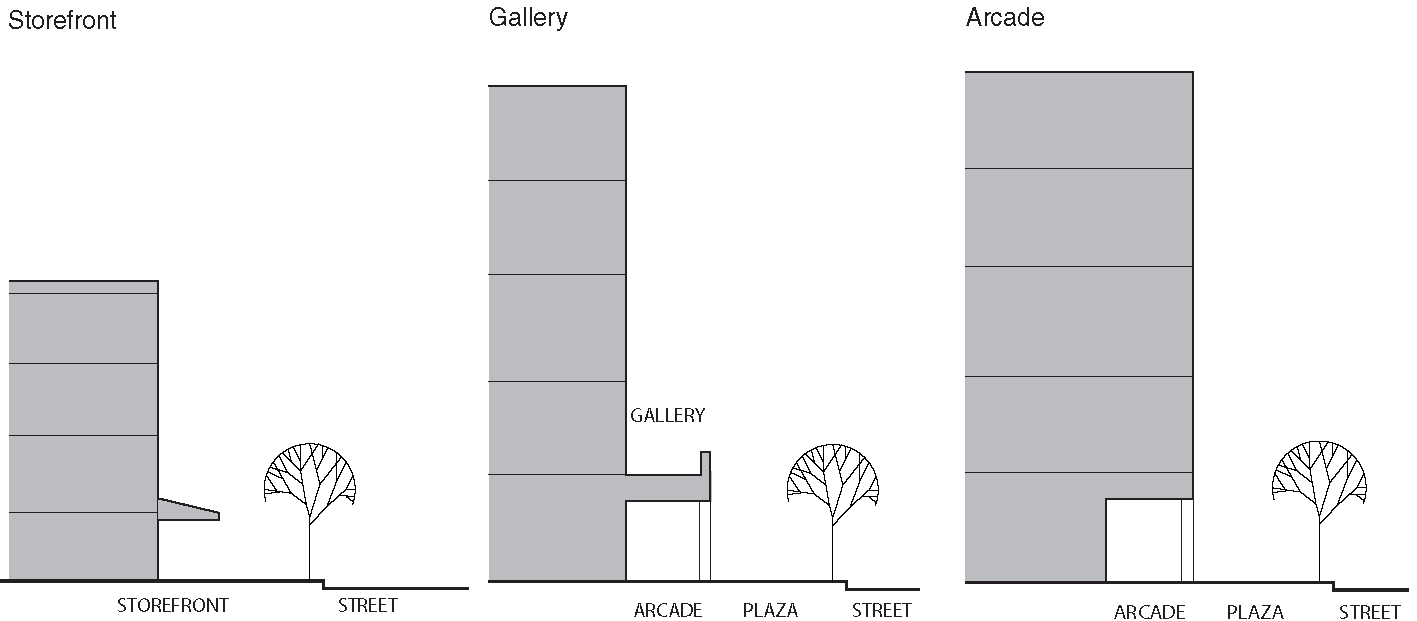
7.
Off Street Parking and Loading
Intent: Provide with adequate parking to accommodate the district's various building types and functions. Refer to Sec. 7.1.4.D.

a.
Parking Types
Surface lot, above ground structure, basement garage.
b.
Parking Spaces, Reserved and Shared
Maximum of 3 parking spaces per 1,000 square feet and maximum of 2 parking spaces per residential unit.
c.
Pavements
65% minimum of uncovered surface parking shall be permeable while meeting overall stormwater requirements.
d.
Garage Location
To rear or center of property or underneath building.
e.
Screening and Shading
One tree (with a 2-inch minimum caliper) is required for every 5 surface parking spaces.
f.
Accessible Spaces and Routes
Meet or exceed city accessibility standards.
g.
Driveways
i.
Driveway shall be 15-foot maximum for one way traffic and 26-foot maximum for two way traffic.
ii.
Sidewalk materials and patterning is continuous through driveway.
h.
Garage Entry
Permitted on all frontages.
i.
Service Loading
Permitted.
j.
Bicycle Parking
Required.
8.
External Elements
Intent: Guide the integration of external elements into property development including landscaping, utilities and lighting. Refer to Sec. 7.1.4.E, Signage and Sec. 7.1.4.F, Lighting and Noise.
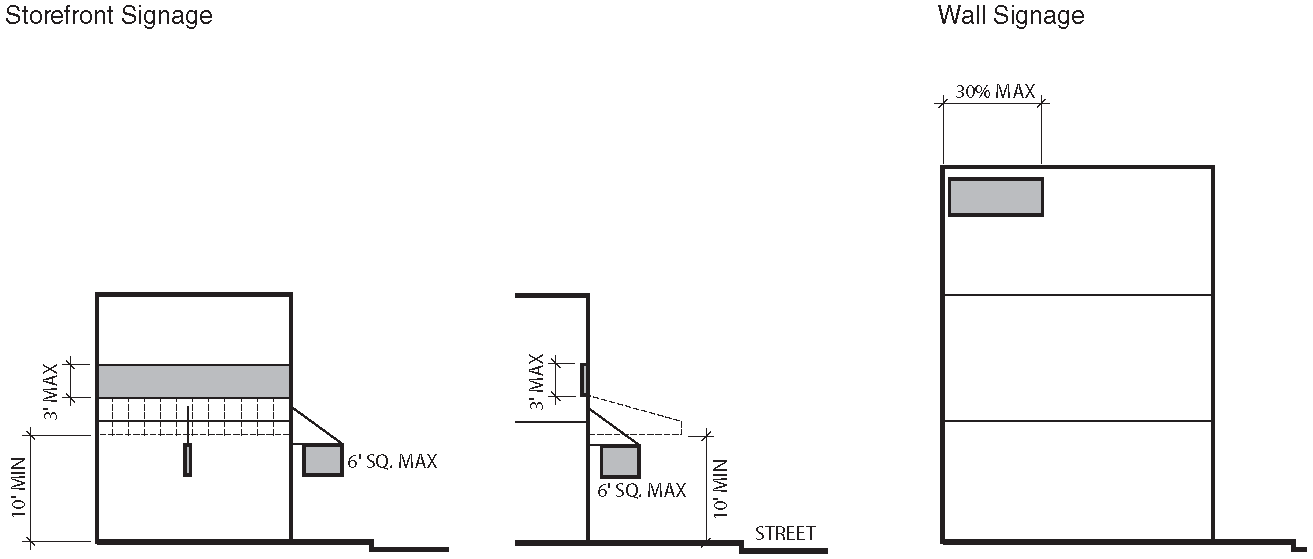
a.
Proposed Topography Grades
Provide grading plan with 2-foot contours.
b.
Side or Rear Privacy Fence or Wall
Maximum of 8 feet.
c.
Front Fence or Wall
Maximum of 3 feet 6 inches.
d.
Landscape Vegetation
i.
Minimum of 8 trees (with a 2-inch minimum caliper) per acre of open space
ii.
Trees required for surface parking may be counted toward overall landscape requirement.
e.
Trash/Recycling Storage, External Mechanical Units, Electrical Units and Rain Barrels
Integrate with building design or screen/conceal from view from public street and riverwalk.
9.
Sustainability
a.
Intent
Encourage longevity, durability, energy and economic efficiency as well as improved environmental conditions.
b.
Green Building and Landscape
i.
Capable of attaining the current Leadership in Energy and Environmental Design (LEED) minimal Performance Level of "Certified."
ii.
Submit completed worksheet of appropriate LEED standard to demonstrate pre-certification estimate.
c.
Reflectivity, Heat Island Reduction, Roof and Surface Lots
i.
Surface lots shall provide shade and/or use light-colored/high albedo materials with a solar reflectance of at least 0.3 (30%).
ii.
Roofs shall use an Energy Star Compliant (highly reflective) for a minimum of 75% of the roof surface.
H.
SW7 Waterfront Marketplace
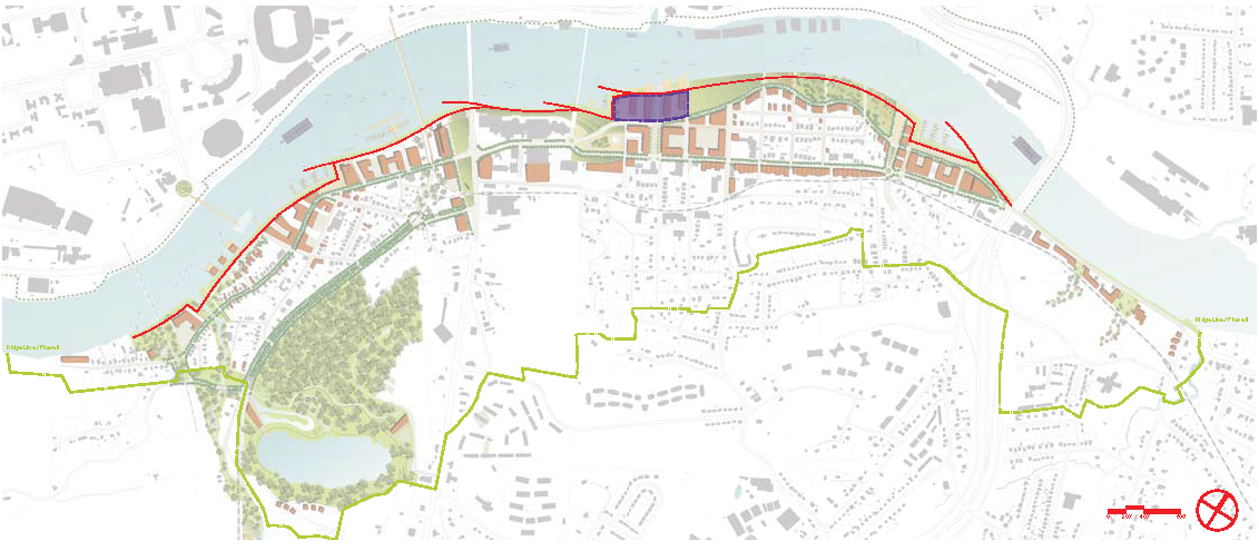
1.
Vision and Intent
This area is an extension of the Bell Tower Walk. It is envisioned as a highly active commercial, entertainment, and residential environment. Bound between a newly established Waterfront Drive and the riverfront setback, the new Waterfront Piers provide an elegant setting for restaurants and various retail and entertainment enterprises. These uses define associated civic plazas that unite the buildings with the Riverwalk and the Gay Street Amphitheater.
Developments on this site shall maximize view corridors to the river by orienting long, horizontal buildings perpendicular to the riverfront. Developments that create a continuous visual barrier to the Tennessee River are not permitted. Surface parking in this district shall be kept to a minimum. A new marina and boat ramp at the base of the Gay Street Bridge invite users to spend time on the water adjacent to the park space.
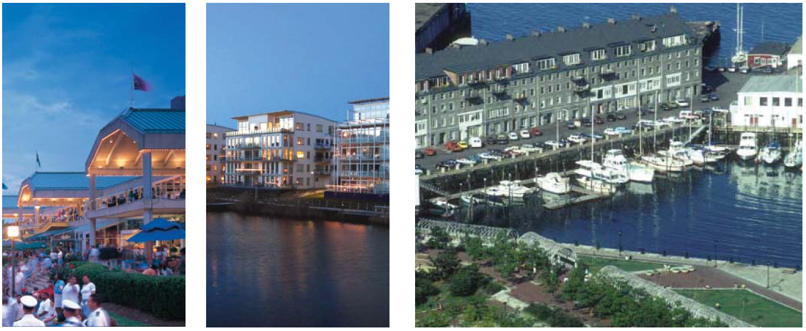
2.
Existing Conditions
a.
Intent
Guide site survey to assess existing site conditions for constraints and opportunities. Direct views to river and downtown, viewed from neighborhoods behind.
b.
Topography
Consider existing topography and provide topographic survey with 2-foot contours.
c.
Existing Trees
i.
Identify all existing trees with a 6-inch minimum caliper including root zone within dripline.
ii.
Preserve a minimum of 1 healthy large canopy tree per lot, or 6 healthy trees per acre, whichever is greater.
d.
Environmental and Archaeological
Comply with State and Federal Requirements.
3.
Block Layout
a.
Intent
Guide lot layout and outline the maximum block perimeter and building setbacks permitted in this district to ensure walkable neighborhoods.
b.
Block Size
Maximum perimeter of 1,400 feet.
c.
Building Lines
Minimum of 70 feet from normal pool EL 813.0. Refer to Sec. 7.1.6, Riverscape Standards.
d.
Proposed Subdivision and Phasing Plan
Clearly designate future phases and describe proposed subdivision plan and phasing when applicable.
4.
Building Siting and Configuration
Intent: Provide building configuration and design parameters, as well as suggestions for building function.
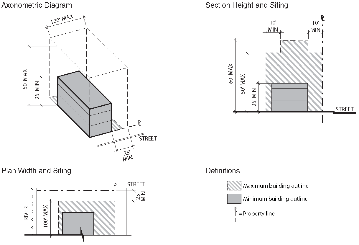
5.
Ancillary Structures and Outdoor Spaces
a.
Intent
Provide outdoor space configuration and design parameters.
b.
Ancillary/Accessory Structures
NA
c.
Ancillary/Accessory Structure Envelope
i.
Footprint/Floor Plate: NA
ii.
Front Setback: NA
iii.
Frontage at Setback: NA
iv.
Side Setback: NA
v.
Rear Setback: NA
vi.
Building Width: NA
vii.
Building Height: NA
d.
Outdoor Space Types
Mall, Plaza
e.
Usable Private Open Space
NA
6.
Building Frontages
Frontage Typologies: Refer to Sec. 7.1.4.C.
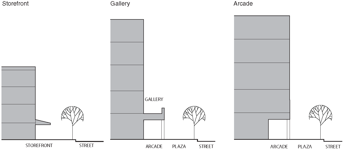
7.
Off Street Parking and Loading
Intent: Provide with adequate parking to accommodate the district's various building types and functions and maintain the overall neighborhood character. Refer to Sec. 7.1.4.D.
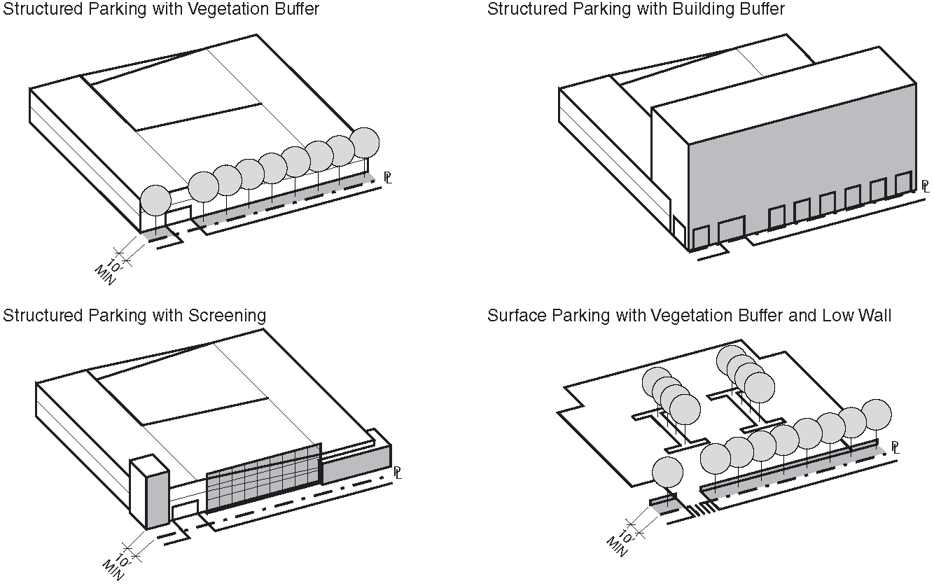
a.
Parking Types
Surface lot, above ground structure, basement garage.
b.
Parking Spaces, Reserved and Shared
Maximum of 3 parking spaces per 1,000 square feet and maximum of 2 parking spaces per residential unit.
c.
Pavements
65% minimum of uncovered surface parking shall be permeable while meeting overall stormwater requirements.
d.
Garage Location
To side of property or underneath building.
e.
Screening and Shading
One tree (with a 2-inch minimum caliper) is required for every 5 surface parking spaces.
f.
Accessible Spaces and Routes
Meet or exceed city accessibility standards.
g.
Driveways
i.
Driveway shall be 15-foot maximum for one way traffic and 26-foot maximum for two way traffic.
ii.
Sidewalk materials and patterning is continuous through driveway.
h.
Garage Entry
Permitted on all frontages.
i.
Service Loading
Permitted.
j.
Bicycle Parking
Required.
8.
External Elements
Intent: Guide the integration of external elements into property development including landscaping, utilities and lighting. Refer to Sec. 7.1.4.E, Signage and Sec. 7.1.4.F, Lighting and Noise.
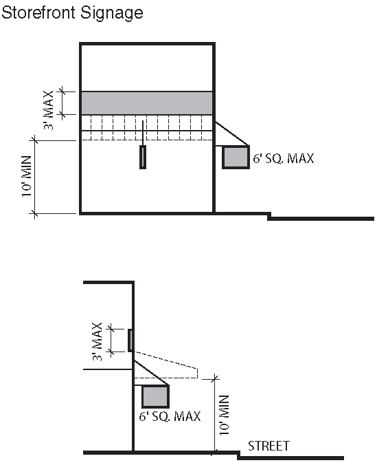
a.
Proposed Topography Grades
Provide grading plan with 2-foot contours.
b.
Side or Rear Privacy Fence or Wall
Maximum of 8 feet.
c.
Front Fence or Wall
Maximum of 3 feet 6 inches.
d.
Landscape Vegetation
i.
Minimum of 8 trees (with a 2-inch minimum caliper) per acre of open space.
ii.
Trees required for surface parking may be counted toward overall landscape requirement.
e.
Trash/Recycling Storage, External Mechanical Units, Electrical Units and Rain Barrels
Integrate with building design or screen/conceal from view from public street and riverwalk.
9.
Sustainability
a.
Intent
Encourage longevity, durability, energy and economic efficiency as well as improved environmental conditions.
b.
Green Building and Landscape
i.
Capable of attaining the current Leadership in Energy and Environmental Design (LEED) minimal Performance Level of "Certified."
ii.
Submit completed worksheet of appropriate LEED standard to demonstrate pre-certification estimate.
c.
Reflectivity, Heat Island Reduction, Roof and Surface Lots
i.
Surface lots shall provide shade and/or use light-colored/high albedo materials with a solar reflectance of at least 0.3 (30%).
ii.
Roofs shall use an Energy Star Compliant (highly reflective) for a minimum of 75% of the roof surface.
7.1.4. - GENERAL DEVELOPMENT STANDARDS
A.
Uses
1.
Prohibited Uses
Uses not to be established in any district of the Knoxville South Waterfront include all major agriculture, heavy industrial, waste-related services, truck depots, cremation facilities, cemeteries, and storage facilities for Class 1 flammable and combustible liquids (having an aggregate total of more than 100 gallons) but excluding storage that is part of a motorized vehicle or pleasure craft facility.
a.
Heavy industrial includes any use that is potentially dangerous, noxious or offensive to neighboring uses in the district or those who pass on public ways by reason of smoke, odor, noise, glare, fumes, gas, vibration, threat of fire or explosion, emission of particulate matter, interference with radio, television reception, radiation or any other likely cause; heavy industrial asbestos and radio active materials products; animal processing, packing, treating, and storage, livestock or poultry slaughtering, concentrate plant, processing of food and related products, production of lumber, tobacco, chemical, rubber, leather, clay, bone, paper, pulp, plastic, stone, or glass materials or products, production or fabrication of metals or metal products including enameling and galvanizing, automobile dismantlers and recyclers; batch plant; bulk storage of flammable liquids; chemical, cosmetics, drug, soap, paints, fertilizers and abrasive products; commercial feed lot; concrete batching and asphalt processing and manufacturing, batch plant; earth moving and heavy construction equipment and transportation equipment; explosives; fabricated metal products and machinery; impound lot, wrecker service includes city wreckers, auto storage; leather and leather products includes tanning and finishing; petroleum, liquefied petroleum gas and coal products and refining; primary metal manufacturing; pulp mills; rubber and plastic products, rubber manufacturing; scrap metal processors; saw mill, pulp mill; secondary materials dealers; tire recapping; tobacco products; transportation equipment; wrecking, junk or salvage yard; dredging, earth extraction, clearing or grading (timber cutting); extraction of phosphate or minerals; extraction of sand or gravel, borrow pit; metal, sand stone, gravel clay, mining and other related processing; stockpiling of sand, gravel, or other aggregate materials; or any similar uses.
b.
Waste-related service includes any use that generally receives solid or liquid wastes from others for transfer to another location, collects sanitary waste or manufactures a product from the composting of organic material. Waste-related service includes the following: animal waste processing, rendering; landfill, incinerator; manufacture and production of goods from composting organic material; outdoor recycle processing center; outdoor storage of recyclable material, including construction material; transfer station; or any similar use.
c.
Major agriculture includes animal raising including horses, hogs, cows, sheep, goats, and swine, poultry, dairying, personal or commercial animal breeding and development; floriculture, pasturage, tree or sod farm, silviculture; animal boarding, outdoor; livestock auction; milk processing plant; packing house for fruits or vegetables; plant nursery; plant nursery with landscape supply; retail or wholesale sales of agriculturally-related supplies and equipment; stable; or any similar use. Major agriculture does not include urban agriculture.
2.
Gated Communities
Private developments such as "gated communities" are prohibited in the Knoxville South Waterfront. They inhibit access to public spaces and create physical and social enclaves. Public rights-of-ways shall remain open, facilitating access to the site and fostering connectivity.
B.
Building Envelope and Materials
1.
The intent of these standards is to utilize a discipline of form when designing new buildings in order to foster a high quality Knoxville South Waterfront identity.
2.
Building walls should reflect and complement the traditional materials and techniques of the Tennessee Valley's regional architecture. They should express the construction techniques and structural constrains of traditional, long-lasting building materials.
a.
Acceptable building façade materials include: brick and block masonry, glass, wood, stucco, metal panel and native stone. The use of composite or synthetic materials not mentioned above must have equivalent or superior visual and performance properties to those mentioned.
b.
Windows shall use clear glass with at least 90% light transmission.
c.
Specialty windows may use stained or opaque glass.
d.
Flat roofs shall be enclosed with parapets a minimum of 42 inches high or as required to conceal mechanical equipment to the satisfaction of the Knoxville South Waterfront Advisory Committee.
3.
Awnings and Canopies
a.
Awnings or canopies shall provide a minimum clearance of 10 feet above the sidewalk and shall have a maximum depth of 6 feet, while maintaining a minimum 2 feet distance to curb edge.
b.
An awning or canopy may extend into the public right-of-way with the City's Engineer's approval.
4.
Requirements of these Form Based Codes apply only where the subject is "clearly visible from the street". The definition of the street includes parks, riverwalks, civic greens, squares and all proposed public areas except alleys. The intention of these parameters are to restrict control to the public realm where it has special significance and limit public preference in the private realm.
C.
Frontage Typologies
1.
Common Yard
A frontage where the building is setback substantially from the property line. The front yard is visually continuous with adjacent yards.
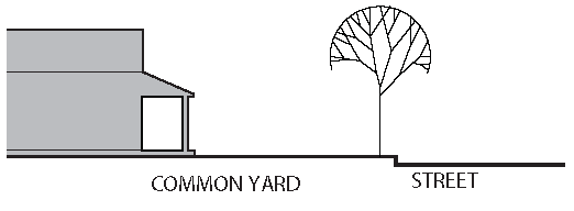
2.
Porch and Fence
A frontage type where the building is setback from the property line and the building includes an attached porch. A fence at the property line demarcates the front yard from the street.
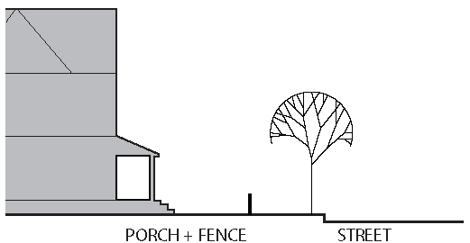
3.
Stoop
A frontage type where the raised entry platform is on the principal frontage and the first story is above the level of the ground creating a change in elevation.
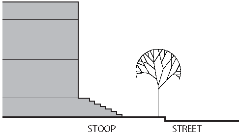
4.
Shopfront/Awning
A frontage type where the building meets the property line and a shop-front or awning extends into the setback space.
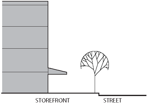
5.
Gallery
A frontage type where the building façade is close to the property line and a continuous, covered space is attached to the length of the façade.
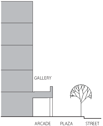
6.
Arcade
A frontage type where the building façade is close to the property line and the ground floor is recessed from the building façade to allow for a continuous, covered passageway.
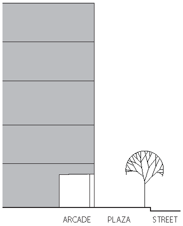
D.
Off Street Parking and Loading
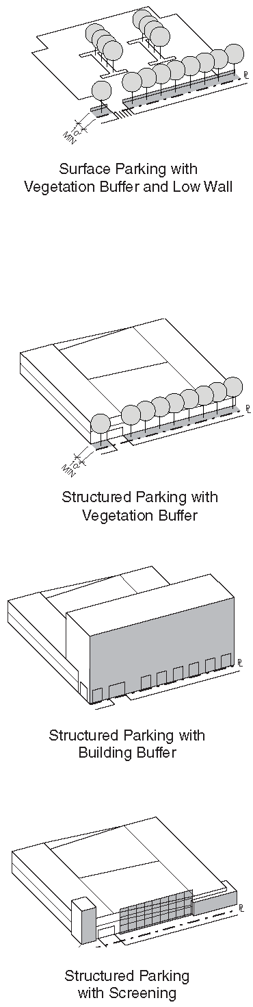
1.
Surface Parking
Vision: Avoid large, unbroken expanses of pavement. Divide large parking lots into smaller paved areas that are separated by landscaping, access driveways or ancillary structures. Parking lots shall include parking islands to breakdown the scale of the surface lot, with the inclusion of pedestrian-scale lighting in lieu of standard lot lighting.
a.
Parking shall be placed behind the buildings, but parking on the side of buildings is acceptable provided that the parking is screened from view from any adjoining right-of-way. On-street parking available along the frontage lines that correspond to each lot shall be counted toward the parking requirement for the parcel. By exemption, the required parking may be provided within a 5 minute (1/4 mile) walking radius of the site which it serves.
b.
A visual buffer of landscaping shall be provided towards adjacent properties.
c.
Any parking lot adjoining a public street shall be screened from view to a height of 3 feet by walls, berms or landscaping or a combination of these 3. If landscaping only is used, the planting bed shall be a minimum of 10 feet wide.
d.
Separate parking areas from buildings by use of a raised walkway or planting strip. Avoid directly abutting parking aisles or spaces to the edge of a building.
e.
One bicycle rack space shall be provided for every 10 vehicular parking spaces.
f.
Stand-alone surface parking lots:
i.
Parking lots that are on lots without a primary use or structure are required to have a minimum interior and rear setback of 5 feet from adjacent properties.
ii.
Headlight screening of parked cars along adjacent properties must be with a solid fence or wall a minimum of 42 inches in height. Breaks in the fence or wall may be permitted for pedestrian access, where it continues a pedestrian way. The fence or wall must be placed a minimum of two feet from the parking lot. The area on the other side of the fence or wall opposite the surface parking lot must be planted with a minimum of ten shrubs for every 100 linear feet. A minimum of 50% of the shrubs must be evergreen.
iii.
Interior parking lot landscape is required for stand-alone surface parking lot of 5,000 square feet or more.
a)
Where more than five parking stalls are provided in a row, one parking lot island must be provided between every five parking spaces.
1)
Islands must be a minimum of 120 square feet in single rows and in double rows are a minimum of 240 square feet.
2)
A minimum of one shade tree must be provided in every parking lot island or landscape area for single-row parking lot islands, and two shade trees for double-row parking lot islands.
3)
In addition to the required shade trees, a minimum of 60% of the area of every parking lot island must be planted in shrubs, live groundcover, perennials, or ornamental grasses, unless the parking lot island or landscape area is designed to facilitate pedestrian access through the parking lot as approved during the landscape plan review process. Stone, mulch, or other permeable landscape materials may be used for any remaining area.
2.
Structured Parking
Vision: Future parking structures in the Knoxville South Waterfront should be constructed with the understanding that required parking spaces for an area should be shared over the course of a day to maximize efficiency. While the construction of new parking garages will be critical to accommodate future vehicles in the study area, it is important to establish parking ratios that promote the use of public transportation and encourage development that generates less traffic. New parking facilities must be designed in such a way that does not adversely affect their surroundings.
a.
Monotonous and unadorned parking structure elevations are prohibited. No blank walls or exposed parking levels should face directly onto primary streets. Attempts should be made to reduce the overall visual mass of the parking garage through the architectural expression of stair towers, canopies and screening devices. Parking garage elevations shall be screened from view with the incorporation of lightweight design elements that add visual interest to the elevations (such as trellis panels) and filter the view to parked cars. When possible, building edges that face primary streets should incorporate programmable spaces into the ground floor of the parking structure (such as small commercial/retail uses) to activate the street edge. Garage entries shall not exceed 16-foot clear height and 26-foot clear width. Provisions shall be made for audible and visible warnings at garage exits to protect pedestrians from vehicles.
3.
Service Loading
Curb cuts and service roads leading to service areas shall be located as far away as possible from public entrances. Service areas to buildings shall be screened from view by plantings or low walls.
_____
E.
Signage
Knoxville's Signage Ordinance shall apply.
Signage within the Knoxville South Waterfront should be clear, informative and durable. Appropriate signage is important for commercial uses that need to effectively advertise their goods and services. Inappropriate advertising signage contributes to visual clutter of the environment by their design, location, material choice or obtrusive size. Primary concerns regarding signage revolve around the sign's location, size, material and illumination.
1.
SW1
The sign regulations of Article 5, Section 10C, Residential Districts, shall apply in the SW1 District.
2.
SW2 through SW7
a.
Sign Area
The total allocated sign area shall not exceed one square foot per linear foot of building frontage per principal building. Except for arcade and hanging signs and window signs, the combination of all other permitted sign types shall not exceed the maximum allocated sign area for the building.
b.
Permitted Sign Types
The following types of signs shall be permitted.
i.
Storefront Signage
a).
Arcade and Hanging Signs
1)
Arcade or hanging signs shall provide a minimum clearance of 8 feet above the sidewalk.
2)
The maximum sign area shall not exceed 6 square feet per arcade or hanging sign.
b).
Awning and Canopy Signs
1)
The maximum sign area shall not exceed 6 square feet per awning or canopy.
c).
Projecting Signs
1)
Projecting signs shall provide a minimum clearance of 8 feet above the sidewalk and shall extend no more than 4 feet from the façade of a building. A projecting sign may extend into the public right-of-way with the City's Law Department approval.
2)
When placed at the ground story level, projecting signs shall not exceed 6 feet in area. When placed at the second story level, projecting signs shall not exceed 12 square feet in area. When placed at the third story level, projecting signs shall not exceed 18 square feet in area. Projecting signs on the third story level are only permitted on the corner of a block, where they may project from a building corner.
3)
No sign shall protrude to within 2 feet of the curb edge, if less than 14 feet above the sidewalk.
d).
Window Signs
Window signs shall not collectively exceed 10% of the window area on each façade.
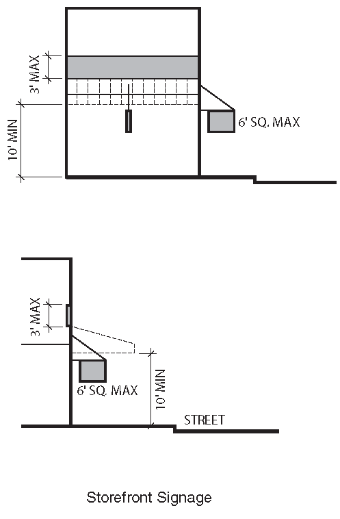
ii.
Wall Signage
a).
Wall signs are permitted within the area between the bottom of the second story windows and the top of first floor windows within a horizontal band not to exceed 3 feet in height In no case shall this band be higher than 18 feet or lower than 12 feet above the adjacent sidewalk.
b).
Wall signs are also permitted immediately below the roof line of the building or structure and shall not extend more than 30% of the width of the building façade. Wall signs shall not project above the elevation of any building or structure.
c).
A wall sign may extend up to 12 inches into a public right-of-way.
iii.
Roof Signage
Roof Signs are prohibited in the Knoxville South Waterfront.
c.
Sign Illumination
i.
Signs may be illuminated from within or from an external source, but such illumination shall be in a manner that avoids glare or reflection which in any way interferes with traffic safety.
ii.
Internally illuminated signs shall be designed with:
a).
Individually illuminated letters;
b).
An opaque background; or
c).
The background of the sign face having a darker color than the content or message of the sign.
iii.
Neon or any similar exposed tube lighting is permitted provided that such lighting shall not be used solely to outline the perimeter of the sign face or sign structure.
d.
Street Addresses
The street number of the business is not required on each sign, provided that the street number is placed on each entry door or within 3 feet of the door.
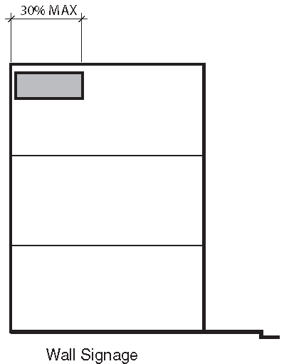
F.
Lighting and Noise
1.
External Lighting Standards
a.
Illuminance/Light Trespass
The intent of the outdoor lighting standards are to:
i.
Provide adequate light for safety and security,
ii.
Promote efficient and cost effective lighting and to conserve energy,
iii.
Minimize light pollution, light trespass, glare, and offensive light sources,
iv.
Minimize development impact on nocturnal environments,
v.
Prevent inappropriate, poorly designed or poorly installed outdoor lighting,
vi.
Encourage quality lighting design; light fixture shielding, uniformity ratios, and establish maximum light levels within and on property lines.
b.
Light Colors
Yellow spectrum lamps such as sodium lamps are permitted only within City right-of-ways and prohibited on private property.
c.
Controls
Use and maintain automated external lighting controls to minimize light pollution and energy consumption. Such controls include but are not limited to:
i.
Time clocks and/or dimmers,
ii.
Motion and/or light sensors,
iii.
Phased switching of multiple circuits.
d.
Prohibitions
No person shall install any of the following types of outdoor lighting fixtures:
i.
Blinking, flashing, moving, revolving, flickering, changing intensity or color, and chase lighting, except for temporary seasonal displays or for public safety.
ii.
Any light fixture that may be confused with or construed as a traffic control device.
iii.
Neon or any similar exposed tube lighting is prohibited to outline or highlight architectural features on a building or structure.
e.
Exceptions
The standards of this Section shall not apply to the following types of exterior lighting:
i.
Landmark Signs: Illumination of cultural significant signs designated by the community as a landmark.
ii.
Ornamental Lighting: Low voltage (12 volts or less), low wattage ornamental landscape lighting fixtures, and solar operated light fixtures having self-contained rechargeable batteries, where any single light fixture does not exceed 100 lumens.
iii.
Strings of Light: Strings of light, not exceeding a maximum of 50 lumens per lamp (equivalent of a 7 watt C7 incandescent light bulb) on properties that are used exclusively for residential uses.
iv.
River Navigation Lighting: Lighting used exclusively for river navigation and safety purposes.
v.
Right of Way Lighting: Public lighting that is located within the right of way on State or Federal controlled land.
vi.
Seasonal Lighting Displays: Lighting displays from November 15 through January 30 of the following year.
vii.
Temporary Events: Temporary outdoor activities that include, without limitation, fairs, carnivals, sporting events, concerts, and promotional activities that require temporary outdoor lighting.
2.
Noise
Knoxville's Noise Ordinance shall apply.
(Ord. No. O-154-2023, § 1, 11-28-23)
7.1.5. - STREETSCAPE STANDARDS

A.
Vision and Intent
Streetscapes are the areas between buildings that are occupied by the public street right-of-way and related street, sidewalk, and landscaping improvements. Streetscapes are among the most important urban design features because their appearance, character and the impressions they evoke create the public image of the Knoxville South Waterfront. That image is significant to how residents and visitors think and feel about the City. The standards establish appropriate requirements for the width and uses of public and private street rights-of-way (for traffic, parking, pedestrians, bicycles, and landscaping). The following standards apply to the design and construction of public rights-of-way and right-of-way improvements in conjunction with proposed subdivisions, individual lot development where proposed projects are required to provide right-of-way dedications or improvements designed and constructed by the City of Knoxville.
Location and provision of some or all streetscape elements is subject to detailed design.
B.
Path, P-20-12
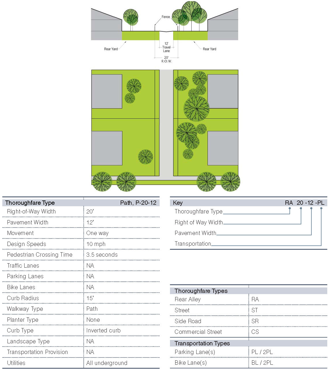
C.
Rear Alley, RA-20-12
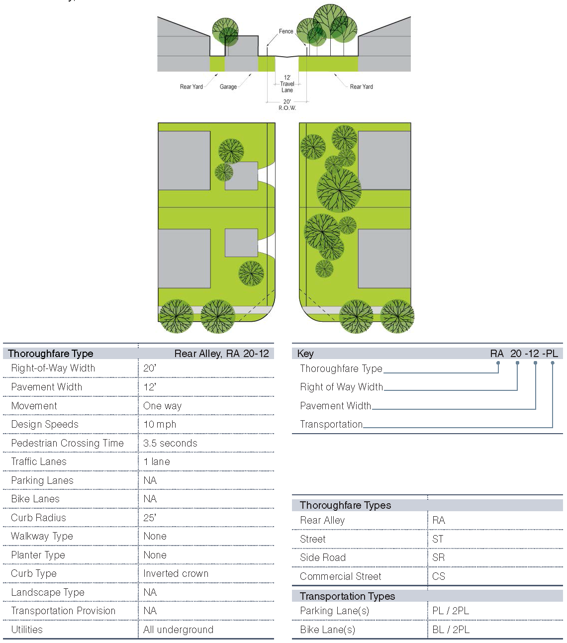
D.
Street, ST-42-24-PL
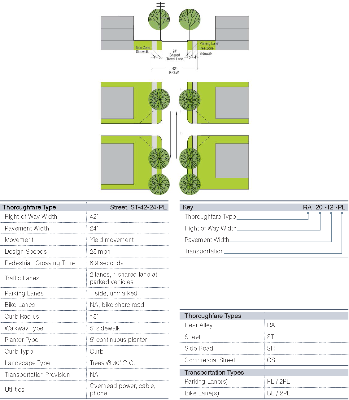
E.
Street, ST-50-30-2PL
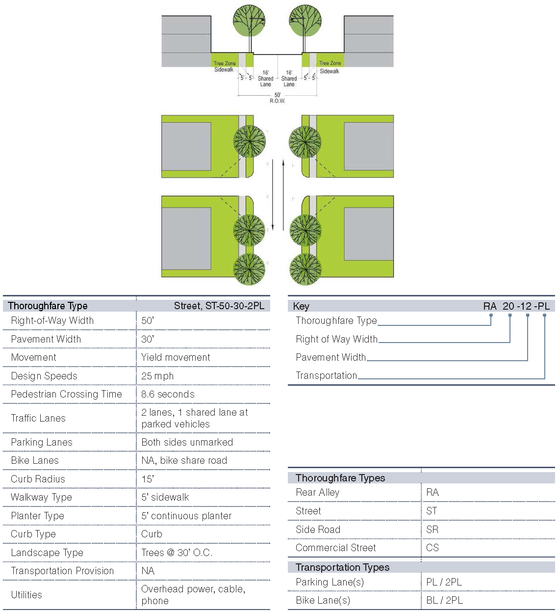
F.
Street, ST-50-30-PL
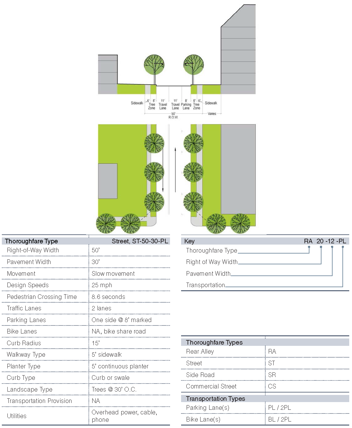
G.
Side Road, SR-56-36-2PL
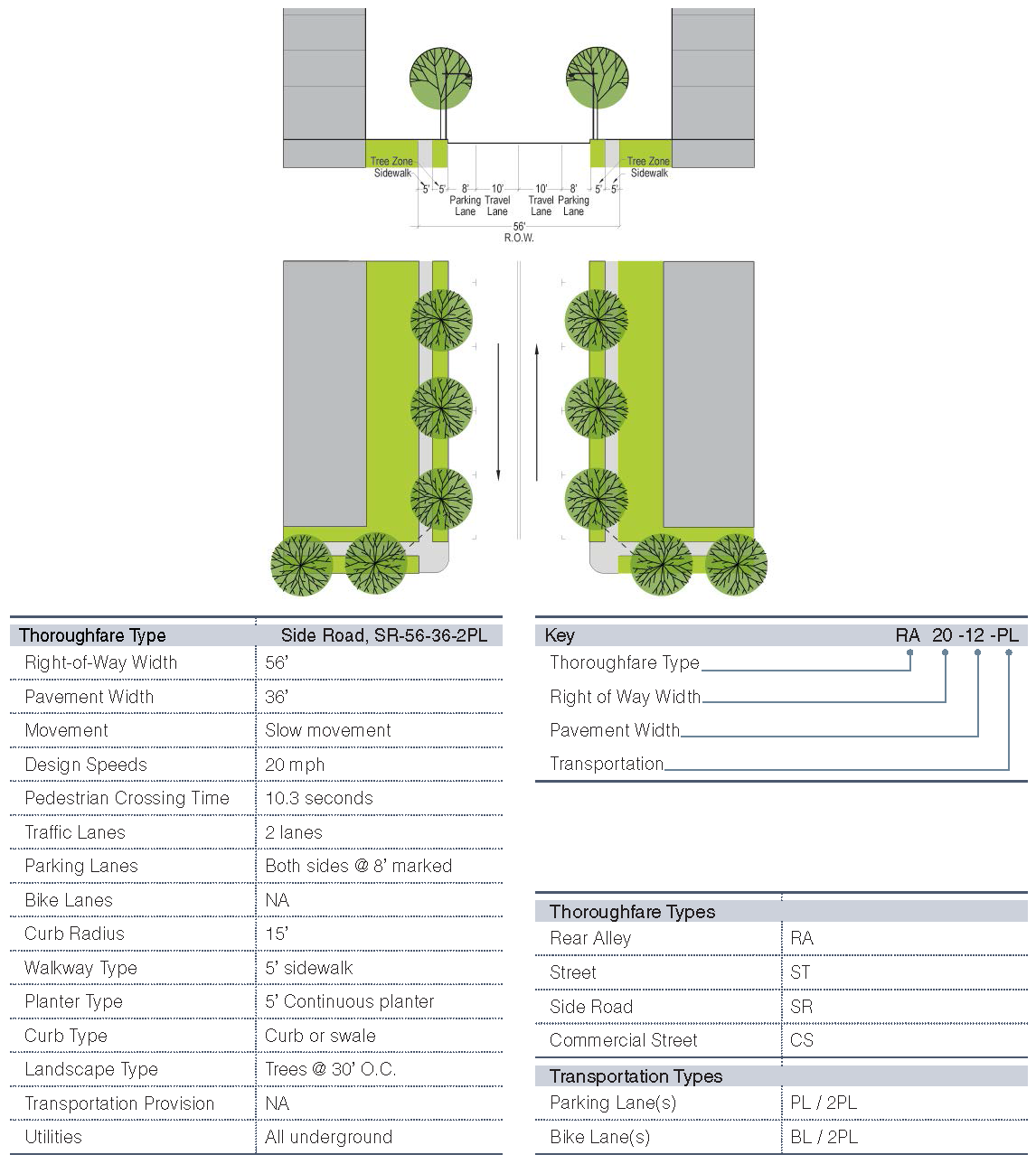
H.
Street, ST-70-40-PL-2BL
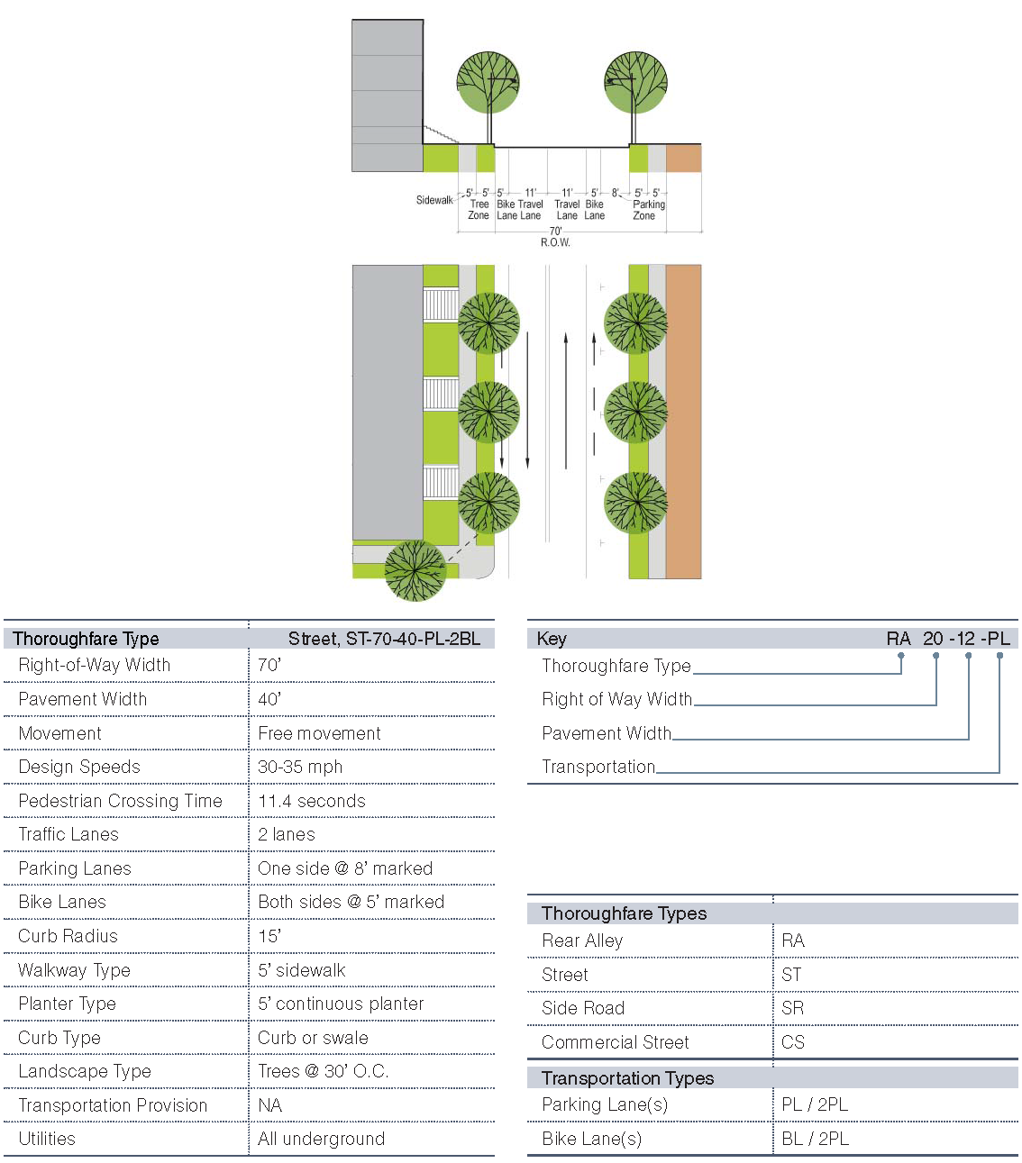
I.
Commercial Street, CS-58-38-2PL-BR
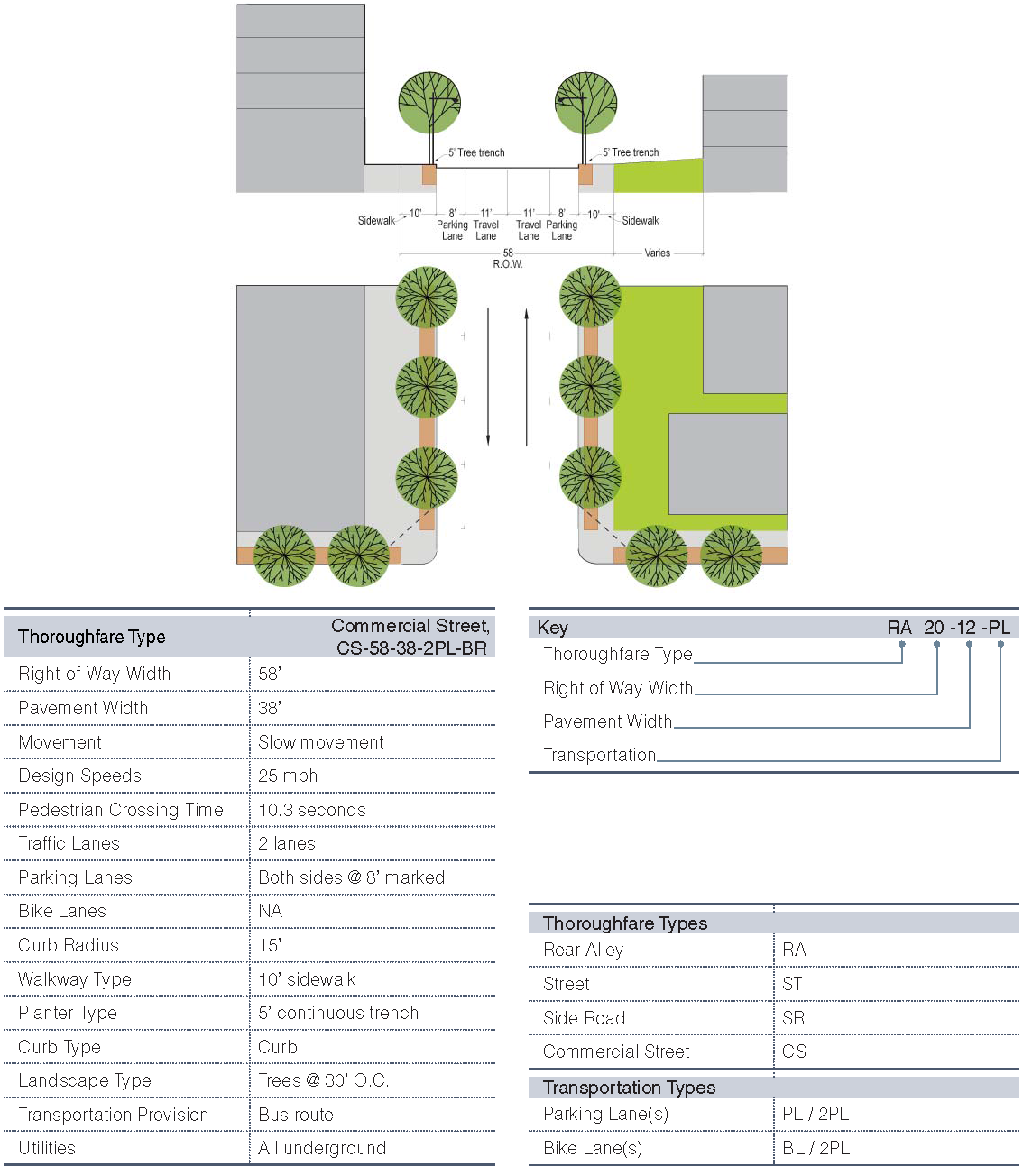
J.
Street, ST-52-22-BR
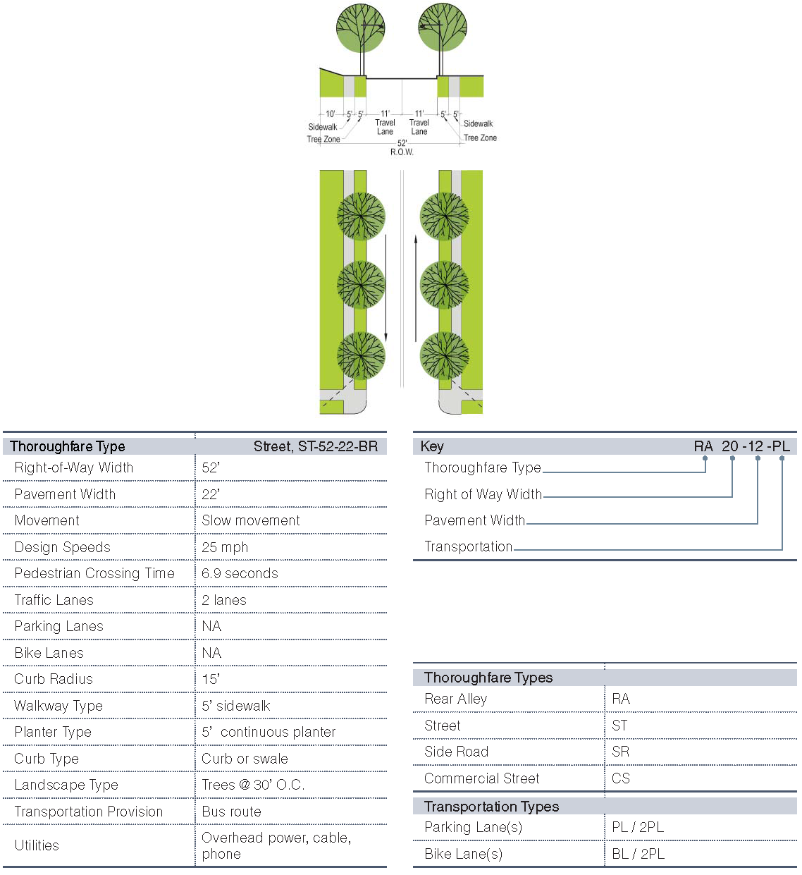
K.
Boulevard, BLVD-70-50-1-PL-2BL-BR
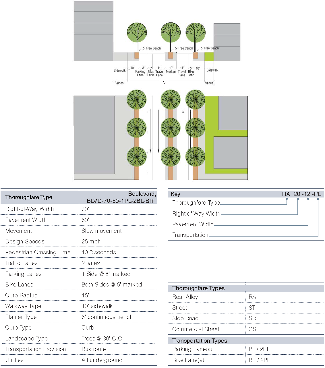
L.
Street: ST-62-38-2PL
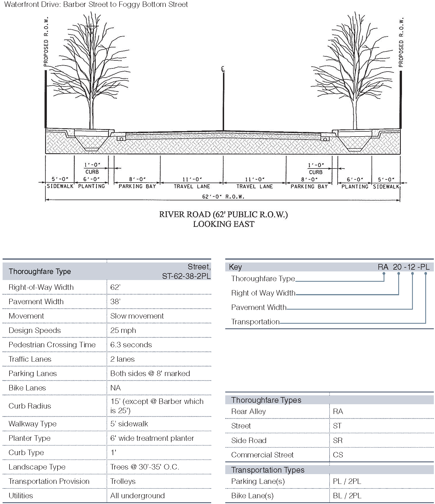
M.
Street: ST-58-36-2PL
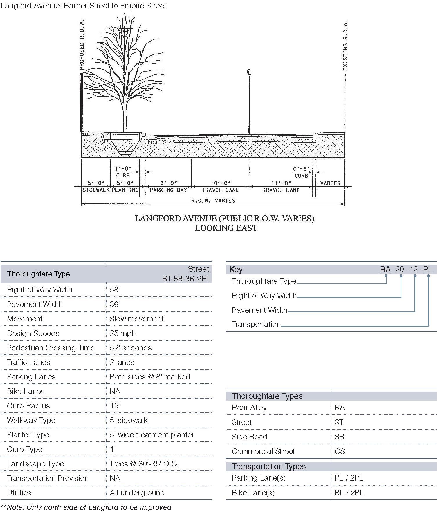
N.
ST-68-46-2PL-2BL
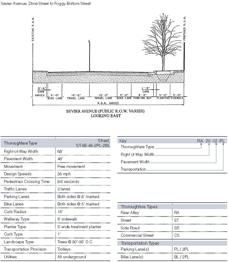
O.
Street: ST-60-38-2PL
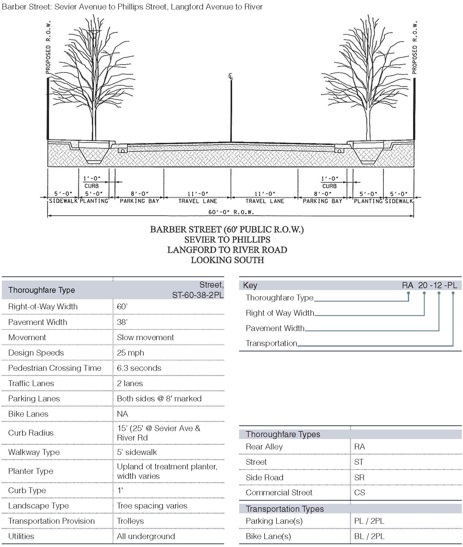
P.
Street: ST-50-22
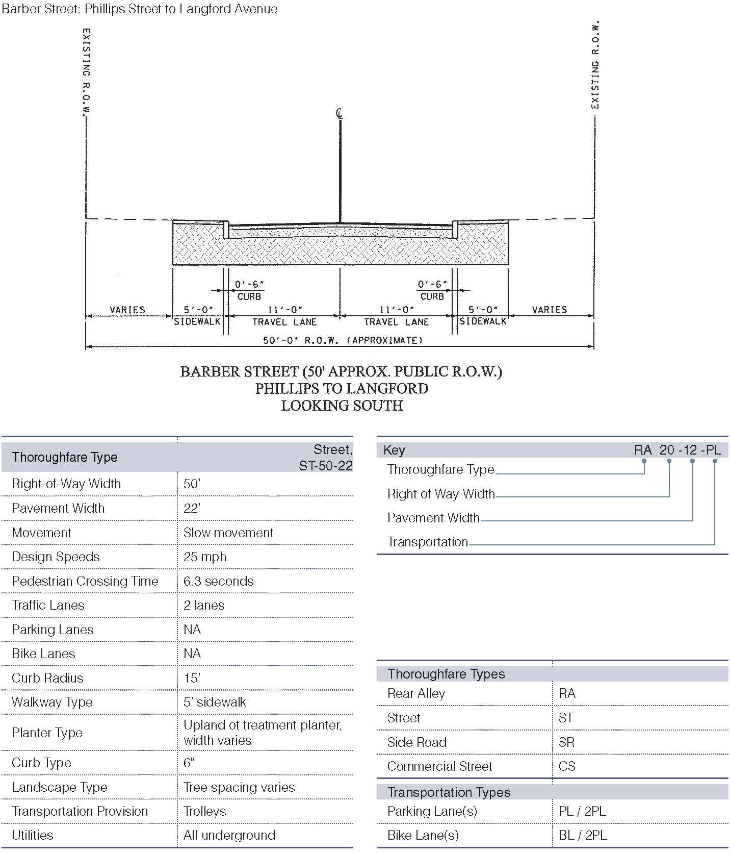
Q.
Street: ST-58-36-2PL
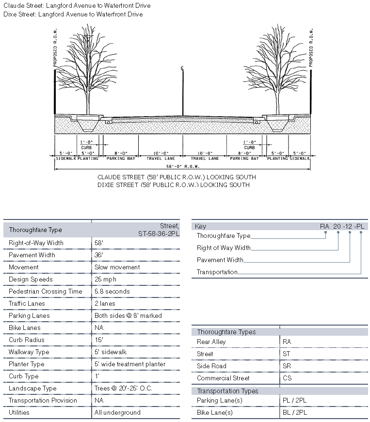
R.
Street: ST-44-22
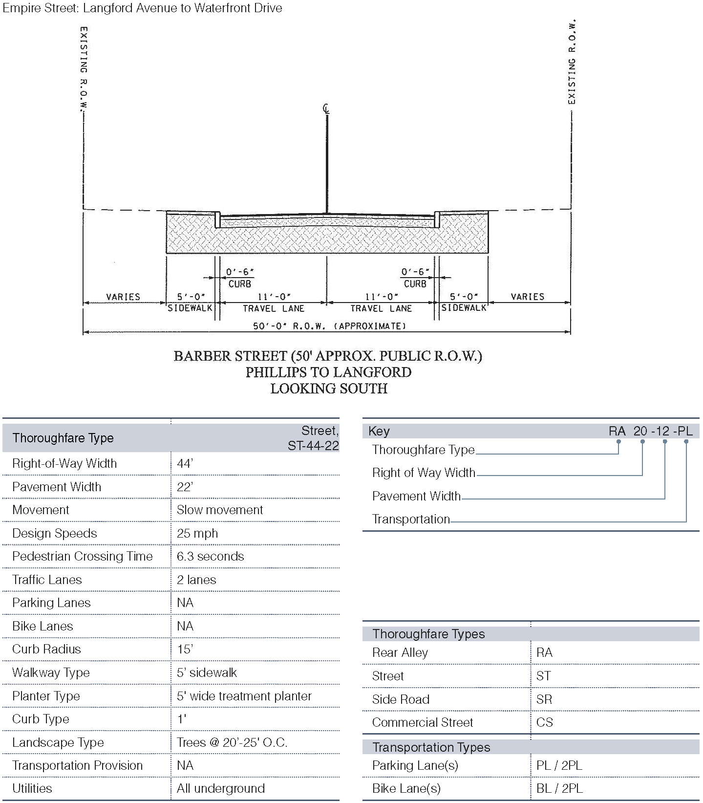
S.
Street: ST-62-38-2PL
7.1.6. - RIVERSCAPE STANDARDS
A.
Vision and Intent
Knoxville's riverfront is one of its greatest assets. Currently populated with industrial use and storage, there are hardly any public access or amenities associated with the river on its south shore. Developing a continuous experience along the riverfront is imperative to the economic, cultural and recreational identity for South Knoxville. It is also a great benefit for the north shore tenants as their views across the river could improve significantly, consequently raising quality of living as well as real-estate values. The riverscape standards ensure access to the waterfront with pedestrian, bike and vehicular access, and improves river frontage to private properties. The following standards apply to the design and construction of riverbanks in conjunction with best management practices as they apply to erosion control, flood protection, and habitat protection and/or improvement.
The intent of the Riverfront Setback is to ensure:
The provision of an adequate amount of landscape coverage for habitat, water quality, erosion control and scenic quality expressed by the community:
1.
Proper riverbank stabilization to prevent property erosion and loss;
2.
Proper space for potential storm water drainage and utility corridors;
3.
Continuous ADA pedestrian and bicycle access along the riverfront with regular connections to lanes, streets or roads perpendicular to the river edge expressed by the community;
4.
A continuous green riparian corridor proportional in scale to adjacent buildings;
5.
Maintenance vehicle access; and
6.
Prevention of non-river-related or non-river-dependent structures.
B.
Riverbank
1.
Riverwalk Path
20-foot wide shared use pavement.
2.
Riverwalk Trees
Trees limbed up to allow views under at 30 feet to 50 feet spacing.
3.
Riverwalk Lighting
Continuous lighting to allow pedestrian use at night.
4.
Riverwalk Furniture
Benches and trash receptacles at regular intervals.
5.
River Bank Lower
Rip-Rap and/or rock-filled wire mattresses from river bottom to normal high.
6.
River Bank Upper
Bioengineered slopes above normal high.
7.
River Bank Slopes
No steeper than 1 in 2.5 unless in rock or mechanically stabilized.
8.
River Bank Storm Drain Outlet
Headwall angle to match bank slope, include scour protection.
9.
River Bank Vegetation
Clusters of trees, 90%—100% coverage of grass, groundcover or shrub species adapted to riparian conditions.
10.
River Bank Clear View
With the exception of tree trunks, allow for unobstructed views from riverwalk over river bank vegetation to river surface.
11.
Permitted Uses
Decks, boat ramps, vessel mooring structures, docks, piers, gangway to marina, walkways, boardwalks, landscape, lighting and furniture elements, utility and stormwater facilities, non habitable shelter structures as accessories to marinas.
12.
Non-Permitted Uses
Parking, filling, waste storage.
C.
Riverwalk
7.1.7. - STREAM BUFFER STANDARDS

A.
Vision and Intent
South Knoxville's Goose Creek is intended to become a continuous green corridor that would connect people, bicycle riders, and wildlife from the waterfront up to the great open space at Fort Dickerson. The intent of the stream buffer standard is to ensure the provision of an adequate amount of landscape coverage for water quality, drainage and flooding, erosion control and stream bank stabilization, wildlife habitat, and scenic quality. By creating a stream buffer and restricting impervious surfaces, the streams are allowed to maintain a natural flow and storm water drainage. Restricting polluting uses will maintain water quality, while protected and/or improved riparian vegetation will ensure bank stabilization, sediment control, and pollution filtration. Improved water quality in streams will also allow for a safe recreational use of the Tennessee River and its waterfront.
7.1.8. - MARINA STANDARDS
A.
Vision and Intent
To establish minimum requirements for the siting, design, construction, and operation of marinas to serve the needs of boaters, while properly managing the State's natural resources, and protecting public health.
B.
Siting
1.
Marina Types
Permitted uses include marinas as accessories to mixed use development, for mooring boats and/or for fueling boats.
2.
Marina Siting
Satisfy TVA, USACE, and State of Tennessee requirements.
Marina must minimize adverse effects on flow of water, commercial boat traffic and recreational rowing, minimize dredging and minimize accumulation of sediments.
3.
Marina Size
As a guide, the riverside width of marina shall not project past the TVA and USACE assessment line as shown on the regulating plan.
Minimum clear distance of fairway aisle between finger float ends shall be minimum 1.5 times the length of the longest finger float but not less than 40'.
Marina length may be no longer than the property it serves.
4.
Marina Depth
Minimum 6 feet of water at normal low pool, max no deeper than river channel. If excavation is required to accomplish the minimum depth, TVA, USACE, or the State of Tennessee may require sediment testing to determine environmental impact of any potential dredging.
5.
Permitted Uses
Marinas as accessories to mixed use development, for mooring boats and/or for fueling boats.
6.
Non-Permitted Uses
Dry boat maintenance, dry lifts, dry boat storage, residential boat houses, covered moorings, in-water maintenance such as pressure washing or hull scraping.
C.
Dimensions
1.
Gangway
Gangways shall have a minimum clear width of 3 feet and at least one gangway slope must meet ADA requirements. Gangways shall be aluminum with guardrails, handrails and kick plate. Gangways shall be hinged at one end and sliding at the other. Gangways shall be capable of disconnecting and stowing during flood events.
2.
Top Landing
Top landing shall have a minimum of 5 feet by 5 feet platform with guardrail and lockable gate.
3.
Utilities
All utilities servicing floats shall have a shut off and/or emergency disconnect adjacent to the top of the gangway.
Potable water and fire suppression lines shall not be combined.
4.
Main Floats
Main floats shall be not less than 5 feet in unobstructed width.
5.
Finger Floats
Finger floats shall be not less than 3 feet unobstructed in width.
In-River Marina Configuration #1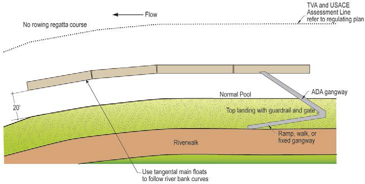
In-River Marina Configuration #2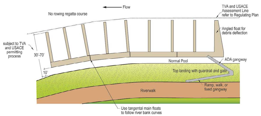
In-Bank Marina Configuration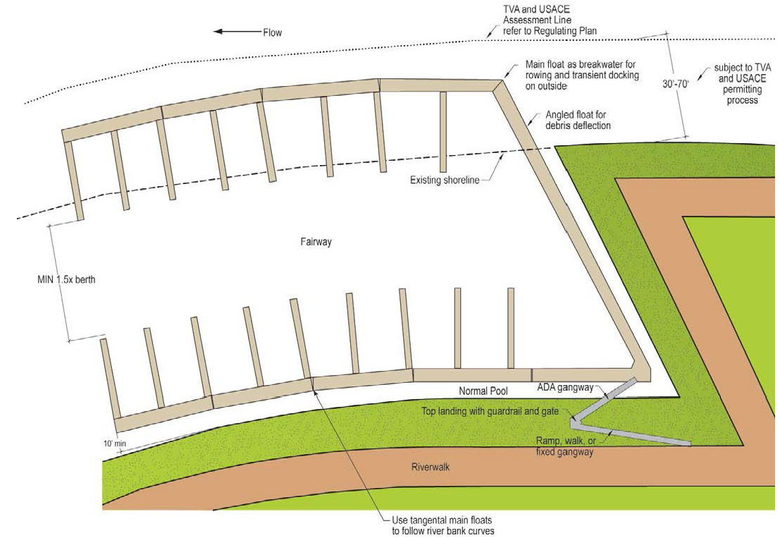
D.
General Standards
1.
Structural Loads
a.
Debris Deflection
Locate float systems and/or breakwater to deflect floating debris around marina.
b.
Flotation Materials
Timber logs and wood flotation shall not be used. Concrete, steel, polyethylene, encapsulated foam, pontoon systems may be used and all floats used for fuel docks shall be concrete impervious to fuel spillage.
c.
Impact Loads
Waterfront structures shall be designed for impact loads from vessels and floating debris up to a 1 in 100 year flood.
d.
Flotation and Anchoring
Steel guide piles or hinged steel arms must enable marina to float up to 1:100 year flood elevations plus freeboard. Fixed Marinas are not permitted.
2.
Environmental Considerations
a.
Sewage Management
No sewer discharge to any waters. One fixed-point collection system at centrally located pumpout station to discharge to city sewer.
b.
Fuel Management
If fuel facilities are proposed, only land based underground storage tank out of floodway is permitted.
3.
On-Shore Components
a.
Off Street Parking
Not required for marinas as an accessory to residential buildings.
b.
Loading Area
Allow service vehicle access to top of gangway landing.
c.
Signs
Signs other than for navigation and regulation are not permitted.
7.1.9. - GLOSSARY AND DEFINITIONS
The following terms are defined for the purpose of the Knoxville South Waterfront. Terms not defined here may be defined elsewhere in the Knoxville Zoning Ordinance. In such case, the definition contained in the Zoning Ordinance will be used.
A
ALBEDO (solar reflectance)
The ratio of the reflected solar energy to the incoming solar energy over wavelengths
of approximately 0.3 to 2.5 micrometers. A reflectance of 100% means that all of the
energy striking a reflecting surface is reflected back into the atmosphere and none
of the energy is absorbed by the surface. See ASTM Standard E903.
ALLEY
A minor street right-of-way, dedicated to public use, which affords a secondary means
of vehicular access to the back or side of properties otherwise abutting a public
street, and which may be used for public utility purposes.
ANCHORAGE
Areas in which vessels are held by means of anchors or similar devices which are removed
from the bottom and carried aboard the vessels once they are underway. (from Delaware
Rules and Regulations)
ARCADE
An open, roofed ground floor passageway supported by columns, piers or pillars.
AWNING
A cantilevered, projected or suspended cover over the sidewalk portion of the street.
Also, roof-like coverings, usually of canvas or metal and often adjustable, placed
over the sidewalk.
B
BALCONY
An exterior platform that projects from the wall of a building and is surrounded by
a railing, balustrade, or parapet.
BAY OR BAY WINDOW
Generally, a u-shaped enclosure, extending the interior space of the building outward
of the exterior building wall. A combination of 3 windows or walls units joined together
that project outwards. The center unit is parallel to the wall and the two units each
side are usually 45° or 90° (right angles) to the wall but can be any angle.
BERTH
A place where a vessel may be secured to a fixed or floating structure and left unattended.
BIKE LANE
A dedicated bicycle lane running with moderate-speed vehicular thoroughfare demarcated
by striping or other means.
BIOENGINEERING SLOPES
Preventative measures that are effective in stabilizing banks and reducing sedimentation
of nearby water bodies. Structures made of natural and biodegradable materials, like
fiber mats, coir fiber logs, wood logs, or synthetic geotextiles reduce the amount
and speed of runoff from storm events and provide erosion and flood protection.
BLOCK
A surface land area which is separated and distinguished from other surface land areas
by visible physical boundaries such as streets, railroads, rivers, or other physical
barriers. Blocks shall be measured at the frontage lot line (along the required build
to line).
BOAT HOUSE
A specific type of vessel designed to be moored to a main float system to enclose
and protect another vessel or vessels from the elements.
BREAKWATER
A structure, parallel to the shore, that protects a shore area, harbor, anchorage,
or basin from waves.
BULKHEAD
A vertical walled structure or partition intended to retain or prevent sliding of
the land, or to provide an interface between land activities and those which occur
in the water, or intended to protect the upland against damage from wave action.
BUFFER ZONE
A naturally undisturbed, vegetated and pervious streamside zone that is protected
from clearing, grading, filling, paving, building or other destruction of the naturally
vegetated state.
BUILDING COVERAGE
Building coverage includes the total lot area covered by a roof, floor or other structures,
except eaves. Building coverage is measured to the outside faces of exterior walls,
at any height, whichever produces the largest area. Carports, sheds, side and rear
porches, covered pedestrian-walkways, breezeways, arbors, gazebos and covered patios
are included in building coverage calculations.
BUILDING HEIGHT
The vertical extent of a building measured in feet and stories. Height limits do not
apply to masts, belfries, clock towers, chimney flues, water tanks, elevator bulkheads
or similar structures. Building height shall be measured from the average grade of
the building face on the principal property frontage to the highest ridge line of
the structure.
C
CANOPY TREE
A tree with a wide spread of branches that can provide shade in summer.
CHANNEL STORAGE CAPACITY
The volume of a stream network within its banks.
COMMON LOT LINES
Lot lines shared by adjacent private lots.
CIVIC GREEN OR SQUARE
The term civic green is generally used to describe a formally configured public lawn
or park that is primarily green. The term square is generally used to describe spaces
that are primarily a hard paved surface.
D
DECK
That element of a waterfront structure which provides the lowest floor level or platform
for use, under which occur only the structural support system for the structure, and
no usable space.
DOCK
A fixed or floating decked structure where a vessel or vessels may be secured either
temporarily or indefinitely.
DORMERS
Small, roofed ancillary structures with windows providing light and air to occupiable
space within the roof. Dormers are permitted and do not constitute a story so long
as they do not break the primary eave line, are individually less than 15 feet wide,
and are collectively not more than 60% of the unit's required building line façade.
DRY BOAT STORAGE
A building, which is either open or subdivided into stalls and is used primarily for
the dry storage of vessels.
F
FENESTRATION
An opening in the building wall allowing light and views between interior and exterior.
Fenestration is measured as glass area (excluding window frame elements with a dimension
greater than one inch) for conditioned space and as open area for parking structures
or other un-conditioned, enclosed spaces.
FENCE
A solid fence made of wood, masonry or semitransparent chain link along alleys and
common lot lines.
FINGER FLOAT
A narrow float connected to a main float, which defines the length of a berth and
separates that berth from adjacent berths.
FLOAT
A floating structure normally used as a point of transfer for passengers and/or goods,
and/or for berthing purposes.
FLOAT SYSTEM
A combinations of a main float and finger floats, either open or covered, designed
to be used to moor vessels.
FLOOR to AREA RATIO (FAR)
The ratio of building area to parcel area. FAR is calculated by adding all of the
areas of each floor of the building together and dividing by the gross area of the
parcel on which the building is sited.
FLOODPLAIN
For a given flood event, that area of land temporarily covered by water, which adjoins
a watercourse and which is necessary for the conveyance of the given flood event.
FOOTPRINT
The area that the ground floor of a building covers.
FRONTAGE
The relationship of the building to a public way. The frontage line refers to the
front setback line which may also be the required build to line. The private frontage
is the area between the building and the private property line. The public frontage
is the area between the private property line and vehicular lanes.
G
GANGWAY
A bridge affording access from shore, or a waterfront structure to a main float.
GARAGE ENTRY (NON-RESIDENTIAL)
An opening (with curb cut) in the building façade where vehicles may enter into the
block interior for general parking and business servicing.
H
HABITABLE FLOOR
Any floor usable for living purposes, which includes working, sleeping, eating, cooking
or recreation, or a combination thereof, but not a floor used only for storage purposes.
L
LEED
Leadership in Energy and Environmental Design Green Building Rating System by the
U.S. Green Building Council (USGBC) defines and measures that should qualify as a
"green building."
LOT
A parcel of land which is or may be occupied by a building and its accessory buildings
or use customarily incidental thereto, together with such yards or open spaces within
the lot lines as may be required by this ordinance.
M
MAIN FLOAT
A float connected by a gangway to the shore or to a waterfront structure, being tied
down laterally by an anchorage system, normally of piles, but free to move vertically,
and which provides access to berths. Finger floats may be attached to one or both
sides of main floats.
MARINA
Any publicly or privately owned dock, basin or wet boat storage facility built to
accommodate more than 2 boats and providing permanent or temporary docking space.
MAXIMUM BUILDING OUTLINE
The maximum dimension by which the proposed building must fit.
MINIMUM BUILDING OUTLINE
The least dimension by which the proposed building must fit.
MOOR
The act of securing a vessel into a berth at a pier, wharf, or float system.
P
PARKING, RESERVED
Parking not available to the public, but only to specifically identified users (either
a single user per space or a set of users for a group of spaces), whether for free
or at a fee, that shall not exceed the prevailing market rate.
PARKING, SHARED
Parking available to the public on an unreserved basis for free, or at the same fee
for all users, which shall not exceed the prevailing market rate. Time limits may
be imposed to ensure turn-over. Hours of public availability may also be restricted.
PERCOLATE
A practice designed to promote the recharge of groundwater by containment and concentration
of stormwater in porous soils. Also referred to as Infiltration.
PERMEABLE PAVEMENT
A pavement system designed to achieve water quality and quantity benefits by allowing
movement of stormwater through the pavement surface and into a base/sub base reservoir.
Examples include pervious concrete, porous asphalt, and permeable paving blocks.
PLAZA
An area devoted strictly to pedestrian use which provides access to two or more businesses.
Such space shall be surfaced with material generally used for pedestrian traffic and
available to the general public during hours which adjoining establishments are open
for business. A public open space with a hard surface. See also CIVIC GREEN or SQUARE.
PRINCIPAL FRONTAGE ROAD
The primary street that accesses the main building entrance.
R
REGULATING PLAN
Part of the code that is the key for the building development standards that provide
specific information for the disposition of each building site. The Regulating Plan
shows how each site relates to streets, the overall Knoxville South Waterfront and
the surrounding neighborhood.
REQUIRED BUILD TO LINE
The building shall be "built-to" the required building line as shown on the Regulating
Plan. The build to line is a requirement, not a permissive minimum as is a set-back.
The build to line for each site is shown on the applicable Regulating Plan. The minimum
length of building that is required to be built-to is shown on the appropriate building
siting and configuration standard.
RESERVED PARKING
See PARKING, RESERVED
R.O.W.—Right-of-Way
An area used as a public way, measured from boundary line to boundary line, which
may also accommodate public utilities.
S
STOOP
A frontage type where the raised entry platform is on the principal frontage and the
first story is above the level of the ground creating a change in elevation.
STORMWATER
The increased volume of water that flows over land areas to collect in lakes and streams
during and just after storms.
STORY, STORY HEIGHT
That portion of a building included between the upper surface of a floor and upper
surface at the floor or roof next above.
STREET
The entire width between boundary lines of every way when any part thereof is open
to the use of the public for purposes of vehicular travel.
STREET FRONTAGE
The lot line coincident with the required build to line or that portion of the building
that is coincident with the required build to line as required by the code. The lineal
distance is measured horizontally and in feet.
STREETSCAPE
Improvements to a property, including paving, tree and/or other decorative plantings,
lighting, and the placement of street furniture, within the street.
V
VESSEL
An all inclusive term to describe a craft which travels on the water, and includes
but is not limited to pleasure boats, commercial shipping, fishing boats, house boats,
boat houses and barges, but does not include floats or other water borne structures
normally anchored in place and stationary.
VIEW CORRIDORS
An unobstructed picture of the landscape. Critical view corridors in the Knoxville
South Waterfront Plan emanate from the public streets and primary civic spaces and
parks towards the river.
W
"WHERE CLEARLY VISIBLE FROM THE STREET"
Many requirements of the code apply only where the subject is "clearly visible from
the street." Note that the definition of street includes squares, civic greens, parks,
and all public space except alleys.
WINDOW SIGN
For the purpose the South Waterfront District, a window sign shall be a sign attached
to, painted on, or etched into a window or displayed within 12 inches (measured horizontally)
of the window and are legible from outside of the window.
7.2.1. - GENERAL PROVISIONS
A.
Applicability
The Cumberland Avenue District applies to all property as designated in Sec. 7.2.2.
B.
Intent
1.
The Cumberland Avenue District is intended to implement the Cumberland Avenue Corridor Plan.
2.
Specifically, the Cumberland Avenue District provides the means to guide implementation of the citizen-endorsed vision for property within the Cumberland Avenue District.
3.
The Cumberland Avenue District fosters predictable results and a high-quality public realm by prescribing the physical form of buildings and other elements and addressing the relationship between building façades and the public realm, the form and mass of buildings in relation to one another, and the scale and types of streets and blocks.
C.
Cumberland Avenue Districts
In order to implement the Cumberland Avenue Corridor Plan, the following districts have been established.
1.
Lake Avenue (CU-1)
a.
CU-1 serves as a transition between Cumberland Avenue and the University of Tennessee and is intended to accommodate a variety of commercial, office and residential uses. This district is the tallest due to the naturally low elevation of the area in comparison to other portions of this district.
b.
Buildings in CU-1 can be a maximum height of 10 stories/120 feet. Each building façade must be articulated vertically or horizontally.
2.
Cumberland Avenue (CU-2)
a.
CU-2 is the key retail street within the area and is primarily intended to accommodate ground floor retail with upper story residential or office uses.
b.
Buildings in CU-2 can be a maximum height of 8 stories/90 feet. Each building must provide a stepback above the second or third story.
3.
White Avenue/Hospital (CU-3)
a.
CU-3 serves as a transition between Cumberland Avenue and the medical campus and is primarily to intended accommodate a mix of medical- or employment-related uses with a variety residential housing options.
b.
Buildings in CU-3 can be a maximum height of 8 stories/90 feet. Due to the scale and character of existing adjacent medical buildings, no articulation is required.
4.
White Avenue/Neighborhood (CU-4)
a.
CU-4 serves as a transition between Cumberland Avenue and the White Avenue neighborhood to the north and is primarily intended to accommodate a variety of commercial, office and residential uses.
b.
Buildings in CU-4 can be a maximum height of 4 stories/50 feet.
5.
Seventeenth Street (CU-5)
a.
CU-5 is a retail street within the area and is primarily intended to accommodate ground floor retail with upper story residential or office uses.
b.
Buildings in CU-5 can be a maximum height of 8 stories/90 feet. Each building façade must be articulated vertically or horizontally.
D.
Approval Procedures
Sec. 7.0.2 applies to the review of all development in the Cumberland Avenue District.
E.
Rules of Measurement
Sec. 7.0.3 applies to all CU- districts, except as supplemented below.
1.
Primary and Side Street Designation
a.
Where only one street abuts a lot that street is considered a primary street.
b.
Where more than one street abuts a lot, the following streets are consider primary streets, all remaining streets are side streets:
i.
Lake Avenue;
ii.
Cumberland Avenue;
iii.
White Avenue;
iv.
Seventeenth Street; and
v.
Clinch Avenue.
c.
A corner lot can have more than one primary street.
2.
Measurement of Height
a.
Height in a CU- district is measured from the following streets using the designated street to determine average grade (see Sec. 7.0.2.H).
i.
Lake Avenue;
ii.
Cumberland Avenue; and
iii.
White Avenue
b.
Overall building height cannot exceed a height plane measured from the closest street designated above and extending to the mid-block.
c.
In a CU- district, more than one additional story is allowed on a downward sloping lot, provided that the measurement above is met.
Measurement of Height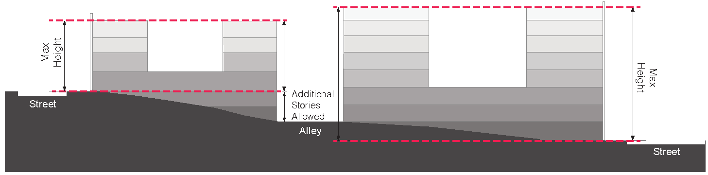
7.2.2. - CUMBERLAND AVENUE REGULATING PLAN
The following map is established and made a part of the City of Knoxville Official Zoning Map.
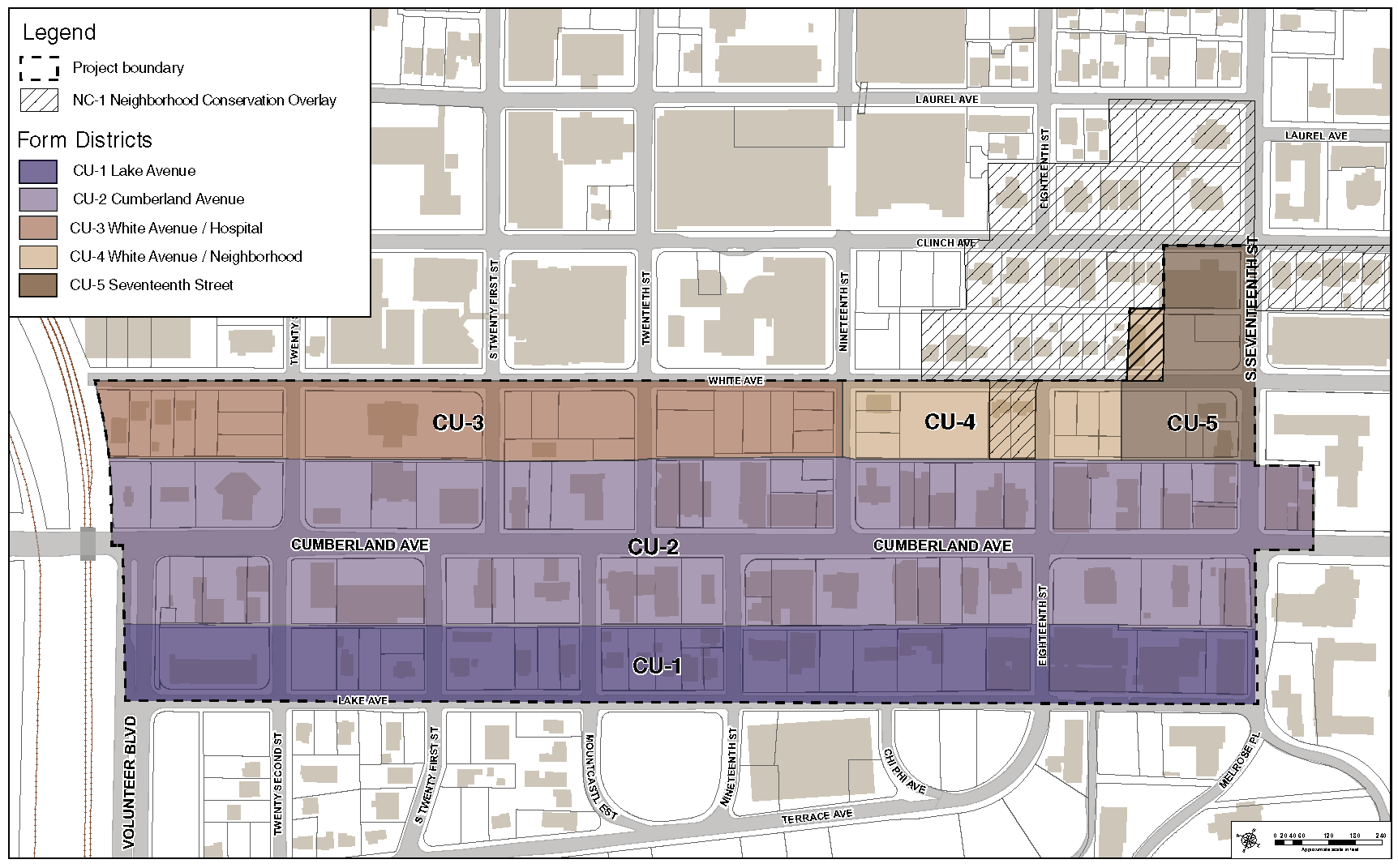
7.2.3. - LOT CONFIGURATION
A.
Lake Avenue (CU-1)
The following lot configuration standards apply within the Lake Avenue (CU-1) district.
1.
Lot
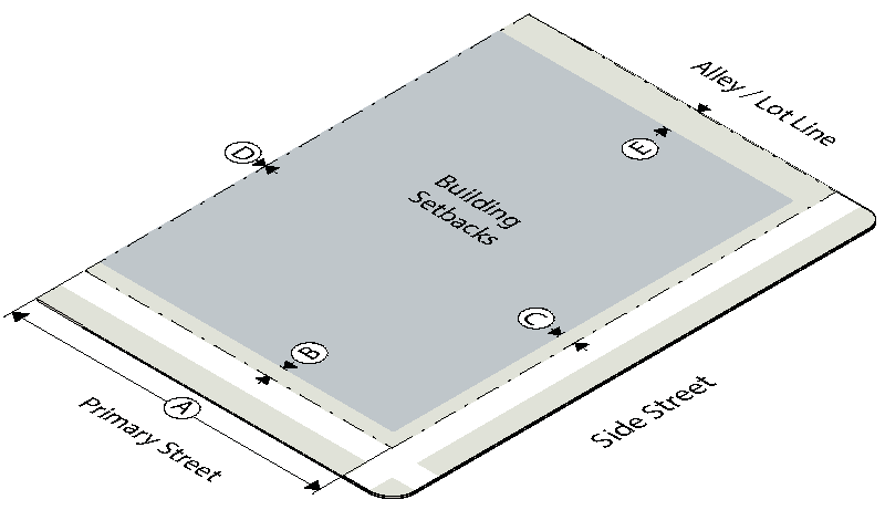
2.
Placement
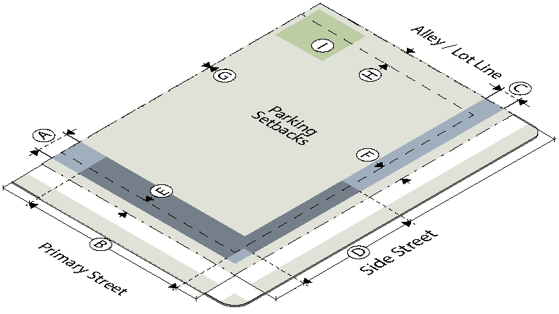
3.
Height
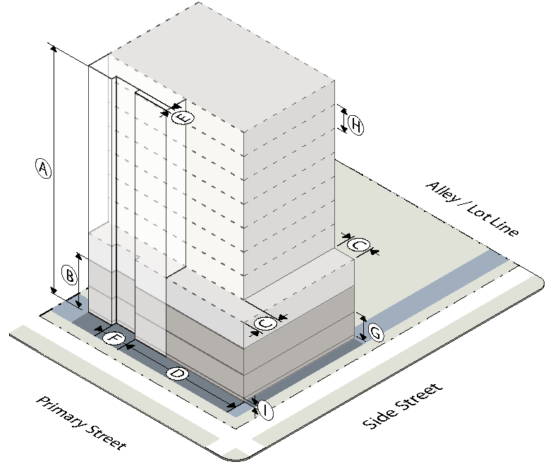
4.
Activation
B.
Cumberland Avenue (CU-2)
The following lot configuration standards apply within the Cumberland Avenue (CU-2) district.
1.
Lot
2.
Placement
3.
Height
4.
Activation
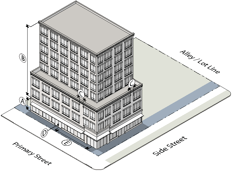
C.
White Avenue/Hospital (CU-3)
The following lot configuration standards apply within the White Avenue/Hospital (CU-3) district.
1.
Lot
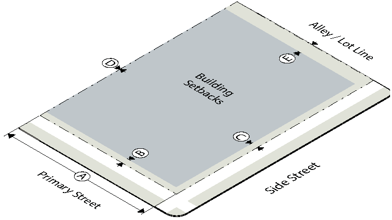
2.
Placement
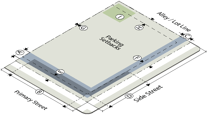
3.
Height
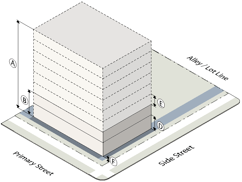
4.
Activation
D.
White Avenue/Neighborhood (CU-4)
The following lot configuration standards apply within the White Avenue/Neighborhood (CU-4) district.
1.
Lot
2.
Placement
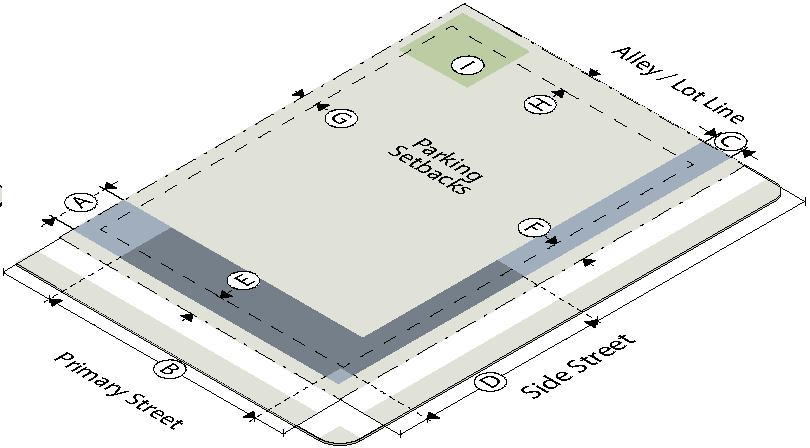
3.
Height
4.
Activation
E.
Seventeenth Street (CU-5)
The following lot configuration standards apply within the Seventeenth Street (CU-5) district.
1.
Lot
2.
Placement
3.
Height
4.
Activation
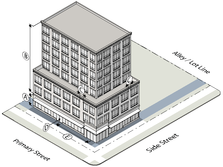
7.2.4. - BUILDING ELEMENTS
Building elements are allowed by district as forth in Sec. 7.2.3. The following standards apply to allowed building elements.
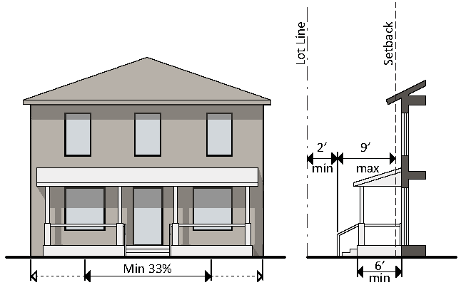
A.
Porch
A raised structure attached to a building, forming a covered entrance to a doorway.
1.
A front porch must be at least 6 feet deep (not including the steps).
2.
A front porch must be contiguous, with a width not less than 33% of the building façade from which it projects.
3.
A front porch must be roofed but cannot be fully enclosed.
4.
A front porch may extend up to 9 feet, including the steps, into a required setback, provided that such extension is at least 2 feet from the vertical plane of any lot line.
5.
A front porch may not encroach into the public right-of-way.
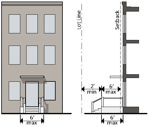
B.
Stoop
A small raised platform that serves as an entrance to a building.
1.
A stoop may be no more than 6 feet deep (not including the steps) and 6 feet wide.
2.
A stoop may be covered but cannot be fully enclosed.
3.
A stoop may extend a up to 6 feet into a required setback, provided that the landing is at least 2 feet from the vertical plane of any lot line.
4.
A stoop may not encroach into the public right-of-way.
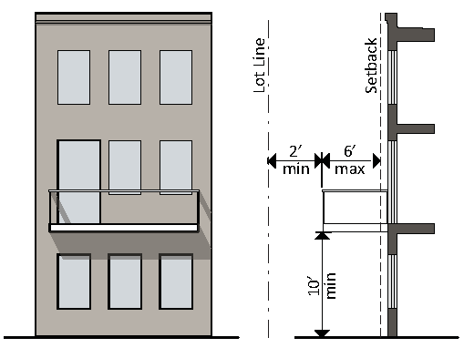
C.
Balcony
A platform projecting from the wall of a building with a railing along its outer edge, often with access from a door or window.
1.
A balcony must be at least 4 feet deep and may extend up to 6 feet into a required setback, provided that such extension is at least 2 feet from the vertical plane of any lot line
2.
A balcony must have a clear height above the sidewalk of at least 10 feet.
3.
A balcony may be covered but cannot be fully enclosed.
4.
A balcony may not encroach into the public right-of-way without a "Use Agreement" for the use of public right-of-way.
5.
No balcony encroachments are allowed on Cumberland Avenue.
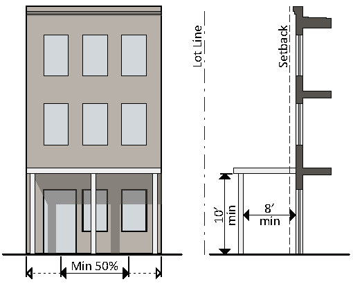
D.
Gallery
A covered passage extending along the outside wall of a building supported by arches or columns that is open on 3 sides.
1.
A gallery must have a clear depth from the support columns to the building's façade of at least 8 feet and a clear height above the sidewalk of at least 10 feet.
2.
A gallery must be contiguous and extend over at least 50% of the width of the building façade from which it projects.
3.
A gallery may extend into a required setback.
4.
A galley may not encroach into the public right-of-way without a license for the use of public right-of-way.
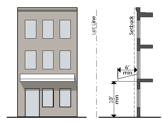
E.
Awning/Canopy
A wall-mounted, cantilevered structure providing shade and cover from the weather for a sidewalk.
1.
An awning/canopy must be a minimum of 10 feet clear height above the sidewalk and must have a minimum depth of 6 feet.
2.
An awning/canopy may extend into a required setback.
3.
An awning/canopy may not encroach into the public right-of-way without a license for the use of public right-of-way.
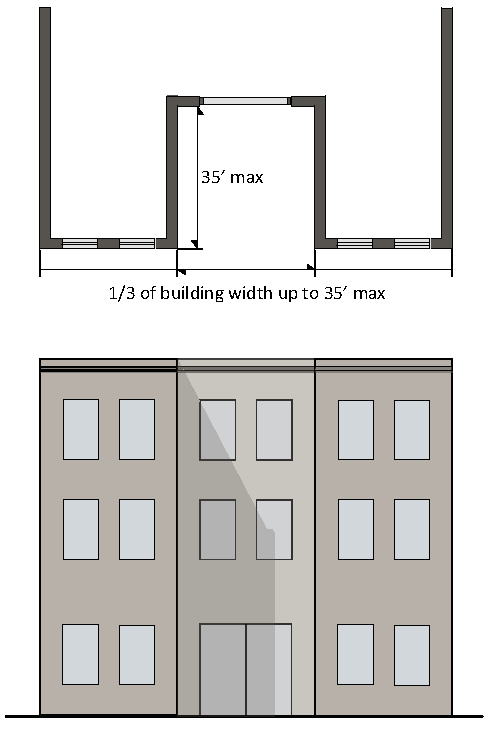
F.
Forecourt
An open area at grade, or within an average 30 inches of grade, that serves as an open space or plaza.
1.
A forecourt must be no more than 1/3 of the length of the building face, and in no case longer than 35 feet in width.
2.
A forecourt may be no more than 35 feet in depth.
3.
A maximum of one forecourt is permitted per site.
4.
A forecourt is considered as part of the building for the purpose of measuring the build-to zone.
7.2.5. - USE
A.
Permitted Uses
1.
This Section establishes the uses allowed in each district. A lot or building must be occupied with only the uses allowed on the permitted use table in Sec. 7.2.5.D.
2.
Any one or more land uses allowed in a district may be established on any lot within that district, subject to the permitted use table, and in compliance with all applicable requirements of this Code.
B.
Classification of Uses
1.
In order to regulate use, categories of uses have been established in Sec. 7.2.5.E providing a systematic basis for assigning land uses to appropriate categories with other similar uses. Use categories classify land uses and activities based on common functional, product or physical characteristics.
2.
The Administrator is authorized to categorize all uses. When determining what use category a proposed use fits in, the Administrator will consider the following criteria:
a.
The actual or projected characteristics of the proposed use.
b.
The relative amount of site area or floor area and equipment devoted to the proposed use.
c.
Relative amounts of sales.
d.
The customer type.
e.
The relative number of employees.
f.
Hours of operation.
g.
Building and site arrangement.
h.
Types of vehicles used and their parking requirements.
i.
The number of vehicle trips generated.
j.
How the proposed use is advertised.
k.
The likely impact on surrounding properties.
l.
Whether the activity is likely to be found independent of the other activities on the site.
m.
Whether the use is in harmony with the general purpose and intent of these zoning regulations.
C.
Accessory Uses
1.
Accessory uses and structures are permitted in conjunction with an allowed principal use. Accessory uses and structures must be accessory and clearly and customarily incidental and subordinate to a permitted principal use or structure.
2.
No accessory use or structure may be established prior to the establishment of a permitted principal use or structure.
3.
All accessory structures must meet the setback and height requirements of Sec. 7.2.3, except for the minimum height provisions.
4.
The Administrator is authorized to determine when a use or structure is accessory. In order to classify a use or structure as accessory, the Administrator must determine that the use or structure:
i.
Is subordinate to the principal use in terms of area, extent and purpose;
ii.
Contributes to the comfort, convenience or necessity of occupants of the principal use or structure served;
iii.
Is located on the same lot as the principal use or structure, or on a contiguous lot in the same ownership;
iv.
Does not involve operations not in keeping with the character of the principal use or structure served; and
v.
Is not of a nature likely to attract visitors in larger numbers than would normally be expected for the principal use or structure.
D.
Allowed Use Table
The allowed use table identifies uses permitted in each sub-district by story.
Key: ■ = Use allowed — = Use not allowed
E.
Use Categories
1.
Residential Uses
a.
Household Living
i.
Residential occupancy of a dwelling unit by a household on a monthly or longer basis.
ii.
In CU-2, lobby areas, recreation areas and workout facilities associated with an upper story residential use are allowed on the ground story.
b.
Live-Work
The intent of live-work is to permit businesses, professions, occupations or trade within a residential dwelling unit that requires employees, customers, clients or patrons to visit the unit. Live-work units are permitted provided the following standards are met:
i.
Live-work is only permitted in units with street level access.
ii.
A minimum of one person must occupy the live-work unit as their primary place of residence.
iii.
The live-work unit may employ no more than 2 persons not living on the premises at any one time.
iv.
No business storage or warehousing of material, supplies or equipment is permitted outside of the live-work unit.
v.
The nonresidential use of the unit is limited to office, personal service and retail sales.
vi.
No equipment or process may be used in connection with the live-work unit that creates noise, vibration, glare, fumes, odors, or electrical interference detectable to the normal senses, off the premises.
vii.
Business signage is limited to one unlit wall or projecting sign no larger than 3 square feet in area, attached to the structure housing the live-work unit.
viii.
No more than 5 customers are permitted on the premises at any one time.
c.
Group Living
Residential occupancy of a structure by a group of people that does not meet the definition of household living. Tenancy is usually arranged on a monthly or longer basis. Generally, group living facilities have a common eating area for residents, and residents may receive care or training.
d.
Social Service
A facility that provides treatment of those with psychiatric, alcohol, or drug problems, and transient housing related to social service programs.
e.
Personal Garden
An area of land on which food or non-food crops are grown by the property owner or other person with an interest in the property for personal or family consumption and enjoyment. Personal gardens may be principal or accessory use. On-site sales are permitted through the use of a temporary use permit issued for a seasonal produce stand.
2.
Public Uses
a.
Civic
i.
Places of public assembly that provide ongoing governmental, life safety, educational and cultural services to the general public, as well as meeting areas for religious practice.
ii.
Civic uses can include museums, libraries, places of worship, police, fire, or EMS station and public schools (K-12).
iii.
Buildings that contain civic uses are not subject to the build-to, story height, transparency and building entrance requirements of Sec. 7.2.3.
b.
Parks & Open Space
Uses focusing on public gathering areas for passive or active outdoor recreation, and having few structures.
c.
Minor Utilities
Public or private infrastructure serving a limited area with no on-site personnel. Minor utilities can include on-site stormwater retention or detention facilities, neighborhood-serving cable, telephone, gas or electric facilities and water/wastewater pump or lift station.
d.
Major Utilities
Public or private infrastructure serving the general community and possibly having on-site personnel.
e.
Market Garden
An area of land managed and maintained by an individual, group or business to grow and harvest food and non-food crops to be sold for profit on-site, off-site, or both. Market gardens may be principal or accessory uses.
3.
Commercial Uses
a.
Commercial Parking
A facility that provides parking not accessory to a principal use, for which a fee may or may not be charged.
b.
Day Care
A facility providing care, protection, and supervision of to 6 more unrelated children or adults on a regular basis.
c.
Indoor Recreation
A facility providing daily or regularly scheduled recreation-oriented activities in an indoor setting. Indoor recreation can include an athletic, tennis, swim or health club; a dance, martial arts, or music studio; or a movie or other type of theater.
d.
Medical
A facility providing medical or surgical care to patients. Some uses may offer overnight care. Medical can include hospital, urgent care, or emergency medical office; medical, dental office or chiropractor; and medical clinic.
e.
Office
A facility focusing on business, professional or financial activities conducted in an office setting.
f.
Outdoor Recreation
A commercial facility providing daily or regularly scheduled recreation-oriented activities primarily in an outdoor setting. Outdoor recreation can include a drive-in theater, outdoor amusements, golf driving range, mini-amusement park, miniature golf facility or private ballfields.
g.
Overnight Lodging—Hotels and Motels
i.
A facility providing overnight accommodations arranged for short term stays of less than 30 days for rent or lease.
ii.
In CU-2, lobby areas, recreation areas, workout facilities, meeting rooms and eating and cooking areas associated with the overnight lodging facility are allowed on the ground story.
h.
Personal Service
Establishment primarily engaged in providing services involving the care of a person or their apparel.
i.
Restaurant/Bar
A facility that prepares and sells food or drink for on- or off-premise consumption.
j.
Retail Sales
A facility involved in the sale, lease, or rental of new or used products, not including car or vehicle sales or rental. Includes bicycle sales, repair or rental.
k.
Vehicle Sales/Rental
A facility involved in the sales, rental or leasing of passenger vehicles, light and medium trucks, and other consumer motor vehicles such as motorcycles, boats, and recreational vehicles. Does not include bicycle sales, repair or rental.
l.
Community Garden
An area of land managed and maintained by a nonprofit or group of individuals to grow and harvest food or non-food crops for personal or group use, consumption, or donations. Community gardens may be principal or accessory uses.
4.
Industrial Uses
a.
Heavy Industrial
A facility involved in dangerous, noxious or offensive activity or a facility that has smoke, odor, noise, glare, fumes, gas, vibration, threat of fire or explosion, emission of particulate matter, interference with radio, television reception or radiation.
b.
Light Industrial
A facility involved in the manufacturing, assembly, repair or servicing of industrial, business, or consumer machinery, equipment, or products.
c.
Research and Development
A facility involved primarily on the research and development of new products.
d.
Self-Service Storage
A facility providing separate storage areas for personal or business use designed to allow private access by the tenant for storing or removing personal property.
e.
Vehicle Service
A facility involved in the repair and service of passenger vehicles, light and medium trucks, and other consumer motor vehicles such as motorcycles, boats, and recreational vehicles. Does not include bicycle sales, repair or rental.
f.
Warehouse & Distribution
A facility involved in the storage or movement of goods for themselves or other firms.
7.2.6. - PARKING
A.
Applicability
1.
General
No permit for the construction, reconstruction, extension, or alteration of any building, structure, or use of land, and no building or land, or any part of any building or land, may be occupied or used until parking has been demonstrated in accordance with the requirements of this Code.
B.
Required Vehicle Parking
1.
The following vehicle parking spaces are required for each use.
2.
For the purposes of calculating required parking spaces, uses are grouped into categories (see Sec. 7.2.5.E).
3.
Reserved parking spaces mean those spaces designated for a specific unit or use.
C.
Required Bicycle Parking
1.
The following bike parking spaces are required for each use.
2.
For the purposes of calculating required bike parking spaces, uses are grouped into categories (see Sec. 7.2.5.E).
D.
Bicycle Parking Facilities
1.
General Requirements
a.
Bicycle parking spaces must be located on paved or pervious, dust-free surface with a slope no greater than 3%. Surfaces cannot be gravel, landscape stone, or wood chips.
b.
Bicycle parking spaces must be a minimum of 2 feet by 6 feet. There must be an access aisle a minimum of 5 feet in width.
c.
Each required bicycle parking space must be accessible without moving another bicycle and its placement must not result in a bicycle obstructing a required walkway.
d.
Up to 25% of bicycle parking may be structured parking, vertical parking or wall mount parking, provided there is a 5-foot access aisle for wall mount parking.
e.
All racks must accommodate cable locks and "U" locks including removing the front wheel and locking it to the rear fork and frame.
2.
Short-Term Bicycle Parking
a.
Required short-term bicycle parking spaces must be located in a convenient and visible area at least as close as the closest non-accessible automobile parking and within one 100 feet of a principal entrance and must permit the locking of the bicycle frame and one wheel to the rack and must support a bicycle in a stable position.
b.
No fee can be charged for resident bicycle parking where free automobile parking is provided on-site.
3.
Long-Term Bicycle Parking
a.
Required long-term bicycle parking spaces must be located in enclosed and secured or supervised areas providing protection from theft, vandalism and weather and must be accessible to intended users.
b.
Required long-term bicycle parking for residential uses can not be located within dwelling units or within deck, patio areas, or private storage areas accessory to dwelling units.
c.
With permission of the Administrator, long-term bicycle parking spaces for non-residential uses may be located off-site within 300 feet of the site.
d.
No fee can be charged for resident bicycle parking where free automobile parking is provided on-site.
E.
Drive-Through Vehicle Stacking
1.
Adequate space must be made available on-site for the stacking, storage and queuing of vehicles.
2.
Vehicles using drive-through facilities may not encroach on or interfere with the public use of streets and sidewalks by vehicles or pedestrians.
3.
All drive-through areas, including but not limited to menu boards, stacking lanes, trash receptacles, ordering box, drive up windows, and other objects associated with the drive-through area, must be located to the side or rear of the building. Drive-through windows and lanes may not be placed between the street and the associated building.
4.
A restaurant with a drive-through must provide at least 4 queuing spaces, measured from the first pick up window.
5.
A bank or pharmacy with a drive-through must provide at least 3 queuing spaces per drive-through lane, measured from the teller box or window.
6.
All other uses determined by the Engineering Department.
F.
Stall Size and Drive Aisle Dimensions
When provided parking spaces and drive aisles must meet the requirements of Article 5, Section 7 "Minimum Off-Street Parking, Access and Driveway Requirements."
G.
Design of Parking Structures
1.
Parking structures must meet all the requirements for a principal structure as specified in Sec. 7.2.3. In no case can structured parking exceed the height of any other building on the site.
2.
Required parking setbacks apply only to the first floor of the parking structure. Parking setbacks do not apply to underground parking.
3.
The ground story of a structured parking garage facing Cumberland Avenue, Lake Avenue or Seventeenth Street must have active uses (such as, but not limited to, residential, commercial, office or civic space, where permitted) located between the parking structure and the street (not including an alley).
4.
Where upper stories of structured parking are allowed at the perimeter of a building, they must be screened so that cars are not visible from ground level view from adjacent property or adjacent public street right-of-way (not including an alley).
5.
Architectural and vegetative screens must be used to articulate the façade, hide parked vehicles and shield lighting. In addition, any ground floor façade treatment (building materials, windows, and architectural detailing) must be continued on upper stories.
6.
Parking structure entries must not exceed 16 feet clear height and 25 feet clear width.
7.2.7. - LANDSCAPING AND SCREENING
A.
Surface Parking Lots
1.
Applicability
a.
This Section applies to all new on-site surface parking lots with more than 10 spaces. For purposes of this Section, multiple platted lots contained on a single site plan and any separate parking areas connected with drive aisles are considered a single parking area.
b.
An existing parking lot may be renovated or repaired without providing additional landscaping, provided there is no increase in the size of the parking lot.
c.
When an existing parking lot is increased in size, landscaping is required for the new parking area only.
d.
When an existing parking lot is increased in size by more than 50% cumulatively, landscaping is required for both the existing parking lot and the new parking area.
2.
Perimeter Screening
All surface parking lots with frontage on any portion of a street right-of-of way (not including an alley) must be screened with the following:
a.
A minimum 10-foot wide, landscaped area with a continuous row of shrubs must be provided between the street and parking lot.
b.
Shrubs must be a minimum of 18 inches in height when planted and must reach a minimum size of 36 inches in height within 3 years of planting.
c.
A 36-inch wall in a minimum 5-foot planting strip may be substituted for the continuous row of shrubs.
d.
Breaks for pedestrian and vehicle access are allowed.
e.
No landscaping is permitted that materially impedes vision for vehicular sight distance.
3.
Interior Islands
a.
A landscaped interior island must be provided every 10 parking spaces. Interior islands must be distributed evenly throughout the parking area.
b.
Interior islands may be consolidated or intervals may be expanded in order to preserve existing trees.
c.
An interior island must be a minimum of 9 feet in width and 320 square feet in area.
d.
Interior islands may be installed below the level of the parking lot surface to allow for runoff capture.
4.
Median Islands
a.
A landscape median island must be provided between every 6 single parking rows.
b.
A landscape median island must be a minimum of 5 feet wide.
Required Parking Lot Landscaping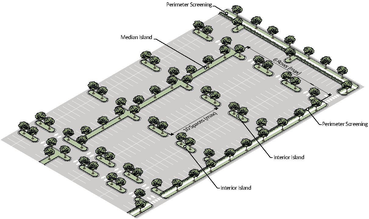
c.
A median island may also serve as the location for a sidewalk. In such case, the sidewalk must be a minimum of 6 feet wide, and the remaining planting area must be no less than 5 feet wide.
d.
Median islands may be consolidated or intervals may be expanded in order to preserve existing trees.
e.
Median islands may be installed below the level of the parking lot surface to allow for runoff capture.
5.
Tree Coverage
a.
Each interior island must include at least 1 shade tree.
b.
In no case can there be less than 1 shade tree for every 3,000 square feet of parking area including drive lanes.
B.
Screening
1.
Applicability
This Section applies to all new service areas and the installation of new mechanical equipment.
2.
Service Areas
a.
Trash collection, trash compaction, recycling collection and other similar service areas must be located to the side or rear of buildings and must be screened from view from adjacent property or public street right-of-way (not including an alley).
b.
Service areas that are fully integrated into a building must be screened with a roll down door or other opaque screen.
c.
Service areas that are not integrated into a building must be screened from 3 sides by a wall at least 6 feet in height and on the fourth side by a solid gate at least 6 feet in height.
d.
The gate and wall must be maintained in good working order and must remain closed except when trash pick-ups occur.
3.
Mechanical Equipment
a.
Roof-Mounted Equipment
i.
Roof-mounted equipment must be screened from ground level view from adjacent property or adjacent street right-of-way (not including an alley), measured at ground level from 150 feet away.
ii.
New buildings must provide a parapet wall or other architectural element that screens roof-mounted equipment.
b.
Wall-Mounted Equipment
i.
Wall-mounted equipment cannot be located on any surface that directly faces a public right-of-way (not including an alley).
ii.
Wall-mounted equipment located on any surface that is visible from a public right-of-way (not including an alley) must be fully screened by landscaping or an opaque screen.
c.
Ground-Mounted Equipment
Ground-mounted mechanical equipment that is visible from a public right-of-way (not including an alley) must be screened from view by landscaping or a wall. The screening must be of a height equal to or greater than the height of the mechanical equipment being screened.
C.
Fence and Walls
1.
Applicability
This Section applies to all new fences and walls.
2.
Standards
a.
Fences and walls may be placed up to the property line, and any posts or supporting rails must face inward toward the property being fenced.
b.
A wall or fence located in a primary or side street yard, not used for a required screen, cannot be more than 6 feet height. The opacity of the wall or fence above 4 feet in height must exceed 50%.
c.
A wall or fence located in a side or rear yard cannot be more 8 feet in height.
d.
Walls must be constructed of high quality materials including one or a combination of the following: decorative blocks; brick; stone; cast-stone; split-faced block; stucco over standard concrete masonry blocks; glass block; or other material approved by the Administrator.
e.
Fences must be constructed of high quality materials including one or a combination of the following: wood, composite fencing; wrought iron, steel, aluminum, PVC vinyl; or other material approved by the Administrator.
f.
No wall or fence may be located within any required drainage or utility easement.
g.
Barbed wire or concertina wire is not allowed.
h.
Chain-link fences are not allowed in any primary or side street yard.
i.
No wall or fence is permitted which materially impedes vision for vehicular sight distance.
D.
Plant Installation
1.
General Provisions
a.
Plant materials must be hardy to zone 7a in accordance with the U.S. Department of Agriculture's Plant Hardiness Zone Map.
b.
Plant materials must be able to survive on natural rainfall once established with no loss of health.
c.
Tree height is measured from the top of the root ball to the tip of the main stem.
2.
Shade Trees
a.
All shade trees planted to meet the landscaping requirements must be a locally adapted species with an expected mature height of 35 feet or greater and an expected mature crown spread of at least 30 feet or greater unless subject to an overhead power line in which case the mature height may be less.
b.
All shade trees planted to meet the landscaping requirements must have a minimum caliper of 2 inches and be at least 8 feet tall at time of planting.
3.
Understory Trees
a.
Understory trees planted to meet the landscaping requirements must be a locally-adapted species with an expected mature height of at least 15 feet and an expected mature crown spread of at least 15 feet.
b.
Single-stem understory trees planted to meet the landscaping requirements must have a minimum caliper of 1 inches and be at least 5 feet tall at time of planting.
c.
Multi-stem understory trees planted to meet the landscaping requirements must be at least 5 feet tall at time of planting.
E.
Maintenance
All required landscaping must maintained in good health and condition. Any dead, unhealthy, deteriorating, broken or missing landscaping must be replaced with landscaping that conforms to this Code within 30 days (or within 180 days where weather concerns would jeopardize the health of plant materials).
7.2.8. - SIGNS
A.
Applicability
1.
No sign may be erected, altered, refurbished or otherwise modified after the effective date of this Code except in accordance with the requirements of this Section.
2.
All signs must be located on the same lot as the permitted use and be clearly incidental, customary and commonly associated with the operation of the permitted use.
3.
Nothing in this Section is intended to prohibit the ordinary maintenance repair of a nonconforming sign or replacement of a broken part of a nonconforming sign.
B.
General Sign Provisions
1.
Prohibited Signs
The following signs are prohibited.
a.
Signs which move, or give the appearance of moving with the exception of those signs not requiring a permit (see Sec. 7.2.8.B.2). This includes banners, pennants, streamers, string pennants, flags and all other signs which flutter, undulate, swing, rotate, oscillate or otherwise move by natural or artificial means.
b.
Signs which contain or make use of any word, phrase, symbol, shape, form or character in such manner as to interfere with, mislead, or confuse traffic. This does not include signs which are accessory to parking lots, driveways or roads.
c.
Signs which have moving parts and signs which have red, green yellow, amber or blue lights.
d.
Signs which have flashing lights, blinking lights or signs containing any running lights creating an illusion of movement.
e.
Signs placed on a parked vehicle or trailer where the apparent purpose is to advertise a product or direct people to a business or business located on the same or nearby property.
f.
Roof signs.
g.
Electronic Message Centers as defined in Article 5, Section 10, "Signs, Billboards, and other advertising structures".
2.
Signs Allowed Without a Permit
The signs listed below do not require a permit if they meet the following provisions.
a.
Street address numbers provided they do not exceed 1 square foot in area.
b.
Building nameplates provided they do not exceed 6 square feet in area.
c.
Paper notices placed on bulletin boards or on kiosks maintained by any governmental organization.
d.
Signs erected or required by governmental bodies, or authorized for a public purpose by any law, statute or ordinance.
e.
Flags bearing the officially adopted design of a nation, state, county, city or the University of Tennessee. Flags cannot exceed 30 square feet in size, except that United States of America garrison size flags are allowed.
f.
Signs that include business hours of operation, not to exceed 1 square foot in size.
g.
Window signs that cover no more than 10% of the total surface of each window.
3.
Signs in the Right-of-Way
a.
Monument signs and bracket signs cannot encroach into the public right-of way.
b.
Wall signs, awning signs, canopy signs, projecting signs, crown signs, shingle signs and sidewalk signs may encroach over the public sidewalk but cannot encroach on or over any streets or alleys. All signs must be a minimum of 18 inches inside the curb line or edge of pavement, whichever is greater.
4.
Common Sign Plan
A common sign plan must be filed with the Administrator for all sites occupied by more than one tenant. After the filing of a common sign plan, all tenant signs must meet the requirements of the common sign plan. The applicant must indicate the standards of consistency of all signs on the subject property with regard to:
a.
Colors;
b.
Letter/graphics style;
c.
Location of each sign;
d.
Materials used in sign construction; and
e.
Maximum dimensions and proportion.
C.
Signs Requiring a Permit
1.
Sign Types
The following signs are allowed in all CU- districts following the issuance of a sign permit under Article V, Section 10 " Signs, Billboards, and Other Advertising Structures." Standards for each sign type are listed in the following pages.
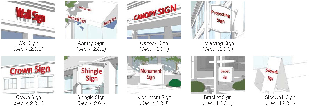
2.
Allocation of Sign Area
The maximum sign area for each sign type is determined is established below.
3.
Computation of Sign Area
The area of all signs is computed as follows:
a.
For wall signs, awning signs, canopy signs and crown signs consisting of freestanding letters or logos, sign area is calculated as the total area of the rectangle, circle or square that fully encloses all the letters or logo.
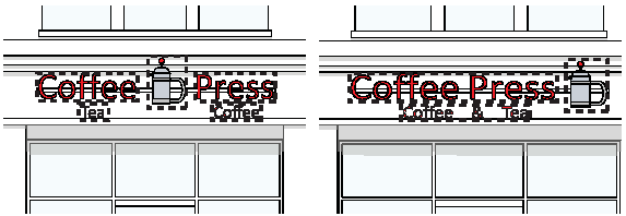
b.
For signs on a background, the entire area of the background is calculated as sign area, including any material or color forming the sign face and the background used to differentiate the sign from the structure on which it is mounted. Sign area includes the face of the structure that the message is affixed to, not including any supports or bracing.
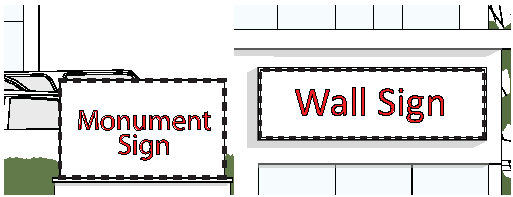
c.
The area of a sign with faces placed less than 45 degrees apart is calculated based on the area of the largest face of the sign. The area of a sign with faces placed 45 or more degrees apart is calculated based on the area of all sign faces.
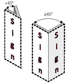
d.
The area of a three-dimensional sign is calculated as the total area of the smallest rectangle, circle or square that fully encloses the largest profile of the three-dimensional sign.
4.
Measurement of Sign Height
The total height of a ground or bracket sign is measured from the highest point of the sign or supporting structure to the top of the abutting sidewalk.
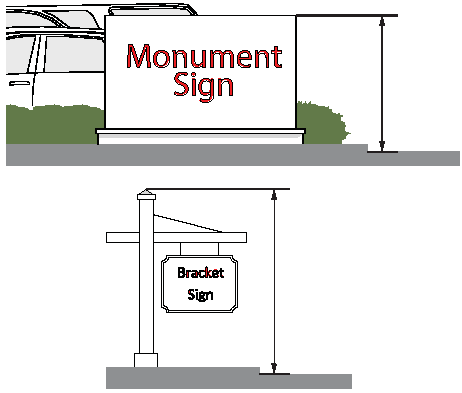
D.
Wall Sign
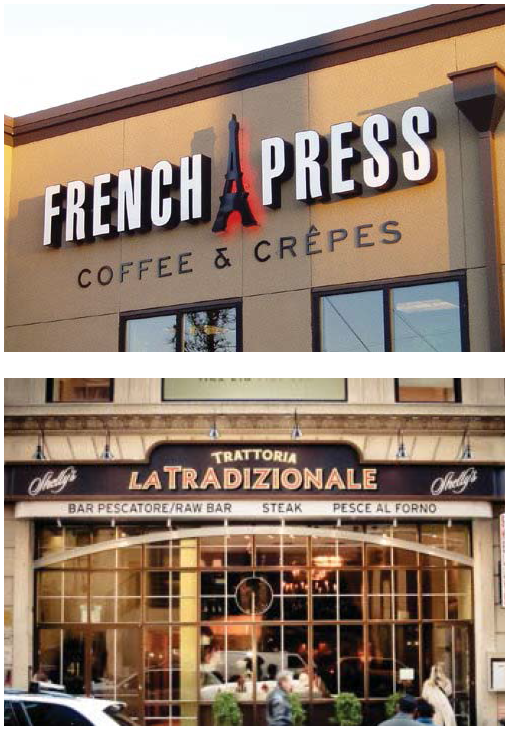
Description
A sign fastened to or painted on the wall of a building in such a manner that the wall becomes the supporting structure for, or forms the background surface of the sign and which does not project more than 1 foot from the building or structure.
General Provisions
1.
A wall sign must be placed no higher than 18 feet above the sidewalk.
2.
No portion of a wall sign may extend above the roof line or above a parapet wall of a building with a flat roof.
3.
No portion of a wall sign may extend above the lower eave line of a building with a pitched roof.
4.
A wall sign cannot cover windows or architectural details.
5.
A wall sign can be externally or internally illuminated under Sec. 7.2.8.M.
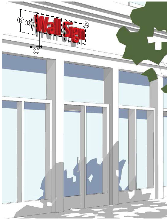
E.
Awning Sign
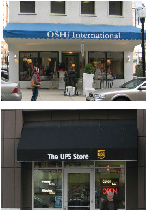
Description
A sign where graphics or symbols are painted, sewn, or otherwise adhered to the awning material as an integrated part of the awning itself.
General Provisions
1.
An awning sign cannot extend outside the awning.
2.
Only awnings over first and second story doors and windows may contain signs.
3.
A maximum of 1 sign is allowed per awning face.
4.
An awning sign may only be externally illuminated under Sec. 7.2.8.M.
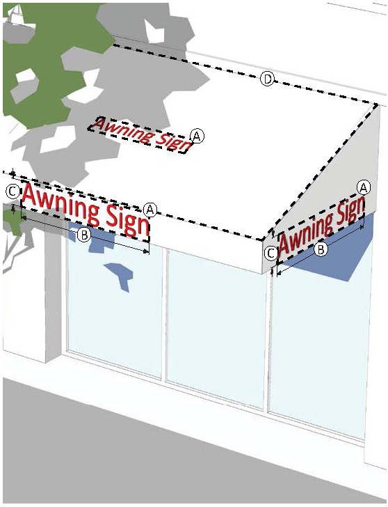
F.
Canopy Sign
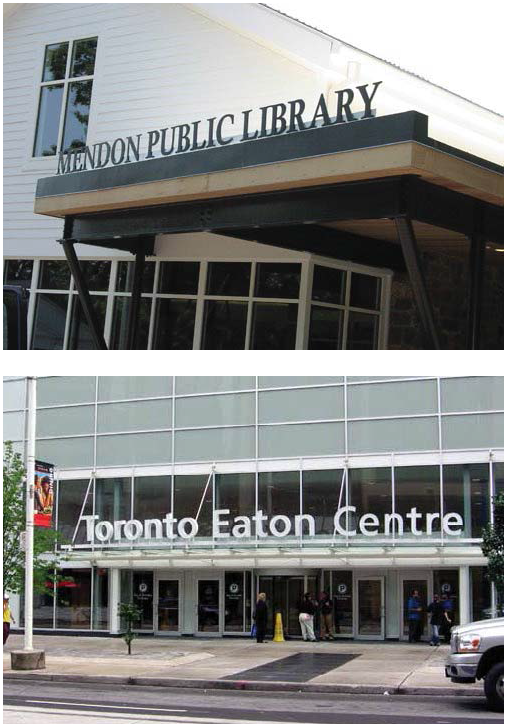
Description
A sign placed on a canopy so that the display surface is parallel to the plane of the wall.
General Provisions
1.
A canopy sign cannot extend outside the overall length or width of the canopy. However, a canopy sign may extend above or below the canopy.
2.
A maximum of 1 sign is allowed per canopy.
3.
Raceways are permitted for signs extending below or above the canopy. Otherwise, raceways are not permitted and the sign must be flush with the canopy face.
4.
A canopy sign can be externally or internally illuminated under Sec. 7.2.8.M.
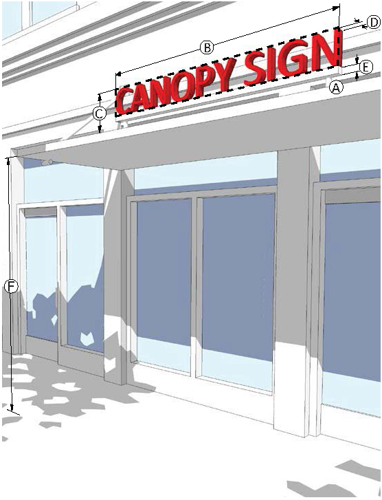
G.
Projecting Sign
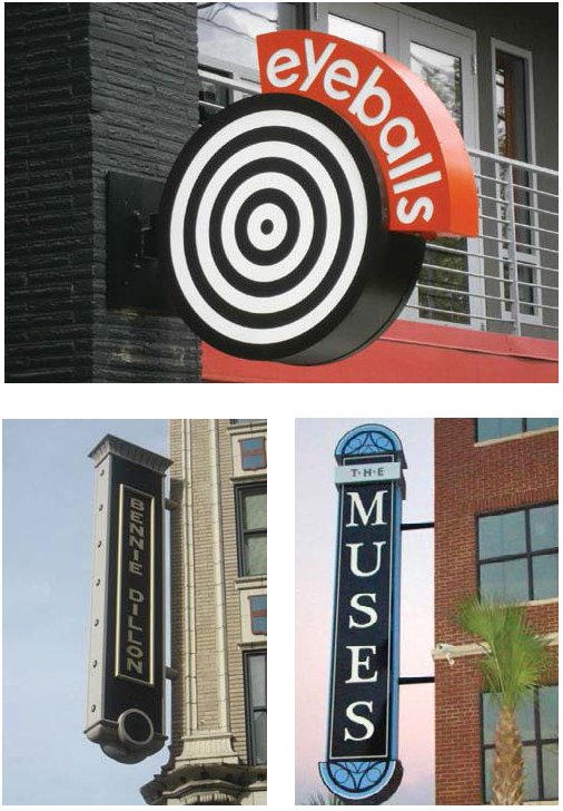
Description
A sign that is wholly or partly dependent upon a building for support, which projects at an angle away from the building, extending more than 1 foot.
General Provisions
1.
A projecting sign must be at least 25 feet from any other projecting sign.
2.
A projecting sign may be erected on a building corner when the building corner adjoins the intersection of 2 streets. Allocation of sign area from both streets may be used, however, in no case can the sign exceed the maximum height and width standards.
3.
The top of a projecting sign can be no higher than the top of the building. However, on 1 story buildings, the top of a projecting sign may have a maximum of 20% of the sign height above the top of the building.
4.
For buildings 4 stories and higher, a projecting sign cannot be located above the window sills of the fourth story.
5.
A projecting sign can be externally or internally illuminated under Sec. 7.2.8.M.
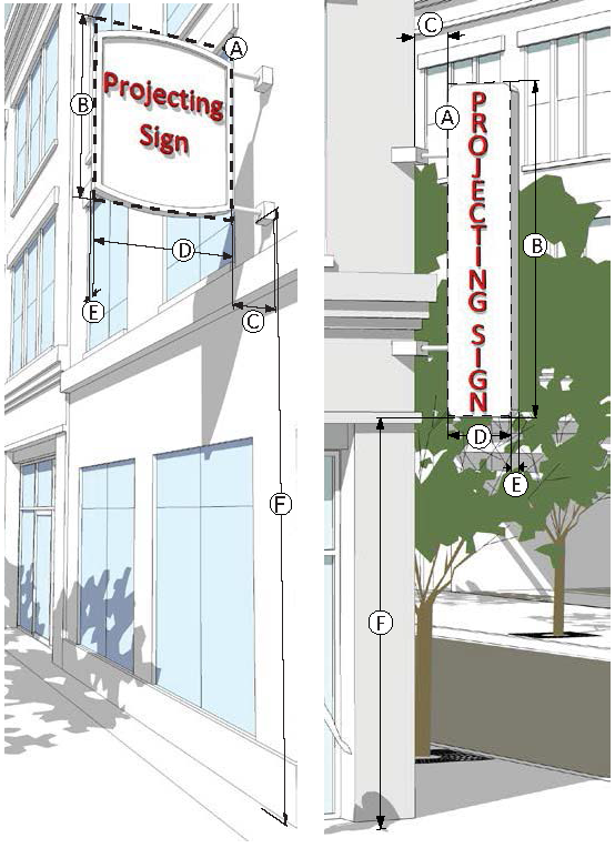
H.
Crown Sign
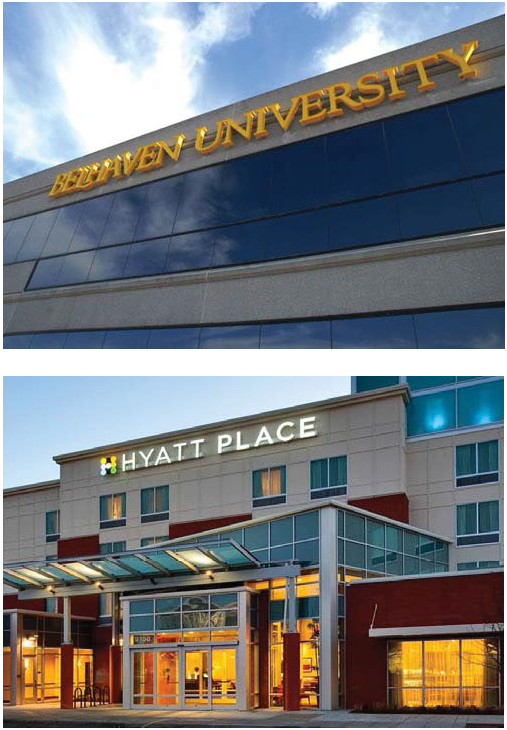
Description
A wall sign extending not more than 3 feet from the building façade located on the upper horizontal band of a building at least 55 feet in height.
General Provisions
1.
A crown sign is only allowed on buildings greater than 55 feet in height.
2.
A crown sign cannot be placed below the start of highest floor and cannot extend above the roof line.
3.
A crown sign cannot cover windows or architectural details.
4.
No more than 2 crown signs per building and no more than 1 crown sign per building façade are allowed.
5.
A crown sign can only be internally illuminated in accordance with Sec. 7.2.8.M.
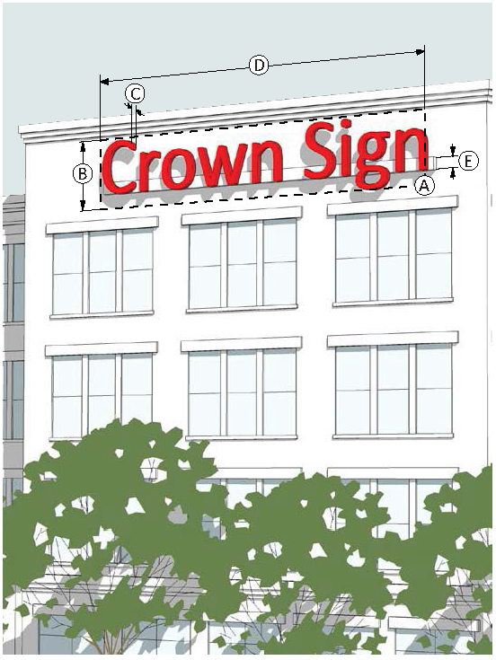
I.
Shingle Sign
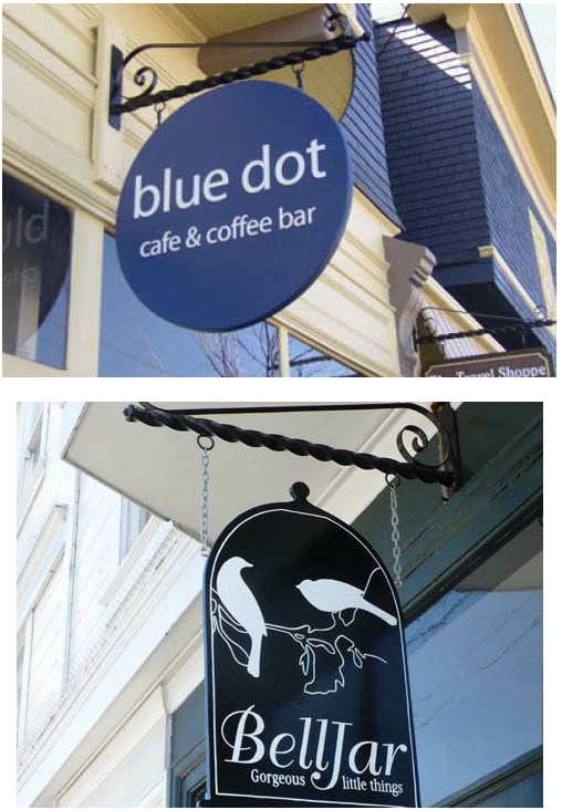
Description
A small projecting sign that hangs from a bracket or support and is located over or near a building entrance.
General Provisions
1.
A shingle sign must be located within 5 feet of an accessible building entrance.
2.
The hanging bracket must be an integral part of the sign design.
3.
A shingle sign must be located below the window sills of the second story on a multi-story building or below the roof line on a single-story building.
4.
A shingle sign can be externally illuminated in accordance with Sec. 7.2.8.M.
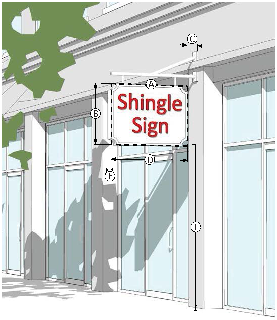
J.
Monument Sign
Description
A sign, no higher than 5 feet, attached along its entire width to a continuous pedestal. A monument sign is horizontally oriented or is square.
General Provisions
1.
1 monument is allowed per street frontage, except that 1 additional monument sign is allowed for properties with 200 feet or more of street frontage. Where more than 1 monument sign is permitted, signs along the same street frontage must be spaced a minimum of 150 feet apart.
2.
A monument sign must be set back at least 5 feet from the front property line and 10 feet from a side property line.
3.
A sign erected on a retaining wall is required to meet the standards for a monument sign. The height of the wall is included in the overall height calculation.
4.
A monument sign can be externally or internally illuminated in accordance with Sec. 7.2.8.M.
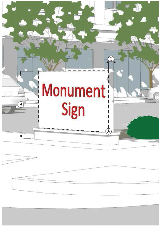
K.
Bracket Sign
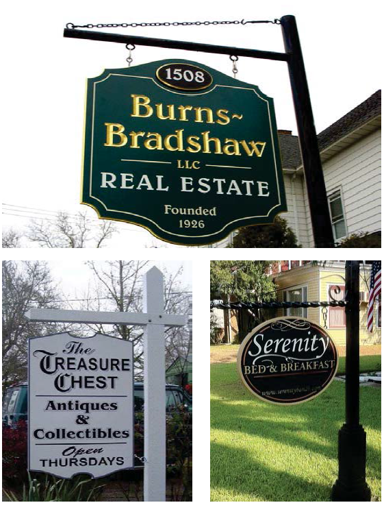
Description
A sign attached to the ground by 1 or more support structures that is not higher than 5 feet and hangs from a bracket or support.
General Provisions
1.
Only 1 bracket sign is allowed per building.
2.
A bracket sign must be located at least 25 feet from any other bracket sign.
3.
The hanging bracket must be an integral part of the sign design.
4.
A bracket sign can only be externally illuminated in accordance with Sec. 7.2.8.M.
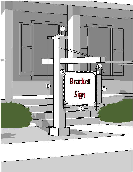
L.
Sidewalk Sign
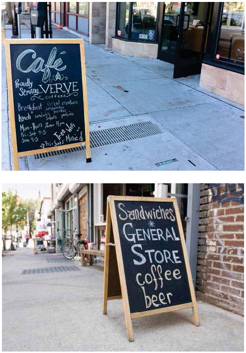
Description
A moveable sign not secured or attached to the ground or surface upon which it is located.
General Provisions
1.
Each ground floor tenant can have 1 sidewalk sign that must be located adjacent to the primary façade with the principal customer entrance, but cannot be placed more than 8 feet from that façade.
2.
A sidewalk sign must be located at least 25 feet from any other sidewalk sign.
3.
Sidewalk signs must be removed and placed indoors at the close of business each day.
4.
Sidewalk signs cannot obstruct vehicular, bicycle or pedestrian traffic and must comply with ADA clearance and accessibility.
5.
A sidewalk sign cannot be illuminated.
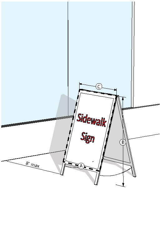
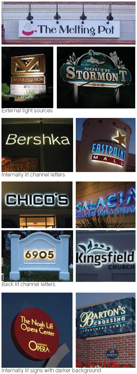
M.
Sign illumination
Illumination of signs must be in accordance with the following requirements:
1.
General Requirements
Illuminated tubing or strings of lights that outline property lines, sales areas, roof lines, doors, windows, or similar area are prohibited, except for temporary signs erected in connection with the observance of holidays.
2.
External Illumination
a.
Lighting directed toward a sign must be shielded so that it illuminates only the face of the sign and does not shine directly into a public right-of-way or onto adjacent properties.
b.
Projecting light fixtures used for externally illuminated signs must be simple and unobtrusive in appearance, and not obscure the sign.
3.
Internal Illumination
a.
Channel letters may be internally lit or back-lit.
b.
For internally illuminated signs on a background, the background must be opaque or a darker color than the message of the sign.
c.
Exposed neon may be used for lettering or as an accent.
4.
Prohibited Light Sources
The following light sources are not allowed:
a.
Blinking, flashing and chasing; and
b.
Bare bulb illumination.
5.
Raceways and Transformers
a.
If a raceway is necessary, it cannot extend in width or height beyond the area of the sign.
b.
A raceway must be finished to match the background wall or canopy, or integrated into the overall design of the sign.
c.
Visible transformers are not allowed.
N.
Design, Construction & Maintenance
All signs must be designed, constructed and maintained in accordance with the following standards:
1.
Except for permitted flags, temporary signs, and window signs conforming in all respects with the requirements of this Section, all signs must be constructed of durable, all-weather materials and must be permanently attached by direct attachment to a rigid wall, frame, or structure.
2.
All signs must be maintained in good structural condition, in compliance with all building and electrical codes, and in conformance with this Section, at all times.
3.
All signs must be kept and maintained in a safe, neat and orderly condition and appearance, and must be repainted or otherwise maintained periodically by the owner to prevent corrosion or deterioration caused by weather, age or any other conditions, and to keep the same in a safe, neat and orderly condition and appearance.
4.
Signs must not obstruct visibility from a driveway to an abutting street or vice versa.
O.
Nonconforming Signs
1.
Building Signs
A sign attached to a building must be brought into compliance with the provisions of this Code if a sign permit is required to rebuild a sign.
2.
Ground Signs
a.
A sign attached to the ground may change the face or panel of the sign that does not meet the area or height standards within this Code. However, in no instance must there be an increase in the degree of nonconformity. All new panels must conform to all illumination standards.
b.
A sign must be brought into compliance with the provisions of this Code if at any time the sign is altered, repaired, restored or rebuilt to the extent that the cost exceeds 50% of the estimated replacement cost of the sign (in current dollar value). All permits within any 6 consecutive calendar months will be aggregated for purposes of measuring the 50% standard.
3.
All signs
If the alteration or repair is caused by involuntary damage or casualty, the sign may be altered or repaired to its previous extent.
7.2.9. - SITE LIGHTING
A.
Applicability
1.
General
a.
No permit for the construction, reconstruction, extension, or alteration of any building, structure, or use of land, and no building or land, or any part of any building or land, may be occupied or used until lighting has been provided in accordance with the requirements of this Code.
b.
The installation of site lighting, replacement of site lighting, and changes to existing light fixture wattage, type of fixture, mounting, or fixture location must be made in compliance with this Code. Routine maintenance, including changing the lamp, ballast, starter, photo control, fixture housing, lens and other required components, is allowed for all existing fixtures.
c.
This Section does not apply to lighting installed in the public right-of-way.
2.
Additions
a.
When a building or site is renovated, any new or replaced outdoor light or lighting fixture must conform to the requirements of this Code.
b.
When the gross floor area or improved site area is increased, the additional floor or site area must conform to the lighting requirements of this Code.
c.
When the gross floor area or improved site area is increased by more than 50% cumulatively, both the existing use and the additional floor or site area must conform to the lighting requirements of this Code.
3.
Change in Use
A change in use does not trigger application of this Section.
B.
Light Level Measuring
1.
Light levels are specified, calculated and measured in footcandles. All footcandles values are maintained footcandles.
2.
Measurements are to be made at ground level, with the light-registering portion of the meter held parallel to the ground pointing up.
C.
Prohibited Sources
The following light fixtures and sources cannot be used:
1.
Cobra-head-type fixtures having dished or drop lenses or refractors, which contain sources that are not incandescent;
2.
Temporary searchlights and other high-intensity narrow-beam fixtures; and
3.
Light sources that lack color correction or do not allow for uniform site lighting.
D.
Design and Installation Requirements
1.
The maximum light level of any light fixture cannot exceed 2.0 footcandles measured at the right-of-way line of a street.
2.
Lighting must not be oriented onto adjacent properties, streets or sidewalks.
3.
Service connections for all freestanding lighting fixtures must be installed underground.
E.
Parking and Pedestrian Areas
1.
Light fixtures within parking and vehicular display areas may be no higher than 30 feet.
2.
Light fixtures within pedestrian areas may be no higher than 15 feet.
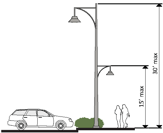
3.
Light fixtures located within 50 feet of the property line of a residential district may be no higher than 15 feet.
4.
All light fixtures must be full cutoff, except as listed in paragraph 6. below.
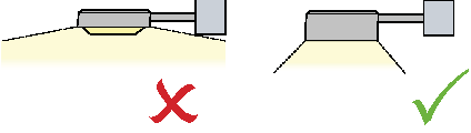
5.
Non-cutoff (unshielded) fixtures can be used when the maximum initial lumens generated by each fixture is less than 9500 initial lamp lumens. These fixtures generally feature globes or vertical glass planes and must be coated with an internal white frosting to diffuse light.
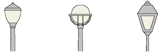
F.
Flood Lights and Flood Lamps
1.
Flood light fixtures must either be aimed down at least 45 degrees from vertical, or the front of the fixture shielded so that no portion of the light bulb extends below the bottom edge of the shield.
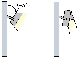
2.
Any flood light fixture located within 50 feet of a street right-of-way must be mounted and aimed perpendicular to the right-of-way, with a side-to-side horizontal aiming tolerance not to exceed 15 degrees.
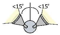
3.
All flood lamps emitting 1,000 or more lumens must be aimed at least 60 degrees down from horizontal, or shielded so that the main beam is not visible from adjacent properties or the street right-of-way.
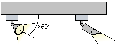
G.
Vehicular Canopies
Lighting under vehicular canopies must be less than 24 maintained footcandles, and be designed to prevent glare off-site. Acceptable lighting designs include the following:
1.
Recessed fixture incorporating a lens cover that is either recessed or flush with the bottom surface of the canopy;
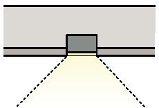
2.
Light fixture incorporating shields, or is shielded by the edge of the canopy itself, so that light is restrained to 5 degrees or more below the horizontal plane;
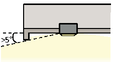
3.
Surface mounted fixture incorporating a flat glass that provides a cutoff design or shielded light distribution; or
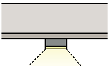
4.
Indirect lighting where light is beamed upward and then reflected down from the underside of the canopy, provided the fixture is shielded so that direct illumination is focused exclusively on the underside of the canopy.
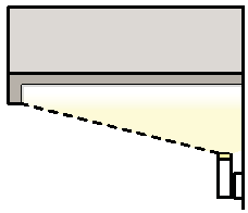
H.
Building Lighting
1.
Lighting fixtures must be selected, located, aimed, and shielded so that direct illumination is focused exclusively on the building façade, plantings, and other intended site features and away from adjoining properties and the street right-of-way.
2.
All wall pack fixtures must be full cutoff fixtures.
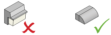
a.
Only lighting used to accent architectural features, landscaping or art may be directed upward, provided that the fixture is located, aimed or shielded to minimize light spill into the night sky.
7.2.10. - OUTDOOR DISPLAY AND STORAGE
A.
Applicability
The requirements of this Section apply to any site where merchandise, material or equipment is stored outside of a completely enclosed building.
B.
Outdoor Display
1.
Defined
a.
Outdoor display is the outdoor display of products actively available for sale that are placed inside a fully-enclosed building at the end of each business day. Outdoor display is not allowed in the public right-of-way.
b.
Outdoor display does not include merchandise or material in boxes, in crates, on pallets or other kinds of shipping containers, propane gas storage racks, ice storage bins, soft drink or similar vending machines (see outdoor storage).
2.
Standards
Outdoor display is permitted in association with any permitted nonresidential principal ground floor use in accordance with the following provisions:
a.
Outdoor display must be removed and placed inside a fully-enclosed building at the end of each business day.
b.
Outdoor display is permitted adjacent to the primary façade with the principal customer entrance, but cannot extend more than 8 feet from the façade and occupy no more than 30% of the horizontal width of the façade.
c.
Outdoor display cannot impair the ability of pedestrians to use the sidewalk or parking areas and must comply with ADA clearance and accessibility.
3.
Exceptions for Incidental, Temporary Outdoor Display and Sales
There may be incidental, temporary outdoor display and sale of merchandise normally sold by a business at the following times:
a.
Special sales events endorsed by the Cumberland Avenue Merchants Association.
b.
University of Tennessee home football game weekends.
c.
For 5 consecutive days beginning 2 days prior to the University of Tennessee fall and spring semester registration.
C.
Outdoor Storage
1.
Defined
a.
Outdoor storage is the overnight storage of products or materials outside of a building.
b.
Outdoor storage includes merchandise or material in boxes, in crates, on pallets or in shipping containers, propane gas storage racks, ice storage bins, soft drink or similar vending machines.
c.
Outdoor storage includes the overnight outdoor storage of vehicles awaiting repair, RV's and boats, garden supplies, building supplies, plants, fleet vehicles and other similar merchandise, material, vehicles, or equipment.
d.
Outdoor storage also includes salvage yards, vehicle storage yards; and overnight outdoor storage of shipping containers, lumber, pipe, steel, junk and other similar merchandise, material or equipment.
2.
Standards
Outdoor storage is not permitted except with permission of the Metropolitan Planning Commission. The Metropolitan Planning Commission will determine where outdoor storage may be allowed on the site, and its extent (vertically and horizontally) must be shown on the site plan.
7.2.11. - STREETSCAPE
A.
Applicability
1.
General
No permit for the construction, reconstruction, extension, or alteration of any building, structure, or use of land, and no building or land, or any part of any building or land, may be occupied or used until the streetscape has been provided in accordance with the requirements of this Section.
2.
Additions
a.
A building or site may be renovated or repaired without meeting the streetscape standards, provided there is no increase in gross floor area or improved site area.
b.
When a building or site increased in gross floor area or improved site area by more than 50%, the streetscape provisions of this Code must be met.
B.
Required Elements
All required streetscapes must be constructed with sidewalks and street trees as illustrated in Sec. 7.2.11.F, unless an alternative is approved by the Engineering Department.
C.
Tree Planting
1.
Unless otherwise noted below, all trees planted in accordance with this Section must be shade trees, planted every 30 feet on center, on average.
2.
Where overhead utilities exist, one understory tree must be planted every 20 feet on center, on average, for every required shade tree.
3.
All required street trees must meet the requirements of Sec. 7.2.7.D. and Sec. 7.2.7.E.
D.
Fee-in-Lieu
If determined by the Administrator that construction of improvements would result in the improvement of less than ½ of a linear block face; an equivalent payment in lieu of construction may be required.
E.
Certificate of Occupancy
1.
Sidewalks, streets, street trees and street lights must be installed prior to the issuance of a certificate of occupancy.
2.
A certificate of occupancy may be issued when the Administrator determines that due to the unavailability of plant material or weather concerns that immediate completion of the street trees would jeopardize the health of plant materials for a period of up to one year following the date of application for a certificate of occupancy.
F.
Required Streetscape
The following streetscape applies to all streets, except Cumberland Avenue.
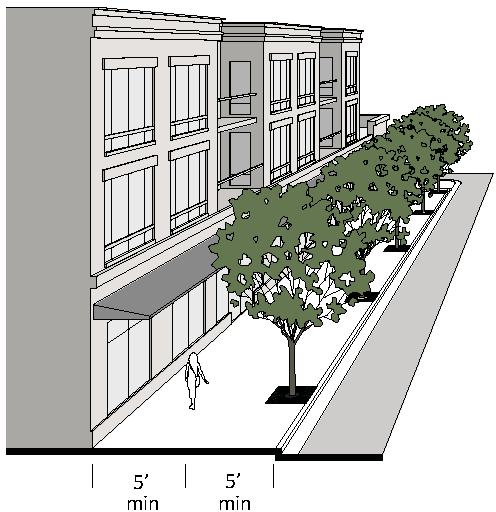
7.2.12. - DEFINED TERMS
A.
General Provisions
1.
General Meaning of Words and Terms
a.
All words and terms used have their commonly accepted and ordinary meaning unless they are specifically defined in this Code or the context in which they are used clearly indicates to the contrary.
b.
When vagueness or ambiguity is found to exist as to the meaning of any word or term used, any appropriate canon, maxim, principle or other technical rule of interpretations or construction used by the courts of this state may be employed to resolve vagueness and ambiguity in language.
2.
Graphics, Illustrations and Photographs
The graphics, illustrations and photographs used to visually explain certain provisions of this Code are for illustrative purposes only. Where there is a conflict between a graphic, illustration or photograph and the text of this Code, the text controls.
B.
Defined Terms
The following terms are defined for the purpose of this Code. Terms not defined may be defined in Article II "Definitions" of the Zoning Regulations. In such case, the definition contained in Article II "Definitions" should be used. If there is a conflict between a definition in Article II "Definitions" and this Code, the definition in this Code must be used.
ACTIVE USE means a use other than parking.
ADDITION (to an existing building) means any walled and roofed expansion to the perimeter of a building in which the addition is connected by a common load-bearing wall other than a fire wall. Any walled and roofed addition which is connected by a fire wall or is separated by independent perimeter load-bearing walls is "new construction."
ATTIC means habitable or uninhabitable space within a building situated within the structure of a pitched roof and above the uppermost regular story.
BUILDING FAÇADE means the face of a building that delineates the edge of conditioned floor space.
GROSS FLOOR AREA means the sum in square feet of the horizontal area of all floors of the building measured from the exterior walls or from the centerline when 2 buildings or units abut. Gross floor area includes basement floor area when more than 50% of the basement height is above the established curb level or above the finished lot grade level where the curb level has not been established. Elevator shafts, stairwells, floor space used for mechanical equipment, attics, balconies and mezzanines, enclosed porches, and floor area devoted to accessory uses is included in the calculation of gross floor area. However, the following is not included: any space devoted exclusively to on-site parking; or outdoor loading, display, storage, utility service areas; and uninhabited enclosed space on tops of roofs; or attic space having head room of less than 7'-6".
GROUND FLOOR means the floor of a building that is at or nearest to the level of the ground around the building. Does not include the floor of a basement.
IMPROVED SITE AREA means the sum of the horizontal area of the outside portion of the site and includes any space devoted to on-site parking; outdoor loading, display, storage, utility service, decorative areas and landscaped areas that are part of the original site plan approval.
RACEWAY means an enclosed channel of metal or nonmetallic materials designed expressly for holding wires or cables associated with illuminating a sign.
SHADE TREE means a locally adapted species with an expected mature height of 35 feet or greater and an expected mature crown spread of at least 30 feet or greater.
UNDERSTORY TREE means a locally adapted species with an expected mature height of at least 15 feet and an expected mature crown spread of at least 15 feet.
UPPER STORY means any story above the ground story or floor.