
La Fayette City Zoning Code
ARTICLE III
APPLICATION, REGULATIONS, AND SUBDIVISIONS
DIVISION 1. - APPLICATION AND REGULATIONS[2]
The regulations set by this Chapter within each district shall be minimum regulations and shall apply uniformly to each class, type or use of building or land, except as hereinafter provided.
Editor's note— Ord. No. 09-02, adopted Mar. 9, 2009, enacted provisions intended for use as Div. 2, subdivisions and land development. To preserve the style of this Code, and at the discretion of the editor, Div. 1 has been added to Art. III for purposes of clarification.
DIVISION 2. - SUBDIVISIONS AND LAND DEVELOPMENT ORDINANCE[3]
Editor's note— Ord. No. 09-02, adopted Mar. 9, 2009, enacted provisions intended for use as § 29-36, subdivisions and land development. To preserve the style of this Code, and at the discretion of the editor, Div. 2, § 29-36, has been added to Art. III for purposes of clarification.
Section 29-30. - Use.
No building or land shall hereafter be used or occupied and no building or part thereof shall hereafter be erected, constructed, reconstructed, structurally altered or moved unless in conformity with all the regulations herein specified for the district in which it is located.
Section 29-31. - Height and density.
No building or other structure shall hereafter be created or altered to exceed the height, or to have a greater number of families or occupy a smaller lot area per family, or occupy a greater percentage of lot area than herein required; or in any other manner contrary to the provisions of this Chapter.
Section 29-32. - Reduction of lot area.
No lot, even though it may consist of one or more adjacent lots of record, shall be reduced in size so that the lot width or depth, front, side or rear yard, lot area per family, or other requirements of this Chapter, are not maintained. This section shall not apply when a portion of a lot is subsequently acquired for public purposes.
Section 29-33. - Principal building.
No building hereafter shall be erected except on a lot as defined herein, and in no case shall there be more than one (1) principal building on each lot except as otherwise provided herein.
Section 29-34. - Street frontage.
No building shall be erected on a lot without direct access to a public street, and no lot shall be created which does not abut for at least 25 feet along a public street. With regard to only lots located in B-1 and B-2 Districts that do not have a direct access to a public street, the requirements of this Subsection may be satisfied if any such lot has a perpetual non-exclusive easement at least 25 feet in width for the purposes of ingress, egress, and utilities extending from said lot to a public street.
(Ord. No. 04-12, § 1, 8-9-2004)
Section 29-35. - Corner and double frontage lots.
On lots having frontage of more than one street in residential districts, a minimum front yard shall be provided for each street in accordance with the provisions of this Chapter.
Section 29-36. - Subdivisions and land development.
(1)
Title. This ordinance shall be known and may be referred to as the Subdivision and Land Development Ordinance of City of LaFayette, Georgia.
(2)
Purposes. This ordinance is adopted for the following purposes:
(a)
Promote the orderly, planned, efficient, and economic development of the City of LaFayette and to guide future growth in accordance with the Comprehensive Plan.
(b)
Ensure that lands subdivided are of such character that they can be used for building purposes without danger to the health or safety of residents, and to secure safety from fire, flood, or other menace.
(c)
Prevent the pollution of air, land, streams, and ponds, as well as encourage the wise use and management of natural resources throughout the City of LaFayette, and preserve the topography and beauty of the community and the value of land.
(d)
Ensure the proper provision of improvements such as drainage, water, sewerage, and capital improvements such as schools, parks, playgrounds, recreational facilities, and transportation facilities.
(e)
Provide for open spaces through the most efficient design and layout of the land.
(f)
Establish procedures for the subdivision and re-subdivision of land in order to further the orderly development of land.
(g)
Provide for the proper monumenting of subdivided land and proper legal descriptions.
(h)
Help eliminate the costly maintenance problems that develop when streets and lots are established without proper consideration given to various public purposes.
(i)
Facilitate and inform lot purchasers who generally lack the specialized knowledge needed to evaluate subdivision improvements and design.
(3)
Rules of Construction. For the purpose of these regulations, the following rules of construction shall apply:
(a)
In case of a conflict between the text of these regulations and any caption, figure, illustration, table, or map, the text of these regulations shall control. In case of a conflict between a chart and an illustration, the chart shall control. All illustration included in these regulations are for illustrative purposes only.
(b)
In case of any conflict in limitations, restrictions, or standards applying to an individual use or structure, the more restrictive provisions shall apply.
(c)
The words "shall," "must," and "will" are mandatory in nature, implying an obligation or duty to comply with the particular provision.
(d)
The word "may" is permissive in nature.
(e)
Words used in the present tense include the future tense.
(f)
Words used in the singular number include the plural number and the plural number includes the singular number, unless the context of the particular usage clearly indicates otherwise.
(g)
Words used in the masculine gender include the feminine gender.
(h)
Any act authorized by these regulations to be carried out by a specific official or agency of the City is impliedly authorized to be carried out by a designee of such official or agency. Any transfer of duties to a different official impliedly transfers the authority to carry out acts under these regulations.
(i)
The time within which an act is to be done shall be computed by excluding the first and including the last day; if the last day is a Saturday, Sunday or a legal holiday. that day shall be excluded.
(4)
Definitions.
Access: A way or means of approach to provide physical entrance to a property.
Access easement: An easement devoted to vehicular access which affords a principal means of access to abutting property or properties, but which is not necessarily open to the general public and which is not necessarily improved to standards of the City.
Agricultural facility: Includes, but is not limited to, any land, building, structure, pond, impoundment, appurtenance, machinery, or equipment which is used for the commercial production or processing of crops, livestock, animals, poultry, honeybees, honeybee products, livestock products, poultry products, timber, forest products, or products which are used in commercial aquaculture. Such term does not include any farm labor camp or facilities for migrant farm workers.
Agricultural operation: Those practices involving the establishment, cultivation, or harvesting of products of the field or orchard; the preparation and planting of pasture land; farm ponds; dairy operations; livestock and poultry management practices; the construction of farm buildings; the plowing, tilling, or preparation of soil at an agricultural facility; the planting, growing, fertilizing, harvesting, or otherwise maintaining of crops; the application of pesticides, herbicides, or other chemicals, compounds, or substances to crops, weeds, or soil in connection with the production of crops, timber, livestock, animals, or poultry; the breeding, hatching, raising, producing, feeding, keeping of livestock, hogs, equines, chickens, turkeys, poultry or other fowl normally raised for food, mules, cattle, sheep, goats, dogs, rabbits, or similar farm animals for commercial purposes, but not the regular slaughtering, or processing of such animals; the production and keeping of honeybees, the production of honeybee products; the production, of eggs or egg products; the manufacturing of feed for poultry or livestock; the rotation of crops, including without limitation timber production; commercial aquaculture; and the application of existing, changed, or new technology, practices, processes, or procedures to any agricultural operation. Agricultural operation does not include a roadside stand or agricultural processing.
Alley: A strip of land dedicated to public use providing vehicular and pedestrian access to the rear of properties which abut and are served by a road or street.
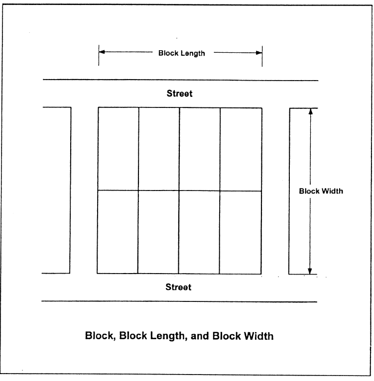
Block: An area of land within a subdivision that is entirely surrounded by public streets, public lands, railroad rights-of-way, watercourses, or other well defined and fixed boundaries. (See Figure).
Comprehensive plan: Any plan adopted by the Mayor and City Council of the City of LaFayette, Georgia, or portion of such plan or plans. This definition shall be construed liberally to include the major thoroughfare plan, master parks and recreation plan, or any other study, document, or written recommendation pertaining to subjects normally within the subject matter of a Comprehensive Plan as provided by the Georgia Planning Act of 1989, if formally adopted by the local governing body.
Conservation: The management of natural resources to prevent waste, destruction, or degradation.
Conservation areas, primary: Any property qualifying as conservation use property under O.C.G.A. § 48-5-7.4; and any steep mountain slopes, floodplains, wetlands, soils subject to slumping, water bodies, upland buffers around wetlands and water bodies, critical wildlife habitat, and sites of historic, cultural, or archaeological significance, located outside of building envelopes and lots established for building purposes; and any "sensitive natural area" as defined herein.
Conservation areas, secondary: Prime farmland, natural meadows, mature woodlands, farm fields, localized aquifer recharge areas, and lands containing scenic views and sites, located outside of building envelopes and lots established for building purposes.
Conservation easement: A legally enforceable agreement between a property owner and the holder of the easement, in a form acceptable to the City Attorney and recorded in the office of the Clerk of Superior Court of Walker County. A conservation easement restricts the existing and future use of the defined tract or lot to conservation use, agriculture, passive recreation, or other use approved by the Mayor and City Council and prohibits further subdivision or development. Such agreement also provides for the maintenance of open spaces and any improvements on the tract, or lot. Such agreement cannot be altered except with the express written permission of the easement holder and any other co-signers. A conservation easement may also establish other provisions and contain standards that safeguard the tract's or lot's special resources from negative changes.
Conservation subdivision: A subdivision where open space is the central organizing element of the subdivision design and that identifies and permanently protects all primary and all or some of the secondary conservation areas within the boundaries of the subdivision.
Contiguous common parcels: Parcels adjoining or touching other land at a common point and having a common owner, regardless of whether portions of the parcels have separate tax lot numbers, or were purchased in different land lots, or were purchased at different times.
Cross-section: A profile of the ground surface perpendicular to the centerline of a road, stream, or other feature.
Cul-de-sac: A dead-end street of limited length having a primary function of serving adjoining land, and constructed with a turnaround at its end.
Cul-de-sac, temporary: A nonpermanent vehicular turn around located at the termination of a street or alley.
Curb radius: The curved edge of a road at road intersections.
Deceleration lane: An added roadway lane, of a specified distance and which may include a taper, as approved by the Land Use Officer that permits vehicles to slow down and leave the main vehicle stream.
Dedication: The deliberate appropriation of land by an owner for any general and public use or purpose, reserving to himself no other rights than such as are compatible with the full exercise and enjoyment of the public uses to which the property has been devoted. Dedication of land must be formally approved and accepted by the Mayor and Council.
Dedication plat: A plat that indicates property to be dedicated for public right-of-way or land for public use. A plat dedicating property must be approved by the Mayor and Council.
Detention: The temporary restraining of storm water on-site.
Detention pond: A pond or pool used for the temporary storage of storm water runoff and which provides for the controlled release of such storm water. If the pond becomes a permanent amenity of the site then the property therein must have a specific owner or must be under the direct responsibility of a permanent group (such as a home owners association). If the area becomes a pond and holds water after normal storm-water runoff has taken place then the pond must be fenced according to swimming pool requirements.
Development: Any manmade change on improved or unimproved real estate, including but not limited to, buildings, structures, mining, dredging, filling, grading, paving, excavation, drilling, or permanent storage of materials or equipment.
Development plan: Any plan containing substantial information required to be filed by this ordinance, which shows how the property to be affected by the development will be changed and improved in a specific manner, including the installation of roads and utilities and the erection of buildings and structures, among other specific requirements.
Drainage structure: A device composed of a virtually non-erodible material such as concrete, steel, plastic or other such material that conveys water from one place to another by intercepting the flow and carrying it to a release point for storm-water management, drainage control, or flood control purposes.
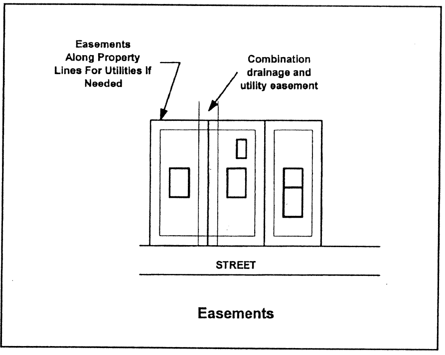
Easement: A grant of one or more of the property rights by the property owner to and/or for use by the public, a corporation, or another person or entity. (See Figure)
Escrow account: A type of subdivision improvement guarantee where the subdivider deposits either cash, a note, a bond, or some other instrument readily convertible to cash for specific face value specified by the Land Use Officer to cover the costs of required improvements.
Excavation: A portion of land surface or area from which earth has been removed or will be removed by excavation; the depth below original ground surface to excavated surface. Also known as "cut."
Fill: A portion of land surface to which soil or other solid material has been added; the depth above the original ground.
Final plat: The final drawing of a subdivision and, as applicable, dedication, prepared for filing for record with the Clerk of the Walker County Superior Court, and containing all elements and requirements set forth in this ordinance. The plat must be signed and stamped by a state licensed engineer or surveyor.
Fire flow: The flow of water required to extinguish the largest probable fire served by a water facility.
Forestry: An operation on a tract or parcel of land involving the growing, conserving, and managing of forests and forest lands (includes the term "silviculture"). Forestry operations or practices include the raising and harvesting of timber, pulp woods and other forestry products for commercial purposes. Incidental uses to forestry include the erection of accessory structures and improvements normally associated with timber production including, but not limited to storage buildings, the construction of roads, insect and disease control, fire protection, and may include the temporary operation of a sawmill and/or chipper to process the timber cut from the parcel or parcels. This term does not include the cutting of timber associated with approved land development. This definition does not include processing of timber into finished or semi-finished products or other than temporary storage of logs.
Gated community: Residential areas containing lots and that restrict access to roads and spaces. Gates can include guard houses, electronic arms operated by card, codes, or remote control devices. Visitors must stop to be verified for entry.
Grade, natural: The existing grade or elevation of the ground surface that exists or existed prior to man-made alterations, such as grading, grubbing, filling, or excavating.
Gradient: The rate of vertical change between two (2) distance points, determined by dividing the vertical distance by the horizontal distance (i.e., rise over run).
Grading: Altering the shape of ground surfaces to a predetermined condition; this includes stripping, cutting, filling, stockpiling and shaping or any combination thereof and shall include the land in its cut or filled condition.
Greenway: A linear park or open space conservation area that provides recreational opportunities, pedestrian and/or bicycle paths, and/or conservation of open spaces or natural areas. The creation of this type of area and its maintenance must be approved by the City.
Habitat for endangered or threatened species: An area verified by the Georgia Department of Natural Resources as: 1) actually containing naturally-occurring individuals of a species that has been listed as endangered or threatened under the Federal Endangered Species Act, as amended, and, 2) being likely to support the continued existence of that species by providing for a significant portion of that species' biological requirements, and that meets the definition of "natural conditions" as defined by this ordinance.
Half street: A portion of the ultimate width of a road or street where the remaining portion of the road or street shall be provided at a future date.
Home owners association: An organization formed for the maintenance and operation of the common areas of a development, where membership in the association is automatic with the purchase of a dwelling unit or lot within the development, with the ability to legally assess each owner of a dwelling unit or lot and which has authority to place a lien against all dwelling units and lots within the development. This association must be created, have members with bylaws of operation and continue to function as long as the subdivision exists. The association is responsible for enforcing any covenants, conditions and restrictions that apply to the property.
Impact: The effect of any direct man-made actions or indirect repercussions of man-made actions on existing physical, social, or economic conditions.
Improvements: The physical addition and changes to land that may be necessary to produce usable, desirable and acceptable lots or building sites.
Intra-family land transfer: A division of land within one or more specified land use districts that creates at least one (1) additional lot but not more than four (4) additional lots, each of which is not less than one (1) acre nor more than five (5) acres in size, where each and every lot within the subdivision is conveyed to the children, spouse and children, surviving heirs, in-laws, or immediate relatives of the property owner, or some combination thereof, and where no more than one (1) lot in the subdivision is deeded to any one individual. Each lot created in an intra-family land transfer is conveyed by final plat, and each lot meets all the requirements of this ordinance for the creation of a lot or lots such as access, lot size, and lot width, but not require meeting subdivision regulations. This definition shall not include or authorize any land subdivision that involves or will involve the creation of lots for sale or otherwise involves a property transfer for money, tangible or intangible personal property, real property exchanges, or other conveyances for consideration.
Land suitability analysis: A method used by land planners, in preparing land use plans at a community wide scale or land plans at a site development scale, to evaluate the fitness of land for various uses based at least partially on environmental criteria. The end product of land suitability analysis is typically a map or set of maps depicting the appropriateness of land areas for various land uses.
Land trust: A private, nonprofit conservation organization formed to protect natural resources, such as productive farm or forest land, natural areas, historic structures, and recreational areas. Land trusts purchase and accept donations of conservation easements. Land Trusts educate the public about the need to conserve land and some provide land-use and estate planning services to local governments and individual citizens.
Letter of credit: A type of subdivision improvement guarantee whereby a subdivider secures an instrument from a bank or other institution or from a person with resources sufficient to cover the cost of improvements required by the City of LaFayette. The instrument pledges the creditor to pay the cost of improvements in case of default by the subdivider.
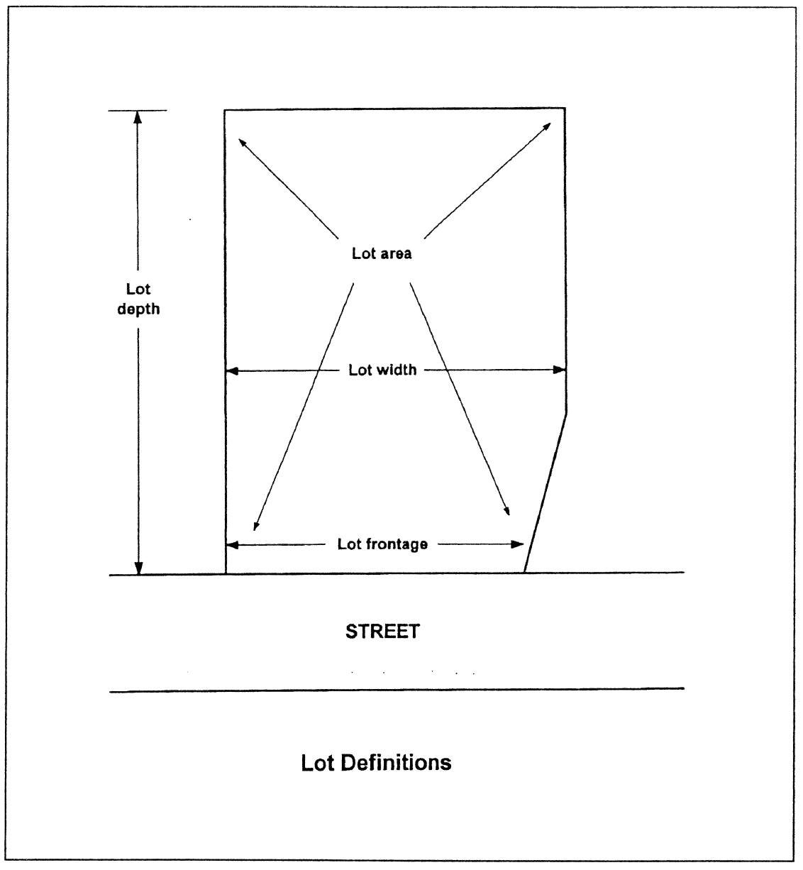
Lot: A portion or parcel of land separated from other portions or parcels by description (such as on a subdivision plat of record or a survey map or plat) or described by metes and bounds, and intended for use, transfer of ownership, or for building development. The word "lot" shall not include any portion of a dedicated right-of-way.
Lot area: The total horizontal area within the lot lines of a lot, exclusive of public road right-of-ways or private roads or access easements, where they exist.
Lot, corner: A lot abutting upon two (2) or more streets at their intersection.
Lot, depth: The average horizontal distance between the front and rear lot lines.
Lot, double frontage: A lot other than a corner lot that has frontage upon two (2) or more streets that do not intersect at a point abutting the property.
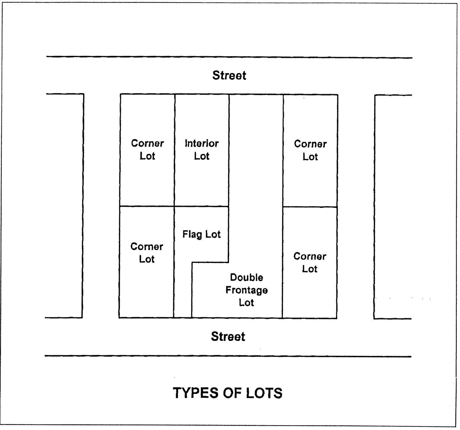
Lot, flag: A tract or lot of land of uneven dimensions in which the portion fronting on a street is less than the required minimum width required for construction of a building or structure on that lot. Such lots have elongated access from the road and a conventionally proportioned building site at the rear of the lot.
Lot, through: See "Lot, double frontage".
Lot frontage: The width in linear feet of a lot where it abuts the right-of-way of any street.
Lot of record: A lot which is part of a subdivision approved in accordance with land subdivision requirements, a plat of which has been lawfully recorded in the records of the Clerk of the Walker County Superior Court; or a parcel of land, the deed of which was lawfully recorded in the same office prior to the adoption of this ordinance.
Lot width: The shortest distance between side lot lines measured at the regulatory/required front building line, or in the absence of a front building line regulation, the distance between side lot lines measured at the front line of the building located or intended to be located on the lot.
Metes and bounds: A system of describing and identifying land by distances or measures (metes) and bearings or direction (bounds) from an identifiable point of reference, such as a monument or other marker or the corner of intersecting roads.
Model home: A principal residential building, temporarily open to viewing by prospective homebuyers, on property containing or proposed to contain a residential subdivision, and which may also be used temporarily as real estate sales office for lots in the residential subdivision.
Mortgage lot: A lot which is created for the primary or sole purpose of meeting the requirement of a bank or lending institution for a loan or mortgage in cases where property descriptions must be smaller than the total acreage of the tract on which the principal building that is the subject of the loan is located.
Natural conditions: The flora, fauna, soil and water conditions that would develop on a specific tract of land if all human interference were to be removed. The tract of land must have been undisturbed for a sufficient period of time for natural processes to dominate the tract. This period of time will vary among environments.
Off-site: Beyond the boundaries of the property in question.
On-site: Within the boundaries of the property in question.
Open space: Any combination of primary conservation areas and secondary conservation areas, as defined, that together form a permanent, undivided or relatively undivided, undeveloped area. As much as twenty-five (25) percent of the open space may be devoted to active recreational facilities, as defined. Easements for electric transmission lines or any other above ground improvement shall not be considered open space. Stormwater management features, such as lakes, ponds, and ways, may be considered open space at the discretion of the Land Use Officer, provided that such areas are designed and maintained in a manner that contributes to open space and the aesthetics of the subdivision.
Open space, public: An area within a development or subdivision designed and intended for the use and enjoyment of all residents or for the use and enjoyment of the public in general.
Original tract: A unit of land which the owner holds under single or unified ownership, or which the owner holds controlling interest on the effective date of this ordinance, where all land abutting said tract is separately owned by others, not related to or associated by business partnership with the owner.
Package treatment plant: A sewage treatment facility, usually privately operated, typical having a treatment capacity of less than one million (1,000,000) gallons per day. In most cases, a package treatment plant is considered a temporary means of wastewater treatment until connection to a public sanitary sewerage system is available.
Pavement width: The width of a given lane, road, or other road pavement, measured from back-of-curb to back-of-curb, or to the edge of pavement where no curbs are required or exist.
Pedestrian way: A public right-of-way or private easement across a block or within a block to provide access for pedestrians and which may, in addition to providing pedestrian access, be used for the installation of utility lines.
Performance bond: A type of subdivision improvement guarantee in the form of a bond, secured by the subdivider from a bonding company, in an amount specified by the Building Official to cover the costs of required improvements, and payable to the City. The City may call in the performance bond in the event the subdivider defaults on required improvements.
Performance guarantee: Any financial deposit or other security that may be accepted by the City as a guarantee that improvements required as part of an application for subdivision or land development are satisfactorily completed in conformance with approved plans.
Person: A natural human being, estate, association, firm, partnership, corporation, or other legal entity.
Potable water: Water that is suitable for human consumption, human contact, or in the preparation of foods for human consumption.
Preliminary plat: A tentative drawing or map of a proposed subdivision. A preliminary plat is the basis for the approval or disapproval of the general layout of a land subdivision.
Planned unit development: A form of development usually characterized by a unified site design for a number of housing units, clustered buildings, common open space, and a mix of building types and land uses in a slightly more dense setting than allowable on separate lots.
Professional engineer: An engineer duly registered or otherwise authorized by the State of Georgia to practice in the field of civil engineering.
Protective covenants: Contracts made between private parties as to the manner in which land may be used, with the view toward protecting and preserving the physical and economic integrity of any given area.
Recreation, active: Leisure activities that are facility oriented, such as swimming pools, tennis courts, and ball fields.
Recreation, passive: Leisure activities that are natural resource oriented, such as hiking trails, conservation areas, and nature preserves.
Registered land surveyor: A surveyor duly registered or otherwise authorized by the State of Georgia to practice in the field of land surveying.
Reservation: The designation by plat or deed of a certain area reserved for possible future public purposes. A reservation does not transfer title of the reserved area to the public unless the local governing body accepts the area for public purposes.
Resubdivision: The act of changing an existing lot created by a plat and recorded in the Office of the Clerk of Superior Court of Walker County, Georgia.
Reserve strip: A strip of land across the end of, or along the edge of, a street, alley, or lot for the purpose of controlling access which is reserved or held until future street extension or widening.
Retaining wall: A wall or similar structure used at a grade change to hold soil on the up-hillside from slumping, sliding, or falling.
Retention: The permanent maintenance of storm water on-site.
Retention pond: A pond or pool used for the permanent storage of storm water runoff. This pond must be designed with a protective fence similar to the requirements for swimming pools.
Right-of-way: A strip of land acquired by reservation, dedication, forced dedication, prescription, or condemnation and intended to be occupied by a road, crosswalk, railroad, electric transmission line, oil or gas pipeline, water line, sanitary storm sewer, or other similar use. Generally, the right of one to pass over the property of another.
Right-of-way, public: That area, distinguished from an easement or private road right-of-way, which is owned in fee-simple title by the local governing body or other government, for the present or future use of roads, roads and highways, together with its drainage facilities and other supporting uses and structures.
Right-of-way, private: That area, distinguished from an access easement or public right-of-way, dedicated to property owners of the subdivision involved or to other individuals, and which affords permanent access to abutting property or properties. A private right-of-way is distinguishable from a public road right-of-way in that maintenance and ownership of the road and accessory improvements is by private individuals or a private association rather than the local governing body or another governmental entity.
Riprap: Rocks, rubble, or stones, irregularly shaped and at least six (6) inches in diameter, used for erosion control and soil stabilization.
Scenic views and sites: Those geographic areas containing visually significant or unique natural features, as identified in the Comprehensive Plan, or by other reasonable means.
Sensitive natural area: Any area, as identified now or hereafter by the Department of Natural Resources, which contains one or more of the following: habitat, including nesting sites, occupied by rare or endangered species; rare or exemplary natural communities; significant landforms, hydroforms, or geological features; and/or other areas so designated by the Department of Natural Resources that are sensitive or vulnerable to physical or biological alteration.
Septic tank: An approved watertight tank designed or used to receive sewage from a building sewer and to affect separation and organic decomposition of sewerage solids, and discharging sewage effluent to an absorption field or other management system.
Sewer: An artificial and usually subterranean conduit designed to carry off sewage and/or water. The term includes any pipe, manhole, connection, or other appurtenances thereto, located in a public right-of-way or easement that is designed to transport sewage and/or water.
Sewer, sanitary: A sewer that carries sewage and residential, commercial or industrial waste.
Sewer, storm: A sewer that carries storm, surface, and ground water drainage but excludes sewage and residential, commercial, and industrial wastes.
Sidewalk: A hard-surfaced pedestrian access area adjacent to or within the right-of-way of a public road.
Site plan: A drawing of a multi-family residential, institutional, office, commercial, or industrial development, showing the general layout of a proposed development including among other features the location of buildings, parking areas, and buffers and landscaping. The site plan is the basis for the approval or disapproval of the general layout of a development in the case of a multiple-family residential, institutional, office, commercial, or industrial development.
Sight visibility triangle: The areas at the corners of an intersection of two (2) roads, or at the intersection of a road and any driveway, which may vary based on type of road involved, that are to be kept free of vegetation, trees, shrubs, ground covers, berms, fences, buildings, structures, or other materials or objects that may impair or impede a person's ability to observe other persons or traffic on the adjacent intersecting roadway and/or driveway.
Slope: Degree of deviation of a surface from the horizontal, usually expressed in percent or degree; the ratio of the difference in elevation between two (2) points on the ground, and the horizontal distance between these two (2) points. For purposes of determining steep slopes, slopes shall be measured between two (2) points on the ground separated by five hundred (500) feet or more.
Steep slopes: Lands with slopes of at least thirty-five (35) percent, as indicated in the Comprehensive Plan of the City, or which can be calculated with aid of a United States Geological Survey 1:24,000, 7.5 minute quadrangle topographic map or other available topographic information.
Street: Any vehicular way, other than an alley, that:
(a)
Is an existing federal, state, county or municipal roadway;
(b)
Is constructed and open to vehicle travel as approved by other official action of the Mayor and City Council.
Street, collector: Unless otherwise defined by the Major Transportation Plan or Comprehensive Plan, a collector street is a public street whose function is to collect traffic from neighborhoods and local streets and which connects to another public street of equal of greater classification. A collector also may provide direct access to adjacent properties.
Street, local: Unless otherwise defined in the Major Transportation Plan or Comprehensive Plan, any public street, except an alley, collector, or arterial, and which has a primary function to provide direct access to adjoining properties and which serves a limited area only, usually a single land subdivision.
Street, major arterial: Unless otherwise defined by the Major Transportation Plan or Comprehensive Plan, a major arterial street is a street connecting two (2) or more towns or communities, connecting two (2) highways of equal or greater capacity, or serving as the primary access to a large land area. A major arterial may also serve a large traffic generator (e.g., an industrial area) and perform a secondary function of providing local access.
Street, marginal access: A residential street parallel and adjacent to a major thoroughfare and which provides access to abutting properties with protection from through-traffic.
Street, private: A road or street that has not been accepted for maintenance by the City and that is not owned and maintained by a state, county, city, or another public entity.
Subdivider: Any person, as defined by this ordinance, who undertakes the subdivision of land, and any person having such a proprietary interest in land to be subdivided as will authorize the maintenance of proceedings to subdivide such land under this ordinance, or the authorized agent of such person.
Subdivision: A division of a tract or parcel of land into two (2) or more lots, building sites, or other divisions for the purpose of sale or building development, whether immediate or future, including all division of land involving the dedication of a new street or a change in existing streets. The word "subdivision" includes re-subdivision and, when appropriate to the context, relates either to the process of subdividing or to the actual land or area which is subdivided.
Subdivision, minor: A subdivision of four (4) or fewer lots, which does not involve the construction of a new public or private street. Because minor subdivisions do not involve the construction of a new public or private street, they are processed administratively by the Building Official as final plat applications that do not require preliminary plat approval. Any improvements to an existing public street abutting the tract proposed for minor subdivision, or the installation of utilities along said existing public road, as may be required to comply with this ordinance, shall be done according to plans and permit requirements of this ordinance.
Subdivision, major: The division of a tract or parcel of land into five (5) or more lots which may or may not involve the construction of a new public or private street; or any subdivision that involves the construction of a new public or private street. Because major subdivisions involve construction of a new public or private street or the upgrade of an existing private access way to City standards, construction plans and development permits are required, and major subdivisions are therefore processed in multiple steps including preliminary plat approval (unless specifically exempted), approval of construction plans and issuance of development permits, and final plat approval.
Trail: A way designed for and used by equestrians, pedestrians, and/or cyclists using non-motorized bicycles.
Tree: Any self-supporting, woody perennial plant usually having a single trunk diameter of three (3) inches or more which normally attains a mature height of a minimum of fifteen (15) feet.
Tree, flowering ornamental: A tree that produces seasonal flowers and blossoms and is used primarily for aesthetic or ornamental purposes (e.g., flowering dogwood; eastern redbud).
Tree, hardwood: Any leaf-bearing (not needle-bearing) tree that is not coniferous (cone bearing). This definition is based on the colloquialism, and does not necessarily reflect any true qualities of the tree.
Tree, shade: A broadleaf tree having an average height at maturity of at least twenty (20) feet and having a broad spread relative to its height (excluding trees with pyramidal, conical, or columnar crowns) and a dense canopy, so as to provide shade to structures or parking areas in the summer months.
Undergrounding: The placement of utility lines below ground, with the removal of above-ground poles, wires and structures as applicable.
Utility: Public or private water or sewer piping systems, water or sewer pumping stations, electric power lines, fuel or gas pipelines, telephone lines, roads, cable telephone line, fiber optic cable, driveways, bridges, river/lake access facilities, storm water systems and drainage ways, and railroads or other utilities identified by the City. As appropriate to the context, the term "utility" may also include all persons, companies, or governmental agencies supplying the same.
Vacation: The termination of, or termination of interest in, an easement, right-of-way, or public dedication of land.
Variance: A grant of relief from the strict requirements of this ordinance which permits construction in a manner that would otherwise be prohibited by this ordinance; a minimal relaxation or modification of the strict terms of this ordinance as applied to specific property when, because of particular physical surroundings, shape, or topographical condition of the property, compliance would result in practical difficulty; or a grant of relief from the strict requirements of this ordinance due to a proposed project not being able to meet policies and objectives specifically identified in the Comprehensive Plan. Variances must be approved by the Board of Appeals.
Vicinity map: A map, not necessarily to scale, showing the general location of the proposed subdivision or land development in relation to major roads, government boundaries, and/or natural features.
Well: A hole or shaft excavated, bored, drilled, dug, or driven to tap an underground supply of water.
(5)
Authority and Delegation.
1.
Authority. These regulations are adopted pursuant to powers vested in the City of LaFayette by the State of Georgia Constitution, Georgia Law, home rule powers, state administrative rules for the adoption and implementation of Comprehensive Plans, and the protection of vital areas of the State.
2.
Delegation of Powers to Planning Commission. The Planning Commission is vested with the authority to review, approve, conditionally approve, and disapprove preliminary plats of major subdivisions, and to give an opinion on granting variances from the requirements of this ordinance. The Zoning Appeals Board has the authority to grant variances to the ordinances dealing with major subdivisions. Only the City Council has the authority to give final approval of major subdivisions.
3.
Delegation of Powers to the Building Official. The Building Official is vested with the authority to review, approve, conditionally approve or disapprove final plats of minor subdivisions and minor re-subdivisions, lot combination plats, lot line adjustments, dedication plats, construction plans and final plats of major subdivisions when preliminary plat approval has been obtained from the Planning Commission. The Building Official shall also be authorized to review major subdivisions and major re-subdivisions for conformity to the requirements of this ordinance, and to make reports and recommendations to the Planning Commission on major subdivisions and major re-subdivisions, and to administer, interpret, and enforce the provisions of this ordinance.
4.
Delegation of Powers to the Building Official. The City's Building Official is vested with the authority to require and approve land development improvements and to require improvement guarantees for public improvements as specified in this ordinance. The Building Official will use approved City of LaFayette technical documents such as approved design specification for water, sewer, gas and road design to implement all improvements.
(6)
Applicability and General Provisions.
1.
Applicability. This ordinance shall apply to all real property within the corporate limits of the City of LaFayette, Georgia.
2.
Land is One Tract Until Subdivided. Until property proposed for subdivision has received final plat approval and been properly recorded, the land involving the subdivision shall be considered as one tract, or as otherwise legally recorded.
3.
Subdivision of Land. No person shall sell, advertise, or offer to sell, by deed, map, plat or other instrument, any parcel of land not subdivided under the requirements of this ordinance. It shall be unlawful for any person to transfer or sell land by reference to, or by exhibition of, or by other use of, a plat of a land subdivision that has not been approved and recorded in accordance with the requirements of this ordinance. The description of such land by metes and bounds in the instrument of transfer shall not exempt the transaction. No plat of land subdivision shall be entitled to be recorded in the Office of the Clerk of the Superior Court of Walker County, and it shall be unlawful to record such a plat of land subdivision, unless and until it shall have been approved in accordance with the requirements of this ordinance.
4.
Development or Improvement of Land. No person shall disturb or develop land or engage in development except in accordance with this ordinance. It shall hereafter be unlawful for any person to disturb or develop any land until construction plans submitted and development permit, if required, has been approved by the Building Official in accordance with this ordinance. No person shall begin construction of any improvement on any lot prior to the approval of a preliminary plat, if required by this ordinance, nor prior to approval of a development plan for said improvement as required by this ordinance. The Building Official shall not authorize or permit the clearance of trees and vegetative materials, except for grubbing, outside approved construction limits.
5.
Reserved.
6.
Preliminary Plat and Plans Required Prior to Construction. No person shall commence construction of any improvements on any lot, prior to the approval of a preliminary plat if required by this ordinance, nor prior to approval of construction plans and engineering plans for said improvements are approved as required by this ordinance.
7.
Building and Other Permits. No building permit or certificate of occupancy, if required by the local government, shall be issued for a building, structure, or use, nor shall any excavation, grading, or land disturbance applications be approved, on any parcel of land regulated by this ordinance that has not been approved in accordance with the provisions of this ordinance.
8.
Public Streets and Lands. No land dedicated as a public street or for other public purpose shall be opened, extended, or accepted as a public street or for other public land unless such improvements are constructed in accordance with the specifications of this ordinance and said land and/or improvements are formally approved and accepted as public improvements by the Mayor and City Council in accordance with procedures established in this ordinance.
9.
Appeals. Any person aggrieved by an interpretation or decision of the Building Official or other official responsible for the administration of this ordinance may file an appeal to the Board of Appeals in accordance with Section 29-82 of this code.
10.
Special Review of Subdivisions along State Routes. No subdivision plat containing land that abuts a state route shall be approved until such plat has been submitted for review and comment by the Georgia Department of Transportation, in accordance with the provisions of O.C.G.A. § 32-6-151. When the City of LaFayette receives such a plat, it shall be required that the subdivider or developer submit two copies of the proposed subdivision plat to the Georgia Department of Transportation (GDOT) if such proposed subdivision includes or abuts on any part of the state highway system. The GDOT shall recommend approval and note its recommendation on the copy of the plans to be returned to the City's Building Official or recommend rejection. If the plat is recommended for rejection, the reasons for rejection and requirements for approval shall be indicated in writing. A recommendation for rejection shall be binding on the Building Official and the Planning Commission unless the Planning Commission, by official action recorded in its minutes, overrules the recommendation for rejection.
(7)
Exemptions from Plat Approval. The following types of land subdivisions, transfers, and sales are specifically exempted from the plat approval requirements of this ordinance; provided, however, that such exemptions shall not apply to land development requirements and improvement requirements of this ordinance.
(a)
The creation and sale of cemetery plots.
(b)
The sale of lots consistent with previously approved and recorded plats or deeds.
(c)
The creation of leaseholds for space within a multiple-occupancy building or the division of property into leaseholds for commercial, industrial, or institutional use.
(d)
The creation of leaseholds for the agricultural use of property where the use does not involve the construction of a building to be used as a residence or for other purposes not directly related to agricultural use of the land or crops or livestock raised thereon.
(e)
Any division of land to heirs through a judicial estate proceeding, or any division of land pursuant to a judicial partition, or any division of land occurring from the foreclosure of a deed of trust; provided, however, that such exemption shall not require the City to issue permits if the resulting lots or parcels fail to meet any applicable regulations of the local jurisdiction concerning lot size, lot width, and other dimensional requirements.
(f)
Intra-family land transfers and mortgage lots, as defined by this ordinance.
These exemptions from plat approval do not relieve the landowner from land development requirements established in this ordinance.
(8)
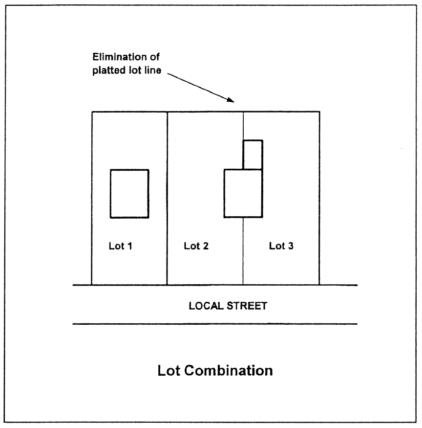
Lot Combinations. An existing lot line forming the boundary between two (2) conforming platted lots located within the same subdivision or a lot line between lots or parcels that have merged to form one (1) building lot may be removed or eliminated through a final plat revision process which conforms to the requirements of this ordinance. In the case no final plat applies to the subject lots or parcels, a boundary survey and plat depicting all lots involved in the lot combination shall be required to be approved by the Building Official and recorded as a final plat. Such combination plat shall be titled with the same name as that of the original subdivision, if applicable, and shall indicate thereon that the replat is for the purpose of removing the lot lines between specific lots. (See Figure).
(9)
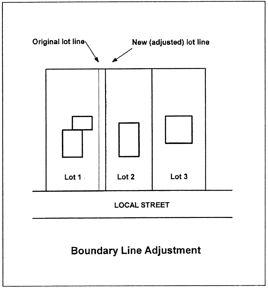
Boundary Line Adjustments. One or more existing lot lines forming boundaries between conforming platted lots located within the same subdivision, or one or more lot lines between abutting lots or parcels may be adjusted through a final plat revision process that requires the approval of the Building Official and recording of a plat meeting the specifications of a final plat. In the case no final plat applies to the subject lots or parcels, a boundary survey and plat of the entire lots involved in the boundary line adjustment shall be required to be approved by the Building Official and recorded. Such plat showing said boundary line adjustment shall be titled with the same name as that of the original subdivision and shall include thereon that the replat is for the purpose of adjusting the lot lines between specific lots. (See Figure)
(10)
Design Requirements for Blocks.
1.
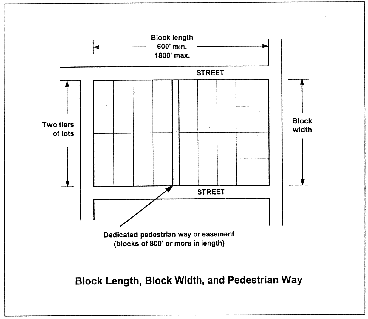
Block Length. Intersecting streets shall be provided at such intervals so as to provide adequate cross traffic. Blocks in residential subdivisions should not exceed eighteen hundred (1,800) feet nor be less than six hundred (600) feet in length, except where topography or other conditions justify a departure from these standards. The Planning Commission may require pedestrian ways and/or easements through the block be located near the center in blocks longer than eight hundred (800) feet.
2.
Block Width. The width of the block shall normally be sufficient to allow two (2) tiers of lots of appropriate depth. Blocks intended for business or industrial use shall be of such width as to be considered most suitable for their respective use, including adequate space for off-street parking and deliveries. (See Figure).
(11)
Design Requirements for Lots.
1.
Natural Features and Assets. In the subdividing of land, appropriate consideration must be given to all natural features, such as tree growth, watercourses, historic sites or similar conditions which, if preserved, will add attractiveness to the proposed development and safety from hazards. At the preliminary review meeting the developer must submit an aerial map showing all natural features and assets to discuss developer's plan for development.
2.
Access and Minimum Lot Frontage. Each lot shall have access to a public street and a minimum of sixty (60) feet in R-2, R-3 and B-2 zones and ninety (90) feet for R-1 zoning for lots adjacent to public street, flag lots are allowed to have twenty-five (25) feet or more of lot frontage on a public street; provided, however, that the local governing body may permit one (1) or more lots to be accessed by private streets, as more fully specified in this ordinance; provided further, that in the case of a lot accessed by a circular cul-de-sac, the minimum lot frontage may be reduced to thirty (30) feet with a minimum width of sixty (60) feet at the setback line for R-2 and seventy-five (75) feet for R-1. For lots located along roadway curvature, the minimum lot frontage shall be reduced to fifty (50) feet for R-2 and R-3, and seventy-five (75) feet for R-1, so long as the minimum frontage requirement is met at the setback line. All lot widths except for the flag lot may be given a variance if reviewed and approved according to ordinance.
3.
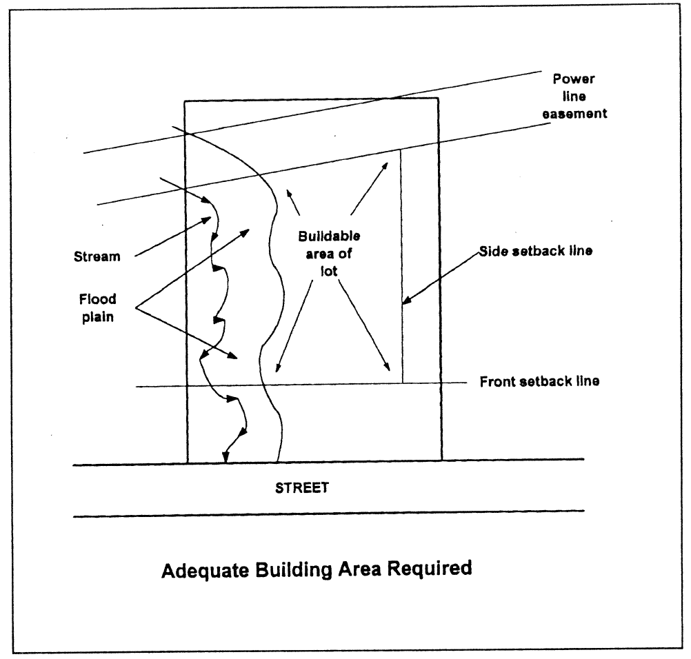
Adequate Buildable Area Required. Land subject to flooding, improper drainage or erosion, or that is unsuitable for residential or other use for topographical or other reasons, shall not be platted for residential use nor for any other use that will continue or increase the danger to health, safety, or of property destruction, unless the hazards can be and are corrected. Each lot shall contain an adequate building site with positive drainage from the buildable area not subject to flooding and outside the limits of any existing easements or building setback lines required by the local governing body (See Figure). Considerable evaluation should be given to lots where the drainage either surface or subsurface has a real negative affect. These are usually the last lots sold in the subdivision.
4.
Lot Remnants Not Permitted. All remnants of lots below any required minimum lot size that may be required, left over after subdividing of a larger tract, must be added to adjacent lots, rather than allowed to remain as unusable parcels. The Building Official may permit a lot remnant for a specific purpose such as a detention pond, provided that access and design is appropriate and the lot remnant is restricted to specific non-building use.
5.
Service Areas. Commercial and industrial lots shall be adequate to provide service areas and off-street parking suitable to the use intended.
6.
Lot Area. The minimum lot area shall not be less than that established by the zoning regulation in which the subdivision is located, or any other such ordinance provisions, if applicable.
7.
Lot Width. No portion of a lot shall be narrower than that established by the zoning ordinance in which the subdivision exists, with the exception of cul-de-sac lots at the street frontage and flag lots that have a minimum of twenty-five (25) feet. If sewers are not available the health department must establish the lot size requirement if a septic system is allowed.
8.
Lot Depth. Lots shall have a depth of not less than one hundred (100) feet, unless circumstances make these limitations impracticable.
A variance of lot sizes and dimensions may be given during the subdivision approval process, but not for individual lots. Additional approval must be given by the Board of Appeals and City Council.
9.
Flag lots.
(a)
Intent. Flag lots, as defined in this ordinance, are strongly discouraged. However, subdivisions designed with one (1) or more flag lots may be approved where conditions of hardship make standard design or frontage impossible or impractical due to the configuration of the lot to be subdivided.
(b)
Denial if reasonable alternative exists. The Building Official in the case of minor subdivisions and the Planning Commission in the case of other subdivisions shall have due cause to deny any plat that proposes any flag lot, when a reasonable alternative to such lot pattern is available.
(c)
Panhandle (flag pole) length restriction. If permitted, no flag lot shall be allowed to be platted that has a "panhandle" portion (i.e., portion that does not meet the required lot width) that is more than four hundred (400) feet in length.
(d)
Prohibition of abutting flag lots. If permitted, no flag lot shall abut another flag lot in any subdivision.
10.
Side Lot Lines. Insofar as practical, side lot lines shall be at right angles to straight street lines or radial to curved street lines.
11.
Corner Lots. Corner lots shall have adequate width to meet the front building setback requirements, if applicable, from all rights-of-way.
12.
Double Frontage Lots. Double frontage or "through" lots should be avoided except where essential to provide separation of residential development from arterials or overcome specific disadvantages of topography or orientation. Double frontage lots with frontage on a major arterial street shall have additional depth in order to allow space for screen planting along the lot line abutting a major arterial street.
13.
Mortgage Lot. This provision addresses situations where a bank or other lending institution requires the creation of a small (e.g., 1-acre to 5-acre) tract of property from a larger existing parcel (usually farmland or timber land) in order to provide a mortgage or loan on a home or other principal building, rather than referring to the entire existing lot of record.
(a)
In cases where a person can show the Building Official in writing that an application for loan or mortgage involving real property has been filed with a bank or lending institution, and said bank or lending institution requires, for purposes of the loan or mortgage, a description of property that encompasses less land area than the lot of record, one (1) or two (2) mortgage lots (see definition) may be lawfully created from the parcel of record without constituting a subdivision. Minimum lot sizes established by any land use district or other ordinance requirement of the City shall not be construed to prevent the creation of mortgage lots pursuant to this subsection, even if the resulting mortgage lot created is less than the minimum lot size required by said land use district or other ordinance requirement. The applicant shall be required in the case of a mortgage lot to file with the Building Official a copy of the survey plat creating the mortgage lot, and may be recorded in the records of the Walker County Superior Court Clerk as a mortgage lot plat of record.
(b)
If created, a mortgage lot shall be no less than one (1) acre and no larger than five (5) acres in size. This provision shall not allow for the creation of a mortgage lot from any lot of record that is five (5) acres or less in area.
(c)
No mortgage lot shall be created unless it meets the requirements within this ordinance for creating a lot.
(12)
Easements. Where a watercourse, drainage way, channel or stream traverses a subdivision, these conveyances must be maintained by the property owners of property on which they exist unless the City of LaFayette agrees to maintain them and the drainage conveyance has a City approved easement connecting to a public right-of-way giving access to the conveyance. Easements shall be provided for all drainage facilities that are approved and accepted by the City of LaFayette. Where easements are needed for utility locations, the subdivider shall provide them as Utility Easements to the City at a width designated by the City. All easements required pursuant to this section shall be shown on the preliminary plat and recorded on the final plat. All easement areas as designated for a subdivision must be accepted by the City or the area will be maintained by the owner of the property on which the easement exists.
(13)
Survey Monuments for All Lots Required. For all subdivisions, a Georgia registered land surveyor shall install permanent survey monuments at all property corners and land lot lines, prior to final plat approval. Lot corners shall be marked with metal rods not less than one-half (½) inch in diameter and eighteen (18) inches in length and driven so as to be stabilized in the ground. Permanent survey monuments shall also be installed in accordance with the most recent edition of Section 180-7-.05 Monument, of the Rules of State Board of Registration for Professional Engineers & Land Surveyors and the Georgia Plat Act (O.C.G.A. § 15-6-67). At least four (4) permanent monuments shall have GPS coordinates given for each subdivision plat.
(14)
Preliminary Plat.
1.
Purpose. The purpose of this section is to ensure compliance with the basic design concepts and improvement requirements of subdivisions and land developments through the submittal of a preliminary plat of all major and minor subdivisions for review and approval by the Building Official and the City's Planning Commission (major subdivision only unless desired by the Building Official to review minor subdivisions).
2.
Required. All major and minor subdivisions, as defined, shall require the submission of a preliminary plat to the Building Official for review and approval. Review and approval by the Planning Commission (for major subdivisions only). Prior to the issuance of any permit for land disturbance or development, or the installation of any improvements, the Planning Commission must approve the preliminary plat, if required.
3.
Preliminary Plat Application and Specifications. Preliminary plat applications shall be made in accordance with requirements shown in Table 4-1, and preliminary plats shall meet the minimum plat specifications shown in Table 4-2.
4.
Procedures. Upon receipt of a completed preliminary plat application, the Building Official shall schedule the application for the next public meeting before the Planning Commission and forward all pertinent materials in the application to the Planning Commission for review. An application for preliminary plat approval must be submitted as least seven (7) days before the regular meeting date of the Planning Commission to be considered on that agenda. The Planning Commission shall have up to thirty-two (32) days from the date the public meeting is held to approve, conditionally approve, or deny the preliminary plat application. The basis of the Planning Commission's review of and action on a preliminary plat shall be whether the preliminary plat meets the purposes and requirements of this ordinance, and all other ordinances that relate to the proposed development. The Planning Commission will set their next meeting date if necessary to approve the preliminary plat.
5.
Disposition. Approval of a preliminary plat shall be valid for a period of one (1) year, in which time a completed construction plans application must be submitted. If a completed application for construction plans is not submitted during that time, preliminary plat approval shall expire and be null and void.
6.
Amendments to Approved Preliminary Plats. The Building Official is authorized to approve minor amendments to preliminary plats. Any proposed amendment to a preliminary plat that is determined by the Building Official to constitute a public interest shall be deemed a major amendment. For all amendments to preliminary plats determined to be major amendments, Planning Commission approval shall be required. The Planning Commission shall approve, conditionally approve, or deny the proposed major amendment to a preliminary plat. Procedures for considering a major amendment to a preliminary plat shall be the same as required for an initial application for preliminary plat approval.
(15)
Construction Plans and Development Permit.
1.
Application. Upon approval of a preliminary plat and proof of mailing is given to the City that notification has been made to Georgia EPD of land disturbing activity (NOI) and providing the City a copy of the E. & S. Plan (if required), the subdivider or land developer may request a construction plan approval and approval of a development from the City. The construction plan approval and development permitting process is administrative. Applications for construction plan approval and development permit shall be made in accordance with requirements shown in Table 4-1 and Table 4-2. No application for construction plans shall be accepted for processing nor development permit approved by the Building Official until a preliminary plat has been approved by the Planning Commission (for major subdivisions only) and the proposed construction plans are found by the Building Official to be in substantial conformity with said approval and any conditions of such approval.
2.
Decision Criteria. The only basis upon which the Building Official may deny a construction plan or development permit is the failure of the application to meet the requirements of this ordinance or any other applicable local regulations or the failure of the construction plans and application to meet the requirements of preliminary plat approval specified by the Planning Commission.
3.
Certificate of Approval. All copies of the construction plans shall be noted by inscription on the plan noting such approval by the Building Official. Construction plan approval shall expire and be null and void after a period of one year, unless substantial activity toward improvements on the land has been initiated and said substantial activity is ongoing, or unless the Building Official approves an extension of time.
4.
Engineered Drawings. Engineering drawings for public streets, including cross sections and centerline profiles, and public and private water, sewer, drainage, and utility systems, shall be certified by a professional engineer registered in the State of Georgia. Prior to approval and recording of a final plat, or prior to the approval of any certificate of occupancy, a registered engineer or a registered land surveyor for the subdivider/developer shall submit one (1) copy of all finished, as-built plans of improvements in an approved format, demonstrating that said improvements, as installed, meet the requirements of this ordinance and certifying that the plans accurately reflect actual construction and installation. The Office of the Building Official shall maintain all as-built street and utility plans for future use by the City.
5.
Permits for Construction in Public Right-Of-Way. Permits from the Office of the Building Official shall be required for construction in any public right-of-way. Permits will not be issued until such time that plans have been submitted meeting all the local, state and federal regulations and requirements and the plans must also be reviewed and approved by the Building Official.
6.
Improvements to Abutting Land. For subdivisions and land developments that abut and access an abutting City public street, the subdivider or land developer shall install curb and gutter, sidewalk, other road improvements, and, if required, a deceleration lane, according to standards and specifications of this ordinance and of the City of LaFayette, along all abutting City public streets. When a subdivision or land development uses an unpaved public right-of-way for access, the subdivider or land developer shall improve that right-of-way to a pavement width consistent with City road design standards. Said improvements shall be from the subdivision or land development entrance to the paved City road which the Building Official determines will be the primary direction of travel for residents of the subdivision or occupants of the land development. Said right of way shall be improved by the developer/subdivider to meet all criteria established by the City for street design and construction.
(16)
Final Plat.
1.
When Required. All major subdivisions, resubdivisions, minor subdivisions, and dedications shall require final plat approval. The final plat approval process is administrative.
Applications shall be made in accordance with requirements shown in Table 4-1.
All final plats must have a state licensed surveyor's or engineer's stamp and signature thereon.
Table 4-1
Application Requirements
2.
Criteria for Approval. The Building Official may grant final plat approval if the following conditions, as applicable, are met.
(a)
The Planning Commission has previously approved a preliminary plat of the proposed subdivision, if required (not required for minor subdivision).
(b)
Where new improvements are involved in the subdivision, construction plans have been approved by the Building Official, all improvements have been installed and inspected by the Building Official, and subdivision improvement guarantees as required by this ordinance have been submitted.
(c)
The final plat meets all applicable requirements of this ordinance.
(d)
A complete final plat application has been submitted, including all supporting materials required by this ordinance for final plats.
The Building Official shall consider final plats and applications that meet the above-referenced conditions a ministerial action of approval. Denial of a final plat shall be permitted only upon specific findings that one or more of the above-referenced criteria have not been met.
Table 4-2
Plat and Plan Requirements
3.
Approval Certificate. Upon approval of the final plat, a certificate, stamped directly on the plat, shall state:
"Pursuant to the Land Subdivision Regulations of City of LaFayette, Georgia, and all requirements of approval having been fulfilled, this final plat was given preliminary approval by the Planning Commission on ___________, 20___, and final approval by the Building Official and it is entitled to recordation in the Clerk's Office, Walker County Superior Court.
_____
"Building Official"
4.
Additional Plat Certificates. In addition to information required by Table 4-1 to be supplied on a final plat, each final plat shall contain the following certificates.
Surveyor's Certificate. A certificate by a Georgia Registered Land Surveyor directly on the final plat as follows:
"It is hereby certified that this plat is true and correct and was prepared from an actual survey of the property by me or persons under my supervision; that all monuments shown hereon actually exist or are marked as "future," and that their location, size, type and material are correctly shown; and that all engineering requirements of the Subdivisions and Land Development Ordinance of City of LaFayette, Georgia, have been fully complied with.
By: _____
Registered Georgia Land Surveyor No.:___"
Owner's Certificate. A certificate by the owner directly on the final plat, signed in an appropriate manner as follows:
"The owner of the land shown on this plat and whose name is subscribed hereto, in person or through a duly authorized agent, certifies that this plat was made from an actual survey, and that all State, City and County taxes or other assessments now due on this land have been paid. Said owner donates and dedicates to the public for use forever the public street right-of-ways as shown on this plat.
_____
Owner
Signed, sealed and delivered
in the presence of:
_____
Witness
_____
Notary Public"
Health Department Approval Certificate.
"This final plat has been approved by the Walker County Health Department as being consistent with applicable state and local environmental health requirements.
_____
Director of Walker County Health Department"
[5.]
Distribution of Recorded Final Plat. The final plat is a source of essential information to tax officials, public safety officials, and utility officials, among others. The Owner or Developer shall be responsible for ensuring that each agency listed in this subsection receives a copy of the final recorded plat with assigned addresses:
1.
The County Tax Commissioner
2.
The County Tax Assessor
3.
The County Health Department
4.
The County GIS Coordinator
5.
The County 911 Coordinator
6.
The County Public Works Department
At the discretion of the Building Official, additional agencies or persons may be added to the above list.
(17)
Dedications of Streets and Public Lands. Public improvements shall be inspected by a City official according to local and state regulations as they are constructed. The Building Official shall inspect all public improvements and shall notify the subdivider or land developer in writing of nonacceptance or preliminary acceptance. If the public improvements are not acceptable, the reason for non-acceptance shall be stated and corrective measures shall be outlined in a letter of notification. Upon notification, the subdivider or land developer shall correct all deficiencies identified in the non-acceptance letter within the time limit established by the Building Official. Once deficiencies are corrected, the subdivider or land developer shall again request inspection in writing. Acceptance of public improvements as required by this ordinance shall be made by the local governing body. As-built drawings of the improvements in acceptable format shall be submitted to the Engineering Department following approval.
Subdivision streets and rights-of-way and other lands to be dedicated to the public shall be accepted or rejected by the City upon formal dedication by the Owner. Upon acceptance a general warranty deed conveying fee simple title of such rights-of-way and lands must be provided by the owner/developer to the City. The warranty deed shall be accompanied by an attorney's certificate of title and a tax transfer form addressed to the Mayor and City Council certifying that the grantor in such deed is vested with marketable fee simple title to the property conveyed thereby, free and clear of all liens and encumbrances, and further that the individual executing such deed has full authority to do so. Acceptance of such dedication shall be accomplished by Resolution of the Mayor and City Council.
The developer shall be responsible for maintenance of any street constructed for either:
(a)
A period of two (2) years from the date of the recording of the final plat of the subdivision in the office of the clerk of the Superior Court with a minimum of one (1) year of construction traffic starting from the first certificate of occupancy; or
(b)
Until such time as construction is completed on at least 85 percent of the lots which are subdivided, platted or otherwise available for construction within the subdivision, whichever last occurs.
(18)
Subdivision Improvement Guarantees. In order to protect the City and prospective purchasers of and residents in a subdivision, the subdivider/developer shall provide to the City financial security to guarantee the installation of public improvements including all phases of the project up to and including completion for both Minor and Major Subdivisions having a land size of three (3) acres or more. The subdivider's or developer's financial guarantee may be any of the following:
(a)
An escrow of funds with the City;
(b)
An escrow with a bank or other financial institution upon which the City can draw;
(c)
An irrevocable letter of commitment or credit upon which the City can draw;
(d)
A performance bond for the benefit of the City upon which the City can collect, or a certificate of deposit with assignment letter, provided, however, that in either case the amount must be one hundred (100) percent of street and utility cost of construction; and
(e)
Any other form of guarantee approved by the Mayor and City Council that will satisfy the objectives of this section. The guarantee shall be in an amount to secure the full costs, as determined solely by the City, of constructing or installing the improvements and utilities required.
(19)
Limitations on Minor Subdivisions.
1.
Purpose. Minor subdivisions provide certain advantages, such as a shorter application process and less public scrutiny, that tend to favor their use over the filing of major subdivision applications. Given these advantages, the prospect exists that subdividers may seek to divide a parcel via consecutive and/or contiguous minor subdivisions instead of filing for a major subdivision. It is the intent of the Mayor and City Council to prohibit the practice of "chain" subdivisions where the same land owner subdivides land and then files minor subdivision applications on common contiguous parcels, which collectively total more than four (4) lots. It is also the intent of the Mayor and City Council to prohibit minor subdivisions adjacent to each other within a three-year time period, in cases where part of an original tract of land is now owned by another person or entity and was transferred or sold to another owner with the apparent intent to circumvent the major subdivision process.
2.
Common Contiquous Parcels Shown on Minor Subdivision Plats. Contiguous common parcels, as defined by this ordinance, shall be referenced on all applications for minor subdivisions, and contiguous common parcels shall be considered part of any application for minor subdivision, for purposes of determining whether or not the division of land proposed is a major subdivision or a minor subdivision. Common contiguous parcels shall not be counted as lots in the case of a minor subdivision.
3.
Limitations. Land within a minor subdivision, including all contiguous parcels owned by the subdivider, shall not be further divided for a period of three (3) years unless a preliminary plat application is filed and approved as a major subdivision pursuant to the requirements of this ordinance. If property proposed to be subdivided was part of an original tract, and if the property proposed to be subdivided abuts land that has been divided as a minor subdivision in the last three (3) years, then minor subdivision of said property shall be prohibited. This provision shall not be construed to prohibit the approval of two (2) contiguous minor subdivisions under separate ownership; however, this provision is intended to be construed so that one property owner does not develop a minor subdivision on part of an original tract and transfer or sell another part of the original tract for the purposes of minor subdivision within a three-year period. It is the intent that land abutting a minor subdivision that was owned by the subdivider of the abutting minor subdivision shall not be subdivided as a minor subdivision for a period of three (3) years, regardless of ownership.
(20)
Standards for Configuring New Streets.
1.
Purpose and Intent. The entire community enjoys the benefits of an interconnected network of streets and roads. It is the intention of the City that new street alignments in new developments reflect the traditional style exhibited throughout older, established neighborhoods. Interconnected streets afford easier, safer access for emergency vehicles, school buses, and sanitation trucks while distributing traffic more evenly and avoiding excess traffic on certain central residential streets. Street patterns that result in isolated pockets of development with relatively little interconnectivity are strongly discouraged. Wherever cul-de-sacs or hammerhead turnarounds are unavoidable (typically for topographic reasons) they must always be provided with bicycle or pedestrian linkages to other nearby streets or to a neighborhood trail system. Wherever possible, cul-de-sacs should be designed to include a central island preserving existing greenery or, alternatively, planted with approved trees, shrubs, and plants.
2.
Street Alignment, Intersections and Jogs. Streets shall be aligned to join with planned or existing streets. Under normal conditions, streets shall be laid out so as to intersect as nearly as possible at right angles (ninety (90) degrees), but in no case shall such a street intersection be less than seventy-five (75) degrees. Where street offsets or jogs cannot be avoided, offset "T" intersections shall be separated by a minimum centerline offset of one hundred fifty (150) feet in urban areas and three hundred (300) feet in rural areas. (See Figure).
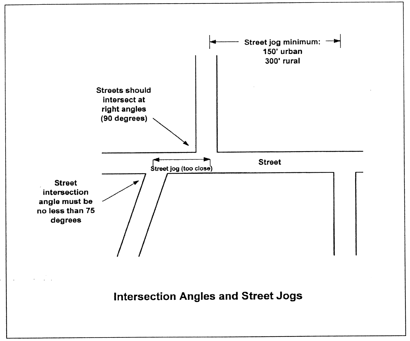
3.
Continuation of Existing Streets and Connections. Existing streets, and their rights-of-way, shall be continued at the same or greater width, but in no case less than the required width. The Planning Commission may require that a major subdivision provide one or more future connections to adjoining subdivisions or unsubdivided tracts.
4.
Street Plans for Future Phases of the Tract. Where the plat or site plan proposed to be subdivided or developed includes only part of the tract owned or intended for subdivision or development by the subdivider or land developer, a tentative plan of a future street system for the portion not slated for immediate subdivision consideration shall be required by the Building Official and shall be prepared and submitted by the subdivider or land developer.
5.
Dead-End Streets and Cul-De-Sacs. Streets that dead-end shall terminate in a cul-de-sac. The maximum length of such streets shall be six hundred (600) feet in urban areas and twelve hundred (1,200) feet in rural areas. Streets that are planned to continue at some future date shall provide a temporary cul-de-sac as required by the Building Official.
6.
Marginal Access Streets. Whenever a major subdivision is proposed abutting the right-of-way of a U.S. or State highway, a marginal access street approximately parallel and adjacent to such right-of-way may be required by the Planning Commission at a distance suitable for the appropriate use of land between such marginal access street and highway right-of-way. The Planning Commission may also require a twenty-foot no-access easement and planting strip along the major arterial street to ensure that lots fronting on said street do not have access thereto. (See Figure).
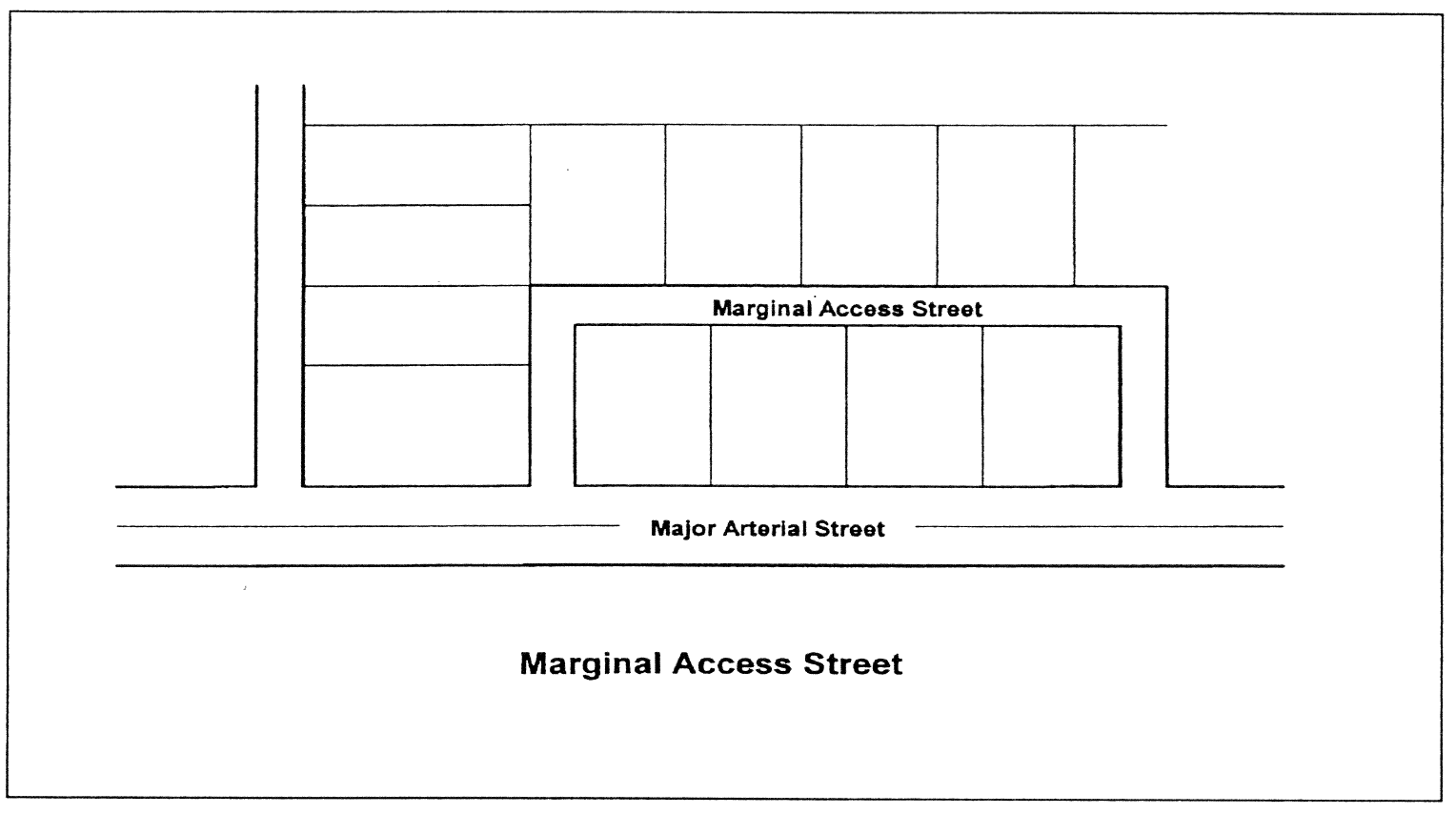
7.
Alleys and Service Access. Alleys may be provided. If they are provided, they must at least be graveled. Dead-end alleys shall be avoided where possible; but if unavoidable, they shall be provided with adequate turn-around facilities. Service access shall be provided to commercial and industrial developments for off-street loading, unloading, and parking consistent with and adequate for the uses proposed.
(21)
Requirements for Streets.
1.
Bridges. Bridges on public rights-of-way shall meet current American Association of State Highway and Transportation Officials standards.
2.
Grading and Stabilization of street Rights-of-Ways. When a new public street is proposed, all trees, brush, stumps, rocks, or other debris shall be cleared from the street right-of-way, except in cases where trees are required to be preserved by the Building Official. All streets shall be graded to lines, grades and cross sections approved on plans. All unsurfaced, disturbed portions of street rights-of-way shall be stabilized by seeding, fertilizing, and mulching or by another equally effective method.
3.
Radius at Street Intersections. The right-of-way radius at street intersections shall be a minimum of fifteen (15) feet, with larger radii for streets serving nonresidential development, as approved by the Building Official. The minimum pavement (curb) radius at street intersections shall be twenty-five (25) feet.
4.
Street Grades. No street grade shall be less than one percent. No street grade for an arterial or collector street shall exceed eight (8) percent. No other local street grade shall exceed twelve (12) percent, unless the Building Official finds that due to topographic conditions, a steeper grade is necessary, in which case the street grade shall not exceed fifteen (15) percent. Grades between twelve (12) percent and fifteen (15) percent shall not exceed a length of one hundred fifty (150) feet.
5.
Minimum Street Right-of-Way and Pavement Widths. Street right-of-way and pavement widths shall at minimum meet the following:
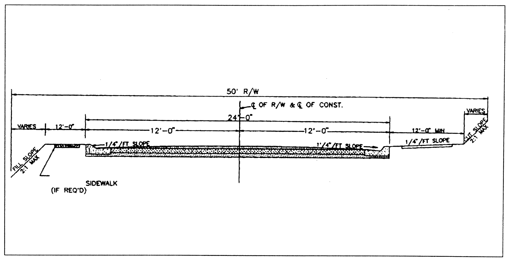
Residential Street with Curb and Gutter
(Cross Section Detail)
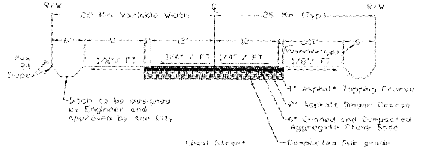
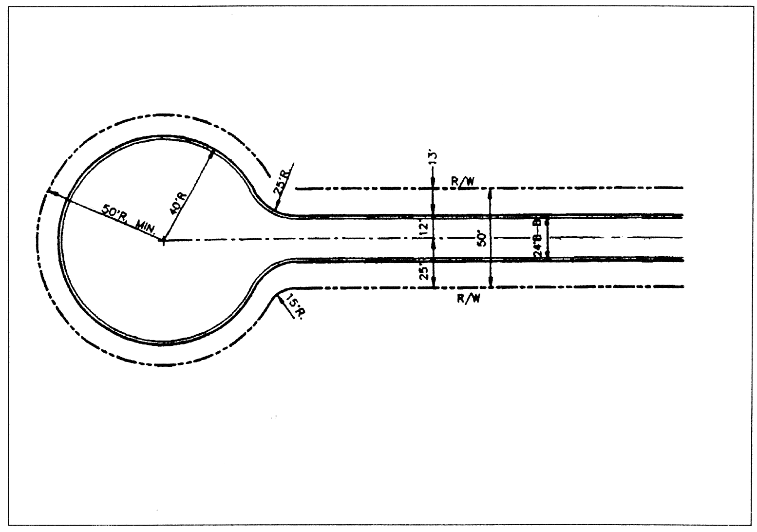
Cul-de-Sac Detail
6.
Street Horizontal Alignment and Reverse Curves. Street horizontal alignments and reverse curves shall at minimum meet the following:
(22)
Curb Cuts and Access Specifications.
1.
Entrance Improvement Specifications. Roadway entrances and improvements, including necessary acceleration and/or deceleration lane(s) and right/left turn lanes, shall be designed, installed, and maintained as approved by the State Department of Transportation, as applicable, or the Building Official, in accordance with applicable State or City specifications. All entrances or exits of any street or driveway, public or private, from or to any state highway shall be approved by the State Department of Transportation and the Building Official prior to the construction of such entrances or exits and prior to the issuance of any land use permit or building permit for any improvement to be served by such entrances or exits. All entrances or exits of any street or driveway, public or private, from or to any City street shall be approved by the Building Official prior to the construction of such entrances or exits and prior to the issuance of any land use permit or building permit for any improvement to be served by such entrances or exits.
2.
Curb Cut Specifications. No curb cut or access driveway shall be permitted to be located closer than fifty (50) feet to the nearest existing or proposed right-of-way of an intersecting roadway. Curb cuts or access driveways shall be no narrower than twenty (20) feet from back of curb to back of curb. Strict adherence to these requirements may not be practical in all instances as determined by the Building Official. The Building Official may limit the maximum width of a curb cut and/or the number of curb cuts to a parcel as necessary when it is deemed to be of benefit to the safety and welfare of the public.
The following factors may be considered during the review and approval of a specific location of an entrance: the location of existing or planned median breaks; separation requirements between the entrance and major intersections; separation requirements between other entrances; the need to provide shared access with other sites; the need to align with previously approved or constructed access points on the opposite side of the street; and the minimum number of entrances needed to move traffic onto and off the site safely and efficiently.
3.
Access Along and Near Divided Highways. Where a divided highway exists or is planned, the following access standards shall be met: Minimum separation of intersecting roads and driveways shall be determined during the review of the proposed plan. Part of the determining factor will be the traffic congestion that is being created.
4.
Interparcel Connections. New development that contains or is intended to contain more than one (1) building or use on site shall provide connections so that automobile trips between and among such buildings or uses can be accomplished without using the highway or major street. Where possible and practical, new developments and substantial improvements to existing developments shall provide for pedestrian and automobile access connections between adjacent properties under different ownership when the uses of the properties are of such compatibility that patrons may frequent both buildings or uses in the same vehicle trip.
(23)
Street Lighting. Street lights may be provided in accordance with City specifications by the developers of a subdivision prior to the approval of a final plat. Fixtures and standards/poles installed or used shall be approved by the City and by the utility company that will be responsible for the maintenance of the facilities. The fixtures shall be mounted no more than thirty (30) feet above the ground and shall have appropriate arm length or power to place light over the street. Post top luminaries may be permitted when approved by the Public Works Director. Fixtures shall be located no more than five hundred (500) feet apart, unless approved by the Public Works Director, and, when provided, at least one (1) light shall be located at each public or private street intersection within the subdivision or land development.
The developer shall pay all costs for poles, fixtures and any other related items or materials necessary for the installation of street lights. All electric utilities will be installed and approved by the Electrical Department and will be accepted as part of the City's electrical system upon completion. Maintenance and operation costs of street lights will be assumed by the City no earlier than one year after lights have been installed.
(24)
Street Signs. Signs for street names, directions of travel, traffic control, and hazards shall be provided as directed by the Public Works Department. Street signs on exterior/boundary streets shall be installed by the City with the developer paying a proportionate share determined by the City. Street signs for interior streets of a subdivision or land development shall be installed at the subdivider or developer's expense by the subdivider or developer, subject to the approval of the Public Works Department.
Unless otherwise provided in standards and specifications adopted by the City, street signs shall meet the following specifications as hereinafter set forth. Signs shall be constructed of aluminum sheets with reflective backgrounds. Information on the street name signs shall be readable from both sides of the sign. Signs shall be installed on a steel post. The vertical distance from the road elevation to the bottom of the sign face shall be seven (7) feet with a minimum burial depth of three (3) feet.
(25)
Curbs and Gutters. Curbs and gutters shall be installed if required by the Public Works Department in accordance with standards and specifications of the City. All residential, commercial and industrial subdivisions and land developments must have curbs and gutters, regardless of the size of the lots. When property fronting on an existing City street is subdivided or developed, and the subdivision or land development uses said existing street for access, then curb and gutter shall be required along said street along the entire property frontage of said street. Extruded concrete and asphalt curbs may be allowed if approved during the review process.
Curbs shall be concrete which shall be class A 3000 psi strength at twenty-eight (28) days. The typical curb minimum section shall be six (6) inches by twenty-four (24) inches by twelve (12) inches (see Figure).
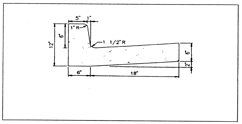
Vertical Curb Detail
All streets and roads not required to include curbs and gutters shall be graded, paved, and drained to meet all construction and drainage standards for ditches, slopes, and grassing according to specifications established by the City.
(26)
Sidewalks.
1.
When Required. Sidewalks shall be provided in accordance with the Comprehensive Plan, unless the Building Official determines that no public need exists for sidewalks in a certain location. Sidewalks shall be required when land developments and subdivisions are located within one-mile of a public school. Sidewalks are required to be installed along one side of the street internal to a major subdivision and in minor subdivisions when adjacent areas have sidewalks, except in cases where the median lot size of the major subdivision is two (2) acres or more.
2.
Location. Sidewalks shall be included within the dedicated nonpayment right-of-way of roads and shall parallel the street pavement as much as possible; provided, however, the Building Official may permit sidewalks to be designed and constructed so that they meander around permanent obstructions or deviate from a linear pattern for design purposes.
3.
Specifications. Sidewalks shall be a minimum of four (4) feet wide. A median strip of grassed or landscaped areas at least two (2) feet wide (could vary as per building official) shall separate all sidewalks from adjacent curbs in residential areas.
(27)
Private Streets.
1.
Private Streets are NOT Permitted.
2.
Construction Plans Required. It shall be unlawful for any person, firm, or corporation to construct a new private street or alter an existing private street or to cause the same to be done without first obtaining approval of construction plans from the Building Official and a development permit issued in accordance with the requirements of this ordinance.
(28)
Drainage and Stormwater Management.
1.
General Requirements. An adequate drainage system, separate and independent of any sanitary sewer system and including any necessary ditches, pipes, culverts, intersectional drains, drop inlets, bridges, etc., shall be provided for the proper drainage of all surface water for all subdivisions and land developments. Sizing and location of all drainage structures shall be the responsibility of a registered professional engineer or land surveyor. The City shall require the use of on-site control methods such as retention or detention to mitigate the stormwater and drainage impacts of the proposed subdivisions and land developments. The Planning Commission shall not approve any preliminary plat of subdivision that does not make adequate provision for storm and flood water runoff channels or basins as determined by the Building Official. No building permit shall be issued for any building within a subdivision or development permit issued for the development of land, if there is not present throughout the subdivision or to the land development an adequate system of drainage and storm water management that meets all federal, state and local requirements.
2.
Method of Design and Capacity. Storm sewers, where required, shall be designed by the Rational Method, or other methods as approved by the City, and a copy of design computations shall be submitted along with required plans. Drainage improvements shall accommodate potential runoff from the entire upstream drainage area within the site and shall be designed to prevent increases in downstream flooding. Capacity for a ten-year storm or rain shall be provided for all street drainage structures such as catch basin, inlets cross drains, etc. Capacity for a one hundred-year frequency storm event shall be provided for all main drainage structures such as retention basins, principal storm sewers, and all types of flood protection works.
3.
Location. Drainage facilities shall be located in the road right-of-way where feasible, and shall be constructed in accordance with standards and specifications of the City. Catch basins shall be located at low points of streets. Where topography or other conditions are such as to make impractical the inclusion of drainage facilities within road rights-of-way, perpetual, unobstructed easements at least fifteen (15) feet in width for drainage facilities shall be provided across property outside the road right-of-way and with satisfactory access to the road.
4.
Discharge. Drainage shall be designed so as to avoid concentration of storm drainage water from each lot or land development site to adjacent lots, land development sites, or vacant properties. Storm water shall not be discharged directly to perennial streams. It shall be directed toward natural drainages. If water must be discharged to a stream, the water quality flowing into the stream must meet or exceed the water quality in the receiving waters. The water quantity flowing into the stream must be evaluated to ensure the stream channel can accommodate the increased flows and not disrupt or degrade the ecology of the water body.
5.
Grading and Site Drainage. Lots or land development sites shall be laid out so as to provide positive drainage away from all buildings, and drainage for individual lots or land development sites shall be coordinated with the general storm drainage pattern for the area. Buildings and parking lots shall be appropriately drained so as to prevent damage to abutting properties or public streets. All disturbed or graded ground areas of a building site not used for buildings or open storage areas shall be appropriately stabilized and grassed or covered with plants or landscaping materials.
6.
Cross-Drainpipes. Where a watercourse separates the buildable area of a lot from the street by which it has access, provisions shall be made for installation of a culvert or other structure, the design of which shall be approved by the City. Cross-drains shall be provided to accommodate all natural waterflow, and shall be of sufficient length to permit full-width roadways and the required slopes. Cross drainpipes shall have head walls of an approved type on inlet and outlet ends of the pipe. Pipe installed within the right-of-way shall be reinforced concrete pipe. All storm drainpipes shall be minimum eighteen (18) inches in diameter. Storm sewer slopes shall be equal to or greater than one (1) percent.
7.
Drop Inlets. Drop inlets shall be generally three-foot by three-foot boxes with two-foot by three-foot grates unless otherwise specified by the City.
8.
Easements. Where an irrigation ditch or channel, natural creek, stream or other drainage way crosses a subdivision or land development, the subdivider or developer shall provide an easement sufficient for drainage and maintenance. Easements shall be provided for all drainage facilities as approved by the City. When a subdivision or land development is traversed by a watercourse, drainage way, channel, or intermittent stream, a stormwater or drainage easement of at least twenty (20) feet shall be provided.
(29)
Water.
1.
Generally. All habitable buildings and buildable lots shall be connected to a water system capable of providing water for health and emergency purposes, including adequate fire protection. The determination of whether the City's existing water system is adequate to serve any new construction shall be made by the City's Water Department and their Engineering Consultant. Providing water for any development must be done while continuing to meet state requirements for the rest of the water system that is affected. No permit shall be issued for any building within a subdivision or for the development of land, if there is not present throughout the subdivision or to the land development an adequate water supply.
2.
Water Main Requirements. When a public water main is accessible, the developer shall install adequate water facilities, including fire hydrants, according to City specifications and as approved by the City and the State of Georgia. All water mains shall normally be at least six (6) inches in diameter except that pipe of lesser size may be used if properly looped and adequate water pressure is maintained in accordance with standards established by the Southeastern Fire Underwriters Association. Pipe of less than four (4) inches shall not be used except in unusual cases. Water lines shall be installed at least thirty (30) inches below grade where practical. Water mains within subdivisions and land developments must be provided with connections to each lot in the subdivision or land development, except as otherwise specifically provided.
3.
Wells. Private wells are not allowed as a potable water source within the City of LaFayette.
4.
Community Water System. Community water systems are not allowed within the City of LaFayette.
5.
Fire Hydrants. Fire hydrants shall be required for all nonresidential land developments and all subdivisions within the city limits of LaFayette. Fire hydrants with appropriate water pressure at appropriate intervals throughout the subdivision or land development shall be provided by the subdivider or land developer as required by the City Fire Department. Fire hydrants shall be located no more than one thousand (1,000) feet apart and within five hundred (500) feet of any principal dwelling. Hydrants, fittings, valves and fire department connections shall be approved by the LaFayette Fire Department. Fire department connections shall be not less than eighteen (18) inches or more than thirty-six (36) inches above the level of the adjoining ground or paving. The thread of such connections shall be uniform with that used by the Fire Department. To eliminate future street openings, all underground utilities for fire hydrants, together with the fire hydrants themselves, and all other supply improvements shall be installed before any final paving of a street within the right-of-way shared by such underground utilities.
(30)
Sewer.
1.
Generally. All habitable buildings and buildable lots shall be served by an approved means of wastewater collection and treatment. Each subdivision and land development shall be served by adequate sewage disposal facilities. No permit shall be issued for any building within a subdivision or for the development of land, if there is not present throughout the subdivision or to the land development an adequate system of wastewater collection and treatment.
2.
Connection to Public Sewerage System. All developments within the City limits must connect to the City sewerage system. Any development outside the City limits wanting to connect to our sewer system must at their request be annexed into the City. The subdivider or land developer shall extend the City sewers within his development and provide sewers accessible to each lot in the subdivision or to each land development. With the accessibility of public sanitary sewer, it shall be unlawful for any person to maintain upon any such property an individual sewage disposal system. Sanitary sewers shall be located within street or alley rights-of-way unless topography dictates otherwise. No public sewer shall be less than eight inches in diameter. Manholes shall be installed in sanitary sewers with a maximum distance between two (2) manholes of four hundred (400) feet, unless otherwise specified by standards of the City. Sanitary sewer slopes shall be equal to or greater than 0.7 percent for eight-inch lines. All sewer lines shall be designed with slopes to obtain a minimum velocity of two (2) feet per second. Minimum twenty-foot wide easements shall be provided for all sanitary sewer lines.
3.
All sewer construction involving sanitary sewer lines, pump stations, metering stations, and appurtenances which are to become a part of the City's sewer system shall not be constructed until the plans are approved and the construction inspected and approved. New developments will not be considered for acceptance and continued maintenance by the City until all the following conditions have been met:
(a)
Eighty (80) percent of all phases of the development has been completed.
(b)
A camera inspection of all sewer lines has been performed by the City.
(c)
An evaluation of all lift and/or pump stations has been conducted by the City.
(d)
All utility easements have been recorded and filed.
(e)
Any deficiency in the system must be repaired and brought up to the City's standards before the system will be taken over by the City.
Once these requirements have been met, the City will issue the developer a letter of acceptance and assume maintenance responsibility from that time forward. Prior to this, all maintenance will be the developer's responsibility.
(31)
Utilities. All utility facilities, including but not limited to gas, electric power, telephone, and cable television, shall be located underground throughout the subdivision or land development. Whenever existing utility facilities (other than major distribution lines) are located above ground, except when existing with public roads rights-of-ways, they shall be removed and placed underground. All utilities shall be placed within street right of ways if possible. Utilities may be installed along lot lines if necessary, but must be within designated "Utility" easements being at least fifteen (15) feet in width. These easements must be recorded as part of the final plat.
(32)
Oversizing of Improvements and Utilities. The subdivider or land developer shall construct such oversized improvements and utilities that the City determines are necessary, provided that the subdivider or land developer shall not be obligated for the additional cost of improvements and utilities that are not uniquely required for that development, and provided the subdivider agrees to a proposal by the City to share in the cost arrangements for over-sizing improvements and utilities. A formula may be developed by the City to provide for a sharing of the cost of other improvements needed to serve the subdivision or land development when certain of the improvements are necessary to serve future subdivisions or developments in the vicinity.
(33)
Administration.
1.
Fees. The fees for various applications required by this Ordinance are listed below. These Fees are established at a level that fully or at least partially offset the costs of administration.
2.
Additional Specifications. The Building Official is hereby authorized to prepare and recommend standard drawings and constructions specifications for private and public improvements not specified in this ordinance. Upon their adoption by the local governing body, they shall become mandatory.
3.
Variances. Upon application, a variance to the terms of this ordinance may be granted, subject to the requirements of Zoning Article VIII.
4.
Inspections. The Building Official shall be authorized to inspect premises proposed for subdivision or land development, including any improvements within such subdivision or land development, to determine compliance with the requirements of this ordinance and other laws and regulations of City. No person shall refuse entry or access to any person authorized to conduct inspections who presents appropriate credentials for same, nor shall any person obstruct, hamper or interfere with any such person while in the process of carrying out his official duties. The Building Official is authorized to establish procedures for inspection of land development activity at various intervals in the development process, including without limitation inspection procedures for erosion control, the initiating of grading or land-disturbing activity, installation of on-site sewage disposal systems or sanitary sewer, installation of storm drainage pipe, detention, or other storm water facilities, and installation of street curbing and gutter, road sub-grade, base, or paving.
5.
Enforcement, Violations, Remedies, and Penalties. Enforcement, violations, remedies and penalties shall be as specified in Zoning Article VII.
6.
Amendment. The Mayor and City Council may amend this ordinance in a manner consistent with Georgia law. Before enacting such amendment to this ordinance, the Planning Commission shall provide a recommendation on the proposed amendment. The Mayor and City Council shall hold a public hearing thereon, notice of which shall be published at least fifteen (15) days prior to such hearing in the city's legal organ or a newspaper of general circulation in the county.
(34)
Repealer. All ordinances and parts of ordinances in conflict with this section are hereby repealed.
(Ord. No. 25/03, § 1, 3-10-2025; Ord. No. 25/10, §§ 1—3, 6-10-2025)
Cross reference— Post-development stormwater management for new development and redevelopment, Ch. 6, Art. XII.