
Lady Lake City Zoning Code
CHAPTER 8
SUBDIVISIONS AND PLATS1
Cross reference— Provisions required to regulate subdivision of land, F.S. § 163.3202(2)(a).
Sec. 8-1.- Applicability.
The requirements set forth in this chapter shall be applicable to all portions of the Town of Lady Lake except commercial and industrial zoned property unless a subdivision plat is elected as a development choice.
(Ord. No. 2013-07, § 1(Exh. A), 7-1-2013)
Sec. 8-2. - Purpose and intent.
The public health, safety, and general welfare of the citizens of Lady Lake require the harmonious and orderly development of land within the incorporated area of the Town. It is the intent of this chapter for each new subdivision:
a)
To conform with minimum standards of subdivision design, established by this chapter, which will result in the development of safe, stable communities, and the prevention of unhealthy living environments.
b)
To have necessary improvements so that such improvements are not a burden upon the taxpayers of the community.
c)
To have efficient, adequate utilities and services.
d)
To have safe, adequate and convenient circulation of vehicular and pedestrian traffic.
e)
To provide adequate protective flood control and drainage.
f)
To have designs and improvements that control pollution and erosion, safeguarding the natural resources of the city.
g)
To provide adequate open space, light and air, solar rights, privacy, and recreational areas to prevent overcrowding of the land and undue congestion of the population.
h)
To provide safety from fire, flood, natural disasters and other dangers.
i)
To provide reasonable, fair, and uniform application of standards of design and procedures for the subdivision and platting of land.
j)
To ensure proper legal descriptions and monumenting of subdivided land.
k)
To preserve the natural beauty and topography of the Town.
l)
To provide for safe and sanitary sewage disposal, adequate potable water supplies and the protection of groundwater.
(Ord. No. 2013-07, § 1(Exh. A), 7-1-2013)
Sec. 8-3. - Definitions.
See "Definitions and Interpretations" - Chapter 2.
(Ord. No. 2013-07, § 1(Exh. A), 7-1-2013)
Sec. 8-4. - Compliance required: exemptions.
a)
Unlawful activity. It shall be unlawful and subject to the penalties provided herein for any person to:
1)
Create a subdivision without first complying with the provisions of this chapter and filing a plat approved by the Town Manager unless exempt under section below.
2)
Divide property by any means for the purpose of sale or transfer of title unless each of the resulting parcels has at least the minimum area and width requirements prescribed by the zoning regulations and Comprehensive Plan of the Town of Lady Lake as applied to the lots created, unless exempt under section below.
3)
Commence the construction of any improvements required under this chapter without first having obtained a development order from the Town of Lady Lake.
4)
Fail to construct or maintain improvements in accordance with an approved development order, plat approval or requirements of this chapter.
5)
Divide any lot or tract that is in a recorded or unrecorded subdivision located within the Town limits into a lot or parcel smaller than or inconsistent with the surrounding lots in the subdivision unless approved by the Town Manager as stated below.
6)
Combine lots or parcels to create an aggregate lot without the approval of the Town Manager.
7)
Subdivide a site that is already platted. The existing plat must first be vacated.
b)
Lot splits and minor subdivisions.
1)
Lot splits. A lot split is any request to divide a lot or tract in such a manner as to make it meet the following criteria:
A)
Only two (2) lots may be created per original parcel.
B)
Each lot created must have a minimum area of the dimensional criteria as required by the zoning designation under which it is categorized.
C)
Each proposed lot shall front a paved private road, a publicly maintained road, or an easement.
D)
If an easement is utilized, the easement shall:
1)
Be nonexclusive;
2)
Be dedicated to the public for road, utility, and drainage purposes;
3)
Connect to a publicly maintained road;
4)
Be no longer than one thousand three hundred twenty (1,320) lineal feet from a publicly maintained road;
5)
Have a minimum width of fifty (50) feet;
6)
Not obligate the Town to maintain the easement; and
7)
Have road name signs installed.
E)
If a paved private road or easement is utilized, then deed restrictions, which require the property owners to maintain the paved private road or easement shall be recorded prior to the recordation of the lot split.
F)
If any lot abuts a publicly maintained road that does not conform to the right-of-way specifications provided or adopted by reference in these regulations the owner shall be required to dedicate the required right-of-way width necessary to meet the minimum design standards.
G)
All proposed lots must meet or exceed the dimensional requirements of this Code, and required easements for utility, drainage, conservation, or other purposes must be delineated for transfer to the Town as part of the development order.
H)
Flag lots are not allowed.
I)
A well or septic tank may be allowed per the matrix in Appendix "B-B" in the Water and Sewer Standard Specifications chapter.
2)
Minor subdivisions. A minor subdivision is defined as meeting all of the following criteria:
A)
An overall tract in single ownership is divided into not more than a total of six (6) lots.
B)
The proposed division is not part of an overall tract previously approved as a minor subdivision.
C)
All proposed lots must meet or exceed the dimensional requirements of this Code, and required easements for utility, drainage, conservation, or other purposes must be delineated for transfer to the Town as part of the development order.
D)
No new streets are proposed or required.
E)
No dedication of access right-of-way, drainage areas, conservation areas or other publicly maintained property is necessary and proposed in order to make the subdivision feasible.
F)
If any lot abuts a publicly maintained road that does not conform to the right-of-way specifications provided or adopted by reference in these regulations, the owner shall be required to dedicate the required right-of-way width necessary to meet the minimum design standards.
G)
Flag lots are not allowed.
H)
A well or septic tank may be allowed per the matrix in Appendix "B-B" in the Water and Sewer Standard Specifications chapter.
3)
Lot splits shall be reviewed by the Technical Review Committee and approved administratively by the Town Manager. The Town Commission shall review and approve Minor Subdivisions.
4)
The request for a lot split or minor subdivision must be made on the appropriate form accompanied by the appropriate fee and must include the following information:
A)
Property owner name, address and legal description of property.
B)
Current zoning of subject parcel and whether a rezoning will be required.
C)
Size and number of proposed lots.
D)
Adjacent street name and classification.
E)
Type and square footage of existing buildings on the parcel.
F)
Information regarding adjacent right-of-way or easements.
G)
Boundary and improvement survey.
H)
Source and location of water and sewer facilities.
5)
The Technical Review Committee (TRC) shall review the request and make a recommendation to the Town Manager in the case of a lot split, and to the Town Commission for Minor Subdivisions.
6)
The Technical Review Committee shall review the request and make a recommendation to forward to the Town Manager or Town Commission should the application be found to be complete. The owner or owner's agent must be present at the Technical Review Committee Meeting. Prior to approval of a lot split by the Town Manager, or the approval of a minor subdivision by the Town Commission, it shall be determined that:
A)
No substantial negative neighborhood impacts are anticipated as a result of the split or subsequent similar neighborhood splits or subdivisions.
B)
The resulting lots conform to applicable Town zoning requirements and state regulations.
C)
The resulting lots are buildable under current regulations.
D)
No substantial adverse impacts on existing infrastructure are anticipated as a result of the split, subsequent similar neighborhood splits or subdivisions, and the resulting increase in density or intensity of use.
E)
The impacts of the split or potential splits or subdivisions will not degrade adopted levels of service to unacceptable levels, pursuant to the provisions of Concurrency Management chapter.
F)
The applicant certifies that he knows of no recorded deed restrictions or covenants which would prohibit the division or splitting of the lots.
G)
The parcel has not previously undergone a lot split or Minor Subdivision.
c)
Aggregate lots.
1)
Two (2) or more contiguous lots or parcels may be combined to create one (1) larger lot or parcel, if approved by TRC.
2)
Application to create such a lot or parcel shall include a new survey and deed.
3)
The deed shall state that the lot or parcel, if split in the future, must comply with-all applicable criteria for the zoning district in which it is located, and the split must be approved by the Town.
4)
Any easements that exist along the property lines that are to be joined shall be vacated prior to approval.
d)
Exemptions. The following activities shall be exempt from the provisions of this chapter, unless otherwise noted:
1)
Boundary settlements. Any conveyance between adjoining landowners if:
A)
The purpose of the conveyance is to adjust or settle the common boundary line between adjoining landowners.
B)
The deed of conveyance or other legal instrument states such purpose and is recorded in the official records of Lake County.
C)
The resulting parcel(s) conform to the applicable zoning district dimensional criteria.
2)
Conveyance to government. Any division of land for the purpose of conveying land to any federal, state, or local government entity or agency or public utility, provided such conveyance is accepted by the grantee by an instrument recorded in the public records of Lake County.
(Ord. No. 2013-07, § 1(Exh. A), 7-1-2013; Ord. No. 2025-10, § 1(Exh. A), 8-4-2025)
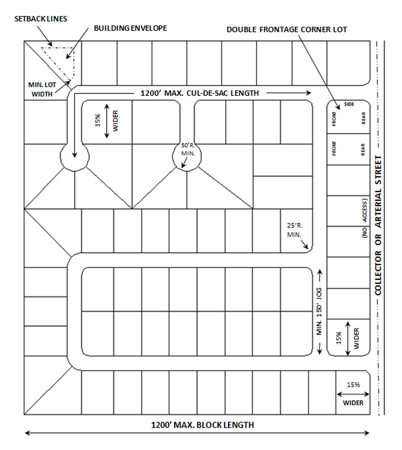
Sec. 8-5. - General design guidelines.
a)
Improvements required. All subdivisions shall construct a system of roadways and streets to provide access to proposed lots and for the through traffic needs of the project and area. The improvements shall include the complete clearing and grading of all road right-of-way, unless specifically shown otherwise on the approved plans. In addition, any unpaved streets which provide access to the subdivision shall be improved as required in this section.
b)
Street layout. Streets shall be laid out in consideration of topographic conditions, existing and previously approved streets, proposed roads as reflected in the Comprehensive Plan, the traffic needs for surrounding land uses, and overall traffic safety. The layout shall specifically be designed as follows:
1)
A minimum of two (2) points of access shall be provided into each subdivision of twenty-five (25) lots or more. Where adjoining development and Code requirements preclude the development of two (2) public street access points, an unobstructed drivable access way and/or boulevard entrance (entrance with divided median), which may include emergency access, may be substituted.
2)
Street jogs with centerline offset of less than one hundred fifty (150) feet shall be prohibited.
3)
All streets that have permanent dead ends shall terminate in a cul-de-sac.
4)
Cul-de-sac streets shall not exceed one thousand two hundred (1,200) feet in length, unless granted a variance by the Town Commission.
5)
Right-of-way intersections shall be rounded with a minimum radius of twenty-five (25) feet. A greater radius may be required on collector or arterial roads, or where road construction details require.
6)
Cul-de-sac right-of-way radius shall not be less than fifty (50) feet with a pavement radius of not less than forty (40) feet.
7)
Alleys shall not be less than thirty (30) feet with a paving width of twenty (20) feet.
8)
Dead end alleys shall be prohibited.
9)
Alleys shall be provided in commercial and industrial subdivisions only.
10)
Right-of-way width:
These are generalized width requirements and may be increased at the request of the appropriate jurisdiction if the proposed project fronts on a state or county road.
11)
Pavement width: Standard pavement widths shall be measured exclusive of curbs and gutters.
12)
Roads within flood prone areas: The minimum centerline elevation shall be as follows:
c)
Street design. The subdivision and developments of any area subject to this chapter shall be in conformity with the Town's general goals, objective and established Town policies and plans.
1)
Where a subdivision abuts or contains an existing or proposed arterial street, provisions shall be made for access streets as required.
2)
In the design of streets, turn radii and reverse curves, good engineering design principles shall be used.
3)
Curvilinear street layouts are strongly encouraged and regimented lot and block patterns are to be avoided.
4)
There shall be no private streets or easements for street use platted in any subdivision unless stated on the plat of record and approved by the Town.
5)
Half or partial streets shall be prohibited.
6)
All streets shall be named consistent with the Lake County 911 system. No name shall be used which will duplicate or be confused with existing street names in the County. A list of streets shall be provided to Lady Lake building department for certification prior to platting.
d)
Easements.
1)
Easements across lots, where necessary, or centered on rear lot lines shall be provided for utilities and shall be at least ten (10) feet in width or a combination thereof on two (2) lots.
2)
Easements, when required for drainage of the area to be subdivided, shall be of such width as is necessary to permit proper construction and maintenance of drainage facilities based on the drainage system of the area.
e)
Lot and block standards.
1)
The lengths, widths and shapes of blocks shall be determined with due regard to providing adequate buildings sites suitable to the special needs of the type of use contemplated; the zoning requirements as to lot sizes and dimensions; the needs for convenient access, circulation, control and safety of street and pedestrian traffic and fire protection; and the limitations and opportunities of topography, with special emphasis on drainage of the proposed subdivision and the possible adverse effects of that drainage on properties surrounding the subdivision.
2)
Block lengths shall not exceed twelve hundred (1,200) feet.
3)
Each lot shall conform to the requirements and regulations of the zoning district in which the subdivision is located.
4)
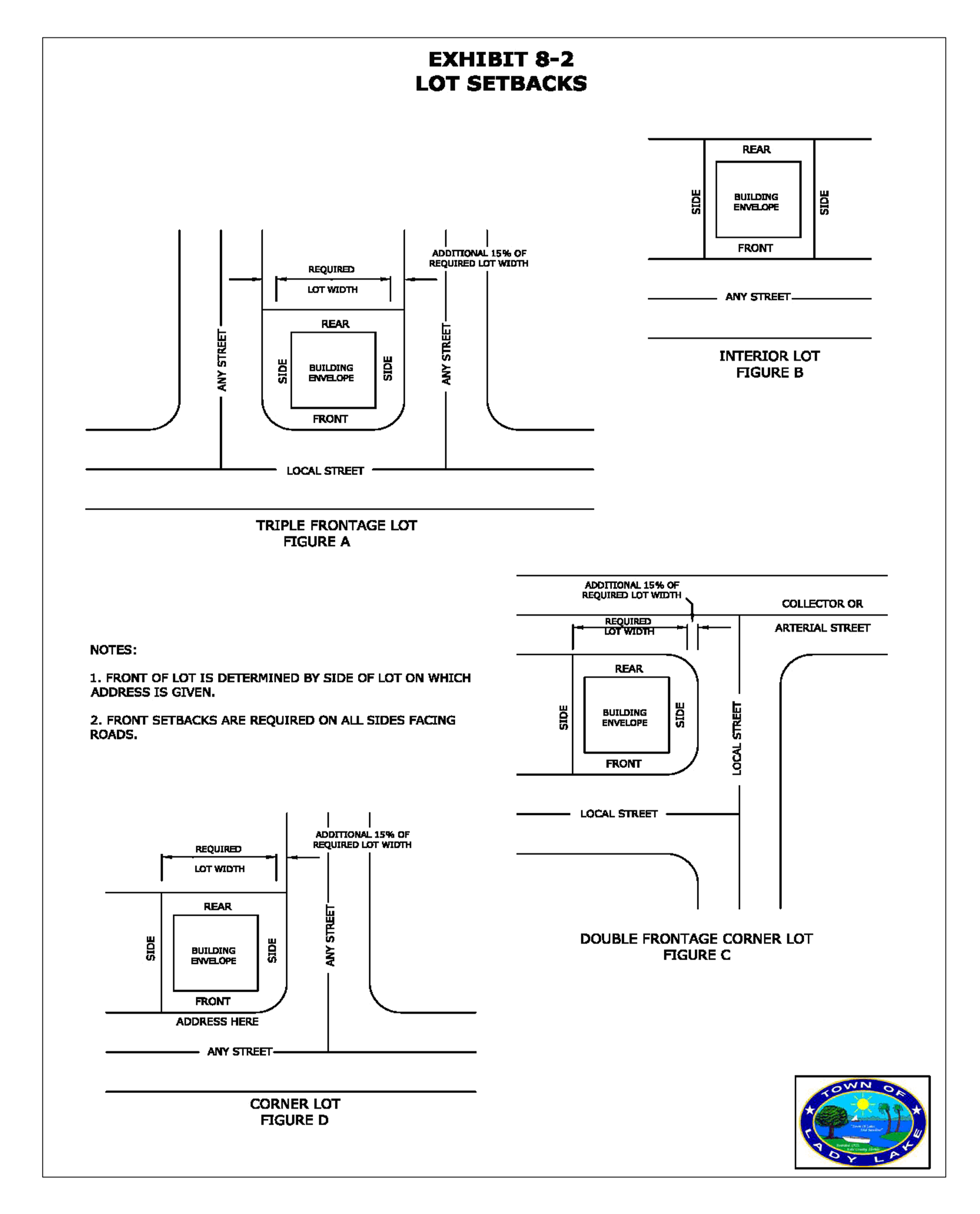
Double frontage lots shall be discouraged; however, when used, access to the rear shall be prohibited.
5)
Lots on curves shall be platted to provide the minimum required lot width at the building location.
6)
All corner lots shall be fifteen (15) percent wider than the minimum width required by this Code.
f)
Subdivision Open Space Requirement. All new residential subdivisions are required to incorporate Open Space as part of the subdivision design. In assessing the needs for use and enjoyment of Open Space areas of the different residential communities throughout the Town, a matrix has been designed to establish open space requirements based on the zoning district.
1)
Subdivision Open Space Requirement Matrix. In providing residents with multiple recreation facilities opportunities, residential subdivisions shall be required to provide a percentage of the required Open Space area for activity-based recreation facilities, as provided by the following matrix:
* Recreation Area is included within the Open Space Percentage, provided as one-fifth (⅕) of the Open Space.
2)
Activity-Based Recreational Area Requirements:
a)
Activity-Based Recreational Areas shall be no less than fifteen thousand (15,000) square feet for any subdivision.
b)
Each subdivision will be required to provide at minimum a combination of two (2) amenities. For each additional fifteen thousand (15,000) square feet of dedicated activity-based recreational area, the provision of an additional amenity will be required; a variation of three (3) from the list shall be provided prior to the placement of two (2) the same amenity type. Applicants may choose amenities from the list below:
1)
Area with swing set (four seats minimum)
2)
Wood/Metal Benches two (2) minimum
3)
Built-In Grill
4)
One (1) Picnic Table
5)
One (1) Slide
6)
One (1) Jungle Gym
7)
One (1) Monkey Bar
8)
Other amenities as approved by the Town Commission
c)
Land being proposed as activity-based park area must be shown as an "activity based recreation area" on the plat and pedestrian sidewalk access shall be provided.
(Ord. No. 2013-07, § 1(Exh. A), 7-1-2013)
Sec. 8-6. - Submitting and processing subdivision applications.
a)
Procedure. All plans for new subdivisions and road rights-of-way must be submitted and processed through the following procedures:
1)
Pre-application conference may be scheduled between the applicant and the Growth Management Department
2)
Submission and approval of preliminary plat/plan.
3)
Concurrency management.
4)
Submission and approval of improvement plans and issuance of a development order (See below).
5)
Submission, approval, and recording of final plat.
6)
Issuance of certificate of completion.
b)
Validity of a subdivision not meeting the requirements of this chapter. No plat of any subdivision shall have any validity until it has been approved in the manner prescribed by this chapter which may include variance by the proper board. In the event an unapproved plat is recorded, it shall be considered invalid. No person shall transfer or sell by reference to, exhibition of or by the use of a plan or plat of a subdivision before such plan or plat has final plat approval and is officially recorded according to the terms of this chapter. The description of any lot by metes and bounds shall not exempt the transaction from the provisions of this chapter if the transaction would be subject hereto otherwise.
1)
The Town shall not make any public improvements and shall have no responsibility for the maintenance of streets, drainage facilities or other facilities in subdivisions whose dedications have not been accepted by the Town under the terms of this Code.
2)
No changes, erasures, modifications or revisions shall be made on any final plat after approval and signature thereof unless said plat is first resubmitted and re-approved under the provisions of this chapter.
c)
Pre-application Conference. It is recommended that a pre-application conference be held with the Growth Management Department by the developer or the developer's representatives, in order to verify the steps necessary for application and review and discuss potential issues regarding the proposed subdivision.
1)
Scheduling. Arrangements for the pre-application conference are to be made through the Growth Management Director.
2)
Items required. Prior to the meeting the applicant shall provide a digital copy in PDF format of the proposed subdivision to Growth Management Staff. A general description of the proposed subdivision must be noted including the number of lots to be created, the approximate size and width of lots, approximate building size, type and use, proposed phases of development, existing zoning and comprehensive land use classification of the subject site and adjacent sites.
d)
Preliminary plat/plan.
1)
Application. A subdivision plan shall receive its first official consideration as a "preliminary plat/plan." A digital copy in PDF format of the preliminary plat/plan and any required supplemental material shall be submitted to the Growth Management Department. To cover the direct administrative costs of reviewing the plan, the developer shall satisfy the application fee at the time of submittal. The preliminary plat/plan shall be at a minimum scale of one hundred (100) feet to the inch. The following information shall be included on or with the plan:
A)
Proposed subdivision name or identifying title preceded by the words "Preliminary Plat of [ Subdivision Name]".
B)
The section, township and range in which the property is located and legal description of the boundary survey.
C)
The complete name and mailing address of the property owner, developer, engineer and other persons directly involved in the proposed subdivision.
D)
Tract boundaries, with dimensions.
E)
North arrow (with north being at the top of the map, when practical), date of preparation, and any other pertinent legend data.
F)
A sketch or "key map" at scale of not larger than one thousand two hundred (1,200) feet to the inch showing the position of the subdivision with relation to surrounding streets and properties; also showing other important features such as zoning, railroads and corporate limits, etc.
G)
Zoning, plat book and page number, typical lot size, streets and easements of adjacent land and subdivisions.
H)
Topographic mapping of the tract based on N.G.V.D. elevations, in not less than one (1) foot intervals.
I)
Conditions on tract, including all existing watercourses, drainage ditches, bodies of water, marshes, flood prone elevations and area, surrounding physical features affecting the site, isolated preservable trees and other significant features.
J)
Existing property lines, buildings, transmission lines, sewers, bridges, culverts and drain pipes, water mains, town limit lines and utility easements on or adjacent to the tract.
K)
Location, name and width of all proposed streets, alleys, rights-of-way, easements, lot lines with dimensions, lot numbers and block designations.
L)
Typical section showing street type and width, storm drainage and designs of any proposed fences and entrance structures.
M)
Statements concerning stormwater disposition and method of water supply and waste disposal, all conforming to Town specifications.
N)
Proposed public improvements, such as highways or other major improvements planned by public authorities for future construction on or near the tract to eliminate gridlock.
O)
If the proposed subdivision is to be constructed in phases, the nature and extent of such phases shall be clearly delineated and shall meet the criteria specified below in a later section.
P)
Sites/and or improvements to be dedicated or deeded for public use.
Q)
A delineation of the soils existing on the site to be developed.
R)
A geological reference point on all plans.
S)
A summary list containing the total acres, number of lots, minimum lot area, lineal feet in streets, zoning and a list of street names.
T)
Drafts of protective covenants whereby the developer proposes to regulate land use in the subdivision and otherwise protect the proposed development.
U)
Requirements of the following sections shall be adequately addressed and satisfied. The Growth Management Department may require information deemed necessary to demonstrate compliance with the regulations concerning:
1)
Zoning.
2)
Buffering.
3)
Environmentally sensitive areas.
4)
Upland habitat.
5)
Floodplain/stormwater management.
6)
Wellfield/aquifer protection.
7)
Historic and archeological preservation.
8)
Traffic.
9)
Concurrency Management.
2)
Review process.
A)
Within 7 business days after receipt of a plat or replat submittal, the Growth Management Staff shall provide written notice to the applicant acknowledging receipt of the plat or replat submittal and identifying any missing documents or information necessary to process the plat or replat submittal for compliance with F.S. § 177.091.
B)
The preliminary plat/plan shall be reviewed initially by the Growth Management Staff. Staff shall review the preliminary plat/plan for technical compliance with this chapter and with all other Town ordinances, zoning regulations and for compliance with the land use element of the Town's Comprehensive Plan. Town staff, along with any third party consultants which may be utilized, shall recommend in writing preliminary approval, conditional approval or denial. Staff shall furnish copies of its recommendations to the Town Manager.
C)
The Town Manager must approve, approve with conditions, or deny the application within thirty (30) working days of a complete submittal, unless the applicant requests an extension.
1)
Preliminary approval by the Town Manager means that the developer is now authorized to proceed with the preparation of the required Improvement Plans.
2)
Conditional approval by the Town Manager means that the developer may proceed, after written notice from the Growth Management Director, with preparation of Improvement Plans, but only after he has submitted a digital copy of the corrected preliminary plan/plan to the Growth Management Department, noting thereon the condition of changes required by the approval of the Town Manager.
3)
Denial by the Town Manager means denial of the application for the subdivision because the developer's plans are not in compliance with these regulations. For further consideration, the developer must rework and resubmit his plans as though they were a completely new preliminary plat/plan.
3)
Expiration of approval. The preliminary approval shall expire if Improvement Plans have not been approved within twenty-four (24) months of the date of approval of the preliminary plat/plans, or unless a time extension is granted by the Town Manager before the expiration date.
4)
Phasing. Subdivision projects may be phased. Phasing, if proposed, shall be shown on the plans.
A)
Phasing shall be arranged and designed in such a manner that at any point in a project's development the initial phase, and any successive groups of phases, shall be able to "stand alone" and function adequately in regards to required improvements, infrastructure, facilities, and in relation to all project conditions so as to be independent from any future phase or phases and improvements or areas contained therein.
B)
Minimum size of phases will be ten (10) percent of the total number of lots in the project.
e)
Improvement plan.
1)
Application. The applicant shall furnish to the Town Manager or designee the Improvement Plans and specifications designed in accordance with the requirements of this Code. The applicant shall also furnish a completed application form. The applicant must have obtained and shall submit copies of all jurisdictional agency approved permit packages and all utility permits and franchises required by the utility provider, prior to the issuance of a development order. All construction plans and specifications must be prepared, signed and sealed by a professional engineer who is registered in the State of Florida. Engineering calculations and tests in support of any of the proposed plans and specifications are required. The drawings and required information shall be so complete that review and analysis can be made from them without research of any outside data. A digital copy of the plans shall be submitted on twenty-four by thirty-six-inch (24" x 36") sheets at a scale no smaller than one-inch equals one hundred feet (1" = 100') unless another size is approved by the Town Manager or designee, and shall contain, but not be limited to:
A)
A cover sheet, including location map, at a scale no smaller than one (1) inch equals one thousand two hundred (1,200) feet showing the zoning of the area and the relationship of the proposed subdivision to the surrounding development.
B)
Subdivision name, date, north arrow, and the property's legal description, boundary, boundary dimensions, and area in acres.
C)
Name and address of owner, and any other professional consultants involved with the generation of the plan information. If the property is owned by a corporation or company, the name and address of its president and secretary, and state of incorporation shall be given.
D)
Proposed streets, roadway improvements, common areas, drainage areas, conservation areas and lot lines.
E)
Benchmark location, based on National Geodetic Vertical Datum (N.G.V.D.) with topography at one (1) foot contour intervals.
F)
All existing buildings, utilities, roads, easements or other improvements on the property.
G)
Existing utility sources, distribution and collection lines, if available, including but not limited to water, sewer, electricity, cable television and telephone. Proposed locations of sidewalks, and bike paths, if any, and of all signs per the Sign Regulations chapter.
H)
All easements required per Developmental Procedures and Regulations chapter.
I)
Environmental assessment showing all wetlands, delineation of wooded areas and vegetative communities.
J)
Delineation of Flood Insurance Rate Map (FEMA) flood zones.
K)
Proposed stormwater management plan, including drainage control facilities and proposed grading.
L)
Complete plans and details of water and sewer systems and improvements. The proposed general location of wells and septic tanks shall be in conformity with the requirements of the Lake County Health Department and all state and local ordinances.
M)
Plan-profile sheets of the rights-of-way and, if necessary, of special or unique situations.
N)
Roadway typical cross sections.
O)
Construction details and minimum standards for materials, showing compliance with Town standards or alternate design as approved by the Town Manager or Town Engineer.
P)
The proposed average daily traffic generated by the development based on trip generation rates contained in the Institute of Traffic Engineers (ITE) Manual, latest edition.
Q)
Traffic control devices and pavement markings.
R)
Soil analysis, showing the location and results of test borings of the subsurface condition of the tract to be developed.
S)
Proposed erosion control facilities and the limits of earthwork construction, both as to final construction and for protection during construction.
T)
Where the design of the subdivision includes man-made canals or waterways, plans of the proposed construction will be included and shall indicate:
1)
All bulkhead locations.
2)
Detailed cross-sections showing existing and proposed depths.
3)
Location of hard pan, muck or other unique soil conditions.
4)
Details of Bulkhead Construction.
2)
Review process.
A)
Within twenty (20) working days after receipt of such plans and specifications, Town staff, along with any third party consultants which may be utilized shall submit their comments and recommendations to the Town Manager or designee.
B)
The applicant will be advised in writing by the Town Manager or designee of all applicable departmental comments within thirty (30) working days from the date of application submittal.
C)
After the applicant has adequately addressed all departmental comments and has submitted to the Town Manager revised documents in accordance with departmental comments and has submitted copies of all required jurisdictional agency permits, the Town Manager shall approve, approve subject to specified conditions or disapprove the plans.
E)
In rejecting any plans, the Town Manager shall provide reasons for such action and recommendation making reference to specific sections in this Code and F.S. Ch. 177 or applicable Town policy. The Town Manager shall send a copy of such reasons to the developer. The subdivider may comply with the recommendations made by the TRC and thus be qualified to resubmit the plans to the Town Manager for processing.
3)
Term of permit. A development order, issued after final approval, shall be void if a final plat has not been recorded within twenty-four (24) months from the date of its issuance, unless the Town Manager grants an extension of time, in response to the applicant's written request for such an extension. In the case of phasing, each new phase must have its final plat recorded within twenty-four (24) months of the date of the previous phase's final plat recording date. Development phasing may not cover a period exceeding twenty (20) years. Commencement of construction for a new phase must begin within twenty-four (24) months of completion and inspection of the previous phase. The development order will lapse if the approved phase time frames are exceeded, unless otherwise extended by the Town Commission as provided for in the section below.
4)
Extensions. A request for an extension of the development order may be submitted to the Town Manager or designee any time prior to the expiration date.
A)
No request for an extension will be accepted after the development order has lapsed or phasing schedule exceeded. The applicant may, however, reapply for plan approval under the provisions of the Code in effect at the time of application.
B)
Where initial development construction has commenced pursuant to the development order and development is continuously proceeding, the Town Manager may grant one (1) or more extensions not to exceed two (2) years.
C)
Where an extension is desired but no construction has been initiated, the request for extension shall be reviewed and considered by the same process as the original approved, with special consideration to:
1)
Amendments to the Town Code, including codes and standards adopted by reference, that have been adopted since the original approval, requiring modification to the development plans or associated documents.
2)
Re-evaluation of the ability of the proposed development to meet the requirements of the Concurrency chapter.
3)
Changes in surrounding land use, development, or other conditions that may require modification of the plans to meet the requirements of the Code.
D)
Extension requests shall be made in writing to the Town Manager. The Town Manager or designee shall consider the request and grant approval or a denial of the extension.
5)
Modifications.
A)
Minor modifications. Minor modifications to development orders may be approved by the Town Manager when such modifications are consistent with the requirements of the Code and do not have a substantial impact on the overall intent of the development order or Memorandum of Agreement, such as:
1)
Dimensional changes to accommodate field conditions, including connection to existing facilities and the preservation of existing vegetation.
2)
Changes of landscape or construction materials that are deemed to be similar or equivalent to those approved.
3)
Technical changes to construction details.
4)
Modifications to roadway layout, phasing, and lot configuration.
B)
Major Modifications. When, in the opinion of the Town Manager, the proposed modifications represent a major or fundamental change in the overall impact and intent of the original development order, the resubmittal shall follow the same approval process as required for the original submittal. Modifications that require a change of ten (10) percent in the number of lots or a change in area to be platted will require re-approval of the preliminary plat/plan.
(Ord. No. 2013-07, § 1(Exh. A), 7-1-2013; Ord. No. 2025-10, § 1(Exh. A), 8-4-2025)
Sec. 8-7. - Procedure and requirements for recording the final plat.
The approved final plat is the official record of the subdivision to be filed with the Town Manager. It is verification that the subdivided land has been developed substantially in accordance with the development order or that a bond has been posted which will secure the development as specified in the final plat. The final plat must be approved by the Town Manager and recorded in the Public Records of Lake County prior to the developer selling any lot or parcel.
a)
Procedure. No final plat application shall be submitted for approval prior to the issuance of a development order. The plat shall be accompanied by:
1)
A completed final plat application furnished by the Growth Management Department.
2)
The appropriate filing fee.
3)
A determination of capacity for the area to be platted per the Concurrency Management chapter.
4)
Two (2) mylar copies of the final plat drawing (a maximum of thirty by forty-two inches (30" x 42"), one (1) eleven by seventeen-inch (11" x 17") paper copy, and an electronic copy showing the required information and certifications.
5)
A copy of the responsible party's documents which accept the responsibility for maintenance of all private streets, rights-of-way, easements, recreation areas, stormwater management facilities or other improvements.
6)
A copy of the final protective covenants and deed restrictions, where such covenants and restrictions are required or established by the applicant.
7)
All applicable informational requirements of this Code.
8)
When submitted in conjunction with a construction contract or bond, a certified cost estimate (EXHIBIT) shall be prepared by the developer's engineer as specified in the Developmental Procedures and Regulations chapter, or the actual contract price(s) may be substituted for the engineer's cost estimate if available.
b)
Format of drawings. The final plat shall be:
1)
Prepared in accordance with F.S. Ch. 177 by a land surveyor registered and licensed in the State of Florida.
2)
On mylar sheets a maximum of thirty by forty-two inches (30" by 42") with a three-quarter (¾) inch margin on three (3) sides and a three (3) inch margin on the left side for binding.
3)
To a scale no smaller than one (1) inch represents one hundred (100) feet.
4)
Clearly drawn or printed with permanent black drawing ink.
c)
Information required. (All information as required in F.S. Chapters. 177.041, .051, .061, .081, and .091). In addition, the final plat shall contain:
1)
The date of preparation of the final plat.
2)
County and Town limit lines within or abutting the tract.
3)
The location and width of all existing or recorded rights-of-way intersecting or contiguous to the boundary of the plat.
4)
The following statements shall be noted on the plat in a prominent place:
"Notice: There may be additional restrictions that are not recorded on this plat that may be found in the public records of Lake County."
5)
A three (3) inch-by-five-(5) inch space in the upper right hand corner of each sheet to be used by the clerk of the circuit court for recording information. The following shall be depicted:
PLAT BOOK: ___________
PAGE: ___________
6)
No strip or parcel of land reserved by the owner unless it is of sufficient size to be of some particular use or service or is environmentally sensitive land.
7)
The boundary of the final plat having a mathematical error of closure not greater than .01 foot. Any plat undertaking to establish a local tidal datum and determine the location of the mean high water line or mean low water line shall comply with the notification requirements of F.S. § 177.37 or as amended.
8)
All covenants, restrictions or reservations placed by the developer or required by the Town shall appear on the final plat or be established by separate recorded document.
9)
When deemed necessary by the staff of the Public Works Department to ensure the proper future expansion of utilities services, a covenant document shall be filed with the plat that indicates the following statement: "In the future, when a potable water distribution and/or wastewater collection system becomes available to service the subdivision, service improvements and connection shall be made by the homeowner's association or by the property owners. All deeds conveying properties within the subdivision shall reference the covenant document.
d)
Certifications, dedications and approvals. The final plat shall contain on the face or first page the following certifications, dedications and approvals, all executed and acknowledged as required by law, in the forms set forth below:
1)
Dedications. The purpose of all reserved areas shown or referred to on the plat and of the improvements defined in the dedication. All areas reserved for use by the residents of the subdivision and all areas or facilities intended for public use, shall be specifically dedicated by the owner of the land at the time the plat is recorded. All streets, rights-of-way, easements, recreation facilities designed to serve more than one (1) property owner shall be dedicated to the Town or to a private property owner's association in a manner that will ensure access to and use by present and future owners of the properties to be served. Where private dedications are involved, ownership and maintenance association documents shall be submitted with the final plat. The dedication shall clearly dedicate the private facilities to the association without recourse to the Town or any other public agency. All dedicated areas shall be identified as tracts unless such areas are dedicated to one (1) entity and clearly identifiable. All dedications shall be in the following forms or as approved by the Town Attorney:
A)
Corporate.
CERTIFICATE OF DEDICATION
(Corporate)
STATE OF________
COUNTY OF________
KNOW ALL MEN BY THESE PRESENTS, that (exact corporate name), a (state) corporation, fee simple owner of the land described and platted herein, as (exact name of subdivision), being in the Town of Lady Lake, Lake County, Florida, have caused said lands to be surveyed and platted as shown hereon and does hereby dedicate as follows:
(SELECT AS APPROPRIATE FROM C) AND D) BELOW)
B)
Individual.
CERTIFICATE OF DEDICATION
(Individual)
STATE OF ________
COUNTY OF________
KNOW ALL MEN BY THESE PRESENTS, that (exact owner's name), fee simple owner of the land described and platted herein, as (exact name of subdivision), being in the Town of Lady Lake, Lake County, Florida, has caused said lands to be surveyed and platted as shown hereon and does hereby dedicate as follows:
(SELECT AS APPROPRIATE FROM C) AND D) BELOW)
C)
Select as appropriate to be added to the Certificate of Dedication above:
1)
Streets and right-at-ways (For public streets). All streets and rights-of-way shown on this plat (name specifically if less than all) are hereby dedicated in perpetuity to the Town of Lady Lake for the use and benefit of the public for proper purposes.
2)
Private streets. All streets and rights-of-way shown on this plat (name specifically if less than all) are hereby declared to be and shall remain private. They are dedicated for the use and benefit of the owners and residents of this subdivision and shall be the perpetual maintenance obligation of the (state exact legal name of maintenance entity). All public authorities, including but not limited to police, fire, ambulance, and utility providers shall have the right to use the streets in the course of performing their respective duties. The Town of Lady Lake shall have no responsibility, duty or liability whatsoever regarding such streets.
3)
Utility easements. The utility easements shown are dedicated in perpetuity to the utility provider for the construction, installation, maintenance and operation of utilities by any utility provider, including cable television services, in compliance with such ordinances and regulations as may be adopted from time to time by the Town Commission of Lady Lake.
4)
Drainage and Stormwater Management Easements. The drainage easements and stormwater management tracts or easements as shown are dedicated in perpetuity for construction and maintenance of drainage facilities and shall be the perpetual maintenance obligation of the (give exact name of maintenance entity). Front yard drainage easements are subject to the right of each lot to have a driveway for ingress/egress as approved by the Town.
5)
Park and recreation areas. The park and recreation areas as shown are dedicated in perpetuity for the (exclusive use and enjoyment of the owners of lots in this subdivision) (Use and enjoyment of the public) and shall be the perpetual maintenance obligation of (give exact name of maintenance entity, if private) (Town of Lady Lake).
6)
Limited access easements. The limited access easements as shown are dedicated in perpetuity to the Town of Lady Lake for the purposes of control and jurisdiction over access rights.
7)
Conservation easements. Conservation easements as shown are dedicated in perpetuity to the Town of Lady Lake (and name any other specific agencies requiring preservation dedication) for the purpose of preservation of environmentally sensitive areas.
D)
Add appropriate conclusion to Certificate of Dedication above:
1)
Corporate.
IN WITNESS WHEREOF, the above named corporation has caused these presents to be signed by its and its corporate seal to be affixed hereto by and with the authority of its board of directors this ________ day of ________, 20___.
(FULL CORPORATE NAME), a corporation of the State of ___________, By: (Signature of president or vice president or chief executive) Type Name and Title of Officer (Signature must have two (2) witnesses or be under corporate seal).
2)
Individual.
IN WITNESS WHEREOF, (I), (we), (name(s), have hereunto set (my) (our) hand(s) and sealed this________ day of ________, 20___.
WITNESSES:
___________
(Typed Name)(Signature)
(ADD ACKNOWLEDGEMENT OF THOSE EXECUTING THE DEDICATION)
3)
Joinder and Consent to Dedication by Mortgagee or Other Party in Interest.
MORTGAGEE'S CONSENT
STATE OF ___________
COUNTY OF ___________
The undersigned hereby certifies that it is the holder of (a) mortgagees), lien(s), or other encumbrance(s) upon the property described hereon and does hereby join in and consent to the dedication of the land described in said dedication by the owner thereof and agrees that its mortgagees), lien(s) or other encumbrance(s) which (is) (are) recorded in Official Record Book at page(s) of the public records of Lake County, Florida, shall be subordinated to the dedication shown hereon.
IN WITNESS WHEREOF, (I) (we), ___________ do hereunto set (my) (our) hand(s) and seal(s) this day ________ of ________ 20___.
WITNESSES
___________ (Signature)
___________ (Typed name)
(ADD ACKNOWLEDGEMENT OF THOSE EXECUTING MORTGAGEE'S CONSENT)
Note: In accordance with F.S. § 177.081, or as amended, this joinder may be executed by a separate instrument joining in and ratifying the plat and all dedications thereon. If this means of joinder is used, such fact must be stated on the plat together with a reference to the location in the public records of such separate instrument.
4)
Certificate of Title. A title certification shall appear on the face or first page of each plat and shall state:
A)
The lands as described and shown on the plat are in the name of, and apparent record title is held by, the person, persons, or organizations executing the dedication;
B)
That all taxes have been paid on said property as required by F.S. § 197.192, or as amended; and
C)
The official record book and page number of all mortgages, liens, or other encumbrances against the land, and the names of all persons holding an interest in such mortgage, lien or encumbrance. The title certification shall be an opinion of a Florida attorney-at-law or the certification of an abstract or title insurance company licensed to do business in Florida. The Town reserves the right to require that the title certification be brought current at the time of final plat approval.
5)
Certification of Surveyor. The plat shall contain the signature, registration number and official seal of the land surveyor certifying that the survey data compiled and shown on the plat complies with all of the requirements of F.S. Ch. 177, latest published edition, in the following forms:
CERTIFICATE OF SURVEYOR
KNOW ALL MEN BY THESE PRESENTS, That the undersigned, being a licensed and registered land surveyor, does hereby certify that on the ________ day of ________ 20___, completed the survey of the lands as shown in the foregoing plat; that said plat is a correct presentation of the lands therein described and platted or subdivided; that permanent reference monuments have been placed and each P.C.P. will be set as shown thereon as required by Chapter 177, Florida Statutes and that said land is located in Lady Lake, Florida.
Dated ___________ Registration No. ___________
6)
Certificate of Approval by the Town Manager. The plat shall contain the approval and signature block for the Town Manager and the acknowledgment and signature block of the clerk of circuit court and the Town Attorney. In the event the plat contains dedications to the Town, this certificate shall also indicate whether the Town accepts in whole or in part the dedications made. The following form is acceptable:
CERTIFICATE OF APPROVAL BY THE TOWN MANAGER
THIS IS TO CERTIFY that on the foregoing plat was approved by the Town Manager of Lady Lake, Florida. (Address acceptance of dedications in whole or in part, as appropriate).
___________
Town Manager
Attest:
___________
Town Clerk
APPROVED AS TO FORM AND LEGAL SUFFICIENCY
___________
Town Attorney
7)
Instrument Prepared By. The name and address of the natural person who prepared the plat shall be contained on the plat. The name and address shall be in statement form consisting of the words "This instrument was prepared by (name), (address)."
8)
Signatures. All signatures required shall be originals on the final plat and shall be made in permanent dark ink.
e)
Review and Approval of Final Plat Documents.
1)
The Growth Management Staff along with any third party consultants which may be utilized, will review the plat and submit their comments and recommendations to the Town Manager.
2)
Upon completion of review and all requested revisions being made, the final plat and application, including recommendations from the Growth Management staff along with any third party consultants which may be utilized, shall be forwarded to the Town Manager for review and consideration of approval. The Town Attorney must review mylars prior to consideration of the final plat by the Town Manager. The Town Manager shall determine whether the final plat is in substantial conformity with the development order and meets all the requirements of the laws, rules and regulations of the Town of Lady Lake and after consideration shall approve, with conditions, or disapprove for stated reasons.
3)
In rejecting any final plat, the Town Manager shall provide reasons for such action and recommendation making reference to specific sections in this Code and Florida Statutes, Chapter 177 or applicable Town policy established by the Commission. The Town Manager shall send a copy of such reasons to the developer. The subdivider may comply with the recommendations made by the Town Manager and thus be qualified to resubmit the final plat to the Growth Management Department for processing as prescribed above.
4)
The Town Manager shall indicate approval on the final plat by signature.
f)
Recording. The final plat shall be recorded by the developer in the circuit court of Lake County. After recording, the developer may sell lots.
g)
Acceptance of Public Improvements. Approval of said final plat shall constitute acceptance by the Town of all public areas or improvements dedicated to the Town of Lady Lake according to the terms set out in the acceptance block. In addition to the following, all provisions specified in the Inspections and Acceptance section of the Development Procedures and Regulations chapter shall be adhered to.
1)
The owner shall be required to maintain the accepted improvements in good condition and post a maintenance bond for a period of two (2) years from the date of final plat approval or one (1) year from the date that a certificate of completion is issued by the Town Manager or designee, whichever is later. At the end of said period, the improvements shall be in such condition that they meet the requirements of this Code as it existed at the time of approval of the final plat.
2)
The Town accepts no obligation to perform any act of construction or maintenance except when the obligation is voluntarily and expressly assumed by the Town.
3)
The Town shall withhold all public improvements, including the maintenance of streets, from all subdivisions which have not been accepted in the manner herein provided.
4)
No changes, erasures, modifications or revisions shall be made on any final plat after approval unless the plat is first resubmitted for approval.
5)
The developer shall pay all costs of public improvements. The Town will not be responsible for any construction costs not paid at the time of acceptance.
6)
All mortgages or others having a lien on the land shall join in or ratify the plat and all dedications thereon executed and shall certify that all dedicated lands are free from such mortgages or liens.
7)
The Town will accept no obligation to repair or maintain navigable canals, waterways or bulkheads. Waterways and canals must be dedicated to and accepted by a property owner's association. Bulkheads that abut private or public streets must also be accepted for maintenance and repair by the property owner's association.
h)
Plat vacation request.
1)
Review process. Plat vacation requests shall be made through the Growth Management Department or designee on applications furnished by the department. A filing fee shall accompany any request. If there are any existing utilities onsite the Town will require an easement. The request will be reviewed by the Growth Management Staff along with any third party consultants which may be utilized. The request will be scheduled for consideration by the Town Commission in accordance with F.S. Ch. 177.101 or as amended, which governs plat vacations.
2)
Public notice. The Town shall advertise that a public hearing will be held to consider the request. Advertisement in a newspaper of general circulation in the area shall be done once a week for two (2) consecutive weeks, with the first advertisement at least two (2) weeks prior to the date stated therein for the hearing. Additionally, the Town shall notify the adjacent property owners by mail two (2) weeks prior to the hearing. Notice shall also be posted in a conspicuous place on the road right-of-way and at the Town Hall as determined by the Town.
i)
Right-of-way abandonment request.
1)
Application. Right-of-way abandonment requests are made through the Growth Management Department on applications furnished by the department. Each property owner adjoining the portion of the right-of-way to be abandoned must submit a petition and the required fee. Should any of the adjoining property owners not agree to the abandonment request, the other petitioners may still request it from the Town Commission, which has sole authority to decide on an abandonment. If there are any existing utilities in the right-of-way, the Town will require easements.
2)
Review process. The request shall be reviewed by the Growth Management Staff along with any third party consultants which may be utilized. Once the applicant has adequately addressed all comments, the abandonment request will be scheduled for consideration by the Town Commission in accordance with the F.S. Ch. 336, or as amended, which governs right-of-way abandonments.
3)
Public notice. The Town shall advertise that a public hearing will be held to consider the petition. Advertisement in a newspaper of general circulation in the area shall be done once a week for two (2) consecutive weeks, with the first advertisement at least two (2) weeks prior to the date stated therein for the hearing. Additionally, the Town shall notify adjacent property owners by mail two (2) weeks prior to the hearing. Notice shall also be posted in a conspicuous place on the road right-of-way and at the Town Hall as determined by the Town.
(Ord. No. 2013-07, § 1(Exh. A), 7-1-2013; Ord. No. 2025-10, § 1(Exh. A), 8-4-2025)
Sec. 8-8. - Commencement of construction improvements.
a)
Construction before final plat approval. Upon issuance of a development order, construction may commence. The improvements required by the development order shall be completed prior to final plat approval. All procedures specified in the Developmental Procedures and Regulations chapter shall be followed.
b)
Construction after final plat approval. Upon issuance of a development order, an applicant may apply for final plat approval, contracting with the Town to construct the improvements required in the development order. The contract and corresponding security as specified in the Developmental Procedures and Regulation chapter shall be required for the performance and maintenance of all improvements which are to be constructed after final plat approval.
c)
Notification. The Town Manager or designee shall be notified in writing of the commencement of construction improvements. Failure to notify the Town of the commencement and completion of any of the construction improvements shall be good cause to refuse to issue a certificate of completion until such further investigation is conducted to verify compliance with the development order.
(Ord. No. 2013-07, § 1(Exh. A), 7-1-2013)
Sec. 8-9. - Variances.
a)
Jurisdiction. Variances to the requirements of this chapter may be granted by the Town Commission, and shall be considered under the variance procedures in the Developmental Procedures and Regulations chapter.
b)
Application procedure.
1)
An applicant seeking a variance from this chapter shall submit an application on the form provided by the Town, together with the required fee and information stated in the "Developmental Procedures and Regulations" chapter.
2)
Variance to plat and development plan review process. Application for a variance to the plat and Improvement Plan review process shall be filed separately.
3)
Variance to required improvements or design criteria. In addition to the variance application, requests to vary required improvements or design criteria shall be noted on the application form for preliminary or improvement plan approval as appropriate. Variances requested shall also be prominently noted on the submitted plans themselves.
c)
Criteria for review of variances from the review process. The following criteria may be considered as the basis for the approval of a variance from the review process:
1)
Required services are already available to proposed lots without the construction of additional improvements.
2)
Levels of service can be reasonably provided through the site development plan review process or residential site plan review process for individual lots.
3)
Other methods can be arranged to assure construction of improvements, eliminating the need for formal subdivision approval.
4)
The granting of a variance is consistent with the overall intent of this Code, and will not be injurious to the surrounding properties or detrimental to the public welfare.
d)
Criteria for review of variances from required improvements or design criteria. In addition to those criteria outlined above, the following criteria may be considered as the basis for the approval of a variance from required improvements or design criteria:
1)
Topographic or other physical conditions exist which are peculiar to the site and not a result of the actions of the applicant.
2)
Literal interpretation of this Code would result in unnecessary and undue hardship on the applicant.
e)
Public notice.
1)
Public advertisement. The public hearing shall be advertised fifteen (15) days prior to the Planning and Zoning Board hearing in a newspaper of general circulation within the Town.
2)
Property owner notification. At least fifteen (15) days prior to the Planning and Zoning Board hearing all property owners listed on the latest tax roll within one hundred fifty (150) feet of the property on which a variance is requested shall be notified in writing by the Town Manager's office by U.S. Mail. Lack of a property owner's receipt of such notice shall not be grounds to postpone or set aside any variance granted.
3)
Posting of property. At least fifteen (15) days prior to the Planning and Zoning Board hearing, the property shall be posted as described in the "Developmental Procedures and Regulations" chapter.
f)
Right to attach conditions. If the Town Commission approves a variance, it may attach any such conditions to the variance as will assure that the variance will not result in noncompliance with the intent and purpose of this Code.
(Ord. No. 2013-07, § 1(Exh. A), 7-1-2013)
Sec. 8-10. - Penalties.
Violation of any condition shall be deemed a violation of this Code. Violation of any of the provisions of this chapter may be punishable by a fine not to exceed five hundred dollars ($500.00) or by imprisonment in County jail not to exceed sixty (60) days or by both such fine and imprisonment.
(Ord. No. 2013-07, § 1(Exh. A), 7-1-2013)
EXHIBIT 8-1
STREET AND LOT LAYOUT
(Ord. No. 2013-07, § 1(Exh. A), 7-1-2013)
(Ord. No. 2013-07, § 1(Exh. A), 7-1-2013)