
Linn County Unincorporated
City Zoning Code
City Zoning Code
APPENDIX B
LESA WORKSHEETS
CASE NO.:
GPN:
PLAN DESIGNATION: AGRICULTURAL AREA (AA)
Summary Sheet
Parent Tract Size: _________________________________
Development Tract Size: _________________________________
APPLICANT INFORMATION
Property Owner: _________________________________
Applicant: _________________________________
Address: _________________________________
City, State, Zip: _________________________________
Phone: _________________________________
Email (optional): _________________________________
Fax (optional): _________________________________
LESA EVALUATION SUMMARY
CASE NO.:
GPN:
PLAN DESIGNATION: AGRICULTURAL AREA (AA)
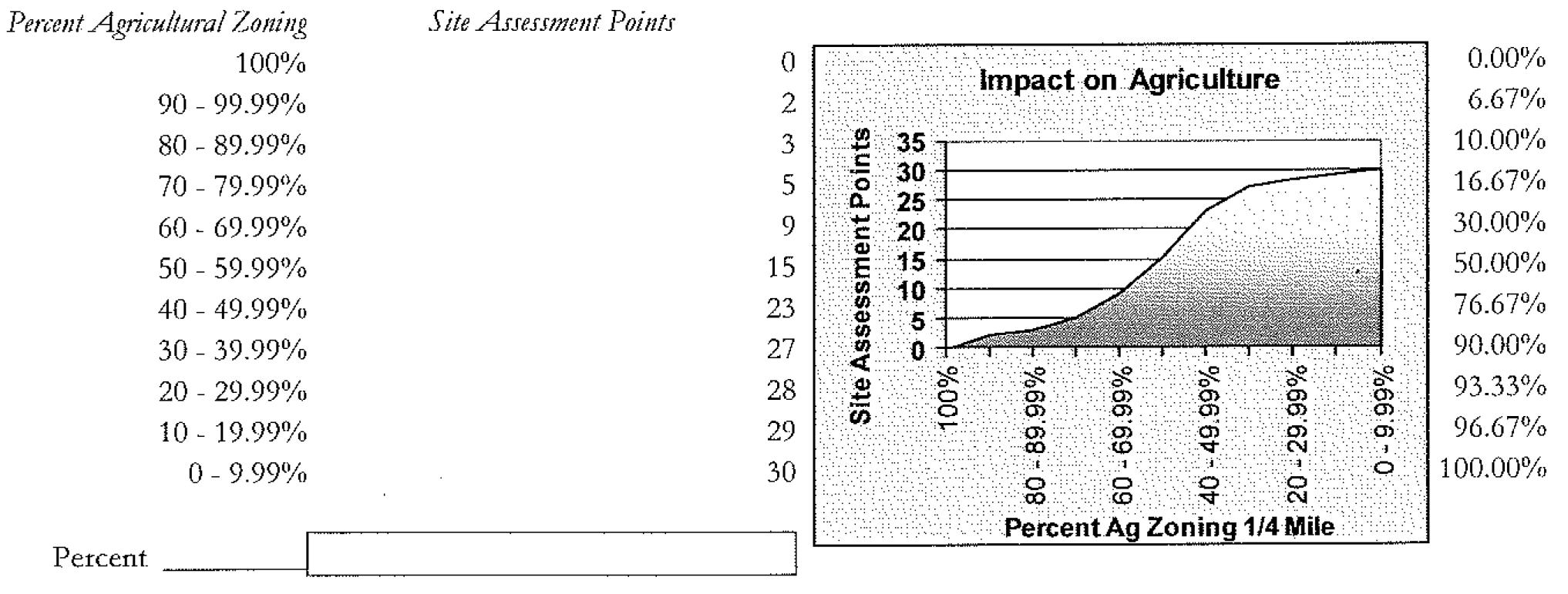
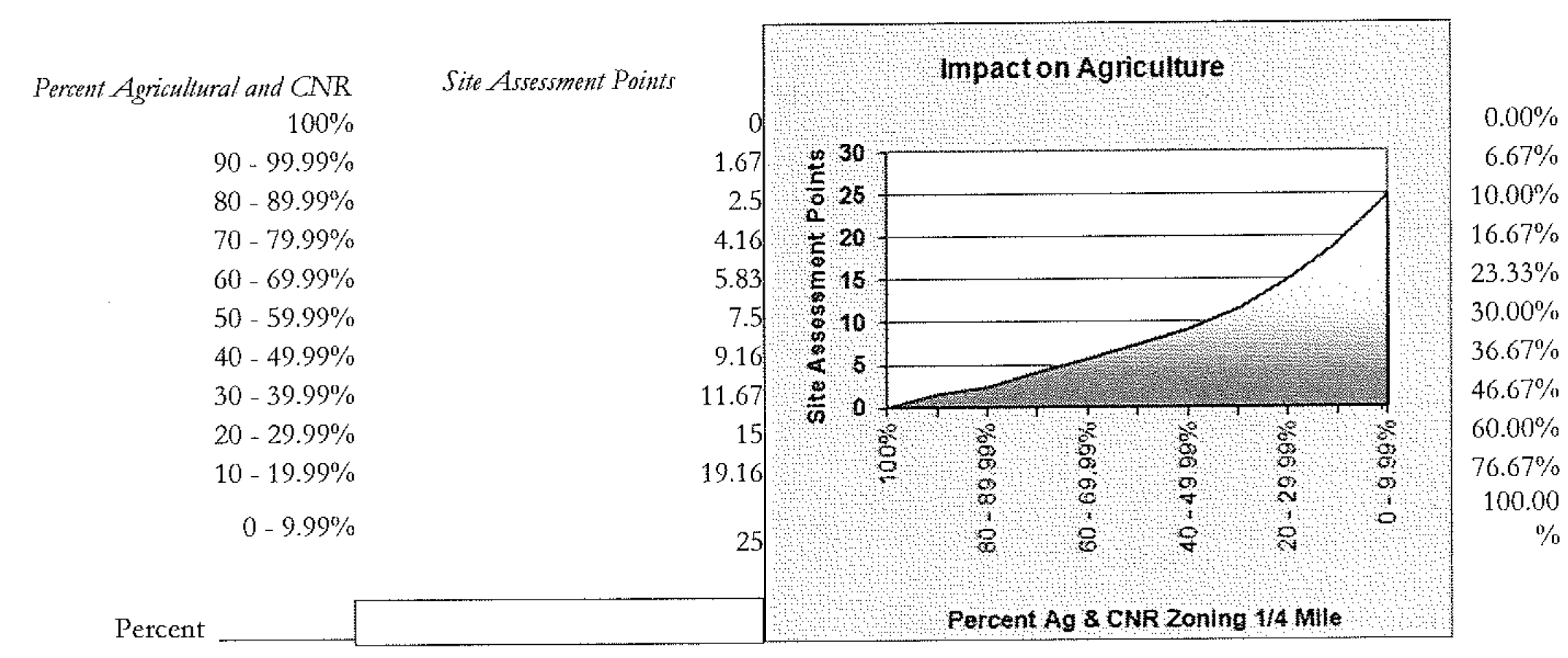
Site Assessment Criterion: Agricultural Zoning within One-Quarter Mile (30 maximum points)
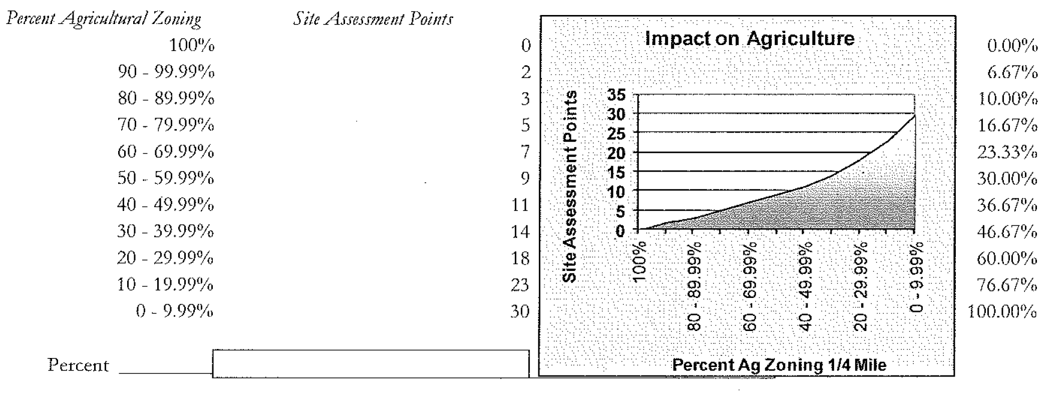
Data Source: Linn County Parcel and Zoning Data
Description: This factor considers the percentage of land that is zoned "AG" or "CNR" (including REC) within one-quarter mile of the boundaries of the parent tract.
Comments:
CASE NO.:
GPN:
PLAN DESIGNATION: AGRICULTURAL AREA (AA)
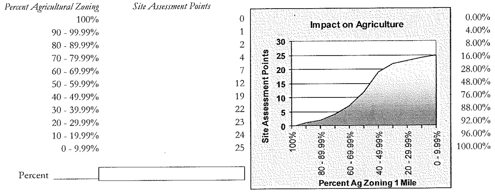
Site Assessment Criterion: Agricultural Zoning within One Mile (30 points maximum)
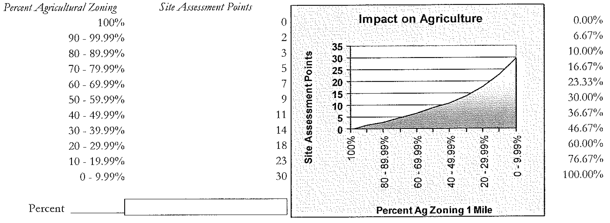
Data Source: Linn County Parcel and Zoning Data
Description: This factor considers the percentage of land that is zoned "AG" or "CNR" (including REC) within one mile of the boundaries of the parent tract.
Comments:
CASE NO.:
GPN:
PLAN DESIGNATION: AGRICULTURAL AREA (AA)
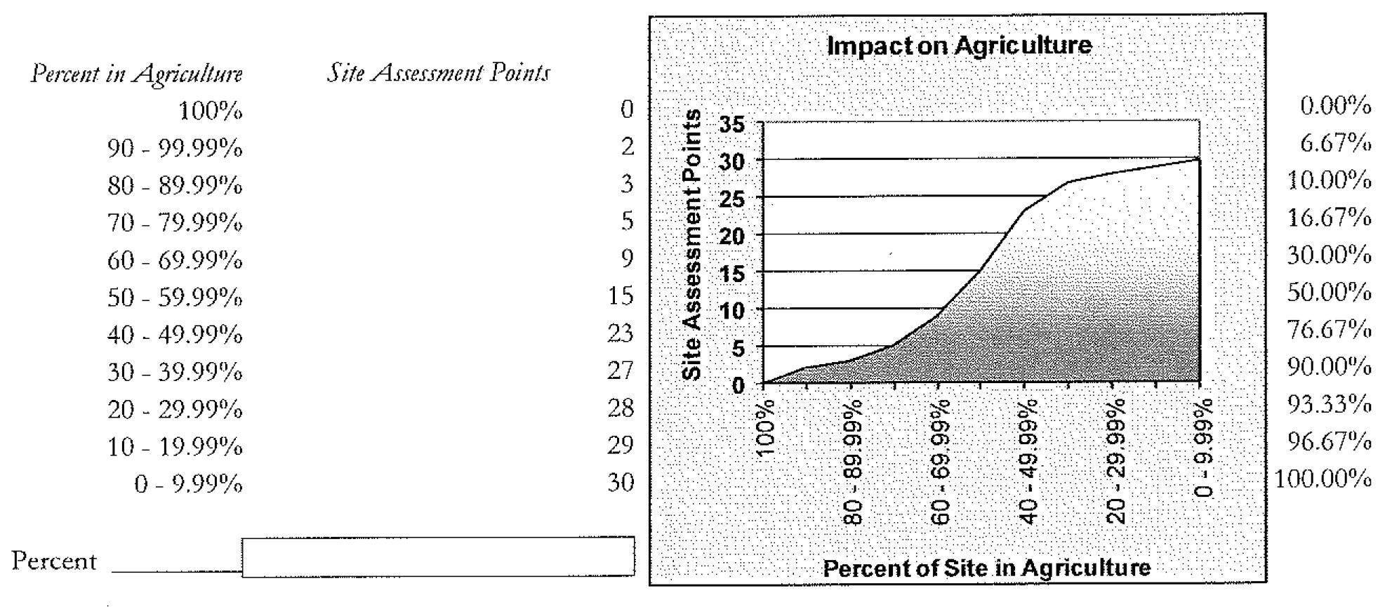
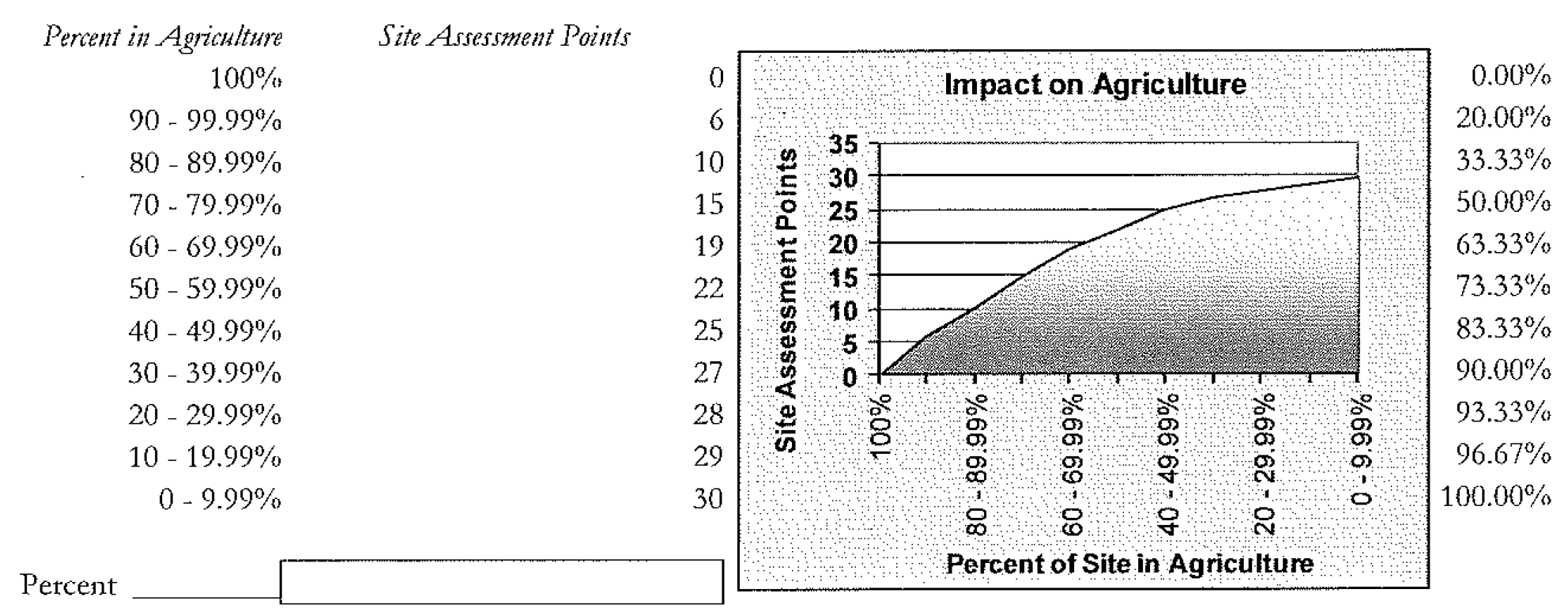
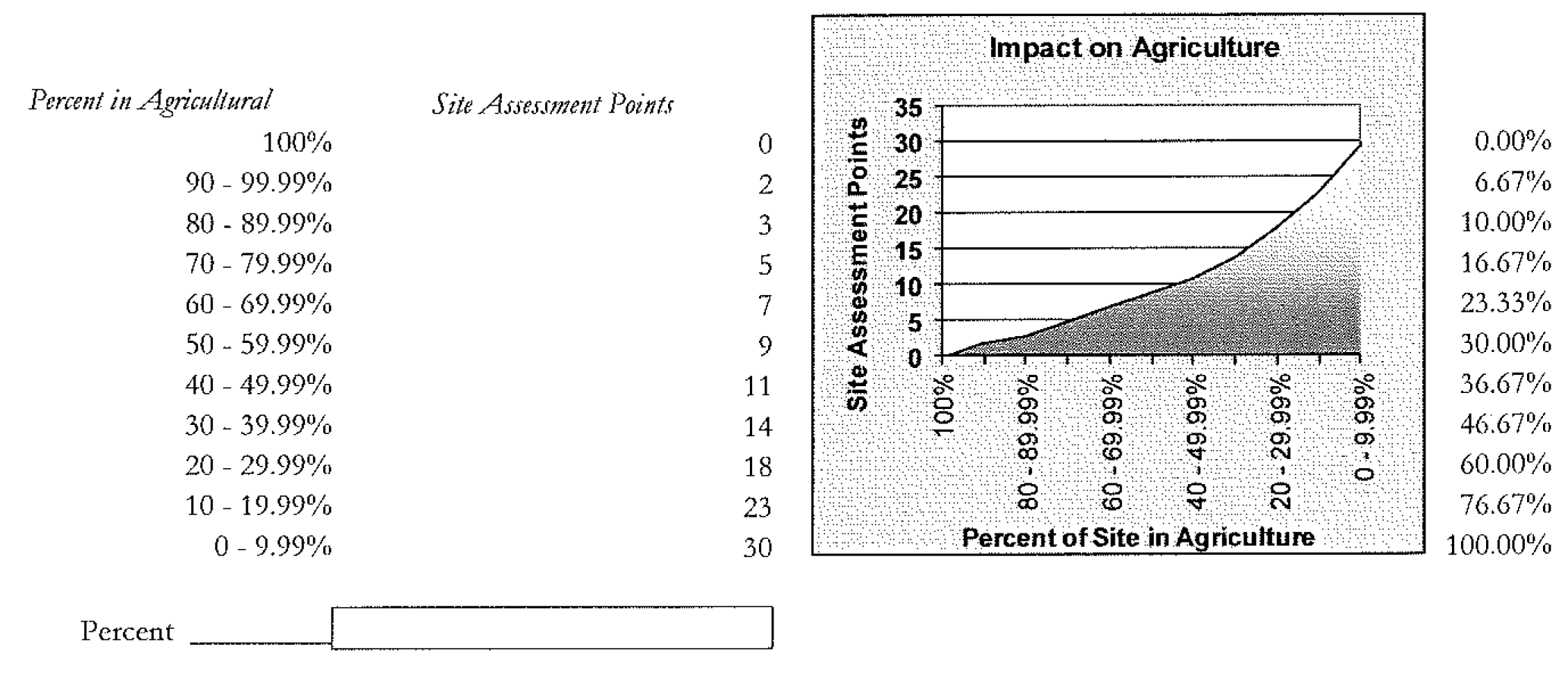
Site Assessment Criterion: On-Site Agricultural Production (30 points maximum)
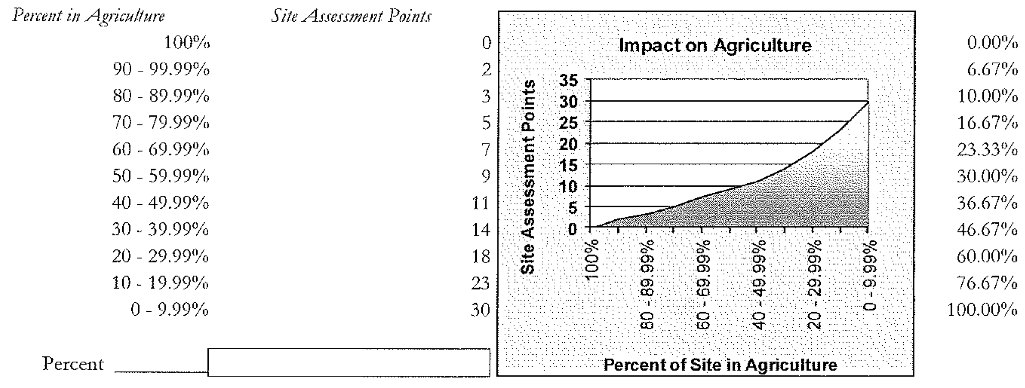
Source: Linn County Aerial Photography
Description: This factor considers the average percentage of the parent tract that has been in agriculture during the past five years. The applicant must provide verifiable documentation regarding this criterion.
Comments: Examine historical aerial photos of site to determine previous five years of agricultural production.
CASE NO.:
GPN:
PLAN DESIGNATION: AGRICULTURAL AREA (AA)
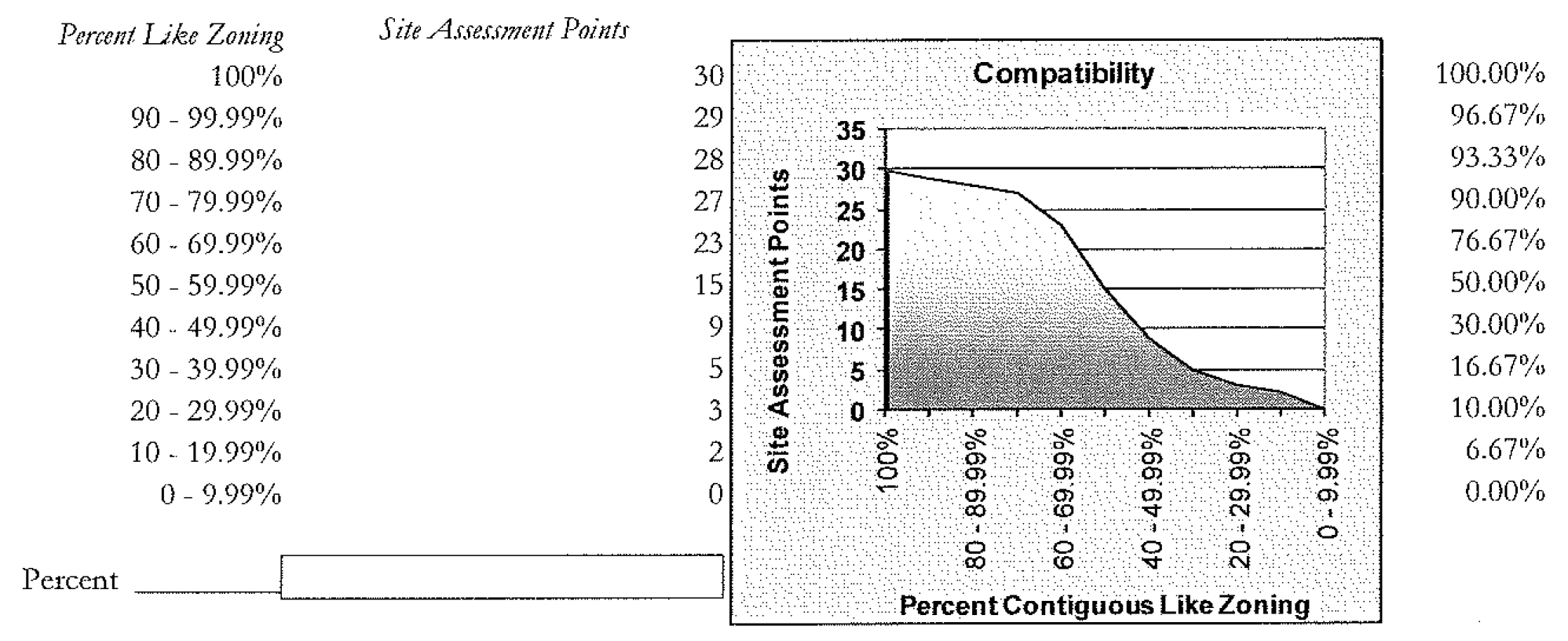
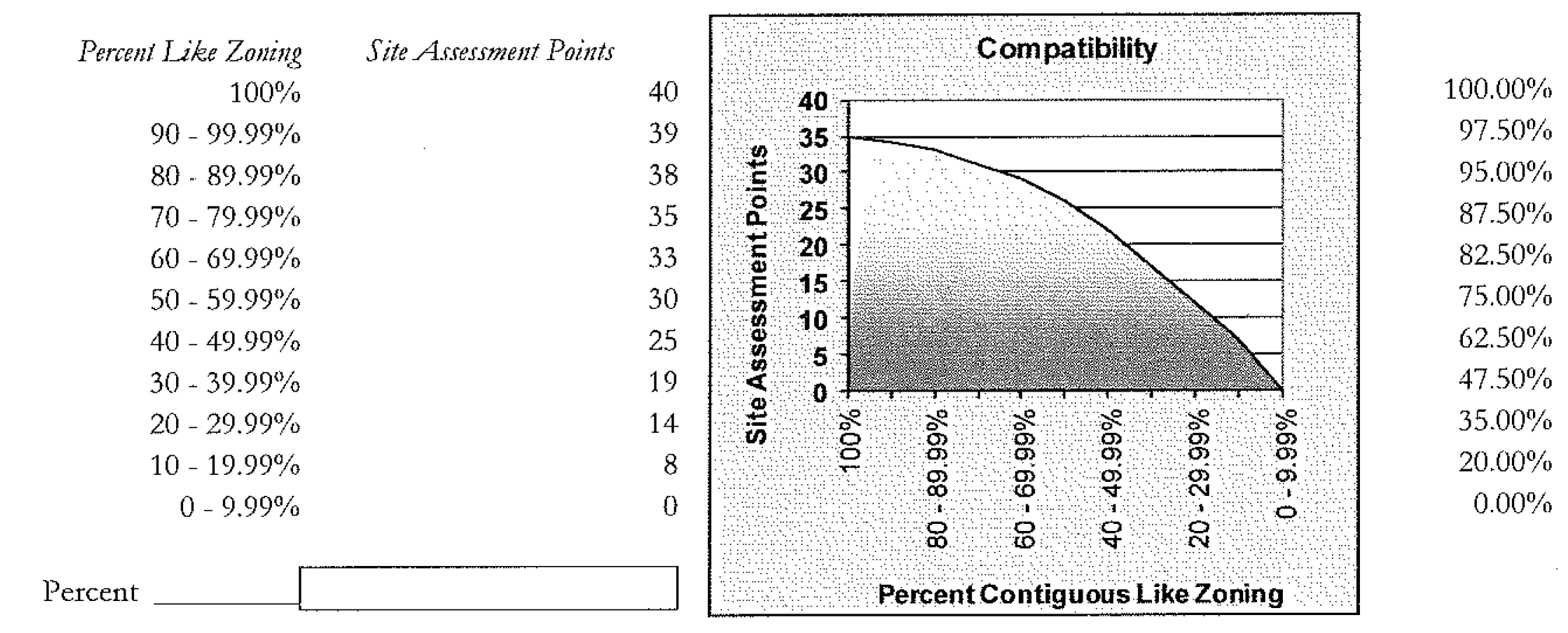
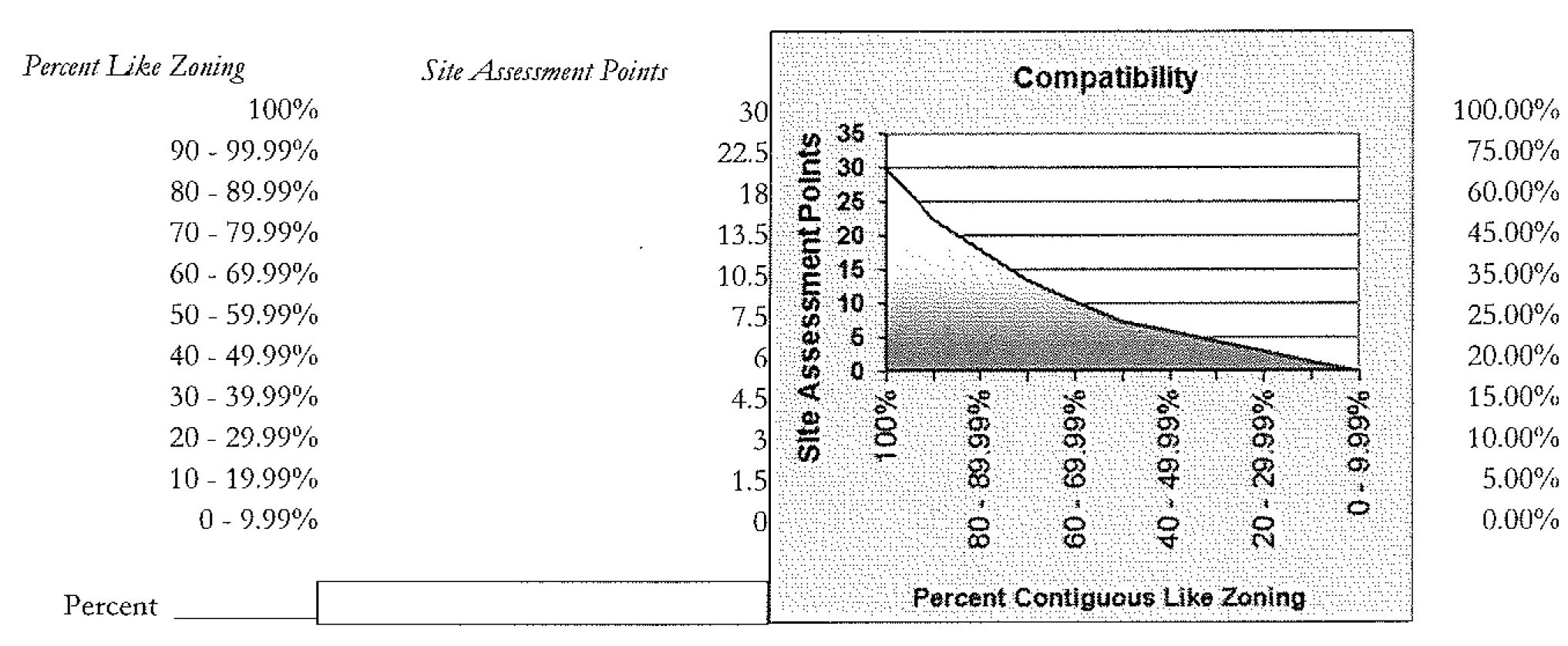
Site Assessment Criterion: Contiguous Like Zoning (20 points maximum)
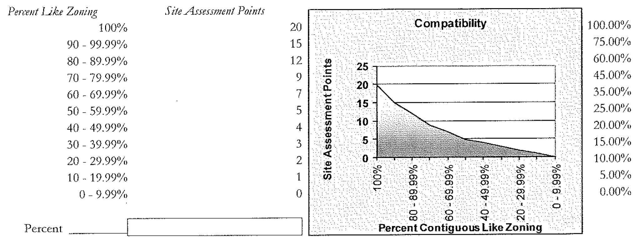
Source: Linn County Parcel and Zoning Data
Description: This factor evaluates the zoning of properties contiguous to the boundaries of the proposed parent tract. This factor analyzes to what extent the contiguous zoning is the same or more intensive than the proposed use.
Comments: See list of relative intensities. Percentages are based on the percent of the perimeter boundary. Where such data is available, the assessment shall include land located inside an incorporated city.
CASE NO.:
GPN:
PLAN DESIGNATION: AGRICULTURAL AREA (AA)
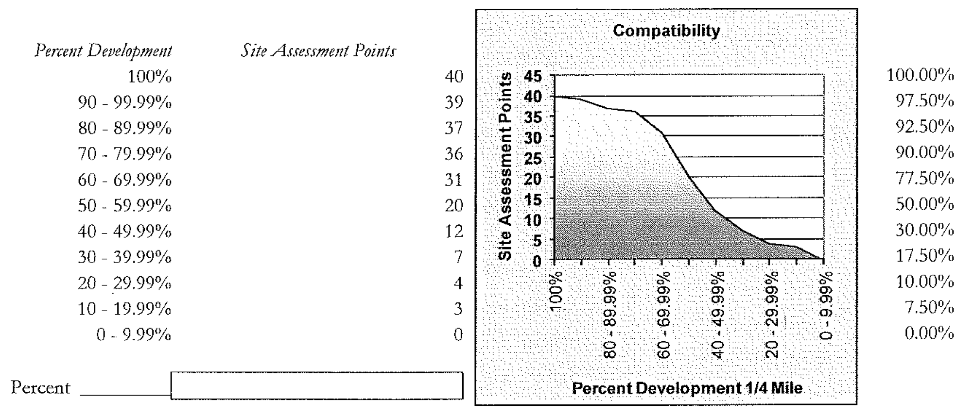
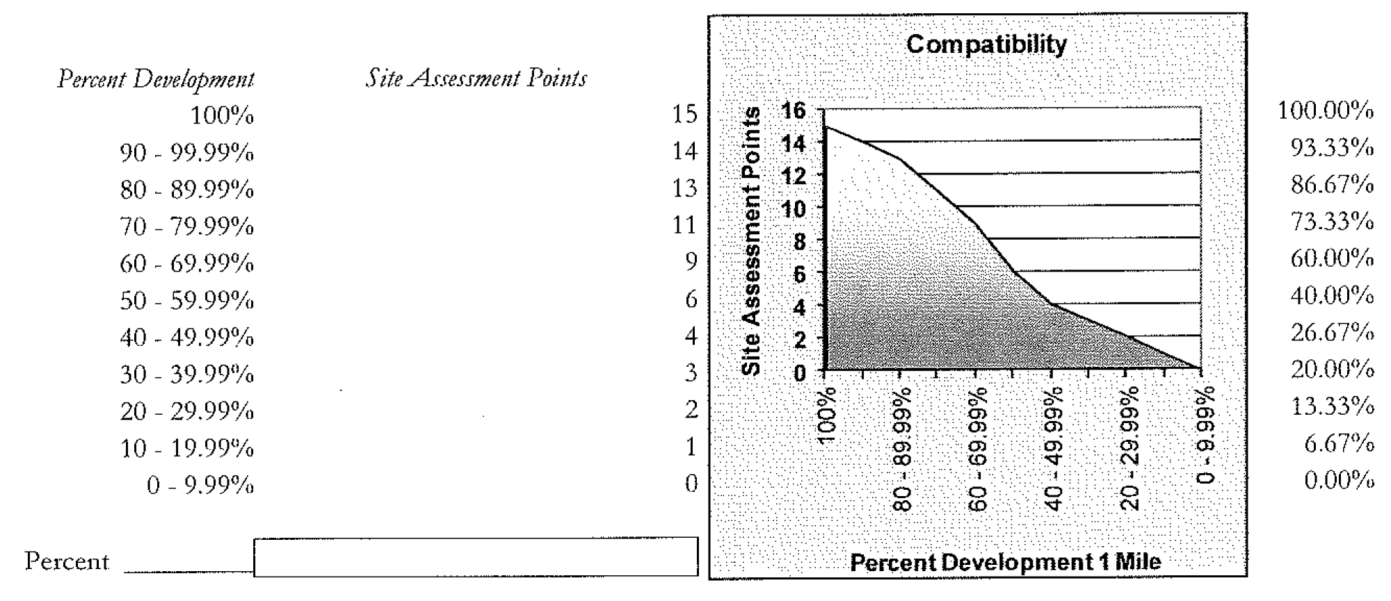
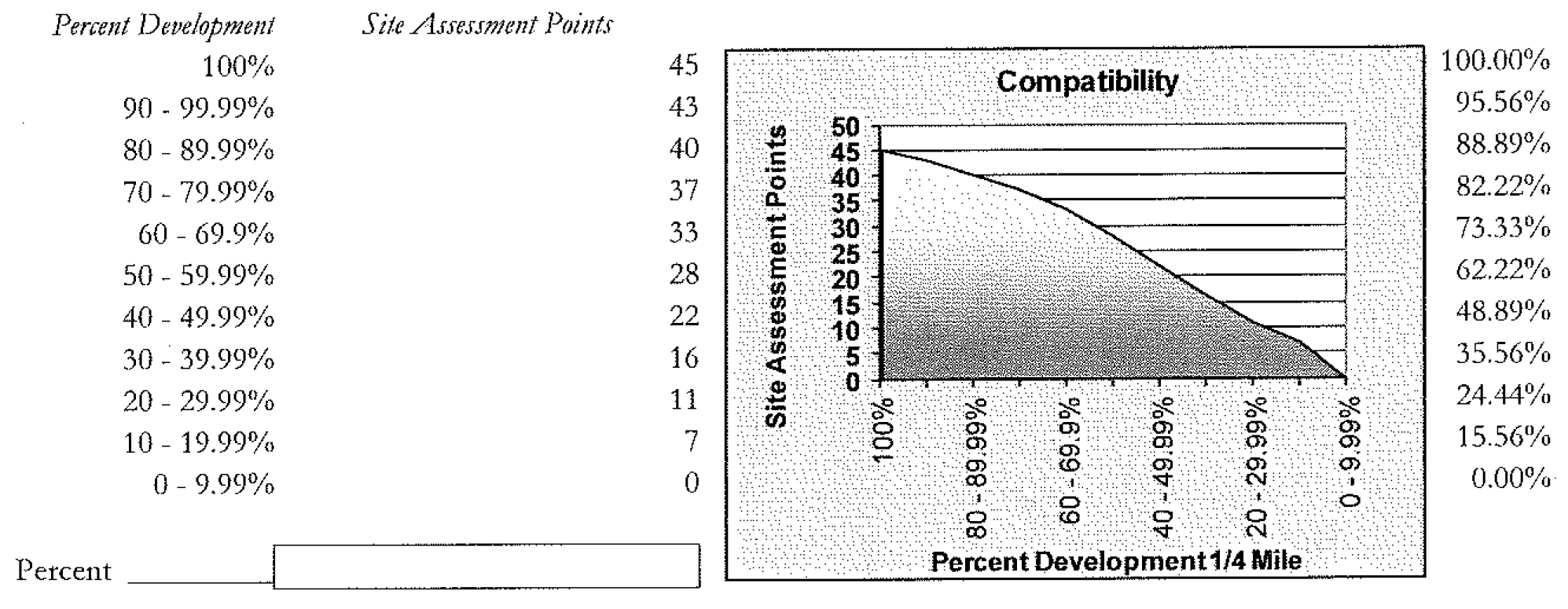
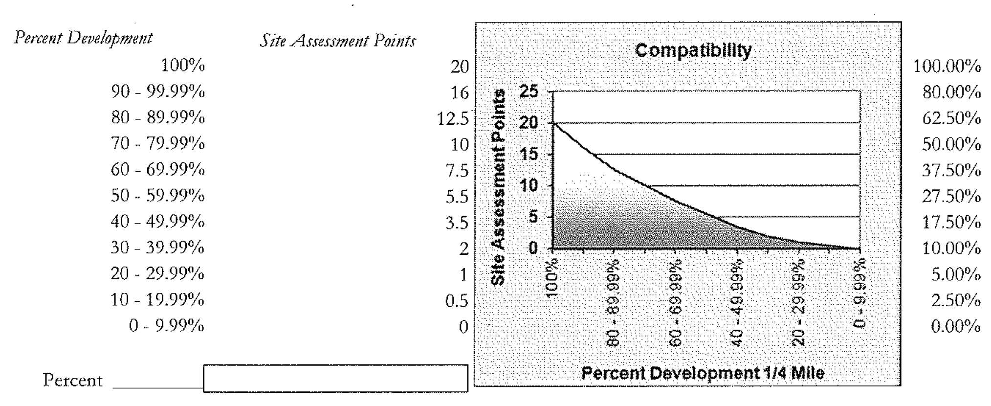
Site Assessment Criterion: Development within One-Quarter Mile (40 points maximum)
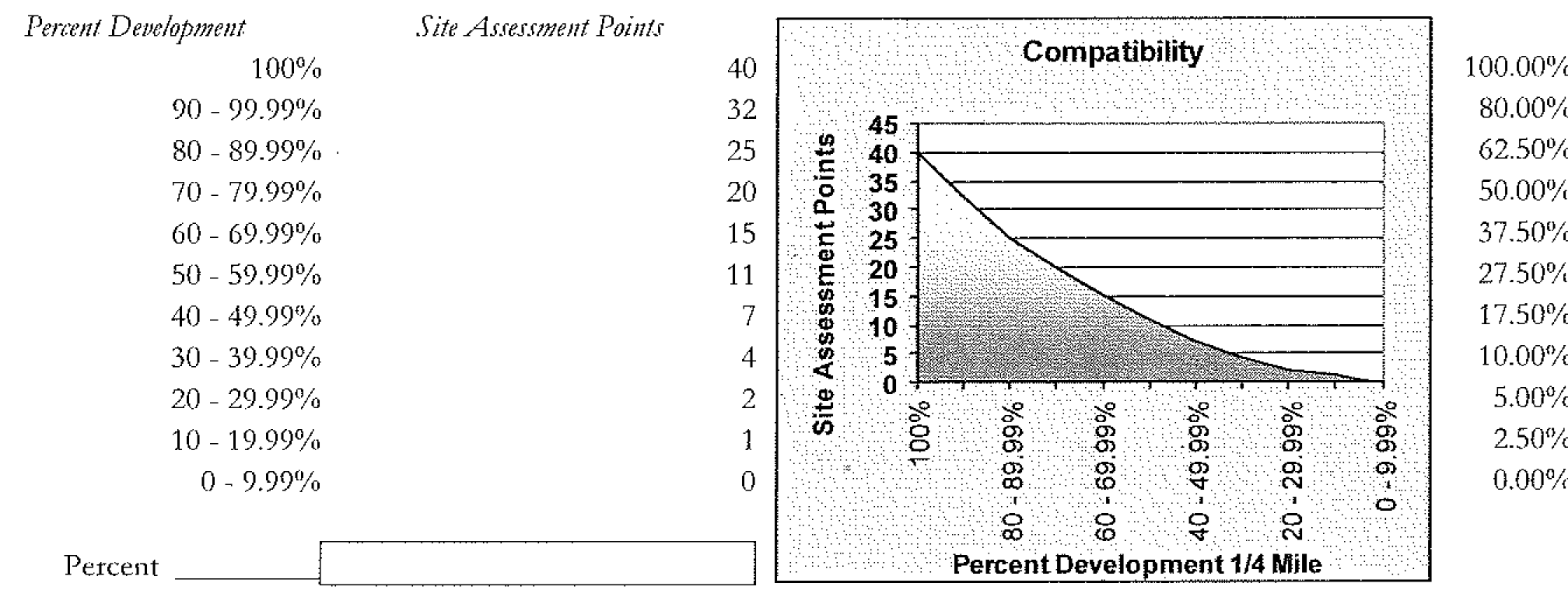
Source: Linn County Parcels Data
Description: This factor considers what percentage of land has been developed for residential or non-residential purposes within one-quarter mile of the boundaries of the proposed parent tract.
Comments: Parcels in the same assessment classification as the proposed development and with similar lot sizes. Similar lot sizes shall mean lot sizes within a range of 90 percent to 110 percent of the proposed lot sizes. Where such data is available, the assessment shall include land located inside an incorporated city.
CASE NO.:
GPN:
PLAN DESIGNATION: AGRICULTURAL AREA (AA)
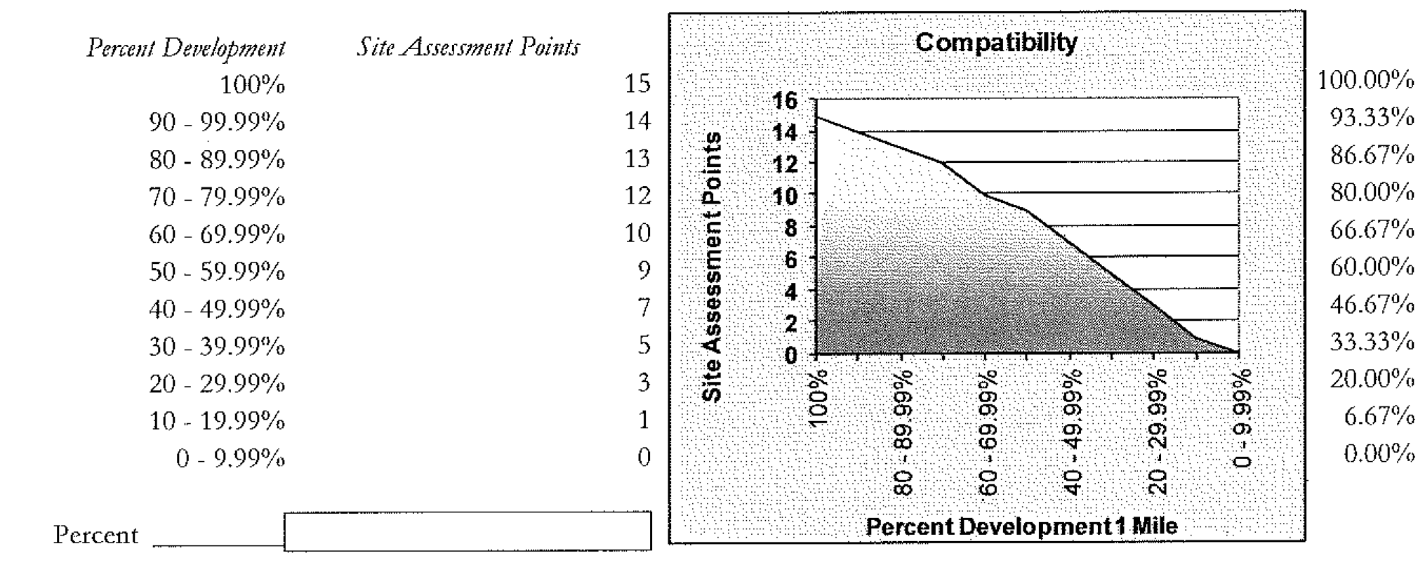
Site Assessment Criterion: Development within One Mile (10 points maximum)
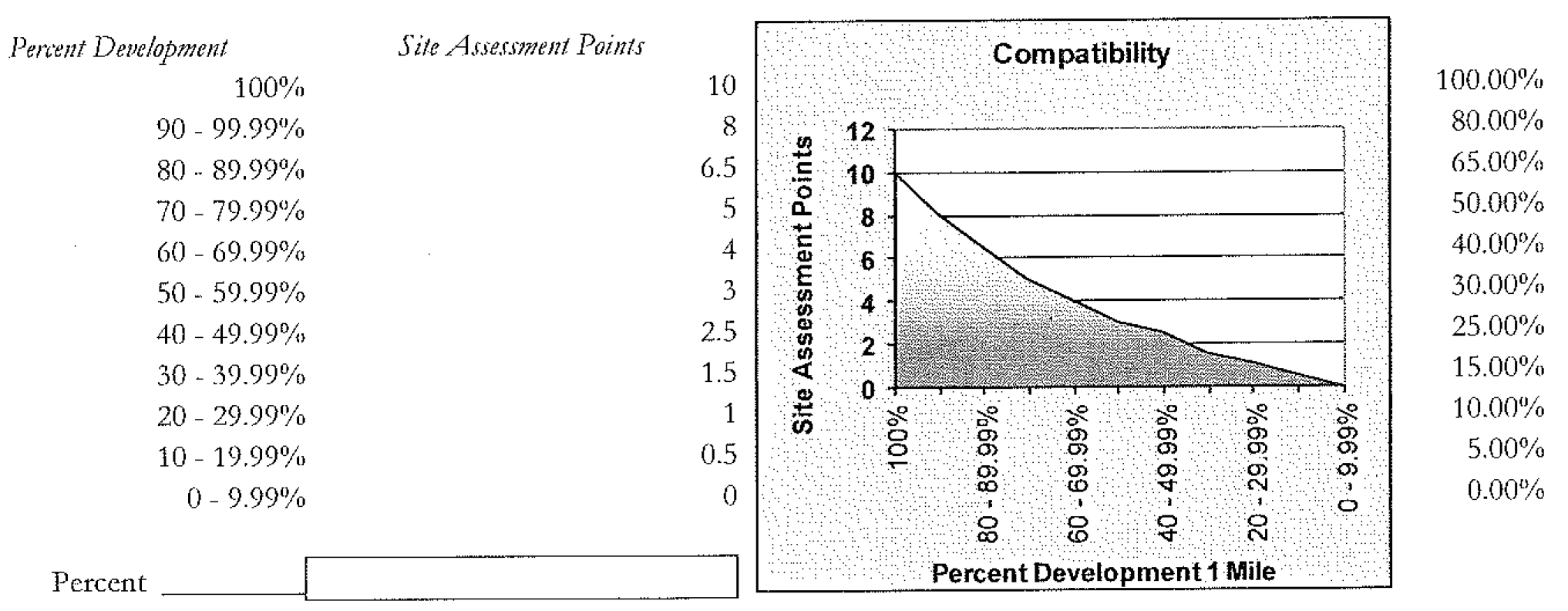
Source: Linn County Parcels Data
Description: This factor considers what percentage of land has been developed for residential or non-residential purposes within one mile of the boundaries of the proposed parent tract.
Comments: Parcels in the same assessment classification as the proposed development and with similar lot sizes. Similar lot sizes shall mean lot sizes within a range of 90 percent to 110 percent of the proposed lot sizes. Where such data is available, the assessment shall include land located inside an incorporated city.
CASE NO.:
GPN:
PLAN DESIGNATION: AGRICULTURAL AREA (AA)
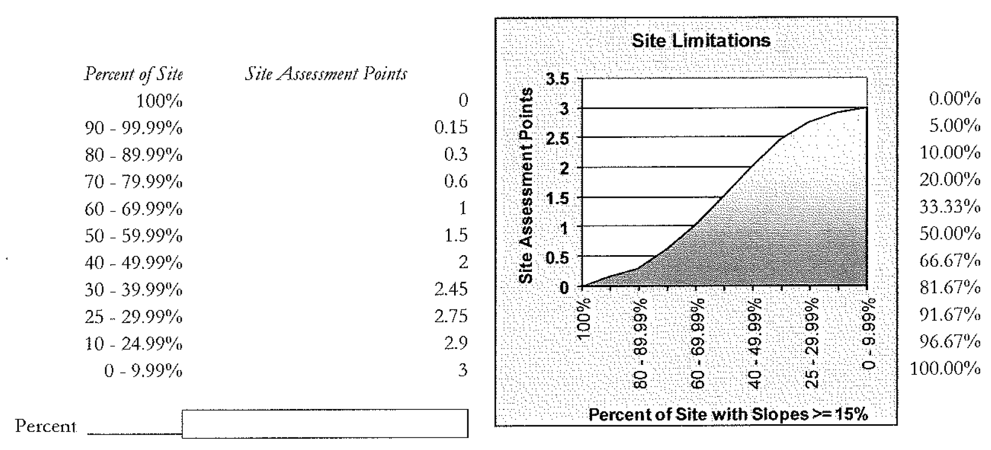
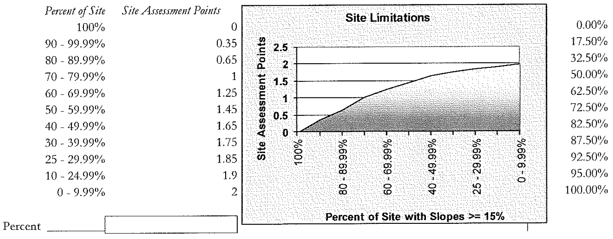
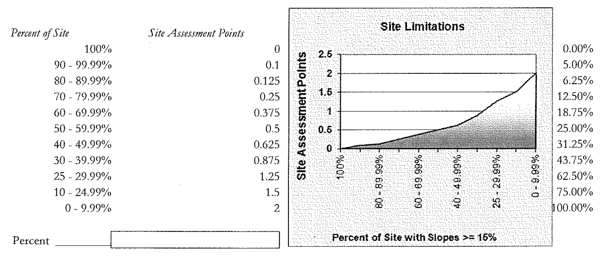
Site Assessment Criterion: Slopes 15 Percent or Greater (4 points maximum)
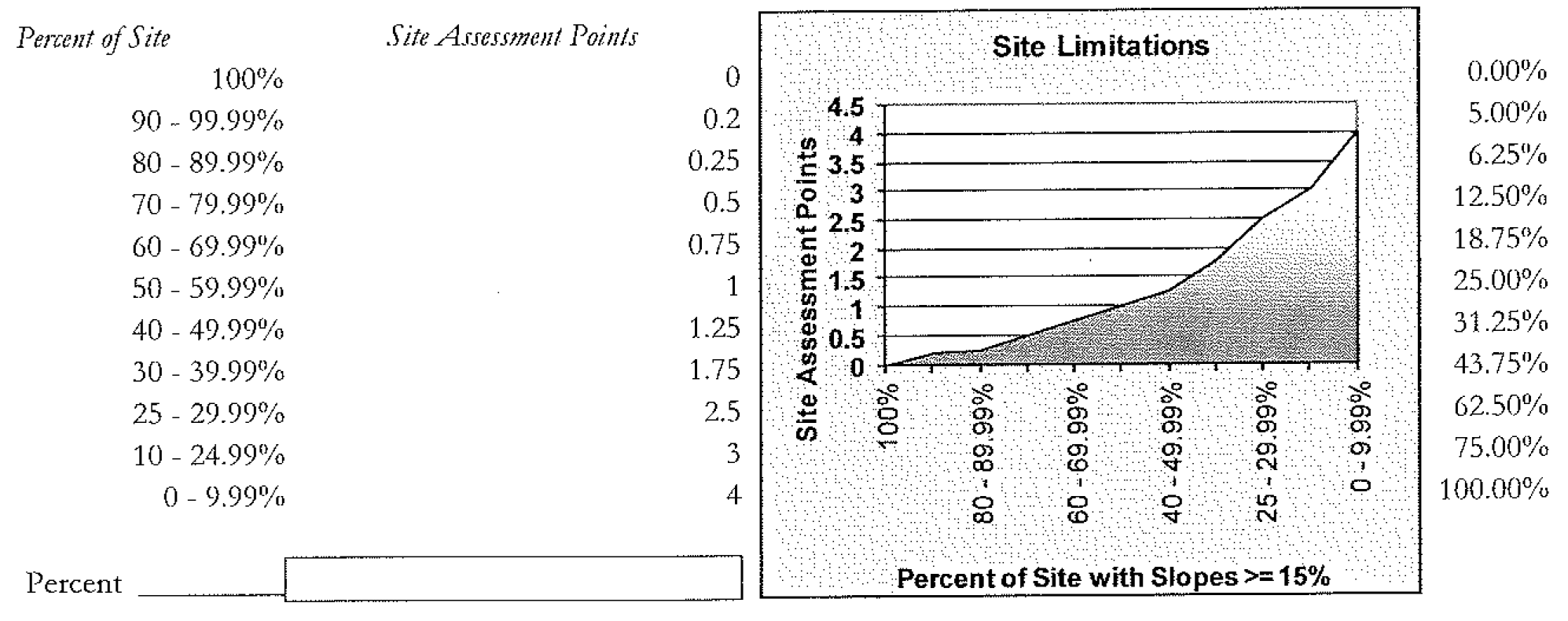
Source: LiDAR Data
Description: This factor considers the environmental limitations of the proposed development area. Steep slopes (15 percent or greater) shall be identified.
Comments:
CASE NO.:
GPN:
PLAN DESIGNATION: AGRICULTURAL AREA (AA)
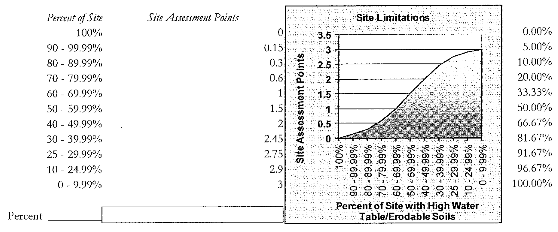
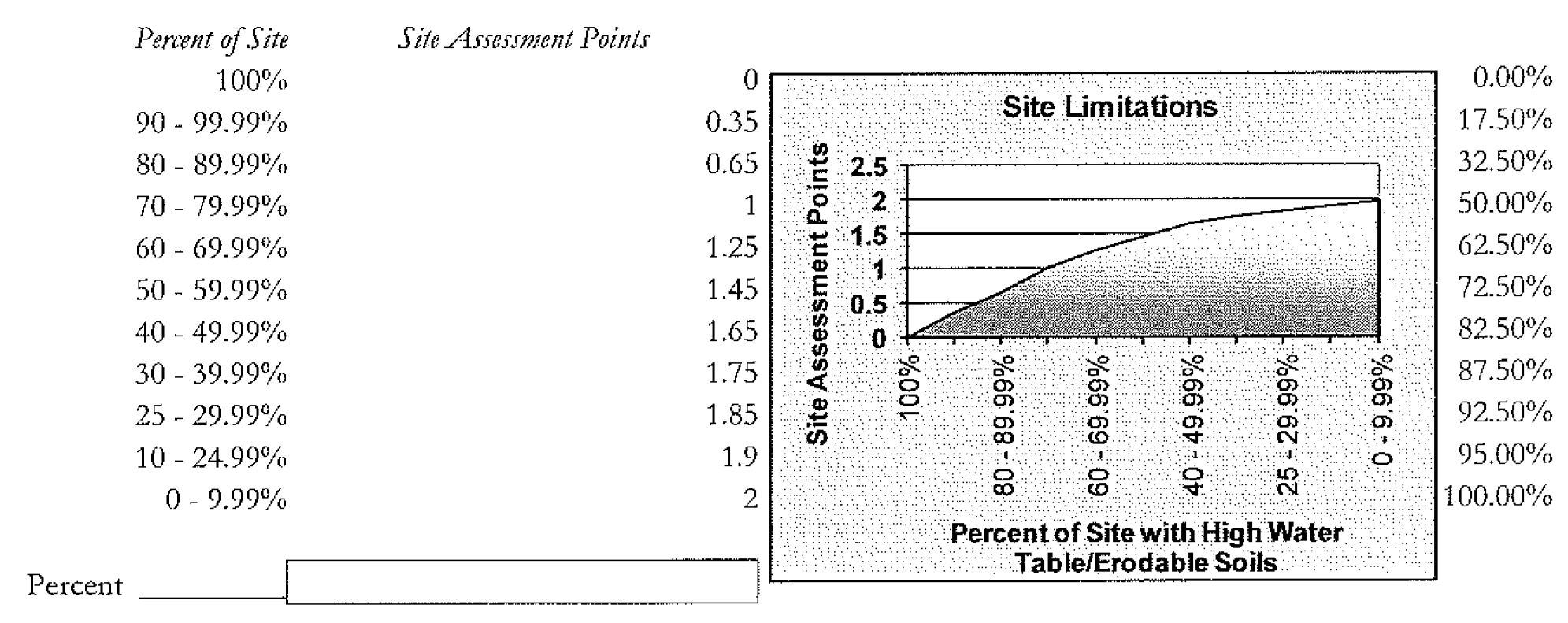
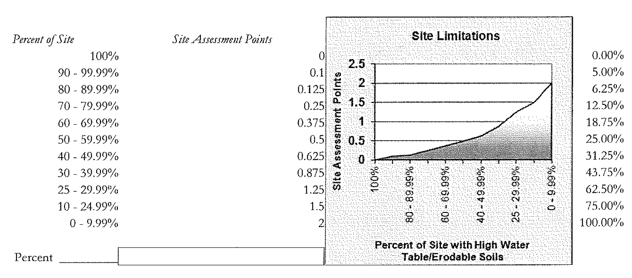
Site Assessment Criterion: High Water Table or Erodible Soils (4 points maximum)
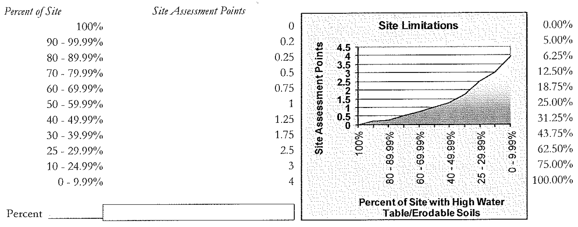
Source: SSURGO Soils Data
Description: This factor considers the environmental limitations of the proposed development area. Soils classified as having a depth to water table of four feet or less, or as having severe erosion potential, shall be identified.
Comments:( [Erosionc] = "SEV" ) or ( [Dpthhiwtrh] andlt;= 2) or ([Dpthhiwtrh] = "" ) SSURGO
CASE NO.:
GPN:
PLAN DESIGNATION: AGRICULTURAL AREA (AA)
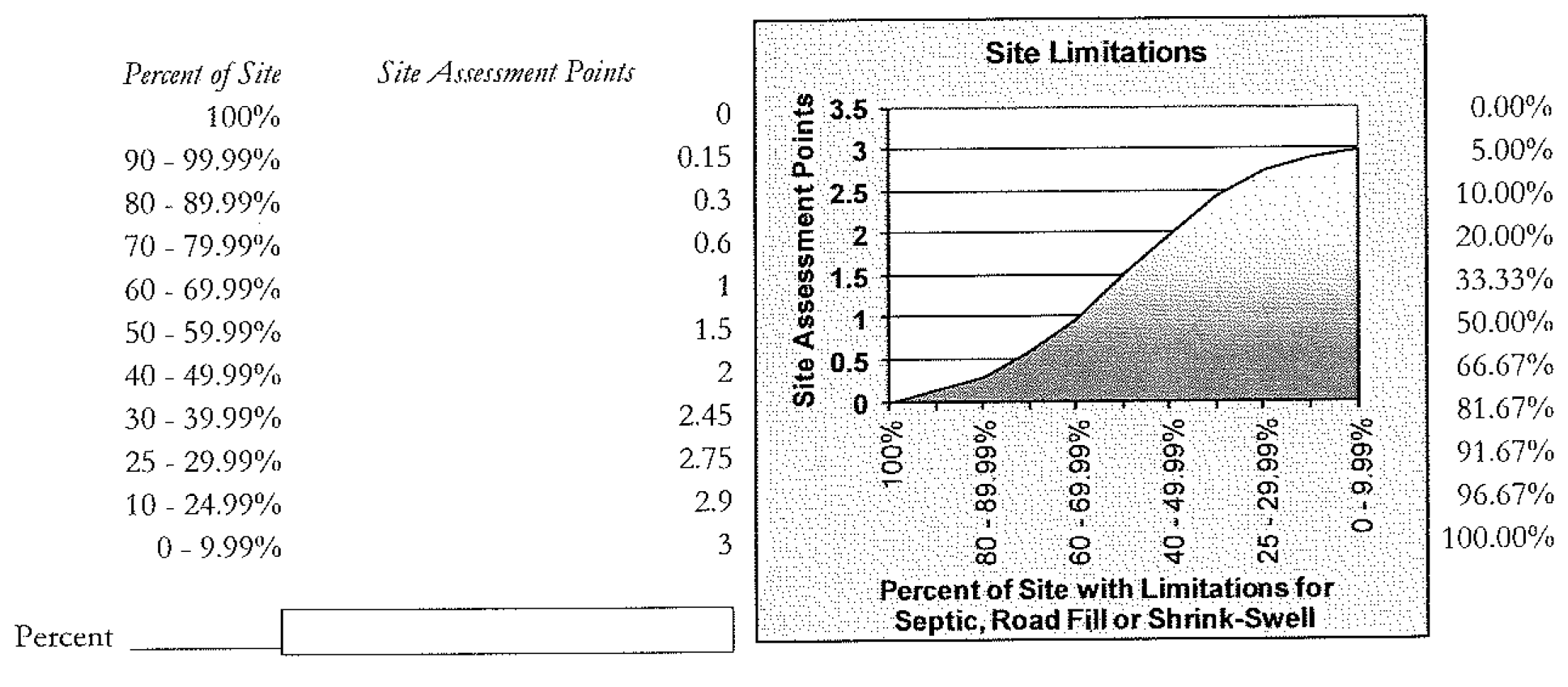
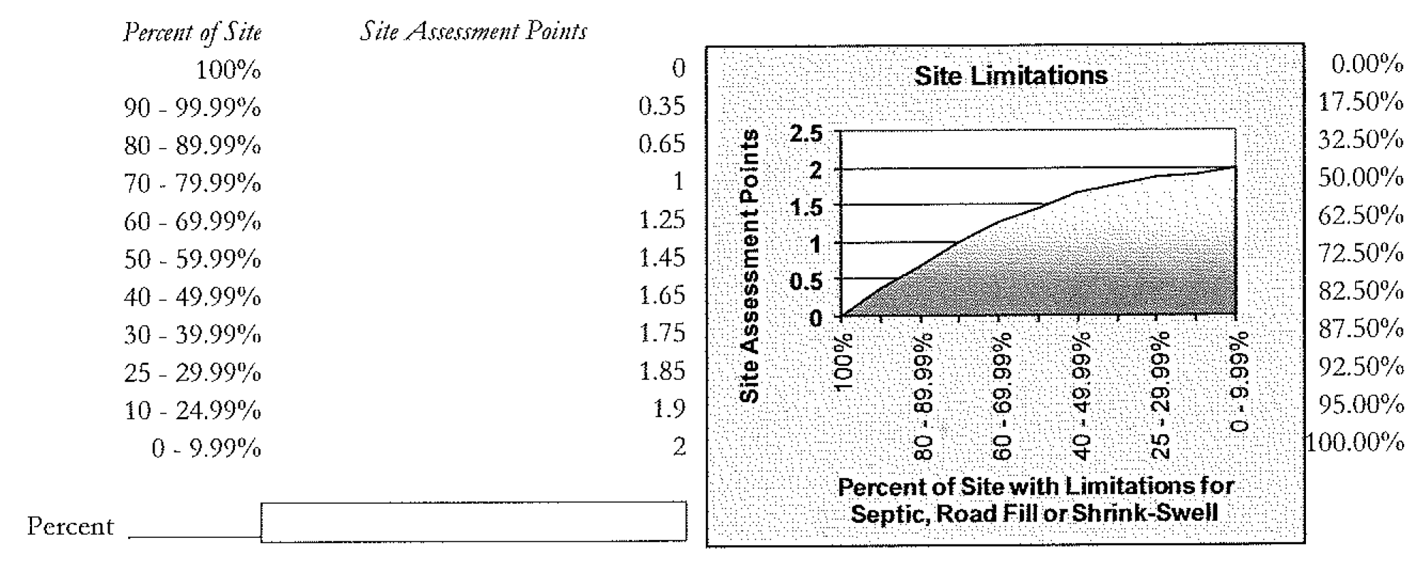
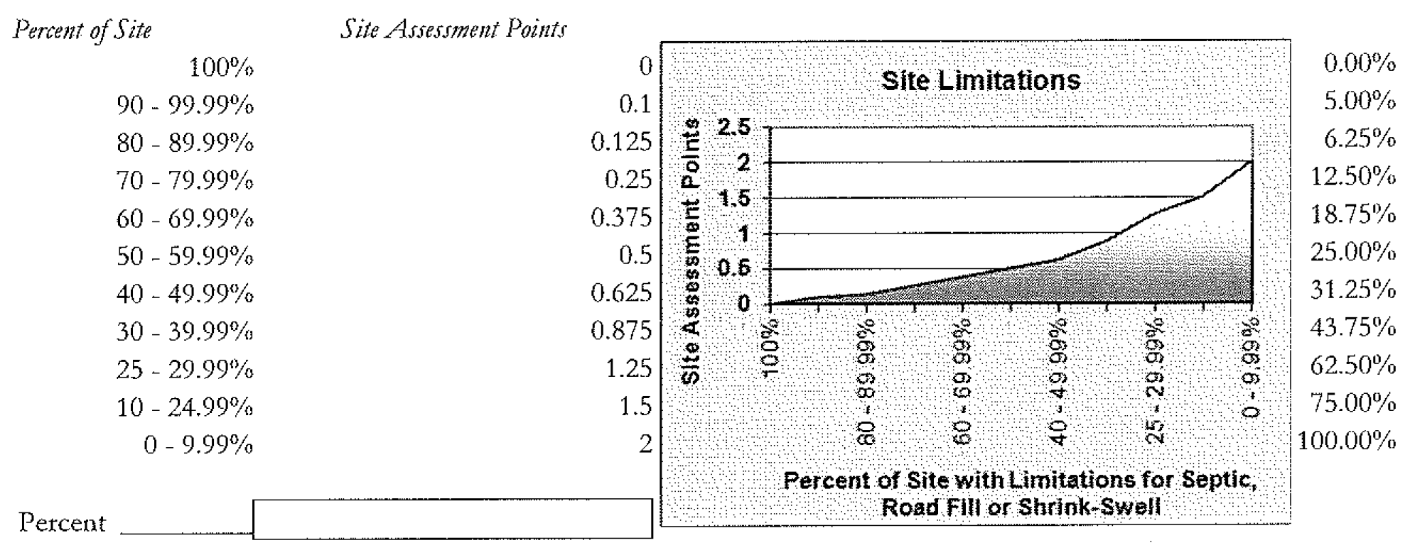
Site Assessment Criterion: Septic/Road Fill/Shrink-Swell (4 points maximum)
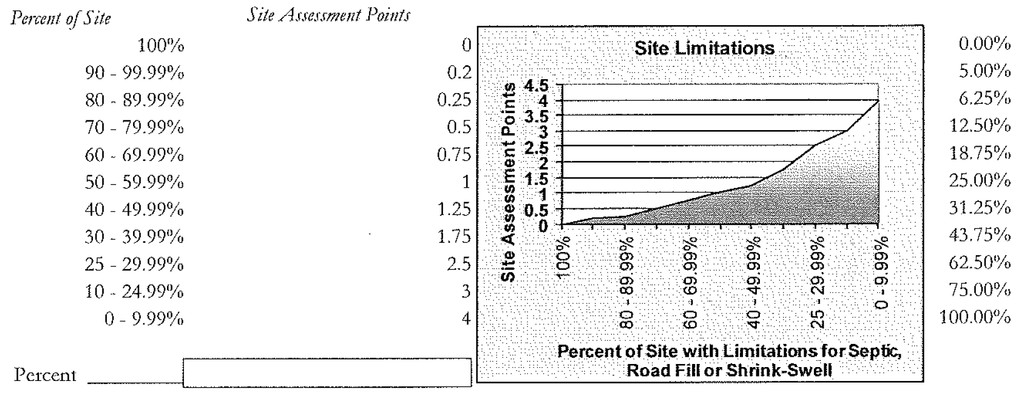
Source: SSURGO Soils Data
Description: This factor considers the environmental limitations of the proposed development area. Soils classified with a severe or very severe limitation for septic tank filter fields; and as not suitable, poor, or very poor as a source of road fill; and with a high shrink-swell potential shall be identified.
Comments:
CASE NO.:
GPN:
PLAN DESIGNATION: AGRICULTURAL AREA (AA)
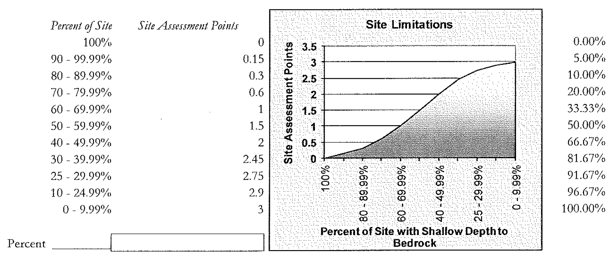
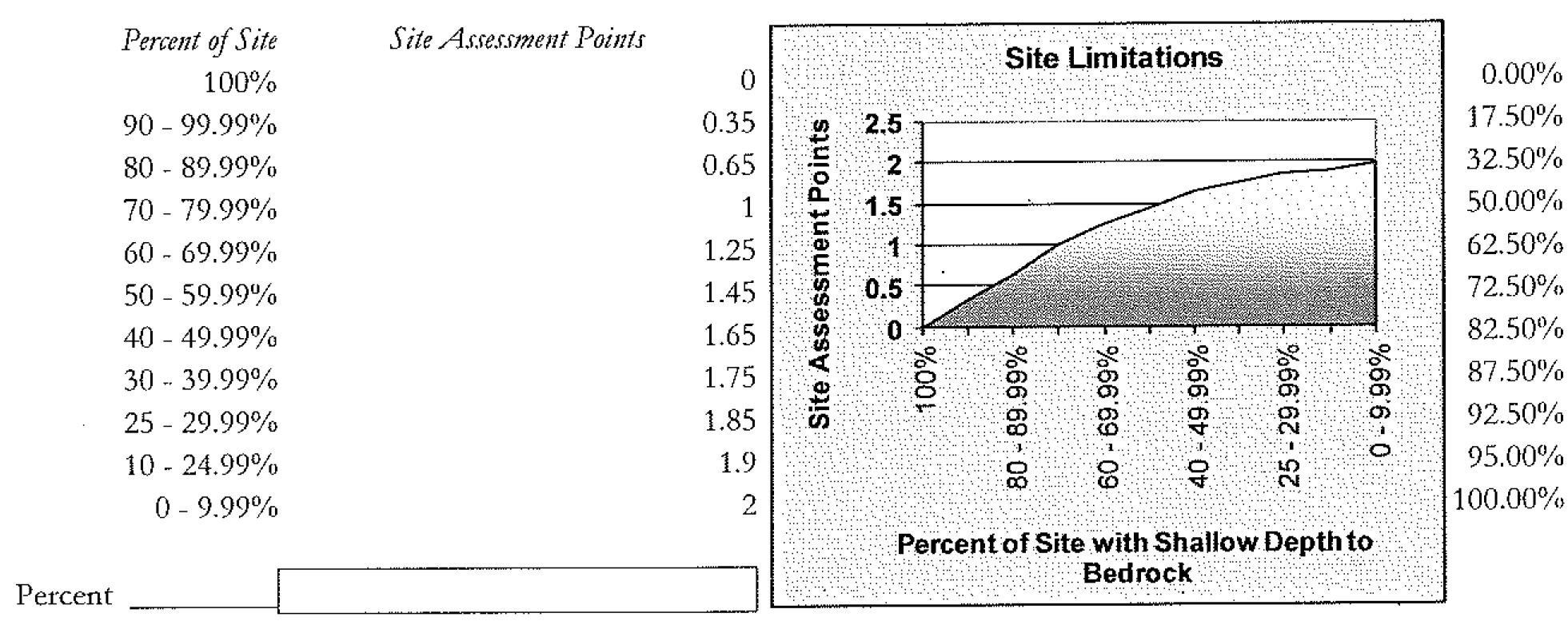
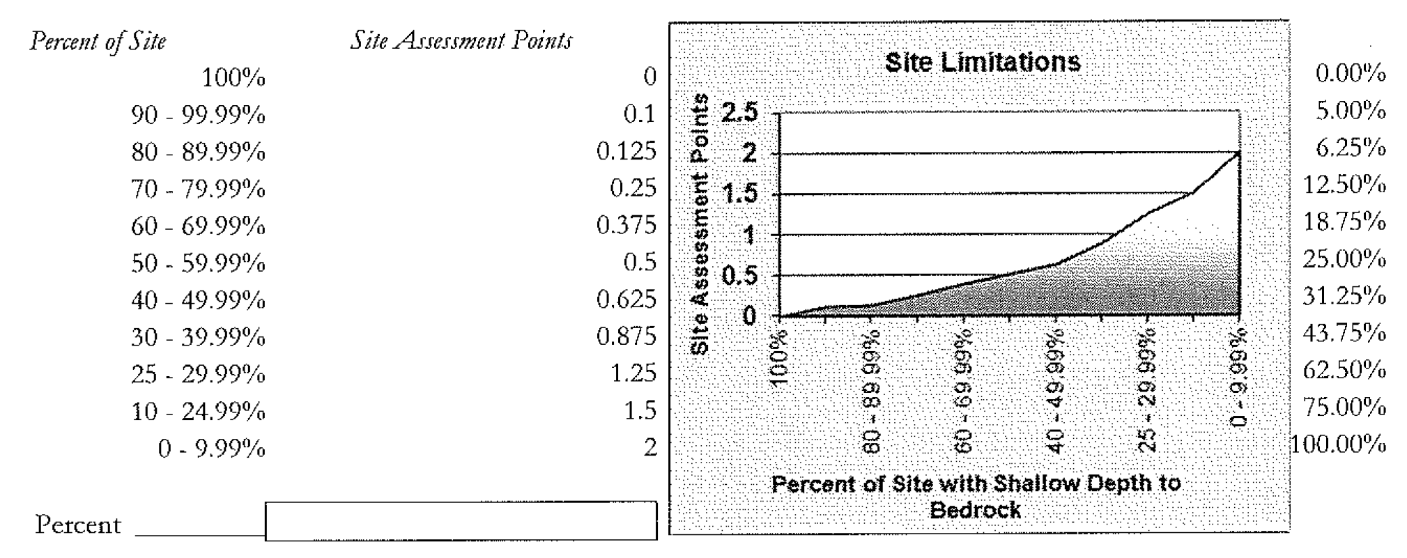
Site Assessment Criterion: Shallow Depth to Bedrock (4 points maximum)
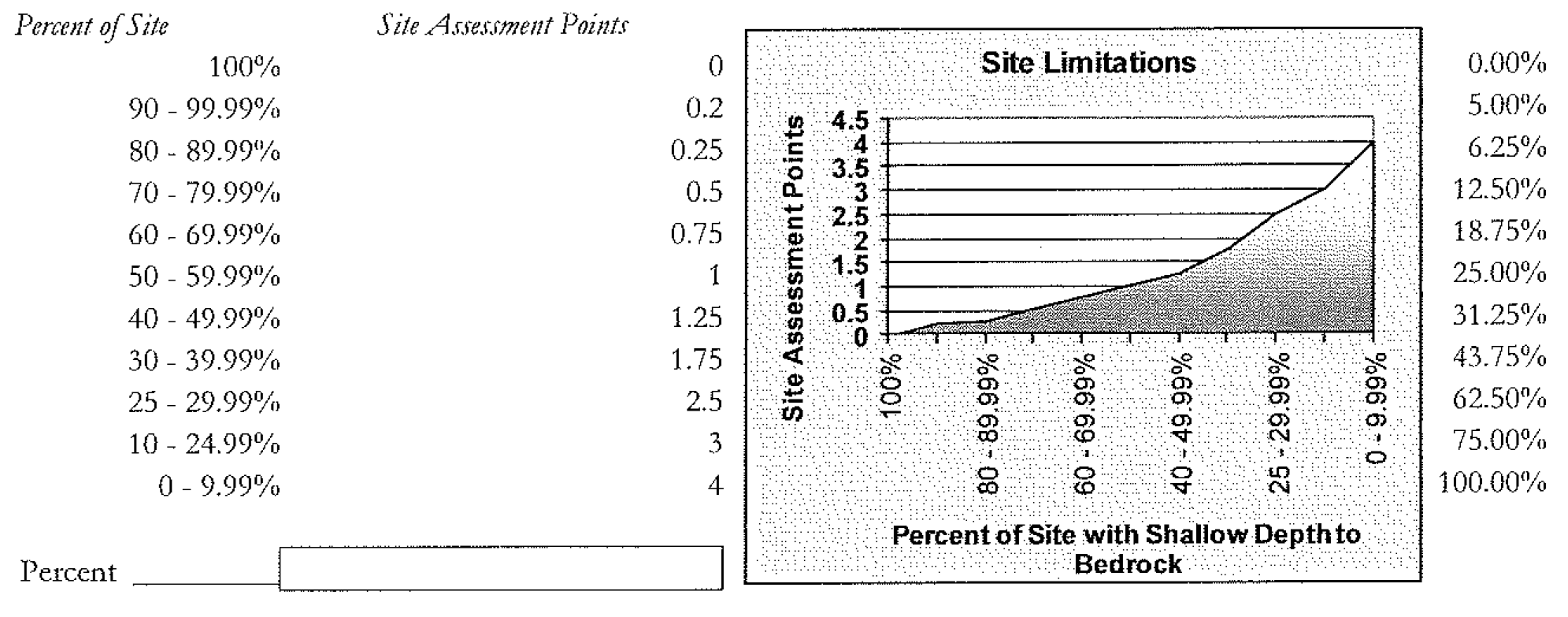
Source: SSURGO Soils Data
Description: This factor considers the environmental limitations of the proposed development area. Soils classified with a shallow depth to bedrock (three feet or less) shall be identified.
Comments:
CASE NO.:
GPN:
PLAN DESIGNATION: AGRICULTURAL AREA (AA)
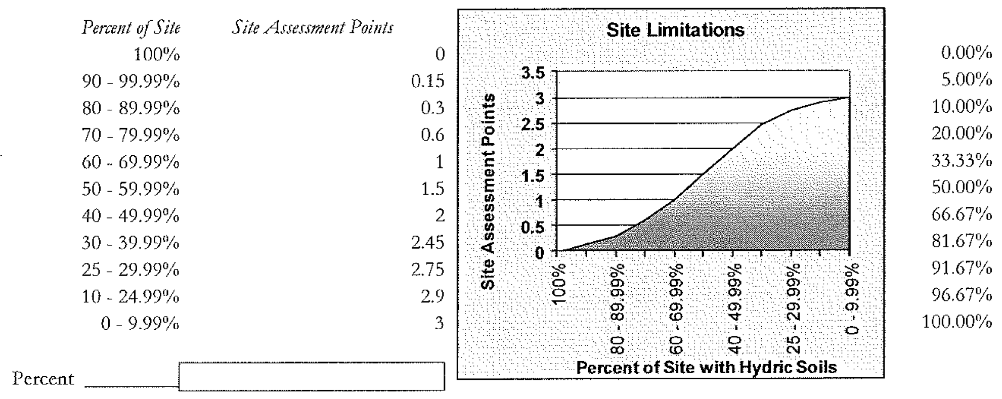
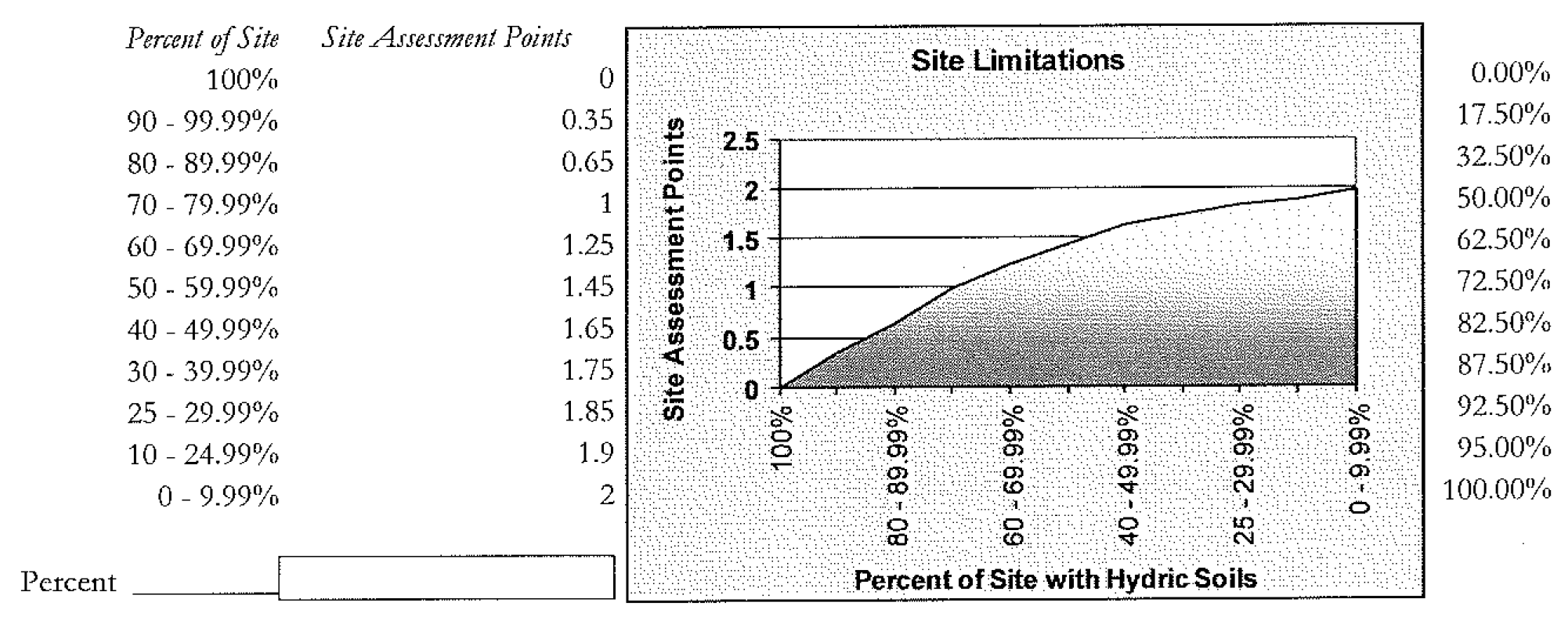
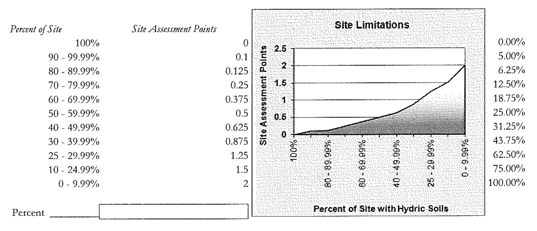
Site Assessment Criterion: Hydric Soils (4 points maximum)
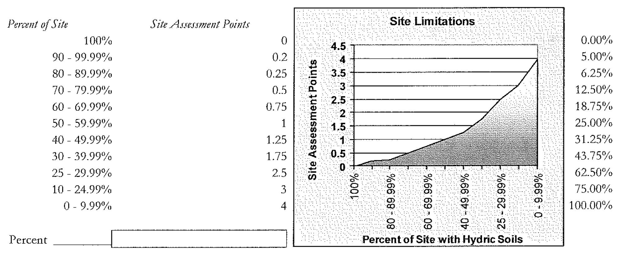
Source: SSURGO Soils Data
Description: This factor considers the environmental limitations of the proposed development area. Hydric soils shall be identified.
Comments: [Hydsoilcd] = 1 SSURGO
CASE NO.:
GPN:
PLAN DESIGNATION: AGRICULTURAL AREA (AA)
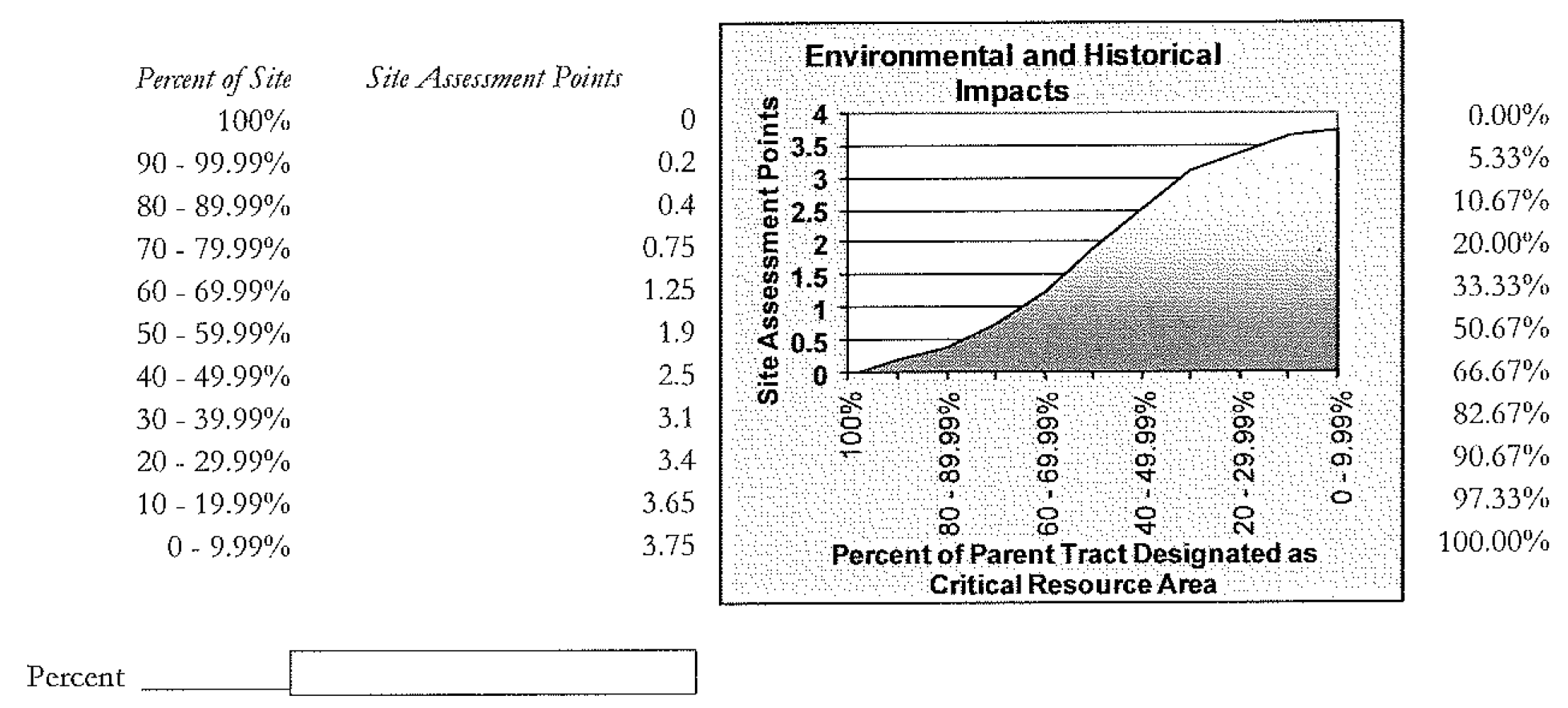
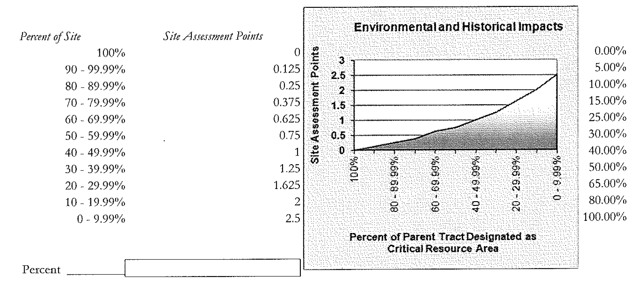
Site Assessment Criterion: Critical Natural Resource Area (5 points maximum)
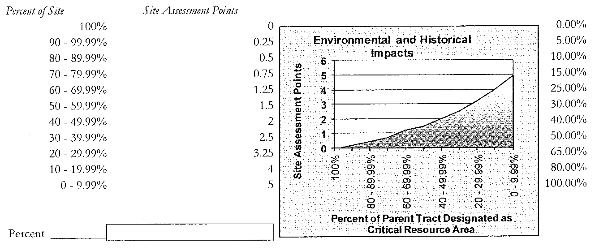
Source: Linn County Parcel and Land Use data.
Description: This factor considers the impact of the proposed development on the environmental and historical resources of the parent tract. The percentage of the parent tract located in critical resource areas shall be identified.
Comments:
CASE NO.:
GPN:
PLAN DESIGNATION: AGRICULTURAL AREA (AA)
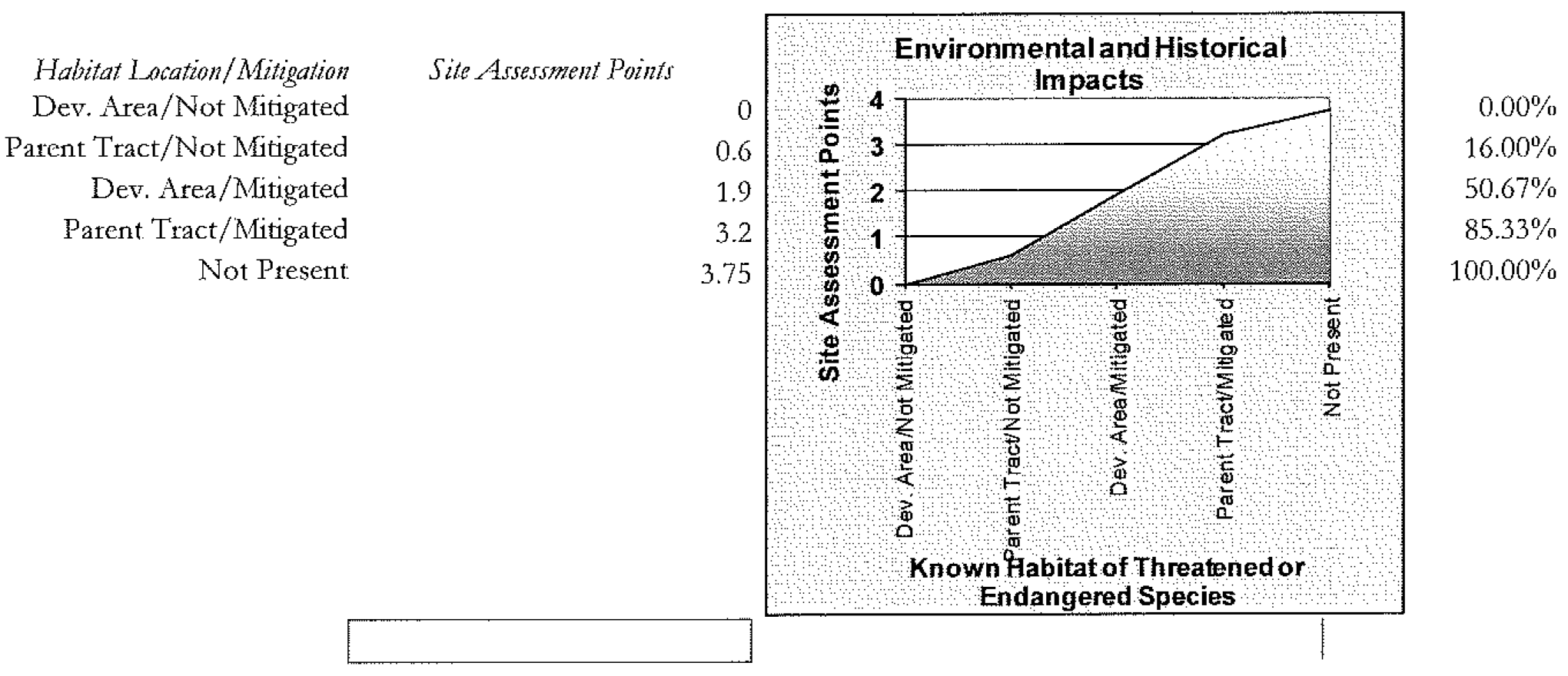
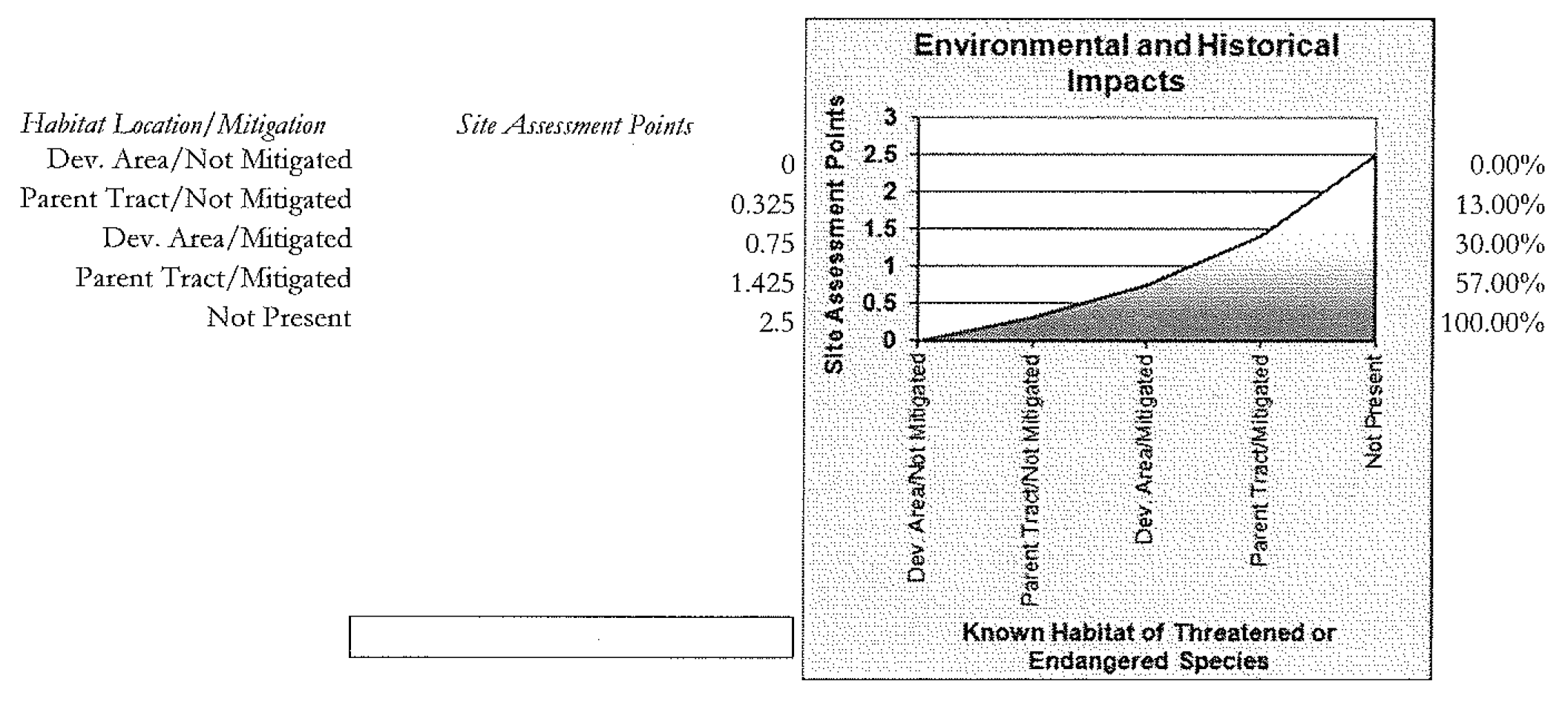
Site Assessment Criterion: Known Habitat of Threatened or (5 points maximum) Endangered Species
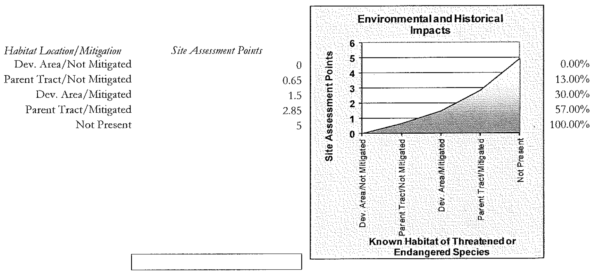
Source: Linn County Threatened and Endangered Species (lcbase.DBO.TESpecies)
Description: This factor considers the impact of the proposed development on the environmental and historical resources of the parent tract. The known habitat of threatened or endangered species shall be identified and proposed mitigation measures considered.
Comments:
CASE NO.:
GPN:
PLAN DESIGNATION: AGRICULTURAL AREA (AA)
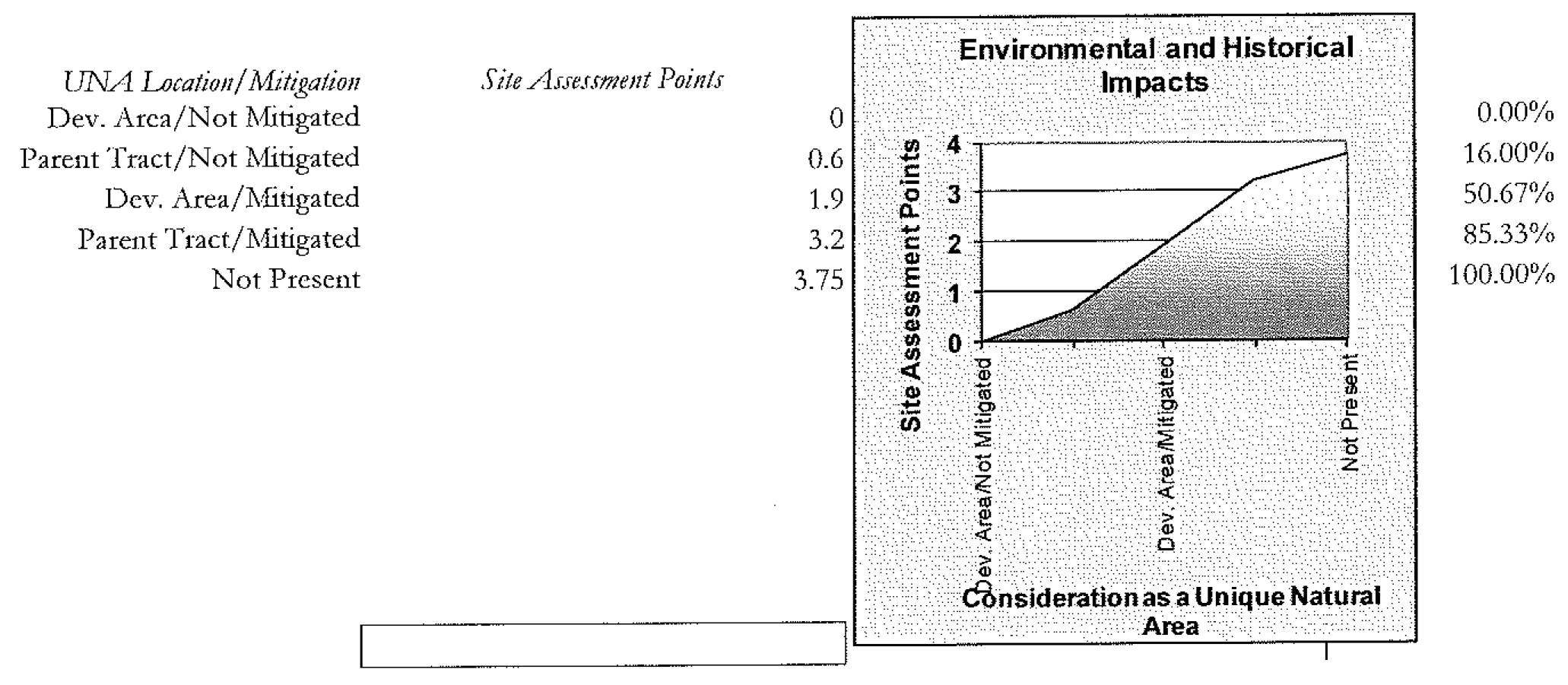
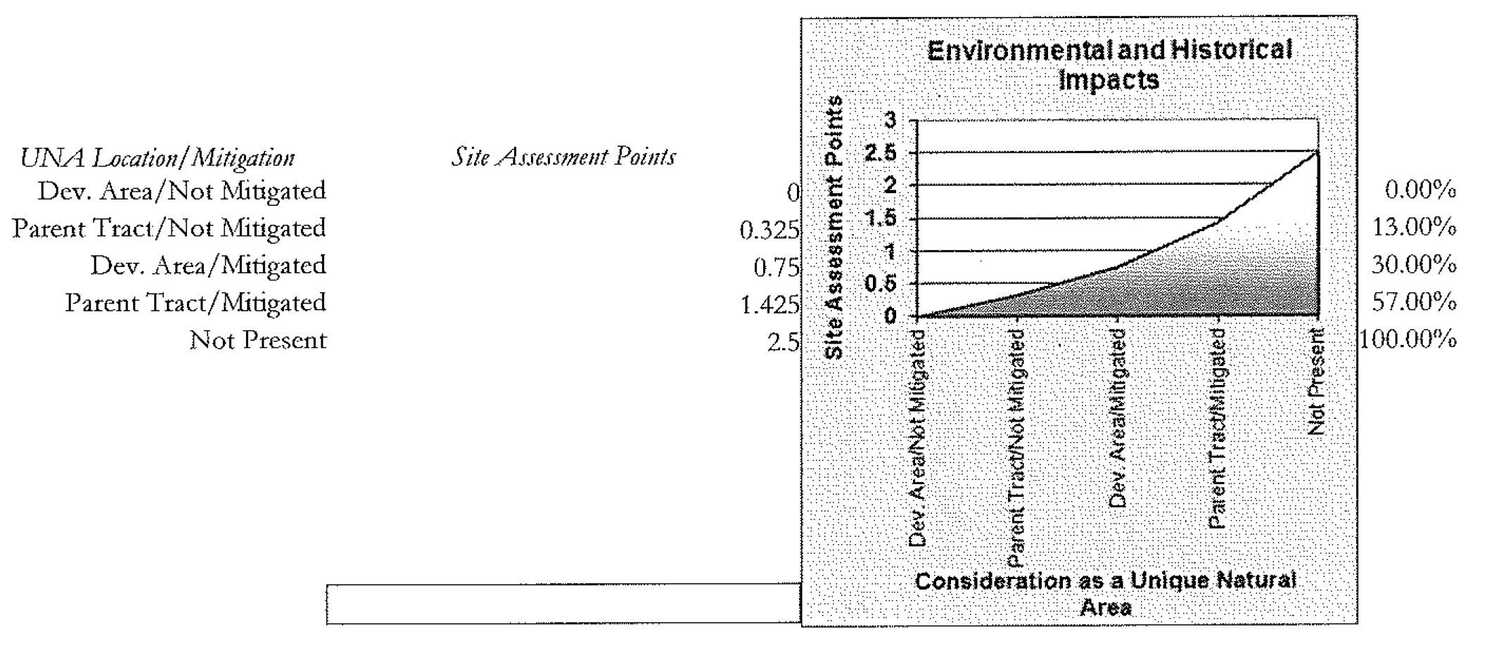
Site Assessment Criterion: Consideration as Unique Natural Area (5 points maximum)
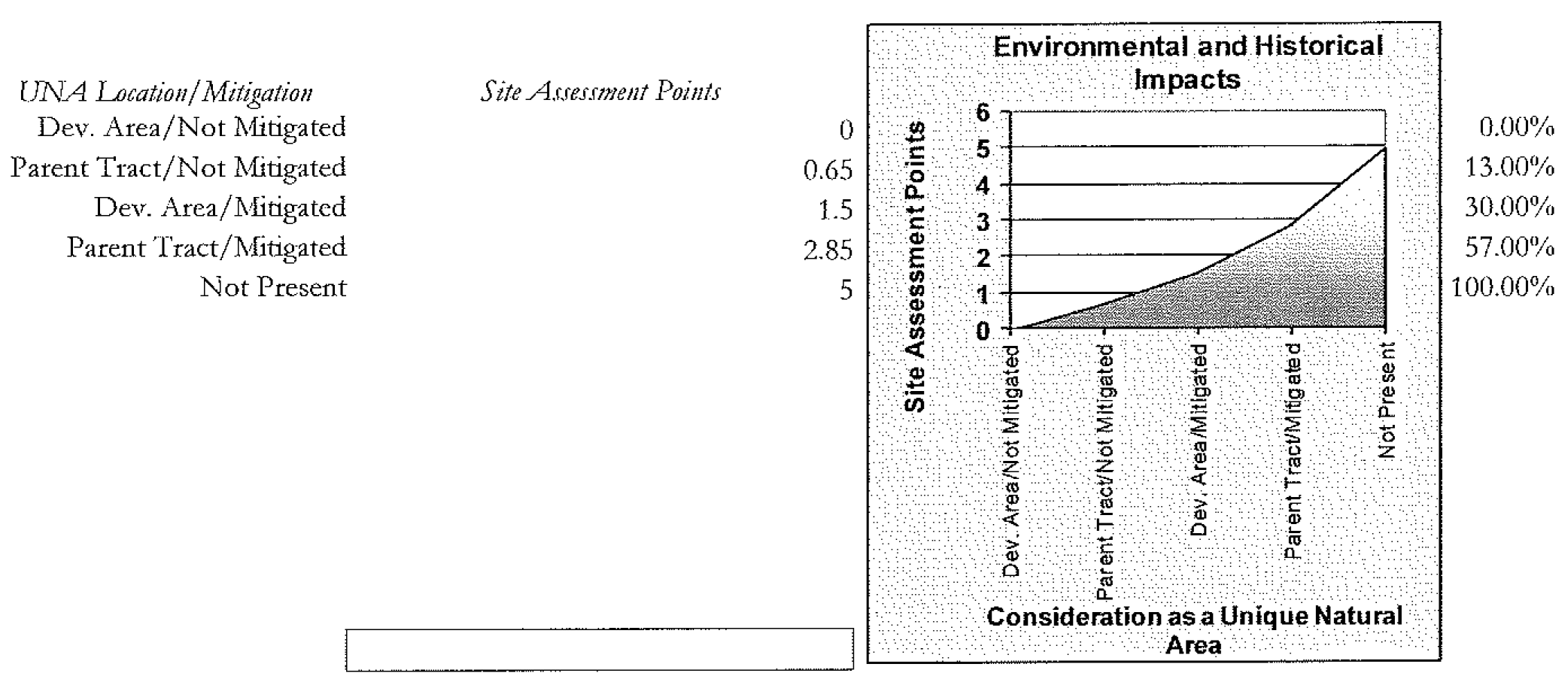
Source: Linn County Conservation, Natural Areas Field Trip, 4/13/91(lcbase.DBO.UniqueNatAreas)
Description: This factor considers the impact of the proposed development on the environmental and historical resources of the parent tract. Inclusion in the report as a significant site shall be verified and proposed mitigation measures considered.
Comments:
CASE NO.:
GPN:
PLAN DESIGNATION: AGRICULTURAL AREA (AA)
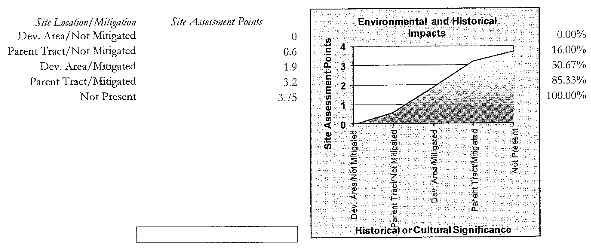
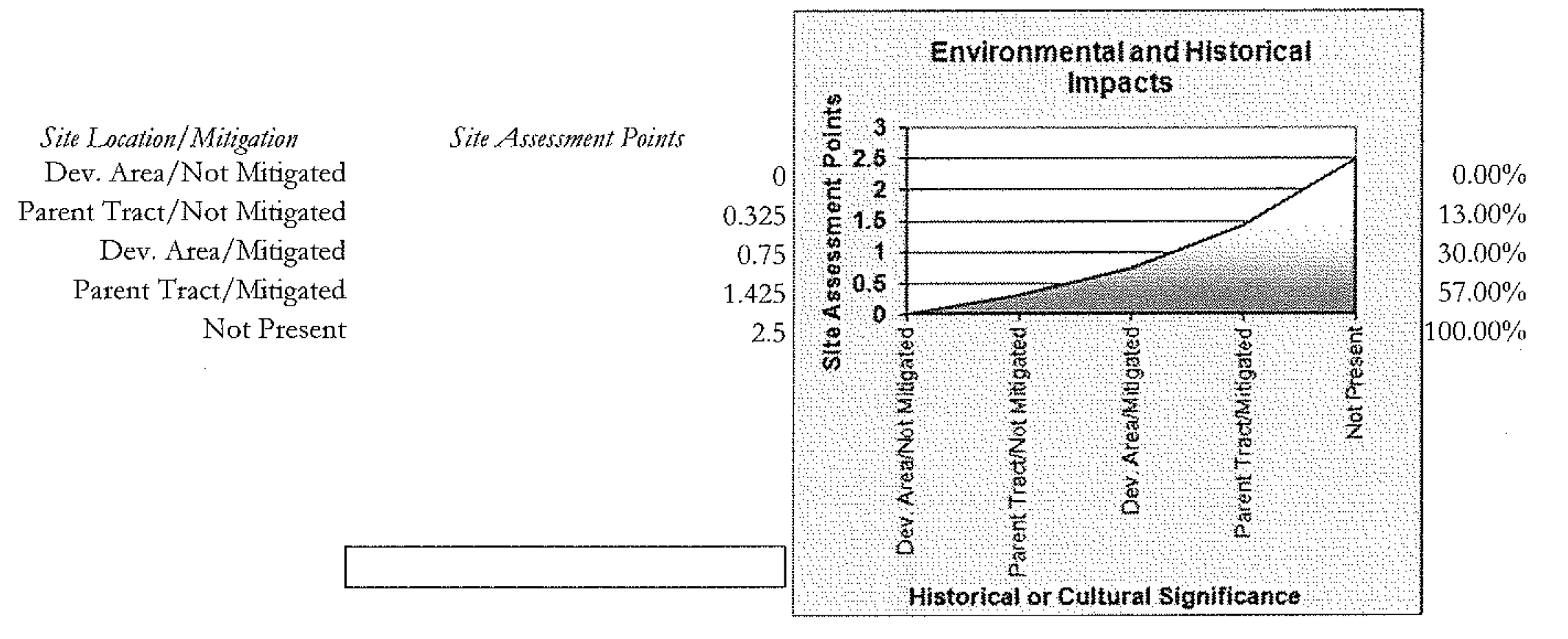
Site Assessment Criterion: Historical or Cultural Significance (5 points maximum)
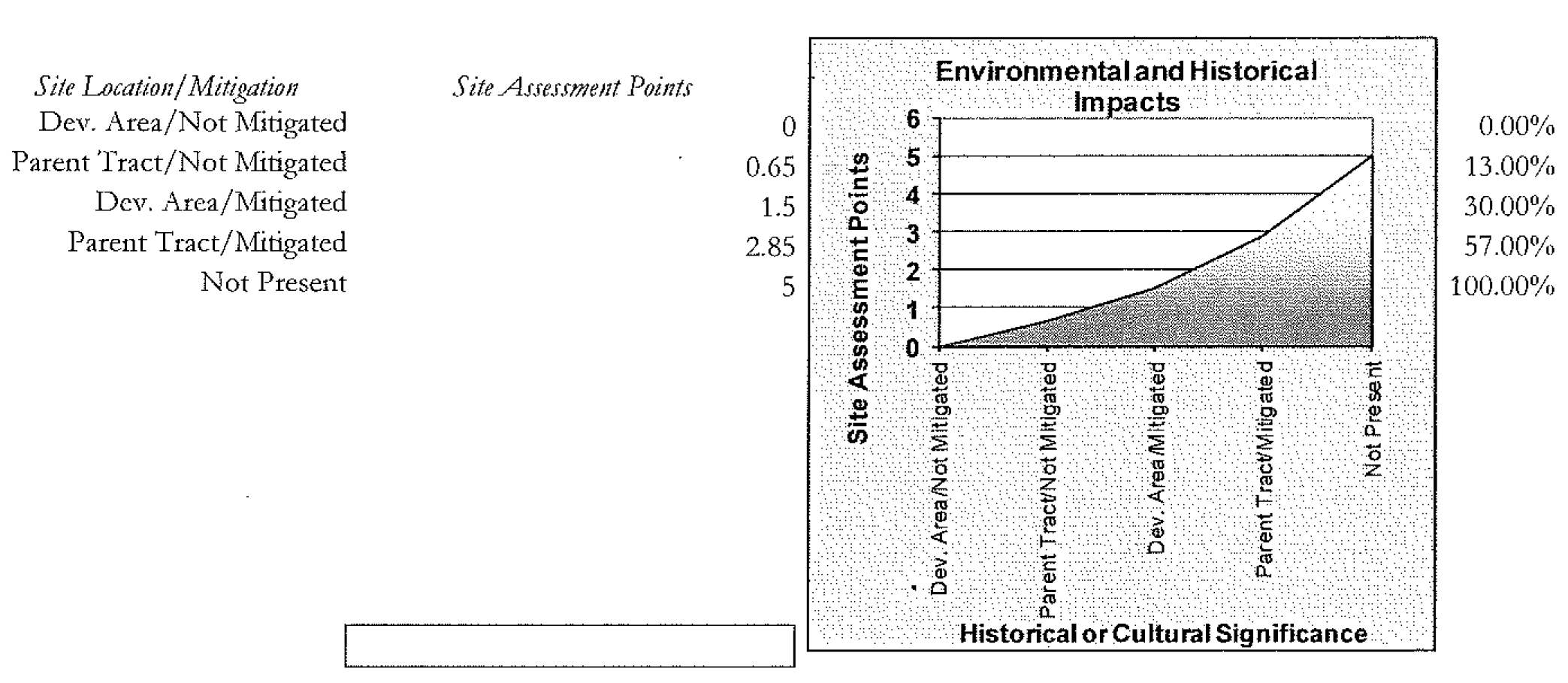
Source: State Historical Society of Iowa; Office of the State Archeologist (lcbase.DBO.HistoricSites)
Description: This factor considers the impact of the proposed development on the environmental and historical resources of the parent tract. Development impacts on historical or cultural buildings, structures or objects; or prehistoric or historic archaeological sites shall be considered.
Comments: Must have documented significance.
LESA Worksheets for Rural Residential Areas
CASE NO.:
GPN:
PLAN DESIGNATION: RURAL RESIDENTIAL DEVELOPMENT AREA (RRDA)
Summary Sheet
Parent Tract Size: ______________________
Development Tract Size: ______________________
APPLICANT INFORMATION
Property Owner: _________________________________
Applicant: _________________________________
Address: _________________________________
City, State, Zip_________________________________
Phone: _________________________________
Email (optional): _________________________________
Fax (optional): _________________________________
LESA EVALUATION SUMMARY
CASE NO.:
GPN:
PLAN DESIGNATION: RURAL RESIDENTIAL DEVELOPMENT AREA (RRDA)
Site Assessment Criterion: Agricultural Zoning within One-Quarter Mile (30 maximum points)
Data Source: Linn County Parcel and Zoning Data
Description: This factor considers the percentage of land that is zoned AG or CNR (including REC) within one-quarter mile of the boundaries of the parent tract.
Comments:
CASE NO.:
GPN:
PLAN DESIGNATION: RURAL RESIDENTIAL DEVELOPMENT AREA (RRDA)
Site Assessment Criterion: Agricultural Zoning within One Mile (25 points maximum)
Data Source: Linn County Parcel and Zoning Data
Description: This factor considers the percentage of land that is zoned AG or CNR (including REC) within one mile of the boundaries of the parent tract.
Comments:
CASE NO.:
GPN:
PLAN DESIGNATION: RURAL RESIDENTIAL DEVELOPMENT AREA (RRDA)
Site Assessment Criterion: On-Site Agricultural Production (30 points maximum)
Source: Linn County Aerial Photography
Description: This factor considers the average percentage of the parent tract that has been in agriculture during the past five years. The applicant must provide verifiable documentation regarding this criterion.
Comments: Examine historical aerial photos of site to determine previous five years of agricultural production.
CASE NO.:
GPN:
PLAN DESIGNATION: RURAL RESIDENTIAL DEVELOPMENT AREA (RRDA)
Site Assessment Criterion: Contiguous Like Zoning (30 points maximum)
Source: Linn County Parcel and Zoning Data
Description: This factor evaluates the zoning of properties contiguous to the boundaries of the proposed parent tract. This factor analyzes to what extent the contiguous zoning is the same or more intensive than the proposed use.
Comments: See list of relative intensities. Percentages are based on the percent of the perimeter boundary. Where such data is available, the assessment shall include land located inside an incorporated city.
CASE NO.:
GPN:
PLAN DESIGNATION: RURAL RESIDENTIAL DEVELOPMENT AREA (RRDA)
Site Assessment Criterion: Development within One-Quarter Mile (40 points maximum)
Source: Linn County Parcels Data
Description: This factor considers what percentage of land has been developed for residential or non-residential purposes within one-quarter mile of the boundaries of the proposed parent tract.
Comments: Parcels assessed as R, C, or I shall be considered as developed. Where such data is available, the assessment shall include land located inside an incorporated city.
CASE NO.:
GPN:
PLAN DESIGNATION: RURAL RESIDENTIAL DEVELOPMENT AREA (RRDA)
Site Assessment Criterion: Development within One Mile (15 points maximum)
Source: Linn County Parcels Data
Description: This factor considers what percentage of land has been developed for residential or non-residential purposes within one mile of the boundaries of the proposed parent tract.
Comments: Parcels assessed as R, C, or I shall be considered as developed. Where such data is available, the assessment shall include land located inside an incorporated city.
CASE NO.:
GPN:
PLAN DESIGNATION: RURAL RESIDENTIAL DEVELOPMENT AREA (RRDA)
Site Assessment Criterion: Slopes 15 Percent or Greater (3 points maximum)
Source: LiDAR Data
Description: This factor considers the environmental limitations of the proposed development area. Steep slopes (15 percent or greater) shall be identified.
Comments:
CASE NO.:
GPN:
PLAN DESIGNATION: RURAL RESIDENTIAL DEVELOPMENT AREA (RRDA)
Site Assessment Criterion: High Water Table or Erodible Soils (3 points maximum)
Source: SSURGO Soils Data
Description: This factor considers the environmental limitations of the proposed development area. Soils classified as having a depth to water table of four feet or less, or as having severe erosion potential, shall be identified.
Comments: ( [Erosionc] = SEV ) or ( [Dpthhiwtrh] andlt;= 2) or ([Dpthhiwtrh] = ) SSURGO
CASE NO.:
GPN:
PLAN DESIGNATION: RURAL RESIDENTIAL DEVELOPMENT AREA (RRDA)
Site Assessment Criterion: Septic/Road Fill/Shrink-Swell (3 points maximum)
Source: SSURGO Soils Data
Description: This factor considers the environmental limitations of the proposed development area. Soils classified with a severe or very severe limitation for septic tank filter fields; and as not suitable, poor, or very poor as a source of road fill; and with a high shrink-swell potential shall be identified.
Comments:
CASE NO.:
GPN:
PLAN DESIGNATION: RURAL RESIDENTIAL DEVELOPMENT AREA (RRDA)
Site Assessment Criterion: Shallow depth to bedrock (3 points maximum)
Source: SSURGO Soils Data
Description: This factor considers the environmental limitations of the proposed development area. Soils classified with a shallow depth to bedrock (three feet or less) shall be identified.
Comments:
CASE NO.:
GPN:
PLAN DESIGNATION: RURAL RESIDENTIAL DEVELOPMENT AREA (RRDA)
Site Assessment Criterion: Hydric Soils (3 points maximum)
Source: SSURGO Soils Data
Description: This factor considers the environmental limitations of the proposed development area. Hydric soils shall be identified.
Comments: [Hydsoilcd] = 1 SSURGO
CASE NO.:
GPN:
PLAN DESIGNATION: RURAL RESIDENTIAL DEVELOPMENT AREA (RRDA)
Site Assessment Criterion: critical natural resource area (3.75 points maximum)
Source: Linn County Parcel and Land Use Data
Description: This factor considers the impact of the proposed development on the environmental and historical resources of the parent tract. The percentage of the parent tract located in critical resource areas shall be identified.
Comments:
CASE NO.:
GPN:
PLAN DESIGNATION: RURAL RESIDENTIAL DEVELOPMENT AREA (RRDA)
Site Assessment Criterion: Known Habitat of Threatened (3.75 points maximum) or Endangered Species
Source: Linn County Threatened and Endangered Species (lcbase.DBO.TESpecies)
Description: This factor considers the impact of the proposed development on the environmental and historical resources of the parent tract. The known habitat of threatened or endangered species shall be identified and proposed mitigation measures considered.
Comments:
CASE NO.:
GPN:
PLAN DESIGNATION: RURAL RESIDENTIAL DEVELOPMENT AREA (RRDA)
Site Assessment Criterion: Consideration as Unique Natural Area (3.75 points maximum)
Source: Linn County Conservation, Natural Areas Field Trip, April 13, 1991 (lcbase.DBO.UniqueNatAreas)
Description: This factor considers the impact of the proposed development on the environmental and historical resources of the parent tract. Inclusion in the report as a significant site shall be verified and proposed mitigation measures considered.
Comments:
CASE NO.:
GPN:
PLAN DESIGNATION: RURAL RESIDENTIAL DEVELOPMENT AREA (RRDA)
Site Assessment Criterion: Historical or Cultural Significance (3.75 points maximum)
Source: State Historical Society of Iowa; Office of the State Archeologist (lcbase.DBO.HistoricSites)
Description: This factor considers the impact of the proposed development on the environmental and historical resources of the parent tract. Development impacts on historical or cultural buildings, structures or objects; or prehistoric or historic archaeological sites shall be considered.
Comments: Must have documented significance.
CASE NO.:
GPN:
PLAN DESIGNATION: URBAN SERVICE AREA (USA)
Summary Sheet
Parent Tract Size:
Development Tract Size:
APPLICANT INFORMATION
Property Owner: _________________________________
Applicant: _________________________________
Address: _________________________________
City, State, Zip: _________________________________
Phone: _________________________________
Email (optional): _________________________________
Fax (optional): _________________________________
____________
LESA EVALUATION SUMMARY
CASE NO.:
GPN:
PLAN DESIGNATION: URBAN SERVICE AREA (USA)
Site Assessment Criterion: On-Site Agricultural Production (30 points maximum)
Source: Linn County Aerial Photography
Description: This factor considers the average percentage of the parent tract that has been in agriculture during the past five years. The applicant must provide verifiable documentation regarding this criterion.
Comments: Examine historical aerial photos of site to determine previous five years of agricultural production.
CASE NO.:
GPN:
PLAN DESIGNATION: URBAN SERVICE AREA (USA)
Site Assessment Criterion: Proximity to Urban Development (50 points maximum)
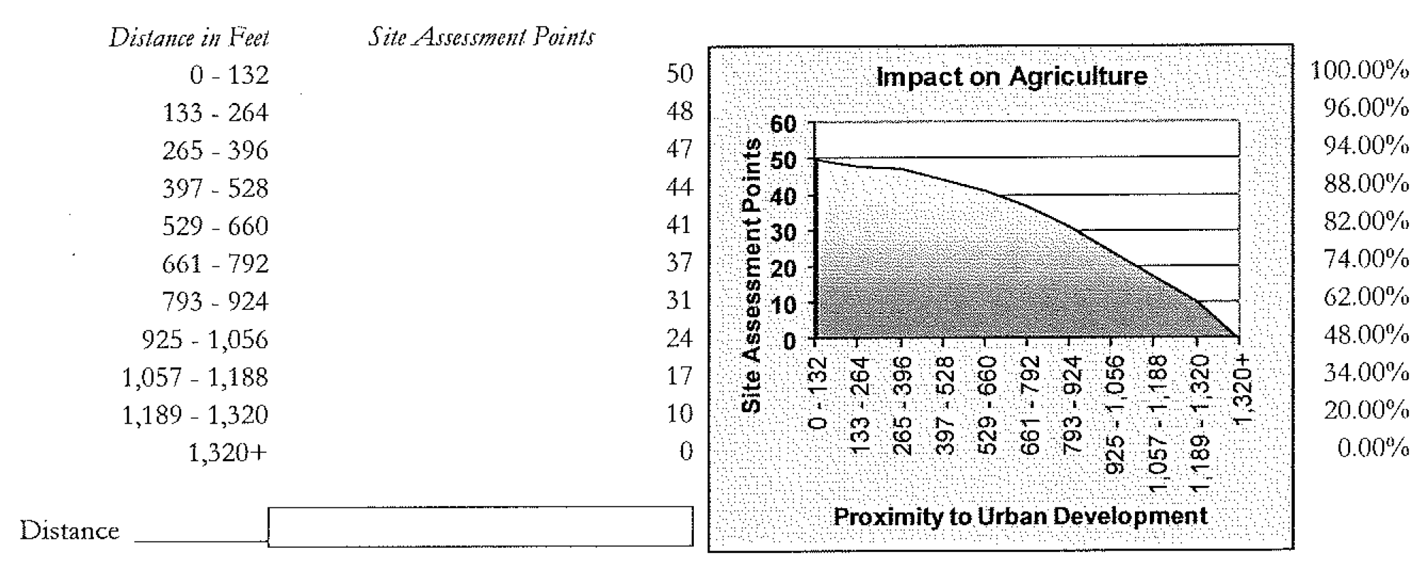
Source: Linn County Parcels Data
Description: This factor considers contiguity of the proposed development by analyzing the distance of the development area to urban development.
Comments: See definition of the term "urban development" in the UDC.
CASE NO.:
GPN:
PLAN DESIGNATION: URBAN SERVICE AREA (USA)
Site Assessment Criterion: Contiguous Like Zoning (40 points maximum)
Source: Linn County Parcels Data
Description: This factor evaluates the zoning of properties contiguous to the boundaries of the proposed parent tract. This factor analyzes to what extent the contiguous zoning is the same or more intensive than the proposed use.
Comments: See list of relative intensities. Percentages are based on the percent of the perimeter boundary. Where such data is available, the assessment shall include land located inside an incorporated city.
CASE NO.:
GPN:
PLAN DESIGNATION: URBAN SERVICE AREA (USA)
Site Assessment Criterion: Development within One-Quarter Mile (45 points maximum)
Source: Linn County Parcels Data
Description: This factor considers what percentage of land has been developed for residential or non-residential purposes within one-quarter mile of the boundaries of the proposed parent tract.
Comments: Parcels assessed as R, C, or I shall be considered as developed. Where such data is available, the assessment shall include land located inside an incorporated city.
CASE NO.:
GPN:
PLAN DESIGNATION: URBAN SERVICE AREA (USA)
Site Assessment Criterion: Development within One Mile (15 points maximum)
Source: Linn County Parcels Data
Description: This factor considers what percentage of land has been developed for residential or non-residential purposes within one mile of the boundaries of the proposed parent tract.
Comments: Parcels assessed as R, C, or I shall be considered as developed. Where such data is available, the assessment shall include land located inside an incorporated city.
CASE NO.:
GPN:
PLAN DESIGNATION: URBAN SERVICES AREA (USA)
Site Assessment Criterion: Slopes 15 percent or greater (2 points maximum)
Source: LiDAR Data
Description: This factor considers the environmental limitations of the proposed development area. Steep slopes (15 percent or greater) shall be identified.
Comments:
CASE NO.:
GPN:
PLAN DESIGNATION: URBAN SERVICES AREA (USA)
Site Assessment Criterion: High Water Table or Erodible Soils (2 points maximum)
Source: SSURGO Soils Data
Description: This factor considers the environmental limitations of the proposed development area. Soils classified as having a depth to water table of four feet or less, or as having severe erosion potential, shall be identified.
Comments: ( [Erosionc] = SEV ) or ( [Dpthhiwtrh] andlt;= 2) or ([Dpthhiwtrh] = ) SSURGO
CASE NO.:
GPN:
PLAN DESIGNATION: URBAN SERVICES AREA (USA)
Site Assessment Criterion: Septic/Road Fill/Shrink-Swell (2 points maximum)
Source: SSURGO Soils Data
Description: This factor considers the environmental limitations of the proposed development area. Soils classified with a severe or very severe limitation for septic tank filter fields; and as not suitable, poor, or very poor as a source of road fill; and with a high shrink-swell potential shall be identified.
Comments:
CASE NO.:
GPN:
PLAN DESIGNATION: URBAN SERVICES AREA (USA)
Site Assessment Criterion: Shallow depth to bedrock (2 points maximum)
Source: SSURGO Soils Data
Description: This factor considers the environmental limitations of the proposed development area. Soils classified with a shallow depth to bedrock (three feet or less) shall be identified.
Comments:
CASE NO.:
GPN:
PLAN DESIGNATION: URBAN SERVICES AREA (USA)
Site Assessment Criterion: Hydric Soils (2 points maximum)
Source: SSURGO Soils Data
Description: This factor considers the environmental limitations of the proposed development area. Hydric soils shall be identified.
Comments: [Hydsoilcd] = 1 SSURGO
CASE NO.:
GPN:
PLAN DESIGNATION: URBAN SERVICE AREA (USA)
Site Assessment Criterion: Critical Natural Resource Area (2.5 points maximum)
Source: cra_sp.shp
Description: This factor considers the impact of the proposed development on the environmental and historical resources of the parent tract. The percentage of the parent tract located in critical resource areas shall be identified.
Comments:
CASE NO.:
GPN:
PLAN DESIGNATION: URBAN SERVICE AREA (USA)
Site Assessment Criterion: Known Habitat of Threatened or Endangered Species (2.5 points maximum)
Source: Linn County Threatened and Endangered Species (lcbase.DBO.TESpecies)
Description: This factor considers the impact of the proposed development on the environmental and historical resources of the parent tract. The known habitat of threatened or endangered species shall be identified and proposed mitigation measures considered.
Comments:
CASE NO.:
GPN:
PLAN DESIGNATION: URBAN SERVICE AREA (USA)
Site Assessment Criterion: Consideration as Unique Natural Area (2.5 points maximum)
Source: Linn County Conservation, Natural Areas Field Trip, April 13, 1991 (lcbase.DBO.UniqueNatAreas)
Description: This factor considers the impact of the proposed development on the environmental and historical resources of the parent tract. Inclusion in the report as a significant site shall be verified and proposed mitigation measures considered.
Comments:
CASE NO.:
GPN:
PLAN DESIGNATION: URBAN SERVICE AREA (USA)
Site Assessment Criterion: Historical or Cultural Significance (2.5 points maximum)
Source: State Historical Society of Iowa; Office of the State Archeologist (lcbase.DBO.HistoricSites)
Description: This factor considers the impact of the proposed development on the environmental and historical resources of the parent tract. Development impacts on historical or cultural buildings, structures or objects; or prehistoric or historic archaeological sites shall be considered.
Comments: Must have documented significance.
CASE NO.:
GPN:
PLAN DESIGNATION: CRITICAL NATURAL RESOURCE AREA (CNRA)
Summary Sheet
Parent Tract Size:
Development Tract Size:
APPLICANT INFORMATION
Property Owner: ________________________________
Applicant: ________________________________
Address: ________________________________
City, State, Zip: ________________________________
Phone: ________________________________
Email (optional): ________________________________
Fax (optional): ________________________________
____________
LESA EVALUATION SUMMARY
CASE NO.:
GPN:
PLAN DESIGNATION: CRITICAL NATURAL RESOURCE AREA (CNRA)
Site Assessment Criterion: Agricultural and CNR Zoning within (30 maximum points) One-Quarter Mile

Data Source: Linn County Parcel and Zoning Data
Description: This factor considers the percentage of land that is zoned AG or CNR (including REC) within one-quarter mile of the boundaries of the parent tract.
Comments:
CASE NO.:
GPN:
PLAN DESIGNATION: CRITICAL NATURAL RESOURCE AREA (CNRA)
Site Assessment Criterion: Agricultural and CNR Zoning (25 points maximum) within One Mile
Data Source: Linn County Parcel and Zoning Data
Description: This factor considers the percentage of land that is zoned AG or CNR (including REC) within one mile of the boundaries of the parent tract.
Comments:
CASE NO.:
GPN:
PLAN DESIGNATION: CRITICAL NATURAL RESOURCE AREA (CNRA)
Site Assessment Criterion: On-Site Agricultural Production (30 points maximum)
Source: Linn County Aerial Photography
Description: This factor considers the average percentage of the parent tract that has been in agriculture during the past five years. The applicant must provide verifiable documentation regarding this criterion.
Comments: Examine historical aerial photos of site to determine previous five years of agricultural production.
CASE NO.:
GPN:
PLAN DESIGNATION: CRITICAL NATURAL RESOURCE AREA (CNRA)
Site Assessment Criterion: Contiguous Like Zoning (30 points maximum)
Source: Linn County Parcel and Zoning Data
Description: This factor evaluates the zoning of properties contiguous to the boundaries of the proposed parent tract. This factor analyzes to what extent the contiguous zoning is the same or more intensive than the proposed use.
Comments: See list of relative intensities. Percentages are based on the percent of the perimeter boundary. Where such data is available, the assessment shall include land located inside an incorporated city.
CASE NO.:
GPN:
PLAN DESIGNATION: CRITICAL NATURAL RESOURCE AREA (CNRA)
Site Assessment Criterion: Development within One-Quarter Mile (20 points maximum)
Source: Linn County Parcels Data
Description: This factor considers what percentage of land has been developed for residential or non-residential purposes within one-quarter mile of the boundaries of the proposed parent tract.
Comments: Parcels in the same assessment classification as the proposed development and with similar lot sizes. Similar lot sizes shall mean lot sizes within a range of 90 percent to 110 percent of the proposed lot sizes. Where such data is available, the assessment shall include land located inside an incorporated city.
CASE NO.:
GPN:
PLAN DESIGNATION: CRITICAL NATURAL RESOURCE AREA (CNRA)
Site Assessment Criterion: Slopes 15 Percent or Greater (2 points maximum)
Source: LiDAR Data
Description: This factor considers the environmental limitations of the proposed development area. Steep slopes (15 percent or greater) shall be identified.
Comments:
CASE NO.:
GPN:
PLAN DESIGNATION: CRITICAL NATURAL RESOURCE AREA (CNRA)
Site Assessment Criterion: High Water Table or Erodible Soils (2 points maximum)
Source: SSURGO Soils Data
Description: This factor considers the environmental limitations of the proposed development area. Soils classified as having a depth to water table of four feet or less, or as having severe erosion potential, shall be identified.
Comments: ( [Erosionc] = SEV ) or ( [Dpthhiwtrh] andlt;= 2) or ([Dpthhiwtrh] = ) SSURGO
CASE NO.:
GPN:
PLAN DESIGNATION: CRITICAL NATURAL RESOURCE AREA (CNRA)
Site Assessment Criterion: Septic/Road Fill/Shrink-Swell (2 points maximum)
Source: SSURGO Soils Data
Description: This factor considers the environmental limitations of the proposed development area. Soils classified with a severe or very severe limitation for septic tank filter fields; and as not suitable, poor, or very poor as a source of road fill; and with a high shrink-swell potential shall be identified.
Comments:
CASE NO.:
GPN:
PLAN DESIGNATION: CRITICAL NATURAL RESOURCE AREA (CNRA)
Site Assessment Criterion: Shallow Depth to Bedrock (2 points maximum)
Source: SSURGO Soils Data
Description: This factor considers the environmental limitations of the proposed development area. Soils classified with a shallow depth to bedrock (three feet or less) shall be identified.
Comments:
CASE NO.:
GPN:
PLAN DESIGNATION: CRITICAL NATURAL RESOURCE AREA (CNRA)
Site Assessment Criterion: Hydric Soils (2 points maximum)
Source: SSURGO Soils Data
Description: This factor considers the environmental limitations of the proposed development area. Hydric soils shall be identified.
Comments: [Hydsoilcd] = 1 SSURGO
CASE NO.:
GPN:
PLAN DESIGNATION: CRITICAL NATURAL RESOURCE AREA (CNRA)
Site Assessment Criterion: Critical Natural Resource Area (2.5 points maximum)
Source: Linn County Parcel and Land Use Data.
Description: This factor considers the impact of the proposed development on the environmental and historical resources of the parent tract. The percentage of the parent tract located in critical resource areas shall be identified.
Comments:
CASE NO.:
GPN:
PLAN DESIGNATION: CRITICAL NATURAL RESOURCE AREA (CNRA)
Site Assessment Criterion: Known Habitat of Threatened or (2.5 points maximum) Endangered Species
Source: Linn County Threatened and Endangered Species (lcbase.DBO.TESpecies)
Description: This factor considers the impact of the proposed development on the environmental and historical resources of the parent tract. The known habitat of threatened or endangered species shall be identified and proposed mitigation measures considered.
Comments:
CASE NO.:
GPN:
PLAN DESIGNATION: CRITICAL NATURAL RESOURCE AREA (CNRA)
Site Assessment Criterion: Consideration as Unique Natural Area (2.5 points maximum)
Source: Linn County Conservation, Natural Areas Field Trip, April 13, 1991 (lcbase.DBO.UniqueNatAreas)
Description: This factor considers the impact of the proposed development on the environmental and historical resources of the parent tract. Inclusion in the report as a significant site shall be verified and proposed mitigation measures considered.
Comments:
CASE NO.:
GPN:
PLAN DESIGNATION: CRITICAL NATURAL RESOURCE AREA (CNRA)
Site Assessment Criterion: Historical or Cultural Significance (2.5 points maximum)
Source: State Historical Society of Iowa; Office of the State Archeologist (lcbase.DBO.HistoricSites)
Description: This factor considers the impact of the proposed development on the environmental and historical resources of the parent tract. Development impacts on historical or cultural buildings, structures or objects; or prehistoric or historic archaeological sites shall be considered.
Comments: Must have documented significance.
(Code 2006, ch. 41, app. B; Ord. No. 3-3-2006, 4-1-2006; Ord. No. 10-10-2013, 10-14-2013)