
Linn County Unincorporated
City Zoning Code
City Zoning Code
ARTICLE VII
- ZONING CLASSIFICATIONS, DENSITY, DIMENSIONAL STANDARDS AND ALLOWED USES
Sec. 107-131. - Districts and district boundaries.
(a)
Reclassification. The zoning districts established under the prior zoning ordinance shall be reclassified as shown in the reclassification list associated with the official zoning map.
(b)
Establishment of districts and overlay zones. In order to carry out the purpose and intent of this chapter, the unincorporated territory of the county is hereby divided into the following zoning districts and overlay zones:
(1)
AG Agricultural District.
(2)
RR2 Rural Residential Two-Acre District.
(3)
RR3 Rural Residential Three-Acre District.
(4)
RR1 Rural Residential One-Acre District.
(5)
VR and VM Rural Village Districts.
(6)
USR Urban Services Residential District.
(7)
USR-MF Urban Services Residential, Multi-Family District.
(8)
HC Highway Commercial District.
(9)
GC General Commercial District.
(10)
I Industrial District.
(11)
CNR Critical Natural Resources District.
(12)
REC Seasonal Cabin and Recreation Areas Overlay District.
(13)
FP Floodplain Overlay District.
(14)
EU-1 Exclusive Use, Sanitary Landfill District.
(15)
MH Mobile Home District.
(16)
PUD Planned Unit Development Overlay District.
(17)
RE Renewable Energy Overlay District.
(18)
EU-2 Exclusive Use - Two, Nuclear Energy Generating Facility and Nuclear Waste Storage District.
(c)
Boundaries and official zoning map. The boundaries of zoning districts and overlay zones are hereby established as shown on the official zoning map of the unincorporated area of the county which maps and notations and references and other matters shown thereon, shall be and are hereby made a part of this chapter.
(1)
Electronic map. The official zoning map may be in hard copy or electronic format or both as specified by a resolution of the board of supervisors.
(2)
Where filed. The official zoning map shall be filed in the office of the county planning and development department.
(3)
Official signature. The official zoning map shall be identified by the written or electronic signature of the chairperson of the board of supervisors, and attested by the county auditor under the following words: "This is to certify that this is the "official zoning map" referred to in section 107-131(c), adopted on this January 1, 2006."
(4)
Map amendments. If, in accordance with the rezoning and map amendment provisions of section 107-68, changes are made in the district boundaries, the ordinance number and date of the change shall be recorded by the zoning administrator on the official zoning map.
(5)
Replacement if destroyed. In the event that the official zoning map becomes damaged, destroyed, lost or difficult to interpret because of use, the board of supervisors may by resolution adopt a new official zoning map that shall supersede the prior official zoning map. The new official zoning map may correct drafting or other errors or omissions in the prior official zoning map; provided, however, that any such adoption shall not have the effect of amending the original zoning ordinance or any subsequent amendment thereof.
(6)
Effect of vacated railroads, streets, roads, alleys and highways. Whenever any railroad, street, road, alley or highway right-of-way is vacated by official action as provided by law, the zoning districts adjoining the sides of such public way shall be automatically extended to the center of said rights-of-way, and the right-of-way thus vacated shall henceforth be subject to all regulations of the extended district.
(d)
Rules for interpretation of district boundaries. In cases where the exact location of the district boundary is not clear as shown on the official zoning map, the following rules shall be used in determining the location of said district boundary.
(1)
Boundaries indicated as approximately following the centerlines of streets, highways, or alleys shall be construed to follow such centerlines.
(2)
Boundaries indicated as approximately following platted lot lines shall be construed as following such lot lines.
(3)
Boundaries indicated as approximately following city limits shall be construed as following city limits.
(4)
Boundaries indicated as following railroad lines shall be construed to be midway between the main tracks.
(5)
Boundaries indicated as following shorelines shall be construed to follow such shorelines, and in the event of change in the shorelines shall be construed as moving with the actual shoreline. Boundaries indicated as approximately following the centerlines of streams, rivers, canals, lakes, or other bodies of water shall be construed to follow such centerlines. If the centerline changes the boundary shall be construed as moving with the centerline changes.
(6)
Boundaries indicated as parallel to or extensions of features indicated in subsections (1) through (5) of this section shall be so construed. Distances not specifically indicated on the official zoning map shall be determined by the scale of the map.
(7)
Where physical features existing on the ground differ from those shown on the official zoning map, or in other circumstances not covered by subsections (1) through (6) of this section, the zoning administrator shall interpret the district boundaries.
(e)
New territory. All territory which may hereafter become a part of the unincorporated area of the county that is regulated by this chapter, by the dissolution of any city or severance of any part of a city, shall automatically be classed as lying and being within the same rural land use map district as the adjacent unincorporated land. If more than one map district is adjacent to the new unincorporated area, the area shall automatically be classified as lying and being within the AG Agricultural District until such classification shall have been changed by a rezoning and map amendment as provided for in section 107-68.
(f)
Zoning districts dividing property/split zoning. Where one parcel of property is divided into two or more portions by reason of different zoning district classifications, each of these portions shall be used independently of the others in its respective zoning classification and for the determination of yard and density requirements.
(g)
Relationship between comprehensive plan and zoning districts. The relationship between the goals and objectives of the comprehensive plan to the various zoning districts are contained within Table 107-147-3 "Goals and Objectives of comprehensive plan as they relate to individual zoning districts."
(Code 2006, ch. 41, art. 7, § 1; Ord. No. 3-3-2007, 4-1-2007; Ord. No. 10-10-2013, 10-14-2013; Ord. No. 11-9-2020, § 1(Att. A), 9-9-2020; Ord. No. 19-12-2020, § 1(Att. A), 12-8-2020; Ord. No. 6-9-2025, § 1, 9-3-2025)
Sec. 107-132. - AG Agricultural District.
(a)
Purpose. Agricultural areas (AA) designated on the land use map are intended to maintain or enhance the viability of agricultural operations in such areas by restricting the proliferation of noncompatible uses and protecting "high-value" agricultural land, while allowing pockets of infill development in appropriate areas. This is achieved through the design of the LESA system scoring, which awards points sparingly and has a high threshold score for development approval. The agricultural area goals are also achieved through the UDC zoning density requirement for lots, which generally requires a 35-acre minimum for agriculturally zoned development, and through the minimum levels of service (MLS) standards. For more information concerning how the goals and objectives of the comprehensive plan relate to each zoning district refer to Table 107-147-3 at the end of article VII of this chapter.
(b)
Geographic location. The agricultural district shall be geographically located in those areas designated agricultural areas in the comprehensive plan, excluding those areas that are also designated as critical natural resource areas.
(c)
Permitted, conditional and accessory uses. Permitted, conditional and accessory uses of land allowed in the agricultural district are only those specified in the use table, Table 107-147-1. All uses not listed in the use table, Table 107-147-1, shall be prohibited. Specific permitted, conditional and accessory uses are subject to the requirements in article VI of this chapter.
(d)
Additional requirements. Additional requirements within this chapter and other county ordinances apply to development in the agricultural district. These include, but are not limited to, the general regulations in article V of this chapter.
(e)
Dimensional standards. Development within the agricultural district shall be subject to the following minimum dimensional standards:
(1)
Minimum lot area:
a.
Single-family dwelling and single-family manufactured home, 35 acres.
b.
Single-family dwellings and single-family manufactured homes in an application that meets the minimum levels of service requirements of section 107-69 and the land evaluation and site assessment requirements of section 107-70, 2 acres.
c.
Single-family dwellings and single-family manufactured homes in an application that meets the minimum levels of service requirements of section 107-69 and the land evaluation and site assessment requirements of section 107-70 and proposes a cluster subdivision, 1 acre.
d.
Residential parcel split, 1 acre.
e.
Other principal permitted and conditional uses, 1 acre or as specified by conditional use permit.
f.
No minimum lot area required for utilities, public uses, and communication towers except as otherwise required.
(2)
Minimum lot width for all uses: 150 feet.
(3)
Minimum setbacks from property or road right-of-way lines for all principal structures:
a.
Front yard, 50 feet.
b.
Side yard, ten feet.
c.
Corner side yard, 50 feet.
d.
Rear yard, 35 feet.
(4)
Maximum height for all principal structures except agricultural buildings, utilities and communication or wind towers: 45 feet.
(5)
Minimum setbacks from property or road right-of-way lines for all accessory structures: Accessory structure setbacks shall conform to the provisions of section 107-94(c).
(Code 2006, ch. 41, art. 7, § 3; Ord. No. 13-9-2006, 10-1-2006; Ord. No. 10-10-2013, 10-14-2013; Ord. No. 7-11-2024, § 6, 11-20-2024)
Sec. 107-133. - RR2 Rural Residential Two-Acre District.
(a)
Purpose. Rural residential development areas (RRDA) designated on the land use map are intended to allow for the logical expansion of low-density, rural character residential development (i.e., large lots served by individual well and septic and by rural cross-section roads). RRDAs are divided into two sub-categories:
(1)
The RRDA three-acre area, which is the rural residential development area located within the well field watershed of the City of Cedar Rapids; and
(2)
The RRDA two-acre area, which is not located within the city's well field watershed.
The RRDA goals are supported by the LESA system scoring criteria, where points are withheld in predominantly agricultural settings but are awarded fairly readily in more suburban surroundings. RRDA goals are also supported through the MLS standards. For more information concerning how the goals and objective of the comprehensive plan relate to each zoning district, refer to Table 107-147-3 at the end of article VII of this chapter.
(b)
Geographic location. The rural residential two-acre district shall be geographically located in those areas designated rural residential development areas, two-acre, in the rural land use map, excluding those areas that are also designated as critical natural resource areas.
(c)
Permitted, conditional and accessory uses. Permitted, conditional and accessory uses of land allowed in the rural residential two-acre district are only those specified in the use table, Table 107-147-1. All uses not listed in the use table, Table 107-147-1, shall be prohibited. Specific permitted, conditional and accessory uses are subject to the requirements in article VI of this chapter.
(d)
Additional requirements. Additional requirements within this chapter and other county ordinances apply to development in the rural residential two-acre district. These include, but are not limited to, the general regulations in article V of this chapter.
(e)
Dimensional standards. Development within the rural residential two-acre district shall be subject to the following minimum dimensional standards:
(1)
Minimum lot area:
a.
Single-family dwelling and single-family manufactured home, 35 acres.
b.
Single-family dwellings and single-family manufactured homes in an application that meets the minimum levels of service requirements of section 107-69 and the land evaluation and site assessment requirements of section 107-70, 2 acres.
c.
Single-family dwellings and single-family manufactured homes in an application that meets the minimum levels of service requirements of section 107-69 and the land evaluation and site assessment requirements of section 107-70 and proposes a cluster subdivision, 1 acre.
d.
Residential parcel split, 1 acre.
e.
Other principal permitted and conditional uses, 2 acres or as specified by conditional use permit.
f.
Communication towers greater than 200 feet, 5 acres.
g.
No minimum lot area required for utilities, public uses, and other communication towers except as otherwise required.
(2)
Minimum lot width for all uses: 150 feet.
(3)
Minimum setbacks from property or road right-of-way lines for all principal structures:
a.
Front yard, 35 feet.
b.
Side yard, ten feet.
c.
Corner side yard, 35 feet.
d.
Rear yard, 35 feet.
(4)
Maximum height for all principal structures except utilities and communication or wind towers: 35 feet.
(5)
Minimum setbacks from property or road right-of-way line for all accessory structures: Accessory structure setbacks shall confirm to the provisions of section 107-94(c).
(Code 2006, ch. 41, art. 7, § 3; Ord. No. 13-9-2006, 10-1-2006; Ord. No. 10-10-2013, 10-14-2013; Ord. No. 7-11-2024, § 6, 11-20-2024)
Sec. 107-134. - RR3 Rural Residential Three-Acre District.
(a)
Purpose. Rural residential development areas (RRDA) designated on the land use map are intended to allow for the logical expansion of low-density, rural character residential development (i.e., large lots served by individual well and septic and by rural cross-section roads). RRDAs are divided into two sub-categories:
(1)
The RRDA three-acre area, which is the rural residential development area located within the well field watershed of the City of Cedar Rapids; and
(2)
The RRDA two-acre area, which is not located within the city's well field watershed.
The RRDA goals are supported by the LESA system scoring criteria, where points are withheld in predominantly agricultural settings but are awarded fairly readily in more suburban surroundings. RRDA goals are also supported through the MLS standards. For more information concerning how the goals and objectives of the comprehensive plan relate to each zoning district, refer to Table 107-147-3 at the end of article VII of this chapter.
(b)
Geographic location. The rural residential three-acre district shall be geographically located in those areas designated rural residential development areas, three-acre, in the rural land use map, excluding those areas that are also designated as critical natural resource areas.
(c)
Permitted, conditional and accessory uses. Permitted, conditional and accessory uses of land allowed in the rural residential three-acre district are only those specified in the use table, Table 107-147-1. All uses not listed in the use table, Table 107-147-1, shall be prohibited. Specific permitted, conditional and accessory uses are subject to the requirements in article VI of this chapter.
(d)
Additional requirements. Additional requirements within this chapter and other county ordinances apply to development in the rural residential three-acre district, these include, but are not limited to, the general regulations in article V of this chapter.
(e)
Dimensional standards. Development within the rural residential three-acre district shall be subject to the following minimum dimensional standards:
(1)
Minimum lot area:
a.
Single-family dwelling and single-family manufactured home, 35 acres.
b.
Single-family dwellings and single-family manufactured homes in an application that meets the minimum levels of service requirements of section 107-69 and the land evaluation and site assessment requirements of section 107-70, three acres.
c.
Single-family dwellings and single-family manufactured homes in an application that meets the minimum levels of service requirements of section 107-69 and the land evaluation and site assessment requirements of section 107-70 and proposes a cluster subdivision, two-acre.
d.
Residential parcel split, one acre.
e.
Other principal permitted and conditional uses, three acres or as specified by conditional use permit.
f.
Communication towers greater than 200 feet, five acres.
g.
No minimum lot area required for utilities, public uses, and other communication towers except as otherwise required.
(2)
Minimum lot width for all uses: 150 feet.
(3)
Minimum setbacks from property or road right-of-way lines for all principal structures:
a.
Front yard, 35 feet.
b.
Side yard, ten feet.
c.
Corner side yard, 35 feet.
d.
Rear yard, 35 feet.
(4)
Maximum height for all principal structures except utilities and communication or wind towers: 35 feet.
(5)
Minimum setbacks from property or road right-of-way lines for all accessory structures: Accessory structure setbacks shall conform to the provisions of section 107-94(c).
(Code 2006, ch. 41, art. 7, § 4; Ord. No. 13-9-2006, 10-1-2006; Ord. No. 7-11-2024, § 7, 11-20-2024)
Sec. 107-135. - RR1 Rural Residential One-Acre District.
(a)
Purpose. The purpose of the rural residential one-acre district is to prevent a class of lots created under the prior zoning ordinance from becoming nonconforming. One acre lots were previously allowed in the former agricultural district and many were created. The goals of the county comprehensive plan discourage this size of lot in rural areas. The RR1 district is created to allow rebuilding of single-family residences on previously created one acre lots if the current structure is destroyed. The RR1 district is a closed district, however, and no new RR1 districts shall be allowed. For more information concerning how the goals and objectives of the comprehensive plan relate to each zoning district, refer to Table 107-147-3 at the end of article VII of this chapter.
(b)
Closed district/rezoning prohibited. Rezoning any land to a RR1 Rural Residential One-Acre District shall be prohibited.
(c)
Permitted, conditional and accessory uses. Permitted, conditional and accessory uses of land allowed in the rural residential one-acre district are only those specified in the use table, Table 107-147-1. All uses not listed in the use table, Table 107-147-1 shall be prohibited. Specific permitted, conditional and accessory uses are subject to the requirements in article VI of this chapter.
(d)
Additional requirements. Additional requirements within this chapter and other county ordinances apply to land uses in the rural residential one-acre districts, these include, but are not limited to, the general regulations in article V of this chapter.
(e)
Dimensional standards. If an existing structure is replaced in the rural residential one-acre district, the structure shall be subject to the following minimum dimensional standards:
(1)
Minimum setbacks from property or road right-of-way lines for all principal structures:
a.
Front yard, 50 feet.
b.
Side yard, 10 feet.
c.
Corner side yard, 50 feet.
d.
Rear yard, 50 feet.
(2)
Maximum height for all principal structures except utilities and communication or wind towers: 35 feet.
(3)
Minimum setbacks from property or road right-of-way lines for all principal structures:
a.
Front yard, 35 feet.
b.
Side yard, ten feet.
c.
Corner side yard, 35 feet.
d.
Rear yard, 35 feet.
(Code 2006, ch. 41, art. 7, § 5; Ord. No. 13-9-2006, 10-1-2006; Ord. No. 3-3-2007, 4-1-2007; Ord. No. 10-10-2013, 10-14-2013; Ord. No. 7-11-2024, § 8, 11-20-2024)
Sec. 107-136. - VR and VM Rural Village Districts.
(a)
Purpose. The county has several rural villages that once served as small, but vital, community centers: Covington, Lafayette, Toddville, Troy Mills, Viola, Waubeek, Western, and Whittier. While some of the county's historical communities are little more than place names, these rural villages each have an opportunity to become vital places that serve many of the social, economic, and cultural needs of the county's rural residents. To accomplish this, the county will need to help each of these communities develop a clear vision of its desired character and facilitate private investments in support of that vision. The county shall support each village's efforts to establish additional planning initiatives that establish shared visions of their future; identify needed public facilities and services; develop consensus for land uses and village character; and identify meaningful incentives to foster private investment to create vibrant, walkable, mixed-use villages. Additionally, the county will support efforts to seek grants and other sources of funding for the redevelopment and revitalization of its rural villages. For more information concerning how the goals and objectives of the comprehensive plan relate to each zoning district, refer to Table 107-147-3 at the end of article VII of this chapter.
(b)
Geographic location. The rural village districts shall be geographically located within the developed areas of the following rural villages identified in the comprehensive plan: Covington, Lafayette, Toddville, Troy Mills, Viola, Western, Waubeek and Whittier. Toddville and Troy Mills have public wastewater utilities as of the effective date of the ordinance from which this chapter is derived.
(c)
Permitted, conditional and accessory uses. Permitted, conditional and accessory uses of land allowed in the rural village districts are only those specified in the use table, Table 107-147-1. All uses not listed in the use table, Table 107-147-1, shall be prohibited. Specific permitted, conditional and accessory uses are subject to the requirements in article VI of this chapter.
(d)
Additional requirements. Additional requirements within this chapter and other county ordinances apply to development in the rural village districts, these include, but are not limited to, the general regulations in article V of this chapter.
(e)
VR Village Residential District.
(1)
Purpose. The purpose of the village residential district is to maintain the existing character of residential neighborhoods within the rural villages, while encouraging rehabilitation of existing buildings and ensuring that new infill development can occur in a way that is compatible with this existing character.
(2)
Table107-136VR dimensional standards for properties served by septic systems.
(3)
VR dimensional standards for properties served by a public wastewater utility. Note that single-family attached dwellings are only allowed where they can be served by public wastewater:
a.
Minimum lot area:
1.
Single-family dwelling, 10,000 square feet.
2.
Two-family dwelling, 5,000 square feet per unit.
3.
Single-family attached dwelling, 3,500 square feet per unit.
4.
Accessory dwelling unit in conjunction with a single-family dwelling, no additional lot area beyond that required for the principal dwelling.
5.
Other principal permitted and conditional uses, 10,000 square feet or as specified by conditional use permit.
b.
Minimum lot width:
1.
Single-family dwelling, 60 feet.
2.
Two-family dwelling, 30 feet.
3.
Single-family attached dwelling, 30 feet.
4.
All other uses, 80 feet.
c.
Minimum setbacks from property or road right-of-way lines for all principal structures:
1.
Front yard, 25 feet, except that on blocks where existing buildings have a relatively consistent setback, the front yard setback shall fall within the range established by those buildings.
2.
Corner side yard, 15 feet.
3.
Interior side yard, 10 feet.
4.
Rear yard, 35 feet.
d.
Maximum height for principal structures except utilities: 35 feet.
e.
Minimum setbacks from property or road right-of-way lines for all accessory structures: Accessory structure setbacks shall conform to the provisions of section 107-94(c).
(f)
VM Village Mixed-Use District.
(1)
Purpose. The purpose of the village mixed-use district is to encourage the rehabilitation and re-use of existing commercial buildings within the rural villages, as well as the development of new neighborhood-serving commercial uses where appropriate, as identified through a community planning process. In order to maximize the possibilities for re-use of existing buildings, all permitted and conditional uses allowed in the village residential district are also allowed in the village mixed-use district.
(2)
VM dimensional standards.
a.
Single-family dwelling, two-family dwelling, single-family attached dwelling, and accessory dwelling unit in conjunction with single-family dwelling: see above under section 107-136(e)(2) and (3).
b.
Multiple-family dwellings: site and development dependent, a minimum area that meets the open space requirements, waste treatment requirements, parking requirements, and other requirements of this ordinance and of the proposed development.
c.
For nonresidential uses, standards are as follows:
1.
Minimum lot area.
(i)
Properties served by an on-site septic system: one acre, or as specified by conditional use permit. Allowed uses may be developed on existing lots less than 1 acre in size, provided that the system meets all requirements of the county public health department and section 107-95.
(ii)
Properties served by a centralized wastewater facility: 20,000 square feet, or as specified by conditional use permit.
(iii)
Properties served by a public wastewater utility: 10,000 square feet, or as specified by conditional use permit.
2.
Minimum lot width, 50 feet.
3.
Minimum setbacks from property line or right-of-way for all principal structures.
(i)
Front yard, no minimum; buildings may be placed at edge of sidewalk or road right-of-way.
(ii)
Corner side yard, 15 feet.
(iii)
Interior side yard, 10 feet.
(iv)
Rear yard, 20 feet.
4.
Maximum height, principal structures, 35 feet, or as specified by conditional use permit.
5.
Minimum setbacks from property or road right-of-way lines for all accessory structures: Accessory structure setbacks shall conform to the provisions of section 107-94(c).
(3)
VM parking standards. For allowed uses in the VM district, required off-street parking may be reduced to 50 percent of the minimum required in section 107-93(e)(3), if sufficient on-street parking is available adjacent to or in close proximity to the development site, as determined by the zoning administrator.
(4)
Buffers for commercial, industrial and mixed uses. Buffers shall be provided when commercial, industrial or mixed uses in the VM district abut non-commercial or non-industrial land uses or zoning districts. The width and composition of buffers in the VM district differs from that required in other commercial and industrial districts in response to the existing development pattern of smaller parcels and building footprints in the rural villages.
a.
Buffer width. The buffer shall be a minimum of ten feet. A narrower buffer with enhanced landscaping may be authorized through an administrative exception approved by the zoning administrator. An administrative exception may be granted when, because of an exceptional situation, topographical condition, surroundings, size, shape or other condition of the property, the strict application of the buffer width provision would result in peculiar and exceptional practical difficulties or particular hardship upon the owner of such property.
b.
Buffer composition and landscaping. All buffer areas shall be landscaped so as to provide a complete visual screen, and shall not include any structures, parking areas, storage areas, playgrounds, or other similar facilities, except that opaque fencing may be used to improve the visual screening capacity of the buffer.
1.
Landscaping. Landscaping shall use native plant and tree species. A combination of plant and tree species shall be used to create a vegetative overstory and understory. Tree species shall have a minimum mature height of 25 feet, and shall have a height of at least six feet within three years of installation.
2.
Screening. Visual screening shall be measured under leaf-on conditions and shall be measured from the elevation of the shared property line.
3.
Stormwater management. Buffer areas may include drainage swales, stormwater retention or infiltration areas, or other stormwater management areas.
4.
Berms. Berms may only be used if native plant and tree landscaping requirements can also be met. Berms must be vegetated to minimize erosion and to slow stormwater runoff.
c.
Maintenance. All buffer areas shall be kept free of litter, debris, noxious weeds, and species of plants identified by the state DNR as exotic or invasive. Landscaping vegetation in buffer areas shall meet the screening requirements of subsection (f)(4)b of this section, on a continual basis for as long as the commercial or industrial use and structure continues.
(g)
Design guidelines, rural village districts. The following guidelines are provided to assist in site plan review of conditional uses or other new development in rural village districts. Planning staff and/or the planning and zoning commission will use the guidelines and work with applicants to encourage development that responds to neighborhood character. The guidelines may be used when reviewing subdivisions, site plans, or other development proposals, using the processes specified in article IV of this chapter.
(1)
Scale of structures. The scale of new structures should be in proportion with that of surrounding traditional buildings, where such buildings have been identified in a village plan. This standard shall apply to building height, orientation, height-to-width ratio, and placement of window and door openings.
(2)
Entrance locations. All buildings should have an entrance facing the adjoining street, to encourage pedestrian circulation.
(3)
Parking locations. Parking should be located in rear and side yards to the extent practicable, and should be screened from the street and adjacent properties, with buffers as specified in subsection (f)(4) of this section.
(4)
Facade transparency. The first floor of any new nonresidential or mixed-use building should be designed with windows and doors occupying at least half the length and one-quarter of the area of the first-floor facade. Blank walls should generally not exceed 20 feet in length.
(h)
Form standards. Form standards for specific building types are included as appendix D. The form standards shall apply to all rural village extension developments, as specified in section 107-72(7). The form standards may also be used to guide development in existing villages, as specified in a village plan.
(Code 2006, ch. 41, art. 7, § 6; Ord. No. 13-9-2006, 10-1-2006; Ord. No. 3-3-2007, 4-1-2007; Ord. No. 10-10-2013, 10-14-2013; Ord. No. 4-5-2014, 5-19-2014)
Sec. 107-137. - USR Urban Services Residential District.
(a)
Purpose. Urban service areas (USA) designated on the land use map are located adjacent to the county's eighteen municipal areas, and will likely be needed for future urban development over the next 30 years. The metro urban services areas (MUSA) are those areas adjacent to the cities of Cedar Rapids, Marion, Hiawatha, and Robins; the non-metro urban service areas (NMUSA) are those areas surrounding the remaining fourteen incorporated cities. It is intended that the USAs be maintained primarily for agricultural use until such time as the land is needed for orderly city development and is annexed into the adjacent city. If land within the USAs is developed under county jurisdiction, it shall be developed in a manner compatible with the adjacent city. These goals are supported through the design of the LESA system scoring criteria, where points are awarded fairly readily and the required threshold score is relatively low. The USA goals are also achieved through the UDC zoning requirements (which place a maximum lot size on new development) and through the MLS standards. For more information concerning how the goals and objectives of the comprehensive plan relate to each zoning district, refer to Table 107-147-3 at the end of article VII of this chapter.
(b)
Intent and geographic location. The intent of the urban services residential district is to allow residential development within the urban services area of the rural land use map at densities that will be compatible with future urban expansion.
(c)
Permitted, conditional and accessory uses. Permitted, conditional and accessory uses of land allowed in the urban services residential district are only those specified in the use table, Table 107-147-1. All uses not listed in the use table, Table 107-147-1, shall be prohibited. Specific permitted, conditional and accessory uses are subject to the requirements in article VI of this chapter.
(d)
Additional requirements. Additional requirements within this chapter and other county ordinances apply to development in the urban services residential district. These include, but are not limited to, the general regulations in article V of this chapter.
(e)
Dimensional standards. Development within the urban services residential district shall be subject to the following minimum dimensional standards:
(1)
Minimum lot area:
a.
Single-family dwelling and single-family manufactured home, 35 acres.
b.
Single-family dwellings and single-family manufactured homes in an application that meets the minimum levels of service requirements of section 107-69 and the land evaluation and site assessment requirements of section 107-70, a maximum one net acre per dwelling.
c.
Conditional uses, as specified by conditional use permit.
(2)
Minimum lot width for all uses: 80 feet.
(3)
Minimum setbacks from property or road right-of-way lines for all principal structures:
a.
Front yard, 25 feet.
b.
Side yard, 10 feet.
c.
Corner side yard, 15 feet.
d.
Rear yard, 35 feet.
(4)
Maximum height for all principal structures except utilities and communication or wind towers: 35 feet.
(5)
Minimum setbacks from property or road right-of-way lines for all accessory structures: Accessory structure setbacks shall conform to the provisions of section 107-94(c).
(Code 2006, ch. 41, art. 7, § 7; Ord. No. 13-9-2006, 10-1-2006; Ord. No. 3-3-2007, 4-1-2007; Ord. No. 10-10-2013, 10-14-2013)
Sec. 107-138. - USR-MF Urban Services Residential, Multi-Family District.
(a)
Purpose. Urban service areas (USA) designated on the land use map are located adjacent to the county's 18 municipal areas, and will likely be needed for future urban development over the next 30 years. The metro urban service areas (MUSA) are those areas adjacent to the cities of Cedar Rapids, Marion, Hiawatha, and Robins; the non-metro urban service areas (NMUSA) are those areas surrounding the remaining 14 incorporated cities. It is intended that the USAs be maintained primarily for agricultural use until such time as the land is needed for orderly city development and is annexed into the adjacent city. If land within the USAs is developed under county jurisdiction, it shall be developed in a manner compatible with the adjacent city. These goals are supported through the design of the LESA system scoring criteria, where points are awarded fairly readily and the required threshold score is relatively low. The USA goals are also achieved through the UDC zoning requirements (which place a maximum lot size on new development) and through the MLS standards. For more information concerning how the goals and objectives of the comprehensive plan relate to each zoning district, refer to Table 107-147-3 at the end of article VII of this chapter.
(b)
Intent and geographic location. The intent of the urban services residential, multi-family district is to allow multi-family residential development within the urban services area of the rural land use map at densities that will be compatible with future urban expansion.
(c)
Permitted, conditional and accessory uses. Permitted, conditional and accessory uses of land allowed in the urban services residential district are only those specified in the use table, Table 107-147-1. All uses not listed in the use table, Table 107-147-1, shall be prohibited. Specific permitted, conditional and accessory uses are subject to the requirements in article VI of this chapter.
(d)
Additional requirements. Additional requirements within this chapter and other county ordinances apply to development in the urban services residential multi-family district. These include, but are not limited to, the general regulations in article V of this chapter.
(e)
Dimensional standards. Development within the urban services residential multi-family district shall be subject to the following minimum dimensional standards:
(1)
Minimum lot area:
a.
Two-family dwellings:
1.
10,000 square feet when served by a centralized wastewater facility.
2.
5,000 square feet when served by a municipal or public wastewater system.
b.
Single-family attached dwellings:
1.
5,000 square feet per unit when served by a centralized wastewater facility.
2.
3,500 square feet per unit when served by a municipal or public wastewater system.
c.
Multiple-family dwelling:
1.
Site and development dependent, a minimum area that meets the open space requirements, waste treatment requirements, parking requirements, and other requirements of this chapter and of the proposed development.
d.
Conditional uses, as specified by conditional use permit.
(2)
Minimum lot width for all uses served by centralized wastewater facility: 80 feet
(3)
Minimum lot width for properties served by municipal or public wastewater system:
a.
Two-family dwelling, 30 feet.
b.
Single-family dwelling, 30 feet.
c.
All other uses, 80 feet.
(4)
Minimum setbacks from property or road right-of-way lines for all principal structures:
a.
Front yard, 25 feet.
b.
Side yard, 10 feet.
c.
Corner side yard, 15 feet.
d.
Rear yard, 35 feet.
(5)
Maximum height for all principal structures except utilities and communication or wind towers: 45 feet.
(6)
Minimum setbacks from property or road right-of-way lines for all accessory structures: Accessory structure setbacks shall conform to the provisions of section 107-94(c).
(Code 2006, ch. 41, art. 7, § 7; Ord. No. 10-10-2013, 10-14-2013)
Sec. 107-139. - HC Highway Commercial District.
(a)
Purpose. It is the intent of the plan to provide for limited commercial (including office) development. At the same time, the plan should support the economic development activities of the cities by limiting such uses in the unincorporated areas to those that are essential to meeting the needs of the agricultural community, rural residents, and the traveling public. For more information concerning how the goals and objectives of the comprehensive plan relate to each zoning district, refer to Table 107-147-3 at the end of article VII of this chapter. While there are no highway commercial designations on the land use map, development proposals for such uses shall be evaluated in accordance with the following criteria.
(1)
Require that minimum levels of service (MLS) are provided at the time development occurs.
(2)
Evaluate each highway commercial development proposal for conformity to the plan goals and objectives and/or any approved fringe area plan (formerly known as city/county strategic growth plan) that pertains to the area in which the development is proposed.
(3)
Prevent scattered, non-agricultural highway commercial development in the unincorporated rural areas. Agricultural sales and service uses meeting minimum levels of service may be allowed in agricultural areas. Appropriate agricultural sales and service uses are identified in article VII of this chapter, Use Table of the UDC.
(4)
Enhance the visual impact of highway commercial operations, and minimize their negative impact with adopted design and performance standards. Standards should be designed to enhance and protect the aesthetic quality of community gateways and other high-visibility corridors, including Interstate 380, U.S. Highways 13, 30, 151 and 100, and county Road E-36 (Blairs Ferry Road). Standards should include guidelines for parking, access, orientation of buildings (so that businesses do not back onto high-visibility corridors), lighting, signage, density, storage, display, landscaping, and buffers.
(b)
Geographic location. Rezoning under section 107-68 to highway commercial district shall be available for parcels that meet all of the following criteria (exceptions may be considered to allow for the reuse or redevelopment of existing highway commercial uses):
(1)
The parcel is located in an AA, RRD2, RRD3, or USA areas as denoted on the rural land use map;
(2)
At least 50 percent of the site proposed to be developed is within one-quarter mile of an intersection and/or interchange of a hard surface road and a state or federal highway.
(c)
Permitted, conditional and accessory uses. Permitted, conditional and accessory uses of land allowed in a highway commercial district are only those specified in the use table, Table 107-147-1. All uses not listed in the use table, Table 107-147-1, shall be prohibited. Specific permitted, conditional and accessory uses are subject to the requirements in article VI of this chapter.
(d)
Additional requirements. Additional requirements within this chapter and other county ordinances apply to development in the highway commercial district. These include, but are not limited to, the general regulations in article V of this chapter.
(e)
Dimensional standards. Development within a highway commercial district shall be subject to the following minimum dimensional standards:
(1)
Minimum lot area: one acre or as specified by conditional use permit.
(2)
Minimum lot width: 150 feet.
(3)
Minimum setbacks from property or road right-of-way lines for all principal structures:
a.
Front yard, 25 feet.
b.
Side yard, 10 feet or wider if needed to meet the buffer requirements in subsection (f) of this section.
c.
Corner side yard, 25 feet.
d.
Rear yard, 25 feet, or wider if needed to meet the buffer requirements in subsection (f) of this section.
(4)
Parking area setbacks: Parking areas, including internal drives, when located in a side or rear yard adjacent to a residential use or district shall be set back a minimum of 10 feet from the property line.
(5)
Maximum height for all principal structures except advertising signs, utilities and communication or wind towers: 35 feet.
(6)
Minimum setbacks from property or road right-of-way lines for all accessory structures: Accessory structure setbacks shall conform to the provisions of section 107-94(c).
(f)
Buffers. Buffers shall be required along highway commercial district lot lines where lot lines are shared with lots in other districts as specified in section 107-93(d).
(Code 2006, ch. 41, art. 7, § 8; Ord. No. 3-3-2006, 4-1-2006; Ord. No. 13-9-2006, 10-1-2006; Ord. No. 6-2-2008, 4-1-2008; Ord. No. 10-10-2013, 10-14-2013; Ord. No. 13-8-2015, 8-17-2015)
Sec. 107-140. - GC General Commercial District.
(a)
Purpose. It is the intent of the plan to provide for limited general commercial (including office) development. At the same time, the plan should support the economic development activities of the cities by limiting such uses in the unincorporated areas to those that are essential to meeting the needs of the agricultural community, rural residents, and the traveling public. For more information concerning how the goals and objectives of the comprehensive plan relate to each zoning district, refer to Table 107-147-3 at the end of article VII of this chapter. While there are no general commercial designations on the land use map, development proposals for such uses shall be evaluated in accordance with the following criteria:
(1)
Require that minimum levels of service (MLS) are provided at the time development occurs.
(2)
Evaluate each general commercial development proposal for conformity to the plan goals and objectives and/or any approved fringe area plan (formerly known as city/county strategic growth plan) that pertains to the area in which the development is proposed.
(3)
Prevent scattered, non-agricultural general commercial development in the unincorporated rural areas. Agricultural sales and service uses meeting minimum levels of service may be allowed in agricultural areas. Appropriate agricultural sales and service uses are identified in article VII of this chapter, Use Table of the UDC
(4)
Allow small-scale commercial, office and institutional development in rural villages. Permitted land uses should be limited in size and intensity to ensure compatibility with existing uses. Appropriate land uses are identified in article VII of this chapter, Use Table of the UDC.
(5)
Enhance the visual impact of general commercial operations, and minimize their negative impact with adopted design and performance standards. Standards should be designed to enhance and protect the aesthetic quality of community gateways and other high-visibility corridors, including Interstate 380, U.S. Highways 13, 30, 151, and 100, and county Road E-36 (Blairs Ferry Road). Standards should include guidelines for parking, access, orientation of buildings (so that businesses do not back into high-visibility corridors), lighting, signage, density, storage, display, landscaping, and buffers.
(b)
Geographic location. Rezoning under section 107-68 to general commercial district shall be available for parcels that meet all of the following criteria (exceptions may be considered to allow for the reuse or redevelopment of existing general commercial uses):
(1)
General commercial development must be contiguous with the boundaries of a city or unincorporated rural village area.
(c)
Permitted, conditional and accessory uses. Permitted, conditional and accessory uses of land allowed in a general commercial district are only those specified in the use table, Table 107-147-1. All uses not listed in the use table, Table 107-147-1, shall be prohibited. Specific permitted, conditional and accessory uses are subject to the requirements in article VI of this chapter.
(d)
Additional requirements. Additional requirements within this chapter and other county ordinances apply to development in the general commercial district. These include, but are not limited to, the general regulations in article V of this chapter.
(e)
Dimensional standards. Development within a general commercial district shall be subject to the following minimum dimensional standards:
(1)
Minimum lot area: one acre or as specified by conditional use permit.
(2)
Minimum lot width: 150 feet.
(3)
Minimum setbacks from property or road right-of-way lines for all principal structures:
a.
Front yard, 25 feet.
b.
Side yard, 10 feet or wider if needed to meet the buffer requirements in subsection (f) of this section.
c.
Corner side yard, 25 feet.
d.
Rear yard, 25 feet, or wider if needed to meet the buffer requirements in subsection (f) of this section.
(4)
Parking area setbacks: Parking areas, including internal drives, when located in a side or rear yard adjacent to a residential use or district shall be set back a minimum of 10 feet from the property line.
(5)
Maximum height for all principal structures except advertising signs, utilities and communication or wind towers: 35 feet.
(6)
Minimum setbacks from property or road right-of-way lines for all accessory structures: Accessory structure setbacks shall conform to the provisions of section 107-94(c).
(f)
Buffers. Buffers shall be required along general commercial district lot lines where lot lines are shared with lots in other districts as specified in section 107-93(d).
(Code 2006, ch. 41, art. 7, § 8; Ord. No. 3-3-2006, 4-1-2006; Ord. No. 13-9-2006, 10-1-2006; Ord. No. 6-2-2008, 4-1-2008; Ord. No. 10-10-2013, 10-14-2013; Ord. No. 13-8-2015, 8-17-2015)
Sec. 107-141. - I Industrial District.
(a)
Purpose. It is the intent of the plan to provide for limited industrial (including warehousing) development. At the same time, the plan should support the economic development activities of the cities and rural villages by limiting such uses in the unincorporated areas to those that are essential to meeting the needs of the agricultural community, rural residents, and the traveling public. For more information concerning how the goals and objectives of the comprehensive plan relate to each zoning district, refer to Table 107-147-3 at the end of article VII of this chapter. While there are no industrial designations on the land use map, development proposals for such uses shall be evaluated in accordance with the following criteria:
(1)
Require that minimum levels of service (MLS) are provided at the time development occurs.
(2)
Evaluate each industrial development proposal for conformity to the plan goals and objectives and/or any approved fringe area plan (formerly known as city/county strategic growth plan) that pertains to the area in which the development is proposed.
(3)
Prevent scattered, non-agricultural industrial-related development in the unincorporated rural areas.
(4)
Allow small-scale manufacturing and production in rural villages. Permitted land uses should be limited in size and intensity to ensure compatibility with existing uses. Appropriate land uses for a village are identified in Article 7, Use Table of the UDC.
(5)
Enhance the visual impact of industrial operations, and minimize their negative impact with adopted design and performance standards. Standards should be designed to enhance and protect the aesthetic quality of community gateways and other high-visibility corridors, including Interstate 380, U.S. Highways, 13, 30, 151 and 100, and county Road E-36 (Blairs Ferry Road). Standards should include guidelines for parking, access, orientation of buildings (so that businesses do not back onto high-visibility corridors), lighting, signage, density, storage, display, landscaping, and buffers.
(b)
Geographic location. Rezoning under section 107-68 to industrial district shall be available for parcels that meet the following criterion (exceptions may be considered to allow for the reuse or redevelopment of existing commercial or industrial uses): Industrial development must be contiguous with the boundaries of a city or unincorporated rural village area.
(c)
Permitted, conditional and accessory uses. Permitted, conditional and accessory uses of land allowed in an industrial district are only those specified in the use table, Table 107-147-1. All uses not listed in the use table, Table 107-147-1, shall be prohibited. Specific permitted, conditional and accessory uses are subject to the requirements in article VI of this chapter.
(d)
Additional requirements. Additional requirements within this chapter and other county ordinances apply to development in the industrial district. These include, but are not limited to, the general regulations in article V of this chapter.
(e)
Dimensional standards. Development within an industrial district shall be subject to the following minimum dimensional standards:
(1)
Minimum lot area: one acre or as specified by conditional use permit.
(2)
Minimum lot width: 150 feet.
(3)
Minimum setbacks from property or road right-of-way lines for all principal structures:
a.
Front yard, 25 feet.
b.
Side yard, none, except as required to meet the buffer requirements in subsection (f) of this section.
c.
Corner side yard, 25 feet.
d.
Rear yard, none, except as required to meet the buffer requirements in subsection (f) of this section.
(4)
Parking area setbacks: Parking areas, including internal drives, when located in a side or rear yard adjacent to a residential use or district shall be set back a minimum of ten feet from the property line.
(5)
Maximum height for all principal structures except advertising signs, utilities and communication or wind towers: 45 feet.
(6)
Minimum setbacks from property or road right-of-way lines for all accessory structures: Accessory structure setbacks shall conform to the provisions of section 107-94(c).
(f)
Buffers. Buffers shall be required along industrial district lot lines where lot lines are shared with a lot in another district as specified in section 107-93(d).
(Code 2006, ch. 41, art. 7, § 9; Ord. No. 3-3-2006, 4-1-2006; Ord. No. 13-9-2006, 10-1-2006; Ord. No. 10-10-2013, 10-14-2013; Ord. No. 4-5-2014, 5-19-2014; Ord. No. 13-8-2015, 8-17-2015; Ord. No. 14-9-2018, § 1(Att. A, § 8), 9-12-2018)
Sec. 107-142. - CNR Critical Natural Resources District.
(a)
Purpose. Critical natural resource areas (CNRA) designated on the land use map are intended to conserve and protect "high-value" natural resource areas, including floodplains, unique natural areas, historic areas, wetlands, existing natural prairies, and other environmentally sensitive areas. Designated CNRAs are also intended to protect and enhance the quantity and quality of potable groundwater and surface water supplies; protect the access to and availability of the county's mineral resources; and conserve soil resources. These goals are achieved through the design of the LESA system scoring criteria, UDC zoning requirements, and MLS standards. In particular, the UDC zoning requirements generally require a 35-acre minimum lot size and that new development meet performance standards to protect identified sensitive environmental resources. For more information concerning how the goals and objectives of the comprehensive plan relate to each zoning district, refer to Table 107-147-3 at the end of article VII of this chapter.
(b)
Geographic location of CNR district. The critical natural resources district shall be geographically located in those areas designated as critical natural resource areas on the rural land use map.
(c)
Criteria for designating critical natural resources. Provisions in this section refer to critical natural resources, including the following:
(1)
Resources that provide vegetative diversity, wildlife habitat, community green space, water quality, flood protection, aesthetics, or economic value including both sustainable harvest and supporting recreation-oriented businesses.
(2)
Areas that sustain rare, threatened, endangered, or unique species or buffer such areas from land uses that might impact these species.
(3)
Areas that is naturally significant in spite of alteration by human impact. These areas may need ongoing management to maintain, enhance, or restore the area's natural resource value, including but not limited to exotic species control, fire management, stormwater management, selective harvesting, and use of best management practices in mitigating impacts of recreational and seasonal residential use.
(4)
Areas having one or more of the following characteristics:
a.
Public waterways (Cedar and Wapsipinicon rivers and Buffalo Creek).
b.
Steep slopes.
c.
Threatened or unique plant or animal communities.
d.
Groundwater recharge/stormwater infiltration area.
e.
Sensitive geological and hydrological features.
f.
Forest cover that contributes to watershed functioning, native habitat, erosion control, and is not part of a designated forest reserve or tree farm.
g.
Historic or archeological site.
(d)
Delineated critical natural resources. Based on some or all of the criteria identified in subsection (c) of this section, the county has determined that areas within the critical natural resources district meeting the following characteristics are to be considered critical natural resources.
(1)
Areas containing rare, threatened or unique plant or animal species as identified in the most recent versions of IDNR's March, 2002 publication of Iowa Listed Species within the county, the county conservation board's inventory of unique areas, Natural Areas Field Trip, dated April, 1991, or including species listed in the DNR Endangered and Threatened Plant and Animal Species rules, IAC ch. 77.2.
(2)
Woodlands located on steep slopes, in riparian areas, or within 50 feet of wetlands or any other delineated critical natural resource.
(3)
Areas not under cultivation that are listed on the national wetland inventory, or areas that contain hydric soils as shown on the ISPAID soils database for the county and are not under cultivation.
(4)
Public parks, greenways, or protected corridors or trails that have been so designated by the county conservation board, state DNR, or a municipality.
(5)
Steep slopes, defined as slopes 15 percent or greater as shown on topography data derived from LiDAR remote sensing.
(6)
Areas with documented historic or archeological significance as identified by the state historical society or the office of the state archeologist.
(e)
Permitted, conditional and accessory uses. Permitted, conditional and accessory uses of land allowed in a critical natural resources district are only those specified in the use table, Table 107-147-1. General agricultural uses are specifically allowed. All uses not listed in the use table, Table 107-147-1, shall be prohibited. Specific permitted, conditional and accessory uses are subject to the requirements in article VI of this chapter.
(f)
Additional requirements. Additional requirements within this chapter and other county ordinances apply to development in the critical natural resources district; these include, but are not limited to, the general regulations in article V of this chapter.
(g)
Dimensional standards. Development within a critical natural resources district shall be subject to the following minimum dimensional standards:
(1)
Minimum lot area:
a.
Single-family dwelling and single-family manufactured home, 35 acres.
b.
Single-family dwellings and single-family manufactured homes in an application that meets the minimum levels of service requirements of section 107-69 and the land evaluation and site assessment requirements of section 107-70, 2 acres, except for those areas within the subwatershed of the Cedar or Wapsipinicon rivers, where the minimum lot size shall be 10 acres.
c.
Single-family dwellings and single-family manufactured homes in an application that meets the minimum levels of service requirements of section 107-69 and the land evaluation and site assessment requirements of section 107-70 and proposes a cluster subdivision, 1 acre, except for those areas within the subwatershed of the Cedar or Wapsipinicon rivers, where the minimum lot size shall be 10 acres.
d.
The minimum lot area for cabin areas regulated under section 107-143 is 7,500 square feet.
e.
All other uses, no minimum lot size.
(2)
Minimum lot width: Minimum lot width, except for designated seasonal cabin areas, shall be 150 feet.
(3)
Minimum setbacks from property or road right-of-way lines for all principal structures except those in designated seasonal cabin areas:
a.
For lots subject to the lot size provision of section 107-137(e)(1)a:
1.
Front yard, 50 feet.
2.
Side yard, ten feet.
3.
Corner side yard, 50 feet.
4.
Rear yard, 35 feet.
b.
For lots as part of a development application and subject to the lot size provisions of sections 107-137(e)(1)b and c:
1.
Front yard, 25 feet.
2.
Side yard, 10 feet.
3.
Corner side yard, 25 feet.
4.
Rear yard, 25 feet.
(4)
Minimum setbacks from delineated critical natural resources for all principal and accessory structures: Principal and accessory structures shall have a minimum setback of at least 50 feet from any delineated critical natural resource except for seasonal cabin areas as described in section 107-143. These required setbacks may be reduced or eliminated, or critical resources may be encroached upon, based on an approved mitigation plan developed in conformance with subsection (i) of this section.
(5)
Minimum setback for septic. Septic drain fields or any other on-site wastewater treatment system or holding equipment shall be set back 10 feet from all lot lines or road right-of-way lines.
(6)
Maximum height for all principal structures except utilities: 35 feet.
(7)
Minimum setbacks from property or road right-of-way lines for all accessory structures: Accessory structure setbacks shall conform to the provisions of section 107-94(c).
(h)
Information required of applicants. An application for a land use or development permit for land in the critical natural resources district shall require the following information in addition to general permit information requirements if the proposed land use or development may result in land disturbances or vegetative clearing of one acre or more.
(1)
A major site development plan meeting the requirements of section 107-71 and including the information required in subsections (h)(2) through (9) of this section.
(2)
Location and identification of all delineated critical natural resources on or within 100 feet of the parcel that is the subject of the application. Information on delineated critical natural resources may be available from the county planning and development department.
(3)
Within the proposed disturbance area the approximate location, size and species of all trees more than nine inches in diameter. Trees outside of the disturbance area must be shown as crown cover with an indication of species composition.
(4)
Watershed divides and natural drainage ways.
(5)
Areas that will result in compacted soils.
(6)
Aerial photographs of the site.
(7)
For those proposals disturbing or clearing one acre of land or more, an erosion and sediment control plan and a stormwater pollution prevention plan as described in section 107-95.
(8)
Landscape plan indicating the size, species, and location of vegetation to be planted.
(9)
Mitigation plan as required; when a mitigation plan is required, a pre-application meeting will also be required.
(i)
General performance standards. The following performance standards apply to any development that occurs in the critical natural resources district that is required to submit a major site development plan. On-going agricultural activities on-sites that were being used for agricultural activities upon the adoption date of the ordinance from which this chapter is derived are not considered vegetative clearing.
(1)
Impervious surface limitation. All development shall minimize the amount of new impervious surface. No more than ten percent of any buildable lot of 35 acres or greater and no more than 25 percent of any lot smaller than 35 acres shall be covered by impervious surfaces, including roofs, paved areas, roads, and compacted soils.
(2)
Steep slopes. Steep slopes shall not be cleared, developed or built upon without an approved soil erosion plan or plan to re-vegetate the site. These plans shall be submitted with the site plan. Contiguous steep slopes on any lot shall not have an impervious surface coverage of greater than 15 percent.
a.
Exception for driveways. A driveway to a buildable lot with no other access other than crossing a steep slope may be constructed if stormwater from the access route is diverted to an infiltration and retention area.
(3)
Shoreland protection. Rivers, streams, ponds or backwater shorelands shall not be filled, altered, compacted, cleared of vegetation, or built upon, without approval of the state department of natural resources or the Army Corps of Engineers where applicable. A vegetative management plan must be prepared and submitted with the site plan. New buildings, outbuildings, or clearing within the critical natural resources district must be set back 100 feet from the ordinary high water line, with the exception of allowed water-oriented accessory uses.
(4)
Wetland protection. Wetlands shall not be altered, filled, piped, diverted, or built upon unless mitigated through the creation of similar quality wetlands in an amount 1.5 times the area of the original wetland and located within the same subwatershed as the original wetland and only after review and comment. Wooded areas may not be used for wetland mitigation areas. Additional setbacks may be required for downhill slopes in excess of four percent between the development and the wetland. The lowest floor elevation of any building must be one foot above the delineated wetland border.
(5)
Vegetative management plan required. No more than ten percent of the trees or 20 trees of ten-inch or greater diameter, whichever is more, on any parcel may be removed without a written vegetative management plan that has been reviewed and approved. Parcels registered as forest reserve with the county assessor are subject to requirements under I.C.A. ch. 427. The vegetative management plan must describe tree removal methods, erosion and sediment control measures, and re-vegetation plans. Approved diseased tree removal and habitat restoration projects are exempt.
(6)
Tree farms and forest reserves. Registered tree farms or forest reserves may be harvested subject to I.C.A. ch. 427 provided the land owner has submitted a re-vegetation plan meeting the provisions of I.C.A. ch. 427 for review and comment and demonstrated financial commitments to complete the plan. No timber harvesting is allowed on bluff areas, within 50 feet of the ordinary high water level of any river, or in areas designated by the IDNR as containing rare, threatened, endangered, or unique plant or animal communities.
(7)
Habitat protection. Where possible, any disturbances of natural habitat areas shall be avoided. If more than one acre of natural habitat is disturbed by any development, clearing, road building, or other non- emergency activity, a natural habitat restoration plan must be filed. The plan must identify the resources that will be disturbed and the corresponding restoration and/or mitigation efforts to retain an equivalent habitat area within the same subwatershed as the clearing.
(8)
Stream and river vegetated buffers. Clearing of vegetation within 100 feet of the ordinary high water line for the rivers or Buffalo Creek is prohibited except as noted below:
a.
Clearing is allowed if mitigated by restoration of an area 1.5 times the area of the cleared vegetation, and the mitigation action is approved.
b.
Maintenance of existing cleared areas in areas designated as cabin areas under section 107-43 are exempt from this standard.
(j)
Performance standards for specific uses. The specific listed land uses within the critical natural resources district shall meet the following performance standards.
(1)
Commercial use setbacks from waterways. All commercial conditional uses, including their parking lots, wastewater systems, and permanent structures other than water-related structures must be set back 150 feet from the ordinary high water line of the Cedar and Wapsipinicon rivers and Buffalo Creek. Wastewater systems, holding tanks, or other means of managing wastewater must be set back 150 feet from the ordinary high water line.
(2)
Infiltration areas required for commercial uses. All impervious surfaces of more than 300 square feet within the subwatershed of a river or Buffalo Creek must be buffered from the river or stream using stormwater infiltration areas, rain gardens, or constructed wetlands. Stormwater runoff must flow through the buffer.
(3)
Campground, recreational vehicle park, travel trailer park. Commercial recreation facilities offering camping, recreational vehicle or travel trailer sites must have a minimum size of five acres, and an additional acre for every 25 sites, except as provided for in section 107-43. All camping or trailer sites must be set back 100 feet from any ordinary high water line, and may not be located in a designated floodway. Impervious surface limitations as established in subsection (j)(1) of this section, apply and include all pavement, parking areas, compacted soil, trailer sites, roads, buildings, and all other recreational areas without vegetative cover. Wastewater systems must be meet county health department performance and technology standards, and must be set back 150 feet from the ordinary high water line.
(4)
Canoe rental. Parking lots, wastewater systems, and permanent structures, other than storage facilities with a footprint less than 200 square feet, must be set back 150 feet from any ordinary high water line.
(5)
Marina. All shoreland, except for a single boat ramp, must be kept in a natural vegetated buffer.
(6)
Bed and breakfast. Bed and breakfast facilities must be located outside of historic seasonal cabin areas, as defined in section 107-43, and outside of the 100-year floodplain.
(7)
Bait and tackle shop. Parking lot and wastewater systems, and permanent structures with a footprint greater than 200 square feet must be set back 150 feet from the ordinary high water line. All impervious surfaces must be buffered from the river using natural vegetation such that stormwater runoff must flow through the buffer.
(Code 2006, ch. 41, art. 7, § 11; Ord. No. 3-3-2006, 4-1-2006; Ord. No. 13-9-2006, 10-1-2006; Ord. No. 10-10-2013, 10-14-2013; Ord. No. 4-5-2014, 5-19-2014; Ord. No. 7-11-2024, § 9, 11-20-2024)
Sec. 107-143. - REC Seasonal Cabin and Recreation Areas Overlay District.
(a)
Purpose. The county has determined that existing cabins and seasonal homes in established seasonal cabin areas contribute to the county's character and provide amenities to residents and visitors. This section establishes an overlay district that serves the following purposes:
(1)
Preserves established seasonal cabin and recreation resources in the county, and ensures their sustainable use into the future.
(2)
Limits established cabin areas to their existing size and density.
(3)
Allows conversion of cabin areas to private recreational vehicle parks for seasonal use.
(4)
Encourages preservation of sensitive natural areas in and adjacent to existing cabin areas.
(5)
Establishes performance standards that ensure ongoing improvement and investment in established cabin areas, protects the safety of cabin users, and enhances property values in and near to cabin areas.
(b)
Closed district/rezoning prohibited. Unless subsequently determined to meet the requirements of subsection (c) of this section, geographic area, rezoning any land to a REC Seasonal Cabin and Recreation District shall be prohibited.
(c)
Geographic area. This section applies to the seasonal cabin areas identified on the official zoning map and includes areas designated under the 1959 the county zoning code as district E, those cabin areas that were allowed under the 1959 zoning ordinance in the D rural district, and other seasonal cabin areas recognized as of the adopted date of the ordinance from which this chapter is derived or as subsequently determined to meet the requirements of this section. Cabin areas designated under the 1959 zoning ordinance that were no longer active on the effective date of the ordinance from which this chapter is derived have not been included on the official zoning map. Evidence of activity used included an actively maintained access road and habitable seasonal cabins.
(d)
Cabin area expansion. Cabin areas shall not be expanded, nor may additional cabin sites be created within cabin areas except under the following circumstances:
(1)
Existing multiple cabins on one lot. Except as provided in subsections (d)(2) and (4) of this section, if multiple cabins are on a single lot of record no new cabin sites shall be created, nor shall any undeveloped area of the lot be used for any other land use, nor can the lot be further subdivided, as long as the established cabin area land use continues.
(2)
Conversion to other uses. Single lots of record with multiple cabins may be converted to other permitted or conditional land uses allowed in the base zoning district if lot size, setback, environmental development standards, and performance standards for the underlying base zoning district can be met. Lots of record that do not meet the minimum lot size requirements for non-cabin land uses shall not be converted to other uses until combined with other lots to provide the minimum lot size standards in the base zoning district.
(3)
Effect of conversion on cabin use. Converting the land use from seasonal cabins to a different land use allowed in the base zoning district, including conversion to year-round residential use, shall remove the cabin overlay from the converted area. After application for conversion, in the form of an application for subdivision or development permit, is submitted to the county the converted area shall not be considered an established seasonal cabin recreation area. Upon approval of said application, the converted area's previous designation as established seasonal cabin and recreation area shall be extinguished.
(4)
Additional cabin sites. Additional cabin sites may be created on a lot of record with multiple cabins if all of the following conditions are met:
a.
The existing cabins, on an averaged basis (number of cabins per acre of developed cabin area land) meet the minimum lot size requirements specified under the base zoning district;
b.
The new cabin sites, including building and yard area associated exclusively with the new cabin, meet the minimum lot size, yard setbacks, and natural resource setbacks specified under the base zoning district;
c.
Wastewater systems meet the county health department wastewater systems standards; and,
d.
A major site plan shall be submitted and reviewed prior to approval of the proposed cabin area expansion.
(e)
Cabin improvements and expansions. Any seasonal cabin may be altered, repaired, structurally altered, enlarged, expanded, or reconstructed, provided that all of the following criteria have been met:
(1)
Permits required. All required permits have been issued, including, but not limited to, zoning, building, electrical, mechanical, plumbing, well or septic.
(2)
Performance standards. All environmental performance standards, including floodplain standards, have been met.
(3)
Size limited. No enlargement or expansion shall result in a total cumulative floor area that exceeds 1,200 square feet.
(4)
Setback from river. An existing cabin that does not meet a 50-foot setback from any river or stream, or critical natural resource as required in the CNR district, shall not further encroach into the required setback area.
(5)
Other setbacks. Enlargements or expansions shall meet the following lot setback and building separation requirements:
a.
Conformance with all setback requirements for the parent tract or parcel shall be maintained;
b.
Any proposed enlargement, expansion, or accessory building shall maintain at least a five-foot setback from adjacent individual lease area boundaries. Individual lease area boundaries shall be determined by one of the following methods (priority is given in order of most to least accurate):
1.
Written descriptions (including surveys) of the individual lease area;
2.
Commonly accepted lease area boundaries (e.g., as determined by fences or other demarcation);
3.
An assumed boundary established at a fixed distance of one-half the distance between the cabin and the exterior structure of existing adjacent cabins.
c.
The applicant shall provide the most accurate available boundary description. The applicant shall be responsible for staking the location of the boundaries.
(6)
Proof of cabin site. If no building currently exists on the site of the proposed expansion or improvement, all of the following standards must be met:
a.
A seasonal cabin shall have been in existence prior to January 1, 1981. Minimum evidence of the existence of the dwelling shall include:
1.
Previous tax records establishing the existence of the dwelling;
2.
Existence of 75 percent or more of the dwelling's foundation; or
3.
Conclusive evidence from aerial photographs of the dwelling's previous existence.
b.
The parcel is located wholly within the seasonal cabin and recreation area overlay district, or is an individual lot of record with existing maintained road access.
c.
The site of the previously existing dwelling must still be currently intact and shall not have been converted to agricultural production or other developed land use.
(7)
Accessory structure size limited. Accessory structures (garages, sheds and similar structures) shall not cumulatively exceed 576 square feet of floor area.
(8)
Property maintenance building on leased land. In cabin areas on leased land, one accessory building may be constructed by the landowner for the purpose of housing property maintenance equipment. A single story building, not exceeding 1,200 square feet in floor area, may be constructed for this purpose.
(f)
Road standards for new or expanded roads. Any new access or new internal road that will serve a seasonal cabin area shall conform to the county standard specifications for private roads.
(Code 2006, ch. 41, art. 7, § 12; Ord. No. 3-3-2006, 4-1-2006; Ord. No. 10-10-2013, 10-14-2013; Ord. No. 1-3-2014, 3-17-2014; Ord. No. 4-5-2014, 5-19-2014; Ord. No. 1-4-2024, § 3, 4-10-2024; Ord. No. 1-4-2024, §§ 3, 4, 4-10-2024)
Sec. 107-144. - Floodplain Overlay Districts.
(a)
Purpose. It is the purpose of the Floodplain Overlay Districts to promote the public health, safety, and general welfare by minimizing flood losses by adopting provisions designed to:
(1)
Reserve sufficient floodplain area for the conveyance of flood flows so that flood heights and velocities will not be increased substantially.
(2)
Restrict or prohibit uses which are dangerous to health, safety or property in times of flood or which cause excessive increases in flood heights or velocities.
(3)
Require that uses vulnerable to floods, including public utilities which serve such uses, be protected against flood damage at the time of initial construction or substantial improvement.
(4)
Protect individuals from buying lands which are unsuited for intended purposes because of flood hazard.
(5)
Ensure that property owners in the county maintain eligibility to purchase flood insurance through the national flood insurance program.
(b)
Geographic location. The Floodplain Overlay Districts shall apply to all lands within the jurisdiction of the county as shown on the flood insurance rate maps to be within the Base Flood Elevation (BFE) boundaries.
(c)
Establishment of official floodplain zoning map. The county and incorporated areas Flood Insurance Rate Map (FIRM), prepared as part of the Federal Emergency Management Agency (FEMA) flood insurance study, dated May 22, 2024, and digital FIRM equivalents are hereby adopted by reference and declared to be the official floodplain zoning map.
(d)
Warning and disclaimer of liability. The degree of flood protection required by this chapter is considered reasonable for regulatory purposes and is based on engineering and scientific methods of study. Larger floods may occur on rare occasions. Flood heights may be increased by manmade or natural causes, such as ice jams and bridge openings restricted by debris. This chapter does not imply that areas outside the floodplain districts or land uses permitted within such districts will be free from flooding or flood damages. This chapter shall not create liability on the part of the county or any officer or employee thereof for any flood damages that result from reliance on this chapter or any administrative decision lawfully made thereunder.
(e)
Floodplain administration. The administrative procedures for applying for, reviewing, ruling, and appealing floodplain permits are described below.
(1)
Duties and responsibilities of zoning administrator. The zoning administrator shall administer and enforce this chapter. Duties and responsibilities of the zoning administrator shall include, but not necessarily be limited to, the following:
a.
Review all floodplain development permit applications to ensure that the provisions of this chapter will be satisfied.
b.
Review all floodplain development permit applications to ensure that all necessary permits have been obtained from federal, state or local governmental agencies.
c.
Review subdivision proposals and other proposed new development to determine whether such proposals will be reasonably safe from flooding.
d.
Record and maintain a record of:
1.
The elevation (in relation to North American Vertical Datum 1988) of the lowest floor of all new or substantially improved structures; or
2.
The elevation to which new or substantially improved structures have been floodproofed.
e.
Notify adjacent communities and/or counties and the department of natural resources prior to any proposed alteration or relocation of a watercourse and submit evidence of such notifications to FEMA.
f.
Keep a record of all permits, appeals, variances and such other transactions and correspondence pertaining to the administration of this chapter.
g.
Submit to the federal insurance administrator an annual report concerning the county's participation in floodplain management measures, utilizing the biannual report form supplied by the federal insurance administrator.
h.
Notify the federal insurance administration of any annexations or modifications to areas within the county's jurisdiction.
i.
Review subdivision proposals to insure such proposals are consistent with the purpose of this chapter and advise the board of supervisors of potential conflicts.
j.
Maintain the accuracy of the county's flood insurance rate maps when:
1.
Development placed within the floodway district results in any of the following:
(i)
An increase in the base flood elevations; or
(ii)
Alteration to the floodway boundary.
2.
Development placed in zones A, AE, AH, and A1-30, as designated on current FEMA flood insurance rate maps, that does not include a designated floodway that will cause a rise of more than one foot in the base flood elevation; or
3.
Development relocates or alters the channel. Within six months of the completion of the development, the applicant shall submit to FEMA all scientific and technical data necessary for a letter of map revision.
k.
Perform site inspections to ensure compliance with the standards of this chapter.
l.
Forward all requests for variances to the board of adjustment for consideration.
m.
Forward all requests for conditional use permits to the planning and zoning commission and board of adjustment.
n.
Ensure all requests in subsections (l) and (m) of this section include the information ordinarily submitted with applications as well as any additional information deemed necessary.
(2)
Floodplain development permit required. A floodplain development permit issued by the zoning administrator shall be secured prior to initiation of any floodplain development (any manmade change to improved or unimproved real estate, including, but not limited to, buildings or other structures, mining, filling, grading, paving, excavation or drilling operations) including the placement of factory-built homes.
a.
Application for floodplain development permit. Application for a floodplain development permit shall be made on forms supplied by the zoning administrator and shall include the following information:
1.
Description of the work to be covered by the permit for which application is to be made.
2.
Description of the land on which the proposed work is to be done (i.e., lot, block, tract, street address or similar description) that will readily identify and locate the work to be done.
3.
Location and dimensions of all buildings and building additions.
4.
Identification of the use or occupancy for which the proposed work is intended.
5.
Elevation of the base flood.
6.
Elevation (in relation to North American Vertical Datum 1988) of the lowest floor (including basement) of building or of the level to which a building is to be floodproofed.
7.
For buildings being improved or rebuilt, the estimated cost of improvements and market value of the building prior to the improvements.
8.
Such other information as the zoning administrator deems reasonably necessary for the purpose of this chapter.
b.
Action for permit application. The zoning administrator shall, within a reasonable time, make a determination as to whether the proposed floodplain development meets the applicable provisions and standards of this chapter and shall approve or disapprove the application. For disapprovals, the applicant shall be informed, in writing, of the specific reasons therefore. The zoning administrator shall not issue permits for conditional uses or variances except as directed by the board of adjustment.
c.
Construction and use to be as provided in application and plans. Development permits issued on the basis of approved plans and applications authorize only the use, arrangement, and construction set forth in such approved plans and applications and no other use, arrangement or construction.
d.
Violations. Any use, arrangement, or construction differing from what is authorized shall be deemed a violation of this chapter. The applicant shall be required to submit certification by a professional engineer or land surveyor, as appropriate, registered in the state, that the finished fill, building floor elevations, floodproofing, or other flood protection measures were accomplished in compliance with the provisions of this chapter, prior to the use or occupancy of any structure.
(3)
Conditional use permits and variance requests.
a.
Conditional uses. Requests for a conditional use permit shall be submitted to the zoning administrator, who shall forward such to the board of adjustment for consideration. Such requests shall include information ordinarily submitted with applications as well as any additional information deemed necessary by the zoning administrator.
b.
Variances. The board of adjustment may authorize upon request in specific cases such variances from the terms of this chapter that will not be contrary to the public interest, where owing to special conditions a literal enforcement of the provisions of this chapter will result in unnecessary hardship. Variances granted must meet the following applicable standards:
1.
No variance shall be granted for any development within the floodway district which would result in any increase in the base flood elevation (BFE). Consideration of the effects of any development on flood levels shall be based upon the assumption that an equal degree of development would be allowed for similarly situated lands.
2.
Variances shall only be granted upon:
(i)
A showing of good and sufficient cause;
(ii)
A determination that failure to grant the variance would result in unnecessary hardship to the applicant; and
(iii)
A determination that the granting of the variance will not result in increased flood heights, additional threats to public safety, or extraordinary public expense; create nuisances, or cause fraud on or victimization of the public, or conflict with existing local codes or ordinances.
3.
A variance shall only be granted upon a determination that the variance is the minimum necessary, considering the flood hazard, to afford relief.
4.
In cases where the variance involves a lower level of flood protection for buildings than what is ordinarily required by this chapter, the applicant shall be notified in writing over the signature of the zoning administrator that:
(i)
The issuance of a variance will result in increased premium rates for flood insurance up to amounts as high as $25.00 for $100.00 of insurance coverage; and
(ii)
Such construction increases risk to life and property.
5.
All variances granted shall have the concurrence or approval of the department of natural resources.
c.
Hearings and decisions of the board of adjustment.
1.
Hearings. Upon the filing of a request for a conditional use or a variance with the board of adjustment the board shall hold a public hearing. The board shall fix a reasonable time for the hearing and give public notice thereof, as well as due notice to parties in interest. At the hearing, any party may appear in person or by agent or attorney and present written or oral evidence. The board may require the appellant or applicant to provide such information as is reasonably deemed necessary and may request the technical assistance or evaluation of a professional engineer or other expert person or agency, including the department of natural resources.
2.
Decisions. The board of adjustment shall arrive at a decision on a conditional use or variance within a reasonable time. The board of adjustment may, so long as such action is in conformity with the provisions of this chapter, reverse or affirm, wholly or in part, or modify the order, requirement, decision, or determination appealed from, and it shall make its decision, in writing, setting forth the findings of fact and the reasons of its decision.
3.
Factors. For a conditional use or variance application, the board of adjustment shall consider such factors as contained in this section and all other relevant sections of this chapter and may prescribe such conditions as contained in subsection (e)(3)c.4 of this section:
(i)
The danger to life and property due to increased flood heights or velocities caused by encroachments.
(ii)
The danger that materials may be swept on to other lands or downstream to the injury of others.
(iii)
The proposed water supply and sanitation systems and the ability of these systems to prevent disease, contamination and unsanitary conditions.
(iv)
The susceptibility of the proposed facility and its contents to flood damage and the effect of such damage on the individual owner.
(v)
The importance of the services provided by the proposed facility to the county board.
(vi)
The requirements of the facility for a floodplain location.
(vii)
The availability of alternate locations not subject to flooding for the proposed use.
(viii)
The compatibility of the proposed use with existing development and development anticipated in the foreseeable future.
(ix)
The relationship of the proposed use to the comprehensive plan and floodplain management program for the area.
(x)
The safety of access to the property in times of flood for ordinary and emergency vehicles.
(xi)
The expected height, velocity, duration, rate of rise and sediment transport of the floodwater expected at the site.
(xii)
Such other factors which are relevant to the purpose of this chapter.
4.
Conditions attached to conditional uses or variances. Upon consideration of the factors listed above, the board of adjustment may attach such conditions to the granting of conditional uses or variances as it deems necessary to further the purpose of this chapter. Such conditions may include, but are not necessarily limited to:
(i)
Modification of waste disposal and water supply facilities.
(ii)
Limitation on periods of use and operation.
(iii)
Imposition of operational controls, sureties and deed restrictions.
(iv)
Requirements for construction of channel modification, dikes, levees, and other protective measures, provided such are approved by the department of natural resources and are deemed the only practical alternative to achieving the purposes of this chapter.
(v)
Floodproofing measures.
(f)
Establishment of floodplain overlay districts. The floodplain areas within the jurisdiction of this chapter are hereby divided into the following overlay districts:
(1)
Floodway (overlay) district. The floodway district shall be consistent with those areas identified as floodway on the official floodplain zoning map.
(2)
Floodway fringe (overlay) district. The floodway fringe district shall be those areas identified as zone AE on the official floodplain zoning map but excluding those areas identified as floodway.
(3)
General floodplain (overlay) district. The general floodplain district shall be those areas identified as zone A on the official floodplain zoning map.
Illustration of Flood Hazard Areas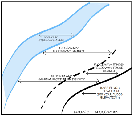
(g)
Allowable uses, conditional uses, and performance standards. Allowable uses and conditional uses in the floodplain overlay districts shall be determined by the more restrictive of the uses listed in the floodplain districts below and those listed in the use table, Table 107-136, for the underlying zoning district. Performance standards for both the overlay and base zoning district must be met. If overlay and base zoning district performance standards are in conflict the more restrictive standard will apply.
(1)
Floodway district allowable uses. The following uses within the floodway district shall be allowed to the extent that they are not prohibited or controlled by any other section of this chapter or underlying zoning district as shown in Table 107-136. The following uses are allowed provided they meet applicable performance standards of the floodway district and receive any additional permit approvals as required by the U.S. Army Corps of Engineers or Iowa department of natural resources.
a.
Agricultural uses such as general farming, pasture, grazing, outdoor plant nurseries, horticulture, viticulture, truck farming, forestry, sod farming, and wild crop harvesting.
b.
Private and public recreational uses such as, picnic grounds, boat launching ramps, swimming areas, parks, wildlife and nature preserves, hunting and fishing areas, hiking and horseback riding trails.
c.
Residential uses such as lawns, gardens, parking areas and play areas.
d.
Open-space uses.
e.
Extraction of sands, gravel and other materials.
f.
Marinas, boat rentals, docks, piers, wharves.
g.
Uses or structures accessory to open-space uses.
h.
Utility transmission lines, underground pipelines.
i.
Bridges, dams, levees, floodwalls, or similar infrastructure.
(2)
Floodway district conditional uses. The following uses which involve structures (temporary or permanent), fill, storage of materials or equipment, and affect an area of disturbance equal to or greater than one acre, may be permitted only upon issuance of a floodway district conditional use permit, unless prohibited in the underlying zoning district. Such uses must also meet the applicable provisions of the floodway district performance standards.
a.
Uses or structures accessory to open-space uses.
b.
Utility transmission lines, underground pipelines.
c.
Bridges, dams, levees, floodwalls, or similar infrastructure.
(3)
Floodway district performance standards. All floodway district development allowed as a permitted or conditional use shall meet the following standards:
a.
No development shall be permitted in the floodway district that would result in any increase in the base flood elevation. Consideration of the effects of any development on flood levels shall be based upon the assumption that an equal degree of development would be allowed for similarly situated lands.
b.
All development within the floodway district shall:
1.
Be consistent with the need to minimize flood damage.
2.
Use construction methods and practices that will minimize flood damage.
3.
Use construction materials and utility equipment that are resistant to flood damage.
c.
No development shall affect the capacity or conveyance of the channel or floodway or any tributary to the main stream, drainage ditch, or any other drainage facility or system.
d.
Structures, buildings, recreational vehicles, and sanitary and utility systems, if permitted, shall meet the applicable performance standards of the floodway fringe district and shall be constructed or aligned to present the minimum possible resistance to flood flows.
e.
Structures, if permitted, shall have a low flood damage potential and shall not be for human habitation.
f.
Storage of materials or equipment that is buoyant, flammable, explosive or injurious to human, animal or plant life is prohibited. Storage of other material may be allowed if readily removable from the floodway district within the time available after flood warning.
g.
Watercourse alterations or relocations (channel changes and modifications) must be designed to maintain the flood carrying capacity within the altered or relocated portion. In addition, such alterations or relocations must be approved by the department of natural resources.
h.
Any fill allowed in the floodway must be shown to have some beneficial purpose and shall be limited to the minimum amount necessary.
i.
Pipeline river or stream crossings shall be buried in the streambed and banks or otherwise sufficiently protected to prevent rupture due to channel degradation and meandering or due to the action of flood flows.
(4)
Floodway fringe district permitted uses. Permitted uses within the floodway fringe district shall be identical to those identified in the land use table, Table 107-136, for the underlying zoning district, provided the land uses meet applicable performance standards of the floodway fringe district.
(5)
Floodway fringe district performance standards. All development must be consistent with the need to minimize flood damage and shall meet the following applicable performance standards. Until a regulatory floodway is designated, no use or development may increase the base flood elevation more than one foot.
a.
All structures or development shall:
1.
Be designed and adequately anchored to prevent flotation, collapse or lateral movement of the structure;
2.
Be constructed with materials and utility equipment resistant to flood damage; and
3.
Be constructed by methods and practices that minimize flood damage.
b.
Maximum damage potential uses, structures, and facilities. All new or substantially improved maximum damage potential uses, structures, and facilities shall:
1.
Have the lowest floor (including basement) elevated a minimum of one foot above the elevation of the 0.2 percent annual chance flood, or together with attendant utility and sanitary systems, be floodproofed to such a level.
2.
When floodproofing is utilized, a professional engineer registered in the State of Iowa shall certify that the floodproofing methods used are adequate to withstand the flood depths, pressures, velocities, impact and uplift forces and other factors associated with the 0.2 percent annual chance flood; and that the structure, below the 0.2 percent annual chance flood elevation is watertight with walls substantially impermeable to the passage of water. A record of the certification indicating the specific elevation (in relation to North American Vertical Datum 1988) to which any structures are floodproofed shall be maintained by the Administrator.
3.
Where 0.2 percent chance flood elevation data has not been provided in the flood insurance study, contact the Iowa department of natural resources to compute such data. The applicant will be responsible for providing the department of natural resources with sufficient technical information to make such determinations.
c.
Residential structures. Residential structures shall meet the following performance standards:
1.
All new or substantially improved residential structures shall have the lowest floor, including basements, utility systems, such as heating and cooling equipment, water heaters and similar devices, elevated a minimum of two feet above the base flood elevation.
2.
Construction shall be upon compacted fill which shall, at all points, be no lower than two feet above the base flood elevation and extend at such elevation at least 18 feet beyond the limits of any structure erected thereon.
3.
Alternate methods of elevating (such as piers or extended foundations) may be allowed, where existing topography, street grades, or other factors preclude elevating by fill. In such cases, the methods used must be adequate to support the structure as well as withstanding the various forces and hazards associated with flooding.
4.
All new residential structures shall be provided with a means of access which will be passable by wheeled vehicles during the base flood. However, this criterion shall not apply where the zoning administrator determines, based on information provided by the applicant, there is sufficient flood warning time for the protection of life and property. When estimating flood warning time, consideration shall be given to the criteria listed in 567-75.2(3), Iowa Administrative Code.
d.
Non-residential structures. All new or substantially improved non-residential structures shall have the lowest floor (including basement) elevated a minimum of two feet above the base flood elevation, or together with attendant utility and sanitary systems, be floodproofed to such a level. When floodproofing is utilized, a professional engineer registered in the state shall certify that the floodproofing methods used are adequate to withstand the flood depths, pressures, velocities, impact and uplift forces and other factors associated with the base flood; and that the structure, below the base flood elevation, is watertight with walls substantially impermeable to the passage of water. A record of the certification indicating the specific elevation (in relation to North American Vertical Datum 1988) to which any structures are floodproofed shall be maintained by the zoning administrator.
e.
New and substantially improved structures. All new and substantially improved structures shall meet the following performance standards:
1.
Fully enclosed areas below the lowest floor (not including basements) that are subject to flooding shall be designed to automatically equalize hydrostatic flood forces on exterior walls by allowing for the entry and exit of floodwaters. Designs for meeting this requirement must either be certified by a registered professional engineer or meet or exceed the following minimum criteria:
(i)
A minimum of two openings, with positioning on at least two walls, having a total net area of not less than one square inch for every square foot of enclosed area subject to flooding shall be provided.
(ii)
The bottom of all openings shall be no higher than one foot above grade.
(iii)
Openings may be equipped with screens, louvers, valves, or other coverings or devices provided that they permit the automatic entry and exit of floodwaters.
(iv)
The enclosed areas, shall be solely used for low damage potential uses such as parking of vehicles, limited storage, and/or access to the building.
(v)
A non-conversion agreement shall be executed and recorded with the county recorder's office.
2.
New and substantially improved structures must be designed (or modified) and adequately anchored to prevent flotation, collapse, or lateral movement of the structure resulting from hydrodynamic and hydrostatic loads, including the effects of buoyancy.
3.
New and substantially improved structures must be constructed with electrical, heating, ventilation, plumbing, and air conditioning equipment and other service facilities (including ductwork) elevated or floodproofed to at least two feet above the base flood elevation.
4.
New and substantially improved structures shall be constructed with plumbing, gas lines, water/gas meters and other similar service utilities either elevated (or in the case of non-residential structures, optionally floodproofed) to a minimum of two feet above the base flood elevation or designed to be watertight and withstand inundation to such a level.
f.
Factory-built homes:
1.
All new and substantially improved factory-built homes, including those placed in existing factory-built home parks or subdivisions, shall be elevated on a permanent foundation such that the lowest floor of the structure is a minimum of two feet above the base flood elevation.
2.
All new and substantially improved factory-built homes, including those placed in existing factory-built home parks or subdivisions, shall be anchored to resist flotation, collapse, or lateral movement. Anchorage systems may include, but are not limited to, use of over-the-top or frame ties to ground anchors as required by the State Building Code.
g.
Utility and sanitary systems. Utility and sanitary systems shall meet the following performance standards:
1.
All new and replacement sanitary sewage systems shall be designed to minimize and eliminate infiltration of floodwaters into the system as well as the discharge of effluent into floodwaters. Wastewater treatment facilities shall be provided with a level of flood protection equal to or greater than two feet above the base flood elevation.
2.
On-site wastewater disposal systems shall be located or designed to avoid impairment to the system or contamination from the system during flooding.
3.
New or replacement water supply systems shall be designed to minimize or eliminate infiltration of floodwaters into the system. Water supply treatment facilities shall be provided with a level of protection equal to or greater than two feet above the base flood elevation.
4.
Utilities such as gas or electrical systems shall be located and constructed to minimize or eliminate flood damage to the system and the risk associated with such flood damaged or impaired systems.
5.
Storage of materials and equipment that are flammable, explosive or injurious to human, animal or plant life is prohibited unless elevated a minimum of two feet above the base flood elevation. Other material and equipment must either be similarly elevated, or not be subject to major flood damage and be anchored to prevent movement due to floodwaters, or be readily removable from the area within the time available after flood warning.
h.
Flood control structures. Flood control structural works such as levees, flood walls, etc., shall provide, at a minimum, protection from a base flood with a minimum of three feet of design freeboard and shall provide for adequate interior drainage. In addition, structural flood control works shall be approved by the department of natural resources.
i.
No development shall affect the capacity or conveyance of the channel or floodway of any tributary to the main stream, drainage ditch, or other drainage facility or system.
j.
Watercourse alterations or relocations must be designed to maintain the flood carrying capacity within the altered or relocated portion. In addition, such alterations or relocations must be approved by the department of natural resources.
k.
Subdivisions. Subdivisions (including factory-built home parks and subdivisions) shall be consistent with the need to minimize flood damages and shall have adequate drainage provided to reduce exposure to flood damage. Development associated with subdivision proposals (including the installation of public utilities) shall meet the applicable performance standards. Subdivision proposals intended for residential development shall provide all lots with a means of vehicular access that will remain dry during occurrence of a base flood. All proposals for subdivisions shall include base flood elevation data for those areas located within the floodway fringe district. All subdivisions must comply with article IV, development review processes and requirements.
l.
Elevation exemption of detached garages, sheds, and similar structures.
1.
Detached garages, sheds, and similar structures that are accessory to a residential use are exempt from the base flood elevation requirements where the following criteria are satisfied:
(i)
The structure shall be designed to have low flood damage potential. Its size shall not exceed 600 square feet. Those portions of the structure located less than two feet above the base flood elevation must be constructed of flood-resistant materials.
(ii)
The structure shall be used solely for low flood damage potential purposes such as vehicle parking and limited storage. The structure shall not be used for human habitation.
(iii)
The structure shall be constructed and placed on the building site so as to offer minimum resistance to the flow of floodwaters.
(iv)
The structure shall be firmly anchored to resist flotation, collapse and lateral movement.
(v)
The structure's service facilities such as electrical and heating equipment shall be elevated or floodproofed to at least two feet above the base flood elevation.
(vi)
The structure's walls shall include openings that satisfy the provisions of subsection (5)e. of this section.
2.
Exemption from the base flood elevation requirements for such a structure may result in increased premium rates for flood insurance coverage of the structure and its contents.
(6)
General floodplain district permitted uses. All development within the general floodplain district shall be permitted to the extent that they are not prohibited by any other ordinance (or underlying zoning district) and provided they meet the applicable performance standards of the general floodplain district and receive any additional permit approvals as required by the U.S. Army Corps of Engineers or Iowa department of natural resources.
a.
Any development which involves placement of structures, factory-built homes, fill or other obstructions, storage of materials or equipment, excavation or alteration of a watercourse shall be reviewed by the department of natural resources to determine (i) whether the land involved is either wholly or partly within the floodway or floodway fringe and (ii) the base flood elevation. The applicant shall be responsible for providing the department of natural resources with sufficient technical information to make the determination.
b.
Review by the Iowa department of natural resources is not required for the proposed construction of new or replacement bridges or culverts where:
1.
The bridge or culvert is located on a stream that drains less than 100 square miles; and
2.
The bridge or culvert is not associated with a channel modification that constitutes a channel change as specified in 567-71.2(1)b, Iowa Administrative Code.
(7)
General floodplain district performance standards.
a.
All development, or portions thereof, to be located in the floodway as determined by the department of natural resources shall meet the applicable provisions and standards of section 107-144(g)3.
b.
All development, or portions thereof, to be located in the floodway fringe as determined by the department of natural resources shall meet the applicable provisions and standards of the floodway fringe district section 107-144(g)5.
(h)
Floodproofing measures. Floodproofing measures shall be designed consistent with the flood protection elevation for the particular area, flood velocities, durations, rate of rise, hydrostatic and hydrodynamic forces, and other factors associated with the regulatory flood. In order to receive approval for a floodplain development permit, variance, or other approval, the county shall require the applicant to submit a plan or document certified by a registered, professional engineer, stating that floodproofing measures performed by the applicant are consistent with the regulatory flood protection elevation and associated flood factors for the particular area. Such floodproofing measures may include, but are not necessarily limited to, the following:
(1)
Anchorage to resist flotation and lateral movement.
(2)
Installation of watertight doors, bulkheads, and shutters, or similar methods of construction.
(3)
Reinforcement of walls to resist water pressures.
(4)
Use of paints, membranes, or mortars to reduce seepage of water through walls.
(5)
Addition of mass or weight structures to resist flotation.
(6)
Installation of pumps to lower water levels in structures.
(7)
Construction of water supply and waste treatment systems so as to prevent the entrance of floodwaters.
(8)
Pumping facilities or comparable practices for subsurface drainage systems for building to relieve external foundation wall and basement flood pressures.
(9)
Construction to resist rupture or collapse caused by water pressure or floating debris.
(10)
Installation of valves or controls on sanitary and storm drains which will permit the drains to be closed to prevent backup of sewage and stormwaters into the buildings or structures.
(11)
Location of all electrical equipment, circuits and installed electrical appliances in a manner which will ensure they are not subject to flooding.
(i)
Performance standards for recreational vehicles in all floodplain overlay districts. Recreational vehicles may not be parked on-site for more than 180 days in a calendar year and must be fully licensed and ready for highway use. A recreational vehicle is ready for highway use if it is on wheels or a jacking system, is attached to the site only by quick disconnect type utilities and security devices, and has no permanently attached additions. Recreational vehicles on site for more than 180 days and not ready for highway use shall be considered factory-built homes and must comply with section 107-144(g)5.f.
(j)
Nonconforming Uses—All floodplain overlay districts. A structure or the use of a structure or premises which was lawful before the passage or amendment of this ordinance, but which is not in conformity with the provisions of this ordinance, may be continued subject to the following conditions:
a.
If such use is discontinued for 12 consecutive months, any future use of the building premises shall conform to this ordinance.
b.
If any nonconforming use or structure is destroyed by any means, including flood, it shall not be reconstructed if the cost is more than 50 percent of the market value of the structure before the damage occurred, unless it is reconstructed in conformity with the provisions of this section.
(Code 2006, ch. 41, art. 7, § 13; Ord. No. 3-3-2010, 4-1-2010; Ord. No. 4-3-2010, 4-5-2010; Ord. No. 10-10-2013, 10-14-2013; Ord. No. 14-9-2018, § 1(Att. A, §§ 9—12), 9-12-2018; Ord. No. 2-2-2020, Att. A, 2-12-2020; Ord. No. 11-7-2021, § 1(Att. A), 7-14-2021; Ord. No. 13-8-2021, § 1(Att. A), 8-11-2021; Ord. No. 1-4-2024, § 1, 4-10-2024)
Sec. 107-145. - EU-1 Exclusive Use One, Sanitary Landfill District.
(a)
Findings of fact. The following facts establish the need to place sanitary landfills into an exclusive use zone.
(1)
Characteristics of a sanitary landfill. A sanitary landfill is primarily a one-of-a-kind community facility which may be a necessary part of the community's waste disposal system. The highvolume of heavy truck traffic and the potential for associated noise, odor and other nuisance-like characteristics suggest industrial zoning would be appropriate. However, a sanitary landfill has limited duration use, and the filled land may not be suitable for industrial uses that require substantial weight bearing foundations. This limitation makes industrial zoning inappropriate for the location of subsequent uses on this land. Major factors in determining the proper site location for landfills are the suitability of the soil and underground drainage systems; neither of which are usually factors in the location of industrial zones. Therefore, the site location criteria for a sanitary landfill must be defined separately.
(2)
Need for specific standards. If proper sanitary landfill standards are not strictly adhered to, the operation may result in an open dump and create a serious health hazard. A completed landfill will settle and require periodic maintenance. Because of this settlement factor, special design and construction must be utilized for buildings constructed on a completed landfill. As a result of all these factors listed above, sanitary landfills must be placed in an exclusive use zone that includes specific design standards and appropriate protection for subsequent use.
(b)
General intent. The major purposes and objectives of this zone are to place sanitary landfills in an exclusive use zone in order to establish site location and design standards which will:
(1)
Protect public health by preventing water pollution, rodent infestation, air pollution, or other health hazards as would occur as a result of improper location, design, or operation of a landfill.
(2)
Protect public safety by requiring proper design of access roads to accommodate the heavy equipment necessary for collection, transportation and disposal of solid wastes.
(3)
Improve compatibility with adjacent uses by requiring adequate screening and set back, regular policing of access roads and heavily traveled routes to the site, and careful review of subsequent uses allowed on the landfill site.
(4)
Promote public welfare by providing a suitable location for the disposal of the solid wastes generated by the community and preserve prime agricultural ground.
(5)
Incorporate local siting approval as specified in I.C.A. § 455B.305A. This state code provision requires that prior to siting of a proposed, new sanitary landfill the board of supervisors must approve the site based on meeting certain criteria. It is the intent of this section that to the greatest extend possible that the local siting approval process and the zoning district reclassification process run concurrently.
(c)
Other applicable state laws and administrative code requirements. Other state laws and administrative code requirements may apply to an application, including, but not limited to laws and rules related to: the issuance or renewal of permits for construction and operation of sanitary landfills, processing facilities, composting facilities, recycling facilities, solid waste management facilities, infectious waste incinerator projects, and waste tire facilities; handling and disposal of hazardous waste and waste oil; and local approval.
(d)
Applicability. The requirements and performance standards as herein provided shall apply to all new or lateral expansions of lawful sanitary landfill projects.
(e)
Principal permitted uses. Sanitary landfill.
(f)
Accessory uses.
(1)
Transfer station.
(2)
Recycling facility.
(3)
Compost facility.
(4)
Household hazardous waste facility.
(5)
Agricultural uses.
(6)
Wildlife refuge or similar public purpose uses.
(7)
Alternative or renewable energy technologies.
(g)
Site and structure requirements.
(1)
Minimum lot area. There shall be no minimum lot area requirement, except that a site must be of sufficient size to accommodate the amount of waste estimated for deposit during the planned life of the landfill.
(2)
Minimum lot width. None.
(3)
Minimum setbacks. Principal permitted use, including all activities related to operation of the principal permitted use such as stockpiles, shall meet the following minimum setback requirements:
a.
Front yard setback, 200 feet.
b.
Rear yard setback, 200 feet.
c.
Side yard setback, 200 feet.
d.
Corner side yard setback, 200 feet.
e.
Maximum structure height, 150 feet.
(4)
Accessory uses, buildings and/or structures. All accessory uses, buildings and/or structures, except those as set forth in subsections (f)(5) and (6) of this section, shall meet the same site and structure requirements as principal permitted uses.
(5)
Fencing. The footprint of the planned waste disposal area shall be enclosed with a substantial wall, chain link fence, other adequate barrier, at least eight feet in height, designed to keep people, children and animals out of the active landfill area, or an alternative provision which will accomplish the same. The entrance gate must be capable of being locked and posted.
(6)
Sign and directions. Necessary identification and directional signs shall be provided. A sign shall be posted at the entrances to inform the public of the hours of operation, cost of disposal, and rules and regulations regarding disposal. Interior signage shall be provided that directs users to the appropriate unloading area.
(7)
Lighting. Lighting shall be provided in such a way as to not interfere with roadway traffic, spill over on adjacent properties, and/or pollute the night sky.
(8)
Parking. Two spaces per employee shall be required, and handicapped parking shall be provided for in the number and manner as required in I.C.A. § 321L.5.
(9)
Buffer. The landfill shall be adequately buffered between the footprint of the planned waste disposal area and perimeter boundaries of the property so as to offset fugitive dust, noise, vibration. The buffer areas shall be landscaped and graded prior to the acceptance of any solid waste.
(h)
Application for landfill siting and EU-1 sanitary landfill district reclassification. The applicant shall submit an application for zoning district reclassification and local site approval to the board. The board shall forward the application to the department to review the completeness of the application. The department shall provide to the board their findings within 14 working days upon receipt. A complete application includes the following:
(1)
A completed application form. The application must be on forms as provided by the department which will include, but not be limited to, information required by state law for local siting approval. The application form must be signed by the owners of the property as such and, if applicable, the entity seeking the reclassification as applicant. However, in the event that the applicant is a public entity and cannot procure the owner's signature, proof of notification to the owner of intent to submit an application for zoning reclassification and local siting approval for the owner's property shall be submitted.
(2)
The application fee, as authorized by the board of supervisors by resolution, for the specific review and processing of the rezoning reclassification and the application fee, as authorized by the board of supervisors by resolution, for the specific processing and review of the landfill siting application.
(3)
The applicant shall provide proof of written notice and proof of publication of notice of their intent to submit an application to the board of supervisors for local siting approval and zoning district reclassification in the manner as prescribed for in I.C.A. § 455B.305A. One complete paper copy and one complete electronic copy of the mailing list utilized to provide written notice to property owners shall be provided to the board.
(4)
The applicant shall demonstrate notice to the state department of natural resources (IDNR) that the local siting process has been initiated.
(5)
Detailed plans, maps and reports shall be submitted in the numbers as indicated herein or as approved by the department. The data in the following reports shall be prepared in a form which facilitates its use in proper engineering design of the landfill. Problem areas must be delineated and recommendations for proper solution included in the report. The following shall be submitted:
a.
Map or aerial photograph. The map or photograph shall be at a scale of not more than 400 feet to the inch. The map or photograph shall locate the boundaries of the site and identify the following:
1.
North compass point.
2.
Zoning and land use within one mile.
3.
Haul routes to and from the site with load limits or other restrictions.
4.
Residential structures and other buildings within at least one mile.
5.
Section lines and/or other legal boundaries.
6.
Nearby runway used or planned to be used by turbojet or piston-type aircraft at FAA.
7.
Certified airports.
8.
Lakes, ponds, watercourses, wetlands, dry runs, and/or rock outcroppings within one mile of the site.
9.
Topography and drainage patterns within one mile.
10.
All wells within one mile.
11.
A bench mark.
b.
A major site development plan. The plan shall be prepared in the following manner and with the following information:
1.
Number of copies and size: Ten copies on 8½-inch by 11-inch sheet size minimum, larger as required (18-inch by 24-inch preferred). Ten copies of the same site development plan on 11-inch by 17-inch sheet size (must be legible).
2.
Scale: One inch equals 50 feet or as approved by the zoning administrator.
3.
Preparation: Only by an engineer certified in the state.
4.
Orientation: Include North directional arrow and map scale indication.
5.
Location map showing relation to surrounding roads, streams, and public facilities.
6.
Address and legal description of parcel or lot.
7.
Title block including the name, address and phone number of the petitioner and owner and the engineer's name, seal, the date, and the date of all revisions.
8.
Existing and proposed zoning classification, use of property, number of employees.
9.
Ownership, land use, and zoning of all adjoining properties.
10.
Anticipated planned systems for collection, storage, transport, and disposal of leachate.
11.
Existing and proposed property lines (proposed property lines must be delineated in a heavier line weight). Provide dimension of existing and proposed lot boundaries.
12.
Existing and proposed right-of-way lines, setback lines and buffer areas.
13.
Existing contour lines at intervals of ten feet.
14.
Proposed contour lines at intervals of five feet.
15.
Watercourses, floodways, floodplains, and wetlands.
16.
Any unique natural feature.
17.
Location and dimensions of all existing and proposed structures. All structures shall be delineated in square feet, and dimensions to existing and/or proposed lot lines must be provided as well as dimensions between structures.
18.
Existing and proposed structures must be labeled as to their use (i.e., existing warehouse). Structures include wells, fences, septic, utility poles, LP tanks, etc. Also existing roads must be shown.
19.
Existing and proposed parking spaces (number, type, dimension and class). Must provide notation of the number of spaces required and the number provided.
20.
All utility easements.
21.
Radius of curvature of ingress and egress drives.
22.
Circulation patterns of traffic.
23.
Access to all public and private streets.
24.
Location and size of existing or proposed freestanding and/or attached signs and their illumination techniques if applicable.
25.
All existing and proposed locations, intensity, height, spacing, efficiency, and shielding of all exterior lighting.
26.
Locations of outside refuse collection areas, and the type of screening to be provided. Refuse containers must be enclosed from public view.
27.
Estimate of increase in vehicle trips per day by type of vehicle.
28.
Any other information deemed necessary by the zoning administrator.
c.
Traffic routing plan. The plan must be prepared by a qualified traffic engineer. The plan must provide an overall county board transportation map that delineates the following:
1.
Major transportation routes.
2.
Overpasses with height limitations.
3.
Bridges with weight limitations.
4.
Railroad crossings.
5.
Flow of traffic to proposed site by type.
6.
Current and anticipated daily traffic flows to site.
d.
Preliminary hydrogeologic investigation report. The report must be prepared by a registered professional engineer licensed in the State of Iowa or qualified hydrogeologist. Information included in the report must include:
1.
General site description including slope, topography, surface drainage and geologic setting.
2.
Description and characteristics of soils including soil types, dominant soil texture, hydraulic conductivity, and suitability of soil for cover and liner construction.
3.
Corn suitability information from which a corn suitability rating for the entire site can be calculated.
4.
Description and characteristics of bedrock including type, thickness, and physical characteristics (ease of excavation, fractures, sinkholes, direction of dip, and solution holding capacity), porosity, and hydraulic conductivity.
5.
Description of site hydrogeology, including distance to permanent streams, springs, and lakes, depth to water table, flood hazard potential and underlying aquifer characteristics.
e.
Habitat inventory. A listing of plant and animal species, prepared from the records of the state department of natural resources, preserves and ecological service bureau. The applicant shall request that the bureau search its records to determine the presence of or habitat for any threatened or endangered species or communities and any forest, prairies or wetlands or the potential thereof.
f.
Impact report on archaeological, historical, or architecturally significant properties. An assessment of the impact on any archaeological, historical, or architecturally significant properties on the proposed or surrounding sites. The applicant is required to request review and comment from the state historical society and the county board historic preservation commission.
g.
Report on compliance with solid waste planning documents. The applicant shall submit a report on how its proposed sanitary disposal project is consistent with the Cedar Rapids Linn County Solid Waste Agency (CRLCWA) integrated solid waste management plan and the East Central Iowa Council of Government's Regional Solid Waste Management Plan. A letter of compliance from each entity must accompany the report.
h.
Need. The applicant must provide a report that outlines the need for siting of the new or lateral expanded sanitary landfill. Current supporting data must accompany the report which substantiates the need as well as the type and size of sanitary landfill.
i.
Operations site plans and reports. The plans and reports shall indicate the following:
1.
The proposed fill area.
2.
Any borrow area.
3.
Access roads.
4.
On-site drives.
5.
Grading plan and cross sections to identify ultimate height above existing grade.
6.
Special drainage devices, if necessary.
7.
Location and type of fencing.
8.
Structures existing or to be located on the site.
9.
Existing wooded areas, trees, ponds or other natural features to be preserved.
10.
Existing and proposed utilities.
11.
Conceptual timetable and sequence of phasing of landfill operations on the site.
12.
Proposed method of operation including weighing of wastes, cross-sectioning the site at definite time intervals, thickness of cover material, depth of cells and lifts, compaction, wet weather procedures, cold weather procedures, amount, type and size of equipment and personnel.
13.
Proposed methods to prevent surface water run-off of possible pollutants.
14.
Proposed systems for collection, storage, transport, and disposal of leachate.
15.
Conceptual plan for control of methane gas including recovery, collection, monitoring and disposal.
16.
How prime agricultural ground (CSR above 65) will be preserved to the extent possible and, if applicable, what type of mitigation program is proposed to address land that is being taken out of agricultural production.
17.
Any other pertinent information to indicate clearly the orderly development and operation of the facility.
j.
Land value assurance program. The applicant shall submit a conceptual plan on how the proposed land value assurance program will operate and shall include the following at a minimum:
1.
Written description of overall program, goals, objectives, intent and schedule.
2.
Identification of property owners who may be eligible for the program and duration for eligibility.
3.
Number and type of appraisals to be conducted, how appraisals should be conducted and who pays for the appraisals.
4.
Period of time during which program exists.
5.
Explanation and example of how compensation could be calculated.
k.
Conceptual end use plan. The plan shall include the following:
1.
A proposed plan and schedule for site restoration and completion.
2.
A plan outlining the ultimate land use of the site, or a plan that demonstrates possible ultimate land uses.
3.
Any other pertinent information that would address final site restoration and possible future re-uses of the property.
(6)
Procedure for zoning district reclassification and local siting approval.
a.
The board upon receipt of a complete application shall forward copies of the joint application for local siting approval and zoning reclassification to the commission. The commission and board shall hold one joint public informational meeting within 30 days of receipt of a complete application. The purpose of the meeting is to provide an outline of how the county board will process, review and make a decision on the application. The applicant shall provide a complete over view of the application submitted and address how compliance with all federal, state, and local site and structure requirements and all performance standards are either being meet or an alternative solution is being proposed. No debate of the joint application shall take place at the public meeting. The purpose of the public meeting is purely informational.
b.
The commission shall, within two weeks after the public informational meeting hold a special meeting to consider the joint application and shall formulate and forward to the board on the zoning district reclassification.
c.
Notice of the special meeting to consider the joint application shall be published in the official newspapers in accordance with I.C.A. § 455B.305A. Utilizing the same mailing list of property owners as provided by the applicant as prescribed in I.C.A. § 455B.305A, the department shall notify property owners of the special commission meeting by ordinary first class mail.
d.
The board shall receive the recommendation of the commission and hold a public hearing in conformance with I.C.A. § 455B.305A and this chapter. The board shall not make a decision on the joint application until the public has had an additional 30-day opportunity to provide written comments on the application for site approval and zoning district reclassification.
e.
Notice of the public hearing shall be published in the official newspapers in accordance with I.C.A. § 455B.305A. Utilizing the same mailing list of property owners as provided by the applicant as prescribed in I.C.A. § 455B.305A, the department shall notify property owners of the public hearing by ordinary first class mail.
f.
At the conclusion of the 30-day review period the board shall determine upon first consideration the zoning district reclassification. The board can approve, continue consideration or deny the application. If the reclassification is denied the board shall immediately consider the local siting approval request.
g.
Within seven days after approval of first consideration the board shall hold second consideration of the zoning district reclassification request. The board may approve, continue or deny the application. If the reclassification is denied the board shall immediately consider the local siting approval request.
h.
Within seven days after approval of second consideration the board shall hold third and final consideration of the rezoning district reclassification. The board may approve or deny the application. Immediately upon rendering their final decision on the zoning district reclassification the board shall make a final decision on the local siting approval request.
i.
Final decisions made by the board on the joint application shall be in writing, specifying the reasons for the decision. A final decision on the joint application shall be made within 180 days after the filing of a complete application by the applicant.
j.
At any time prior to the board's final decision the applicant may file not more than one amended application upon payment of additional fees, the sum of which will be determined by the board. The time limitation for final action on an amended application shall be extended for an additional 90 days.
k.
An applicant shall not file a request for zoning district reclassification and or local siting approval, which is substantially the same as a request which was denied, within the preceding two years. The two-year time period starts from date of issuance of the board's written decision.
(i)
Evaluation criteria and standards. The following criteria shall be the basis upon which the commission shall formulate their recommendation to the board and upon which the board shall render their decision. Following the criteria are additional site location, design standards, and/or performance standards which shall be met. This listing of standards is not intended to be inclusive of all that may be required of the applicant to satisfy the evaluation criteria.
(1)
Need criteria. The project is necessary to accommodate the solid waste management needs of the area in which the project is intended to serve. In addition, the following standards shall be met.
a.
The applicant's proposal conforms to the most currently approved East Central Iowa Council of Government's regional solid waste plan.
b.
The applicant's proposal conforms to the most currently approved Cedar Rapids Linn County Solid Waste Agency's integrated solid waste management plan.
c.
The applicant's proposal justifies the size and type sanitary landfill proposed.
(2)
Protection of the public health, safety, and welfare criteria. The project is designed, located, and proposed to be operated so that the public health, safety, and welfare will be protected. In addition, the following standards shall be met:
a.
The fill area is to be located and designed so as to obviate any predictable lateral movement of significant quantities of leachate from the site to standing or flowing surface water or to shallow aquifers that are in actual use or are deemed to be of potential use as a water resource.
b.
The fill area is to be located and designed so that the base of the landfill is at least five feet above the high water table unless a greater separation is required to ensure that there will be no significant adverse effect groundwater or surface water or a lesser separation is unlikely to have a significant adverse effect on groundwaters and surface waters.
c.
The footprint of the planned waste disposal area is located outside of a delineated floodplain.
d.
The footprint of the planned waste disposal area is so situated as to ensure:
1.
No adverse effect on any well within 1,000 feet of the site and in existence at the time of application which is being used or could be used without major renovation for human or livestock consumption; or
2.
At least 1,000 feet from any such well unless hydrologic conditions are such that a greater distance is required to ensure there is no adverse effect on the well; or an agreement between the owners have been provided for.
e.
The fill area is located so that no adverse effect on the source of any community water system in existence at the time of application within one mile of the site or at least one mile from the source of any community water system in existence at the time of application unless hydrologic conditions are such that a greater distance is required to ensure no adverse effect on the water system.
f.
The footprint of the planned waste disposal area is not located in fragile land areas including, but not limited to, wetlands, and/or karst terrain.
g.
The footprint of the planned waste disposal area is not located in areas with rare or valuable ecosystems or geologic formations or significant wildlife habitat.
h.
The footprint of the planned waste disposal area is not located in areas with slopes of greater than 25 percent.
i.
The proposed sanitary landfill is designed, located, and proposed to be operated so that prime agricultural ground will be preserved. Prime agricultural ground is generally defined as land with a weighted corn suitability rating (CSR) above 65.
(3)
Compatibility criteria. The project is located so as to minimize incompatibility with the character of the surrounding area and to minimize the effect on the value of the surrounding property. In addition, the following location and design standards must be met:
a.
The landfill cannot significantly impact a unique scenic, cultural or historic area. If unavoidable, the applicant will provide mitigation either in design provisions or host community benefits.
b.
The landfill cannot be located in a primary residential area as designated on the most recently adopted the county board land use policy map.
c.
The landfill cannot be located in park and open space areas as designated on the most recently adopted the county board land use policy map.
d.
The applicant shall provide a land value assurance program, as defined herein, for all privately owned properties within one mile of the landfill boundaries and to the host community and all other affected taxing bodies for loss of taxable valuation.
e.
The design of the landfill shall be compatible with the natural terrain of the surrounding landscape.
(4)
Plan of operation criteria. The project is designed to minimize the danger to the surrounding area from fire, spills, or other operational accidents. To this end the applicant must demonstrate, in their site plan, operational site plan, and plan of operations that the additional following standards can be met:
a.
An aggressive and effective vector and litter control program shall be provided.
b.
Solid waste will not be deposited in such a manner that material or leaching from the waste could cause pollution of groundwaters or surface waters.
c.
All fill areas are accessible for solid waste disposal during all weather conditions under which solid waste can be received.
d.
An aggressive soil erosion program and cover maintenance program are provided. To that end the finished surface of the site must be kept in good repair, covered with soil, and seeded with native grasses or other suitable vegetation immediately upon completion or promptly in the spring to areas terminated during winter conditions.
e.
The facility management and its employees are properly trained in landfill operations and that an emergency response program is provided for.
(5)
Traffic patterns and roadway provisions. The site should be easily reached by asphalt or concrete paved county board trunk roads, state highways or federal interstates. All roads to the site should be of sufficient width and construction to safely handle all sizes of trucks when fully loaded during all weather conditions. Problems such as narrow bridges, low underpasses, and steep grades on access routes must be avoided. The county board may require the applicant to pay in whole or in part the cost to the county board for providing roadway improvements necessary for the siting of a landfill. In addition, the following standards must be met:
a.
The traffic patterns to and from the project have been designed to minimize the impact on existing traffic flows.
b.
Safe design of entrances and exits, with provision for right turn deceleration lanes, protected left turn lanes, acceleration lanes and, if needed, signalization of intersections.
c.
The site should be accessible at all times. Several access routes are planned so that if one route is temporarily unusable, the site can still be reached.
d.
The distance of driveway entrance or exit from any adjacent lot line should be at least 125 feet. The landfill access drive, within 150 feet of the public street, shall be paved or treated so as to be free of dust.
e.
The on-site roads to the unloading area should be of all-weather construction and wide enough to permit two-way truck travel. Road grades should be designed for the largest fully loaded trucks to travel at a reasonable rate.
f.
The haul distance from the major waste generation centroids has been carefully considered, and any reduced impact of a remote location on existing development should be balanced against the engineering costs of making a site closer to the waste generation centroids.
(6)
Previous operating experience of a private agency. A private applicant shall submit information regarding the previous operating experience of the agency and its subsidiaries or parent corporation in the area of solid waste management or related activities. Past performance shall be considered as an indicator of how the proposed landfill could likely affect the health, safety, and welfare of area residents or businesses.
(j)
Consultation by the state department of natural resources. The board shall consult with the state department of natural resources prior to approval of any local siting approval and consider their comments and advice.
(k)
Post construction of sanitary landfill.
(1)
Inspection. An inspection of the entire site shall be made by the state department of natural resources, or their designee, to determine compliance with IDNR approved plans and specifications prior to issuance of an occupancy permit by the department. In addition, an inspection of the entire site shall be made by the designee of the board to determine compliance with all site and structure requirements or other standards to be met as outlined in the written decision of the board prior to issuance of an occupancy permit by the department. Any necessary correcting work as directed by IDNR or the county board shall be performed before the landfill project is accepted as completed and ready for issuance of an occupancy permit by the department.
(2)
Compliance with conditions. Prior to final approval of the rezoning classification the applicant and board shall sign an agreement which binds the applicant to meeting local conditions of the rezoning classification.
(3)
Subsequent maintenance. The applicant must provide in a written report how maintenance after closure will be ensured in compliance with state code requirements for closure and post closure.
(4)
Subsequent zoning. The Exclusive Use Zone I (EU-1) designation replaces the previous zoning classification and, upon completion of the sanitary landfill operation, no other use shall be permitted without a rezoning and map amendment as provided in section 107-68.
(5)
Waiver of requirements or standards. Whenever strict application of the requirements or standards of this section would result in substantial hardship or injustice, the board, after recommendation by the commission, may vary or modify such requirements or standards. Said waiver or modification may be granted so long as the applicant can demonstrate the public health, safety, welfare, and interests of the county board and the surrounding area are protected, and that the general intent and spirit of this section are preserved.
(Code 2006, ch. 41, art. 7, § 14; Ord. No. 1-3-2016, 4-1-2016)
Sec. 107-146. - MH Mobile Home District.
(a)
Purpose. The mobile home district is intended to regulate the creation of mobile home parks within the county.
(b)
Geographic location. Rezoning under section 107-68 to mobile home district shall be available for parcels located only in urban service areas.
(c)
Permitted, conditional and accessory uses. Permitted, conditional and accessory uses of land allowed in a mobile home district are only those specified in the use table, Table 107-147-1. All uses not listed in the use table, Table 107-147-1, shall be prohibited. Specific permitted, conditional and accessory uses are subject to the requirements in article VI of this chapter.
(d)
Additional requirements. Additional requirements within this chapter and other county ordinances apply to development in the mobile home district, including, but not limited to, the general regulations in article V of this chapter.
(e)
Dimensional standards and density standards. Development within a mobile home district shall be subject to the following minimum dimensional standards:
(1)
Minimum size of mobile home park. The area proposed for a mobile home park shall have at least five acres of gross development area or provide for a minimum of 40 mobile home lots. Such area may be developed in two or more stages, provided that said stages conform in all respects with the overall mobile home park development plan. Occupancy shall not be permitted until all facilities and improvements are installed and operational for not less than 25 mobile home lots.
(2)
Maximum density of mobile home units. The maximum density allowed for the gross development area shall be eight mobile home units per acre.
(3)
Minimum individual lot area: 2,500 to 4,000 square feet.
(4)
Minimum depth of individual lots, 80 feet.
(5)
Minimum frontage on street or ROW, 15 feet.
(6)
Minimum mobile home unit setbacks from road right-of-way lines:
a.
Front yard from public street outside park, 50 feet.
b.
Front yard from internal street, 15 feet.
c.
Front, side, or rear yard adjoining another residential district, 50 feet.
(f)
Maximum height. Maximum height for all principal structures except utilities and communication or wind towers: 35 feet.
(g)
Buffers. Buffers, including fencing and landscaping, may be required by the board of supervisors.
(h)
Minimum mobile home unit standard for utility service. No mobile home shall be connected to water, sewer, or electrical service unless the mobile home complies with the standards and requirements prescribed by "Standard for Mobile Homes, USAS A199.1, 1963" and amendments thereto published by United States of America Standards Institute as applicable or an equivalent standard.
(1)
Demonstration of minimum unit standard. A certificate issued by the manufacturer of the mobile home shall be permanently affixed on a readily visible location on the exterior of the mobile home as prima facie evidence of such compliance.
(2)
Compliance with the aforestated standard shall be determined by the county building official.
(i)
Mobile home park development plan. No mobile home shall be located or altered, or land or water used, nor shall any certificate of occupancy be issued by the building official unless and until the required mobile home park development plan is filed by the park owner and officially approved by the resolution of the board of supervisors.
(1)
Mobile home plan map required. The proposed mobile home park development plan shall include a to-scale map of the development site showing the following elements:
a.
Topography with topographic lines at a minimum of five foot intervals.
b.
Mobile home park boundaries and dimensions.
c.
Location and area of all uses, including streets adjacent to and within the park; walks, patios, mobile home stands; play areas, parks, and common open spaces, parking areas; utilities including street lighting and fire hydrants; physical features such as retaining walls, fences, trees, and natural features;
d.
Other information that may be required by the engineering, traffic, fire, health, water or building departments; easements and dedications.
(2)
Registered preparer. The mobile home park plan shall be prepared by a landscape architect, architect, engineer, land surveyor, or other experienced designer and have the seal of a duly authorized engineer or land surveyor in the state, certifying boundaries, boundary measurements, and such other matters as are required to be so approved by section 107-72.
(3)
Consistent with rezoning requirements. The proposed mobile home park development plan shall be in accordance with the site design plan approved by the board of supervisors with the MH rezoning granted for the proposed mobile home park.
(4)
Construction and maintenance. Every mobile home park shall be constructed and maintained in accordance with the approved mobile home park development plan.
(5)
Location and maintenance of mobile home units. All mobile homes shall be located and maintained in full conformity with the approved mobile home park development plan.
(6)
Criteria for mobile home park approval. In recommending upon and approving mobile home parks, the board of supervisors shall consider the location, size, height, spacing, and extent of use of any mobile home and its appurtenances, access and circulation for vehicles and pedestrians, streets, parking areas, yards and open spaces and the relationship to adjacent property. The planning and zoning commission shall not recommend nor the board of supervisors adopt such mobile home park development plan unless it finds that such plan conforms to all applicable provisions of this chapter.
(7)
Maintenance of utilities and infrastructure. If said mobile home park development plan contains no dedication to the county for streets or utilities or should it be contemplated that the facilities of the county shall not be used for maintenance of streets, sidewalks, water and sewer lines, garbage collection or other related functions, then such owner shall be required to record with such mobile home park development plan a covenant stating that owner will maintain said streets, sidewalks, water and sewer lines in compliance with the minimum standards as established by the county and that should he fail to maintain said standards in any of these respects, the county may, after ten days' notice to such owner, effect all the necessary repairs or improvements as required to maintain said minimum standards and the cost of all these and necessary repairs or improvements shall be come a lien against said real estate and enforced and recorded as mechanic's liens are enforced and recorded against such real estate, and said covenant shall contain the following proviso:
"That (name of owner) being the owner or owners of the real estate contained in the above attached mobile home park development plan hereby consent that if they or their assignees, heirs or those holding or owning said land through said owners fail to maintain the streets, sidewalks, water and sewer mains according to and in compliance with the minimum standards for the maintenance of streets, sidewalks, water and sewer mains as established by the county that after ten days' notice in writing to the owner of said land as shown upon the records in the county auditor's office, and at the address herein shown, then said owner, assignees, heirs, and those holding or owning through said owners, hereby authorize the county to make all necessary repairs and perform all necessary maintenance and further authorize the county to file a mechanic's lien or such other lien or encumbrance against said real estate and enforce said lien pursuant to laws then applicable."
(j)
Amending procedure. All material and substantial alterations or modifications to an approved mobile home park development plan shall be subject to the approval of the board of supervisors.
(1)
Amendment application requirements. A request for approval of alterations or modifications of a previously approved mobile home park development plan shall be accompanied by the same kind and number of exhibits as is required for a new request for approval insofar as such exhibits are applicable to the requested alterations or modifications. When the board of supervisors by official resolution approves the revised mobile home park development plan said revised plan will supplant the original approved mobile home park development plan.
(2)
Time and circumstance limit on plan approval. If a reasonable length of time has elapsed without significant progress having been made in completion of the mobile home park or if there has in the interim been a significant environmental change within or surrounding the area covered by the plan, the board of supervisors may require that a revised plan be submitted by the developer.
(k)
Minimum requirements for mobile home sites. Every lot upon which a mobile home unit or allowed accessory structure is located shall front onto an approved public or private street or right-of-way as defined in this chapter and shall conform to the following minimum lot area and width requirements.
(1)
Residential uses. The following standards must be met for all residential uses within the mobile home park:
a.
Minimum lot area. The lot area shall be a minimum of 4,000 square feet with a minimum depth of 80 feet and with a minimum frontage on an approved public or private street or right-of-way of not less than 15 feet.
b.
Reducing lot area for common open space. Such minimum lot area may be reduced by an amount equal to an adjoining area designated as common open space (an area permanently reserved as open space).
1.
The open space shall not include land in individual lots, land outside the mobile home park, wetlands or open water, required recreation areas, parking areas or streets contiguous and immediately available to the individual lot or lots having reduced minimum areas.
2.
The common open space must, by means of location, size, shape and landscaping being obviously primarily for the utilization and enjoyment of the inhabitants of the said contiguous lots.
3.
Notwithstanding subsection (k)(1)b of this section, an individual mobile home lot shall not be reduced in area to less than 2,500 square feet.
(2)
Accessory uses. Accessory uses are limited to structures for the direct servicing, management and maintenance of the park.
a.
Minimum lot area. The lot area shall be a minimum of 4,000 square feet.
b.
Building code standards. Any such structure shall be of permanent type construction meeting all local applicable building codes.
c.
Maintaining minimum yard and separation requirements. For uses requiring larger lot areas than heretofore set forth under this section, such uses may be permitted if lot sizes are increased proportionately to maintain minimum yard and separation requirements as set forth in this chapter.
(l)
Yards, mobile home lot. Each mobile home lot shall meet the following standards in regard to the yards within the designated mobile home lot. All yards shall be subject to the following provisions:
(1)
Front yard. Every lot shall have a front yard not less than 15 feet in depth measured from the edge of the surface of the public or private street, or right-of-way to the closest point on the lower surface of the mobile home.
(2)
Side and rear yards. Side and rear yards shall be provided and maintained as set forth in this chapter.
(m)
Required separation between mobile homes, accessory uses, and appurtenances.
(1)
Minimum unit separation. Every mobile home shall be separated from other mobile homes and from accessory buildings on adjacent lots by a minimum distance of 25 feet.
(2)
Attached appurtenances. Appurtenances attached to a mobile home shall be provided with a minimum separation of 25 feet from:
a.
Any other attached appurtenance on an adjacent lot.
b.
Any mobile home on an adjacent lot.
c.
Any accessory building on an adjacent lot.
(3)
Detached appurtenances. There shall be provided and maintained a minimum distance of ten feet between any detached appurtenance and:
a.
Any other detached appurtenance on the same lot.
b.
Any mobile home on the same lot.
c.
Any detached appurtenance on an adjacent lot.
d.
Any mobile home on an adjacent lot.
(4)
Detached appurtenances and adjacent lots. There shall be provided and maintained a minimum distance of 25 feet between any detached appurtenance and any necessary buildings on adjacent lots.
(5)
Separation across street or ROW. Mobile homes shall be separated from each other on opposing sides of public or private streets a minimum of 45 feet provided that in no event shall the required front yard be less than set forth in this chapter. No mobile home accessory use or appurtenance shall be permitted in the required mobile home lot front yard or in the required separation between mobile homes on opposing sides of public or private streets as provided in this section.
(n)
Park perimeter general area requirements.
(1)
Each yard adjoining on a perimeter public street shall be considered a front yard and shall be a minimum of 50 feet in depth.
(2)
All other yards shall have a minimum depth of 50 feet when adjacent to any residential land use or residential district (RR, USR or RV).
(3)
The yard requirement herein may be reduced by one-half the width of any alley adjacent thereto and, provided further that a greater or lesser yard may be required where the board of supervisors deems necessary.
(4)
Where the boundary of a mobile home park directly abuts another use district the board of supervisors may, where it is deemed necessary, require that an area a minimum of ten feet in width be reserved along the perimeter of the mobile home park and within said area require the erection of a fence or wall six feet in height of a material which will provide a significant visual and sound barrier, and/or screen plantings to be provided and maintained with a minimum height of eight feet at maturity; or as otherwise required by the board of supervisors.
(o)
Soil and ground cover requirements. Exposed ground surfaces in all parts of every mobile home park shall be paved, or covered with stone screenings, or other solid material, or protected with a vegetative growth that is capable of preventing soil erosion and objectionable dust.
(p)
Site drainage requirements. Adequate provisions shall be made to plan for and manage or infiltrate all stormwater consistent with section 107-95, and all other additional provisions determined by the county board to be necessary.
(q)
Lot markers. The limits of each mobile home lot shall be clearly marked on the ground by permanent steel or iron rods driven into the ground with the top of said rods flush with the finish lot grade. Location of lot limits on the ground shall be approximately the same as shown on the accepted plans. The degree of accuracy obtainable by working with a scale on the plan and then a tape on the ground is acceptable. Precise engineering of lot limits is not required either on the plans or on the ground. This is in no way to be construed as permitting lots of a lesser size than the required minimum or in permitting lesser yard or separation dimensions than set forth elsewhere in this chapter.
(r)
Accessory uses.
(1)
Residential uses only. No part of any park shall be used for nonresidential purposes, except such uses that are required for the direct servicing and well-being of park residents and for the management and maintenance of the park.
(2)
Mobile home unit sale. Nothing contained in this section shall be deemed as prohibiting the sale by an owner of a mobile home located on a mobile home stand and connected to the pertinent utilities. Any sales of mobile homes in place on the mobile home stand shall not in any way relieve any parties involved from complying with all the applicable regulations of this chapter.
(s)
Required recreation areas. In all parks, there shall be one or more recreation areas which shall be easily accessible to all park residents.
(1)
Size. The size of such recreation area shall be based upon a minimum of 250 square feet for each lot. No outdoor recreation area shall contain less than 2,500 square feet.
(2)
Distinct from open space. Required recreational area shall be computed in addition to any other common open space required elsewhere in this chapter.
(3)
Location. Recreation areas shall be so located as to be free of traffic hazards and should be easily accessible.
(t)
Park street systems. All mobile home parks shall be provided with safe and convenient vehicular access from adjoining public or private streets or roads to each mobile home lot. Alignment and gradient shall be properly adapted to topography.
(1)
Access. Access to mobile home parks shall be designed to minimize congestion and hazards at the entrance or exit and allow free movement of traffic on adjacent streets. The entrance road connecting the park streets with a public street or road shall have a minimum road pavement width of 42 feet where parking is permitted on both sides, or a minimum road pavement width of 32 feet where parking is limited to one side. Where the primary entrance road is more than 100 feet long and does not provide access to adjoining mobile home lots within such distance, the minimum road pavement width may be 24 feet providing parking is prohibited at both sides.
(2)
Interior streets. Surfaced roadways shall be of adequate width to accommodate anticipated traffic, and in any case shall meet the following minimum requirements:
a.
All streets, except minor streets, no parking 24 feet.
b.
Minor streets, no parking 22 feet.
c.
One-way minor streets, no parking 22 feet. (Acceptable only if less than 500 feet total length and serving less than 25 mobile home lots.)
d.
Dead end streets shall be limited in length to 300 feet and shall be provided at the closed end with a turnaround having an outside roadway radius of at least 40 feet with no parking permitted. Where parking is permitted the radius shall not be less than 48 feet.
e.
All streets of a mobile home park providing ingress and egress from an adjoining public street or road shall have the location and design of intersection with said public street or road approved by the county engineer and by any other governmental agency exercising control over such streets or roads.
(3)
Required illumination of mobile home park street systems. All parks shall be furnished with lighting units so spaced and equipped with approved fixtures placed at such mounting heights as will provide the following average maintained levels of illumination for the safe movement of pedestrians and vehicles at night.
a.
All parts of the park street system: 0.6 footcandle, with a minimum of 0.25 footcandle.
b.
Potentially hazardous locations, such as major street intersections and steps or stepped ramps: Individually illuminated with a minimum of 0.4 footcandle.
(4)
Street construction and design standards.
a.
Pavement. All streets shall be constructed with hot mix asphaltic concrete or Portland cement concrete with an approved curb to provide for drainage, or alternative pervious surface with approved infiltration and conveyance consistent with section 107-95. Street surfaces shall be maintained free of cracks, holes and other hazards. All streets shall be constructed to specifications approved by the county board.
b.
Grades. Grades of all streets shall be sufficient to ensure adequate surface drainage, but shall be not more than eight percent. Short runs with a maximum grade of ten percent may be permitted, provided traffic safety is assured by appropriate paving, adequate leveling areas and avoidance of lateral curves. All street grades shall have prior approval of the county board before commencing construction.
c.
Intersections. Within 100 feet of an intersection, streets shall be at approximately right angles. A distance of at least 150 feet shall be maintained between centerline of off-set intersecting streets. Intersections of more than two streets at one point shall be avoided.
(u)
Required parking areas. Parking areas shall be provided in all mobile home parks for the use of park occupants and guests. Such areas shall be furnished at the rate of at least two car spaces for each mobile home lot.
(1)
Access. Required car parking spaces shall be so located as to provide convenient access to the mobile home, but shall not exceed a distance of 200 feet from the mobile home that it is intended to serve.
(2)
Surface. All parking areas shall be constructed with a hard, smooth, dust-free surface.
(3)
Accommodating vehicle storage. Sufficient off-street parking and storage area shall be provided to meet anticipated requirements of park occupants for storing of boats, boat trailers, travel trailers, pickup coaches, truck tractors, trucks over three-fourths ton pickup size, and items of a similar nature. Said parking and storage area shall be in addition to parking required elsewhere in this section and parking and storage of vehicles and items listed in this section shall not be permitted in parking areas required elsewhere in this section. Temporary mobile home storage may be permitted prior to permanent placement on the mobile home stand; such temporary storage of a mobile home shall not exceed 48 hours.
(v)
Walks. All parks shall be provided with safe, convenient, all season pedestrian access of adequate width for intended use, durable and convenient to maintain between individual mobile homes, the park streets and all community facilities provided for park residents. Sudden changes in alignment and gradient should be avoided. All sidewalks shall be constructed to specifications approved by the county board.
(1)
Common walk system. A common walk system shall be provided and maintained between locations where pedestrian traffic is concentrated. Such common walks shall have a minimum width of four feet and may be constructed adjacent to the street curbing.
(2)
Individual walks. All mobile home stands shall be connected to common walks, to paved streets, or to paved driveways or parking spaces connected to a paved street. Such individual walks shall have a minimum width of two feet.
(w)
Mobile home stands. The area of the mobile home stand shall be approved to provide an adequate foundation for the placement and tie-down of the mobile home, thereby securing the superstructure against uplift, sliding, rotation and overturning.
(1)
Base construction. The mobile home stand shall be constructed in such a manner that it will not heave, shift, or settle unevenly under the weight of the mobile home due to inadequate drainage, vibration or other forces acting on the superstructure. The mobile home stand shall be constructed at a minimum with six-inch deep by 30-inch wide poured concrete ribbons with six by six No. 10 wire mesh reinforcing and of sufficient length to support all wheels and undercarriage supports of any mobile home that may be placed on the mobile home stand.
(2)
Anchors. The mobile home stand shall be provided with anchors, arrowhead anchors, or other devices insuring the stability of the mobile home.
(3)
Tie-downs. Tie-down or anchors shall be placed at least at each corner of the mobile home stand to provide a readily accessible anchor for the mobile home and each shall be able to sustain a minimum tensile strength of 2,800 pounds.
(4)
Skirting. Skirting of a permanent type material shall be installed to enclose the open space between the bottom of a mobile home floor and the grade level of the mobile home stand and shall be so constructed to provide substantial resistance to heavy winds, thereby alleviating, to the maximum extent possible, lifting action created on the underside of the mobile home by heavy winds.
(5)
Skirting ventilation. A sufficiently screened ventilating area shall be installed in the skirting to supply the combustion requirements of heating units and other ventilating requirements of the mobile home. Provision shall be made for easy removal of a section large enough to permit access for inspection of the enclosed area under the mobile home and for repairs on sewer and water riser connections.
(6)
Skirting appearance. Skirting shall be maintained in an attractive manner consistent with the exterior of the mobile home and to preserve the appearance of the mobile home park.
(x)
Water supply. All mobile home stands and mobile home park facilities shall be connected to a central water supply and its supply used exclusively.
(1)
Source of supply. The water supply shall be capable of supplying a minimum of 150 gallons per day per mobile home.
(2)
Water distribution system.
a.
The water supply system of the mobile home park shall be connected by pipes to all mobile homes, buildings, and other facilities requiring water.
b.
All water piping, fixtures and other equipment shall be constructed and maintained in accordance with state and local regulations and requirements and shall be of a type and in locations approved by the building department.
c.
The water system shall be designed, constructed, and maintained according to specifications of the health department and the building department.
(3)
Individual water riser pipes and connections.
a.
Individual water riser pipes shall be located within the confined area of the mobile home stand at a point where the water connection will approximate a vertical position.
b.
Water riser pipes shall extend at least to ground level. The pipe shall be at least three-fourths inch. The water outlet shall be capped when a mobile home does not occupy the lot.
c.
Adequate provisions shall be made to prevent freezing of service lines, valves and riser pipes from heaving and thawing actions of ground during freezing weather. Surface drainage shall be diverted from the location of the riser pipe.
d.
A shut-off valve below the frost line shall be provided near the water riser pipe on each mobile home lot.
e.
Underground stop and water valves shall be installed as required by county board regulations.
(y)
Sewage disposal. An adequate and safe sewage system shall be provided in all mobile home parks for conveying and disposing of all sewage. Such system shall be designed, constructed and maintained in accordance with state and local laws.
(1)
Sewer lines. All sewer mains and laterals shall be constructed according to specifications of the county of the and connected to a system approved by the county board.
(z)
Individual sewer connections.
(1)
Each mobile home stand shall be provided with at least a four-inch diameter sewer riser pipe. The sewer riser pipe shall be so located on each stand that the sewer connection to the mobile home drain outlet will approximate a vertical position.
(2)
The sewer connection shall have a minimum inside diameter of three inches, and the slope thereof shall not be less than one-fourth inch per foot. The sewer connection shall consist of one pipe line only without any branch fittings. All joints shall be air and water tight.
(3)
All materials used for sewer and sewer connections shall be semi-rigid, corrosive resistant, nonabsorbent and durable. The inner surface shall be smooth.
(4)
Provisions shall be made for plugging the sewer riser pipe when a mobile home does not occupy the lot. Surface drainage shall be diverted away from the riser. The rim of the riser pipe shall extend at least to ground level.
(aa)
Electrical distribution system. Every park shall contain an electrical wiring system consisting of necessary wiring, fixtures, and equipment which shall be installed and maintained in accordance with applicable codes and regulations governing such systems.
(1)
Main electrical power distribution lines. Main electrical power lines should be constructed underground according to local electric utility specifications.
(2)
Protective equipment. Each mobile home stand shall be provided with an approved disconnecting device and over-current protective equipment. The minimum service per mobile home stand outlet shall be according to county specifications.
(3)
Outlet receptacles. Outlet receptacles at each mobile home stand shall be located not more than 25 feet from the over-current protective devices in the mobile home and a three pole, four-wire grounding type shall be used. Receptacles shall be of weatherproof construction and configuration shall be in accordance with "Standard for Mobile Home USAS A119.1" published by United States of America Standards Institute or similar equipment meeting the approval of the county electrical code.
(4)
Connectors. The mobile home shall be connected to the outlet receptacle by an approved type of flexible cable with connectors and a male attachment plug. However, where the calculated load of the mobile home is between 50 and 100 amperes, and second 50 ampere power supply assembly may be installed or an electrical service shall be provided by means of permanently installed conductors.
(5)
Loads over 100 amps. Where the calculated load exceeds 100 amperes or where a permanent feeder is used, the supply shall be by means of a four wire installation according to county specifications.
(6)
Required grounding. All exposed noncurrent-carrying metal parts of mobile homes and all equipment having electrical connections shall be grounded by means of an approved grounding conductor with branch circuit conductors or other approved method of grounded metallic wiring. The neutral conductor shall not be used as a ground for mobile homes or other electrical equipment.
(bb)
Service building and other community service facilities. The following requirements shall apply to service buildings, recreation buildings and other community service facilities such as management offices, repair shops and storage areas; sanitary facilities; laundry facilities; and indoor recreation areas.
(1)
Required community sanitary facilities. Every park shall be provided with the following emergency sanitary facilities. For each 100 mobile home lots, or fractional part thereof, there shall be one flush toilet and one lavatory for each sex. The building containing such emergency sanitary facilities shall be accessible to all mobile homes. Where waiver of such facilities is permitted by the state code governing new mobile home parks, the provisions of this section may be waived.
(2)
Structural requirements for building. All buildings other than mobile homes and their appurtenances shall be constructed in compliance with applicable state and local codes and regulations.
(3)
Barbecue pits, fireplaces, stoves and incinerators. Cooking shelters, barbecue pits, fireplaces, wood-burning stoves and incinerators shall be so located, constructed, maintained and used as to minimize fire hazards and smoke nuisance both on the property on which used and on neighboring property. No open fire shall be permitted except in facilities provided. No open fire shall be left unattended. No fuel shall be used and no material burned which emits dense smoke or objectionable odors.
(cc)
Refuse handling. The storage, collection and disposal of refuse in the mobile home park shall be so conducted as to create no health hazards, rodent harborage, insect breeding areas, accident or fire hazards or air pollution.
(1)
Containers. All refuse shall be stored in fly-tight, water-tight, rodent-proof containers, which shall be located not more than 300 feet from any mobile home lot they serve. Containers shall be provided in sufficient number and capacity to properly store all refuse.
(2)
Container stands. Refuse collection stands consisting of a holder or rack elevated at least 12 inches above ground level, or an impervious slab at ground level shall be provided for all refuse containers. Such container stands shall be so designed as to prevent containers from being tipped, to minimize spillage and container deterioration and to facilitate cleaning around them.
(3)
Frequency of collection. All refuse containing garbage shall be collected at least twice weekly. Where suitable collection service is not available from private agencies, the mobile home park operator shall provide this service. All refuse shall be collected and transported in covered vehicles or covered containers.
(4)
Other refuse management. Where private disposal service is not available, the mobile home park owner shall dispose of the refuse by incineration or transporting to a disposal site approved by the health department.
(5)
Incinerators. Refuse incinerators shall be constructed in accordance with engineering plans and specifications which shall be reviewed and approved by the health department or other authority having jurisdiction.
(6)
Management of incinerators. Incinerators shall be operated only when attended by some person specifically authorized by the owner or operator of the mobile home park.
(dd)
Insect and rodent control.
(1)
Grounds, buildings and structures shall be maintained free of insect and rodent harborage and infestation. Extermination methods and other measures to control insects and rodents shall conform with the requirements of the county health department.
(2)
Parks shall remain free of accumulations of debris which may provide rodent harborage or breeding places for flies, mosquitoes and other pests.
(3)
Storage areas shall be so maintained as to prevent rodent harborage, lumber, pipe and other building materials shall be stored at least one foot above the ground.
(4)
The growth of brush, weeds and grass shall be controlled to prevent harborage of ticks, chiggers and other offensive insects. Parks shall be so maintained as to prevent the growth of ragweed, poison ivy, poison oak, poison sumac and other weeds considered detrimental to health. Open areas shall be maintained free of heavy undergrowth of any description.
(ee)
Natural gas system. Natural gas piping systems shall be installed and maintained in accordance with applicable codes and regulations governing such systems.
(ff)
Liquefied petroleum gas systems. Liquefied petroleum gas systems shall be installed and maintained in accordance with applicable codes and regulations governing such systems.
(gg)
Fuel oil supply systems. All fuel oil systems shall be installed and maintained in accordance with applicable costs and regulations governing such systems.
(hh)
Fire protection. The mobile home park area shall be subject to the rules and regulations of the applicable fire district.
(1)
Mobile home parks shall be kept free of litter, rubbish and other flammable materials.
(2)
Portable fire extinguishers of a type approved by the building department and fire district shall be kept in service buildings and at all locations designated by such fire prevention authority and shall be maintained in good operating condition.
(3)
Fires shall be made only in stoves, incinerators and other equipment intended for such purposes.
(4)
Fire hydrants shall be installed in the park system and located at such locations as determined by the building department and fire district.
(ii)
Responsibilities of park management. The mobile home park shall be operated and maintained in compliance with this chapter and regulations issued hereunder and shall provide adequate supervision to maintain the park, its facilities and equipment in good repair and in a clean and sanitary condition.
(1)
Notification to occupants. The park management shall notify park occupants of all applicable provisions of this chapter and inform them of their duties and responsibilities under this chapter and regulations issued hereunder.
(2)
Ensuring proper mobile home placement and utility connections. The park management shall be responsible for the proper placement of each mobile home on its mobile home stand which includes securing its stability and installing all utility connections and required skirting. Required skirting shall be installed in accordance with the provisions of this chapter and within 30 days after initial occupancy unless prohibited by frozen ground, in which event such skirting shall be installed immediately after the ground becomes unfrozen.
(3)
Maintaining register. The park management shall maintain a register containing the names of all park occupants. Such register shall be available to any authorized person inspecting the park.
(4)
Communicable disease. The park management shall notify the health department immediately of any suspected communicable or contagious disease within the park.
(jj)
Responsibilities of park occupants. The park occupant shall comply with all applicable requirements of this chapter and regulations issued hereunder and shall maintain his mobile home lot, its facilities and equipment in good repair and in a clean and sanitary condition.
(1)
All the county ordinances with respect to keeping of animals and pets shall apply within the mobile home park.
(kk)
Restriction on occupancy. A mobile home unit shall not be occupied for dwelling purposes unless it is properly placed on a mobile home stand and connected to water, sewage and electrical utilities.
(ll)
Mobile home park regulations, variations and exceptions. Whenever the tract proposed to be subdivided is of such unusual size or shape or is surrounded by such development or unusual conditions that the strict application of the requirements contained in these regulations would result in substantial hardships or injustice, the board of supervisors upon recommendation of the planning and zoning commission may vary or modify such requirements so that the developer is allowed to develop his property in a reasonable manner, but so, at the same time, the public welfare and interests of the county and surrounding area are protected and the general intent and spirit of these regulations are preserved.
(mm)
Occupancy. It shall be unlawful to use any mobile home, travel trailer, pickup coach, motorized home or vehicle for human occupancy within the unincorporated limits of the county of the, except where located in a mobile home park regularly approved according to the provisions of this chapter, or in an area licensed by the state as a mobile home park prior to the effective date of the ordinance from which this chapter is derived, and except such mobile homes or vehicles may be used for human occupancy in an area authorized by the board of supervisors for recreational or other purposes.
(nn)
Storage. This section does not prohibit the storage of one mobile home, travel trailer, pickup coach, or motorized home for any one family providing that the stored location of said unit is in compliance with this chapter. At no time shall parked or stored mobile homes, travel trailers, pickup coaches, or motorized homes be occupied or used for living, sleeping, or housekeeping purposes.
(Code 2006, ch. 41, art. 7, § 15)
Sec. 107-147. - Use table.
(a)
Use table. Table 107-147-1, below, establishes the permitted, conditional and accessory uses allowed in each zoning district within the county, except that uses allowed in the PUD Planned Unit Development Overlay District shall be established in an associated approved governing plan.
(1)
Permitted uses. Uses specified with a "P" in Table 107-147-1 shall be permitted as of right in the district or districts where designated, provided that the use complies with all other applicable provisions of this chapter.
(2)
Conditional uses. Uses specified with a "C" in Table 107-147-1 may be allowed as a conditional use in the district or districts where designated, provided that the conditional use complies with all other applicable provisions of this chapter.
(3)
Accessory uses. Uses specified with an "A" in Table 107-147-1 shall be permitted in the district where designated, provide that the accessory use complies with all other applicable provisions of this chapter, including requirements for the zoning district and specific use standards in article VI of this chapter.
(4)
Prohibited uses. Any use not listed as permitted, conditional or accessory in a district shall be prohibited in that district.
(5)
Specific development standards. Any use where a specific reference to a section number (for example, "Sec. 107-73, etc.") is indicated in the column headed by "STDS" shall conform to the specific development standards referenced. Specific development standards apply in addition to the general criteria for conditional uses denoted in section 107-73, and all other applicable provisions.
(b)
Uses included in general categories. For the purposes of Table 107-147-1, the following specific uses shall be included under the listed general categories.
(1)
General retail sales includes:
a.
Antiques and collectibles store.
b.
Art gallery.
c.
Bicycle sales and repair.
d.
Book store, music store.
e.
Clothing and accessories.
f.
Drugstore, pharmacy.
g.
Electronics and appliance sales and repair.
h.
Florists.
i.
Food store, including bakery, butcher shop, delicatessen, etc., but not full-service grocery.
j.
Jewelry store.
k.
Hardware store.
l.
Liquor store.
m.
Newsstands, magazine sales.
n.
Photographic equipment and supplies.
o.
Picture framing.
p.
Secondhand store, thrift or consignment store.
q.
Sporting goods store.
r.
Stationery store.
s.
Tobacco store.
t.
Video rental or sales.
(2)
Limited production and processing includes:
a.
Apparel and other finished products made from fabrics.
b.
Boat building and repair.
c.
Film, video and audio production.
d.
Musical instruments.
e.
Precision medical and optical goods.
f.
Signs, including electric and neon signs.
g.
Watches and clocks.
h.
Winery.
i.
Wood crafting and carving.
j.
Wood furniture.
(3)
Limited industrial uses includes:
a.
Computers and accessories, including circuit boards and software.
b.
Electronic components and accessories.
c.
Food and beverage products, not including live slaughter, grain or feed milling, cereal, vegetable oil or vinegar production.
d.
Furniture and fixtures, not including metal working.
e.
Household appliances and components, not including metal working.
f.
Measuring, analyzing and controlling instruments.
g.
Office and commercial equipment.
h.
Pharmaceuticals, health and beauty products.
i.
Precision machined products, including jewelry.
j.
Printing and publishing, including distribution.
k.
Sporting and athletic goods.
l.
Telecommunications products.
(4)
General industrial uses include:
a.
Electrical equipment such as motors and generators, lighting, wiring and transmission and distribution equipment.
b.
Fabricated metal products such as cans and shipping containers, cutlery, hand tools and general hardware.
c.
Fabricated plastic and rubber products, except tires and inner tubes.
d.
Glass and glass products, ceramics, china and earthenware such as dishes and kitchenware.
e.
Grain milling, cereal production, feed milling.
f.
Gypsum, drywall and plaster products.
g.
Latex paints.
h.
Lumber and wood products, including plywood.
i.
Machinery and equipment such as engines and turbines, farm, lawn and garden equipment, heating, cooling and refrigeration equipment, and machine tools.
j.
Metal working such as stamping, welding, machining, extruding, engraving, plating, grinding, polishing, cleaning and heat treating.
k.
Textiles and fabrics.
(5)
Heavy industrial uses include:
a.
Animals or poultry (slaughter or processing).
b.
Asphalt, paving and roofing materials.
c.
Battery manufacture and reprocessing.
d.
Chemicals and chemical products, including ammonia, chlorine, household cleaners, detergent, and fertilizer.
e.
Food processing, including vegetable oil or vinegar production.
f.
Oil-based paints, varnishes, lacquers and enamels.
g.
Petroleum and coal products, not including mining or extraction.
h.
Plastics and synthetic resins and fibers.
i.
Primary metals, including steelworks, rolling and finishing mills, foundries.
j.
Pulp or paper products.
k.
Sand and gravel, not including mining or extraction.
l.
Tanned hides and leather.
m.
Tires and inner tubes.
Table 107-147-1 Use Table
107-147-2. Summary Table of Zoning District Dimensional Standard
Table 107-147-3 Goals and Objectives of comprehensive plan as they relate to individual zoning districts
(Code 2006, ch. 41, art. 7, § 16; Ord. No. 3-3-2006, 4-1-2006; Ord. No. 13-9-2006, 10-1-2006; Ord. No. 3-3-2007, 4-1-2007; Ord. No. 1-2-2008, 4-1-2008; Ord. No. 2-5-2009, 5-20-2009; Ord. No. 1-3-2011, 6-1-2011; Ord. No. 10-8-2011, 9-1-2011; Ord. No. 4-3-2012, 5-1-2012; Ord. No. 10-10-2013, 10-14-2013; Ord. No. 1-3-2014, 3-17-2014; Ord. No. 4-5-2014, 5-19-2014; Ord. No. 6-8-2014, 8-25-2014; Ord. No. 13-8-2015, 8-17-2015; Ord. No. 1-3-2016, 4-1-2016; Ord. No. 1-2-2020, Att. A, § 1, 2-12-2020; Ord. No. 11-9-2020, § 1(Att. A), 9-9-2020; Ord. No. 19-12-2020, § 1(Att. A), 12-8-2020; Ord. No. 2-2-2021, § 1(Att.A, § 7), 1-27-2021; Ord. No. 14-9-2021, § 1(Att. A), 9-8-2021; Ord. No. 18-10-2022, § 5, 10-12-2022; Ord. No. 6-4-2023, § 1, 4-12-2023; Ord. No. 8-6-2023, § 1, 6-7-2023; Ord. No. 10-9-2023, § 1, 9-20-2023 Ord. No. 12-11-2023, §§ 1, 2, 11-15-2023; Ord. No. 3-7-2024, § 4, 7-31-2024; Ord. No. 7-11-2024, §§ 10, 11, 11-20-2024; Ord. No. 8-12-2024, § 3, 12-11-2024; Ord. No. 3-7-2025, § 3, 7-9-2025)
Sec. 107-148. - PUD Planned Unit Development Overlay District.
(a)
Purpose. The county has determined that establishing a planned unit development overlay district is appropriate in order to accommodate large, comprehensively planned projects that are likely to develop in phases over a relatively long period of time. This overlay district will allow for the development or redevelopment of land with a mix of uses in accordance with an approved governing plan. Elements contained within an approved governing plan shall prevail over any conflicting regulations in this chapter. This section establishes an overlay district that serves the following purposes:
(1)
To allow flexibility in design to encourage innovative development proposals with a mix of uses.
(2)
To encourage development that can be conveniently, efficiently, and economically served by existing local utilities and services.
(3)
To encourage the conservation of natural features, preservation of open space, and protection from natural hazards.
(4)
To provide compensating community benefits to offset impacts of the development.
(5)
To encourage energy-efficient development.
(6)
To encourage development that conforms to the goals, objectives, and strategies in the county's comprehensive plan, and/or any approved fringe area plan (formerly known as city/county strategic growth plan) that pertains to the area in which the development is proposed.
(b)
Geographic location. The Renewable Energy Overlay District shall be geographically located in those areas currently zoned AG (Agricultural), CNR (Critical Natural Resources), or EU-2 (Exclusive Use-Two).
(c)
Permitted, conditional and accessory uses. Uses allowed in the planned unit development overlay district may include a mix of agricultural, residential, institutional and civic, and retail, service and commercial uses as described in an associated approved governing plan, which prevails over any conflicting regulations in this chapter. Uses which are not included in the approved governing plan are prohibited in the associated planned unit development district.
(d)
Signage. Signage shall conform to the requirements in section 107-94(j), unless signage regulations are included in the governing plan.
(e)
Governing plan. A governing plan containing specific development requirements related to the planned unit development overlay district, including a master plan depicting the comprehensively planned character of the project, is required. A governing plan may include, but not be limited to:
a.
Development goals/vision.
b.
Master plan (a visual representation of the planned unit development project subject to the governing plan).
c.
Required documents for approval/developer and association responsibilities.
d.
Traffic analysis.
e.
Bulk requirements/dimensional standards.
f.
Street design standards.
g.
Parking design standards.
h.
Signage.
i.
Stormwater management.
j.
Phasing.
k.
Development incentives.
(f)
Subdivision of land. Subdivisions which accomplish the implementation of an approved master plan are exempt from the underlying zoning district minimum or maximum lot size requirements.
(g)
Amendments to an approved master plan and/or governing plan. Amendments to associated plans shall be reviewed as follows:
(1)
Minor changes that still meet the intent of the original master plan and of the adopted governing plan may be reviewed and approved by the planning and development director. At the discretion of the planning and development director, changes to the master plan that are deemed major changes shall require an amendment to the governing plan. Major changes may include, but not be limited to:
a.
Proposed areas for different land use types not shown on the original master plan.
b.
Proposed changes to the transportation facilities such as new or relocated connections to existing roads, new internal streets, or realignment of streets (other than to accommodate final engineering design).
c.
A 15-percent or greater reduction of open space, sidewalks, pathways or trails.
(2)
Amendments to the governing plan shall require notification of surrounding property owners as outlined in section 107-66, subsection (c)(3), the review and recommendation of the planning and zoning commission, and approval by the board of supervisors.
(Ord. No. 11-9-2020, § 1(Att. A), 9-9-2020; Ord. No. 14-9-2021, § 1(Att. A), 9-8-2021)
Sec. 107-149. - Renewable Energy Overlay District.
(a)
Purpose. The county has determined that establishing a renewable energy overlay district is appropriate in order to allow for the orderly development of utility scale solar and utility scale wind energy conversion systems. This section establishes an overlay district that serves the following purposes:
(1)
To encourage and support the development and use of alternative and renewable energy resources.
(2)
To encourage development that conforms to the goals, objectives, and strategies in the county's comprehensive plan, and/or any approved fringe area plan (formerly known as city/county strategic growth plan) that pertains to the area in which the development is proposed.
(3)
To encourage sustainable and energy efficient development as outlined by the Linn County Board of Supervisors Resolution in support of the objectives of the Paris Agreement, which aims to strengthen the global response to the threat of climate change.
(4)
To advance the seven targets identified by the county board of supervisors in the resolution declaring a climate crisis and committing to accelerated efforts to limit the global average temperature increase.
(5)
To maintain or enhance soil health for future agricultural use after project decommissioning.
(b)
Geographic location. The Renewable Energy Overlay District shall be geographically located in those areas currently zoned AG (Agricultural) or CNR (Critical Natural Resources), or EU-2 (Exclusive Use-Two).
(c)
Permitted uses. Uses allowed in the renewable energy overlay district include utility scale wind energy conversion systems, utility scale solar installations, and/or utility scale battery energy storage systems.
(d)
Signage. Signage shall conform to the requirements in section 107-94(j) for the underlying zoning district.
(e)
Additional requirements. Additional requirements within this chapter and other county ordinances apply to development in the Renewable Energy Overlay District, including but not limited to, the general regulations in article V of this chapter. Other requirements apply to this overlay district, including:
(1)
Protection of critical natural resources. Rezoning proposals in CNR (Critical Natural Resources) zoning districts must meet the general performance standards outlined in article VII of this chapter, which are designed to protect delineated critical natural resources.
(f)
Setbacks. Setbacks within the Renewable Energy Overlay District shall be subject to a minimum setback of 50 feet from property lines. Setbacks may be reduced to zero when property abuts another property used for a use permitted in this overlay district as described in this section.
(g)
Outlots and nonbuildable lots. Platted outlots or parcels that have been determined to be nonbuildable (not a legal lot of record) may be included in the overall site proposed to be used for a utility scale wind energy conversion systems or utility scale solar energy installation.
(h)
Notification requirements. To assist in providing adequate notice to interested parties, the applicant for a rezoning to the Renewable Energy Overlay District shall:
(1)
Within 14 days of filing the rezoning application with the planning and development department, mail a notice via first class mail to property owners and tenants within 1,000 feet of the subject site explaining the request and identifying the subject property.
(2)
Prior to the application being heard at the planning and zoning commission meeting, the applicant shall host a public informational meeting held at a location reasonably accessible to all identified property owners. Applicants must mail a notice of the public informational meeting via first class mail to property owners and tenants within 1,000 feet of the subject site.
a.
Applicants must submit a list of the property owners and tenants contacted, a copy of the notice sent, and a notarized affidavit stipulating to the mailing to the planning and development department.
(i)
Local Labor. Whenever possible, the use of locally sourced labor on renewable energy projects is highly encouraged.
(Ord. No. 19-12-2020, § 1(Att. A), 12-8-2020; Ord. No. 17-10-2022, § 1, 10-12-2022; Ord. No. 10-9-2023, § 1, 9-20-2023; Ord. No. 3-7-2024, §§ 5, 6, 7-31-2024; Ord. No. 6-9-2025, § 3, 9-3-2025)
Sec. 107-150. - EU-2 Exclusive Use - Two, Nuclear Energy Generating Facility and Nuclear Waste Storage District.
(a)
Purpose. The Linn County Board of Supervisors (Board) recognizes that the regulation of nuclear energy generation and the storage of nuclear waste is primarily governed by federal agencies, including the U.S. Nuclear Regulatory Commission (NRC), and that significant aspects of these activities are subject to federal preemption. The Board also recognizes that, within the scope allowed by state and federal law and in accordance with an adopted Comprehensive Plan, counties may establish land use regulations to protect public health, safety, welfare, and the long-term economic interests of their residents.
The Board further recognizes that Iowa Code Chapter 15A identifies economic development as a public purpose of counties, including the creation of high-quality jobs, infrastructure investment, and support for industries that contribute to Iowa's economic resilience. Nuclear energy facilities and related infrastructure represent an opportunity for Linn County to attract long-term investment and high-skilled employment while ensuring local planning and emergency response capabilities are adequate to address the scale and nature of these facilities.
Linn County will be responsible for providing continuous public safety and emergency response support throughout the operational life of nuclear energy and waste storage facilities. This includes maintaining adequate resources, infrastructure, training, and coordination to respond effectively to incidents or hazards that may arise. Land use regulations must therefore reflect the county's interest in ensuring that these responsibilities are acknowledged and supported as part of any project approval.
Therefore, the Board finds it necessary and advisable to adopt land use standards, in alignment with the Linn County Comprehensive Plan, that balance the potential benefits of nuclear energy development with the need to protect public safety, preserve environmental quality, promote long term economic development, and ensure compatibility with surrounding land uses.
(b)
General intent. The primary purpose and objective of this zone is to provide an exclusive-use zone for the siting and operation of nuclear power generation facilities and nuclear waste storage facilities. Specific objectives of this zoning district include:
(1)
Protect public health and safety by ensuring that land use decisions account for the county's capacity to respond to potential incidents, and that siting, access, and supporting infrastructure are compatible with local emergency services.
(2)
Respect federal preemption by regulating only those aspects of nuclear energy generation and waste storage that are clearly within the county's authority, such as land use compatibility, local infrastructure planning, emergency response coordination, and the negotiation of host community agreements.
(3)
Ensure compatibility with adjacent uses by requiring adequate setbacks and careful review of accessory uses.
(4)
Support economic development by enabling responsible and sustainable nuclear energy investment that creates high-quality jobs, expands the tax base, and positions Linn County as a leader in innovative, sustainable energy infrastructure.
(c)
Other applicable state and federal laws and administrative code requirements. Other state and federal laws and administrative code requirements may apply to a person submitting a nuclear energy generating facility or a nuclear waste storage application, including, but not limited to laws and rules related to the issuance or renewal of permits.
(d)
Applicability. The requirements as herein provided shall apply to all nuclear energy generating facilities that begin generating nuclear energy following adoption of this section, and all new nuclear waste storage facilities. The requirements herein provided shall not reapply where an operating facility that has already been subject to the requirements herein receives an amendment or renewal of a federal license.
(e)
Principal permitted uses.
(1)
Nuclear energy generating facilities.
(2)
Nuclear waste storage facilities.
(f)
Accessory uses.
(1)
Agricultural uses.
(2)
Permitted uses under section 107-149 - Renewable Energy Overlay District.
(3)
Administrative and maintenance buildings.
(4)
Security support infrastructure, including security training facilities, and buildings.
(g)
Site and structure requirements.
(1)
Minimum lot area. There shall be no minimum lot area requirement, except that a site must be of sufficient size to accommodate the use.
(2)
Minimum lot width. None.
(3)
Minimum setbacks. Principal permitted uses, including all activities related to operation of the principal permitted use, shall meet the following minimum setback requirements:
a.
Front yard setback, 200 feet.
b.
Rear yard setback, 200 feet.
c.
Side yard setback, 200 feet.
d.
Corner side yard setback, 200 feet.
e.
Setbacks may be reduced to zero when property abuts another property used for a use permitted in this district as described in this section or if overlapping with existing equipment, facilities, or structures utilized or formerly utilized by a nuclear energy generating facility.
f.
Setbacks may be reduced to zero where an intake or outfall structure, utility connection, interconnection facility, transmission line, or other infrastructure component must be located at or near the property boundary to serve the operational needs of the facility, such as access to a river, pipeline, or grid interconnection.
(4)
Accessory uses, buildings and/or structures. All accessory uses, buildings and/or structures, shall meet the same site and structure requirements as principal permitted uses and shall require building permits where applicable.
a.
Accessory uses permitted under section 107-149, Renewable Energy Overlay District, shall follow the established use-specific setbacks.
(5)
Lighting. Lighting shall meet all applicable federal and state standards, and shall be downcast wherever possible.
(h)
Application. A separate application shall be required for each of the following: nuclear energy generating facility, nuclear waste storage siting, and EU-2 zoning district reclassification. A completed application includes the following:
(1)
A completed application form. The application must be on forms provided by the department, and shall include a description and narrative of the project. The application form must be signed by the owners of the property as such and, if applicable, the entity seeking the reclassification as applicant. However, in the event that the applicant is a public entity and cannot procure the owner's signature, proof of notification to the owner(s) of intent to submit an application for zoning reclassification and local siting approval for the owner's property shall be submitted.
(2)
The application fee, as authorized by the board of supervisors by resolution, for the specific review and processing of the rezoning reclassification.
(3)
The applicant shall demonstrate notice to the Iowa Utilities Commission (IUC) and NRC that the local approval process has been initiated.
(4)
Completed economic development plan. The applicant shall submit an economic development plan outlining how the proposed facility is anticipated to contribute to the local and regional economy. The plan should describe potential direct and indirect economic impacts, including but not limited to job creation, local contracting and procurement opportunities, workforce training or development, and any anticipated community investments or benefit agreements. The plan should also address the applicant's approach to engaging local labor, recognizing the importance of high-quality jobs and workforce standards to the community.
(5)
Host community agreement. As a condition of EU-2 zoning, every approval for a nuclear facility shall require the applicant to enter into a legally binding Host Community Agreement (HCA) with Linn County, which shall become effective upon such nuclear energy generating facility generating electricity. In addition to any payment established in the HCA, the applicant shall reimburse the county and all relevant agencies for verified costs for person-hours incurred as a direct result of pre-operational activities undertaken pursuant to a federally approved emergency response plan from the time the rezoning is approved until the nuclear energy generating facility becomes operational.
The HCA shall establish a fixed annual payment to the county to support a broad range of governmental functions and public services associated with hosting a nuclear facility. These may include but are not limited to emergency preparedness and response, public safety, infrastructure maintenance, environmental monitoring and oversight, intergovernmental coordination, community outreach, economic development, and long-range planning. The initial payment amount shall be based on an analysis of the county's anticipated service needs and costs, prepared in consultation with relevant local agencies. The annual payment shall include a fixed annual escalator to account for inflation and long-term service demands.
The HCA shall remain in effect until such time as the plant operator has eliminated the offsite radiological emergency preparedness plan in accordance with NRC regulations or specific NRC approval.
The HCA shall be binding on the applicant and any future owner or operator, and any transfer of ownership or operational control shall require prior written notice to Linn County, which includes acknowledgement by the successor entity of acceptance of all terms and obligations of the HCA.
If additional nuclear facilities are approved in Linn County in the future, those facilities shall also be subject to a Host Community Agreement. The annual payment may be reduced for existing facilities subject to HCAs and for subsequent facilities to reflect the county's lower marginal cost of serving additional facilities.
(6)
A Major Site Plan shall be required in accordance with section 107-71(3).
(j)
Performance agreement and proof of financial surety. At the time of rezoning, the applicant, facility owner, or site operator shall commit to filing notice with the county, prior to commercial operation of the nuclear energy generating facility, demonstrating the existence of an account, in the form of a trust, other mechanism, or combination thereof acceptable to the NRC under 10 C.F.R. 50.75, funded sufficiently to meet applicable NRC decommissioning funding requirements, the sufficiency of which is determined solely by the NRC. The trust, other acceptable mechanism, or combination of mechanisms, shall be maintained as required by federal law. The applicant, facility owner, or site operator shall thereafter provide the county with any update provided to the NRC pursuant to 10 CFR 50.75(f)(1) or similar.
(Ord. No. 6-9-2025, § 3, 9-3-2025)