
Linn County Unincorporated
City Zoning Code
City Zoning Code
ARTICLE IV
- DEVELOPMENT REVIEW PROCESSES AND REQUIREMENTS
Sec. 107-66. - Introductory provisions.
(a)
Purpose. The purpose of this article is to establish application requirements, review processes and standards for land use approvals and development permits in the county.
(b)
Additional studies. In considering a development proposal, the board of supervisors may request a report by the zoning administrator or other county staff or consultant; additional information from the applicant; input from any affected public service facility provider or special service district; and input from contiguous, affected or potentially affected jurisdictions. If so required, the applicant shall bear the full cost of meeting this requirement.
(c)
Notification requirements. Whenever in this article notification of a public meeting or public hearing by the planning and zoning commission, the board of adjustment or the board of supervisors is required, or an amendment to an adopted governing plan associated with a planned unit development overlay district is proposed, the following procedures shall be followed:
(1)
Notification to applicant. The zoning administrator shall notify the applicant by mail of the time, place and date of the technical review committee meeting, public meeting and/or public hearing.
(2)
Notice of meeting of public body. Notice of the time and place of the meeting of the public body holding the public hearing or public meeting shall be given not less than four nor more than 20 days before the time of the hearing in one publication in a newspaper of general circulation in the county. Notice shall also be mailed to the applicant.
(3)
Notification to surrounding property owners. The zoning administrator shall notify owners of record of property within 500 feet of the property that is the subject of the application, by mail, of the time, place and date of the technical review committee meeting, public meeting and/or public hearing. Failure to notify shall not be deemed sufficient cause to invalidate proceedings regarding the land use approval or development permit under consideration.
(4)
Notification signs. The zoning administrator or their designee shall post a minimum of one notification sign. Said sign shall be posted on the property for which a request has been made in a location that is clearly visible from surrounding properties, and the following additional conditions shall be met:
a.
On large parcels additional signs may be required to be posted.
b.
At least one sign must be placed so that it may be seen from a street, and in cases of through lots or corner lots, a sign may be posted on all frontages.
c.
When a property is in the interior of a block or tract of land additional signs may be required to be posted adjacent to and facing the surrounding properties.
1.
The notification signs shall be posted at least 15 calendar days prior to the date of the planning and zoning commission meeting. The sign will provide a telephone number to the county planning and development department and/or a website address to allow contact by members of the public to obtain additional information about the proposed case.
2.
The notification sign or signs related to variance and special exception requests shall be posted at least 15 calendar days prior to the date of the board of adjustment meeting.
d.
It shall be the applicant's responsibility to see that said signs remain posted during the entire review period. If the signs are removed or damaged so as to be unreadable, the applicant shall inform the zoning administrator.
e.
No person other than county staff, or their designee, shall erect, remove, alter, or tamper with the notification signs, nor in any way affect the visibility, or in any way interfere with the signs during the period provided in this subsection.
f.
Removal. Said signs shall be removed by the zoning administrator, or their designee, after the date of a final action by the public body. In the event the application is withdrawn prior to final action by the public body said signs shall be removed as soon as practical but in no event shall the signs be removed before any public meeting or public hearing at which the application is scheduled to be considered.
g.
If the signs are not posted in accordance with the preceding requirements, the public body may delay action on the petition.
(d)
No new petition filed. Whenever any application for a rezoning/map amendment, conditional use permit, special exception, or variance shall have been denied, then no new respective application for a rezoning/map amendment, conditional use permit or variance covering the same property and/or additional property shall be filed with or considered by the county until one year shall have elapsed from the date of the denial.
(Code 2006, ch. 41, art. 4, § 1; Ord. No. 3-3-2006, 4-1-2006; Ord. No. 3-3-2010, 4-1-2010; Ord. No. 1-3-2011, 6-1-2011; Ord. No. 4-3-2012, 5-1-2012; Ord. No. 13-8-2015, 8-17-2015; Ord. No. 14-9-2018, § 1(Att. A, § 1), 9-12-2018; Ord. No. 14-9-2018, § 1(Att. A, § 1), 9-12-2018; Ord. No. 11-9-2020, § 1(Att. A), 9-9-2020)
Sec. 107-67. - Zoning verification and site plan review (zoning permit).
A zoning verification process is established in this section and requires applicants to verify the zoning district where a lot or parcel is located and compliance with the regulations that apply to the lot or parcel. Zoning verification determines if proposed structures meet required setbacks, allowed uses and other requirements for the zoning district where the lot or parcel is located. The following provisions establish a process for zoning verifications.
(1)
When required. Zoning verification is necessary prior to the following actions:
a.
Issuance of a building permit for additions, enlargements, or new construction; or as required by the zoning administrator.
b.
Prior to placement of an accessory structure where a building permit is not required.
c.
Prior to a change in the use of a lot or parcel.
(2)
Application. An application for a zoning verification shall be completed by the applicant on a form prepared by the county. An application is complete when it contains all of the following information:
a.
The name and address of the landowner and applicant, if different than the landowner.
b.
A legal description of the property which is the subject of the application.
c.
One copy of a minor site plan meeting the requirements of section 107-71, shall be submitted as part of the application for a zoning verification.
d.
Full application fee as established in section 107-27.
(3)
Determination of zoning district. Upon review of an application and site plan for a zoning verification, including a floodplain determination, the zoning administrator shall approve or disapprove the zoning permit.
(4)
Recordkeeping. A record of all zoning verifications, including applications and site plans, shall be kept in the office of the zoning administrator for a period of two years from the date of the verification determination. The recordkeeping requirements of this subsection may be met with electronic or scanned records.
(Code 2006, ch. 41, art. 4, § 3; Ord. No. 3-3-2010, 4-1-2010)
Sec. 107-68. - Rezoning/map amendment.
A rezoning and zoning map amendment process is established to allow applicants to change zoning district boundaries or classifications of property as shown on the zoning maps. Rezoning actions shall be in accord with the county comprehensive plan and rural land use map. The following provisions establish a review process and review standards for rezoning and map amendments which shall proceed as one process termed rezoning.
(1)
Pre-application meetings. In order to convey critical information about the land development process, informal and formal pre-application meetings are required prior to the submission of an application for rezoning.
a.
Informal pre-application meeting. An informal pre-application meeting shall occur between the potential applicant and planning and development staff. The purpose of the meeting is to share general information from the applicant regarding the possible development, and from the staff regarding the review and approval process. The following information shall be discussed:
1.
Information from potential applicant. The potential applicant shall provide the following information:
(i)
The location of the property under consideration.
(ii)
The current use of the property, including existing structures.
(iii)
The proposed use of the property, including proposed structures.
2.
Development process information. Planning and development department staff shall provide the following information:
(i)
Rural land use map designation and zoning district for the property.
(ii)
Requirements for minimum levels of service for the site.
(iii)
Overview of the land evaluation and site assessment (LESA) analysis process and criteria.
(iv)
Overview of the rezoning and platting processes and their relationship.
b.
Land evaluation and site assessment (LESA) analysis completed. After the informal pre-application meeting and upon verbal request of the potential applicant, planning and development staff shall conduct a land evaluation and site assessment analysis conforming to the provisions of section 107-70. A report of the results of the land evaluation and site assessment analysis shall be mailed to the potential applicant. No fee shall be charged for the land evaluation and site assessment analysis.
c.
Formal pre-application meeting. After the land evaluation and site assessment analysis is received by the potential applicant, a formal, scheduled pre-application meeting shall occur between the potential applicant and planning and development staff at the planning and development department offices. Planning and development staff may have representatives of other relevant county departments, and in some cases cities, present at the meeting. The following information shall be discussed:
1.
Information from potential applicant. The potential applicant shall prepare a concept plan to be discussed at the meeting. The concept plan does not have to be to scale nor professionally drawn, but shall contain the following information:
(i)
Size of the parent tract; and size and lot lines of any proposed divisions.
(ii)
Location and use of existing structures and proposed structures.
(iii)
Location of existing and proposed roads, access and other public improvements.
(iv)
General location of topographic features and other site conditions.
(v)
Uses of surrounding, contiguous parcels.
(vi)
Additional property owned by the applicant within one-quarter mile of the proposed development tract.
2.
Development process information. Planning and development department staff shall review and provide the following information:
(i)
The prepared land evaluation and site assessment (LESA) analysis report.
(ii)
Review of the rezoning and platting processes and their relationship.
(iii)
Overview of the requirements of this chapter for the proposed development under its current zoning classification and its proposed classification, including minimum levels of service.
(iv)
Review of application forms and fees.
d.
Effect of pre-application meetings and LESA analysis. Informal and formal pre-application meetings and the land evaluation and site assessment are designed to convey information about the development potential of property, application requirements and review processes. Pre-application meetings and the land evaluation and site assessment analysis do not result in official decisions on development proposals. Official decisions to deny or approve an application are made only upon the conclusion of the application review process in subsection (3) of this section. Potential applicants are barred from claiming a right to develop property based on pre-application meeting discussions and land evaluation and site assessment analysis.
(2)
Application. Applications for rezoning of property shall be submitted to the zoning administrator at the planning and development department office upon forms provided by the planning and development department containing, at a minimum, the following:
a.
General information. The following general information shall be included in the application:
1.
Property owner's name, address and phone number;
2.
Applicant's name, address and phone number;
3.
Applicant's agent and phone number, if applicable;
4.
Current zoning and requested rezoning reclassification;
5.
General geographic location of the property within the county;
6.
Legal description of the property requested for reclassification including number of acres;
7.
A written report which addresses all the following issues:
(i)
A description of the proposed development including the existing land uses of the area proposed for amendment and surrounding land uses;
(ii)
The proposed future land use;
(iii)
A description of the density and intensity of the proposed development, by land use, including the density or intensity for each geographic sub-area of the development that will require development phasing. Such description shall include the range of development densities or intensities by each land use category and for each development phase;
(iv)
The identification of Agricultural Land Preservation Areas created pursuant to I.C.A. § 352.6 within and contiguous to the property proposed for rezoning;
(v)
Comprehensive plan amendment area and the effect of the density or intensity of project development on such areas;
(vi)
A description of how the proposed development meets, or fails to meet, the standards of review for a rezoning listed in section 107-69.
b.
Verification. A verification signed by at least one owner, or the owner's authorized agent, of the property proposed to be rezoned attesting to the truth and correctness of all facts and information presented with the application.
c.
Major site plan. A major site plan conforming to the requirements of section 107-71(3) shall be prepared and submitted as part of any application for a request to rezoning, except those initiated by Linn County.
d.
Application fee. The application shall be accompanied by the full application fee as established in section 107-27.
e.
Timing of application submission. Completed major site plan application and fees shall be submitted in accordance with the planning and development department's published calendar.
(3)
Process for review of rezoning applications. The following process shall be followed in reviewing applications for rezoning:
a.
Review for completeness. The zoning administrator shall review the application and shall determine if the application is complete pursuant to this article. If the zoning administrator determines the application is not complete, then the applicant shall be instructed as to the reasons for the incompleteness of the application and informed of the most expedient review schedule.
b.
Site review. Planning and development staff will conduct an on-site review of the property proposed to be rezoned. The applicant shall cooperate in making the property accessible to staff. Staff will take photographs of the property with at least one photo taken of a notification sign required in section 107-66(c)(4).
c.
Technical review committee and staff report. Upon receipt of a complete application for rezoning, planning and development staff shall forward the application to the technical review committee. The technical review committee shall review the application for conformance with this article, the comprehensive plan, and other applicable plans, regulations and design standards. The applicant and surrounding property owners shall be notified of the date and time of the technical review committee meeting to review the application and shall be invited to attend. The technical review committee shall prepare a report on its findings. The report shall detail any recommended conditions for approval. The report shall be mailed to the applicant and submitted to the planning and zoning commission and the board of supervisors. If an applicant disagrees with one or more technical review committee recommendations, the applicant may request a review of the recommended conditions. The review shall be made by the board, agency or commission responsible for the technical review committee member making the disputed recommendation. Any review of a technical review committee recommendation shall be completed prior to a final decision on the application.
d.
Planning and zoning commission. The planning and zoning commission shall consider the technical review committee's findings and recommendation on the application, and shall consider the proposed rezoning during at least one public meeting before submitting its findings and recommendation on the application to the board of supervisors. The applicant and surrounding property owners shall be notified of the date and time of the planning and zoning commission meeting and shall be invited to attend. The planning and zoning commission in making a decision on a rezoning and map amendment shall make findings of fact and conclusions of law to ensure that the proposal is consistent with the comprehensive plan and the purposes and intent of this chapter, including, but not limited to, the standards for review contained in section 107-69.
e.
Acceptance of conditions and revisions to application. The planning and zoning commission findings and recommendations, including any conditions, shall be mailed to the property owner along with an acceptance of conditions form provided by the zoning administrator. The acceptance of conditions form shall state that the property owner has read, understands and agrees to the conditions recommended by the planning and zoning commission and technical review committee and shall be signed by the property owner prior to the adjournment of the public hearing in subsection (f) of this section, as provided for in I.C.A. § 335.7. In addition, the applicant shall make any revisions to the rezoning application, including the site plan, recommended by the planning and zoning commission. The acceptance of conditions form and revisions to the application and site plan, if necessary, shall be returned to the zoning administrator prior to the submission of the application to the board of supervisors or scheduling of the public hearing and first consideration.
f.
Board of supervisors public hearing and first consideration. After receiving the planning and zoning commission's report of findings and recommendations on the proposed rezoning, the signed acceptance of conditions form and the revised application, if required, the board of supervisors shall hold a public hearing on the proposal. The applicant and surrounding property owners shall be notified of the date and time of the hearing and shall be invited to attend. Notice of the public hearing shall be given not less than four nor more than 20 days before the time and place of the hearing in at least one publication in a newspaper of general circulation in the county.
g.
Board of supervisors considerations. A rezoning and map amendment request requires consideration by the board of supervisors at three public meetings. The board of supervisors shall consider the application and make a decision to deny or approve based on the standards for review contained in section 107-69. The decision to deny or approve may be made at any of the three consideration meetings, however, final consideration and approval shall not occur until all conditions of approval have been met. A decision to postpone the decision may also be made at the first or second consideration meetings. The following process shall be followed by the board of supervisors in considering a rezoning and map amendment request:
1.
The first consideration shall occur immediately following the conclusion of the public hearing described in subsection (f) of this section.
2.
The second and third considerations shall occur at two separate, subsequent public meetings of the board of supervisors.
3.
If the rezoning is associated with a platting process, the third consideration shall not occur until final approval has been granted in the platting process and all conditions of the platting approval have been met.
4.
If the rezoning is not associated with a platting process, the third consideration shall occur only after all conditions of approval have been met by the applicant.
h.
Board of supervisors decision. The board of supervisors shall consider the findings and recommendations of the technical review committee and the planning and zoning commission, and the public comments received, and shall vote upon the adoption of the proposed rezoning and map amendment. The proposed rezoning and map amendment shall become effective by a favorable vote of a majority of the members of the board of supervisors. The board of supervisors, in making a decision on a rezoning and map amendment application, shall make findings of fact and conclusions of law to ensure that the proposal is consistent with the comprehensive plan and the purposes and intent of this chapter, including, but not limited to, the standards for review contained in section 107-69.
i.
Recording. Notification of a rezoning and map amendment shall be filed with the county recorder for recordation on the deeds of all affected parcels.
(4)
Rezoning is not development approval. The approval of a rezoning and map amendment shall not be deemed to authorize the use, occupancy or development of property. The approval of a rezoning and map amendment shall authorize the applicant to apply for subdivision or site plan approval consistent with the provisions of this chapter.
(Code 2006, ch. 41, art. 4, § 4; Ord. No. 3-3-2006, 4-1-2006; Ord. No. 13-9-2006, 10-1-2006; Ord. No. 11-9-2020, § 1(Att. A), 9-9-2020)
Sec. 107-69. - Standards for review.
Review of all applications for rezoning/map amendments shall ensure that all of the standards in this section are met.
(1)
Adequate public facilities/minimum levels of service. The county comprehensive plan requires that proposed development be allowed only if it can be served by adequate public facilities and services prior to its occupancy and use or that the relevant service provider has, or will have, the capacity to ensure the provision of adequate facilities and services in accordance with a development agreement, meeting adopted level of service standards. The requirements in this section shall be met prior to approval of a development application.
a.
Scope. The requirements of this section shall be met prior to the approval of an application for a rezoning, major subdivision, minor subdivision, or cluster subdivision. Other permits and approvals required by this chapter are not subject to the requirements of this section. Additionally, applications for rezoning to a renewable energy overlay zoning district are not subject to the requirements of this section.
b.
Evidence of adequate public facilities required. Development permits for a proposed rezoning, major subdivision, minor subdivision, or cluster subdivision shall not be approved unless the applicant provides documented, verifiable evidence that the proposed development can be served by adequate public facilities and services prior to its occupancy and use or that the relevant service provider has, or will have, the capacity to ensure the provision of adequate facilities and services in accordance with a development agreement, meeting adopted level of service standards. Such assurances from service providers may take the form of a service availability letter applicable to the proposed development.
c.
Adequate public services defined. The public facilities and services governed by this section, shall include, but are not limited to, the following:
1.
Water and wastewater service complying with minimum level of service standards established in subsection (1)d of this section.
2.
Fire protection consistent with the minimum levels of service established in subsection (1)d of this section.
3.
Stormwater management that meets the standards in section 107-95.
4.
Adequate roads with sufficient capacity to accommodate traffic anticipated to be generated by the proposed development, and transportation access in accordance with minimum level of service standards established in subsection (1)d of this section.
d.
Minimum levels of service. This section establishes minimum levels of service for water, wastewater, transportation and fire protection in appendix A to this chapter, the content of which shall be incorporated by reference into this subsection. Evidence that the established minimum levels of service have been met for a proposed development prior to approval shall serve as prima facie evidence that the required adequate public services are available.
1.
Effect of fringe area plan. If there is an approved fringe area plan (formerly known as city/county strategic growth plan), alternative minimum levels of service requirements may be provided for in a 28E Agreement between the affected city and the county.
2.
Metro Area services. Additional public improvements and services as provided in the metro area design standards are required to be met for development in the metro area urban service areas as designated on the rural land use map.
(2)
Animal feeding operations separation distance requirements. At the time of application, any proposed development that is located near a state department of natural resources (IDNR) permitted animal feeding operation shall be separated by the distance required for the type of structure as provided for in appendix C of this chapter.
(3)
Land evaluation and site assessment. All requirements of section 107-70 shall be met as a condition of approval.
(4)
Rural village extension rezoning review standards. A rezoning of land to expand a rural village district is allowed only if all of the following conditions are met:
a.
Adopted village plan. The rural village proposed to be expanded has adopted a village plan.
b.
Adjacency. The parcel proposed to be rezoned shall be directly adjacent to the boundary of an existing rural village district, or separated by existing or planned public open space.
c.
Minimum size. The proposed development shall be at least five acres in size.
d.
Uses, standards and requirements. All use, site design, density and housing mix standards and requirements that apply to the adjacent rural village district shall apply to the expansion.
e.
Development standards and review process. An expansion of a rural village district shall be developed in conformance with the rural village extension development requirements in section 107-72(7).
(5)
Additional standards for review. Additional standards for review shall include, but not be limited to, the following:
a.
The proposed development is not detrimental to existing agricultural uses;
b.
The proposed development will be served by adequate public facilities and services as set forth in a development agreement (if applicable);
c.
The proposed development will not degrade significant environmental, ecological or natural resources;
d.
The proposed development achieves densities and uses in agricultural areas, critical natural resource areas, rural residential development areas and urban service areas as designated in the comprehensive plan; and
e.
The proposed development is consistent with the goals, objectives and strategies of the comprehensive plan.
(Code 2006, ch. 41, art. 4, § 5; Ord. No. 3-3-2006, 4-1-2006; Ord. No. 4-5-2014, 5-19-2014; Ord. No. 19-12-2020, § 1(Att. A), 12-8-2020)
Sec. 107-70. - Land evaluation and site assessment.
This section implements a land evaluation and site assessment system (referred to as the LESA system) to evaluate proposed development located in the AA Agricultural Area, RRDA Rural Residential Development Area, CNRA critical natural resource area, and USA Urban Service Area as designated on the rural land use map. This section establishes criteria for the LESA system. Appendix B includes LESA system worksheets that shall be considered a part of the requirements of this section and are incorporated by reference.
(1)
A LESA analysis shall be required for all development proposals where a rezoning or subdivision of land is proposed. Exceptions to this shall include:
a.
Residential parcel split;
b.
Minor boundary change;
c.
Rezoning of land to correct a situation that would otherwise result in a parcel with more than one zoning district classification;
d.
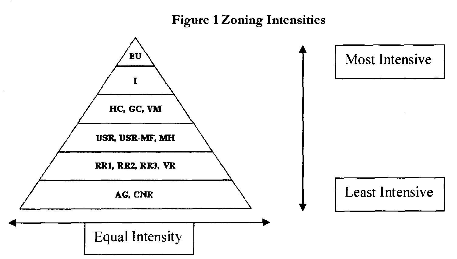
Rezoning to a zoning district of equal or lesser intensity. The pyramid diagram (see figures below) illustrates the hierarchy of districts;
e.
Land preservation parcel split;
f.
A minor subdivision which is proposed for the benefit of locating a public utility installation including, but not limited to the following uses found in Table 107-147-1 of this article; which, at the location selected, shall meet all applicable site and use standards: Public safety facility, sewage treatment plant, utility substation, utility scale solar or wind installations (or similar alternative and renewable energy technologies), communications tower, and water distribution facility (water tower);
g.
Bisected lots as described in section 107-49(2)f;
h.
A minor subdivision that does not create any additional buildable lots;
i.
Rezoning to the renewable energy overlay district.
(2)
LESA system components. The LESA system is composed of two components: a land evaluation component and a site assessment component. A maximum point value is established for each component.
a.
Land evaluation. The land evaluation (LE) component considers the agricultural productivity of the soils of the parent tract.
1.
All factors being equal, development in the AA and RRDA areas of the rural land use map should first occur on areas of lower agricultural productivity. The LE component is critical because of the county's goal to preserve productive agricultural land.
2.
Within the USA areas of the rural land use map, some development of land with high CSR soils may be appropriate for development because development should first occur in areas that are logical extensions of a city's growth patterns and upon provision of urban services conforming to municipal standards.
3.
Within the CNRA, development should occur in areas without designated critical natural resources. The development site limitations and the environmental and historical impacts should be the most limiting factors for development. The goal of reducing impact on agriculture is less important than in the agricultural area.
4.
The average corn suitability rating (CSR) used in calculating the LE component shall be determined using the planning and development department's geographical information system (GIS) data base. Average CSR shall be calculated using the entire parent tract, not merely the area of the parent tract to be directly impacted by structures.
5.
The maximum point value for the LE is 100 points in areas designated AA on the rural land use map; 75 points in areas designated RRDA; 50 points in areas designated USA; and 75 points in areas designated CNRA.
b.
Site assessment. The site assessment (SA) component considers the impact of development on the development area, parent tract and surrounding land. The SA recognizes that scattering non-agricultural uses within an area used primarily for agricultural purposes leads to land use and transportation conflicts, as well as increased costs for provision of public facilities and services. The county encourages new development to be located contiguous to existing development and where adequate public facilities are available. Within the CNRA, compatibility with surrounding uses is of low importance because the presence of critical natural resources takes precedence over extending similar development patterns. Where data is available, the site assessment shall include land located inside an incorporated city. The maximum point value for the SA is 200 points. The following criteria apply to site assessment factors:
1.
Impact on agriculture.
(i)
Agricultural and CNR zoning within one-quarter mile. This factor considers the percentage of land that is under agricultural and critical natural resource (including REC) zoning within one-quarter mile of the boundaries of the parent tract. Generally, the lower the percentage of agricultural zoning within one-quarter mile of the parent tract the more points that may be awarded
(ii)
Agricultural and CNR zoning within one mile. This factor considers the percentage of land that is under agricultural and critical natural resource (including REC) zoning within one mile of the boundaries of the parent tract. Generally, the lower the percentage of agricultural zoning within one mile of the parent tract the more points that may be awarded.
(iii)
On-site agricultural production. This factor considers the average percentage of the parent tract that has been in agriculture during the past five years. Generally, the lower the percentage of the parent tract that has been in agriculture during the past five years the more points that may be awarded. The applicant must provide verifiable documentation of on-site agricultural production for this factor.
(iv)
Proximity to urban development. This factor applies only in the USA and considers contiguity of the proposed development by analyzing the distance to urban development. Generally, the closer the proposed development area is to existing urban development the more points that may be awarded. Maximum points are awarded if the development area is contiguous to urban development.
2.
Compatibility.
(i)
Contiguous like zoning. This factor evaluates the zoning of properties contiguous to the boundaries of the parent tract. This factor analyzes to what extent the contiguous zoning is the same or more intensive than the required zoning for the proposed use. Where the contiguous zoning differs, buffering may be required to mitigate impacts if the proposed development application is approved. Generally, the greater the percentage of contiguous like zoning, the more points that may be awarded.
(ii)
Development within one-quarter mile. This factor considers what percentage of land has been developed for residential or non-residential purposes within one-quarter mile of the boundaries of the proposed parent tract. As the percentage of developed land within one-quarter mile increases, more points may be awarded. For the purpose of determining nearby development: Parcels assessed as "R," "C," or "I" shall be considered as developed.
(iii)
Development within one mile. This factor considers what percentage of land has been developed for residential or non-residential purposes within one mile of the boundaries of the proposed parent tract. As the percentage of developed land within one mile increases, more points may be awarded. For the purpose of determining nearby development: Parcels assessed as "R," "C," or "I" shall be considered as developed.
3.
Development limitations and impacts.
(i)
Site limitations. This factor considers the environmental limitations of the development area. Points will be awarded if none of the conditions listed below exist. Points shall be deducted for each of the listed conditions present within a development area:
A.
Steep slopes of 15 percent or greater as shown on topography data derived from LiDAR remote sensing.
B.
Soils classified as having a depth to water table of four feet or less, or as having "severe" erosion potential as shown on ISPAID soils database for the county.
C.
Soils classified with a "severe" or "very severe" limitation for septic tank filter fields; classified as "not suitable," "poor," or "very poor" as a source of road fill (Table 5); or classified with a "high" shrink-swell potential as shown in Tables 4 and 5 of the cooperative soil survey of the county.
D.
Land with shallow depth to bedrock (three feet or less) as shown in Table 4 of the cooperative soil survey of the county.
E.
Hydric soils as shown in ISPAID soils database for the county.
(ii)
Environmental and historical impacts. This factor considers the impact of the proposed development on the environmental and historical resources of the parent tract. Points will be awarded if none of the conditions listed below exist. Points shall be deducted for each of the listed conditions present on the parent tract:
A.
Designation as a critical natural resource area (CNRA) on the rural land use map.
B.
The known habitat of endangered or threatened species as included in the state department of natural resources publication, "Iowa Listed Species Within Linn County," printed March 6, 2002 or as subsequently updated.
C.
Consideration as a unique natural area as documented in the county conservation inventory of natural areas titled "Natural Areas Field Trip, Saturday, April 13, 1991."
D.
Historical or cultural buildings, structures or objects; or prehistoric or historic archaeological sites. Any such buildings, structures, objects or sites shall have documented significance. Sources of documented significance may include the state historical society or the office of the state archaeologist.
c.
Worksheets. Worksheets and formulas for determining point value allocations for the land evaluation and site assessment factors are included in appendix B.
d.
Bonus points. Bonus points may be awarded subject to subsection (14) of this section.
(3)
Minimum scores required for approval. Proposed development in areas governed by this section shall be approved only if the proposed development has received a minimum number of points as determined by the LESA system. The award of the minimum number of required points is considered the initial requirement for development approval. Other factors for consideration of development approval are contained in other provisions of this chapter. The following minimum number of points must be received in each of the listed areas:
a.
AA Agricultural Area, at least 115 points.
b.
RRDA Rural Residential Development Area, at least 110 points.
c.
USA Urban Service Area, at least 105 points.
d.
CNRA Critical Natural Resource Area, at least 115 points.
(4)
Cluster/conservation subdivision required for minimum scoring applications. If the LESA evaluation results in the award of at least the minimum number of required points for approval of the development application in the AA Area, RRDA Area, or CNRA Area, the applicant shall comply with the cluster/conservation subdivision design requirements as contained in subsection (14)e.1 of this section.
(5)
Maximum density and number of lots. All development projects shall demonstrate compliance with the density limits established for the zoning district in which the development is located. No subdivision approved for the AA areas of the rural land use map shall result in more than nine lots being created from a parent tract or group of contiguous parcels under common ownership.
(6)
Purpose and intent of LESA criteria for lands designated "AA" (Agricultural Area). The LESA system used to evaluate proposed development located in the AA as delineated on the rural land use map is intended to:
a.
Preserve agricultural lands within the AA as designated on the rural land use map;
b.
Prohibit non-agricultural development to occur that will negatively impact existing agricultural operations within the area; and
c.
Allow for pockets of infill in existing developed areas.
(7)
LESA scoring for lands designated "AA" (Agricultural Area). The following provisions list the maximum scores for LESA scoring components and factors for lands designated AA on the rural land use map.
a.
Land evaluation (LE) component. The average corn suitability rating (CSR) calculated for the parent tract shall be subtracted from the maximum of 100 points to give a total LE score (100, CSR).
b.
Site assessment (SA) component. Site assessment components shall be scored using the worksheets and formulas for determining point value allocations in appendix B. Maximum SA scores for lands designated AA on the rural land use map are:
1.
Impact on agriculture, maximum 90 points.
(i)
Agricultural and CNR zoning within one-quarter mile, maximum of 30 points.
(ii)
Agricultural and CNR zoning within one mile, maximum of 30 points.
(iii)
On-site agricultural production, maximum of 30 points.
2.
Compatibility, maximum 70 points.
(i)
Contiguous like zoning, maximum of 20 points.
(ii)
Development within one-quarter mile, maximum of 40 points.
(iii)
Development within one mile, maximum of ten points.
3.
Development limitations and impacts, maximum 40 points.
(i)
Site limitations, maximum of 20 points.
(ii)
Environmental and historical impacts, maximum of 20 points.
(8)
Purpose and intent of LESA criteria for lands designated "RRDA" (Rural Residential Development Area). The LESA system used to evaluate proposed development located in the RRDA as delineated on the rural land use map is intended to:
a.
Discourage premature conversion of prime agricultural land having high CSRs; and
b.
Encourage development that is contiguous and compatible with existing development.
(9)
LESA scoring for lands designated "RRDA" (Rural Residential Development Area). The following provisions list the maximum scores for LESA scoring components and factors for lands designated RRDA on the rural land use map.
a.
Land evaluation (LE) component. The average corn suitability rating (CSR) calculated for the parent tract shall be subtracted from the maximum of 100 points and multiplied by .75 to give a total LE score ((100, CSR)*.75).
b.
Site assessment (SA) component. Site assessment components shall be scored using the worksheets and formulas for determining point value allocations in appendix B. Maximum SA scores for lands designated RRDA on the rural land use map are:
1.
Impact on agriculture, maximum 85 points.
(i)
Agricultural and CNR zoning within one-quarter mile, maximum of 30 points.
(ii)
Agricultural and CNR zoning within one mile, maximum of 25 points.
(iii)
On-site agricultural production, maximum of 30 points.
2.
Compatibility, maximum 85 points.
(i)
Contiguous like zoning, maximum of 30 points.
(ii)
Development within one-quarter mile, maximum of 40 points.
(iii)
Development within one mile, maximum of 15 points.
3.
Development limitations and impacts, maximum 30 points.
(i)
Site limitations, maximum of 15 points.
(ii)
Environmental and historical impacts, maximum of 15 points.
(10)
Purpose and intent of LESA criteria for lands designated "USA" (Urban Service Area). The LESA system used to evaluate proposed development located in the USA as delineated on the rural land use map when there is no fringe area plan approved is intended to:
a.
Discourage premature conversion of prime agricultural land having high CSRs;
b.
Encourage development that is contiguous and compatible with existing development and consistent with contiguous city land use plans;
c.
Locate development where adequate public facilities are available;
d.
Reduce development pressure in the AA; and
e.
Coordinate growth in the USA to be consistent with city plans.
(11)
LESA scoring for lands designated "USA" (Urban Service Area). The following provisions list the maximum scores for LESA scoring components and factors for lands designated USA on the rural land use map.
a.
Land evaluation (LE) component. The average corn suitability rating (CSR) calculated for the parent tract shall be subtracted from the maximum of 100 points and multiplied by .50 to give a total LE score ((100, CSR)*.50).
b.
Site assessment (SA) component. Site assessment components shall be scored using the worksheets and formulas for determining point value allocations in appendix B. Maximum SA scores for lands designated USA on the rural land use map are:
1.
Impact on agriculture, maximum 80 points.
(i)
On-site agricultural production, maximum of 30 points.
(ii)
Proximity to urban development, maximum of 50 points.
2.
Compatibility, maximum 100 points.
(i)
Contiguous like zoning, maximum of 40 points.
(ii)
Development within one-quarter mile, maximum of 45 points.
(iii)
Development within one mile, maximum of 15 points.
3.
Development limitations and impacts, maximum 20 points.
(i)
Site limitations, maximum of ten points.
(ii)
Environmental and historical impacts, maximum of ten points.
(12)
Purpose and intent of LESA criteria for lands designated "CNRA" (critical natural resource area). The LESA system used to evaluate proposed development located in the CNRA as delineated on the rural land use map is intended to:
a.
Direct development to areas without designated critical natural resources, therefore, the development site limitations and the environmental and historical impacts are the most limiting factors for development.
b.
Reducing the impact of development on agriculture is less important than in the agricultural area because the CNRA is largely sloped and wooded.
c.
Compatibility with surrounding uses is of low importance because the presence of critical natural resources takes precedence over extending similar development patterns.
(13)
LESA scoring for lands designated "CNRA" (critical natural resource area). The following provisions list the maximum scores for LESA scoring components and factors for lands designated CNRA on the rural land use map.
a.
Land evaluation (LE) component. The average corn suitability rating (CSR), calculated for the parent tract, shall be subtracted from the maximum of 100 points and multiplied by .75 to give a total LE score ((100, CSR)*.75).
b.
Site assessment (SA) component. Site assessment components shall be scored using the worksheets and formulas for determining point value allocations in appendix B. Maximum SA scores for lands designated CNRA on the rural land use map are:
1.
Impact on agriculture, maximum 85 points.
(i)
Agricultural and CNR zoning within one-quarter mile, maximum of 30 points.
(ii)
Agricultural and CNR zoning within one mile, maximum of 25 points.
(iii)
On-site agricultural production, maximum of 30 points.
2.
Compatibility, maximum 50 points.
(i)
Contiguous like zoning, maximum of 30 points.
(ii)
Development within one-quarter mile, maximum of 20 points.
(iii)
Development within one mile, maximum of 0 points.
3.
Development limitations and impacts, maximum 20 points.
(i)
Site limitations, maximum of ten points.
(ii)
Environmental and historical impacts, maximum of ten points.
(14)
Bonus points. Bonus points may be available for development proposals that approach, but do not meet, the established LESA threshold score for each plan area as listed in subsection (2) of this section. Bonus points are incentives designed to encourage high-quality development supporting the county's goals by supplementing total LESA scores achieved pursuant to the criteria in subsections (1) through (13) of this section. A development proposal may be awarded bonus points within the specific categories listed below.
a.
Counting. Bonus points may be awarded at the discretion of the board of supervisors, after receiving the recommendations of the technical review committee and the planning and zoning commission, to a development proposal to increase the development's total LESA points. Bonus points granted under one category shall not be counted under a second category. For instance, if the applicant proposes to dedicate 35 acres of land for an agricultural easement under the excess land preservation or dedication category, that land dedication may not also be used for bonus points under the cluster/conservation subdivision design category.
b.
Inclusive design. The applicant is encouraged to provide as many of the amenities as possible to improve the proposed development's compatibility with existing conditions.
c.
Review standards. In its determination to award bonus points the board shall consider the public value for the amenity, the current need for the amenity, and the timeliness of the proposed development.
d.
Design in final development plan. Bonus point awards shall not be final until a development plan containing the design elements required to earn the points receives final approval. If final development plans do not contain the required elements, the development plan shall be denied.
e.
Bonus point categories and maximums. Bonus points shall be awarded in the categories listed below. Also listed are the rural land use map Areas that may receive points in the category and the maximum points that may be awarded.
1.
Cluster/conservation subdivision design. Up to four bonus points shall be awarded in the LESA scoring when the applicant designs the site to the cluster/conservation subdivision design standards as provided for in subsection (14)e.1 of this section. In the AA and CNRA, cluster/conservation subdivision design is required if the proposed development includes five or more lots and the LESA evaluation results in the award of the minimum number of required points for approval of the development application. Cluster/conservation subdivision design is optional in the RRDA.
2.
Excess land preservation or dedication. One-half point for every two excess contiguous acres preserved per lot or parcel created shall be awarded for protection of farm, open space and/or environmentally sensitive land within the proposed development area in excess of any other requirements adopted by the county. A land preservation proposal shall be consistent with the comprehensive plan's goals and objectives.
(i)
Up to eight bonus points may be awarded for this category in the AA LESA scoring.
(ii)
Up to three bonus points may be awarded for the RRDA and USA LESA scoring.
(iii)
Up to ten bonus points may be awarded for this category in the CNRA LESA scoring.
3.
Public uses benefiting the public. Two bonus points shall be awarded for each dedication of land and/or facilities for specific public activities that would meet an existing community need. For purposes of this bonus point category, the term "public uses" means those uses operated by a unit of government to serve a public need. Public uses eligible for points are public schools, fire/ambulance stations, libraries, and conservation/nature facilities. Conservation/nature facilities may be under the ownership of a private non-profit organization but must be open to the general public. The applicant shall provide documentation from the appropriate governing board that the dedication of land for the type of use is needed and the land would be accepted by the governing board as part of final plat approval pursuant to this chapter.
(i)
Up to two points may be awarded for the AA and CNRA LESA scoring.
(ii)
Up to four points may be awarded for the RRDA LESA scoring.
(iii)
Up to four points may be awarded for the USA LESA scoring system.
4.
Mitigation of environmental or historical impact. Two bonus points shall be awarded for each mitigation effort that effectively addresses environmental or historical impacts. Mitigation efforts may include a subdivision design that protects the environmental feature or historical structure, preserves the known or likely habitat of an endangered or threatened species, places conservation easements on land within a critical natural resource area or dedicates a unique natural area, or replaces wetlands with other high-quality wetlands. Allocation of points shall be based upon the severity of the impact and the effectiveness of the proposal to address the impact.
(i)
Up to six points may be awarded in the AA, RRDA, and USA LESA scoring system.
(ii)
Up to ten points may be awarded in the CNRA scoring system.
5.
Increased density. Bonus points shall be awarded for exceeding the minimum density levels established under a city with a comprehensive land use plan showing future use outside of its existing corporate limits for residential development. For each 25 percent increase surpassing the minimum density of the applicable future land use category two points shall be awarded. Where the proposed development abuts an existing subdivision, the applicant shall provide lots that measure 70 percent of the width of the adjoining lots, provided however that the planning and zoning commission may recommend and the board may approve narrower lots where sufficient setbacks and buffering are provided. Up to four points may be awarded for the USA LESA scoring system.
Table107-70 Summary of LESA Scoring
;hn0; (Code 2006, ch. 41, art. 4, § 6; Ord. No. 3-3-2006, 4-1-2006; Ord. No. 6-2-2008, 4-1-2008; Ord. No. 1-3-2011, 6-1-2011; Ord. No. 4-6-2011, 7-1-2011; Ord. No. 10-10-2013, 10-14-2013; Ord. No. 4-5-2014, 5-19-2014; Ord. No. 13-8-2015, 8-17-2015; Ord. No. 1-3-2016, 4-1-2016; Ord. No. 19-12-2020, § 1(Att. A), 12-8-2020)
Sec. 107-71. - Site plans.
Development applications for some uses require minor site plans to be submitted, other development applications require major site plans to be submitted. The specific uses and which site plan is required are listed in subsections (1)(a) and (b) of this section.
(1)
Site plan requirements, minor and major. Site plans are required in development review processes to ensure that the development meets the stated purposes and standards of the zoning district in which it is located; to provide for the necessary public facilities such as roads and utilities; and to protect and preserve topographical features and adjacent properties through appropriate siting of structures and landscaping. The following provisions describe the submission and technical requirements for minor and major site plans.
a.
Minor site plans, when required. Minor site plans are required with applications for the following when there is no proposed division of land:
1.
New single-family residential uses.
2.
Additions to existing structures, where the addition is less than ten percent of the size of the existing structure; except structures in the REC Seasonal Cabin and Recreation Overlay District which are regulated by section 107-143.
3.
A proposed revision to a site where an existing major site plan is on file.
4.
A change of use to a permitted use in an existing structure.
5.
Variances and special exceptions.
6.
Where otherwise specified in article VI of this chapter.
7.
Temporary uses.
b.
Major site plans, when required. A major site development plan is required with applications for the following:
1.
New uses (not including a change of use to a permitted use in an existing structure) other than exclusively single-family residential uses.
2.
Additions to existing structures, for uses other than single-family residential uses, where the addition is ten percent or greater than of the size of the existing structure; except structures in the REC Seasonal Cabin and Recreation Overlay District which are regulated by section 107-143. For an existing use with multiple structures on a single parcel, this provision shall apply if the addition is ten percent or greater than the total square footage of all structures, or for a new structure on the same parcel that is ten percent or greater than the square footage of all structures.
3.
Subdivisions that require platting.
4.
Where otherwise specified in article VI of this chapter.
(2)
Minor site plan requirements. Whenever this chapter requires submission of a minor site plan the applicant shall submit one copy, unless otherwise specified, of a site plan showing the data listed, preferably overlaid on a recent aerial photo of the property:
a.
Required data to be shown.
1.
Address of property including street, city and zip code and/or parcel number(s).
2.
Existing lot lines.
3.
Location of all existing and proposed structures labeled as existing or proposed with the current or proposed use noted. Structures include:
(i)
Buildings.
(ii)
Wells.
(iii)
Septic tank and septic field locations.
(iv)
Signs.
4.
Distance from proposed structures to all lot lines.
5.
Location of existing and proposed parking areas.
6.
Other information deemed necessary by the zoning administrator.
b.
Review of minor site plans. Unless otherwise specified in this chapter, a minor site plan may be approved by the zoning administrator.
(3)
Major site plan requirements. Whenever this chapter requires submission of a major site plan, the applicant shall submit one electronic copy and one paper copy of a site plan prepared by an engineer, landscape architect, architect or similar licensed professional. A major site plan shall meet the following specifications and show the data listed:
a.
Application information.
1.
Names of all property owners.
2.
Address of property including street, city and zip code.
3.
Existing and requested zoning classification, use of property, number of employees if applicable.
b.
Specifications.
1.
Paper sized 11 inches by 17 inches; additional larger format copies may be submitted in addition to the 11 inches by 17 inches format.
2.
Drawn to scale of not less than one inch equals 50 feet, unless otherwise approved by the zoning administrator.
c.
All existing and proposed site conditions shall be shown including:
1.
Existing and proposed contour lines at intervals no greater than five feet, referred to USGS datum.
2.
Location and dimensions of lot boundaries.
3.
Flood hazard areas as designated on FEMA flood hazard boundary maps.
4.
Watercourses and wetlands.
5.
Any unique natural features including wooded areas.
6.
Location and dimensions of all existing and proposed structures. The structure must be labeled (e.g. existing warehouse, dwelling) and use must be labeled as well (e.g. storage of contractor's equipment, single-family residence.) Each structure must delineate its square footage and dimensions to existing and/or proposed lot lines. Structures include:
(i)
Buildings.
(ii)
Wells.
(iii)
Fences.
(iv)
Septic tank and septic field locations.
(v)
Retaining walls.
(vi)
Utility poles.
(vii)
Walkways.
(viii)
Signs.
7.
Location, dimensions and uses of each existing platted street, highway, railroad, or utility easement.
8.
Identification of parks and other public open space within or adjacent to the proposed development.
9.
All existing storm and sanitary sewer lines, water lines, gas lines, culverts, or other underground installations within the proposed development or immediately adjacent, with pipe size (if available) and locations shown.
10.
The boundary of the area proposed for platting or division, shown as a dark line, with length of boundary lines and approximate location of the property in reference to known section lines.
11.
Layout, lot numbers, and scaled dimensions of each lot in each block of any proposed subdivision.
12.
Names, locations and dimensions of all proposed streets, roadways, alleys and pedestrian ways.
13.
Other property lines, proposed right-of-way lines, building setback lines.
14.
Location, dimensions and uses of each proposed street, highway, railroad, drainage, or utility easement.
15.
Location and dimensions of existing and proposed parks, playgrounds, churches, school sites, or special uses of land to be considered for dedication to public use or to be reserved by deed or covenant for the use of all property owners in the subdivision and any conditions of such dedication or reservations.
16.
Existing and proposed parking spaces with dimensions and class (including handicapped) with a notation of the number of spaces required and the number provided. Proposed parking drive areas with proposed direction of traffic flow.
17.
Access to all public or private streets and radius of curvature of ingress and egress drives.
18.
Circulation patterns of traffic.
19.
Location, intensity, height, spacing, efficiency, and shielding of all exterior lighting.
20.
Locations of outside refuse collection areas, and the type of screen to be provided to enclose the container from the public view.
d.
The following information shall also be noted on the plan:
1.
A vicinity map clearly identifying the subject property and showing the location of the subject property in relationship to surrounding properties, roads, streams and public facilities. The vicinity map shall extend for a distance of two miles and shall identify any incorporated city boundaries.
2.
Date site plan was prepared or date when surveyed.
3.
North arrow and scale of drawings.
4.
Title block including the name, address, phone number and profession of the person preparing the site plan or plat, and the architect's, engineer's or surveyor's professional seal, the date, and the date of all revisions. Title blocks shall meet requirements of state law.
5.
Name, address, phone number and signed consent of all property owners.
6.
Ownership, land-use, and zoning of all adjoining properties within 500 feet of the proposed development, and when adjoining properties are part of a recorded subdivision, the name of that subdivision.
7.
Type of water supply and sewage disposal and if storm sewer is available.
e.
Other information deemed necessary by the planning and zoning commission or board of supervisors.
f.
Review of major site plans. Unless specified otherwise in this chapter for land division applications, a major site plan may be approved by the zoning administrator upon concurrence of all the appropriate county departments or other appropriate agencies as indicated on a site plan review form.
(Code 2006, ch. 41, art. 4, § 7; Ord. No. 3-3-2006, 4-1-2006; Ord. No. 13-9-2006, 10-1-2006; Ord. No. 6-2-2008, 4-1-2008; Ord. No. 3-3-2010, 4-1-2010; Ord. No. 4-5-2014, 5-19-2014; Ord. No. 14-9-2018, § 1(Att. A, § 2), 9-12-2018; Ord. No. 2-2-2021, § 1(Att.A, § 1), 1-27-2021; Ord. No. 8-6-2023, § 1, 6-7-2023)
Sec. 107-72. - Land division processes and requirements.
This section includes the processes and requirements for all land division applications within the county.
(1)
General requirements for land division.
a.
Scope of these regulations. It shall be unlawful for an owner of any parcel or tract of land to divide or plat said parcel or tract into two or more parts, any of which is less than 35 acres, except in accordance with the regulations in this section. A boundary line adjustment between two parcels or tracts with a common boundary is exempt from the platting procedures of this section, and shall be processed as a minor boundary change.
b.
Conformance to other regulations. All proposed land divisions and development shall conform to the goals, objectives, and strategies of the county comprehensive plan; other provisions of this chapter; other applicable county ordinances; and any applicable administrative rules of the state department of transportation, state department of health, state department of natural resources, and other agencies of the state.
c.
Review of land divisions by municipalities. Land divisions for parcels within two miles of an incorporated municipality may be subject to the land division regulations and review authority of the municipality. The applicant for a land division shall be responsible for conforming to the regulations of any municipality exercising extraterritorial subdivision review authority under state code.
d.
Rezoning. Rezoning in accordance with section 107-68 may be required before a land division may be considered.
e.
Approvals necessary for recording. No plat or subdivision shall be recorded until all provisions and approvals set forth in these regulations have been met.
f.
Approval necessary for building permits. No building permit shall be issued for construction on any lot, parcel, or tract where subdivision approval is required by these regulations, unless and until such subdivision has been approved and recorded in accordance with these regulations, and until the improvements required by these regulations have been installed. This prohibition shall not apply to any plat legally filed and recorded before the effective date of the ordinance from which this chapter is derived.
g.
Final plat review time frame following planning and zoning commission action. A public hearing for a final subdivision plat shall be heard by the board of supervisors within one year of the recommendation action taken by the planning and zoning commission. If the plat is not heard within one year of planning and zoning action, the plat shall be deemed to have expired unless an administrative exception is granted for unusual circumstances.
(2)
Major subdivision.
a.
Purpose and scope. A major subdivision process is established to provide for submission and platting requirements, review processes, and review criteria for any of the following types of land divisions:
1.
Where the proposed land division would result in four or more lots.
2.
Where the proposed land division would result in two or more lots with an internal road or other public improvement.
b.
MLS and LESA requirements. Major subdivisions are subject to the minimum levels of service requirements of section 107-69 and to the land evaluation and site assessment requirements of section 107-70. If the major subdivision application is proceeding simultaneously with a rezoning application or subsequent to a rezoning, the minimum levels of service requirement and land evaluation and site assessment requirements shall be reviewed only with the rezoning application.
1.
Exception for outlots. An outlot may not contain any principal dwelling or other principal structure. However, a limited number of structures or types of uses may be permitted on outlots in major subdivisions including existing accessory buildings or structures used for agricultural purposes, geothermal loop fields, stormwater management installations, shared well and septic systems, SWECS, ground mounted solar panels and similar structures and appurtenances necessary for the generation of alternative and renewable energy for the benefit of one or more structures within the subdivision. All structures or uses shall require an approved zoning permit or building permits, as appropriate, prior to construction.
c.
Pre-application meetings. In order to convey critical information about the land development process, informal and formal pre-application meetings are required prior to the submission of a major subdivision application.
1.
Informal pre-application meeting. An informal pre-application meeting shall occur between the potential applicant and planning and development staff. The purpose of the meeting is to share general information from the applicant regarding the possible development, and from the staff regarding the review and approval process. The following information shall be discussed:
(i)
Information from potential applicant. The potential applicant shall provide the following information:
A.
The location of the property under consideration.
B.
The current use of the property, including existing structures.
C.
The proposed use of the property, including proposed structures.
(ii)
Development process information. planning and development department staff shall provide the following information:
A.
Rural land use map designation and zoning district for the property.
B.
Requirements for minimum levels of service (MLS) for the site.
C.
Overview of the land evaluation and site assessment (LESA) analysis process and criteria.
D.
Overview of the major subdivision and platting process.
E.
Overview of the relationship between the major subdivision and rezoning processes, if applicable.
2.
Land evaluation and site assessment (LESA) analysis completed. After the informal pre-application meeting and upon verbal request of the potential applicant, planning and development staff shall conduct a land evaluation and site assessment analysis conforming to the provisions of section 107-70. A report of the results of the land evaluation and site assessment analysis shall be mailed to the potential applicant. No fee shall be charged for the land evaluation and site assessment analysis.
3.
Formal pre-application meeting. After the land evaluation and site assessment analysis is received by the potential applicant, a formal, scheduled pre-application meeting shall occur between the potential applicant and planning and development staff at the planning and development department offices. Planning and development staff may have representatives of other relevant county departments, and in some cases city representatives, present at the meeting. The following information shall be discussed:
(i)
Information from potential applicant. The potential applicant shall prepare a concept plan to be discussed at the meeting. The concept plan does not have to be to scale nor professionally drawn, but shall contain the following information:
A.
Size of the parent tract and size and lot lines of any proposed divisions.
B.
Location and use of existing structures and proposed structures.
C.
Location of existing and proposed roads, access and other public improvements.
D.
General location of topographic features and other site conditions.
E.
Uses of surrounding, contiguous parcels.
F.
Additional property owned by the applicant within one-quarter mile of the proposed development tract.
(ii)
Development process information. Planning and development department staff shall review and provide the following information:
A.
The prepared land evaluation and site assessment (LESA) analysis report.
B.
Review of the major subdivision and platting process.
C.
Review of the relationship between the major subdivision and rezoning processes, if applicable.
D.
Overview of the requirements of this chapter for the proposed development under its current zoning classification and its proposed classification, including minimum levels of service.
E.
Identification of necessary city or state approvals and processes.
F.
Review of application forms and fees.
4.
Effect of pre-application meetings and LESA analysis. Formal and informal pre-application meetings and the land evaluation and site assessment are designed to convey information about the development potential of property, application requirements and review processes. Pre-application meetings and the land evaluation and site assessment analysis do not result in official decisions on development proposals. Official decisions to deny or approve an application are made only upon the conclusion of an application review process. Potential applicants are barred from claiming a right to develop property based on pre-application meeting discussions or land evaluation and site assessment analysis.
d.
Application. Applications for a major subdivision of property shall be submitted to the zoning administrator at the planning and development department office upon forms provided by the planning and development department containing, at a minimum, the following:
1.
Preliminary plat. A preliminary plat clearly marked preliminary plat and meeting all the requirements for a major site plan in section 107-71(3), and conforming to the minimum design standards and required minimum improvements provisions in subsections (2)h and i of this section.
2.
Stormwater pollution prevention plan (SWPPP). A stormwater pollution prevention plan meeting all the requirements of section 107-95(b).
3.
Verification. A verification signed by at least one owner of the property proposed to be subdivided attesting to the truth and correctness of all facts and information presented with the application.
4.
Application fee. The application shall be accompanied by the full application fee as established in section 107-27.
5.
Timing of application submission. Completed major subdivision applications, plats and fees shall be submitted in accordance with the planning and development department's published calendar.
e.
Process for review of major subdivision applications. The process below shall be followed in reviewing applications for major subdivisions:
1.
Review for completeness. The zoning administrator shall review the application and shall determine if the application is complete pursuant to this chapter. If the zoning administrator determines the application is not complete, then the applicant shall be instructed as to the reasons for the incompleteness of the application and informed of the most expedient review schedule.
2.
Site review. Planning and development staff will conduct an on-site review of the property proposed to be subdivided. The applicant shall cooperate in making the property accessible to staff. Staff will take photographs of the property.
3.
Technical review committee and staff report. Upon receipt of a complete application for a major subdivision, planning and development staff shall forward the application to the technical review committee. The technical review committee shall review the application for conformance with this chapter, the comprehensive plan, and other applicable plans, regulations and design standards. The applicant and surrounding property owners shall be notified of the date and time of the technical review committee meeting to review the application and shall be invited to attend. The technical review committee shall prepare a report on its findings. The report shall detail any changes that must be made and any recommended conditions for approval. The report shall be mailed to the applicant and submitted to the planning and zoning commission and the board of supervisors. If an applicant disagrees with one or more technical review committee recommendations, the applicant may request a review of the recommended conditions. The review shall be made by the board, agency or commission responsible for the technical review committee member making the disputed recommendation. Any review of a technical review committee recommendation shall be completed prior to a final decision on the application.
4.
Planning and zoning commission. The planning and zoning commission shall consider the technical review committee's findings and recommendation on the application, and shall consider the proposed major subdivision during at least one public meeting before submitting its findings and recommendation on the application to the board of supervisors. The applicant and surrounding property owners shall be notified of the date and time of the planning and zoning commission meeting and shall be invited to attend. The planning and zoning commission shall review the application and preliminary plat for conformance with the provisions of this chapter, including the review criteria in section 107-69. Applicants will have an opportunity to make a presentation to the planning and zoning commission on their application. The planning and zoning commission shall make findings and make a recommendation to the board of supervisors to approve, approve with conditions, or disapprove the application.
5.
Acceptance of conditions and revisions to application and preliminary plat. The planning and zoning commission findings and recommendations, including any conditions, shall be mailed to the property owner along with an acceptance of conditions form provided by the zoning administrator. The acceptance of conditions form shall state that the property owner has read, understands and agrees to the conditions recommended by the planning and zoning commission and the technical review committee, and shall be signed by the property owner prior to the adjournment of the public hearing in subsection (2)e.6 of this section. In addition, the applicant shall make any revisions to the rezoning application, including the preliminary plat, recommended by the planning and zoning commission. The acceptance of conditions form and revisions to the application and preliminary plat, if necessary, shall be returned to the zoning administrator prior to the submission of the application to the board of supervisors, or scheduling of the public hearing and first consideration for any associated rezoning application.
6.
Board of supervisors public hearing on preliminary plat. The board of supervisors shall examine the application and the planning and zoning commission's findings and recommendation in accordance with the planning and development department's published calendar. The applicant and surrounding property owners shall be notified of the date and time of the hearing and shall be invited to attend. The board of supervisors shall review the application and preliminary plat for conformance with the provisions of this chapter, including the review criteria in section 107-69. Following such examination, the board of supervisors shall approve, approve subject to conditions, or disapprove the plat. Such action taken by the board shall be set forth in the form of a resolution, and a copy of said resolution shall be provided to the applicant.
(i)
Notice of public hearing. Notice of the time and place of the public hearing shall be given not less than four nor more than 20 days before the time of the hearing in one publication in a newspaper of general circulation in the county. Notice shall also be mailed to the applicant.
7.
Effect of approval by the county board of supervisors. Approval by the board of supervisors of the preliminary plat shall not constitute authority to sell lots or record the plat, or authority to construct permanent buildings in reliance upon the preliminary plat layout, except that one building permit may be issued prior to approval of the final plat provided the proposed building is located on and in conformance with a lot included in the approved preliminary plat.
8.
Duration of preliminary plat approval. Approval of the preliminary plat by the board of supervisors shall be valid for a period of 20 months from the date of approval of a plat by the county board of supervisors for a portion or all of the area included in said preliminary plat. In the event a final plat has not been approved within 20 months, the preliminary plat shall be void, and the subdivider shall resubmit the preliminary plat for approval prior to submission of a final plat for any portion of the area covered by the preliminary plat. Review and action on the resubmission of the preliminary plat by the county shall conform to all provisions of this chapter.
9.
Approval of improvement plans. After approval by the board of supervisors of the preliminary plat, the developer shall submit plans, profiles, and specifications for improvements to the county for approval. The final plat shall not be approved by the board of supervisors until said improvement plans have been submitted and approved by the county, and the improvements installed or guaranteed as provided for in subsection (2)e.15 of this section. If a development agreement is used, the development agreement shall include all improvement plans required under this subsection and shall be approved by the board of supervisors.
10.
Final plat. Following approval of a preliminary plat, the subdivider shall file a final plat with the planning and zoning department for a portion or all of the area covered by said preliminary plat. The final plat shall conform to the preliminary plat as approved or conditioned by the board of supervisors.
11.
Final plat filing requirements. Two copies of the final plat, together with copies of forms and certificates as specified in subsection (2)f of this section, shall be submitted to the planning and development department in bound form. Bound copies shall be backed with a blue top-fold manuscript cover. To be considered by the board of supervisors, a final plat clearly marked "Final Plat" shall meet all of the following requirements:
(i)
Drawn at a scale of one inch equals 100 feet or as approved by the zoning administrator.
(ii)
Sheet size shall be no greater than 18 inches by 24 inches nor smaller than 11 inches by 17 inches, unless otherwise approved by the zoning administrator. If more than one sheet is used, each sheet shall clearly show the sheet number, the total number of sheets included in the plat, and match lines indicating where other sheets adjoin.
(iii)
Name of the subdivision; north arrow; scale of the plat; name of the owner and subdivider; date, name, address, and seal of the land surveyor; legal description of property, including location of boundary lines in relation to section and quarter-section; and a statement of total acreage encompassed by the plat computed to the nearest one-tenth of an acre.
(iv)
The right-of-way lines of all public or private streets and alleys with the right-of-way width and names shown.
(v)
All lots lines with dimensions, area of lots in acres, lots and blocks numbered in accord with a uniform system.
(vi)
Easements for any right-of-way provided for public use, frontage road, drainage, services or utilities showing dimensions and purpose. A strip of land shall not be reserved by the subdivider unless the land is of sufficient size and shape to be of some practical use or service as determined by the county.
(vii)
All dimensions, both linear and angular, necessary for locating the lines of lots, tracts, or parcels of land, streets, alleys, easements, and the boundaries of the subdivision. The linear dimensions are to be expressed in feet and decimals of feet to the nearest hundredth. The plat shall show all curve data necessary to reconstruct on the ground all curvilinear boundaries and lines and radii of all rounded corners. Curve data for streets of uniform width may be shown only with reference to the center line, and lots fronting on such curves may show only the chord bearing and distance of such portion of the curve as is included in their boundary. In all other cases, the curve data must be shown for the line affected.
(viii)
The course of every boundary line shown on the plat shall be indicated by a direct bearing reference or by an angle between the boundary line and an intersecting line having a shown bearing, except when the boundary line has an irregular or constantly changing course, as along a body of water, or when a description of the boundary line is better achieved by measurements shown at points or intervals along a meander line having a shown course. All bearings and angles shown shall be given to at least one nearest minute of arc.
(ix)
The minimum unadjusted acceptable error of closure for all subdivision boundaries shall be 1:10,000 and shall be 1:5,000 for any individual lot.
(x)
The description, location, and elevation of all existing bench marks.
(xi)
The description and location of all permanent monuments to be of record as required by I.C.A. ch. 355.
(xii)
Names of adjacent plats with location of adjoining streets shown by dashed lines.
(xiii)
The plat shall contain a statement by a licensed land surveyor that the plat was prepared by the surveyor or under the surveyor's direct personal supervision and shall be signed and dated by the surveyor and bear the surveyor's Iowa registration number or seal.
(xiv)
A vicinity map showing location of plat in relationship to surrounding property and road or street systems shall be attached to each of the unbound copies of the final plat.
12.
Time of filing. The final plat shall be filed with the planning and development department in accordance with its published calendar.
13.
Technical review committee review or check-off. The technical review committee shall examine final plats for conformance to the approved preliminary plat and these regulations, and report their findings to the board of supervisors. The technical review committee may examine the final plat by either holding a meeting or by circulating a form allowing for indication by each technical review committee member that the conditions imposed for final plat approval have been met.
14.
Required improvements. Before the final plat of any subdivision is approved and recorded, the required improvements must be installed or have such improvements guaranteed as provided for in subsection (2)e.15 of this section. All improvements shall conform to the requirements of this chapter and the county standard specifications as adopted by the board of supervisors.
(i)
Development agreement. A development agreement, approved by the board of supervisors, may be required as part of the final plat approval process. If used, the development agreement shall include the following minimum terms:
A.
Conditions of plat approval.
B.
Description of standards and conditions for improvements.
C.
Schedule for installing or constructing required improvements.
D.
Ownership of improvements.
E.
Guarantees of performance and maintenance.
F.
Remedies for default.
(ii)
Permission to construct improvements. Before construction of each improvement, the owner shall submit an application to the county engineer's office or other appropriate county departments requesting permission to construct the improvement and have such request approved by the county engineer or appropriate department.
15.
Guarantees of performance. If, at the time of the presentation of the final plat, it is not practicable or advisable to have the required improvements completed before the final plat is accepted and approved, the owner shall enter into a performance agreement or escrow account with the county to make such improvements at such time as may be therein stated. The performance shall be secured by the filing of a performance bond, escrow account, or other equally acceptable financial instrument equal to ten percent of the cost of the improvement as approved by the county engineer. The performance agreement guaranteeing the construction of improvements in the subdivision shall be drawn on a standard form as approved by the county attorney. If a development agreement is used, the development agreement shall include all performance agreements and guarantees required under this subsection and shall be approved by the board of supervisors. If the improvements are not completed within the time specified, the board of supervisors may use any necessary portion of the secured amount to complete said improvements. The county board of supervisors may allow an extension of time for completion of improvements.
16.
Board of supervisors public meeting and review of final plat. The board of supervisors shall consider the final plat along with the technical review committee report after the applicant has complied with all necessary conditions, performance and maintenance guarantees, and all provisions of this chapter. If the board of supervisors finds that the plat has been prepared in compliance with the provisions of this chapter and in substantial compliance with the approved preliminary plat, such final plat shall be approved. In the event of disapproval, the record shall show the specific points on which the final plat varies from these regulations or the preliminary plat. No road, street, venue, highway, alley, or travel way dedicated to public use by the owner of the subdivided land shall be deemed a public way or be under the use, control, or maintenance of the county unless the dedication shall be accepted and confirmed by resolution specially passed by the board of supervisors for such purpose.
f.
Required recording of final plat. The final plat with all required documents shall be entered in the proper record books in the office of the county recorder. When so entered, the plat only shall also be entered in the records of the county auditor and the plat shall be of no validity until so filed in both offices. Approval of the final plat by the board of supervisors shall be void if the plat and its proceedings are not recorded by the owner in the office of the county recorder within one year after date of approval, unless, within that time, an extension based upon unusual circumstances is granted by the board of supervisors.
1.
Filing document requirements. Required filings with the county recorder shall include all of the following documents:
(i)
Owner's certificate and dedication certificate executed in the form provided by state law, dedicating to the county the title to all property intended for public use, including public roads.
(ii)
Title opinion and a consent to plat signed by the mortgage holder if there is a mortgage or encumbrance on the property as well as a release of all streets, easements, or other areas to be conveyed or dedicated to local government units within which the land is located.
(iii)
Surveyor's certificate.
(iv)
Auditor's certificate.
(v)
Resolution of the planning and zoning commission.
(vi)
Resolution of the board of supervisors.
(vii)
Resolution of approval or waiver of review by applicable municipalities.
(viii)
Treasurer's certificate.
(ix)
Agricultural land use notification.
(x)
Restrictive covenants or deed restrictions, as separate instruments, not combined with any other instrument.
(xi)
Ten original signed plat drawings.
(xii)
Covenant for a secondary road assessment.
g.
Minor changes after final approval. During the development of an approved major subdivision, the zoning administrator may approve minor changes in the location, placement and height of structures, and lot line or road alignment, if such changes are required by engineering or other circumstances not foreseen at the time the final plat was approved, provided the changes are indeed minor and conform to the review criteria applied by the board of supervisors.
h.
Development design standards. All major subdivision applications shall meet the development design standards in this section, which are intended only as minimum requirements.
1.
Streets. The arrangement, character, extent, width, grade, and location of all streets should consider site characteristics and shall conform to any applicable requirements of the comprehensive plan, the Metropolitan planning organization (MPO) or regional planning affiliation (RPA), statewide urban design and specifications (SUDAS), the county standard specifications and to any other applicable plans or specifications that may be adopted by the board of supervisors, including, but not limited to, the following:
(i)
Major streets. The design of the subdivision shall provide for major streets that are identified by the MPO or RPA, or classified as trunk or trunk collector by the county.
(ii)
Street extensions. Proposed streets shall normally continue as an extension of existing streets.
(iii)
Adjoining properties. Street patterns shall take into consideration access needed to develop adjoining properties and shall conform to topography so as to provide the best building sites. Sketches of a proposed street system for adjoining property may be required if it is owned or under the control of the applicant.
(iv)
Local streets. When possible, local service streets shall be planned so as to discourage through-traffic and to conveniently channel traffic onto the collector and major streets.
(v)
Dead-end streets. Dead-end streets are prohibited, except where planning indicates that a street is to continue past the applicant's property. Where dead-end streets are allowed, a temporary turn-around shall be required until such time as the street is continued except that a temporary turn-around in residential subdivisions where a dead-end street serves only one lot depth is not required.
(vi)
Cul-de-sacs. Cul-de-sacs are generally undesirable because of fire protection concerns and a preference for through streets. Cul-de-sacs may be used only when justified because of difficult topography, low traffic volumes, to protect natural resources, or to prevent multiple drives accessing a through street. If justified, they should not exceed 600 feet in length. Every cul-de-sac shall have a permanent turn-around at its closed end with a minimum right-of-way diameter of 120 feet.
(vii)
Intersection design. Streets shall be laid out so as to intersect as nearly as possible at right angles except where topography or other conditions justify variations. Street intersections with centerline offsets of less than 125 feet should be avoided.
(viii)
Street grades. Street grades shall conform to the overall drainage pattern of the locality of the subdivision and shall fall within the minimum and maximum set forth under the county standard specifications for improvements.
(ix)
Sight distances. Vertical and horizontal sight distances shall conform to the county standard specifications.
(x)
Alleys. Alleys are not required in residential areas. They may, however, be required in commercial areas where necessary to provide access for loading and utilities.
(xi)
Right-of-way widths. Right-of-way widths for all streets, and other thoroughfares hereafter dedicated shall conform to the requirements set forth in the county standard specifications for subdivision improvements and by the MPO or RPA.
(xii)
Partial width streets. Partial width streets are discouraged, except where they may be required to complete the remaining portion of a street already dedicated, or where conditions indicated that the alignment of a street should straddle the property lines.
(xiii)
Surface widths. Street surface widths and street grades shall conform to the county standard specifications.
(xiv)
Street names. Street names shall be used that will not duplicate or be confused with the names of existing or platted streets. Streets that are now or will eventually be continuations of existing or planned streets shall be called by names of the existing or planned streets.
(xv)
Dedication. All streets (roads) in subdivisions shall be dedicated as public roads and constructed in accord with the county standard specifications for improvements. Existing county road easements shall be included in such dedication where they are part of the platted area.
A.
Private roads. Private roads may be approved as an exception and only under one or more of the following conditions:
(I)
Cul-de-sac or other similar street design such as loop street system.
(II)
Topographic conditions that will not permit street construction to conform fully to grade, right-of-way, or other requirements in the county standard specifications for public roads.
(III)
Frontage roads as a private road or road easement.
(IV)
Other conditions similar to the above that may warrant private roads as determined by the board of supervisors.
2.
House numbering. House numbers shall be assigned in accordance with the house numbering system now in effect in article II of chapter 18.
3.
Blocks. Intersecting streets determining block lengths shall be provided at such intervals to serve cross traffic adequately, and to conform to existing street design and customary subdivision practices in the immediate area. Blocks in residential districts should normally not exceed 1,320 feet in length, unless variation to this rule is approved. The width of a block shall normally be sufficient to allow for two tiers of lots with alley or utility easement. Blocks intended for business or industrial use shall be of such width as may be best suited for the contemplated use of the property.
4.
Lots. The shape and configuration of lots within a subdivision shall conform to the following:
(i)
Septic systems. In subdivisions where buildings are to be served by septic tanks, soil conditions, topography, and size of lots shall be adequate to accommodate required drainage fields as required in article VI of chapter 10.
(ii)
Resubdivision of large lots. When a tract is subdivided into larger than normal lots or parcels, such lots or parcels shall be so arranged as to permit the logical location and opening of future streets and appropriate resubdivision with provision for adequate utility connections for such resubdivision.
(iii)
Side lines. The side lines of a lot shall be at right angles to straight street lines, or radial to curved street lines, unless variation to this rule will give a better street and lot plan.
(iv)
Minimum lot area. A lot that is to be used for residential purposes shall not contain less area than is required by the lot area regulation of the zoning district in which the property is located.
(v)
Buildable site. Each lot shall afford a buildable site after taking into account all yard spaces required by this chapter.
(vi)
Required upland or resource protection area. Each buildable lot shall have a minimum required area outside of the special flood hazard area and any required critical resource buffer area within a CNR zoned district for construction of a single-family dwelling or principal permitted structures. The minimum required area shall be reserved for the dwelling or principal structures, septic systems and wells.
(vii)
Lot depth. Excessive lot depth in relation to width of greater than a 4:1 ratio shall be avoided.
(viii)
Corner lots. Corner lots in residential areas shall be wide enough to permit required building setbacks from both streets.
(ix)
Lot frontage. Each lot shall have frontage on a public street unless a private street or easement is approved as provided for in subsection (2)h.1.(xv) of this section.
(x)
Frontage roads. Unless unavoidable, lots shall not front or have direct access to major streets or county roads. If interior streets cannot be established, frontage roads shall be provided along major streets or county roads with lots fronting on said frontage road unless property size, topography, or other conditions will not allow development of a frontage road system. Where frontage roads cannot be provided, lots fronting on major streets or county roads shall be so arranged as to minimize the number of access points.
5.
Access. Access to, from and within the subdivision and individual lots shall conform to the following:
(i)
Lot accesses. All lots shall have a single access to an internal subdivision street unless physical or natural impediments make such access unadvisable.
(ii)
Access permit. All accesses shall be located at the time of plat approval or when an access permit is requested from the county secondary road department.
(iii)
Safety and drainage. The location of the access shall be so located to provide for the safety of the road traffic and the lot access, and to provide optimum drainage conditions for the roadway.
(iv)
Installation. The installation of the access shall be the responsibility of the lot owner or subdivision developer. Installation shall be in accord with county standard specifications.
(v)
Maintenance. It shall be the property owner's responsibility to maintain the access.
(vi)
Joint accesses. In the event that final plat approval requires that certain lots be served by a joint access, no additional access will be permitted for those lots so designated.
(vii)
Number of accesses, non-residential. The number of lot accesses for all commercial, office, industrial, and institutional uses shall be determined by the county engineer.
(viii)
Number of accesses, residential. All residential lots one acre or less in size shall be restricted to one access. However, if the lot is either located at the intersection of two internal subdivision streets with a minimum of 300 feet of total frontage or fronts onto a street that has curb and gutter, two accesses may be allowed, unless potential safety or drainage problems are significant as determined by the county engineer. All residential lots greater than one acre in size may have two accesses, when the additional drive is warranted by the county engineer.
(ix)
Flood hazard area. If reasonable access to the lot cannot be located except through a flood hazard area the access shall be elevated no lower than one foot above the 100-year flood elevation but shall not be elevated higher than the public road serving the lot.
6.
Easements. Easements shall conform to the following provisions:
(i)
Utility easements. An easement for utilities, including future sanitary sewer and water line easements at least four feet wide, may be required along each side of the rear line of lots where necessary to form a continuous easement with adjacent properties. If necessary, easements of greater width may be required along lot lines or across lots, and easements of lesser width may be approved if accepted by utility companies. Easements shall connect with easements established in adjoining properties. A ten-foot easement shall be provided contiguous to and along each side of a street unless waived by the utility companies. Easements shall be approved in writing by any public or private utility company intending to use such easement for their facilities; such approval to be submitted prior to approval of the final plat.
(ii)
Drainage easements. Drainage easements for storm sewers, swales, rain gardens, open channels, or other stormwater management structures may be required where storm drainage cannot be practically carried by streets or other rights-of-way. Open channel drainage easements may be required where there is evidence that the natural drainage for a large area traverses the subdivision. Drainage easements should be sufficient in width so that motorized equipment may be used in their maintenance.
(iii)
Review of future changes. Utility and drainage easements, as recorded, shall not thereafter be changed or vacated without the approval of the board of supervisors, by resolution upon recommendation of the planning and zoning commission and technical review committee staff.
7.
Floodplain. Site design shall comply with the floodplain regulations in section 107-144.
i.
Minimum improvements required. The following minimum improvements shall be required for major subdivisions:
1.
Road improvement requirements.
(i)
Public roads. All public roads shall be improved in accordance with the county standard specifications, and shall meet roadway width, cross section, grade, drainage, and such other requirements as established in said specifications. No road, street, venue, highway, alley, or travel way dedicated to public use by the owner of the subdivided land shall be deemed a public way or be under the use, control, or maintenance of the county unless the dedication shall be accepted and confirmed by resolution specially passed by the board of supervisors for such purpose.
(ii)
Covenant for assessments for future improvements. Where a plat contains lots adjacent to or adjoining upon an existing county road that provides primary access to said lots, the subdivider shall agree to place covenants running with each of the lots of the plat providing for the participation of the owner of each lot in a secondary road assessment agreement district under I.C.A. ch. 311 for the future improvement of the county road and which shall occur at the time it is required by the board of supervisors.
(iii)
Covenant for dust control assessment. Where a plat contains internal roads accessing onto existing county rock surfaced road(s), the subdivider shall agree to place covenants running with each of the lots of the plat providing for the participation of the owner of each lot in a secondary road assessment district under I.C.A. ch. 311, or its successor, for surface improvements limited to use solely for the purpose of dust control along the existing county road(s) on the most commonly traveled route(s) to the nearest pavement(s). In no case shall the assessment spread against a single lot involve a dollar amount in excess of one-half the amount charged by the county engineer for a 150-foot single seal coat application under the approved county dust control program for that year. Such assessment to be made on developed lots only.
(iv)
Private roads. All private roads shall conform to the county standard specifications for private roads, and the following:
A.
Road association agreement. In all plats where private roads are to be approved, a road association agreement shall be established to (1) guarantee access to all lots; (2) ensure repair and maintenance of said facilities; and (3) such other requirements as stipulated by the county. A separate agreement with the county shall also be executed stating that the road shall remain private and maintained under the private road association agreement. The road association agreement shall meet the county requirements and shall also provide, if the right-of-way is to be dedicated at any time in the future, that prior to such dedication the association shall bring roads up to the county standard specification requirements for public roads applicable at the time of such dedication.
B.
Condemnation. In the event that the association requests the county to accept private roads as public roads, and the clear title of the street rights-of-way cannot be readily established, the county may exercise its right of eminent domain and condemn for title the street rights-of-way. All expenses incurred by the county for such action, including preparation, hearings, documentation, and damage awards shall be paid by the road association. An agreement between the road association and the county board of supervisors will be required.
C.
Access to existing private roads. Where private roads exist as of the effective date of these regulations and a new plat is proposed to gain access from these private roads, such plat will not be considered until the new plat owner has secured in writing the approval of the owners of all lots having legal access to the existing private roads. This approval shall include the willingness of all lot owners to enter into an association of lot owners in the form of a legal and valid document binding said owners to the repair and maintenance of the existing private road and its proposed execution.
2.
Sanitary sewer system requirements.
(i)
Public or private system required. The subdivider of the land being platted shall make adequate provision for the disposal of sanitary sewage from the platted area with due regard being given to present or reasonably foreseeable needs. Where connection to a public sewer, or the construction of a central private sewage collection and treatment system, cannot reasonably be accomplished as determined by the county public health department, septic systems may be allowed. When a private central system is provided, a sewer association agreement approved by the board of supervisors will be required.
(ii)
Percolation test and soil evaluation. No final plat for a subdivision to be served by septic systems shall be approved until and unless percolation tests have been performed, as required, and the results of such tests have been provided to and reported on by the county public health department. Such septic systems, if approved and permitted by the county public health department, may be installed by the subdivider, or by a subsequent owner at the time development of a lot takes place.
3.
Water system requirements. The subdivider of land being platted shall make appropriate provision for a suitable water supply for each platted lot or parcel. Such water supply shall be appropriate for the character of development proposed. No subdivision shall be approved until and unless the proposed system for providing water has been approved by the county public health department. Public (25 or more individuals) or shared wells may be required by the county and shall include a water association agreement approved by the board of supervisors providing for the operation of the system in accord with local and state requirements. Individual wells, if approved and permitted by the county public health department, may be installed by the subdivider, or by a subsequent owner at the time development of a lot takes place.
4.
Stormwater management requirements. The subdivider shall provide for stormwater management in the subdivision that meets the requirements of section 107-95.
5.
Erosion control requirements. The subdivder shall provide for erosion control in the subdivision that meets the requirements of section 107-95.
6.
Other improvements. The subdivider of the land being platted shall be responsible for the installation of sidewalks and walkways necessary to secure pedestrian safety, grading and seeding or sodding of all lots, the planting of any required trees, and the installation of street signs and street lighting, as may be required.
j.
Standard specifications for improvements. In addition to the standards set forth in these regulations, the county engineer shall, from time to time, prepare, and the board of supervisors may from time to time, adopt by resolution, standard specifications for public improvements. Such standards for public improvements shall contain the minimum acceptable specifications for the construction of improvements. Such standards may vary for classes of improvements, giving due regard to the classification of streets and roads, or other improvements, and the extent and character of the area served by the improvements.
k.
Maintenance bond. A four-year maintenance bond, meeting requirements of the county, shall be submitted and approved by the county following construction of all public improvements and prior to acceptance of said improvements by the county. The maintenance bond requirement may be part of the performance guarantees required under a development agreement.
(3)
Minor subdivision.
a.
Purpose and scope. A minor subdivision process is established to provide for submission and platting requirements, review processes, and review criteria for proposed subdivisions containing no more than three lots and no road or other public improvements. A boundary line adjustment between two parcels or tracts with a common boundary is exempt from the platting procedures of this section, and shall be processed as a minor boundary change.
b.
MLS and LESA requirements. Minor subdivisions are subject to the minimum levels of service requirements of section 107-69 and to the land evaluation and site assessment requirements of section 107-70. If the minor subdivision application is proceeding simultaneously with the rezoning application or subsequent to a rezoning, the minimum levels of service requirements and land evaluation and site assessment requirements shall be reviewed only with the rezoning application. Exceptions to the MLS and LESA requirements shall apply to the following: residential parcel split, land preservation parcel split, minor boundary change, or separation of a bisected legal lot of record; minor subdivision that does not create any additional buildable lots; public safety facility, sewage treatment plant, or water distribution facility (water tower); utility substation or utility scale solar or wind installations (or similar alternative and renewable energy technologies); and communications tower.
1.
Exception for non-buildable lots and outlots. An outlot or a lot in a minor subdivision that does not meet one or more of the minimum levels of service or the land evaluation and site assessment requirements may be approved in a minor subdivision only if approval includes the requirement that a note be filed on the plat stating that the lot is non-buildable until such time as the lot comes into compliance with this chapter including all minimum levels of service and land evaluation and site assessment requirements.
(i)
An outlot may not contain any principal dwelling or other principal structure. However, a limited number of structures or types of uses may be permitted on outlots and non-buildable lots in minor subdivisions including existing accessory buildings or structures used for agricultural purposes, geothermal loop fields, stormwater management installations, shared well and septic systems, SWECS, ground mounted solar panels, and similar structures and appurtenances necessary for the generation of alternative and renewable energy for the benefit of one or more structures within the subdivision. All structures or uses shall require an approved zoning permit or building permits, as appropriate, prior to construction.
c.
Application, review process, and requirements. The application, review process and requirements for a minor subdivision shall be the same as those specified for a major subdivision in subsection (2)b. through k. of this section, except for the following:
1.
Preliminary plat requirements waived. Submission and review requirements for preliminary platting shall not be necessary for a minor subdivision application. All submission and review requirements for final platting as provided for in subsection (2)b. through k. of this section, shall be followed.
d.
Existing dwellings constructed prior to January 1, 1985 located on proposed minor subdivision parcels shall be reviewed by Linn County Planning and Development in accordance with the safety inspection checklist established by the zoning administrator.
(4)
Residential parcel split.
a.
Purpose. The purpose of this subsection (4) is to prescribe uniform procedures allowing for approval of a division of land for use as a single-family residential site on which site there exists, or evidence provided by the applicant documents the prior existence of, one or more single-family residential structures, and where no farmstead split has previously occurred.
b.
Conditions. A residential parcel split shall not be approved unless all of the following conditions are met:
1.
The single-family dwelling unit shall have been in existence prior to January 1, 1985. Minimum evidence of the existence of the dwelling shall include:
(i)
Previous tax records establishing the existence of the dwelling;
(ii)
Existence of 75 percent or more of the dwelling's foundation; or
(iii)
Conclusive evidence from aerial photographs of the dwelling's previous existence.
2.
The site of the previously existing dwelling must still be currently intact and shall not have been converted to agricultural production.
3.
While the owner of the remaining land may construct a new dwelling if all requirements of this chapter are met for the remaining land, that new dwelling will not qualify for a residential parcel split under the provisions of this section.
4.
If the remaining land is less than 35 net acres or does not otherwise meet zoning requirements, the remaining land shall be included in the minor subdivision for the residential parcel split and shall be noted as follows: "This parcel may only be developed in accordance with all development regulations in effect at the time development is proposed."
5.
All resulting parcels shall have access to an adjoining public roadway by actual road frontage or easement.
6.
A minimum of one net acre shall be required for each residential parcel split. All side and rear yard setback requirements must be met.
7.
No variances from subdivision or zoning standards shall be granted in order to accomplish a residential parcel split.
8.
Neither this process nor any former "farmstead split" zoning process has previously been used to sever a lot from the parent tract.
c.
Not subject to MLS or LESA requirements. Creation of lots pursuant to this subsection is not subject to the minimum levels of service requirements in section 107-69; nor are they subject to the land evaluation and site assessment requirements of section 107-70.
d.
Application. Applications shall be submitted by the landowner on a form established by the zoning administrator and shall be accompanied by a minor subdivision meeting the provisions of subsection (3) of this section, and an application filing fee as established by the board of supervisors.
e.
Review and approval. Review and approval of applications for existing residential parcel splits shall follow the process for a minor subdivision in subsection (3) of this section.
(5)
Minor boundary change.
a.
Purpose. The purpose of this subsection is to prescribe uniform procedures for review of an adjustment to a common boundary between no more than two adjacent parcels or tracts of land.
b.
Conditions.
1.
A minor boundary change shall not result in the creation of any additional buildable parcels or tracts. A parcel or tract is considered non-buildable if it cannot comply with the provisions of this chapter, including but not limited to the provisions for nonconforming lots and legal lots of record in section 107-49.
2.
No new violations of this chapter shall be created by the action.
3.
Such division of land shall not be in conflict with any other state or lawful municipal regulations regarding division of land.
4.
The plat of survey parcel(s) shall be considered non-buildable until such time as it comes into compliance with this chapter, and a note shall be filed on the plat of survey indicating this.
c.
Application. An application for a minor boundary change shall be submitted on a form as established by the zoning administrator, along with an application filing fee as established by the board of supervisors. In addition, all of the following shall be submitted with the application and required fee:
1.
A review copy of the plat of survey, including the plat of survey number, describing the areas to be conveyed between the adjacent property owners;
2.
Any proposed or required easement agreement;
3.
An accompanying sketch plan that demonstrates all site and structure requirements for the zoning district in which the parcels of land are located can be maintained.
4.
If applicable, an amended land preservation parcel deed restriction, as described in section 107-72(8)b.
d.
Review and approval. Review of applications for minor boundary changes shall be by the zoning administrator or designee, who shall notify the surveyor of approval or of any required changes. The auditor's office shall receive a copy of the notification.
e.
Recording of plat of survey. The surveyor shall submit the plat of survey to the auditor's office following the zoning administrator's review, along with the required fees and documentation established by that office. The plat of survey shall be recorded in accordance with the provisions set forth in I.C.A. § 355.10.
f.
Recording of easement agreements. Upon notification that the plat of survey has been recorded, the planning and development department shall record any easement agreement submitted with the application.
g.
Not subject to MLS or LESA requirements. Minor boundary changes are not subject to the minimum levels of service requirements in section 107-69; nor are they subject to the land evaluation and site assessment requirements of section 107-70.
(6)
Cluster/conservation subdivision.
a.
Purpose. Cluster/conservation subdivisions are an option for residential development designed to preserve and protect agricultural land and the environment. A cluster/conservation subdivision shall attempt to achieve these goals by basing the location of the development area of the subdivision on an existing resources/site analysis plan. It is recognized that protecting all prime agricultural land (CSR above 65) and all sensitive environmental areas, while still allowing for development, may not be practical and that some tradeoffs may be required. As a general guideline, protecting prime agricultural land shall take precedence in cluster/conservation subdivisions in the AG district, while protecting sensitive environmental areas shall take precedence in RR2, RR3, CNR, and USR districts.
b.
When required. A cluster/conservation subdivision shall be required for the following developments:
1.
Agricultural district. In the AG Agricultural District, a cluster/conservation subdivision design shall be required for development projects resulting in five or more development lots created from a parent tract or group of contiguous parcels under common ownership. For phased development, cluster/conservation subdivision design shall be required for those development phases resulting in five or more total development lots for all phases. Cluster/ conservation subdivision design may be used for development projects resulting in three or four lots in the AG Agricultural District.
2.
RR2, RR3, CNR and USR districts. Cluster/conservation subdivisions may be used in RR2, RR3, CNR and USR districts.
c.
MLS and LESA requirements. Cluster/conservation subdivisions are subject to the minimum levels of service requirements of section 107-69 and to the land evaluation and site assessment requirements of section 107-70.
d.
Application and review. Cluster/conservation subdivisions shall follow the same application and review procedures as a major subdivision as provided for in subsection (2) of this section, however, additional site design standards and required improvements in subsection (6)e of this section shall apply. Site design standards and required improvements in this section shall take precedence over those listed for major subdivisions in subsection (2) of this section.
e.
Development and site design standards. The following site design standards shall apply to proposed cluster/conservation subdivision developments:
1.
Existing resources and site analysis plan. The applicant shall submit an existing resources and site analysis site plan that delineates wetlands, floodplains, slopes, soils, prime agricultural land (CSR above 65), drainage ways, sensitive lands, groundwater recharge areas, significant wildlife habitats, stands of trees, historic or cultural features, and the like. The existing resources and site analysis site plan shall provide the basis for the cluster/conservation subdivision design and the allocation of open space.
2.
Major site plan. The applicant shall submit a major site plan, pursuant to requirements in section 107-71(3), but which also:
(i)
Provides a design which takes into account the information delineated in the existing resources and site analysis site plan; and
(ii)
Delineates the percentage of land area dedicated for conservation which shall be no less than 50 percent of the gross development area. However, the board of supervisors may require the reservation of up to 70 percent of the site depending on the site constraints and conditions.
3.
Density. The density of a cluster/conservation subdivision shall not exceed 1.2 times the maximum density established for the land use category and base zoning applicable to the subject parcel, subject to a suitability determination made by the county public health department.
4.
Minimum lot size. The minimum lot size for cluster/conservation subdivisions shall be:
(i)
One acre in size in the AG district.
(ii)
Two acres in size in the RR3 district.
(iii)
One acre in size in the RR2 district.
(iv)
Consistent with applicable fringe area plan densities and public facilities in USR district. If no fringe area plan exists, the minimum density in a USR district shall be one dwelling unit per acre.
(v)
The board of supervisors may authorize the creation of smaller lots if it finds that provisions have been made to adequately address compatibility with adjacent uses and provisions for wastewater treatment and disposal.
(vi)
Maximum lot size. No residential lot shall be greater than three acres in size in a cluster/conservation subdivision design development.
5.
Open space. At least 50 percent of the gross development area shall be reserved as open space. However, the board of supervisors shall have the authority to require the reservation of up to 70 percent of the site depending on the site constraints and conditions. Open space limitations shall be established prior to approval of any final plat. Open space may be designated for agricultural operations or as common open space for the benefit of the subdivision.
(i)
Any portion of the open space to be used for agricultural operations shall be separated by a buffer strip as required in subsection (6)e.8 of this section between every residential lot and the area to be farmed. Appropriate easements shall be established to ensure that residents acknowledge and accept potential nuisances from normal farm operations.
(ii)
Open space may be used as the site for a wastewater system so long as the system does not occupy more than 20 percent of the open space, and the open space is held in common ownership by the wastewater system users.
6.
Maximum number of residential dwelling units per cluster. Residential dwelling units shall be clustered in groups of not more than ten units per cluster.
7.
Separation between clusters. Residential clusters shall be separated by a minimum of 1,200 feet of open space in the AG and a minimum of 400 feet of open space in the RR2, RR3 and the USR districts. Open spaces between clusters shall be linked, and fragmented open spaces shall be avoided, to the greatest extent possible.
8.
Buffers between the development and adjoining agricultural land. A buffer strip of at least 100 feet shall separate every residential lot from on- and off-site land authorized for agricultural use. The board of supervisors may reduce this width upon the recommendation of the planning and zoning commission if it finds that existing topography or vegetation provides a sufficient buffer.
f.
Improvements required.
1.
Water. The proposed development shall be in compliance with the requirements of appendix A, minimum levels of service for public improvements and services, of this chapter. For each lot in the cluster/conservation subdivision that is not served by a centralized water system, but where well water usage is approved by the county, the applicant shall provide satisfactory test information to the county public health department that any individual well intended to serve fewer than 25 individuals is safe and potable. Where a well is intended to serve 25 or more individuals, such well shall be in compliance with and conform to the public drinking water standards for combined or community wells by the state department of natural resources.
2.
Wastewater. For each lot that is not served by a centralized wastewater system approved by the county, the applicant shall demonstrate that there is sufficient land for an original and replacement drain field based on soil, subsurface and hydrological conditions on the lot or adjacent open space reserved for waste treatment and disposal. Provision for wastewater shall be in conformance with appendix A, minimum levels of service for public improvements and services, of this chapter and shall meet the standards of the county public health department depending on the constraints for the site.
3.
Access. Access to the residential units in a cluster/conservation subdivision shall be provided from internal streets with the principal entrance of the internal road system adjoining upon a public road. Any private street shall meet the private road and road association requirements of subsections (2)h.1.(xv) and i.1.(iv) of this section.
(7)
Rural village extension development.
a.
Purpose. The rural village extension subdivision process provides a method for extending the boundaries of a rural village residential or mixed use district, based on an adopted village plan and subsequent site planning studies or master plans for expansion areas.
b.
When required. A rural village extension subdivision shall be required when an applicant proposes a rural village extension meeting the location and design standards of this subsection (7).
c.
MLS and LESA requirements. Rural village extension subdivisions shall be subject to the minimum levels of service requirements of section 107-69. Rural village extension subdivisions shall not be subject to the land evaluation and site assessment requirements of this chapter.
d.
Application and review. Rural village extension subdivisions shall follow the same application and review procedures as a major subdivision as provided for in subsection (2) of this section, however, additional site design standards and density and housing mix requirements in subsections (7)e and f of this section shall apply. Site design standards and density and housing mix requirements in this section shall take precedence over those listed for major subdivisions in subsection (2) of this section.
e.
Site design standards. The following site design standards shall apply to proposed rural village extension subdivisions:
1.
Minimum size. A land area of at least five acres.
2.
Sewer and water. Wastewater treatment and drinking water supply connected to public utilities, if available. If not available, private wastewater treatment and water supply serving multiple dwellings shall be provided. Design and engineering of such community systems shall be approved by the county public health department.
3.
Adjacency. The extension-site shall be directly adjacent to the existing rural village, or separated by existing or planned public open space.
4.
Access to major street. The extension-site shall have direct access to an arterial or collector street in at least one location.
5.
Requirements for new streets. An interconnected street system is needed to provide safe and pleasant pedestrian connections between existing and new parts of the village and avoid traffic congestion on major thoroughfares.
(i)
The street system of the village extension shall connect to existing streets in at least two locations. Additional pedestrian pathways may be required.
(ii)
Cul-de-sac streets and loop streets shall be permitted only where topography or natural features make a street connection infeasible.
(iii)
Sidewalks shall be provided along at least one side of every street.
6.
Design and form standards. The general design and form standards in appendix D shall apply to all rural village extensions.
7.
Open space. In order to meet residents' recreational needs and reinforce the identity, form and character of the existing village, open space shall be provided within every village extension, except for village extensions consisting of fewer than ten single-family dwellings.
(i)
Minimum: ten percent of gross acreage of site.
(ii)
Open space shall be designed as at least two of the following categories:
A.
Squares, with a minimum dimension of 50 feet.
B.
Parks, playgrounds.
C.
Pedestrian trails.
D.
Community gardens.
E.
Greenbelt; other natural areas.
(iii)
All open space shall be accessible to the general public. The location of open space within the extension shall be coordinated with and, if appropriate, shall connect with or expand adjacent open space, trails or recreational areas.
(iv)
Squares, parks and playgrounds should be incorporated into the street pattern in central locations to provide a central focus for the village extension and link it to the existing village.
f.
Density and housing mix requirements. The dimensional standards of the rural village residential and mixed use districts shall apply, with the following additional requirements:
1.
Residential density shall not exceed ten units per net acre (developed acreage not including road rights-of-way or designated open space). Accessory dwelling units shall not be counted towards maximum density.
2.
No more than 75 percent of the residential units within the village extension shall consist of any single housing type. Housing types are defined as single-family detached, two-family, single-family attached, multi-family units, and units in mixed-use buildings.
3.
A maximum of ten percent of the total land area of the village extension shall be used for commercial purposes, not including home occupations. Any commercial uses shall be located at intersections of new through streets with existing local streets or through roads, and shall complement the existing mix of commercial uses within the village.
(8)
Land preservation parcel split.
a.
Purpose. The purpose of this section is to prescribe uniform procedures to allow a single division of land from a parent parcel which contains one or more single-family residential structures and which the proposed division does not qualify as a residential parcel split.
b.
Conditions for approval. A land preservation parcel split shall only be approved when all of the following conditions are met:
1.
The parent parcel qualifies as a legal lot of record.
2.
The parcel proposed for the split (i.e. "bonus parcel") shall contain a minimum of one net acre, must include an existing single-family dwelling and may include associated accessory structures.
3.
If one or more dwelling exists on the parent parcel which qualifies for a residential parcel split, that process must be completed prior to, or in conjunction with, the land preservation parcel split process.
4.
The following provisions shall apply to the remaining land (i.e. "land preservation parcel") of the parent parcel:
i.
The land preservation parcel shall be designated as an outlot on the plat.
ii.
The land preservation parcel shall contain a minimum of ten net acres.
iii.
The land preservation parcel may not contain any principal dwelling or other principal structure, but may contain existing accessory buildings or structures (such as agricultural buildings) associated with the use of the land preservation parcel.
iv.
The land preservation parcel boundaries may be changed in the future through a minor boundary change process, with the recording of an amended deed restriction as described in subsection 5. below. The adjusted land preservation parcel shall meet all requirements described in section 107-72(8).
5.
The deed restriction attached to the land preservation parcel shall be recorded with the plat. The deed restriction will describe the limitations for future development of the land preservation parcel and will include, at a minimum, the following provisions:
i.
Other than as stipulated below, no new principal, conditional or accessory uses (including farm dwelling) shall be permitted on the land preservation parcel under the terms of the deed restriction as long as the restriction remains in place.
ii.
Subject to applicable zoning and building permit requirements, the deed restriction shall allow, on the land preservation parcel, the construction, reconstruction, alteration, or enlargement of accessory buildings or structures (such as agricultural buildings) associated with the use of the land preservation parcel.
iii.
If, in the future, the land preservation parcel subject to the deed restriction meets the county's development requirements in effect at the time development is proposed, the deed restriction may be removed through approval of such proposed development through appropriate platting and zoning applications, including the recordation of a document affirming that the conditions for development approval have been met and the restrictions no longer have force and effect.
iv.
If, in the future, the land preservation parcel is involved in a minor boundary change, an amended deed restriction with the updated legal description and including the same limitations for future development as described in this section shall be recorded. The amended deed restriction shall include reference to the book and page of the previously recorded deed restriction.
6.
All resulting parcels shall have access to an adjoining public roadway by actual road frontage or easement.
7.
No variances from subdivision or zoning standards shall be granted in order to accomplish a land preservation parcel split.
8.
This process has not previously been used to sever a lot from the parent tract.
c.
Not subject to MLS or LESA requirements. Creation of lots pursuant to this subsection shall not be subject to the minimum levels of service requirements in this section 107-69; nor shall they be subject to the land evaluation and site assessment requirements of section 107-70 or this chapter.
d.
Application. Applications shall be submitted by the landowner on a form established by the zoning administrator and shall be accompanied by a minor subdivision meeting the provisions of subsection (3) of this section, and an application filing fee as established by the board of supervisors.
e.
Review and approval. Review and approval of applications for a land preservation parcel split shall follow the process for a minor subdivision in subsection (3) of this section.
f.
Enforcement. A violation of these provisions, including the provisions of a deed restriction imposed upon a land preservation parcel, shall be considered to be a violation of this chapter.
(Code 2006, ch. 41, art. 4, § 8; Ord. No. 3-3-2006, 4-1-2006; Ord. No. 7-6-2006, 7-1-2006; Ord. No. 13-9-2006, 10-1-2006; Ord. No. 1-2-2008, 4-1-2008; Ord. No. 6-2-2008, 4-1-2008; Ord. No. 3-3-2010, 4-1-2010; Ord. No. 1-3-2011, 6-1-2011; Ord. No. 10-10-2013, 10-14-2013; Ord. No. 4-5-2014, 5-19-2014; Ord. No. 6-8-2014, 8-25-2014; Ord. No. 15-12-2015, 1-1-2016; Ord. No. 1-3-2016, 4-1-2016; Ord. No. 14-9-2018, § 1(Att. A, § 3), 9-12-2018; Ord. No. 2-2-2021, § 1(Att.A, §§ 2, 3), 1-27-2021; Ord. No. 19-12-2021, § 1(Att. A), 12-15-2021; Ord. No. 8-6-2023, § 3, 6-7-2023; Ord. No. 1-4-2024, § 1, 4-10-2024)
Sec. 107-73. - Conditional use permits.
This section establishes criteria and procedural requirements for conditional uses listed in Table 107-147-1.
(1)
Pre-application meetings. In order to convey critical information about the land development process, informal and formal pre-application meetings are required prior to the submission of an application for conditional use permit.
a.
Informal pre-application meeting. An informal pre-application meeting shall occur between the potential applicant and planning and development staff. The purpose of the meeting is to share general information from the applicant regarding the possible development, and from the staff regarding the review and approval process. The following information shall be discussed:
1.
Information from potential applicant. The potential applicant shall provide the following information:
(i)
The location of the property under consideration.
(ii)
The current use of the property, including existing structures.
(iii)
The proposed use of the property, including proposed structures.
2.
Development process information. planning and development department staff shall provide the following information:
(i)
Rural land use map designation and zoning district for the property.
(ii)
Requirements for specific development standards for the proposed use.
(iii)
Overview of the conditional use permit review and approval process.
b.
Formal pre-application meeting. Prior to submission of the conditional use permit application, a formal, scheduled pre-application meeting shall occur between the potential applicant and planning and development staff at the planning and development department offices. Planning and development staff may have representatives of other relevant county departments, and in some cases cities, present at the meeting. The following information shall be discussed:
1.
Information from potential applicant. The potential applicant shall prepare a concept plan to be discussed at the meeting. The concept plan does not have to be to scale nor professionally drawn, but shall contain the following information:
(i)
Size and lot lines of the parent tract.
(ii)
Location and use of existing structures and proposed structures.
(iii)
Location of existing and proposed roads, access and other public improvements.
(iv)
General location of topographic features and other site conditions.
(v)
Uses of surrounding, contiguous parcels.
2.
Development process information. planning and development department staff shall review and provide the following information:
(i)
Review of the conditional use permit review and approval process, including the standards that must be met for the conditional use permit to be granted.
(ii)
Overview of the requirements of this chapter for the proposed development under its current zoning classification, including specific development standards that must be met.
(iii)
Review of application forms and fees.
c.
Effect of pre-application meetings. Informal and formal pre-application meetings are designed to convey information about the development potential of the property, the application requirements, and the review processes. Pre-application meetings do not result in official decisions on development proposals. Official decisions to deny or approve an application are made only upon the conclusion of the application review process in subsection (3) of this section. Potential applicants are barred from claiming a right to develop property based on pre-application meeting discussions.
(2)
Application. An applicant shall submit an application to the zoning administrator for a conditional use on forms provided by the planning and development department. A major site plan shall be required with the application.
a.
Application fee. The application shall be accompanied by the full application fee as established in section 107-27.
b.
Timing of application submission. Completed major or minor site plan applications and fees shall be submitted in accordance with the planning and development department's published calendar.
(3)
Process for review of conditional use permit applications. The following process shall be followed in reviewing applications for conditional use permits:
a.
Review for completeness. The zoning administrator shall review the application and shall determine if the application is complete pursuant to this chapter. If the zoning administrator determines the application is not complete, then the applicant shall be instructed as to the reasons for the incompleteness of the application and informed of the most expedient review schedule.
b.
Site review. Planning and development staff will conduct an on-site review of the property proposed to be developed. The applicant shall cooperate in making the property accessible to staff. Staff will take photographs of the property with at least one photo taken of the notification sign required in section 107-66(c)(4).
c.
Technical review committee and staff report. Upon receipt of a complete application for a conditional use permit, planning and development staff shall forward the application to the technical review committee. The technical review committee shall review the application for conformance with this chapter, the comprehensive plan, and other applicable plans, regulations and design standards. The applicant and surrounding property owners shall be notified of the date and time of the technical review committee meeting to review the application and shall be invited to attend. The technical review committee shall prepare a report on its findings. The report shall detail any changes that must be made and any conditions for approval recommended by the technical review committee, including required conditions as listed for conditional uses in article VI of this chapter. The report shall be mailed to the applicant and submitted to the planning and zoning commission and the board of adjustment. If an applicant disagrees with one or more technical review committee recommendations, the applicant may request a review of the recommended conditions. The review shall be made by the board, agency or commission responsible for the technical review committee member making the disputed recommendation. Any review of a technical review committee recommendation shall be completed prior to a final decision on the application.
d.
Planning and zoning commission. The planning and zoning commission shall consider the technical review committee's findings and recommendation on the application, and forward a written report of their findings and recommendations to the board of adjustment prior to the board of adjustment's scheduled public hearing on the application. The applicant and surrounding property owners shall be notified of the date and time of the planning and zoning commission meeting and shall be invited to attend. In their review, the planning and zoning commission shall consider each of the general standards established in subsection (4) of this section, as well as the specific conditions required by article VI of this chapter. In a separate paragraph in such report, the planning and zoning commission shall list any required and any recommended conditions and restrictions to be attached to an approval of the subject application.
e.
Board of adjustment public hearing. The board of adjustment shall set a public hearing for the application and shall publish notice of time and place of the hearing, in a publication of general circulation within the county, not less than four days nor more than 20 days before the date of such hearing. In setting the public hearing, the board of adjustment shall allow time required by the planning and zoning commission to review the application and return its report to the board of adjustment. The applicant and surrounding property owners shall be notified of the date and time of the hearing and shall be invited to attend.
f.
Action by the board of adjustment. The board of adjustment shall, after receiving the report from the planning and zoning commission and conducting the public hearing on the application, reach its decision within 45 days of the date of the public hearing, unless such time is extended by mutual consent of the applicant and the board of adjustment. In its review, the board of adjustment shall consider each of the standards established in subsection (4) of this section and any specific conditions required for the conditional use established in article VI of this chapter. The board of adjustment shall grant the application for conditional use, grant approval subject to conditions, or deny the application.
(4)
Standards for review. In reviewing an application for a conditional use permit the board of adjustment shall make findings based on the following criteria which shall serve as the basis for approval or denial of the request:
a.
Does the proposed use conform to the comprehensive plan?
b.
Is the site suitable for the proposed use? Factors that shall be considered include:
1.
Size and shape of the property;
2.
Topographic conditions;
3.
Soil conditions to support water and septic systems;
4.
Accessibility to transportation facilities;
5.
Diversion of prime agricultural land (CSR above 65) to non-agricultural uses; and
6.
Potential for soil erosion.
c.
Is the proposed use compatible with surrounding property use? Such factors as the activities and function of the proposed use should be considered to determine if the proposed use conflicts with or reduces the usefulness or value or creates other negative impacts on adjoining property or properties in the general area, including public health, safety and welfare.
d.
Is the adjoining road system adequate to accommodate the proposed use in terms of the present traffic volume versus road capacity and the general condition of the road system?
e.
Can adequate measures be taken to minimize any potential adverse impacts on adjoining property? If so, stipulate such measures as required by this chapter or special conditions that would be required.
(5)
Conditions. The board of adjustment may impose such conditions, including restrictions and safeguards, upon the property benefited by the conditional use as considered necessary to prevent or minimize adverse effects upon other property in the vicinity or upon public facilities and services. Such conditions shall include a requirement that development be in accord with any site plan submitted with the application and approved by the board of adjustment. Such conditions shall be expressly set forth in the approval of the conditional use. Violations of such conditions shall be a violation of this chapter.
(6)
Amendments and modifications. The permit holder requesting approval of amendments or modifications to an approved conditional use permit shall submit an application to the zoning administrator on forms provided by the planning and development department. A minor site plan shall be required with the application. The zoning administrator shall determine whether the proposed modification falls within the categories set forth in this section. Approval of all modifications listed below in subsections a., b., and c. must be given in writing.
a.
Insignificant modifications to the approved permit are permissible upon authorization by the zoning administrator. A modification is insignificant if it has no discernible impact on neighboring properties, the general public or those intended to use or occupy the proposed development. Fees as established for site plan reviews shall apply.
b.
Minor modifications to the approved permit are permissible with the approval of the board of adjustment after review by the technical review committee. A modification is minor if it has no substantial impact on neighboring properties, the general public or those intended to use or occupy the proposed development. A fee in the amount of one-half of the fees as established for conditional use permits shall apply.
c.
All other requests for modifications to the approved permit will be processed as new applications. New conditions may be imposed by the board of adjustment, but the applicant retains the right to reject such new conditions by withdrawing the request for modifications and proceeding under the terms and conditions of the original permit. Fees as established for conditional use permits shall apply.
(Code 2006, ch. 41, art. 4, § 9; Ord. No. 3-3-2006, 4-1-2006; Ord. No. 13-9-2006, 10-1-2006; Ord. No. 14-9-2018, § 1(Att. A, § 4), 9-12-2018)
Sec. 107-74. - Variances and special exceptions.
(a)
Purpose.
(1)
The board of adjustment shall authorize upon appeal, in specific cases, such variance from the terms of this chapter as will not be contrary to the public interest, where owing to special conditions a literal enforcement of the provisions of this chapter will result in unnecessary hardship, and so that the spirit of this chapter and comprehensive plan shall be observed and substantial justice done.
(2)
The board shall also authorize upon appeal, in specific cases, special exceptions from the terms of this chapter with respect to the area, dimensional, or other numerical limitations of this chapter as will not be contrary to the public interest, where owing to special conditions a literal enforcement of provisions of this chapter will result in practical difficulties to the property owner in making a beneficial use of the property allowed by this chapter, and so that the spirit of this chapter and comprehensive plan shall be observed and substantial justice done. Area, dimensional, or other numerical limitations include but are not limited to requirements for minimum lot size, setbacks, yard widths, height, bulk, fencing, signage, and off-street parking.
a.
Application. An applicant shall submit an application for a variance or special exception on forms provided by the planning and development department to the zoning administrator. A minor site plan shall be required with the application. The application shall be accompanied by the full application fee as established in section 107-27.
b.
Conditions on variances or special exceptions. The board of adjustment may impose such conditions, including restrictions and safeguards, upon the property benefited by the variance or special exception as considered necessary to prevent or minimize adverse effects upon other property in the vicinity or upon public facilities and services. Such conditions shall be expressly set forth in the grant of variance or special exception. Violation of such conditions shall be a violation of this chapter.
c.
Relief less than requested. A variance or special exception less than or different from that requested may be granted when the record supports the applicant's right to some relief but not to the relief requested.
(b)
Standards for granting variances. No variation in the application of the provisions of this chapter shall be made unless and until the board of adjustment shall be satisfied that all of the following criteria are met:
(1)
The requested variance is not a prohibited variance; and
(2)
The requested relief is not related to area, dimensional, or numerical limitations of this chapter; and
(3)
The provisions of this chapter, as applied to this property, result in an unnecessary hardship and amount to a practical confiscation. The applicant must demonstrate that a hardship is a compelling force and will not merely serve as a convenience to the applicant; and
(4)
The requested variance will not impair the general purpose and intent of the regulations and provisions contained in this chapter; and
(5)
The requested variance will not impair the public health, safety and general welfare of the inhabitants of the county.
(c)
Standards for granting special exceptions. No variation to the application of the provisions of this chapter shall be made unless and until the board of adjustment shall be satisfied that all of the following criteria are met:
(1)
Strict compliance with area, dimensional, or other numerical limitations of this chapter would result in a practical difficulty upon the owner of such property; and
(2)
The exception relates entirely to a permitted use (principal, conditional, or accessory) classified by applicable district regulations; and
(3)
The property owner must prove that the practical difficulty is due to circumstances unique to the property at issue and is not self-created, and would do substantial justice to an applicant. Such circumstances may include:
a.
Topographical conditions;
b.
Surroundings;
c.
Size and shape of the property;
d.
Location of public utilities or improvements on or adjacent to the subject property;
e.
Other extraordinary or exceptional situation(s); and
(4)
Relief can be granted in a manner that will not alter the essential character of the locality.
(d)
Process for review of variance and special exception applications. The following process shall be followed in reviewing applications for variances and special exceptions:
(1)
Review for completeness. The zoning administrator shall review the application and shall determine if the application is complete pursuant to this chapter. If the zoning administrator determines the application is not complete, then the applicant shall be instructed as to the reasons for the incompleteness of the application and informed of the most expedient review schedule.
(2)
Site review. Planning and development staff will conduct an on-site review of the property with the proposed variance or special exception. The applicant shall cooperate in making the property accessible to staff. Staff will take photographs of the property with at least one photo taken of the notification sign required in section 107-66(c)(4).
(3)
Board of adjustment public hearing. The board of adjustment shall set a public hearing for the application and shall publish notice of time and place of the hearing, in a publication of general circulation within the county of not less than four days nor more than 20 days before the date of such hearing. The applicant and surrounding property owners shall be notified of the date and time of the hearing and shall be invited to attend.
(4)
Action by the board of adjustment. The board of adjustment shall, after receiving the report from planning and development staff and conducting the public hearing on the application, reach its decision within 45 days of the date of the public hearing, unless such time is extended by mutual consent of the applicant and the board of adjustment. In its review, the board of adjustment shall consider each of the standards established in subsections (b) and (c) of this section, and each of the circumstances for granting variances listed in subsection (e) of this section. The board of adjustment is prohibited from granting variances of the types listed in subsection (f) of this section. The board of adjustment shall grant the application, grant it subject to conditions, grant relief less than requested, or deny the application.
(e)
Additional circumstances for granting special exceptions. Special exceptions from the regulations of this chapter shall be granted by the board of adjustment only in accordance with the standards established in subsection (c) of this section and may additionally be granted in the following instances:
(1)
To permit the reconstruction of a nonconforming building which has been damaged or destroyed by fire, explosion, act of God, or public enemy, to the extent of more than 65 percent of the fair market value of the building before damage, based upon insurance value, where the board finds some compelling necessity requiring a continuance of the nonconforming use and the primary purpose of continuing the nonconforming use is not to continue a monopoly.
(2)
To permit the substitution or reconstruction of communication towers registered in accordance with the tower regulations in section 107-94, excluding those delineated in section 107-94 which are automatically allowed to be reconstructed by a finding that an infringement on communication activity will occur if the applicant is not allowed to substitute or reconstruct the tower. For the purposes of this subsection reconstruction of a communication tower shall mean any repair, improvement or reconstruction, the cost of which equals or exceeds 50 percent of the current fair market value or current replacement cost of the structure, exclusive of foundation.
(3)
To permit the enlargement of a nonconforming communication tower, registered in accordance with the tower provisions of this chapter, when the application of those provisions would result in a clear economic hardship to the applicant, noncompliance with the applicant's license requirements or significant infringement upon the ability to conduct amateur communication activities on the property. Enlargement of a nonconforming communication tower shall include adding additional antenna towers to an AM broadcasting antenna system. Other compelling reasons may also be considered.
(f)
Specified variances or special exceptions prohibited. No variance or special exception shall be granted which would:
(1)
Impair the public health, safety or general welfare of the inhabitants of the county.
(2)
Permit a use which is not allowed as a permitted or conditional use by the provisions of this chapter in the district in which a property is located, nor any use expressly or by implication prohibited from such district.
(3)
Accomplish a residential parcel split, minor boundary change, or land preservation parcel split.
(Code 2006, ch. 41, art. 4, § 10; Ord. No. 3-3-2006, 4-1-2006; Ord. No. 1-2-2008, 4-1-2008; Ord. No. 10-10-2013, 10-14-2013; Ord. No. 5-7-2014, 7-21-2014; Ord. No. 14-9-2018, § 1(Att. A, §§ 5, 6), 9-12-2018; Ord. No. 4-5-2020, § 1(Att. A), 5-13-2020; Ord. No. 1-4-2024, § 2, 4-10-2024; Ord. No. 3-7-2025, § 1, 7-9-2025)
Sec. 107-75. - Comprehensive plan amendments.
(a)
Purpose. The purpose of this section is to prescribe uniform procedures for amendments to the comprehensive plan. The board of supervisors, the planning and zoning commission, the zoning administrator, a property owner of land lying in the unincorporated areas of the county, or the owner of any business located in the unincorporated area of the county may initiate a request for an amendment to the comprehensive plan.
(b)
Application. An eligible applicant, or his designated representative, with land lying in the unincorporated areas of the county may initiate a comprehensive plan amendment request, including any amendment to the rural land use map, by filing an application with the zoning administrator and paying the application filing fee as established by the board of supervisors. Before any application is made, the applicant shall schedule a pre-application conference with the zoning administrator to discuss, in general, the procedures and requirements for a comprehensive plan amendment request pursuant to these regulations.
(c)
Application contents. An application for a comprehensive plan amendment shall contain the following information:
(1)
Maps of the following items:
a.
Location map, showing boundaries of the proposed map amendment area;
b.
All existing and proposed road easements and rights-of-way;
c.
Wetlands, floodplains, slopes, soils, prime agricultural land (CSR above 65), drainage ways, sensitive lands, groundwater recharge areas, significant wildlife habitats, stands of trees, historic or cultural features, and the like;
d.
Existing and proposed rural land use map designations;
e.
Existing and surrounding zoning and all agricultural land preservation areas created pursuant to I.C.A. § 352.6 within and contiguous to the amendment area;
(2)
Evidence of title;
(3)
Legal description of the amendment area; and
(4)
A written report which addresses the following issues:
a.
A description of the proposed amendment including the existing land uses of the area proposed for amendment and surrounding land uses; the number of acres; the existing and proposed rural land use map designations; existing and surrounding zoning; the proposed future land use; and any proposed zoning amendment;
b.
Reasons why the comprehensive plan amendment is being requested;
c.
The relationship of the proposed amendment to the goals, objectives and strategies of the comprehensive plan;
d.
Proposed land development regulations or amendments to the zoning ordinance and/or subdivision regulations necessary to implement the proposed comprehensive plan amendment;
e.
A description of the density and intensity of the proposed development, by land use, including the density or intensity for each geographic sub-area of the development that will require development phasing. Such description shall include the range of development densities or intensities by each land use category and for each development phase;
f.
Effects of proposed comprehensive plan amendment on public facilities and rights-of-way;
g.
The identification of Agricultural Land Preservation Areas created pursuant to I.C.A. § 352.6 within and contiguous to the comprehensive plan amendment area and the effect of the density or intensity of project development on such areas; and
h.
The public benefit in support of the amendment.
(d)
Review. The zoning administrator shall review the comprehensive plan amendment application and shall determine if the application is complete pursuant to this chapter, and inform the applicant of the status of the completeness of the application. If the zoning administrator determines the application is not complete, then the application shall be returned to the applicant along with the requisite fees and the applicant shall be instructed as to the reasons for the incompleteness of the application and informed of the schedule for the next application period.
(e)
Commission hearing. The planning and zoning commission shall hold a hearing and consider the following factors prior to rendering a decision:
(1)
The progress in implementing the comprehensive plan;
(2)
Changes in conditions and circumstances that form the basis for the comprehensive plan;
(3)
The impact of the proposed change on the affected and adjacent properties;
(4)
Changes in state or federal laws that affect the county's tools for plan implementation;
(5)
The impact of proposed amendments on agriculture, economic development, the provision of public facilities and services and quality of life issues;
(6)
The relationship of the proposed amendment to the goals, objectives and strategies of the comprehensive plan; and
(7)
Community support for the plan's goals and strategies.
When presented to the commission, the application shall be accompanied by a report setting forth the planning and development staff proposed findings and conclusions concerning the completeness of the application and conclusions regarding the above factors, as well as any staff recommendations.
(f)
Board public hearing. The board of supervisors shall hold a public hearing and consider the following factors:
(1)
Those factors in subsection (e) of this section.
(2)
The recommendations of the zoning administrator and the planning and zoning commission.
(g)
Limitation. The approval of an amendment to the comprehensive plan shall not be deemed to authorize the use, occupancy or development of property. The approval of an amendment shall authorize the applicant to apply for zoning changes and/or subdivision or site plan approval consistent with the actions and strategies of the comprehensive plan amendment.
(Code 2006, ch. 41, art. 4, § 11)
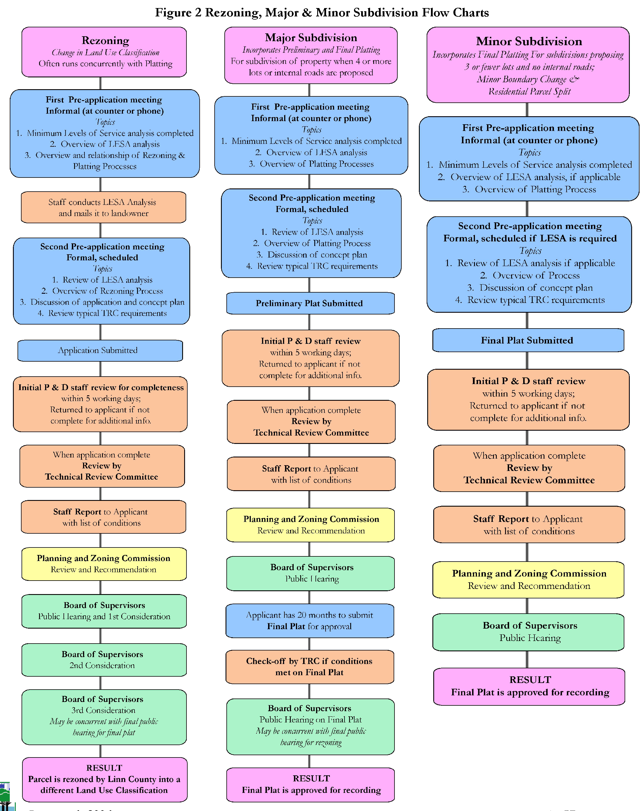
(Code 2006, ch. 41, art. 4, att.)