
Los Angeles County Unincorporated
City Zoning Code
City Zoning Code
Division 1
INTRODUCTORY PROVISIONS
22.02.010 - Title.
Title 22 (Planning and Zoning) of the Los Angeles County Code shall be known and cited as this "Title 22," the "Zoning Ordinance," or the "Zoning Code."
(Ord. 2019-0004 § 1, 2019.)
22.02.020 - Purpose.
In the creation of the respective zones set forth herein by this Title 22 ordinance, the Board of Supervisors has given due and special consideration to the peculiar suitability of each and every such zone herein created for the particular uses enumerated therefor, the area requirements, density of land occupancy, and the necessary, proper, and comprehensive groupings and arrangements of the various industries, businesses, and population of the unincorporated area of the County of Los Angeles (County) and in relation with established plans in the incorporated areas of the County in accordance with a well-considered master plan of land use for the development of the entire County, paying particular attention to those areas in said unincorporated area in which more densely populated communities have arisen, giving to such communities urban characteristics.
(Ord. 2019-0004 § 1, 2019.)
22.02.030 - Applicability of Title 22.
A.
Applicability.
1.
This Title 22 shall apply to all properties within the unincorporated area of Los Angeles County, including all uses, buildings, structures, and land owned by any private person, firm, corporation, or organization, or the County or other federal, State, or local agencies.
2.
Governmental and quasi-governmental agencies may be exempt from portions of this Title 22 pursuant to provisions of the California Government Code.
B.
Compliance. No land shall be used, and no structure shall be constructed, occupied, enlarged, altered, or moved except as permitted in this Title 22.
C.
Provisions Interpreted as Minimum Requirements. In interpreting and applying the provisions of this Title 22, they shall be held to be the minimum requirements for the promotion of the public health, safety, and general welfare.
D.
Regulations Not Exclusive. This Title 22 shall not relieve a person from the responsibility of complying with all other applicable regulations of any other federal, State, or County agency.
E.
Amendments and Additions Included. Whenever reference is made to this Title 22 or any portion of this Title 22, the reference applies to all amendments and additions made hereafter.
(Ord. 2019-0004 § 1, 2019.)
22.02.040 - Administration of Use Classifications.
A.
Principal Use. In determining compliance with this Title 22 as it applies to the uses listed in the basic zones, each principal use shall be considered a separate use, provided:
1.
The accessory uses, buildings, or structures shall be deemed an integral part of each principal use; and
2.
That more than one principal use may be placed on a single lot if not in conflict with other provisions of this Title 22.
B.
Accessory Use. The Director shall determine whether a use or structure may be considered accessory pursuant to the definitions contained in this Title 22.
(Ord. 2019-0004 § 1, 2019.)
22.02.050 - Consistency with the General Plan.
A.
General Plan Goals and Policies. Building permits may only be issued for developments and land uses that conform to the goals and policies of the General Plan, and any applicable Area, Community, or Neighborhood Plan.
B.
Use.
1.
General. Except as otherwise specified in Subsection B.2, below, building permits may be issued only for those land uses that are allowed through zoning and deemed compatible with the general intended uses of the land use designation in the General Plan, or an applicable Area, Community, or Neighborhood Plan.
2.
Housing Development Project. Notwithstanding Subsection B.1, above, building permits may be issued for a housing development project, as defined in Section 22.14.80, without a zone change, even if the use is prohibited in the zone, so long as the housing development project is consistent with the general intended uses of the land use designation in the General Plan, or an applicable Area, Community, or Neighborhood Plan. The housing development project may be subject to standards of a zone that are consistent with the general intended uses of the land use designation in the General Plan, or an applicable Area, Community, or Neighborhood Plan, pursuant to section 65589.5(i)(4) of the California Government Code.
C.
Density.
1.
General. Except as specified otherwise in this Title 22, all proposed densities, not including dwelling units permitted by a density bonus awarded by any provisions in this Title 22, shall fit within the range of density specified by the land use designation in the General Plan, or an applicable Area, Community, or Neighborhood Plan.
2.
Maximum. Except as specified otherwise in this Title 22, the maximum density specified by the land use designation in the General Plan, or an applicable Area, Community, or Neighborhood Plan shall be used to calculate the maximum number of dwelling units permitted on a lot, not including dwelling units permitted by a density bonus awarded by any provisions in this Title 22.
D.
Floor Area Ratio. Except as specified otherwise in this Title 22, all buildings subject to this Title 22 shall comply with the maximum floor area ratio specified by the land use designation in the General Plan, or an applicable Area, Community, or Neighborhood Plan.
(Ord. 2023-0038 § 1, 2023; Ord. 2021-0010 § 3, 2021; Ord. 2019-0004 § 1, 2019.)
22.02.055 - Applicability of Affordable Housing Replacement.
No approvals shall be issued under this Title 22 without replacement of affordable housing units, when required, pursuant to Chapter 22.119 (Affordable Housing Replacement).
22.02.060 - Condition of Land Use Approval.
As a condition of the approval of a zoning permit, the applicant shall agree to defend, indemnify, and hold harmless the County, its agents, officers, and employers from any action, or proceeding against the County, its agents, officers, or employees to attack, set a side, void, or annul an approval of the County. Although the applicant is the real party in interest in such an action, the County may, at its sole discretion, participate at its own expense in the defense of the action, but such participation shall not relieve the applicant of its obligations under this condition.
(Ord. 2019-0004 § 1, 2019.)
22.02.070 - Application Where Violation Exists.
A.
No application required pursuant to this Title 22 shall be accepted for processing or approved where an existing land use, not previously authorized by any statute or ordinance, is being maintained or operated in violation of any applicable provision of this Title 22, or any condition of approval of a land use permit. This provision applies to the operation of land uses only, and does not affect buildings or structures which do not conform to development standards.
B.
Where in the sole discretion of the Director, whose determination shall be final, the Director determines that the use in question is consistent with the objectives, goals, and policies of the General Plan, or that the continuation of said use is essential or desirable to the public convenience or welfare, this provision shall not apply.
(Ord. 2019-0004 § 1, 2019.)
22.02.080 - Approval Does Not Legalize Nuisances.
Any approval granted pursuant to this Title 22 shall not authorize nor legalize the maintenance of any public or private nuisance.
(Ord. 2019-0004 § 1, 2019.)
22.02.090 - Approvals Run with the Land.
Any approval granted pursuant to this Title 22 that is valid and in effect shall adhere to the land. The approval, including any applicable conditions or requirements, shall continue to be valid upon change of ownership of the subject land or any lawfully existing structure from the effective date of the approval, except if and when the approval expires and becomes void in compliance with this Title 22 or as otherwise specified in the approval.
(Ord. 2019-0004 § 1, 2019.)
22.02.100 - Severability.
22.04.010 - Purpose.
22.04.020 - Provisions Not Exclusive—More Restrictive Provisions Govern.
No part of Title 22 shall be deemed or construed to repeal, amend, modify, alter, or change any other ordinance or any part thereof not specifically repealed, amended, modified, altered, or changed herein, except in such particulars or matters as this title is more restrictive than such other ordinances or part thereof; and that in all particulars wherein this Title 22 is not more restrictive, each such other ordinance shall continue and shall be in full force and effect.
(Ord. 2019-0004 § 1, 2019.)
22.04.030 - Yards, Highway Lines, and Highways.
A.
Establishment—Purpose. To provide for adequate open spaces and the admission thereto of light and air, and to provide adequate visibility to the operators of motor and other vehicles along streets, highways, and parkways, and at the intersection thereof, the yards provided in Division 3 (Zones) and any Combining Zone identified in Section 22.06.030 (Combining Zones) and the yards and highway lines provided for in Chapter 22.110 (General Site Regulations) and Chapter 22.116 (Highway Lines, Road Dedication, and Access) are created and established as part of a comprehensive system of yard and highway lines covering the unincorporated area of the County.
B.
Use Restrictions. A person shall not use any building, structure, equipment, or obstruction within any yard or highway line except as hereinafter specifically permitted in this Title 22, and subject to all regulations and conditions enumerated in this Title 22.
C.
Supplemental Districts and General Site Regulations Provisions Applicable When. Where a different yard requirement is established by any Supplemental District identified in Section 22.06.040 (Supplemental Districts) or Chapter 22.110 (General Site Regulations), it shall supersede the yard requirements contained elsewhere in this Title 22.
(Ord. 2019-0004 § 1, 2019.)
22.04.040 - Rules for Language.
The following rules for language shall apply:
A.
The following conjunctions shall be interpreted as follows:
1.
"And" indicates that all connected words or provisions shall apply.
2.
"Or" indicates that the connected words or provisions may apply individually or in any combination.
3.
"Either . . . or" indicates that the connected words or provisions shall apply individually but not in combination.
B.
All references to departments, committees, commissions, boards, or other public agencies, and public officials are to those of the County, unless stated otherwise.
C.
All references to Department and Director are to those of the County Department of Regional Planning, unless stated otherwise, and all references to the Commission are to the County Regional Planning Commission unless stated otherwise.
D.
All references to the Board are to the Los Angeles County Board of Supervisors, unless stated otherwise.
E.
All references to the General Plan are to the Los Angeles County General Plan.
F.
All references to days are to calendar days, unless stated otherwise.
G.
All references to lists of items or examples that use terms such as "including," "such as," or similar language are intended to provide examples and are not exhaustive lists of all possibilities.
H.
The words "shall," "will," "must," and "is to" shall mean mandatory requirements.
I.
The words "should" or "may" shall mean that the provisions are optional, subject to the Department's discretion.
J.
The present tense includes the past and future tenses, and the future tense includes the present.
K.
The singular number includes the plural and the plural includes the singular.
L.
Section and subsection headings contained herein shall not be deemed to govern, limit, modify, or in any manner affect the scope, meaning, or intent of any section.
(Ord. 2019-0004 § 1, 2019.)
22.04.050 - Rules for Measurement.
The following rules for measurement shall apply:
A.
Fractions.
1.
Parking Spaces.
a.
Calculations for parking spaces shall comply with Section 22.112.070.C (Fractions).
b.
Exception. Calculations for parking spaces for projects subject to Chapter 22.120 (Density Bonus) shall comply with Subsection A (Fractional Numbers) of Section 22.120.100.
2.
Density. Where a density calculation results in a fractional number, the result shall be rounded up to the nearest whole number.
3.
Other Fractions. Notwithstanding Subsections A.1 and A.2, above, when a measurement is expressed in terms of maximum or minimum limits or requirements, any other fractional measurement shall not be rounded. For example, if a maximum height for a building is 35 feet and the proposed building actually measures 35 feet and 6 inches, then the height is not in compliance with the requirement.
B.
Distance.
1.
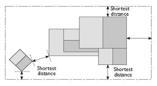
Measurements are Shortest Distance.
a.
Measurement of a required distance shall be made from the closest or shortest distance between the two objects. For example, see Figure 22.04.050-A, below.
b.
The following shall be excluded when measuring required distances:
i.
Projections, as permitted in Section 22.110.090 (Projections into Yards) and Section 22.140.585.F.17 (Projections into Yards).
ii.
The below-ground portion of a basement.
FIGURE 22.04.050-A: MEASUREMENTS ARE SHORTEST DISTANCE
2.
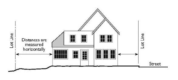
Distances are Measured Horizontally. When determining distances for setbacks and structure dimensions, all distances are measured along a level horizontal plane from the appropriate line, edge of building, structure, storage area, parking area, or other object. Distances shall not be measured by following the topography or slope of the land. For example, see Figure 22.04.050-B, below.
FIGURE 22.04.050-B: DISTANCES ARE MEASURED HORIZONTALLY
C.
Height.
1.
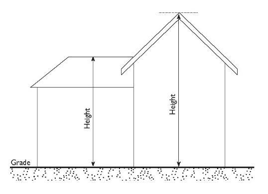
Measuring Height. Measurement of the height of building or structure shall be the plumb line distance from the point being measured to the grade. For example, see Figure 22.04.050-C, below.
FIGURE 22.04.050-C: MEASURING HEIGHT
D.
Flag Lot Width and Depth. With the exception of flag lots that are created within a compact lot subdivision, measurement for the average width and depth of a flag lot shall comply with Section 22.110.170.A (Measurement).
E.
Gross Floor Area and Floor Area Ratio.
1.
Gross Floor Area. Gross floor area shall be the total gross area of all floors of a building expressed in square feet.
a.
Included in Gross Floor Area. Gross floor area shall be the total building area, measured from the exterior of the building walls, of all floors of a building expressed in square feet.
b.
Excluded from Gross Floor Area. Gross floor area shall exclude:
i.
Parking structures, garages, carports, or other areas designated for parking and loading, or vehicular access to parking and loading spaces, because these structures shall be counted separately.
ii.
Unenclosed exterior balconies, decks, porches, courts, and stairs.
iii.
Buildings or structures for housing building operating equipment or machinery.
iv.
Cellars.
v.
Attics, if not a habitable room as defined by Title 26 (Building Code) of the County Code.
2.
Floor Area Ratio. Floor area ratio shall be the numerical value obtained through dividing the above ground gross floor area of a building or buildings located on a lot by the total area of such lot. Floor area ratio is expressed as a decimal number and shall be rounded to the tenths place.
F.
Lot Coverage.
1.
General.
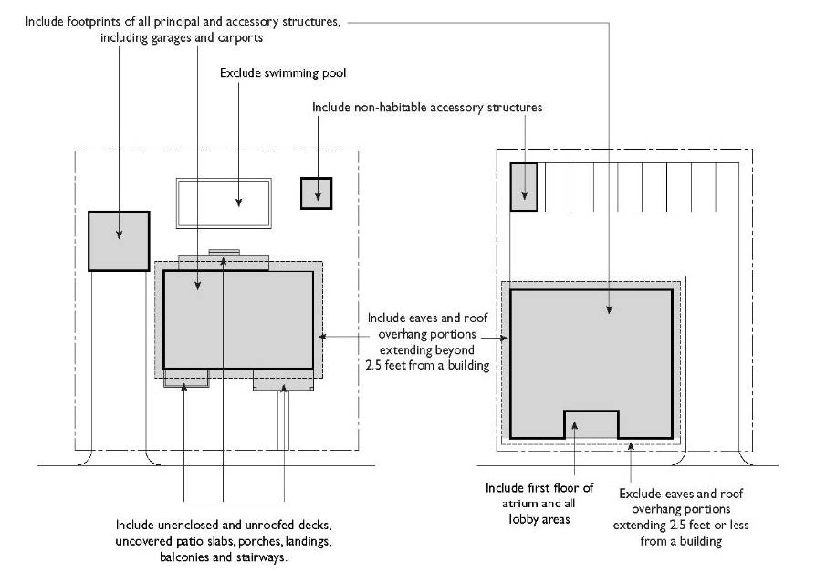
a.
Lot coverage shall be the ratio of the total footprint area of all buildings and structures on a lot to the net lot area, expressed as a percentage with a decimal number to the hundredths place.
b.
For examples of this Subsection F, see Figure 22.04.050-D, below.
2.
Included in Lot Coverage. Lot coverage shall include:
a.
The footprints of all principal and accessory building and structures, including garages, carports, covered patios, and roofed porches. The footprint shall be measured from the exterior walls or the exterior supports, and include all habitable and non-habitable rooms, and interior walls and partitions.
b.
Unenclosed and unroofed decks, uncovered patio slabs, porches, landings, balconies, and stairways.
c.
Eaves and roof overhangs that project more than two and one-half feet from the building wall.
d.
The first floor of atrium and all lobby areas.
3.
Excluded from Lot Coverage. Lot coverage shall exclude:
a.
Uncovered walkways, driveways, and landscaping.
b.
Eaves and roof overhangs when projecting less than two and one-half feet from the building wall.
c.
Swimming pools and hot tubs that are not enclosed in roofed buildings, structures, or decks.
FIGURE 22.04.050-D: LOT COVERAGE
G.
Compact Lot Width.
1.
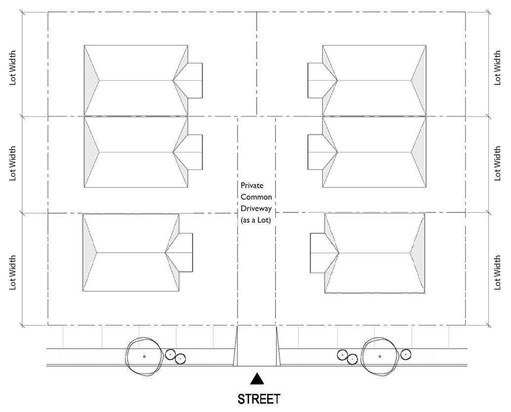
The average width of a compact lot that fronts a private common driveway perpendicular to a public right-of-way, including any flag lot whose access strip serves in whole or in part as the private common driveway, shall be measured as follows (see Figures 22.04.050-E and 22.04.050-F):
FIGURE 22.04.050-E: COMPACT LOT WIDTH WHEN FRONTING SIDE PRIVATE COMMON DRIVEWAY
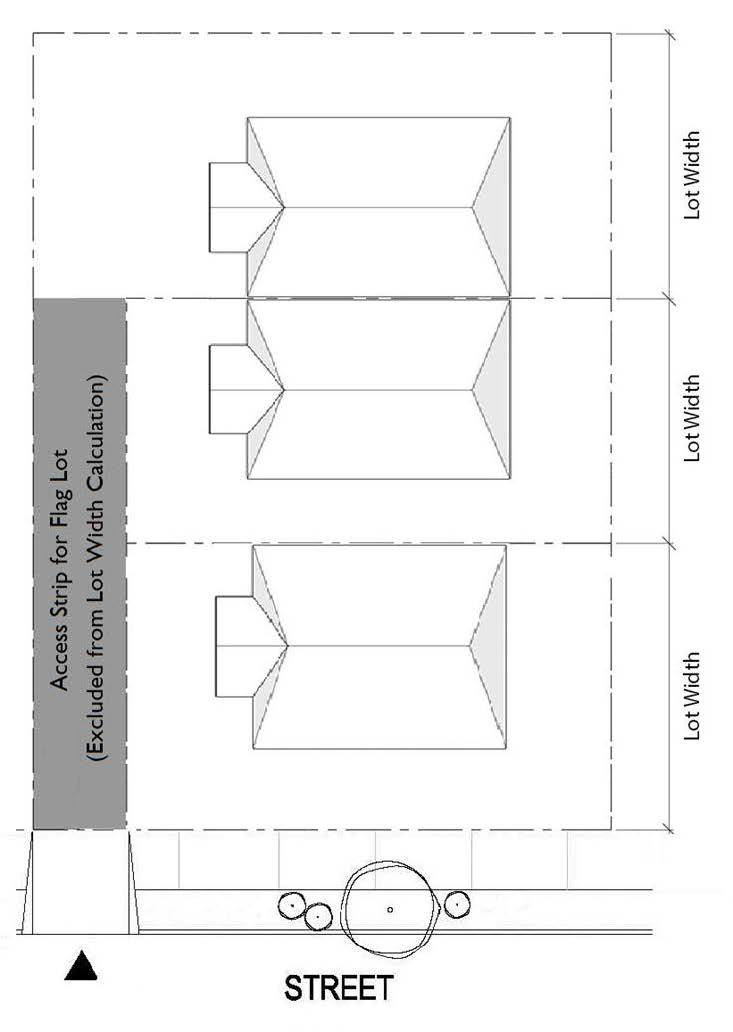
FIGURE 22.04.050-F: COMPACT LOT WIDTH WHEN FRONTING
CENTRAL PRIVATE COMMON DRIVEWAY
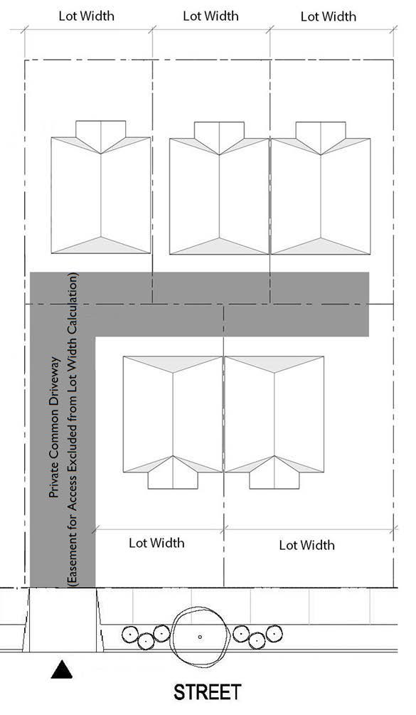
2.
Where a compact lot is bounded by a T-shaped or an L-shaped private common driveway, the average width of the compact lot shall be measured as follows (see Figures 22.04.050-G and 22.04.050-H):
FIGURE 22.04.050-G: COMPACT LOT WIDTH WHEN FRONTING
T-SHAPED PRIVATE COMMON DRIVEWAY
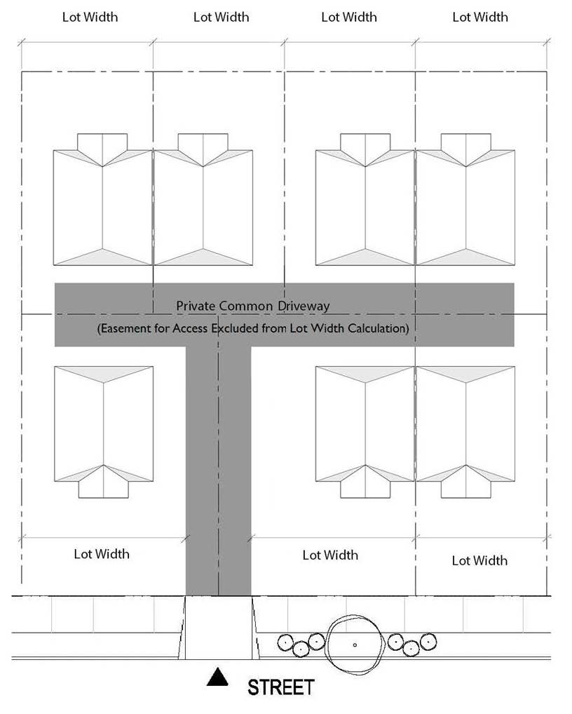
FIGURE 22.04.050-H: COMPACT LOT WIDTH WHEN FRONTING
L-SHAPED PRIVATE COMMON DRIVEWAY
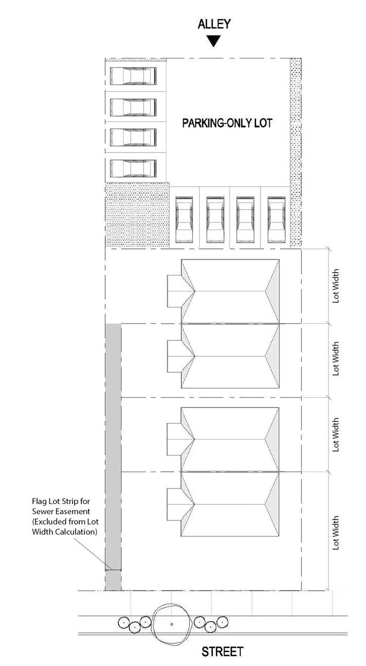
3.
Where a compact lot subdivision contains a parking-only lot pursuant to Section 22.140.585.F.8.b (Parking-Only Lot), the average width of a compact lot shall be measured as follows (see Figure 22.04.050-I):
FIGURE 22.04.050-I: COMPACT LOT WIDTH WHEN COMPACT LOT
SUBDIVISION CONTAINS PARKING-ONLY LOT
(Ord. 2021-0010 § 4, 2021; Ord. 2020-0032 § 12, 2020; Ord. 2019-0053 § 4, 2019; Ord. 2019-0004 § 1, 2019.)
22.04.060 - Interpretation of Rules.
The Director may make interpretations for any provision or measurements not expressly identified in this Chapter and provide clarification of these rules and their application, in compliance with Chapter 22.234 (Interpretations).
(Ord. 2019-0004 § 1, 2019.)
22.06.010 - Zones Established.
A.
To classify regularly and restrict the location of trades and industries and the location of buildings for special uses, and the use and area of premises for the general welfare of the County as regulations for the execution of the General Plan pursuant to Chapters 3 and 4 of Division 1 of Title 7 (Planning and Land Use) of the California Government Code, or any statute superseding those chapters, the unincorporated area of the County is divided into classes of zones, according to Table 22.06.010-A, below.
B.
Zones designated in Subsection A, above, shall be deemed the basic zone.
(Ord. 2022-0008 § 1, 2022; Ord. 2019-0004 § 1, 2019.)
22.06.020 - Suffixes to Zoning Symbols.
Notwithstanding Section 22.02.050.B (Density), the letter "U," where used as a suffix to a zoning symbol, in combination with a numeral, shall designate the maximum density, not including dwelling units permitted by a density bonus awarded by any provisions in this Title 22, in terms of units per net acre.
(Ord. 2021-0010 § 5, 2021; Ord. 2019-0004 § 1, 2019.)
22.06.030 - Combining Zones.
Combining Zones are established according to Table 22.06.030-A, below. Combining Zones are established as additional zone designations used in combination with the basic zone.
(Ord. 2024-0032 § 1, 2024; Ord. 2024-0028 § 1, 2024; Ord. 2019-0004 § 1, 2019.)
22.06.040 - Supplemental Districts.
Supplemental districts are established according to Table 22.06.040-A, below. The regulations of each such supplemental district shall supersede the specific regulations of the basic zone to which the district is added in the manner indicated for each type of district.
(Ord. 2024-0032 § 2, 2024; Ord. 2024-0029 § 1, 2024; Ord. 2019-0004 § 1, 2019.)
22.06.050 - Special Management Areas.
Special Management Areas are established according to Table 22.06.050-A, below.
(Ord. 2019-0004 § 1, 2019.)
22.06.060 - Zoned Districts Established.
Zoned Districts are established according to Table 22.06.060-A, below.
(Ord. 2025-0007Z § 1, 2025; Ord. 2025-0006Z § 1, 2025; Ord. 2025-0005Z § 1, 2025; Ord. 2024-0052Z § 1, 2024; Ord. 2024-0031Z § 1, 2024; Ord. 2024-0030Z § 1, 2024; Ord. 2024-0027Z § 1, 2024; Ord. 2023-0051Z § 1, 2023; Ord. 2023-0039Z § 1, 2023; Ord. 2023-0024Z § 1, 2023; Ord. 2023-0014Z § 1, 2023; Ord. 2023-0002Z § 1, 2023; Ord. 2022-0033Z § 1, 2022; Ord. 2022-0024Z § 1, 2022; Ord. 2021-0064Z § 1, 2021; Ord. 2021-0033 § 1, 2021; Ord. 2021-0026Z § 1, 2021; Ord. 2021-0022Z § 1, 2021; Ord. 2021-0012Z § 1, 2021; Ord. 2021-0006Z § 1, 2021; Ord. 2020-0025Z § 1, 2020; Ord. 2019-0002Z § 1, 2020; Ord. 2019-0046Z § 1, 2019; Ord. 2019-0038Z § 1, 2019; Ord. 2019-0036Z § 1, 2019; Ord. 2019-0026 § 1, 2019; Ord. 2019-0023 § 1, 2019; Ord. 2019-0004 § 1, 2019.)
22.06.070 - Zoning Map.
A.
Zoning Map. The boundaries of the zones established by this Title 22 are shown on the Zoning Map. The Zoning Map shall be maintained in the County's geographic information system. The Zoning Map is hereby incorporated into this Title 22 and may be amended pursuant to this Title 22 and Title 7 (Planning and Land Use) of the California Government Code.
B.
Boundaries. Where the boundaries of any zone are not clearly determined or shown on the Zoning Map, the Director shall make an interpretation in accordance with Chapter 22.234 (Interpretations).
C.
Zoning for Vacated Streets and Alleys. Where a public street or alley is officially vacated, the zoning regulations applicable to the abutting property shall apply to the vacated portion.
D.
Property Divided by Zone Boundaries. If a zone boundary divides a lot where either or both portions of such lot created by such division are not in Zones -P, B-1, or B-2, and are of such size and shape that no part of such portion is more than 50 feet from such zone boundary, then that portion may be used for any purpose permitted in the other portion of such lot if such lot is:
1.
Shown as a single lot on a final subdivision map which map was recorded with the Registrar-Recorder/County Clerk after the effective date of such zone boundary; and
2.
At all times since the recording of such final map, in undivided ownership.
(Ord. 2019-0004 § 1, 2019.)