
Los Angeles County Unincorporated
City Zoning Code
City Zoning Code
Division 6
DEVELOPMENT STANDARDS
Chapter 22.119 - AFFORDABLE HOUSING REPLACEMENT
Sections:
Chapter 22.128 - SUPPORTIVE HOUSING
Sections:
22.110.010 - Purpose.
This Chapter prescribes development and site regulations to encourage development that produces an environment of desirable character, is compatible with existing development, and protects the use and enjoyment of neighboring properties.
(Ord. 2019-0004 § 1, 2019.)
22.110.020 - Applicability.
A.
This Chapter shall apply to development in all zones, unless superseded by more specific regulations in this Title 22.
B.
A person shall not use any building, structure, equipment, or obstruction within any yard or highway line except as hereinafter specifically permitted in this Title 22, and subject to all regulations and conditions enumerated in this Title.
(Ord. 2019-0004 § 1, 2019.)
22.110.030 - Accessory Buildings.
The following accessory buildings are permitted in required yards:
A.
Garages or Carports within Front Yards on Sloping Terrain. A one-story attached or detached garage or carport may be used within a required front yard on sloping terrain, provided that:
1.
The difference in elevation between the curb level and the natural ground at a point 25 feet from the highway line is five feet or more; or where there is no curb, that a slope of 20 percent or more from the highway line to a point on natural ground 25 feet from said highway line exists. Measurement in all cases shall be made from a point midway between the side lot lines;
2.
The garage or carport is located not closer than five feet to a highway line or closer to a side lot line than is permitted for a main building on such lot; and
3.
The garage or carport does not exceed a height of 15 feet above the level of the centerline of the adjoining street or highway.
B.
Garages and Carports in Rear and Side Yards. One-story detached garages and carports may be used within a required interior side and rear yard, provided that:
1.
The detached garages and carports are located 75 feet or more from the front lot line;
2.
Where the garages or carports have direct vehicular access to an alley, they shall be located a distance of not less than 26 feet from the opposite right-of-way line of such alley;
3.
On a corner or reversed corner lot, the garage or carport is located not closer to the highway line than a distance equal to the corner side yard;
4.
The provision is made for all roof drainage to be taken care of on the same property; and
5.
No more than 50 percent of the required rear yard shall be covered by buildings or other roofed structures.
C.
Accessory Dwelling Units in Rear and Side Yards. Accessory dwelling units are subject to yard requirements as provided in Section 22.140.640.
D.
Other Accessory Buildings in Rear Yards. Other one-story accessory buildings permitted in the zone, excluding guest houses or any other building designed or used for living or sleeping purposes, may be used within a required rear yard, provided that:
1.
Such buildings are not placed within a required side yard;
2.
Such buildings are placed not closer than five feet to any lot line; and
3.
Not to exceed 50 percent of the required rear yard shall be covered by buildings or other roofed structures.
E.
Replacement of Open Space. The Director may modify Subsection D.3, above, and approve buildings or other roofed structures covering an area in excess of 50 percent of a required rear yard, provided that:
1.
An equivalent area replacing the covered area is substituted elsewhere on the property;
2.
The Director determines that the equivalent area substituted is equally satisfactory with regard to usability and location; and
3.
Such equivalent area does not exceed 10 percent in grade and has a minimum dimension of not less than 15 feet. Such dimension may include area contained in the required rear or side yard but required yards shall not be included in computing such equivalent replacement area.
(Ord. 2019-0020 § 10, 2019; Ord. 2019-0004 § 1, 2019.)
22.110.040 - Accessory Structures and Equipment.
The following structures are permitted in required yards:
A.
Planter Boxes and Masonry Planters. The maximum height of planter boxes and masonry planters in required front yards shall not exceed a height of three and one-half feet.
B.
Swimming Pools. A swimming pool is permitted in a required rear yard, provided that it is at least five feet from any lot line.
C.
Guard Railings or Fences for Safety Protection. Guard railings or fences for safety protection adjacent to depressed ramps may be placed in any yard, provided that:
1.
An open-work railing or fence is used; and
2.
Such railing or fence does not exceed a height of three and one-half feet.
D.
Driveways, Walkways, and Patio Slabs. Driveways, walkways, patio slabs, and other areas constructed of concrete, asphalt, or similar materials, and wooden decks, may be used in any required yard. The maximum height of such structures in a required yard may not exceed one foot above ground level. Steps providing access between areas of different elevation on the same property are included in this requirement.
E.
Ground-Mounted Equipment. Ground-mounted air conditioners, swimming pool pumps, heaters, filters, and fans may be used in required rear yards, provided that:
1.
Such structures or equipment are at least two and one-half feet from any lot line; and
2.
Such structures or equipment do not exceed a height of six feet measured from the base of the unit.
F.
Equipment in Rear Yards. The following equipment may be placed in rear yards:
1.
Trash enclosures for developments not subject to Chapter 22.132 (Storage Enclosure Requirements for Recycling and Solid Waste).
2.
Movable dog houses.
3.
Movable children's play equipment.
G.
Temporary Signs. Temporary signs advertising the sale or lease of the premises on which the sign is located may be placed within the front or corner side yard if a minimum setback of 10 feet is maintained from the highway line. All such signs shall comply with Chapter 22.114 (Signs).
H.
Projecting On-Site Signs. On-site signs permitted by Chapter 22.114 (Signs) and attached to a lawfully existing building may extend a maximum of 18 inches into the front or corner side yard. This Subsection H does not authorize the projection of such signs beyond the right-of-way line established by the highway line.
I.
Freestanding Signs in Zones C-H and C-1. Freestanding signs in Zones C H and C-1 may be placed in the front yard subject to Chapter 22.114 (Signs).
(Ord. 2024-0028 § 9, 2024; Ord. 2019-0004 § 1, 2019.)
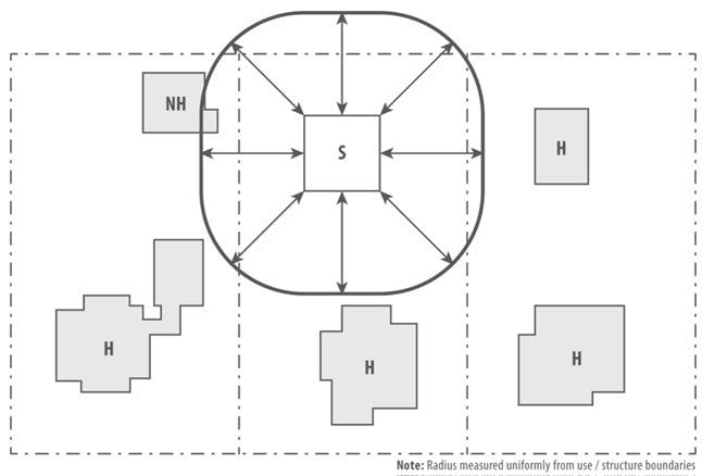
22.110.050 - Distance Between Buildings.
A.
Where more than one building is placed on a lot, the following minimum distances shall apply in any zone where front, side, and rear yards are required by this Title 22:
1.
Distance Between Main Buildings. A minimum distance of 10 feet shall be required between all main residential buildings on the same lot.
2.
Distance Between Accessory and Main Buildings. Except where a greater distance is required by this Title 22, a minimum distance of six feet shall be required between any main residential building and any accessory building on the same lot.
3.
Projections Permitted Between Buildings on the Same Lot. The following projections are permitted within the required distance between buildings, provided they are developed subject to the same standards as, and are not closer to, a line midway between such buildings than is permitted in relation to a side lot line within a required interior side yard:
a.
Eaves and cantilevered roofs.
b.
Fireplace structures, buttresses, and wing walls.
c.
Rain conductors and spouts, water tables, sills, capitals, cornices, and belt courses.
d.
Awnings and canopies.
e.
Water heaters, water softeners, and gas or electric meters; including service conductors and pipes.
f.
Exterior stairways and balconies above the level of the first floor.
B.
Uncovered porches, platforms, landings, decks, and related access stairs that do not extend above the first floor, are permitted between buildings without any distance restriction.
FIGURE 22.110.050-A: DISTANCE BETWEEN BUILDINGS
(Ord. 2019-0004 § 1, 2019.)
22.110.060 - Height Limits.
A.
Maximum Height. The height of buildings, except where otherwise provided, shall be determined by the total floor area in all the buildings on any one lot shall not exceed 13 times the buildable area of such lot. Cellar floor space, parking floor space with related interior driveways and ramps, or space within a roof structure or penthouse for the housing of building operating equipment or machinery shall not be considered in determining the total floor area within a building.
B.
Buildable Area. Where any provision of this Title 22, or of any other ordinance, requires any front, side, or rear yards, or prohibits the occupation of more than a certain portion of a lot by a structure, the portion of such lot which may be occupied by structures is the "buildable area" as used in Subsection A, above.
C.
Exceptions from Height Limit. The following are exceptions from the maximum permitted height limits stated by this Title 22:
1.
Chimneys and rooftop antennas.
2.
Signs, as regulated by this Title 22.
(Ord. 2019-0004 § 1, 2019.)
22.110.070 - Fences and Walls.
A.
Measuring Height of Fences and Walls. The height of a fence or wall shall be measured at the highest average ground level within three feet of either side of said wall or fence. In order to allow for variation in topography, the height of a required fence or wall may vary an amount not to exceed six inches; provided that the average height of such fence or wall shall not exceed the specified maximum height. For example, see Figure 22.110.070-A, below.
FIGURE 22.110.070-A: MEASURING FENCE HEIGHT
B.
Maximum Height of Fences and Walls. Fences and walls may be erected and maintained in required yards subject to the following requirements:
1.
Front Yards. Fences and walls within a required front yard shall not exceed three and one-half feet in height. For example, see Figure 22.110.070-A, above.
2.
Interior Side and Rear Yards. Fences and walls within a required interior side yard or rear yard shall not exceed six feet in height, provided that on the street or highway side of a corner lot such fence or wall shall be subject to the same requirements as for a corner side yard. For example, see Figure 22.110.070-A, above.
3.
Corner Side Yards. Fences and walls within a required corner side yard shall not exceed three and one-half feet in height where closer than five feet to the highway line, nor exceed six feet in height where located five feet or more from said highway line.
4.
Retaining Walls.
a.
Retaining Walls. Retaining walls within required yards shall not exceed six feet in height.
b.
Retaining Walls Topped with Walls or Fences.
i.
Where a retaining wall protects a cut below the natural grade and is located on a front, side, or rear lot line, such retaining wall may be topped by a fence or wall of the same height that would otherwise be permitted at the location if no retaining wall existed. Where such retaining wall contains a fill, the height of the retaining wall built to retain the fill shall be considered as contributing to the permissible height of a fence or wall; provided that a non-view-obscuring fence of three and one-half feet may be erected at the top of the retaining wall for safety protection.
ii.
Where a wall or fence is located in the required yard adjacent to a retaining wall containing a fill, such wall or fence shall be set back from said retaining wall a distance of one foot for each one foot in height, to a maximum distance of five feet. This Subsection B.4.ii does not permit a wall or fence in required yards higher than permitted by this Section. The area between such wall or fence and said retaining wall shall be landscaped and continuously maintained in good condition.
5.
Flag Lots. Notwithstanding this Subsection B, fences or walls are permitted within any required yard on flag lots to a height not to exceed six feet, pursuant to the approval of a Ministerial Site Plan Review (Chapter 22.186) application.
6.
Exemption. Where a fence or wall that is required by any law or regulation of the State of California, and that fence or wall exceeds any height limitation specified by this Title 22, said fence or wall shall be permitted and shall not exceed such required height by any law or regulation of the State of California.
C.
Landscaping as Fences and Walls. Trees, shrubs, flowers, and plants may be placed in any required yard, provided that all height restrictions applying to fences and walls shall also apply to hedges planted within yards and forming a barrier serving the same purpose as a fence or wall.
(Ord. 2019-0004 § 1, 2019.)
22.110.080 - Required Yards.
A.
Yard Determination. On corner lots, through lots with three or more frontages, flag lots, and irregularly shaped lots, where the provisions of this Title 22 do not clearly establish location of yards and lot lines, the Director shall make such determination.
B.
Front Yards.
1.
On Partially Developed Blocks. Where some lots in a block are improved or partially improved with buildings, each lot in said block may have a front yard of not less than the average depth of the front yards of the land adjoining on either side. A vacant lot, or a lot having more than the front yard required in the zone, shall be considered for this purpose as having a front yard of the required depth.
2.
On Key Lots. The depth of a required front yard on key lots shall not be less than the average depth of the required front yard of the adjoining interior lot and the required side yard of the adjoining reversed corner lot.
3.
On Sloping Terrain. The required front yard of a lot need not exceed 50 percent of the depth required in a zone where the difference in elevation between the curb level and the natural ground at a point 50 feet from the highway line, measured midway between the side lot lines, is 10 feet or more; or, if there is no curb, where a slope exists of 20 percent or more from the highway line to a point on natural ground 50 feet from said highway line. Measurement in all cases shall be made from a point midway between the side lot lines.
C.
Side Yards.
1.
Reversed Corner Lots Adjoining Key Lots. Where the front yard of a key lot adjoining a reversed corner lot is less than 10 feet in depth, such reversed corner lot may have a corner side yard of the same depth, but not less than five feet.
2.
Interior Side Yards on Narrow Lots. Where a lot is less than 50 feet in width, such lot may have interior side yards equal to 10 percent of the average width, but in no event less than three feet in width.
D.
Rear Yards on Shallow Lots. Where a lot is less than 75 feet in depth, such lot may have a rear yard equal to 20 percent of the average depth, but in no event less than 10 feet in depth.
E.
Limited Secondary Highways.
1.
Supplemental Yard. A supplemental yard eight feet wide shall be established in all zones along and contiguous to the highway lines of limited secondary highways; any other yard requirements established in Division 3 (Zones), Chapter 22.50 (Billboard Exclusion Zone), Chapter 22.52 (Development Program Zone), Chapter 22.54 (Parking Zone), Chapter 22.58 (Commercial—Residential Zone), Chapter 22.60 (Industrial Preservation Zone), and Section 22.140.585 (Single-Family Residences on Compact Lots), shall be in addition to this requirement.
2.
Use of Supplemental Yard. A person shall not use any building or structure within this supplemental yard except for openwork railings or fences which do not exceed six feet in height and except as permitted within a yard by Section 22.110.040.A (Planter Boxes and Masonry Planters), Section 22.110.040.D (Driveways, Walkways, and Patio Slabs), Section 22.140.585.F.15.a (Planter Boxes and Masonry Planters), and Section 22.140.585.F.15.c (Driveways, Walkways, and Patio Slabs).
3.
Yard Modification. The supplemental yard requirement established by this Subsection E may be modified with the approval of a Yard Modification (Chapter 22.196) application.
(Ord. 2020-0032 § 20, 2020; Ord. 2019-0004 § 1, 2019.)
22.110.090 - Projections into Yards.
The following projections are permitted in required yards subject to the provisions of this Title 22 and Title 26 (Building Code) of the County Code.
A.
Eaves and Cantilevered Roofs. Eaves and cantilevered roofs may project a maximum distance of two and one-half feet into any required yard, provided that:
1.
Such eaves or cantilevered roofs are not closer than two and one-half feet to any lot or highway line;
2.
No portion of such eaves or cantilevered roofs are less than eight feet above grade; and
3.
There are no vertical supports within the required yard.
B.
Awnings and Canopies. Awnings and canopies may project a maximum distance of two and one-half feet into a required interior side yard and five feet into a required front, rear, and corner side yard, provided that:
1.
Such structures are not closer than two and one-half feet to any lot or highway line;
2.
Such structures have no vertical support within such yard; and
3.
Such awnings or canopies extend only over the windows or doors to be protected, and for not more than one foot on either side thereof.
C.
Fireplace Structures. Fireplace structures, not wider than eight feet measured in the general direction of the wall of which they are a part, buttresses, and wing walls may project a maximum distance of two and one-half feet into any required yard, provided that:
1.
Such structures are not closer than two and one-half feet to any lot or highway line; and
2.
Such structures shall not be utilized to provide closets or otherwise increase usable floor area.
D.
Porches, Platforms, Landings, and Decks.
1.
Uncovered porches, platforms, landings, and decks, including any access stairs exceeding an average height of one foot, which do not extend above the level of the first floor may project a maximum distance of three feet into required interior side yards, and a maximum distance of five feet into required front, rear, and corner side yards, provided that:
a.
Such porches, platforms, landings, and decks shall not be closer than two feet to any lot or highway line; and
b.
Such porches, platforms, landings, and decks are open and unenclosed; provided, that an openwork railing not to exceed three and one-half feet in height may be installed.
2.
Porches, platforms, landings, and decks may be covered provided that in addition to the requirements in Section 22.110.090.D.1:
a.
Such covered porches, platforms, landings, and decks may project a maximum distance of three feet into required interior side yards and a maximum distance of five feet into required front, rear, and corner side yards;
b.
Such covered porches, platforms, landings, and decks shall not be closer than two feet to any lot or highway line; and
c.
Such covered porches, platforms, landings, and decks do not extend above the level of the first floor or 12 feet, whichever is lower.
E.
Rain Conductors. Rain conductors, spouts, utility-service risers, shut-off valves, water tables, sills, capitals, bases, cornices, and belt courses may project a maximum distance of one foot into any required yard.
F.
Equipment. Water heaters, water softeners, and gas or electric meters, including service conduits and pipes, enclosed or in the open, may project a maximum distance of two and one-half feet into a required interior side or rear yard, provided that such structures or equipment are not closer than two and one-half feet to any lot line. Gas meters, if enclosed or adequately screened from view by a structure permitted in the yard, may project a maximum distance of two and one-half feet into a required front or corner side yard, provided that such equipment is not closer than two and one-half feet to any lot or highway line.
G.
Stairways and Balconies. Stairways and balconies above the level of the first floor may project a maximum distance of two feet into a required interior or corner side yard, or four feet into a required front or rear yard, provided that:
1.
Such stairways and balconies shall not be closer than three feet to any lot or highway line;
2.
Such stairways and balconies are open and unenclosed; and
3.
Such stairways and balconies are not covered by a roof or canopy except as otherwise provided by Subsection B, above.
H.
Covered Patios. Covered patios attached to a dwelling unit may project into a required rear yard, provided that:
1.
Such patio roofs are not closer than five feet to any lot line;
2.
No more than 50 percent of the required rear yard is covered by buildings or other roofed structures, except as provided in Section 22.110.030.E (Replacement of Open Space); and
3.
Such patio shall remain permanently open and unenclosed on at least two sides. This provision does not preclude the placement of detachable screens.
I.
Uncovered Patios. Uncovered patios shall comply with Section 22.110.030.D (Other Accessory Buildings in Rear Yards).
J.
Wall and Window Mounted Air Conditioners, Coolers, and Fans. Wall- and window-mounted air conditioners, coolers, and fans may be used in any required yard, provided that such equipment is not closer than two and one-half feet to any lot line.
(Ord. 2024-0049 § 19, 2024; Ord. 2022-0008 § 80, 2022; Ord. 2019-0004 § 1, 2019.)
22.110.100 - Conversion or Alteration of Buildings and Structures.
No building or structure existing at the time of the effective date of this Section, or by any subsequent amendment to this Section, which is designed, arranged, intended for, or devoted to a use not permitted in the zone in which such building or structure is located, shall be enlarged, extended, reconstructed, built upon, or structurally altered unless the use of such building or structure is changed to a use permitted in the zone where the building is located.
(Ord. 2019-0004 § 1, 2019.)
22.110.110 - Relocation of Buildings and Structures.
A.
Conditions. No building or structure shall be moved from one lot or premises to another unless such building or structure can be made to conform to all provisions of this Title 22 relative to all building or structures on the new lot or premises, and shall be made to conform to the general character of the existing buildings in the neighborhood, or better.
B.
For Public Use. Where a building or structure is lawfully located on property acquired for public use (by condemnation, purchase, or otherwise), such building or structure may be relocated on the same lot, even if such building or structure exists as a nonconforming use or even if it is not in compliance with the area or width regulations of this Title 22. Where any part of such building or structure is acquired for public use, the remainder of such building or structure may be repaired, reconstructed, or remodeled, with the same or similar kind of materials as used in the existing buildings.
(Ord. 2019-0004 § 1, 2019.)
22.110.130 - Required Area and Width.
A.
Required Area. As used in this Title 22, "required area" means:
1.
The area of a lot which is shown as a part of a subdivision for purposes of sale, recorded as a final map or filed as a record of Survey Map approved as provided in the Subdivision Map Act or as provided in Title 21 (Subdivisions) of the County Code, except that where a lot which otherwise would have been shown as one lot, is divided into two or more lots because of a city boundary line or a line between land the title to which was registered under the Land Title Law (Torrens Title) and land the title to which was not so registered, in which case "required area" means the area of such lot; or
2.
The area of a lot, the right of possession of which, by virtue of a deed duly recorded, or by a recorded contract of sale, is vested in a person who neither owns nor has a right of possession of any contiguous lot or property; provided, that the deed or contract of sale by which such right of possession was separated has been recorded prior to the adoption by the Board of the ordinance which imposes the area requirements upon such lot; or
3.
a.
Where a number follows the zoning symbol and Subsection A.1 or A.2, above, does not apply:
i.
A gross area, including that portion, if any, subject to a highway easement or other public or private easement where the owner of the servient tenement does not have the right to use the entire surface, of the number of acres shown by such number if such number is less than 100, provided that the portion of the lot not subject to any such easement shall have an area not less than 40,000 square feet, if the lot was established on or after September 22, 1967, or not less than 32,000 square feet if the lot was established before September 22, 1967, or
ii.
A net area of the number of square feet shown by such number if such number is greater than 100.
b.
"Required area" shall not include the access strip of a flag lot extending from the main portion of the lot to the adjoining parkway, highway, or street.
4.
Where no number follows the zoning symbol and Subsection A.3.a.i or A.3.a.ii, above, does not apply, the required area is:
a.
In Zone C-R, the same as in Zone C-R-5;
b.
In Zone A-2, the same as in Zone A-2-10,000;
c.
In Zones R-1, R-2, R-3, R-4, R-5, R-A, RPD, A-1, R-R, CPD, and M-3, the same as in Zone R-1-5000;
5.
A lot shown as such on a subdivision for the purpose of lease only does not have the required area unless it complies with Subsection A.2, A.3, or A.4, above;
6.
The area of a lot created prior to March 4, 1972, for which a certificate of compliance has been granted pursuant to Section 21.60.060 (Notices of Violation);
7.
The area of a lot for which a Variance (Chapter 22.194) application for lot area has been approved shall be deemed to have the required area;
8.
Notwithstanding any contrary provisions of this Subsection A, lots created within a compact lot subdivision shall be in compliance with Section 22.140.585.F.1.a (Required Area).
B.
Required Width. As used in this Title 22, "required width" means:
1.
The average width of a lot which is shown as part of a subdivision recorded as a final map or filed as a Record of Survey Map in accordance with law, except that where a parcel which otherwise would have been shown as one lot is divided into two or more lots because of the city boundary line or a line between land, the title to which is registered under the Land Title Law (Torrens Title) and land the title to which is not so registered in which case the "required width" means the average width of such lot;
2.
The average width of a lot, the right of possession of which, by virtue of a deed duly recorded, or by a recorded contract of sale, is vested in a person who neither owns nor has the right of possession of any contiguous lot, provided that the deed or contract of sale by which such right of possession was separated has been recorded prior to the adoption by the Board of the ordinance which imposes the width requirement upon such lot;
3.
The width specified by any legislative restriction except in those cases in which the Hearing Officer, in approving a tentative map of a subdivision as provided in Title 21 (Subdivisions) of the County Code, finds, pursuant to Section 21.52.010 (Modification or Waiver of Provisions Authorized When) of such Title that such width should be modified;
4.
An average width of 60 feet if the required area is 7,000 square feet or more; or
5.
An average width of 50 feet where there is a required area and such required area is less than 7,000 square feet. If there is no required area, there is no required width.
6.
Exceptions.
a.
Neither Subsection B.4 nor B.5, above, applies except in the Lancaster District No. 31 and Palmdale District No. 54, which are established in Section 22.06.060 (Zoned Districts Established).
b.
Except in the zoned districts in Subsection B.6.a, above, and except where a legislative restriction requires an average width of 60 feet, the average width of a lot created pursuant to Section 22.110.160 (Resubdivision Conditions for Undersized or Underwidth Lots) need not be more than 50 feet even if the required area is 7,000 square feet or greater.
c.
Notwithstanding any contrary provisions of this Subsection B, lots created within a compact lot subdivision shall be in compliance with Section 22.140.585.F.1.b (Required Width).
(Ord. 2021-0010 § 23, 2021; Ord. 2020-0032 § 21, 2020; Ord. 2019-0004 § 1, 2019.)
22.110.140 - Required Area or Width for Specific Circumstances.
A.
Required Area - For a Housing Permit. Where a Housing Permit (Chapter 22.166) application for projects subject to Chapter 22.120 (Density Bonus) or Chapter 22.121 (Inclusionary Housing) is approved, lot area requirements specified by said approval shall be deemed the required area established for the lot or the lots where approved.
B.
Required Area—Reduced by Certain Public Uses—Computation. If a lot has not less than the required area, and after creation of such lot a part thereof is acquired for a public use other than for highway purposes, in any manner including dedication, condemnation, or purchase, and if the remainder of such lot has not less than 80 percent of the area indicated by the number which follows the zoning symbol, such remainder shall be considered as having the required area. If no number follows the zoning symbol, the following numbers shall be deemed to follow the zoning symbol:
1.
The number 5 in Zone C-R;
2.
The number 10,000 in Zone A-2; and
3.
The number 5,000 in Zones R-1, R-2, RPD, R-A, A-1, R-R, CPD, and M-3.
C.
Required Area—Reduced for Highways—Conditions. If a lot has not less than the required area and after the creation of such lot a part thereof is acquired for highway purposes exclusively, in any manner including dedication, condemnation, or purchase, and if the remainder of such lot has not less than 75 percent of the required area, then such remainder shall be considered as having the required area, provided the remaining portion of said lot has an area of not less than 2,500 square feet, or an area as is otherwise provided herein. The Director, without notice of hearing, may approve a reduction of lot area to 75 percent of the required area where the remaining lot would have less than 2,500 square feet, but not less than 2,000 square feet, where topographic features, subdivision design, or other conditions create an unnecessary hardship or unreasonable limitation making it obviously impractical to comply with the stated minimum.
D.
Required Width—Reduced by Public Use—Conditions. If a lot has not less than the required width, and after the creation of such lot a part thereof is acquired for public use in any manner, including dedication, condemnation, or purchase, if the remainder of such lot has an average width of not less than 40 feet, such remainder shall be considered as having the required width.
E.
Conveyance or Division of Land—Lot Area and Width Restrictions. Except a conveyance for public use or as otherwise provided in this Chapter, a person shall not divide any lot, and shall not convey any lot or any portion thereof, if as a result of such division or conveyance the area or average width of any lot is so reduced, or a lot is created, which lot has an area or average width less than:
1.
Sufficient so that the number and type of structures on such resulting lot comply with the provisions of this Chapter;
2.
The required area, or required width, if any portion of such lot is in Zone R-1, R-2, R-3, R-4, R-A, A-1, A-2, C-R, or M-3; or
3.
The required area or required width, if any portion of such lot is in Zone RPD or CPD, except as otherwise provided in this Section, or by a Conditional Use Permit (Chapter 22.158) for a planned residential or commercial development pursuant to Section 22.18.050 (Development Standards and Regulations for Zone RPD) or Section 22.20.080 (Development Standards for Zone CPD).
F.
Temporary Dwellings. The provisions of this Chapter do not prohibit the use for residential purposes of any temporary building on any such lot in Zones R-1, R-2, R-A, A-1, or A-2, pending the construction and completion of a permanent residence building thereon, in the event that such temporary building contains an aggregate floor area of not to exceed 400 square feet and the nearest portion thereof is located 75 feet or more from the front line of such lot, if in Zones R-1, R-A, or R-2, or not less than 50 feet from the street or highway upon which such property fronts if in Zones A-1 or A-2, and in the further event that such temporary buildings and each portion thereof is distant not less than 30 feet from the designated site of such permanent building and each portion thereof.
G.
Sales—Portions of Lots. Where a portion of a lot is sold or transferred and as a result of such sale or transfer one or more lots are created of such an area that the number and locations of the buildings thereon no longer conform to the requirements of this Chapter, then, in the determination of the permissible number and location of any buildings on any other lot so created by such sale or transfer, the portion sold or transferred and the remainder shall be considered as one lot.
H.
Sales—Contracts Voidable When. Any deed of conveyance, sale, or contract to sell made contrary to the provisions of this Chapter is voidable at the sole option of the grantee, buyer, or person contracting to purchase, his heirs, personal representative, or trustee in insolvency or bankruptcy within one year after the date of execution of the deed or conveyance, sale, or contract to sell, but the deed of conveyance, sale, or contract to sell is binding upon any assignee or transferee of the grantee, buyer, or person contracting to purchase, other than those above enumerated, and upon the grantor, vendor, or person contracting to sell, his assignee, heir, or devisee.
(Ord. 2021-0010 § 24, 2021; Ord. 2019-0053 § 19, 2019; Ord. 2019-0020 § 11, 2019; Ord. 2019-0004 § 1, 2019.)
22.110.150 - Substandard Lots.
A.
Required Area for Undersized Lots. If, as a result of the normal division of an undersized section of land, a lot would be created having less than the required area, such lot shall be considered as having the required area, provided that:
1.
In no event shall more lots be created under this Section than would result from the breakdown of a normal section of land in the same zone;
2.
This Subsection A shall apply only to lots when division of a normal section would create lots having not less than a minimum gross area of two and one-half acres;
3.
The total reduction of all lots in a division of an undersized section shall not exceed 10 percent;
4.
No lot shall be created which contains less than a minimum gross area of two and one-quarter acres; and
5.
The creation of such lots shall meet all the requirements of Title 21 (Subdivisions) of the County Code.
B.
Substandard Area or Width. A building or structure shall not be erected, constructed, altered, enlarged, occupied, or used in Zones R-1, R-A, A-1, or A-2 on any lot which has less than the required area or the average width of which is less than the required width.
(Ord. 2021-0010 § 25, 2021; Ord. 2019-0004 § 1, 2019.)
22.110.160 - Resubdivision Conditions for Undersized or Underwidth Lots.
A.
Undersized Lots.
1.
The owner of two or more contiguous lots, one or more of which has an area less than that indicated by the number which follows the zoning symbol, or, if no number follows the zoning symbol, less than five acres if in Zone C-R, or less than 10,000 square feet in Zone A-2, or less than 5,000 square feet in any other zone, may file a map with the Director resubdividing such lots into the same number or a lesser number of lots. The Director may approve such map if:
a.
The lot on such map having the smallest area has an area not less than the original lot having the smallest area;
b.
The lot on such map having the narrowest average width has an average width not less than that of the original lot having the least average width, except that such average width need not be more than 60 feet if the required area is 7,000 square feet or more and need not be more than 50 feet in other cases; and
c.
The division made by such map tends to promote the public health, safety, comfort, convenience, general welfare, and other purposes of this Title 22 to a greater extent than the division of the original lots.
2.
Each lot shown on a map approved by the Director pursuant to this Section shall be deemed to have the required area.
B.
Underwidth Lots.
1.
The owner of two or more contiguous lots, one or more of which has an average width of less than 50 feet if the required area is less than 7,000 square feet or of less than 60 feet if the required area is 7,000 square feet or more, may file a map with the Director resubdividing such lots into the same or a lesser number of lots. The Director may approve such maps if:
a.
The areas of the lots created by such map are either equal to the required area or could be approved pursuant to Subsection A, above;
b.
The lot on such map having the narrowest average width, has an average width not less than that of the original lot of land having the least average width, except that such average width need not be more than 60 feet if the required area is 7,000 square feet or more and need not be more than 50 feet in other cases; and
c.
The division made by such map tends to promote the public health, safety, comfort, convenience, general welfare, and other purpose of this Title 22 to a greater extent than the division of the original lots.
2.
Each lot shown on a map approved by the Director pursuant to this Section shall be deemed to have the required width.
C.
Contiguous Narrow Lots.
1.
Where, prior to the territory being zoned R-1, R-2, R-A, A-1, or A-2, lots exist not less than 100 feet deep but less than 50 feet wide, if two or more such contiguous lots, or one or more such contiguous lots and one or more lots also contiguous thereto which have a depth of not less than 100 feet, have a total frontage of not less than 50 feet, such lots may be treated and considered as one lot.
2.
If such lot is in Zone R-1, R-A, A-1, or A-2, two single-family dwellings may be constructed thereon and so used. If such lot is in Zone R-2, two single-family dwellings or two two-family dwellings or one single-family dwelling and one two-family dwelling may be constructed thereon and so used.
D.
Notwithstanding Subsections A, B, and C above, the owner of two or more contiguous undersized lots, underwidth lots, or narrow lots in Zone R-2, R-3, or R-4 may file a map with the Director resubdividing such lots into compact lots, subject to all applicable provisions set forth in Section 22.140.585.
(Ord. 2020-0032 § 22, 2020; Ord. 2019-0004 § 1, 2019.)
22.110.170 - Flag Lots.
With the exception of flag lots that are created within a compact lot subdivision, all flag lots shall be subject to the following:
A.
Measurement. Average width and depth of flag lots shall exclude the access strip for the lot. For example, see Figure 22.110.170-A, below.
FIGURE 22.110.170.A: FLAG LOT WIDTH AND DEPTH
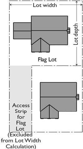
B.
Development. The development of a single-family residence on a flag lot shall comply with the following:
1.
Yards.
a.
Front, side, and rear yards required by this Title 22 shall be established on the main portion of a flag lot exclusive of the access strip.
b.
In lieu of any yard required by this Title 22, a uniform distance of 10 feet from all lot lines may be substituted.
2.
Access Strip. The access strip shall be maintained clear except for driveways, landscaping, fences, or walls, which shall be subject to the same requirements specified for yards on adjoining properties fronting on the same parkway, highway, or street.
(Ord. 2020-0032 § 23, 2020; Ord. 2019-0004 § 1, 2019.)
22.110.180 - Sight Distance.
Adequate sight distance from any driveway or access road to the public right-of-way shall be maintained to the satisfaction of Public Works. The placement of any object, such as fencing, walls, structure, or storage adjacent to the driveway or access road at the property line may be subject to review by Public Works.
(Ord. 2022-0008 § 81, 2022; Ord. 2019-0004 § 1, 2019.)
22.110.190 - Modifications Authorized.
A.
Regional Planning. Yard or setback regulations required by this Title 22 may be modified with the approval of a Yard Modification (Chapter 22.196) application.
B.
Public Works. The Director of Public Works, without notice or hearing, may grant a modification to yard or setback regulations required by this Title 22 or any other ordinance where topographic features, subdivision plans, or other conditions create an unnecessary hardship or unreasonable regulation or make it obviously impractical to require compliance with the yard requirements or setback line, except for the supplemental yards established contiguous to limited secondary highways, as described in Section 22.110.080.E, may be modified with the approval of a Yard Modification (Chapter 22.196) application. The Director of Public Works shall notify the Director of all modifications which the Director of Public Works has granted.
(Ord. 2023-0038 § 6, 2023; Ord. 2022-0008 § 82, 2022; Ord. 2019-0004 § 1, 2019.)
22.110.200 - Modifications for Public Sites.
The Director, without notice or hearing, may grant a modification of yard and setback regulations for public sites unless such modification would be incompatible with adjoining development.
(Ord. 2022-0008 § 83, 2022.)
22.112.010 - Purpose.
This Chapter:
A.
Establishes comprehensive parking provisions to effectively regulate the design of parking facilities and equitably establish the number of parking spaces required for various uses;
B.
Promotes vehicular and pedestrian safety and efficient land use;
C.
Promotes compatibility between parking facilities and surrounding neighborhoods and to protect property values by providing such amenities as landscaping, walls, and setbacks; and
D.
Establishes parking requirements to assure that an adequate number of spaces be made available to accommodate anticipated demand in order to lessen traffic congestion and adverse impacts on surrounding properties.
22.112.020 - Applicability.
A.
Parking and Loading Spaces. Parking and loading spaces shall be provided in compliance with this Chapter in the following circumstance:
1.
New Development. Any new building or structure is constructed and/or any new use is established.
2.
Alteration, Enlargement, Expansion, or Intensification to an Existing Development.
a.
Any existing building, structure, or use is altered, enlarged, expanded, or intensified. Required parking or loading spaces shall be provided to serve the altered, enlarged, expanded, or intensified building, structure, or use.
b.
For the purposes of this Chapter, alteration, enlargement, expansion, or intensification includes an increase to the number of dwelling units, guest rooms, floor area, occupant load, employees, or any other unit of measurement used to establish required parking and loading spaces.
B.
Reduction of Required Parking and Loading Spaces. A reduction in the number of required parking or loading spaces may be granted pursuant to any of the following:
1.
Section 22.112.110 (Reduction in Required Parking Spaces When Bicycle Parking Provided).
2.
Section 22.112.130 (Reduction in Required Parking Spaces When Providing Transportation Demand Management Measures for Multi-Family Residential Developments).
3.
Chapter 22.176 (Minor Parking Deviations).
4.
Chapter 22.178 (Parking Permits).
5.
Section 22.24.040.F (Vehicle Parking Incentives).
6.
As otherwise authorized by this Title 22.
C.
Bicycle Parking. Bicycle parking shall be provided in compliance with this Chapter when a new building or structure is constructed, and when an existing building or structure is altered or enlarged to increase floor area if the alteration or enlargement results in the addition of at least 15,000 square feet of gross floor area.
(Ord. 2024-0036 § 5, 2024; Ord. 2019-0004 § 1, 2019.)
22.112.030 - Exemptions.
A.
Exemptions to This Chapter. This Chapter shall not apply to the following:
1.
Santa Catalina or San Clemente Islands. Property on Santa Catalina or San Clemente Islands.
2.
Special Event Permits. Temporary parking facilities authorized by an approved Special Event Permit (Chapter 22.188), except where specifically required by the Director.
3.
Community Standards Districts. Community Standards Districts where different standards are provided.
4.
Housing. Projects subject to Chapter 22.120 (Density Bonus), where either of the following apply:
a.
The parking provisions described in Section 22.120.080 (Parking); or
b.
The parking provisions described in Section 22.120.080 (Parking) as waived or modified in accordance with Chapter 22.120 (Density Bonus), as applicable.
5.
Scientific Research and Development Zone. Scientific Research and Development Zone established pursuant to Section 22.26.050 (Scientific Research and Development Zone), where different development standards are provided.
6.
Nonconforming Due to Parking. Buildings, structures, and uses nonconforming due to parking may be continuously maintained, provided there is no alteration, enlargement, intensification, or addition to any building or structure, no increase in occupant load, nor any enlargement of area, space, or volume occupied by such a use.
B.
Residential Uses on Lots of One Acre or More. Any single-family residence, two-family residence, apartment house, and other structure designed for or intended to be used as a dwelling on a lot having an area of one acre or more per dwelling unit shall be exempt from Section 22.112.070 (Required Parking Spaces) and Section 22.112.080.E (Paving).
C.
Access. Where vehicular access to any parking space on the same lot as the residential structure to which it would be accessory is not possible from any highway or street due to topographical or other conditions, or is so difficult that to require such access is unreasonable in the opinion of the Director or Director of Public Works, such parking space is not required if:
1.
Alternate parking facilities approved by either the Director or Director of Public Works are provided; or
2.
The Director or Director of Public Works finds that alternate parking facilities are not feasible.
(Ord. 2019-0053 § 20, 2019; Ord. 2019-0004 § 1, 2019.)
22.112.040 - General Standards and Measurements.
A.
Improved Prior to Occupancy. Any parking facilities required by this Chapter shall be established in compliance with this Chapter and improved prior to:
1.
Occupancy of new buildings or structures; or
2.
Occupancy of a new use in the case of an existing building or structure that has been altered, enlarged, expanded, or intensified, in accordance with this Chapter.
B.
Permanent Maintenance Required. Any parking facilities required by this Chapter shall be conveniently accessible and permanently maintained as such unless and until substituted for in full compliance with this Title 22.
C.
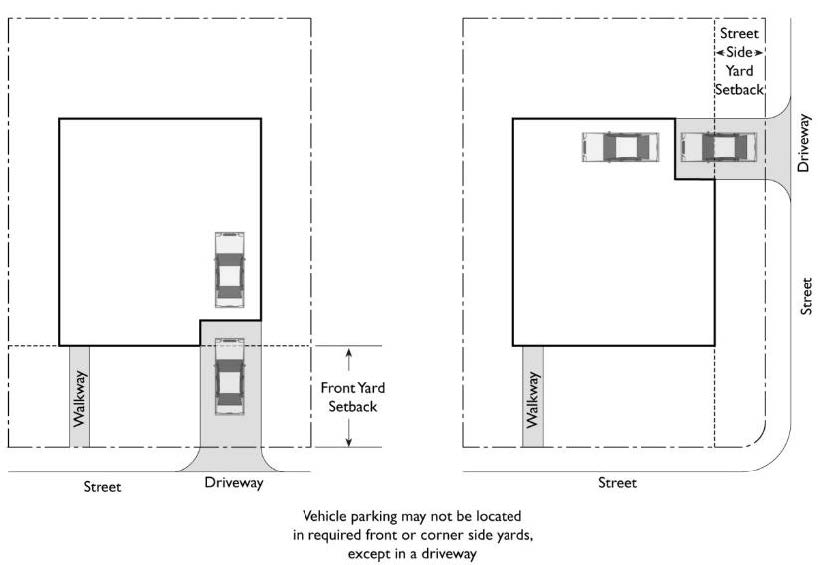
Residential and Agricultural Zones. Except as otherwise specified in this Title 22, the following standards apply in all Residential and Agricultural Zones:
1.
A person shall not keep, store, park, maintain, or otherwise permit any vehicle or any component thereof in the front yard, corner side yard, or any additional area of a lot situated between the road and any building or structure located thereon, except that the parking of passenger vehicles, including pickup trucks, other than a motor home or travel trailer, is permitted on:
a.
A driveway; for example, see Figure 22.112.040-A, below; and
b.
An area that is no longer a driveway to a garage or carport due to the conversion of that garage or carport to an accessory dwelling unit.
2.
A person shall not keep, store, park, maintain, or otherwise permit an "inoperative vehicle", as defined in Section 22.14.090 of Division 2 (Definitions), in any Residential or Agricultural Zone. Inoperative vehicles shall be removed within 30 days of June 7, 1991, the effective date of this Subsection C.
3.
Notwithstanding Subsections C.1 and C.2, above, a person may keep and maintain a historic vehicle collection, provided the Director finds it to be in full compliance with Section 22.140.270 (Historic Vehicle Collections).
FIGURE 22.112.040-A: LOCATION OF PARKING AREAS—
RESIDENTIAL ZONES
D.
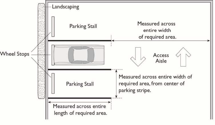
Measurement.
1.
Measurement of space lengths, aisle widths, and stacking areas for parking spaces required by this Chapter are measured from across the entire width and length of the required areas.
2.
Where single striping lines are used, the width shall be measured from the center of the striping line.
3.
Where double striping is used, the width shall be measured from the midpoint between the striping lines.
4.
For examples of this Subsection D, see Figure 22.112.040-B, below.
FIGURE 22.112.040-B: MEASUREMENT
E.
Calculation. The following rules shall apply for calculation of parking spaces required by this Chapter:
1.
Multiple Uses. When two or more uses are located on the same lot or within the same building or structure, the required parking for each use shall be calculated separately. The number of on-site parking spaces required shall be the sum total of the requirements for the individual uses, unless as otherwise provided for by this Chapter.
2.
Area—Based Standards.
a.
Area—based parking space ratios shall be computed based on gross floor area in square feet. Gross floor area shall be calculated in compliance with Section 22.04.050.E (Gross Floor Area and Floor Area Ratio).
b.
The Director is authorized to determine the area measurement for uses or portions of uses not located within buildings or structures.
3.
Occupancy Load. Occupant load parking space ratios shall be computed based on the occupant load as determined by the Director of Public Works.
(Ord. 2019-0020 § 12, 2019; Ord. 2019-0004 § 1, 2019.)
22.112.050 - Ownership of Required Parking Facilities.
A.
General. Parking facilities required by this Chapter shall be owned by the owner of the premises on which the use required to be served by said parking facility is located.
B.
Exemptions. The following shall be exempt from this Section:
1.
For Nonresidential Developments, ownership of any parking facility required by Subsection A, above, is not necessary if another alternative is granted pursuant to Chapter 22.178 (Parking Permit).
2.
For multi-family residential developments, ownership of any parking facility required by Subsection A, above, is not necessary if the applicant provides a legal written agreement or covenant guaranteeing the leased spaces are available for the use of the development. The agreement or covenant shall be signed by the applicant and the owner of the parking facilities, and shall be recorded with the Recorder-Registrar/County Clerk, and shall continue to be valid upon change of ownership. In the event of a dissolution of the written agreement or covenant, the multi-family residential development shall remain in compliance with parking requirements if one of the following is satisfied:
a.
A comparable agreement for required parking spaces is provided in a parking facility in compliance with this Chapter 22.112 (Parking), and recorded by the owner of the multi-family residential development and the property providing the parking facility;
b.
The total parking requirement is reduced through Section 22.112.130 (Reduction in Required Parking Spaces When Providing Transportation Demand Management Measures for Multi-Family Residential Developments) and allows the development to meet its requirement without the spaces that had been provided by the dissolved agreement or covenant; or
c.
The reduction in required parking is approved through Section 22.176 (Minor Parking Deviation) or Section 22.178 (Parking Permit).
3.
Unless as otherwise provided for by this Title 22.
(Ord. 2024-0036 § 6, 2024; Ord. 2020-0032 § 24, 2020; Ord. 2019-0004 § 1, 2019.)
22.112.060 - On-Site Parking.
A.
General. Every use shall provide the number of required parking spaces on the same lot on which the use is located. For the purposes of this Section, transitional parking spaces separated only by an alley from the use shall be considered to be located on the same lot.
B.
Exemptions. The following shall be exempt from this Section:
1.
Density—Controlled Developments (Section 22.140.170), where off-site parking is specifically approved by the Commission or Hearing Officer;
2.
Off-site parking, when granted pursuant to a Parking Permit (Chapter 22.178); or
3.
Off-site parking for multi-family residential developments, when the owner of the multi-family residential development is also the owner of the off-site parking facility, provided off-site parking spaces are secured according to the following restrictions:
a.
Up to 100 percent of the required parking may be located off-site if any portion of the lot containing the off-site parking is located within 400 feet of the nearest property line of the lot with the multi-family residential development; or
b.
Up to 50 percent of the required parking may be located off-site if any portion of the lot containing the off-site parking is located within 1,320 feet of the nearest property line of the lot with the multi-family residential development.
4.
Off-site parking for multi-family residential developments, when the owner of the multi-family residential development is not the owner of the off-site parking facility, provided off-site parking spaces are secured according to the following restrictions, and demonstrated by a covenant between the owner of the residential lot and the owner of the parking property, to be in effect for no less than 20 years from the date of the multi-family property's certificate of occupancy:
a.
Up to 50 percent of the required parking may be located off-site if any portion of the property containing the off-site parking is located within 400 feet of the nearest property line of the lot with the multi-family residential development; or
b.
Up to 25 percent of the required parking may be located off-site if any portion of the property containing the off-site parking is located within 1,320 feet of the nearest property line of the lot with the multi-family residential development.
5.
Unless as otherwise provided for by this Title 22.
(Ord. 2024-0036 § 7, 2024; Ord. 2019-0004 § 1, 2019.)
22.112.070 - Required Parking Spaces.
A.
Required Parking Spaces Within Public Transit Areas.
1.
Except for lodging uses or as provided in Subsection A.2, below, or where required by State law, all uses located within a public transit area, as defined in Section 22.14.160 (P), shall not require parking. Voluntarily provided parking shall comply with all applicable regulations in the County Code.
2.
Parking Minimum Required When. If a development project within a public transit area, as defined in Section 22.14.160 (P), shall require parking, such requirements pursuant to this Chapter may be imposed if written findings are made within the period as specified in State law, supported by substantial evidence, that not imposing or enforcing such requirements would have a substantially negative impact on any of the following:
a.
The County's ability to meet its share of the regional housing need for low-income and very low-income households;
b.
The County's ability to meet any identified special housing needs for seniors or people with disabilities; or
c.
Existing residential or commercial parking within one-half mile of a residential project.
3.
Findings to impose parking requirements pursuant to Subsection A.2, above, shall not apply to housing development projects that:
a.
Set aside at least 20 percent of dwelling units for very low-, lower-, or moderate-income households, students, seniors, or persons with disabilities;
b.
Contain fewer than 20 dwelling units; or
c.
Are subject to parking reductions under any other law.
B.
Required Parking Spaces Outside of Public Transit Areas. Table 22.112.070-A, below, identifies the minimum number of parking spaces required to establish each use.
C.
Uses Not Specified—Number of Spaces Required. Where parking requirements for any use are not specified, parking shall be provided in an amount that the Director finds adequate to prevent traffic congestion and excessive on-street parking. Whenever practical, such determination shall be based upon the requirements for the most comparable use specified in this Chapter.
D.
Fractions. If the number of on-site parking spaces for a use required by this Chapter contains a fraction, that fraction shall be rounded to the nearest whole number. Any such fraction equal to or greater than 0.50 shall be rounded up to the nearest whole number and any such fraction less than 0.50 shall be rounded down to the nearest whole number. For example, "Use A" requires 9.7 spaces, and "Use B" requires 9.4 spaces. "Use A" rounds up and requires 10 spaces and "Use B" rounds down and requires 9 spaces. A total of 19 spaces would be required for the two uses.
E.
Parking as a Transitional Use. Where parking as a transitional use is allowed by this Title 22, it shall comply with all locational and design standards of Section 22.140.440 (Parking as a Transitional Use).
F.
Compact Spaces. A maximum of 40 percent of the number of parking spaces required by this Chapter may be compact automobile parking spaces, except as otherwise provided in this Chapter. Compact spaces shall be distributed throughout the parking area. Any parking spaces provided in excess of the number of parking spaces required by this Chapter may be compact.
(Ord. 2024-0036 § 8, 2024; Ord. 2022-0023 § 26, 2022; Ord. 2022-0008 § 84, 2022; Ord. 2020-0059 § 11, 2020; Ord. 2020-0032 § 25, 2020; Ord. 2019-0020 § 13, 2019; Ord. 2019-0004 § 1, 2019.)
22.112.080 - Parking Design.
A.
Applicability. Except as specified otherwise in this Title 22, this Section shall apply to parking areas in all zones. Parking spaces shall be provided pursuant to this Section and Figure 22.112.080-A, below.
B.
General Standards for Parking Spaces and Maneuvering Aisles.
1.
Parking Spaces.
a.
Standard. Standard parking spaces shall have a minimum width of 8.5 feet and a minimum depth of 17.5 feet for parking facilities serving multi-family residential or mixed use development and of 18 feet for parking facilities serving other development, based on a 90-degree parking layout.
b.
Compact. Compact parking spaces shall have a minimum width of eight feet and a minimum depth of 15 feet, based on a 90-degree parking layout.
c.
Tandem.
i.
Tandem Parking Spaces for Residential Uses.
(1)
When two or more parking spaces are reserved or required for a dwelling unit, such spaces may be developed as tandem parking spaces.
(2)
Standard tandem parking spaces shall have a minimum width of 8.5 feet and a minimum depth of 35 feet to accommodate two vehicles.
(3)
Compact tandem parking spaces shall have a minimum width of eight feet and minimum depth of 30 feet to accommodate two vehicles.
ii.
Tandem Parking Spaces for Nonresidential Uses. Tandem parking spaces for nonresidential uses are allowed when granted pursuant to Chapter 22.178 (Parking Permits).
d.
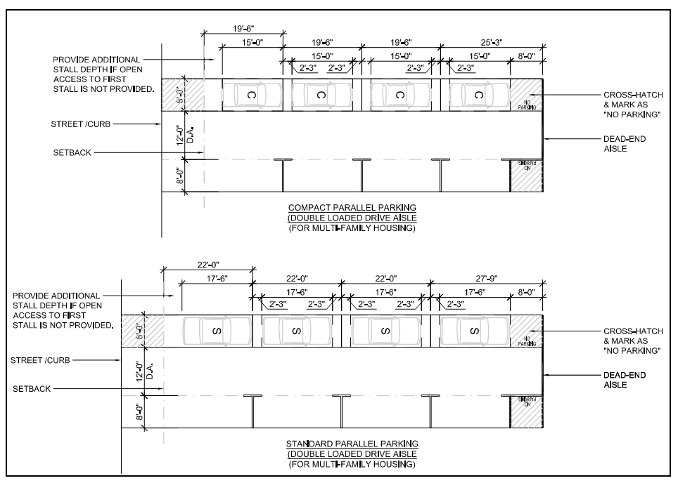
Parallel. Parallel parking is subject to the following standards, also illustrated in Figure 22.112.080-B, below:
i.
Standard parallel parking spaces shall have a minimum width of eight feet and a minimum length dependent on the location of the standard parallel parking space as follows:
(1)
A standard parallel end-space with direct, pull-in access shall have a minimum length of 17.5 feet;
(2)
A standard parallel middle space shall have a minimum length of 22 feet; and
(3)
A standard parallel end-space without direct access shall have a minimum length of 26 feet. If the end-space does not have a maneuvering aisle that continues beyond the space, it shall have a minimum length of 27 feet and nine inches.
ii.
Compact parallel parking spaces shall have a minimum width of eight feet and a minimum length dependent on the location of the compact parallel parking space as follows:
(1)
A compact parallel end-space with direct access shall have a minimum length of 15 feet;
(2)
A compact parallel middle space shall have a minimum length of 19 feet and six inches; and
(3)
A compact parallel end-space without direct access shall have a minimum length of 23 feet or 27 feet if the maneuvering aisle does not continue beyond the space.
2.
Maneuvering Aisles.
a.
Standard. Maneuvering aisles that provide access to standard parking spaces shall have a minimum width of 24 feet for parking facilities serving multi-family residential or mixed use developments and 26 feet for parking facilities serving other developments.
b.
Compact. Maneuvering aisles that provide access to only compact parking spaces shall have a minimum width of 23 feet, except where a 26-foot wide access road is required by the Fire Department.
c.
Parallel. Maneuvering aisles that provide access to only parallel parking spaces shall have a minimum width of 12 feet for one-way aisles or 24 feet for two-way aisles. Figure 22.112.080-B, Parallel Parking Dimensions, below, identifies the dimensions for maneuvering aisles and parallel parking spaces subject to this Chapter.
3.
Covered Parking. Where required, covered parking spaces shall be provided in a garage, carport, or other suitable vehicle storage structure that complies with all applicable codes and ordinances. Tarps or other temporary structures do not count toward required covered parking spaces.
FIGURE 22.112.080-A: MINIMUM PARKING SPACE DIMENSIONS
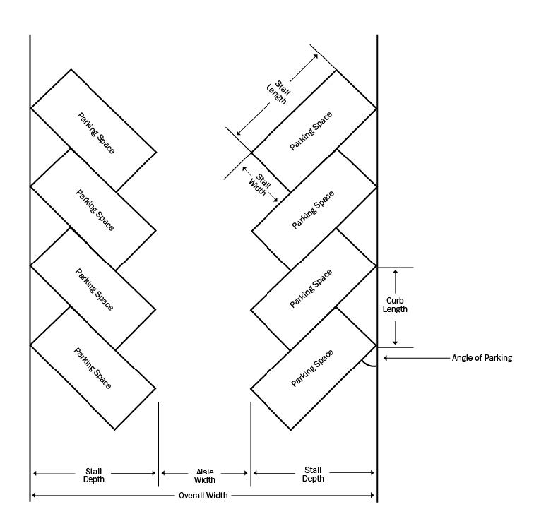
FIGURE 22.112.080-B: PARALLEL PARKING DIMENSIONS
C.
Striping.
1.
Each parking space shall be clearly striped with paint or other similar distinguishable material, except that spaces established in a garage or carport having not more than three parking spaces need not be striped.
2.
The Director may approve alternate means of striping parking spaces if:
a.
There is a dual use of the parking facility; or
b.
An alternate paving material is allowed by Public Works, pursuant to Subsection E, below.
3.
Each compact parking space shall be clearly marked with the words "Compact Only."
D.
Wheel Stops.
1.
Wheel stops shall be provided for parking lots with a slope of more than three percent, except that the installation of wheel stops is optional for parking stalls oriented at right angles to the direction of slope.
2.
Wheel stops shall be provided along the perimeter of parking lots that are adjacent to walls, fences, or pedestrian walkways.
E.
Paving.
1.
Where access to parking spaces is from a highway, street, or alley which is paved with asphaltic or concrete surfacing, such parking areas, as well as the maneuvering areas and driveways used for access thereto, shall be paved with:
a.
Concrete surfacing to a minimum thickness of three and one-half inches, with expansion joints as necessary; or
b.
Asphalt surfacing, rolled to a smooth, hard surface having a minimum thickness of one and one-half inches after compaction, and laid over a base of crushed rock, gravel, or other similar material compacted to a minimum thickness of four inches. The requirement for said base may be modified if:
i.
A qualified engineer, retained to furnish a job-site soil analysis, finds that said base is unnecessary to insure a firm and unyielding subgrade, equal, from the standpoint of the service, life and appearance of the asphaltic surfacing, to that provided if said base were required, and so states in writing, together with a copy of his findings and certification to such effect, or
ii.
Other available information provides similar evidence; or
c.
Other alternative material that will provide at least the equivalent in service, life and appearance of the materials and standards which would be employed for development pursuant to Subsection E.1.a or E.1.b, above; and
d.
Public Works, at the request of the Director, shall review and report on the adequacy of paving where modification of base is proposed under Subsection E.1.b, above, or where alternative materials are proposed under Subsection E.1.c. The Director of Public Works may approve such modification or such alternative materials if, in said Director's opinion, the evidence indicates compliance with Subsection E.1.b or E.1.c., above, as the case may be.
F.
Walls.
1.
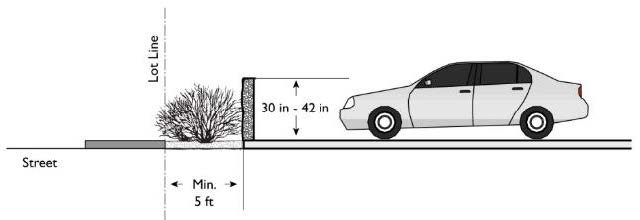
Front Yards. Where parking facilities are located adjacent to the front lot line, a solid masonry wall not less than 30 inches nor more than 42 inches in height shall be established parallel to and not nearer than five feet to the front lot line, except that:
a.
The required wall shall be set back at least to the line of the front or side yard line required in any adjacent Residential or Agricultural Zone for a distance of 50 feet from the common boundary line. For example, see Figure 22.112.080-C, below.
FIGURE 22.112.080-C: SCREENING WALL—FRONT YARD
b.
Where abutting and adjacent property is in a zone other than a Residential or Agricultural Zone, the Director may approve the establishment of the required wall:
i.
Closer than five feet to the front property line; or
ii.
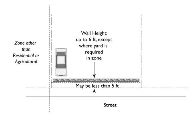
To a height not exceeding six feet, except where a yard is required in the adjacent nonresidential zone. For example, see Figure 22.112.080-D, below.
FIGURE 22.112.080-D: SCREENING WALL ADJACENT TO A
NON-RESIDENTIAL OR NON-AGRICULTURAL ZONE
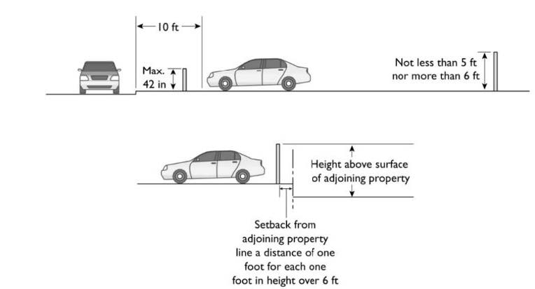
2.
Side and Rear Yards. Where parking facilities are located on land adjoining a Residential or Agricultural Zone, a solid masonry wall not less than five feet nor more than six feet in height shall be established along the side and rear lot lines adjoining said zones except that:
a.
Where such wall is located within 10 feet of any highway, street, or alley and would interfere with the line-of-sight of the driver of a motor vehicle leaving the property on a driveway, or moving past a corner at the intersection of two streets or highways, said wall shall not exceed a height of 42 inches; and
b.
Such wall shall not be less than four feet in height above the surface of the adjoining property. If said wall is more than six feet in height above said adjoining property, it shall be set back from the adjoining property line a distance of one foot for each one foot in height above six feet. For example, see Figure 22.112.080-E, below.
FIGURE 22.112.080-E: SCREENING WALLS—SIDE AND REAR YARDS
3.
Modification. The Director may approve a Ministerial Site Plan Review (Chapter 22.186) application to modify Subsection F.1 or F.2, above, for the substitution of a decorative fence or wall or a landscaped berm where, in the Director's opinion, such fence, wall, or landscaped berm will adequately comply with the intent of this Section.
G.
Landscaping.
1.
Where a wall is required to be set back from a lot line, the area between said lot line and such wall shall be landscaped with a lawn, shrubbery, trees, and/or flowers, and shall be continuously maintained in good condition.
2.
Where more than 20 parking spaces exist on a lot, areas not used for parking or maneuvering, or for the movement of pedestrians to and from vehicles, shall be used for landscaping; and
a.
At least two percent of the gross area of the parking lot shall be landscaped;
b.
Landscaping shall be distributed throughout the parking lot to maximize the aesthetic effect and compatibility with adjoining uses; and
c.
This regulation shall not apply to parking areas on the roof or within a building or structure.
3.
Where an improved curbed walkway is provided within a parking lot, a landscaped strip a minimum of four feet in width shall be required adjoining such walkway. Within the landscaped strip, one tree shall be planted every 25 linear feet of walkway, and shall be at least seven feet in height measured from the base of the tree to the bottom of the tree canopy at the time of planting.
4.
All landscaping materials and sprinkler systems shall be clearly indicated on the required site plans.
H.
Lighting. Parking area lighting shall be arranged to prevent glare or direct illumination into any Residential or Agricultural Zone.
I.
Design. Parking lots shall be designed to preclude the backing of vehicles over a sidewalk, public street, or highway. Parked vehicles shall not encroach on, nor extend over, any sidewalk.
J.
Slope. Parking lots shall not have a slope exceeding five percent, except for access ramps or driveways, which shall not exceed a slope of 20 percent.
K.
Width, Paving, and Slope of Driveways.
1.
Driveways with Multiple Residences. Access (e.g., driveways) to parking areas that serve three or more dwelling units shall comply with the following standards:
a.
Driveways shall be at least 10 feet in width for each direction.
b.
If the driveway is required to be paved, the pavement shall be at least 10 feet in width for its entire length, except that a center strip over which the wheels of a vehicle will not pass in normal use need not be paved.
c.
Unless modified by the Director of Public Works because of topographical or other conditions, no portion of a driveway providing access to parking spaces may exceed a slope of 20 percent. Where there is a change in the slope of driveway providing such access, it must be demonstrated that vehicles will be able to pass over such change in slope without interference with their undercarriages.
L.
Electric Vehicle Supply Equipment and Electric Vehicle Charging Spaces. Any parking space served by electric vehicle supply equipment and any parking space intended as a future electric vehicle charging space shall qualify as a required standard automobile parking space where such parking space meets or exceeds the minimum length and width requirements for a standard automobile parking space.
(Ord. 2024-0036 § 9, 2024; Ord. 2020-0032 § 26, 2020; Ord. 2019-0004 § 1, 2019.)
22.112.090 - Accessible Parking for Persons with Disabilities.
Where parking spaces are provided, accessible parking shall be required as specified in Part 2, Volume 1, Chapters 11A and 11B of the California Building Code, except for parking lots providing 100 percent valet parking with an approved parking permit in accordance with Chapter 22.178 (Parking Permit).
(Ord. 2019-0004 § 1, 2019.)
22.112.100 - Bicycle Parking Spaces and Bicycle Facilities.
A.
Required Bicycle Parking Spaces. Table 22.112.100-A, below, identifies the minimum number of bicycle parking spaces required for each use.
B.
General Standards and Measurement for Bicycle Parking.
1.
Fractions. If the calculation for required bicycle parking contains a fraction, Section 22.112.070.C (Fractions) shall apply.
2.
Calculation. For purposes of this Section, when floor area is used, all calculations for the specific use shall be based on gross floor area, in square feet, and shall include the gross floor area of any proposed addition to the involved structure or site.
3.
Combination of Uses. For a combination of uses on a single lot, the number of required bicycle parking spaces shall be equal to the combined total of the required bicycle parking spaces for each of the individual uses.
C.
Showers and Changing Facilities. Showers and changing facilities, of a size and at a location deemed appropriate by the Director, shall be provided in all new commercial and industrial buildings with 75,000 or more square feet of gross floor area and shall, at a minimum, be accessible to employees.
D.
Development Standards for Bicycle Parking Spaces.
1.
General Requirements. All bicycle parking spaces shall be:
a.
Directly adjacent to a bicycle rack or within a secure, single bicycle locker and allow for convenient, unobstructed access to such bicycle rack or locker; and
b.
Located so as not to block pedestrian entrances, walkways, or circulation patterns in or around nearby facilities or structures.
2.
Bicycle Racks. When using bicycle racks, they shall be:
a.
Located and installed to support an entire bicycle, including the frame and wheels, so that the frame and wheels can be locked without damage when using a customary, heavy-duty cable, or U-shaped bicycle lock;
b.
Securely anchored to a permanent surface; and
c.
Installed to allow bicycles to remain upright when locked, without the use of a kickstand.
3.
Bicycle Lockers. When using bicycle lockers, they shall be:
a.
Of sufficient size to hold an entire bicycle; and
b.
Securely anchored to a permanent surface.
4.
Location of Bicycle Parking Spaces.
a.
Short-Term. Short-term bicycle parking spaces shall be:
i.
Located to be visible from public areas such as public streets, store fronts, sidewalks, and plazas, and to be convenient to the target users of the bicycle parking to the maximum extent feasible;
ii.
Installed close to a structure's main entrance located outside the building and within 50 feet of either the main pedestrian entrance or the nearest off-street automobile parking space. For developments with multiple pedestrian entrances, the required number of short-term bicycle parking shall be distributed evenly around each pedestrian entrance;
iii.
Separated with a barrier from areas where vehicles park, such as with a curb or wheel stop; and
iv.
Located in a well-illuminated area.
b.
Long-Term. Long-term bicycle parking spaces shall be:
i.
Located in a well-illuminated, secure, and covered area;
ii.
Access to and from nearby public streets and sidewalks for the target users of the bicycle parking, who may or may not include the general public;
iii.
Located at surface levels near main pedestrian entrances to nearby facilities or structures, or in the parking garages of such facilities or structures;
iv.
Accessible only to residents and owners, operators, and managers of a residential facility when the involved use is residential; and
v.
Accessible only to employees, tenants, and owners of a commercial facility or structure when the involved use is commercial.
c.
Signage. For projects that include long-term parking, signage identifying the location of such bicycle parking shall be included in the project design. Preferred signage locations for this purpose shall be building access ways, streets, and sidewalk approaches, and nearby bicycle paths or facilities.
(Ord. 2024-0049 § 20, 2024; Ord. 2019-0004 § 1, 2019.)
22.112.110 - Reduction in Required Parking Spaces When Bicycle Parking Provided.
A.
Eligibility Requirements for a Parking Reduction. A reduction in required automotive parking spaces shall be granted pursuant to this Section, when:
1.
The project provides more than the minimum number of required bicycle parking spaces provided in Section 22.112.100 (Bicycle Parking and Related Facilities); and
2.
The project is located:
a.
On, or adjoining, a lot or lots containing an existing or proposed bicycle path, lane, route, or boulevard, and so designated in the County Bicycle Master Plan; and
b.
Within a half-mile of a transit stop for a fixed rail or bus rapid transit or local bus system along a major or secondary highway.
B.
Reduction Calculation. For every two bicycle parking spaces provided above the minimum number of such spaces required by Section 22.112.100 (Bicycle Parking and Related Facilities), the number of required automotive parking spaces may be reduced by one, with a maximum reduction of five percent of the total number of such spaces otherwise required by this Chapter.
(Ord. 2019-0004 § 1, 2019.)
22.112.120 - Loading Spaces.
Every nonresidential use shall provide and maintain on-site loading and unloading spaces for vehicles as required by this Section.
A.
Number of Spaces Required. Table 22.112.120-A, below, identifies the minimum number of loading spaces required for each use.
B.
Minimum Dimensions for Loading Spaces. Table 22.112.120-B, below, identifies the minimum dimensions for each type of loading space.
C.
General Standards and Measurement for Loading Spaces.
1.
Loading spaces shall be located so that vehicles do not back onto a public highway or street.
2.
All maneuvering operations shall be conducted on-site and not within required parking spaces.
3.
The number of loading spaces required may be modified, but not waived, by the Director in special circumstances involving, but not necessarily limited to, the nature of the use and the design of the project. In no event shall the Director require less than one loading space on the subject property.
4.
Office and commercial uses with a gross floor area of less than 5,000 square feet may be required to provide one Type A loading space when the Director deems it appropriate to prevent traffic congestion in the parking lot or adjacent streets and highways.
D.
"No Idling" Sign Required. Where loading spaces are required by this Section, the loading area shall include at least one sign stating that vehicle idling shall be limited to five minutes. Graphics related to the vehicle idle limitation are permitted on said sign. Said sign shall be a minimum size of 12 inches wide by 18 inches in height and shall be prominently displayed and visible from the loading spaces. Said sign may contain language such as "5 minute idle limit," "spare the air," "please turn engine off when stopped," "turn engine off," or similar.
(Ord. 2019-0004 § 1, 2019.)
22.112.130 - Reduction in Required Parking Spaces When Providing Transportation Demand Management Measures for Multi-Family Residential Developments.
A.
Eligibility Requirements for a Parking Reduction. For multi-family residential developments, the parking requirements for residential uses in accordance with Section 22.112.070, above, may be reduced by 25 percent if the site plan includes multiple on-site Transportation Demand Management (TDM) measures selected from Table 22.112.130-A, below, with a combined point value of five or greater, or reduced by 50 percent with a combined point value of 10 or greater. A TDM-based parking reduction shall require approval of a Ministerial Site Plan Review (Chapter 22.186) application.
B.
Development Standards for Residential Developments with TDM Measures.
1.
Each residential development shall post a display of approved TDM measures in a common and accessible space, such as a lobby, where all residents can view the document.
2.
A list of the approved TDM measures shall be provided to each owner and/or tenant as part of purchase or leasing documents.
C.
In the event an approved TDM measure, which contributes to a multi-family property's minimum TDM points, no longer applies or is in effect, the owner of the multi-family residential development shall substitute another TDM option of equal or greater value in points.
(Ord. 2024-0036 § 10, 2024.)
22.112.140 - Shared Parking for Multi-Family Residential Development.
Shared parking requests shall be approved with a Ministerial Site Plan (Chapter 22.186) application if the applicant provides a parking study demonstrating adequate parking availability (not deficit in the number of parking spaces available in the shared parking facility), during typical peak times for the land uses which the shared parking facility is currently serving and during typical peak parking conditions for the multi-family development the parking facility proposes to serve. Parking adequacy (the number of available spaces) will be defined methodologically by the most recent edition of Shared Parking by the Urban Land Institute and International Council of Shopping Centers or another parking demand modeling methodology used by a firm or individual that demonstrates a minimum of five years' experience performing shared parking studies. This methodology may include actual parking occupancy counts for the existing land uses in the shared parking facility during the identified peak times. Shared parking between multiple owners shall require a written covenant, pursuant to Section 22.112.050 (Ownership of Required Parking Facilities). Off-site shared parking may be provided according to the limitations detailed in Section 22.112.060 (On-Site Parking).
(Ord. 2024-0036 § 11, 2024.)
22.114.010 - Purpose.
This Chapter establishes comprehensive sign regulations for effectively regulating the placement, erection, and maintenance of signs in the unincorporated area of the County. These regulations are intended to provide equitable standards for the protection of property values, visual aesthetics, and the public health, safety, and general welfare while still providing ample opportunities for businesses and the visual advertising industry to operate successfully and effectively.
(Ord. 2019-0004 § 1, 2019.)
22.114.020 - Applicability.
A.
Use Restrictions. A person shall not use any sign in any zone except as specifically permitted in this Title 22 and subject to all regulations and conditions enumerated in this Title 22.
B.
Application Requirements.
1.
A Ministerial Site Plan Review (Chapter 22.186) application shall be required for the following types of signs:
a.
Building identification signs.
b.
Directional or informational signs.
c.
Freestanding business signs, except as specified in Subsection B.2.a, below.
d.
Portable advertising signs.
e.
Projecting business signs.
f.
Roof signs.
g.
Temporary subdivision sales, entry, and special feature signs.
h.
Wall business signs.
2.
A Minor Conditional Use Permit (Chapter 22.158) application shall be required for the following types of signs:
a.
Freestanding business signs as specified in Section 22.114.120.H.3.a.
3.
A Conditional Use Permit (Chapter 22.160) application shall be required for the following types of signs:
a.
Outdoor advertising signs.
b.
Subdivision directional signs.
4.
No separate application is required for all other types of signs not listed in Subsection B.1 through B.3, above.
(Ord. 2022-0008 § 85, 2022; Ord. 2019-0004 § 1, 2019.)
22.114.030 - Exemptions.
The provisions of this Title 22 regulating signs shall not apply to the following signs except as otherwise indicated herein:
A.
Official notices issued by any court, public body, or public officer.
B.
Notices posted by any public officer in performance of a public duty, or for any person in giving legal notice.
C.
Traffic, directional, warning, or informational signs required or authorized by the public authority having jurisdiction.
D.
Official signs used for emergency purposes only.
E.
Permanent memorial or historical signs, plaques, or markers.
F.
Public utility signs, provided such signs do not exceed three square feet in area.
(Ord. 2019-0004 § 1, 2019.)
22.114.040 - Prohibited Signs Designated.
The following signs shall be prohibited in all zones:
A.
Signs which contain or utilize:
1.
Any exposed incandescent lamp with a rated wattage in excess of 40 watts.
2.
Any exposed incandescent lamp with an internal metallic reflector.
3.
Any exposed incandescent lamp with an external metallic reflector.
4.
Any revolving beacon light.
5.
Any continuous or sequential flashing operation, other than signs displaying time of day, atmospheric temperature or having programmable electronic messages, in which:
a.
More than one-third of the lights are turned on or off at one time; or
b.
The operation is located less than 100 feet on the same side of the street or highway from any Residential or Agricultural Zone.
6.
Any system for display of time of day, atmospheric temperature or programmable electronic messages in which:
a.
The proposed display has any illumination which is in continuous motion or which appears to be continuous motion;
b.
The message is changed at a rate faster than one message every four seconds;
c.
The interval between messages is less than one second;
d.
The intensity of illumination changes; or
e.
The display is located less than 100 feet on the same side of the street or highway from any Residential or Agricultural Zone.
B.
Revolving signs, all or any portion of which rotate at a speed exceeding six revolutions per minute.
C.
Signs advertising or displaying any unlawful act, business, or purpose.
D.
Devices dispensing bubbles and free-floating particles of matter.
E.
Any notice, placard, bill, card, poster, sticker, banner, sign, advertising, or other device calculated to attract the attention of the public which any person posts, prints, sticks, stamps, tacks, or otherwise affixes, or causes the same to be done to or upon any street, right-of-way, public sidewalk, crosswalk, curb, lamppost, hydrant, tree, telephone pole, or lighting system, or upon any fixture of the police or fire alarm system of the County.
F.
Any strings of pennants, banners or streamers, clusters of flags, strings of twirlers or propellers, flares, balloons, and similar attention-getting devices, including noise-emitting devices, with the exception of the following:
1.
National, state, local governmental, institutional, or corporate flags, properly displayed; and
2.
Holiday decorations, in season, used for an aggregate period of 60 days in any one calendar year.
G.
Devices projecting or otherwise reproducing the image of a sign or message on any surface or object.
H.
Signs emitting or amplifying sounds for the purpose of attracting attention.
I.
Portable signs, except as otherwise specifically permitted by this Title 22.
J.
Temporary signs, except as otherwise specifically permitted by this Title 22.
(Ord. 2019-0004 § 1, 2019.)
22.114.050 - General Regulations.
The following regulations apply to all signs in any zone:
A.
In no case shall a lighted sign or lighting device thereof be so placed or directed so as to permit the beams and illumination therefrom to be directed or beamed upon a public street, highway, sidewalk, or adjacent premises so as to cause glare or reflection that may constitute a traffic hazard or nuisance.
B.
Outdoor advertising signs may be either single or double-faced, except as otherwise provided in this Title 22, provided that if double-faced the distance between the faces of such signs shall not exceed 48 inches.
C.
Signs, except outdoor advertising signs, may be single-, double-, or multi-faced, provided that:
1.
The distance between the faces of any double-faced sign, other than a V-shaped projecting sign, shall not exceed 36 inches; and
2.
The separation between the intersecting faces of any multi-faced sign or a double-faced projecting sign shall not exceed 12 inches.
D.
Any sign located on vacant and unoccupied property, and which was erected for an occupant or business unrelated to the present occupant or business, or any sign which pertains to a time, event or purpose which no longer exists, shall be removed within 90 days after the purpose for, or use utilizing, such sign has been removed from such property.
E.
Any permitted sign may be a changeable-copy sign.
F.
All signs shall be designed in the simplest form and lie free of any bracing, angle-iron, guy wires, cables, or similar devices.
G.
The exposed backs of all signs visible to the public shall be suitably covered, finished, and properly maintained.
H.
All signs shall be maintained in good repair, including display surfaces, which shall be kept neatly painted or posted.
I.
Any sign which does not conform to the provisions of this Title 22 shall be made to conform or shall be removed as provided in Subsections B.1.d and B.2 of Section 22.172.050.
J.
Except where otherwise specifically provided by this Title 22, sign regulations established pursuant to this Chapter shall not apply to signs within a building, arcade, court, or other similarly enclosed area where such signs are not visible to the public without entering such facilities.
K.
The height of all signs shall be measured from the highest point of the sign, exclusive of any part of the sign not included in area calculations.
(Ord. 2019-0004 § 1, 2019.)
22.114.060 - Surface Area—Computation.
The surface area of any sign face shall be computed from the smallest rectangles, circles, and/or triangles which will enclose all words, letters, figures, symbols, designs, and pictures, together with all framing background material, colored or illuminated areas, and attention-attracting devices forming an integral part of the overall display, but excluding all support structures, except that:
A.
Superficial ornamentation and/or symbol-type appendages of a non-message-bearing character which do not exceed five percent of the surface area shall be exempted from computation; and
B.
Wall signs painted on, or affixed directly to, a building wall, facade, or roof, and having no discernible boundary, shall have the areas between letters, words intended to be read together, and any device intended to draw attention to the sign message included in any computation of surface area; and
C.
Signs placed in such a manner, or bearing a text, as to require dependence upon each other to convey meaning shall be considered one sign and the intervening areas between signs included in any computation of surface area; and
D.
Spherical, cylindrical, or other three-dimensional signs not having conventional sign faces shall be considered to have two faces and the area of each sign face shall be computed from the smallest three-dimensional geometrical shape or shapes which will best approximate the actual surface area of said faces.
(Ord. 2019-0004 § 1, 2019.)
22.114.070 - Outdoor Advertising Signs—Conditions.
Outdoor advertising signs may be erected and maintained in Zones C-MJ, M-1, M-1.5, M-2, and M-3 provided a Conditional Use Permit (Chapter 22.158) has first been obtained and subject to all of the following conditions of use:
A.
That the total sign face of such signs shall not exceed 800 square feet.
B.
That the height of such signs shall not exceed 42 feet measured from the ground level at the base of the sign.
C.
That such signs having a total sign face of:
1.
More than 150 square feet shall not be erected or maintained within:
a.
500 feet of an outdoor advertising sign having a total sign face greater than 150 square feet; or
b.
200 feet of an outdoor advertising sign having a total sign face greater than 80 square feet but not exceeding 150 square feet; or
c.
100 feet of any other outdoor advertising sign located on the same side of the street or highway; or
2.
More than 80 square feet, but not exceeding 150 square feet, shall not be erected or maintained within:
a.
200 feet of an outdoor advertising sign having a total sign face greater than 80 square feet; or
b.
100 feet of any other outdoor advertising sign located on the same side of the street or highway.
3.
80 square feet or less shall not be erected or maintained within 100 feet of any outdoor advertising sign located on the same side of the street or highway.
D.
That such sign shall not be permitted having a message face visible from and within a distance of 660 feet of the edge of right-of-way of a freeway or scenic highway, measured horizontally along a line normal or perpendicular to the centerline of such freeway or scenic highway, if designed to be viewed primarily by persons traveling thereon.
E.
That such signs shall not be permitted on a roof and that not more than 15 percent of the length of the structure of a freestanding sign shall extend over a roof.
F.
That such signs shall not be permitted to encroach over public rights-of-way.
G.
That such signs shall not be permitted within 200 feet of a Residential Zone located on the same side of the street or highway.
H.
Tobacco Advertising Prohibited in Certain Areas of the County.
1.
No person shall place or cause to be placed any advertisement for cigarettes or other tobacco products on any outdoor advertising sign within a Residential or Agricultural Zone, or within 1,000 feet of the premises of any school, park, playground, recreational facility, youth center, child care center, entertainment park, or church.
2.
This Subsection H shall not apply to outdoor advertising signs located on property adjacent to, and designed to be viewed primarily by, persons traveling on a freeway.
3.
The distances specified in this Subsection shall be measured in a straight line, without regard to intervening structures, from the nearest point of the outdoor advertising sign to the nearest property line of a use or zone listed above.
4.
This Subsection shall be administered and enforced by the Department. The Department shall create and update a detailed map of the County, showing the location and boundaries of all schools, parks, playgrounds, recreational centers and facilities, youth centers, child care centers, entertainment parks, and churches, and the corresponding 1,000-foot radii within which tobacco product advertising is prohibited. The Department shall also develop guidelines, as appropriate, to ensure proper implementation and enforcement of this Subsection. Nothing contained in this Subsection shall be interpreted or enforced in such a manner as to constitute a compensable limitation on the use of any advertising display pursuant to Business and Professions Code Section 5412. The Department may enter into agreements with appropriate departments to enforce this Subsection.
I.
Alcoholic Beverage Advertising Prohibited in Certain Areas of the County.
1.
No person shall place or cause to be placed any advertisement for alcoholic beverages on any outdoor advertising sign within a Residential or Agricultural Zone, or within 1,000 feet of the premises of any school, park, playground, recreational facility, youth center, child care center, entertainment park, or church.
2.
This Subsection I shall not apply to outdoor advertising signs located on property adjacent to, and designed to be viewed primarily by, persons traveling on a freeway.
3.
The distances specified in this Subsection shall be measured in a straight line, without regard to intervening structures, from the nearest point of the outdoor advertising sign to the nearest property line of a use or zone listed above.
4.
This Subsection shall be administered and enforced by the Department. The Department shall create and update a detailed map of the County, showing the location and boundaries of all schools, parks, playgrounds, recreational centers, and facilities, youth centers, child care centers, entertainment parks, and churches, and the corresponding 1,000-foot radii within which alcoholic beverage advertising is prohibited. The Department shall also develop guidelines, as appropriate, to ensure proper implementation and enforcement of this Subsection. Nothing contained in this Subsection shall be interpreted or enforced in such a manner as to constitute a compensable limitation on the use of any advertising display pursuant to Business and Professions Code Section 5412. The Department may enter into agreements with appropriate departments to enforce this Subsection.
J.
Advertising Adult Telephone Messages Prohibited in Certain Areas of the County.
1.
No person shall place or cause to be placed any advertisement for live or recorded telephone messages containing any harmful matter, as defined in Section 313 of the Penal Code, on any outdoor advertising sign within a Residential or Agricultural Zone, or within 1,000 feet of the premises of any school, park, playground, recreational facility, youth center, child care center, entertainment park, or church.
2.
This Subsection J shall not apply to outdoor advertising signs located on property adjacent to, and designed to be viewed primarily by, persons traveling on a freeway.
3.
The distances specified in this Subsection shall be measured in a straight line, without regard to intervening structures, from the nearest point of the outdoor advertising sign to the nearest property line of a use or zone listed above.
4.
This Subsection shall be administered and enforced by the Department. The Department shall create and update a detailed map of the County, showing the location and boundaries of all schools, parks, playgrounds, recreational centers and facilities, youth centers, child care centers, entertainment parks, and churches, and the corresponding 1,000-foot radii within which adult telephone messages advertising is prohibited. The Department shall also develop guidelines, as appropriate, to ensure proper implementation and enforcement of this Subsection. Nothing contained in this Subsection shall be interpreted or enforced in such a manner as to constitute a compensable limitation on the use of any advertising display pursuant to Business and Professions Code Section 5412. The Department may enter into agreements with appropriate departments to enforce this Subsection.
(Ord. 2019-0004 § 1, 2019.)
Editor's note— Ords. 98-0023—98-0025, which enacted Subsections H—J of Section 22.114.070, are operative on January 10, 1999.
22.114.080 - Portable Outdoor Advertising Signs—Conditions.
A.
Portable outdoor advertising signs may be placed and maintained in conformance with the provisions of Section 22.114.070 (Outdoor Advertising Signs-Conditions) as well as the following additional conditions of use:
1.
That such signs shall be placed in compliance with the provisions of this Chapter;
2.
That placement of such signs shall not constitute a potential hazard to pedestrian or vehicular traffic, or be placed in any area where the erection of buildings or structures is prohibited;
3.
That such signs shall not be placed within a public right-of-way; and
4.
That an official site-approval card shall be visibly attached to the sign during its placement at the approved location.
B.
No person shall place or grant permission to place a portable outdoor advertising sign unless an approval has been obtained and an official site-approval card is displayed on such sign or trailer. Placement of a portable outdoor advertising sign in violation of this provision shall cause such sign to be deemed a public nuisance pursuant to Section 22.242.040 (Public Nuisance).
(Ord. 2019-0004 § 1, 2019.)
22.114.090 - Business Signs—In Agricultural and Special Purpose Zones.
Business signs are permitted in Zones A-1, A-2, O-S, P-R, B-1, and W, subject to the following restrictions:
A.
Number and Area Permitted. Signs shall comply with Table 22.114.090-A, below, for maximum number of signs per lot and area permitted:
B.
Height and Projection Permitted. Signs shall comply with Table 22.114.090-B, below, for height and projection permitted.
C.
Location of Signs.
1.
Freestanding business signs shall not:
a.
Be placed on any property nearer than 25 feet to a lot line, other than one adjoining a street or highway;
b.
Be placed within a required front or corner side yard nearer than 10 feet to the highway line of the adjacent street, highway, or parkway.
2.
No projecting business sign shall be placed on any building nearer to the corner of such building than a distance equal to 25 percent of the length of such building wall.
D.
Movement. Signs shall not rotate, move, or simulate motion in any way.
E.
Lighting. Signs may be internally or externally lighted provided:
1.
That in Zones A-1, A-2, O-S, or P-R, no exposed incandescent lamp used shall exceed a rated wattage of 25 watts; and
2.
That any continuous or sequential flashing operation is prohibited.
F.
Sign Content. In Zone B-1, such signs may relate to business uses in an adjoining zone located on the same lot.
G.
Alternative Signing.
1.
Where a zone boundary divides a lot so that:
a.
A P-R or B-1 Zone separates commercial or industrial property from a street or highway upon which said property would otherwise front, such P-R or B-1 Zone may be considered as a part of the Commercial or Industrial Zone for purposes of determining the number, sign area, and location of freestanding business signs permitted on that specific frontage; or
b.
A P-R or B-1 Zone and a Commercial or Industrial Zone front on the same street or highway, said P-R or B-1 Zone may be considered as a part of the Commercial or Industrial Zone for the purpose of determining the number, sign area, and location of freestanding business signs permitted on that specific frontage; provided, however, that such sign or signs shall not be erected in the P-R or B-1 Zone.
2.
In all such instances, the signing permitted by this Subsection G shall be in lieu of the signing permitted in the P-R or B-1 Zone by this Section.
(Ord. 2022-0008 § 86, 2022; Ord. 2019-0004 § 1, 2019.)
22.114.100 - Business Signs—In Commercial and Industrial Zones.
Business signs are permitted in Zones C-H, C-1, C-2, C-3, C-M, C-MJ, C-R, R-R, M-1, M-1.5, M-2, M-2.5, M-3, C-RU, MXD-RU, and MXD, subject to the restrictions set out in Sections 22.114.110 (Wall Business Signs) through 22.114.150 (Temporary Window Signs).
(Ord. 2019-0004 § 1, 2019.)
22.114.110 - Wall Business Signs.
A.
Area Permitted.
1.
Each ground-floor business establishment fronting on and/or oriented toward one or more public street, highway, or parkway shall be permitted:
a.
In Zones R-R, C-H, C-1, and MXD-RU, a maximum of two square feet of wall sign area for each one linear foot of building frontage; and
b.
In Zones C-2, C-3, C-M, C-MJ, C-R, M-1, M-1.5, M-2, M-2.5, M-3, C-RU, and MXD, a maximum of three square feet of wall sign area for each one linear foot of building frontage.
2.
Where a ground-floor business establishment fronts only on a parking lot, alley, open mall, landscaped open space or other public way, the exterior building wall facing such parking lot, alley, open mall, landscaped open space, or other public way shall be considered a building frontage for purposes of computing permitted wall sign area.
3.
A ground-floor business establishment having entrances intended for and regularly utilized by the public on the side of a building not considered to be building frontage by this Section shall be permitted one wall sign on each such side, provided the sign does not exceed one-half the sign area permitted on the building frontage of said business. Where a business has more than one building frontage recognized by this Section, an average of the permitted sign areas shall be used in computation.
4.
Any building containing business establishments which front only on an interior mall having a limited number of entrances, shall be considered a single establishment for the purpose of computing the wall sign area permitted on the exterior walls of such building.
5.
In all cases, permitted sign area shall be used only on the side of the building for which it was calculated.
6.
In all listed zones, each ground-floor business establishment shall be permitted a minimum sign area of 20 square feet for each building frontage.
7.
In all listed zones, each business establishment located on the second floor and facing the street or highway shall be permitted a maximum of 10 square feet of sign area.
8.
In all listed zones, each business establishment located on the ground or second floor having no building frontage shall be permitted a maximum of two square feet of sign area facing the street or highway.
B.
Steep Sloping Roofs. That portion of any actual or false roof varying 45 degrees or less from a vertical plane may be considered an extension of the building wall for the purpose of wall business-sign placement.
C.
Height Permitted. Wall business signs shall not extend above:
1.
The highest point, exclusive of any roof structures, of that portion of a false or actual roof having a slope of 45 degrees or less from the vertical plane;
2.
The highest point of a parapet wall, except that such sign may extend one-third of its height or five feet, whichever is less, above a parapet wall, provided that a new parapet line, approximately parallel to the existing parapet line, is established for at least 80 percent of the building frontage; or
3.
The lowest point of a sloping roof, except that such sign may extend four feet above the eave line, provided that a new eave line approximately parallel to the existing eave line is established for at least 80 percent of the building frontage.
D.
Projection Permitted. Wall business signs shall not project more than 18 inches from the building wall or permanent roofed structure to which they are attached.
E.
Lighting. Wall business signs may be internally or externally lighted.
(Ord. 2019-0004 § 1, 2019.)
22.114.120 - Roof and Freestanding Business Signs.
A.
Frontage. Roof and freestanding business signs shall be permitted on any lot for each street or highway frontage having a continuous distance of 100 feet or more. Such signs shall also be permitted as provided in Subsection H, below.
B.
Area Permitted.
1.
a.
Except as otherwise provided in this Section, the maximum roof and freestanding business sign area that shall be permitted for each street or highway frontage or for each combination of frontages considered to be a single frontage under either Subsections H.1 or H.2, below, is:
i.
In Zones R-R, C-H, C-1, and MXD-RU, 50 square feet plus one-fourth square foot of sign area for each one foot of street or highway frontage in excess of 100 feet.
ii.
In Zones C-2, C-3, C-M, C-MJ, C-R, M-1, M-2, M-3, M-1.5, M-2.5, and C-RU, 150 square feet plus three-fourths square foot of sign area for each one foot of street or highway frontage in excess of 100 feet.
b.
Where the locational requirements of this Section allow additional freestanding or roof business signs on the same frontage, sign area allocated for each sign may be in any proportion, provided that the sum does not exceed the maximum permitted sign area established herein for a specific frontage or combination of frontages, and that they conform to all other requirements of this Section.
2.
If a sign has two or more faces, the maximum total sign area that shall be permitted is twice the sign area permitted for that sign.
3.
Except for freeway-oriented signs as otherwise provided in this Section, permitted freestanding and roof sign area shall be used only for signs oriented to be viewed primarily on and/or along the street or highway frontage or combination of street or highway frontages from which said permitted area has been calculated.
C.
Height Permitted. Signs shall comply with Table 22.114.120-A, below, for height permitted.
D.
Location of Signs.
1.
In Zones R-R, C-H, C-1, and MXD-RU, no roof or freestanding business sign shall be located on any property nearer to a lot line, other than one adjoining a street or highway, than a distance equal to 25 feet plus one foot for every one square foot of sign area in excess of 50 square feet.
2.
In Zones C-2, C-3, C-M, C-MJ, C-R, M-1, M-1.5, M-2, M-2.5, M-3, and C-RU, no roof or freestanding business sign shall be located on any property nearer to a lot line, other than one adjoining a street or highway, than a distance equal to 25 feet plus one foot for every three square feet of sign area in excess of 150 square feet.
3.
In Zones R-R, C-H, C-1, and MXD-RU, no roof or freestanding business sign shall be located nearer to any other freestanding or roof business sign on the same frontage on the same lot or parcel of land than a distance equal to 100 feet plus one foot for each one square foot of the largest sign's computed sign area in excess of 25 square feet to a maximum of 200 feet.
4.
In Zones C-2, C-3, C-M, C-MJ, C-R, M-1, M-1.5, M-2, M-2.5, M-3, and C-RU, no roof or freestanding business sign shall be located nearer to any other freestanding or roof business sign on the same frontage on the same lot or parcel of land than a distance equal to 100 feet plus one foot for each three square feet of the largest sign's computed area in excess of 75 square feet to a maximum of 200 feet.
E.
Projection.
1.
Freestanding business signs shall not project over the roof of any building or structure more than one-third of their length.
2.
Roof and freestanding business signs which project over public rights-of-way are subject to Title 26 (Building Code) of the County Code.
F.
Movement. One rotating or revolving freestanding business sign is permitted per premises, provided that:
1.
Such sign may not rotate at a rate of more than six revolutions per minute; and
2.
A premises having such a sign may have no other freestanding or roof signs.
3.
The permitted area of such sign shall be:
a.
In Zones R-R, C-1, C-H, and MXD-RU, 50 square feet plus one-eighth square foot of sign area for each one foot of street or highway frontage in excess of 100 feet; and
b.
In Zones C-2, C-3, C-M, C-MJ, C-R, M-1, M-1.5, M-2, M-2.5, M-3, and C-RU, 150 square feet plus three-eighths square foot of sign area for each one foot of street or highway frontage in excess of 100 feet.
c.
If such sign has two or more faces, the maximum total sign area that shall be permitted is twice the sign area permitted.
G.
Lighting. Roof and freestanding business signs may be internally or externally lighted.
H.
Exceptions.
1.
If a lot is a corner lot, the distances of any two intersecting street or highway frontages may be combined and considered as a single frontage for the purpose of erecting and/or maintaining a roof or freestanding business sign adjacent to the corner formed by the intersecting street or highway frontages, provided that:
a.
The total combined distance of the two street or highway frontages is 100 feet or more;
b.
Where the locational requirements of this Section allow additional freestanding or roof signs on the combined frontage, the sum of the sign areas of all freestanding and roof signs intended to be viewed from each street or highway frontage so combined shall not exceed the maximum permitted sign area established for each such frontage if considered separately;
c.
No street or highway frontage shall be used in combination as described herein more than once;
d.
All street or highway frontages not used in combination as described herein shall be considered a separate frontage for purposes of computation; and
e.
Such sign or signs comply with all area, height, projection, movement and locational requirements established elsewhere in this Title 22.
2.
The street or highway frontages of two or more contiguous lots or parcels of land may be combined and considered as a single frontage for the purpose of jointly erecting and/or maintaining one roof or one freestanding business sign, provided that:
a.
The combined street or highway frontage is 100 feet or more;
b.
Such lots of land share a common street or highway frontage;
c.
Such sign complies with all area, height, projection, movement and locational requirements established elsewhere in this Title 22; and
d.
If one such lot is a corner lot, only frontage along the street or highway common to all lots so combined shall be used in these computations and all other frontages shall be considered separately.
3.
a.
A Minor Conditional Use Permit (Chapter 22.160) application is required for one freestanding sign on a lot having less than 100 feet of continuous street of highway frontage, provided that the following additional findings are made:
i.
That no roof or freestanding business sign currently exists on the subject property;
ii.
That it is not feasible for the applicant to combine the street or highway frontage of said property with the frontage of one or more contiguous properties in order to comply with the minimum frontage requirement pursuant to Subsection B.1, above;
iii.
That surrounding buildings, structures, or topographical features would substantially obstruct the visibility of a projecting or wall sign as permitted by this Chapter for a distance of 100 feet on one or both sides of such sign, measured along the centerline of the street or highway upon which such property fronts;
iv.
That the requested sign is necessary for the effective identification of business located on said premises;
v.
That the requested sign will not obscure or significantly detract from existing legal signing located on surrounding properties;
vi.
That the requested sign does not constitute a detriment to public health, safety, and welfare; and
vii.
That the requested sign is in compliance with all other provisions of this Title 22.
b.
If the obstruction referred to in Subsection H.3.a.iii, above, is a nonconforming sign, the Commission or Hearing Officer shall require, as a condition of approval, that the proposed sign be removed no later than the date specified by this Title 22 for removal of the nonconforming sign. Such date for removal shall not be extended except in the instance where the amortization period for said nonconforming sign has been extended by the approval of an application for Nonconforming Use and Structure Review (Chapter 22.172). In such instance, the new removal date shall not extend beyond the new amortization period established for said nonconforming sign.
c.
The maximum permitted area of such sign shall be in the following ratio:
i.
In Zones R-R, C-H, C-1, and MXD-RU, one-half square foot of sign area for each one foot of street or highway frontage;
ii.
In Zones C-2, C-3, C-M, C-MJ, C-R, M-1, M-1.5, M-2, M-2.5, M-3, and C-RU, one and one-half square feet of sign for each one foot of street or highway frontage; and
iii.
If such sign has two or more faces, the maximum total sign area that shall be permitted is twice the sign area permitted.
4.
A Minor Conditional Use Permit (Chapter 22.160) application may approve one or more of the following modifications for freeway-oriented business signs which are located within 660 feet of the edge of the right-of-way of a freeway, measured horizontally along a line normal or perpendicular to the center of such freeway, and within a radius of 1,500 feet of a freeway exit providing access to the premises on which the sign is to be maintained:
a.
Modification of the permitted height of one such freestanding or roof business sign per lot to a maximum height of 60 feet, provided that the Commission or Hearing Officer makes the following additional finding:
That such sign would otherwise not be visible at a lesser height for a distance on the freeway of one-third mile (1,760 feet) preceding the freeway exit providing access to said premises, or for a line-of-sight distance of two-thirds mile (3,520 feet), whichever is less.
b.
Location of one such freestanding business sign per lot to within five feet of an interior lot line and to within 25 feet of a roof business sign or another freestanding business sign on the same or adjoining properties, provided that the Commission or Hearing Officer makes the following additional findings:
i.
That such sign is at least 50 feet from any lot line adjoining a street or highway or 25 feet from a Residential Zone;
ii.
That all other freestanding and/or roof business signs shall be oriented toward the street or highway frontages from which their permitted areas are calculated; and
iii.
That the sum of the sign areas of such sign and all other freestanding and roof business signs shall not exceed the maximum sign area permitted on all street or highway frontages of such lot.
(Ord. 2019-0004 § 1, 2019.)
22.114.130 - Projecting Business Signs.
A.
Area Permitted.
1.
Each ground-floor business may substitute projecting business sign area for wall sign area on the basis of one-half square foot of permitted projecting sign area for each one square foot of permitted wall sign area. There shall be a corresponding reduction in the permitted area for wall signs.
2.
If a projecting business sign has two or more faces, the maximum total sign area that shall be permitted is twice the sign area permitted for that sign.
3.
Permitted sign area shall be used only on the side of the building for which it was calculated, except where permitted at the corner of a building. Where a projecting business sign is located at the corner of two intersecting building frontages, such sign shall not exceed the permitted projecting business sign area of the smallest frontage, and there shall be a corresponding reduction in the permitted projecting business sign area of both frontages.
B.
Height Permitted. Projecting business signs shall not extend above:
1.
The highest point of a parapet wall, except that such sign may extend one-third of its height or five feet, whichever is less, above a parapet wall, provided that a new parapet line, approximately parallel to the existing parapet line, is established for at least 80 percent of the building frontage; or
2.
The lowest point of a sloping roof, except that such sign may extend four feet above the eave line, provided that a new eave line, approximately parallel to the existing eave line, is established for at least 80 percent of the building frontage.
C.
Projection Permitted.
1.
Projecting business signs shall not project beyond the face of the building in excess of the limitations set forth in Figure 22.114.130-A, below, provided, however, that:
a.
Signs projecting over public rights-of-way are subject to Title 26 (Building Code) of the County Code; and
b.
At street corners, signs may project the maximum distance measured at an angle of 45 degrees.
2.
Such signs shall not project into any alley or parking area when located below a height of 14 feet, nor shall such sign project more than one foot when located above a height of 14 feet over such alley or parking area.
3.
The width of a projecting business sign shall not be in excess of the limitations set forth in Figure 22.114.130-B, below, and V-shaped signs shall not exceed projecting allowed for projecting sign for corresponding clearance.
D.
Movement. Projecting business signs shall not rotate, move, or simulate motion in any way.
E.
Location. No projecting business sign shall be:
1.
Located on any building nearer to another business establishment located in the same building, or in a separate building if separated by less than 25 feet, than a distance equal to 25 percent of the length of such business establishment;
2.
Located within 50 feet of any other projecting business sign of the same business on any frontage or frontages where such sign is visible; or
3.
Located on the same lot as a roof or freestanding business sign of the same business.
F.
Lighting. Projecting business signs may be internally or externally lighted.
FIGURE 22.114.130-A: ALLOWABLE CLEARANCE AND PROJECTION FROM BUILDING FACE FOR PROJECTING SIGNS
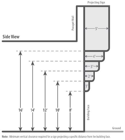
FIGURE 22.114.130-B: ALLOWABLE THICKNESS OF PROJECTING SIGNS OVER PROPERTY OR BUILDING LINE
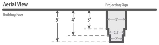
(Ord. 2019-0004 § 1, 2019.)
22.114.140 - Incidental Business Signs.
A.
Each business establishment shall be permitted incidental business signs, provided:
1.
That such signs are wall signs or are attached to an existing freestanding sign structure;
2.
That such signs do not exceed three feet in sign area or six square feet in total sign area; and
3.
That the sum of the sign areas of all such signs does not exceed 10 square feet.
B.
Such signs may be internally or externally lighted, but any continuous or sequential flashing operation is prohibited.
C.
This provision shall not be interpreted to prohibit the use of similar signs of a larger size or in greater numbers where otherwise permitted by this Title 22, and computed as part of the sign area permitted for business signs as provided in Sections 22.114.110 (Wall Business Signs) through 22.114.150 (Temporary Window Signs).
(Ord. 2019-0004 § 1, 2019.)
22.114.150 - Temporary Window Signs.
Each business establishment shall be permitted temporary window signs, provided that such signs do not exceed 25 percent of the area of any single window or of adjoining windows on the same frontage. This provision is not intended to restrict signs utilized as part of a window display of merchandise when such signs are incorporated within such display and located not less than one foot from such windows.
(Ord. 2019-0004 § 1, 2019.)
22.114.160 - Building Identification Signs.
Building identification signs are permitted in all zones, except Zones B-1 and B-2, subject to the following restrictions:
A.
Area Permitted.
1.
In Zones R-1, R-2, R-A, A-1, A-2, O-S, R-R, and W, one wall-mounted sign, not to exceed one square foot in sign area, shall be permitted per principal use.
2.
In Zones R-3, R-4, and R-5, one wall-mounted sign, not to exceed six square feet in sign area, shall be permitted per principal use.
3.
In Zones C-H, C-1, C-2, C-3, C-M, C-MJ, C-R, M-1, M-1.5, M-2, M-2.5, M-3, C-RU, MXD-RU, MXD, P-R, and W, one wall-mounted sign shall be permitted per principal use provided:
a.
Such sign does not exceed six square feet in sign area where located less than 30 feet above ground level, measured at the base of the building below said sign; or
b.
Such sign does not exceed two percent of the exterior wall area of the building wall on which it is mounted, excluding penthouse walls, where located more than 30 feet above ground level measured at the base of the building below said sign.
4.
This provision shall not be interpreted to prohibit the use of similar signs of a larger size or in greater number where otherwise permitted by this Title 22, and computed as part of the sign area permitted for business signs as provided in Sections 22.114.110 (Wall Business Signs) through 22.114.150 (Temporary Window Signs).
B.
Height Permitted. Such signs shall not extend above the highest point of a parapet wall or the lowest point of a sloping roof.
C.
Lighting. Such signs may be internally or externally lighted, provided:
1.
That any continuous or sequential flashing operation is prohibited; and
2.
That in Zones R-1, R-2, R-3, R-4, R-5, R-A, A-1, A-2, O-S, R-R, and W, no exposed incandescent lamp used shall exceed a rated wattage of 25 watts.
(Ord. 2022-0008 § 87, 2022; Ord. 2019-0004 § 1, 2019.)
22.114.170 - Temporary Real Estate Signs.
Temporary real estate signs are permitted in all zones subject to the following restrictions:
A.
Area Permitted.
1.
In Zones R-1, R-2, R-A, A-1, A-2, O-S, R-R, and W, one wall-mounted or freestanding real estate sign shall be permitted for each street or highway frontage, provided:
a.
That such sign does not exceed six square feet in sign area or 12 square feet in total sign area on any street or highway frontage of 100 feet or less; and
b.
That such sign does not exceed 32 feet in sign area or 64 square feet in total sign area on any lot having a street or highway frontage greater than 100 feet.
2.
In Zones R-3, R-4, R-5, and P-R, one wall-mounted or freestanding real estate sign shall be permitted for each street or highway frontage, provided:
a.
That such sign does not exceed 12 square feet in sign area or 24 square feet in total sign area on any frontage of 100 feet or less; and
b.
That such sign does not exceed 48 square feet in sign area or 96 square feet in total sign area on any lot having a street or highway frontage greater than 100 feet.
3.
In Zones C-H, C-1, C-2, C-3, C-M, C-MJ, C-R, M-1, M-1.5, M-2, M-2.5, M-3, B-1, C-RU, MXD-RU, and MXD, one wall-mounted or freestanding real estate sign shall be permitted for each street or highway frontage, provided:
a.
That such sign does not exceed 48 square feet in sign area or 96 square feet in total sign area on any frontage of 100 feet or less; and
b.
That such sign does not exceed 48 square feet in sign area plus an additional one-half square foot in sign area for each one foot of street or highway frontage in excess of 100 feet, to a maximum sign area of 100 square feet or an amount equal to twice the permitted sign area in total sign area.
B.
Height Permitted.
1.
Wall-mounted real estate signs shall not extend above the highest point of a parapet wall or the lowest point of a sloping roof.
2.
Freestanding real estate signs shall not exceed the following maximum heights:
a.
In Zones R-1, R-2, R-3, R-4, R-5, R-A, A-1, A-2, O-S, R-R, and W, eight feet measured vertically from ground level at the base of the sign; and
b.
In Zones C-H, C-R, C-1, C-2, C-3, C-M, C-MJ, M-1, M-1.5, M-2, M-2.5, M-3, B-1, C-RU, MXD-RU, and MXD, 16 feet measured vertically from ground level at the base of the sign.
C.
Location of Signs.
1.
Freestanding real estate signs may be placed in required front yards, provided such signs are located not less than 10 feet from the highway line.
2.
Freestanding real estate signs shall not be placed nearer to a lot line, other than one adjoining a street or highway, than 10 feet.
D.
Lighting.
1.
Signs in Zones R-1, R-2, R-3, R-4, R-5, R-A, A-1, A-2, O-S, R-R, W, and P-R shall be unlighted.
2.
Signs in Zones C-H, C-1, C-2, C-3, C-R, C-M, C-MJ, M-1, M-1.5, M-2, M 2.5, M-3, B-1, C-RU, MXD-RU, and MXD may be internally or externally lighted, but any continuous or sequential flashing operation is prohibited.
E.
Time Limit. All real estate signs shall be removed from the premises within 30 days after the property has been rented, leased, or sold.
(Ord. 2022-0008 § 88, 2022; Ord. 2019-0004 § 1, 2019.)
22.114.180 - Temporary Construction Signs.
Temporary construction signs are permitted in all zones, subject to the following restrictions:
A.
Area Permitted.
1.
In Zones R-1, R-2, R-3, R-4, R-5, R-A, A-1, A-2, O-S, and W, one wall-mounted or freestanding construction sign shall be permitted for each street or highway frontage, provided:
a.
That such sign does not exceed six square feet in sign area or 12 square feet in total sign area on any street or highway frontage of 100 feet or less; and
b.
That such sign does not exceed 32 square feet in sign area or 64 square feet in total sign area on any lot having a street or highway frontage greater than 100 feet.
2.
In Zones C-H, C-1, C-2, C-3, C-R, C-M, C-MJ, M-1, M-1.5, M-2, M-2.5, M-3, B-1, C-RU, MXD-RU, MXD, R-R, and P-R, one wall-mounted or freestanding construction sign shall be permitted for each street or highway frontage, provided:
a.
That such sign does not exceed 48 square feet in sign area or 96 square feet in total sign area on any frontage of 100 feet or less; and
b.
That such sign does not exceed 48 square feet in sign area plus an additional one-half square foot in sign area for each one foot of street or highway frontage in excess of 100 feet to a maximum sign area of 100 square feet or an amount equal to twice the permitted sign area in total sign area.
B.
Height Permitted.
1.
Wall-mounted construction signs shall not extend above the highest point of a parapet wall or the lowest point of a sloping roof.
2.
Freestanding construction signs shall not exceed the following maximum heights:
a.
In Zones R-1, R-2, R-3, R-4, R-5, R-A, A-1, A-2, O-S, and W, eight feet measured vertically from the base of the sign; and
b.
In Zones C-H, C-1, C-2, C-3, C-R, C-M, C-MJ, M-1, M-1.5, M-2, M-2.5, M-3, B-1, C-RU, MXD-RU, MXD, R-R, and P-R, 16 feet measured vertically from the base of the sign.
C.
Location of Signs.
1.
Construction signs shall be maintained only upon the site of the building or structure under construction, alteration or in process of removal.
D.
Lighting.
1.
Construction signs in Zones R-1, R-2, R-3, R-4, R-5, R-A, A-1, A-2, and O-S shall be unlighted.
2.
Construction signs in Zones C-H, C-1, C-2, C-3, C-R, C-M, C-MJ, M-1, M-1.5, M-2, M-2.5, M-3, B-1, C-RU, MXD-RU, MXD, R-R, and P-R, may be internally or externally lighted, but any continuous or sequential flashing operation is prohibited.
E.
Time Limit. All construction signs shall be removed from the premises within 30 days after the completion of construction, alteration or removal of the structure.
(Ord. 2022-0008 § 89, 2022; Ord. 2019-0004 § 1, 2019.)
22.114.190 - Directional or Informational Signs.
A.
Applicability. Free standing or wall-mounted directional or informational signs are permitted in Zones A-1, A-2, O-S, R-R, W, C-1, C-2, C-3, C-M, C-MJ, C-R, M-1, M-1.5, M-2, M-2.5, M-3, B-1, C-RU, MXD-RU, MXD, and P-R, subject to this Section.
B.
Development Standards. Directional or informational signs shall be permitted where there is a need based on the geographic location of the use or the access route to the use creates a need for directional or informational signs not satisfied by other signs permitted by this Title 22.
C.
Area Permitted. Directional or informational signs shall not exceed 12 square feet in sign area or 24 square feet in total sign area.
D.
Height Permitted.
1.
Wall-mounted directional or informational signs shall not extend above the highest point of a parapet wall or the lowest point of a sloping roof.
2.
Freestanding directional or informational signs shall not exceed the following maximum heights:
a.
In Zones A-1, A-2, O-S, R-R, and W, six feet measured vertically from the base of the sign; and
b.
In all other permitted zones, 12 feet measured vertically from the base of the sign.
E.
Location of Signs.
1.
In Zones A-1, A-2, O-S, R-R, and W, directional or informational signs may be located on-site and off-site, provided that where located within a front or corner side yard, such sign shall not be nearer than 10 feet to any street or highway upon which the property fronts; and
2.
In all other permitted zones, such signs shall be located on-site.
F.
Lighting. Directional or informational signs may be internally or externally lighted, provided:
1.
That any continuous or sequential flashing operation is prohibited; and
2.
That in Zones A-1, A-2, O-S, R-R, and W, no exposed incandescent lamp used shall exceed a rated wattage of 25 watts.
(Ord. 2022-0008 § 90, 2022; Ord. 2019-0004 § 1, 2019.)
22.114.200 - Special—Purpose Signs.
The following special-purpose signs are permitted as provided in this Section:
A.
Community Identification Signs. Freestanding community signs are permitted in any zone at or near the entrance to an unincorporated community or city of the County, subject to the following restrictions:
1.
Area Permitted. Such signs shall not exceed 96 square feet in sign area or 192 square feet in total sign area.
2.
Height Permitted. Such signs shall not exceed a maximum height of 16 feet, measured vertically from the base of the sign.
3.
Lighting. Such signs may be internally or externally lighted, but any continuous or sequential flashing operation is prohibited.
4.
Design. Such signs will be architecturally related to the area in which they are located.
B.
Civic Organization Signs. Freestanding civic organization signs are permitted in any zone at or near the entrance to an unincorporated community or city of the County, subject to the following restrictions:
1.
Area Permitted. Such signs shall not exceed 50 square feet in sign area or 100 square feet in total sign area.
2.
Height Permitted. Such signs shall not exceed a maximum height of 15 feet, measured vertically from the base of the sign.
3.
Lighting. Such signs shall be unlighted.
4.
Design. Such signs shall be architecturally related to the area in which they are located.
C.
Bulletin or Special-Event Signs. One freestanding or wall-mounted bulletin or special-event sign may be erected and maintained on each lot in any zone developed for a publicly owned, charitable, religious, or educational institution subject to the following restrictions:
1.
Area Permitted. Such sign shall not exceed 50 square feet in sign area or 100 square feet in total sign area.
2.
Height Permitted.
a.
A wall-mounted sign shall not extend above the highest point of a parapet wall or the lowest point of a sloping roof.
b.
A freestanding sign shall not exceed a maximum height of 15 feet, measured vertically from the base of the sign.
3.
Location of Sign. A freestanding sign shall not be located nearer than 25 feet to a lot line which does not adjoin a street or highway.
4.
Lighting. Such sign may be internally or externally lighted, provided that no exposed incandescent lamp used shall exceed a rated wattage of 25 watts in any Residential or Agricultural Zone, and that any continuous or sequential flashing operation is prohibited in all zones.
5.
Design. Such sign shall be architecturally related to the structure to which it is accessory.
D.
Fuel Pricing Signs. Fuel pricing signs are permitted for each business offering gasoline or other motor vehicle fuel for sale, subject to the following restrictions:
1.
Types of Signs. Such signs shall be separate freestanding signs, panels mounted to freestanding sign structures, or combined freestanding business and fuel pricing signs.
2.
Area Permitted.
a.
One sign, not to exceed 30 square feet in sign area or 60 square feet in total sign area, shall be permitted for each street or highway frontage.
b.
If said business is located on a corner, one sign, not to exceed 60 square feet in sign area or 120 square feet in total sign area, shall be permitted at the corner in lieu of separate signs on each of the intersecting frontages.
c.
The area per sign face of a combined freestanding business and fuel pricing sign shall not exceed the sum of the permitted areas per sign face of the two merging signs. Nor shall the business portion of said sign exceed the area per sign face that would be permitted a business sign were it erected separately.
3.
Height Permitted.
a.
No separate freestanding sign shall exceed 15 feet in height at a corner or five feet in height elsewhere. Such height shall be measured vertically from the base of the sign.
b.
No combined business and fuel pricing sign, or no business sign to which fuel pricing panels are mounted, shall exceed the maximum permitted height of a freestanding business sign as established in Sections 22.114.110 (Wall Business Signs) through 22.114.150 (Temporary Window Signs).
4.
Location of Sign. No separate freestanding sign shall be located nearer to an existing freestanding sign or to a lot line, other than one adjoining a street or highway, than 25 feet.
5.
Lighting. Such signs may be internally or externally lighted.
(Ord. 2019-0004 § 1, 2019.)
22.114.210 - Temporary Subdivision Sales, Entry, and Special-Feature Signs.
Specific terms used in this Section are set forth in Division 2 (Definitions) under Section 22.14.190. Temporary subdivision sales and related entry and special-feature signs are permitted in all zones subject to the following restrictions:
A.
Subdivision Sales Signs.
1.
Area Permitted. One freestanding subdivision sales sign shall be permitted for each street or highway bordering the tract, provided:
a.
That such sign does not exceed 32 square feet in sign area or 64 square feet in total sign area where such tract contains 10 lots or less;
b.
That such sign does not exceed 64 square feet in sign area or 128 square feet in total area where such tract contains 11 to 19 lots; and
c.
That such sign does not exceed 96 square feet in sign area plus an additional one-half square foot in sign area for each one foot of street or highway frontage in excess of 500 feet, to a maximum sign area of 180 square feet, or an amount equal to twice the permitted sign area in total sign area, where such tract contains more than 20 lots.
2.
Height Permitted.
a.
Subdivision sales signs shall not exceed the following maximum heights:
i.
Eight feet, measured vertically from ground level at the base of the sign where such sign has a sign area of 64 square feet or less; and
ii.
Sixteen feet, measured vertically from the base of the sign where such sign is 65 square feet or greater in sign area.
b.
Where a wall is required along the street or highway frontage for which such sign is permitted, Subsection A.2.a, above, may be modified pursuant to Chapter 22.160 (Minor Conditional Use Permit).
3.
Location of Signs. All subdivision sales signs shall be located on the subdivision and shall be oriented to read from the street or highway for which said sign is permitted.
4.
Lighting. Subdivision sales signs may be internally or externally lighted, but any continuous or sequential flashing operation is prohibited.
5.
Time Limit. Subdivision sales signs shall be maintained only until all the property is disposed of, or for a period of three years from the date of issuance of the first building permit for the subdivision, whichever should occur first. Any structure used for such purpose shall, at the end of such three-year period, be either removed or restored for a use permitted in the zone where located, except that the Director may, upon showing of need by the owner of the property, extend the permitted time beyond three years.
6.
Text. All text on such signs shall relate exclusively to the subdivision being offered for sale or lease.
B.
Subdivision Entry and Special-Feature Signs.
1.
This Subsection B may permit the following signs in any subdivision qualifying for subdivision sales signs where:
a.
Subdivision entry signs as are necessary to facilitate entry into and movement within the subdivision; and
b.
Subdivision special-feature signs located in the immediate vicinity of an approved model home and temporary real estate tract office.
2.
Area Permitted.
a.
Subdivision entry signs shall not exceed 12 square feet in sign area or 24 square feet in total sign area.
b.
Special-feature signs shall not exceed 6 square feet in sign area or 12 square feet in total sign area.
3.
Height Permitted. Subdivision entry and special-feature signs shall not exceed a maximum height of eight feet, measured from the base of the sign.
4.
Lighting. Subdivision entry and special-feature signs shall be unlighted.
5.
Location of Signs. Subdivision entry and special-feature signs shall be located on said subdivision.
6.
Time Limit. Subdivision entry and special-feature signs shall have the same time limit as subdivision sales signs approved for the same tract and shall be removed at the end of such period.
(Ord. 2019-0004 § 1, 2019.)
22.114.220 - Subdivision Directional Signs.
A.
Applicability. Subdivision directional signs are permitted in Zones A-1, A-2, C-1, C-H, C-R, R-1, R-2, R-3, R-4, R-A, and R-R, in accordance with this Section.
B.
Definitions. Specific terms used in this Section are defined in Division 2 (Definitions) under Signs.
C.
Permit Requirements Generally.
1.
Except as otherwise provided in this Section, all procedures relative to application, notification, public hearing, and appeal governing conditional use permits for subdivision directional signs shall be the same as for other Conditional Use Permit (Chapter 22.158) applications.
2.
Each application shall be for one subdivision directional sign only.
D.
Application—Additional Information Required. In addition to Chapter 22.158 (Conditional Use Permits), an application for a subdivision directional sign shall contain the following information:
1.
An exact quotation of the message to be placed upon the sign.
2.
A list of all previously approved subdivision directional signs for the same subdivision development, whether existing or not.
3.
The name of the owner of the sign and the owner of the property on which the sign is to be placed.
E.
Approval—Term and Conditions. Findings and decision shall be made in compliance with Section 22.158.050 (Findings and Decision), and the following:
1.
The Commission or Hearing Officer shall find that such subdivision directional sign will comply with the development standards required by Subsection G, below.
2.
Approval of such sign may be for a period of not to exceed one year; provided, however, that the Commission or Hearing Officer, where evidence is submitted to its satisfaction that a continuing need for travel directions to the subdivision development for which such sign was approved exists, may extend such permit for not more than one year if the applicant files a request for such extension prior to the expiration of his original permit. Only one extension may be granted.
F.
Approval—Filing of Deposit and Agreement.
1.
The Commission or Hearing Officer shall require as a condition of approval with each application the deposit of the sum of $175 or savings and loan certificates in the same amount as provided in Chapter 4.36 (Assignment of Savings and Loan Certificates and Shares) of Title 4 (Revenue and Finance) of the County Code, and an agreement signed by the applicant, the owner of the sign, and the owner of the property on which the sign is to be placed, by which such persons agree that the County may enter upon the land upon which the sign is located and remove it, if such sign is not removed and the site thereof restored to a neat and orderly condition within five days after the termination of the permit. Said applicant and owners also shall agree that if such sign is not so removed by them within said five days and the site restored, the County may retain the deposit or savings and loan certificates as liquidated damages.
2.
Any applicant may, in lieu of filing a separate deposit with each application, file a single cash deposit or savings and loan certificates in the amount of $3,000 to cover all of his applications for subdivision directional signs approved pursuant to this Section. A rider showing the administrative file number (permit number) and such other information as may be necessary to readily identify each application covered by such deposit shall be filed.
G.
Development Standards. All subdivision directional signs shall comply with the following regulations:
1.
The written and illustrative messages shall be the same as quoted in the application and as shown on the site plan except as otherwise permitted by the Commission or Hearing Officer, and shall be limited to necessary travel directions, the name of the land development project to which it pertains, a characteristic trademark or insignia, and other such information describing the character of the development as may be specifically approved by the Commission or Hearing Officer; provided, however, that such information shall be auxiliary to the sign's primary purpose of providing travel directions. The sign shall not contain any other advertising.
2.
Such signs shall not exceed a height or width in excess of 20 feet and shall not have an area in excess of 180 square feet per face.
3.
An unobstructed open space shall be maintained to a height of eight feet below the sign except for structural supports. Where topographic features create an unnecessary hardship or unreasonable regulation or make it obviously impractical to require compliance with the provisions of this Subsection H.3, the Commission or Hearing Officer may, without notice or hearing, modify this requirement.
4.
The sign shall be located not less than 500 feet from any other subdivision directional sign.
5.
No additions, tags, streamers, or accessories may be added to an approved sign.
6.
Not more than four single- or double-faced signs pertaining to the same subdivision development may be used at the same time.
7.
Such signs shall be used and located within four miles from the exterior boundary of the subdivision development to which they relate.
8.
Such signs shall not be located within the right-of-way of any highway, parkway, street, or alley or along established and existing freeways which have been designated as freeway routes by the Division of Highways of the State of California or along scenic highways.
9.
Identification shall be placed on such sign indicating the permit number, sign, owner, and expiration date.
10.
Where the distance between the faces of a double-faced sign is more than 24 inches, such faces shall be considered two separate signs.
11.
All exposed backs of such signs visible to the public shall be suitably covered to conceal the structure and be properly maintained.
H.
Combining Signs for Separate Developments—Conditions. The Commission or Hearing Officer may, where an applicant concurrently files applications for Conditional Use Permits for subdivision directional signs pertaining to more than one subdivision development, modify the standards contained in Subsections G.3 and G.4, above, to permit the grouping or combining of two or more signs providing travel directions to different developments. Such two or more separate signs may be grouped together in one structure or may be consolidated into one sign where, in the opinion of the Commission or Hearing Officer, such grouping or combining helps to reduce visual clutter and distraction.
I.
Removal or Relocation of Signs Required When. If a highway, parkway, street, or alley is widened so that the location of the sign is included in the right-of-way, the owner, at no expense to the County shall either remove such sign or relocate it outside of the new right-of-way.
(Ord. 2019-0004 § 1, 2019.)
22.114.230 - Signs for Uses Granted by a Conditional Use Permit in Residential, Agricultural, or Watershed Zones.
A.
Where a Conditional Use Permit (Chapter 22.158) application is required for a use in a Residential, Agricultural, or Watershed Zone, the Commission or Hearing Officer may approve business signs deemed appropriate for such use as part of the application; provided, however, that no business sign or signs may be authorized that would not be permitted in Zone C-1 as permitted by this Chapter.
B.
Where business signs described in Subsection A, above, have not been approved by the Commission or Hearing Officer as part of the application, the provisions applicable to principal permitted uses in the specific zone in which the use is located shall be deemed to have been specified.
(Ord. 2019-0004 § 1, 2019.)
22.116.010 - Purpose.
This Chapter establishes the centerlines, dedication, improvement, and access requirements that the County may impose on development.
(Ord. 2019-0004 § 1, 2019.)
22.116.020 - Applicability.
A.
Section 22.116.030 (Road Dedication and Improvements), Section 22.116.040 (Intersections and Corner Cutoff Requirements), and Section 22.116.050 (Major Bridge and Thoroughfare Fees) do not apply to the following buildings or structures if they comply with all other provisions of this Title 22:
1.
Buildings, structures, or uses permitted in Zone R-2.
2.
Outdoor advertising signs.
3.
Accessory agricultural buildings where used primarily for agricultural purposes.
4.
Oil wells.
5.
Electrical distribution and transmission substations.
6.
Water storage tanks, reservoirs, and water pumping plants, but excluding offices or maintenance yard facilities.
7.
Gas measurement, distribution, and meter and control stations.
8.
Telephone repeater stations.
9.
Temporary carnivals and revival meetings.
10.
Other similar uses that, in the opinion of the Commission or Hearing Officer, will not generate a greater volume of traffic than the uses listed in this Section.
B.
Section 22.116.030 (Road Dedication and Improvements), Section 22.116.040 (Intersections and Corner Cutoff Requirements), and Section 22.116.050 (Major Bridge and Thoroughfare Fees) do not apply to the use, alteration, or enlargement of an existing building or structure or the erection of one or more accessory buildings or structures, or both, on the same lot, if the total value of such alteration, enlargement, or construction does not exceed one-half of the current market value of all existing buildings or structures on such lot.
(Ord. 2019-0004 § 1, 2019.)
22.116.030 - Road Dedication and Improvements.
A building or structure shall not be used on any lot, or any portion of such lot, that abuts upon an alley, street, or highway unless the one-half of the alley, street, or highway that is located on the same side of the centerline as such lot has been dedicated and improved as follows:
A.
Dedication.
1.
Dedication Standards. Alleys, streets, and highways, shall be dedicated to the width from the centerline specified in Section 22.116.070 (Highway Lines), and including corner cutoffs specified in Section 21.24.110 of Title 21 (Subdivisions) of the County Code, except that dedication in any case shall not be required to such an extent as to reduce the area or width of any lot to less than that specified in Sections 22.110.140.C (Required Area—Reduced for Highways—Conditions) and 22.110.140.E (Conveyance or Division of Land—Lot Area and Width Restrictions).
2.
Agreement to Dedicate. In lieu of dedication, the Director of Public Works may accept a dedication agreement signed by all persons having any right, title, interest, or lien in the property, or any portion thereof, to be dedicated. The signatures on such agreement shall be verified, and the Director of Public Works shall record such agreement with the Registrar-Recorder/County Clerk.
B.
Improvements.
1.
Curbs, gutters, sidewalks, base, pavement, street lights, street trees, and drainage structures, where required, shall be constructed at the grade and at the location specified by the Director of Public Works unless there already exists within the present right-of-way, or on property the owner has agreed to dedicate, curbs, gutters, sidewalks, base, pavement, street lights, street trees, or drainage structures that the Director of Public Works finds are adequate.
2.
Sidewalks shall be not less than five feet in width unless the available portion of the highway or street is less, in which case they shall be the width specified by the Director of Public Works.
3.
Curbs, gutters, drainage structures, base, pavement, street lights, street trees, and sidewalks shall comply with the standards in Title 21 (Subdivisions) of the County Code, except as otherwise authorized by the Director of Public Works for public health, safety, or welfare reasons.
4.
All construction within the existing or proposed road rights-of-way shall be done under provisions of Division 1 of Title 16 (Highway Code) of the County Code for Highway Permits.
5.
In lieu of the required improvements, the Director of Public Works may accept from any responsible person a contract to make such improvements in accordance with the following:
a.
Such contract shall specify a time in which the improvements shall be completed. Said improvements shall be completed within the time specified in the agreement to improve, except that the Director of Public Works may grant such additional time as the Director deems necessary if, in the Director's opinion, a good and sufficient reason exists for the delay.
b.
Such contract shall be accompanied by a deposit with the Board of a sum of money or negotiable bonds or savings and loan certificates or shares in an amount which, in the opinion of the Director of Public Works, equals the cost of providing the improvements. If savings and loan certificates or shares are deposited, such certificates or shares shall be assigned to the County, and such deposit and assignment shall be subject to all the provisions and conditions of Chapter 4.36 of Title 4 (Revenue and Finance Code) of the County Code.
c.
If the estimated cost of the improvements equals or exceeds $1,000, in lieu of such deposit the applicant may file with the Board a corporate surety bond guaranteeing the adequate completion of all of the improvements, in an amount equal to such estimated cost.
d.
If the improvement is not completed within the time specified in an agreement, the Board may, after 10 days, serve a written notice to the person, firm, or corporation that signed the contract, or after 20 days, send a written notice by registered mail and addressed to the last known address of the person, firm, or corporation that signed the contract. The notice shall state that the Board has determined that the improvement work or any part of the work is incomplete, and any portion of deposits or bonds given for the faithful performance of the work may be forfeited to the County, or the Board may cash any instrument of credit so deposited in such amount as may be necessary to complete the improvement work.
(Ord. 2019-0004 § 1, 2019.)
22.116.040 - Intersections and Corner Cutoff Requirements.
In all zones at the intersections of roads:
A.
No building or structure shall be used within the area of the curve radii required at the intersections of roads by Section 21.24.110 (Right-of-Way Radius) in Title 21 (Subdivisions) of the County Code, except as permitted below and provided that such structures do not constitute a visual obstruction between three and one-half feet and eight feet above the level of the ground:
1.
Eaves and cantilevered roofs per Section 22.110.090.A (Eaves and Cantilevered Roofs) and Section 22.140.585.F.17.b.i (Eaves and Cantilevered Roofs);
2.
Planter boxes and masonry planters per Section 22.110.040.A (Planter Boxes and Masonry Planters) and Section 22.140.585.F.15.a (Planter Boxes and Masonry Planters);
3.
Driveways, walkways, patio slabs, wooden decks, and other materials as specified in Section 22.110.040.D (Driveways, Walkways, and Patio Slabs) and Section 22.140.585.F.15.c (Driveways, Walkways, and Patio Slabs);
4.
Projecting signs site signs per Section 22.110.040.H (Projecting Signs); and
5.
Freestanding signs per Section 22.110.040.I (Freestanding Signs) in Zones C-H and C-1.
B.
Corner cutoffs, per Section 22.116.030.A.1 (Dedication Standards), shall be provided as specified in Section 21.24.110 (Right-of-Way Radius) in Title 21 (Subdivisions) of the County Code.
(Ord. 2020-0032 § 27, 2020; Ord. 2019-0004 § 1, 2019.)
22.116.050 - Major Bridge and Thoroughfare Fees.
A building or structure shall not be used on any lot, any portion of which is located within a district established pursuant to Section 21.32.200 (Major Thoroughfare and Bridge Fees) in Title 21 (Subdivisions) of the County Code, unless the required district fee has been paid as a condition of issuing a building permit or unless exempted by Section 22.116.020.A.
(Ord. 2019-0004 § 1, 2019.)
22.116.060 - Modifications.
A.
Director of Regional Planning. The Director may grant a modification and relieve the applicant from compliance with all or a portion of Section 22.116.030 (Road Dedication and Improvements) and Section 22.116.050 (Major Bridge and Thoroughfare Fees) if the following standards are met:
1.
Property adjoining on both sides of the subject property is developed with lawfully existing buildings or structures which, were they not already existing, would be subject to the provisions of this Chapter, and the requirement to dedicate, pave, or improve would require a greater width than is the alley, street, or highway abutting the existing buildings or structures on the adjoining properties; or
2.
The lot adjoins an alley, street, or highway for a distance of 100 feet or more, and only a portion of said lot is to be used for such building or structure or occupied by such use, and the modification will not affect the safety and convenience of bicyclists and pedestrians, including children, senior citizens, and persons with disabilities, using such alley, street, or highway.
B.
Director of Public Works. The Director of Public Works may grant a modification and relieve the applicant from compliance with all or a portion of Sections 22.116.030 (Road Dedication and Improvements) and 22.116.050 (Major Bridge and Thoroughfare Fees), if the following standards are met:
1.
There is in existence or under negotiation a contract between the County and a contractor to install the required improvements;
2.
The Director of Public Works is unable to furnish grades within a reasonable time;
3.
The required construction would create a drainage or traffic problem;
4.
The construction will be isolated from a continuous roadway that may not be improved for many years; or
5.
There are in existence partial improvements satisfactory to the Director of Public Works, who deems construction of additional improvements to be unnecessary or constitute an unreasonable hardship.
C.
Variance. Any aggrieved person may apply for a Variance (Chapter 22.194) from any provision of this Chapter, whether that person has applied for a modification or not. The provisions of Subsections A and B, above, shall constitute additional grounds for a variance from any provisions of this Chapter.
(Ord. 2019-0004 § 1, 2019.)
22.116.070 - Highway Lines.
In all zones, highway lines are hereby established parallel to the centerline of every parkway, alley, highway, and street, as follows:
A.
Forty feet from the centerline for every secondary highway, except as otherwise provided below:
1.
Downey Road—35 feet on the easterly side of the centerline, extending from Whittier Boulevard northerly to 3rd Street, as shown on C.S.B.-2866.
2.
Hooper Avenue—Increasing in width on the westerly side of the centerline from a minimum of 40 feet at a point 0.54 foot southerly of the centerline of 67th Street, the westerly boundary of said Hooper Avenue, extending southerly along the westerly boundary of Hooper Avenue (60 feet wide), as shown on map of Tract No. 5450, recorded in Book 59, Pages 94 and 95 of Maps, to a maximum of 50 feet at the centerline of 69th Street as shown on the map. Increasing in width at a uniform rate on the easterly side of the centerline from a minimum of 40 feet at a point 0.54 foot southerly of the centerline of 67th Street, southerly to a maximum of 50 feet at the centerline of 69th Street; 50 feet on each side of the centerline extending from the centerline of 69th Street southerly to a point 133.59 feet southerly of the centerline of 75th Street; decreasing in width at a uniform rate from a maximum of 50 feet on each side of the centerline at a point 133.59 feet southerly of the centerline of 75th Street southerly to a minimum of 40 feet on each side of the centerline at a point 62.60 feet southerly of the centerline of 76th Street, as shown on C.S.B.-5140, sheets 1 and 2.
3.
Pennsylvania Avenue—50 feet on the easterly side of the centerline, extending from the northeasterly boundary of the Route 210 (Foothill) Freeway northerly to Altura Avenue; decreasing in width on the easterly side of the centerline from a maximum of 50 feet at Altura Avenue extending northerly along a curve in the easterly boundary having a radius of 1,351.70 feet to a point 122 feet northerly of the northerly line of Altura Avenue (60 feet wide), and continuing northerly along said easterly boundary along a reverse curve having a radius of 1,335.70 feet a distance of 119 feet, to a minimum of 40 feet, as shown on C.S.B.-5072, sheet 1.
4.
223rd Street—50 feet on the northerly side of the centerline extending from Vermont Avenue westerly to a point 245 feet westerly of the centerline of Vermont Avenue; 50 feet on the southerly side of the centerline extending from Vermont Avenue westerly to a point 295 feet westerly of the centerline of Vermont Avenue; decreasing in width at a uniform rate on the southerly side of the centerline from a maximum of 50 feet at a point 295 feet westerly of the centerline of Vermont Avenue extending westerly to a minimum of 40 feet at a point 395 feet westerly of the centerline of Vermont Avenue; 42 feet on the northerly side of the centerline extending from Meyler Street westerly to Normandie Avenue, as shown on C.S.B.-793, sheet 1.
B.
Fifty feet from the centerline of every major highway, except as otherwise provided below:
1.
Arizona—Mednik Avenue—54 feet on each side of the centerline extending from Telegraph Road northerly to a point 277.49 feet northerly of the centerline of Verona Street; decreasing in width at a uniform rate from a maximum of 54 feet on each side of the centerline, extending from a point 277.49 feet northerly of the centerline of Verona Street northerly to a minimum of 50 feet on each side of the centerline at a point 456.61 feet northerly of the centerline of Verona Street; increasing in width at a uniform rate from a minimum of 50 feet on each side of the centerline extending from a point 201.28 feet northerly of the centerline of Whittier Boulevard northerly to a maximum of 54 feet on each side of the centerline at a point 400.44 feet northerly of the centerline of Whittier Boulevard; 54 feet on each side of the centerline extending from a point 400.44 feet northerly of the centerline of Whittier Boulevard northerly to the centerline of First Street, as shown on C.S.B.-2825, sheets 1 and 2.
2.
Atlantic Boulevard—45 feet on each side of the centerline extending, from Whittier Boulevard northerly to the northeasterly boundary of Tract No. 7192 filed in Book 78, Page 38 of Maps, as shown on C.S.B.-8758.
3.
Azusa Avenue—55 feet on each side of the centerline extending from Amar Road southerly to Colima Road, excluding all those portions within the cities of West Covina and Industry, as shown on C.S.B.-707, 2949, and 2628.
4.
Colima Road—60 feet on the southerly and southeasterly side of the centerline extending from Azusa Avenue westerly and southwesterly to the northerly boundary of the city of Whittier; 60 feet on the northerly side of the centerline extending from Azusa Avenue westerly to the easterly boundary of Tract No. 27718, as shown on map recorded in Book 766, Pages 49 and 50 of Maps; 60 feet on the northwesterly side of the centerline extending from a point 186.92 feet northeasterly of the easterly boundary of Tract No. 27176, as shown on map recorded in Book 738, Pages 79 to 81 of Maps, southwesterly to said northerly boundary of the city of Whittier, as shown on C.S.B.-2626, sheets 1 and 2.
5.
Del Amo Boulevard—54 feet on the northerly side of the centerline, extending from Wilmington Avenue easterly to Alameda Street, as shown on C.S.B.-617, sheet 4.
6.
Lake Avenue—40 feet on the easterly side of the centerline, extending from the northerly boundary of the city of Pasadena to Woodbury Road; 45 feet on each side of the centerline extending from Woodbury Road northerly to Altadena Drive, as shown on C.S.B.-2900.
7.
Lakes Hughes Road—55 feet on each side of the centerline extending Castaic Road easterly to Ridge Route, as shown on C.S.B.-5001, sheet 1.
8.
Mednik Avenue—Described under Arizona-Mednik Avenue.
9.
Paramount Boulevard—55 feet on each side of the centerline, extending from the northeasterly boundary of the city of Montebello northeasterly to San Gabriel Boulevard, as shown on C.S.B.-3068.
10.
Pearblossom Highway—60 feet on each side of the centerline from Sierra Highway northerly and easterly to the centerline of Fort Tejon Road, as shown on C.S.B.-.5396, and C.S.B.-2858, Sheet 3.
11.
Sierra Highway—Increasing in width at a constant rate on each side of the centerline from a minimum centerline of the Angeles Forest Highway to a maximum of 60 feet northerly of the centerline of the Angeles Forest Highway, 60 feet on each side of the centerline extending from a point 640.00 feet northerly of the centerline of the Angeles Forest Highway northerly to the centerline of Pearblossom Highway as shown on C.S.B.-5396, C.S.B.-5505, and F.M. 120048, Sheets 2 and 3.
12.
Slauson Avenue—47 feet on the southerly side of the centerline extending from Wilmington Avenue westerly to Central Avenue, as shown on C.S.B.-2930.
C.
Parkways, minimum 40 feet from centerline, except as otherwise provided herein:
1.
Grand Avenue—60 feet on the easterly side of the centerline extending from the northwesterly boundary of the city of Walnut northerly to the centerline of Golden Bough Drive; 55 feet on the easterly side of the centerline extending from the centerline of Golden Bough Drive northwesterly to the southerly boundary of the city of West Covina at a point approximately 78 feet southeasterly of the centerline of Virginia Avenue; 60 feet on the westerly side of the centerline extending from said northwesterly boundary of the city of Walnut northerly to the centerline of Cortez Street; 50 feet on the westerly side of the centerline extending from the centerline of Cortez Street northerly to the centerline of Sunset Hill Drive; 55 feet on the westerly side of the centerline extending from the centerline of Sunset Hill drive northerly to said southerly boundary of the city of West Covina, as shown on C.S.B. 5049, sheets 1 and 2.
2.
Huntington Drive—44 feet on the northerly side of the centerline (as used in this portion of subsection C.2, "centerline" means the centerline of the northerly roadway of Huntington Drive) extending from the centerline of Michillinda Avenue westerly to the centerline of Rosemead Boulevard; 51 feet on the northerly side of the centerline extending from the centerline of Rosemead Boulevard westerly to the centerline of Lotus Avenue; 40 feet on the northerly side of the centerline extending from the centerline of Lotus Avenue westerly to a point 50 feet westerly of the centerline of Madre Street; decreasing in width at a uniform rate on the northerly side of the centerline from a maximum of 40 feet at a point 50 feet westerly of the centerline of Madre Street to a minimum of 20 feet at a point 350 feet westerly of the centerline of Madre Street; 20 feet on the northern side of the centerline extending from a point 350 feet westerly of the centerline of Madre Street westerly to a point 639.12 feet easterly of the centerline of El Campo Drive; 51 feet on the northerly side of the centerline extending from a point 639.12 feet easterly of the centerline of El Campo Drive westerly to the centerline of El Campo Drive; 20 feet on the northerly side of the centerline extending from the centerline of El Campo Drive westerly to the centerline of San Gabriel Boulevard, as shown on C.S.B.-2700.
3.
Mulholland Highway—50 feet on each side of the centerline extending from Pacific Coast Highway northerly and easterly to a point 5,847.20 feet westerly of the centerline of Las Virgenes Canyon Road; 60 feet on each side of the centerline extending from a point 5,847.20 feet westerly of the centerline of Las Virgenes Canyon Road easterly to a point 4,780.20 feet westerly of the centerline of Las Virgenes Canyon Road; 50 feet on each side of the centerline extending from a point 4,780.20 feet westerly of the centerline of Las Virgenes Canyon Road easterly and northerly to the southerly boundary of the city of Los Angeles, as shown on C.S.B.-8824, sheets 9, 11, 13, 14; C.S.B.-2836; F.M. 20265, sheets 2, 3, 4; C.S.B.2881; F.M. 11541, sheet 3; F.M. 20235, sheets 1, 2; and C.S.B. 2336, sheets 1, 2, 3, 4.
D.
Alleys and streets, one-half the planned ultimate width for alleys or streets, pursuant to the standards of Section 21.24.090 (Right-of-Way and Roadway Width Requirements—Cross-section Diagrams) of Title 21 (Subdivisions) of the County Code unless in the opinion of the Director, topographic features, subdivision plans, or other conditions create an unnecessary hardship or unreasonable regulation and the Director deems a lesser width adequate. The Director shall designate the distance from the centerline in any case where such ultimate width is not specified.
E.
Limited secondary highway, thirty-two feet from centerline; this may be increased to 40 feet for additional improvements where traffic or drainage conditions warrant.
(Ord. 2019-0004 § 1, 2019.)
22.118.010 - Regulations—Board Authority.
The Board may prescribe, by uniform rule or regulation, the minimum course of its excavations or other operations tending to displace the soil; and shall also have the power to prescribe any and all other rules and regulations, uniform in their operation, necessary for the carrying out of the purposes of this Chapter.
(Ord. 2019-0004 § 1, 2019.)
22.118.020 - Permit—Required When Work Would Create Flood Hazards.
Whenever the Board finds that the excavation or quarrying of any rock, sand, gravel, or other material in a particular area would create flood hazard or would be otherwise dangerous to the public safety, then before any person excavates or quarries in any part of such area, such person shall first obtain from the Los Angeles County Flood Control District a permit to do so.
(Ord. 2019-0004 § 1, 2019.)
22.118.030 - Permit—Issuance Conditions.
The Los Angeles County Flood Control District may issue such permit upon the condition that the applicant, before commencing any such excavation and at such other times during such excavation as may be necessary, shall erect such dikes, barriers, or other structures as will afford, in the opinion of the Los Angeles County Flood Control District, either the same protection as if no excavation should be made, or protection adequate to prevent the flow of the floodwaters out of their natural channels.
(Ord. 2019-0004 § 1, 2019.)
22.118.040 - Plans and Specifications.
The Los Angeles County Flood Control District may require the submission of plans and specifications showing the nature of the proposed excavation and dikes, barriers, or other structures.
(Ord. 2019-0004 § 1, 2019.)
22.118.050 - Conformity with Permit Conditions.
No person may make any excavation within such area except after receiving, and in conformity with, such a permit.
(Ord. 2019-0004 § 1, 2019.)
22.118.060 - Permit—Liability Limitations.
The issuance of such a permit shall not constitute a representation, guarantee, or warranty of any kind or nature by the Los Angeles County Flood Control District, or by any officer or employee of either thereof, of the practicability or safety of any structure or other plan proposed, and shall create no liability upon, or a cause of action against such public body, officer, or employee for any damage that may result from any excavation made pursuant thereto.
(Ord. 2019-0004 § 1, 2019.)
22.118.070 - Obstructions Prohibited Where.
A.
A person shall not place or cause to be placed in the channel or bed of any river, stream, wash, or arroyo, or upon any property over which the Los Angeles County Flood Control District has an easement for flood control purposes duly recorded by the Registrar-Recorder/County Clerk, any wires, fence, building, or other structure, or any rock, gravel, refuse, rubbish, tin cans, or other matter which may impede, retard, or change the direction of the flow of water in such river, stream, wash, or arroyo, or that will catch or collect debris carried by such water, or that is placed where the natural flow of the stream and floodwaters would carry the same downstream to the damage or detriment of either private or public property adjacent to the said river, stream, wash, arroyo, or channel.
B.
This Section does not supersede or modify the provisions of any other ordinance.
(Ord. 2019-0004 § 1, 2019.)
22.118.080 - Operations Along Rio Hondo and San Gabriel Rivers.
A.
Every operator of any rock quarry, sand or gravel pit, rock crushing plant, or any apparatus for the excavation or manufacture of rock, sand, or gravel, which quarry pit, excavation plant or apparatus is so located as to intercept or obstruct any of the flow of the Rio Hondo or San Gabriel Rivers, shall so conduct all such operations as to always provide a channel of sufficient capacity to bypass 1,000 cubic feet of water per second in each river without the flow entering any such pit, excavation, or quarry.
B.
This Section does not apply to that reach of the Rio Hondo between Santa Fe Dam and Peck Road.
(Ord. 2019-0004 § 1, 2019.)
22.118.090 - Hazardous Area Designated.
The Board finds that the excavation or quarrying of any rock, sand, gravel, or other material in the area described as follows:
Beginning at a point in the easterly line of Section 1, T. 1 S., R. 11 W., as shown on a map of the subdivision of Rancho Azusa de Duarte, recorded in Book 6, pages 80 and 82, inclusive, of Miscellaneous Records of Los Angeles County, distant N. 0° 10' 06" W. thereon 1,820.99 feet from the southerly line of said Rancho, as shown on County Surveyor's Map No. B-1215, on file at the Los Angeles County Flood Control District; thence S. 57° 59' 09" W. 7,538.27 feet; thence S. 32° 00' 51" E. 900.00 feet; thence N. 57° 59' 09" E. 6,979.25 feet to a point in said easterly line of Section 1, distant S. 0° 10' 06" E. thereon 1059.48 feet from the point of beginning; thence northerly along said easterly line to the point of beginning; would create a flood hazard and in other ways be dangerous to the public safety.
(Ord. 2019-0004 § 1, 2019.)
22.118.100 - Los Angeles County Flood Control District to Act as Consultant.
A.
The Los Angeles County Flood Control District shall act as a consultant to the Department on all applications for a permit, variance, nonconforming use or structure review, or zone change relating to flood control and flood hazard identification, avoidance, and mitigation in all areas delineated on maps furnished to the Department pursuant to Subsection B, below.
B.
The Los Angeles County Flood Control District shall provide the Department with a series of maps delineating areas subject to flood, mud, and debris hazards. The maps shall be prepared by the Los Angeles County Flood Control District, shall be based on the best currently available information and shall be updated at least annually.
C.
The Department shall consult with the Los Angeles County Flood Control District with respect to such applications affecting property in the hazard areas delineated on the maps.
D.
The Los Angeles County Flood Control District shall prepare written reports of its examination of each application affecting property in the hazard areas delineated on the maps.
E.
The reports shall be considered by the Department, the Commission, and the Board in acting upon the applications. The actions upon the application shall be supported in writing.
(Ord. 2019-0004 § 1, 2019.)
22.119.010 - Purpose.
The purpose of this Chapter is to preserve the supply of affordable housing and require affordability of replacement dwelling units.
(Ord. 2021-0018 § 8, 2021.)
22.119.020 - Definitions.
Specific terms used in this Chapter are defined in Division 2 (Definitions), under "Affordable housing and senior citizen housing."
(Ord. 2021-0018 § 8, 2021.)
22.119.030 - Applicability.
Except as otherwise specified in this Chapter, the provisions of this Chapter, in conjunction with Chapter 22.166 (Housing Permits), apply to any of the following:
A.
New construction of any principal building;
B.
A change of a principal residential use to another principal use;
C.
A change in the number of dwelling units;
D.
A land division subject to Title 21 (Subdivisions) of the County Code; or
E.
Legalization of an existing unpermitted dwelling unit.
(Ord. 2021-0018 § 8, 2021.)
22.119.040 - Exemptions.
The following are exempt from the requirements of this Chapter:
A.
New construction of a single-family residence on a lot with no other principal uses or structures;
B.
New construction or legalization of accessory dwelling units or junior accessory dwelling units;
C.
Conversion to resident ownership of all rented spaces in a mobilehome park;
D.
Addition of mobilehome spaces or mobilehomes in a mobilehome park;
E.
A lease project, as defined in Section 21.08.090 (Lease project) in Title 21 (Subdivisions) of the County Code;
F.
A project in a Very High Fire Hazard Severity Zone, as depicted in the General Plan;
G.
A project that is located within an area subject to an affordable housing replacement requirement, pursuant to a development agreement, specific plan, or local policy.
(Ord. 2021-0018 § 8, 2021.)
22.119.050 - Requirements.
A.
Dwelling units that are proposed to be or have been demolished, vacated, or converted from rental to for sale, shall be replaced if the use and density of such units are consistent with zoning or the General Plan, including any applicable Area, Community, or Neighborhood Plan, as set forth in Section 22.02.050 (Consistency with the General Plan), and are or were any of the following:
1.
Subject to a recorded covenant that restricts rents to levels affordable to persons and families of moderate, lower, very low or extremely low income within the five years prior to application submittal;
2.
A rent-stabilized unit pursuant to Section 8.52.030.F (Covered Rental Unit) in Title 8 (Consumer Protection, Business and Wage Regulations) of the County Code or pursuant to section 1947.12 of the California Civil Code within the five years prior to application submittal;
3.
Occupied by lower, very low or extremely low income tenants, including mobilehome owners renting spaces in a mobilehome park, within the five years prior to application submittal;
4.
Withdrawn from rent or lease in accordance with Chapter 12.75 (commencing with section 7060) of the California Government Code within the 10 years prior to application submittal.
B.
The number and type of affordable replacement units shall be determined as follows:
1.
The number of affordable replacement units for lower or very low income households shall be determined in accordance with section 65915 of the California Government Code;
2.
Affordable replacement units for lower or very low income households shall be provided at the level of affordability determined in accordance with section 65915 of the California Government Code;
3.
Affordable replacement units for extremely low income households shall be provided in at least the same number as existed on the site within the five years prior to application submittal, or in the same proportion of extremely low income renter households to all renter households within unincorporated County, as determined by the most recently available data from the United States Department of Housing and Urban Development's Comprehensive Housing Affordability Strategy database, if the income category is unknown for any of the following:
a.
The current household in occupancy at the time of application submittal;
b.
The last household in occupancy, if a unit is unoccupied at the time of application submittal; or
c.
The households at the highpoint of such units that existed in the five-year period preceding application, if the units have been vacated or demolished.
4.
Dwelling units that are or were rent-stabilized pursuant to Section 8.52.030.F (Covered Unit) in Title 8 (Consumer Protection, Business and Wage Regulations) of the County Code or section 1947.12 of the California Civil Code during the five-year period prior to application submittal, and were or are occupied by households above lower income, shall be replaced with units affordable to lower, very low or extremely low income households;
5.
At least the same total number of dwelling units and at least the same total number of bedrooms shall be replaced at the same or deeper level of affordability;
6.
The required number of affordable replacement units shall not be reduced as the result of the deeper level of affordability of the affordable replacement units;
7.
Affordable replacement units affordable to lower, very low or extremely low income households shall be rental dwelling units; and
8.
Units subject to a covenant that restricts rents to levels affordable to moderate income households shall be replaced with units that are affordable to households of moderate income or below moderate income. If they are replaced with units affordable to households of moderate income, the affordable replacement units may be rental or for sale.
C.
Inclusionary Housing or Density Bonus. Affordable replacement units required in this Chapter may count toward the affordable housing set-aside units required in Chapter 22.120 (Density Bonus) or Chapter 22.121 (Inclusionary Housing), if applicable.
D.
Location of Affordable Replacement Units.
1.
On-site. Except as specified in Subsection D.2, below, affordable replacement units shall be provided on-site.
2.
Off-site.
a.
Affordable replacement units may be provided off-site, subject to the following:
i.
The affordable replacement units count toward the affordable housing set-aside units required in Chapter 22.121 (Inclusionary Housing);
ii.
The required affordable housing set-aside units are provided off-site, subject to all applicable provisions in Section 22.121.050.F (Location), except that the off-site parcel shall be located in an unincorporated area of the County and is either within one-quarter mile of the principal project or developed as part of a community land trust; and
iii.
The construction of such units does not result in units requiring replacement pursuant to this Chapter.
b.
Notwithstanding Subsection D.2.a.i, above, where the number of required affordable replacement units exceeds the number of required affordable housing set-aside units that are provided off-site, all affordable replacement units, including those that do not count toward the required affordable housing set-aside units, may be provided on the same off-site parcel, subject to the following:
i.
The off-site parcel, with its developable acreage, zoning and General Plan land use designation, is sufficient to permit the construction of all affordable replacement units; and
ii.
The requirements in Section 22.121.050.F.5, if the applicant partners with a third-party developer for the provisions of the affordable replacement units.
E.
Notwithstanding Subsection D, above, a project that is subject to this Chapter may provide replacement in accordance with Chapter 22.268 (Affordable Housing Replacement Fee) if it is either of the following:
1.
A non-residential development; or
2.
A land division that:
a.
Shall result in no increase in dwelling units; and
b.
Is required to provide rental replacement units pursuant to this Section.
F.
Tenure. Affordable replacement units in a common interest development or a single-family residential subdivision shall be for sale only.
G.
Timing.
1.
All permits and entitlements, including the building permits, for the affordable replacement units shall be obtained prior to or concurrently with the permits and entitlements, including the building permits, for the non-replacement units.
2.
Where affordable replacement units are provided off-site, pursuant to Subsection D.2, above, such units shall obtain a certificate of occupancy from Public Works prior to the issuance of the final certificate of occupancy for the principal project.
H.
Duration of Affordability.
1.
Rental. The affordability term for rental replacement units shall be in perpetuity.
2.
For sale. The initial sale of the affordable replacement units shall be restricted to eligible buyers and shall require an equity-sharing agreement with the County, as described in Chapter 22.166 (Housing Permits).
I.
Covenant and Agreement Required. A covenant and agreement ensuring the continued availability of affordable replacement units shall be recorded, pursuant to Section 22.166.070 (Covenant and Agreement).
(Ord. 2021-0018 § 8, 2021.)
22.120.010 - Purpose.
The purpose of this Chapter is to implement the requirements as set forth in Section 65915 of the California Government Code, as amended, and to increase the production of affordable housing and senior citizen housing.
(Ord. 2019-0053 § 21, 2019.)
22.120.020 - Definitions.
Specific terms used in this Chapter are defined in Division 2 (Definitions), under "Affordable Housing and Senior Citizen Housing."
(Ord. 2019-0053 § 21, 2019.)
22.120.030 - Applicability.
Notwithstanding any contrary provisions in this Title 22, the provisions of this Chapter, in conjunction with Chapter 22.166 (Housing Permits), shall apply in all zones that allow residential use as a principal use, and apply to the eligible housing developments, including projects to substantially rehabilitate and convert an existing multi-family dwelling, as defined in section 65863.4 (d) of the California Government Code, where the result of the rehabilitation would be a net increase in available dwelling units.
(Ord. 2020-0064 § 10, 2020; Ord. 2019-0053 § 21, 2019.)
22.120.040 - Eligibility.
Except as specified otherwise, a project is eligible for a density bonus, if it complies with the following:
A.
Minimum Dwelling Units Required.
1.
A project subject to Section 22.120.050 (Affordable Housing) or Section 22.120.070 (Land Donation) shall have a minimum of five baseline dwelling units.
2.
A project subject to Section 22.120.060 (Senior Citizen Housing) shall have:
a.
A minimum of 35 dwelling units, if it is a senior citizen housing development; or
b.
A minimum of 80 percent of occupied dwelling units occupied by at least one senior citizen, if it is a mobilehome park for senior citizens.
B.
Replacement Dwelling Units. The project shall replace any rental dwelling units that exist(ed) on the site, pursuant to Chapter 22.119 (Affordable Housing Replacement).
C.
Additional Requirements. The project shall be in compliance with one of the following:
1.
Section 22.120.050 (Affordable Housing);
2.
Section 22.120.060 (Senior Citizen Housing);
3.
Section 22.120.070 (Land Donation); or
4.
Section 22.120.075 (Mobilehome Park Density Bonus).
(Ord. 2021-0018 § 9, 2021; Ord. 2019-0053 § 21, 2019.)
22.120.050 - Affordable Housing.
A.
Density Bonus. Except as specified otherwise, a housing development shall receive a density bonus in the amounts shown in Table 22.120.050-A, below, subject to an Administrative Housing Permit (Section 22.166.040), if it provides an affordable housing set-aside.
B.
Affordable Housing Set-Aside.
1.
Duration of Affordability.
a.
Rental. The affordability term for rental affordable housing set-aside units shall be at least 55 years from the issuance of the final certificate of occupancy by Public Works.
b.
For-sale. The initial sale of the affordable housing set-aside units shall be restricted to eligible buyers and shall require an equity-sharing agreement with the County, as described in Chapter 22.166 (Housing Permits).
2.
Comparability. Affordable housing set-aside units shall have the same number of bedrooms as the non-set-aside dwelling units. In a housing development with a variety of bedroom counts per dwelling unit, the percentage of affordable set-aside dwelling units with a particular number of bedrooms shall be equal to the percentage of non-set-aside dwelling units with the same number of bedrooms.
3.
Location of Units. The affordable housing set-aside units and the density bonus dwelling units may be located in different geographic areas within the housing development.
4.
Covenant and Agreement Required. A covenant and agreement ensuring the continuing availability of affordable housing set-aside units shall be recorded, pursuant to Section 22.166.070 (Covenant and Agreement).
5.
Timing. All permits and entitlements, including the building permits, for the affordable housing set aside units shall be obtained prior to or concurrently with the permits and entitlements, including the building permits, for the non set-aside units.
C.
Incentives. A housing development shall receive a number of incentives in the amounts shown in Table 22.120.050-B, below, if it provides an affordable housing set-aside. The granting of an incentive is subject to an Administrative Housing Permit (Section 22.166.040), unless any of the findings in Section 22.166.040.C.1.a are made, in which case a Discretionary Housing Permit (Section 22.166.050) application is required. The provision of direct financial incentives for a housing development, such as the fee exemption and reductions provided in Section 22.250.020.B (Fee Exemption and Reductions for Affordable Housing), subject to Chapter 22.120 (Density Bonus), shall not be counted toward the incentives provided in this Subsection C.
D.
Additional Density Bonus or Incentive for Child Care Facility. Except as specified otherwise, a housing development shall receive either an additional density bonus or an additional incentive as shown in Table 22.120.050-C, below, if it provides an affordable housing set-aside pursuant to this Section and includes a child care facility.
(Ord. 2021-0010 § 26, 2021; Ord. 2020-0064 § 11, 2020; Ord. 2019-0053 § 21, 2019.)
22.120.060 - Senior Citizen Housing.
A.
Density Bonus. A senior citizen housing development or a mobilehome park for senior citizens shall receive a density bonus of 20 percent of the number of senior housing units, subject to an Administrative Housing Permit (Section 22.166.040).
B.
Duration of Age Restriction.
1.
Rental. Senior citizen dwelling units shall be age-restricted for at least 55 years from the issuance of the final certificate of occupancy by Public Works.
2.
For-sale. The initial sale of the senior citizen dwelling units shall be restricted to eligible buyers.
C.
Covenant and Agreement Required. A covenant and agreement ensuring the continuing availability of age-restricted units shall be recorded, pursuant to Section 22.166.070 (Covenant and Agreement).
(Ord. 2019-0053 § 21, 2019.)
22.120.070 - Land Donation.
A.
Density Bonus. Except as specified otherwise, a housing development shall receive a density bonus in the amounts shown in Table 22.120.070-A, below, subject to an Administrative Housing Permit (Section 22.166.040), if it includes the donation of land for housing for very low income households, within the boundary of the housing development or one-quarter mile thereof, in which case the donated land shall be within the unincorporated areas of Los Angeles County.
B.
Affordable Housing Set-Aside. The very low income housing set-aside units on the donated land shall be subject to Subsection B.1 (Duration of Affordability) of Section 22.120.050.
C.
Additional Requirements. The following shall be completed on or before the date of approval for the housing development:
1.
The applicant for the housing development shall transfer the donated land to the County or a housing developer approved by the County;
2.
All necessary permits and entitlements, including a Housing Permit, but excluding the building permits, shall be obtained for the development of the very low income housing set-aside units on the donated land;
3.
A covenant and agreement, ensuring the continuing availability of the very low income housing set-aside units on the donated land, shall be recorded by the applicant for the Housing Permit for the donated land, pursuant to Section 22.166.070 (Covenant and Agreement); and
4.
The applicant for the Housing Permit for the donated land shall identify a proposed source of funding to develop the very low income housing set-aside units on the donated land.
(Ord. 2019-0053 § 21, 2019.)
22.120.075 - Mobilehome Park Density Bonus.
A.
An existing legal nonconforming mobilehome park that exceeds the density permitted by the General Plan or the Zone, and that is not receiving any other density bonus pursuant to this Chapter, shall be eligible for a density bonus which would deem the existing total number of mobilehome spaces as the maximum number of dwelling units permitted on site, subject to the approval of an Administrative Housing Permit (Section 22.166.040) application.
B.
Such application is not subject to Section 22.166.040.B.2.b or Section 22.166.040.C.3.
C.
Such application is not eligible for any waivers or reductions of development standards provided in Section 22.120.090 (Waivers of Reductions of Development Standards).
(Ord. 2021-0018 § 10, 2021.)
22.120.080 - Parking.
A.
Notwithstanding any contrary provisions in this Title 22, Table 22.120.080-A, below, identifies the parking requirements for multi-family residential developments subject to this Chapter:
B.
Religious Institution Affiliated Housing Development Projects. Any religious institution affiliated housing development project shall be eligible for a reduction in parking requirements in accordance with section 65913.6 of the California Government Code.
(Ord. 2024-0036 § 12, 2024; Ord. 2023-0038 § 7, 2023; Ord. 2021-0017 § 16, 2021; Ord. 2021-0010 § 27, 2021; Ord. 2019-0053 § 21, 2019.)
22.120.090 - Waivers or Reductions of Development Standards.
A.
Except as specified otherwise, a project that is subject to this Chapter shall receive waivers or reductions of development standards, subject to an Administrative Housing Permit (Section 22.166.040), unless any of the findings specified in Section 22.166.040.C.1.b are made, in which case a Discretionary Housing Permit (Section 22.166.050) application is required if an affordable housing set-aside is provided pursuant to Table 22.120.050-A.
B.
The granting of a waiver or reduction of development standards shall not be counted toward the incentives provided in Section 22.120.050 (Affordable Housing).
(Ord. 2021-0018 § 11, 2021; Ord. 2021-0010 § 28, 2021; Ord. 2019-0053 § 21, 2019.)
22.120.100 - Rules and Calculations.
A.
Fractional Numbers. Each calculation for density bonuses, affordable housing set-asides, and parking resulting in fractional numbers shall be rounded up to the next nearest whole number.
B.
Baseline Dwelling Units.
1.
When calculating the baseline dwelling units, the maximum allowable density permitted by the General Plan land use designation shall prevail and supersede any contrary provisions in this Title 22.
2.
Baseline dwelling units do not include dwelling units permitted by a density bonus awarded or any other section in this Title 22 granting a greater density bonus.
C.
Affordable Housing Set-Aside.
1.
Except as specified otherwise, the affordable housing set-aside shall be calculated using the baseline dwelling units exclusive of a manager's unit or units.
2.
Affordable housing set-aside units in a common interest development or a single-family residential subdivision shall be for sale only.
D.
Density Bonus.
1.
Except as specified otherwise, the density bonus shall be calculated using the baseline dwelling units, exclusive of a manager's unit or units, on contiguous parcels.
2.
An applicant can elect to accept a smaller or no density bonus.
3.
Notwithstanding any contrary provisions in this Chapter, a project shall not receive any density bonus, if the project is located within the 70 or above decibel Community Noise Equivalent Level (dB CNEL) noise contour of an airport influence area.
E.
Not Cumulative. For the purposes of this Chapter:
1.
When more than one affordable housing set-aside income category applies, the density bonuses shall not be cumulative. The applicant may choose which affordable housing set-aside category shall be used for the purpose of calculating the density bonus; and
2.
Where a project provides both affordable housing set-aside units and senior housing units, the density bonuses shall not be cumulative. The applicant may choose to request a density bonus, pursuant to Section 22.120.050 (Affordable Housing) or Section 22.120.060 (Senior Citizen Housing), but not both.
F.
Contiguous Parcels. For the purposes of this Chapter, a Housing Permit application may only be filed for contiguous parcels.
(Ord. 2021-0010 § 29, 2021; Ord. 2019-0053 § 21, 2019.)
22.121.010 - Purpose.
The purpose of this Chapter is to ensure the inclusion of affordable housing units in housing developments that meet certain criteria, including those in section 65583.2(c) and (h) of the California Government Code, and encourage mixed-income communities.
(Ord. 2025-0010 § 3, 2025; Ord. 2025-0008 § 1, 2025; Ord. 2020-0064 § 12, 2020.)
22.121.020 - Definitions.
Specific terms used in this Chapter are defined in Division 2 (Definitions), under "Affordable Housing and Senior Citizen Housing."
(Ord. 2020-0064 § 12, 2020.)
22.121.030 - Applicability.
Notwithstanding any contrary provisions in this Title 22, the provisions of this Chapter, in conjunction with Chapter 22.166 (Housing Permits), apply to the following:
A.
Unless as specified otherwise in Subsection B, below, all housing developments, excluding mobilehome parks, and projects to substantially rehabilitate and convert an existing commercial building to residential uses or the substantial rehabilitation of an existing multi-family dwelling, as defined in section 65863.4(d) of the California Government Code, where the result of the rehabilitation would be a net increase in available dwelling units, that meet all of the following:
1.
Has at least five or more baseline dwelling units;
2.
Is located in a submarket area, with the following exceptions:
a.
Rental projects or condominium projects located in the South Los Angeles or Antelope Valley submarket areas; or
b.
Rental projects located in the East Los Angeles/Gateway submarket area; and
3.
Is not located within an area subject to an affordable housing requirement pursuant to a development agreement, specific plan, or local policy.
B.
All housing developments located on lots that are in the following:
1.
The 2021-2029 Revised Housing Element as one of the following:
a.
Nonvacant lot, identified to accommodate very low- or lower-income units in the Sites Inventory and included in the 2014-2021 Housing Element;
b.
Vacant lot, identified to accommodate very low- or lower-income units in the Sites Inventory and included in both the 2008-2014 and the 2014-2021 Housing Elements; or
c.
Sites that are rezoned to accommodate very low- or lower-income units; and
2.
One of the unincorporated communities as shown in Table 22.121.030-A, below:
(Ord. 2025-0011 § 1, 2025; Ord. 2025-0010 § 4, 2025; Ord. 2025-0008 § 2, 2025;Ord. 2024-0032 § 17, 2024; Ord. 2024-0029 § 6, 2024; Ord. 2023-0052 § 1, 2023; Ord. 2020-0064 § 12, 2020.)
22.121.040 - Application Requirement.
Except as specified otherwise, an Administrative Housing Permit (Section 22.166.040) is required for any housing development subject to this Chapter.
(Ord. 2020-0064 § 12, 2020.)
22.121.050 - Affordable Housing Set-Aside.
A.
Projects that are subject to Section 22.121.030.A shall provide the following affordable housing set-aside:
1.
Rental. If the project consists of rental units, the affordable housing set-aside units shall be provided at an affordable rent, as described in Table 22.121.050-A, below.
2.
For-sale. If the project consists of for-sale units, the affordable housing set-aside units shall be provided at an affordable sale price, as described in Table 22.121.050-B, below.
B.
Projects that are subject to Section 22.121.030.B shall provide a minimum of 20 percent affordable housing set-aside for lower-income households.
C.
Calculation.
1.
Inclusionary Housing Requirement.
a.
General. The inclusionary housing requirement shall be calculated using the baseline dwelling units exclusive of a manager's unit or units.
b.
Mixed Tenure Project. Where a project consists of both rental and for-sale units, the inclusionary housing requirement shall apply to both rental and for-sale units. The requirement for each tenure shall be calculated separately using the baseline dwelling units under each tenure, exclusive of a manager's unit or units.
c.
All calculations resulting in fractional numbers shall be rounded up to the next whole number.
2.
Density Bonus. The affordable housing set-aside units required in Chapter 22.120 (Density Bonus) may count toward the affordable housing set-aside units required in this Chapter, in which case such units shall be:
a.
Subject to Section 22.120.050.B.1 (Duration of Affordability); and
b.
Provided on-site.
3.
Affordable Housing Replacement. Affordable replacement units required, pursuant to Chapter 22.119 (Affordable Housing Replacement), may count toward the affordable housing set-aside units required in this Chapter.
4.
Average Affordability. Average affordability is the sum of each unit set aside for extremely low income, very low income, lower income, moderate income, or middle income households multiplied by the income level, and divided by the total number of affordable housing set-aside units.
D.
Comparability.
1.
Affordable housing set-aside units shall have the same number of bedrooms as the non-set-aside dwelling units. In a project with a variety of bedroom counts per dwelling unit, the percentage of affordable set-aside dwelling units with a particular number of bedrooms shall be equal to the percentage of non-set-aside dwelling units with the same number of bedrooms.
2.
The affordable housing set-aside units shall be indistinguishable from the non-set-aside units in terms of exterior and interior appearance and overall quality of construction. Where reasonable, interior finishes may consist of less expensive materials and equipment, provided they are new, durable, and of good quality.
3.
Affordable housing set-aside units shall have comparable access to building amenities as other non-set-aside units.
4.
Affordable housing set-aside units shall not be overly concentrated in one area of the project, and shall be reasonably distributed throughout the project.
5.
Affordable housing set-aside units in a common interest development or a single-family residential subdivision shall be for-sale only.
E.
Duration of Affordability.
1.
Rental. Except as specified otherwise in this Chapter, the affordability term for rental affordable housing set-aside units shall be in perpetuity.
2.
For-sale. The initial sale of the affordable housing set-aside units shall be restricted to eligible buyers and shall require an equity-sharing agreement with the County, as described in Chapter 22.166 (Housing Permits).
F.
Location. The required affordable housing set-aside units shall be provided on-site, or off-site provided that:
1.
The required affordable housing set-aside units are not subject to Chapter 22.120 (Density Bonus) or Subsection B, above;
2.
The off-site parcel is located in an unincorporated area of the County and is one of the following:
a.
Located within one-quarter mile of the principal project;
b.
Located within an area designated as Highest, High, or Moderate Resource by the State Tax Credit Allocation Committee and State Department of Housing and Community Development. Where the principal project is also located in an area designated as Highest, High, or Moderate Resource, the off-site parcel shall be located in an area with the same or higher resource designation as the principal project;
c.
Located within two miles of the principal project and in an area with known displacement risk based on evidence to the satisfaction of the Department; or
d.
Developed as part of a community land trust;
3.
The off-site parcel, its developable acreage, zoning and General Plan land use designation, is sufficient to permit the construction of the required set-aside units for the principal project;
4.
The required affordable housing set-aside units for the principal project shall not count toward the affordable housing set-aside units required on said off-site parcel pursuant to this Chapter;
5.
The construction of the affordable housing set-aside units for the principal project does not result in units requiring replacement of the off-site parcel, pursuant to Chapter 22.119 (Affordable Housing Replacement); and
6.
Where the applicant partners with a third-party developer for the provisions of the affordable housing set-aside units on the off-site parcel:
a.
The applicant shall submit a memorandum of understanding ("MOU") to the Los Angeles County Development Authority ("LACDA") for review prior to the approval of an Administrative Housing Permit (Section 22.166.040) application. The MOU shall include the agreed upon payment or compensation that the applicant will give to the partnering third-party developer to construct the set-aside units, with sworn affidavits from both parties;
b.
Upon approval of the Administrative Housing Permit (Section 22.166.040) application, the Director shall notify the Commission of said approval with the following:
i.
The location of the off-site parcel;
ii.
The number of affordable housing set-aside units provided on the off-site parcel;
iii.
The household income levels assigned to such set-aside units;
iv.
The sizes (square footage) and number of bedrooms of such set-aside units; and
v.
A copy of the MOU between the applicant and the partnering third-party developer; and
c.
The approval of the Administrative Housing Permit (Section 22.166.040) application may be called for review by the Commission pursuant to Chapter 22.240 (Appeals).
G.
Covenant and Agreement Required. A covenant and agreement ensuring the continuing availability of affordable housing set-aside units shall be recorded, pursuant to Section 22.166.070 (Covenant and Agreement).
H.
Timing.
1.
All permits and entitlements, including the building permits, for the affordable housing set-aside units shall be obtained prior to or concurrently with the permits and entitlements, including the building permits, for the non-set-aside units.
2.
Where affordable housing set-aside units are provided off-site pursuant to Subsection F, above, such units shall obtain a certificate of occupancy from Public Works prior to the issuance of the final certificate of occupancy for the principal project.
(Ord. 2023-0052 § 2, 2023; Ord. 2021-0018 § 12, 2021; Ord. 2020-0064 § 12, 2020.)
22.121.060 - Incentive and Waiver or Reduction of Development Standard.
A project with any middle income affordable set-aside shall be eligible for one incentive and one waiver or reduction of a development standard, subject to the following:
A.
The project is not eligible to receive any incentive or waiver or reduction of development standard provided in Chapter 22.120 (Density Bonus);
B.
Incentive. The granting of an incentive pursuant to this Section is subject to the following:
1.
An Administrative Housing Permit (Section 22.166.040), unless any of the findings specified in Section 22.166.040.C.1.a are made, in which case a Discretionary Housing Permit (Section 22.166.050) application is required; and
2.
Said incentive shall not be used to request any density bonus or direct financial incentive, such as an exemption from, or a reduction in, the payment of any planning and zoning fees.
C.
Waiver or Reduction of Development Standard. The granting of a waiver or reduction of development standard pursuant to this Section is subject to an Administrative Housing Permit (Section 22.166.040), unless any of the findings specified in Section 22.166.040.C.1.b are made, in which case a Discretionary Housing Permit (Section 22.166.050) application is required.
(Ord. 2021-0010 § 30, 2021; Ord. 2020-0064 § 12, 2020.)
22.121.070 - Adjustment or Waiver of Inclusionary Requirements.
Notwithstanding any other provision of this Chapter, the requirements of this Chapter may be adjusted or waived, in whole or in part, for projects that are subject to Section 22.121.030.A, if the applicant demonstrates that applying the requirements of this Chapter would take property in violation of the United States or California Constitution, subject to the following:
A.
Written Request. The applicant shall bear the burden of presenting substantial evidence to support the adjustment or waiver. The request shall be submitted, in writing, at the time of initial application submittal. The request shall set forth the factual and legal basis for the claim and include financial and other information that the Director deems necessary to perform an independent evaluation of the applicant's rationale for the request.
B.
Determination. The Director will consider the request and issue a written determination, subject to the following;
1.
In making a determination, the Director may assume the following:
a.
The applicant will benefit from density bonuses, incentives, waivers, or other concessions pursuant to this Chapter or Chapter 22.120 (Density Bonus); and
b.
The applicant will provide the most economical inclusionary units feasible, meeting the requirements of this Chapter.
2.
If the Director determines the requirements of this Section may be adjusted or waived, in whole or in part, then the inclusionary housing requirement(s) of the proposed housing development shall be adjusted or waived to reduce the obligations under this Chapter, only to the extent necessary to avoid an unconstitutional result.
C.
Appeal. The Director's determination may be appealed in the manner and within the time set forth in Chapter 22.240 (Appeals).
(Ord. 2023-0052 § 3, 2023; Ord. 2020-0064 § 12, 2020.)
22.121.080 - County Feasibility Assessment.
To ensure consistency with long term economic trends, the Department shall evaluate the appropriateness of the affordable housing set asides in Table 22.121.050-A and Table 22.121.050-B and evaluate the boundaries of the submarket areas every five years from the effective date of this Chapter. The evaluation may be conducted more frequently as deemed appropriate by the Director.
(Ord. 2020-0064 § 12, 2020.)
22.122.010 - Low Impact Development.
All development, as defined in Chapter 12.84 (Low Impact Development Standards) of Title 12 (Environmental Protection) of the County Code, shall comply with the low-impact development requirements of said Chapter, subject to the applicability provisions of said Chapter.
(Ord. 2019-0004 § 1, 2019.)
22.124.010 - Title for Citation.
This Chapter is known as, and may be cited as, the "Historic Preservation Ordinance."
(Ord. 2019-0004 § 1, 2019.)
22.124.020 - Purpose.
The purpose of the Historic Preservation Ordinance is to:
A.
Enhance and preserve the County's distinctive historic, architectural, and landscape characteristics that are part of the County's cultural, social, economic, political, and architectural history;
B.
Foster community pride in the beauty and noble accomplishments of the past as represented by the County's historic resources;
C.
Stabilize and improve property values in and around the County's historic resources, and enhance the aesthetic and visual character and environmental amenities of these historic resources;
D.
Recognize the County's historic resources as economic assets and encourage and promote the adaptive reuse of these historic resources;
E.
Further establish the County as a destination for tourists and as a desirable location for businesses; and
F.
Specify significance criteria and procedures for the designation of landmarks and historic districts, and provide for the ongoing preservation and maintenance of these landmarks and historic districts.
(Ord. 2019-0004 § 1, 2019.)
22.124.030 - Definitions.
Specific terms used in this Chapter are defined in Section 22.14.080 of Division 2 (Definitions), under "Historic Preservation."
(Ord. 2019-0004 § 1, 2019.)
22.124.040 - Applicability.
A.
This Chapter applies to all privately owned property within the unincorporated area of the County, and all publicly owned landmarks, except as provided in Subsection B, below.
B.
This Chapter does not apply to:
1.
Work involving a landmark or property within a historic district where a valid permit for the performance of such work was issued prior to the effective date of the nomination of the landmark or historic district, and the permit remains valid and in full force and effect at the time the work allowed by the permit is undertaken; or
2.
Noncommercial property owned by any association or corporation that is religiously affiliated and not organized for profit, whether the corporation is organized as a religious corporation or as a public benefit corporation, provided that both of the following occur:
a.
The association or corporation objects to the application of the provisions of this part to its property; and
b.
The association or corporation determines during a public hearing held pursuant to this Chapter that it will suffer substantial hardship, which is likely to deprive the association or corporation of economic return on its property, the reasonable use of its property, or the appropriate use of its property in the furtherance of its religious mission, if the application of this Chapter to the property is approved.
(Ord. 2019-0004 § 1, 2019.)
22.124.050 - County of Los Angeles Register of Landmarks and Historic Districts.
A County Register of Landmarks and Historic Districts is hereby created to record and maintain an inventory of landmarks and historic districts. The Landmarks Commission shall, upon designation by the Board, update and keep a record of landmarks and historic districts on this register.
(Ord. 2019-0004 § 1, 2019.)
22.124.060 - Powers and Duties.
A.
In addition to any other powers set forth in this Chapter, and subject to the provisions of this Chapter, the Landmarks Commission shall have the authority to:
1.
Act as the County's local historic preservation review commission for the purposes of the Certified Local Government Program, recommend properties for inclusion in the National Register of Historic Places, and review and comment where authorized under the National Historic Preservation Act;
2.
If directed to do so by the Board, Commission, or Director, review and provide written reports to the Board, Commission, or Director on proposed actions by the County, including but not limited to the adoption or amendment of the General Plan, community plans, specific plans, or ordinances which may have an impact on, or affect historic preservation or historic resources;
3.
If directed to do so by the Board or the Director, investigate and study methods other than those provided for in this Chapter for encouraging and achieving historic preservation, and make appropriate recommendations to the Board or the Director, or to other public agencies or private entities specified by the Board or the Director, for the adoption or incorporation of such methods;
4.
If directed to do so by the Board or the Director, disseminate information to the public concerning historic resources within the unincorporated area of the County and appropriate ways to protect, enhance, perpetuate, and use landmarks and property in historic districts;
5.
In connection with proposed landmark and historic district designations, recommend to the Board or Commission the adoption, certification, or ratification of environmental documents in accordance with CEQA or the National Environmental Policy Act (NEPA); and
6.
Adopt operational or instructional guidelines necessary to administer and enforce this Chapter.
B.
In addition to any other powers set forth in this Chapter, and subject to the provisions of this Chapter, the Commission shall have the authority to recommend to the Board the adoption, certification, or ratification of environmental documents, in accordance with CEQA or NEPA.
C.
In addition to any other powers set forth in this Chapter, and subject to the provisions of this Chapter, the Director shall have the authority to:
1.
Conduct studies and prepare documents, or cause such studies and documents to be conducted and prepared, in connection with the nomination of a landmark or historic district, as necessary to comply with CEQA, NEPA, or other applicable laws;
2.
Carry out, assist, and collaborate in studies and programs designed to identify and evaluate structures, sites, objects, trees, landscapes, and natural land features within the unincorporated areas of the County which may qualify as historic resources;
3.
Disseminate information to the public concerning historic resources within the unincorporated area of the County, and encourage and advise owners in the protection, enhancement, perpetuation, and use of landmarks and property within historic districts;
4.
Apply to enroll the County in the Certified Local Government Program, and evaluate and apply for grants or funding sources for the purposes of historic preservation;
5.
Propose operational or instructional guidelines necessary to administer and enforce this Chapter, for adoption by the Landmarks Commission; and
6.
Except as otherwise provided in this Chapter, make any and all decisions, findings, and determinations necessary to carry out the provisions of this Chapter.
(Ord. 2019-0004 § 1, 2019.)
22.124.070 - Criteria for Designation of Landmarks and Historic Districts.
A.
A structure, site, object, tree, landscape, or natural land feature may be designated as a landmark if it is 50 years of age or older and satisfies one or more of the following criteria:
1.
It is associated with events that have made a significant contribution to the broad patterns of the history of the nation, State, County, or community in which it is located;
2.
It is associated with the lives of persons who are significant in the history of the nation, State, County, or community in which it is located;
3.
It embodies the distinctive characteristics of a type, architectural style, period, or method of construction, or represents the work of an architect, designer, engineer, or builder whose work is of significance to the nation, State, County, or community in which it is located; or possesses artistic values of significance to the nation, State, County, or community in which it is located;
4.
It has yielded, or may be likely to yield, significant and important information regarding the prehistory or history of the nation, State, County, or community in which it is located;
5.
It is listed, or has been formally determined eligible by the United States National Park Service for listing, in the National Register of Historic Places, or is listed, or has been formally determined eligible by the State Historical Resources Commission for listing, on the California Register of Historical Resources;
6.
If it is a tree, it is one of the largest or oldest trees of the species located in the County; or
7.
If it is a tree, landscape, or other natural land feature, it has historical significance due to an association with a historic event, person, site, street, or structure, or because it is a defining or significant outstanding feature of a neighborhood.
B.
Property less than 50 years of age may be designated as a landmark if it meets one or more of the criteria set forth in Subsection A, above, and exhibits exceptional importance.
C.
The interior space of a property, or other space held open to the general public, including but not limited to a lobby, may be designated as a landmark or included in the landmark designation of a property if the space qualifies for designation as a landmark under Subsection A or B, above.
D.
Historic Districts. A geographic area, including a noncontiguous grouping of related properties, may be designated as a historic district if all of the following requirements are met:
1.
More than 50 percent of owners in the proposed district consent to the designation;
2.
The proposed district satisfies one or more of the criteria set forth in Subsections A.1 through A.5, above; and
3.
The proposed district exhibits either a concentration of historic, scenic, or sites containing common character-defining features, which contribute to each other and are unified aesthetically by plan, physical development, or architectural quality; or significant geographical patterns, associated with different eras of settlement and growth, particular transportation modes, or distinctive examples of parks or community planning.
(Ord. 2019-0004 § 1, 2019.)
22.124.080 - Process to Nominate a Landmark or Historic District.
A.
Nomination by Board of Supervisors or Landmarks Commission. The Board or Landmarks Commission may by resolution nominate a landmark or historic district. Such resolution shall be in writing and shall include findings of fact in support of the nomination, including reasons why the proposed landmark or historic district is eligible for, and deserving of, designation under the criteria set forth in Section 22.124.070 (Criteria for Designation of Landmarks and Historic Districts). The nomination shall be effective as of the date the resolution is adopted.
B.
Nomination by Application.
1.
Nomination of a Landmark by Application. Any person, organization, or other entity may file an application with the Director to nominate a landmark. The application must be accompanied by the applicable fee, which shall be non-refundable. The application shall contain the following information:
a.
Name and address of the applicant;
b.
Evidence of the applicant's ownership interest in the subject property, if any;
c.
The location and legal description of the subject property;
d.
Evidence that the subject property is eligible and deserving of designation as a landmark under the criteria set forth in Section 22.124.070 (Criteria for Designation of Landmarks and Historic Districts); and
e.
Such other information as the Director may require.
2.
Nomination of a Historic District by Application. Any person or organization may file an application with the Director to nominate a historic district. The application must be accompanied by the applicable fee, which shall be non-refundable. The application shall contain the information required by Subsection B.1, above, and shall also contain the following information:
a.
A map of the proposed historic district depicting the district's boundaries and each contributing and non-contributing property within the district, by street address;
b.
Evidence that the proposed historic district is eligible and deserving of designation as a historic district under the criteria set forth in Section 22.124.070 (Criteria for Designation of Landmarks and Historic Districts); and
c.
A certification in writing by more than 50 percent of the owners of real property within the proposed historic district that such owners consent to the designation of the historic district.
3.
Effective Date of a Nomination by Application. A nomination by application shall be effective upon a written determination by the Director that the application is complete.
C.
Development Restrictions Upon Nomination.
1.
Except as provided in Subsections C.2 and D, below, no person shall perform or cause to be performed any work on a property subject to a landmark nomination, or on a property located within the proposed boundaries of a historic district nomination which has become effective, and no application for a permit or other approval which would authorize such work shall be approved by any County department or commission.
2.
The restrictions set forth in Subsection C.1, above, do not apply to an application for a permit or other approval, which application was deemed complete by the appropriate County department or commission prior to the effective date of the landmark or historic district nomination, or to work which may be performed on a landmark or property within a historic district without a certificate of appropriateness pursuant to Section 22.124.140.B (Certificate of Appropriateness—When Required).
D.
Certificate of Appropriateness or Certificate of Economic Hardship During Nomination. A person desiring to conduct work on a property subject to a landmark nomination which has become effective, or on a property located within the proposed boundaries of a historic district nomination which has become effective, may file an application for a certificate of appropriateness or certificate of economic hardship. The application shall be processed in accordance with Section 22.124.140 (Certificate of Appropriateness—When Required) through Section 22.124.180 (Certificate of Economic Hardship) as though the nomination has been approved. Work authorized by a certificate of appropriateness or certificate of economic hardship approved pursuant to this Chapter is not subject to the restrictions set forth in Subsection C.1, above.
(Ord. 2019-0004 § 1, 2019.)
22.124.090 - Process for Designation of a Landmark.
A.
Review by the Director.
1.
Notice to Record Owner of the Nomination. Within 30 days of the effective date of a landmark nomination, the Director shall, by first-class mail, provide the following information to the record owner(s) of any property subject to the nomination:
a.
Notice that the property was nominated for designation as a landmark;
b.
That the landmark designation may restrict the owner's ability to alter, demolish, reconstruct, rehabilitate, relocate, renovate, or restore the property, and may otherwise limit the owner's use of the property;
c.
That the owner has a right to object to and be heard regarding the landmark designation; and
d.
The name, title, and contact information of a person within the Department who shall provide the owner information regarding the landmark designation process.
The Director shall also request that the owner(s) certify in writing within 30 days of the mailing of the notice of nomination whether the owner(s) consents or does not consent to the landmark designation. An owner who fails to respond within 30 days will be deemed not to consent to the designation. The notice required by this Subsection A.1 need not be given to any owner who is also the applicant filing the nomination application. An owner who is also the applicant shall be deemed to consent to the landmark designation.
2.
Report and Recommendation. Within 90 days of the date the Director mails the information required by Subsection A.1, above, but not sooner than the time allowed for an owner to certify whether or not the owner consents to the landmark designation, the Director shall file a report with the Landmarks Commission containing:
a.
A detailed description of the proposed landmark, including any character-defining features of the proposed landmark;
b.
The precise location and boundaries of the proposed landmark site;
c.
A recommendation as to whether the proposed landmark designation should be approved, approved with modifications, or disapproved;
d.
The factual basis supporting the recommendation, including a discussion of any applicable criteria set forth in Section 22.124.070 (Criteria for Designation of Landmarks and Historic Districts); and
e.
A statement indicating whether the owner or owners of the property subject to the nomination consents to the designation.
The Director shall file a copy of the report with the Executive Officer-Clerk of the Board.
3.
Summary Denial by the Director. The Director may summarily deny an application to nominate a landmark where the Director finds based on the contents of the application and the criteria set forth in Section 22.124.070 (Criteria for Designation of Landmarks and Historic Districts) that the nomination is wholly lacking in merit, and where there is evidence that the application was filed to delay or frustrate development activity planned for the property subject to the nomination. The Director may summarily deny an application no later than 90 days after receiving an application to nominate a landmark, but not before all record owners have indicated their consent or non-consent to the nomination, or are deemed not to consent to the nomination pursuant to Subsection A.1, above. For the purposes of this Subsection A.3, a nomination is "wholly lacking in merit" if no reasonable professional experienced in historic preservation within the County would find the nomination has merit. Within 10 days of summary denial, the Director shall, by first-class mail, notify the applicant and the record owner of any property subject to the nomination of the denial and the specific reasons therefor.
B.
Review by Landmarks Commission.
1.
The Landmarks Commission shall hold a public hearing on a landmark nomination not later than 90 days after the Director files a report with the Landmarks Commission pursuant to Subsection A.2, above.
2.
Within 30 days of the close of the public hearing, but in no event later than 120 days from the date of the filing of the Director's report pursuant to Subsection A.2, above, the Landmarks Commission shall do one of the following:
a.
Adopt a resolution recommending the Board approve the landmark designation, in whole or in part and with or without modifications. The resolution shall be in writing and shall:
i.
Contain a detailed description of the proposed landmark, including any character-defining features of the proposed landmark;
ii.
Delineate the location and boundaries of the proposed landmark;
iii.
State findings of fact supporting the recommendation, including a discussion of the applicable criteria for the designation of landmarks set forth in Section 22.124.070 (Criteria for Designation of Landmarks and Historic Districts) as applied to the proposed landmark; and
iv.
Indicate whether the owner or owners of all property subject to the designation consent to the designation.
The Landmarks Commission shall promptly file a copy of the resolution with the Executive Officer-Clerk of the Board; or
b.
Adopt a resolution disapproving the landmark designation and deny the nomination application. The Landmarks Commission shall disapprove a landmark designation and deny a nomination application if it determines that the criteria applicable to the designation have not been met. The Landmarks Commission shall adopt written findings of fact supporting its action disapproving a landmark designation.
3.
The Landmarks Commission shall provide notice of its action pursuant to Section 22.222.220 (Notice of Action), and shall also provide notice to the record owner(s) of all property subject to the proposed landmark designation.
4.
In the event the Landmarks Commission fails to act within the time set forth in Subsection B.1 or B.2, above, the landmark designation shall be deemed disapproved and the nomination application denied. In such case, the Department shall provide the notice required by Subsection B.3, above.
C.
Designation by the Board.
1.
Following the filing by the Landmarks Commission of a resolution adopted pursuant to Subsection B.2, above, and after holding a public hearing if required by Subsection C.2, below, the Board shall do one of the following:
a.
Adopt a resolution approving the landmark designation, in whole or in part and with or without modifications. The resolution shall be in writing and shall:
i.
Contain a detailed description of the proposed landmark, including any character-defining features of the proposed landmark;
ii.
Delineate the location and boundaries of the landmark; and
iii.
State findings of fact supporting the landmark designation, including a discussion of the applicable criteria for the designation of landmarks set forth in Section 22.124.070 (Criteria for Designation of Landmarks and Historic Districts).
The resolution may also establish guidelines and standards for future proposed changes to the landmark, and may specify the nature of any work which may be performed on the landmark without the prior issuance of a certificate of appropriateness; or
b.
Adopt a resolution disapproving the landmark designation and deny the nomination application, if the Board determines that the criteria applicable to the designation have not been met. The Board shall adopt written findings of fact supporting its action denying a designation.
2.
If the resolution filed by the Landmarks Commission with the Board pursuant to Subsection B.2, above, indicates the owner of any property subject to the landmark designation does not consent to the designation, the Board shall hold a public hearing to consider the proposed landmark designation.
3.
The Board shall provide notice of its action pursuant to Section 22.222.220 (Notice of Action), and shall also provide notice by first-class mail or electronic mail, where applicable, to the owner(s) of all property subject to the landmark designation.
D.
Effective Date of Designation. A landmark designation shall be effective as of the date a resolution approving the designation is adopted by the Board.
E.
Upon the effective date of a landmark designation, the Landmarks Commission shall promptly enter the property into the County Register as a "Los Angeles County Landmark," and shall specify the effective date of the landmark designation.
F.
Recordation. The Director shall cause a document titled "Notice of Landmark Designation" to be promptly recorded with the Registrar-Recorder/County Clerk upon the effective date of a landmark designation. The Notice of Landmark Designation shall include:
1.
A legal description of the property designated as a landmark;
2.
The effective date of the landmark designation;
3.
A statement that the alteration, demolition, reconstruction, rehabilitation, relocation, renovation, or restoration of the landmark may be restricted or prohibited by the provisions of this Chapter; and
4.
A certified copy of the resolution adopted by the Board designating the landmark.
(Ord. 2019-0004 § 1, 2019.)
22.124.100 - Process for Designation of a Historic District.
A.
Review by the Director.
1.
Notice to Record Owner of the Nomination. Within 30 days of the effective date of a historic district nomination, the Director shall, by first-class mail, provide the following information to the record owner(s) of any property within the boundaries of a proposed historic district:
a.
Notice that the property is within the boundaries of a proposed historic district;
b.
That the designation of the historic district may restrict the owner's ability to alter, demolish, reconstruct, rehabilitate, relocate, renovate, or restore the property within the historic district;
c.
That the owner has a right to object to and be heard regarding the historic district designation; and
d.
The name, title, and contact information of a person within the Department who shall provide the owner information regarding the historic district designation process.
The Director shall also request that the owner(s) certify in writing within 30 days of the mailing of the notice of nomination whether the owner(s) consents or does not consent to the historic district designation. An owner who fails to respond within 30 days will be deemed not to consent to the designation. The Director may grant one extension, not to exceed 90 days, for owners to certify in writing whether they consent or do not consent, applicable to all properties within the proposed historic district, where the Director determines that the additional time is necessary based on the size or specific features of the proposed historic district.
2.
Report and Recommendation. Within 180 days of the date the Director mails the information required by Subsection A.1, above, but not sooner than the time allowed for an owner to certify whether or not the owner consents to the designation, including any extension granted by the Director, the Director shall file a report with the Landmarks Commission containing:
a.
A detailed description of the proposed historic district, including each contributing property therein, and the character-defining features of the proposed historic district;
b.
The precise location and boundaries of the proposed historic district;
c.
A recommendation as to whether the proposed historic district should be approved, approved with modifications, or disapproved;
d.
The factual basis supporting the recommendation, including a discussion of any applicable criteria set forth in Section 22.124.070 (Criteria for Designation of Landmarks and Historic Districts); and
e.
A statement indicating the percentage of owners which have consented to the designation.
The Director shall file a copy of the report with the Executive Officer-Clerk of the Board.
3.
Summary Denial by the Director. The Director may summarily deny an application to nominate a historic district where the Director finds based on the contents of the application and the criteria set forth in Section 22.124.070 (Criteria for Designation of Landmarks and Historic Districts) that the nomination is wholly lacking in merit, and where there is evidence that the application was filed to delay or frustrate development activity planned for the property subject to the nomination. The Director may summarily deny an application no later than 180 days after receiving an application to nominate a historic district, but not before all record owners have indicated their consent or non-consent to the nomination, or are deemed not to consent to the nomination pursuant to Subsection A.1, above. For the purposes of this Subsection A.3, a nomination is "wholly lacking in merit" if no reasonable professional experienced in historic preservation within the County would find the nomination has merit. Within 10 days of summary denial, the Director shall, by first-class mail, notify the applicant and the record owners of any real property within the boundaries of the proposed historic district of the denial and the specific reasons therefor.
B.
Review by Landmarks Commission.
1.
The Landmarks Commission shall hold a public hearing on a historic district nomination not later than 90 days after the Director files a report with the Landmarks Commission pursuant to Subsection A.2, above.
2.
Within 30 days of the close of the public hearing, but in no event later than 120 days from the date of the filing of the Director's report pursuant to Subsection A.2, above, the Landmarks Commission shall do one of the following:
a.
Adopt a resolution recommending the Board approve the historic district designation, in whole or in part and with or without modifications. The resolution shall be in writing and shall:
i.
Contain a detailed description of the proposed historic district, including each contributing property therein, and the character-defining features of the proposed historic district;
ii.
Delineate the location and boundaries of the proposed historic district;
iii.
State findings of fact supporting the recommendation, including a discussion of the applicable criteria for the designation of historic districts set forth in Section 22.124.070 (Criteria for Designation of Landmarks and Historic Districts); and
iv.
Indicate the percentage of owners who have consented to the historic district designation.
The Landmarks Commission shall promptly file a copy of the resolution with the Commission and the Executive Officer-Clerk of the Board; or
b.
Adopt a resolution disapproving the historic district designation and deny the nomination application. The Landmarks Commission shall disapprove a historic district designation if it determines that the criteria applicable to the designation have not been met. The Landmarks Commission shall adopt written findings of fact supporting its action disapproving a historic district designation.
3.
The Landmarks Commission shall provide notice of its action pursuant to Section 22.222.220 (Notice of Action), and shall also provide notice by first-class mail or electronic mail, where applicable, to the record owner(s) of all real property located within the proposed historic district.
4.
In the event the Landmarks Commission fails to act within the time set forth in Subsection B.1 or B.2, above, the historic district designation shall be deemed denied. In such case, the Department shall provide the notice required by Subsection B.3, above.
C.
Review by Regional Planning Commission.
1.
For each proposed historic district for which the Landmarks Commission files a resolution with the Commission pursuant to Subsection B.2, above, the Commission shall hold a public hearing to consider whether the proposed historic district is consistent with the General Plan and any applicable area or specific plans, and whether the designation of the proposed historic district will be in the interest of public health, safety and general welfare, and in conformity with good zoning practice. The Commission shall defer to the Landmarks Commission's findings regarding whether the historic district satisfies the criteria for the designation of historic districts set forth in Section 22.124.070 (Criteria for Designation of Landmarks and Historic Districts).
2.
The Commission shall hold a public hearing on a proposed historic district designation not later than 90 days after the Landmarks Commission files a resolution with the Regional Planning Commission pursuant to Subsection B.2, above.
3.
Within 30 days of the close of the public hearing, but in no event later than 120 days of the filing of the Landmarks Commission's resolution pursuant to Subsection B.2, above, the Commission shall do one of the following:
a.
Adopt a resolution recommending the Board approve the historic district designation, in whole or in part and with or without modifications. The resolution shall be in writing and contain findings of fact demonstrating that the proposed historic district is consistent with the General Plan and any applicable area or specific plans, and will be in the interest of public health, safety and general welfare, and in conformity with good zoning practice. The resolution shall attach and incorporate any prior resolution of the Landmarks Commission recommending approval of the historic district designation. The Commission shall promptly file a copy of the resolution with the Executive Officer-Clerk of the Board; or
b.
Adopt a resolution disapproving the historic district designation and deny the nomination application. The Commission shall disapprove a historic district designation if it determines that the proposed historic district is inconsistent with the General Plan or any applicable area or specific plans, is not in the interest of public health, safety, and general welfare, or is not in conformity with good zoning practice. The Commission shall adopt written findings of fact supporting its action disapproving a designation.
4.
The Commission shall provide notice of its action pursuant to Section 22.222.220 (Notice of Action), and shall also provide notice by first-class mail or electronic mail, where applicable, to the record owners of all real property subject to the proposed historic district designation.
5.
In the event the Commission fails to act within the time set forth in Subsection C.2 or C.3, above, the designation shall be deemed disapproved. In such case, the Department shall notify the Board and shall provide the notice required by Subsection C.4, above.
D.
Designation by the Board.
1.
Following the filing by the Commission of a resolution pursuant to Subsection C.3, above, or following notice from the Department given pursuant to Subsection C.5, above, and after holding a public hearing on the proposed Historic District designation, the Board may:
a.
Adopt an ordinance designating the historic district designation, in whole or in part and with or without modifications. The ordinance shall delineate the location and boundaries of the historic district, specify the contributing properties therein, and describe the character-defining features of the historic district. The ordinance may also establish guidelines and standards for future proposed changes to property within the historic district, and may specify the nature of any work which may be performed within the historic district without the prior issuance of a certificate of appropriateness. The Board shall adopt written findings of fact in support of its designation, including a discussion of the applicable criteria set forth in Section 22.124.070 (Criteria for Designation of Landmarks and Historic Districts); or
b.
Disapprove the historic district designation, if the Board determines that the applicable criteria set forth in Section 22.124.070 (Criteria for Designation of Landmarks and Historic Districts) have not been met; or if it determines that the proposed historic district is inconsistent with the General Plan or any applicable area or specific plans, is not in the interest of public health, safety, and general welfare, or is not in conformity with good zoning practice. The Board shall adopt written findings of fact supporting its action disapproving a designation.
2.
The Board shall provide notice of its action pursuant to Section 22.222.220 (Notice of Action), and shall also provide notice by first-class mail or electronic mail, where applicable, to the owners of all property subject to the historic district designation.
E.
Effective Date of Designation. A historic district designation shall be effective as of the date the ordinance establishing the historic district becomes effective.
F.
Upon the effective date of a historic district designation:
1.
The Landmarks Commission shall promptly enter the district into the County Register as a "Los Angeles County Historic District," and shall specify the effective date of the historic district nomination; and
2.
The Director shall promptly revise the County's Zoning Map to reflect the historic district.
(Ord. 2019-0004 § 1, 2019.)
22.124.110 - Procedure for Amendment or Rescission of Designation.
A.
The designation of a landmark or historic district may be modified or rescinded by the Board if it finds, after holding a public hearing, that:
1.
The evidence used to establish the designation was erroneous or that the designation was procured by fraud; or
2.
The landmark or historic district no longer meets the criteria for designation set forth in Section 22.124.070 (Criteria for Designation of Landmarks and Historic Districts) due to reasons outside the control of the owner(s) of the designated property, including but not limited to damage caused by natural disaster, flood, earthquake, or other calamity.
The Board shall adopt written findings of fact supporting its decision to modify or rescind a designation.
B.
The Board may, without prior notice or public hearing, rescind a landmark designation if it finds that a landmark has been lawfully demolished, removed, or relocated in conformance with the provisions of this Chapter. The decision to rescind a landmark designation pursuant to this Section shall be by written resolution containing findings of fact in support of the decision.
(Ord. 2019-0004 § 1, 2019.)
22.124.120 - Notice of Modification to or Rescission of Designation.
When a landmark or historic district designation has been modified or rescinded, the Department shall promptly notify the owners of the property included therein, and shall cause a copy of the appropriate resolution or ordinance, or notice thereof, to be recorded with the Registrar-Recorder/County Clerk.
(Ord. 2019-0004 § 1, 2019.)
22.124.130 - Designation of County-Owned Property as a Landmark.
A.
The Board may designate any County-owned property as a landmark, if the Board determines that the property satisfies the applicable criteria set forth in Section 22.124.070 (Criteria for Designation of Landmarks and Historic Districts).
B.
The designation of a County-owned property as a landmark may be made by written resolution which shall:
1.
Contain a detailed description of the property subject to the landmark designation, including the character-defining features that justify the designation and should be preserved;
2.
Delineate the location and boundaries of the landmark; and
3.
Discuss the criteria for the designation of landmarks set forth in Section 22.124.070 (Criteria for Designation of Landmarks and Historic Districts) as applied to the landmark. The resolution may also establish guidelines and standards for future proposed changes to the landmark, and may impose any other restrictions or regulations on future work on or use of the landmark.
C.
Effective Date of Designation. A landmark designation of a County-owned property shall be effective as of the date the resolution approving the designation is adopted by the Board.
D.
Upon the effective date of the designation of the County-owned property as a landmark, the Landmarks Commission shall promptly enter the property into the County Register as a "Los Angeles County Landmark," and shall specify the effective date of the landmark designation.
E.
Recordation. The Director shall cause a document titled "Notice of Landmark Designation" to be promptly recorded with the Registrar-Recorder/County Clerk upon the effective date of the designation of a County-owned property as a landmark. The Notice of Landmark Designation shall include:
1.
A legal description of the property designated as the landmark;
2.
The effective date of the landmark designation; and
3.
A certified copy of the resolution adopted by the Board designating the landmark.
F.
A County-owned property designated by the Board as a landmark shall be subject only to the guidelines, standards, restrictions, or regulations set forth in the designating resolution, or in any subsequent resolution adopted by the Board regarding the landmark designation, and shall not otherwise be subject to this Chapter. The Director shall assist County departments or commissions to determine whether proposed work on or use of a County-owned landmark is consistent with its landmark designation, at the request of such departments or commissions.
(Ord. 2019-0004 § 1, 2019.)
22.124.140 - Certificate of Appropriateness—When Required.
A.
Except as set forth in Subsection B, below, a certificate of appropriateness is required prior to conducting any of the following work:
1.
Work involving or impacting the exterior of a landmark structure or property located within a historic district;
2.
Work involving or impacting a character-defining feature of a landmark or historic district; and
3.
Work which requires a certificate of appropriateness pursuant to the resolution or ordinance designating the landmark or historic district.
B.
A certificate of appropriateness shall not be required for work which the Director determines constitutes any of the following:
1.
Maintenance and repair;
2.
Work which is authorized by the ordinance or resolution designating the landmark or historic district without a certificate of appropriateness;
3.
A change to sign copy of a sign affixed to or part of a landmark or located within a historic district, if the change does not alter the existing design or materials of the sign; or
4.
Work which is necessary to correct an unsafe condition, pursuant to Section 22.124.220 (Unsafe or Dangerous Conditions).
5.
Construction of an accessory dwelling unit, pursuant to Section 22.140.640 (Accessory Dwelling Units and Junior Accessory Dwelling Units).
(Ord. 2025-0029 § 5, 2025; Ord. 2019-0004 § 1, 2019.)
22.124.150 - Certificate of Appropriateness—Application and Hearing.
A.
Application.
1.
Where a certificate of appropriateness is required pursuant to this Chapter, the owner of any property requiring the certificate of appropriateness, or the owner's authorized agent, may file an application with the Director for a certificate of appropriateness. The application must be accompanied by the applicable fee, which shall be non-refundable. The application shall contain the following information:
a.
Name and address of the applicant;
b.
Evidence that the applicant is the sole owner of the subject property or has the written permission of all owners to make such application;
c.
The location (address or vicinity) and legal description of the subject property;
d.
A site plan drawn to a scale satisfactory to and in the number of copies prescribed by the Director, indicating the use, location, and size of all buildings and structures, yards, driveways, access areas, vehicle and bicycle parking areas, pedestrian facilities, landscaping, walls or fences, and other similar features on the subject property;
e.
A detailed description of work proposed to be carried out, and any plans, drawings, diagrams, or photographs as may be required by the Director to determine compliance with this Chapter and with this Title 22; and
f.
Such other information as the Director may require.
2.
The Director shall notify the applicant within 30 days of submittal whether the application is complete or whether additional information is required.
B.
Review by the Director. Upon receipt of a complete application accompanied by all required fees, the Director shall review the application, conduct or cause to be conducted any research, inspections, studies, or other activities necessary to evaluate the application, and take appropriate action pursuant to Subsection C or D, below.
C.
Administrative Certificate of Appropriateness. If an application for a certificate of appropriateness seeks to authorize reconstruction, rehabilitation, restoration, an addition of less than 500 square feet of new floor area to a landmark structure or structure located in a historic district, or any combination thereof, the Director shall administratively approve the application if the work proposed conforms to the standards set forth in Section 22.124.160 (Certificate of Appropriateness—Standards). The Director shall administratively deny the application if the work proposed does not conform to the standards set forth in Section 22.124.160. The Director shall approve, modify and approve, or disapprove the application within 60 days of the receipt of a complete application for a certificate of appropriateness accompanied by all required fees, unless extended by the applicant. In the event the Director fails to act within the time set forth in this Subsection C, the application shall be deemed approved.
D.
Review by Landmarks Commission.
1.
Where an application for a certificate of appropriateness seeks to authorize work not subject to administrative approval by the Director pursuant to Subsection C, above, the Landmarks Commission shall hold a public hearing to consider the application. The public hearing shall be held within 180 days of the receipt of a complete application for a certificate of appropriateness accompanied by all required fees, unless extended by the applicant or by the Director pursuant to Section 22.124.280 (Time Extensions to Comply with CEQA). In advance of the public hearing, the Director shall file with the Landmarks Commission a report summarizing the research, investigations, inspection, studies, or other activities with respect to the application for a certificate of appropriateness. The report shall contain a recommendation to approve, approve with modifications, or deny the certificate of appropriateness.
2.
The Landmarks Commission may continue any public hearing required by Subsection D.1, above, to permit the investigation of alternatives to the work proposed in the certificate of appropriateness application. Any continuances pursuant to Subsection D.2, below, shall not cumulatively exceed 180 days from the receipt by the Director of a complete application for a certificate of appropriateness accompanied by all required fees, unless agreed to by the applicant or extended by the Director pursuant to Section 22.124.280 (Time Extensions to Comply with CEQA).
3.
Within 60 days of the close of the public hearing, the Landmarks Commission shall do one of the following:
a.
Approve or modify and approve the application, if the work proposed conforms to each of the standards set forth in Section 22.124.160 (Certificate of Appropriateness—Standards); or
b.
Deny the application if the work proposed does not conform to each of the standards set forth in Section 22.124.160 (Certificate of Appropriateness—Standards). The decision of the Landmarks Commission pursuant to this Subsection D.3 shall be in writing and state findings of fact in support of its decision.
4.
The Landmarks Commission shall serve notice of its action pursuant to Section 22.222.220 (Notice of Action), and shall also provide notice by first-class mail or electronic mail, where applicable, to all owners of the subject property.
5.
In the event the Landmarks Commission fails to act within the time set forth in Subsection D.1 or D.3, above, the application shall be deemed approved. In such case the Department shall provide the notice required by Subsection D.4, above.
E.
Where a certificate of appropriateness authorizes work that requires a permit or other approval from a County department or commission, or other government agency, an application for such permit or approval must be submitted within one year from the date the certificate of appropriateness is approved. Where a certificate of appropriateness authorizes work requiring more than one permit or approval from a County department or commission, or other government agency, each such application must be submitted within one year from the date the certificate of appropriateness is approved. The applicant may submit a written request to the Director for an extension of time to submit any necessary application. The request must provide facts demonstrating that such additional time is necessary despite the applicant's diligence and good faith efforts to prepare and submit the required application. The Director shall grant a one-time, six-month extension if the Director determines the applicant has proceeded diligently and in good faith but requires additional time to submit the required application. A certificate of appropriateness will expire and become null, void, and of no effect if the applicant fails to submit a timely application for a permit or other approval pursuant to this Subsection E.
F.
An application for a certificate of appropriateness may be filed concurrently with an application for any other permit or approval. Except as provided in Section 22.124.040.B.1, no person shall conduct or cause to be conducted any work requiring a certificate of appropriateness pursuant to this Chapter, regardless of any permit or other approval authorizing such work, unless and until a certificate of appropriateness authorizing such work is approved and becomes final and effective pursuant to this Chapter.
(Ord. 2019-0004 § 1, 2019.)
22.124.160 - Certificate of Appropriateness—Standards.
A certificate of appropriateness shall be approved if the work proposed therein satisfies each of the following criteria:
A.
The proposed work is appropriate for and consistent with the purposes of this Chapter.
B.
The proposed work will comply with the United States Secretary of the Interior's Standards for the Treatment of Historic Properties for landmarks and contributing properties.
C.
The proposed work will preserve, enhance, or restore, and does not damage or destroy, the exterior or character-defining features, interior or exterior, of a landmark or contributing property.
D.
The proposed work will not adversely affect the special character or special historical, architectural, or aesthetic interest or value of a landmark, contributing property, or historic district.
E.
For proposed work involving the exterior of a structure in a historic district, which structure is not designated as a landmark or contributing property, the proposed work will be compatible with the character of the historic district.
F.
The proposed work will comply with the provisions of the applicable resolution or ordinance designating the landmark or historic district.
G.
The proposed work will comply with any applicable guidelines adopted by the County for the treatment of landmarks and properties within historic districts.
(Ord. 2019-0004 § 1, 2019.)
22.124.170 - Certificate of Appropriateness—Subsequent Modifications.
A County department or commission may authorize modifications to an approved certificate of appropriateness where:
A.
The County department or commission is responsible for issuing a permit or approval for the work to be modified;
B.
The Director, department head, or other authorized agent of the department or commission determines that the modifications are required by applicable law or County Code; and
C.
After consultation with the Director, the Director determines the modifications will not have an adverse effect on the character-defining features of any landmark or contributing property, and are compatible with any applicable landmark or historic district designation.
(Ord. 2019-0004 § 1, 2019.)
22.124.180 - Certificate of Economic Hardship.
A.
Application.
1.
Where a certificate of appropriateness is required pursuant to this Chapter, an owner of the subject property, or the owner's authorized agent, may instead file an application with the Director for a certificate of economic hardship on the basis that strict application of the provisions of this Chapter to the subject property will result in an undue hardship to the owner(s) of the subject property. The application shall be accompanied by the applicable fee, which shall be non-refundable. The application shall contain all of the information required by Section 22.124.150.A.1 (Application) and shall contain the following additional information:
a.
The estimated market value of the property in its current condition;
b.
The estimated market value of the property after completion of the work proposed in the application;
c.
Estimates of the costs of the work proposed in the application;
d.
In the case of demolition:
i.
The estimated market value of the property after rehabilitation of the existing property and an estimate from an architect, developer, real estate consultant, appraiser, or other professional with experience in rehabilitation as to the economic feasibility of rehabilitation of the existing structures on the property; and
ii.
A rehabilitation report from a licensed engineer or architect with expertise in rehabilitation as to the structural soundness of any structures on the property and their suitability for rehabilitation;
e.
For income producing properties, information on annual gross income, operating and maintenance expenses, tax deductions for depreciation, annual cash flow after debt service, assessed property valuations, and real estate taxes for the two years preceding the date of the application;
f.
The remaining balance of any mortgage or other financing secured by the property and annual debt service, if any, for the two years preceding the date of the application;
g.
A current appraisal of the property and all other appraisals of the property obtained by the owner or applicant within the two years preceding the date of the application;
h.
The date the property was purchased and, if purchased within the 36 months preceding the date of the application, the amount paid for the property, the party from whom the property was purchased, including a description of the relationship, if any, between the owner or applicant and the person from whom the property was purchased, and any terms of financing between the seller and buyer;
i.
Any listing of the property for sale or rent, and prices or rent amounts asked, and offers for purchase or lease received, if any, within the two years preceding the date of the application; and
j.
Any other information the Director may require to determine whether or not the property does or may yield a reasonable return to the owner.
2.
The Director shall notify the applicant within 30 days of submittal whether the application is complete or whether additional information is required.
B.
Review by the Director. Upon receipt of a complete application accompanied by all required fees, the Director shall review the application, and conduct or cause to be conducted any research, inspections, studies, or other activities necessary to evaluate the application.
C.
Review by the Landmarks Commission.
1.
The Landmarks Commission shall hold a public hearing to consider an application for a certificate of economic hardship. The public hearing shall be held within 180 days of the receipt of a complete application accompanied by all required fees, unless extended by the applicant or by the Director pursuant to Section 22.124.280 (Time Extensions to Comply with CEQA). In advance of the public hearing, the Director shall file with the Landmarks Commission a report summarizing the research, investigations, inspection, studies or other activities with respect to the application for a certificate of appropriateness. The report shall contain a recommendation to approve, approve with modifications, or deny the certificate of economic hardship.
2.
The Landmarks Commission may continue any public hearing required by Subsection C.1, above, to permit the investigation of alternatives to the work proposed in the certificate of economic hardship application. Any continuances pursuant to this Subsection C.2 shall not cumulatively exceed 180 days from the receipt by the Director of a complete application for a certificate of economic hardship accompanied by all required fees, unless agreed to by the applicant or extended by the Director pursuant to Section 22.124.280 (Time Extensions to Comply with CEQA).
3.
Within 60 days of the close of the public hearing, the Landmarks Commission shall approve, modify and approve, or disapprove the application. The decision of the Landmarks Commission shall be in writing and state findings of fact in support of its decision.
4.
The Landmarks Commission shall not approve an application for a certificate of economic hardship unless the information submitted by the applicant or presented at public hearing substantiates all of the following findings:
a.
Denial of the certificate of economic hardship will result in immediate and substantial hardship to the owner(s) of the subject property because of conditions peculiar to the property, or features thereof;
b.
The sale, rental, or rehabilitation of the property is not economically reasonable, practical, or viable, considering the cost of utilizing the property for uses allowed in the applicable zone, including any existing allowed non-conforming uses; and
c.
Denial of the certificate of economic hardship would damage the owner of the property unreasonably in comparison to the benefit conferred on the community.
5.
For the purposes of the findings required by Subsection C.4, above, evidence of actual financial loss or lost opportunity to obtain increased return from the property may be evidence supporting the approval of a certificate of economic hardship, but standing alone is not sufficient evidence to approve a certificate of economic hardship.
6.
The Landmarks Commission shall serve notice of its action pursuant to Section 22.222.220 (Notice of Action), and shall also provide notice by first-class mail or electronic mail, where applicable, to all owners of the subject property.
7.
In the event the Landmarks Commission fails to act within the time set forth in Subsection C.1 or C.3, above, the application shall be deemed approved. In such case the Department shall provide the notice required by Subsection C.6, above.
D.
Concurrent Processing with an Application for a Certificate of Appropriateness. An application for a certificate of economic hardship may be filed concurrently with an application for a certificate of appropriateness. In such cases, the applications will be processed and considered concurrently as a single application, and only the applicable fee for a certificate of economic hardship application shall be required. The applicable reviewing body pursuant to this Chapter may approve the certificate of appropriateness and deny the certificate of economic hardship as moot; deny the certificate of appropriateness and approve the certificate of economic hardship; or deny both.
E.
Where a certificate of economic hardship authorizes work that requires a permit or other approval from a County department or commission, or other government agency, an application for such permit or approval must be submitted within one year from the date the certificate of economic hardship is approved. Where a certificate of economic hardship authorizes work requiring more than one permit or approval from a County department or commission, or other government agency, each such application must be submitted within one year from the date the certificate of economic hardship is approved. The applicant may submit a written request to the Director for an extension of time to submit any necessary application. The request must provide facts demonstrating that such additional time is necessary despite the applicant's diligence and good faith efforts to prepare and submit the required application. The Director shall grant a one-time, six-month extension if the Director determines the applicant has proceeded diligently and in good faith, but requires additional time to submit the required application. A certificate of economic hardship will expire and become null, void, and of no effect if the applicant fails to submit a timely application for a permit or other approval pursuant to this Subsection E.
F.
An application for a certificate of economic hardship may be filed concurrently with an application for any other permit or approval. Except as provided in Section 22.124.040.B.1 (Applicability), no person shall conduct or cause to be conducted any work requiring a certificate of economic hardship pursuant to this Chapter, regardless of any permit or other approval authorizing such work, unless and until a certificate of economic hardship authorizing such work is approved and becomes final and effective pursuant to this Chapter.
(Ord. 2019-0004 § 1, 2019.)
22.124.190 - Effective Date of Decision; Appeals and Calls for Review; Resubmission, Reconsideration.
A.
The effective date of a decision made pursuant to this Chapter shall be determined pursuant to Section 22.222.230 (Effective Date of Decision and Appeals), except that a decision of the Director or Landmarks Commission made pursuant to this Chapter which is not subject to appeal or call for review is effective and final on the date the decision is made. A decision of the Board made pursuant to this Chapter is effective and final on the date the decision is made.
B.
Rights of Appeal.
1.
The rights of appeal described in Section 22.222.230.C are limited as set forth in this Subsection B.
2.
Appeals to the Landmarks Commission. Any person may appeal the following decisions or determinations to the Landmarks Commission:
a.
A decision by the Director to summarily deny a nomination pursuant to Section 22.124.090.A.3 (Summary Denial by the Director) or Section 22.124.100.A.3 (Summary Denial by the Director), in which case such appeal shall be limited to the issue of whether summary denial was proper; or
b.
A decision by the Director to approve, including deemed approvals, modify and approve, or deny an administrative certificate of appropriateness pursuant to Section 22.124.150.C (Administrative Certificate of Appropriateness).
The decision by the Landmarks Commission on any such appeal shall not be subject to further administrative appeal.
3.
Appeals to the Board. Any person may appeal the following decisions or determinations to the Board:
a.
A decision by the Landmarks Commission to disapprove, including deemed disapprovals, the designation of a landmark pursuant to Section 22.124.090.B (Review by Landmarks Commission) or historic district pursuant to Section 22.124.100.B (Review by Landmarks Commission);
b.
A decision by the Landmarks Commission to approve, including deemed approvals, modify and approve, or disapprove a certificate of appropriateness pursuant to Section 22.124.150.D (Review by Landmarks Commission); or
c.
A decision by the Landmarks Commission to approve, including deemed approvals, modify and approve, or disapprove a certificate of economic hardship pursuant to Section 22.52.3180.C (Review by Landmarks Commission).
4.
Where the Board reverses the decision of the Landmarks Commission to disapprove a historic district nomination, the Board shall either remand the matter to the Landmarks Commission for further consideration, or direct the matter to the Commission for consideration pursuant to Section 22.124.100.C (Review by Regional Planning Commission).
5.
Where work authorized by a certificate of appropriateness or certificate of economic hardship approved pursuant to this Chapter may not be carried out in whole or in part without a Conditional Use Permit, variance, subdivision, or other entitlement pursuant to this Title 22, and such Conditional Use Permit, variance, subdivision, or other entitlement may be appealed to the Board pursuant to this Title 22, the certificate of appropriateness or certificate of economic hardship may not be separately appealed to the Board under Subsection B.3, above. The effective date of such certificate of appropriateness or certificate of economic hardship shall be deemed stayed pending the processing of the Conditional Use Permit, variance, or other entitlement. If such Conditional Use Permit, variance, subdivision, or other entitlement is approved, the effective date of the certificate of appropriateness or certificate of economic hardship shall be deemed the same as the effective date of the Conditional Use Permit, variance, subdivision, or other entitlement, and may be timely appealed concurrently with a timely appeal of the Conditional Use Permit, variance, subdivision, or other entitlement. Where the Conditional Use Permit, variance, subdivision, or other entitlement is timely called for review pursuant to Chapter 22.240 (Appeals), the certificate of appropriateness or certificate of economic hardship shall also be deemed timely called for review.
C.
Notice of Decision. In addition to persons entitled to receive notice pursuant to Section 22.222.220 (Notice of Action), the appellate or review body shall serve notice of its action by first-class mail or electronic mail where applicable on all owners of the property subject to the appeal or call for review.
D.
Resubmission, Reconsideration. When a decision approving, modifying and approving, or disapproving a nomination or application made or submitted pursuant to this Chapter becomes final pursuant to this Section, no subsequent nomination or application that is the same or substantially the same may be made for a period of one year from the effective date of the final determination or decision.
(Ord. 2019-0004 § 1, 2019.)
22.124.200 - Public Hearing Procedures.
A.
Notice of Public Hearing. Whenever a public hearing is required or permitted to be held pursuant to this Chapter, notice shall be provided pursuant to Section 22.222.120.B.2 (Notice of Public Hearing), and shall also be provided as follows:
1.
Nominations, Landmarks. Not less than 30 days prior to the date of the public hearing, notice shall be given by first-class mail to the record owner(s) of any property subject to the nomination to be considered at the public hearing.
2.
Nominations, Historic Districts. Not less than 30 days prior to the date of the public hearing, notice shall be given by first-class mail to the record owner(s) of each property proposed to be located within a historic district.
3.
Certificate of Appropriateness/Certificate of Economic Hardship, Landmarks. Not less than 30 days prior to the date of the public hearing, notice shall be given by first-class mail to all record owners within 150 feet of the subject property.
4.
Certificate of Appropriateness/Certificate of Economic Hardship, Historic Districts. Not less than 30 days prior to the date of the public hearing, notice shall be given by first-class mail to the record owners of all properties within 300 feet of the subject property.
B.
Posting. Posting of a public hearing notice sign shall be required in compliance with Section 22.222.170 (Sign Posting), except that the hearing notice sign shall be posted not less than 30 days prior to the date of the public hearing. For proposed landmarks, where the owner consents to the landmark designation, the notice sign shall also be prominently displayed on the place, building, object, or structure subject to the public hearing. For proposed historic districts, the notice sign shall also be placed on the principal boundaries thereof, or at any alternative posting locations as may be directed by the Director.
C.
Appeals. In the case of an appeal, not less than 30 days prior to the date of the public hearing on the appeal, notice shall be given by first-class mail to the appellant, in addition to any other person to whom notice is required to be given pursuant to Subsection A, above.
(Ord. 2019-0004 § 1, 2019.)
22.124.210 - Joint and Common Ownership—Notice and Consent.
A.
Where notice is required to or may be given pursuant to this Chapter, notice may be given as follows:
1.
Where a building or group of buildings has been divided into condominiums with any common areas maintained or operated by an association of the condominium owners, to the association only.
2.
Where a building or group of buildings has been dividing into condominiums with any common areas maintained or operated by an association of the condominium owners, and a proposed designation includes commonly owned features and features which are not commonly owned, such as, but not limited to, the interior of a condominium unit, to the association and the owner of any of the areas which are not commonly owned.
3.
Where property is owned by a cooperative corporation, to the corporation only.
B.
Where consent of an owner is required or may be given pursuant to this Chapter, the following rules apply:
1.
Where a building or group of buildings has been divided into condominiums with any common areas maintained or operated by an association of the condominium owners, the association shall be the sole owner for the purposes of giving consent, except that where a proposed designation includes commonly owned areas and areas which are not commonly owned, such as, but not limited to, the interior of a condominium unit, the owner of any of the areas which are not commonly owned shall also be an owner for the purposes of giving consent.
2.
Where a property is owned by a cooperative corporation, the corporation shall be deemed the sole owner for the purposes of giving consent.
3.
Where property is owned jointly by one or more persons, organizations, corporations, or other entities, the owners must act unanimously as though there were only one owner. Joint owners who fail to provide unanimous consent shall be deemed not to consent. The County shall have no obligation to investigate or determine the legal relationship among the joint owners governing the owners' respective rights to grant consent.
4.
Where property is owned in trust, the trustee shall be considered the sole owner for the purposes of giving consent, unless the trustee notifies the Department in writing of the identity of the beneficial owner or owners of the building, structure, or other real property, and certifies in writing that the beneficial owner or owners will act on behalf of the trust for the purposes of this Chapter. The rules regarding unanimous consent of joint owners set forth in Subsection B.3, above, shall apply to multiple trustees or multiple beneficial owners. The County shall have no obligation to investigate or determine the legal relationship among the trustees or beneficial owners governing the trustees' or owners' respective rights to grant consent.
(Ord. 2019-0004 § 1, 2019.)
22.124.220 - Unsafe or Dangerous Conditions.
None of the provisions of this Chapter shall be construed to prevent any work necessary to correct an unsafe or dangerous condition of any structure, site, place, object, tree, landscape, or natural land feature, where such condition has been declared unsafe or dangerous by the Director of Public Works or the Fire Chief of the Fire Department; provided, however, that only such work as is absolutely necessary in the opinion of the Director of Public Works or the Fire Chief to correct the unsafe or dangerous condition may be performed pursuant to this Section.
(Ord. 2019-0004 § 1, 2019.)
22.124.230 - Compliance with Maintenance Requirements.
The owner, lessee, or other person with actual possession, care, or control of a landmark or property in a historic district shall perform maintenance and repairs as needed to prevent the deterioration, decay, or degradation of the historic or character-defining features of the landmark or historic district.
(Ord. 2019-0004 § 1, 2019.)
22.124.240 - Enforcement and Penalties.
A.
The failure to comply with a requirement of this Chapter, or of any order, resolution, or ordinance issued or adopted pursuant to this Chapter, shall be declared to be a public nuisance pursuant to Section 22.242.040 (Public Nuisance).
B.
In addition to any other remedy provided in this Title 22, any person who performs or causes to be performed any work on a landmark or a contributing property in violation of this Chapter shall restore or reconstruct the landmark or contributing property to its original condition prior to the violation. The County may seek relief in any court of competent jurisdiction to compel the reconstruction or restoration of the landmark or contributing property. This civil remedy is cumulative to any other remedy, including criminal prosecution, and the imposition of any administrative fines, penalties and noncompliance fees as provided by law.
C.
Where a landmark or contributing property is demolished in violation of this Chapter, no County department or commission shall accept for processing or approve any application for a building permit or other approval authorizing construction on the site, or a permit or approval to use the site as a parking area, unless and until the earlier of:
1.
Sixty months from the date the County receives actual notice that the unauthorized work has occurred; or
2.
The landmark or contributing property has been fully restored or reconstructed.
Notwithstanding the foregoing, a County department or commission may accept for processing and approve a permit or approval for work necessary to restore or reconstruct the landmark or contributing property, or to move an existing landmark or contributing property to the site.
(Ord. 2019-0004 § 1, 2019.)
22.124.250 - Street Improvements in Historic Districts.
Whenever street or streetscape improvements are proposed by the County in areas that are historic districts, the County may consider the use of materials, landscaping, light standards, signage, and other street features that are compatible with the area's historic and architectural character.
(Ord. 2019-0004 § 1, 2019.)
22.124.260 - Waiver of Parking Requirements.
Provided the gross square footage of a building or structure of a landmark or contributing property does not increase, a landmark or contributing property shall not be required to provide more parking spaces than the number of spaces existing on the landmark or contributing property site as of the effective date of the designation of the landmark or historic district. In the event the gross square footage of the building or structure of a landmark or contributing structure increases, the parking requirements shall be calculated in accordance with Section 22.172.020.C.3.
(Ord. 2019-0004 § 1, 2019.)
22.124.270 - Determining Record Owner; Notice to Owners Not Of-Record.
The identity of a record owner of a property for purposes of this Chapter shall be determined by reference to the latest equalized assessment roll from the Assessor. Where in this Chapter notice is required to be given to a record owner, notice shall also be given to an owner not of-record whose identity and address is actually known to the party giving notice.
(Ord. 2019-0004 § 1, 2019.)
22.124.280 - Time Extensions to Comply with CEQA.
Any time periods set forth in this part may be extended by the Director by such periods as are necessary to comply with, or permitted by, CEQA.
(Ord. 2019-0004 § 1, 2019.)
22.126.010 - Purpose.
This Chapter establishes a project's tree planting requirements to provide environmental benefits. Trees planted pursuant to this Chapter will reduce greenhouse gases by absorbing carbon dioxide, reduce water pollution by retaining storm water onsite, and reduce the urban heat island effect by shading impervious surfaces.
(Ord. 2019-0004 § 1, 2019.)
22.126.020 - Applicability.
A.
This Chapter shall apply to any project that includes:
1.
A new principal use building;
2.
Additions to buildings, where the addition adds a cumulative floor area of at least 50 percent of the total existing building floor area on the subject property, within any 12-month period; or
3.
New uncovered surface parking lots with a minimum of 15 parking spaces and/or existing uncovered surface parking lots expanded to have 15 or more parking spaces.
B.
The following projects are exempt from the requirements of this Chapter:
1.
Any project where a complete application for the project was filed with the Department prior to April 28, 2016, the effective date of this Chapter; and
2.
Utility-scale solar energy facilities, ground-mounted.
C.
Trees required by this Chapter are the minimum requirement for a project, but may also contribute to fulfilling other landscaping requirements in this Title 22, including any such requirements in a Community Standards District.
(Ord. 2019-0004 § 1, 2019.)
22.126.030 - Tree Requirements.
A.
Amount of Trees.
1.
Except for development of single-family residences on compact lots that are otherwise subject to Section 22.140.585, and all other residential subdivision projects that are otherwise subject to Section 21.32.195 in Title 21 (Subdivisions) of the County Code, projects that fall within a category described in Sections 22.126.020.A.1 and 22.126.020.A.2, above, shall comply with the following requirements:
a.
For projects that are primarily residential with three or fewer units per lot, a minimum of two trees shall be planted on each lot:
b.
For projects that are primarily residential with four or more units per lot, a minimum of one tree shall be planted for every 5,000 square feet of building footprint per lot; and
c.
For projects that are non-residential or mixed-use, a minimum of three trees shall be planted for every 10,000 square feet of developed lot area.
2.
Any existing tree located on the project site with a minimum trunk diameter of 0.75 inches, as measured six inches above the soil line, may count towards meeting the requirement in Subsection A.1, above.
3.
For projects described in Section 22.126.020.A.3, above, a shade plan meeting the specifications set forth in the Tree Planting Guide, to be maintained by the Director, is required. For those projects, the amount of trees required on that shade plan shall anticipate a minimum of 50 percent shade coverage of the uncovered parking area within 15 years of planting the required trees. Trees required by this Subsection A.3 may also count towards the requirements in Subsections A.1.b and A.1.c, above.
B.
Species. The tree species planted pursuant to this Chapter shall be those that provide adequate shade, are not invasive, are resistant to local pests and diseases, are adaptable to the local climate, and are appropriate for the planting location. The Director shall prepare and maintain the Tree Species List, which shall contain a list of tree species which the Director has determined to satisfy the first three criteria set forth in this Section.
C.
Size. Required trees shall be a minimum size of 15 gallons and shall have a trunk diameter of 0.75 to 1.5 inches as measured six inches above the soil line at the time of planting.
D.
Location.
1.
Trees shall be planted in locations that maintain the required lines of sight for safe pedestrian and vehicular movement and will not cause root damage to the sidewalk or other public infrastructure, to the satisfaction of Public Works; and
2.
Trees planted near buildings or fire lanes shall be placed in locations that do not adversely impact Fire Department operations or response times, to the satisfaction of the Fire Department.
E.
Maintenance.
1.
Trees shall be supported with staking and ties that are made of soft and mold resistant material (such as rubber), until the trees are able to support themselves:
2.
Trees for projects as described in Subsections A.1.b and A.1.c, above, and in Section 22.126.020.A.3 and not planted in turf shall require an irrigation system; and
3.
Trees failing to survive shall be replaced.
(Ord. 2020-0032 § 28, 2020; Ord. 2019-0004 § 1, 2019.)
22.126.040 - Site Plan Requirements.
A.
For projects described in Sections 22.126.020.A.1 and 22.126.020.A.2 required trees shall be depicted on a site plan and the tree species shall be labeled.
B.
For projects located in a designated Fire Hazard Severity Zone, required site or shade plans shall be routed to the Fire Department's Fuel Modification Unit for review and approval to ensure proposed tree locations comply with Title 32 (Fire Code) of the County Code.
(Ord. 2019-0004 § 1, 2019.)
22.126.050 - Modification of Development Standards.
The requirements of Section 22.126.030.A (Amount of Trees) may be modified by the Director during the application process, without additional fees where:
A.
The applicant documents in a notarized letter by a certified arborist, submitted to the Director, that the required trees will not survive on the site due to the soil type thereon;
B.
The requirement would conflict with other provisions set forth in the County Code. When, pursuant to this Section, the Director reduces the required shade area for a project described in Section 22.126.030.A.3 because there is not enough square footage for both the required shade area and the required parking, so long as the parking requirements are met, the Director may replace the tree requirements intended to create the shade area with a cool pavement requirement, preferably permeable, to be used in uncovered parking areas as defined in Division 2 (Definitions); or
C.
The parking lot described in Section 22.126.020.A.3 is retrofitted with solar panels.
(Ord. 2019-0004 § 1, 2019.)
22.128.100 - Supportive Housing.
Supportive housing shall be considered a residential use subject to only those restrictions that apply to other residential dwellings of the same type in the same zone.
(Ord. 2021-0017 § 18, 2021.)
22.128.200 - Supportive Housing Streamlining (Reserved).
(Ord. 2021-0017 § 18, 2021.)
22.128.210 - Purpose.
The purpose of this Section 22.128.200 is to streamline permits for certain supportive housing projects, as set forth in sections 65650 through 65656 of the California Government Code, as amended, and to increase the production of lower income housing and supportive housing for persons experiencing homelessness.
(Ord. 2021-0017 § 18, 2021.)
22.128.220 - Definitions.
Specific terms used in this Section are defined in Division 2 (Definitions).
(Ord. 2021-0017 § 18, 2021.)
22.128.230 - Applicability.
This Section shall apply to all zones where permitted.
(Ord. 2021-0017 § 18, 2021.)
22.128.240 - Application Requirement.
An Administrative Housing Permit (Section 22.166.040) and a Ministerial Site Plan Review (Chapter 22.186) are required.
(Ord. 2021-0017 § 18, 2021.)
22.128.250 - Requirements.
Notwithstanding other Title 22 requirements, a supportive housing project, pursuant to this Section, shall comply with the following:
A.
Supportive Housing. Projects shall be consistent with Section 22.128.100, above.
B.
Affordability. All dwelling units, exclusive of any manager's unit(s) and density bonus units, shall be restricted to lower income households.
C.
Supportive Housing Dwelling Units.
1.
Minimum Number of Supportive Housing Dwelling Units.
a.
Projects with 11 or fewer dwelling units, exclusive of any manager's unit(s) and density bonus units, shall be restricted to supportive housing.
b.
Projects with 12 or more dwelling units, exclusive of any manager's unit(s) and density bonus units, shall be restricted to a minimum of 25 percent of such units or 12 units, whichever is greater, for supportive housing.
2.
Target Population. The dwelling units restricted to supportive housing shall be for the target population.
D.
Duration. The term of the affordability and supportive housing restrictions and requirements, pursuant to Section 22.166.070 (Covenant and Agreement), shall be 55 years from the issuance of the final certificate of occupancy by Public Works.
E.
Public Funding. The project shall be publicly funded, or the applicant shall have applied for, or shall intend to apply for, public funding.
F.
Supportive Services. Projects shall provide designated areas for on-site supportive services that are limited to tenant use, including without limitation, community rooms, case management offices, computer rooms, and community kitchens, as follows:
1.
Projects with 20 or fewer dwelling units, exclusive of any manager's unit(s) and density bonus units, shall designate a minimum of 90 square feet of the floor area for on-site supportive services.
2.
Projects with 21 or more dwelling units, exclusive of any manager's unit(s) and density bonus units, shall designate a minimum of three percent of the total nonresidential floor area for on-site supportive services.
G.
Supportive Services Plan. Projects shall submit documentation of a supportive services plan, which includes without limitation, the entity providing supportive services, the supportive services funding source, and supportive services staffing levels, subject to Section 22.166.040 (Administrative Housing Permit).
H.
Dwelling Unit Facilities. All dwelling units, exclusive of any manager's unit(s), shall include at least one bathroom and a kitchen or other cooking facilities, including at minimum, a stovetop, a sink, and a refrigerator.
I.
Replacement Dwelling Units. Projects shall replace rental dwelling units, pursuant to Chapter 22.119 (Affordable Housing Replacement).
J.
Covenant and Agreement. A covenant and agreement shall be recorded, pursuant to Section 22.166.070 (Covenant and Agreement).
(Ord. 2021-0017 § 18, 2021.)
22.128.260 - Parking.
Unless a greater parking reduction is provided in Section 22.120.080 (Parking), no parking shall be required for the supportive housing units, if the project is located within one-half mile of a public transit stop.
(Ord. 2021-0017 § 18, 2021.)
22.128.270 - Reduced Number of Supportive Housing Units Due to Termination of Subsidy.
Notwithstanding any contrary provision of this Section 22.128.200, the Director, in consultation with the Executive Director of the LACDA, shall, at the request of the project owner, reduce the number of supportive housing units in an operating project, if the number of residents living in the supportive housing units decreased as the result of the termination of a project-based rental assistance or operating subsidy through no fault of the project owner. An Administrative Housing Permit (Section 22.166.040) application is required for such a request, provided that the project owner submits the following:
A.
A request to the Director to reduce the number of supportive housing units six months prior to termination of the project-based rental assistance or operating subsidy; and
B.
Documentation demonstrating that:
1.
The owner has made good faith efforts to find other sources of financial support;
2.
Any change in the number of supportive housing units is restricted to the minimum necessary to maintain project financial feasibility; and
3.
Any change to the occupancy of the supportive housing units is made in a manner that minimizes tenant disruption and only upon the vacancy of any supportive housing units.
(Ord. 2021-0017 § 18, 2021.)
22.130.100 - Transitional Housing.
Transitional housing shall be considered a residential use subject to only those restrictions that apply to other residential dwellings of the same type in the same zone.
(Ord. 2021-0017 § 18, 2021.)
22.130.200 - Motel Conversions, Permanent (Reserved).
(Ord. 2021-0017 § 18, 2021.)
22.130.210 - Purpose.
The purpose of this Section 22.130.200 is to streamline permits for certain permanent conversions of existing, legally-built hotels, motels, and youth hostels to transitional housing, thereby increasing the production of lower income and transitional housing for persons experiencing homelessness.
(Ord. 2021-0017 § 18, 2021.)
22.130.220 - Definitions.
Specific terms used in this Section are defined in Division 2 (Definitions).
(Ord. 2021-0017 § 18, 2021.)
22.130.230 - Applicability.
This Section shall apply to all zones where permitted.
(Ord. 2021-0017 § 18, 2021.)
22.130.240 - Application Requirement.
An Administrative Housing Permit (Section 22.166.040) and a Ministerial Site Plan Review (Chapter 22.186) are required.
(Ord. 2021-0017 § 18, 2021.)
22.130.250 - Requirements.
Notwithstanding other Title 22 requirements, the permanent conversion of certain existing hotels, motels, or youth hostels to transitional housing, pursuant to this Section 22.128.200, shall comply with the following:
A.
Residential Use. Projects shall be consistent with Section 22.130.100, above.
B.
Affordability. All dwelling units, exclusive of any manager's unit(s), shall be restricted to lower income households.
C.
Transitional Housing Dwelling Units. All dwelling units, exclusive of any manager's unit(s), shall be restricted to transitional housing. The number of transitional housing units shall be at least equal to the number of hotel, motel, or youth hostel rooms, except where a reduction in the number of rooms is necessary to create common areas and supportive services spaces required in this Chapter.
D.
Target Population. All dwelling units, exclusive of any manager's unit(s), shall be restricted to the target population.
E.
Duration. The term of the affordability and transitional housing restrictions and requirements, pursuant to Section 22.166.070 (Covenant and Agreement), shall be 55 years from the issuance of the final certificate of occupancy by Public Works.
F.
Supportive Services. Projects are subject to Sections 22.128.250.F (Supportive Services), 22.128.250.G (Supportive Services Plan), and 22.128.250.H (Dwelling Unit Facilities).
G.
Covenant and Agreement. A covenant and agreement shall be recorded, pursuant to Section 22.166.070 (Covenant and Agreement).
(Ord. 2021-0017 § 18, 2021.)
22.130.260 - Reduced Number of Transitional Housing Units Due to Termination of Subsidy.
Notwithstanding any other provision of this Section 22.130.200 to the contrary, the Director, in consultation with the Executive Director of the LACDA, shall, at the request of the project owner, reduce the number of transitional housing units required in an operating project, if the operating subsidy for the project is terminated through no fault of the project owner. An Administrative Housing Permit (Section 22.166.040) application is required for such a request, provided that the project owner submits the following:
A.
A request to the Director to reduce the number of transitional housing units six months prior to termination of the operating subsidy; and
B.
Documentation demonstrating that:
1.
The owner has made good faith efforts to find other sources of financial support;
2.
Any change in the number of transitional housing units is restricted to the minimum necessary to maintain project financial feasibility; and
3.
Any change to the occupancy of the transitional housing units is made in a manner that minimizes tenant disruption and only upon the vacancy of any transitional housing units.
(Ord. 2021-0017 § 18, 2021.)
22.132.010 - Purpose.
This Chapter ensures that enclosed rooms or storage areas are provided to store, collect, and load waste, recyclable materials, and organic materials generated by commercial, industrial, and residential land uses with four or more units, and that the area may be safely accessed by building occupants and waste and recycling haulers in compliance with Title 14, Division 7 (Natural Resources) of the California Code of Regulations.
(Ord. 2022-0023 § 27, 2022.)
22.132.020 - Applicability.
This Chapter applies to recycling and solid waste storage associated with the following:
A.
New non-residential development;
B.
New residential mixed use development with four or more primary units, excluding compact lot subdivision and single-family residential subdivision; and
C.
Expansion by 50 percent or more of the existing floor area for existing non-residential, residential, or mixed use developments with four or more primary units, excluding compact lot subdivision and single-family residential subdivision.
(Ord. 2024-0028 § 10, 2024; Ord. 2022-0023 § 27, 2022.)
22.132.030 - Development Standards.
A.
Receptacles. All waste, compost, and recyclables shall be stored in closed receptacles at all times.
B.
Location. The following location standards apply to recycling and solid waste storage areas.
1.
All municipal solid waste, recyclable, and compostable material receptacles shall be located within the same enclosure, unless the Director determines that extraordinary circumstances prevent co-locating containers within one enclosure, thereby necessitating multiple enclosures.
2.
The storage area shall be accessible to residents, employees, and refuse and recycling haulers at all times.
3.
When the storage area is located outside of a building, it shall be located in the rear portion of the lot wherever feasible, or adjacent to an alley if the lot is bordered by an alley.
C.
Distance Requirements.
1.
Where an outdoor recycling and solid waste storage area is separated from an adjoining building, it shall be no closer than 10 feet from any building or 20 feet from any door or window in linear distance.
D.
Area. Recycling and solid waste storage areas shall comply with any applicable requirements of Public Works, and have a vertical dimension of at least eight feet.
E.
Clearance and Circulation. Outdoor recycling and solid waste storage areas shall not be located in any required yard, parking space, landscaped areas, or other areas required to remain clear of obstructions to comply with Title 26 (Building Code) and Title 32 (Fire Code) of the County Code, and shall not obstruct vehicular or pedestrian circulation.
F.
Enclosure.
1.
All outdoor recycling and solid waste storage areas are required to have a view-obstructing fence or wall in compliance with Section 22.140.430 (Outdoor Storage). Chain-link fences are not sufficient for view-obstructing requirements unless combined with inserts that obstruct view to the satisfaction of the Director.
2.
The height of stored items shall not exceed the enclosure surrounding it.
3.
A roof shall be required to screen the storage area from views down from upper-story windows in adjacent residential or mixed-use buildings.
G.
Paving. The ground or floor where the storage area is located shall be paved, pursuant to Section 22.112.080.E (Paving). The paving shall extend beyond the walls of the enclosure by at least two feet to the satisfaction of Public Works.
H.
Signage.
1.
At least one sign, not to exceed four square feet in area, shall be provided for recycling and waste storage areas.
2.
The sign shall be posted adjacent to the entrance to the storage area.
3.
The sign shall list the type of material that may be deposited in each receptacle.
I.
Cleaning and Maintenance. Recycling and solid waste storage areas shall be maintained in a clean, litter-free condition, in such a way that vermin, rodents, or other pests are prevented from entering the area.
(Ord. 2022-0023 § 27, 2022.)
22.134.010 - Applicability.
A.
The standards and requirements in this Chapter shall apply to any new sensitive use, including dwelling units (except for accessory dwelling units), schools and school yards, parks, playgrounds, daycare centers, preschools, nursing homes, hospitals, and daycares or preschools as accessory to a place of worship, developed on a lot that is adjacent to or adjoins any legally-established industrial uses, recycling or solid waste uses, or vehicle-related uses listed in Table 22.22.030-B (Principal Use Regulations for Industrial Zones), except for vehicle sales and rentals sub-category.
B.
The approval of a new sensitive use shall not subject existing industrial, recycling or solid waste, or vehicle-related uses that are within a 500-foot radius of the lot containing the new sensitive use to the requirements of Chapter 22.84 (Green Zone).
(Ord. 2024-0028 § 12, 2024; Ord. 2022-0023 § 28, 2022.)
22.134.020 - Additional Application Materials.
Applications to establish a new sensitive use adjacent to or adjoining an existing, legally-established industrial use, recycling or solid waste use, or vehicle- related use listed in Table 22.22.030-B (Principal Use Regulations for Industrial Zones), except for vehicle sales and rentals sub-category, shall submit a Land Use Map, including a land use legend with symbols identifying existing land uses that are within a 500-foot radius of the property lines of the proposed site.
(Ord. 2024-0028 § 13, 2024; Ord. 2022-0023 § 28, 2022.)
22.134.030 - Development Standards for Sensitive Uses.
A.
Setbacks and Landscaping.
1.
In addition to the requirements of Chapter 22.126 (Tree Planting Requirements) a landscaped setback of a minimum 15 feet in depth and a minimum three feet in height, shall be provided along the adjoining property lines or street frontage that directly faces any portion of an existing industrial, recycling or solid waste use, or vehicle-related use.
2.
All landscaping shall be drought-tolerant, include only non-invasive plant species, and include a mix of shrubs, turf, trees, or vertical landscaping.
3.
The landscaping shall be maintained in a healthy condition, with regular watering, pruning, weeding, fertilizing, litter removal, and replacement of plants when necessary.
B.
Solid Walls. Solid walls shall be provided along the property lines or along required landscaping adjoining the applicable non-sensitive uses (industrial, recycling or solid waste uses, or vehicle-related uses, except for sales and rental) and shall have a uniform height of at least eight feet.
C.
Open Space. Any common open space shall be buffered from the adjacent facilities by a building, structure(s), or landscaping of a minimum of three feet in height. The landscaped buffer shall be a minimum of three feet in depth on the premise.
D.
Additional requirements.
1.
All windows in any buildings shall be double-glazed (double-paned).
2.
Balconies shall be prohibited on the side of a building that faces an adjoining lot containing an existing industrial use, recycling or solid waste use, or vehicle-related use, except for vehicle sales and rentals.
3.
Air filtration systems shall be provided in residential units and other rooms that are intended for human occupancy, as recommended by Public Works, Building and Safety Division and the California Air Resources Board (CARB).
(Ord. 2022-0023 § 28, 2022.)