
Love Valley City Zoning Code
CHAPTER 2
- ZONING DISTRICTS
Section 2.1.- Purpose.
This Chapter establishes zoning districts and identifies the uses that are permitted within each district. In accordance with the requirement of NCGS §160A-382 160D-703 that zoning regulation be by districts, the County, as shown on the Zoning Map accompanying this Ordinance, is hereby divided into the following districts which shall be governed by all of the uniform use and dimensional requirements of this Ordinance.
The purposes of establishing the following zoning districts are:
•
To implement the 2030 Horizon Plan;
•
To promote public health, safety, and general welfare;
•
To provide for orderly growth and development;
•
To provide for the efficient use of resources; and
•
To facilitate the adequate provision of services.
(Ord. of 4-20-21)
Section 2.1.1. - Interpretation.
Each zoning district has uses permitted by right, uses permitted with special requirements, and special uses. Tables are shown for each district placing uses under one of the three categories. In addition to the individual district tables, is a detailed permitted uses table showing the uses allowed in each district. The following describes the processes of each of the three categories that the uses are subject to:
A.
Permitted by right. Staff review and approval subject to district provisions and other applicable requirements only.
B.
Permitted with special requirements. Staff review and approval subject to district provisions, other applicable requirements, and performance requirements outlined in Chapter 3.
C.
Special uses. Staff review and recommendation, Board of Adjustment review and approval of special uses, other applicable requirements, and conditions of approval. Some special uses may also be subject to performance requirements outlined in Chapter 3.
Chapter 8 details specific approval processes for the different categories of uses described above.
Section 2.2. - General Provisions; Exceptions and Modifications.
The regulations in this section detail general provisions that apply in all districts such as outdoor lighting and visibility standards, exceptions to height and setback regulations, and other modifications to the standards set forth in this Ordinance.
Section 2.2.1. - Relationship of Buildings to Lot.
More than one (1) non-residential principal building may be constructed on a lot in any non-residential district provided that an access road at least ten (10) feet wide from a publicly maintained street to each such building is available and maintained in passable condition for service and emergency vehicles. Except where otherwise provided, separate buildings on the same lot shall be separated by a minimum horizontal distance of twenty (20) feet. In no case shall there be more than one (1) principal residential building per lot, except as provided for in Chapter 2, Table of Permitted and Special Uses and except as provided for as follows:
A.
The minimum acreage per unit shall be ten (10) acres.
B.
A maximum of three (3) principal residential structures may be constructed on a parcel.
C.
Tracts with direct access to a state maintained highway or a platted road not yet under state maintenance shall have at least twenty-five (25) feet of road frontage per unit built.
D.
In the case where a tax parcel is divided by a state maintained road or a platted road not yet under state maintenance, each section shall be treated on an individual basis for the purpose of this Ordinance. If any parcel is separated from the larger tract and being less than ten (10) acres, one (1) principal residential structure may be constructed on said parcel.
E.
The minimum horizontal distance between principal residential structures shall be one hundred (100) feet.
F.
The minimum horizontal distance between principal residential structures and any exterior property lines shall be fifty (50) feet.
G.
The minimum distance of any multiple residential structure to any street right-of-way (state highway or platted road not yet under state maintenance) shall be fifty (50) feet.
H.
Only single-family residential structures, including mobile homes shall be allowed under this section.
Section 2.2.2. - Every Lot Must Abut a Street.
No building, structure or use of land for other than agricultural purposes shall be constructed on a lot which does not abut a street at least twenty-five (25) feet except that land-locked parcels that have no road frontage as shown on the Iredell County Mapping Department 1992 Parcel Boundary Line Maps (1967 Orthophotography) shall be allowed to divide a maximum of two (2) lots from that landlocked parcel. Said parcel shall be served by an easement of no less than twenty-five (25) feet in width and shall be legally described and recorded in the Register of Deeds.
Section 2.2.3. - Lot of Record.
With regards to minimum lot size, any legally non-conforming lot may be developed as a residential building site, provided however, that the other requirements of the district are complied with or a variance is obtained from the Board of Adjustment.
However, this exemption is not applicable to multiple contiguous undeveloped lots under single ownership within the watershed areas that were recorded prior to January 1, 1994. These lots shall comply with the minimum lot size requirements in Table 2.1.
Table 2.1 Minimum Lot Sizes for Existing Lots of Record
(Ord. of 7-17-12(1))
Section 2.2.4. - Front Yard Setbacks for Dwellings.
The front yard setback requirements of this Ordinance for dwellings shall not apply to any lot where the average setback of existing buildings located wholly or partially within one hundred (100) feet on either side of the proposed dwelling and on the same side of the same block and use district and fronting on the same street as such lot is less than the minimum required front yard depth. In such case, the setback on such lots may be less than the required setback, but not less than the average of the existing setbacks on the aforementioned lots, or a distance of ten (10) feet, from the street right-of-way line, whichever is greater.
Section 2.2.5. - Height Limitation Exceptions.
The height limitations of this Ordinance shall not apply to public buildings, churches, temples, schools, hospitals, belfries, cupolas and domes not intended for residential purposes, or to monuments, water towers, observation towers, power transmission towers, flag poles and similar structures, provided such structures meet the required North Carolina Building Code and the Airport Hazard regulations in Section 4.6. In some cases, however, such buildings and structures that exceed the height limitation for the District in which located shall be subject to certain conditions as set forth in the Performance Requirements to the Table of Permitted Uses.
Section 2.2.6. - Building Setback Exceptions.
Setback distances shall be measured from the property line or street right-of-way line to the nearest portion of any building, or structure excluding:
A.
Uncovered porches, balconies or decks which do not project into any required yard more than three (3) feet; and
B.
Chimneys, flues, eaves, steps, roof overhangs, window sills and bay windows which do not project into any required yard more than three (3) feet; and
C.
Any structure that is a mere appendage to a building, such as a flagpole, or fountain; and
D.
Handicap ramps and lifts; and
E.
Bus shelters, mailboxes, newspaper boxes, walls, and water wells; and
F.
Utility cabinets and substations not large enough to gain entry into and without an enclosed area for occupation or storage.
Section 2.2.7. - Double Frontage Lots.
In all zoning districts, double frontage lots shall provide the minimum yard requirements for all front yards along both street fronts.
Section 2.2.8. - Visibility at Intersections.
On a corner lot no planting, structure, sign, fence, wall or obstruction to vision more than three (3) feet in height measured from the centerline of the street shall be placed or maintained within the triangular area formed by the intersecting road right-of-way, and a straight line connecting points on said road right-of-way, described as follows:
At the intersection of two (2) roads, a ten-foot by seventy-foot sight triangle shall be established. Such triangle shall apply to the road(s) in which a stop in traffic (stop sign, red light, etc.) is required. The lesser measurement (ten (10) feet) shall be required along the right-of-way of the road that must stop, while the greater measurement (seventy (70) feet) shall be required along the unimpeded. A straight line shall connect these two (2) points to create said triangle (See Figure 2.1). In the case of a four way stop, said triangles shall apply to each roadway.
Figure 2.1 Site Triangle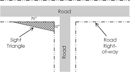
Section 2.2.9. - Exemption of Electric Transmission and Distribution Poles, Towers, and Lines.
The provisions of this Ordinance shall not prohibit electric transmission distribution poles, towers, and lines.
Section 2.2.10. - Open Space Requirements.
No part of a yard, court or other open space provided around any building or structure for the purpose of complying with the provisions of this Ordinance shall be included as a part of a yard or other open space required under this Ordinance for another building or structure. Every part of a required yard shall be open and unobstructed from its lowest level to the sky, except as provided for in this section. However, certain accessory structures are permitted to be placed in the required yard areas as provided for in Chapter 3, R1.
Section 2.2.11. - Reduction of Lot and Yard Areas Prohibited.
No yard or lot existing at the time of passage of this Ordinance shall be reduced in size or area below the minimum requirements set forth in this Ordinance. Yards or lots created after the effective date of this Ordinance shall meet at least the minimum requirements established by this Ordinance.
Section 2.2.12. - Outdoor Lighting.
Outdoor lighting fixtures shall be installed in a manner to protect the street and neighboring properties from direct glare or hazardous interference of any kind.
Section 2.2.13. - Mobile Home HUD Requirements.
No mobile home of any class shall be permitted to be placed within the jurisdiction of this Ordinance (or moved and placed if already within the jurisdiction of this Ordinance) unless it was constructed after June 15, 1976 and unless it meets or exceeds the construction standards promulgated by the US Department of Housing and Urban Development (HUD) that were in effect at the time of construction.
Section 2.3. - Zoning Districts.
The primary use districts are outlined from Section 2.3 to Section 2.17. Each section includes a description of the district and its intent, a chart with the most common uses permitted in the district, a chart that lists the dimensional requirements and a list with additional requirements and their location in the Ordinance.
Section 2.3.1. - Primay Use District Conversion.
The zoning district names in effect prior to the effective date of this Ordinance are converted as shown in Table 2.2.
Table 2.2 District Conversions
New uses, additions, or changes in use in the CB district shall now comply with the uses and standards of the HB district. New uses, additions, or changes in use in the SC district shall now comply with the uses and standards in the NB district. Nothing in this section should be interpreted to invalidate any use in the CB or SC district which was legally adopted.
Section 2.4.1. - Intent.
This district is intended for large areas of rural farmland and very low density residential uses. These regulations are developed to allow for greater flexibility for agricultural related uses in rural farming areas, encourage a viable farming community, and to provide better transition between agricultural and residential land uses.
Table 2.3 Dimensional Requirements in the A-C District
Section 2.4.2. - Other Requirements.
A.
Uses. See the Tables of Permitted and Special Uses Section 2.21 in this chapter.
B.
Locations of accessory buildings. Accessory buildings and structures shall be placed in accordance with the provisions of Chapter 3, R1.
C.
Off-street parking. Off-street parking shall be provided in accordance with the requirements in Chapter 7.
D.
Signs. Signs shall be regulated by the requirements in Chapter 6.
E.
Landscaping. Landscaping shall be provided in accordance with the requirements in Chapter 5.
F.
Performance requirements. Performance requirements apply as specified in Chapter 3.
G.
Overlays (airport, floodplain, municipal growth, urban service area, watershed). Overlay requirements can be found in Chapter 4.
H.
Infrastructure (roads, utilities, erosion control). Infrastructure requirements can be found in Chapter 10.
I.
Subdivision and development plans. Subdivision and development plan requirements can be found in Chapter 9.
J.
Permit and site plan process. Permit and site plan process requirements can be found in Chapter 8.
Section 2.4.3. - Uses.
The chart below indicates the common uses generally permitted in the AC zoning district. For a complete table of permitted uses see Section 2.21.
Table 2.4 More Common Uses Permitted in the A-C District
Section 2.5.1. - Intent.
The regulations of this district are intended to encourage the continuance of agricultural uses as well as to insure that residential development not having access to public water supplies and dependent upon septic tanks for sewage disposal will occur at a sufficiently low density to provide a healthful environment.
Table 2.5 Dimensional Requirements in the R-A District
Section 2.5.2. - Other Requirements.
A.
Uses. See the Tables of Permitted and Special Uses Section 2.21 in this chapter.
B.
Locations of accessory buildings. Accessory buildings and structures shall be placed in accordance with the provisions of Chapter 3, R1.
C.
Off-street Parking. Off-street parking shall be provided in accordance with the requirements in Chapter 7.
D.
Signs. Signs shall be regulated by the requirements in Chapter 6.
E.
Landscaping. Landscaping shall be provided in accordance with the requirements in Chapter 5.
F.
Performance Requirements. Performance requirements apply as specified in Chapter 3.
G.
Overlays (airport, floodplain, municipal growth, urban service area, watershed). Overlay requirements can be found in Chapter 4.
H.
Infrastructure (roads, utilities, erosion control). Infrastructure requirements can be found in Chapter 10.
I.
Subdivision and development plans. Subdivision and development plan requirements can be found in Chapter 9.
J.
Permit and site plan process. Permit and site plan process requirements can be found in Chapter 8.
Section 2.5.3. - Uses.
The chart below indicates the common uses generally permitted in the RA zoning district. For a complete table of permitted uses see Section 2.21.
Table 2.6 More Common Uses Permitted in the R-A District
Section 2.6.1. - Intent.
The regulations of this district are intended to ensure that residential development not having access to public utilities will occur at sufficiently low densities to maintain and promote a rural and semi-rural atmosphere, as well as to encourage the continuance of agricultural uses appropriate to a rural residential area.
Table 2.7 Dimensional Requirements in the RU-R District
Section 2.6.2. - Other Requirements.
A.
Uses. See the Tables of Permitted and Special Uses, Section 2.21 in this Chapter.
B.
Locations of accessory buildings. Accessory buildings and structures shall be placed in accordance with the provisions of Chapter 3, R1.
C.
Off-street parking. Off-street parking shall be provided in accordance with the requirements in Chapter 7.
D.
Signs. Signs shall be regulated by the requirements in Chapter 6.
E.
Landscaping. Landscaping shall be provided in accordance with the requirements in Chapter 5.
F.
Performance Requirements. Performance requirements apply as specified in Chapter 3.
G.
Overlays (airport, floodplain, municipal growth, urban service area, watershed). Overlay requirements can be found in Chapter 4.
H.
Infrastructure (roads, utilities, erosion control). Infrastructure requirements can be found in Chapter 10.
I.
Subdivision and development plans. Subdivision and development plan requirements can be found in Chapter 9.
J.
Permit and site plan process. Permit and site plan process requirements can be found in Chapter 8.
Section 2.6.3. - Uses.
The chart below indicates the common uses generally permitted in the RUR zoning district. For a complete table of permitted uses see Section 2.21.
Table 2.8 More Common Uses Permitted in the RU-R District
Section 2.7.1. - Intent.
The regulations of this district are intended to insure that the principal use of the land is for a combination of low density recreational and outdoor recreation uses and activities appropriate for sites adjacent to Lake Norman and other streams and bodies of water which lend themselves to the development of outdoor recreational areas and communities.
Table 2.9 Dimensional Requirements in the R-R District
Section 2.7.2. - Other Requirements.
A.
Uses. See the Tables of Permitted and Special Uses, Section 2.21 in this Chapter.
B.
Locations of accessory buildings. Accessory buildings and structures shall be placed in accordance with the provisions of Chapter 3, R1.
C.
Off-street parking. Off-street parking shall be provided in accordance with the requirements in Chapter 7.
D.
Signs. Signs shall be regulated by the requirements in Chapter 6.
E.
Landscaping. Landscaping shall be provided in accordance with the requirements in Chapter 5.
F.
Performance Requirements. Performance requirements apply as specified in Chapter 3.
G.
Overlays (airport, floodplain, municipal growth, urban service area, watershed). Overlay requirements can be found in Chapter 4.
H.
Infrastructure (roads, utilities, erosion control). Infrastructure requirements can be found in Chapter 10.
I.
Subdivision and development plans. Subdivision and development plan requirements can be found in Chapter 9.
J.
Permit and site plan process. Permit and site plan process requirements can be found in Chapter 8.
Section 2.7.3. - Uses.
The chart below indicates the common uses generally permitted in the RR zoning district. For a complete table of permitted uses see Section 2.21.
Table 2.10 More Common Uses Permitted in the R-A District
Section 2.8.1. - Intent.
The regulations of this district are intended to insure that residential development not having access to public water supplies and dependent upon septic tanks for sewage disposal will occur at sufficiently low densities to provide a healthful environment.
Table 2.11 Dimensional Requirements in the R-20 District
Section 2.8.2. - Other Requirements.
A.
Uses. See the Tables of Permitted and Special Uses, Section 2.21 in this chapter.
B.
Locations of accessory buildings. Accessory buildings and structures shall be placed in accordance with the provisions of Chapter 3, R1.
C.
Off-street parking. Off-street parking shall be provided in accordance with the requirements in Chapter 7.
D.
Signs. Signs shall be regulated by the requirements in Chapter 6.
E.
Landscaping. Landscaping shall be provided in accordance with the requirements in Chapter 5.
F.
Performance requirements. Performance requirements apply as specified in Chapter 3.
G.
Overlays (airport, floodplain, municipal growth, urban service area, watershed). Overlay requirements can be found in Chapter 4.
H.
Infrastructure (roads, utilities, erosion control). Infrastructure requirements can be found in Chapter 10.
I.
Subdivision and development plans. Subdivision and development plan requirements can be found in Chapter 9.
J.
Permit and site plan process. Permit and site plan process requirements can be found in Chapter 8.
Section 2.8.3. - Uses.
The chart below indicates the common uses generally permitted in the R-20 zoning district. For a complete table of permitted uses see Section 2.21.
Table 2.12 More Common Uses Permitted in the R-20 District
Section 2.9.1 - Intent.
This district is a medium-density neighborhood consisting of single-family residences along with limited home occupations and private and public community uses. This district will accommodate residences with access to both public water and sewerage.
Table 2.13 Dimensional Requirements in the R-12 District
Section 2.9.2. - Other Requirements.
A.
Uses. See the Tables of Permitted and Special Uses, Section 2.21 in this Chapter.
B.
Locations of accessory buildings. Accessory buildings and structures shall be placed in accordance with the provisions of Chapter 3, R1.
C.
Off-street parking. Off-street parking shall be provided in accordance with the requirements in Chapter 7.
D.
Signs. Signs shall be regulated by the requirements in Chapter 6.
E.
Landscaping. Landscaping shall be provided in accordance with the requirements in Chapter 5.
F.
Performance requirements. Performance requirements apply as specified in Chapter 3.
G.
Overlays (airport, floodplain, municipal growth, urban service area, watershed). Overlay requirements can be found in Chapter 4.
H.
Infrastructure (roads, utilities, erosion control). Infrastructure requirements can be found in Chapter 10.
I.
Subdivision and development plans. Subdivision and development plan requirements can be found in Chapter 9.
J.
Permit and site plan process. permit and site plan process requirements can be found in Chapter 8.
Section 2.9.3. - Uses.
The chart below indicates the common uses generally permitted in the R-12 zoning district. For a complete table of permitted uses see Section 2.21.
Table 2.14 More Common Uses Permitted in the R-12 District
Section 2.10.1. - Intent.
The R-8 Residential District is established as a high density district in which the principal use of lands is for single-family, two-family and multi-family residences that have access to both public water and sewer. The regulations of this district are intended to provide areas of the community for those persons desiring small residences and multi-family structures in relatively high density neighborhoods.
Table 2.15 Dimensional Requirements in the R-8 District
Section 2.10.2. - Other Requirements.
A.
Uses. See the Tables of Permitted and Special Uses, Section 2.21 in this Chapter.
B.
Locations of accessory buildings. Accessory buildings and structures shall be placed in accordance with the provisions of Chapter 3, R1.
C.
Off-Street Parking. Off-street parking shall be provided in accordance with the requirements in Chapter 7.
D.
Signs. Signs shall be regulated by the requirements in Chapter 6.
E.
Landscaping. Landscaping shall be provided in accordance with the requirements in Chapter 5.
F.
Performance requirements. Performance requirements apply as specified in Chapter 3.
G.
Overlays (airport, floodplain, municipal growth, urban service area, watershed). Overlay requirements can be found in Chapter 4.
H.
Infrastructure (roads, utilities, erosion control). Infrastructure requirements can be found in Chapter 10.
I.
Subdivision and development plans. Subdivision and development plan requirements can be found in Chapter 9.
J.
Permit and site plan process. Permit and site plan process requirements can be found in Chapter 8.
Section 2.10.3. - Uses.
The chart below indicates the common uses generally permitted in the R-8 zoning district. For a complete table of permitted uses see Section 2.21.
Table 2.16 More Common Uses Permitted in the R-8 District
Section 2.11.1 - Intent.
The regulations of this district are intended to provide for higher-density residential development as well as new structures or the conversion of older homes into office or apartment structures where such area appropriate, and to provide a buffer between purely business and purely residential areas. In order to utilize the higher density residential lot sizes, water and sewer will be required.
Table 2.17 Dimensional Requirements in the R-O District
Section 2.11.2. - Other Requirements.
A.
Uses. See the Tables of Permitted and Special Uses, Section 2.21 in this Chapter.
B.
Locations of accessory buildings. Accessory buildings and structures shall be placed in accordance with the provisions of Chapter 3, R1.
C.
Off-street parking. Off-street parking shall be provided in accordance with the requirements in Chapter 7.
D.
Signs. Signs shall be regulated by the requirements in Chapter 6.
E.
Landscaping. Landscaping shall be provided in accordance with the requirements in Chapter 5.
F.
Performance requirements. Performance requirements apply as specified in Chapter 3.
G.
Overlays (airport, floodplain, municipal growth, urban service area, watershed). Overlay requirements can be found in Chapter 4.
H.
Infrastructure (Roads, utilities, erosion control). Infrastructure requirements can be found in Chapter 10.
I.
Subdivision and development plans. Subdivision and development plan requirements can be found in Chapter 9.
J.
Permit and site plan process. Permit and site plan process requirements can be found in Chapter 8.
Section 2.11.3. - Uses.
The chart below indicates the common uses generally permitted in the R-O zoning district. For a complete table of permitted uses see Section 2.21.
Table 2.18 More Common Uses Permitted in the R-O District
Section 2.12.1 - Intent.
The purpose of this district is to establish areas exclusively for office, institutional, and other low-intensity commercial uses which do not materially detract from nearby residential areas and to provide a buffer between purely business and purely residential areas. In order to utilize the higher density residential lot sizes, water and sewer will be required.
Table 2.19 Dimensional Requirements in the O-I District
Section 2.12.2. - Other Requirements.
A.
Uses. See the Tables of Permitted and Special Uses, Section 2.21 in this Chapter.
B.
Locations of accessory buildings. Accessory buildings and structures shall be placed in accordance with the provisions of Chapter 3, R1.
C.
Off-street parking. Off-street parking shall be provided in accordance with the requirements in Chapter 7.
D.
Signs. Signs shall be regulated by the requirements in Chapter 6.
E.
Landscaping. Landscaping shall be provided in accordance with the requirements in Chapter 5.
F.
Performance requirements. Performance requirements apply as specified in Chapter 3.
G.
Overlays (airport, floodplain, municipal growth, urban service area, watershed). Overlay requirements can be found in Chapter 4.
H.
Infrastructure (Roads, utilities, erosion control). Infrastructure requirements can be found in Chapter 10.
I.
Subdivision and development plans. subdivision and development plan requirements can be found in Chapter 9.
J.
Permit and site plan process. Permit and site plan process requirements can be found in Chapter 8.
Section 2.12.3. - Uses.
The chart below indicates the common uses generally permitted in the O-I zoning district. For a complete table of permitted uses see Section 2.21.
Table 2.20 More Common Uses Permitted in the O-I District
Section 2.13.1. - Intent.
The regulations of this district are intended to provide for the retailing of goods and services for convenience to the nearby residential neighborhoods in such a way as to protect abutting areas from blighting influences.
Table 2.21 Dimensional Requirements in the N-B District
Section 2.13.2. - Other Requirements.
A.
Uses. See the Tables of Permitted and Special Uses, Section 2.21 in this Chapter.
B.
Locations of accessory buildings. Accessory buildings and structures shall be placed in accordance with the provisions of Chapter 3, R1.
C.
Off-street parking. Off-street parking shall be provided in accordance with the requirements in Chapter 7.
D.
Signs. Signs shall be regulated by the requirements in Chapter 6.
E.
Landscaping. Landscaping shall be provided in accordance with the requirements in Chapter 5.
F.
Performance requirements. Performance requirements apply as specified in Chapter 3.
G.
Overlays (airport, floodplain, municipal growth, urban service area, watershed). Overlay requirements can be found in Chapter 4.
H.
Infrastructure (Roads, utilities, erosion control). Infrastructure requirements can be found in Chapter 10.
I.
Subdivision and development plans. Subdivision and development plan requirements can be found in Chapter 9.
J.
Permit and site plan process. Permit and site plan process requirements can be found in Chapter 8.
Section 2.13.3. - Uses.
The chart below indicates the common uses generally permitted in the N-B zoning district. For a complete table of permitted uses see Section 2.21.
Table 2.22 More Common Uses Permitted in the N-B District
Within the N-B District all uses shall be conducted wholly within enclosed buildings with the exception of gasoline pumps, drive-through service, outdoor dinning facilities associated with a restaurant, incidental displays of produce and merchandise, vending machinery, displays associated with official festivals and similar incidental outdoor displays.
Section 2.14.1. - Intent.
These commercial districts are designed to serve the special needs of the traveling public. They also provide space for indoor and outdoor recreational uses which require large lots. It is very important that such districts be developed in accordance with high standards.
Table 2.23 Dimensional Requirements in the H-B District
(Ord. of 7-17-12(1))
Section 2.14.2. - Other Requirements.
A.
Uses. See the Tables of Permitted and Special Uses, Section 2.21 in this Chapter.
B.
Locations of accessory buildings. Accessory buildings and structures shall be placed in accordance with the provisions of Chapter 3, R1.
C.
Off-street parking. Off-street parking shall be provided in accordance with the requirements in Chapter 7.
D.
Signs. Signs shall be regulated by the requirements in Chapter 6.
E.
Landscaping. Landscaping shall be provided in accordance with the requirements in Chapter 5.
F.
Performance requirements. Performance requirements apply as specified in Chapter 3.
G.
Overlays (airport, floodplain, municipal growth, urban service area, watershed). Overlay requirements can be found in Chapter 4.
H.
Infrastructure (Roads, utilities, erosion control). Infrastructure requirements can be found in Chapter 10.
I.
Subdivision and development plans. Subdivision and development plan requirements can be found in Chapter 9.
J.
Permit and site plan process. Permit and site plan process requirements can be found in Chapter 8.
Section 2.14.3. - Uses.
The chart below indicates the common uses generally permitted in the H-B zoning district. For a complete table of permitted uses see Section 2.21.
Table 2.24 More Common Uses Permitted in the H-B District
Section 2.15.1. - Intent.
These commercial districts are generally located along major radial highways leading out of urban areas. They dispense retail goods and services to the community and provide space for wholesaling and warehousing activities.
Table 2.25 Dimensional Requirements in the G-B District
Section 2.15.2. - Other Requirements.
A.
Uses. See the Tables of Permitted and Special Uses, Section 2.21 in this Chapter.
B.
Locations of accessory buildings. Accessory buildings and structures shall be placed in accordance with the provisions of Chapter 3, R1.
C.
Off-street parking. Off-street parking shall be provided in accordance with the requirements in Chapter 7.
D.
Signs. Signs shall be regulated by the requirements in Chapter 6.
E.
Landscaping. Landscaping shall be provided in accordance with the requirements in Chapter 5.
F.
Performance requirements. Performance requirements apply as specified in Chapter 3.
G.
Overlays (airport, floodplain, municipal growth, urban service area, watershed). Overlay requirements can be found in Chapter 4.
H.
Infrastructure (Roads, utilities, erosion control). Infrastructure requirements can be found in Chapter 10.
I.
Subdivision and development plans. Subdivision and development plan requirements can be found in Chapter 9.
J.
Permit and site plan process. Permit and site plan process requirements can be found in Chapter 8.
Section 2.15.3. - Uses.
The chart below indicates the common uses generally permitted in the G-B zoning district. For a complete table of permitted uses see Section 2.21.
Table 2.26 More Common Uses Permitted in the G-B District
Section 2.16.1. - Intent.
The M-1 Light Manufacturing District is designed to accommodate industries and warehousing operations which can be operated in a relatively clean and quiet manner and which will not be obnoxious to adjacent residential and business districts.
Table 2.27 Dimensional Requirements in the M-1 District
Section 2.16.2. - Other Requirements.
A.
Uses. See the Tables of Permitted and Special Uses, Section 2.21 in this Chapter.
B.
Locations of accessory buildings. Accessory buildings and structures shall be placed in accordance with the provisions of Chapter 3, R1.
C.
Off-street parking. Off-street parking shall be provided in accordance with the requirements in Chapter 7.
D.
Signs. Signs shall be regulated by the requirements in Chapter 6.
E.
Landscaping. Landscaping shall be provided in accordance with the requirements in Chapter 5.
F.
Performance requirements. Performance requirements apply as specified in Chapter 3.
G.
Overlays (airport, floodplain, municipal growth, urban service area, watershed). Overlay requirements can be found in Chapter 4.
H.
Infrastructure (Roads, utilities, erosion control). Infrastructure requirements can be found in Chapter 10.
I.
Subdivision and development plans. Subdivision and development plan requirements can be found in Chapter 9.
J.
Permit and site plan process. Permit and site plan process requirements can be found in Chapter 8.
Section 2.16.3. - Uses.
The chart below indicates the common uses generally permitted in the M-1 zoning district. For a complete table of permitted uses see Section 2.21.
Table 2.28 More Common Uses Permitted in the M-1 District
Section 2.17.1. - Intent.
The M-2 Heavy Manufacturing District is designed to accommodate intensive manufacturing, processing, and assembly uses and to promote economic development opportunities. The uses permitted in this district may be very intensive, with their impacts controlled by performance requirements.
Table 2.29 Dimensional Requirements in the M-2 District
Section 2.17.2. - Other Requirements.
A.
Uses. See the Tables of Permitted and Special Uses, Section 2.21 in this Chapter.
B.
Locations of accessory buildings. Accessory buildings and structures shall be placed in accordance with the provisions of Chapter 3, R1.
C.
Off-street parking. Off-street parking shall be provided in accordance with the requirements in Chapter 7.
D.
Signs. Signs shall be regulated by the requirements in Chapter 6.
E.
Landscaping. Landscaping shall be provided in accordance with the requirements in Chapter 5.
F.
Performance requirements. Performance requirements apply as specified in Chapter 3.
G.
Overlays (airport, floodplain, municipal growth, urban service area, watershed). Overlay requirements can be found in Chapter 4.
H.
Infrastructure (Roads, utilities, erosion control). Infrastructure requirements can be found in Chapter 10.
I.
Subdivision and development plans. Subdivision and development plan requirements can be found in Chapter 9.
J.
Permit and site plan process. Permit and site plan process requirements can be found in Chapter 8.
Section 2.17.3. - Uses.
The chart below indicates the common uses generally permitted in the M-2 zoning district. For a complete table of permitted uses see Section 2.21.
Table 2.30 More Common Uses Permitted in the M-2 District
Section 2.18.1. - Intent.
It is recognized that certain types of zoning districts would be inappropriate at certain locations in the absence of special conditions. Where the applicant for rezoning desires property to be rezoned to such a district in such situations, the conditional zoning district is a means by which such special conditions can be imposed in the furtherance of the purpose of this Ordinance. The conditional zoning district classification will be considered for rezoning only upon request of a property owner or authorized agent.
Therefore, the following conditional zoning districts (CD) which correspond to each of the districts authorized by this Ordinance are established: AC-CD, RA-CD, RU-R-CD, R-R-CD, R-20-CD, R-12-CD, R-8-CD, R-O-CD, O-I-CD, N-B-CD, H-B-CD, G-B-CD, M-1-CD, M-2-CD, and CB-CD.
Section 2.18.2. - Uses.
Within a CD, only those uses authorized as permitted uses in the zoning district with which the CD corresponds shall be permitted, and all other requirements of the corresponding district shall be met as minimum standards. The CB-CD districts that were approved prior to the adoption of this Ordinance shall comply with the HB district uses unless otherwise stated in the conditions. All conditional use districts approved prior to January 15, 2008 shall hereby be replaced by a comparable conditional district. For instance, a pre-existing GB-CUD designation will be changed to a GB-CD designation, including any associated conditions. All conditions and approvals shall continue to apply; however, changes to that district shall be handled through the conditional district process. Nothing in this section should be interpreted to invalidate any CUD or CD which was legally adopted.
Section 2.19.1. - Purpose.
Overlay districts are created to provide additional development standards for specially identified areas. Overlay districts combine with the regulatory provisions of the underlying base zoning district to provide additional or supplementary standards. The following overlay districts are created for this purpose:
A.
Airport Overlay. The Airport Overlay is designed to protect approach zones for the Statesville Regional Airport from structures and landscaping whose height may be detrimental to incoming and outgoing flights.
B.
Floodplain Overlay. The purpose of Floodplain Overlay is to promote public health, safety, and general welfare and to minimize public and private losses due to flood conditions within flood prone areas by provisions designed to: restrict or prohibit uses that are dangerous to health, safety, and property due to water or erosion hazards or that result in damaging increases in erosion, flood heights or velocities; require that uses vulnerable to floods, including facilities that serve such uses, be protected against flood damage at the time of initial construction; control the alteration of natural floodplains, stream channels, and natural protective barriers, which are involved in the accommodation of floodwaters; control filling, grading, dredging, and all other development that may increase erosion or flood damage; and prevent or regulate the construction of flood barriers that will unnaturally divert flood waters or which may increase flood hazards to other lands.
C.
Municipal Growth Overlay. The Municipal Growth Overlay has been developed to accommodate development that is located within the County's zoning jurisdiction but will likely be developed under one of the local municipality's regulations. This development pattern will likely be predicated by the fact that annexation may occur in the future or that municipal utilities are, or soon will be, available and is meant to create a "seamless" development pattern between urban and rural uses.
D.
Watershed Overlay. The Watershed Overlay is intended to protect local water sources from any activity that would pose a threat to water quality. This is done by limiting lot sizes for single-family uses, limiting hard surface or impervious area for all other uses, and buffering water sources to protect from pollutants.
Development regulations for each overlay district can be found in Chapter 4.
(Ord. of 10-18-21)
Section 2.20.1. - Purpose.
The Table of Permitted and Special Uses which follows contains a listing of uses which may be permitted in one or more of the various Zoning Districts established by this Ordinance. Uses are listed in alphabetical order in five functional categories. The categories in the order of listing are:
•
Agricultural and residential uses
•
Recreational, educational and institutional uses
•
Commercial uses
•
Manufacturing and industrial uses
•
Pubic works facilities, utilities and infrastructure
Section 2.20.2. - Entries.
The district or districts in which a particular listed use may be permitted is indicated by an "X", "R", or "S" in the District column(s) opposite the listed use.
Section 2.20.3. - Meaning of Entries.
The meaning of the entries in the Table are as follows:
A.
"X" indicates the use is permitted by right and a zoning permit may be obtained.
B.
"R" indicates that a use is permitted but has additional performance requirements that the use must meet. The column on the far right labeled "R" indicates the number associated with the Performance Requirement. These requirements are contained in Chapter 3.
C.
"S" indicates the use requires approval of a special use permit in accordance with the procedures in Section 12.2.4. All of these uses have additional Performance Requirements which are identified in the column on the far right labeled "R." The performance requirement shall represent the minimum conditions for issuance of a special use permit.
D.
The listing of a use in the Table of Permitted Uses and Special Uses in no way relieves that use of having to meet all local, state and federal laws pertaining to the establishment and operation of that use.
Section 2.20.4. - Determining Permitted Uses, Principal Uses and Mixed Uses.
The listings of permitted uses in the various districts in this Ordinance are considered to be specific in regard to the types of uses intended for each of the various districts. In determining proposed uses, the Zoning Administrator shall refer to the latest edition of the North American Industry Classification System (NAICS). When a proposed use is not specifically listed in the Table of Permitted Uses, the Zoning Administrator shall use NAICS to determine if the use is the same as, or manifestly similar to, a listed use in form and function. If the Zoning Administrator finds that the proposed use is the same as, or manifestly similar to, a listed use, he shall classify the proposed use as the listed use. If the Zoning Administrator finds that a proposed use is not the same as, or is not manifestly similar to, a listed use, he shall classify the proposed use as not permitted. In each case, the Zoning Administrator shall maintain a written record of such determinations.
In determining what is a principal use, the principal use shall be considered as the primary purpose or function that a lot or structure serves or is proposed to serve. An accessory use shall be considered a structure or use that:
A.
Is clearly incidental to and customarily found in connection with a principal building or use;
B.
Is subordinate to and serves a principal building or a principal use;
C.
Is subordinate in area, extent, or purpose to the principal building or principal use served;
D.
Contributes to the comfort, convenience, or necessity of occupants, business, or industry in the principal building or principal use served; and
E.
Is located on the same lot and zoned the same as the principal building or use served.
Two or more principal uses may, in some cases, be permitted to occupy the same land or building as long as each use is a permitted use.
Section 2.21.1. - Agricultural and Residential Uses.
(Ord. of 10-17-23(1))
Section 2.21.2. - Recreational, Educational, and Institutional Uses.
(Ord. of 7-17-12(1); Ord. of 1-17-17(1); Ord. of 12-5-17(2))
Section 2.21.3. - Commercial Uses.
(Ord. of 10-4-11; Ord. of 3-5-13(2))
Section 2.21.4. - Manufacturing and Industrial Uses.
(Ord. of 12-5-17(2); Ord. of 7-16-19(1))
Section 2.21.5. - Public Works Facilities, Utilities, and Infrastructure Uses.
(Ord. of 10-4-11; Ord. of 3-5-13(3); Ord. of 12-5-17(2); Ord. of 3-4-20(1))