
Love Valley City Zoning Code
CHAPTER 4
- OVERLAY DISTRICTS
Section 4.1 - Purpose.
This chapter sets forth the regulations that apply for the Urban Service Areas, ETJ Extension, the Watershed Overlay, the Airport Overlay and the Floodplain Overlay.
Section 4.2.1. - Purpose and Application.
In order for Iredell County to effectively address future development outside of the local municipal limits, Urban Service Areas (USAs) have been established within the 2030 Horizon Plan. These areas have been developed with the assistance of the Towns of Troutman and Mooresville and the City of Statesville. The USA boundaries have been established based on the assumption that the municipalities will grow within these areas and utilities will be extended either voluntarily or upon request. These boundaries are not static; they are based on the ability of the municipalities to deliver utilities and services. Therefore, the USAs are subject to change.
The USA boundaries will serve as the basis for three (3) primary functions to facilitate and address future growth:
1.
Extraterritorial Jurisdiction (ETJ) extension (Section 4.3);
2.
The adoption of certain municipal standards (Section 4.4); and
3.
Land use decisions (Section 4.4.2).
Section 4.3.1 - Municipal ETJ Requests.
In certain situations the Board of Commissioners may consider ETJ requests from local municipalities. This would apply to areas that are strategically targeted for growth by the requesting town. When a request is made to the Board the following criteria must be addressed before making a decision.
A.
Location within an urban services area. An area proposed for ETJ expansion shall be within the USA associated with the municipality. Areas outside the USA will not be considered for expansion of ETJ.
B.
Commitment to comprehensive planning. The municipality should demonstrate a commitment to comprehensive planning by including in a request for ETJ expansion the following: adopted land use, public facilities and transportation plans, and a CIP (or a similar plan or arrangement that shows a timeline for utility construction, either associated with a development proposal or town initiated). This commitment must be demonstrated through official actions by the governing body. Future land use and transportation plans are paramount to ensure that the foundation of the USA (including the development densities, form, and function) is upheld. It is understood that most of the expansions to the utilities systems come through development-funded requests. Therefore, significant pieces of information may come just prior to an ETJ request. Determining whether an area can be reasonably served by utilities within a given amount of time five (5) years by this arrangement) must be resolved prior to a decision to release county jurisdiction.
C.
Existing ETJ. When a municipality requests additional ETJ, the municipality must demonstrate its progress in annexing and supplying municipal services, especially water and sewer within existing ETJ areas.
D.
Special standards. When evaluating an ETJ expansion request, the municipality's application of special regulations to its existing ETJ, such as transportation improvements along significant corridors, should be considered as evidence of its willingness to apply these special regulations. The municipality must also demonstrate a willingness to adopt such or similar regulations for new areas under consideration for ETJ expansion. If the county has developed area-specific standards such as corridor protection overlays or perennial stream buffers it will be important to continue those protections.
E.
Municipal utilities. The municipality should show how the area proposed for ETJ expansion will be served by water and sewer service within five (5) years of the effective date of ETJ expansion. The systems should be designed with adequate treatment capacity and adequately sized major trunk line extensions to service the area proposed for ETJ expansion. The municipality should include needed improvements above and beyond those proposed in relation to a specific project in its capital improvements program. If the municipality will be required to make improvements or adjustments (generally oversizing) to utilities that will be attributed to a specific project they must be documented in the ETJ request.
F.
School capacity. The Iredell-Statesville and Mooresville Graded School Systems will be given the opportunity to comment on any ETJ extension request. These comments will be taken into consideration by the Board of Commissioners during their deliberation.
G.
Traffic impacts. An analysis of the traffic impacts resulting from the development proposed in the ETJ expansion area(s) will be submitted by the municipality for consideration by the Board of Commissioners.
H.
Public meetings. If the request is being made by a municipality to bring an area into the ETJ that includes over five (5) parcels a public meeting must be held prior to the request coming before the BOC. This public meeting would be the responsibility of the municipality and the plans for the area would be expressed at the time. The minutes of the meeting would then be submitted as part of the overall request to the Board.
Section 4.3.2. - Private ETJ Requests.
If a request is being made by an individual or group of individuals (whose property would not have far reaching impacts if released) the following process shall apply.
A.
The applicant (developer, citizen, etc.) makes request to the Iredell County Department of Planning and Development.
B.
The Department verifies application information which includes:
1.
Authorization from the town that the area will be accepted into their jurisdiction;
2.
An accurate map and description of the property; and
3.
The proposed use of the property.
C.
Once the information is verified by the Department of Planning and Development, the request is then sent to the Board of Commissioners to call for a public hearing.
D.
If the Board sets a date for the hearing then the following shall take place:
1.
The property is posted with a public hearing sign;
2.
Letters are sent to the affected property owners; and
3.
A legal ad is run in the local paper.
E.
If the Board does not call for the hearing, the request is denied.
F.
At the public hearing property owners may voice their opinions on the request. The Board has the authority to grant the request or deny it based solely on their discretion.
Section 4.4.1 - Purpose and Application.
The MGO has been developed to accommodate development that is located within the county's zoning jurisdiction but will likely be developed at a later date under one of the local municipality's regulations. This development pattern will likely happen because municipal utilities are, or soon will be, available and annexation may occur. This overlay is meant to foster a "seamless" development pattern between urban and rural uses by providing municipal-type development requirements which are administered by the county.
In making the decision(s) to establish an MGO, the Board of County Commissioners, upon recommendation by the Planning Board, should consider the following:
A.
Location within a USA depicted in the 2030 Horizon Plan; and
B.
The time in which municipal utilities will be available to the site, or the general area. Municipal utilities should be available (sewer trunk lines and/or major water lines), or planned to be available, within two (2) years of the establishment of the MGO. This may be shown through inclusion in a capital improvements plan or via an agreement between the municipality and a developer, property owner, or other legal entity with property within the proposed area.
Section 4.4.2. - Land Use Decisions.
Proposed land use changes in areas that lie within an MGO shall be subject to a higher level of review than those found outside these districts. The 2030 Horizon Plan has incorporated the adopted land use and/or comprehensive plans for the City of Statesville and the Towns of Mooresville and Troutman. As part of any requested land use change within an MGO the Iredell County Department of Planning and Development shall request, in writing, a statement of consistency from the municipality in whose USA the development lies. This statement shall be included as part of the application for the change and shall be considered by the appointed and elected boards that are making the decision.
The decision making body is not bound by the statement of consistency. However, if the decision runs contrary to the statement of the municipality, the decision making body shall explain why the decision was made and justify the change.
Section 4.4.3. - Site plan review.
Any non-residential site plan submitted for review for a project within an MGO shall also be considered by the municipality in whose USA the development lies. These plans shall be reviewed by the municipality to insure compliance with the requirements found in the following section. The municipality shall have 14 days in which to review these plans. Failure to respond to the Department of Planning and Development shall constitute the municipality's support of the project.
Section 4.4.4. - Regulations and Required Improvements.
These regulations apply to all uses within the overlay. This overlay has been developed based on USAs designated by the City of Statesville, and the Towns of Mooresville and Troutman.
A.
Developments that occur within an MGO shall meet the required stormwater management guidelines adopted by the jurisdiction in whose USA the development is located.
B.
Sidewalks shall be required for subdivisions and developments that fall within this overlay and may be constructed to the standards required by the municipality in whose USA the development is located.
C.
Curb and gutter may be required for subdivisions and developments that fall within this overlay and shall be constructed to the standards required by the municipality in whose USA the development is located.
Section 4.4.5. - Billboards.
New off-premises signs or billboards are expressly prohibited within this overlay district.
Section 4.5.1. - Establishment of Watershed Areas.
For purposes of Water Supply Watershed protection, Iredell County is hereby divided into the following areas:
•
WS-II-BW (Balance of Watershed)
•
WS-III-BW (Balance of Watershed)
•
WS-IV-CA (Critical Area)
•
WS-IV-PA (Protected Area)
Section 4.5.2. - Watershed Areas Described.
A.
WS-II Watershed Areas—Balance of Watershed (WS-II-BW). In order to maintain predominantly undeveloped land use intensity pattern, single family residential uses shall be allowed at a maximum of one (1) dwelling unit per acre. All other residential and non-residential development shall be allowed a maximum built-upon area of twelve (12) percent built-upon area.
1.
Allowed uses.
a.
Agriculture, subject to the provisions of the Food Security Act of 1985 and the Food, Agricultural, Conservation and Trade Act of 1990.
b.
Silviculture, subject to the provisions of the Forest Practices Guidelines Related to Water Quality (15 NCAC 1I.6101-.0209).
c.
Residential development.
d.
Non-residential development excluding discharging landfills.
2.
Density and built-upon limits (See Table 4.1).
a.
Single family residential-development shall not exceed one (1) dwelling unit per acre on a project-by-project basis. No residential lot shall be less than one acre, except within an approved cluster development as described Chapter 3, R5.b. All other shall not exceed twelve (12) percent built-upon area on a project-by-project basis except as follows:
i.
Within the Yadkin Back Creek Watershed, up to ten (10) percent of the balance of the watershed may be developed at up to seventy (70) percent built-upon area ratio. Non-residential uses which can qualify for the seventy-percent built upon ratio shall be served by public or community water and sewer and zoned for business or industrial uses (N-B, G-B, H-B, M-1, M-2).
ii.
Within the Coddle Creek Watershed, up to ten percent (10%) of the balance of the watershed may be developed at up to seventy percent (70%) built-upon area ratio. In order to qualify for the seventy percent (70%) built-upon area ratio in Coddle Creek, the development shall be non-residential in nature.
iii.
For the purpose calculating built-upon area, total project area shall include total acreage in the tract on which the project is to be developed. Additionally, no tract of land shall be further subdivided to an acreage that would exempt the divided property from the required built upon area without first assigning the impervious area to each proposed lot. The assignment of impervious area from the greater tract shall be identified on a map approved by the Watershed Administrator and shall be held on file at the Iredell County Department of Planning and Development.
B.
WS-III Watershed Areas—Balance of Watershed (WS-III-BW). In order to maintain low to moderate land use intensity, no single-family residential lot shall be less than twenty-five thousand (25,000) square feet, except within an approved cluster development (See Chapter 3, R5.). All other residential and non-residential development shall be allowed at a maximum of twenty-four (24) percent built-upon area.
1.
Allowed uses.
a.
Agriculture, subject to the provisions of the Food Security Act of 1985 and the Food, Agricultural, Conservation and Trade Act of 1990.
b.
Silviculture, subject to the provisions of the Forest Practices Guidelines Related to Water Quality (15 NCAC 1I.6101-.0209).
c.
Residential development.
d.
Non-residential development excluding discharging landfills.
2.
Density and built-upon limits(See Table 4.1).
a.
No single-family residential lot shall be less than twenty-five thousand (25,000) square feet, except within an approved cluster developments (See Chapter 3, R5.) shall also be allowed.
b.
All other residential and non-residential—development shall not exceed twenty-four (24) percent built-upon area on a project-by-project basis except that up to ten (10) percent of the balance of the watershed may be developed with new development and expansions to existing development at up to seventy (70) percent built-upon area on a project-by-project basis.
c.
For the purpose of calculating built-upon area, total project area shall include total acreage in the tract on which the project is to be developed. Additionally, no tract of land shall be further subdivided to an acreage that would exempt the divided property from the required built upon area without first assigning the impervious area to each proposed lot. The assignment of impervious area per the greater tract shall be identified on a map approved by the Watershed Administrator and shall be held on file at the Iredell County Department of Planning and Development.
C.
WS-IV Watershed Areas—Critical Area (WS-IV-CA). New development activities that require an erosion/sedimentation control plan under state law or approved local program are required to meet the provisions of this Ordinance when located in a WS-IV watershed. This also includes additions to existing development activities that would cause the development to total an acre or more. This district is meant to accommodate a moderate to high land use intensity.
1.
Allowed uses.
a.
Agriculture subject to the provisions of the Food Security Act of 1985 and the Food, Agriculture, Conservation and Trade Act of 1990 and the rules and regulations of the Soil and Water Conservation Commission.
Silviculture, subject to the provisions of the Forest Practices Guidelines Related to Water Quality (15 NCAC 1I.6101-.0209).
b.
Residential development.
c.
Non-residential development, excluding: 1) landfills and 2) sites for land application of residuals or petroleum contaminated soils.
2.
Density and built-upon limits (See Table 4.1).
a.
Single family residential. No residential lot shall be less than thirty thousand (30,000) square feet, except within an approved cluster development (See Chapter 3, R5).
b.
All other residential and non-residential-development shall not exceed twenty-four (24) percent built-upon area on a project-by-project basis. For the purpose of calculating the built-upon area, total project area shall include total acreage in the tract on which the project is to be developed.
c.
Additionally, no tract of land shall be further subdivided to an acreage that would exempt the divided property from the required built upon area without first assigning the impervious area to each proposed lot. The assignment of impervious area per the greater tract shall be identified on a map approved by the Watershed Administrator and shall be held on file at the Iredell County Department of Planning and Development.
d.
The high density option shall be available for use in the Catawba Lake Norman and Lookout Shoals Lake watersheds. High density development using engineered stormwater control devices is permitted in this district. Ultimate responsibility for the operation and maintenance of these facilities will rest with the local government. Please refer to Section 8.10.1 and Section 10.13 for a more detailed explanation of this topic.
D.
WS-IV Watershed Areas—Protected Area (WS-IV-PA). New development activities that require an erosion/sedimentation control plan under state law or approved local government program are required to meet the provisions of this Ordinance when located in a WS-IV watershed. This also includes additions to existing development activities that would cause the development to total an acre or more. This district is meant to accommodate a moderate to high land use intensity.
1.
Uses allowed.
a.
Agriculture subject to the provisions of the Food Security Act of 1985 and the Food, Agricultural, Conservation and Trade Act of 1990.
Silviculture, subject to the provisions of the Forest Practices Guidelines Related to Water Quality (15 NCAC 1I.6101-.0209).
b.
Residential development.
c.
Non-residential development.
2.
Density and built-upon limits (See Table 4.1).
a.
Single family residential-development. No residential lot shall be less than 25,000 square feet, except within an approved cluster development (See Chapter 3, R5).
b.
All other residential and non-residential development shall not exceed twenty-four (24) percent built-upon area on a project-by-project basis. For projects without a curb and gutter street system, development shall not exceed thirty-six (36) percent built-upon area on a project-by-project basis. For the purpose of calculating built-upon area, total project area shall include acreage in the tract on which the project is to be developed.
c.
Additionally, no tract of land shall be further subdivided to an acreage that would exempt the divided property from the required built-upon area without first assigning the impervious area to each proposed lot. The assignment of impervious area per the greater tract shall be identified on an approved map and shall be held on file at the Iredell County Department of Planning and Development.
d.
In the Catawba Lake Norman and Lookout Shoals Lake watersheds only, development under the high density option of up to seventy (70) percent built-upon area is allowed. High density development using engineered stormwater control devices is permitted in this district. Ultimate responsibility for the operation and maintenance of these facilities will rest with the local government. Please refer to Chapter 10 for a more detailed explanation of this topic.
e.
In addition to the development allowed under paragraph b., new development and expansions to existing development may occupy up to ten (10) percent of the protected area of both the Cooleemee and South Yadkin River watersheds with up to seventy (70) percent built-upon area on a project-by-project basis, when approved as a special intensity allocation (SIA). The Watershed Administrator is authorized to approve SIAs consistent with the provisions of this Ordinance. Projects must, to the maximum extent practicable, minimize built-upon surface area, direct stormwater away from surface waters and incorporate best management practices from the North Carolina Division of Water Quality's Stormwater Best Management Practices Manual to minimize water quality impacts. For the purpose of calculating built-upon area, total project area shall include total acreage in the tract on which the project is to be developed.
Table 4.1 Watershed Densities
Section 4.5.3. - Buffer Areas Required.
A.
A minimum one hundred-foot vegetative buffer measured perpendicularly from the streambank is required for all new development activities that exceed the low density option; otherwise, a minimum fifty-foot vegetative buffer for development activities is required along all perennial waters indicated on the most recent versions of U.S.G.S. 1:24,000 (7.5 minute) scale topographic maps or as determined by local government studies (See Figure 4.1). Desirable artificial streambank or shoreline stabilization is permitted.
Figure 4.1 Perennial Water Buffer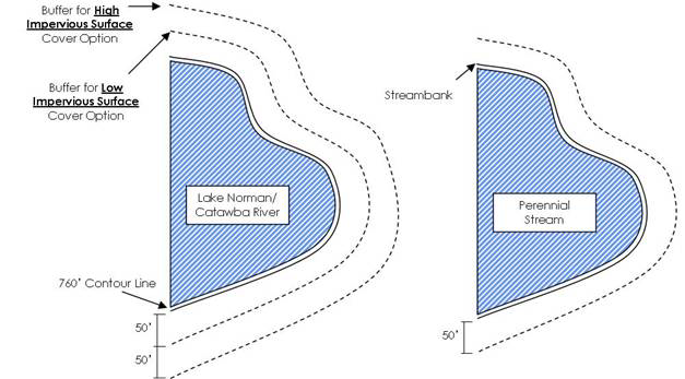
B.
Uses permitted in the buffer include water dependent structures, other structures which result in only diminutive increases in impervious area, public projects such as road crossings and greenways where no practical alternative exists, and recreational structures such as decks, gazebos and sheds which meet the following criteria:
1.
Structures must be elevated above pervious ground;
2.
Installation cannot result in the removal of trees; and
3.
When the cumulative footprint of all structures will exceed 150 square feet, written approval by the Division of Water Quality must be submitted prior to permitting.
These activities should minimize built-upon surface area, direct runoff away from the surface waters and maximize the utilization of stormwater Best Management Practices.
Section 4.5.4. - Application of Regulations.
A.
No building or land shall hereafter be used and no development shall take place except in conformity with the regulations herein specified for the watershed area in which it is located.
B.
No area required for the purpose of complying with the provisions of this Ordinance shall be included in the area required for another building.
C.
If a use or class of use is not specifically indicated as being allowed in a watershed area, such use or class of use is prohibited.
Section 4.5.5. - Subdivisions in Watersheds.
Provisions in Section 4.5.5 shall apply only within the corporate limits of the Towns of Love Valley and Harmony. All others areas within the jurisdiction of this Ordinance (unincorporated areas not within the planning jurisdiction of another municipality) shall follow the subdivision regulations contained in Chapters 8—10.
A.
General provisions.
1.
No subdivision plat of land within the corporate limits of Love Valley and Harmony which lies within the Public Water Supply Watershed shall be filed or recorded by the Register of Deeds until it has been approved in accordance with the provisions of this chapter. Likewise, the Clerk of Superior Court shall not order or direct the recording of a plat if the recording of such plat would be in conflict with this chapter.
2.
The approval of a plat does not constitute or effect the acceptance by Love Valley and Harmony or the public of the dedication of any street or other ground, easement, right-of-way, public utility line, or other public facility shown on the plat and shall not be construed to do so.
3.
All subdivisions shall conform with the mapping requirements contained in G.S. 47-30.
4.
All subdivisions of land within the jurisdiction of Love Valley and Harmony after the effective date of this Ordinance shall require a plat to be prepared, approved, and recorded pursuant to this Ordinance.
B.
Subdivision application and review procedures.
1.
All proposed subdivisions (as designated in Section 4.5.5.A) shall be reviewed prior to recording with the Register of Deeds by submitting a vicinity map to the Subdivision Administrator to determine whether or not the property is located within a designated Public Water Supply Watershed. Subdivisions within the corporate limits of Love Valley or Harmony that are not within the designated watershed area shall not be subject to the provisions of this Ordinance and may be recorded provided the Subdivision Administrator signs the certificate of approval for recording. In addition, subdivisions within a WS-IV protected watershed are subject to the provisions of this Ordinance only when an erosion and sedimentation plan is required to be filed under the provisions of state law, or approved local program. Subdivisions within the designated watershed area shall comply with the provisions of this article and all other state and local requirements that may apply.
2.
Subdivision applications shall be filed with the Subdivision Administrator. The application shall include a completed application form, two (2) copies of the plat and supporting documentation deemed necessary by the Subdivision Administrator.
3.
The Subdivision Administrator shall review the completed application and shall either approve, approve conditionally or disapprove each application. The Subdivision Administrator shall take final action within thirty (30) days of submission of the application. The Subdivision Administrator may provide public agencies an opportunity to review and make recommendations. However, failure of the agencies to submit their comments and recommendations shall not delay action within the prescribed time limit.
4.
If the Subdivision Administrator approves the application, such approval shall be indicated on both copies of the plat by the appropriate certificate in Appendix A and signed by the Subdivision Administrator.
5.
If the Subdivision Administrator disapproves or approves conditionally the application, the reasons for such action shall be stated in writing for the applicant. The subdivider may make changes and submit a revised plan which shall constitute a separate request for the purpose of review.
C.
Subdivision standards and required improvements.
1.
All lots shall provide adequate building space in accordance with the development standards contained in Section 4.5.
2.
For the purpose of calculating built-upon area and density, total project area shall include total acreage in the tract on which the project is to be developed. Additionally, no tract of land shall be further subdivided to an acreage that would exempt the divided property from the required built upon area without first assigning the impervious area to each proposed lot. The assignment of impervious area per the greater tract shall be identified on an approved map and shall be held on file at the Iredell County Department of Planning and Development.
3.
The application shall be accompanied by a description of the proposed method of providing stormwater drainage. The subdivider shall provide a drainage system that diverts stormwater runoff away from surface waters and incorporates best management practices to minimize water quality impacts.
4.
The application shall, where required, be accompanied by a written statement that a sedimentation and erosion control plan has been submitted to and approved by either the N.C. Division of Land Resources or the Iredell County Department of Planning and Development as long as they are considered and approved delegated sedimentation and erosion control program.
5.
Roads constructed in critical areas and watershed buffer areas. Where possible, roads should be located outside of critical areas and watershed buffer areas. Roads constructed within these areas shall be designed and constructed to minimize their impact on water quality.
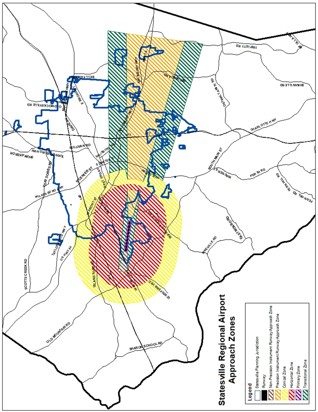
Section 4.6.1. - Airport zones.
In order to carry out the purposes of air safety, there are hereby created and established certain zones, which include all of the land lying beneath the primary surface, approach surfaces, transitional surfaces, horizontal surfaces, and conical surfaces as they apply to Statesville Regional Airport. Such zones are shown on the Height Zoning Map (See Figure 4.2), prepared by Parrish and Partners, LLC and dated July 23 rd , 2020, which is incorporated into the comprehensive zoning map. An area located in more than one (1) of the following zones is considered to be only in the zone with the more restrictive height limitation. The various zones are hereby established and defined as follows:
A.
Primary Zone. The primary zone is the area beneath the primary surface. This zone extends 200 feet beyond each physical end of the runway, has a width of 1,000 feet, and is centered on the runway centerline. The primary surface and the primary zone are based on a planned ultimate runway length of eight thousand (8,000) feet.
B.
Non-Precision Instrument with Visibility Minimums as Low As ¾ Mile Approach Zone. The inner edge of this approach zone coincides with the width of the primary surface and is 1,000 feet wide. The approach zone expands outward uniformly to a width of 4,000 feet at a horizontal distance of 10,000 feet from the primary surface. Its centerline is the continuation of the centerline of the runway.
C.
Precision Instrument Runway Approach Zone. The inner edge of this approach zone coincides with the width of the primary surface and is 1,000 feet wide. The approach zone expands outward uniformly to a width of 16,000 feet at a horizontal distance of 50,000 feet from the primary surface. Its centerline is the continuation of the centerline of the runway.
D.
Reserved.
E.
Transitional Zones. The transitional zones are the areas beneath transitional surfaces.
F.
Horizontal Zone. The horizontal zone is established by swinging arcs of 10,000 feet radii from the center of each end of the primary surface of each runway and connecting the adjacent arcs by drawing lines tangent to those arcs. The horizontal zone does not include the approach and transitional zones.
G.
Conical Zone. The conical zone is established as the area that commences at the periphery of the horizontal zone and extends outward there from a horizontal distance of 4,000 feet.
(Ord. of 5-18-21(1); Ord. of 5-18-21(2))
Section 4.6.2. - Height Limitations.
A.
Except as otherwise provided in this Ordinance, no structure shall be erected, altered, or maintained, and no tree shall be allowed to grow in any zone created by this Ordinance to a height in excess of the applicable height limit herein established for such zone, as depicted on the Statesville Regional Airport Height Zoning Map referred to in Section 6. Such applicable height limitations are hereby established for each of the zones in question as follows:
1.
Primary Zone. The elevation of any point in the primary zone is the same as the elevation of the nearest point on the runway centerline.
2.
Non-Precision Instrument Runway with Visibility Minimums as Low As 3/4 Mile Approach Zone. Slopes thirty-four (34) feet outward for each foot upward beginning at the end of and at the same elevation as the primary surface and extending to a horizontal distance of ten thousand (10,000) feet along the extended runway centerline.
3.
Precision Instrument Runway Approach Zone. Slopes fifty (50) feet outward for each foot upward beginning at the end of and at the same elevation as the primary surface and extending to a horizontal distance of ten thousand (10,000) feet along the extended runway centerline; thence slopes upward forty (40) feet horizontally for each foot vertically to an additional horizontal distance of forty thousand (40,000) feet along the extended runway centerline.
4.
Transitional Zones. Slope seven (7) feet outward for each foot upward beginning at the sides of and at the same elevation as the primary surface and the approach surface, and extending to a height of one hundred and fifty (150) feet above the airport elevation which is nine hundred sixty-seven and eight tenth (967.8) feet above mean sea level. In addition to the foregoing, there are established height limits sloping seven (7) feet outward for each foot upward beginning at the sides of and at the same elevation as the approach surface and extending to where they intersect the conical surface. Where the precision instrument runway approach zone projects beyond the conical zone, there are established height limits sloping seven (7) feet outward for each foot upward beginning at the sides of and at the same elevation as the approach surface, and extending a horizontal distance of five thousand (5,000) feet measured at ninety (90) degree angles to the extended runway centerline.
5.
Horizontal Zone. Established at one hundred and fifty (150) feet above the airport elevation or at an elevation of one thousand one hundred seventeen and eight tenth (1,117.8) feet above mean sea level.
6.
Conical Zone. Slopes twenty (20) feet outward for each foot upward beginning at the periphery of the horizontal zone and at one hundred and fifty (150) feet above the airport elevation and extending to a height of three hundred and fifty (350) feet above the airport elevation.
B.
The following limitations shall also hereby apply:
1.
Structures and/or trees that exceed the height limitations established for each zone in this article are hereby determined to be obstructions. Except for the City of Statesville, the property owner of a tree determined to be an obstruction shall not be responsible for bringing such tree into conformance with this article.
2.
In addition to the height limitations defined herein, any structure or tree that would either cause a minimum obstruction clearance altitude, a minimum descent altitude, or a decision height for Statesville Regional Airport to be raised, takeoff minimums to be raised, or a non-standard climb gradient to be increased, is hereby determined to be an obstruction.
3.
Notwithstanding any other provision of this article, any structure or tree that exceeds the following height limitations within the jurisdictional limits of the City of Statesville shall be considered an obstruction:
a.
A height of five hundred (500) feet above ground level at the site of the structure.
b.
A height that is two hundred (200) feet above ground level, or the established airport elevation, whichever is higher, within three (3) nautical miles of the established airport reference point.
Figure 4.2 Height Zoning Map
(Ord. of 5-18-21(1); Ord. of 5-18-21(2))
Section 4.6.3. - Use Restrictions.
Notwithstanding any other provisions of this Ordinance, no use may be made of land or water within any zone established by this Ordinance in such a manner as to create interference with the operation of airborne aircraft. The following special requirements shall apply to each permitted use:
A.
All lights, lasers or illumination used in conjunction with streets, parking, signs, or use of land, and structures, shall be arranged and operated in such a manner so that it is not misleading or dangerous to aircraft operating from the Airport or in the vicinity thereof. Particularly, it shall not be made difficult for pilots to distinguish between airport lights and others.
B.
No operations or use of land of any type shall produce smoke, glare or other visual hazards which impair the visibility in the vicinity of the airport, create bird strike hazards, or otherwise endanger or interfere with the landing, takeoff or maneuvering of aircraft intending to use the Airport.
C.
No operations or use of land of any type shall produce electronic interference with navigation signals or radio communication between the Airport and aircraft.
(Ord. of 5-18-21(2))
Section 4.6.4. - Nonconforming Uses.
A.
Regulations Not Retroactive. The regulations prescribed by this Ordinance shall not be construed to require the removal, lowering, or other change or alteration of any structure or tree not conforming to the regulations as of the effective date of this Ordinance, or otherwise interfere with the continuance of nonconforming use of any structure or tree not conforming to the regulations as of December 3, 2003. Nothing contained herein shall require any change in the construction, alteration, or intended use of any structure, the construction or alteration of which was begun prior to the effective date of this Ordinance and is diligently prosecuted.
B.
Marking and Lighting. Notwithstanding the preceding provision of this Section, the owner of any existing nonconforming structure or tree is hereby required to permit the installation, operation, and maintenance thereon of such markers and lights as shall be deemed necessary by the Airport Manager to indicate to the operators of aircraft in the vicinity of the airport the presence of such airport obstruction. Such markers and lights shall be installed, operated, and maintained at the expense of the owner of such nonconforming structure or tree in accordance with FAA Advisory Circular AC 70/7460-1L or subsequent revisions.
(Ord. of 5-18-21(2))
Section 4.6.5. - Permits.
A.
Future Uses. Except as specifically provided in a., b., and c. hereunder, no material change shall be made in the use of land, no structure shall be erected or otherwise established, and no tree shall be planted in any zone hereby created unless a permit in accordance with the provisions of this article has been applied for and granted. Each application for a permit shall indicate the purpose for which the permit is desired, with sufficient particularity to permit it to be determined whether the resulting use, structure, or tree would conform to the regulations herein prescribed. If such determination is in the affirmative, the permit shall be granted. No permit for a use inconsistent with the provisions of this Ordinance shall be granted unless a variance has been approved in accordance with Section 10, §4.
1.
In the area lying within the limits of the Horizontal Zone and Conical Zone, no permit shall be required for any tree or structure less than eighty (80) feet of vertical height above the ground, except when, because of terrain, land contour, or topographic features, such tree or structure would extend above the height limits prescribed for such zones.
2.
In areas lying within the limits of the Approach Zones, but at a horizontal distance of not less than four thousand two hundred (4,200) feet from each end of the runway, no permit shall be required for any tree or structure less than eighty (80) feet of vertical height above the ground, except when such tree or structure would extend above the height limit prescribed for such approach zones.
3.
In the areas lying within the limits of the Transition Zones beyond the perimeter of the Horizontal Zone, no permit shall be required for any tree or structure less than eighty (80) feet of vertical height above the ground, except when such tree or structure, because of terrain, land contour, or topographic features, would extend above the height limit prescribed for such transition zones.
4.
When compliance with the aerial contour height limits as depicted on the Statesville Regional Airport Height Zoning Map cannot be clearly established without further information, the Planning Director may require that the permit include, but not be limited to, the ground elevation and coordinates of the area in question with certification by a registered land surveyor or professional engineer.
5.
Each applicant for a permit shall include as an attachment to the application an airspace determination issued by the FAA pursuant to the requirements of 14 CFR Part 77, and a copy of FAA Form 7460.
Nothing contained in any of the foregoing exceptions shall be construed as permitting or intending to permit any construction, or alteration of any structure, or growth of any tree in excess of any of the height limits established by this Ordinance.
B.
Existing Uses. No permit shall be granted that would allow the establishment or creation of an obstruction or permit a nonconforming use, structure, or tree to become a greater hazard to air navigation than it was on the effective date of this Ordinance or any amendments thereto or than it is when the application for a permit is made. Except as indicated, all applications for such a permit shall be granted.
C.
Nonconforming Uses Abandoned or Destroyed. Whenever the Planning Director determines that a nonconforming tree or structure has been abandoned or more than 80 percent torn down, physically deteriorated, or decayed, no permit shall be granted that would allow such structure or tree to exceed the applicable height limit or otherwise deviate from the zoning regulations.
D.
Variances. Any person desiring to erect or increase the height of any structure or tree, or use their property not in accordance with the regulations prescribed in this ordinance, may apply to the Board of Adjustment for a variance from such regulations. Such variances may be allowed where it is duly found that a literal application or enforcement of the regulations would result in practical difficulty or undue hardship and the relief granted would not be contrary to the public interest but will do substantial justice and be in accordance with the intent of this ordinance.
E.
Obstruction Marking and Lighting. Any permit or variance granted may, if such action is deemed advisable to effectuate the purpose of this Ordinance and be reasonable in the circumstances, be so conditioned as to require the owner of the structure or tree in question to install, operate, and maintain, at the owner's expense, such markings and lights as may be necessary in accordance with FAA Advisory Circular AC 70/7460-1L or subsequent revisions.
(Ord. of 5-18-21(2))
Section 4.6.6. - Conflicting Regulations.
Where there exists a conflict between any of the regulations or limitations prescribed in this Ordinance and any other regulations applicable to the same area, whether the conflict be with respect to the height of structures or trees, and the use of land, or any other matter, the more stringent limitation or requirement shall govern and prevail.
(Ord. of 5-18-21(2))
Section 4.6.7. - Airport Overlay Requirements.
Before the Board of Adjustment considers a variance request or hears an appeal from any order, requirement, decision or determination made under the provisions of this article, the Statesville Regional Airport Commission shall be given an opportunity to make recommendations with respect to the variance or appeal.
(Ord. of 5-18-21(2))
Editor's note— An ordinance adopted May 18, 2021(2) enacted provisions designated as § 12.2.3. Inashmuch as there were already provisions so designated, said section has been codified herein as § 4.6.7, at the discretion of the editor.
Section 4.7 - Floodplain Overlay Regulations.
Floodplain Overlay Regulations for development within the Special Flood Hazard Areas can be found within Appendix G: Iredell County Flood Damage Prevention Ordinance.
(Ord. of 10-18-21)
Editor's note— An Ord. adopted Sept. 18, 2018(2), repealed the former §§ 4.7, 4.7.1, 4.7.2, 4.7.3, and enacted a new § 4.7 as set out herein. The former § 4.7 pertained to similar subject matter and derived from the original Land Development Code.
Section 4.7.1 - Density Averaging.
A.
Density averaging involves the transfer of impervious development rights between two non-contiguous parcels provided the following requirements are met.
1.
The properties must be within the same water supply watershed. The receiving property shall not be within the critical area watershed unless the donor property is also in the critical area watershed.
2.
Overall project density must meet applicable density or stormwater control requirements under 15A NCAC 2B .0200.
3.
Vegetated setbacks on both properties must meet the minimum statewide water supply watershed protection requirements and those of this ordinance. The area on the donor property that can be counted for purposes of density averaging shall not include lands in any buffer or vegetated setback required by the ordinance or any lands used for septic tanks or on-site sewage treatment.
4.
Built upon areas must be designed and located to minimize stormwater runoff impact to the receiving waters, minimize concentrated stormwater flow, maximize the use of sheet flow through vegetated areas, and maximize the flow length through vegetated areas.
5.
Areas of concentrated density development shall be located in upland areas and, to the maximum extent practicable, away from surface waters and drainage ways.
6.
The property or portions of the donor properties that are not being developed shall remain in a vegetated or natural state and shall be managed by a homeowners' association as common area, conveyed to a local government as a park or greenway, or placed under a permanent conservation or farmland preservation easement unless it can be demonstrated that the local government can ensure long-term compliance through deed restrictions and an electronic permitting mechanism. A metes and bounds description of the areas to remain vegetated and limits on use shall be recorded on the subdivision plat, in homeowners' covenants, and on individual deed and shall be irrevocable.
7.
Development permitted under density averaging and meeting applicable low density requirements shall transport stormwater runoff by vegetated conveyances to the maximum extent practicable.
8.
A Density Averaging Certificate shall be obtained from the Board of Adjustment (serving as the Watershed Review Board) to ensure that both properties considered together meet the standards of the watershed ordinance and that potential owners have record of how the watershed regulations were applied to the properties.
9.
If the area to be donated is subdivided from the parcel, it will be exempt from the road frontage requirements in the Iredell County Land Development Code. However, the lot must have a 25 foot recorded easement.
10.
Refer to Table 4.1 Watershed Densities of this Ordinance for the allowances considered for the donating properties.
B.
Process for Density Averaging
1.
A pre-application meeting is required to go over the application materials and any questions about the process.
2.
An Iredell County Watershed Density Averaging application must be submitted with the following:
a.
Existing condition surveys of both properties showing the current impervious surface amount.
b.
Draft of revised property deeds, homeowners covenants (if applicable), and subdivision plat, including the metes and bounds descriptions of the areas to remain vegetated and limits on use for each property.
c.
Stormwater mitigation plan.
d.
Board of Adjustment fee.
3.
Once all submittal requirements are met, the request will be heard by the Board of Adjustment (as the Watershed Review Board) at the next available hearing.
4.
The Board of Adjustment must make written findings that the proposed project meets the requirements set forth in Section 4.5 of this Ordinance.
5.
If approved, the applicant shall submit two (2) mylar maps for recording and one (1) paper copy of each plat for filing with the Planning Department for final review.
6.
Once approved, the plats and the deeds for each parcel (including donor and receiver) must be recorded at the Iredell County Register of Deeds Office and the respective Register of Deeds Office of the donor property, if located outside Iredell County.
7.
The Planning Department will issue a Density Averaging Certificate to the applicant at which time the applicant can submit plans for zoning and building permits.
8.
A copy of the Density Averaging Certificate including surveys, recorded plat(s) deeds/ property descriptions, and any documentation reflecting the restrictions to the parcel that will remain undeveloped will be forwarded to the North Carolina Division of Water Quality.
9.
No change in the development proposal can be made unless the certificate is amended by the Board of Adjustment.
(Ord. of 5-3-22(1))