
Mason County Unincorporated
City Zoning Code
City Zoning Code
CHAPTER 17
31 - LANDSCAPING IN THE BELFAIR UGA
17.31.010 - Purpose.
The purpose of this section is to:
(1)
Preserve and improve the aesthetic character of Belfair;
(2)
Enhance the esthetic quality of new construction;
(3)
Promote retention and protection of existing vegetation and to reduce the impact of development on drainage systems, water quality, and natural habitats;
(4)
Enhance the appearance of the SR-3 corridor and other streets in Belfair;
(5)
Mitigate the negative impacts of parking lots on the streetscape;
(6)
Screen unsightly uses from view.
(Ord. 133-04 Att. B § 2 (part), 2004).
17.31.020 - Standards.
The following standards apply to all commercial and multi family development unless otherwise noted. A landscape design plan is required.
(1)
Landscaping should be suitable and fitting with the character of Belfair as a growing community in a rural area. Because this is within an urban growth area with a variety of development types, landscaping—both naturalized and cultivated—will be important in establishing and unifying the community's character. Existing substantial vegetation and native materials in informal plantings and arrangements should be considered in the concept.
Specific objectives include:
(A)
To provide visual screens and barriers as a transition between differing land uses;
(B)
To define plant species which are of low maintenance, resistant to drought and otherwise appropriate for conditions within the business district and which are safe for pedestrians;
(C)
To provide visual relief from large expanses of parking areas and integrate new construction into the natural environment;
(D)
To provide physical separation between vehicular and pedestrian traffic;
(E)
To retain existing vegetation and significant trees by incorporating them into the site design;
(F)
To provide decorative landscaping as a focal setting for signs, special site elements and/ or pedestrian areas;
(G)
To provide increased areas of permeable surfaces to allow for infiltration of surface water into groundwater resources, reduce the quantity of stormwater discharge and improve the quality of stormwater discharge;
(H)
Maintaining a green corridor along SR-3 except where buildings are encouraged to front directly onto the highway.
(2)
The landscape design plan shall address the following considerations:
(A)
A unified pedestrian circulation system with amenities and plantings;
(B)
A coordinated system of open spaces and/or planted areas that provide the required pedestrian areas and landscaping. The plan should indicate how the various spaces and plantings relate to the project's site design objectives of continuity, variety, activity, etc.;
(C)
Screening of service or unsightly areas;
(D)
Plantings and/or site features that enhance the building's architectural qualities;
(E)
Protection of existing significant trees and natural site amenities.
(3)
The design plan should consider the following landscape design objectives where appropriate:
(A)
Where feasible, coordinate the selection of plant material to provide a succession of blooms, seasonal color, and a variety of textures;
(B)
Provide a transition in landscaping design between adjacent sites, within a site, and from native vegetation areas in order to achieve greater continuity;
(C)
Design landscaping to create definition between public and private spaces;
(D)
Design landscaping to provide a transition between built structures (vertical planes) and the site (horizontal planes);
(E)
Use plantings to highlight significant site features and to define the function of the site, including parking, circulation, entries, and open space;
(4)
The design plan should use planting strips or areas as barriers and/or screens to separate land uses or specific activities and provide visual relief from large expanses of parking areas or buildings.
Specifically:
(A)
Planting areas should be a mix of evergreen and deciduous shrubs whose height and width will be proportionate to the area being planted;
(B)
Trees, shrubs, ground covers, and/or grasses that are native to the Puget Sound basin and are appropriate to the conditions of the site are preferred;
(C)
Care must be taken not to visually block lines of sight for vehicles or pedestrians or obscure businesses with landscape material that will be too large at maturity for the site;
(D)
Plants should be arranged asymmetrically unless the landscape plan emphasizes a formal design concept or space is too restricted to allow a mix of plant materials;
(E)
Ground cover material should cover seventy percent of the soil in one growing season or seventy percent of the soil in three years if mulch is applied until the ground cover fills the designated area.
(5)
The design plan should also consider:
(A)
Integration of the stormwater management features (such as biofiltration swales or surface water detention ponds) into the planting strip;
(B)
Incorporation of or protection of natural features, including wetlands, significant trees and vegetation, and slopes.
(6)
Landscaping types. The following list of landscaping types:
(A)
Landscape Type A.
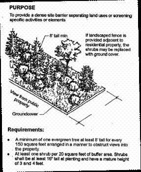
Figure 18. Landscape Type A.
(B)
Landscape Type B
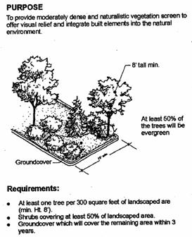
Figure 19. Landscape Type B.
(C)
Landscape Type C
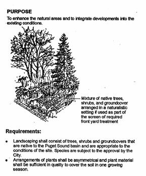
Figure 20. Landscape Type C.
(7)
Landscape buffer requirements between uses shall be as noted in Table 1 below. Where substantial native vegetation exists in the required side and rear buffer areas, such vegetation shall be retained within the required buffer width to the extent possible. Where a limited amount of native vegetation exists in the required buffer area, the county may require supplemental landscaping based on the required landscape types noted in Table 3 to complement the existing native vegetation.
Table 3. Required buffers for side and rear yards. Landscape Types A, B, and C refer to the landscaping types referenced in subsection (4) above.
*Land Use Categories are detailed in the Mason County Development Regulations, see MCC 17.03.034.
(8)
Provide internal parking lot landscaping (parking lots within the Business-Industrial district are exempt unless visible from SR-3). Specifically, all surface parking lots (excluding underground or structured parking areas) with more than fourteen stalls and within one hundred feet of the public right-of-way (excluding alleys) and not separated from that street by another building shall conform to the following standards:
* Landscaped area calculations can include landscaped areas between the parking lot and the street.
(9)
Provide shrubs and ground cover in the required interior parking lot landscape areas.
(A)
Plant shrubs at a density of five per one hundred square feet of landscape area.
(B)
Up to fifty percent of shrubs may be deciduous.
(C)
Select and plant ground cover so as to provide ninety percent coverage within three years of planting, provided that mulch is applied until plant coverage is complete.
(10)
Do not locate a parking stall more than fifty feet from a landscape area.
Exceptions:
(A)
Mason County may exempt parking lots with less than one hundred parking spaces and not visible from or not within one hundred feet of a street or park from interior parking lot landscaping, but not necessarily from perimeter parking lot landscaping;
(B)
Mason County may allow alternative parking lot landscaping schemes where the applicant can successfully demonstrate that such schemes better meet the intent of the guidelines.
(11)
Provide at least one tree for every six parking spaces. The trees required for parking lot landscaping may not be considered as street trees.
Exceptions:
(A)
Mason County may exempt parking lots with less than one hundred parking spaces and not visible from or not within one hundred feet of a street or park from interior parking lot landscaping, but not necessarily from perimeter parking lot landscaping;
(B)
Mason County may allow alternative parking lot landscaping schemes where the applicant can successfully demonstrate that such schemes better meet the intent of the guidelines.
(12)
Provide landscaping to screen parking lots from adjacent or neighboring properties. Specifically, screen parking lots with over fourteen stalls and within five feet of adjacent property lines with Landscape Type A or ten feet of Type B or C landscaping. Mason County may waive this requirement if parking is shared by the adjacent uses.
(Ord. 133-04 Att. B § 2 (part), 2004).
(Ord. No. 23-19, Att. A, 3-19-2019; Ord. No. 2022-093, Att. C, 12-20-2022)