
Michigan City Zoning Code
ARTICLE 31
- DEFINITIONS
Section 31.01 - Construction of Language
(a)
Interpretations.
(1)
If the meaning of this Ordinance is unclear in a particular circumstance, then the individual or body charged with interpreting or applying the Ordinance shall construe the provision to carry out the intent of the Ordinance, if the intent can be discerned from other provisions of the Ordinance or law.
(2)
All words and phrases shall be construed and understood according to the common preferred use of the language; but technical words and phrases that may have acquired a peculiar and appropriate meaning in the law shall be construed and understood according to that peculiar and appropriate meaning.
(3)
Whenever a word or term defined hereinafter in the text of this Ordinance, its meaning shall be construed as defined herein. Words or terms not herein defined shall have the meaning customarily assigned to them.
(4)
The definitions contained in this Article are for the purposes of this Ordinance.
(b)
Terms.
(1)
The word "shall" is always mandatory and not discretionary. The word "may" is permissive.
(2)
The terms "Ordinance" shall be understood to include the term "as amended" where the context is appropriate.
(3)
The terms "abutting" or "adjacent to" include property along the lot lines of the subject site, including those in another community, but do not include lands separated by a public street right-of-way.
(4)
A "building" or "structure" includes any part thereof.
(5)
The word "building" includes to "erect" or "construct."
(6)
The word "person" includes an individual, a corporation, a partnership, an incorporated association, or any other similar entity. A masculine term shall include the feminine version of the term and vice versa.
(7)
The phrase "used for" includes "arranged for," "intended for," "occupied for," and "maintained for."
(8)
Unless the context clearly indicates the contrary, the conjunctions noted below shall be interpreted as follows.
a.
"And" indicates that all connected items, conditions, provisions, or events shall apply.
b.
"Or," indicates that the connected items, conditions, provisions or events may apply separately or in combination.
c.
"Either...or" indicates that the connected items, conditions, provisions or events shall apply separately, not in combination.
(c)
The particular shall control the general. For terms used in this Ordinance the use of a general term shall not be taken to be the same as the use of any other specific term.
(d)
Words used in the present tense shall include the future; words used in the singular number shall include the plural; and the plural the singular, unless the context clearly indicates otherwise.
(e)
Computing the number of days, the first day is excluded and the last day is included. If the last day of any period during which an application, filing, or request is required to be made to the city, county or other governmental agency is a Saturday, Sunday, or legal holiday, the period is extended to include the next day which is not a Saturday, Sunday, or legal holiday.
(f)
All measurements shall be to the nearest integer, unless otherwise specified herein.
(g)
Unless the context clearly indicates to the contrary, where an illustration accompanies any item in this Ordinance, the written text shall have precedence over the illustration.
Section 31.02 - Definitions "A"
For the purpose of this title, the following definitions shall apply unless the context clearly indicates or requires a different meaning.
Abandoned. Cessation of the use of a structure or land, with the intent to abandon the use at that location. The intent to abandon may be demonstrated by records indicating that the address is vacant or occupied by another use, the utility service associated with the use has been disconnected, the telephone number associated with the use as disconnected/moved to another location or the business associated with the use has moved to another location or been discontinued.
Abuts or abutting. Having a common property line or district line.
Access management. A technique to improve traffic operations and decrease the potential for accidents along major thoroughfares through the control of driveway locations and design; consideration of the relationship of traffic activity for properties adjacent to, and across from, one another; and the promotion of alternatives to direct access.
Accessory building or use. A subordinate building located on the same lot with the main building, or a subordinate use of land, either of which is incidental to the main building or to the principal use of the land. An accessory building or use includes, but is not limited to:
(1)
A children's playhouse, garden house, or private greenhouse;
(2)
A detached garage, shed, or building for domestic storage;
(3)
Incinerators incidental to residential use;
(4)
Storage of merchandise normally carried in stock on the same lot with any retail, service, or business use, unless that storage is prohibited by district regulations;
(5)
Storage of goods used in, or produced by, manufacturing activities on the same lot or parcel of ground with those activities, unless that storage is prohibited by district regulations;
(6)
A non-paying guest house or rooms for guests within an accessory building, if those facilities are used for the occasional housing of guests of occupants of the principal building and not for permanent occupancy by others as housekeeping units;
(7)
Servants quarters, if part of an accessory garage and solely for occupancy by a servant or household employee of the occupants of the principal dwelling and the family of that servant or employee;
(8)
Off-street motor vehicle parking area and loading and unloading facilities;
(9)
Signs, other than advertising signs, as permitted and regulated in each district incorporated in this title;
(10)
Boat house;
(11)
Swimming pool, if private and being incidental to use by the owner and guests; and
(12)
Public utility communication, electric, gas, water, and sewer lines, their supports, and incidental equipment.
Accessory equipment building. A structure used to house equipment for the operation, maintenance, or repair of a wireless communications tower, including electronic receiving and relay equipment.
Accessory living quarters. Living quarters within an accessory building for the sole use of persons employed on the premises, such as quarters having no kitchen facilities and not rented or otherwise used as a separate dwelling.
Acreage. Any tract or parcel of land which has not been subdivided and platted.
Adjacent. To lie near or close to; in the neighborhood or vicinity of, including across a public right-of-way, stream, river or railroad.
Adjacent property owners, owner, or interested party. The owners of record of each lot or parcel of real estate abutting the tract of real estate that is the subject of the application, petition, or matter upon which a public hearing is to be held before the legislative body, plan commission, or board of zoning appeals. The owners of record shall be according to the real estate master file as maintained by the auditor of the county or city, at the time of the filing of an application or petition,
Adjoining. Touching or contiguous, as distinguished from lying near or adjacent.
Adult regulated use. The following definitions shall apply to adult regulated uses:
(1)
Adult bath house. An establishment which is not a hotel but which contains any combination of baths, showers, saunas and pools for public use and which excludes persons under the age of 18 from part or all of the facility that is open to adults
(2)
Adult cabaret. An establishment that customarily features adult entertainers providing live adult entertainment or which holds itself out to the public as an establishment where adult entertainment is available, but such definition shall not include any uses prohibited by this ordinance. Signs, advertisements or an establishment name including verbal or pictorial allusions to sexual stimulation or gratification or by references to "adult entertainment," "strippers," "showgirls," "exotic dancers," "gentleman's club," "XXX" or similar terms, shall be considered evidence that the establishment holds itself out to the public as providing adult entertainment. The fact that an establishment does not serve alcoholic beverages shall not remove it from classification as an adult cabaret if it otherwise falls under this definition.
(3)
Adult encounter center. A business or enterprise that offers live physical contact between two or more persons when one or more of the persons is in a state of nudity or semi-nudity, for the purpose of engaging in sexually explicit activities or touching specified anatomical areas.
(4)
Adult entertainer. Any person paid by some form of remuneration to provide live adult entertainment to customers at an adult regulated use that may consist of dancing, singing, acting, other forms of performing, or individual conversations with customers whereby the entertainer is paid any form of remuneration directly or indirectly for such conversations.
(5)
Adult entertainment. Any of the following activities, when performed live by an adult entertainer at an adult regulated use: dancing, singing, talking, touching, gymnastics, acting, other forms of performing, or individual conversations with customers.
(6)
Adult massage establishment. A business or enterprise where a massage is provided by a person not certified by the state as a massage therapist under Indiana Code Title 25, Art. 21.8 or by someone other than a physician, surgeon, nurse, physical therapist, occupational therapist, or chiropractor who is licensed, certified or registered to practice their respective professions under the laws of the state, or any business that provide massage for the purpose of sexual stimulation.
(7)
Adult media. Media which are distinguished or characterized by their emphasis on matter depicting, describing, or relating to sexually explicit activities or specified anatomical areas.
(8)
Adult motel. An establishment which customarily:
a.
Offers accommodations to the public for any form of consideration and provides patrons with transmissions of adult media; and which advertises the availability of adult media by means of a sign, visible from the public right-of-way, or by means of any off-premises advertising, including, but not limited to, newspapers, magazines, pamphlets or leaflets, radio, internet or television; or
b.
Permits patrons to be filmed or photographed performing "sexually explicit activities" or displaying "specified anatomical areas" for electric transmission outside the room; or
c.
Offers a room for rent for a period of time that is less than ten hours; or allows an occupant of a room to sub-rent the room for a period of time that is less than ten hours.
(9)
Adult motion picture theater. An establishment which customarily shows adult media and is marketed as or offers adult media described as "XXX". This definition specifically excludes adult video arcades.
(10)
Adult novelties. Instruments, devices, toys, or paraphernalia either designed as representations of human genitals or female breasts or designed or marketed primarily for use in sexual stimulations of specified anatomical areas.
(11)
Adult regulated use. An adult cabaret, adult motion picture theater, adult retail store.
(12)
Adult retail store. A retail establishment that meets any one of the following four tests:
a.
Thirty-five percent or more of the gross public floor area or gross wall display area or stock in trade consists of adult media; or
b.
Offers for sale items from any two of the following categories; adult media; lingerie; leather goods marketed or presented in a context to suggest their use for sadomasochistic practices; and the combination of such items comprise more than ten percent of its gross public floor area or stock in trade; or
c.
More than ten percent of its gross public floor area or stock in trade consists of adult novelties; or
d.
It is advertised, marketed, or holds itself out in any forum as an "XXX," "adult," or "sex" business.
(13)
Adult video arcade. Any place to which the public is permitted or invited wherein cash-operated, credit-operated, coin-operated or slug-operated or electronically, internet or mechanically controlled still or motion picture machines, projects or other image producing devices are maintained to show images depicting "sexually explicit activities" or "specified anatomical areas".
(14)
Escort. A person who, for consideration in any form, offers to act as a companion or date for another person, and who offers to perform sexually explicit activities while acting as a companion or date.
(15)
Escort agency. A person or business association that offers to furnish or advertises to furnish escorts as one of its business purposes, for a fee, tip or other consideration.
(16)
Nude modeling or photography studio. Any place where a person appears in a state of nudity or displays specific anatomical areas, and is provided any form of consideration to be observed, sketched, drawn, painted, sculpted, photographed or similarly depicted by other persons. This does not include a modeling studio whose primary function is to provide art classes as part of a college, university or educational institution and which is certified by the State of Indiana.
(17)
Nudity. A state of undress in which the human pubic area, anus, genitals, nipples or areolas are viewable.
(18)
Semi-nudity. A state of undress in which clothing (of any type) covers no more than the human pubic area, anus, and genitals.
(19)
Sexually explicit activities. Acts of human masturbation, sexual intercourse, sodomy, bestiality, erotic or sexual stimulation with objects or mechanical devices; acts of human analingus, cunnilingus, fellatio, flagellation, masturbation, sadism, sadomasochism, sexual intercourse, sodomy, or any excretory functions as part of or in connection with any of the activities set forth above. This definition shall include sexual stimulation of another person's genitals whether clothed or unclothed.
(20)
Specified anatomical areas. Any of the following: less than completely and opaquely covered human genitals, pubic area, anus, female areola or nipple, or any combination thereof; or human male genitals in a discernibly turgid state, even if completely and opaquely covered. Opaquely covered does not include the use of paint or latex or other similar materials applied to the body.
Adverse Impact. Any activity that would destroy, harm, impair, diminish or degrade the value, utility or function of a natural resource.
Advertising device. An advertising sign, billboard, or poster panel which directs attention to a business, commodity, service, or entertainment not exclusively related to the premises where the sign is located or to which it is affixed. However, this does not include those advertising signs, billboards, or poster panels which direct attention to the business on the premises or to a brand name of a product or commodity with which the business is specifically identified and which is sold on the premises.
Agricultural building. A structure utilized for the keeping of livestock, storage, or raising of agricultural products or storage of agricultural equipment.
Agricultural land use. The use of land for the production of animal or plant life, including forestry, pasturing or yarding livestock, and planting, growing, cultivating, and harvesting crops for human or livestock consumption.
Agriculture. The use of land for agricultural purposes with the intent of selling any products produced by this type of activity. Agricultural uses include farming, dairying, pasturage, apiculture, horticulture, floriculture, viticulture, and animal and poultry husbandry, and the necessary accessory uses for packing, treating, or storing the products. The operation of any accessory uses shall be secondary to that of the normal agricultural activities. The agricultural use does not include the operation or maintenance of a commercial stockyard or feedlot (confined feeding operation).
Alteration. Any change, addition, or modification in construction, or any change in the structural members of a building, such as load bearing walls, columns, beams, or girders.
Anchoring system. An approved system of straps, cables, turnbuckles, chains, ties, or other approved materials used to secure a manufactured or mobile home.
Animal
(1)
Small or domesticated animal/pet. Any animal that is commonly considered capable of being trained or is capable of adapting to living in a human environment and being of use to human beings, and which is not likely to bite without provocation, nor cause death, maiming or illness to human beings, including: dogs, cats (domesticated), birds (caged), fish, turtles, rodents (bred, such as a gerbils, rabbits, hamsters or guinea pigs) and lizards (non-poisonous). Wild, vicious, or exotic animals shall not be considered domesticated.
(2)
Exotic or vicious animal. Any animal of a species not indigenous to the State of Indiana and not a domesticated animal, including any hybrid animal that is part exotic animal; or any animal which, irrespective of geographic origin, is of wild or predatory character, or which because of size, aggressive or vicious characteristics would constitute an unreasonable danger to human life or property if not kept, maintained or confined in a safe and secure manner, including any hybrid animal that is part exotic animal; or any animal that attacks, bites, or injures human beings or other domesticated animals without adequate provocation, or which because of temperament, conditioning, or training, has a known propensity to attack, bite, or injure human beings or domesticated animals.
(3)
Large animal or livestock. Any of various bird or animal breeds, long ago domesticated by man so as to live and breed in a tame, docile, tractable condition useful to man, including animals such as: horses, ponies, mules, donkeys, cattle, sheep, goats, buffaloes, lama, swine, chickens, ducks, geese and turkeys.
Ansi/NFPA 501: a standard for installation of manufactured homes. Model national standards (including all authorized successor documents) for installation of manufactured and mobile homes, as adopted and copyrighted by the National Fire Protection Association and the Manufactured Housing Institute.
Apartment. See dwelling, apartment.
Applicant. The owner, or his or her representative, of land which is proposed to be developed, subdivided, or rezoned or for which a variance is sought, or their designated representative.
Arcade. A commercial recreation business, usually conducted indoors, which provides mechanical and/or electronic games for entertainment.
Automobile car wash. A commercial building, or portion thereof, containing facilities for washing vehicles or other items using production line methods, or other mechanical devices including the use of steam cleaning or high pressure equipment.
Automobile repair.
(1)
Major. Engine rebuilding, or major reconditioning, collision service, body, frame, or fender straightening, or repair and overall painting of vehicles, or trailers.
(2)
Minor. Incidental repairs, replacement of parts, and motor service to motor vehicles, such as oil changes, and lubrication, tune-ups, wheel alignment, replacement of mufflers, exhaust systems, brakes, shock absorbers, batteries, pumps, belts, hoses, air filters, and windshield wipers, radiator cleaning, and flushing; auto detailing, sale/installation of automobile accessories such as tires, radios, and air conditioners, but not including any operation included above under automobile repair, major.
Automobile service station. A building, or portion thereof, or premises used for dispensing or offering for sale, at retail, gasoline when stored only in underground tanks, kerosene, lubrication oil, or grease, for operation of automobiles, and where tires, batteries, and similar automobile accessories may be offered for sale on the premises at retail. Minor vehicle repair services and installation customarily incidental thereto may also be performed if enclosed in a building. However, automobile service stations do not include open sales lots, as defined herein, or vehicle wash establishments.
Awning. A roof-like structure which projects from the wall of a building.
(Ord. No. 4254, § 3(Exh. A), 10-30-2013; Ord. No. 4500, §§ 5.48., 5.49., 2-5-2019)
Section 31.03 - Definitions "B"
For the purpose of this title, the following definitions shall apply unless the context clearly indicates or requires a different meaning.
Balcony. An unenclosed platform that projects from or recesses into the wall of a building a minimum of 2 feet, is surrounded by a parapet or railing on its open side(s) and is entirely supported by the building and/or columns. When such platform is both roofed and enclosed, it is considered interior space and is not a balcony.
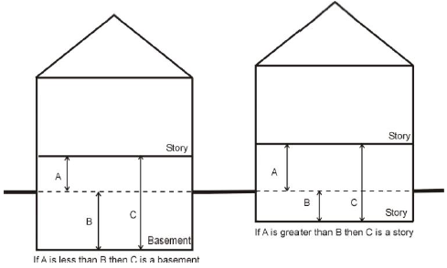
Basement or cellar. A story partly or wholly underground, but having more than one-half of its clear height below finished grade. If more than one-half its clear height is above grade, it shall be considered a story for the purposes of height measurement.
Bay window. A window that projects outward from the building façade in a semicircular, rectangular, or polygonal design. The base of the projected area of each bay window shall be at least one foot above the level of the floor, shall project a minimum of two feet from the façade, shall not be used as an extension of interior floor space, and shall span a maximum of eight feet along a street-facing façade.
Bed and breakfast. A residential building, or portion thereof, (other than a hotel, apartment hotel, or motel) containing lodging rooms for accommodation of persons who are not members of the keeper's family and where lodging and/or meals are provided by pre-arrangement, for definite periods of time and for compensation.
Bicycle parking, short-term. Space for temporary parking of bicycles for visitors and customers. Such spaces may be public or private and typically consist of outdoor bicycle racks.
Bicycle parking, long-term. Space for parking of bicycles for all-day users or residents. Such spaces may consist of bicycle lockers, bicycle racks in enclosed areas, or space within a building where a resident, employee, or visitor may park a bicycle for the day or overnight.
Block. A tract of land bounded by streets, public or institutionally owned lands, railroad rights-of-way, rivers and lakes, and other lines of demarcation.
Block face. The frontage on a public street located between intersecting public or private streets or alleys.
Board of zoning appeals (BZA). The board of zoning appeals has the duty to hear and determine appeals on orders, requirements, or decisions made in connection with this ordinance and is authorized to grant variances and special exceptions from the code. There shall be individual bzas for the county and both cities.
Boarding stable. A building or structure designed, arranged, used, or intended to be used for housing saddle horses or ponies where horse owners pay a fee to keep their horses.
Boat club. A private facility that provides service to members for docking, storing and loading of at least five watercraft. A boat club may include docking facilities, boat storage, clubhouse and other recreational facilities for members. A boat club shall include a lot held in common by a subdivision, association, similar agency or group of individuals which provides docking, storing and loading of at least five watercraft. (See also "Boat harbor/public marina.")
Boat harbor/public marina. A facility that: can service simultaneously at least five watercraft; and provides, for a fee, one or more of the following:
(1)
Watercraft engine fuel.
(2)
Watercraft repair.
(3)
Watercraft sales or rental.
A public marina shall be distinguished from a "boat club" in that a public marina may lease docks for long-term mooring of watercraft or short-term transient boaters (See also "Boat club.")
Bond. Any form of security, including a cash deposit, surety bond, collateral, property, or instrument of credit, in an amount and form satisfactory to the plan commission. All bonds shall be approved by the plan commission whenever a bond is required by these regulations.
Buffer. A landscaped or naturally vegetated area established or managed to provide separation between adjacent land uses.
Buffer strip. An area of required space adjacent to the boundary of a natural feature or property, not less in width than is designated in this article, which consists of native vegetation appropriate to the feature to which it is adjacent.
Building. A structure built for the support, enclosure, shelter, or protection of persons, animals, or chattels, or affixed to the land.
(1)
Building, detached. A building, surrounded by open space on the same lot with, but no structural attachment to, another structure.
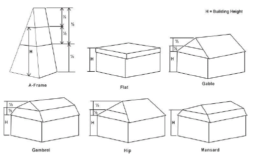
Building height. The vertical distance from the average grade around the building foundation to the highest point of the roof surface for a flat roof, to the deck line of a mansard roof, and the midpoint between the peak and eave of a pitched roof. Chimneys, spires, elevator penthouses, tanks, and similar projections that do not include usable floor space shall not be included in calculating the height. This definition and method of measuring building height shall apply to all structures including principal buildings and accessory structures. For buildings located in the R1E Zoning District, the method for determining building height shall be as specified in Section 04.04(b)(2).
(2)
Building, principal. The main or dominant building in which is conducted the principal use of the lot on which the building is located.
(3)
Building, residential. A building which is arranged, designed, used, or intended to be used for residential occupancy by one or more families or lodgers and which includes, but is not limited to, the following types:
a.
Single-family detached dwellings;
b.
Two-family dwellings;
c.
Single-family or two-family attached and semi-detached dwellings developed initially under single ownership or unified control.
d.
Multiple-family dwellings; and
e.
Mixed-use buildings with residential uses on upper floors above non-residential uses.
(4)
Building, semi-detached. A building having one party wall in common with an adjacent building.
(5)
Building, temporary. Any building not designed to be permanently located at the place where it is, or where it is intended to be temporarily placed or affixed.
Building commissioner. The secretary of the county plan commission and board of zoning appeals oversees the operation of the building department and is responsible for insuring the enforcement of county zoning and subdivision ordinances, building standards, and compliance with related planning requirements, and issues and approves building permits.
Building height. The vertical distance from the average grade around the building foundation to the highest point of the roof surface for a flat roof, to the deck line of a mansard roof, and the midpoint between the peak and eave of a pitched roof. Chimneys, spires, elevator penthouses, tanks, and similar projections that do not include usable floor space shall not be included in calculating the height. This definition and method of measuring building height shall apply to all structures including principal buildings and accessory structures. For buildings located in the Waterfront View Protection Overlay Zoning District, the method for determining building height shall be as specified in Section 12.03.
Building line. A horizontal line generally parallel to a front, rear, or side lot line which is located at the point of the foundation of a principal building nearest to the front, rear, or side lot line.
Building permit. An official document or certification issued by the building official authorizing performance of a specified activity that complies with all provisions of this title and the building code.
Bulk. The term used to indicate the size and setback of buildings or structures, and their location with respect to one another, and includes the size and height of buildings, the location of exterior walls, the floor area ratio, the open space allocated to buildings, and the lot area and lot width.
Business. An occupation, employment, or enterprise which occupies time, attention, labor, and materials, or wherein merchandise is exhibited or sold, or where services are offered.
(Ord. No. 4254, § 3(Exh. A), 10-30-2013; Ord. No. 4500, §§ 5.50., 5.51., 2-5-2019)
Section 31.04 - Definitions "C"
For the purpose of this title, the following definitions shall apply unless the context clearly indicates or requires a different meaning.
Capacity in persons. The maximum number of persons that can avail themselves of the services or goods of an establishment or use at any one time, with reasonable comfort and safety.
Carport. An open-sided roofed automobile shelter, formed by the extension of a roof from the side of a building.
Cemetery. Land or structure used or intended to be used for the lawful disposition of the remains of a deceased individual in the earth, a mausoleum, a garden crypt, a columbarium, or scattering garden area, including crematories, mausoleums, and mortuaries if operated in connection with and within the boundaries of a cemetery.
Certificate of compliance. A document issued by the proper authority stating that the plans for a proposed use meet all applicable codes and regulations.
Certificate of occupancy. A certificate stating that the occupancy and use of land or a building or structure referred to therein complies with the provisions of this title, and any other ordinance adopted by the county or city relating to a building code.
Club or lodge, private. A private association of persons who are bonafide members paying annual dues, which owns, hires, or leases a building, or portion thereof, the use of the premises being restricted to members and their guests. The affairs and management of a private club or lodge are conducted by a board of directors, executive committee, or similar body chosen by the members.
Co-location. The use of a wireless telecommunications facility by more than one wireless communications provider.
Commission's seal. The official seal of the plan commission.
Commitments. Restrictions and guidelines placed upon a property's use or development and recorded in the office of the county recorder to take effect upon adoption of an amendment to the zoning map or upon granting approval for a special exception, contingent use, or variance from the terms of this ordinance.
Common ownership. The ownership of real property by family members, shareholders, business partners, corporations, or any other legal entity with the intent to develop under a common scheme or plan.
Compensatory mitigation: See: "Flood-Related Definitions."
Comprehensive plan. See "County Land Development Plan."
Condominium. Ownership in common with others of a parcel of land and certain parts of a building thereon which would normally be used by all the occupants, such as yards, foundation, basements, floors, walls, hallways, stairways, elevators, and all other related common elements, together with individual ownership in fee of a particular unit or portion of the building.
Confined feeding operation. A feedlot is the confinement of livestock or fowl for any period of time, whether open or enclosed based upon the number of animals regulated by the Concentrated Animal Feeding Operation Ordinance contained in Chapter 97 of the La Porte County Code of Ordinances.
Conforming building or structure. Any building or structure which complies with all the regulations of this title or of any amendment hereto governing the zoning district in which the building or structure is located.
Conservation The planned management of a natural resource to prevent its exploitation, destruction or neglect.
Contractor. Any person, firm, or corporation engaged in the business of general contractor, roofing, insulation, electrical, plumbing, sewage, well installation, heating, ventilation, air conditioning, or other ancillary contracting, excepting those individuals doing work on their own residence.
Contractor's yard. A site on which a building or construction contractor stores equipment, tools, vehicles, building materials, and other appurtenances used in or associated with building or construction. A contractor's yard may include outdoor or indoor storage, or a combination of both.
Conservation easement. A legal agreement in which the landowner retains ownership of private property, but conveys certain specifically identified rights to a land conservation organization or a public body.
Construction. Any act or process that is carried out under a current and valid building permit consisting of on-site erection, fabrication, installation, alteration, demolition, or removal of any structure, facilities or addition thereto, including related activities. Construction implies a diligent continuance of action toward completion, and any construction that has ceased due to expiration of a permit shall be considered inactive.
Convenience store. A small retail store that is designed and stocked to sell primarily food, beverages and other household supplies to customers who purchase relatively few items. It may be designed to attract, and depend upon, a large volume of transient traffic. The store may or may not also sell gasoline and other automotive supplies.
Corner lot. See "Lot, corner."
County Land Development Plan. The document, adopted by the La Porte County Plan Commission, City of La Porte Plan Commission and City of Michigan City Plan Commission, that is a compilation of policy statements, goals and objectives, standards, maps, and statistical data for the physical, social, and economic development of the community. The County Land Development Plan serves as the community comprehensive plan under the requirements of IC 36-7-4. The County Land Development Plan shall include any community master plan, comprehensive plan or other similar plan.
Court. An open unoccupied space bounded on two or more sides by the exterior walls of a building or by exterior walls and lot lines.
Critical facilities: See: "Flood-Related Definitions."
Cupola. A decorative, small, projecting tower at the top of the roof of a building, often square, round or octagonal in shape.
(Ord. No. 4500, §§ 5.52., 5.53., 2-5-2019)
Section 31.05 - Definitions "D"
For the purpose of this title, the following definitions shall apply unless the context clearly indicates or requires a different meaning.
Day care centers, commercial. A child care use licensed to care for more than 12 children from a provider:
(1)
While unattended by a parent, legal guardian, or custodian;
(2)
For regular compensation; and
(3)
For more than four hours but less than 24 hours in each of ten consecutive days per year, excluding intervening Saturdays, Sundays, and holidays. licensed for 12 or fewer children.
Day care homes, residential. A residential structure in which at least six and not more than 12 children plus three children during the school year only who are enrolled in at least grade one at any time receive child care from a provider:
(1)
While unattended by a parent, legal guardian, or custodian;
(2)
For regular compensation; and
(3)
For more than four hours but less than 24 hours in each of ten consecutive days per year, excluding intervening Saturdays, Sundays, and holidays. licensed for 12 or fewer children.
(4)
A child for whom a provider of care in the child care home is a parent, stepparent, guardian, custodian, or other relative and who is at least seven years of age; or who is at least 14 years of age and does not require child care; shall not be counted in determining whether the child care home is within the limit set forth in subsection (a).
Decibel. A unit of measurement of the intensity (loudness) of sound. Sound level meters, which are employed to measure the intensity of sound, are calibrated in decibels.
Developer. Any person engaged in developing or improving a lot or group of lots or structures thereon for use or occupancy.
Development.
(1)
Any improvement or change to property brought about by human activity (man-made), including, but not limited to:
a.
Construction, reconstruction, or placement of a building or any addition to a building valued at more than $1,000.00;
b.
Installing a manufactured home on a site, preparing a site for a manufactured home, or installing a recreational vehicle on a site for more than 180 days;
c.
Installing utilities, erection of walls and fences, construction of roads, or similar projects;
d.
Construction of flood control structures such as levees, dikes, dams, channel improvements, and the like;
e.
Mining, dredging, filling, grading, excavation, or drilling operations;
f.
Construction and/or reconstruction of bridges or culverts;
g.
Storage of materials; and
h.
Any other activity that might change the direction, height, or velocity of flood waters or surface waters.
(2)
Development does not include activities such as the maintenance of existing buildings and facilities such as painting, re-roofing, resurfacing roads, or gardening, plowing, and similar agricultural practices that do not involve filling, grading, excavation, or the construction of permanent buildings.
Diameter at Breast Height (DBH). The diameter of the trunk of a tree (including the bark) measured in inches at point four and one-half (4.5) feet above the ground level. This point of measurement is used for established and mature trees.
District. A geographical area within which certain uniform regulations and requirements or various combinations thereof apply under the provisions of this title.
Domesticated Animal/Pet. See: "Animal."
Dooryard. Building fronts are located in front setbacks and provide small landscaped and paved yards at building entrances. In residential settings dooryards can be enclosed by low walls, fences or hedges.
Drive-in establishment. An establishment which offers merchandise, service, or entertainment to persons in parked motor vehicles. A drive-in restaurant is distinct from a drive-through restaurant in that the majority of drive-in patrons consume food and beverages while in the vehicle and parked on the premises.
Drive-through establishment. An establishment where persons in motor vehicles wait in line to obtain merchandise from a service window.
Driveway. An approach and private vehicle travel way providing access from a street to private property.
Dune and Swale Complex. A series of roughly parallel, sandy ridges and low, wet swales formed from irregular cycles of high and low water levels, also known as linear dunes, beach ridge complexes or shore parallel dune ridges.
Dwelling. A permanent building, or portion thereof, designed or used exclusively for residential occupancy, including single-family dwellings, two-family dwellings, and multiple-family dwellings, but not including hotels or lodging houses.
(1)
Apartment dwelling. An apartment is an attached dwelling unit with party or common walls, contained in a building with other dwelling units or sharing the occupancy of a building with other than a residential use. Apartments are commonly accessed by a common stair landing or walkway. Apartments are typically rented by the occupants but may be condominiums. Apartment buildings often may have a central heating system and other central utility connections. Apartments typically do not have their own yard space.
(2)
Duplex. A pair of dwellings that may be located side-by-side with a shared wall from the finished floor to the roof, or that may be attached vertically, separated by a floor, which are located on a single platted lot. May also be termed as a two-family.
(3)
Live-Work Unit. A dwelling unit that provides space that is designed for one or more light commercial or office uses that are allowed in the zoning district. Access between the dwelling unit and the light commercial or office space is provided within the unit or from an exterior stairwell. A live-work unit may have up to three employees who do not live on the premises.
(4)
Multiple-family dwelling. A building, or portion thereof, used or designed as residences for three or more families living independently of each other and each doing their own cooking in the building, with the number of families in residence not exceeding the number of dwelling units provided. This definition includes three-family houses, four-family houses, and apartment houses.
(5)
Multiplex. A multiple-family building type that is designed to resemble a large single-family home. Units are not necessarily separated by a wall that extends from the foundation to the roof. Units may have either private or shared access and may be arranged in a variety of configurations, including back-to-back, side-to-side, or over-under units.
(6)
Single-family detached dwelling. A detached building or manufactured home designed exclusively for the complete living accommodations of one family and containing one dwelling unit only.
(7)
Single-family, attached/townhouse. A self-contained single dwelling unit attached to a similar single dwelling unit with party or common walls, designed as part of a series of three or more dwelling units, each on a separate lot or parcel and each with: a separate entryway with direct access to the outdoors at ground level, a separate garage, separate utility connections and defined front, and rear yards. Single-family attached townhouses may also be known as row houses, clustered single-family dwellings or stack ranches. Any three or more attached dwellings not meeting the above criteria shall be considered a multiple-family dwelling.
(8)
Twin Home. A dwelling designed as a single structure, containing two separate living units on individually platted lots, each of which is designed to be occupied as a separate residence for one family. Each unit is separated from the other by an unpierced fire rated wall that extends from the ground to the roof.
(9)
Two-family. A detached building, designed for or occupied exclusively by two families living independently of each other on a single lot or parcel. May also be termed as a duplex.
Dwelling unit. A single unit providing complete, independent living facilities for one or more persons, including provisions for living, sleeping, eating, cooking, and sanitation.
(Ord. No. 4500, §§ 5.54., 5.55., 2-5-2019)
Section 31.06 - Definitions "E"
For the purpose of this title, the following definitions shall apply unless the context clearly indicates or requires a different meaning.
Easement. An authorization or grant by a property owner for right of access or passage for limited use of private land by another person or for a defined public or quasi-public purpose.
Ecosystem. A system made up of a community of organisms and its interrelated physical and chemical environment.
Enforcement official. Officials for each of the cities and the county, duly appointed and designated as the enforcement official responsible for administering the terms of this ordinance and supporting the functions of the plan commission.
Entrance. A doorway providing direct access into an individual dwelling unit or nonresidential building, or a common entryway providing indirect access to multiple dwelling units or offices through a common area, foyer, lobby or hallway.
Erosion. The detachment and movement of soil, sediment, or rock fragments by water, wind, ice, or gravity.
Erosion control measure. A practice or a combination of practices to control erosion and resulting sedimentation.
Erosion control plan. A written description of pertinent information concerning erosion control measures designed to meet the requirements of this title as submitted with a site plan or subdivision application.
Essential services. The erection, construction, alteration, or maintenance of public utilities of underground, surface or overhead distribution of gas, electrical, cable TV, fuel, steam, or water transmission or distribution systems, collection, communication, supply or disposal systems, including mains, drains, sewers, pipes, conduits, wires, cables, transformers, splice boxes, police call boxes, fire alarm boxes, traffic signals, hydrants, towers, poles, and other similar equipment, and accessories in connection therewith but not including buildings or storage yards.
(Ord. No. 4500, § 5.56., 2-5-2019)
Section 31.07 - Definitions "F"
For the purpose of this title, the following definitions shall apply unless the context clearly indicates or requires a different meaning.
Family. One person or two or more persons each related to the other by blood, marriage, or legal adoption, or a group of not more than four persons not all so related, together with his or their domestic servants, maintaining a common household in a dwelling unit. In addition, a family may include not more than two roomers, boarders, or permanent guests, whether or not gratuitous.
Farm. An area of ten or more acres used for agricultural operations including truck gardening, forestry, tree or plant nursery, or the production and/or keeping of livestock and poultry.
Feedlots. The confinement for any period of time of livestock or fowl, whether open or enclosed.
Fence. A barrier of wood, masonry, stone, wire, metal or any other manufactured material or combination of materials, used to prevent, or control entrance, confine within, mark a boundary or screen.
Fill material. Any solid material, when placed in a wetland or lake, that displaces water or reduces water holding capacity.
Flood-Related Definitions
(1)
Compensatory Mitigation. Replacement of floodplain acreage, functions and values to compensate for floodplain areas that were subjected to human disturbance.
(2)
Critical facilities. Facilities that if impacted by flood, can have a community-wide impact on public health, safety and welfare, including schools, nursing homes, hospitals, police, fire, and emergency response installations, installations which produce, use or store hazardous materials or hazardous waste.
(3)
FEMA. Federal Emergency Management Agency.
(4)
FHBM. Flood Hazard Boundary Map. A FHBM is defined by FEMA as a map based on approximate data that identifies, in general, the SFHAs within a community. A FHBM is used in the NFIP's Emergency Program for floodplain management and insurance purposes.
(5)
Floodplain. The channel proper and the areas adjoining any wetland, lake or watercourse that have been or hereafter may be covered by the regulatory flood. The floodplain includes both the floodway and the floodway fringe districts. Floodplains are generally relatively flat lowlands next to a watercourse. For the purposes of this document, all SFHAs are considered floodplains, defined by the 100-year flood as delineated on FEMA Flood Insurance Rate Maps.
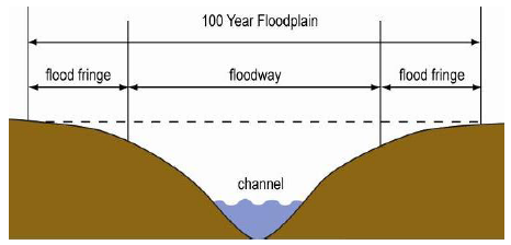
(6)
Floodway. The channel of a river, stream or other watercourse and the land areas of the floodplain adjoining the channel that are reasonably required to efficiently carry and discharge the flood water or flood flow of a river or stream and must be reserved in order to discharge the base flood without cumulatively increasing the water surface elevation more than a designated height.
(7)
Floodway Fringe. The portions of the floodplain lying outside of the floodway.
(8)
Flood Protection Grade (FPG). The elevation of the regulatory flood plus two feet at any given location in the Special Flood Hazard Area or 100-year floodplain.
(9)
IDNR. Indiana Department of Natural Resources.
(10)
Letter of Map Amendment (LOMA). An amendment to the currently effective FEMA map that establishes that a property is not located in a Special Flood Hazard Area (SFHA). A LOMA is only issued by FEMA. See: "Flood-Related Definitions."
(11)
Letter of Map Revision (LOMR). An official revision to the currently effective FEMA map. It is issued by FEMA and changes flood zones, delineations and elevations.
(12)
National Flood Insurance Program (NFIP). A program managed by FEMA, to identify and map flood hazard areas, assist with community floodplain management programs, and to provide flood insurance to participating communities that are located within a SFHA.
(13)
Regulatory Flood. In La Porte County, the flood having a one percent probability of being equaled or exceeded in any given year, as calculated by a method and procedure that is acceptable to and approved by the Indiana Natural Resources Commission and the FEMA.
(14)
Special Flood Hazard Area (SFHA). The land area covered by the floodwaters of the regulatory flood on NFIP maps. The SFHA is the area where the NFIP's floodplain management regulations must be enforced and the area where the mandatory purchase of flood insurance applies. The SFHA includes Zones A, AO and AH. The SFHAs of the County are generally identified as such on the Flood Insurance Rate Map of the County prepared by the FEMA and dated June 4, 1996.
Floor area.
(1)
Gross floor area (GFA). The area within the perimeter of the outside walls of the building under consideration, without deduction for hallways, stairs, closets/storage rooms, thickness of walls, columns, or other features.
(2)
Residential floor area. For the purposes of computing the minimum allowable floor area in a residential dwelling unit, the sum of the horizontal areas of each story of the building shall be measured from the exterior faces of the exterior wall. The floor area measurement is exclusive of areas of basements, unfinished attics, attached garages, breezeways, and enclosed or unenclosed porches.
(3)
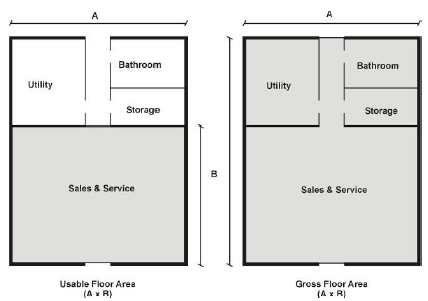
Usable floor area (UFA). That area used for or intended to be used for the sale of merchandise or services, or for use to serve patrons, clients or customers. Such floor area which is used or intended to be used principally for the storage of merchandise, or areas such as hallways, stairways, elevator shafts, utilities space or sanitary facilities, shall be excluded from this computation of UFA. Measurement of UFA shall be the sum of the horizontal areas of the several floors of the building, measured from the exterior faces of the exterior walls. When a detailed floor plan is not available, a factor of 80 percent shall be used to estimate the useable floor area for purposes of calculating parking requirements and other standards based on useable floor area.
Footcandle. A unit of illumination, equivalent to the illumination at all points which are one foot distant from a uniform point source of one candlepower.
Forecourt. A private frontage wherein a portion of the facade is close to the frontage line and the central portion is set back.
Foster care home. As defined by the state department of social service, homes which provide congregate living arrangements for non-family members.
Foundation siding or skirting. A type of wainscoting constructed of fire and weather resistant material, such as aluminum, asbestos board, treated pressed wood, or other approved materials enclosing the entire undercarriage of a manufactured or mobile home.
Freight terminal. A building or area in which freight brought by motor truck or railroad freight cars is assembled or stored for routing in intrastate or interstate shipment by motor trucks or railroad freight cars.
Frequency. Signifies the number of oscillations per second in a sound wave and is an index of the pitch of the resulting sound.
Frontage. All of the property of the lot fronting on a street, road, or highway as measured between the side lot lines and as measured along the front lot line unless a public right-of-way easement exists, then along the easement line of the parcel or lot.
Funeral home. A business that provides burial and funeral services for the deceased and their families. These services may include a prepared wake and funeral, the provision of a chapel for the funeral and a crematory.
(Ord. No. 4500, § 5.57., 2-5-2019)
Section 31.08 - Definitions "G"
For the purpose of this title, the following definitions shall apply unless the context clearly indicates or requires a different meaning.
Garage. An accessory building or an accessory portion of the principal building, including a carport, which is intended for or used for storing the private passenger vehicles of the family or families residing upon the premises. No business, service, or industry connected directly or indirectly with the motor vehicles is carried on.
Grade. The arithmetic average of the lowest and highest pre-construction grade elevations within the boundaries of the foundation line of a building or structure.
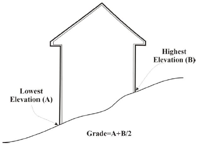
(1)
For construction on a vacant lot, the pre-construction grade shall be the undisturbed average grade of the proposed building site, before it is altered by land clearing, berming or preparation for construction.
(2)
For additions to existing buildings, the pre-construction grade shall be the average grade within the boundaries of the foundation line of the building and the undisturbed land area proposed to be covered by an addition.
(3)
For lots located in the Waterfront View Protection Overlay Zoning District, the method for determining grade shall be as specified in Section 12.03.
Greenbelt. A zone of trees or treelike plantings along a road frontage.
Ground floor area. The area of a building in square feet, as measured in a horizontal plane at the ground floor level within the largest outside dimensions, exclusive of open porches, breezeways, terraces, garages, and exterior stairways.
Group homes. A residential facility licensed by the State of Indiana that provides residential services for not more than four unrelated individuals and such staff, as are sufficient to manage the home, but not including a halfway house.
Section 31.09 - Definitions "H"
For the purpose of this title, the following definitions shall apply unless the context clearly indicates or requires a different meaning.
Halfway house. A facility used to house persons who have been recently released from prison for the purpose of reintegration with society, while still providing monitoring and support.
Home occupation. Any gainful occupation or profession conducted within a dwelling unit by a member of the family residing in the dwelling unit which is incidental and secondary to the use of the dwelling unit for residential purposes, provided that no retail sales activities are conducted.
Horizontal Mixed-Use Development. A grouping of single-use buildings, both residential and nonresidential, within one cohesive, interconnected development.
Hospital. An institution where sick or injured persons are given medical care and, in the course of same, are housed overnight, fed and provided nursing and related services. This definition shall include any related, accessory facilities such as laboratories, outpatient departments, training facilities, central service facilities and staff offices which are integral parts of the facility.
Hotel (motel). A building or structure under a single management that provides rental rooms or suites intended primarily as sleeping accommodations for public rental on a daily basis for registered guests. A hotel or motel shall maintain a central, internal lobby. A hotel or motel shall provide daily room cleaning and linen changes for its guests, and may include supportive areas such as meeting rooms, incidental retail sales and commercial services, central kitchen facilities, dining rooms, restaurants, lounges, office areas, swimming pools, recreational facilities, spas, and fitness/exercise areas and other similar services and amenities intended principally as services for registered guests.
Hotel room. A room in an inn, motel, hotel or other facility operated to accommodate overnight guests; a room shall be considered a "hotel room" if it occupies at least 150 square feet and includes a bathroom and bed.
Hotel-minium. A structure meeting the definition of a hotel (motel), and in addition allows for individually-owned units with full kitchen facilities.
(Ord. No. 4254, § 3(Exh. A), 10-30-2013; Ord. No. 4500, § 5.58., 2-5-2019)
Section 31.10 - Definitions "I"
For the purpose of this title, the following definitions shall apply unless the context clearly indicates or requires a different meaning.
IDEM. Indiana Department of Environmental Management.
IDNR. Indiana Department of Natural Resources.
Impact fee. A fee imposed on a development to help finance the cost of improvements or services.
Impervious surface. Any man-made material which covers the surface of land and substantially reduces the infiltration of storm water to a rate of five percent or less. Impervious surfaces include but are not limited to pavement, buildings, and structures.
Improvement location permit. A permit stating that the proposed erection, construction, enlargement, or moving of a building or structure referred to therein complies with the provisions of this ordinance.
Individual sewage disposal system. A septic tank, seepage tile sewage disposal system, or any other approved sewage treatment device.
Indoor recreation facility. An establishment which provides indoor exercise facilities and/or indoor court and field sports facilities, and which may include spectator seating in conjunction with the sports facilities such as skating rinks, swimming pools, indoor golf facilities, pool or billiard halls and bowling alleys. Auditoriums and stadiums are not included.
Industrial waste facility. Any facility used for the storage, transportation, reclamation, or disposal of any waste classified as hazardous or toxic by the united states environmental protection agency.
Industry, heavy. Manufacturing, processing, assembling, storing, testing, and similar industrial uses which are generally major operations and extensive in character; which require large sites, open storage and service areas, extensive services and facilities, and ready access to regional transportation; and which normally generate some nuisances such as smoke, noise, vibration, dust, glare, air pollution, and water pollution, but not beyond the district boundary. Waste is limited to wastes other than those classified as hazardous or toxic by the United States Environmental Protection Agency.
Industry, light. Manufacturing or other industrial uses which are usually controlled operations; relatively clean, quiet, and free of objectionable or hazardous elements such as smoke, noise, odor, or dust; operating and storing within enclosed structures; and generating little industrial traffic and no nuisances. Waste disposal is limited to wastes other than those classified as hazardous or toxic by the United States Environmental Protection Agency.
Infill Development. Development that occurs on vacant or underutilized land in an area where 50 percent or more of the existing lots within the same block face are occupied by principal structures.
Interested party. The interested parties shall include, but are not limited to, the appellant and the county or city's official or body whose order, decision, or determination is being appealed, the applicant for the relief being sought, and adjacent property owners. This also includes any individual who addresses the Board favoring or opposed to a matter before the legislative body, plan commission, or board of zoning appeals.
Invasive plant species. Predominantly non-native, non-indigenous, alien tree, shrub, vine, or herbaceous species that grow or reproduce aggressively, usually because they have no natural predators, and which can so dominate an ecosystem that they kill off or drive out many indigenous plant species. Invasive trees, shrubs, vines, or herbaceous species include, but are not limited to:
(Ord. No. 4500, § 5.59., 2-5-2019)
Section 31.11 - Definitions "J"
For the purpose of this title, the following definitions shall apply unless the context clearly indicates or requires a different meaning.
Junk. For the purpose of this ordinance, the term "junk" shall mean any motor vehicles, machinery, appliances, product, or merchandise with parts missing or scrap metals or other scrap materials that are damaged, deteriorated, or are in a condition which cannot be used for the purpose for which the product was manufactured.
Junk yard. See "Salvage yard."
Section 31.12 - Definitions "K"
For the purpose of this title, the following definitions shall apply unless the context clearly indicates or requires a different meaning.
Kennel. Any premises, or portion thereof, on which more than four dogs, cats, or other household domestic animals over four months of age are kept, or on which more than two of these animals are maintained, boarded, bred, or cared for, in return for remuneration, or are kept for the purpose of sale.
Section 31.13 - Definitions "L"
For the purpose of this title, the following definitions shall apply unless the context clearly indicates or requires a different meaning.
Laboratory. A facility devoted to experimental study, testing, or analysis. Manufacturing, assembly, or packaging of products shall not be conducted within this facility.
Land disturbing activity. Any man- made change of the land surface, including removing vegetative cover, excavating, filling, transporting, and grading. In the context of this title, it includes only non-agricultural land disturbing activities on sites which also require a local improvement location permit or an approved subdivision plat.
Letter of Map Amendment (LOMA). See: "Flood-Related Definitions."
Letter of Map Revision (LOMR). See: "Flood-Related Definitions."
Livestock. See: "Animal."
Live-Work. A dwelling unit that provides space that is designed for one or more commercial or office uses that are allowed in the zoning district. Access between the dwelling unit and the commercial or office space is provided within the unit or from an exterior stairwell. A live-work unit may have up to two employees who do not live on the premises.
Loading and unloading space, off-street. An open, hard-surfaced area of land other than a street or public way, which is principally used for the standing, loading, and unloading of motor trucks, tractors, and trailers to avoid undue interference with the public use of streets and alleys.
Locker plants. A facility for the cold storage and preservation of food in separate and individual compartments that are offered to the public for cold storage of privately owned food, including meat processing.
Lodger or roomer. Any person, not the principal tenant or a family member of the principal tenant, who resides in a living unit and who pays remuneration to the principal tenant, as distinguished from a guest who does not pay remuneration to the principal tenant.
Lodging room. A room rented as sleeping and living quarters, but without cooking facilities and with or without an individual bathroom. In a suite of rooms without cooking facilities, each room which provides sleeping accommodations shall be counted as one lodging room for the purpose of this title.
Lot.
(1)
Lot. A legally described parcel of land occupied, or intended to be occupied, by a building or a group of buildings, or utilized for the principal and accessory uses, together with such yards and open spaces as are required under the provisions of this ordinance. For purposes of meeting the dimensional standards of this ordinance, a lot does not include public rights-of-way or private road easements, but does include access easements for a service drive. A lot may consist of:
a.
A single lot of record;
b.
A portion of a lot of record;
c.
A combination of complete lots of record, of complete lots of record and portions of lots of record, or of portions of lots of record; or
d.
A parcel of land described by metes and bounds.
(2)
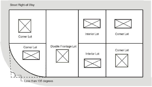
Lot, corner. A lot situated at the intersection of two streets, the interior angle of that intersection not exceeding 135 degrees. (the narrowest part of a lot having frontage on a street is the front of the lot.)
(3)
Lot, double frontage or through. A lot, other than a corner lot, which fronts on two more or less parallel streets.
(4)
Lot, interior. A lot other than a corner lot or a through lot.
(5)
Lot, reverse corner. A corner lot where the side lot line adjoining a street is substantially a continuation of the front line of an adjacent interior lot.
(6)
Lot, zoning. A single tract of land located within a single block, which (at the time of filing for a building permit) is designated by its owner or developer as a tract to be used, developed, or built upon as a unit, under single ownership or unified control. A zoning lot may or may not coincide with a lot of record.
Lot area, gross. The area of a horizontal plane bounded by the front, side and rear lot lines, but not including any area occupied by a public road right-of-way or the waters of a lake, river.
Lot coverage. The percentage of the lot area that is occupied by buildings or structures, including accessory buildings or structures.
(1)
Building lot coverage. The percent of the lot area that is covered by buildings.
(2)
Impermeable surface coverage. The percent of the lot area that is covered by buildings plus other impermeable surfaces, such as pavement, decks and pools.
Lot depth. The average distance between the front lot line and the rear lot line of a lot.
Lot frontage. See "Frontage."
Lot line.
(1)
Front lot line. The boundary of a lot which is along an existing or dedicated public street or, where no public street exists, is along a public way. On a corner lot the lot line having the shortest length abutting a street line shall be the front lot line, unless otherwise determined by the enforcement official.
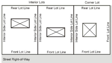
(2)
Rear lot line. The boundary of a lot which is most distant from, and is, or is most nearly, parallel to the front lot line.
(3)
Side lot line. Any boundary of a lot which is not a front or rear lot line.
Lot of record. A lot which is part of a subdivision, the plat of which has been recorded in the office of the county recorder, or a parcel of land, described by metes and bounds, the deed to which was recorded in the office of the recorder prior to the adoption of this title.
Lot width. The horizontal distance between the side lot lines, measured at the two points where the minimum required front setback line intersects the side lot lines.
(Ord. No. 4500, § 5.60., 2-5-2019)
Section 31.14 - Definitions "M"
For the purpose of this title, the following definitions shall apply unless the context clearly indicates or requires a different meaning.
Manufactured home. A dwelling unit (as defined in IC 9-13-2-96), designed and built in a factory, which bears a seal certifying that it was built in compliance with the federal Manufactured Housing Construction and Safety Standards Law, and certified by the state. Also, a structure, transportable in one or more sections, which is built on a permanent chassis and is designed for use with or without a permanent foundation when attached to the required utilities. The term MANUFACTURED HOME does not include a recreational vehicle.
Manufactured home park. Any parcel or tract of land licensed and registered under provisions of IC 16-41-27 et seq. under the control of any persons, upon which three or more occupied manufactured homes are harbored on a continual or non-recreational basis, or which is offered to the public for that purpose, regardless of whether a charge is made therefor, together with any building, structure, enclosure, street, equipment, or facility used or intended for use incident to the harboring or occupancy of manufactured homes.
Manufactured home subdivision. A parcel of land platted for subdivision according to all requirements of the subdivision and zoning ordinances, designed or intended for lots to be conveyed by deed to individual owners for residential occupancy primarily by manufactured homes.
Manufactured home tie downs. Sufficient anchorage to resist flotation, collapse, or lateral movement of any mobile home. At a minimum, this anchorage shall consist of:
(1)
Over-the-top ties to be provided at each of the four corners of the manufactured home, with two additional ties per side at intermediate locations, with manufactured homes less than 50 feet long requiring only one additional tie per side;
(2)
Frame ties to be provided at each corner of the home with five additional ties per side at intermediate points, with manufactured homes less than 50 feet long requiring four additional ties per side;
(3)
All components of the anchoring system to be capable of carrying a force of 4,800 pounds; and
(4)
Additions to the manufactured home to be similarly anchored.
Manufactured housing construction and safety standard codes. Title VI of the 1974 Housing and Community Development Act (42 USC 5401 et seq.), as amended (previously known as the Federal Mobile Home Construction and Safety Act), rules and regulations adopted thereunder (including information supplied by the home manufacturer, which has been stamped and approved by a Design Approval Primary Inspection Agency, an agent of the U.S. Department of Housing and Urban Development pursuant to HUD rules), and regulations and interpretations of that code by the state Administrative Building Council; all of which became effective for mobile and manufactured home construction on June 15, 1976.
Marina. (See also "Boat harbor/public marina.")
Marquee or canopy. A roof-like structure of a permanent nature which projects from the wall of a building.
Massage. The act of touching, stroking, kneading, stretching, friction, percussion, and vibration, and includes holding, positioning, causing movement of the soft tissues and applying manual touch and pressure to the body.
Massage therapy services. A massage provided by massage therapists certified under Indiana Code Title 25, Art. 21.8 or by physicians, surgeons, nurses, physical therapists, occupational therapists, or chiropractors who are licensed, certified or registered to practice their respective professions under the laws of the state.
Media store, general. A store that sells or rents books, videos and other media in which ten percent or less of the retail floor area or numbers of items in inventory are adult media, but does not meet the criteria contained in the definition of an "Adult Retail Store."
Media store, with backroom. A store that sells or rents books, videos and other media in which more than ten percent but less than 35 percent of the retail floor area or numbers of items in inventory are adult media, but does not meet the criteria contained in the definition of a "Adult Retail Store."
Medical or dental clinic. A building, or portion thereof, the principal use of which is for medical or dental study and/or treatment and in which the services of at least two professionals in the medical or dental fields of practice are provided.
Micro-brewery or micro-winery. A facility for the brewing of beer or wine that produces less than 15,000 barrels of non-distilled alcohol (beer, cider, mead, wine, or other similar beverages) per year. The use may include a tasting room and retail space to sell the alcohol to patrons on-site or it may be in conjunction with a tavern/bar or restaurant. Copies of reports filed with the Alcohol and Tobacco Tax and Trade Bureau (TTB) shall be maintained to demonstrate, upon request of the enforcement official, that they have not exceeded the annual beverage production limit in any 12-month period. A microbrewery may also be known as a brewpub.
Micro-distillery. A facility for the distillation of alcohol that produces less than 10,000 barrels of distilled alcohol per year. The use may include a tasting room and retail space to sell the alcohol to patrons on-site or may be in conjunction with a tavern/bar or restaurant. Copies of report filed with the TTB shall be maintained to demonstrate, upon request of the City, that they have not exceeded the annual beverage production limit in any 12-month period.
Mineral extraction. Includes mining, quarrying, and removal of earth materials.
Mobile home. A detached transportable structure larger than 320 square feet and designed to be used as a single-family residential dwelling with all of the following characteristics:
(1)
Certified in a factory and fabricated to the standards outlined in IC 20-12-5 et seq. pursuant to IC 9-20-12-1;
(2)
Designed to be transported after fabrication on its own wheel; and
(3)
Arriving at the site where it is to be occupied as a dwelling complete, including the major appliances, and ready for occupancy, except for minor and incidental unpacking and assembly operations, location on foundation supports, connection to the utilities, and the like.
Modular home. A housing unit designed, built, and certified in a factory to IC 22-12-2 through 22-12-5 for use as a principal residence. It is to be constructed complete with the necessary plumbing, heating, and electrical systems. It is designed to be transported by means other than its own undercarriage to a prepared site, and becomes suitable for permanent occupancy after proper installation of foundation supports and connection to utility service.
Monopole. A support structure constructed of a single, self-supporting hollow metal tube securely anchored to a foundation.
Motel. See "Hotel/motel."
Motor vehicle. A passenger vehicle, truck, truck-trailer, or semi-trailer propelled or drawn by mechanical power.
(Ord. No. 4254, § 3(Exh. A), 10-30-2013; Ord. No. 4500, § 5.61., 2-5-2019)
Section 31.15 - Definitions "N"
For the purpose of this title, the following definitions shall apply unless the context clearly indicates or requires a different meaning.
National Flood Insurance Program (NFIP): See: "Flood-Related Definitions."
National wetlands inventory or NWI. A series of maps produced by the Fish and Wildlife Service of the U.S. Department of the Interior, in coordination with the maps produced by the U.S. Geologic Survey, showing the location and classification of certain identified wetlands in standard topographic areas.
Native vegetation. Vegetation composed of plants which originated, developed, or were produced naturally in the Northern Indiana region and were not introduced directly or indirectly by humans. Native vegetation may be found in but is not limited to marshes, native grasslands, coastal/inland sage scrub, woodlands, and forests.
Natural resources. A component of a landscape existing or maintained as a part of the natural environment and having ecological value. Such resources include those which, if disturbed, may cause hazards or stress to life, property and the natural environment. Natural resources shall include, but not be limited to, all ecosystems listed in Article 22 and the following:
(1)
Sensitive areas. A Local Decision Maker map layer that indicates areas where development is illegal or highly undesirable. "Sensitive areas" as defined by Indiana Code (327 IAC 16-2-34) are 300 foot buffers around streams, lakes, karst areas and 100 foot buffers around water wells. These buffer areas are especially susceptible to pollution from human activity and serve as a refuge for many plant and wildlife species.
(2)
Steep slopes. A Local Decision Maker map layer that shows distribution of slopes steeper than 20 percent in Indiana.
(3)
Major rivers and lakes of Indiana (USGS). A Local Decision Maker map layer that shows main hydrologic features of Indiana landscape.
(4)
Streams and lakes of Indiana (NHD). A Local Decision Maker map layer that shows detailed hydrologic features of Indiana landscape. The National Hydrography Dataset (NHD) is a feature-based database that interconnects and uniquely identifies the stream segments or reaches that make up the nation's surface water drainage system.
(5)
Recreational facilities in Indiana. A Local Decision Maker map layer dataset that contains point locations of sites in Indiana that have outdoor recreation facilities. It includes facilities managed by federal, state, and local governments, as well as non-government organizations, private and commercial entities, and schools. It does not include sites that are private and not open to the public.
(6)
Indiana Biodiversity Initiative (IBI) - High irreplaceability sites. A Local Decision Maker map layer that shows grid squares that have the highest potential to contribute to the conservation of plant communities and plant species. Grid squares containing rare plant species often have particularly high scores. The highest scores are typically for grid squares with unique conservation potential, not necessarily those with the greatest area of natural vegetation.
(7)
CrEAM - Species Rarity (C3.2), Indiana. A Local Decision Maker map layer map of species rarity that is based on the Heritage Program data that contained observations for any individual quad with a possible GHRS (Global Heritage Ranking System) rank as rare as G1 or as common as G5. Within a quad, the rarest GHRS rank determined the score for the entire quad. If the highest observation in the quad was G1, the whole quad received the score of 100. A score from 100 to zero was assigned to each quad in the region, and each cell was assigned the score of the quad in which it was located.
(8)
Indiana Floodplains, IDEM. A Local Decision Maker map database layer that is an interim version of the Digital Flood Insurance Rate Map (DFIRM) Database. The DFIRM depicts flood risk information and supporting data used to develop the risk data. The primary risk classifications used are the one-percent-annual-chance flood event, the 0.2-percent-annual-chance flood event, and areas of minimal flood risk.
(9)
Indiana wetlands. A Local Decision Maker map layer that represents the extent, approximate location and type of wetlands and deepwater habitats in the conterminous United States.
(10)
Biodiversity — Ecological Classifications - Indiana Natural Regions. A Local Decision Maker map layer that presents the ecological classification system (ECS) of the eastern United States.
Non-access easement. A public easement along a public road right-of-way which restricts or prohibits direct access from the property to the roadway.
Non-conforming building or structure. A legally established building or structure, or portion of a structure, existing at the effective date of this code, or subsequent amendment thereto, that could not be built under the terms of this title by reasons of restrictions on lot size, height, yards, location on the lot, or other requirements concerning the structure.
Non-conforming use. A legally established use of land, buildings, or structures which does not comply with all of the regulations of this title or of any amendment hereto governing use for the zoning district in which that use is located.
Normal water level. The water level of the lake established by law or if the water level has not been established, the level where the presence and action of the water has been so constant as to give to the bed of the lake a character distinct from that of the surrounding land with regard to vegetation and the nature of the soil.
Noxious matter or materials. Matter or material which is capable of causing injury to living organisms by chemical reaction or is capable of causing detrimental effects upon the physical or economic well-being of individuals.
Nursery, plant materials. Land, buildings, structures, or the combination thereof for the storage, cultivation, or transplanting of live trees, shrubs, or plants offered for retail sale on the premises including products used for gardening and landscaping.
Nursing home. A home for the care of aged, chronically ill, children, infirm, or incurable persons, or a place of rest for those persons suffering bodily disorders, in which three or more persons not members of the family residing on the premises, are received and provided with food, shelter, and care, but not including hospitals, clinics, or similar institutions devoted primarily to the diagnosis and treatment of disease or injury, maternity cases, or mental illness. A nursing home also includes rehabilitation housing for released mental or alcoholic patients where medical treatment is not provided and no longer deemed necessary.
Nuisance. An offensive, annoying, unpleasant, or obnoxious thing or practice, a cause or source of annoyance, especially a continuing or repeating invasion of any physical characteristics of activity or use across a property line which can be perceived by or affects a human being, or the generation of an excessive or concentrated movement of people or things, such as, but not limited to: noise, dust, smoke, odor, glare, fumes, flashes, vibration, shock waves, heat, electronic or atomic radiation, objectionable effluent, noise of congregation of people and traffic.
(Ord. No. 4500, § 5.62., 2-5-2019)
Section 31.16 - Definitions "O"
For the purpose of this title, the following definitions shall apply unless the context clearly indicates or requires a different meaning.
Occupancy permit. A required permit allowing the use of a building or structure after it has been determined that all the requirements of applicable ordinances have been met.
Odorous matter. Matter or material that yields an odor which is offensive in any way.
Official thoroughfare plan. The part of the County land development plan, now or hereafter adopted, which includes a major thoroughfare and highway plan and sets forth the location, alignment, dimensions, identification, and classification of existing and proposed streets, highways, and other thoroughfares.
Off-site. Restoration or creation of a wetland at a location not adjacent to, or within 25 feet of, a previous wetland.
One- and two-family dwelling code, Indiana. The nationally-recognized model building code prepared by the Council of American Building Officials, adopted by the state Administrative Building Council (ABC) as mandated through P.L. 360, Acts of 1971, and which includes those supplements and amendments promulgated by the ABC.
Open sales lot (yard, garage, roadside, or similar). Land used or occupied for the purpose of buying or selling merchandise stored or displayed out-of-doors. The merchandise includes, but is not limited to, passenger cars, trucks, motor scooters, motorcycles, boats, and monuments.
Ordinary High Water Mark (OHWM): Uppermost elevation on bank or shore influenced by prolonged contact with surface water, evidence of which is found in distinctive marks left by surface water. Such marks can include water lines on trees, erosion scour line, debris deposits, destruction of terrestrial vegetation, transition point from wetland to terrestrial vegetation.
Outdoor recreation. Outdoor recreation includes one or more of the following uses: riding clubs, polo fields, horse shows, hunter trials, and other equestrian sports; conservation clubs; girl scout and boy scout lodges or clubhouses; private parks or playgrounds; archery ranges; and other outdoor recreation uses, and accessory uses, buildings, and structures such as off-street parking and loading facilities, administration, maintenance, and clubhouse buildings.
Overhead Door. A large door that typically rolls up when opened, the vertical dimension for which is typically greater than six feet. Such doors have uses that include, but are not limited to, giving vehicles access to a building, for loading and unloading materials, or for personal access to storage or self-storage areas in a building.
Owner. Any individual, firm, association, syndicate, co-partnership, or corporation having sufficient proprietary interest in the land sought to be subdivided to commence and maintain proceedings to subdivide the same under this title.
(Ord. No. 4500, § 5.63., 2-5-2019)
Section 31.17 - Definitions "P"
For the purpose of this title, the following definitions shall apply unless the context clearly indicates or requires a different meaning.
Parcel. A separate division of land individually described, surveyed, and of record to show the actual boundaries of the property.
Parcel of property. A single tract or plot of land.
Parking space. An area reserved for the parking of one motor vehicle, unenclosed or enclosed in a building.
Particulate matter. Dust, smoke, or any other form of airborne pollution in the form of minute separate particles.
Pediment. A decorative element, usually triangular or curved in shape, above a door or window.
Performance guarantee. A security, in the form of cash deposit, certified check, irrevocable bank letter of credit, or surety bond, in an amount sufficient to cover the estimated cost of improvements required as part of an application for development that is deposited with the municipality to ensure that said improvements are satisfactorily completed.
Performance standard. Criteria established to control smoke and particulate matter, noise, odor, toxic or noxious matter, vibration, fire and explosion hazards, glare or heat, or radiation hazards generated by or inherent in uses of land or buildings.
Permanent foundation. Any structural system for transposing loads from a structure to the earth at a depth below the established frost line without exceeding the safe bearing capacity of the supporting soil.
Permanent perimeter enclosure. A permanent perimeter structural system completely enclosing the space between the floor joists of the home and the ground.
Person. Includes a corporation, firm, partnership, association, organization, or any other group which acts as a unit.
Philanthropic and eleemosynary institutions. Centers operated by philanthropic or non-profit institutions that assist individuals with social needs, such as shelters and rehabilitation centers. These centers may provide temporary housing, meals, counseling, health services, education, job placement assistance and leisure-time activities. Adult care facilities, community centers, hospitals, medical centers, medical/psychiatric offices, shelters for abused women/children and government health/social services facilities are not regulated under the requirements of "philanthropic and eleemosynary institutions." Places of public assembly that provide community outreach services are also not regulated under this definition, unless they operated an onsite homeless shelter.
Plan commission. The county plan commission has jurisdiction within the unincorporated area of the county and each city has a plan commission for the incorporated areas of each city. The plan commissions have the following duties for each of their respective jurisdictions: to formulate and recommend the adoption of plans for the conservation of resources and community betterment, participate in the preparation of a county land development plan for the development of the county, approve proposed subdivisions, authorize the preparation of public road maps, and administer this ordinance.
Planned unit development or PUD. A tract of land developed under single ownership or control, the development of which is unique, incorporating some or all, but not limited to, the following attributes: a variety of uses, varied density of development, reduced right-of-way width, dedicated open space, and zero lot line development.
Plat.
(1)
A map representing a tract of land showing the boundaries and location of individual properties and streets; or
(2)
A map of a subdivision or site plan.
Plat, final. A map or chart indicating the subdivision or resubdivision of land, intended to be filed for record.
Plat, preliminary. The preliminary drawing or drawings, described in these regulations, indicating the proposed manner or layout of the subdivision to be submitted to the plan commission for approval.
Plat, primary. The preliminary drawing or drawings, described in these regulations, indicating the proposed manner or layout of the subdivision to be submitted to the plan commission for approval.
Plaza. An unenclosed gathering space on private property open to the sky, surrounded partly by a building, and that may have integrated landscaping and street furnishings. Ground space is primarily covered with patterned paving material.
Porch. A roofed-over structure, projecting out from the wall or walls of a main structure, with a portion of it commonly open to the weather.
Practical alternative. An alternative to a proposed project that would accomplish the basic purpose of the project and avoid, or have less adverse impact on, a wetland or lake.
Private road. A non-dedicated road serving more than one parcel for access.
Private sewer. A disposal system which is not constructed, installed, maintained, operated, or owned by a municipality, taxing district established for that purpose, or a utility under the jurisdiction of the Public Services Commission of the state.
Private water. A water supply which is not constructed, installed, maintained, operated, or owned by a municipality, taxing district established for that purpose, or a utility under the jurisdiction of the Public Services Commission of the state.
Property lines. Legally defined lot lines bounding a lot.
Protected Natural Resource Area. Include wetlands, streams, floodplains, riparian zones, and other natural resource features regulated by local, state and/or federal regulation.
Public improvement. Any drainage ditch, roadway, parkway, sidewalk, pedestrian way, tree lawn, off-street parking area, lot improvement, or other facility for which the local government may ultimately assume the responsibility for maintenance and operation, or which may affect an improvement for which local government responsibility is established.
Public sewer. A sewage disposal system which is constructed, installed, maintained, operated, and owned by a municipality or taxing district established for that purpose.
Public utility. A firm, corporation, municipal department, or board duly authorized to furnish or furnishing under regulation to the public: electricity, gas, steam, communication (including CATV), transportation, drainage, sewer, or water.
Public water. A water supply system which is constructed, installed, maintained, operated, and owned by a municipality, taxing district established for that purpose, or a utility under the jurisdiction of the Public Services Commission of the state.
(Ord. No. 4500, §§ 5.64., 5.65., 2-5-2019)
Section 31.19 - Definitions "R"
For the purpose of this title, the following definitions shall apply unless the context clearly indicates or requires a different meaning.
Railroad right-of-way. A strip of land with tracks and auxiliary facilities for track operation, but not including depots, loading platforms, stations, train sheds, warehouses, car shops, car yards, locomotive shops, or water towers.
Recreational campground. An area of land on which two or more recreational vehicles, including campers, tents, RVs, or other similar temporary recreational structures, are regularly accommodated with or without charge, including any building, structure, or fixture of equipment that is used or intended to be used in connection with providing these accommodations.
Recreational vehicle. Commonly referred to as an RV. A vehicle used for travel, camping recreation, and vacation use.
(a)
This type of vehicle is:
(1)
Built on a single chassis;
(2)
Four-hundred square feet or less when measured at the largest horizontal projections;
(3)
Designed to be self-propelled or permanently towable by a light duty truck; and
(4)
Designed primarily not for use as a permanent dwelling, but as temporary living quarters for recreational camping, travel, or seasonal use.
(b)
An RV may include, but is not limited to:
(1)
Motor home. A self-propelled vehicle with a dwelling constructed as an integral part of the vehicle, or so altered.
(2)
Pick-up coach. A structure designed to be mounted on a truck chassis or cut-down car.
(3)
Travel or camping trailer. A vehicle or other portable structure that is designed to move on the highway and designed or used as a dwelling.
Recycling facility. See "waste disposal management and reduction."
Regulatory Flood: See: "Flood-Related Definitions."
Research laboratory. A building or group of buildings in which are located facilities for scientific research, investigation, testing, or experimentation, but not facilities for the manufacture or sale of products, except as incidental to the main purpose of the laboratory.
Resubdivision. A change in a map of an approved or recorded subdivision plat so that the change affects any street layout on the map or area reserved thereon for public use, or any lot line; or if it affects any map or plan legally recorded prior to the adoption of any regulations controlling subdivisions.
Restaurant. Any establishment whose principal business is the sale of food and beverages to the customer in a ready-to-consume state, and whose method of operation is characteristic of a carry-out, drive-in, drive-through, fast food, standard restaurant, or bar/lounge, or combination thereof, as defined below:
(1)
Carry-out restaurant. A business establishment whose method of operation involves sale of food, beverages, and/or frozen desserts in disposable or edible containers or wrappers in a ready-to-consume state for consumption primarily off the premises.
(2)
Delicatessen. A restaurant typically offering both carry-out and seating of sandwiches and other foods and beverages. A delicatessen also typically offers meats, cheese and prepared foods on a retail basis.
(3)
Drive-in restaurant. A business establishment whose method of operation involves delivery of prepared food so as to allow its consumption in a motor vehicle or elsewhere on the premises, but outside of an enclosed building. A drive-in restaurant may also have interior seating.
(4)
Drive-thru restaurant. A business establishment whose method of operation involves the delivery of the prepared food to the customer in a motor vehicle, typically through a drive-through window, for consumption off the premises. A drive-thru restaurant may also have interior seating.
(5)
Standard restaurant. A business establishment whose method of operation involves either the delivery of prepared food by waiters and waitresses to customers seated at tables within a building or the prepared food is acquired by customers at a cafeteria line and is subsequently consumed by the customers at tables within a completely enclosed building. Restaurants may include accessory outdoor seating.
(6)
Tavern/bar. An establishment licensed to serve alcoholic beverages on the premises. Taverns/bars may include accessory outdoor seating.
Rezone. To change the zoning classification of particular lots or parcels of land, otherwise known as a map amendment.
Right-of-way. A strip of land occupied or intended to be occupied by a street, crosswalk, railroad, road, electric transmission line, oil or gas pipeline, water main, sanitary or storm sewer main, shade trees, or for another special use. The usage of the term right-of-way for land platting purposes shall mean that every right-of-way hereafter established and shown on a secondary plat is to be separate and distinct from the lots or parcels adjoining the right-of-way and not included within the dimensions or areas of the lots or parcels. Rights-of-way intended for streets, crosswalks, water mains, sanitary sewers, storm drains, shade trees, or any other use involving maintenance by a public agency, shall be dedicated to public use by the maker of the plat(s) on which the rights-of-way are established.
Riparian: Lands adjacent to waterways and lakes, that are influenced by the adjacent water body by overbank flooding and changes in elevation of the water table.
Riparian or wetland buffer. An area surrounding a watercourse, floodplain or wetland, containing trees and other vegetation that intercepts surface water runoff, wastewater, subsurface flow, and/or groundwater flows from upland sources. Riparian and wetland buffers help process and remove nutrients, sediment, organic matter, pesticides, or other pollutants from runoff and subsurface flow. This transition area between aquatic and terrestrial environments can also provide wildlife habitat, control water temperature, attenuate flood flows, and provide opportunities for passive recreation.
Roadside stand. A structure for the display and sale of agricultural products, with no space for customers within the structure itself.
Roadway. That portion of a street which is used or intended to be used for the travel of vehicles. See also "street."
Runoff. The portion of precipitation from such sources as rainfall, snow melt, or irrigation water that flows over the ground surface.
Section 31.20 - Definitions "S"
For the purpose of this title, the following definitions shall apply unless the context clearly indicates or requires a different meaning.
Salvage yard. An open area where waste or used materials are bought, sold, exchanged, stored, baled, packed, disassembled or handled. Such waste and used materials include, but are not limited to, motor vehicles, vehicles, machinery or equipment drawn or operated by being attached to motor vehicles, mechanical units which are not in running or operable condition, scrap iron, other metals, paper, rags, rubber tires, and bottles. It does not include residential, commercial or municipal "garbage" which is defined as animal, vegetable or mineral refuse. Any lot containing three or more unlicensed vehicles shall be considered a salvage yard.
Sand Dunes. Soils classified as Duneland (DU), or Oakville Fine Sand (OaE), or Urban Land - Oakville Complex (UoC) that are greater than 12 percent slope as defined by the Soil Survey Geographic Database of the Natural Resources Conservation Service.
Self-storage facility. A building or group of buildings in a controlled-access and fenced compound that contains varying sizes of individual, compartmentalized, and controlled-access stalls or lockers for the storage of customer's goods or wares.
Setback. The minimum horizontal distance between a lot line and the wall of a building or structure.
Shopping center. A structure or group of structures located on the same lot or parcel which is developed in accordance with an overall plan and designed and built as an interrelated project that provides a variety of commercial uses and common off-street parking, pedestrian access and vehicular movements. Buildings constructed on outlots shall not be considered part of the shopping center unless access and parking easements are provided.
Shoreline. The average normal water level as established under IC 14-26-4-1 through 14-26-4-12 for public freshwater lake and administered under supervision of the state Department of Natural Resources or the ordinary high water mark.
Sight distance. The length of roadway visible to the driver. Generally related to the distance or time (perception/reaction time) sufficient for the driver to execute a maneuver (turn from driveway or side street, stop or pass) without striking another vehicle or object in the roadway.
Sign. A name, identification, description, display, or illustration which is affixed to, or represented directly or indirectly upon a building, structure, or piece of land and which directs attention to an object, product, place, activity, person, institution, organization, or business.
(1)
A sign shall not include:
a.
The display of official court or public office notices;
b.
The flag, emblem, or insignia of a nation, political unit, school, or religious group; or
c.
One located completely within an enclosed building, except signs located behind window areas intended to be viewed from outside the building.
(2)
Billboard. A structure or accessory structure that advertises or directs attention to a business, commodity, service, entertainment or any other subject matter not located or carried on the parcel of real estate where any such sign is located or in the building or structure to which the sign is affixed.
(3)
Business sign. A sign which directs attention to a business, commodity, service, or entertainment related to the premises where the sign is located or to which it is affixed.
(4)
Electrical reader board. Sign which contains a traveling message or a message which appears to be traveling and usually in a horizontal manner.
(5)
Flashing sign. An illuminated sign on which the artificial light is not maintained stationary or constant in intensity and color at all times when the sign is in use. A revolving, illuminated sign shall be considered to be a flashing sign.
(6)
Gross area of sign:
a.
The entire area within a single continuous perimeter enclosing the extreme limits of the sign and in no case passing through or between any adjacent elements of same.
b.
The perimeter shall not include any structural elements lying outside the limits of the sign and not forming an integral part of the display.
(7)
Ground/monument sign. A three dimensional, base mounted freestanding display sign, that is supported by uprights or braces in or upon the ground surface or mounted on a base, and consisting of two or more sides extending up from the base, and upon which a message, business, group of businesses or center name is affixed.
(8)
Identification sign. A sign which directs attention to a residence, a business, commodity, service, entertainment, or other activity conducted on the lot upon which the sign is located.
(9)
Nameplate sign. Non-illuminated sign flush with the front of the building indicating the name or address of a building, or the name of an occupant thereof and the practice of a permitted occupation therein.
(10)
Pole or pylon sign. A type of freestanding sign that is elevated above the ground on poles or braces and not attached to any building or other structure.
(11)
Reader board sign. A sign whereon provision is made for letters or characters to be placed in or upon the surface area either manually or electronically to provide a message that may be changed periodically.
(12)
Roof sign. A sign erected, constructed, and maintained above the roof of any building.
(13)
Wall sign/Blade sign. A wall sign is a sign attached to, painted on, or erected against the wall of a building with the sign face in a parallel plane to the plane of the building. A blade sign is a sign attached or erected against the wall of a building with the sign face in a perpendicular plane to the plane of the building.
(14)
Window Signs. A sign attached to a window or glass door and any sign on the interior of a window that is visible from the outside of the window, including signs not attached to the window.
Site plan. A drawing to scale which must be furnished to the enforcement official when application is made for an improvement location permit and which shows size and location of all existing and proposed buildings, all adjacent streets and highways, size of all entrances and exits from the land, and a legal description of the land. For some uses a landscape development plan must be included.
Special exception. Those uses of land which are not essentially incompatible with the uses permitted in a zoning district, but possess characteristics or locational qualities which require individual review and restriction by the board of zoning appeals.
Special Flood Hazard Area (SFHA): See: "Flood-Related Definitions."
Spot zoning. The rezoning of a lot or parcel of land to benefit an owner for a use incompatible with surrounding land uses and that does not further the county land development plan.
Sprawl. Uncontrolled growth, usually of a low-density nature, in previously rural areas and some distance from existing development and infrastructure.
Stable. A building or structure designed, arranged, used, or intended to be used for housing saddle horses or ponies. See also: "Boarding Stable."
Stockyards. A yard for livestock; especially an enclosure, usually with pens, and the like, in which cattle, hogs, sheep, or horses are kept temporarily before being slaughtered or sent to market.
Stoops are small staircases leading to the entrance of a residential building. The stoop elevation provides some privacy between the sidewalk and ground floor uses. Stoops may be covered by a building awning or canopy.
Storefront Cafés provide ground floor dining spaces directly accessible from the adjacent sidewalks. Storefront café frontages are similar to storefront frontages but provide specific provisions for outdoor seating.
Story. That portion of a building, other than a cellar, included between the surface of any floor and the surface of the floor next above it or, if there be no floor above it, then the space between the floor and the ceiling next above it. The floor of a story may have split levels provided that there is not more than four feet difference in elevation between the different levels of the floor. A mezzanine floor shall be counted as a story when it covers over one-third the area of the floor next below it, or if the vertical distance from the floor next below it to the floor next above it is 24 feet or more. A basement shall be counted as a story if it is 50 percent or move above the average grade.
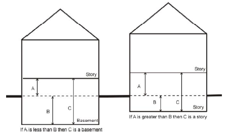
Story, half. A partial story under a gable, hip, or gambrel roof, the wall plates of which on at least two opposite exterior walls are not more than three feet above the floor of the story, except that any partial story used for residence purposes, other than for a janitor or caretaker or his family, or by a family occupying the floor immediately below it, shall be deemed a full story.
Streetfront. A frontage type whereby the building is parallel to street right-of-way and setback the distance required by this ordinance.
Street or road. A right-of-way, other than an alley, dedicated or otherwise legally established to the public use, usually affording the principal means of access to abutting property. A street may be designated as a highway, thoroughfare, parkway, boulevard, road, avenue, lane, drive, or other appropriate name.
(1)
Cul-de-sac street. A street with a single common ingress and egress and with a turn-around at the end.
(2)
Highway, limited access. A freeway, or expressway, providing a for through traffic, to which abutting lands have no legal right to have direct access, and all access is at defined points determined by the public road agency having jurisdiction over that roadway.
(3)
Minor street. A local roadway, the primary function of which is to provide direct access to residential, commercial, industrial, or other abutting real estate.
(4)
Major thoroughfare. All arterial streets, county primary roads, major city streets and state highways.
Stormwater-related Definitions:
(1)
Accelerated erosion. Erosion caused by development activities that exceeds the natural processes by which the surface of the land is worn away by the action of water, wind, or chemical action.
(2)
Applicant. A property owner or agent of a property owner who has filed an application for a stormwater management permit.
(3)
Best Management Practices (BMPs) Structural measures (wetlands, ponds, infiltration basins, etc.) or non-structural measures (low impact development planning, restrictive zoning, reduced impervious areas, etc.). BMPs are designed for the benefit of water quality and quantity.
(4)
Building. Any structure, either temporary or permanent, having walls and a roof, designed for the shelter of any person, animal, or property, and occupying more than 100 square feet of area.
(5)
Channel. A natural or artificial watercourse with a definite bed and banks that conducts flowing water continuously or periodically.
(6)
Clean Water Act (CWA). The federal Water Pollution Control Act (33 U.S.C. § 1251 et seq.), and any subsequent amendments thereto.
(7)
Construction Activity. Activities subject to a stormwater management permit as set out in Chapter 46, Article IX of the Michigan City, Indiana Code of Ordinances. These include construction projects resulting in land disturbances of 10,000 square feet or more. Such activities include, but are not limited to, clearing and grubbing, grading, excavation, and demolition.
(8)
Detention. The temporary storage of storm runoff in a stormwater BMP with the goals of controlling peak discharge rates and providing settling and filtration of pollutants.
(9)
Detention facility. A detention basin or alternative structure designed for the purpose of temporary storage of stream flow or surface runoff, and gradual release of stored water at controlled rates.
(10)
Drainage easement. A legal right granted by a landowner to a grantee allowing the use of private land for stormwater management purposes.
(11)
Erosion and sediment control plan (ESCP). A plan that is designed to minimize the erosion and sediment runoff at a site during construction activities.
(12)
Hotspot. An area where land use or activities generate highly contaminated runoff, with concentrations of pollutants in excess of those typically found in stormwater.
(13)
Hydrologic soil group (HSG). The Natural Resource Conservation Service classification system in which soils are categorized into four runoff potential groups according to texture and drainage capacity. The groups are HSG-A, B, C, and D. Runoff volume for a given rainfall depth increases, and infiltration capacity decreases, From HSG A to D.
(14)
Illicit Connections. Either of the following:
a.
A stormwater conveyance system that allows an illicit discharge to enter the storm drainage system or the MS4. Such systems include but not limited to any conveyances that allow any non-stormwater discharge, and any connections to the storm drainage system, MS4, or receiving waters from indoor drains and sinks. Such systems are illicit regardless of whether said drain or connection had been previously allowed, permitted, or approved. Or,
b.
Any conveyance connected from a commercial or industrial land use to the storm drainage system, MS4, or receiving water that has not been documented in plans, maps, or equivalent records and approved.
(15)
Illicit Discharge. An unapproved direct or indirect non-stormwater or pollutant discharge to the storm drainage system, MS4, or receiving waters.
(16)
Industrial Activity. Activities subject to NPDES Industrial Permits as defined by 327 IAC 15-6-1:12 (Rule 6).
(17)
Invasive Plant Species. Predominantly non-native, non-indigenous, alien tree, shrub, vine, or herbaceous species that grow or reproduce aggressively, usually because they have no natural predators, and which can so dominate an ecosystem that they kill off or drive out many indigenous plant species.
(18)
Impervious cover. Surfaces that cannot effectively infiltrate rainfall (e.g., building rooftops, pavement, sidewalks, driveways, etc).
(19)
Industrial stormwater permit. A National Pollutant Discharge Elimination System (NPDES) permit issued to a commercial industry or group of industries, which regulates the pollutant levels associated with industrial stormwater discharges or specifies on-site pollution control strategies.
(20)
Infiltration. The process of percolating stormwater into the subsoil.
(21)
Infiltration facility. Any structure or device designed to infiltrate retained water to the subsurface. These facilities may be above grade or below grade.
(22)
Land disturbance activity. Any activity which changes the volume or peak flow discharge rate of rainfall runoff from the land surface. This may include the grading, digging, cutting, scraping, or excavating of soil, placement of fill materials, paving, construction, substantial removal of vegetation, or any activity which bares soil or rock or involves the diversion or piping of any natural or man-made watercourse.
(23)
Low Impact Development (LID). Development strategy that encourages maintaining existing drainage patterns while minimizing changes to existing topography. LID often employs distributed, localized storage of stormwater, disconnection of directly connected impervious surfaces to the site outlet, and incorporation of public education into the long-term plan for stormwater management.
(24)
Maintenance agreement. A legally recorded document that acts as a property deed restriction, and that provides for long-term maintenance of stormwater management practices.
(25)
Maximum Extent Practicable (MEP). The statutory standard that establishes the level of pollutant reductions that operators of regulated MS4s must achieve.
(26)
Municipal Separate Storm Sewer System (MS4). A stormwater conveyance system which is owned or operated by a state, city, town, county, tribe, district, association, or other public body or a designated and approved management agency under Section 208 of the Clean Water Act, that discharges into waters of the United States (40 CFR 122.26(b)(8)).
(27)
MS4 Advisory Committee. Appointed representatives of the municipal and county entities who administer the MS4 Program under the permit issued by IDEM.
(28)
MS4 Coordinator. Designated representative of the city responsible for assisting in the implementation and management of the Stormwater Quality Management Program for the city.
(29)
National Pollutant Discharge Elimination System (NPDES) Stormwater Discharge Permit. A permit issued by EPA (or by a state under authority delegated pursuant to 33 USC § 1342(b)) that authorizes the discharge of pollutants to waters of the United States, whether the permit is applicable on an individual, group, or general area-wide basis.
(30)
Non-point source pollution. Pollution from any source other than discernible, confined, and discrete conveyances, including but not be limited to pollutants from agricultural, silvicultural, mining, construction, subsurface disposal and urban runoff sources.
(31)
Notice of Intent (NOI). A written notification indicating an entity's intention to comply with the terms of a specified general permit rule in lieu of applying for an individual NPDES stormwater discharge permit. The NOI includes information as required under 327 IAC 15-3 and the applicable general permit rule.
(32)
Pollutant. Anything that causes or contributes to pollution. Pollutants may include, but are not limited to: paints, varnishes, and solvents; oil and other automotive fluids; non-hazardous liquid and solid wastes; yard wastes, including grass, brush, leaves, and limbs; refuse, rubbish, garbage, litter, or other discarded or abandoned objects, ordinances, and accumulations; floatables, pesticides, herbicides, and fertilizers; hazardous substances and wastes; sewage, fecal coliform and pathogens; dissolved and particulate metals; animal wastes; wastes and residues that result from constructing a building or structure; soil and sediments; and noxious or offensive matter of any kind.
(33)
Recharge. Replenishment of underground water reserves.
(34)
Redevelopment. Any construction, alteration or improvement equal to or greater than 43,560 square feet (one acre) in areas where existing land use is high density commercial, industrial, institutional or multi-family residential.
(35)
"Rule 5" and "Rule 13. 327 IAC 15-5 and 327 IAC 15-13, respectively. The Indiana Department of Environmental Management (IDEM) has the authority to administer the Erosion Control Program under Rule 5. When IDEM approves the transfer of the Erosion Control Program to MS4 entities, such authority will be by Rule 13 in the MS4 areas only. Rule 5 will continue to apply to non-MS4 areas of the state. The issuance of an authorization letter by IDEM will determine which rule will have precedence or apply.
(36)
Stormwater Conveyance Systems. System of surface and subsurface drainage systems, catch basins, and other drainage structures including retention and detention BMPs, vegetated swales, municipal streets, catch basins, curbs, gutters, roads with subsurface drainage systems, reservoirs, pumped piping systems and other drainage structures or watercourses.
(37)
Stormwater management. The use of structural or non-structural practices, physical and biological measures that are designed to reduce stormwater runoff pollutant loads, discharge volumes and peak flow discharge rates. Goals of stormwater management include avoiding detrimental changes in the hydrology, water quality and temperature of receiving waters that affect habitat and ecological function, and minimizing flash floods.
(38)
Stormwater Pollution Prevention Plan (SWPPP). A document that describes the best management practices and activities to be implemented by an entity to identify sources of pollution or contamination at a site, and actions that will be taken to eliminate or reduce pollutant discharges to stormwater, stormwater conveyance systems, and/or receiving waters to the maximum extent practicable.
(39)
Watercourse. A permanent or intermittent stream or other body of water, either natural or manmade, which gathers or carries surface water.
(40)
Structural alteration. A change, other than incidental repairs, which would prolong the life of the supporting members of a building, such as the addition, removal, or alteration of bearing walls, columns, beams, girders, or foundations.
Structure. Anything constructed or erected, the use of which requires location above the ground or attached to something having location on the ground. A structure will include buildings, fences, walls, decks, towers, pools, gazebos, play structures, tree house, and other similar above ground structures.
Subdivision. The division of land by deed or other recorded instrument. A subdivision shall be deemed to have occurred on any land, vacant or improved, that is divided into two or more lots, parcels, sites, units, plots or interests for the purpose of offer, sale, lease, mortgage or development, either on the installment plan or upon any and all other plans, terms and conditions, including re-subdivision and the granting of access easements. However, this regulation shall not apply to the following:
(a)
An allocation of land by a court decree for the distribution of property;
(b)
The unwilling sale of land as a result of legal condemnations as defined and allowed in the Indiana State Law.
Support system. A pad or a combination of footings, piers, caps, plates, and shims, which, when properly installed, support the manufactured or mobile home.
(Ord. No. 4328, § 9, 6-16-2015; Ord. No. 4500, § 5.66., 2-5-2019; Ord. No. 4770, § 2(Exh. B, A.27), 8-4-2025)
Section 31.21 - Definitions "T"
For the purpose of this title, the following definitions shall apply unless the context clearly indicates or requires a different meaning.
Tattoo establishment. Any place or establishment which is operated for the principal business or primary purpose of marking the skin with indelible pigment or other such substance so as to produce a permanent design, mark or similar feature on the skin.
Tavern/bar. A building where liquors are sold to be consumed on the premises and where entertainment may or may not be provided.
Terrace, open. A level and rather narrow plane, or platform, which for the purpose of this title is located adjacent to one or more faces of the principal structure and which is constructed not more than four feet in height above the average level of the adjoining ground.
Travel trailer park. An area of land on which two or more travel trailers are regularly accommodated with or without charge, including any building or other structure, fixture, or equipment that is used or intended to be used in connection with providing that accommodation.
Truck stop. Any building, premises or land in which or upon which a business, service or industry involving the maintenance, servicing, storage or repair of commercial vehicles is conducted or rendered including the dispensing of motor fuel or other petroleum products directly into motor vehicles, the sale of accessories or equipment for trucks and similar commercial vehicles. A truck stop may include overnight accommodations and restaurant facilities solely for use of truck crews.
Truck terminal or yard, commercial. Any land use with or without buildings for, but not limited to: parking, storage, maintenance, or transfer station for commercial trucks, tractors, truck trailers, and other commercial vehicles.
Section 31.22 - Definitions "U"
For the purpose of this title, the following definitions shall apply unless the context clearly indicates or requires a different meaning.
Urban Frontage is suitable for mixed use, commercial or office uses. It provides access to ground floor uses but is primarily characterized by windows facing the sidewalk. Unlike storefronts there is no minimum ground floor height.
Use (of property). The purpose or activity for which the land or building thereon is designed, arranged, or intended, or for which it is occupied or maintained. This includes any manner of performance of activity or operation with respect to the performance standards of this title. Uses are classified under the following major categories:
(1)
Residential, which includes single-family, two-family, multiple-family and manufactured homes.
(2)
Agriculture, which includes all farming, livestock and forestry.
(3)
Commercial, which includes all retail trade uses, motor vehicle service, lodging accommodation, food services, other services and entertainment/recreational businesses.
(4)
Office, which includes administrative offices and buildings, used for finance, insurance, legal, real estate, professional, scientific, technical, health care, and social assistance uses.
(5)
Institutional, which includes all religious, civic, social, and similar organizations, educational services and public uses.
(6)
Industrial, which includes all manufacturing, transportation, warehousing, utilities (generation/treatment plants), waste processing/disposal, construction contractors and mining/mineral extraction uses.
Use, permitted. A use which may be lawfully established in a particular district or districts, provided that it conforms with all requirements, regulations, and performance standards, if any, of the district.
Use, principal. The main use of land or buildings, as distinguished from a subordinate or accessory use. May be either a permitted use or a special exception use.
Use, special exception. See "Special exception."
(Ord. No. 4500, § 5.67., 2-5-2019)
Section 31.23 - Definitions "V"
For the purpose of this title, the following definitions shall apply unless the context clearly indicates or requires a different meaning.
Variance. A deviation, authorized by the board of zoning appeals, from the strict application of the specific requirements of zoning as it pertains to use, building, frontages, access, lot size, setbacks, or other developments as it pertains to specific property.
Vertical Mixed-Use Building. A building that combines residential and nonresidential uses in the same building with residential uses only located above the first floor.
Veterinary clinic. An institution which is licensed to provide for the care, diagnosis, and treatment of sick or injured animals, including those in need of medical or surgical attention. A veterinary clinic may include customary pens or cages for the overnight boarding of animals and such related facilities as laboratories, testing services, and offices.
Veterinary hospital. An institution which is licensed to provide for the care, diagnosis, and treatment of sick or injured animals, including those in need of medical or surgical attention. A veterinary hospital may include customary pens or cages for the overnight boarding of animals and such related facilities as laboratories, testing services, and offices.
(Ord. No. 4254, § 3(Exh. A), 10-30-2013; Ord. No. 4500, §§ 5.68., 5.69., 2-5-2019)
Section 31.24 - Definitions "W"
For the purpose of this title, the following definitions shall apply unless the context clearly indicates or requires a different meaning.
Walkway. A pedestrian connection from the public right-of-way to a principal building.
Warehouse. A building used for long-term and short-term storage and wholesale of manufactured products, supplies, and equipment related to the operation of a single business and material for "just in time" delivery to a manufacturing facility. The use will include truck loading and unloading, provided the area dedicated to the outdoor storage of trucks and trailers is no more than the area of the warehouse building.
Waste.
(1)
Hazardous waste. Regulated by the Resources Conservation and Recovery Act (RCRA, 1976) (42 USC 6901) and its amendments; any waste that is "corrosive, ignitable, reactive, or toxic" or poses a substantial threat to human health and environment when improperly managed.
(2)
Industrial solid waste. Generally consists of materials such as wastewater treatment sludge (waste with most of the water removed; semi-liquid), agricultural wastes, plastics, oil, paint, metal, or coal ash, and is managed on-site in landfills, surface impoundments, land application units, and waste piles and/or off-site land facilities, discharged to wastewater treatment plants and to surface waters.
(3)
Municipal solid waste. The refuse discarded by households, institutions, and commercial establishments (as distinguished from hazardous wastes and sludge), and which is disposed of in landfills, by incineration, or is composted, recycled, or reused.
(4)
Yard waste. Plant clippings, pruning, and other discarded materials from yards and gardens; also called yard rubbish.
Waste disposal management and reduction. Techniques which include but are not limited to:
(1)
Collection center or intermediate processing facility. A light industrial facility for collecting secondary materials, usually from the public, and reselling to brokers, processing centers, or manufacturing. Collection centers may or may not buy material, can be permanent or mobile, and do no processing of materials for resale.
(2)
Composting. The controlled decay of organic matter, producing a nutrient-rich mulch or organic soil, thus removing part of the waste going to landfills and incinerator.
(3)
Incineration. A process technology which reduces the amount (particularly by volume) of wastes, the residues of which must then be managed and disposed of properly.
(4)
Landfill, sanitary. An engineering project for refuse disposal in which the waste is dumped in accordance with a preconceived plan, compacted, and covered during and at the end of each day.
(5)
Processing center. A heavy industrial facility that buys secondary material, usually from brokers, collection centers, and various post-consumer waste facilities, to use on-site for the remanufacturing of products.
(6)
Recycling. The process by which materials otherwise destined for disposal are retrieved and remanufactured into new products. Recycling involves four steps:
a.
Separating recyclable material from the waste stream;
b.
Processing recyclable materials so that they can substitute for virgin materials in the manufacture of products;
c.
Producing a marketable commodity using the recycled material; and
d.
Consumer purchase and use of recycled products.
(7)
Transfer station. An inter- mediate facility where collected refuse is deposited for transfer to the final disposal site.
Watershed. All land and water within the confines of a drainage divide (a ridge separating two drainage basins).
Wetland. Those areas that are inundated or saturated by surface or groundwater at a frequency and duration sufficient to support, and that under normal circumstances do support, a prevalence of vegetation typically adapted for life in saturated soil conditions, including swamps, marshes, bogs, and similar areas. Any area meeting the official wetland definition of the U.S. Army Corps of Engineers, the U.S. Environmental Protection Agency, or the Indiana Department of Natural Resources, shall be considered a wetland for the purposes of this Ordinance. In the event the definition of a wetland conflicts between any of these agencies, the more restrictive definition shall apply.
Wetland delineation. The determination as to whether an area is a wetland. Reference shall be made to and guided by, and field observations shall be conducted in accordance with, the methods set forth and described in the most recent legislation for: Federal Interagency Committee for Wetlands Delineation, and subsequent amendments; Federal Manual for Identifying and Delineating Jurisdictional Wetlands; U.S. Army Corps of Engineers; U.S. Environmental Protection Agency; U.S. Fish and Wildlife Service; and U.S.D.A. Soil Conservation Service, Washington D.C. (Cooperative technical publication, 76 pages, plus appendices.)
Wetland maps.
(1)
The portion of the National Wetlands Inventory which includes the county and cities, and which shows wetlands and lakes located within the county's geographic area.
(2)
The National Wetlands Inventory, as periodically updated, is incorporated herein by reference. These maps are intended as a preliminary guide, as only the general location of wetlands may be shown. Copies of these maps are on file at the office of the plan commission.
Wholesale establishment. A business establishment engaged in selling to retailers or jobbers rather than consumers.
Wireless communications. The technology by which communications or radio signals are transmitted or received from one communication source to another, which may include mobile units, land-based units, or satellite, whether radio, digital, telephone, or television not otherwise exempted by federal regulation.
Wireless communications antenna. The physical device through which wireless communications signals are transmitted or received.
Wireless communications facility. A facility consisting of the equipment and structures involved in receiving and transmitting wireless communications signals.
Wireless communications tower. A structure intended to support equipment used to transmit and/or receive wireless communications signals, including monopoles and self-supporting lattice towers.
(Ord. No. 4500, § 5.70., 2-5-2019)
Section 31.25 - Definitions "Y"
For the purpose of this title, the following definitions shall apply unless the context clearly indicates or requires a different meaning.
Yard. An open space on the same lot with a building or structure unoccupied and unobstructed from its lowest level to the sky, except as otherwise permitted. A yard extends along a lot line, and to a depth or width specified in the yard requirements for the zoning district in which the lot is located, and shall not include that part in use as or to be used as a street.
(1)
Front yard. A yard between the front line of the building and the street right-of-way, extending along the full length of the front lot line between the side lot lines, which shall not include that part in use or to be used as a street. On a corner lot, the front yard shall be along the street right of way that the front of the building faces or the shorter of the two front lot lines. The side street front yard shall also be considered a front lot line, but may be distinguished with separate requirements in the district.
(2)
Interior side yard. A side yard which is located immediately adjacent to another lot or to an alley separating the side yard from another lot.
(3)
Rear yard. A yard between the rear line of the building and the rear lot line, extending along the full length of the rear lot line between the side lot lines. In the case of a corner lot, the rear yard will be opposite the street frontage that the building faces or the shorter of the two front lot lines, but there shall be only one rear yard.
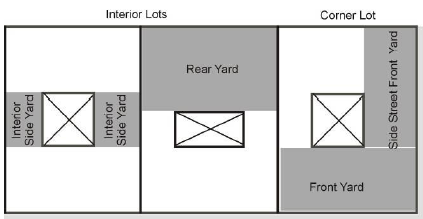
(4)
Required yard. That portion of a lot that meets the required minimum front, side, or rear setback of the zoning district in which the property is located.
(5)
Side yard. A yard extending along a side lot line from the front yard to the rear yard.
Section 31.26 - Definitions "Z"
For the purpose of this title, the following definitions shall apply unless the context clearly indicates or requires a different meaning.
Zero lot line. The location of a building on a lot in such a manner that one or more of the building's sides rest directly on a lot line.
Zoning. The delineation of districts and the establishment of regulations governing the use, placement, spacing, and size of land and buildings.
Zoning district(s). A section or sections of the territory of the county and cities, for which the regulations and requirements governing use, lot, bulk of buildings, and premises are uniform.
Zoning map. The map or maps that are a part of the zoning ordinance and delineate the boundaries of zoning districts.
Zoning Ordinance. The part of the Comprehensive Plan or County Land Development Plan, now or hereafter adopted, which includes an ordinance and zoning maps which divide the jurisdiction of the plan commission into districts, with regulations, requirements, and procedures for the establishment of the land use controls.