
Michigan City Zoning Code
ARTICLE 07
BUSINESS DISTRICTS
Section 07.01 - Intent
(a)
B1 Neighborhood Commercial District. The B1 Neighborhood Commercial District is established to provide for small-scale neighborhood commercial nodes. This district is intended to meet the day-to-day convenience shopping and service needs of persons residing in adjacent residential areas. B1 District designations are located within close proximity to residential neighborhoods and are intended to serve the immediate vicinity so as not to draw additional traffic from other areas of the county or cities. In order to promote business development compatible with nearby residential, the size and scale of uses is limited and uses that would create hazards, loud noises, odors, truck traffic or late hours of operation are not allowed. This district will apply to neighborhood shopping nodes along major corridors within the cities and convenience commercial nodes in unincorporated areas of the county.
(b)
B2 General Commercial District. The B2 General Commercial District is established to serve a larger population than is serviced by a B1 District. The district is generally characterized by an integrated cluster of establishments serviced by a common parking area and generating a large volume of vehicular and pedestrian traffic. The intent of this district is also to encourage the concentration of regional business areas to the mutual advantage of both the consumers and merchants and thereby to promote the best use of land at certain strategic locations and avoid encouraging marginal strip business development along major streets. Special attention must be given to site layout, building design, vehicular and pedestrian circulation and coordination of site features between adjoining sites.
(c)
B3 Highway Commercial District. The uses in the B3 Highway Commercial District will be more automotive oriented and serve a market that includes the traveling public. The permitted uses would be located near highway interchanges and are generally not appropriate immediately adjacent to residential zoning districts. Special attention must be given to site layout, vehicular circulation, building design and buffering from other nearby uses.
(d)
O1 Office Service District. O1 Office District is intended to accommodate uses such as offices for professional and business services, planned office developments, medical centers, as well as appropriately located ancillary services and uses. The O1 District is further intended to provide a buffer or zone of transition between residential and commercial districts and between residential districts and major streets.
Section 07.02 - Uses
Use and development of land and buildings shall only be for the following specified uses, unless otherwise provided for in this Ordinance. Uses are grouped into major categories and only those uses listed under each category are permitted. Land and/or buildings in the districts indicated at the top of the Table may be used for the purposes denoted by the following abbreviations:
P:
Permitted Use. Land and/or buildings in this District may be used for the purposes listed by right.
S:
Special Exception Use. Land and/or buildings in this District may be used for this purpose by obtaining Special Exception approval when all applicable standards cited in Article 24 Special Exception Review Requirements and Procedures.
-:
Not Permitted. The use is not permitted in the district. Uses not listed in the table are also not permitted. Uses that are not listed in any district of the zoning ordinance, as shown in Appendix A, may be allowed based upon a similar use determination in accordance with Section 02.06.
Table 07.02
Schedule of Permitted Uses
Section 07.03 - Lot Area and Width Requirements
All lots shall meet the following minimum area and width requirements. No new lots shall be created or altered in a manner that does not comply with the following requirements.
Table 07.03
Lot Area And Width Requirements
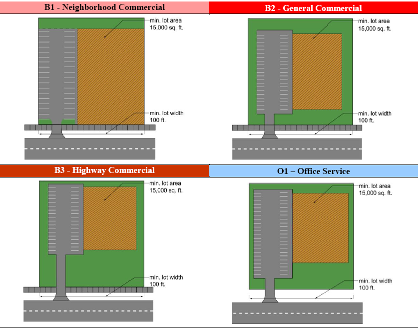
(a)
Subdivision of Land. All divisions to land shall be subject to the requirements set forth in the Subdivision Regulations of La Porte County, City of La Porte or City of Michigan City, as applicable.
(b)
Lot Size Reduction. The lot area and lot width may be reduced below the amounts indicated in Table 07.03 where driveway spacing requirements of Section 18.04 can be met and the lot has a recorded easement for a shared driveway, and cross circulation with parking lots on all adjacent lots zoned or planned for business use, meeting the requirements of Section 18.04.
(c)
Lot Area Calculation. Lot area is calculated based upon the net area of the lot, measured in the horizontal plane, exclusive of any area that is part of a public road right-of-way, private road easement or submerged land beneath the ordinary high water mark of a lake, river or stream.
(d)
Lot Width and Frontage. Lot width shall be measured as a straight line between the side lot lines at the minimum front yard setback of the district. All lots shall have frontage along a public road or street. The width along the road shall be sufficient to meet the lot width requirement at the minimum front yard setback. This requirement shall not apply to individual lots that have access by a shared service drive system within a shopping center or shared access with adjacent uses.
(e)
Dominant Parcel. The dominant tract or parcel from which any newly created lot has been divided from must also maintain the required lot width.
(f)
Depth to Width Ratio. All newly created lots shall have a lot depth of no more than four times the width (i.e. maximum 4:1 depth to width ratio).
(g)
Nonconforming Lots. Lots of record that were in existence prior to the effective date of this ordinance may be used subject to the provisions of the nonconforming lot regulations of Section 29.03.
(h)
Residential in B1. Multiple family residential or dwelling units in mixed use buildings shall be permitted in the B1 district only where both public sewer and public water are available. The maximum density shall be 14 dwelling units per acre.
(i)
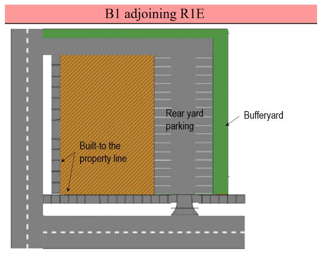
B1 Neighborhood Commercial Adjoining R1E, Waterfront Residential.
(1)
Applicable Properties. The following provisions apply to properties located at the intersection of two public streets in the B1 district that adjoin properties in the R1E district. Unless explicitly modified in this Subsection, all other applicable provisions of this Ordinance apply.
(2)
Notwithstanding. Notwithstanding the permitted and special exception uses, the lot area and width requirements, or the other applicable standards of this Section, the following apply when adjoining the R1E, Waterfront Residential, district:
a.
Prohibited Uses. The following uses are prohibited:
1.
Multiple-family dwellings;
2.
Fraternity, sorority or student cooperative;
3.
Agriculture and animal-related uses;
3.
Retail uses with accessory drive through service;
4.
Feed stores;
5.
Machine and equipment sales;
6.
Mobile home and trailer sales/rental;
7.
Petroleum product sales;
8.
Tool and equipment rental;
9.
Automobile sales (new/used) and rental;
10.
Major automobile service, body repair, and painting;
11.
Motorcycle, snowmobile, and ATV sales/service;
12.
Truck sales (new/used) and rental;
13.
Truck stops;
14.
Vehicle auctions;
15.
Amusement parks;
16.
Campgrounds;
17.
Golf course and country clubs; and
18.
Shooting range, indoors;
19.
Stadiums/arenas;
20.
Cemeteries;
21.
Parking structures as a principal use;
22.
Self-storage facilities, indoor;
23.
Utility substation.
b.
Minimum Lot Area and Width. The minimum lot area shall be 7,500 square feet and the minimum lot width shall be 50 feet.
c.
Maximum Density. The maximum density for dwellings in mixed-use buildings is 12 units per acre, or portion thereof.
d.
Building Height Exceptions.
1.
Minimum. All buildings must be constructed at a height of 30 feet.
2.
Exceptions. The exceptions to building height may be parapet walls and roof structures housing necessary mechanical appurtenances, which may be no more than five feet taller than the highest point of the roof. In addition, the overall height of the entire structure, including parapet and screening structures, shall not exceed 35 feet.
e.
Outdoor Storage. Prohibited.
f.
Maximum Front Yard Setback.
1.
Buildings shall be setback a maximum of five feet along street rights-of-way. If a public entrance is at the corner of a building, the angular façade containing the entrance may be recessed a maximum of 10 feet from the intersection of the two right-of-way lines. Buildings may exceed a five-foot setback up to a maximum of 10 feet to provide:
a.
A sidewalk along the building frontage;
b.
A public gathering area or plaza that offers seating or dining, landscape or hardscape enhancements, public displays, or other pedestrian amenities; or
c.
Parallel parking.
g.
Parking and Loading Requirements.
1.
Parking may be located off-site in a common parking area provided the parking lot is within 300 feet of the subject parcel, measured from the nearest property lines, and provided compliance with all other requirements of this ordinance.
2.
Off-street parking shall be located to the side or rear of the building (see B1 adjoining R1E below).
3.
Loading and unloading is allowed over-the-curb along street rights-of-way, and other locations as approved by the enforcement officer. Loading and unloading shall be prohibited between the hours of 8 p.m. and 7 a.m.
h.
Maximum Building Coverage Ratio (BCR) and Floor Area Ratio (FAR). Notwithstanding the maximum building coverage provisions of Table 07.04, Building Dimensional Requirements, the building coverage and floor area ratios of a two-story or, by special exception, a three-story building may be as follows:
1.
Two-story building:
a.
On-site parking = 0.50 FAR and 25 percent BCR.
b.
Off-site or on-street parking = 1.85 FAR and 95 percent BCR
2.
Three-story building:
a.
On-site parking = 0.62 FAR and 21 percent BCR
b.
Off-site or on-street parking = 2.68 FAR and 95 percent BCR
Note: Off-site parking requires Plan Commission approval of a parking plan.
i.
Buffer Zone. See Sec. 17.02, Landscaping Requirements.
(Ord. No. 4500, § 5.9., 2-5-2019)
Section 07.04 - Building Dimensional Requirements
All structures shall be subject to the dimensional regulations of the following table.
Table 07.04
Building Dimensional Requirements (a)
(a)
Accessory Structures. Accessory structures shall be regulated under the requirements of Article 16.
(b)
Height Exceptions. No structure shall exceed the maximum height of the district except for the allowable exceptions to the height limits contained in Section 15.02.
(c)
Projections into Yards. All required yard spaces shall remain as landscaped open space, except for pavement, accessory structures and architectural features that are allowed to extend or project into required setbacks under Section 15.01.
(d)
Yards Maintained as Landscaped Open Space. Setback areas shall be provided with landscape greenbelts and buffer zones as required in Section 17.02.
(e)
Outdoor Storage. Outdoor storage shall be screened in accordance with Sections 17.02 and 17.03. Storage areas shall meet the applicable building setback requirements from each lot line.
(f)
Setback from Road. The front yard setback shall be measured from the road right-of-way or private road easement. Detention/retention ponds shall be prohibited in the required front yard setback, unless there is no reasonable alternative due to existing topography and natural drainage problems. This restriction shall not apply to rain gardens, bio-retention swales, irrigation trench planters and other similar stormwater management alternatives to retention or detention ponds.
(g)
Corner Lots. Corner lots shall provide the minimum front yard setback from both road frontages.
(h)
Double Frontage Lots. In all districts, where a double frontage lot backs-up to a roadway, the minimum required front or roadside setback shall be required from both road rights-of-way.
(i)
Parking Setback. All parking, loading, and vehicular circulation aisles shall provide sufficient setback to meet the frontage greenbelt and buffer zones required by Section 17.02.
(j)
Loading Areas. All loading and unloading shall be provided off-street in the rear yard or interior side yard, and shall in no instance be permitted in a front yard. Where an alley exists or is provided at the rear of buildings, the rear building setback and loading requirements may be computed from the center of the alley. Loading and unloading areas located in a side yard shall be fully screened from view from a public street. No overhead doors shall be permitted in the front elevation of the building. All residential districts and uses must be screened from truck loading and unloading activities in accordance with Section 17.03.
(k)
Wetlands. A minimum setback of 50 feet shall be maintained from all wetlands. The setback may be adjusted according to requirements of natural resource preservation guidelines contained [in] Article 22.
(l)
Waterway Setback. The waterway setback shall be measured from the shoreline of the lake, river or stream. In no instance shall any structures other than docks, seawalls, retaining walls, sidewalks, boardwalks, and patios be permitted within the minimum waterway setback. The setback may be adjusted according to requirements of Natural Resource Preservation Guidelines.
(m)
Maximum Lot Coverage. The maximum lot coverage for buildings and impermeable surface shall be measured as follows:
(1)
The building coverage shall be calculated as the ratio of the footprint of all buildings, including the principal building, garages and detached accessory buildings, to the net area of the lot.
(2)
The total impermeable surface coverage shall be calculated as the ratio of the ground area covered by all buildings, accessory structures, decks, pools, pavement, parking, loading and storage areas, normal pool area of wet detention basins to the net lot area.
(n)
Building Side Yard Setback. The minimum side yard setback in B1 and B2 shall be zero where the side lot line adjoins another lot that is zoned as a business district and the side wall is a fire rated wall with no windows. Where a lot borders on a residential district, there shall be provided a minimum 20-foot setback on the side bordering the residential district.
(Ord. No. 4500, § 5.10., 2-5-2019)