
Michigan City Zoning Code
ARTICLE 09
INDUSTRIAL DISTRICTS
Section 09.01 - Intent
(a)
M1 Light Industrial District. The M1 Light Industrial District is established for light industries, such as light manufacturing or processing of previously refined materials and other industrial uses that have no adverse impact upon neighboring districts. This district also allows certain commercial uses that are industrial in character or are necessary to provide services to persons working within the district. Uses in this district must have less of an impact on surrounding uses and generate less truck traffic than the other industrial developments. Limitations regarding the degree of noise, smoke, glare, odor, and vibration are placed upon such uses to preclude any adverse effects upon nearby commercial or residential districts. it is intended that this district act as a transition between heavier industrial uses and residential or commercial areas.
(b)
M2 Heavy Industrial District. The M2 Heavy Industrial District is established to permit heavier industrial uses that are primarily of a manufacturing, assembling, and fabricating character, and are large-scale or specialized industrial operations more likely to produce external physical effects impacting to some degree surrounding districts. The M-2 District is further designed to be located in areas where heavy industrial uses can most efficiently utilize major roadways, utilities and other infrastructure while minimizing any incompatible aspects with neighboring districts.
Section 09.02 - Uses
Use and development of land and buildings shall only be for the following specified uses, unless otherwise provided for in this Ordinance. Uses are grouped into major categories and only those uses listed under each category are permitted. Land and/or buildings in the districts indicated at the top of the Table may be used for the purposes denoted by the following abbreviations:
P:
Permitted Use. Land and/or buildings in this District may be used for the purposes listed by right.
S:
Special Exception Use. Land and/or buildings in this District may be used for this purpose by obtaining Special Exception approval when all applicable standards cited in Article 24 Special Exception Review Requirements and Procedures.
-:
Not Permitted. The use is not permitted in the district. Uses not listed in the table are also not permitted. Uses that are not listed in any district of the zoning ordinance, as shown in Appendix A, may be allowed based upon a similar use determination in accordance with Section 02.06.
Table 09.02
Schedule of Permitted Uses
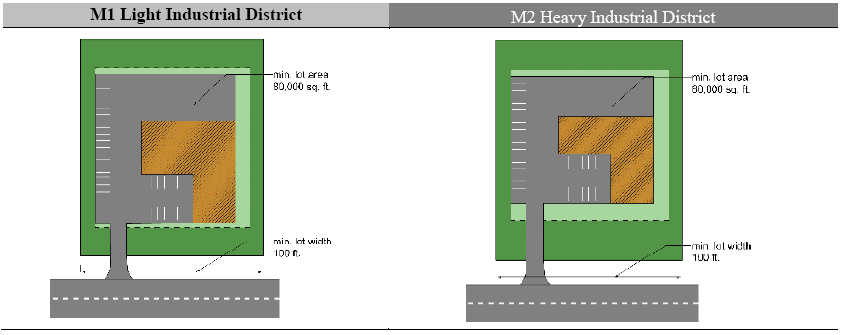
Section 09.03 - Lot Area and Width Requirements
All lots shall meet the following minimum area and width requirements. No new lots shall be created or altered in a manner that does not comply with the following requirements.
Table 09.03
Lot Area And Width Requirements
(a)
Subdivision of Land. All divisions to land shall be subject to the requirements set forth in the Subdivision Regulations of La Porte County, City of La Porte or City of Michigan City, as applicable.
(b)
Lot Area Calculation. Lot area is calculated based upon the net area of the lot, measured in the horizontal plane, exclusive of any area that is part of a public road right-of-way, private road easement or submerged land beneath the ordinary high water mark of a lake, river or stream.
(c)
Lot Width and Frontage. Lot width shall be measured as a straight line between the side lot lines at the minimum front yard setback of the district. All lots shall have frontage along a public road or street. The width along the road shall be sufficient to meet the lot width requirement at the minimum front yard setback.
(d)
Dominant Parcel. The dominant tract or parcel from which any newly created lot has been divided from must also maintain the required lot width.
(e)
Depth to Width Ratio. All newly created lots shall have a lot depth of no more than four times the width (i.e. maximum 4:1 depth to width ratio).
(f)
Nonconforming Lots. Lots of record that were in existence prior to the effective date of this ordinance may be used subject to the provisions of the nonconforming lot regulations of Section 29.03.
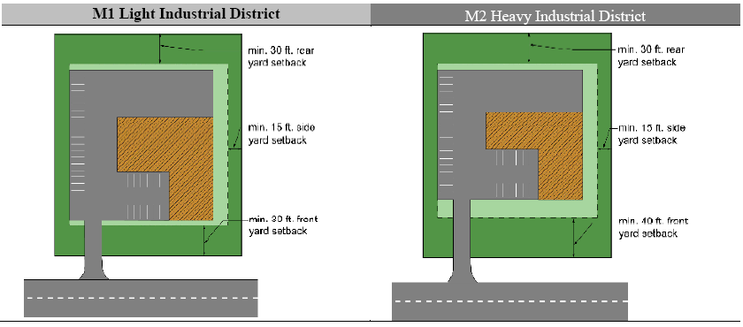
Section 09.04 - Building Dimensional Requirements
All structures shall be subject to the dimensional regulations of the following table.
Table 09.04
Building Dimensional Requirements (a)
(a)
Accessory Structures. Accessory structures shall be regulated under the requirements of Article 16.
(b)
Height Exceptions. No structure shall exceed the maximum height of the district except for the allowable exceptions to the height limits contained in Section 15.02.
(c)
Projections into Yards. All required yard spaces shall remain as landscaped open space, except for pavement, accessory structures and architectural features that are allowed to extend or project into required setbacks under Section 15.01.
(d)
Yards Maintained as Landscaped Open Space. All buildings shall meet the setback requirement. Setback areas shall be provided with landscape greenbelts and buffer zones as required in Section 17.02.
(e)
Outdoor Storage. Outdoor storage shall be screened in accordance with Sections 17.02 and 17.03. Storage areas shall meet the applicable building setback requirements from each lot line.
(f)
Setback from Road. The front yard setback shall be measured from the road right-of-way or private road easement. Detention/retention ponds shall be prohibited in the required front yard setback, unless there is no reasonable alternative due to existing topography and natural drainage problems. This restriction shall not apply to rain gardens, bio-retention swales, irrigation trench planters and other similar stormwater management alternatives to retention or detention ponds.
(g)
Parking Setback. Parking lots shall be required to meet the front yard setback. Parking shall be permitted in the side or rear yard setback, provided it does not encroach into any required landscape greenbelts or buffer zones required by Section 17.02. Where a parking lot or loading area borders on a residential district, there shall be provided a buffer and screening from the residential district, as required by Sections 17.02 and 17.03.
(h)
Corner Lots. Corner lots shall provide the minimum front yard setback from both road frontages.
(i)
Double Frontage Lots. In all districts, where a double frontage lot backs-up to a roadway, the minimum required front or roadside setback shall be required from both road rights-of-way.
(j)
Loading Areas. All loading and unloading shall be provided off-street in the rear yard or interior side yard, and shall in no instance be permitted in a front yard. Where an alley exists or is provided at the rear of buildings, the rear building setback and loading requirements may be computed from the center of the alley. Loading and unloading areas located in a side yard shall be fully screened from view from a public street. No overhead doors shall be permitted in the front elevation of the building. All residential districts and uses must be screened from truck loading and unloading activities in accordance with Section 17.03.
(k)
Wetlands. A minimum setback of 50 feet shall be maintained from all wetlands. The setback may be adjusted according to requirements of natural resource preservation guidelines contained [in] Article 22.
(l)
Waterway Setback. The waterway setback shall be measured from the shoreline of the lake, river or stream. In no instance shall any structures other than docks, seawalls, retaining walls, sidewalks, boardwalks, and patios be permitted within the minimum waterway setback. The setback may be adjusted according to requirements of Natural Resource Preservation Guidelines.
(m)
Maximum Lot Coverage. The maximum lot coverage for buildings and impermeable surface shall be measured as follows:
(1)
The building coverage shall be calculated as the ratio of the footprint of all buildings, including the principal building, garages and detached accessory buildings, to the net area of the lot.
(2)
The total impermeable surface coverage shall be calculated as the ratio of the ground area covered by all buildings, accessory structures, decks, pools, pavement, parking, loading and storage areas, normal pool area of wet detention basins to the net lot area.
(n)
Reserved.
(o)
M2, Heavy Industrial adjoining R1E, Waterfront Residential.
(1)
Applicable Properties. This Subsection applies to properties in the M2 district that adjoin or are adjacent to properties in the R1E district.
(2)
Notwithstanding. Notwithstanding the permitted and special exception uses, the lot area and width requirements, or the other applicable standards of this Section, the following apply when adjoining the R1E, Waterfront Residential district:
(a)
Existing Uses. Land uses that exist as of January 1, 2019 may continue or the use may be expanded or changed subject to a special exception.
(b)
Prohibited Uses. The following uses are prohibited:
1.
Agriculture (except indoor or rooftop gardening) and animal-related uses (all uses);
2.
Adult cabaret and retail store;
3.
Chemical manufacturing and storage;
4.
Concrete and gravel crushing;
5.
Contractors' outdoor storage;
6.
Explosive manufacturing and storage;
7.
Foundries;
8.
Machinery and equipment sales;
9.
Mining (all uses);
10.
Mobile homes and trailer sales/rental;
11.
Petroleum tank farms;
12.
Power generation plants;
13.
Racetracks and go-cart tracks;
14.
Self-storage facilities, outside;
15.
Sewage treatment plants;
16.
Shooting ranges, outdoors;
17.
Stadiums/arenas;
18.
Utility substations;
19.
Waste processing and disposal (all uses); and
(c)
Prohibited Activities and Characteristics. The following are prohibited on properties within 100 feet of the common lot line or district boundary between the M2 and R1E properties between the hours of 8:00 p.m. to 7:00 a.m.:
1.
Collection of solid waste, including recycling;
2.
Loading, unloading, or idling of vehicles, including tractor trailers, with two or more rear axles; and
3.
Open overhead doors.
(d)
Shared Driveways, Frontage Roads and Service Drives.
a.
All industrial uses shall install frontage or service roads to allow connection to adjacent lots, except when the connection would result in an industrial property having direct access to a local street serving residentially zoned properties. A frontage road shall be parallel to and service roads shall be parallel or perpendicular to the front lot line. All frontage roads and service drives shall be designed in accordance with the requirements of Section 18.04.
b.
A traffic impact study is required with site plan submission for any development on an applicable property meeting the warrants for a traffic impact study, as provided in the "Applicant's Guide to Traffic Impact Studies," published by the Indiana Department of Transportation. The preparation and review of the traffic impact study shall also follow this guide.
(e)
Buffer Standards. See Table 17.02(c)(1), Buffer Zone Type.
(Ord. No. 4500, § 5.11., 2-5-2019)