
Mobile City Zoning Code
ARTICLE 2
- ZONING DISTRICTS
Sec. 64-2-1.- Districts established.
A.
The following zoning districts are hereby established:
1.
Residential Agriculture (R-A);
2.
Single-Family Residential (R-1);
3.
Two-Family Residential (R-2);
4.
Multi-Family Residential (R-3);
5.
Residential Business (R-B);
6.
Historic Business (H-B);
7.
Buffer Business (B-1);
8.
Transitional Business (T-B);
9.
Limited Neighborhood Business (LB-2);
10.
Neighborhood Business (B-2);
11.
Community Business (B-3);
12.
General Business (B-4);
13.
Office Distribution (B-5);
14.
Commercial Warehouse (CW);
15.
Maritime Mixed (MM);
16.
Maritime Light (ML);
17.
Maritime Heavy (MH);
18.
Light Industry (I-1);
19.
Heavy Industry (I-2);
20.
Planned Development (PD);
21.
Downtown Development District (DDD)—See appendix A:
(a)
T-3;
(b)
T-4;
(c)
T-5.1;
(d)
T-5.2;
(e)
T-6;
(f)
SD-WH;
(g)
SD.
B.
Sub-districts.
1.
Sub-district regulations provide standards to allow development compatible with existing neighborhoods in order to enhance and protect the established character of traditional or environmentally sensitive communities. Sub-districts created by this chapter are as follows and are shown on the zoning map of the city:
(a)
Urban. Areas generally developed prior to 1950, historically with smaller lots sizes, proximity to street car service, with a walkable development pattern based on a grid, and generally located within or near a federally or locally designated historic district.
(b)
Suburban. Areas generally developed after 1950, typically with larger lot sizes; the development pattern is not based on a grid. Larger footprint commercial buildings with large parking lots as a focus are typical of suburban development.
(c)
Conservation. A type of development pattern that is focused on preserving environmental elements associated with the site; including wetlands, flood zones and other environmentally sensitive features.
C.
Area plans.
1.
Area plans provide specific policies that reflect the unique character of neighborhoods defined within the corresponding plan. These regulations supplement and, in certain circumstances, will supersede the base zoning regulations established in this chapter to reflect specific considerations for the following neighborhoods:
(a)
Africatown (see article 11);
(b)
Peninsula (see article 12);
(c)
Village of Spring Hill (see article 13);
(d)
Historic District Overlay (HDO) (see article 14).
D.
Future land use map applicability.
1.
The future land use map (FLUM) is a general guide for the establishment of zoning districts. An applicability statement based upon the zoning district correspondence matrix from the Map for Mobile future land use plan and major street plan document, adopted in 2017, may be found for each zoning district defined by this section. It should be noted that the FLUM is a general guide, not a mandate for development. As the FLUM is a general guide, any zoning district may be considered for a location where the district does not correspond with the FLUM.
(Ord. No. 64-017-2022, 7-12-22)
Sec. 64-2-2. - Zoning map.
A.
The city will maintain a digital zoning map which will show the location and boundaries of the zoning districts, sub-districts, and area plans. The digital map will be maintained to accurately reflect the most recently adopted zoning ordinances, rulings and decisions impacting the permitted uses of property located with the city limits.
(Ord. No. 64-017-2022, 7-12-22)
Sec. 64-2-3. - Zoning of annexed land.
A.
All territory that is annexed to the city is automatically assigned the "R-1 Single-Family Residential" district until existing land uses are determined and a new zoning category is adopted.
B.
In lieu of the "R-1, Single-Family Residential" district, the applicant for annexation may request pre-zoning pursuant to Code of Ala. § 11-52-85.
(Ord. No. 64-017-2022, 7-12-22)
Sec. 64-2-4. - Residential Agriculture (R-A).
A.
Generally. These districts are composed of larger tracts of land that are vacant or in agricultural, forest, or single-family residential uses. It is intended that these districts provide for a full range of agricultural and farming activities and protect these established uses from encroaching development. The farmer has a right to farm without being restricted by neighboring residential districts or nonagricultural uses. It is further intended that the districts protect existing natural resources and scenic values and provide a spacious residential environment for residents of the community.
B.
FLUM applicability. The FLUM does not indicate a specific land use category as suitable for new R-A districts. It is recommended that the following FLUM categories be considered as suitable for location of new R-A districts.
1.
Low Density Residential;
2.
Parks and Open Space;
3.
Water Dependent Uses.
C.
Overlay applicability. New R-A districts may be considered for location within the following overlay:
1.
Peninsula.
D.
Permitted uses. See the use table (section 64-2-24.1).
E.
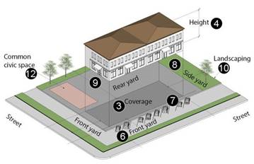
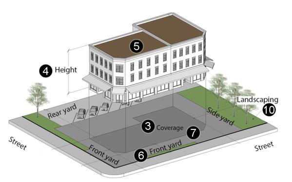
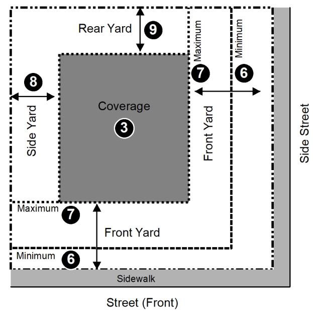
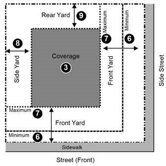
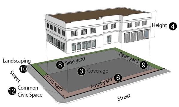
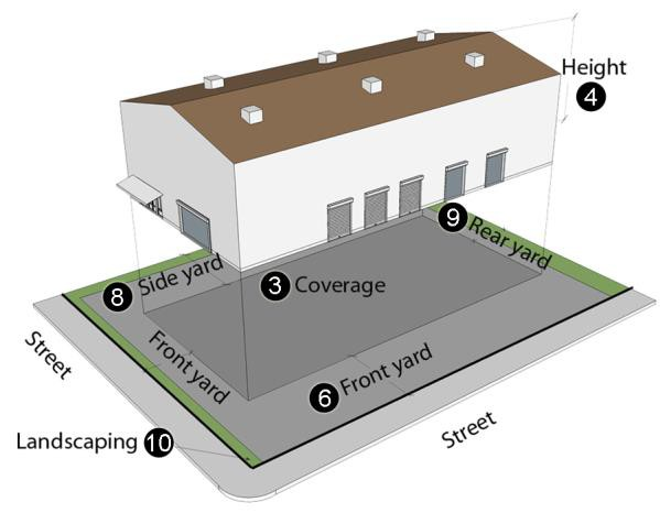
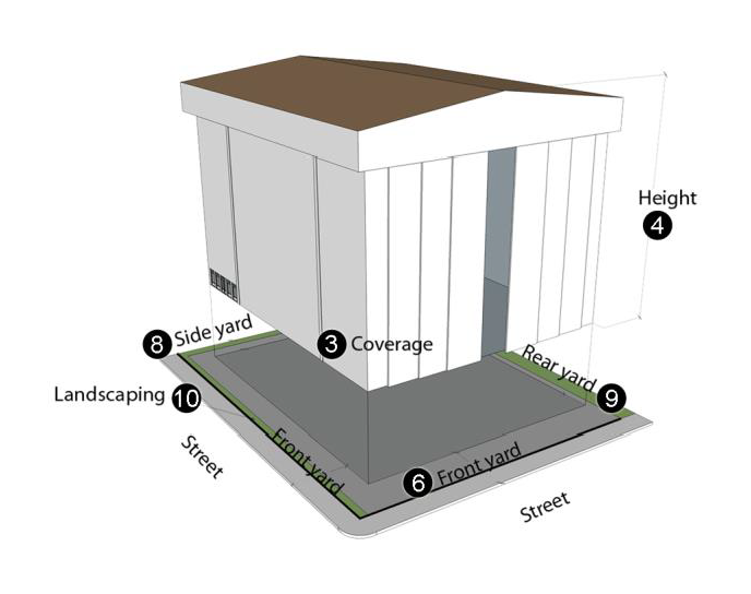
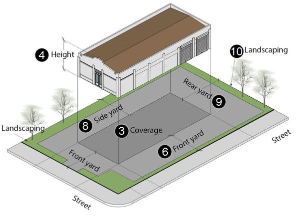
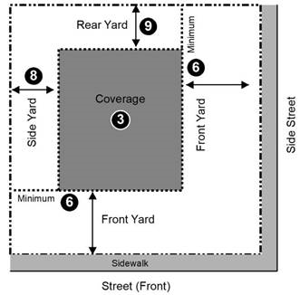
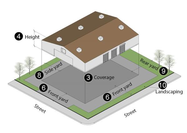
Dimensional standards.
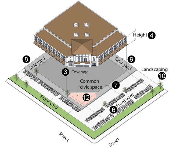
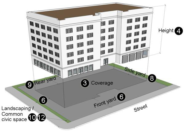
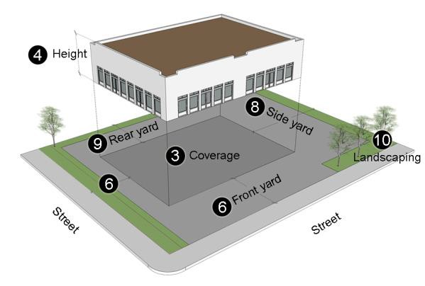
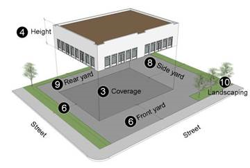
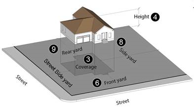 |  | |
| 1 | Lot area (minimum) | 1 acre |
| 2 | Density (maximum) | 1 dwelling/lot |
| 3 | Coverage (maximum) | 35% |
| 4 | Height (maximum) | 35 feet |
| 5 | Building size (maximum) | Not applicable |
| 6 | Front yard (minimum) | 25 feet |
| 7 | Front yard (maximum) | Not applicable |
| 8 | Side yard (minimum) | 10 feet |
| 9 | Rear yard (minimum) | 10 feet |
| 10 | Landscaping percent (minimum) | Not applicable |
| 11 | Common open space per dwelling unit | Not applicable |
| 12 | Common civic space (minimum) | Not applicable |
(Ord. No. 64-017-2022, 7-12-22)
Sec. 64-2-5. - Single-Family Residential (R-1).
A.
Generally. These districts are composed of both developed and largely undeveloped areas. The developed areas contain mainly one-family dwellings and small open areas, usually subdivided, where residential development seems likely to occur; few two-family and multiple-family dwellings are found in these developed areas. It is anticipated that most of the large undeveloped areas will ultimately be developed for residential use. The district regulations are designed to protect the residential character of the developed areas by prohibiting commercial activities and encouraging a suitable neighborhood environment for family life.
B.
FLUM applicability. New R-1 districts may be considered for location within the following FLUM categories:
1.
Low Density Residential (R-1 Suburban and Conservation);
2.
Neighborhood Center - Traditional (R-1 Urban and Suburban);
3.
Traditional Corridor (R-1 Urban and Suburban).
C.
Overlay applicability. New R-1 districts may be considered for location within the following overlays:
1.
Africatown (R-1 Urban and Suburban);
2.
Peninsula (R-1 Conservation);
3.
Springhill:
(a)
Village Center (R-1 Urban);
(b)
Neighborhood Center (R-1 Urban);
(c)
Neighborhood General (R-1 Urban and Suburban);
4.
Historic District (R-1 Urban and Suburban).
D.
Permitted uses. See the use table (section 64-2-24.1).
E.
Dimensional standards.
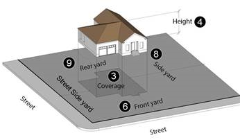 |  | ||||
| District → | R-1 Urban | R-1 Suburban | R-1 Conservation | ||
| 1 | Lot area (minimum) | 6,000 square feet | 7,200 square feet | Not applicable | |
| 2 | Density (maximum) | 1 dwelling/lot | 1 dwelling/lot | 6 dwelling units/acre | |
| 3 | Coverage (maximum) | 50% | 35% | 75% per individual dwelling lot | |
| 4 | Height (maximum) | 35 feet | 35 feet | 35 feet | |
| 5 | Building size (maximum) | Not applicable | Not applicable | Not applicable | |
| 6 | Front yard (minimum) | 5 feet | 25 feet | 5 feet | |
| 7 | Front yard (maximum) | Not applicable | Not applicable | Not applicable | |
| 8 | Side yard (minimum) | 5 feet | 5 feet | 5 feet | |
| 9 | Rear yard (minimum) | 5 feet | 8 feet | 5 feet | |
| 10 | Landscaping percent (minimum) | Not applicable | Not applicable | Not applicable | |
| 11 | Common open space per dwelling unit | Not applicable | Not applicable | Sufficient to protect natural resource(s) | |
| 12 | Common civic space (minimum) | Not applicable | Not applicable | Not applicable | |
(Ord. No. 64-017-2022, 7-12-22)
Sec. 64-2-6. - Two-Family Residential (R-2).
A.
Generally. These districts are composed mainly of areas containing a mixture of one-family and two-family dwellings and open areas where similar residential development seems likely to occur. The district regulations are designed to protect the residential character of the developed areas by prohibiting commercial activities and encouraging a suitable neighborhood environment for family life.
B.
FLUM applicability. New R-2 districts may be considered for location within the following FLUM categories:
1.
Low Density Residential (R-2 Suburban);
2.
Neighborhood Center - Traditional (R-2 Urban and Suburban);
3.
Traditional Corridor (R-2 Urban and Suburban);
4.
Downtown Waterfront (R-2 Urban).
C.
Overlay applicability. New R-2 districts may be considered for location within the following overlays:
1.
Africatown (R-2 Urban and Suburban);
2.
Peninsula (R-2 Suburban);
3.
Springhill:
(a)
Village Center (R-2 Urban);
(b)
Neighborhood Center (R-2 Urban);
(c)
Neighborhood General (R-2 Urban and Suburban);
4.
Historic District (R-2 Urban and Suburban).
D.
Permitted uses. See the use table (section 64-2-24.1).
E.
Dimensional standards.
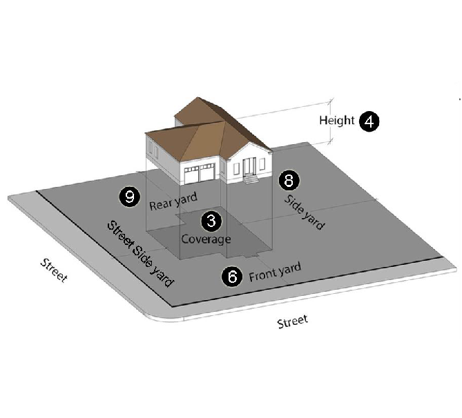 |  | ||
| District → | R-2 Urban | R-2 Suburban | |
| 1 | Lot area (minimum) | 4,000 square feet | 8,000 square feet |
| 2 | Density (maximum) | 20 dwelling units/acre | 10 dwelling units/acre |
| 3 | Coverage (maximum) | 50% | 40% |
| 4 | Height (maximum) | 35 feet | 35 feet |
| 5 | Building size (maximum) | Not applicable | Not applicable |
| 6 | Front yard (minimum) | 5 feet | 25 feet |
| 7 | Front yard (maximum) | Not applicable | Not applicable |
| 8 | Side yard (minimum) | 5 feet | 5 feet |
| 9 | Rear yard (minimum) | 5 feet | 8 feet |
| 10 | Landscaping percent (minimum) | Not applicable | Not applicable |
| 11 | Common open space per dwelling unit | Not applicable | Not applicable |
| 12 | Common civic space (minimum) | Not applicable | Not applicable |
(Ord. No. 64-017-2022, 7-12-22)
Sec. 64-2-7. - Multi-Family Residential (R-3).
A.
Generally. These districts are composed mainly of areas containing a mixture of one-family, two-family, and multiple-family dwellings. The district regulations are designed to protect the residential character of the developed areas by prohibiting commercial activities, encouraging a suitable neighborhood environment for family life and to avoid excessive population density by requiring a minimum building site area and establishing a maximum number of dwelling units per acre.
B.
FLUM applicability. New R-3 districts may be considered for location within the following FLUM categories:
1.
Low Density Residential (R-3 Suburban);
2.
Mixed Density Residential (R-3 Urban and Suburban);
3.
Neighborhood Center - Traditional (R-3 Urban);
4.
Neighborhood Center - Suburban (R-3 Suburban);
5.
Downtown Waterfront (R-3 Urban).
C.
Overlay applicability. New R-3 districts may be considered for location within the following overlays:
1.
Africatown (R-3 Urban and Suburban);
2.
Peninsula (R-3 Suburban);
3.
Springhill:
(a)
Village Center (R-3 Urban);
(b)
Neighborhood Center (R-3 Urban);
(c)
Neighborhood General (R-3 Urban and Suburban);
4.
Historic District (R-3 Urban).
D.
Permitted uses. See the use table (section 64-2-24.1).
E.
Dimensional standards.
| | ||
| District → | R-3 Urban | R-3 Suburban | |
| 1 | Lot area (minimum) | 4,000 square feet | 10,000 square feet |
| 2 | Density (maximum) | 30 dwelling units/acre | 25 dwelling units/acre |
| 3 | Coverage (maximum) | 50% | 45% |
| 4 | Height (maximum) | 45 feet | 50 feet |
| 5 | Building size (maximum) | Not applicable | Not applicable |
| 6 | Front yard (minimum) | 10 feet | 25 feet |
| 7 | Front yard (maximum) | Not applicable | Not applicable |
| 8 | Side yard (minimum) | 5 feet | 10 feet |
| 9 | Rear yard (minimum) | 5 feet | 10 feet |
| 10 | Landscaping percent (minimum) | 10% | 15% |
| 11 | Common open space per dwelling unit | 100 sf | 700 sf |
| 12 | Common civic space (minimum) | Not applicable | Not applicable |
(Ord. No. 64-017-2022, 7-12-22)
Sec. 64-2-8. - Residential Business (R-B).
A.
Generally. Usually located within urbanized areas of the city, these districts are composed of a mixture of residential and light commercial uses. The district regulations are designed to protect the character of the area or to encourage further appropriate development, with a mixture of residential, public and semipublic and light commercial uses.
B.
FLUM applicability. New R-B districts may be considered for location within the following FLUM categories:
1.
Mixed Density Residential;
2.
Neighborhood Center - Traditional;
3.
Traditional Corridor;
4.
Downtown Waterfront.
C.
Overlay applicability. New R-B districts may be considered for location within the following overlays:
1.
Africatown;
2.
Peninsula;
3.
Springhill:
(a)
Village Center;
(b)
Neighborhood Center;
(c)
Neighborhood General;
4.
Historic District.
D.
Permitted uses. See the use table (section 64-2-24.1).
E.
Dimensional standards.
 |  | |
| 1 | Lot area (minimum) | 4,000 square feet per dwelling unit |
| 2 | Density (maximum) | 10 dwelling units/acre |
| 3 | Coverage (maximum) | 75% |
| 4 | Height (maximum) | 45 feet |
| 5 | Building size (maximum) | Not applicable |
| 6 | Front yard (minimum) | 5 feet |
| 7 | Front yard (maximum) | Not applicable |
| 8 | Side yard (minimum) | 0 or 5 feet |
| 9 | Rear yard (minimum) | 0 or 5 feet |
| 10 | Landscaping percent (minimum) | 5% for multi-family or commercial |
| 11 | Common open space per dwelling unit | Not applicable |
| 12 | Common civic space (minimum) | Not applicable |
(Ord. No. 64-017-2022, 7-12-22)
Sec. 64-2-9. - Historic Business (H-B).
A.
Generally. These districts are composed of areas containing architecturally or historically valuable buildings. By reason of location and accessibility, the districts are suitable for residences as well as specialty shopping and entertainment activities for tourist and local trade. The district regulations are designed to protect the special character of the areas, to encourage restoration of architecturally and historically valuable buildings and their adaptation to house permitted uses and to encourage further appropriate development for a limited number of mutually supporting light business and cultural uses.
B.
FLUM applicability. New H-B districts may be considered for location within the following FLUM categories:
1.
Downtown;
2.
Neighborhood Center - Traditional;
3.
Traditional Corridor.
C.
Overlay applicability. New H-B districts may be considered for location within the following overlays:
1.
Africatown;
2.
Springhill:
(a)
Village Center;
(b)
Neighborhood Center;
(c)
Neighborhood General;
3.
Historic District.
D.
Permitted uses. See the use table (section 64-2-24.1).
E.
Dimensional standards.
 |  | |
| 1 | Lot area (minimum) | Not applicable |
| 2 | Density (maximum) | 25 dwelling units/acre |
| 3 | Coverage (maximum) | 50% |
| 4 | Height (maximum) | 45 feet |
| 5 | Building size (maximum) | Not applicable |
| 6 | Front yard (minimum) | 5 feet |
| 7 | Front yard (maximum) | Not applicable |
| 8 | Side yard (minimum) | 5 feet/and required buffer |
| 9 | Rear yard (minimum) | 0 or 5 feet/and required buffer |
| 10 | Landscaping percent (minimum) | 5% |
| 11 | Common open space per dwelling unit | Not applicable |
| 12 | Common civic space (minimum) | 4% |
(Ord. No. 64-017-2022, 7-12-22)
Sec. 64-2-10. - Buffer Business (B-1).
A.
Generally. These districts are composed of land and structures occupied by or suitable for such uses as residential, offices and parking. Although usually located between residential areas and business areas, these districts are in some instances free-standing in residential areas or they may include hospital, college or other public or semipublic groups and related uses. The district regulations are designed to protect and encourage the buffer character of the districts by limiting the permitted uses to dwellings and uses of a semicommercial nature and to protect the abutting and surrounding residential areas by requiring certain minimum yard and area standards to be met, standards that are comparable to those called for in the residence districts.
B.
FLUM applicability. New B-1 districts may be considered for location within the following FLUM categories:
1.
Neighborhood Center - Suburban (B-1 Suburban);
2.
Traditional Corridor (B-1 Urban);
3.
Mixed Commercial Corridor (B-1 Urban and Suburban);
4.
Downtown Waterfront (B-1 Urban).
C.
Overlay applicability. New B-1 districts may be considered for location within the following overlays:
1.
Africatown (B-1 Urban and Suburban);
2.
Peninsula (B-1 Urban and Suburban);
3.
Springhill:
(a)
Village Center (B-1 Urban);
(b)
Neighborhood Center (B-1 Urban);
(c)
Neighborhood General (B-1 Urban and Suburban);
4.
Historic District (B-1 Urban).
D.
Permitted uses. See the use table (section 64-2-24.1).
E.
Dimensional standards.
 |  | ||
| District → | B-1 Urban | B-1 Suburban | |
| 1 | Lot area (minimum) | 4,000 square feet | 7,200 square feet |
| 2 | Density (maximum) | 25 dwelling units/acre | 25 dwelling units/acre |
| 3 | Coverage (maximum) | 45% | 45% |
| 4 | Height (maximum) | 45 feet | 45 feet |
| 5 | Building size (maximum) | Not applicable | Not applicable |
| 6 | Front yard (minimum) | 10 feet | 25 feet |
| 7 | Front yard (maximum) | 45 feet | Not applicable |
| 8 | Side yard (minimum) | 5 feet/and required buffer | 5 feet/and required buffer |
| 9 | Rear yard (minimum) | 5 feet/and required buffer | 5 feet/and required buffer |
| 10 | Landscaping percent (minimum) | 5% | 15% |
| 11 | Common open space per dwelling unit | Not applicable | Not applicable |
| 12 | Common civic space (minimum) | 4% | Not applicable |
(Ord. No. 64-017-2022, 7-12-22)
Sec. 64-2-11. - Transitional Business (T-B).
A.
Generally. These districts are intended for small sites in or near dense residential neighborhoods on, at or near a thoroughfare. The district regulations encourage the provision of small-scale retail and service uses for nearby residential areas, as well as mixed use development. Some uses that are not retail or service in nature are also allowed so a variety of uses may locate in existing buildings. Uses are restricted in size, number and character to promote a local orientation and to limit adverse impacts on nearby residential areas. Development is intended to be pedestrian-oriented and compatible with the scale of surrounding residential areas. Parking areas are restricted, since their appearance is generally out of character with the surrounding residential development and the desired orientation of the uses.
B.
FLUM applicability. New T-B districts may be considered for location within the following FLUM categories:
1.
Mixed Density Residential;
2.
District Center;
3.
Neighborhood Center - Traditional;
4.
Neighborhood Center - Suburban;
5.
Traditional Corridor.
C.
Overlay applicability. New T-B districts may be considered for location within the following overlays:
1.
Africatown;
2.
Peninsula;
3.
Springhill:
(a)
Village Center;
(b)
Neighborhood Center;
(c)
Neighborhood General;
4.
Historic District.
D.
Permitted uses. See the use table (section 64-2-24.1).
E.
Dimensional standards.
 |  | |
| 1 | Lot area (minimum) | 4,000 square feet per dwelling unit |
| 2 | Density (maximum) | 10 dwelling units/acre |
| 3 | Coverage (maximum) | 50% |
| 4 | Height (maximum) | 45 feet |
| 5 | Building size (maximum) | 10,000 square feet for commercial use |
| 6 | Front yard (minimum) | 10 feet |
| 7 | Front yard (maximum) | Within two feet of the average front yard setback of developed lots on the same side of the street; maximum setback of 45 feet |
| 8 | Side yard (minimum) | Not applicable |
| 9 | Rear yard (minimum) | Not applicable |
| 10 | Landscaping percent (minimum) | 5% for multi-family or commercial |
| 11 | Common open space per dwelling unit | Not applicable |
| 12 | Common civic space (minimum) | 2% |
(Ord. No. 64-017-2022, 7-12-22)
Sec. 64-2-12. - Limited Neighborhood Business District (LB-2).
A.
Generally. These districts are composed of land and structures occupied by or suitable for furnishing retail goods, such as groceries and drugs, and services, such as barbering and shoe repairing, to satisfy the daily household needs of the surrounding residential neighborhoods, as well as allowing mixed use development. Locational guidelines for LB-2 districts are the same as for B-2 districts. Often located on a thoroughfare or near the intersection of two (2) thoroughfares, these districts are small and are within convenient walking distance of most of the areas they will serve. The district regulations are designed to permit the development of the districts for their purpose and to protect the abutting and surrounding residential areas by prohibiting certain commercial uses such as bars and liquor stores and requiring certain minimum yard and area standards to be met with standards that are comparable to those called for in residential districts. LB-2 does not supplant or replace B-1, but is another option for certain permitted uses in lieu of B-2.
B.
FLUM applicability. New LB-2 districts may be considered for location within the following FLUM categories:
1.
Mixed Density Residential (LB-2 Urban and Suburban);
2.
Neighborhood Center - Suburban (LB-2 Suburban);
3.
Traditional Corridor (LB-2 Urban);
4.
Mixed Commercial Corridor (LB-2 Urban and Suburban);
5.
Downtown Waterfront (LB-2 Urban).
C.
Overlay applicability. New LB-2 districts may be considered for location within the following overlays:
1.
Africatown (LB-2 Urban and Suburban);
2.
Peninsula (LB-2 Urban and Suburban);
3.
Springhill:
(a)
Village Center (LB-2 Urban);
(b)
Neighborhood Center (LB-2 Urban);
(c)
Neighborhood General (LB-2 Urban and Suburban);
4.
Historic District (LB-2 Urban).
D.
Permitted uses. See the Use Table (Sec. 64-2-24.1).
E.
Dimensional standards.
 |  | ||
| District → | LB-2 Urban | LB-2 Suburban | |
| 1 | Lot area (minimum) | 4,000 square feet | 7,200 square feet |
| 2 | Density (maximum) | 25 dwelling units/acre | 25 dwelling units/acre |
| 3 | Coverage (maximum) | 50% | 50% |
| 4 | Height (maximum) | 45 feet | 45 feet |
| 5 | Building size (maximum) | Not applicable | Not applicable |
| 6 | Front yard (minimum) | 10 feet | 25 feet |
| 7 | Front yard (maximum) | 45 feet | n/a |
| 8 | Side yard (minimum) | 0 or 5 feet/and required buffer | 0 or 5 feet/and required buffer |
| 9 | Rear yard (minimum) | 0 or 5 feet/and required buffer | 0 or 5 feet/and required buffer |
| 10 | Landscaping percent (minimum) | 5% | 15% |
| 11 | Common open space per dwelling unit | Not applicable | Not applicable |
| 12 | Common civic space (minimum) | 4% | Not applicable |
(Ord. No. 64-017-2022, 7-12-22)
Sec. 64-2-13. - Neighborhood Business District (B-2).
A.
Generally. These districts are composed of land and structures occupied by or suitable for furnishing the retail goods, such as groceries and drugs, and the services, such as barbering and shoe repairing, to satisfy the daily household needs of the surrounding residential neighborhoods, as well as allowing mixed use development. Often located on a thoroughfare or near the intersection of two (2) thoroughfares, these districts are small and are within convenient walking distance of most of the areas they will serve. The district regulations are designed to permit the development of the districts for their purpose and to protect the abutting and surrounding residential areas by requiring certain minimum yard and area standards to be met, standards that are comparable to those called for in residential districts.
B.
FLUM applicability. New B-2 districts may be considered for location within the following FLUM categories:
1.
Mixed Density Residential (B-2 Urban and Suburban);
2.
Neighborhood Center - Suburban (B-2 Suburban);
3.
Traditional Corridor (B-2 Urban);
4.
Mixed Commercial Corridor (B-2 Urban and Suburban);
5.
Downtown Waterfront (B-2 Urban).
C.
Overlay applicability. New B-2 districts may be considered for location within the following overlays:
1.
Africatown (B-2 Urban and Suburban);
2.
Peninsula (B-2 Urban and Suburban);
3.
Springhill:
(a)
Village Center (B-2 Urban);
(b)
Neighborhood Center (B-2 Urban);
(c)
Neighborhood General (B-2 Urban and Suburban);
4.
Historic District (B-2 Urban).
D.
Permitted uses. See the use table (section 64-2-24.1).
E.
Dimensional standards.
 |  | ||
| District → | B-2 Urban | B-2 Suburban | |
| 1 | Lot area (minimum) | 4,000 square feet | 7,200 square feet |
| 2 | Density (maximum) | 25 dwelling units/acre | 25 dwelling units/acre |
| 3 | Coverage (maximum) | 50% | 50% |
| 4 | Height (maximum) | 45 feet | 45 feet |
| 5 | Building size (maximum) | Not applicable | Not applicable |
| 6 | Front yard (minimum) | 10 feet | 25 feet |
| 7 | Front yard (maximum) | 45 feet | Not applicable |
| 8 | Side yard (minimum) | 0 or 5 feet/and required buffer | 0 or 5 feet/and required buffer |
| 9 | Rear yard (minimum) | 0 or 5 feet/and required buffer | 0 or 5 feet/and required buffer |
| 10 | Landscaping percent (minimum) | 5% | 15% |
| 11 | Common open space per dwelling unit | Not applicable | Not applicable |
| 12 | Common civic space (minimum) | 4% | Not applicable |
(Ord. No. 64-017-2022, 7-12-22)
Sec. 64-2-14. - Community Business (B-3).
A.
Generally. These districts are composed of land and structures used to furnish, in addition to the retail goods and services found in neighborhood business districts, such less frequently needed goods as clothing and automobiles-the wider range of retail goods and services to satisfy all the household and personal needs of the residents of a group or community of neighborhoods, as well as allowing mixed use development. Light or heavy distribution uses may be allowed as defined in the chart of permitted uses. Usually located on a thoroughfare or near the intersection of two (2) thoroughfares, these districts are large and are within convenient driving distance of the group of neighborhoods they will serve. The district regulations are designed to permit the development of the districts for their purpose in a spacious arrangement and to protect the abutting and surrounding residential areas certain restrictions are placed on uses.
B.
FLUM applicability. New B-3 districts may be considered for location within the following FLUM categories:
1.
District Center (B-3 Urban);
2.
Mixed Commercial Corridor (B-3 Urban and Suburban);
3.
Institutional (B-3 Urban and Suburban);
4.
Downtown Waterfront (B-3 Urban).
C.
Overlay applicability. New B-3 districts are not suitable for location within any of the overlay districts.
D.
Permitted uses. See the use table (section 64-2-24.1).
E.
Dimensional standards.
 |  | ||
| District → | B-3 Urban | B-3 Suburban | |
| 1 | Lot area (minimum) | 4,000 square feet | 7,200 square feet |
| 2 | Density (maximum) | 25 dwelling units/acre | 25 dwelling units/acre |
| 3 | Coverage (maximum) | 50% | 50% |
| 4 | Height (maximum) | 45 feet | 45 feet |
| 5 | Building size (maximum) | Not applicable | Not applicable |
| 6 | Front yard (minimum) | 10 feet | 25 feet |
| 7 | Front yard (maximum) | 45 feet | Not applicable |
| 8 | Side yard (minimum) | 0 or 5 feet/and required buffer | 0 or 5 feet/and required buffer |
| 9 | Rear yard (minimum) | 0 or 5 feet/and required buffer | 0 or 5 feet/and required buffer |
| 10 | Landscaping percent (minimum) | 5% | 15% |
| 11 | Common open space per dwelling unit | Not applicable | Not applicable |
| 12 | Common civic space (minimum) | 4% | Not applicable |
(Ord. No. 64-017-2022, 7-12-22)
Sec. 64-2-15. - General Business (B-4).
A.
Generally. These districts are composed of land and structures used to furnish, in addition to the retail goods and services found in the community business district, the wider range of retail goods and services required by transients and by residents of the metropolitan area and of the trade area, as well as certain wholesale and limited manufacturing and distributing in support of the main uses. Mixed use development is also allowed. Located at the convergence of the principal thoroughfares and highways, as well as transit lines.
B.
FLUM applicability. New B-4 districts may be considered for location within the following FLUM categories:
1.
Downtown;
2.
Mixed Commercial Corridor;
3.
Institutional;
4.
Downtown Waterfront.
C.
Overlay applicability. New B-4 districts are not suitable for location within any of the overlay districts.
D.
Permitted uses. See the use table (section 64-2-24.1).
E.
Dimensional standards.
 |  | |
| 1 | Lot area (minimum) | Not applicable |
| 2 | Density (maximum) | 200 dwelling units/acre |
| 3 | Coverage (maximum) | 95% |
| 4 | Height (maximum) | 100 feet |
| 5 | Building size (maximum) | Not applicable |
| 6 | Front yard (minimum) | 0 feet |
| 7 | Front yard (maximum) | Not applicable |
| 8 | Side yard (minimum) | 0 or 5 feet/and required buffer |
| 9 | Rear yard (minimum) | 0 or 5 feet/and required buffer |
| 10 | Landscaping percent (minimum) | 5% any combination of landscaping and civic space to equal 5% |
| 11 | Common open space per dwelling unit | Not applicable |
| 12 | Common civic space (minimum) | 5% any combination of landscaping and civic space to equal 5% |
(Ord. No. 64-017-2022, 7-12-22)
Sec. 64-2-16. - Office Distribution (B-5).
A.
Generally. These districts are intended for a mixture of certain commercial and light industrial uses such as administrative offices of business and industrial concerns, uses engaged in the large-scale handling, warehousing and distribution of materials and equipment and research activities for scientific and technological businesses. Design standards for site development should promote a commercial, rather than industrial, atmosphere. All activities shall take place entirely within the structure. Desirable locations for these districts, which should serve as a transition between commercial and industrial districts, include sites with interstate access, along principal thoroughfares and highways, areas convenient to major commercial or industrial concentrations, and to a lesser extent, along rail lines.
B.
FLUM applicability. New B-5 districts may be considered for location within the following FLUM categories:
1.
Mixed Commercial Corridor;
2.
Light Industrial.
C.
Overlay applicability. New B-5 districts are not suitable for location within any of the overlay districts.
D.
Permitted uses. See the use table (section 64-2-24.1).
E.
Dimensional standards.
 |  | |
| 1 | Lot area (minimum) | 7,200 square feet |
| 2 | Density (maximum) | 0 dwelling units/acre |
| 3 | Coverage (maximum) | 50% |
| 4 | Height (maximum) | 45 feet |
| 5 | Building size (maximum) | Not applicable |
| 6 | Front yard (minimum) | 25 feet |
| 7 | Front yard (maximum) | Not applicable |
| 8 | Side yard (minimum) | 0 or 5 feet/and required buffer |
| 9 | Rear yard (minimum) | 0 or 5 feet/and required buffer |
| 10 | Landscaping percent (minimum) | 15% |
| 11 | Common open space per dwelling unit | Not applicable |
| 12 | Common civic space (minimum) | Not applicable |
(Ord. No. 64-017-2022, 7-12-22)
Sec. 64-2-17. - Commercial Warehouse (CW).
A.
Generally. These districts are composed of land and structures used for construction trades, office showrooms and similar warehousing facilities. Located along smaller thoroughfares this district allows increased site coverage and reduced front setbacks.
B.
FLUM applicability. New CW districts may be considered for location within the following FLUM categories:
1.
Mixed Commercial Corridor;
2.
Light Industrial.
C.
Overlay applicability. New CW districts are not suitable for location within any of the overlay districts.
D.
Permitted uses. See the use table (section 64-2-24.1).
E.
Dimensional standards.
 |  | |
| 1 | Lot area (minimum) | 7,000 square feet |
| 2 | Density (maximum) | Not applicable |
| 3 | Coverage (maximum) | 60% |
| 4 | Height (maximum) | 45 feet |
| 5 | Building size (maximum) | Not applicable |
| 6 | Front yard (minimum) | 15 feet |
| 7 | Front yard (maximum) | Not applicable |
| 8 | Side yard (minimum) | 0 or 5 feet/and required buffer |
| 9 | Rear yard (minimum) | 0 or 5 feet/and required buffer |
| 10 | Landscaping percent (minimum) | 12% |
| 11 | Common open space per dwelling unit | Not applicable |
| 12 | Common civic space (minimum) | Not applicable |
(Ord. No. 64-017-2022, 7-12-22)
Sec. 64-2-18. - Maritime Mixed (MM).
A.
Generally. These districts are maritime related and should abut water bodies, and are intended to encourage a mix of marine-oriented residential, commercial and recreational uses; such as marinas, restaurants and mixed density residential.
B.
FLUM applicability. New MM districts may be considered for location within the following FLUM categories:
1.
Low Density Residential;
2.
Mixed Density Residential;
3.
Mixed Commercial Corridor;
4.
Downtown Waterfront;
5.
Water Dependent.
C.
Overlay applicability. New MM districts may be considered for location within the following overlays:
1.
Africatown;
2.
Peninsula.
D.
Permitted uses. See the use table (section 64-2-24.1).
E.
Dimensional standards.
 |  | |
| 1 | Lot area (minimum) | Not applicable |
| 2 | Density (maximum) | 30 dwelling units/acre |
| 3 | Coverage (maximum) | 75% |
| 4 | Height (maximum) | 45 feet |
| 5 | Building size (maximum) | Not applicable |
| 6 | Front yard (minimum) | 12 feet |
| 7 | Front yard (maximum) | Not applicable |
| 8 | Side yard (minimum) | Not applicable |
| 9 | Rear yard (minimum) | Not applicable |
| 10 | Landscaping percent (minimum) | 12% any combination of landscaping and civic space to equal 12%; however, landscaping must be a minimum of 5% |
| 11 | Common open space per dwelling unit | Not applicable |
| 12 | Common civic space (minimum) | 12% any combination of landscaping and civic space to equal 12% |
(Ord. No. 64-017-2022, 7-12-22)
Sec. 64-2-19. - Maritime Light (ML).
A.
Generally. These districts may be located on or in near proximity to navigable water bodies and consist of maritime supporting commercial or light industrial uses, such as marine supplies or ship chandleries.
B.
FLUM applicability. New ML districts may be considered for location within the following FLUM categories:
1.
Light Industrial;
2.
Heavy Industry;
3.
Water Dependent.
C.
Overlay applicability. New ML districts are not suitable for location within any of the overlay districts, however, it may be considered where proposed to replace an existing Light Industry (I-1) district.
D.
Permitted uses. See the use table (section 64-2-24.1).
E.
Dimensional standards.
 |  | |
| 1 | Lot area (minimum) | Not applicable |
| 2 | Density (maximum) | Not applicable |
| 3 | Coverage (maximum) | 75% |
| 4 | Height (maximum) | 100 feet |
| 5 | Building size (maximum) | Not applicable |
| 6 | Front yard (minimum) | 12 feet |
| 7 | Front yard (maximum) | Not applicable |
| 8 | Side yard (minimum) | Not applicable |
| 9 | Rear yard (minimum) | Not applicable |
| 10 | Landscaping percent (minimum) | 12% |
| 11 | Common open space per dwelling unit | Not applicable |
| 12 | Common civic space (minimum) | Not applicable |
(Ord. No. 64-017-2022, 7-12-22)
Sec. 64-2-20. - Maritime Heavy (MH).
A.
Generally. These districts accommodate maritime, water-dependent uses including maritime industrial and port activities, with access to existing rail lines; examples include container facilities and ship building.
B.
FLUM applicability. New MH districts may be considered for location within the following FLUM categories:
1.
Heavy Industry;
2.
Water Dependent.
C.
Overlay applicability. New MH districts are not suitable for location within any of the overlay districts, however, it may be considered where proposed to replace an existing Heavy Industry (I-2) district.
D.
Permitted uses. See the use table (section 64-2-24.1).
E.
Dimensional standards.
 |  | |
| 1 | Lot area (minimum) | Not applicable |
| 2 | Density (maximum) | Not applicable |
| 3 | Coverage (maximum) | 75% |
| 4 | Height (maximum) | 200 feet |
| 5 | Building size (maximum) | Not applicable |
| 6 | Front yard (minimum) | 12 feet |
| 7 | Front yard (maximum) | Not applicable |
| 8 | Side yard (minimum) | Not applicable |
| 9 | Rear yard (minimum) | Not applicable |
| 10 | Landscaping percent (minimum) | 12% |
| 11 | Common open space per dwelling unit | Not applicable |
| 12 | Common civic space (minimum) | Not applicable |
(Ord. No. 64-017-2022, 7-12-22)
Sec. 64-2-21. - Light Industry (I-1).
A.
Generally. These districts are composed of land and structures used for light manufacturing or wholesaling, or suitable for such uses, where the use and its operation do not directly adversely affect nearby residential and business uses. These districts are usually separated from residential areas by business areas or by natural barriers.
B.
FLUM applicability. New I-1 districts may be considered for location within the following FLUM categories:
1.
Light Industrial.
C.
Overlay applicability. New I-1 districts are not suitable for location within any of the overlay districts.
D.
Permitted uses. See the use table (section 64-2-24.1).
E.
Dimensional standards.
 |  | |
| 1 | Lot area (minimum) | Not applicable |
| 2 | Density (maximum) | Not applicable |
| 3 | Coverage (maximum) | 75% |
| 4 | Height (maximum) | 45 feet |
| 5 | Building size (maximum) | Not applicable |
| 6 | Front yard (minimum) | 25 feet |
| 7 | Front yard (maximum) | Not applicable |
| 8 | Side yard (minimum) | Not applicable |
| 9 | Rear yard (minimum) | Not applicable |
| 10 | Landscaping percent (minimum) | 12% |
| 11 | Common open space per dwelling unit | Not applicable |
| 12 | Common civic space (minimum) | Not applicable |
(Ord. No. 64-017-2022, 7-12-22)
Sec. 64-2-22. - Heavy Industry (I-2).
A.
Generally. These districts are composed of land and structures used for heavy manufacturing and related activities or suitable for such uses. Located for convenient access from existing and future arterial thoroughfares, highways and railway lines, these districts are in many instances separated from residential areas by business or light industry areas or by natural barriers; where they are adjacent to residential areas some type of artificial separation may be required.
B.
FLUM applicability. New I-2 districts may be considered for location within the following FLUM categories:
1.
Heavy Industry.
C.
Overlay applicability. New I-2 districts are not suitable for location within any of the overlay districts.
D.
Permitted uses. See the use table (section 64-2-24.1).
E.
Dimensional standards.
 |  | |
| 1 | Lot area (minimum) | Not applicable |
| 2 | Density (maximum) | Not applicable |
| 3 | Coverage (maximum) | 75% |
| 4 | Height (maximum) | 100 feet |
| 5 | Building size (maximum) | Not applicable |
| 6 | Front yard (minimum) | 25 feet |
| 7 | Front yard (maximum) | Not applicable |
| 8 | Side yard (minimum) | Not applicable |
| 9 | Rear Yard (minimum) | Not applicable |
| 10 | Landscaping percent (minimum) | 12% |
| 11 | Common open space per dwelling unit | Not applicable |
| 12 | Common civic space (minimum) | Not applicable |
(Ord. No. 64-017-2022, 7-12-22)
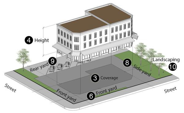
Sec. 64-2-23. - Planned Development (PD).
A.
Applicability.
1.
This section establishes planned development districts that are applied at the request of a property owner, or their authorized agent.
2.
An application for PD rezoning must include the following minimum contiguous land area:
(a)
Areas east of I-65 and north of I-10: 5 acres; and
(b)
Areas west of I-65 or south of I-10: 10 acres.
B.
Generally.
1.
Submittal requirements for PD applications and concept plans are established in article 10.
2.
The procedures for approving a PD are established in article 5.
3.
The PD district is not intended to be used as a means to reduce the standards and requirements for the development of property as otherwise required by this chapter.
4.
The PD district is available for projects that use alternative ways to implement the policies of Map for Mobile.
C.
Permitted uses. The uses permitted in the PD are established as a condition of PD approval.
D.
Dimensional and design standards.
1.
Development and performance standards for the PD zoning shall be established as a condition of PD approval.
2.
The following otherwise applicable zoning standards and regulations shall be established as part of the PD application and concept plans:
(a)
Permitted and prohibited uses;
(b)
Density;
(c)
Lot size;
(d)
Coverage;
(e)
Setbacks;
(f)
Building height;
(g)
Open or civic space;
(h)
Off-street and on-street parking and loading;
(i)
Signs;
(j)
Screening, landscaping or buffering;
(k)
Building design;
(l)
Site design;
(m)
Tree preservation;
(n)
Project phasing;
(o)
Requirements for compatibility with surrounding development.
3.
The submittal by the property owner, or their authorized agent and the approval by the city council of the concept plans is a firm commitment by the property owner, or their authorized agent that the development will comply with the approved plans.
(Ord. No. 64-017-2022, 7-12-22)
Sec. 64-2-24. - Use table.
A.
Permitted uses. The use table (see section 64-2-24.1) establishes uses permitted within each zoning district, and how they are permitted. For additional reference, please see article 8, definitions. The uses permitted in each of the zoning districts established in this article are permitted as follows:
B.
Compliance with district requirements.
1.
Any use allowed by right, by special exception, conditional use permit or as an accessory use in any district must comply with the requirements of the district in which it is located unless the board of adjustment approves a variance from those requirements.
2.
Every use in any district other than R-A, MM, ML, MH, I-1 or I-2, or as specifically noted in the use table or article 4, shall be conducted entirely within a completely enclosed structure (except for accessory uses).
3.
The following applies to all T-B districts:
(a)
Parking configuration and design.
(1)
No more than a single row of angled parking stalls shall be located between the principle structure and a street.
(2)
Minimum required parking facilities shall be in accordance with section 64-3-12 of this chapter except as follows:
a.
General business/retail/office uses:
1.
Limited to a maximum parking ratio of one (1) space per two hundred (200) square feet of gross floor area will be allowed.
2.
Any parking spaces provided in excess of the ratio of one (1) space per two hundred (200) square feet shall be of an alternative parking surface, as defined in section 64-3-12 of this chapter.
b.
Restaurants and other food/beverage uses:
1.
Limited to a maximum parking ratio of one (1) space per seventy-five (75) square feet.
2.
Any parking spaces provided in excess of the ratio of one (1) space per seventy-five (75) square feet shall be of an alternative parking surface, as defined in section 64-2 of this chapter.
(b)
Drive-thrus. Drive-thrus are not permitted in a T-B district.
(c)
Hours of operation. Hours of operation of uses located in T-B districts shall be limited to the following:
(1)
Retail: 6:00 a.m. to 10:00 p.m.
(2)
Restaurants: 6:00 a.m. to 12:00 a.m.
Table 64-2-24.1 Use Table
(Ord. No. 64-017-2022, 7-12-22)