
Myrtle Beach City Zoning Code
ARTICLE 18
- Overlay Zones
Section 1801.- Purpose and Intent
A base zoning classification, as described in Article 14 - Zoning Districts and Map, regulates all lands in the City. Properties within the City may also be subject to additional regulations provided by one of the overlay zones included in this Article. Overlay districts are established to provide for certain additional requirements, to permit uses not otherwise permitted in the underlying district, to prohibit uses allowed in the underlying district, or to establish special development requirements for uses permitted. Where an overlay zone regulates land, the regulations governing development in the overlay district shall apply in addition to those required in the base zoning district. Where overlay districts exist and there is a conflict between the requirements and/or uses specified between the overlay and the underlying district, the regulations of the overlay district shall prevail. A Zoning Map change either establishing or changing any overlay district shall be subject to the same procedures and requirements as any other Zoning Map change.
1801.A.
Branding Overlay Zones. Overlay districts are zoning districts, which are applied only in conjunction with other zoning districts, and may grant additional use or development requirements upon the underlying zoning districts. The effect is to have both the overlay district and the underlying zoning controlling the use and development of a lot. Overlay districts are applicable on an area wide basis to support specific public policy objectives and should be consistent with the Comprehensive Plan. Overlay districts may be applied to all districts and across district lines. An overlay district may be initiated as an amendment by the City Council, City Manager. Planning Commission, Planning Department or not less than 50% of the property owners in a defined area for the purposes of branding.
The City Council herein establishes a process by ordinance by which one (1) or more overlay districts pursuant to this section may be created to provide additional regulations for design standards and development within any area of the city determined to be an area that has a unique commercial, historical, architectural, natural, or cultural significance that is suitable for enhancement, branding, preservation or conservation.
Application Requirements: In consideration of a complete application, the Planning Director and the Planning Commission may require any or all of the following information and any other materials as may be deemed necessary for its review:
• Statement, photographs and maps relating to existing zoning and proposed overlay, and its relationship to the surrounding property and/or the corridor on which it is located.
• Site plan drawings and other exhibits showing the location of the existing or proposed building and site improvements, including:
o existing property boundaries, building placement and site configuration,
o location of existing parking, pedestrian access, signage, exterior lighting, fencing and other site improvements,
o relationship to adjacent land uses,
o proposed site improvements, including location of parking, pedestrian access, signage, exterior lighting, fencing, buildings and structures and other appurtenant elements, proposed building color and materials,
o relationship of building and site elements to existing and planned corridor development and
o relationship of parking, pedestrian facilities, and vehicular access ways to existing and planned corridor development.
o other site plans and subdivision plats as may be required by Planning Director and Planning Commission for its recommendation.
• A landscaping and buffer plan.
• A signage plan addressing designs for exterior signing, lighting and graphics, to include description of materials, colors placement and means of physical support, lettering style and message to be placed on signs.
Upon the establishment of an overlay district, development within the area shall conform to all zoning regulations applicable to the area and all overlay district regulations.
An ordinance establishing an overlay district shall, at a minimum, include the following provisions:
1.
An accurate description of the boundaries of the district;
2.
A description of the commercial, historical, architectural, cultural, aesthetic, natural, or other distinctive characteristics of the district that are to be preserved or conserved;
3.
The standards, guidelines, or criteria that shall govern development within the district to preserve, conserve, or protect the historical, architectural, cultural, aesthetic, commercial or other distinctive characteristics of the district. These standards, guidelines, or criteria may be set out descriptively in the ordinance or by illustration, and may incorporate by reference established architectural standards or guidelines.
Section 1802. - CP Coastal Protection Overlay Zone
1802.A.
Purpose of District. The purpose of the CP coastal protection zone is to provide supplementary regulations for oceanfront property seaward of the projected 50 year erosion control line to control erosion, preserve and maintain a recreational beach, safeguard property and promote public safety, while acknowledging the public benefit and historic location of pier structures on deeded pier lots located approximately at 14 th Avenue North, 2 nd Avenue North and 54 th Avenue North. Further, it is the intent of this section to promote the retreat of buildings, structures and other improvements located on non-pier lots from the CP district or as far landward in the district as possible. Except for the piers on pier lots, if retreat is not possible, it is intended that existing buildings may be replaced without exceeding the gross square footage of the existing building and without any portion of the footprint of the building located in the CP district being exceeded.
1802.B.
Location.
1.
All property lying seaward of the building control line and extending eastward to the corporate limit of the City of Myrtle Beach are hereby designated as the coastal protection district (overlay zone). A building control line is established at the projected 50-year shoreline (50-year future dune crest).
2.
The building control line shall be located 34 feet land-ward and parallel to the baseline defined by the most recent Baseline Coordinates as provided by the South Carolina office of Ocean and Coastal Resource Management (OCRM).
1802.C.
Permitted Uses. Only the following uses are permitted within the CP coastal protection zone:
1.
Open space
2.
Passive recreation (to include such improvements as walkways for beach access and decks)
3.
Portable lifeguard stations (to include such improvements as chairs and equipment storage bins.
4.
Pier lots may be the situs of new pier structures and permanent improvements directly related to pier structures under appropriate state and local permitting.
1802.D.
Prohibited Structures and Improvements.
1.
Erosion control structures. In keeping with the City's and the state's policy of retreat of structures threatened by erosion the following are prohibited. This prohibition extends to erosion control structures or devices intended to protect public highways.
a.
temporary or permanent sea-walls
b.
bulkheads
c.
revetments
d.
other erosion control structures or devices.
2.
Incompatible fill. Gumbo or other incompatible fill.
3.
Drains. Storm drains or pool drains that empty onto the beach.
1802.E.
Swimming Pools. Swimming pools shall be permitted on the following conditions:
1.
No pool shall be constructed seaward of the building control line unless the pool is built landward of an erosion control structure or device which was in existence, or permitted on June 25, 1990, and is built as far landward as practical;
2.
When built landward of a structure referenced in section 1802.D.1 - Erosion Control Structures no pool shall be constructed nearer than 20 feet to the baseline established by this Ordinance, measured from any vertical portion of the pool, above or below grade, which is five or more inches in total vertical measurement;
3.
No pool-related structures, except decks and safety fences, shall be allowed;
4.
Landscaping and stormwater management shall comply with primary zoning district requirements.
1802.F.
Parking. Parking is not permitted in the CP overlay zone.
1802.G.
Coastal Protection (CP) Special Requirements.
1.
South Carolina office of Ocean and Coastal Resource Management (OCRM) permit. No land use, including the reconstruction of nonconforming structures, proposed in the coastal protection district shall be permitted by the City until a permit for such land use has been granted by OCRM if such land use is subject to the permitting requirements of the South Carolina Coastal Management Act.
2.
Design standards.
a.
All walkways over dunes for access to the beach shall comply with OCRM standards:
i.
Except for single family dwellings, one walkway per lot shall be required (unless a public walkway structure exists adjacent to the lot and is connected to the principal building beach entrance by an appropriate path or walk); the walkway shall be constructed prior to the issuance of a final certificate of occupancy.
ii.
No walkway shall be located within 50 feet of another walkway on the same lot or property.
iii.
Walkways shall be located and designed to facilitate safe and convenient access from the principal building or parking area to the beach as well as to protect existing or reconstructed sand dunes.
iv.
The walkway shall be located according to the OCRM base line, shall originate on private property and shall terminate at the beach storm profile (typical winter profile) or typical profile existing;
v.
The walkway shall be constructed of wood, shall follow existing land contours and shall be no wider that six feet.
vi.
The bottom of the stringer under the decking shall provide a minimum clearance of 36 inches above the primary dune, 24 inches above secondary and tertiary dunes, and 24 inches above any back dune areas under public ownership.
vii.
All materials shall meet the standards of ASCE 24 (American Society of Civil Engineers) and FEMA regulations for flood resistant materials.
viii.
All connections to posts shall be by means of bolts.
ix.
No concrete footing shall be permitted.
x.
All construction shall meet or exceed minimum standards of "Design Standards for Permitting Process for Construction of Dune Walkovers Serving Oceanfront Properties," a copy of which may be obtained from the department of construction services.
xi.
Walkways in nonresidential areas shall include installation of a double sand fence as a pedestrian barrier or as otherwise permitted by OCRM
xii.
The walkway shall not displace sand and shall be constructed with as little environmental damage a possible.
b.
Decks, except pool decks as required by federal or state regulations, shall be made of wood, shall be less than six inches above grade and shall be no larger than 144 square feet. No decks shall be constructed seaward of the baseline or otherwise alter or affect sand dunes, dune vegetation or the beach.
1802.H
Nonconformities in the Coastal Protection (CP) Overlay Zone.
1.
Uses. The regulations of section 710 regarding nonconforming uses shall apply to existing uses which are made non-conforming by the application of the coastal protection district designation.
2.
Structures and other improvements. The regulations in this subsection shall apply to the Coastal Protection District in addition to the other applicable provisions of section 1802 - Coastal Protection Overlay Zone for those structures and other improvements made nonconforming by the application of the coastal protection district regulations. The regulations in this section shall apply in cases of conflict between them and the provisions of section 1802 - Coastal Protection Overlay Zone. The absence, in this subsection, of a provision found in section 1802 - Coastal Protection Overlay Zone shall not be considered to be a conflict, and therefore the provision of section 1802 - Coastal Protection Overlay Zone shall apply. All permanent structures or other permanent improvements which are in violation of section 1802 - Coastal Protection Overlay Zone are nonconforming. These nonconforming structures or improvements may continue in their present locations, but will be subject to the following regulations:
a.
Reconstruction (including replacement) of nonconforming buildings destroyed by man-made or natural causes shall be allowed provided that the following provisions are met:
i.
The buildings do not exceed the gross square footage;
ii.
The buildings do not have a foot print with larger dimensions than that of the buildings which existed before the enactment of this Ordinance;
iii.
The cost of reconstruction and repairs does not exceed 50% of the value of the buildings which existed before the enactment of this Ordinance;
iv.
No reconstruction is allowed which requires erosion control structures;
v.
No reconstructed building shall be placed seaward of the footprint of the building to be replaced;
vi.
New buildings conform to all landscaping requirements, parking requirements and stormwater management regulations applicable at the time of reconstruction or replacement.
b.
Reconstruction (including replacement) of a nonconforming pool, for which a building permit was issued prior to July 1, 1988, but which was destroyed by less than 50% of size due to man-made or natural causes, shall be allowed as long as the rebuilt pool is no larger than the pool being replaced, has a footprint with no larger dimensions than the destroyed pool, is located no farther seaward than the destroyed pool, and is not reinforced in a manner so as to act as an erosion control structure or device. (Added text clarifies the 50% rule) 3/22/11
c.
Bulkheads, seawalls, revetments or other permanent erosion control structures or devices which existed on June 25, 1990, shall not be repaired or replaced if, as measured by OCRM, they are destroyed more than 50 percent above grade after June 30, 2005.
i.
Before the repair or replacement of any erosion control structure is permitted, the applicant must demonstrate to OCRM and the City that all reasonable soft erosion control measures such as sand scraping, sandbagging and renourishment from an approved external sand source have been attempted and will not protect existing permanent improvements which are imminently threatened by erosion. Every effort must be made to renourish the beach and sand dune system from an external sand source approved by OCRM and the City.
ii.
All applications for the repair or replacement of an erosion control structure shall be prepared and stamped by a registered engineer in the field of civil, structural or coastal engineering licensed to practice in the State of South Carolina.
iii.
No beach sand shall be used for backfill material during the repair or replacement of any erosion control structure.
iv.
The property owner must provide stairs to the beach when an erosion control structure is repaired or replaced.
d.
In the event that a man-made or natural disaster shall damage any parking lot or portion of a parking lot seaward of the building control line so that the repair cost of the parking lot exceeds 50 percent of its replacement cost, reconstruction will only be allowed if parking lot design standards, landscaping requirements and stormwater management regulations are met subject to the primary zoning requirements.
e.
Reconstruction (including replacement) of nonconforming decks, patios or other permanent improvements destroyed less than 50% of size due to man-made or natural causes shall be allowed as long as the rebuilt improvement is no larger than the improvement being replaced, has a footprint with no larger dimensions than the destroyed improvement and is located no farther seaward than the destroyed improvement.
Section 1803. - Airport Hazard Zone for Myrtle Beach International Airport
The purpose of these provisions is to regulate and restrict the height of structures and objects of natural growth, and otherwise regulating the use of property, in the vicinity of the Myrtle Beach International Airport by creating the appropriate zones and establishing the boundaries thereof; provide for changes in the restrictions and boundaries of such zones; define certain terms used herein; and provide for enforcement in accordance with the most up-to-date provisions of Federal Aviation Regulation (FAR) Part 77. Accordingly, it is declared that:
1803.A.
The creation or establishment of an airport hazard is a public nuisance and an injury to the region served by the Myrtle Beach International Airport;
1803.B.
It is necessary in the interest of the public health, public safety, and general welfare that the creation or establishment of airport hazards be prevented.
1803.C.
The prevention of these hazards should be accomplished, to the extent legally possible, by the exercise of the police power without compensation.
1803.D.
Both the prevention of the creation or establishment of airport hazards and the elimination, removal, alteration, mitigation, or marking and lighting of existing airport hazards are public purposes for which political subdivisions may raise and expend public funds and acquire land or interests in land.
1803.E.
Myrtle Beach International Airport Zones and Imaginary Surfaces.
1.
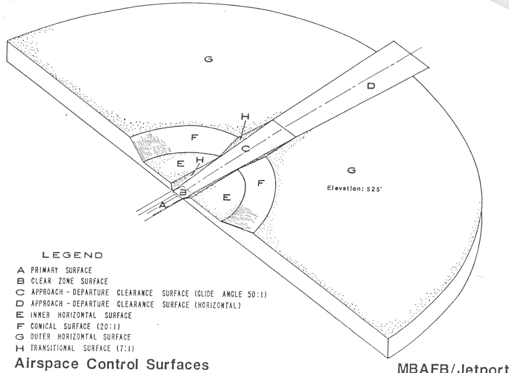
Horizontal Surface. A horizontal plane 150 feet above the established airport elevation or 180 feet above mean sea level (NGVD), the perimeter of which is constructed by swinging arcs of 10,000 feet from the center of each end of the primary surface of each runway and connecting the adjacent arcs by lines tangent to those arcs.
2.
Conical Surface. A surface extending outward and upward from the periphery of the horizontal surface at a slope of 20 to 1 for a horizontal distance of 4,000 feet, to a height of 350 feet above the established airport elevation or 380 feet above mean sea level (NGVD).
3.
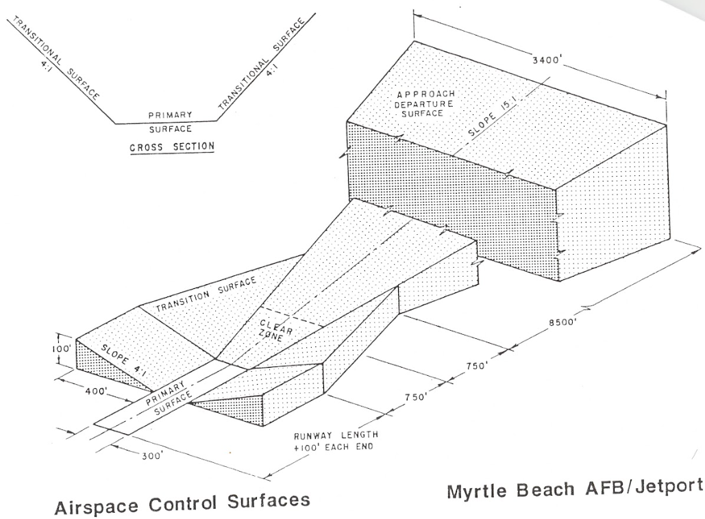
Primary Surface. A surface longitudinally centered on a runway. When the runway has a specifically prepared hard surface, the primary surface extends 200 feet beyond each end of that runway. The width of the primary surface is that width prescribed in Part 77 of the Federal Aviation Regulations (FAR) for the most precise approach existing or planned for either end of the runway. The elevation of any point on the primary surface is the same as the elevation of the nearest point on the runway centerline. The elevation of the primary surface for the Myrtle Beach International Airport is 30 feet above mean sea level (NGVD)
4.
Precision Instrument Runway Approach Surface. A surface longitudinally centered on the extended runway centerline and extending outward and upward from each end of the primary surface. An approach surface is applied to each end of each runway. The inner edge of this approach surface is the same width as the primary surface. The approach surface expands outward uniformly to a width of 16,000 feet. The approach surface extends for a horizontal distance of 10,000 feet at a slope of 50 to 1 to a height of 200 feet above the established airport elevation or 230 feet above mean sea level (NGVD); with an additional 40,000 feet at a slope of 40 to 1 to a height of 1200 feet above the established airport elevation or 1230 feet above mean sea level (NGVD).
5.
Transitional Surfaces. These surfaces extend outward and upward at right angles to the runway centerline and the runway centerline extended at a slope of 7 to 1 from the sides of the primary surface to the horizontal surface and from the sides of the approach surfaces to the conical surfaces. Transitional surfaces for those portions of the precision approach surface which project through and beyond the limits of the conical surface, extend a distance of 5,000 feet measured horizontally from the edge of the approach surface and at right angles to the runway surface.
1803.F.
Height Limitations. In order to carry out the provisions of this ordinance, there are hereby created and established certain zones which include all of the land lying beneath the horizontal surfaces, conical surfaces, primary surfaces, precision instrument approach surfaces and transitional surfaces as they apply to the Myrtle Beach International Airport. No structure or tree shall be erected, altered, allowed to grow, or be maintained to or at a height in excess of the height of any of the following zones. Nothing in this section shall be construed as prohibiting the growth, construction, or maintenance of any vegetation or structure to a height up to 50 feet above the surface of the land. For the purpose of determining the height limits in all zones set forth in this ordinance the datum shall be mean sea level (NGVD) elevation unless otherwise specified. In any zone covered by more than one height restriction, the more restrictive limitation shall prevail. Airport elevation is 30 feet above mean sea level:
1.
Precision Instrument Runway Approach Zone.
The inner edge of this approach zone coincides with the width of the primary surface and is two thousand (2,000) feet wide. The approach zone expands outward uniformly to a width of sixteen thousand (16,000) feet at a horizontal distance of fifty thousand (50,000) feet from the primary surface and extends at a slope upward one (1) foot vertically for each fifty (50) feet horizontally beginning at the end of and at the same elevation of the primary surface. The centerline of the zone is the continuation of the centerline of the runway. (Note: the approach ratio of horizontal to vertical 50:1 exists in the immediate vicinity closest to the ends of the runway surfaces. From the conical zone outward, the approach ratio is then 40:1.)
Height limitation: (50:1) Slopes upward one (1) foot vertically for each fifty (50) feet horizontally beginning at the end of an at the same elevation of the primary surface and extending to a horizontal distance of twenty-five thousand (25,000) feet, and thereafter extending at the same height for an additional distance of twenty-five thousand (25,000) feet. Structures shall not exceed fifty (50) feet in elevation above ground level or eighty (80) feet above mean sea level, whichever is less, within the area from the ends of the primary surface runways to the limit of the horizontal surface zone. Structures shall not exceed one hundred (100) feet in elevation above ground level or one hundred thirty (130) feet above mean sea level, whichever is less, within the area beginning at the horizontal surface zone (extended from the primary surface centerline of Runway 18) to the limit of the approach surface a distance of forty thousand (40,000) feet inland.
2.
Transition Zones. (7:1) Slopes upward and outward seven (7) feet horizontally for each foot vertically beginning at the sides of and at the same elevation as the primary surface and the approach zone, and extending to a height of 150 feet above the airport elevation. In addition to the foregoing, there are established height limits sloping upward and outward seven (7) feet horizontally for each foot vertically beginning at the sides of and at the same elevation as the approach zone, and extending to where they intersect the conical surface. Structures shall not exceed fifty (50) feet elevation above ground level or eighty (80) feet elevation above mean sea level.
3.
Inner Horizontal Zone. One hundred and fifty (150) feet above the airport elevation. Unless determined not to be an airport obstruction or hazard by the FAA and the Horry County Director of Airports, structures shall not exceed one hundred forty-nine (149) feet in elevation above ground level or one hundred seventy-nine (179) feet above mean sea level, whichever is less. In the event a determination is made that a structure may exceed this height limitation, required documentation must accompany any permit application for construction.
4.
Conical Zone. (20:1) Slopes upward and outward twenty (20) feet horizontally for each foot vertically beginning at the periphery of the inner horizontal zone and at 150 (150) feet above the airport elevation and extending to a height of 350 feet above the airport elevation. Unless determined not to be an airport obstruction or hazard by the FAA and the Horry County Director of Airports, structures shall not exceed one hundred forty-nine (149) feet in elevation above ground level (airport elevation) or one hundred seventy-nine (179) feet above mean sea level, whichever is less. In the event a determination is made that a structure may exceed this height limitation, required documentation must accompany any permit application for construction.
5.
Outer Horizontal Zone. Five hundred (500) feet above the airport elevation.
1803.G.
Use Restrictions. Notwithstanding any other provisions of this ordinance, no use may be made of land or water within any zones established by this ordinance in such a manner as to create electrical interference with navigational signals or radio communication between the airport and aircraft; make it difficult for pilots to distinguish between airport lights and others; result in glare in the eyes of pilots using the airport or impair visibility in the vicinity of the airport; or otherwise in any way create a hazard or endanger the landing, takeoff, or maneuvering of aircraft intending to use the airport.
1803.H.
Nonconforming Uses.
1.
Regulations not Retroactive. The regulations prescribed by this section shall not be construed to require the removal, lowering or other changes or alteration of any structure not conforming to the regulations as of the effective date of this ordinance, or otherwise interfere with the continuance of a nonconforming use. Nothing contained herein shall require any change in the construction, alteration, or intended use of any structure, the construction or alteration of which was begun prior to January 8, 1985, and is diligently prosecuted.
2.
Marking and Lighting. Notwithstanding the preceding provision of this section, the owner of any existing nonconforming structure or vegetation is hereby required to permit the installation, operation, and maintenance thereon of such markers and lights as shall be deemed necessary by the city zoning administrator to indicate to the operators of aircraft in the vicinity of the airport, the presence of such airport hazards. Such markers and lights shall be installed, operated, and maintained at the expense of the City.
1803.I.
Permits. FAA determination regarding the impact to air navigation shall be considered during the review of any permit, variance, special exception or rezoning application.
1.
Future Uses. No material change shall be made in the use of land and no structure or vegetation shall be erected, altered, planted, or otherwise established in any zone hereby created unless a permit therefore shall have been applied for and granted.
a.
However, a permit for vegetation or a structure of less than 75 feet of vertical height above the ground shall not be required in the horizontal and conical zones or in any approach and transition zones beyond a horizontal distance of 4,200 feet from each end of the runway except where such vegetation or structure, because of terrain, land contour, or topographic features, would extend above the height limit prescribed for the respective zone.
b.
Each application for a permit shall indicate the purpose for which the permit is desired with sufficient particulars to determine whether the resulting use, structure or vegetation would conform to the regulations herein prescribed. If such determination is in the affirmative, the permit shall be granted.
2.
Existing Uses. No permit shall be granted that would allow the establishment or creation of an airport hazard or permit a nonconforming use, structure, or vegetation to become a greater hazard to air navigation than it was on the effective date of this ordinance or any amendments thereto or than it is when the application for a permit is made. Except as indicated, all applications for such a permit shall be granted.
3.
Use Restriction. Notwithstanding any provisions of this ordinance, no use may be made of areas, land or water within any zone established by this ordinance in such a manner as to:
a.
Create electrical interference with navigational signals or radio communications between the airport, aircraft, and/or any Air Traffic Control Facility, whether such facility is operated by the (FAA (or its successor) or operated by a non-FAA entity; or
b.
Make it difficult for pilots to distinguish between airport lights and others, resulting in glare in the eyes of pilots using the airport or otherwise in any way creating a hazard or endangering the landing, takeoff, or maneuvering of aircraft intending to use the airport.
4.
Nonconforming Uses Abandoned or Destroyed. Whenever the City zoning administrator determines that a nonconforming vegetation or structure has been abandoned or more than 80 percent torn down, physically deteriorated, or decayed, no permit shall be granted that would allow such structure or vegetation to exceed the applicable height limit or otherwise deviate from the zoning regulations.
5.
Hazard Marking and Lighting. Any permit or variance granted may, if such action is deemed advisable to effectuate the purpose of this ordinance and be reasonable in the circumstances, be so conditioned as to require the owner of the structure or vegetation in question to permit the City, at its own expense, to install, operate, and maintain thereon such markers and lights as may be necessary to indicate to pilots the presence of an airport hazard.
6.
Zoning Variances. In granting variances to zoning requirements, and in recommending Planned Unit Developments (PUD) the Board of Zoning Appeals and the Planning Commission shall give consideration to ensure that development can be accommodated in navigable airspace without adverse impact to Myrtle Beach International Airport's aviation operations. In addition to the considerations set forth is Article 5 - Board of Zoning Appeals, consideration is also given to:
a.
The character of flying operations and planned development of Myrtle Beach International Airport.
b.
Whether construction or development would cause an increase in the minimum descent altitude or the decision height at Myrtle Beach International Airport.
c.
The safe and efficient use of navigable airspace.
d.
The cumulative effects on navigable airspace of all existing structures, proposed structures identified in the Myrtle Beach and Horry County Comprehensive Plans, and all other known proposed structures in the area.
e.
Federal Aviation Administration (FAA) determinations and results of aeronautical studies conducted by or for the FAA.
f.
Federal Department of Transportation (FDOT) comments and recommendations, including FDOT findings relating to flight standards and guidelines.
g.
Comments and recommendations from the Horry County Department of Airports.
Section 1804. - Priority Investment Zone
1804.A
Purpose of district. To encourage private development in areas identified by the City as being in need of revitalization.
1804.B
Procedure. The City may adopt market-based incentives or relax or eliminate nonessential housing requirements to encourage private development in a priority investment zone.
1804.C
Applicability. The City may, by ordinance, create a priority investment zone, defining its boundaries in such a way as to encompass a geographic area in which private redevelopment is essential to the well being of the area.
Section 1805. - Booker T. Washington Neighborhood Overlay Zone
1805.A
Purpose: The purpose of the Booker T. Washington Overlay Zone is to allow the re-establishment of residential development consistent with the history of the neighborhood and to increase the protection of the residential quality of life by regulating certain land uses that present a threat to the quality of life in the neighborhood.
1805.B.
Notwithstanding any other provision of law and within a lot wholly within the overlay, a nonconforming existing unoccupied structure that had previously engaged in multifamily land use may be renovated within its current footprint to the current building code, if,
1.
within a timeframe ending February 13, 2014, the structure is closed, maintained and secured from the elements, and from trespass in accordance with the ordinances pertaining thereto in Chapters 6, 9, and 10 of the Code of Ordinances of the City of Myrtle Beach; and
2.
on or before June 1, 2018, renovation is commenced as shown by the letting of a building permit.
3.
Failure to close, maintain and secure the unoccupied property by February 13, 2014, and in accordance with the ordinances pertaining thereto in Chapters 6, 9, and 10 of the Code of Ordinances of the City of Myrtle Beach, constitutes a waiver by the property owner to claim applicability of this law allowing renovation to the property, and the multifamily land use is thereafter deemed abandoned, and the ordinances in Chapters 6, 9, and 10 of the Code of Ordinances shall apply regarding buildings.
4.
Failure to obtain a building permit on or before the date of June 1, 2018 after appropriate closure and securing as set forth above in Section 1806.B.1 constitutes a waiver by the property owner to claim applicability of this law to the property, and the multifamily use is thereafter deemed abandoned, and the ordinances in Chapters 6, 9, and 10 of the Code of Ordinances shall apply regarding buildings.
1805.C.
Specific Land Uses in the MP and MU-M zones restricted. Nightclubs, bars, or other business that permit the on-site consumption of alcoholic beverages are prohibited within the boundaries of the overlay zone.
1805.D.
Existing religious establishments within the Booker T. Washington Overlay Zone are permitted one freestanding sign in accordance with the underlying zoning district sign regulations. A freestanding sign for a religious establishment may include a manual changeable copy or Changeable Electronic Variable Message Sign (CEVMS) area up to 18 square feet or 20 percent of the allowable sign area, whichever is greater. CEVMS shall conform to the standards set forth in section 808.C.
(Ord. No. 2024-63, 10-22-24)
Section 1806. - Seahawk District Overlay Zone
1806.A.
Purpose: The Seahawk District is intended to showcase the collective campuses of the Myrtle Beach schools and their shared association with the Seahawk mascot.
Description of the commercial, historical, architectural, cultural aesthetic, natural and/or other distinctive characteristics of the Seahawk District:
The Seahawk District is made up of the parcels from 29st Avenue North to 38 th Avenue North, and from North Oak Street to the Robert M. Grissom Parkway, inclusive of all parcels owned by the Horry County Board of Education, the City of Myrtle Beach, or any combination thereof as well as the South Atlantic Bank branch. The intent of the district is to showcase the area associated with the Myrtle Beach schools. Meetings were held with stakeholders, including school staff, school district staff, and members of the Myrtle Beach Cluster K-5 School Improvement Council. There was a strong desire on the part of all stakeholders to support the creation of a district to recognize the significance of the Seahawks in the community.
The Seahawk District is unique in that it contains Myrtle Beach's Primary, Elementary, Intermediate, Middle, and High Schools on a shared urban campus. They all use the Seahawk as their mascot, so there is a collective pride in the area tied to the schools as well as the athletic facilities which serve a host of athletic and special events outside of those sponsored by the schools. They City of Myrtle Beach's Pepper Geddings Recreational facility is there, as well as the Grand Strand Miracle League's James C. Benton Field.
The desires expressed by many of the stakeholders is that the ideas enumerated in this ordinance can be designed and implemented to be consistent with various school designs, while creating a contiguous unifying theme. Safety is also an overarching theme, with all consideration being made to maintain the safety of the children attending the schools.
1806.B.
The standards, guidelines, or criteria governing development within the Seahawk District to preserve, conserve, protect, and/or enhance the commercial, historical, architectural, cultural aesthetic, natural and/or other distinctive characteristics of that Seahawk District. These standards, guidelines, or criteria collectively are collectively designated as the Seahawk District Overlay Zone.
1.
Signs Permitted in the Seahawk District:
a.
Signs allowed in Section 805.A (Single Family Residential Districts).
b.
Primary entrance identification signs, in a monument style sign, with digital message boards that conform to Section 808 of the zoning ordinance and are not larger than eight feet (8') high and six feet (6') wide, subject to the following condition: Digital sign face shall be no more than 24 square feet of the sign face.
c.
Primary entrance features with columns and arches at a minimum clearance of 14 feet and that provides clearance enough for public safety, public works, and school bus clearance, in the following locations:
i.
33rd Ave N, west of N Oak St, and
ii.
Seahawk Way, east of Grissom Pkwy.
d.
Uniform building identification signage of the size allowed under Section 805 of the zoning ordinance.
e.
All traffic entrances clearly marked for pick up/drop off; signage for the entrances shall not be more than six ( 6) square feet, no part higher than four feet (4') higher than the closest adjacent sidewalk, and shall not interfere with sight triangles.
f.
Banners for uniform style street lights and posts.
g.
Murals on buildings that tie in with the Seahawk theme.
h.
Areas for recognition of current and past school achievements that are fully located out of the public rights-of-way.
2.
Pedestrian features associated with the Seahawk District:
a.
Specially designed themed pedestrian crosswalks that provide safe walking areas across public rights-of-way and internally in the district.
b.
Sidewalk and street art to celebrate the contributions of the Seahawks to the district.
c.
Speed bumps or other traffic calming devices to slow traffic.
i.
If traffic islands are used, landscaping is encouraged as part of the design.
ii.
No traffic calming devices shall slow down emergency vehicle response times.
3.
Amenities associated with the Seahawk District
a.
Pedestrian walking and cycling areas that connect the schools
b.
Uniform style street lights and posts
c.
Wayfinding signage for building and amenity locations
d.
Create a campus-wide park/playground area with landscaping and grass
e.
Emergency call boxes near Pepper Geddings Center and Doug Shaw Stadium
Section 1807. - OCEAN BOULEVARD ENTERTAINMENT OVERLAY DISTRICT (OBEOD)
1807.A
Purpose and intent. The City of Myrtle Beach finds that:
1.
Without debate, the City's economic engine is tourism.
2.
Sustaining tourism is essential to maintain our standard of living, the funding of our amenities for our citizens and for the preservation of property values.
3.
Tourism is threatened by perceived unseemliness or unsafety in any particular area.
4.
The perception of unseemliness or unsafety is, to large degree, a product of atmosphere.
5.
The atmosphere of a location is comprised of many factors, one of which is whether a location is suitable and safe for children, and families.
6.
One component of atmosphere for a location is the proliferation of retail offerings of businesses in that area, that are not family attractive.
7.
Certain retail offerings create an atmosphere that is repulsive to mothers and fathers in the care of their children, in that retail outlets are promoting crudity and sexually explicit apparel, drug paraphernalia, and consumables that mimic and promote drug and substance consumption.
8.
The purpose of the Ocean Boulevard Entertainment Overlay District (OBEOD) is to establish a family friendly entertainment and retail land use, and encourage compatible land uses, ensure higher quality development and business uses and function in order to protect property values and provide safe and efficient pedestrian and automobile access.
9.
These retail restrictions and criteria can encourage quality development and economic growth while continuing to provide for a wide range of economic development opportunities throughout the City for those uses which are incompatible with the OBEOD.
10.
The displacement of CBD consumables, smoke shops and tobacco stores is necessary and in the interests of the public health, safety and general welfare because there is the substantial likelihood of the establishment and operation of expanded retail offerings of CBD consumables, smoke shops and tobacco stores in the OBEOD.
11.
The continued operation and expansion of these family adverse retail offerings in the overlay would result in undesirable impacts to the public economy of the overlay.
12.
Among these impacts are increased potential for CBD consumables and tobacco sales to minors, greater opportunity for the sale of illegal drug paraphernalia that is marketed as tobacco paraphernalia, and heightened risk of negative aesthetic impacts, blight, and loss of property values of residential neighborhoods and businesses in close proximity to such uses.
13.
This overlay contains amendments consistent with good zoning and planning practices to address such negative impacts of smoke shops and tobacco stores while providing a reasonable number of locations and zones for such shops/stores to locate within the city of Myrtle Beach.
14.
The OBEOD is intended to encourage mixed-use within the same structure or block and/or high intensity commercial development, which provides a wide array of entertainment and retail options, without the current family unfriendly environment promoting unhealthy tobacco use, crudity and the stigma of drug use and paraphernalia.
15.
In the event of a conflict between the entitlements, regulations or standards established in the OBEOD, and the equivalent provisions in the underlying zoning districts, the provisions of the OBEOD shall govern.
16.
Families are the center of all communities, the building blocks of our city and the basis of a sustained tourism economy. The Council is determined to see a "family friendly lens" placed over all policies, strategies and initiatives undertaken and supported by the Council.
1807.B
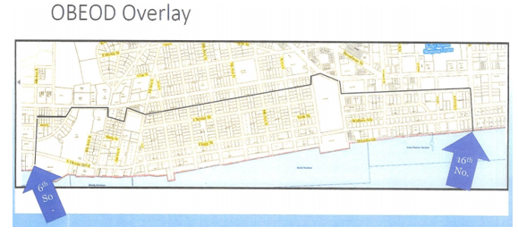
Boundaries. The boundaries of the OBEOD are as indicated in the attachment to Ordinance 2017-23 as shown below:
1807.C
Definitions:
ALTERNATIVE NICOTINE PRODUCT. A product or device not consisting of or containing tobacco that provides for the ingestion into the body of nicotine, whether by chewing, smoking, absorbing, dissolving, inhaling, snorting, sniffing, or by any other means.
ALTERNATIVE NICOTINE PRODUCT does not include cigarette, smokeless tobacco, other tobacco products, or any other product approved by the United States Food and Drug Administration as a non-tobacco product for sale as a tobacco cessation product, as a tobacco dependence product, or for other medical purposes, which is being marketed and sold solely for that approved purpose.
BARKER. A person who stands in front of a business, theater, sideshow, etc., and calls out to passersby to attract customers.
BUSINESS OPERATOR. Any person who owns, leases, operates or manages or is employed by a business establishment.
CANNABIS PRODUCT. A product originating from the species Cannabis Sativa L., excluding marijuana as defined by South Carolina law in 44-53-110 (27(a), and shall include all forms of Cannabis or low-THC Cannabis products (CBD) to be consumed or applied.
CANNABIS DISPENSING BUSINESS. A business offering for sale CBD, Cannabis or Derivative Cannabis Products.
CBD. Cannabidiol, a chemical compound from the species Cannabis Sativa L., of the family Cannabaceae.
E-CIGARETTE. Any electronically actuated device or inhaler meant to simulate cigarette smoking that uses a heating element to vaporize a liquid solution, popularly referred to as "juice," and that causes the user to exhale any smoke, vapor, or substance other than that produced by unenhanced human exhalation. The juice used in e-cigarettes typically contains nicotine, and for this reason e-cigarettes and their juice can be classified as both tobacco products and tobacco paraphernalia.
SMOKE OR SMOKING. The carrying, smoking, burning, inhaling, or exhaling of any kind of lighted pipe, cigar, cigarette, hookah, weed, herbs, or any other lighted tobacco product in any manner or in any form and shall also include the inhaling, exhaling, burning or carrying any alternative nicotine product or vapor product as defined in this chapter.
SMOKE SHOP AND TOBACCO STORE. Any premises with more than an incidental display, sale, distribution, delivery, offering, furnishing, or marketing of alternative nicotine, alternative nicotine delivery product, vapor product, e-cigarette, single cigarette tobacco, tobacco products, or tobacco paraphernalia; provided however the incidental retail of commonly available packaged packs. cartons or boxes of cigarettes and cigars are not regulated herein. Incidental retail means accounting for Less than ten (10) % of the retail offerings.
TOBACCO AND TOBACCO RELATED PRODUCTS. Items, including but not limited to cigarettes and any product containing, made, or derived from nicotine or tobacco that is intended for human consumption, whether chewed, smoked, absorbed, dissolved, inhaled, snorted, sniffed, or ingested by any other means, including by vaping, or any component, part, or accessory of a tobacco product; cigars; pipe tobacco, cheroots; stogies; perique; granulated, plug cut, crimp cut, ready rubbed, and other smoking tobacco; snuff; snuff flour; cavendish; plug and twist tobacco; fine cut and other chewing tobaccos; shorts; refuse scraps, clippings, cuttings and sweepings of tobacco; dipping tobaccos; and other kinds and forms of tobacco. Tobacco excludes any tobacco product that has been approved by the United States Food and Drug Administration for sale as a tobacco cessation product, as a tobacco dependence product, or for other medical purposes, and is being marketed and sold solely for such an approved purpose.
TOBACCO PARAPHERNALIA. Any paraphernalia, equipment, device, or instrument that is designed or manufactured for the smoking, chewing, absorbing, dissolving, inhaling, snorting, sniffing, or ingesting by any other means into the body of tobacco, tobacco products, or other controlled substances as defined in South Carolina Code of Laws 44-53-110 (33). et seq. Items or devices classified as tobacco paraphernalia include but are not limited to the following: pipes, punctured metal bowls, bongs, water bongs, electric pipes, e-cigarettes, e-cigarette juice, buzz bombs, vaporizers, hookahs, and devices for holding burning material. Lighters and matches shall be excluded from the definition of tobacco paraphernalia. It further includes items designed or manufactured and which may be used in ingesting, inhaling, or otherwise introducing marijuana, cocaine, hashish, hashish oil, PCP, methamphetamine, or amphetamines, tobacco or tobacco related products into the human body, such as-
1.
metal, wooden, acrylic, glass, stone, plastic, or ceramic pipes with or without screens, permanent screens, hashish heads, or punctured metal bowls;
2.
water pipes;
3.
carburetion tubes and devices;
4.
smoking and carburetion masks;
5.
roach clips: meaning objects used to hold burning material, such as a marijuana cigarette, that has become too small or too short to be held in the hand;
6.
miniature spoons with level capacities of one-tenth cubic centimeter or less;
7.
chamber pipes;
8.
carburetor pipes;
9.
electric pipes;
10.
air-driven pipes;
11.
chillums;
12.
bongs;
13.
ice pipes or chillers;
14.
wired cigarette papers; or
15.
cocaine freebase kits.
16.
rolling papers
VAPOR PRODUCT. Any non-combustible product, which may or may not contain nicotine that employs a heating element, power source, electronic circuit, or other electronic chemical or mechanical means, regardless of shape or size that can be used to produce vapor from a solution or any other form. VAPOR PRODUCT includes any electronic cigarette, hookah, electronic cigar, electronic cigarillo, electronic pipe, hookah pipe or similar product or device, as well as any vapor cartridge or other container that is intended to be used with or in an electronic cigarette, electronic cigar, electronic cigarillo, electronic pipe, or similar product or device. VAPOR PRODUCT does not include any product regulated as a drug or device by the United States Food and Drug Administration under Chapter V of the Food, Drug, and Cosmetic Act.
MERCHANDISE. Without limitation, any article, object, substance, compound, elixir, preparation, banner, button, clothing (including hats), figurine, game, greeting card, magnet, photograph, postcard, novelty item, poster, sculpture, souvenir, sticker, towel, apparel or similar item, whether or not the item is offered for sale.
SEXUALLY ORIENTED MERCHANDISE. Any merchandise which graphically or by symbol or symbols depicts, describes, portrays, pictures by way of realistic, naturalistic or cartoonish representation human or animal sexual activities or specified anatomical parts. This shall include any depiction or description, by pictorial representation or language, of any sexual intercourse; masturbation; sadomasochistic abuse; sexual penetration with an inanimate object; sodomy; bestiality; uncovered genitals, buttocks, or female breast; defecation or urination; covered genitals in an obvious state of sexual stimulation or arousal; or the fondling or other erotic touching of genitals, the pubic region, buttocks or female breasts, or merchandise of that subject.
1807.D
The following retail business uses are prohibited in the OBEOD:
1.
Smoke shops and tobacco stores.
2.
Retail merchandising or of alternative nicotine, alternative nicotine delivery product, vapor product, e-cigarette, tobacco paraphernalia or cannabis products.
3.
Retail merchandising of tobacco or tobacco products of more than an incidental nature.
4.
Retail merchandising or display of sexually oriented merchandise, as defined herein. Any display of sexually oriented merchandise qualifies the retail operation as a sexually oriented business, which must be located in a permitted zone.
5.
Providing space for a "barker" for a business not located at the premises.
1807.E
Amortization.
Retail stores offering space for the prohibited retail business uses that are operating on the effective date of the ordinance codified in this overlay are hereby declared immediately nonconforming as of the date of second reading, and shall be amortized as to the nonconformity, and must cease the nonconforming portion of their retail offerings no later than December 31, 2018.
1807.F
Business License impacts.
1.
Only businesses that discontinue the incompatible retail uses are subject to business license renewal.
2.
After the date of amortization, continued nonconforming shall result in business license suspension until conformity is achieved, or revocation of the business license.
1807.G
Severability
It is hereby declared to be the intention of the City Council that the words, phrases, clauses, sentences, paragraphs and sections of this ordinance are severable and if any phrase clause sentence paragraph or section of this ordinance shall be declared unconstitutional by the valid judgment or decree of any court of competent jurisdiction such unconstitutionality shall not affect any of the remaining words, phrases clauses, sentences, paragraphs and sections of this ordinance since the same would have been enacted by the City Council without the incorporation in this ordinance of any such unconstitutional phrase clause sentence paragraph or section, and the remainder shall not be affected thereby and shall remain in full force and effect.
Section 1808. - Short-Term Rental Conversion (STRC) Overlay Zone
1808.A
Purpose: To sustain the economic vitality of the Myrtle Beach oceanfront by preserving and enhancing tourist accommodations between Kings Highway and the Atlantic Ocean.
1808.B
Conversion Prohibited: No building or structure consisting of more than two (2) units, including each unit within such building or structure, that was constructed or used as a Visitor Accommodation, commonly known as short term rental, may be used for rental or lease for ninety (90) continuous days or more. It shall be a violation of this prohibition to enter into successive leases or rental agreements, each for less than ninety (90) days, for the purpose of allowing an occupant to remain for more than ninety (90) continuous days.
1808.C
Location: This section applies to all commercial uses listed in City of Myrtle Beach Code of Ordinances, Appendix A Zoning, Article 14, Section 1407.C located between Kings Highway and the Atlantic Ocean within the municipal limits.
1808.D
Exception: Owners of units within the overlay zone that are legally operating with a business license for long term rental at the time of adoption may continue to use the licensed unit as a long-term rental so long as the owner maintains the business license for long term rental.
(Ord. No. 2024-69, 12-10-24)

