
New Bern City Zoning Code
ARTICLE XXII
COMMERCIAL ENTRANCEWAY CORRIDOR OVERLAY DISTRICTS
Section 15-450. - Commercial entranceway corridor district statement of purpose.
The commercial entranceway corridor district is an overlay district designed to visually enhance and provide for the orderly development of the city's primary connector and arterial streets which serve as "gateways" into the city. A site plan review process regulates the development of structures and sites in a manner which considers the following concerns and, where necessary, requires modification of development proposals to eliminate or minimize potential problems and nuisances, and to encourage architecturally and aesthetically integrated development in accordance with adopted architectural and site design guidelines. The principal areas of interest are:
(a)
Protection of property values;
(b)
The balancing of the landowner's rights to use his land, with the corresponding right of abutting and neighboring landowners to live without nuisances such as noise, smoke, fumes, odors, and glare of lights, visual pollution, etc.;
(c)
The convenience and safety of vehicular and pedestrian movement within the site, and in relation to adjacent areas or roads;
(d)
Minimizing the area over which existing vegetation is to be removed. Where tree removal is necessary, special attention shall be given to replacement trees;
(e)
Applicant's efforts to integrate the proposed development into the existing landscape, or to create a new "image" streetscape through design features such as vegetative buffers, roadside plantings, and the retention of open space; and
(f)
The building setbacks, area, and location of parking, architectural compatibility, and how these features harmonize with the surrounding developments and the natural landscape.
Section 15-451. - Commercial entranceway corridor district established.
Commercial entranceway corridor districts are hereby established as districts which overlay existing zoning districts for the primary connector and arterial streets that are located within the city's planning jurisdiction. Portions of Broad Street, Queen Street, Trent Road, Glenburnie Road, Neuse Boulevard, and U.S. Highway 17 (Clarendon Boulevard) shall be subject to the provisions of this article in addition to all other applicable requirements of the City of New Bern's land use ordinance. The extent and boundaries of said districts are indicated on the official zoning map of the City of New Bern, prepared by the engineering department of the City of New Bern, a copy of which is on file in the office of the city engineer.
Section 15-452. - Reserved.
Editor's note— Ord. No. 16-047, § 70, adopted September 13, 2016, repealed § 15-452 in its entirety. Former § 15-452 pertained to "Projects requiring site plan review," and was derived from Original Code.
Section 15-453. - Reserved.
Editor's note— Ord. No. 16-047, § 71, adopted September 13, 2016, repealed § 15-453 in its entirety. Former § 15-453 pertained to "Exemptions from site plan review," and was derived from Original Code.
Section 15-454. - Reserved.
Editor's note— Ord. No. 16-047, § 72, adopted September 13, 2016, repealed § 15-454 in its entirety. Former § 15-454 pertained to "Procedure," and was derived from Original Code.
Section 15-455. - Reserved.
Editor's note— Ord. No. 16-047, § 73, adopted September 13, 2016, repealed § 15-455 in its entirety. Former § 15-455 pertained to "Site plan submission requirements," and was derived from Ord. No. 2013-239, § 6, adopted October 22, 2013.
Section 15-456. - Reserved.
Editor's note— Ord. No. 16-047, § 74, adopted September 13, 2016, repealed § 15-456 in its entirety. Former § 15-456 pertained to "Enforcement," and was derived from Original Code.
Section 15-461. - General scope and commentary.
Due to the wide variety of commercial uses that are permitted in the city's established commercial districts and the differences in development patterns that currently exist in the city's primary connector and arterial streets, it is neither practical nor desirable to develop a single set of design guidelines and performance standards which would apply uniformly to each of the city's commercial entranceway corridor districts, with the exception of subsection (a) below. Therefore, guidelines and standards have been specifically tailored to each specific corridor identified in section 15-451. Despite differences that do exist, however, each set of guidelines and standards is meant to facilitate an orderly pattern of architecturally and aesthetically integrated development in the city's designated gateway corridors as detailed in part I of this article.
(a)
Colors. The exterior color finish of all buildings, excluding single-family and two-family dwellings shall be of low reflectance. High intensity colors, such as fluorescent colors, shall be prohibited. Black is prohibited when used on more than twenty-five percent (25%) of any one exterior wall surface.
(Ord. No. 2013-239, § 7, 10-22-13; Ord. No. 16-047, § 75, 9-13-16; Ord. No. 17-018, § 1, 5-30-17)
Section 15-462. - Design guidelines and performance standards—Broad/Queen Street Corridor.
(a)
Statement of intent. Historically, Broad Street Corridor, extending from Bern Street on the east to Fort Totten Drive on the west, and Queen Street, extending from First Street on the west to West Street on the east, have served as the commercial center of New Bern's "Five Points" Neighborhood. Originally comprised of neighborhood-related businesses that catered to a walk-in trade in a pedestrian-oriented environment, the Broad/Queen Street Corridor eventually developed into a "commercial strip" corridor that accommodated primarily vehicular-oriented businesses that placed little emphasis on the pedestrian. The result of this transition from pedestrian-oriented to vehicular-oriented businesses was the creation of a "cluttered" landscape and a "confusing" pattern of development that lacks any organizational structure. The intent of the design guidelines and performance standards outlined in subsection (b) of this section is to provide a series of developmental controls designed to create a unified "image" streetscape for the Broad/Queen Street Corridor by ensuring a development pattern that is consistent with historic building traditions in the Five Points commercial center and reestablishing a balance between the vehicular and pedestrian environments.
(b)
[Standards.] All developments in this corridor requiring site plan review as outlined in section 15-452 of this article, as well as public improvements, shall comply with the following standards:
Required:
(1)
Private developments (new construction).
(a)
Buildings (new construction) shall be located at the front property line of the site, or within ten feet thereof. There is no minimum side yard setback. The rear yard setback shall be governed by section 15-187.
(b)
Buildings shall generally be one, two or three stories in height, not to include cornices, parapet walls, towers, or other similar rooftop appurtenances.
(c)
Buildings to be erected in this corridor shall be designed so as to incorporate features and forms that are consistent with older commercial buildings found in the Broad Street/Queen Street Corridor, the Five Points commercial area (i.e., in the vicinity of the intersection of Broad, Queen, and Roundtree Streets), and in the downtown commercial district. These new buildings shall be constructed of materials that are consistent with the materials used in the construction of the said older commercial buildings. Typically, a commercial building was oriented to the street and was constructed with a storefront on the first-floor facade with the primary building entrance facing the street. A storefront incorporated large paned windows for the display of merchandise and had a recessed entry, usually located in the center of the facade. The storefront was capped by a decorative wooden cornice which included a flat panel for the placement of signage. The upper stories of the building, if any, had windows that were smaller in dimension and vertical in their orientation. The building was capped by a wooden cornice, patterned brickwork, or parapet wall that helped to define the facade and contribute to the building's overall character. (See sketch entitled "Elements of the Facade.") Wood, brick, or concrete block (both rusticated and smooth) were predominant finish treatments and shall be used on new construction located in this corridor. Buildings of contemporary design that incorporate the above-mentioned design elements are encouraged. Further information regarding design standards for commercial buildings are contained in the New Bern urban design plan, which was adopted by the board of aldermen on December 11, 1990.
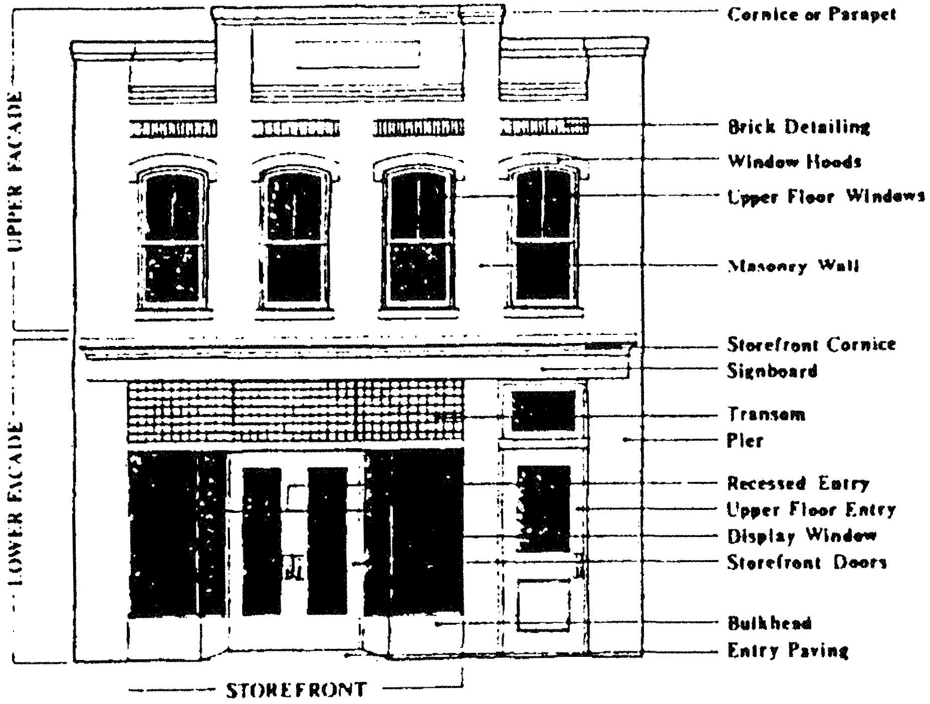
Elements of the Facade
(d)
To encourage the pedestrian oriented environment of this corridor, the number of parking spaces required by section 15-342 may be reduced a maximum of 50 percent. Parking shall be prohibited from the front yard of any principal building and shall be located solely in the side or rear yards of the said building. In cases were parking is located on the side of a principal building, a semi-opaque type B planting screen, as defined in section 15-364 of article XIX, along the public sidewalk shall be installed to screen the parking area from the street. The said planting screen shall constitute compliance with a percentage of the planting requirements detailed in article XIX of this ordinance. However, the permit issuing authority may permit deviations from the requirements of article XIX in order to accommodate the development patterns promulgated by this section.
(e)
Each development under single ownership shall be limited generally to one driveway access onto Broad Street which shall provide both points of ingress and egress. In cases where it is deemed by highway authority's traffic engineer and the city that more than one driveway access would provide a more efficient circulation pattern within the development and would promote improved traffic safety on Broad Street and Queen Street, one additional driveway access into the development may be permitted. Shared driveway access between two neighboring developments shall also be recommended as a suitable alternative to the above-mentioned requirement. In such cases, it is recommended that the driveway midpoint be the property line between the two parcels. The driveway must meet standard specifications, and the estimated driveway volume will be the sum of the trip generation rate of both land uses in question.
When two adjacent property owners agree to establish a shared driveway, the city shall grant an incentive bonus. The total lot size and road frontage normally required will be reduced by 15 percent for each development. In addition, the required number of parking spaces will be reduced by 15 percent for each development. Site circulation and safety standards will still be enforced.
(f)
Signs in the Broad/Queen Street Corridor shall comply with the provisions outlined in article XVII (Signs) as well as the following standards:
(1)
For any one sign, including frame and supports, there shall be no more than three colors and no more than two lettering styles;
(2)
At least one of the colors in each sign shall match the predominant colors in the building; and
(3)
Signs should be compatible with the building or development in terms of design, scale, and materials.
(2)
Public streetscape improvements (to be implemented at the time of the narrowing of Broad Street).
(a)
A concrete strip, measuring two to three feet in width, shall be installed at the back of the curbline for placement of utility poles and streetlights.
(b)
A planting strip, measuring eight feet to ten feet in width, shall be installed next to the concrete utility strip. Strip to be planted with canopy and/or small deciduous trees placed every 30 feet. For image consistency purposes, one street tree species shall be planted along the corridor's length. The selection of such tree species shall be determined by the city groundskeeper based upon an evaluation of those species that are most suitable for urban conditions.
(c)
A concrete sidewalk shall be installed next to the planting strip. The sidewalk shall be a minimum of eight feet in width and shall be scored every six feet.
(d)
Utility lines should be placed underground or consolidated to reduce visual clutter.
(Ord. No. 1998-3, §§ 1—3, 1-13-98)
Section 15-463. - Design guidelines and performance standards—Trent Road Corridor.
(a)
Statement of intent. Formerly a residential street consisting of single-family houses set back on large wooded lots, Trent Road, extending from U.S. Highway 17 on the south to Ninth Street on the north, over the past decade, has become increasingly more commercialized. Commercial developments that have occurred have largely ignored the traditional residential patterns of development in terms of building scale, massing, placement, orientation, and materials. The intent of these guidelines and performance standards is to ensure an orderly pattern of commercial development that is compatible with surrounding residential uses and serves to reinforce the residential character that has distinguished Trent Road from other entranceway corridors in the city.
(b)
Standards. All developments in this corridor requiring site plan review, as outlined in section 15-71 of this article, shall comply with the following standards:
(1)
Driveway access requirements shall be the same as those required in section 15-462(b)(1)(e) for access onto Trent Road.
(2)
All on-site utilities shall be located underground unless required by the city or other utility to be placed otherwise. In cases where utilities are not placed underground, said utilities shall be consolidated to reduce visual clutter.
(3)
Those portions of a principal building visible from the street right-of-way shall be sheathed in materials of a type commonly found in residential and earlier commercial construction such as wood siding, brick, stone, or other masonry construction (excluding cinderblock or regular concrete block).
(4)
Buildings should maintain a scale, massing, and orientation that is compatible with surrounding residential buildings. No more than 40 percent of the facade facing the entranceway corridor should be of glass or reflective material.
(5)
Signs should be compatible with the building in terms of design, scale, color, and materials.
(Ord. No. 16-047, § 76, 9-13-16; Ord. No. 18-020, § 1, 4-10-18)
Section 15-464. - Design guidelines and performance standards—Glenburnie Road Corridor.
(a)
Statement of intent. Glenburnie Road functions as one of the city's major north-south thoroughfares and plays a crucial role in serving as a connector with Trent Road, U.S. Highway 17 (Clarendon Boulevard), U.S. Highway 70, Neuse Boulevard, and Oaks Road. Due to the high traffic volumes that the road is equipped to handle and the large-scale residential development that is taking place to the west of the thoroughfare, development pressures along the Glenburnie Road Corridor, which extends from Neuse Boulevard on the North to Trent Road on the South, have intensified. Once lined by large, wooded, undeveloped tracts of land that gave the road a forested edge, Glenburnie Road in recent years has become a prime location for office and institutional parks, "strip" shopping centers and commercial developments. The intent of these guidelines and standards is to provide for an orderly development of office, institutional, and commercial uses within the context of an office or commercial park setting which reflects the once densely wooded character of Glenbumie Road.
(b)
[Standards.] All developments in this corridor requiring site plan review, as defined in section 15-452, shall comply with the following standards:
(1)
Buildings shall maintain a minimum front yard setback of 35 feet to 50 feet from the street right-of-way.
(2)
Those portions of the principal building visible from the street right-of-way shall be sheathed in materials such as wood siding, stone, brick, or other masonry materials (excluding cinderblock or regular concrete block).
(3)
Driveway access requirements shall be the same as those required in section 15-462(f) [15-462(e)].
(4)
All on-site utilities shall be located underground unless required by the city or other utility to be placed otherwise. In cases where utilities are not placed underground, said utilities shall be consolidated to reduce visual clutter.
(5)
No more than 60 percent of the facade of any principal building facing the highway should be glass or reflective material.
(6)
Flat-roofed buildings should be concealed by parapet walls on all sides of the building or be capped by a cornice treatment that provides articulation to the roofline.
(7)
Existing regulated trees should not be disturbed within 25 feet of the property line that abuts the street right-of-way. This area should be labeled as "open space setback." No structures, fences, walls, or parking area should be placed in this setback area. Such open space setback should constitute fulfillment of 50 percent of the planting requirements detailed in article XIX.
In the event the placement of an open space setback zone within the first 25 feet of the property is not possible due to drainage problems or other site development constraints, the property owner should provide the same amount of open space setback elsewhere on the lot.
(8)
Signs should be compatible with the building or development in terms of design, scale, and materials.
(9)
Wherever possible, a planting area, measuring an average of five feet in width, should be provided around the periphery of all principal buildings in a development. Said planting shall constitute fulfillment of a percentage of the planting requirements detailed in article XIX.
(Ord. No. 16-047, § 77, 9-13-16)
Section 15-465. - Design guidelines and performance standards—Neuse Boulevard Corridor.
(a)
Statement of intent. As one of the city's major thoroughfares, Neuse Boulevard has experienced intense commercial development over the past three decades. The incremental nature of development has created a streetscape of competing land uses which lacks any sense of visual unification or connection with the traditional character of New Bern. Factors such as the limited amount of public right-of-way available for landscape improvements, the tendency for developments to concentrate parking in the fronts of buildings with little allocation of land for landscaping, a large number of curb cuts, and the obstruction caused by overhead utilities and large freestanding signage have complicated possibilities for achieving comprehensive corridor improvements. The intent of these guidelines and performance standards is to create some degree of gradual visual unification and consistent streetscape improvements which will help to make the Neuse Boulevard Corridor, extending from Clarendon Boulevard on the east to the fork at Washington Post Road on the west, a more attractive streetscape in New Bern.
(b)
[Standards.] All developments in this corridor requiring site plan review, as defined in section 15-452 of this article, shall comply with the following standards:
(1)
Those portions of the principal building visible from the street right of way shall be sheathed in materials such as wood siding, stone, brick or other masonry material (excluding cinderblock or regular concrete block.
(2)
Driveway access requirements shall be the same as those required in section 15-462(f)[15-462(e)]
(3)
No more than 60 percent of the facade of any principal building facing the highway corridor should be of glass or reflective material.
(4)
Flat-roofed buildings should be concealed by parapet walls on all sides or capped by a cornice treatment that provides articulation to the roofline.
(5)
Signs should be compatible with the building or development in terms of design, scale, and materials.
(6)
A standard planting treatment of flowering tree clusters consisting of crepe myrtle and low-growing shrubbery should be planted at all major intersections and shall be maintained by the city. All planting treatments shall be located so as not to obscure sight lines to traffic. In cases where limited public right-of-way makes such planting placement impossible, a planting easement may be granted by the private landowner to the city for installation of said planting on private property. Such a planting treatment will provide a consistent and recognizable intersection pattern that helps to reinforce the thematic development of the corridor.
(7)
Wherever possible, a planting area, measuring five feet in width, should be provided around the periphery of all principal buildings in the development. Said planting area shall constitute fulfillment of a percentage of the planting requirements detailed in article XIX.
(Ord. No. 16-047, § 78, 9-13-16)
Section 15-466. - Design guidelines and performance standards—U.S. Highway 17/Clarendon Boulevard Corridor.
(a)
Statement of intent. The U.S. Highway 17/Clarendon Boulevard Corridor, extending from the northern merger of Rocky Run Road and U.S. Highway 17 on the south to the merger of Neuse Boulevard and U.S. Highway 17 on the north, is a divided four-lane, state-maintained highway with grassed median, which provides the primary southern access into New Bern from Jacksonville and Wilmington. Because of the highway's broad right-of-way, established development pattern, grassed median, and restricted driveway access, it offers a significant opportunity to establish a grand entranceway into the city. Public cooperation between private landowners, state highway officials, and the city will be necessary to coordinate corridor improvements.
(b)
Standards. All developments in this corridor requiring site plan review, as defined in section 15-452, shall comply with the following standards:
Required:
(1)
Private developments.
(a)
Driveway requirements shall be the same as those required in section 15-462(f) [15-462(e)].
(b)
Those portions of the principal building visible from the street right-of-way shall be sheathed in wood siding, stone, aluminum composite material (ACM), deep ribbed aluminum panels with exposed fasteners, brick, or other masonry materials (excluding cinderblock or regular concrete block). The exterior finish of deep ribbed aluminum panels shall be either film laminated, or baked-on enamel paint prepared to the wall manufacturer's standards. All other deep ribbed aluminum panel finishes are prohibited. Deep ribbed aluminum panels shall not exceed thirty-five percent (35%) of the primary building façade, excluding windows and doors.
Recommended:
(1)
Private developments.
(a)
No more than 60 percent of the facade of any principal building facing the highway corridor should be of glass or other reflective material.
(b)
A tree row planting buffer with a minimum width of 15 feet should be planted in all private developments that abut the street right-of-way. Said tree row shall be used in lieu of a broken screen only along the property line that abuts the street right-of-way and shall consist of a single species of canopy-type trees planted every 40 feet.
The intent of the tree row planting buffer is to create a definable "edge" to the corridor which will help to establish a landscape theme for the highway and reinforce a sense of unity between developments. Said tree row shall constitute a fulfillment of a percentage of the planting requirements detailed in article XIX of this ordinance.
(c)
Wherever possible, a planting area, measuring an average of five feet in width, should be provided around the periphery of all principal buildings in a development. Said planting area shall constitute fulfillment of a percentage of the planting requirements detailed in article XIX.
(d)
Signs should be compatible with the building in terms of design, scale, and materials.
(2)
Public improvements.
(a)
Center grassed medians shall be preserved to the extent possible. It is recommended that future additional lanes be located to the outside of existing lanes.
(b)
Medians shall be planted with clusters of small plantings in an irregular or naturalistic pattern to create visual accent points along the corridor. At locations where the median narrows, a short evergreen hedge evenly interspersed with flowering trees or similar arrangement should be planted to allow a three-dimensional separation between travel lanes and to provide textural variety throughout the corridor. Such landscaping shall be maintained by the city and/or NCDOT.
(c)
Outside grassed shoulders of the right-of-way shall be planted in a regularly spaced pattern of dense shrubbery along the entire length of the corridor. The selection of a shrubbery species shall be determined by the city groundskeeper based upon an evaluation of those species that are most suitable for urban conditions.
(d)
A standard planting treatment of flowering shrubs shall be installed at all major intersections to provide a consistent and recognizable intersection pattern. Said planting shall be located in the grassed medians and shall not obscure sight lines to traffic.
(e)
All aboveground utilities shall be consolidated whenever substantial utility construction is undertaken.
(Ord. No. 16-047, § 79, 9-13-16; Ord. No. 17-012, § 7, 5-9-17; Ord. No. 17-018, § 2, 5-30-17)
Section 15-467. - Design guidelines and performance standards—First Street Corridor.
(a)
Statement of intent. The First Street Corridor, extending from U.S. 70 bypass on the south to Broad Street on the north, is developing into an important gateway into the city's downtown commercial district. New Bern's urban design plan, adopted by the board of aldermen in 1990, recommends that First Street become a principal entry into the city from the U.S. 70 bypass. Traffic would be directed down First Street to Broad Street, through the five points commercial district, and into the downtown historic district. Wedged between the Ghent National Register Historic District to the west and the city's historic Long Wharf/Lawson Creek Neighborhood to the east, First Street forms the spine of these two established neighborhoods. Inappropriate development patterns along the corridor could undermine the integrity and character of these areas along their edges. At present, the corridor is characterized by a loosely arranged mixture of residential, commercial, and institutional land uses that provide little character to the streetscape. Vacant tracts of land found along First Street have the potential to positively impact the corridor through the introduction of new construction that promotes a positive image for the city and establishes an urban character for the corridor.
(b)
Boundary. The said First Street Corridor consists of a strip of land which is 400 feet wide, 200 feet on each side of the center line of First Street and that portion of Country Club Road (Pembroke Road) which lies between First Street and the Highway 70 bypass. Notwithstanding any other provision of the land use ordinance, the corridor requirements set out in this section apply only to those portions of the properties which lie within the described corridor.
(c)
Standards. With the exception of single-family dwellings, all developments in this corridor requiring site plan review, shall comply with the following required standards:
(1)
Principal buildings shall be oriented with their main entrance toward the street.
(2)
Buildings (new construction) shall be located within 15 feet of the front property line of the site. There is no minimum side yard setback. The rear yard setback shall comply with section 15-187.
(3)
Those portions of buildings visible from the street right-of-way shall be sheathed in horizontal lap wood or vinyl siding, brick, stone, stucco (drivet), concrete block, or other masonry materials.
(4)
Parking shall be limited to the side or rear yards of any principal building or development. In cases where parking is located in the side yard, the said parking shall be appropriately screened as defined in section 15-364 of article XIX. Said screening shall constitute fulfillment of a percentage of the planting requirements detailed in article XIX.
(5)
Driveway access requirements shall be the same as those required in section 15-462(e).
(6)
All on site-utilities shall be located underground unless required by the city or other utility to be placed otherwise. In cases where utilities are not placed underground, said utilities shall be consolidated to reduce visual clutter.
(7)
Signs should be compatible with the building in terms of design, scale, proportion, color, and materials.
(Ord. No. 1996-70, §§ 1, 2, 11-12-96; Ord. No. 16-047, § 80, 9-13-16)