
Oconee County Unincorporated
City Zoning Code
City Zoning Code
ARTICLE 9
- ENVIRONMENTAL PROTECTION11
Editor's note— A resolution, adopted March 1, 2022(3), repealed the former Art. 9, §§ 901—930.02, and enacted a new Art. 9 as set out herein. The absence of a history note indicates that the provision remains unchanged from this resolution. The former Art. 9 pertained to similar subject matter and derived from a resolution adopted Sept. 3, 2019(1), Exh. A.
Sec. 901.- Purpose of Article 9.
This Article sets out the minimum requirements and standards for the protection of the natural environment within the County, including restrictions on the use of land near certain rivers and streams, within water supply watersheds, within groundwater recharge areas susceptible to pollution, and in wetlands in order to:
a.
Protect the drinking water quality of the rivers, streams, reservoirs and aquifers that supply water to the residents of the jurisdiction and the State;
b.
Protect the natural habitat of animal and plant life relative to water resources; and
c.
Protect valuable water-related and other natural resources, to help control erosion and river sedimentation, for contribution to drought management, and to help absorb flood waters.
Sec. 902. - Definitions related to environmental protection.
Aquifer: A layer or formation of rock beneath the Earth's surface that bears significant amounts of groundwater.
Aquifer Recharge Area: (synonymous with Groundwater Recharge Area) An area of the Earth's surface where water infiltrates the ground, thereby replenishing the groundwater supplies within an aquifer.
Aquifer Recharge Area District: All lands within unincorporated Oconee County which is indicated as "most significant groundwater recharge areas..." on the Ground-Water Pollution Susceptibility Map of Georgia.
Generalized Wetland Map: The most recently published Generalized Wetland Map shall include all portions of the National Wetlands Inventory Maps produced by the U.S. Department of the Interior that are pertinent to lands within the jurisdictional boundaries of Oconee County, GA.
Hydric Soils: Soils that form as a result of saturated soils conditions. A list of these soils is maintained by the Soil Conservation Service.
Hydrophytic Vegetation: Macrophytic plants tolerant of or dependent on saturated soil conditions.
Jurisdictional Determination: An official, written statement or map signed by the U.S. Army Corps of Engineers.
Jurisdictional Wetland: A wetland area that meets the definitional requirements for wetlands as determined by the U.S. Army Corps of Engineers.
Perennial Stream: A stream that flows throughout the whole year. Perennial streams may be identified as shown as such on a United States Geologic Service Quad map.
Pollution Susceptibility: The relative vulnerability of an aquifer to being polluted from spills, discharges, leaks, impoundments, applications of chemicals, injections and other human activities in a groundwater recharge area.
Pollution Susceptibility Map(s): Maps prepared by the Georgia Department of Natural Resources (DNR) that show the relative susceptibility of aquifers to pollution. Pollution Susceptibility Maps categorize the land areas of the state into areas of high, medium, and low groundwater pollution potential.
Recharge Area: Any portion of the earth's surface, where water infiltrates into the ground to replenish an aquifer.
Regulated Activity: Any activity which will, or which may reasonably be expected to, result in the discharge of dredged or fill material into waters of the United States excepting those activities exempted under provisions of this Article and exempted in Section 404 of the Federal Clean Water Act.
Regulated Stream: A natural, free-flowing watercourse that meets certain criteria as established within the Environmental Protection Article of this Code.
River: A natural, free-flowing watercourse that is typically of greater volume than a stream or creek. See also "State Protected River."
River Bank: The rising ground, bordering a river, which serves to confine the water to the natural channel during the normal course of flow.
Significant Aquifer Recharge Areas: Areas mapped by DNR in Hydrologic Atlas 18 (1989 Edition). Mapping of recharge areas is based on outcrop area, lithology (chemical nature and form of the rock), soil type, and thickness, slope, density of lithologic contacts, geologic structure, presence of "karst" topography (sinkholes, caves, and fissures associated with limestone and other carbonate rocks), and potentiometric surfaces.
Silviculture: The art of producing, reproducing and growing a forest of distinctive stands of trees.
State Protected River: A "State protected river" is any perennial river or watercourse that has an average annual flow of at least 400 cubic feet per second as determined by the State.
State Waters: Those waters of the State of Georgia as defined under the Georgia Erosion and Sedimentation Act of 1975, as amended (O.C.G.A. 12-7-1 et seq.).
Stream: A natural, free-flowing watercourse with either constant or intermittent flow of moderate volume typically less than that of a river.
Stream Bank: The point where vegetation has been wrested by normal stream flow or wave action.
Stream Buffer: See "Buffer, Stream" in Article 11.
Stream, Regulated: See "Regulated Stream."
Watershed: The total area of land that is drained by a river or stream and its tributaries.
Water Supply Reservoir: A governmentally owned impoundment of water for the primary purpose of providing water to one or more governmentally owned drinking water systems. This definition specifically excludes the multipurpose reservoirs owned by the U.S. Army Corps of Engineers.
Water Supply Watershed: The portion of a watershed upstream of a governmentally owned public drinking water supply intake.
Wetland: An area that is inundated or saturated by surface water or groundwater at a frequency and distribution sufficient to support, and under normal circumstances does support a prevalence of vegetation typically adapted for life in saturated soil conditions, commonly known as hydrophytic vegetation. Wetlands generally include swamps, marshes, bogs, and similar areas.
Wetland Delineation: The establishment of wetland boundaries by a representative of the U.S. Army Corps of Engineers or an authority designated by the Corps, or a wetlands delineator certified by the U.S. Army Corps of Engineers.
Wetland Functions: The beneficial roles that wetlands serve, including: storage, conveyance, and attenuation of floodwater and storm water; protection of water quality and reduction of erosion; habitat for wildlife, including rare, threatened and endangered species; food chain support for a wide variety of wildlife and fisheries; educational, historical, and archeological value protection; and scenic, aesthetic, and recreational amenities.
Wetland, Jurisdictional: An area that meets the definitional requirements for wetlands as determined by the U.S. Army Corps of Engineers.
Wetland Protection Area: All wetlands within the jurisdiction of Oconee County which are indicated on the Generalized Wetland Map as "wetlands providing significant wildlife habitat and/or which may be subject to extensive mitigation."
DIVISION I. - RIVER AND STREAM CORRIDOR PROTECTION
The provisions of this Division are adopted pursuant to the Rules for Environmental Planning Criteria of the Georgia Department of Natural Resources (Chapter 391-3.16), adopted by DNR under O.C.G.A. 12-2-8, the Metropolitan River Protection Act (O.C.G.A. 12-5-440 et seq.), and the Georgia Erosion and Sedimentation Act of 1975, as amended (O.C.G.A. 12-7-1 et seq.).
Sec. 903. - Protected rivers and streams; defined.
The following rivers and streams are defined as State protected rivers and regulated streams and are regulated under the provisions of this Division.
Sec. 903.01. - Criteria for state protected rivers.
State protected rivers are those that have an average annual flow of at least 400 cubic feet per second. The following rivers have been identified by the Georgia Department of Natural Resources as State Protected Rivers: the Oconee River, the Middle Oconee River (north of its confluence with the North Oconee River) and the Apalachee River.
Sec. 903.02. - Criteria for regulated streams.
All watercourses, other than State Protected Rivers, that appear as a solid or broken line on a U.S.G.S. Quadrangle Map shall be regulated streams. Other natural watercourses may be classified as regulated streams if they possess one or more of the following characteristics, as determined by the Planning Director based on data analysis and/or field review:
a.
Evidence of significant water flow along the channel or bed of the watercourse, characterized by one or more of the following: hydraulically sorted sediments; scouring of vegetation and vegetative litter; and loosely rooted vegetation caused by the action of moving water; or
b.
Evidence of hydric soils, hydrophytic vegetation, or wetlands in or around the channel or bed of the watercourse.
Sec. 904.01. - State protected rivers.
A natural vegetative stream buffer is established along the banks of the Oconee River, the Middle Oconee River (north of its confluence with the North Oconee River) and the Apalachee River, as follows:
a.
The stream buffer shall include all lands within 100 feet of the Oconee River, the Middle Oconee River (north of its confluence with the North Oconee River) and the Apalachee River, inclusive of any islands, as measured outwardly and horizontally from the uppermost part of each riverbank. The area between the top of the banks and the edge of the river shall be included within the stream buffer.
b.
No land may be used, and no vegetation shall be disturbed, within the stream buffer by building construction, development activity, septic tanks or septic tank drain fields, the handling of hazardous wastes, or for any other purpose except for the following permitted uses:
(1)
A land use existing prior to the adoption of this Development Code.
(2)
A single-family dwelling provided that:
(a)
The dwelling is located on a lot having an area of at least 5 acres, not including any area that lies between the riverbanks;
(b)
Only 1 dwelling is located on the lot; and
(c)
No septic tank or septic tank drain field may be located within the stream buffer.
(3)
Timber production and harvesting, subject to the following conditions:
(a)
Forestry activity shall be consistent with best management practices established by the Georgia Forestry Commission; and
(b)
Forestry activity shall not impair the drinking quality of the river water as defined by the federal Clean Water Act, as amended.
(4)
Wildlife and fisheries management activities consistent with the purposes of Section 12-2-8 (as amended) of Article 1, Chapter 2, Title 12 of the Official Code of Georgia Annotated (O.C.G.A.).
(5)
Public road and utility crossings meeting all requirements of the Georgia Soil Erosion and Sedimentation Control Act.
(6)
Public wastewater treatment and natural water quality treatment or purification.
(7)
Recreational usage consistent either with the maintenance of a natural vegetative stream buffer or with river-dependent recreation, such as a boat ramp.
(8)
Agricultural production and management, subject to the following conditions:
(a)
Agricultural activity shall be consistent with best management practices established by the Georgia Soil and Water Conservation Commission;
(b)
Agricultural activity shall not impair the drinking quality of the river water as defined by the federal Clean Water Act; and
(c)
Agricultural activity shall be consistent with all state and federal laws and all regulations promulgated by the Georgia Department of Agriculture.
(9)
Utilities, other than public water or sewerage facilities, provided that:
(a)
The utilities shall be located as far from the riverbank as reasonably possible;
(b)
Installation and maintenance of the utilities shall be such as to protect the integrity of the stream buffer as well as is reasonably possible; and
(c)
Utilities shall not impair the drinking quality of the river water.
(10)
Other uses permitted by DNR under Section 404 of the Clean Water Act that are also allowed by the property's zoning classification.
c.
The natural vegetative stream buffer shall be restored as quickly as possible following any land-disturbing activity within the stream buffer.
Sec. 904.02. - Regulated streams and other state waters.
For all regulated streams and other state waters (other than the State Protected Rivers identified above), the following shall apply:
a.
Watershed protection areas. All regulated streams within watershed protection areas must comply with the stream buffer and setback requirements established for streams in each watershed. (See Division II of this Article.)
b.
Other streams and waters. For regulated streams and other state waters for which there are no stream buffer or setback restrictions otherwise established by this Article, there shall be no land disturbing activities within a 25-foot wide stream buffer extending outward from both of the stream banks, other than drainage structures and roads allowed under a development permit.
Sec. 904.03. - Recordation of restrictions.
Restrictions shall be noted on the plats and deeds of included properties to maintain any designated natural stream buffer area, undisturbed area or construction setback required by this Article.
Sec. 905. - Stream buffers.
Unless more restrictive requirements under this Code apply, all perennial streams and other state waters shall be provided with a natural vegetative stream buffer as follows:
Sec. 905.01. - Minimum width of stream buffer.
a.
The minimum stream buffer width must be provided along any State Protected River as required under Sec. 904.01;
b.
The minimum stream buffer width must be provided within a conservation corridor along any protected stream within any water supply watershed, as required under Sec. 907, or within any other watershed area as required under Sec. 908, below; and
c.
For all other perennial streams and state waters, the stream buffer is to be established for a distance of 25 feet along the banks of any such stream or other state waters, as measured from the point where vegetation has been wrested by normal stream flow or wave action, in accordance with the Soil Erosion and Sediment Control Section of the Erosion Control and Stormwater Management Article of this Development Code.
Sec. 905.02. - Protection of stream buffers; general.
a.
A stream buffer is to be included within a conservation or natural resources easement that meets the requirements of this Article.
b.
No land disturbing activities shall be conducted within a stream buffer and a stream buffer shall remain in its natural, undisturbed state of vegetation until all land disturbing activities on the construction site are completed. Land disturbing activities may only be allowed as follows:
(1)
Where the EPD Director determines to allow a variance that is at least as protective of natural resources and the environment; or
(2)
Where otherwise allowed by the EPD Director pursuant to O.C.G.A. 12-2-8; or
(3)
Where a drainage structure or a roadway structure must be constructed, provided that adequate erosion control measures are incorporated in the project plans and specifications and are implemented; provided, however, that stream buffers established pursuant to part 6 of article 5, chapter 5 of title 12, of the Official Code of Georgia, the Georgia Water Quality Control Act, shall remain in force unless a variance is granted by the EPD Director.
c.
Once the final stabilization of the site is achieved, a stream buffer may be thinned or trimmed of vegetation, consistent with the terms of any applicable conservation or natural resources easement, as long as a protective vegetative cover remains to protect water quality and aquatic habitat and a natural canopy is left in sufficient quantity to keep shade on the stream bed.
d.
Any person constructing a single family residence, when such residence is constructed by or under contract with the owner for his or her own occupancy, may thin or trim vegetation in a stream buffer at any time, consistent with the terms of any applicable conservation or natural resources easement, as long as protective vegetative cover remains to protect water quality and aquatic habitat and a natural canopy is left in sufficient quantity to keep shade on the stream bed.
Sec. 905.03. - Regulatory requirements for stream buffers.
a.
All stream buffer areas shall be maintained with appropriate indigenous plant species for the maintenance of groundcover and limitation of erosion. Undisturbed natural vegetation is the preferred, optimum state of a stream buffer. In the alternate, careful reestablishment of indigenous vegetation and ground cover is required.
b.
No construction, grading, clearing, grubbing, excavating, filling, or other land disturbing activity shall be permitted within the stream buffer. As an exception to this rule, the following limited uses may be established within the stream buffer provided that: land disturbance and impact in the stream buffer is minimized to the greatest extent possible; proper soil erosion and sedimentation control is established and maintained; and the disturbed area is stabilized and appropriately revegetated as soon as possible following the completion of approved work within the stream buffer.
(1)
Sanitary sewer lines may be located along and across stream buffers if it is determined by the Planning Director that no reasonable design alternative exists.
(2)
Other utility lines may cross stream buffers, when it is determined by the utility provider and the Planning Director that no reasonable design alternative exists.
(3)
Private driveways and public roads may cross stream buffers as near as possible to 90 degrees when necessary and as approved by Oconee County in the subdivision or development review process.
(4)
Recreational amenities (such as trails, wildlife observation stands, and other low impact uses) when approved by Oconee County as an element of a development plan.
(5)
Trimming and thinning allowed under Sec. 905.02 shall be limited as follows: Cutting and clearing (with hand-held tools) of low-lying shrubs and underbrush, live trees less than 1-inch in caliper measured at a point 4.5 feet above grade, and dead trees, provided the stumps and root structure of trees are left in place to ensure minimal soil erosion potential.
(6)
Stormwater detention facilities within a natural resources easement required under Sec. 928.01, subject to all State and federal regulations having been met, as evidenced by appropriate written approvals or permits issued by such agencies, and subject to written approval and acceptance by the proposed holder of the natural resources easement. Such facilities are not allowed to be located within a conservation easement required under said Sec. 928.01.
Sec. 906. - Watershed protection areas; defined.
All land within unincorporated Oconee County is included within one or another watershed area. The watershed areas within Oconee County correspond to the topographical features that delimit the drainage basins of the respective creeks, streams and rivers within the county. Under the provisions of this Division, there are two types of watershed protection areas: water supply watersheds and all other watersheds.
Sec. 907.01. - Water supply watersheds; defined.
a.
The State of Georgia defines a "water supply watershed" as being the portion of a watershed upstream of a governmentally owned public drinking water supply intake.
(1)
A "large water supply watershed" is one having a drainage basin of 100 square miles or greater governmentally owned public drinking water supply intake.
(2)
A "small water supply watershed" is one having a drainage basin less than 100 square miles governmentally owned public drinking water supply intake.
b.
Large water supply watersheds. The requirements of this Section apply to the large water supply watersheds identified by the State of Georgia associated with the Oconee River, the Middle Oconee River (north of its confluence with the North Oconee River) and the Apalachee River.
c.
Small water supply watersheds. There are no small water supply watersheds within or affecting Oconee County. Upon the creation of a small water supply watershed in or extending into Oconee County as the result of construction of a governmentally owned public drinking water supply intake, the rules of the Georgia Department of Natural Resources adopted pursuant to State law shall apply.
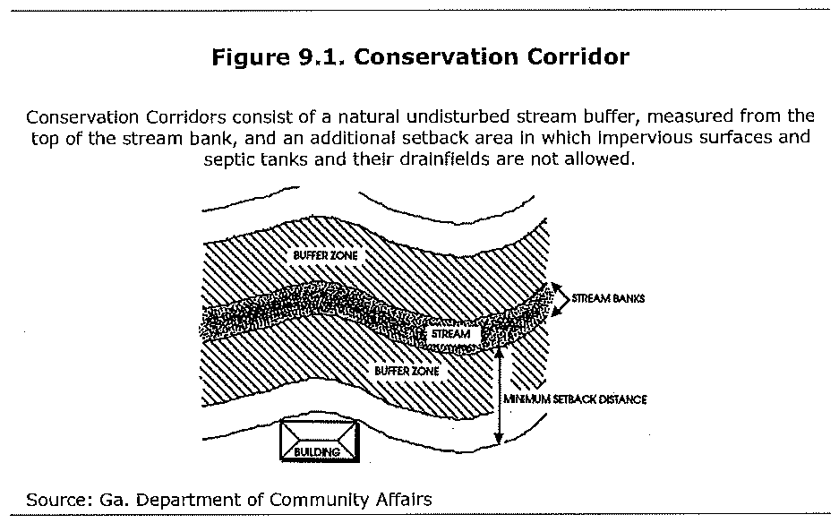
Sec. 907.02. - Conservation corridors in water supply watersheds.
a.
Conservation corridors; stream buffers required. Along all watercourses within a water supply watershed, the conservation corridors shown on the Future Land Use Map shall be shown on all plans and plats proposing urbanized development as defined by Sec. 1113.d and shall be protected by the following:
(1)
Within 7 miles upstream from a public water supply intake or reservoir:
(a)
A minimum 100-foot wide undisturbed buffer as measured outwardly and horizontally from the uppermost part of each stream bank; and
(b)
A minimum setback from the stream buffer of 50 feet for all impervious surfaces, septic tanks and their drainfields.
(2)
Beyond 7 miles upstream from a public water supply intake or reservoir in a small water supply watershed:
(a)
A minimum 50-foot wide undisturbed buffer as measured outwardly and horizontally from the uppermost part of each stream bank; and
(b)
A minimum setback from the stream buffer of 25 feet for all impervious surfaces, septic tanks and their drainfields.
b.
Exceptions. No vegetation shall be removed from within the conservation corridor except as allowed under Sec. 905.02 and except as allowed for under Georgia Forestry Best Management Practices, and
(1)
Disturbance is required to construct mulched pedestrian paths;
(2)
Road and utility crossings; and
(3)
For the installation of a dam necessary for stormwater detention or green stormwater infrastructure as approved by the Director of Public Works.
c.
Construction plans. No construction plans for a development containing a conservation corridor will be released until copies of all necessary state and federal permits have been provided to Oconee County.
Sec. 907.03. - Water supply watersheds; restrictions.
The following are limited within all water supply watersheds:
a.
New hazardous waste treatment or disposal facilities are prohibited.
b.
New sanitary landfills, if permitted by DNR, shall have synthetic liners and leachate collection systems.
c.
Any new facility that handles hazardous materials of the types listed in Section 312 of the Resource Conservation and Recovery Act of 1976 (excluding underground storage tanks) and in amounts of 10,000 pounds or more on any one day, shall perform their operations on impermeable surfaces having spill and leak collection systems as prescribed by DNR
d.
Agricultural waste. The application of animal waste on land must follow guidelines established by the United States Department of Agriculture, Natural Resource Conservation Service, And Agricultural Best Management Practices.
e.
Landfills and Waste Disposal Utilities. Utilities that cannot be feasibly located outside the stream buffer or setback area must be located as far from the stream bank as reasonably possible; installed and maintained to protect the integrity of the stream buffer and setback area as best as reasonably possible, and must not impair the quality of the drinking water stream.
f.
Street runoff and drainage. New streets that cross perennial streams shall be designed in such a way as to avoid direct runoff from the paved surface into the streams they cross. Such design features shall be shown on the Stormwater Management Plan (see the Procedures and Permits Article of this Code).
Sec. 907.04. - Water supply watersheds; exemptions.
The following uses are exempt from the restrictions of this Sec. 907 (with some limitations and conditions as noted):
a.
Development and land use legally established prior to the adoption of this Development Code.
b.
Mining activities permitted by the Department of Natural Resources under the Surface Mining Act (outside of stream buffer areas).
c.
Specific forestry and agricultural activities (outside of stream buffer areas) that are consistent with best management practices established by the Georgia Forestry Commission/Department of Agriculture and do not impair the quality of streams.
Sec. 908.01. - Other watersheds; defined.
The provisions of this Section apply to all watersheds that are not defined as water supply watersheds under Sec. 907.01.
Sec. 908.02. - Conservation corridors in other watersheds.
a.
Conservation corridors; stream buffers required. The conservation corridors shown on the Future Land Use Map shall be shown on all plans and plats proposing urbanized development as defined by Sec. 1113.d and shall be protected by the following:
(1)
A minimum 50-foot wide undisturbed buffer as measured outwardly and horizontally from the uppermost part of each stream bank; and
(2)
A minimum setback from the stream buffer for all impervious surfaces, septic tanks and their drainfields equal to the applicable minimum principal building setback required by the zoning district.
b.
Exceptions. No vegetation shall be removed from within the conservation corridor except as allowed under Sec. 905.02 and except as allowed for under Georgia Forestry Best Management Practices, and
(1)
Disturbance is required to construct mulched pedestrian paths;
(2)
Road and utility crossings; and
(3)
For the installation of a dam necessary for stormwater detention or green stormwater infrastructure as approved by the Director of Public Works.
c.
Construction plans. No construction plans for a development containing a conservation corridor will be released until copies of all necessary state and federal permits have been provided to Oconee County.
Sec. 909. - Authority.
The provisions of this Division are adopted pursuant to the Rules for Environmental Planning Criteria of the Georgia Department of Natural Resources, adopted by DNR under O.C.G.A. 12-2-8.
Sec. 910.01. - Findings of fact.
In order to provide for the health, safety, and welfare of the public and a healthy economic climate within Oconee County, Georgia and surrounding communities, it is essential that the quality of public drinking water be insured. For this reason, it is necessary to protect the subsurface water resources that Oconee County, Georgia and surrounding communities rely on as sources of public water.
a.
Groundwater resources are contained within aquifers, which are permeable, rock strata occupying vast subsurface regions.
b.
These aquifers are replenished by infiltration of storm water runoff in zones of the surface known as aquifer recharge areas.
c.
Aquifers are susceptible to contamination when unrestricted development occurs within significant aquifer recharge areas.
d.
It is, therefore, necessary to manage land use within aquifer recharge zones in order to ensure that pollution threats are minimized.
Sec. 910.02. - Objectives.
The objectives of this Division are:
a.
Protect groundwater by prohibiting land uses that generate dangerous pollutants in recharge areas;
b.
Protect groundwater by limiting density of development; and,
c.
Protect groundwater by reducing adverse effects on groundwater from the development that occurs within the recharge area.
Sec. 911.01. - Protected aquifer recharge areas; defined.
The Georgia Department of Natural Resources and the Georgia Department of Community Affairs have determined that each local government with "significant groundwater recharge areas" (identified on the Ground-Water Pollution Susceptibility Map of Georgia—Hydrologic Atlas #20) must adopt an Aquifer Recharge Protection Ordinance under the requirements of House Bill 215, Georgia's 1989 Growth Strategies Legislation and the rules promulgated there under.
Sec. 911.02. - Aquifer recharge area; established.
An Aquifer Recharge Area is hereby established which shall correspond to all lands within the jurisdiction of Oconee County, Georgia that are mapped as significant recharge areas by the Georgia Department of Natural Resources in Hydrologic Atlas 18, (1989 Edition) and are indicated as "most significant groundwater recharge areas" on the Ground-Water Pollution Susceptibility Map of Georgia—Hydrologic Atlas #20.
Sec. 912. - Determination of pollution susceptibility.
Each recharge area shall be determined to have a pollution susceptibility of high, medium, or low based on the Ground-Water Pollution Susceptibility Map of Georgia—Hydrologic Atlas #20. Said map is hereby adopted and made a part of this Development Code.
Sec. 913. - Aquifer protection standards.
a.
Waste disposal.
(1)
For all pollution susceptibility areas, new solid waste disposal facilities must have synthetic liners and leachate collection systems.
(2)
No land disposal of hazardous waste shall be permitted within any Significant Aquifer Recharge Area.
(3)
Any new facility that involves the treatment, storage or disposal of hazardous waste, if permitted by DNR and the zoning district, shall perform such operations on an impermeable surface having a spill and leak collection system.
(4)
Any new facility that handles hazardous materials of the types listed in Section 312 of the Resource Conservation and Recovery Act of 1976 (excluding underground storage tanks) and in amounts of 10,000 pounds or more on any one day, shall perform their operations on impermeable surfaces having spill and leak collection systems as prescribed by DNR.
b.
Agricultural waste impoundment. New agricultural waste impoundment sites shall be lined if they exceed 50 acre-feet. As a minimum, the liner shall be constructed of compacted clay having a thickness of one foot and a vertical hydraulic conductivity of less than 5 x 10 -7 cm/sec or other criteria established by the U.S. Soil Conservation Service.
c.
Chemical or petroleum storage tanks. For all Significant Aquifer Recharge Areas, new above-ground chemical or petroleum storage tanks larger than 650 gallons must have secondary containment for 110 percent of tank volume or 110 percent of the largest tanks in a cluster of tanks. Such tanks used for agricultural purposes are exempt, provided they comply with all federal requirements.
d.
New construction on septic tanks. Within all significant aquifer recharge areas, construction shall not proceed on a building, mobile home or manufactured home to be served by a septic tank or on-site sewage management system unless the Oconee County Health Department first approves the proposed septic system installation as meeting the requirements of Section M of the Georgia Department of Human Resources Manual for On-Site Sewage Management Systems relating to protection of groundwater recharge areas. Such State requirements are also found under the Rules of the Department of Natural Resources, Environmental Protection Division, Chapter 391-3-16-.02.
Sec. 914. - Permit and plan review requirements.
Consideration of the effect of aquifer recharge areas on the issuance of permits, approval of rezoning requests and review of subdivision plans is found under the "Other Permits" Division of the Procedures and Permits Article of this Development Code.
Sec. 915. - Assessment relief.
Assessors and boards of assessors shall consider the requirements of these regulations in determining the fair market value of land.
Sec. 916. - Purpose of wetlands protection.
a.
The purposes of this Division are to promote wise use of wetlands and protect wetlands, while taking into account varying ecological, economic development, recreational, and aesthetic values.
b.
Activities that may damage wetlands should be located on upland sites to the greatest degree practical as determined by a permitting process.
c.
The objective of this Division is to protect wetlands from alterations that will significantly affect or reduce their primary functions for water quality, floodplain and erosion control, ground water recharge, aesthetic nature, and wildlife areas and to comply with the requirements of state law related to wetland protection.
Sec. 917. - Wetlands protection; findings of fact.
The wetlands within Oconee County, Georgia are indispensable and fragile natural resources with significant development constraints due to flooding, erosion and soils limitations. In their natural state, wetlands serve man and nature. They provide habitat areas for fish, wildlife, and vegetation; water quality maintenance and pollution control; flood control; erosion control; natural resource education; scientific study; open space; and recreational opportunities. In addition, the wise management of forested wetlands is essential to the economic well-being of many communities within the State of Georgia.
a.
Nationally, a considerable number of these important natural resources have been lost or impaired by draining, dredging, filling, excavating, building, pollution, and other acts. Piecemeal or cumulative losses will, over time, destroy additional wetlands. Damaging or destroying wetlands threatens public safety and the general welfare.
b.
The Georgia Department of Natural Resources and the Georgia Department of Community Affairs have determined that each local government with classified wetlands located in its jurisdiction must adopt a Wetlands Protection Ordinance under the requirements of House Bill 215, Georgia's 1989 Growth Strategies Legislation and the rules promulgated thereunder.
c.
It is therefore necessary for Oconee County, Georgia to ensure maximum protection for wetlands by discouraging development activities in wetlands that may adversely affect wetlands.
Sec. 918. - Wetlands protection; authority.
The provisions of this Division are adopted pursuant to the Rules for Environmental Planning Criteria of the Georgia Department of Natural Resources, adopted by DNR under O.C.G.A. 12-2-8.
Sec. 919.01. - Wetland protection area.
This Division shall apply to all wetlands within the Wetland Protection Area as defined herein and located within the jurisdiction of Oconee County, Georgia.
a.
The Generalized Wetland Map, adopted as part of this ordinance, shows the general location of wetlands and of the Wetland Protection Area and should be consulted by persons contemplating activities in or near wetlands before engaging in a regulated activity.
b.
The Generalized Wetland Map, together with all explanatory matter thereon and attached thereto, is hereby adopted by reference and declared to be a part of this ordinance. The Generalized Wetland Map shall be on file in the office of the Oconee County Planning Department.
Sec. 919.02. - Wetland protection area boundaries.
The Generalized Wetland Map is a general reference document and wetland boundaries indicated on the map are approximations. The purpose of the Generalized Wetland Map is to alert developers/landowners if they are within proximity to a wetland, which means that there is a high likelihood of the presence of a jurisdictional wetland and a need for the developer/landowner to seek U.S. Army Corps of Engineers guidance as to whether a Section 404 Permit will be required prior to any activity. The Generalized Wetland Map does not necessarily represent the exact boundaries of jurisdictional wetlands within the jurisdiction of Oconee County and cannot serve as a substitute for a delineation of wetland boundaries by the U.S. Army Corps of Engineers, as required by Section 404 of the Clean Water Act, as amended, or by a certified wetlands delineator. Any local government action under this Development Code does not relieve the landowner from federal or state permitting requirements.
Sec. 920. - Local development permit requirements.
a.
No regulated activity will be allowed within the Wetland Protection Area without written permission from Oconee County or its designee in the form of a development permit.
b.
Issuance of a development permit is contingent on full compliance with the terms of this Division and other applicable regulations.
c.
All activities that are not exempted in Sec. 921 below or by other local development ordinances, shall be prohibited without prior issuance of a development permit.
d.
If the area proposed for development is located within 50 feet of the Wetland Protection Area boundary, as determined from the Generalized Wetland Map, a U.S. Army Corps of Engineers determination shall be required. If the Corps determines that wetlands are present and that a Section 404 Permit or Letter of Permission is required, a local development permit will be issued only following issuance of the Section 404 Permit or Letter of Permission.
Sec. 921.01. - Allowed land uses.
The following uses shall be allowed as a right within the Wetland Protection Area if otherwise permitted by the zoning district and to the extent that they are not prohibited by any other ordinance or law and provided they do not require structures, grading, fill, draining, or dredging except as provided herein.
a.
Operations conducted during normal silvicultural activities, including minor dredge and fill associated with road construction, harvesting, and reforestation practices provided they meet the performance standards and road construction best management practices required under Section 404 of the Clean Water Act.
b.
Conservation or preservation of soil, water, vegetation, fish, and other wildlife, provided they do not affect waters of Georgia or of the United States in such a way that would require an individual 404 Permit.
c.
Outdoor passive recreational activities, including fishing, bird watching, hiking, boating, horseback riding, and canoeing.
d.
Forestry practices applied in accordance with best management practices approved by the Georgia Forestry Commission.
e.
The cultivation of agricultural crops. Agricultural activities shall be subject to best management practices approved by the Georgia Department of Agriculture.
f.
The pasturing of livestock provided that riparian wetlands are protected, that soil profiles are not disturbed and that approved best management practices are followed.
g.
Education, scientific research, and nature trails.
Sec. 921.02. - Prohibited land uses.
Within any protected wetlands area, the following are prohibited:
a.
Receiving areas for toxic or hazardous waste or other contaminants;
b.
Sanitary waste landfills;
c.
Hazardous or toxic waste receiving, treatment or disposal facilities; and
d.
Any other use not specifically exempted as noted above or properly approved by Oconee County and relevant State and Federal agencies.
Sec. 922. - Wetlands certification.
A design professional or certified wetlands delineator shall indicate wetlands on plans required for a land disturbance permit application. The design professional that prepared the required plans accompanying the permit application shall add a statement to the grading plan sheet indicating whether or not wetlands are located on the property by checking the appropriate box on the Wetlands Certification. The Wetlands Certification shall read as shown under the specifications for grading plans in the Procedures and Permits Article of this Code.
Sec. 923. - Permits.
Site plan and permit review procedures for a development permit affecting protected wetlands are found under the "Other Permits" Division of the Procedures and Permits Article of this Development Code.
Sec. 924. - Assessment relief.
Assessors and boards of assessors shall consider wetland regulations in determining the fair market value of land. Any owner of an undeveloped wetland who has dedicated an easement or entered into a conservation easement with the government or a nonprofit organization to permanently control some or all regulated activities in the wetland shall have that portion of land assessed consistent with those restrictions. Such landowner shall also be exempted from special assessment on the controlled wetland to defray the cost of capital improvements such as sanitary sewers, storm sewers, and water mains.
Sec. 925. - Purposes of natural resource conservation.
The purposes of this Division, among others, are as follows:
a.
To recognize the current development rights of property owners established through zoning;
b.
To conserve open land, including those areas containing unique and sensitive natural features such as stream buffers, floodplains and wetlands, by setting them aside from development;
c.
To support the continued viability of agricultural activities in the county, including crop production, dairying and managed forestry;
d.
To reduce erosion and sedimentation by the retention of existing vegetation and encourage minimization of development on steep slopes;
e.
To enhance water quality of streams and waterways, and to protect valuable groundwater resources; and
f.
To provide notification to property owners of natural resources that must be protected on their property.
Sec. 926.01. - Primary conservation areas.
Primary Conservation Areas are defined as follows:
a.
Floodways within the 100-year floodplain. These areas are designated on maps prepared by the Federal Emergency Management Agency (FEMA), and must be confirmed as to their specific location on a Preliminary Plat or Site Development Plan, whichever comes first.
b.
Flood hazard areas. All areas within the 100-year floodplain but lying outside any floodway, wetland or other designated Primary Conservation Area fall under this category. The boundaries of the 100-year floodplain are designated as the "flood hazard area" on maps prepared by the Federal Emergency Management Agency (FEMA), and must be confirmed as to their specific location on a Preliminary Plat or Site Development Plan.
c.
Required stream buffers. Natural vegetative stream buffers along the banks of all perennial streams and other state waters, as required by this Article (except for activities that are exempt from the soil erosion and sedimentation control provisions of Article 11.
d.
Wetlands. Protected wetlands are defined under Sec. 918.
e.
Wildlife habitats of threatened or endangered species. The following have been identified by the Federal and/or the State governments as threatened or endangered species in Oconee County:
f.
Natural buffer areas around wetlands and habitats of endangered species. Additional lands in their natural state provided around designated wetlands and critical wildlife habitats as protective vegetated buffers are recognized as Primary Conservation Areas. A naturally-vegetated wetland buffer must extend at least 25 feet from the wetland, and a natural buffer around a protected wildlife habitat must be at least 100 feet deep, except for a necessary road crossing, utility crossing or other reasonable encroachments approved by the United States Army Corps of Engineers, the Georgia Environmental Protection Division and Oconee County Board of Commissioners.
Sec. 926.02. - Secondary conservation areas
Secondary Conservation Areas are areas that are encouraged (but not required) to be protected in any major subdivision or site development. These include:
a.
Soils with exposed bedrock or rock outcroppings greater than 40,000 sf. Areas with exposed bedrock or rock outcroppings must be identified through observation on each site. Areas comprising 40,000 contiguous square feet or less are not considered Secondary Conservation Areas.
b.
Mature timber stands or significant trees. Forests and timberlands that have developed mature stands of trees qualify for conservation consideration. Individual trees that are specimen trees or otherwise have significance through their size, age, species or historic value may be designated as a Secondary Conservation area to the extent of the tree's dripline.
c.
Registered historic or archeological assets. Sites or areas registered with the State or the National Register of Historic Places qualify under this category since preservation is desirable but not mandated by law. Information regarding all such sites is available from the Georgia Office of Historic Preservation.
d.
Village greens, parkways. These areas create neighborhood assets by providing open space and passive recreation close to the homes in a subdivision. A village green is an open space area surrounded by streets and/or building lots on at least three sides, and intended for common neighborhood use. A parkway is a narrow strip of open space surrounded by streets on all sides, intended as a landscaped element or passive recreation area for the neighborhood.
e.
Passive recreational areas. Common areas solely designated and improved for passive recreational activities, such as picnicking, walking, relaxation and repose, may be treated as Secondary Conservation Areas. Active recreation areas, including but not limited to golf courses, swimming pools, sports fields and courts, and community buildings and grounds are not considered conservation uses or conservation areas.
f.
Flood fringe areas. All areas within the flood fringe area but lying outside any wetland or other designated Primary Conservation Area fall under this category. The boundaries of the area are designated as the "flood fringe area" on maps prepared by the Federal Emergency Management Agency (FEMA), and must be confirmed as to their specific location on a Preliminary Plat or Site Development Plan.
Sec. 927. - Allowed uses in natural resource conservation areas.
The following requirements apply only to land set aside under conservation or natural resources easements in fulfillment of the provisions of this Article.
Sec. 927.01. - Undisturbed areas.
Certain areas identified as Primary Conservation Areas shall remain in their natural, undisturbed state. Such undisturbed areas include floodways, stream buffers, critical wildlife habitats and habitat buffers, wetlands and wetland buffers.
Sec. 927.02. - Allowed uses.
The following uses are allowed in natural resource conservation areas to the extent that they are compatible with the protection and preservation of areas required by law but not otherwise required to remain undisturbed, and provided they are allowed uses under the site's zoning classification.
a.
Conservation of natural, archeological or historical resources;
b.
Meadows, woodlands, wetlands, wildlife corridors, game preserves, or similar conservation-oriented areas;
c.
Walking or bicycle trails;
d.
Parks, community gardens, playing fields or recreation facilities primarily for the use of the subdivision residents and their guests;
e.
Landscaped storm water detention areas and community water and sewage disposal systems located on soils particularly suited to such uses;
f.
Easements for drainage, access, and sewer or water lines, or other public purposes;
g.
Underground utility rights-of-way; and
h.
Other conservation-oriented uses if approved by the Board of Commissioners.
i.
Agricultural and horticultural uses, including raising crops, pasturelands and dairy operations, along with associated buildings (including residences) that are specifically needed to support an active, viable agricultural or horticultural operation. Specifically excluded are commercial livestock operations involving swine, poultry, mink, and other animals likely to produce highly offensive odors.
j.
Pastureland for horses used solely for recreational purposes. Equestrian facility buildings and grounds shall be permitted but may not be located in any Primary Conservation Area.
k.
Silviculture, in keeping with established standards for selective harvesting and sustained yield forestry, and best management practices endorsed by the Georgia Forestry Commission.
l.
Neighborhood open space uses such as village greens, commons, picnic areas, community gardens, trails, and similar low-impact passive recreational uses specifically excluding motorized off-road vehicles, rifle ranges, golf courses, sports fields and courts, community recreation buildings and grounds, swimming pools, and other active recreation uses.
m.
Stormwater detention facilities within a natural resources easement required under Sec. 928.01, subject to all State and federal regulations having been met, as evidenced by appropriate written approvals or permits issued by such agencies, and subject to written approval and acceptance by the proposed holder of the natural resources easement. Such facilities are not allowed to be located within a conservation easement required under said Sec. 928.01.
n.
The establishment by the developer or its designees and/or successors in interest of a Jurisdictional Wetlands conservation credit mitigation bank, threatened or endangered species conservation credit mitigation bank, or other conservation credit mitigation bank approved by and established in accordance with the rules and regulations of the United States Army Corp of Engineers or other applicable state or federal governing entity.
Sec. 927.03. - Non-permitted uses of open space include the following:
a.
Roads and non-permeable paved surfaces except necessary road crossings or as approved otherwise by Oconee County;
b.
Above-ground utility rights-of-way except necessary utility crossings or as approved otherwise by Oconee County; and
c.
Other uses inconsistent with the purposes of this Development Code.
Sec. 928.01. - Primary conservation areas.
All stream buffers required by this Article, all protected wetlands, and all other primary conservation areas that are required to be protected by the provisions of this Development Code, shall be permanently protected from further subdivision, development, and unauthorized use as follows:
a.
By a natural resources easement in a traditional subdivision, multi-family or nonresidential development; or
b.
By a conservation easement in a conservation subdivision or a master planned development.
Sec. 928.02. - Secondary conservation areas.
Lands in secondary conservation areas that are designated by the developer for protection shall be included within a natural resources or conservation easement.
Sec. 928.03. - Ownership of land in conservation and natural resources easements.
Land within conservation and natural resources easements may be included within the lots in a subdivision, or owned by a homeowners' association or other entity that meets the provisions for a Property Owners' Association in the Subdivisions and Planned Developments Article of this Development Code.
Sec. 929.01. - Natural resources easements; creation.
The natural resources easement, when required, shall be shown on the final subdivision plat and recorded with the Clerk of the Superior Court at the same time as the final plat.
a.
When included within the lots in a subdivision, the natural resources easement shall be granted at no cost to a homeowners' association or other entity that meets the provisions for a Property Owners' Association in the Subdivisions and Planned Developments Article of this Development Code.
b.
When the land to be included in the easement is owned by the homeowners' association, the easement shall be created and granted as a conservation easement under the provisions of Sec. 930.
c.
The natural resources easement shall grant a third-party right of enforcement to the Oconee County Board of Commissioners to enforce, at its discretion, any of the terms of the natural resources easement.
Sec. 929.02. - Natural resources easements; guidelines.
The following guidelines must be incorporated into any natural resources easement in a form acceptable to the County Attorney:
a.
The easement specifically and clearly identifies the boundaries of the property subject to the easement through reference to the easement area shown on the final subdivision plat;
b.
The easement contains restrictions as to what the owner may do with the property and specifically delineates what may not be done with the property. Limitations shall be consistent with the type of area protected and the applicable requirements of this Code to such areas, and may include but shall not be confined to prohibitions against subdivision, earthmoving, dumping, signs, utility lines, construction, changes to existing structures, and uses made of the property;
c.
The easement provides for the right of the holder of the easement to inspect the property to assure observance of restrictions and also provides for enforcement procedures;
d.
The easement contains provisions governing its amendment, including provisions that the easement shall not be altered or terminated except with the express written permission of the County.
Sec. 930.01. - Conservation easements; creation.
The conservation easement, when required, shall be created subject to the provisions of O.C.G.A § 44-10-1, et seq., which is known as the "Georgia Uniform Conservation Easement Act."
a.
The conservation easement shall be approved by the Board of Commissioners and shall be granted at no cost to a charitable corporation, charitable association or charitable trust that qualifies as a "holder" under the Georgia Uniform Conservation Easement Act.
b.
Such "holder" shall be approved by the Board of Commissioners on the basis of their past experience as a "holder" of conservation easements and their lack of an ownership or corporate relationship with the owner or developer of the project.
c.
The conservation easement shall grant a third-party right of enforcement to the Oconee County Board of Commissioners to enforce, at its discretion, any of the terms of the conservation easement.
d.
The conservation easement may not be granted to the owner of the property to which the easement will apply, including a homeowners' association holding natural resource conservation areas as common open space in a conservation subdivision or master planned development.
e.
An undivided property ownership interest in the common open space shall be granted to each property in a conservation subdivision or master planned development in accordance with the Open Space Ownership and Management Section of the Subdivisions and Planned Developments Article of this development Code.
Sec. 930.02. - Conservation easements; guidelines.
The following guidelines are required to be incorporated into any conservation easement in a form acceptable to the County Attorney:
a.
The easement recognizes and describes in a statement of purpose the special qualities of the property subject to the easement. Conditions within the tract subject to the conservation easement may be shown by map and/or photograph;
b.
The easement clearly identifies the owner of the property subject to the easement, the holder of the easement, and co-signer, and the responsibilities of the property owner, easement holder, and co-signer;
c.
The easement specifically and clearly identifies the boundaries of the property subject to the easement, either by metes and bounds legal description, survey plat or reference to the easement area shown on the final subdivision plat;
d.
The easement contains restrictions as to what the owner may do with the property and specifically delineates what may not be done with the property. Limitations shall be consistent with the type of area protected and the applicable requirements of this Code to such areas, and may include but shall not be confined to prohibitions against subdivision, earthmoving, dumping, signs, utility lines, construction, changes to existing structures, and uses made of the property;
e.
The easement provides for the right of the easement holder to inspect the property to assure observance of restrictions and also provides for enforcement procedures;
f.
The easement provides for the maintenance of the open space; and
g.
The easement contains provisions governing its amendment, including provisions that the easement shall not be altered or terminated except with the express written permission of all entities having either a property right or enforcement right in the easement.