
Oconee County Unincorporated
City Zoning Code
City Zoning Code
ARTICLE 15
- INTERPRETATION AND DEFINITIONS17
Editor's note— A resolution, adopted March 1, 2022(3), repealed the former Art. 15, §§ 1501—1503, and enacted a new Art. 15 as set out herein. The absence of a history note indicates that the provision remains unchanged from this resolution. The former Art. 15 pertained to similar subject matter and derived from a resolution adopted Dec. 3, 2019, Exh. A.
Sec. 1501.- Purpose of Article 15.
This Article describes how figures, words and phrases used in this Development Code are to be interpreted, and provides a glossary of all definitions specifically used in the text of this Development Code.
Sec. 1502.01. - Responsibility for interpretation.
a.
The Planning Director shall be responsible for the interpretation of the requirements, standards, definitions or any other provision of this Development Code. The Planning Director and the Public Works Director may be consulted or relied upon for interpretations relative to their areas of responsibility, and shall assist the Planning Director in the appeal of any such interpretation.
b.
Interpretations of the Planning Director may be appealed under the provisions of this Development Code relating to Appeals.
Sec. 1502.02. - Use of figures and examples for illustration.
a.
Figures associated with defined terms or regulatory paragraphs in this Development Code are provided for illustration only and do not limit or change the meaning of the term as defined or the requirements of the regulation as written.
b.
When an example of the application of a specific provision is given, or other explanatory text is provided, such example or text is identified by placement in a shaded box separate from the regulatory paragraphs in this Development Code. Such examples or explanatory text are provided for illustration only and do not limit or change the meaning of the provision or the requirements of this Development Code as written.
Sec. 1502.03. - Use of words and phrases.
Except as specifically defined herein, all words used in this Development Code have their customary dictionary definitions.
For the purposes of this Development Code, certain words or terms used herein shall be defined as follows:
a.
Words used in the singular include the plural and words used in the plural include the singular.
b.
Words used in the present tense include the future tense.
c.
The word "structure" includes the word "building"; a "building" is a type of structure.
d.
The word "erected" includes the words "constructed," "moved," "located" or "relocated."
e.
The word "lot" includes the words "plot" or "parcel."
f.
The words "zoning map" or "zoning atlas" means the Official Zoning Map of Oconee County, Georgia.
g.
The words "road," "street," "highway" and "thoroughfare" have the same meaning with regard to the requirements and restrictions of this Code.
h.
The word "person" includes the words "individuals," "firms," "partnerships," "corporations," "associations," "governmental bodies," and all other legal entities.
i.
The words "shall," "will," "is to" and "must" are always mandatory and never discretionary.
j.
The words "may" and "should" are discretionary.
k.
The word "and" indicates that all of the conditions, requirements or factors so connected must be met or fulfilled, while the word "or" indicates that at least one condition, requirement or factor so connected must be met.
l.
The term "such as" is intended to introduce one or more examples in illustration of a requirement or point, and is intended to mean "including but not limited to the following."
m.
The terms "include" or "including" when used to introduce a list of items is not intended to be exclusive only to the items on the list, but is intended to mean "including but not limited to the following."
n.
The verbs "zone" and "rezone" have the same meaning and refer to the act of amending the Official Zoning Map through the process established by this Development Code.
o.
The nouns "zone," "zoning district" and "district" have the same meaning and refer to the zoning districts established under this Development Code.
p.
The word "day" means a calendar day unless otherwise specified as a "work" day or "business" day, which mean Monday through Friday exclusive of County-recognized holidays.
q.
The words "used" or "occupied" include the words "intended, arranged or designed exclusively to be used or occupied by a particular use or function."
r.
References to the "County" and to the Board of Commissioners and any public officials or appointed bodies of the County not otherwise named by political jurisdiction or defined in this Development Code shall always mean Oconee County, Georgia, and its governing body, appointed or employed officials, and appointed bodies as named. These include:
(1)
The Planning Commission, created as such and appointed as such by the Oconee County Board of Commissioners.
(2)
The County Administrator, appointed as such by the Oconee County Board of Commissioners, or the County Administrator's designee.
(3)
The County Attorney, appointed as such by the Oconee County Board of Commissioners, or the County Attorney's designee.
(4)
The Planning Director, the County official appointed as such, or the Planning Director's designee.
(5)
The Public Works Director, the County official appointed as such, or the Public Works Director's designee.
(6)
The Water Resources Director, the County official appointed as such, or the Utilities Director's designee.
(7)
Other County officials or employees, such as a "building inspector" or "road & bridges inspector," shall mean the County official or employee appointed as such by their respective department director.
s.
References to an administrative department or committee of Oconee County shall always mean the department or committee created by the Board of Commissioners as such. These include:
(1)
Planning Department: References to action by the "Planning Department" shall mean action by the Planning Director or by that administrative official to whom responsibility for that action has been assigned by the Planning Director.
(2)
Public Works Department: A reference to action by the "Public Works Department" shall mean action by the Public Works Director by that administrative official to whom responsibility for that action has been assigned by the Public Works Director.
(3)
County Engineer: A reference to action by the "County Engineer" shall mean action by that administrative official to whom responsibility for that action has been assigned by the Public Works Director.
(4)
Utilities Water Resources Department: A reference to action by the "Water Resources Department" shall mean action by that administrative official to whom responsibility for that action has been assigned by the Utilities Director.
(5)
Development Review Committee: The body composed of representatives from the Planning and Code Enforcement Department, Public Works Department, Water Resources Department, Health Department, EMA and other County departments as appointed by the Board of Commissioners.
t.
References to other public officials, departments or appointed bodies, unless otherwise specified, shall always mean such persons or bodies having jurisdiction over or relative to Oconee County, Georgia. These include:
(1)
The Clerk of the Superior Court of Oconee County, Georgia.
(2)
The Oconee County Health Department, and its Environmental Services Division.
(3)
The Oconee River Soil and Water Conservation District.
(4)
The Northeast Georgia Regional Development Center (RDC).
(5)
The Georgia Departments of Community Affairs (DCA), Transportation (GDOT), Human Resources (DHR), Natural Resources (DNR) and DNR's Environmental Protection Division (EPD).
(6)
The United States Army Corps of Engineers, the Federal Aviation Administration (FAA), the Federal Emergency Management Agency (FEMA), the Federal Communications Commission (FCC) and the Environmental Protection Agency (EPA).
Sec. 1502.04. - Meaning of words and phrases.
a.
All words and phrases are to be interpreted within the context of the sentence, paragraph, subsection, section and Article in which they occur.
b.
Words and phrases specifically relating to a category of use of land or a structure that are defined in this Development Code shall be interpreted as defined herein without regard to other meanings in common or ordinary use, unless the context of the word or phrase indicates otherwise. Words and phrases not defined in this Development Code shall be construed to have the meaning given by common and ordinary use, the meaning of which may be further clarified by use of the word or phrase in the North American Industrial Classification System (NAICS) published by the U.S. Department of Commerce, 2002 Edition. See also the Interpretation of Uses Section of the Use of Land and Structures Article of this Development Code.
c.
Other words and phrases specifically defined in this Development Code shall be interpreted as defined herein without regard to other meanings in common or ordinary use, unless the context of the word or phrase indicates otherwise. Words and phrases not defined in this Development Code shall be construed to have the meaning given by common and ordinary use, the meaning of which may be further clarified by definition of the word or phrase in a dictionary of the English language in current circulation.
d.
Definitions are clearly identified as such and are located throughout this Development Code in the Articles or Sections to which they most readily refer. All definitions, regardless of location within a particular Article of this Code, apply equally to the use of such terms throughout the Code. A glossary of all defined terms is included in this Article for convenience. However, if differences in wording occur between definitions of a term in a particular Article and in the glossary of terms in this Article, below, the definition contained within a particular Article of this Code shall control.
Sec. 1503. - Definitions.
A
Accessory Structure to a Manufactured Home: A structure incidental to occupancy of the property by a manufactured home, such as one-story non-habitable room, storage building, garage or carport; or a patio, deck or similar structure that may include window screens, knee walls, and other partial enclosures.
Accessory Structure to a Recreational Vehicle: A storage building, deck, awning, carport, patio, patio enclosure and similar structures incidental to occupancy of the property by a recreational vehicle.
Accessory Use or Structure: A use or structure customarily incidental and subordinate to the principal use of the building and located on the same lot in the rear or side yard.
Active Recreational Facilities: Equipment and areas prepared for active use for recreational and leisure purposes, including but not limited to: playground equipment (swing sets and climbing structures); courts for basketball, volleyball, and tennis; leveled, striped fields for football, soccer, or all-purpose fields; community picnic pavilion (including covered facilities with grills and/or fire pits); and community buildings for recreational events. Trails and bikeways through open spaces shall not be considered active recreational facilities.
Addition to an Existing Building: Any walled and roofed expansion to the perimeter of a building in which the addition is connected by a common load bearing wall other than a firewall. Any walled and roofed addition, which is connected by a firewall or is separated by independent perimeter load bearing walls, is new construction.
Adult Bookstore: Any commercial establishment in which more than ten square feet of floor space is used for the display or offer for sale of any book or publication, film, or other medium which depicts sexually explicit nudity or sexual conduct by its emphasis on matter depicting, describing or relating to specified sexual activities or specified anatomical areas.
Adult Entertainer: Any person employed by an adult entertainment establishment who exposes his or her "specified anatomical areas," as defined herein. For purposes of this section, adult entertainers include employees as well as independent contractors.
Adult Entertainment: A retail business establishment that includes, but is not limited to, one of the following items as defined in the Adult Entertainment Establishments Ordinance of Oconee County, Georgia: adult bookstore, adult entertainment establishment, adult hotel or motel, adult mini-motion picture theater, adult motion picture arcade, adult motion picture theater, and/or adult video store.
Adult Entertainment: Entertainment that is characterized by an emphasis on the depiction, display or the featuring of "specified anatomical areas."
Adult Entertainment Establishment shall be defined to include the following types of business:
1.
Any commercial establishment that employs or uses any person live, in any capacity in the sale or service of beverages or food while such person is unclothed or in such attire, costume or clothing, so as to expose any portion of his or her "specified anatomical areas," as defined herein.
2.
Any commercial establishment which provides live entertainment where any person appears unclothed or in such attire, costume or clothing as to expose any portion of his or her "specified anatomical areas" as defined herein or where such performances are distinguished or characterized by an emphasis on "specified sexual activities," as defined herein.
3.
Any commercial establishment which holds, promotes, sponsors or allows any contest, promotion, special night, event or any other activity where live patrons of the establishment are encouraged or allowed to engage in any of the conduct described in paragraphs 1 and 2 of this definition.
4.
Any commercial establishment having a substantial or significant portion of its stock in trade, books, magazines or other periodicals, videotapes or movies or other reproductions, whether for sale or rent, which are distinguished or characterized by their emphasis on matter depicting, describing or relating to "specified sexual activities" as defined herein or "specified anatomical areas" as defined herein or having a segment or section comprising more than ten square feet of its total floor space, devoted to the sale or display of such material or which derives more than 5% of its net sales from the sale or rental of such material.
5.
Any commercial establishment utilizing an enclosed building with a capacity of fifty (50) or more persons used for cinematographic or videographic presentation of material distinguished by or characterized by an emphasis on matter depicting, describing, or relating to "specified sexual activities" or "specified anatomical areas", as defined herein, for observation by patrons therein.
6.
Any adult motion picture theater, adult motion picture arcade, adult mini-motion picture theater, adult bookstore, adult video store, adult hotel, or adult motel, as defined herein.
7.
The definition of "adult entertainment establishment" shall not include traditional or live theater (mainstream theater) which means a theater, concert hall, museum, educational institution or similar establishment which regularly features live performances which are not distinguished or characterized by an emphasis on the depiction, display, or description or the featuring of "specified anatomical areas" or "specified sexual activities" in that the depiction, display, description or featuring is incidental to the primary purpose Of any performance.
Adult Hotel or Motel: A hotel or motel wherein material is presented which is distinguished or characterized by an emphasis on matter depicting, describing or relating to specified sexual activities or specified anatomical areas.
Adult Mini-Motion Picture Theater: An enclosed building with a capacity for less than 50 persons used for presenting material distinguished or characterized by an emphasis on matter depicting or relating to specified sexual activities or specified anatomical areas for observation by patrons therein.
Adult Motion Picture Arcade: Any place to which the public is permitted to be invited wherein paper currency, coin or slug-operated or electronically, electrically or mechanically controlled still or motion picture machines, projectors or other image-producing devices are maintained to show images to five or fewer persons per machine at any one time and where the images so displayed are distinguished or characterized by an emphasis on depicting or describing specified sexual activities or specified anatomical areas.
Adult Motion Picture Theater: An enclosed building with a capacity of 50 or more persons, used for presenting material distinguished or characterized by an emphasis on matter depicting, describing or relating to specified sexual activities or specified anatomical areas for observation by patrons therein.
Adult Video Store: Any establishment having a substantial or significant portion of its stock in trade, video tapes or movies or other reproductions, whether for sale or rent, which are distinguished or characterized by an emphasis on matter depicting, describing or relating to specified sexual activities or specified anatomical areas, or an establishment with a segment or section, comprising five percent of its total floor space, devoted to the sale or display of such material or which derives more than five percent of its net sales from videos which are characterized or distinguished or relating to specified sexual activities or specified anatomical areas.
Agricultural Land: Land, including necessary buildings and structures, used for the raising of crops or animals.
Agricultural: See under "Land Use Categories."
Agritourism: Any activity carried out on a farm that allows members of the general public for recreational, entertainment, or educational purposes, to view or enjoy rural activities, including farming, ranching, historic, cultural, harvest-your-own activities, and farm wineries as defined by O.C.G.A 3-6-32.1, and excluding any competitions utilizing motorized vehicles. An activity is an agritourism activity whether or not a fee is collected to participate.
Airport: A transportation facility, terminal or similar location where commercial aircraft take off and land as distinguished from an "Airstrip, Private" as defined herein.
Airstrip, Private: A facility or location where fixed-wing private non-commercial aircraft take off and land.
Alley: See under "street."
Alteration of a Building: Any change, addition or modification in construction of the structural members of a building, such as walls, partitions, columns, beams or girders, any change that results in an addition to the enclosed floor area of a building, or the movement of the building from one location to another.
Alternative Tower and Antenna Structure: man-made "trees", clock towers, bell steeples, church steeples, light poles, flag poles and similar alternative-design mounting structures that camouflage or conceal the presence of antennas or towers so as not to be readily discernible as an antenna or tower. In order to establish quantitative and qualitative standards for determining that an alternative tower structure is "not readily discernible," nine examples (photographs) of such "non-readily discernible" structures are included in the appendix to this Development Code..
Antenna: any exterior apparatus designed for telephonic, radio, or television communications through the sending and/or receiving of electromagnetic waves.
Apartment: See "Dwelling, Multi-family"
Applicant: A property owner or their authorized representative who has petitioned the County for approval of a zoning change, development permit, building permit, hardship or special exception variance, appeal, or any other authorization for the use or development of their property under the requirements of this Development Code, or a person submitting a post-development stormwater management application and plan for approval.
Application: A petition for approval of a zoning change, development permit, building permit, hardship or special exception variance, appeal, or any other authorization for the use or development of a property under the requirements of this Development Code.
Aquifer Recharge Area District: All lands within unincorporated Oconee County which is indicated as "most significant groundwater recharge areas..." on the Ground-Water Pollution Susceptibility Map of Georgia.
Aquifer Recharge Area: (synonymous with Groundwater Recharge Area) An area of the Earth's surface where water infiltrates the ground, thereby replenishing the groundwater supplies within an aquifer.
Aquifer: A layer or formation of rock beneath the Earth's surface that bears significant amounts of groundwater.
Architectural Features: Ornamental or decorative features attached to or protruding from an exterior wall, including cornices, eaves, gutters, belt courses, sills, lintels, bay windows, chimneys, and decorative ornaments.
Area of Shallow Flooding: A designated AO or AH zone on the flood insurance rate map (FIRM) with base flood depths from one to three feet, or where a clearly deemed channel does not exist, where the path of flooding is unpredictable and indeterminate, and where velocity flow may be evident.
Area of Special Flood Hazard: The land in the floodplain within a community subject to a one percent or greater chance of flooding in any given year.
As-Built Data Drawings: Drawings specifying the dimensions, location, capacities, and operational capabilities of structures and facilities as they have been constructed.
Awning Sign: See "Building Sign."
Awning: A roof-like cover that projects from the wall of a building for the purpose of shielding a doorway, or window from the elements. Awnings are often made of fabric or flexible plastic supported by a rigid frame, and may be retracted into the face of the building.
Axle: assembly of a vehicle consisting of two or more wheels whose centers are in one horizontal plane, by means of which a portion of the weight of a vehicle and its load, if any, is continually transmitted to the roadway. An axle is any such assembly whether or not it is load-bearing only part of the time. For example, a single-unit truck with a steering axle and two axles in a rear-axle assembly is a truck even though one of the rear axles is a so-called dummy, drag, tag, or pusher type axle.
B
Banner: A sign other than a flag, made of paper, cloth, thin plastic, or similar lightweight pliable material, and usually containing a message or logo.
Base Flood: The flood having a one percent chance of being equaled or exceeded in any given year (i.e., 100-year flood).
Base Flood Elevation: The elevation shown on the Flood Insurance Rate Map for Zones AE, AH, A1-A30, AR, AR/A, AR/AE, AR/A1-A30, AR/AH, AR/AO, V1-V30, and VE that indicates the water surface elevation resulting from a flood that has a one percent chance of equaling or exceeding that level in any given year.
Basement: The lower level of a building having a floor-to-ceiling height of at least 6½ feet and a portion of its floor subgrade (below ground level) on at least one side. See also "Cellar."
Bay Window: A window assembly whose maximum horizontal projection is not more than two feet from the vertical plane of an exterior wall and is elevated above the floor level of the home.
Bed and Breakfast Inn: A business establishment operated within a dwelling by the owner or occupant, offering temporary lodging and one or more meals to guests while away from their normal places of residence. In contrast, see "Rooming or Boarding House" and "Hotel or Motel."
Beneficial Owner(s): All property owners in a subdivision that derive benefit from a stormwater management facility, detention facility, retention facility, or drainage easement may be considered owners of that facility or easement.
Best Management Practices (BMP's)—Erosion and Sedimentation Control: A collection of structural measures and vegetative practices which, when properly designed, installed and maintained, will provide effective erosion and sedimentation control and are designed in accordance with the specifications contained in the Manual for Erosion and Sediment Control in Georgia.
Best Management Practices (BMPs)-Stormwater Management: Schedules of activities, prohibitions of practices, general good housekeeping practices, pollution prevention and educational practices, maintenance procedures, and other management practices to prevent or reduce the discharge of pollutants directly or indirectly to stormwater, receiving waters, or stormwater conveyance systems. BMPs also include treatment practices, operating procedures, and practices to control site runoff, spillage or leaks, sludge or water disposal, or drainage from raw materials storage.
Biomedical Waste Disposal or Transfer Facility: A facility engineered and designed for the collection and/or transfer of biomedical waste products such as used gauze, syringes, needles, bandages, test tubes and surgical wastes from a collector vehicle to a transport vehicle for conveyance to another destination for incineration or disposal.
Biomedical Waste: Any solid waste which contains pathological waste, biological waste, cultures, and stocks of infectious agents and associated biologicals, contaminated animal carcasses (body parts, their bedding, and other wastes from such animals), chemotherapy waste, discarded medical equipment and parts, not including expendable supplies and materials, which have not been decontaminated in accordance with the rules of the Georgia Environmental Protection Division.
Block: A piece or parcel of land entirely surrounded by public highways or streets (other than alleys), railroads or other rights-of-way, or boundaries of the development within which the block is located.
Bridge: A structure having a clear span of more than twenty feet designed to convey vehicles and/or pedestrians over a water course, railroad, public or private right-of-way, or any depression.
Buffer, Landscape: A landscape buffer is an area of natural/planted vegetation and/or manmade construction that is intended to provide a visual and dimensional separation between dissimilar land uses. In contrast, see "Buffer, Stream."
1.
Natural Buffer: A visual screen created by undisturbed vegetation of such density so as to present an opaque visual separation when viewed from one side to the other throughout the year.
2.
Structural Buffer: A visual screen created through construction of a solid wooden fence, decorative masonry wall, earthen berm, or combination of fence or wall with an earthen berm, which may be supplemented with existing or planted vegetation, so as to present an opaque visual separation when viewed from one side to the other throughout the year.
Buffer, Stream: A strip of natural indigenous vegetation adjacent and parallel to the bank of a regulated stream designed to preserve and improve the quality of water within the regulated stream and its watershed. In contrast, see "Buffer, Landscape."
Buildable Area of Lot: That portion of a lot bounded by and interior to the minimum required rear, side and front yards as established by the minimum building setback lines for a principal building.
Building: Any structure having a roof supported by columns or walls and intended for shelter, housing or enclosure of persons, animals or chattels.
Building Code: The technical codes approved for enforcement or otherwise adopted or adopted as amended by the County under the Georgia Uniform Codes Act, which regulate the construction of buildings and structures.
Building Line: The line established by law beyond which a building shall not extend as determined by front, side, and rear yards herein.
Building Permit: A written permit that allows construction issued by the Planning Director.
Building, Alterations of: See "Alteration of a Building."
Building, Main: A building in which is conducted the principal use of the lot on which it is situated. Also referred to as a "Principal Building."
Building Sign: A sign that in any manner is fastened to, projects from, or is placed or painted upon the exterior wall, window, door, or roof of a building. The term "building sign" includes but is not limited to the following:
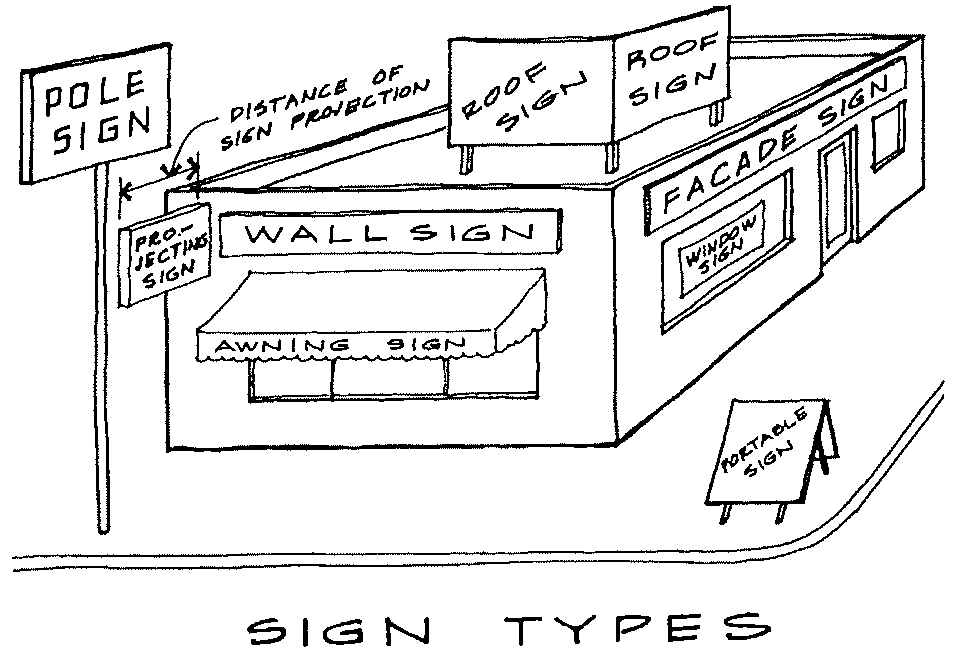
1.
Awning Sign: A sign imposed, mounted or painted upon an awning.
2.
Mansard Sign: A sign imposed, mounted or painted upon a mansard and not extending above the top of the mansard.
3.
Marquee Sign: Any sign attached flat against the marquee or permanent sidewalk canopy of a building and not extending above the top of the marquee.
4.
Mural Sign: A work of art either painted or otherwise directly applied on a building's wall or façade.
5.
Parapet Sign: A sign imposed, mounted or painted on a parapet and not extending above the top of the parapet.
6.
Projecting Sign: A sign affixed to a wall and extending more than 12 inches from the surface of such wall, usually perpendicular to the wall surface.
7.
Roof Sign: A sign that is mounted on, applied to, painted on, or otherwise structurally supported by the roof of a building.
8.
Under-Canopy Sign: A display attached to the underside of a marquee or canopy and protruding over public or private sidewalks.
9.
Wall (Or Facade) Sign: A sign that is fastened directly to or is placed or painted directly upon the exterior wall of a building, with the sign face parallel to the wall, and extending from the surface of the wall no more than 12 inches.
10.
Window Sign: A sign that is placed on or behind a windowpane or glass door and intended to be viewed from outside the building.
C
Caliper: The diameter of a tree (usually nursery stock) measured at a point 6 inches above the ground or top of root ball for up to and including 4-inch caliper trees, and at a point 12 inches above the ground or top of root ball for larger sizes.
Canopy: A permanent roof-like structure projecting from a building and open on at least one side for the purpose of shielding a pedestrian walkway from the elements, or a freestanding roof-like structure supported by columns intended to shield a vehicular driveway or service area from the elements.
Caretaker's Residence: A permanent, secondary, or accessory dwelling for person's employed principally on-site for the purposes of care and protection of persons, property, maintenance responsibilities, etc., and his or her spouse and children.
Cellar: The lower level of a building with more than one-half of its floor-to-ceiling height below the average finished grade of the adjoining ground on all sides, or with a floor-to-ceiling height of less than 6½ feet. See Also "Basement."
Cemetery: Any plot of ground, churchyard, building, mausoleum, or other enclosure used for the burial of the dead.
Changeable Copy Sign:
1.
Automatic Changeable Copy Sign: A sign on which the copy changes automatically on a lamp bank or through mechanical means, e.g., electrical or electronic time and temperature units. Copy shall mean words and numbers.
2.
Manual Changeable Copy Sign: A sign on which copy is changed manually in the field, e.g., reader boards with changeable letters. Copy shall mean words and numbers.
Channel: A natural or artificial watercourse with a definite bed and banks that conducts continuously or periodically flowing water.
Channeled Letters:
1.
Internally Channeled Letters: Letters or other symbols with recessed surface designed to accommodate incandescent bulbs or luminous tubing.
2.
Reverse Channeled Letters: Letters or other symbols with raised surface designed to be lighted from behind by incandescent bulbs or luminous tubing.
Children's Day Care Facility: A "day care facility," as defined in this Code, for children. For the purpose of this Development Code the term "children's day care facility" shall include but not be limited to the terms "nursery school," "early learning center, "pre-kindergarten," "private kindergarten," "play school," or "pre-school."
Clean Water Act: The federal Water Pollution Control Act (33 U.S.C § 1251 et seq.), and any subsequent amendments thereto.
Clinic: An establishment where patients, who are not lodged overnight, are admitted for medical examination and treatment.
Cluster Box Unit (CBU): A structure or shelter housing multiple mailbox units to serve each residential dwelling of the development for the express purpose of regular mail delivery provided by the United States Post Office (USPS).
Commercial: See under "Land Use Categories."
Common Open Space: See "Open Space."
Compatibility: With regard to buildings, compatibility means achieving harmony in appearance of architectural features in the same vicinity.
Composting Center: A site or facility in which composting activities take place under controlled conditions.
Composting: The controlled biological decomposition of organic matter into a stable, odor free humus.
Condition of Zoning Approval: A requirement adopted by the Board of Commissioners at the time of approval of a rezoning or Special Use, placing greater or additional requirements or restrictions on the property than provided in this Development Code in order to reduce an adverse impact of the rezoning or Special Use and to further the protection of the public health, safety, morals, aesthetics, convenience, order, prosperity, and general welfare.
Condominium: A form of ownership distinguished by the absence of individual lots or lot lines and utilizing instead a system of ownership whereby dwelling or other units are individually owned but where land outside of the building walls is held in common and maintained by a condominium association in accordance with OCGA Section 44-3-70, known and cited as the "Georgia Condominium Act."
Conservation Subdivision: See "Subdivision, Conservation."
Construction Activity: Activities subject to the Georgia Erosion and Sedimentation Control Act or NPDES Construction Permits. Such activities include but are not limited to clearing and grubbing, grading, excavating, and demolition.
Construction/Demolition Waste: Waste building materials and rubble resulting from construction, remodeling, repair, and demolition operations on pavements, houses, commercial buildings and other structures. Such wastes include, but are not limited to asbestos containing waste, wood, bricks, metal, concrete, wall board, paper, cardboard, inert waste landfill material, and other nonputrescible wastes which have a low potential for groundwater contamination.
Construction/Demolition Waste Landfill: A discrete area of land that receives construction/demolition waste as defined above.
Critical Facility: Any public or private facility, which, if flooded, would create an added dimension to the disaster or would increase the hazard to life and health. Critical facilities include:
a.
structures or facilities that produce, use, or store highly volatile, flammable, explosive, toxic, or water-reactive materials;
b.
hospitals and nursing homes, and housing for the elderly, which are likely to contain occupants who may not be sufficiently mobile to avoid the loss of life or injury during flood and storm events
c.
emergency operation centers or data storage centers which contain records or services that may become lost or inoperative during flood and storm events; and
d.
generating plants, and other principal points of utility lines.
Cut: A portion of land surface or area from which earth has been removed or will be removed by excavation; the depth below original ground surface to excavated surface. Also known as "excavation."
D
Dam: A structure or wall constructed for the purpose of stopping water, whether constructed as An earthen, embankment, reinforced concrete, or other material.
Day Care Facility: The use of a building or premises for the care and supervision of children or elderly adults who do not reside on the property, for periods of less than 24 hours.
1.
Family Day Care Home: An accessory use within a private residence operated by the occupant of the dwelling that enrolls for pay, supervision and non-medical care, 5 or fewer children or elderly adults with no overnight stays, or no more than 6 children or elderly adults if the structure meets the Building Code requirements for institutional uses.
2.
Group Day Care Home: A day care facility that enrolls for pay, supervision and non-medical care, up to 18 children or elderly adults with no overnight stays.
3.
Day Care Center: A day care facility that enrolls for pay, supervision and non-medical care, 19 or more children or elderly adults with no overnight stays.
Dead Tree Or Plant: Any living plant material that has lost 33% or more of its branches or leaves, as determined by the Planning Director or other qualified designee, shall be considered dead.
Design Professional of Record: The licensed professional whose seal appears on plats or plans subject to these regulations.
Detention: The temporary storage of stormwater runoff in a stormwater management facility for the purpose of controlling the peak discharge.
Detention Facility: A basin or structure used for the temporary storage of stormwater runoff for the purpose of controlling the peak discharge and which is designed to completely drain after a specified period of time.
Developer: A person who undertakes land development activities.
Development Permit: The authorization necessary to initiate and conduct a land-disturbing activity and to carry out the planned development of land and structures.
Development Review Committee (DRC): An internal review group to provide technical review of zoning applications, construction plans and other related items, and consisting of representatives of the Planning and Code Enforcement, Public Works/Engineering, Water Resources, Health, EMA and/or other County Departments
Development: Any man-made change to improved or unimproved real estate, including, but not limited to, buildings or other structures, mining, dredging, filling, grading, paving, excavating, drilling operations, and permanent storage of materials or equipment; a land development or land development project.
Diameter Breast Height (Dbh): The diameter of an existing tree trunk measured at a height of 4½ feet above the ground. If a tree splits into multiple trunks below 4½ feet, the trunk is measured at its most narrow point beneath the split.
Dormer: A window projecting from a roof.
Double Frontage Lot: A lot having frontage on two (2) streets as distinguished from a corner lot.
Double-Faced Sign: A sign structure with two sign faces that are parallel (back-to-back) or that form an angle to one another, where each sign face is designed to be seen from a different direction and the two sign faces are separated from each other at their nearest point by no more than three feet. Sign faces on a single sign structure that are separated by more than three feet are treated as separate signs.
Drainage Easement: An easement appurtenant or attached to a tract or parcel of land allowing the owner of adjacent tracts or other persons to discharge stormwater runoff onto the tract or parcel of land subject to the drainage easement.
Drainage Structure: A device composed of a virtually nonerodible material such as concrete, steel, plastic or other such material that conveys water from one place to another by intercepting the flow and carrying it to a release point for storm-water management, drainage control or flood control purposes.
Drip Line: A perimeter formed by the points farthest away from the trunk of a tree where precipitation falling from the branches of that tree lands on the ground.
Driveway Grade: the grade of the centerline of driveway measured at its steepest point.
Driveway: A travelway improved for vehicular access to a property for the primary purpose of providing access between a street and automobile parking facilities or truck loading areas on the property, or for providing a connection between distinct parking or loading areas on the property.
Drug Store/Pharmacy: A retail business establishment which, A) dispenses prescription and non-prescription medications and B) has more than 2,500 square feet of floor space or which offers for sale products from more than three of the following product categories:
1.
Bulk consumption food or drink products such as multiple serving food or drink packages or containers, (but not including single serving packages or containers).
2.
Photographic film developing or processing services.
3.
Tobacco products such as cigarettes, cigars, snuff, pipe tobacco, or chewing tobacco, (but not including nicotine gum, patches or similar products marketed as stop smoking aids).
4.
Small appliances and personal electronics such as toasters, radios, cassette tape and CD players, calculators, cameras, video games, hair dryers or electric razors, (but not including digital medical thermometers, blood pressure or blood oxygen monitors, humidifiers, heating pads and medication delivery systems.
5.
Cosmetics such as makeup, lipsticks or perfumes, (but not including mouthwashes, toothpastes, foot powders, first aid supplies or medical prostheses).
6.
Alcoholic beverages such as beer, wine or spiritous liquors, (but not including medicines containing alcohol).
7.
Housewares such as light bulbs, cooking utensils, cleaning fluids, drain cleaners, mops, garden hoses or lawn sprinklers.
8.
Hardware such as hand tools, power tools, nails, screws, or electrical extension cords, (but not including durable medical equipment such as wheelchairs, braces, splints, crutches, walkers and similar equipment).
9.
Seasonal items such as Christmas decorations, Halloween costumes and candy, lawn chairs, barbeque grills or picnic coolers, (but not including seasonal flu vaccine or other seasonal medicines).
10.
School and office supplies such as staplers, three ring binders, file folders, desk calendars or pencil sharpeners.
11.
Sporting goods and toys.
12.
Automobile products including motor oil, gas treatment, jumper cables, wiper blades or fuses, (but not including prostheses or other device to assist a disabled person with driving).
Dumpster/Waste Container: A container used solely for the temporary collection and periodic transfer of garbage, household waste or trash excluding sanitary waste in septic tanks, yard trimmings, construction and demolition wastes, and hazardous wastes.
Dwelling: Any building or portion thereof which is designed for or used for residential purposes.
Dwelling Unit: An enclosure of one or more interconnected rooms, including separate bathroom and kitchen facilities, designed and constructed as a unit for permanent residential occupancy by one family.
Dwelling, Single Family: A building designed for and occupied exclusively by one family. See also "Site Built Single-Family Dwelling," "Manufactured Home," "Mobile Home" and "Modular Home."
Dwelling, Multi-Family: A residential building designed exclusively for occupancy by three or more families in separate dwelling units living independently of each other.
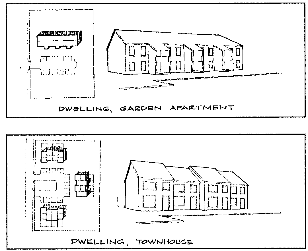
1.
Townhouse: A multi-family dwelling in which the dwelling units may adjoin one another only at the vertical walls and no dwelling unit may be located above another, as shown in the following illustration.
2.
Apartment: A multifamily dwelling in which a dwelling unit may be located above another, as shown in the illustration.
Dwelling, Tenant: A residential structure located on a farm, said structure being owned by the farmer or property owner and occupied by a non-transient farm worker who is employed by the owner or operator of the farm. Said employment shall be directly associated with a bona fide agricultural operation on the same property as the tenant dwelling.
Dwelling, Two-Family (Duplex): A building designed for and occupied exclusively by two families living independently of each other in separate dwelling units within the same building.
E
Earthen Fill Landfill: An inert waste landfill, as defined in this Code, limited to earth, yard trimmings, stumps, limbs, and leaves.
Easement: A grant by a property owner of the use of land for a specific purpose or purposes by the general public, or a corporation or a certain person or persons.
Eave: The projecting lower edges of a roof overhanging the wall of a building.
Elevated Building: A non-basement building built to have the lowest floor of the lowest enclosed area elevated above the ground level by means of fill, solid foundation perimeter walls, pilings, columns, piers, or shear walls adequately anchored so as not to impair the structural integrity of the building during a base flood event.
Engineer: A registered, practicing engineer, licensed by the State of Georgia.
EPD Director: The Director of the Environmental Protection Division of the Georgia Department of Natural Resources.
EPD: The Environmental Protection Division of the Georgia Department of Natural Resources.
Erosion and Sedimentation Control Plan: A plan that is designed to minimize the accelerated erosion and sediment runoff at a site during land disturbance activities.
Erosion: The process by which land surface is worn away by the action of wind, water, ice, or gravity.
Event Venue: A structure or space being leased for receptions, events, or similar functions not carried out as part of an agritourism activity.
Excavation and Trenching Certificate Holder: The holder of the "excavation and trenching certificate" identified above.
Excavation and Trenching Certificate: The certificate issued upon satisfactory completion of a mandatory training/educational program regarding excavation and trenching safety practices, such program to be provided by or approved by the Oconee County Fire Department.
Excavation: (1) The mechanical removal of earth material. (2) Any manmade cavity or depression in the earth's surface, including its sides, wall, or faces, formed by earth removal and producing unsupported earth conditions by reasons of the excavation. If installed forms or similar structures reduce the depth-to-width relationship, an excavation may become a trench.
Existing Construction: For the purposes of flood damage prevention requirements, any structure for which the start of construction commenced before adoption of the first flood damage prevention ordinance or regulation in the county (July 17, 1989).
Existing Manufactured Home Park or Subdivision: A manufactured home park or subdivision for which the construction of facilities for servicing the lots on which the manufactured homes are to be affixed (including at a minimum the installation of utilities, the construction of streets, and final site grading or the pouring of concrete pads) is completed before July 17, 1989.
Expansion to an Existing Manufactured Home Park or Subdivision: The preparation of additional sites by the construction of facilities for servicing the lots on which the manufactured homes are to be affixed, including the installation of utilities, the construction of streets, and either final site grading or the pouring of concrete pads.
F
FAA: Federal Aviation Administration.
Family: One or more persons occupying a dwelling unit and living as a single housekeeping unit, as distinguished from persons occupying a boarding house, lodging house, or hotel, as herein defined.
FCC: Federal Communications Commission.
Fill: A portion of land surface to which soil or other solid material has been added; the depth above the original ground.
Finished Grade: The final elevation and contour of the ground after cutting or filling and conforming to the proposed design.
Flag: A sign made of paper, woven natural or synthetic fabric, thin plastic, or similar lightweight pliable material that is normally displayed by flying from a pole as a wind-activated device.
Flood and Flooding: A general and temporary condition of partial or complete inundation of normally dry land areas from: (1) the overflow of inland or tidal waters; or (2) the unusual and rapid accumulation or runoff of surface waters from any source.
Flood Hazard Boundary Map (FHBM): The official map issued by the Federal Emergency Management Agency where the areas of special flood hazard have been designated as Zone A.
Flood Insurance Rate Map (FIRM): The official map of a community on which the Federal Emergency Management Agency has delineated both the areas of special flood hazard and the risk premium zones applicable to the community.
Flood Insurance Study: The official report provided by the Federal Emergency Management Agency evaluating flood hazards and containing flood profiles and water surface elevations of the base flood.
Flood Plain: Any land area susceptible to flooding.
Flood Proofing: Any combination of structural and non-structural additions, changes, or adjustments to structures, which reduce or eliminate flood damage to real estate or improved real property, water and sanitary facilities, structures and their contents.
Floodway: The channel of a river or other watercourse and the adjacent land areas that must be reserved in order to discharge the base flood without cumulatively increasing the water surface elevation more than a designated height.
Floor Area, Gross Leasable: The gross floor area of all floors intended for occupancy and the exclusive use of tenants, specifically excluding public or common areas such as utility rooms, stairwells, enclosed malls and interior hallways.
Floor Area, Gross: The total area of all floors of a building measured from the exterior faces of the exterior walls or from the centerline of common walls separating two buildings, but not including attic space providing headroom for less than 7 feet; unusable basement or cellar space; uncovered steps or fire escapes; open porches; accessory water or cooling towers; and accessory off-street parking spaces or accessory off-street loading berths within the building.
Floor Area, Heated: The gross floor area of all spaces within a building that are heated by mechanical means, known also in dwelling units as "living area." Heated floor area does not include garages, unheated basements or cellars, attic storage areas, partially unenclosed decks or lanais, and areas open to the sky.
Freeboard: A factor of safety usually expressed in feet above a flood level for purposes of floodplain management. "Freeboard" tends to compensate for the many unknown factors that could contribute to flood heights greater than the height calculated for a selected size flood and floodway conditions, such as wave action, bridge openings, and the hydrological effect of urbanization of the watershed.
Freestanding Sign: A sign permanently attached to the ground and that is wholly independent of any building or other structure. The term "freestanding sign" includes but is not limited to the following:
1.
Pole Sign: A sign that is mounted on a freestanding pole, columns, or similar support such that the bottom of the sign face or lowest sign module is not in contact with the ground.
2.
Ground Sign: A freestanding sign in which the entire bottom of the sign face or structure is in contact with the ground, providing a solid and continuous background for the sign face from the ground to the top of the sign. Also referred to as a "monument sign."
Frontage, Lot: The distance over which the boundary line of the lot and the street line are coincident.
Functionally Dependent Use: A use that cannot perform its intended purpose unless it is located or carried out in close proximity to water.
G
Garage Apartment: A dwelling unit for one family erected above a private garage detached from the main dwelling.
Garage, Parking: A building or portion thereof designed or used for storage of motor-driven vehicles, and at which motor fuels and oils may be sold, and in connection with may be performed general automotive servicing as distinguished from automotive repairs.
Garage, Private: An accessory building or a portion of a main building used for the parking or storage of automobiles of the occupants of the main building. A carport would be considered as a private garage.
Garage, Repair: A building or portion thereof, other than a private or parking garage, designed or used for the storage, servicing, repairing, equipment and hiring of motor driven vehicles.
Garbage: Food waste including waste accumulations of animal or vegetable matter used or intended for use as food, or that attends the preparation, use, cooking, dealing in or storing of meat, fish, fowl, fruit or vegetables.
Generalized Wetland Map: The most recently published Generalized Wetland Map shall include all portions of the National Wetlands Inventory Maps produced by the U.S. Department of the Interior that are pertinent to lands within the jurisdictional boundaries of Oconee County, GA.
Georgia D.O.T. Standards/Specifications: State of Georgia Standard Specifications - Construction of Transportation Systems, latest edition.
Georgia Stormwater Management Manual, Volume 2: Technical Handbook, produced as a result of a collaborative effort between the Atlanta Regional Commission (ARC), the Georgia Department of Natural Resources-Environmental Protection Division (EPD), and 35 cities and counties from across Georgia that provides guidance on the techniques and measures that can be implemented to meet a set of stormwater management minimum standards for new development and redevelopment, as amended from time to time.
GIS: Geographic Information System.
GPS: Global Positioning System.
Gradient Formula: d = gxl/100 where d is vertical difference in elevation in feet; I is horizontal distance in feet; and g is slope or gradient expressed as a percent.
Gradient: Slope.
Grading: Altering the shape of ground surfaces to a predetermined condition; this includes stripping, cutting, filling, stockpiling and shaping, or any combination thereof, and shall include the land in its cut or filled condition.
Greenspace: Permanently protected areas of the site that are preserved in a natural state. See also under "Open Space."
Gross Floor Area (GFA): See "Floor Area, Gross."
Gross Leasable Area (GLA): See "Floor Area, Gross Leasable."
Ground Elevation: The original elevation of the ground surface prior to cutting or filling.
Guest House: A habitable living unit that is an accessory use to a dwelling and is designed and intended for the temporary housing of visitors to a property at the behest of the property residents for no fee or other consideration, and meeting or exceeding the Standards for Single-Family and Two-Family Dwellings under this Code.
H
Habitable Room: Any room designed and used for sleeping or living purposes, or combinations thereof. Enclosed places intended for common use, such as, bathrooms, toilet compartments, halls, closets, kitchens, storage or utility spaces, and other similar areas are not considered a habitable room.
Hazardous Materials: Any material, including any substance, waste, or combination thereof, which because of its quantity, concentration, or physical, chemical, or infectious characteristics may cause, or significantly contribute to, a substantial present or potential hazard to human health, safety, property, or the environment when improperly treated, stored, transported, disposed of, or otherwise managed.
Hazardous or Toxic Waste Transfer Station: A facility in which toxic or hazardous wastes are brought in to the site exclusively for transferal to another vehicle that will transport the wastes to another facility for disposal.
Hazardous Waste: Solid or liquid waste material resulting from the manufacture or use of pesticides and drugs (other than normal household use); pathological wastes; highly flammable or explosive wastes; toxic wastes; sewage sludges; and other waste material that may be a hazard to the public health, safety or environment, except radioactive waste materials as defined by the State of Georgia.
Heated Floor Area: See "Floor Area, Heated."
Heavily Landscaped Area: An area planted with a combination of shade and flowering trees, deciduous and evergreen shrubs, and flowering perennials such that the entire area is covered with landscape materials. The green space designated to be heavily landscaped shall have no more than 25% of its area covered in turf (seed or sod). The remaining 75% shall contain shade trees (2 inch caliper minimum), flowering trees (2 inch caliper minimum), evergreen shrubs (3 gallon minimum), deciduous shrubs (3 gallon minimum), and perennials or non-turf groundcovers (2½ inch pot minimum). All plant materials shall be mulched.
Heavy Truck: Any vehicle, except recreational vehicles, vehicles displaying restricted plates, buses used in transportation of chartered parties, and government owned vehicles, used for the transportation of persons for hire or designed, used, or maintained primarily for the transportation of property and which is:
1.
A power unit having a gross vehicle weight in excess of 26,000 pounds;
2.
A power unit having three or more axles, regardless of weight; or
3.
Used in combination, when the weight of such combination exceeds 26,000 pounds gross vehicle weight.
Height of Telecommunications Tower: When referring to a tower or other structure, the distance measured from ground level to the highest point on the tower or other structure, even if said highest point is an antenna.
Helipad: An accessory facility where helicopters take off and land in the normal course of business, delivery or service to a principal use. A helipad consists only of the takeoff/landing facility and its attendant safety structures, and does not include service, maintenance and repair, or fueling facilities. See also "Heliport."
Heliport: A takeoff and landing area for helicopters which also provides service, storage, maintenance and repair, and fueling for private or commercial helicopters.
Highest Adjacent Grade: The highest natural elevation of the ground surface, prior to construction, next to the proposed foundation of a building.
Historic Structure: Any structure that is:
1.
Listed individually in the National Register of Historic Places (a listing maintained by the U.S. Department of Interior) or preliminarily determined by the Secretary of the Interior as meeting the requirements for individual listing on the National Register:
2.
Certified or preliminarily determined by the Secretary of the Interior as contributing to the historical significance of a registered historic district or a district preliminarily determined by the Secretary to qualify as a registered historic district:
3.
Individually listed on a state inventory of historic places and determined as eligible by states with historic preservation programs which have been approved by the Secretary of the Interior; or
4.
Individually listed on a local inventory of historic places and determined as eligible by communities with historic preservation programs that have been certified either: a) By an approved state program as determined by the Secretary of the Interior, or b) Directly by the Secretary of the Interior in states without approved programs.
Home Business: See "Home Occupation."
Home Occupation: Any activity carried out for profit by the resident and conducted as an accessory use in the resident's dwelling unit. A home occupation is further defined as one of the following:
1.
Home Office: A home occupation that is limited to an office use and does not involve visits or access by the public, suppliers or customers, and does not involve the receipt, maintenance, repair, storage or transfer of merchandise at the home.
2.
Home Business: A home occupation that is limited to the use of a practicing professional or artist, or to the office use of the operator of a business, and may involve very limited visits or access by clients or customers and the maintenance, repair, storage or transfer of merchandise received at the home.
3.
Family day care home: A home occupation in which the occupant of the dwelling provides supervision and non-medical care for up to 6 children or elderly adults with no overnight stays. See definition under "Day Care Facilities."
Home Office: See "Home Occupation."
Horse Riding Stable: A building in which horses are housed, kept, fed or maintained for personal enjoyment or commercial recreation.
1.
Horse Riding Stables, Commercial: A horse riding stable in which the horses are available for riding or riding instruction for compensation to persons other than the owners of the horses or the owners' guests.
2.
Horse Riding Stables, Private: A horse riding stable in which some or all of the horses that are housed, kept, fed or maintained, whether or not for compensation, may not be owned by the owner of the stable, and horse riding is limited to the owners of the horses or the owners' guests.
3.
Horse Riding Stables, Personal: A horse riding stable that is an accessory use to a residence and in which the horses that are housed, kept, fed or maintained are owned by the occupants of the residence.
Hotel or Motel: A business establishment offering short term lodging (30 days or fewer) to the traveling public while away from their normal places of residence, and often including a restaurant as an accessory use. In contrast, see "Bed and Breakfast Inn" and "Rooming or Boarding House."
Hotspot: A land use or activity on a site that produces higher concentrations of trace materials, hydrocarbons or other pollutants than are normally found in urban stormwater runoff. Examples of hotspots include, but are not limited to: gas stations, vehicle service and maintenance areas, salvage yards, material storage sites, garbage transfer facilities, and commercial parking lots with high-intensity use.
Household Waste: Any solid waste (including garbage, trash, and sanitary waste in septic tanks) derived from households (including single and multiple residences, hotels and motels, bunkhouses, ranger stations, crew quarters, campgrounds, picnic grounds, and day use recreation areas).
Hydric Soils: Soils that form as a result of saturated soils conditions. A list of these soils is maintained by the Soil Conservation Service.
Hydrophytic Vegetation: Macrophytic plants tolerant of or dependent on saturated soil conditions.
I
Illegal Connection: An illegal connection is defined as either of the following:
1.
Any pipe, open channel, drain or conveyance, whether on the surface or subsurface, which allows an illicit discharge to enter the storm drain system including but not limited to any conveyances which allow any non-stormwater discharge including sewage, process wastewater, and wash water, regardless of whether said drain or connection has been previously allowed, permitted, or approved by an authorized enforcement agency; or
2.
Any pipe, open channel, drain or conveyance connected to the Oconee County separate storm sewer system that has not been documented in plans, maps or equivalent records and approved by an authorized enforcement agency.
Illicit Discharge: Any direct or indirect non-stormwater discharge to the Oconee County storm drain system, except as exempted in the Storm Drainage and Stormwater Management Division of the Erosion Control and Stormwater Management Article of this Development Code.
Illuminated Signs:
1.
Internally Illuminated Sign: Any sign that is illuminated by an artificial light source from within the sign structure over any or all of its sign face.
2.
Externally Illuminated Sign: Any sign that is partially or completely illuminated at any time by an artificial light source that directly or indirectly illuminates the face of the sign from outside the sign structure.
Impervious Cover: A surface composed of any material that significantly impedes or prevents the natural infiltration of water into soil. Impervious surfaces include, but are not limited to, rooftops, buildings, streets and roads, disturbed and compacted soil, and any concrete or asphalt surface.
Incidental Sign: A small sign, emblem, or decal no larger than one square foot. Such signs are normally located on doors, windows, and gas pumps, and are generally not readily visible or legible from public rights-of-way.
Industrial: See under "Land Use Categories."
Industrial Activity: Activities subject to NPDES Industrial Permits as defined in 40CFR, Section 122.26 (b) (14).
Industrialized Building: A building manufactured in accordance with the Georgia Industrialized Building Act (O.C.G.A. Title 8, Chapter 2, Article 2, Part 1) and the Rules of the Commissioner of the Georgia Department of Community Affairs issued pursuant thereto. State approved buildings meet the State Building and Construction Codes and bear an insignia of Approval issued by the Commissioner.
Inert Waste Landfill: A disposal facility accepting only wastes that will not or are not likely to cause production of leachate of environmental concern. Such wastes are limited to earth and earth-like products, concrete, cured asphalt, rock, bricks, yard trimmings, stumps, limbs, and leaves. This definition excludes industrial and demolition waste not specifically listed above.
Infiltration: 1) The use of pervious surfaces to allow rainfall to soak into the ground on site. 2) The process of percolating stormwater runoff into the subsoil.
Inspection and Maintenance Agreement: A written agreement providing for the long-term inspection and maintenance of stormwater management facilities and practices on a site or with respect to a land development project, which when properly recorded in the deed records, constitutes a restriction on the title to a site or other land involved in a land development project.
Institution: A non-profit corporation or non-profit establishment.
Intensity of Rainfall Event: The rate at which rain is falling at any given instant during the life of a rainfall event expressed in inches per hour.
Interchange: A grade separated intersection, usually on a controlled access or limited access roadway, where access to such roadway is provided by means of bridges and ramps so that traffic entering and exiting the highway can merge into and exit from the highway at the posted speed limit. This definition shall not include at-grade intersections.
Intermodal Container: A six-sided container used for the storage and/or transportation of goods and designed for transport or capable of being transported by a variety of transportation modes, i.e. on semi-trailer beds, rail cars or ships.
Internally Channeled Letters: See under "Channeled Letters."
J
Junk Vehicle: A wrecked, damaged, inoperable, or dismantled or partially dismantled motor vehicle in such a condition that the cost of restoring the vehicle to an operating condition exceeds the market value of the vehicle.
Junk Yard: Any establishment which is maintained or used for storing, buying, or selling junk, or for an automobile graveyard, in contrast to a "recycling or materials recovery facility.
Junk: Old or scrap copper, brass, rope, rags, batteries, paper, trash, rubber debris, waste; junked, dismantled, or wrecked automobiles, or parts thereof; or iron, steel, and old scrap ferrous or nonferrous material.
Jurisdictional Determination: An official, written statement or map signed by the U.S. Army Corps of Engineers.
Jurisdictional Wetland: A wetland area that meets the definitional requirements for wetlands as determined by the U.S. Army Corps of Engineers.
K
Kennels: Any location where raising, grooming, caring for or boarding of dogs, cats or other small animals for commercial purposes is carried on.
Kindergarten: A school for pre-elementary school children ranging in age from 4 through 6 years; which operates for less than 8 hours per day.
Kiosk: A freestanding sign structure, usually cylindrical in shape, intended to be viewed from all sides and erected for the purpose of posting signs, notices or other public announcements. Kiosks that are composed of flat faces are treated as multi-faced signs.
L
Land Development: Any land change, including, but not limited to, clearing, digging, grubbing, stripping, removal of vegetation, dredging, grading, excavating, transporting and filling of land, construction, paving, and any other installation of impervious cover.
Land Development Activities: Those actions or activities that comprise, facilitate, or result in land development.
Land Development Project: A discrete land development undertaking.
Land Disturbance Permit: Authorization from the local or state regulatory agency to perform construction activities or land disturbance activities in conformance with an approved soil erosion and sediment control plan and/or minimum standards as provided by law.
Land-Disturbing Activity: Any activity that may result in soil erosion from water or wind and the movement of sediments into state waters or onto lands within the state, including, but not limited to, clearing, dredging, grading, excavating, transporting and filling of land but not including those practices that are exempt under the Soil Erosion and Sedimentation Control provisions of this Development Code.
Land Use Categories (for Sign Regulations under Article 7):
1.
Agricultural: A property used primarily for the cultivation of crops, dairying or the raising of livestock, or a vacant property zoned or offered for sale or lease for such purpose.
2.
Single- and Two-Family Residential: A property occupied primarily by one or more single-family dwellings or duplex dwellings, or a vacant property zoned or offered for sale or lease for such purpose.
3.
Multi-Family Residential: A property occupied primarily by one or more residential buildings containing three or more dwelling units, or a mobile home park, or a vacant property zoned or offered for sale or lease for such purposes.
4.
Commercial: A property occupied by one or more business establishments that are primarily engaged in the sale of goods; the provision of personal, professional, business, entertainment or other commercial services; the management of a business enterprise; or the provision of temporary housing to the traveling public (such as a motel); or a vacant property zoned or offered for sale or lease for such purposes.
5.
Industrial: A property occupied by one or more business establishments that are primarily engaged in the fabrication, manufacture or production of durable or nondurable goods, or a vacant property zoned or offered for sale or lease for such purpose.
6.
Public or Community Use: A property occupied by a nonprofit religious, recreational or philanthropic organization, club or institution.
Landing Area: The area of an airport used for landing, taking off, or taxiing of aircraft.
Landscape Architect: A registered, practicing landscape architect licensed by the State of Georgia.
Landscape Buffer: See "Buffer, Landscape."
Landscape Materials: Any combination of living plant materials and nonliving materials such as rock, pebbles, wood chips, mulch and pavers, and decorative features, including sculpture, patterned walks, fountains, and pools. Synthetic landscaping materials acceptable to the Director of Planning may also be used.
Larger Common Plan of Development or Sale: A contiguous area where multiple, separate and distinct construction activities are or may be occurring at different times on different schedules under one plan of development or sale. For purposes of this paragraph, "plan" means an announcement; piece of documentation such as a sign, public notice or hearing, sales pitch, advertisement, drawing, permit application, zoning request, or computer design; or physical demarcation such as boundary signs, lot stakes, or surveyor markings, indicating that construction activities may occur on a specific plot.
Lateral Expansion: A horizontal expansion of the waste boundaries of an existing MSWLF unit or landfill unit.
Laundry and Dry Cleaning Pick Up: A business that provides only for the convenience of taking and picking up of laundry, such as establishments not having any equipment for processing of the laundry.
Life Plan Community (LPC): an organization which offers a contract to provide an individual of retirement status, other than an individual related by consanguinity or affinity to the provider furnishing the care, with board and lodging, licensed nursing facility care and medical or other health related services, or both. These services are provided for a minimum period of more than one (1) year and may be for as long as the lifetime of the resident.
1.
Type A Life Plan Community (Type A LPC) provides LPC services at the same location for the life of an individual, including mutually terminable contracts, and in consideration of the payment of an entrance fee with or without other periodic charges. A Type A LPC offers nursing facility care for a little or no substantial increase in monthly payments, except normal operating costs and inflation adjustments.
2.
Type B Life Plan Community (Type B LPC) provides LPC services at the same location for a period in excess of one year, including mutually terminable contracts, and in consideration of the payment of an entrance fee with other periodic charges. A Type B LPC offers a specified amount of nursing facility care for little or no substantial increase in monthly payments except normal operating costs and inflation adjustments. After the specified amount of nursing care is received, residents pay either a discounted rate or the full per diem rate for nursing care required.
Loading Space: A space within the main building or on the same lot, providing for the standing, loading, or unloading of trucks and other carriers.
Local Issuing Authority: The Oconee County Board of Commissioners or its assigned or designated representative, which shall be responsible for administering this Article and has been certified by the Director of the Environmental Protection Division of the Department of Natural Resources as the issuing authority, pursuant to the Erosion and Sedimentation Act of 1975, as amended.
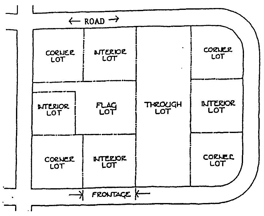
Lot: A parcel or tract of land held in single or undivided ownership devoted to a common use or occupied by a building or group of buildings devoted to a common use, together with the customary accessories and open spaces belonging to the same.
1.
Corner Lot: A lot or parcel of land abutting upon two or more streets at their intersection or upon two parts of the same street forming an interior angle of less than 120 degrees.
2.
Double-Frontage Lot (i.e., a "Through Lot"): A lot bounding on 2 or more streets, but not at their intersection, so that it is not a corner lot unless said corner lot has frontage on 3 or more sides.
3.
Interior Lot: A lot having frontage on only one street.
4.
Flag Lot: A lot having a street frontage and initial lot width notably less wide than the body of the lot (usually where the principal building is intended to be located), such that the lot appears to be a "flag" on a "pole" extending to the street frontage.
Lot Area: The computed ground area inside the lot lines.
Lot Coverage: The computed ground area occupied by all impervious surface within a lot.
Lot, Depth Of: The distance between the front and rear lot lines, measured in the general direction of the side lines of the lot.
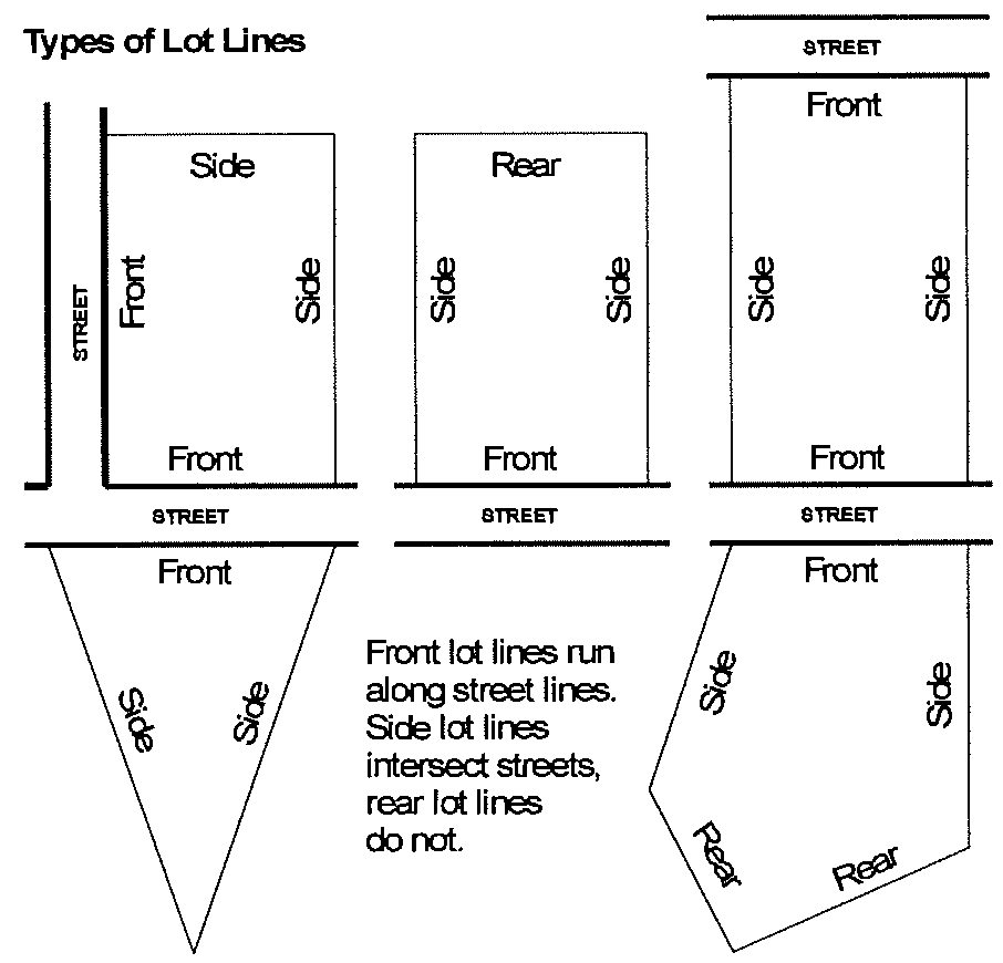
Lot Line: The boundary dividing a given lot from the street or adjacent lots; the boundary defining the limit of ownership of a property.
1.
Front Lot Line: Any boundary line of a lot that abuts a street. A lot adjacent to more than one street will have more than one front lot line.
2.
Rear Lot Line: Any boundary line of a lot that does not intersect with a street right-of-way line and is not a front lot line.
3.
Side Lot Line: Any boundary line of a lot that intersects with a street right-of-way line and is not a front lot line.
Lot of Record: A lot or parcel of land whose existence, location and dimensions have been recorded in the Office of the Clerk of the Superior Court of Oconee County.
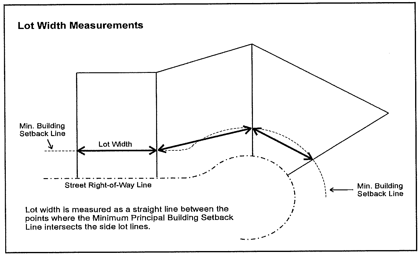
Lot Width: The distance measured along the front minimum building setback line between intersecting lot lines. The lot width shall be measured along a straight line between such points of intersection.
Lot, Depth Of: The mean horizontal distance between the front and rear lot lines, measured in the general direction of the side lines of the lot.
Lowest Floor: The lowest floor of the lowest enclosed area, including a basement. An unfinished or flood resistant enclosure, used solely for parking of vehicles, building access, or storage, in an area other than a basement, is not considered a building's lowest floor, provided that such enclosure is not built so as to render the structure in violation of other provisions of this code.
M
Mansard: A steeply sloped, roof-like facade architecturally similar to a building wall.
Manufactured Home Installation: The construction of a foundation system and the placement or erection of a manufactured home or a mobile home on the foundation system. Such term includes, without limitation, supporting, blocking, leveling, securing, or anchoring such home and connecting multiple or expandable sections of such home.
Manufactured Home Installer: A person responsible for performing an installation and who has obtained a license pursuant to the provisions of Georgia Law.
Manufactured Home Park: A single, un-subdivided property on which two or more manufactured homes are located or intended to be located for purposes of residential rental occupancy as permanent places of residence.
Manufactured Home Park or Subdivision (Per Floodplain Management requirements): A parcel (or contiguous parcels) of land divided into two or more manufactured home lots for rent or sale.
Manufactured Home Space: A designated area within a manufactured home park, distinguished from a lot in a subdivision under fee-simple ownership, upon which a single manufactured home is or may be placed, along with its accessory structures and uses.
Manufactured Home Subdivision: A residential subdivision, designed and approved in accordance with the subdivision regulations, in which individual ownership of a lot is permitted, for the placement of a manufactured home for dwelling unit purposes.
Manufactured Home: A structure, transportable in one or more sections, which, in the traveling mode, is eight body feet or more in width or 40 body feet or more in length or, when erected on site, is 320 or more square feet and which is built on a permanent chassis and designed to be used as a dwelling with or without a permanent foundation when connected to the required utilities and includes the plumbing, heating, air-conditioning, and electrical systems contained therein; except that such term shall include any structure which meets all the requirements of this paragraph except the size requirements and with respect to which the manufacturer voluntarily files a certification required by the secretary of housing and urban development and complies with the standards established under the National Manufactured Housing Construction and Safety Standards Act of 1974, 42 U.S.C. Section 5401, et seq.
Manufactured Home (Per Floodplain Management requirements): A building, transportable in one or more sections, built on a permanent chassis and designed to be used with or without a permanent foundation when connected to the required utilities. The term also includes park trailers, travel trailers, and similar transportable structures placed on a site for 180 consecutive days or longer and intended to be improved property.
Marquee Sign: See under "Building Sign."
Marquee: A permanent roof-like structure or canopy of rigid materials supported by and extending from the facade of a building.
Massage Therapy Establishment: An establishment where body massages are provided by State licensed massage therapists.
Master Planned Development: An area of land for which an overall development plan has been prepared that meets the requirements of Article 5 and which allows for design flexibility from traditional land use development requirements (such as setbacks, prohibitions against mixing land uses within a development, street design and ownership) and which allows for greater design flexibility in locating buildings and in combining residential and commercial land uses and dwelling and structure types making it possible to achieve certain economics in construction as well as the preservation of green space and the inclusion of amenities. MPDs are designed to be located where adequate infrastructure (such as utilities and transportation) is available or can be easily obtained and on or near major road corridors near major transportation areas, shopping, schools and employment centers.
Materials Recovery Facility: A solid waste handling facility that provides for the extraction from solid waste of recoverable materials, materials suitable for use as a fuel or soil amendment, or any combination of such materials.
Mean Sea Level: The average height of the sea for all stages of the tide. It is used as a reference for establishing various elevations within the floodplain. For purposes of the National Flood Insurance Program, the National Geodetic Vertical Datum (NGVD) of 1929 or other datum, to which base flood elevations shown on a community's Flood Insurance Rate Map are referenced.
Metropolitan River Protection Act (MRPA): A state law referenced as O.C.G.A. 12-5-440 et seq., which addresses environmental and developmental matters in certain metropolitan river corridors and their drainage basins.
Minimum Street-Side Setback: The minimum distance required by the zoning on a property between an adjoining street and the façade of a principal building on the property.
Mobile Food Service Unit: An independent trailer, motor driven or manually propelled pushcart, food truck, watercraft, movable portable structure, vehicle vendor or any other similar conveyance which is not connected to a permanent water supply or sewer disposal system and from which food is offered for sale or service.
Mobile Home: A structure, transportable in one or more sections, which, in the traveling mode, is eight body feet or more in width or 40 body feet or more in length or, when erected on site, is 320 or more square feet and which is built on a permanent chassis and designed to be used as a dwelling with or without a permanent foundation when connected to the required utilities and includes the plumbing, heating, air-conditioning, and electrical systems contained therein; and manufactured prior to June 15, 1976 or otherwise does not comply with the standards established under the National Manufactured Housing Construction and Safety Standards Act of 1974, 42 U.S.C. Section 5401, et seq.
Modular Building: See "Industrialized Building."
Modular Home: A dwelling manufactured in accordance with the Georgia Industrialized Building Act (see "Industrialized Building").
Monument Sign: See "Ground Sign" under "Freestanding Sign."
Motel: See "Hotel or Motel."
Motor Vehicle Safety Commissioner: The Georgia Commissioner of Motor Vehicle Safety or the Oconee County Tax Commissioner when so authorized by the Georgia Commissioner of Motor Vehicle Safety to act on his or her behalf in carrying out the responsibilities of O.C.G.A. 8-2-180 et seq.
Mulch: Pine straw, pine bark, pebbles, lava rock, or processed cypress trees acceptable to the Director of Planning may be used. By products of unprocessed grinding operations may not be used for mulching under landscape plants or trees.
Multi-Faced Sign: A single sign structure consisting of two sign faces (see "double-faced sign) or three or more sign faces that are separated from each other at their nearest point by no more than three feet. Sign faces on a single sign structure that are separated by more than three feet are treated as separate signs.
Multi-Family Residential: See under "Land Use Categories."
Municipal Solid Waste Landfill (MSWLF) Unit: A discrete area of land or an excavation that receives household waste, and that is not a land application unit, surface impounding, injection well, or waste pile, as those terms are defined under 40 CFR Part 257.2. A MSWLF unit also may receive other types of solid waste, such as commercial solid waste, non-hazardous sludge, small quantity generator waste and industrial solid waste. Such a landfill may be publicly or private owned. A MSWLF unit may be a new MSWLF unit, an existing MSWLF unit or a lateral expansion.
Mural: A large picture or image which is painted, constructed, or affixed directly onto a vertical building wall.
N
National Geodetic Vertical Datum (NGVD): As corrected in 1929, is a vertical control used as a reference for establishing varying elevations within the flood plain.
National Pollutant Discharge Elimination System (NPDES) Stormwater Discharge Permit: A permit issued by Georgia EPD under authority delegated pursuant to 33 USC § 1342 (b) that authorizes the discharge of pollutants to waters of the United States, whether the permit is applicable on an individual, group, or general area-wide basis.
Natural Buffer: See under "Buffer, Landscape."
Natural Ground Surface: The ground surface in its original state before any grading, excavation or filling.
Nephelometric Turbidity Units (NTU): Numerical units of measure based upon photometric analytical techniques for measuring the light scattered by finely divided particles of a substance in suspension. This technique is used to estimate the extent of turbidity in water in which colloidally dispersed particles are present.
Net Density: For the purposes of conservation subdivisions, net density shall be the total contiguous acreage within the boundaries of the subdivision divided by the total number of building lots and shall be expressed in "lots per acre" (e.g., 50 total acres divided by 43 building lots = one lot per 1.1628 acres net density).
New Construction: For the purposes of determining insurance rates, structures for which the "start of construction" commenced after April 17. 1995 and includes any subsequent improvements to such structures. For floodplain management purposes, "new construction" means structures for which the "start of construction" commenced after July 17, 1989, and includes any subsequent improvements to such structures.
New Development: A land development activity on a previously undeveloped site.
New Manufactured Home Park or Subdivision: A manufactured home park or subdivision for which the construction of facilities for servicing the lots on which the manufactured homes are to be affixed (including at a minimum, the installation of utilities, the construction of streets, and either final site grading or the pouring of concrete pads) is completed on or after adoption of the first flood damage prevention ordinance or regulation in the county (July 17, 1989).
New MSWLF Unit: Any municipal solid waste landfill unit that has not received waste prior to October 9, 1993.
Nonpoint Source Pollution: A form of water pollution that does not originate from a discrete point such as a sewage treatment plant or industrial discharge, but involves the transport of pollutants such a sediment, fertilizers, pesticides, heavy metals, oil, grease, bacteria, organic materials and other contaminants from land to surface water and groundwater via mechanisms such as precipitation, stormwater runoff, and leaching. Nonpoint source pollution is a by-product of land use practices such as agricultural, silvicultural, mining, construction, subsurface disposal and urban runoff sources.
Non-Stormwater Discharge: Any discharge to the storm drain system that is not composed entirely of stormwater.
Nonstructural Stormwater Management Practice or Nonstructural Practice: Any natural or planted vegetation or any other nonstructural component of the stormwater management plan that provides for or enhances stormwater quantity and/or quality control or other stormwater management benefits, and includes, but is not limited to, riparian buffers, open and greenspace areas, overland flow filtration areas, natural depressions, and vegetated channels.
Non-Urbanized Area: The area of unincorporated Oconee County not regulated under the National Pollutant Discharge Elimination System (NPDES) Stormwater Phase II Permit.
Nursing Care Facility: A home for aged or ill persons in which 3 or more persons not of the immediate family are provided with food, shelter, and care for compensation but not including hospitals, clinics, or similar institutions devoted primarily to diagnosis and treatment, and not including personal care homes. Nursing homes usually have comprehensive medical staff including RNs and LPNs or other state licensed health care providers.
O
Oconee County Separate Storm Sewer System: Any facility, owned or maintained by the county, designed or used for collecting and/or conveying stormwater, including but not limited to roads with drainage systems, Oconee County streets, curbs, gutters, inlets, catch basins, piped storm drains, pumping facilities, retention and detention basins, natural and man-made or altered drainage channels, reservoirs, and other drainage structures.
One-Hundred-Year Flood Plain: A land area subject to a 1 percent or greater statistical occurrence probability of flooding in any given year.
Opaque: Impenetrable to view, or so obscuring to view that features, buildings, structures, and uses become visually indistinguishable.
Open Space: An area of land or water that is permanently set aside through dedication, designation or reservation to remain in a natural and unimproved state or that may be improved only for active or passive recreation or enjoyment. Open space can be defined as:
Common Open Space: Land or water areas within a development project that are available to or benefit all occupants of the development on a continuing and permanent basis, such as walking trails, community centers or clubhouses, golf courses and other recreation areas, protected flood plains or wetlands, and fishing or boating lakes. Common open space does not include any streets or public or private rights-of-way, or yard areas or landscape areas located on private property.
Public Open Space: Land reserved for preservation, leisure or recreational use but dedicated in fee simple to a governing body or agency to be responsible for operation and maintenance. Public open space may not be reserved for or dedicated to the exclusive use of the residents of a particular development.
Greenspace: Permanently protected areas of a site that are preserved in a natural state.
Operator: The manager or other person principally in charge of an adult entertainment establishment.
Operator: The party or parties that have: 1) operational control of construction project plans and specifications, including the ability to make modifications to those plans and specifications; or 2) day-to-day operational control of those activities that are necessary to ensure compliance with a storm-water pollution prevention plan for the site or other permit conditions, such as a person authorized to direct workers at a site to carry out activities required by the storm-water pollution prevention plan or to comply with other permit conditions.
OSHA: The U.S. Department of Labor, Occupational Safety and Health Administration, or successor agency.
Owner (of an Adult Entertainment Establishment): Any individual or entity holding more than a 30 percent interest in an adult entertainment establishment.
Owner: Any individual, firm, association, syndicate, partnership, corporation, trust, or any other legal entity having sufficient proprietary interest in land or other real estate to commence and maintain proceedings for approval of a zoning change, permit or other approval under this Development Code. The term "owner" includes the legal or beneficial owner of a site, including, but not limited to, a mortgagee or vendee in possession, receiver, executor, trustee, lessee or other person, firm or corporation in control of a site. See also "Beneficial Owner."
P
Parapet: The extension, false front or wall above a roof line.
Parcel: A general term including all plots of land shown with separate identification on the Official Tax Appraisal Maps. Parcels may or may not be lots, depending upon whether or not such parcels are created as herein provided.
Parcel: See "Lot of Record."
Parking Aisle: The traveled way, which is not the public right-of-way, by which cars directly enter and depart parking spaces.
Parking Bay: Three or more parking spaces adjacent to one another and aligned side-by-side.
Parking Lot Island: A landscaping strip located in a parking lot. Such islands must be sized to allow the plants and trees located within it to grow to their mature size.
Parking Lot: Any public or private area at grade used for the express purpose of temporarily parking automobiles and other vehicles otherwise in operation for personal or business use.
Parking Space: A space identified and set aside for the temporary parking of an automobile or other motor vehicle.
Parkway: A road or street in which the travelways are separated by a vegetated median; and, within the context of its use, the vegetated median itself within such a road or street.
Paved Roadway Width: The shortest distance as measured from curb face to curb face or, if without curbing, as measured from edge of pavement to edge of pavement.
Pennant: Any lightweight plastic, fabric or similar material designed to move in the wind; pennants are often suspended from a rope, wire, or string in series. The term "pennant" shall not include a "banner" or an "official or personal flag" as regulated in this Development Code.
Perennial Stream: A stream that flows throughout the whole year. Perennial streams may be identified as shown as such on a United States Geologic Service Quad map.
Person: Any individual, partnership, firm, association, joint venture, public or private corporation, trust, estate, commission, board, public or private institution, utility, cooperative, state agency, municipality or other political subdivision of the State, any interstate body or other legal entity.
Personal Care Home: A profit or nonprofit facility, home or structure providing protective care and watchful oversight for residents. Such home, however, shall not provide chronic or convalescent medical or nursing care. Personal care involves responsibility for the safety of the residents while inside the building. Personal care may include daily awareness by the management of the residents' functioning and whereabouts, the reminding of residents of their appointments, the ability and readiness of management to intervene if a crisis arises for a resident, and supervision by management in areas of nutrition, medication, and actual provision of transient medical care. The residents and staff shall live together as a single housekeeping unit and in a long-term, family-like environment. Personal care homes are distinguished from Nursing Homes in that personal care homes do not have a comprehensive or full-time medical staff.
Personal care homes shall not provide services to any person who would constitute a direct threat to the health and safety of other individuals. The term "personal care home" shall not include alcohol or drug treatment centers, work release facilities for convicts or ex-convicts, or other housing facilities serving as an alternative to incarceration. All personal care homes must have a permit from the Georgia Department of Human Resources.
Personal Care Home, Congregate: A personal care home which offers care to 16 or more persons.
Personal Care Home, Family: A personal care home in a family residence setting, non-institutional in character, which offers care to 2 through 6 persons.
Personal Care Home, Group: A personal care home in a residence or other type building or buildings, non-institutional in character, which offers care to 7 through 15 persons.
Pervious Pavement: A hardened surface capable of supporting automobiles and light trucks, constructed of cast-in-place concrete or precast modular concrete pavers, which contains voids that are filled with pervious materials such as sand or grass turf.
Pet Grooming: Pet bathing, grooming, clipping, dipping and other care of domestic animals that does not include overnight boarding.
Photovoltaic (PV) System: A solar energy system that produces electricity by the use of semiconductor devices, called photovoltaic cells, which generate electricity whenever sunlight strikes them. Included in a PV system are the solar energy generation mechanisms (e.g., panels or other assemblies of solar electric cells), inverters (devices that convert Direct Current electricity produced by the system to usable Alternating Current), batteries and battery systems that store electrical energy from the PV system for future use, meters, and electric transmission wires and conduits that facilitate connections with users and/or the local power grid.
Planned Center: A single office, commercial, or industrial property that is designed or intended for occupancy by two or more principal businesses that are separately owned and have no corporate relationship.
Planned Unit Development: Any planned concentration, which provides for innovative concepts in large scale residential, commercial, or industrial development, which enables economy in capital expenditures or utilities and streets and in subsequent maintenance.
Plat, Final: A plat of a subdivision of property that is intended to be recorded with the Clerk of the Superior Court of Oconee County.
Plat, Preliminary: A plat showing the layout of a proposed subdivision, submitted for approval prior to submission of the final plat.
Plat: A map, plan or layout of a county, town section, subdivision, parcel or lot indicating the location and boundaries of properties.
Pollutant: Anything that causes or contributes to pollution. Pollutants may include, but are not limited to: paints, varnishes, and solvents; petroleum hydrocarbons; automotive fluids; cooking grease; detergents (biodegradable or otherwise); degreasers; cleaning chemicals; non-hazardous liquid and solid wastes; refuse, rubbish, garbage, litter, or other discarded or abandoned objects and accumulations, so that same may cause or contribute to pollution; floatables; pesticides, herbicides, and fertilizers; liquid and solid wastes; sewage, fecal coliform and pathogens; dissolved and particulate metals; animal wastes; wastes and residues that result from constructing a building or structure; concrete and cement; and noxious or offensive matter of any kind.
Pollution: Contamination or other alteration of any water's physical, chemical, or biological properties by addition of any constituent including but not limited to a change in temperature, taste, color, turbidity, or odor of such waters, or the discharge of any liquid, gaseous, solid, radioactive, or other substance into any such waters as will or is likely to create a nuisance or render such waters harmful, detrimental, or injurious to the public health, safety, welfare, or environment, or to domestic, commercial, industrial, agricultural, recreational, or other legitimate beneficial uses, or to livestock, wild animals, birds, fish or other aquatic life.
Pollution Susceptibility: The relative vulnerability of an aquifer to being polluted from spills, discharges, leaks, impoundments, applications of chemicals, injections and other human activities in a groundwater recharge area.
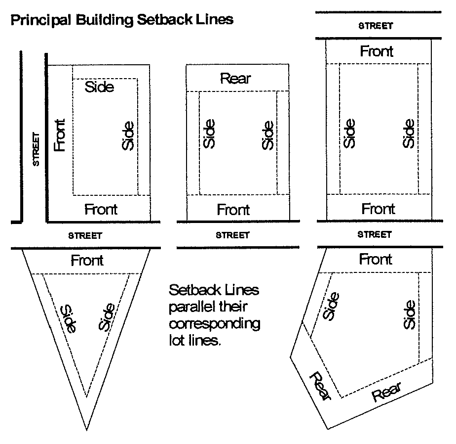
Principal Building Setback Line: A line delineating the minimum allowable distance between a property line (or the right-of-way line) of an abutting street and a principal building on a lot.
1.
Front Building Setback: The minimum allowable distance between the right-of-way line of any abutting street and any part of a principal building on a lot. The front setback distance is applied along the full length of the right-of-way line and is parallel to it.
2.
Rear Building Setback: The minimum allowable distance between a rear lot line and any part of a principal building on a lot. The rear building setback extends along and is parallel to the full length of the rear lot line.
3.
Side Building Setback: The minimum allowable distance between a side lot line and any part of a principal building on a lot. The side building setback extends along and is parallel to the side lot line between the front building setback and a rear building setback (if any).
Principal Freestanding Sign: The main or largest freestanding sign or signs on a property.
Principal Use: The primary purpose for which land or a building is used.
Private Access Drive: A driveway that provides access to a public road for not more than 5 parcels of residential, commercial, or industrial property.
Private Bridge: A bridge owned by an individual or individuals in common which is closed to public use and in no way the responsibility of Oconee County for maintenance, over which a roadway passes.
Private Dam: A dam owned by an individual or individuals in common which is closed to public use and in no way the responsibility of Oconee County for maintenance, over which a roadway passes.
Private Walkway: that portion of "on-site" development that provides pedestrian access through the site to a building or other destination.
Project: 1) The entire proposed development project regardless of the size of the area of land to be disturbed. 2) For stormwater management, see "Land Development Project."
Project Entrance Sign: A permanent freestanding sign located at an entrance designed and permitted for vehicular access into a multi-family development, or into a development containing multiple lots or condominium units, or into a public or community use property, such as but not limited to a particular residential or commercial subdivision, business center, office park or industrial park. Designs for project entrance signs are classified as two types:
Single Sign: A project entrance sign designed as a single sign structure with two back-to-back faces, oriented to be seen from both directions on the road adjacent to the development.
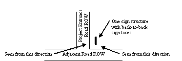
Dual Sign: A project entrance sign designed as two separate sign structures (each up to the maximum allowed size), each with a single sign face (each up to the maximum allowed size) individually oriented toward the intersection so as to be viewed from only one direction on the road adjacent to the development, and each located on opposite sides of the project entrance. Projecting sign: See under "Building Sign."

Public Announcement Sign: A notice of an event or action made by a government or governmental entity that may be of interest to the general public.
Public Improvement: The construction, enlargement, extension or other construction of a facility intended for dedication to the public, including but not limited to a street, curb and gutter, sidewalk, cross drain, catch basin, traffic control and street name sign, or other roadway appurtenance other than a driveway apron connection; domestic water supply system main, fire hydrant, valve or other appurtenance other than a supply line to a building; or sanitary sewerage main or outfall, lift station, force main, manhole or other appurtenance other than a drain line from a building.
Public or Community Use: See under "Land Use Categories."
Public Utilities: water, gas, sanitary and storm sewer, electrical and communications lines and facilities, and improved drainage facilities.
Public Utilities: Water, gas, sanitary sewer, storm sewer, electrical, and communications lines and facilities, and natural or improved drainage facilities.
Putrescible Wastes: Wastes that are capable of being quickly decomposed by microorganisms. Examples of putrescible wastes include but are not necessarily limited to kitchen wastes, animal manure, offal, hatchery and poultry processing plant wastes, dead animals, garbage and wastes which are contaminated by such wastes.
Q
Qualified Personnel: Any person who meets or exceeds the education and training requirements of O.C.G.A. 12-7-19.
R
Ramp: (1) A sloping roadway or passage used to join two different levels of streets, structures or buildings; (2) Driveways leading to parking aisles.
Recharge Area: Any portion of the earth's surface, where water infiltrates into the ground to replenish an aquifer.
Recovered Materials Processing Facility/Materials Recovery Facility (MRF): A facility engaged in the storage, processing, and resale or reuse of recovered materials regardless of whether such facility is principal or accessory use. Such term shall not include a solid waste handling facility; provided, however, any solid waste generated by such facility shall be subject to all applicable laws and regulations relating to such solid waste.
Recovered Materials: Those materials which have known use, reuse, or recycling potential; can be feasibly used, reused or recycled; and have been diverted or removed from the solid waste stream for sale, use, reuse, or recycling, whether or not requiring subsequent separation and processing.
Recreational Vehicle: A vehicle type unit that is one of the following:
1.
A portable camping trailer mounted on wheels and constructed with collapsible partial side walls which fold for towing by another vehicle and unfold for camping.
2.
A motor home designed to provide temporary living quarters for recreational, camping, or travel use and built on or permanently attached to a self-propelled motor vehicle chassis, or on a chassis cab or van that is an integral part of the completed vehicle.
3.
A park trailer built on a single chassis, mounted on wheels, and designed to be connected to utilities necessary for operation of installed fixtures and appliances, and has a gross trailer area of less than when it is set up, except that it does not include fifth wheel trailers. For units 320 square feet or larger, see the definition of "mobile home."
4.
A travel trailer mounted on wheels, designed to provide temporary living quarters for recreational, camping or travel use, of a size or weight that may or may not require special highway movement permits when towed by a motorized vehicle and has a trailer area of less than 320 square feet. This type includes fifth wheel trailers. Should a unit require a size or weight permit, it shall be manufactured to the standards for park trailers A119.5 of the American National Standards Institute Code.
Recreational Vehicle (Per Floodplain Management requirements): A vehicle, which is: built on a single chassis; 320 square feet or less when measured at the largest horizontal projection; designed to be self-propelled or permanently towable by a light duty truck; and designed primarily not for use as a permanent dwelling but as temporary living quarters for recreational, camping, travel, or seasonal use.
Recreational Vehicle Lot: A parcel of land within an approved recreational vehicle subdivision, which was designed and intended for the accommodation of one recreational vehicle and its accessory structures and uses.
Recreational Vehicle Park: A residential development in which individual spaces are provided for the parking of recreational vehicles for temporary housing purposes for persons traveling away from their permanent places of residence. A campground designed to serve recreational vehicles is also included in this definition.
Recreational Vehicle Space: A site within a recreational vehicle park, which is designed and intended for the accommodation of one recreational vehicle.
Recreational Vehicle Subdivision: A residential subdivision, designed and approved in accordance with the subdivision regulations, in which individual ownership of a lot is permitted for the placement of a recreational vehicle for temporary housing purposes for persons traveling away from their permanent places of residence.
Recycling Center: Any facility that involves any process by which materials which would otherwise become solid waste are collected, separated, and reused or shipped off site to be used in the form of raw materials or products.
Recycling Collection Locations: Metal or heavy-duty plastic containers designed for short term holding of pre-bagged recyclable items such as tin, aluminum, glass, and paper (no perishable or food items allowed) for scheduled, minimum monthly pickup with no on-premise sorting.
Recycling: Any process by which materials that would otherwise become solid waste are collected, separated, or processed and reused or returned to use in the form of raw materials or products.
Redevelopment: A land development project on a previously developed site, but excludes ordinary maintenance activities, remodeling of existing buildings, resurfacing of paved areas, and exterior changes or improvements which do not materially increase or concentrate stormwater runoff, or cause additional nonpoint source pollution.
Regulated Activity: Any activity which will, or which may reasonably be expected to, result in the discharge of dredged or fill material into waters of the United States excepting those activities exempted under provisions of this Article and exempted in Section 404 of the Federal Clean Water Act.
Regulated Stream: A natural, free-flowing watercourse that meets certain criteria as established within the Environmental Protection Article of this Code.
Religious Retreat: Lodging facilities operated by religious or non-secular organizations for their members and not open to the general public. Includes convents and monasteries.
Rental, Short Term: The renting or leasing of a detached, attached or semi-detached single-family dwelling unit or portion thereof, not including a rooming or boarding house, where the term of occupancy, possession, or tenancy is less than thirty (30) consecutive calendar days. Renting or leasing, as used herein, means the payment of compensation, money, rent, or other bargained for consideration in exchange for occupancy, possession or use of the property. In contrast, see "Bed and Breakfast Inns," "Hotel and Motel," and "Rooming or Boarding House." Residential Subdivision: See "Subdivision, Residential."
Restaurant, Custom Service: An establishment where food and drink are prepared to individual order, ordered and served at the table, and consumed primarily within the principal building or in established outdoor dining areas, as contrasted to a fast food restaurant.
Restaurant, Drive-In: An eating and/or drinking establishment which caters to motor-driven vehicle business where the patron is served and consumes his food and/or drink while sitting in a motor-driven vehicle in a parking space on the property provided specifically for such service and consumption.
Restaurant, Family: A Custom Service Restaurant primarily oriented to sit-down service, occasionally with take-out service but no drive-in or drive-through facilities, and having an average turnover rate generally of less than 1 hour.
Restaurant, Fast Food: See "Restaurant, Limited Service."
Restaurant, Limited Service: Any establishment, building or structure where food or drink are served for consumption, either on or off the premises, by order from or service to persons either over an interior counter, outside the structure or from an outdoor service window or automobile service window, or by delivery. This definition shall not include otherwise permitted restaurants where outdoor table service is provided to customers in established outdoor dining areas or where drive-through or take-out service is provided incidental to a Custom Service Restaurant.
Restaurant, Quality: A Custom Service Restaurant primarily oriented to fine dining and often associated with a particular cuisine. Quality restaurants are characterized by table settings of better silverware, china, glassware and cloth tablecloths, and have average turnover rates generally of 1 hour or more.
Retention Facility: A basin or structure designed to contain a permanent pool of water with sufficient freeboard to provide for temporary storage and water quality treatment of stormwater runoff.
Return Frequency Storm: The statistically expected time interval between recurrences of a storm of an equal or greater intensity for a given duration.
Reverse Channeled Letters: See under "Channeled Letters."
Right-Of-Way Line: The dividing line between a lot, tract or parcel of land and a contiguous right-of-way.
Right-Of-Way: Access over or across particularly described property for a specific purpose or purposes.
River Bank: The rising ground, bordering a river, which serves to confine the water to the natural channel during the normal course of flow.
River: A natural, free-flowing watercourse that is typically of greater volume than a stream or creek. See also "State Protected River."
Road, Controlled Access: A state or federal highway (usually median divided) that, by design, may only be accessed from:
1.
Public streets where such access is provided by grade separated interchanges consisting of bridge(s) and ramps so that traffic entering and exiting said highway can safely merge into and exit from the highway at the posted speed limit, or
2.
Public streets where such access is provided at grade level intersections which are designed and permitted by the Georgia DOT as part of the highway construction project, or
3.
Right in/right out only private drives without median cuts and where such private drives are permitted by the Georgia DOT due to extenuating circumstances such as no other means of access.
Controlled access roads are distinguished from other state and federal roads in that the private driveway access is the exception to the rule rather than the norm. This definition does not include "limited access roads."
Road, Limited Access: A median divided state or federal highway which, by design, may only be accessed from public streets and where such access is provided by grade separated interchanges consisting of bridge(s) and ramps so that traffic entering and exiting said highway can safely merge into and exit from the highway at the posted speed limit, (an example would be an interstate highway). This definition does not include "controlled access roads."
Roadway Drainage Structure: A device such as a bridge, culvert or ditch, composed of a virtually non-erodible material such as concrete, steel, plastic or other such material that conveys water under a roadway by intercepting the flow on one side of a traveled way consisting of one or more defined lanes, with or without shoulder areas, and carrying water to a release point on the other side.
Roof Sign: See under "Building Sign."
Rooming or Boarding House: A dwelling within which a resident family or manager offers lodging (rooming) or lodging and meals (boarding) to two or more persons not under the resident's parental or protective care in exchange for monetary compensation or other consideration, as a place of residence on a permanent or long term (more than 30 days) basis. In contrast, see "Bed and Breakfast Inn," "Hotel or Motel," and "Rental, Short Term."
S
Safety Fire Commissioner: The Safety Fire Commissioner of Georgia.
Scrap Yard: See "junk yard."
Sediment: Solid material, both organic and inorganic, that is in suspension, is being transported or has been moved from its site of origin by air, water, ice or gravity as a product of erosion.
Sedimentation: The process by which eroded material is transported and deposited by the action of water, wind, ice, or gravity.
Semi-Trailer: A trailer with a set or sets of wheels at the rear, the forward portion of which is designed to be supported by the truck tractor or towing vehicle. For the purpose of this definition, flatbeds designed to be hauled by truck tractors are included as semi-trailers.
Setback, Minimum: The shortest distance allowed between a street right-of-way line or any other lot line and any principal or accessory building on a lot. Minimum setback requirements for buildings are associated with the type of lot line from which the setback is taken; for instance, a "side yard setback" is measured from a side lot line.
Setback: The shortest straight-line distance between a street right-of-way or lot line and the nearest point of a structure or building or projection therefrom, measured at 90 degrees to the street or lot line. The "nearest point of a building" includes such projections as sun parlors and covered porches, whether enclosed or unenclosed, but does not include steps and roof overhangs of 18 inches or less.
Shopping Center: A group of two or more commercial establishments planned and developed as a unit with common off-street parking provided on the property.
Shoulder: That portion of a street or road from the outer edge of the paved surface or the back of curb to the inside edge of the ditch or gutter or original ground surface.
Shrub: A self-supporting woody plant that normally reaches a height of less than 15 feet.
Sidewalk: That portion of a street or road available exclusively for pedestrian traffic.
Sign Face: That portion of the surface of a sign structure where words, letters, figures, symbols, logos, fixtures, colors, or other design elements are or may be located in order to convey the message, idea, or intent for which the sign has been erected or placed. The sign face may be composed of two or more modules on the same surface that are separated or surrounded by open space or by portions of a sign structure not intended to contain any advertising message or idea and are purely structural or decorative in nature.
Sign Module: Each portion or unit of a sign face that is clearly separable from other such units by virtue of the expression of a complete thought, message, logo, or idea.
Sign Structure: A structure exclusively or primarily intended to support a sign face and which, in combination with the sign face, comprises a sign as defined in this Article. A sign structure comprises all elements of a freestanding sign, including the sign face, background, or decorative elements related to the presentation or support of the sign's message, and the structural supports. A structure that incidentally supports a sign face but whose primary purpose is other than providing such support, such as, but not limited to, an exterior wall of a building, a roof, a structural retaining wall or a decorative freestanding fence or wall at a project entrance is not considered a sign structure.
Sign: Any structure, display, or device that is used to advertise, identify, direct, or attract attention to a business, institution, organization, person, idea, product, service, event, or location by any means, including words, letters, figures, design characteristics, symbols, logos, fixtures, colors, movement, or illumination.
Significant Aquifer Recharge Areas: Areas mapped by DNR in Hydrologic Atlas 18 (1989 Edition). Mapping of recharge areas is based on outcrop area, lithology (chemical nature and form of the rock), soil type, and thickness, slope, density of lithologic contacts, geologic structure, presence of "karst" topography (sinkholes, caves, and fissures associated with limestone and other carbonate rocks), and potentiometric surfaces.
Silviculture: The art of producing, reproducing and growing a forest of distinctive stands of trees.
Single- And Two-Family Residential: See under "Land Use Categories."
Site: The parcel of land being developed, or the portion thereof on which the land development project is located.
Site Development Plans: A set of plans, details and technical specifications for the construction of site improvements to a commercial, office, industrial or multi-family lot that includes but is not limited to building footprints, drives, parking, drainage systems, utilities, buffers, landscaping, parking lot lighting, embankments, signage, soil erosion control devices, soil erosion control measures and all other improvements required for the subdivision of land.
Site Plan, Preliminary: A plan showing the layout of a proposed nonresidential or multifamily development project.
Site-Built Single-Family Detached Dwelling: A single-family detached dwelling constructed on the building site from basic materials delivered to the site (in contrast to assembly of pre-constructed modules), and which is constructed in accordance with all requirements of the Building Code as adopted by the County.
Slaughterhouse: An establishment where animals are butchered for market or for other commercial reasons.
Sludge: Any solid, semi-solid, or liquid waste generated from a municipal, commercial, or industrial wastewater treatment plant, water supply treatment plant, or air pollution control facility exclusive of the treated effluent from a wastewater treatment plant.
Soil & Water Commission: The State Soil and Water Conservation Commission.
Soil & Water District: The Oconee River Soil and Water Conservation District.
Soil and Water Conservation District Approved Plan: An erosion and sedimentation control plan approved in writing by the Oconee River Soil and Water Conservation District.
Solar Array: A number of photovoltaic modules or panels that generate solar electricity, assembled or connected together to provide a single electrical output.
Solar Array, Tracking: A solar array that follows the path of the sun to optimize the amount of solar radiation received by the device. A tracking solar array may be ground mounted or building mounted.
Solar Access Easement: A recorded easement, the purpose of which is to secure the right to receive sunlight across real property of another for continued access to sunlight necessary to operate a solar energy system.
Solar Energy: Radiant energy received from the sun that can be collected in the form of heat or light by a solar collector or solar energy system.
Solar Energy Facility: The area of land devoted to solar energy system installation. A solar energy facility may include an interconnection with the local utility power grid for distribution to more than one property or consumer in the electricity market as a commercial venture. Includes the term "solar farm."
Solar Energy System: The components and subsystems required to convert solar energy into electric or thermal energy suitable for use. The term applies, but is not limited to, photovoltaic (solar electric) systems and thermal solar energy systems.
Solar Energy System, Building Mounted: A solar energy system, which may include solar thermal panels, solar hot water system panels, and photovoltaic panels, which are mounted to a building or structure, to provide energy primarily for on-site use. Building-mounted solar panels may be flush-mounted (i.e., flush to the surface of a building roof or building façade in a manner that the panel cannot be angled or raised), or as one or more modules fixed to frames which can be tilted or automatically adjusted at an optimal angle for sun exposure. A mounted solar energy system is accessory to the building or structure.
Solar Energy System, Ground Mounted: A solar energy system that is directly installed on (mounted to) the ground and is not attached or affixed to any structure.
Solar Energy System, Thermal: A solar energy system that directly heats water or other liquid using sunlight, including the use of heated liquid for such purposes as space heating and cooling, domestic hot water, and heating pool water.
Solar Farm: A solar energy facility, typically with multiple solar arrays, designed and used for the purpose of generating electric energy via a photovoltaic system.
Solid Waste Disposal Facility: Any facility or location where the final disposition of solid waste occurs and includes, but is not limited to, landfilling and solid waste thermal treatment technology facilities.
Solid Waste Handling Facility: Any facility, the primary purpose of which is the storage, collection, transportation, treatment, utilization, processing, or disposal, or any combination thereof, of solid waste.
Solid Waste Handling: The storage, collection, transportation, treatment, utilization, processing, or disposal of solid waste, or any combination of such activities.
Solid Waste Transfer Station: A facility used to transfer solid waste from one transportation vehicle to another for transportation to a disposal facility or processing operation.
Solid Waste: Any garbage or refuse; sludge from a wastewater treatment plant, water supply treatment plant, or air pollution control facility; and other discarded material including solid, liquid, semisolid, or contained gaseous material resulting from industrial, commercial, mining, and agricultural operations and from community activities, but does not include recovered materials; solid or dissolved materials in domestic sewage; solid or dissolved materials in irrigation return flows or industrial discharges that are point sources subject to permit under 33 U.S.C. Section 1342; or source, special nuclear, or by-product material as defined by the federal Atomic Energy Act of 1954, as amended (68 Stat. 923).
Specified Anatomical Areas shall include the following:
1.
Less than completely and opaquely covered human genitals or pubic region, cleft of the buttocks, or female breast below a point immediately above the top of the areola; or
2.
Human male genitalia in a discernibly turgid state, even if completely and opaquely covered.
Specified Sexual Activities shall be defined to mean and include any of the following:
1.
Actual or simulated sexual intercourse, oral copulation, anal intercourse, oral anal copulation, bestiality, direct physical stimulation of unclothed genitals, flagellation or torture in the context of a sexual relationship, or the use of excretory functions in the context of a sexual relationship and any of the following sexually oriented acts or conduct: anilingus, buggery, coprophagy, coprophilia, cunnilingus, fellatio, necrophilia, pederasty, pedophilia, piquerism, sapphism, zooerasty; or
2.
Use of human or animal ejaculation, sodomy, oral copulation, coitus or masturbation; or
3.
Fondling or other erotic touching of nude human genitals, pubic region, buttocks or female breast; or
4.
Masochism, erotic or sexually oriented torture, beating or the infliction of pain; or
5.
Erotic or lewd touching, fondling or other sexual contact with an animal by a human being.
Speed Bump: A raised section of a paved surface or roadway designed to slow down and deter speeding traffic.
Stabilization: The process of establishing an enduring soil cover of vegetation by the installation of temporary or permanent structures for the purpose of reducing to a minimum the erosion process and the resultant transport of sediment by wind, water, ice or gravity.
Start of Construction: The initiation of new construction or a substantial improvement, as follows: (1) For New Construction: The date the development permit was issued, provided the actual start of construction, repair, reconstruction or improvement was within 180 days of the permit date. The actual start of construction means the first placement of permanent construction of a building, including a manufactured home, on a site, such as the pouring of slabs or footings, installation of piles, construction of columns, or any work beyond the stage of excavation or the placement of a manufactured home on a foundation. Permanent construction does not include land preparation, such as clearing, grading and filling, nor does it include the installation of streets or walkways; the excavation for a basement, footings, piers or foundations or the erection of temporary forms; nor does it include the installation on the property of accessory buildings, such as garages or sheds not occupied as dwelling units or not part of the main building. (Note: accessory structures are not exempt.) (2) For a Substantial Improvement: The date the building permit was issued provided the actual start of construction was within 180 days of the permit date. The actual start of construction means the first alteration of any wall, ceiling, floor or other structural parts of a building, whether or not that alteration affects the external dimensions of the building.
State General Permit: The National Pollution Discharge Elimination System general permit or permits for storm-water runoff from construction activities as is now in effect or as may be amended or reissued in the future pursuant to the State's authority to implement the same through federal delegation under the Federal Water Pollution Control Act, as amended, 33 U.S.C. Section 1251, et seq., and subsection (f) of O.C.G.A. 12-5-30.
State Protected River: A "State protected river" is any perennial river or watercourse that has an average annual flow of at least 400 cubic feet per second as determined by the State.
State Waters: Those waters of the State of Georgia as defined under the Georgia Erosion and Sedimentation Act of 1975, as amended (O.C.G.A. 12-7-1 et seq.).
Stockyard: An enclosure with pens, sheds or buildings for the temporary keeping or shelter of cattle, sheep, horses or other animals intended for market.
Stormwater: Any surface flow, runoff, and drainage consisting entirely of water from any form of natural precipitation, and resulting from such precipitation.
Stormwater Better Site Design: Nonstructural site design approaches and techniques that can reduce a site's impact on the watershed and can provide for nonstructural stormwater management. Stormwater better site design includes conserving and protecting natural areas and greenspace, reducing impervious cover and using natural features for stormwater management.
Stormwater Discharge: The flow rate of surface water resulting from precipitation.
Stormwater Management: The collection, conveyance, storage, treatment and disposal of stormwater runoff in a manner intended to prevent increased flood damage, stream bank channel erosion, habitat degradation and water quality degradation, and to enhance and promote the public health, safety and general welfare.
Stormwater Management Facility: Any infrastructure that controls or conveys stormwater runoff.
Stormwater Management Measure: Any stormwater management facility, structure, or nonstructural stormwater management practice.
Stormwater Management Plan: A document describing how existing runoff characteristics will be affected by a land development project and containing measures for complying with the provisions of this Division.
Stormwater Management System: The entire set of structural and nonstructural stormwater management facilities and practices that are used to capture, convey, and control the quantity and quality of the stormwater runoff from a site.
Stormwater Management Retrofit: A stormwater management practice designed for a currently developed site that previously had either no stormwater management practice in place or a practice inadequate to meet the stormwater management requirements of the site.
Stormwater Runoff: The quantity of surface water resulting from precipitation.
Stream Bank: The point where vegetation has been wrested by normal stream flow or wave action.
Stream Buffer: See "Buffer, Stream."
Stream, Regulated:See "Regulated Stream."
Stream: A natural, free-flowing watercourse with either constant or intermittent flow of moderate volume typically less than that of a river.
Street: A public right-of-way or private easement for vehicular traffic, whether designated as a street, highway, thoroughfare, parkway, road, avenue, drive, expressway, freeway, boulevard, lane, place, circle, alley, or otherwise. Various types of streets may be defined as follows:
Arterial: A public way which is used primarily for fast and heavy traffic flow; is of considerable continuity; and is used as a traffic artery for intercommunication among large areas. (ADT greater than or equal to 10,000 vehicles per day)
Major Collector: A street which carries traffic from activity centers and minor collector streets to arterial streets and streets of high classification. (ADT between 2,501 and 9,999 vehicles per day)
Minor Collector: Principal entrance streets to subdivisions and the main streets for circulation within a subdivision, which serve a network of 4 or more local streets. Minor collector streets are designed so that traffic circulation in a subdivision would cause such a street to be used as a link between local streets and major collector or arterial streets. (ADT between 251 and 2500 vehicles per day)
Local: A street used primarily in residential subdivisions or within nonresidential developments for access to abutting properties as opposed to the collection and dispersion of traffic. (ADT less than or equal to 250 vehicles per day)
Cul-De-Sac: A local street with only one outlet, closed and terminated by a vehicular turnaround.
Alley: A platted service way providing a secondary means of access to abutting properties.
Street Grade: The grade of the curb or centerline of a street measured at any point along the street.
Street, Half: A street which does not meet the minimum right-of-way widths as set forth in these Regulations.
Structural Buffer: See under "Buffer, Landscape."
Structural Erosion and Sedimentation Control Measures: Measures for the stabilization of erodible or sediment-producing areas by utilizing the mechanical properties of matter for the purpose of either changing the surface of the land or storing, regulating or disposing of runoff to prevent excessive sediment loss. Examples of structural erosion and sedimentation control practices are riprap, sediment basins, dikes, level spreaders, waterways or outlets, diversions, grade stabilization structures, sediment traps and land grading. Such measures can be found in the publication Manual for Erosion and Sediment Control in Georgia.
Structural Soil: Highly porous engineered aggregate mix designed to be used under asphalt and concrete pavements as the load-bearing and leveling layer as a means to providing a soil component beneath impervious surfaces to facilitate the root growth of trees.
Structural Stormwater Control: A structural stormwater management facility or device that controls stormwater runoff and changes the characteristics of that runoff including, but not limited to, the quantity and quality, the period of release, the velocity of flow, or the rate of discharge of such runoff.
Structure: Anything constructed or erected, the use of which requires a location on the ground, including but not necessarily limited to, signs, buildings, parking lots, patios, pools, decks, well houses and canopies.
Subdivider: Any person who undertakes the subdivision of land as herein defined for himself or for another within the confines of Oconee County.
Subdivision: Any division of a tract or parcel of land into two or more lots, building sites, or other divisions for the purpose, whether immediate or future, of sale, legacy or building development, and including any division of land involving a new street, public or private, or a change in existing streets, and including resubdivision or recombination of previously platted lots, and where appropriate to the context, relating to the process of subdividing or to the land or areas subdivided.
Subdivision Construction Plans: A set of plans, details and technical specifications for the construction of roads, drainage systems, utilities, embankments, signage, traffic control devices, soil erosion control devices, soil erosion control measures and all other improvements required for the subdivision of land.
Subdivision, Conservation: A form of subdivision design which concentrates lots, houses, streets, utilities and related development activities on the more suitable, and less environmentally sensitive areas of the site, thereby preserving the steep slopes, wetlands, unsuitable soils, stream corridors and otherwise environmentally sensitive areas in a natural or undisturbed state. The net density of the development is equal to or less than that of traditional subdivision design but the lot sizes are smaller in order to preserve the environmentally sensitive areas in dedicated, perpetual open space.
Subdivision, Residential: An area with streets designed primarily for residential and accessory traffic that are primarily interior subdivision streets and specifically including all residential areas platted and regulated under this Development Code.
Subdivision, Traditional: A form of subdivision design where all land areas within the development are divided into building lots and rights-of-way and where there is little or no open space land set aside outside of said building lots and rights-of-way for preservation in its natural or undeveloped condition.
Substantial Damage: Damage of any origin sustained by a structure whereby the cost of restoring the structure to its before-damaged condition would equal or exceed 50 percent of the market value of the structure before damage occurred.
Substantial Improvement: Any combination of repairs, reconstruction, rehabilitation, alteration, or improvements to a building, taking place during a 5-year period, in which the cumulative cost equals or exceeds 50 percent of the market value of the building prior to the start of construction of the improvement. The market value of the building should be: (1) The appraised value of the building prior to the start of the initial repair or improvement; or (2) In the case of damage, the value of the building prior to the damage occurring. This term includes structures that have incurred "substantial damage," regardless of the actual amount of the actual repair work performed. For the purposes of this definition, "substantial improvement" is considered to occur when the first alteration of any wall, ceiling, floor, or other structural part of the building commences, whether or not that alteration affects the external dimensions of the building. The term does not, however, include (1) those improvements of a building required to comply with existing violations of state or local health, sanitary or safety code specifications which are solely necessary to assure safe living conditions, which have been pre-identified by the Code Enforcement official through enforcement of this Development Code and not solely triggered by an improvement or repair project, or (2) any alteration of a "historic structure" provided that the alteration will not preclude the structure's continued designation as a "historic structure".
Substantially Improved Existing Manufactured Home Parks or Subdivisions: is where the repair, reconstruction, rehabilitation or improvement of the streets, utilities and pads equals or exceeds 50 percent of the value of the streets, utilities and pads before the repair, reconstruction or improvement commenced.
Subtitle D Landfill: Any municipal solid waste landfill unit that meets the minimum requirements of (part II), 40 CFR parts 257 & 258, as amended, for Solid Waste Disposal Facility Criteria, Final Rule, and that has not received waste prior to October 9, 1993.
Surface Water: the surface drainage of water, its management, control, transportation, storage, and disposal.
Surveyor: A registered, practicing surveyor, licensed by the State of Georgia.
Swale: a shallow lineal depression with a parabolic cross-section and gently sloped sides.
Swimming Pools, Private: Any permanent container of watertight construction which is built for the purpose of wading, informal swimming and diving and other water recreation uses, and is restricted to private use of the property owner and guests.
Swimming Pools, Public: Any permanent container of watertight construction, which is built for the purpose of wading, informal or competitive swimming and diving, and team sports, and is open to the public. This definition shall include pools for associations, clubs and neighborhood pools where membership is required and/or fees are paid for use of the facility.
T
Telephone, Cellular and Other Wired or Wireless Telecommunications Carriers (except Satellite): A facility designed and engineered to contain the equipment for telephone, cellular, broadband or other wired or wireless transmission. This shall include all types of transmission equipment including fiber optics. All facilities shall be within a fully enclosed building. This shall not include a digital data center or any facility that exceeds 10,000 square feet in total building(s) size.
Temporary Event: An activity having a specific duration or the end of which is related to a specific action, usually lasting for only a few days or months at a time. Temporary events include but are not limited to such activities as:
1.
The offering of a property or premises for sale or rent.
2.
An election, political campaign, referendum, or ballot proposition put to the voters as part of city, county, state, or federal governance.
3.
Special business promotions, such as but not limited to "grand openings," "closeout sales," and seasonal sales events.
4.
A yard sale.
5.
The construction of a building or development project, or the rehabilitation, remodeling, or renovation of a building.
6.
A special event by a nonprofit organization.
Tenant: A natural person, business or other entity that occupies land or buildings by title, under a lease, or through payment of rent; an occupant, inhabitant, or dweller of a place.
Tower Owner: The owner, permittee or lessee of the tower, antennae or associated equipment as well as any parent or subsidiary companies of the foregoing entities.
Tower: Any structure that is designed and constructed primarily for the purpose of supporting one or more antennas, including self-supporting lattice towers, guy towers, or monopole towers. The term includes radio and television transmission towers, microwave towers, common-carrier towers, cellular telephone towers, alternative tower structures, and the like.
Townhouse: See "Dwelling, Multi-Family"
Toxic Waste: Any combination of pollutants, including disease-carrying agents, that, after discharge and upon exposure, ingestion, inhalation, or assimilation into any organism, can cause death or disease, mutations, deformities, or malfunctions in such organisms or their offspring and that adversely affect the environment.
Traditional Subdivision: See "Subdivision, Traditional."
Transfer Station: A combination of structures, machinery, or devices at a place or facility where solid waste is taken from collection vehicles and placed in other transportation units, with or without reduction of volume, for movement to another solid waste management facility or processing operation.
Trash: All worthless or discarded material, objects, or refuse derived from residential, commercial, industrial, or other generators. This includes waste building materials and rubble resulting from construction, remodeling, repair, and demolition activities on pavement, houses, commercial buildings, and other structures. Such wastes include, but are not limited to, asbestos containing wastes, hazardous wastes, paper and paper products, plastic bags and plastic products, waste tires, wood, bricks, metal, concrete, asphalt, wallpaper, wallboard, inert waste material, white goods, furnishings, yard clippings and trimmings, and other putrescible and nonputrescible wastes.
Travelway: The paved or otherwise improved portion of a street or road specifically provided and set aside to carry vehicular traffic. Travelways are commonly identified as the pavement between the curbs or between the shoulders of a road if no curbs are provided.
Tree Harvesting: The planting, cultivating and harvesting of trees in a continuous cycle as a regular agricultural practice on a tract of land; not including the removal of trees for purposes of development or the removal of trees without replanting.
Tree, Large: A shade tree that has a single trunk and which will reach at least 35 feet in height and 35 feet in spread at maturity. In defining such trees, reference may be made to the latest editions of Landscape Plant Materials for Georgia (Cooperative Extension Service, The University of Georgia College of Agriculture, Bulletin No. 625) and the Manual of Woody Landscape Plants (Michael Dirr, 1983, Castle Books).
Tree, Medium: A medium tree has a single trunk and which will reach to least 25 feet in height at maturity. In defining such trees reference may be made to the latest editions of Landscape Plant Material for Georgia [Cooperative Extension Service, The University of Georgia College of Agriculture, Bulletin No. 625] and the Manual of Woody Landscape Plants [Michael Dirr, 1983, Castel Books].
Tree, Small: A small tree may have single or multiple trunks and which will reach at least 15 feet in height at maturity. In defining such trees, reference may be made to the latest editions of Landscape Plant Materials for Georgia [Cooperative Extension Service, The University of Georgia College of Agriculture, Bulletin No. 625] and the Manual of Woody Landscape Plants [Michael Dirr, 1983, Castle Books]
Trench: A narrow excavation made below the surface of the ground. In general, the depth is greater than the width, but the width of a trench is not greater than 15 feet.
Trout Streams: All streams or portions of streams within the watershed as designated by the Game and Fish Division of the Georgia Department of Natural Resources under the provisions of O.C.G.A. 12-5-20 et. seq. Streams designated as primary trout waters are defined as supporting a self-sustaining population of rainbow, brown or brook trout. Streams designated as secondary trout waters are those in which there is no evidence of natural trout reproduction, but are capable of supporting trout throughout the year. First order trout waters are streams into which no other streams flow except springs.
Truck Tractor: A heavy motor vehicle consisting of a truck cab designed to tow semi-trailers.
U
Under-Canopy Sign: See under "Building Sign."
Urbanized Area: The area of unincorporated Oconee County regulated under the National Pollutant Discharge Elimination System (NPDES) Stormwater Phase II Permit.
V
Vegetative Erosion and Sedimentation Control Measures: Measures for the stabilization of erodible or sediment-producing areas by covering the soil with:
1.
Permanent seeding, sprigging or planting, producing long-term vegetative cover; or
2.
Temporary seeding, producing short-term vegetative cover; or
3.
Sodding, covering areas with a turf of perennial sod-forming grass.
4.
Such measures can be found in the publication Manual for Erosion and Sediment Control in Georgia.
Vehicle Use Area: Vehicle use areas include any areas designated as automobile, truck, or van parking spaces, including access aisles and driveways. Vehicle use areas also include the driveways and access aisles associated with mini storage warehouses, truck loading and unloading spaces, and impoundment yards.
Vehicular Sign: Any sign placed, mounted, painted on or affixed to a motor vehicle, freight, flatbed or storage trailer or other conveyance when same are placed or parked in such a manner as to be viewed or intended to be viewed from the public right(s)-of-way except that this definition shall not apply when:
1.
Such conveyances are actively being used to transport persons, goods or services in the normal course of business;
2.
When such conveyances are parked in an inconspicuous area; or
3.
When such conveyances are actively being used for storage of construction materials for, and on the same lot with a bona fide construction project for which building and other applicable permits have been issued and where construction is underway and provided said conveyances are located within designated storage areas.
Veterinary Clinic or Animal Hospital: A facility or establishment where animals are regularly given medical care or treatment under the supervision of a licensed veterinarian.
Violation (Per Floodplain Management requirements): The failure of a structure or other development to be fully compliant with the community's floodplain management regulations. A structure or other development without the elevation certificate, or other certifications, or other evidence of compliance required by this ordinance is presumed to be in violation until such time as that documentation is provided.
Visual Screen: Vegetation or a decorative structure that creates an opaque visual block or obscures an unattractive view. Screening may consist of any combination of the following, as approved by the Planning Director: Fencing constructed of cedar, redwood, treated wood, vinyl replicating wood, or other suitable all-weather material; masonry walls of brick or stone; planted or natural vegetation; or earthen berms.
W
Wall Sign: See under "Building Sign."
Warehouse, Mini, Self-Storage: A facility with multiple storage compartments where each compartment has an individual separate door accessed directly from the exterior vehicular use area and where the person(s) leasing the individual spaces, (usually on a monthly basis) keep the key in their possession. Such compartments are usually not more than 14 feet by 14 feet in size.
Warehouse: A building use primarily for the bulk storage, transfer or distribution of goods and materials.
Wastewater: Any water or other liquid discharged from a facility, that has been used, as for washing, flushing, or in a manufacturing process, and so contains waste products.
Water Supply Reservoir: A governmentally owned impoundment of water for the primary purpose of providing water to one or more governmentally owned drinking water systems. This definition specifically excludes the multipurpose reservoirs owned by the U.S. Army Corps of Engineers.
Water Supply Watershed: The portion of a watershed upstream of a governmentally owned public drinking water supply intake.
Watercourse: Any natural or artificial watercourse, stream, river, creek, channel, ditch, canal, conduit, culvert, drain, waterway, gully, ravine, or wash in which water flows either continuously or intermittently and which has a definite channel, bed and banks, and including any area adjacent thereto subject to inundation by reason of overflow or floodwater.
Watershed: The total area of land that is drained by a river or stream and its tributaries.
Wetland Delineation: The establishment of wetland boundaries by a representative of the U.S. Army Corps of Engineers or an authority designated by the Corps.
Wetland Functions: The beneficial roles that wetlands serve, including: storage, conveyance, and attenuation of floodwater and storm water; protection of water quality and reduction of erosion; habitat for wildlife, including rare, threatened and endangered species; food chain support for a wide variety of wildlife and fisheries; educational, historical, and archeological value protection; and scenic, aesthetic, and recreational amenities.
Wetland Protection Area: All wetlands within the jurisdiction of Oconee County which are indicated on the Generalized Wetland Map as "wetlands providing significant wildlife habitat and/or which may be subject to extensive mitigation."
Wetland, Jurisdictional: An area that meets the definitional requirements for wetlands as determined by the U.S. Army Corps of Engineers.
Wetland: An area that is inundated or saturated by surface water or groundwater at a frequency and distribution sufficient to support, and under normal circumstances does support a prevalence of vegetation typically adapted for life in saturated soil conditions, commonly known as hydrophytic vegetation. Wetlands generally include swamps, marshes, bogs, and similar areas.
Wetlands: Those areas that are inundated or saturated by surface or ground water at a frequency and duration sufficient to support, and that under normal circumstances do support a prevalence of vegetation typically adapted for life in saturated soil conditions. Wetlands generally include swamps, marshes, bogs and similar areas.
Window Sign: See under "Building Sign."
Y
Yard: An area that lies between the principal building on a lot and the nearest lot line.
1.
Front Yard: a yard extending the full width of the lot, located between the street line and the front line of a principal building, projected to the side lines of the lot.
2.
Rear Yard: a yard extending the full width of the lot and situated between the rear lot line of the lot and the rear of a principal building projected to the side lines of the lot.
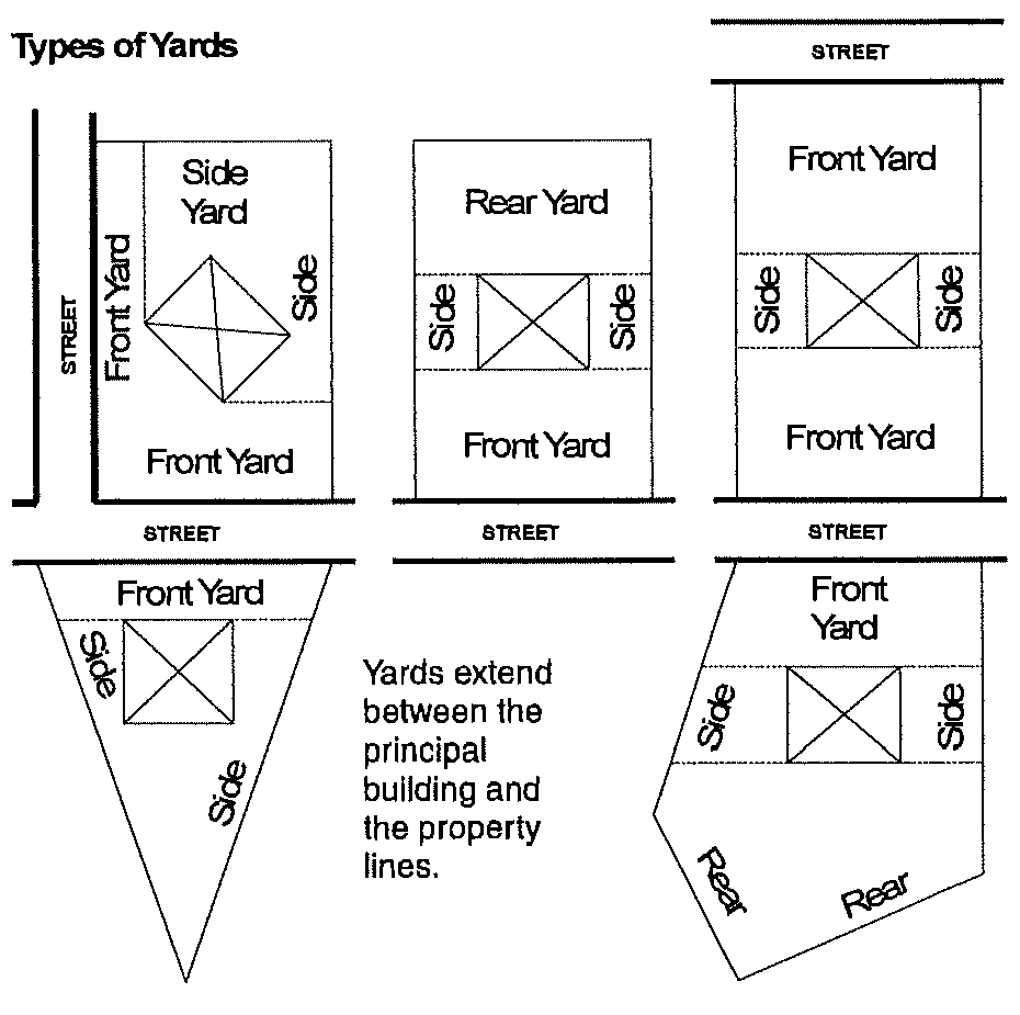
3.
Side Yard: a yard located between the side of a principal building and the side line of the lot and extending from the rear line of the front yard to the front line of the rear yard.
4.
Court Yard: A yard that is semi-enclosed on two or more sides by the walls of a building or structure or the extension of such walls.
Yard Trimmings: Leaves, brush, grass, clippings, shrub and tree prunings, discarded Christmas trees, nursery and greenhouse vegetative residuals, and vegetative matter resulting from landscaping development and maintenance other than mining, agricultural, and silvacultural operations.
Yield Plan: A subdivision plan, similar to a preliminary plat, showing the maximum number of lots which would be permitted if the subject property was developed as a traditional subdivision under the provisions of the Oconee County Zoning Regulations, Land Subdivision Regulations and other applicable ordinances, specifications and policies. A yield plan shall be based upon accurate topography, boundary survey, Level Two Soil Scientist Report (or greater) and other information necessary to accurately determine the maximum net density for the subject property under the Oconee County regulations for traditional subdivisions, which may not be exceeded by the conservation subdivision.
Z
Zero Lot Line: The location of a building on a lot in such a manner that one or more of the building's sides rest directly on a lot line, such as "patio homes" or "townhouses."
Zoning Change: An amendment to the Zoning Map (rezoning), approval of a Special Use, or approval of a change in the conditions of approval associated with a rezoning or Special Use.
(Res. of 02-04-2025(1), Exh. A)